49
A Proposed Practice October 2010 Center for Urban Transportation Research University of South Florida Mobility Review Guide

A Proposed Practice October 2010
Center for Urban Transportation Research University of South Florida
Mobility Review Guide

ii
The opinions, findings and conclusions expressed in this publication are those of the authors and not necessarily
those of the State of Florida Department of Transportation or the U.S. Department of Transportation.
Prepared in cooperation with the State of Florida Department of Transportation and the U.S. Department of
Transportation.

iii
Acknowledgements
Florida Department of Transportation Project Staff and Contacts
Gary Sokolow, Systems Planning Office
850‐414‐4912, [email protected]
Gina Bonyani, Systems Planning Office
850‐414‐4707, [email protected]
CUTR Project Staff
Kristine M. Williams, AICP
Karen E. Seggerman, AICP
Domenico Pontoriero
Melissa McCarville
The authors would like to acknowledge the
Comprehensive Transportation Review Scorecard for Developments of Regional Impact,
developed by Glatting Jackson Kercher and Anglin (now AECOM) for the Georgia Regional
Transportation Authority, which inspired us to prepare this checklist.
Foreword This guide and the accompanying checklist were developed by the Center for Urban Transportation
Research under a grant from the Florida Department of Transportation (FDOT), Systems Planning
Office. They are intended for use by FDOT Growth Management Coordinators in their review of
local government comprehensive plan amendments in relation to the state transportation system.
This proposed guidance sets forth a voluntary practice and represents one of several tools that may
be used by FDOT for this purpose. The checklist is designed to be adapted by the user to reflect the
needs and characteristics of a particular community or region. FDOT staff and local governments
should also refer to applicable sections of Chapter 163, Florida Statutes, Rule 9J‐5, Florida
Administrative Code, and related guidance from the Florida Department of Community Affairs to
ensure that all State of Florida requirements regarding Transportation Concurrency Exception
Areas (TCEAs), mitigation of impacts to the Strategic Intermodal System (SIS), and other
transportation‐related requirements for comprehensive plan amendments are met.

iv

v
Table of Contents 1 INTRODUCTION ........................................................................................................................... 1
1.1 OBJECTIVE OF THE GUIDE ................................................................................................................ 1
1.2 METHODOLOGY ............................................................................................................................. 2
2 USING THE CHECKLIST ................................................................................................................. 3
2.1 SUGGESTED REVIEW AND SUBMITTAL PROCESS ................................................................................... 3
2.2 CHECKLIST DIRECTIONS ................................................................................................................... 4
2.3 CATEGORY SP: SUPPORTING PLANS AND GUIDELINES .......................................................................... 5
2.3.1 Element SP: State, Regional, Local .......................................................................... 5 2.4 CATEGORY ME: MULTIMODAL ENVIRONMENT .................................................................................. 6
2.4.1 Element ME1: Organization and Location .............................................................. 8 2.4.2 Element ME2: Mix ................................................................................................... 9 2.4.3 Element ME3: Density ............................................................................................. 9 2.4.4 Element ME4: Multimodal Policy (other) .............................................................. 10
2.5 CATEGORY NI: NETWORK IMPROVEMENT ........................................................................................ 11
2.5.1 Element NI1: Major Roadway Network ................................................................ 11 2.5.2 Element NI2: Local Street Network ....................................................................... 13 2.5.3 Element NI3: Bicycle/Pedestrian Network ............................................................ 15 2.5.4 Element NI4: Transit Network ............................................................................... 16
2.6 CATEGORY OS: OPERATIONS AND SAFETY ........................................................................................ 17
2.6.1 Element OS1: Demand Management ................................................................... 18 2.6.2 Element OS2: Access Management ...................................................................... 19 2.6.3 Element OS3: Transit Operations/Safety .............................................................. 21 2.6.4 Element OS4: Pedestrian/Bicycle Operations/Safety ............................................ 22
2.7 CATEGORY IM: IMPLEMENTATION .................................................................................................. 22
2.7.1 Element IM1: Coordination ................................................................................... 23 2.7.2 Element IM2: Incentives ........................................................................................ 24 2.7.3 Element IM3: Monitoring ...................................................................................... 24 2.7.4 Element IM4: Funding ........................................................................................... 25
3 SUMMARIZE AND APPLY FINDINGS ........................................................................................... 27
3.1 COMPLETE STAFF REPORT ............................................................................................................. 27
3.2 A FINAL WORD ON THE GUIDE AND CHECKLIST ................................................................................. 27
APPENDIX A: FDOT’S ROLE IN GROWTH MANAGEMENT .................................................................... 29
APPENDIX B: SAMPLE MOBILITY ANALYSIS & PLAN REPORT CONTENTS ............................................. 37
APPENDIX C: MOBILITY PLAN ASSESSMENT CHECKLIST ...................................................................... 39

vi
List of Tables
Table 1: Supporting Plans and Guidelines (SP1) Criteria .............................................................................. 6
Table 2: Multimodal Environment (ME1) Organization and Location Criteria ............................................. 8
Table 3: Multimodal Environment (ME2) Mix Criteria ................................................................................. 9
Table 4: Multimodal Environment (ME3) Density/Intensity Criteria .......................................................... 10
Table 5: Multimodal Environment (ME4) Multimodal Policy Criteria ........................................................ 11
Table 6: Network Improvement (NI1) Major Roadway Network Criteria .................................................. 12
Table 7: Network Improvement (NI2) Local Street Network Criteria ......................................................... 13
Table 8: Network Improvement (NI3) Bicycle/Pedestrian Network Criteria .............................................. 15
Table 9: Network Improvement (NI4) Transit Network Criteria ................................................................. 17
Table 10: Operations and Safety (OS1) Demand Management Criteria ..................................................... 19
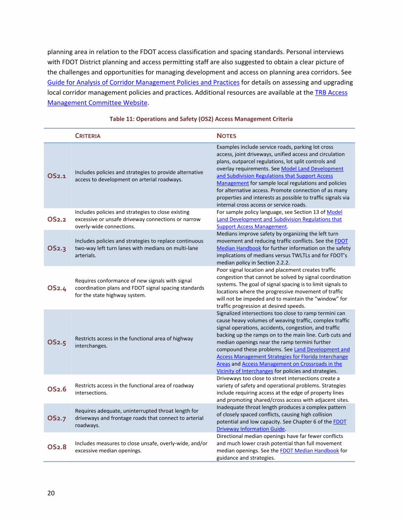
Table 11: Operations and Safety (OS2) Access Management Criteria ........................................................ 20
Table 12: Operations and Safety (OS3) Transit Operations/Safety Criteria ............................................... 21
Table 13: Operations and Safety (OS4) Pedestrian/Bicycle Operations/Safety Criteria ............................. 22
Table 14: Implementation (IM1) Intergovernmental Coordination Criteria .............................................. 23
Table 15: Implementation (IM2) Incentives Criteria ................................................................................... 24
Table 16: Implementation (IM3) Monitoring Criteria ................................................................................. 25
Table 17: Implementation (IM4) Funding Criteria ...................................................................................... 26
List of Figures
Figure 1: Land use organization, network connectivity and arterial traffic .................................................. 7
Figure 2: Corridor transect ............................................................................................................................ 7
Figure 3: Corridor network and access management concepts ................................................................. 13
Figure 4: Network connectivity and system capacity ................................................................................. 14
Figure 5: Comparison of transit modes....................................................................................................... 17
1
1 Introduction Through its role in the comprehensive plan amendment (CPA)
review process, the Florida Department of Transportation (FDOT)
must comment as to whether proposed strategies adequately
support mobility on the Strategic Intermodal System (SIS) and other
state transportation facilities. One issue that often arises in this
review process is the difficulty of measuring the value of corridor
management and multimodal strategies for improving or
maintaining mobility on applicable portions of the state highway
system. Guidance regarding what may constitute acceptable land
use and transportation strategies to support and fund mobility will
support FDOT review efforts. This research was conducted for that purpose.
1.1 Objective of the Guide
The objective of this guide and companion checklist is to provide the Florida Department of
Transportation (FDOT) with a proposed framework for review of local government “land use and
transportation strategies to support and fund mobility” submitted through the CPA review process as
they relate to the function of the state transportation system. The guide and checklist, with applicable
modifications, may also be useful for reviewing proposed SIS mitigation plans or corridor management
plans for major highway corridors. In addition, local governments may find the guide and checklist a
useful resource in developing effective land use and transportation strategies.
This proposed framework depicts options that are considered best practices for transportation and land
use (mobility) planning, rather than specific statute and rule requirements. These options could be used
in planning and implementing viable strategies to advance mobility objectives for the SIS and other
major highway corridors, while supporting growth management efforts to increase use of alternative
modes, reduce vehicle miles of travel (VMT), and enhance the multimodal environment. FDOT’s role in
the review of CPAs is defined in statute and subject to change from time to time. Appendix A provides a
background of FDOT’s current role.
In addition, opportunities for FDOT staff to develop corridor management plans for the state highway
system in cooperation with local governments
continue to arise throughout the state. Such
plans may form the basis for Strategic
Intermodal System (SIS) mitigation
agreements and may also be a prominent
component of local land use and
transportation plans. Additional guidance on
the review of local government corridor
access management plans and policies is
provided in Guide for Analysis of Corridor Management Plans and Policies.
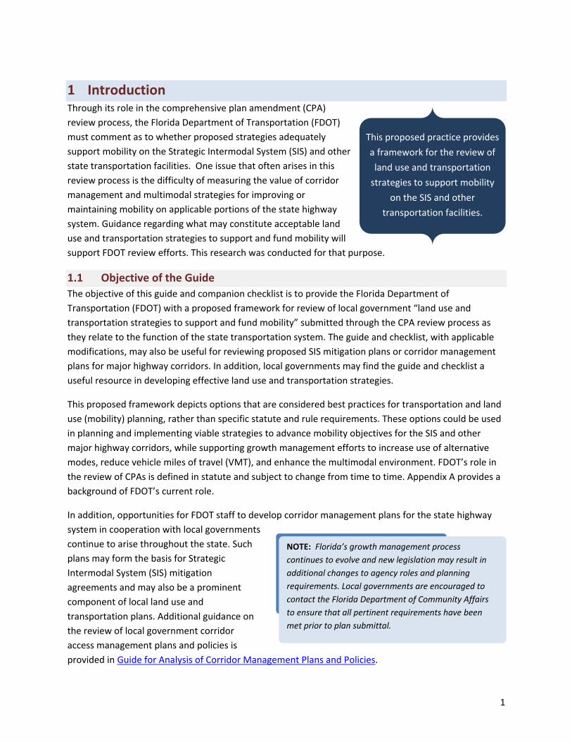
This proposed practice provides
a framework for the review of
land use and transportation
strategies to support mobility
on the SIS and other
transportation facilities.
NOTE: Florida’s growth management process
continues to evolve and new legislation may result in
additional changes to agency roles and planning
requirements. Local governments are encouraged to
contact the Florida Department of Community Affairs
to ensure that all pertinent requirements have been
met prior to plan submittal.
2
FDOT’s chief responsibility is to maintain mobility on the state transportation system. Therefore, this
practice proposes that FDOT review staff should assess and comment on both land use and
transportation strategies as they pertain to mobility on the system.
A comprehensive menu of criteria is provided to assess proposed local strategies. Examples include land
use and activity center criteria, network connectivity, access management, parallel relievers,
transportation demand management, bicycle/pedestrian improvements, and transit service
enhancements. These and other criteria are also contained in a spreadsheet checklist to aid the user in
gauging the adequacy of proposed land use and transportation strategies to support and fund mobility.
1.2 Methodology
The criteria included in this guide and checklist is based on planning strategies relevant to mobility. The
selected criteria embody transportation and land use planning best practices that support the use of
alternative modes, advance corridor management objectives for major highway corridors, reduce
vehicle miles of travel (VMT), and enhance the multimodal environment. The criteria were selected
through a comprehensive review of the literature and current practice in multimodal planning and
corridor management, as well as relevant findings from previous research and a review of Florida
transportation and growth management legislation. A technical working group of knowledgeable
persons in the public and private sector was also assembled to guide the project.
The resulting criteria were grouped into general categories by topic (i.e. Supporting Plans and
Guidelines, Multimodal Environment, Network Improvement, Operations and Safety, Implementation)
and by elements relating to the respective categories. For example, in the Network Improvement
category, elements include the major roadway network, the local street network, the bicycle/pedestrian
network, and the transit network. This information was integrated into a spreadsheet checklist to aid
users in determining the range and depth of land use and transportation strategies to support and fund
mobility included in a proposed comprehensive plan amendment.
The guide and checklist may be used in the review process to highlight categories/elements that are
effectively addressed and those that would benefit from additional or more complete strategies. The
review checklist guides the agency reviewer in the assessment process, but may also be used to guide
local governments in developing effective strategies. In addition, it acknowledges the value of such
strategies to improved mobility on the SIS and other state transportation facilities and the difficulty of
measuring the benefit of certain land use and transportation best practices known to improve mobility
and/or reduce VMT.

3
2 Using the Checklist This report is a user guide that accompanies a spreadsheet checklist designed for review and assessment
of local government comprehensive plan amendments that contain land use and transportation
strategies to support and fund mobility. This guide includes important details about the criteria in the
checklist and must be consulted in concert with the checklist during the review and assessment process.
Keep in mind that this is a proposed practice and not an official procedure; criteria depict transportation
and land use planning best practices that may be used in accomplishing improved mobility, rather than
specific statutory requirements. Local governments are referred to the applicable sections of Chapter
163, F.S. Rule 9J‐5, F.A.C., and related guidance from the Florida Department of Community Affairs to
ensure that all state requirements regarding the adoption of land use and transportation strategies to
support and fund mobility within transportation concurrency exception areas (TCEAs) are met. In
addition, the FDOT Transportation Impact Handbook contains guidance for the review of local
government comprehensive plan review.
The checklist combines the suggested land use and transportation criteria into the following broad
categories: Supporting Plans and Guidelines, Multimodal Environment, Network Improvement,
Operations and Safety, and Implementation. It can be used to assess the range and depth of locally
proposed land use and transportation strategies to support and fund mobility. It is further
recommended that local governments include appropriate performance measures for proposed
strategies so progress may be tracked. Keep in mind that individual criteria as well as locally proposed
strategies may relate to more than one criterion in more than one element or category. For example,
street network connectivity strategies and criteria also have implications relative to the pedestrian
network as well as access management and multimodal environment.
Proposed comprehensive plan amendments containing strategies that correspond to criteria within each
of the categories are those with the greatest potential to advance the following general mobility
objectives: 1) improve operations and safety of the major highway system, 2) increase opportunities for
walking, bicycling, and transit use, and 3) promote a built environment conducive to use of alternative
transportation modes. The combined application of strategies found in the checklist criteria may over
time help to reduce dependence on single occupant vehicle travel and the corresponding energy use
and greenhouse gas emissions attributable to transportation. The following sections provide specific
direction on how to use the checklist and interpret the results.
2.1 Suggested Review and Submittal Process
As required by Rule 9J‐5, local governments must conduct an analysis of existing land use and
transportation conditions that affect mobility. Ideally, results of this existing conditions analysis will be
used in developing appropriate strategies to support and fund mobility as well as determining
applicability of the checklist criteria. This will help focus the review process on those issues most
important within the local context. Appendix B includes a sample outline based on this checklist that
may be useful for documenting results of the existing conditions analysis.
Before submitting a comprehensive plan amendment for FDOT review, local governments are
encouraged to complete a self review of their proposed comprehensive plan amendment using the
4
guide and checklist. This will help highlight strengths and potential shortcomings of proposed
transportation and land use strategies to support and fund mobility in light of current best practices. If
any local strategies that correspond to specific criteria, elements, and categories are determined to be
inadequate, incomplete, or not addressed, then these strategies should be reconsidered and enhanced
as appropriate. It is important to include strategies within each element and category, to maximize the
potential effectiveness of the plan in accomplishing mobility objectives.
Prior to beginning their review, FDOT District staff should coordinate with DCA regional staff in tailoring
the review checklist to the local context. This checklist should be provided to the local government for
use in their self‐review process. Local governments are advised to submit their final self review to the
FDOT District along with their comprehensive plan amendment. In doing so, local governments should
note specific policies or other information in the comments section of the checklist to aid FDOT staff
reviewers in identifying local strategies that relate to the criteria when reviewing the proposed
comprehensive plan amendment. Where differences in assessments occur, FDOT staff could discuss
these items with the local government and determine if additional information is available that may be
pertinent to the assessment. For example, some criteria may already be addressed in the local
comprehensive plan. If so, these items could be identified as such in the comments section.
Checklist users must apply reasonable discretion in assessing proposed strategies as their
appropriateness will vary according to the context of the area. For example, major urban areas have
extensive multimodal needs involving a diversity of modes and strategies. Needs in small towns without
transit may focus more on highway access management, local street connectivity, gaps in the sidewalk
network, and ridesharing programs. In addition, FDOT reviewers should understand that while their
expertise lies in the transportation realm, land use strategies are often inextricably connected to
transportation. Therefore, reviewers should assess both land use and transportation strategies in close
coordination with DCA regional staff. Although needs and methods to advance the criteria may differ,
every local government should be encouraged to seek all opportunities to connect land use and
transportation planning objectives and address as many criteria as possible.
2.2 Checklist Directions
The checklist contains specific criteria within categories and elements to be reviewed along with
columns for input specific to the plan under review. A copy of the checklist is provided in Appendix C.
The contents of each column may be described as follows:
1. Category ‐ indicates the overall category that best describes the supporting elements and criteria. (e.g. “Network Improvements” relates to elements and criteria for improving the multimodal transportation network)
2. Elements ‐ breaks down each category into core elements that relate to the category (e.g. Local
NOTE: Transportation system and land use strategies
should be evaluated relative to the criteria on this
checklist. While all criteria may not be desirable for
each community, it is important to seek all
opportunities to connect land use and transportation
planning objectives. Items not relevant to local
government objectives may be designated “not
applicable.”
5
Street Network is one element in the category Network Improvement.)
3. Criteria Code – a code number for each criterion to add in cross referencing.
4. Criteria – states selected criteria that reflect planning strategies relevant to that category and element (e.g. “Includes network‐enhancing local and minor collector street projects” is a criterion in the Local Street Network element of the Network Improvement category).
5. Columns 5 – 8 provide space for the reviewer to indicate the extent which each criterion has been addressed by proposed strategies, using the terms noted below. Double‐clicking in each column produces an “X” in the space.
Adequately addressed ‐ a strategy or strategies addresses the criterion.
Not adequately addressed – a strategy or strategies addresses the criterion; however, more complete strategies would provide greater benefit.
Not addressed – no strategies address the criterion.
Not applicable – the criterion is not applicable within the local context.
6. Comments – for staff comments related to the criteria.
Below is an explanation of the Categories, Elements, and Criteria contained in the checklist to guide
both plan preparers and reviewers. The “Notes” located adjacent to each criterion in the tables below
describe how the criterion may be addressed and/or pertinent considerations and resources.
2.3 Category SP: Supporting Plans and Guidelines
2.3.1 Element SP: State, Regional, Local
As partners in maintaining regional mobility, local government land use and transportation strategies to
support and fund mobility should be coordinated and consistent to the extent feasible with adopted
plans of adjacent local governments, as well as with state and regional plans. The same is true for SIS
mitigation plans, including corridor management plans. Where local governments have previously
established corridor management policies and mitigation plans for SIS facilities, such policies and
programs should also be incorporated into the proposed land use and transportation strategies to
support and fund mobility.
The efficiency of local and regional transportation systems and the effectiveness of growth management
efforts are directly influenced by the degree of coordination in state, regional, and local government
planning. Urbanized areas designated for additional growth and urban infrastructure/services (e.g.,
within urban service boundaries) in regional vision plans, MPO long range transportation plans, transit
development plans, and local comprehensive plans are more conducive to development because
infrastructure and services are already in place or planned. Locating development and transportation
projects in these areas improves the ability of government agencies to provide cost‐effective and
efficient transportation service. Such location may also increase overall density and land use mix
resulting in a reduction in vehicle miles of travel.
6
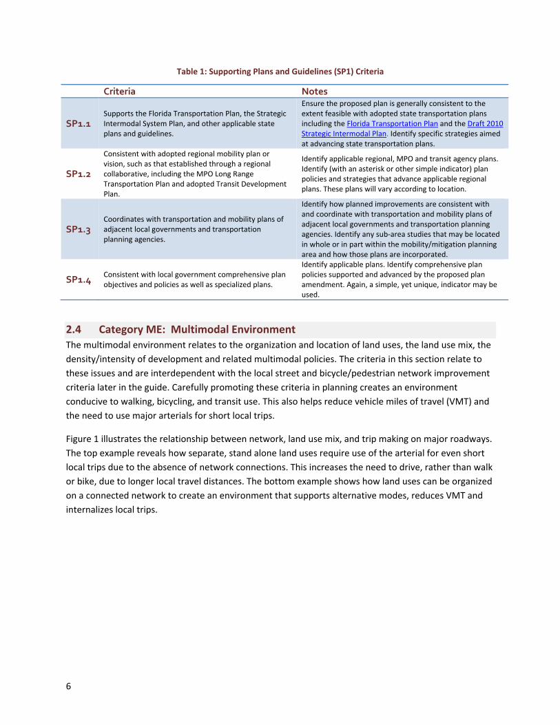
Table 1: Supporting Plans and Guidelines (SP1) Criteria
Criteria Notes
SP1.1 Supports the Florida Transportation Plan, the Strategic Intermodal System Plan, and other applicable state plans and guidelines.
Ensure the proposed plan is generally consistent to the extent feasible with adopted state transportation plans including the Florida Transportation Plan and the Draft 2010 Strategic Intermodal Plan. Identify specific strategies aimed at advancing state transportation plans.
SP1.2
Consistent with adopted regional mobility plan or vision, such as that established through a regional collaborative, including the MPO Long Range Transportation Plan and adopted Transit Development Plan.
Identify applicable regional, MPO and transit agency plans. Identify (with an asterisk or other simple indicator) plan policies and strategies that advance applicable regional plans. These plans will vary according to location.
SP1.3 Coordinates with transportation and mobility plans of adjacent local governments and transportation planning agencies.
Identify how planned improvements are consistent with and coordinate with transportation and mobility plans of adjacent local governments and transportation planning agencies. Identify any sub‐area studies that may be located in whole or in part within the mobility/mitigation planning area and how those plans are incorporated.
SP1.4 Consistent with local government comprehensive plan objectives and policies as well as specialized plans.
Identify applicable plans. Identify comprehensive plan policies supported and advanced by the proposed plan amendment. Again, a simple, yet unique, indicator may be used.
2.4 Category ME: Multimodal Environment
The multimodal environment relates to the organization and location of land uses, the land use mix, the
density/intensity of development and related multimodal policies. The criteria in this section relate to
these issues and are interdependent with the local street and bicycle/pedestrian network improvement
criteria later in the guide. Carefully promoting these criteria in planning creates an environment
conducive to walking, bicycling, and transit use. This also helps reduce vehicle miles of travel (VMT) and
the need to use major arterials for short local trips.
Figure 1 illustrates the relationship between network, land use mix, and trip making on major roadways.
The top example reveals how separate, stand alone land uses require use of the arterial for even short
local trips due to the absence of network connections. This increases the need to drive, rather than walk
or bike, due to longer local travel distances. The bottom example shows how land uses can be organized
on a connected network to create an environment that supports alternative modes, reduces VMT and
internalizes local trips.

A challeng
environm
that may
Context Se
2006) offe
transport
the FDOT
go to Cen
elements
Figu
ge in mobility
ent appropria
have a variet
ensitive Solut
ers an illustra
ation strateg
Transit Orien
ter for Applie
of the multim
ure 1: Land use
y and corridor
ate to the con
y of urban, su
tions in Desig
ated checklist
ies across var
nted Develop
ed Transect St
modal environ
S
e organization,
r managemen
ntext and lev
uburban and
ning Major U
to aid users
rying levels of
ment Guideli
tudies. The fo
nment.
Figure 2:
Source: Duany P
, network conn
nt planning is
el of urbaniza
rural environ
Urban Thoroug
in establishin
f urbanization
nes. For furth
ollowing secti
: Corridor tran
Plater‐Zyberk an
nectivity and a
s how to prom
ation. This is p
nments. The t
ghfares for W
ng appropriate
n (see Figure
her informati
ions provide s
nsect
d Company
arterial traffic
mote a multim
particularly tr
transect conc
Walkable Com
e sets of land
2). This conce
on on the tra
specific detai
modal
rue in countie
ept presente
mmunities (ITE
d use and
ept was appli
ansect approa
ls regarding
7
es
d in
E
ied in
ach

8
2.4.1 Element ME1: Organization and Location
The organization and location of land uses directly affects local and regional mobility and the efficiency
of alternative modes. Focusing non‐residential development into activity centers, rather than in strips
along major roadways, creates destinations that can be more efficiently served by transit. An activity
center may be generally defined as a compact node of
development containing uses and activities which are
supportive of and have a functional relationship with the
social, economic, and institutional needs of the
surrounding area.
Proximity of shopping, services, and employment centers
to each other and to the surrounding residential uses
facilitates walking, bicycling, and transit use and reduces
the number and length of auto trips. This same principle
can be translated on a smaller scale to a neighborhood
level. Neighborhoods that include a greater mix of land uses within reasonable proximity not only have
greater choice of travel alternatives, they also afford residents greater convenience in meeting daily
needs.
Table 2: Multimodal Environment (ME1) Organization and Location Criteria
When activity centers and other major land uses that generate transit ridership are located along
existing transit routes, then route productivity and transit service improves. Conversely, locating such
land uses outside an existing transit service area may result in the need to alter or extend routes leading
CRITERIA NOTES
ME1.1 Designates and reinforces strong urban core(s) and urban activity centers of varying sizes and compositions.
Helps reduce VMT. Plans should focus employment and commercial activities into a strong city/village core also known as a central business district. Larger cities and counties may also have regional activity centers outside of this core. Locate smaller employment centers and commercial/service nodes of varying sizes in proximity to residential neighborhoods.
ME1.2
Transit‐compatible land uses are defined and required to locate on existing or planned transit corridors with direct access to transit. This should include but is not limited to transit‐oriented developments (TOD).
A detailed description of transit compatible land uses is contained in Model Regulations and Plan Amendments for Multimodal Transportation Districts. See also the FDOT Transit Oriented Development Guidelines (draft to‐date, see web for updated version) for detailed guidelines on varying types of TOD depending on context (e.g. urban core, urban general, suburban, rural). The report Mixed Income Housing Near Transit offers strategies for increasing the affordable housing supply as part of transit oriented developments to offset the tendency to cater only to high income markets in these locations.
ME1.3
Ensures that industrial and other freight‐related uses locate in proximity to and have direct access to major transportation routes and intermodal stations or other freight transfer locations.
Proper location and direct access to major transportation routes and/or ports and airports help reduce impacts on the surface street system and improve efficiency of freight movement.
“Transit compatible land use decisions are one way to build transit ridership and ultimately reduce headways, without the risk and uncertainty of major capital outlays. “
‐ FDOT, Impact of Transportation: Transportation and Land Use, 2009

9
to longer headways and less convenient service. Locating large residential subdivisions at the urban
fringe and focusing goods and services onto strips along arterial roadways requires residents to make
more auto trips, longer trips, and focuses these local trips onto the arterial system. These development
patterns preclude transit and walking, increase VMT and increase demand for single occupant vehicle
travel on the arterial system.
2.4.2 Element ME2: Mix
Transit, walking, and bicycling operate more efficiently in communities with a diverse mix of land uses
and services on an interconnected street system (see also NI2). Core areas and urban activity centers
should contain a complementary mix of office, retail, government, residential, entertainment,
restaurants, grocery stores, and related uses that promote activity during peak and non‐peak hours.
Mixing uses vertically in multi‐story buildings encourages walking by providing more activities at the
street level (e.g. office, parking, or residential above retail/service uses, etc.). The goal is a mixed use
environment that attracts people and allows them to walk and interact with their environment outside
of an automobile.
Table 3: Multimodal Environment (ME2) Mix Criteria
CRITERIA NOTES
ME2.1
Provides for a complementary mix of retail, services, residential, institutional, cultural, recreational, and employment opportunities within urban cores and major activity centers.
Guidelines for achieving a complementary land use mix in varying types of activity centers or service nodes are contained in Model Regulations and Plan Amendments for Multimodal Transportation Districts (pp. 18‐20). This criterion also addresses strategies such as workforce housing in proximity to employment. Providing a mix of uses can increase internal capture and reinforce alternative modes. However, these benefits are highly dependent on context and factors such as land use compatibility and network connectivity as indicated in the FDOT Community Capture Methodology.
ME2.2 Provides for a vertical mix of uses within urban cores and major activity centers to encourage active uses at the street level.
To avoid long vacant block fronts, multi‐level parking structures should be required to allow at least 50% of the ground‐floor street frontage, excluding driveway entrances and elevators, to accommodate pedestrian‐oriented uses such as retail or neighborhood services. For example policies and regulations, see Section 9.3 of Model Regulations and Plan Amendments for Multimodal Transportation Districts. This strategy is most appropriate for high‐intensity urban cores and major activity centers.
ME2.3 Provides for compatible food, education, retail and service uses on a neighborhood level within or in close proximity to residential areas.
Strict separation of residential and other uses into large single use areas increases auto dependence. Look for opportunities to integrate service centers within existing single‐use residential neighborhoods.
2.4.3 Element ME3: Density
Future land use plans and zoning ordinances typically establish maximum densities using dwelling units
per acre or floor area ratios (FAR). The resulting densities in Florida cities are often less than the
maximum allowed – particularly in commercial centers or along corridors. Efforts to increase density in

10
these areas are often opposed by neighborhood residents due to concerns over traffic impacts.
Establishing minimum density/intensity policies may be necessary in some areas to achieve appropriate
densities for urban cores and major activity centers. As noted by the Victoria Transport Policy Institute:
“Commercial centers should be medium‐ to high‐density, with multi‐story buildings. Densities of 50
employees or more per gross acre are desirable. ”1
It is essential that efforts to increase density in designated areas be combined with urban design criteria
aimed at ensuring a livable, walkable environment. For example, Miami adopted a citywide form‐based
code in 2009 based on the transect concept (Miami 21) in an effort to better integrate infill and
redevelopment into the existing urban context and enhance the character and livability of urban
neighborhoods.
Table 4: Multimodal Environment (ME3) Density/Intensity Criteria
CRITERIA NOTES
ME3.1 Establishes minimum density/intensity requirements for urban core and major activity center areas.
Future land use plans and zoning regulations typically establish maximum limits on density/intensity, allowing less intensive development. Minimum density/intensity ensures a denser built environment. Some form‐based codes include a combination of minimum and maximum building height and number of stories.
ME3.2 Establishes appropriate densities and intensities within walking distance of transit stops.
Densities needed to support transit in various environments (e.g. urban core, urban general, suburban, rural) are identified in FDOT Transit Oriented Development Guidelines (draft to‐date, see web for updated version).
ME3.4
Establishes urban design criteria for urban cores and major activity centers to preserve or improve livability while increasing densities to support multimodal objectives.
Plans should include policies relative to adoption or refinement of urban design criteria. Urban design standards and/or form based codes enhance the character of activity centers and compatibility of infill development with surrounding land uses.
2.4.4 Element ME4: Multimodal Policy (other)
Improving the multimodal environment in urban cores, activity centers, and along designated corridors
requires a shift in transportation and development policy. Greater emphasis must be placed on
improving the pedestrian and bicycle environment and promoting a diverse, compatible mix of land uses
to support transit service in these areas.
This section assesses the degree to which local governments have enacted the necessary multimodal
transportation and development policies in the comprehensive plan. In addition, it looks at whether
transportation impact assessment procedures have been expanded to address three basic concerns:
can people reach developments conveniently and safely on foot, by public transportation, and by car.
The Florida Department of Transportation has enacted multimodal level of service analysis tools and is
increasingly assessing the ability to serve developments by transit. Further information on these tools is
available at http://www.dot.state.fl.us/planning/systems/sm/los/default.shtm.
1 Victoria Transport Policy Institute, “Strong Commercial Centers,” TDM Online Encyclopedia, January 25, 2010.

11
Table 5: Multimodal Environment (ME4) Multimodal Policy Criteria
CRITERIA NOTES
ME4.1 Establishes priority on enhancing bicycle and pedestrian mobility within existing and proposed activity centers, including urban core areas.
Planners should identify centers with the greatest potential to accommodate alternative modes and focus investment on enhancing the multimodal environment for those centers. Over‐emphasizing auto improvements in these centers works counter to multimodal goals. Policies, regulations and funding mechanisms should reflect the higher priority on enhancing the multimodal environment in these areas.
ME4.2 Includes parking management strategies for urban cores, activity centers and transit corridors to reduce surface area parking and promote walkability.
Large parking lots are generally unattractive and uninviting to pedestrians. In addition, parking lots increase the overall length of a pedestrian trip thereby discouraging walking as an alternative mode. Parking management includes strategies such as parking maximums, shared use parking, increasing capacity of existing parking facilities, remote parking/shuttle services, pricing and other strategies. For more information see Parking Management Best Practices (T. Littman, ©American Planning Association, 2006.)
ME4.3 Provides for, and requires new development to contribute to, pedestrian‐friendly amenities on the public streetscape.
An attractive street environment with trees and other amenities increases the willingness of people to walk to their destination. Examples include benches, lighting, street trees, covered walkways, trash cans, and pedestrian entrances and windows at the street level. For one example, see Policy 12 of Model Regulations and Plan Amendments for Multimodal Transportation
Districts.
ME4.4
Provides for, and requires new development to contribute to, amenities at existing and proposed transit stations including covered shelters, trash receptacles, benches, landing pads, lighting, and bicycle parking.
Transit station amenities can be determinants of transit use. For example, a potential user may be more likely to use transit if the station provides shelter from the sun and rain, is clean and is well lit to increase safety.
ME4.5
Transportation impact assessment procedures are in place that address development impacts on all modes of transportation and minimize vehicular, transit, bicycle, and pedestrian conflicts.
See the multimodal transportation impact assessment (TIA) methodology in the Florida Department of Community Affairs, Transportation Concurrency Best Practices Guide and Montgomery County, Maryland’s Local Area Transportation Review and Policy Area Mobility Review Guidelines for ideas on procedures and requirements for multimodal TIAs.
2.5 Category NI: Network Improvement
This category involves a range of strategies for improving the balance, connectivity, and capacity of the
multimodal transportation network. Balance is considered in relation to the availability of local,
collector, and arterial roadway networks, as well as networks for transit and bicycle/pedestrian travel.
Connectivity is addressed through criteria in each section as a means of improving mobility as well as
system capacity by providing multiple alternative routes.
2.5.1 Element NI1: Major Roadway Network
The criteria in this section address the adequacy of local mobility planning for the major roadway
network. Considerations include whether plans are in place to preserve and manage future rights of way
for major roadway corridors, the availability of relievers and alternate routes, methods to address

12
bottlenecks, and addition of new lanes. Note that in the absence of adequate and connected supporting
networks, the capacity from adding new lanes may be counteracted by excessively long signal cycles and
delay at major intersections. Long signal cycles at intersections indicate a need for other corrective
actions such as grade separations, rerouting left turns or improving the density, and connectivity of the
secondary street system to reduce arterial left‐turn volumes.
Table 6: Network Improvement (NI1) Major Roadway Network Criteria
CRITERIA NOTES
NI1.1 Transportation corridors planned for improvement are designated for preservation and management as provided in §337.273, F.S.
Local governments must designate corridors in their comprehensive plan prior to adopting corridor management ordinances. See Managing Corridor Development: A Municipal Handbook for further information. See also Model Corridor Management Plan Amendments.
NI1.2
Includes transportation corridor management policies to preserve right‐of‐way needed for transportation facilities and provide for dedication of land or conveyance of easements to local governments for transportation improvements as provided in §337.273(6), F.S.
See Corridor Preservation Best Practices for details on how local governments in Florida are preserving and managing transportation right‐of‐way in the context of Florida law. Methods include thoroughfare right‐of‐way needs maps and regulations. Ensure that sufficient right‐of‐way is reserved to accommodate future cross‐section needs for all modes and utilities. See also Model Ordinance for Corridor Protection and Rights of Way.
NI1.3 Provides for construction of parallel relievers or service roads along major highway corridors or within interstate interchange quadrants.
These roads may be established through designation of a corridor and adoption of a corridor management plan as provided in NI1.1&1.2. Parallel relievers or service roads along congested highways tend to attract traffic and may require more than one travel lane in each direction. Service roads within interchange quadrants provide alternative access, while enhancing the ability to accommodate development near interchanges.
NI1.4 Provides for construction of new interstate highway overpass crossings to connect local street networks.
This type of improvement helps maintain local roadway connectivity and relieves congestion at interstate interchanges by providing an alternate route to cross interstate highways.
NI1.5 Includes grade separated intersection improvement(s). This strategy was used on US Highway 19 to recapture system capacity that had been lost due in part to inadequate access management.
NI1.6
Provides for construction of additional travel lanes
and/or turn lanes to address existing or anticipated
traffic volume where appropriate.
Plans should note the location of planned roadway lanes and turn lanes. FDOT access management guidelines for right‐ and left‐turn lanes into driveways are provided in the FDOT Driveway Information Guide. Note that adding new lanes can serve as a barrier to bicycle and pedestrian mobility and should therefore always be evaluated in relations to other modal needs.
NI1.7 Includes new arterial or major collector roadways to relieve traffic congestion and enhance network connectivity.
Many urban areas in Florida lack a balanced network of arterial, collector and local streets. Potential strategies include master street plans with right‐of‐way policies, street network standards, and limiting right‐of‐way vacation and/or requiring replacement of those proposed for abandonment. See also NI2.1.
NI1.8 Includes design elements to enhance bicycle and pedestrian safety and mobility.
This should include safe crossings at roadway intersections and appropriate mid‐block locations. See ITE Designing Walkable Urban Thoroughfares: A Context Sensitive Approach.
13
Figure 3: Corridor network and access management concepts
2.5.2 Element NI2: Local Street Network
Local network density and connectivity is a primary determinant of the quality of the multimodal
environment. People can walk and bike more easily where streets provide relatively short blocks and
multiple connections to shops and services from the surrounding residential areas. Figures 3 and 4
provide network development concepts and strategies for both the major roadway network and the
local neighborhood network. In addition, arterial congestion in many areas of Florida is exacerbated by
sparse and discontinuous supporting local and collector street networks. This element includes criteria
for increasing the connectivity and availability of local and collector street networks and promotes
improved connection of activity centers to surrounding neighborhoods to enhance local mobility and
reduce local trips on major roadways.
Table 7: Network Improvement (NI2) Local Street Network Criteria
CRITERIA NOTES
NI2.1 Includes network‐enhancing local and minor collector street projects.
Such projects are designed to address gaps in the street network, enhance network connectivity, and provide alternate routes to reduce congestion on arterials.
NI2.2 Promotes direct connections between activity centers and surrounding residential areas.
See Section 4.3.1 of the Guide for Analysis of Corridor Management Policies and Practices for sample policies and regulations. The intent is to reduce vehicular trips on major roadways.
NI2.3 Includes policies and strategies to enhance street network connectivity.
Pertinent policies and strategies may include the continuation of existing streets, limits on cul‐de‐sacs, and connectivity indices. See sidebar entitled Network Connectivity Measures for sample connectivity indices. See Section 4.3 of the Guide for Analysis of Corridor Management Policies and Practices for sample street network plans and regulations and Appendix A & B of Implementing Multimodal Transportation Districts: Connectivity, and the FIHS for numerous examples of street network policies and standards across the U.S.

14
CRITERIA NOTES
Network Connectivity Measures
Establishing a connectivity index in the land development code is one method of increasing local
network density and connectivity. The Victoria Transport Policy Institute (www.vtpi.org) provides the
following succinct description of various types of connectivity indices. (Another method, not noted
below is to establish maximum block perimeter standards. An example of this method may be found
in the Alachua County Mobility Plan.)
“A Connectivity Index can be used to quantify how well a roadway network connects destinations.
Indices can be measured separately for motorized and non‐motorized travel. Several methods can be
used:
1. The number of roadway links divided by the number of roadway nodes or intersections (Ewing,
1996). A higher index that travelers have increased route choice, allowing more direct
connections for access between any two locations.
2. The ratio of intersections divided by the sum of intersections and dead ends, expressed on scale
from zero to 1.0 (USEPA, 2002). The closer the index is to 1.0, the more connected the network.
3. The number of surface street intersections within a given area, such as a square mile, a measure
of intersection density. The more intersections, the greater the degree of connectivity.
4. An Accessibility Index as the ratio of direct travel distances to actual travel distances. Well
connected streets result in a high index. Less connected streets with large blocks result in a lower
index.”
The most common connectivity index in Florida is #1 above ‐ the number of links divided by nodes. It
is typically set at a desirable index of 1.4 links to nodes. Another approach is to evaluate “polygons
per square mile” as suggested in the FDOT Multimodal Handbook. The desirable index using this
approach is a system of interconnected and direct routes with a connectivity index of 50 or more
polygons per square mile.
Figure 4: Network connectivity and system capacity
Source: Georgia Regional Transportation Authority DRI Review Checklist Users Guide

15
2.5.3 Element NI3: Bicycle/Pedestrian Network
Creating bicycle/pedestrian‐friendly environments is key to encouraging choice of these modes over the
automobile, particularly for short‐distance trips. Those not using vehicles should be able to circulate
throughout the planning area and access land uses. Bicyclists are capable of traveling greater distances
and may be the preferred non‐motorized mode of travel; however, sidewalks are essential to pedestrian
travel within urban cores and activity centers. Sidewalks, bicycle facilities, and multi‐use trails should be
provided throughout and extended beyond the planning area creating tangible alternative mode
choices.
Table 8: Network Improvement (NI3) Bicycle/Pedestrian Network Criteria
CRITERIA NOTES
NI3.1 Requires bicycle lanes and sidewalks of appropriate width on or near all new or reconstructed major collector and arterial routes where appropriate.
Such policies encourage bicycle use as an alternative mode. The American Association of State Highway and Transportation Officials (AASHTO) developed the Guide for the Development of Bicycle Facilities. In addition, the Florida DOT provides guidance in the Florida Bicycle Facilities Planning and Design Handbook and Florida Pedestrian Facilities Planning and Design Handbook.
NI3.2 Includes planned improvements to address bicycle and pedestrian network connectivity.
Local governments should prepare and adopt a master bicycle and pedestrian plan to support bicycle and pedestrian mobility. Projects should be programmed to address network gaps. Options may include multi‐use paths to provide for bicycle and pedestrian circulation between neighborhoods to reduce need for automobile travel on arterials.
NI3.3 Addresses the continuation of, or establishes new, multi‐use trail(s).
Multi‐use trails that shorten the distance between two uses encourage alternative mode travel in addition to facilitating active recreation.
NI3.4
Requires new development to maintain continuous pedestrian networks, including connections to transit stops, adjacent lots, and between building entrances and the internal and external sidewalk network.
Pedestrian connections should be more convenient/ direct than those provided for vehicles, particularly on
transit corridors or in activity centers. Example policies
may be found in Model Regulations and Plan Amendments for Multimodal Transportation Districts (pp. 11‐13). Additional information may be found at the Pedestrian and Bicycle Information Center. Strategies may also seek commitments from existing development to retrofit or enhance pedestrian infrastructure.
NI3.5
Requires new development to maintain continuous bicycle networks, including connections to transit stops and adjacent properties, and to provide bicycle parking at all non‐residential uses, multi‐family uses and other key destinations.
A complete network and abundant parking encourages bicycle use. Guidance on policies and regulations may be found in Model Regulations and Plan Amendments for Multimodal Transportation Districts (pp. 29‐31). Additional information may be found at the Pedestrian and Bicycle Information Center. Strategies may also seek commitments from existing development to retrofit or enhance bicycle infrastructure.
Bicycle boulevards are another option. These are bicycle priority streets where people can feel safe
bicycling, even if they do not feel comfortable bicycling in traffic on ordinary streets. They are intended
to have low traffic volumes, slow traffic speeds, and clear signage indicating that priority is given to
bicycle traffic. The existing conditions analysis performed as a precursor to developing land use and
transportation strategies to support mobility should include analyses of bicycle and pedestrian facility

16
connectivity. A number of tools have also recently been developed to analyze the quality/level of service of
these facilities.
Local governments are encouraged to develop a bicycle and pedestrian circulation plan and use this as
the basis for their capital improvement program for bicycle/pedestrian infrastructure. Adopting a long‐
term plan will allow the community to prioritize and fund projects in well‐defined increments, rather
than relying on an ad hoc approach. A system approach with a clearly defined plan will also set the stage
for proportionate fair share negotiations and other mitigation actions.
2.5.4 Element NI4: Transit Network
This section addresses improvements to the transit network and is interrelated with Section 3.6.3:
Transit Operations/Safety. The term transit is synonymous with public transportation and mass
transportation. It refers to transportation by bus, rail, or other conveyance, either publicly or privately
owned, providing general or special service to the public on a regular and continuing basis. Transit
includes various modes for air, water, and ground transportation (e.g. air craft, ferries, water taxies, high
speed rail, trolleys/streetcars, light rail, subways, commuter rail, monorail, buses, bus rapid transit,
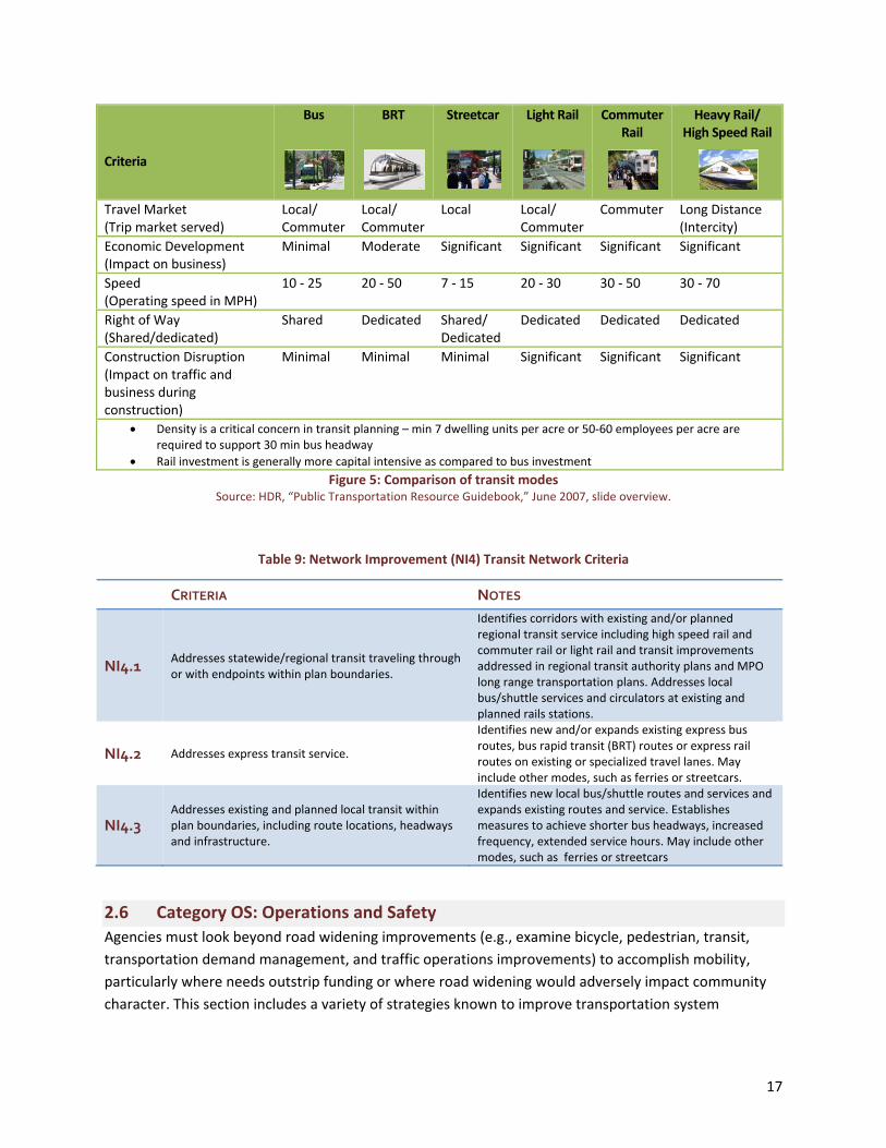
jitneys, van pool services, paratransit services, etc.).2 Figure 5 provides a comparison of transit modes
commonly integrated into mobility plans including bus, bus rapid transit (BRT), streetcar, light rail,
commuter rail, and heavy, high speed rail. Each type of transit is assessed regarding travel market,
economic development impact, speed, right of way, and construction disruption.
Rail transit provides a sense of permanency for its riders as well as for real estate developers. The
construction of transit rails and supporting stations anchors transit service within a community.
Supporting land development regulations establish an environment for new development to occur near
the stations. Bus transit is important for mobility, but may have less impact on land development.
Developers tend to be less aggressive in developing along bus routes given that service could move from
that location due to changing ridership or budget demands.
In Florida, transit network improvements may not be fully addressed in local government
comprehensive plans or MPO long range transportation plans. Detailed plans may be found in regional
transportation/transit authority plans or local transit development plans and transportation
disadvantaged service plans. Any transit system improvements appearing in such plans should be a part
of mobility or mitigation plans. Users are referred to theDistrict 5 Public Transportation Resource
Guidebook for further information. Additional resources for transit planning are available at:
National Center for Transit Research, http://www.nctr.usf.edu
National Bus Rapid Transit Institute, http://www.nbrti.org
2 HDR, “Public Transportation Resource Guidebook,” June 2007, slide overview. http://www.cfgis.org/trafficdata/files/Resource/D5_Public_Transportation_Resource_Guidebook.pdf
17
Criteria
Bus
BRT
Streetcar
Light Rail
Commuter Rail
Heavy Rail/ High Speed Rail
Travel Market (Trip market served)
Local/ Commuter
Local/Commuter
Local Local/Commuter
Commuter Long Distance (Intercity)
Economic Development (Impact on business)
Minimal Moderate Significant Significant Significant Significant
Speed (Operating speed in MPH)
10 ‐ 25 20 ‐ 50 7 ‐ 15 20 ‐ 30 30 ‐ 50 30 ‐ 70
Right of Way (Shared/dedicated)
Shared Dedicated Shared/Dedicated
Dedicated Dedicated Dedicated
Construction Disruption (Impact on traffic and business during construction)
Minimal Minimal Minimal Significant Significant Significant
Density is a critical concern in transit planning – min 7 dwelling units per acre or 50‐60 employees per acre are required to support 30 min bus headway
Rail investment is generally more capital intensive as compared to bus investment
Figure 5: Comparison of transit modes Source: HDR, “Public Transportation Resource Guidebook,” June 2007, slide overview.
Table 9: Network Improvement (NI4) Transit Network Criteria
CRITERIA NOTES
NI4.1 Addresses statewide/regional transit traveling through or with endpoints within plan boundaries.
Identifies corridors with existing and/or planned regional transit service including high speed rail and commuter rail or light rail and transit improvements addressed in regional transit authority plans and MPO long range transportation plans. Addresses local bus/shuttle services and circulators at existing and planned rails stations.
NI4.2 Addresses express transit service.
Identifies new and/or expands existing express bus routes, bus rapid transit (BRT) routes or express rail routes on existing or specialized travel lanes. May include other modes, such as ferries or streetcars.
NI4.3 Addresses existing and planned local transit within plan boundaries, including route locations, headways and infrastructure.
Identifies new local bus/shuttle routes and services and expands existing routes and service. Establishes measures to achieve shorter bus headways, increased frequency, extended service hours. May include other modes, such as ferries or streetcars
2.6 Category OS: Operations and Safety
Agencies must look beyond road widening improvements (e.g., examine bicycle, pedestrian, transit,
transportation demand management, and traffic operations improvements) to accomplish mobility,
particularly where needs outstrip funding or where road widening would adversely impact community
character. This section includes a variety of strategies known to improve transportation system
18
operations and safety. The strategies are organized in relation to transportation demand management,
roadway access management, transit, and bicycle/pedestrian strategies.
This section also acknowledges the importance of estimating the potential effectiveness of mobility
planning efforts (OS1.1). Current measures of service levels include quality of service (QOS) and level of
service (LOS). QOS is measured using traveler perception of facility operation while LOS is measured
quantitatively using volume to capacity ratios. The 2009 FDOT Quality/Level of Service (QLOS) Handbook
“provides tools to quantify multimodal transportation service inside the roadway environment
(essentially inside the right‐of‐way).”3 These tools measure the QLOS of each mode but do not measure
the diversion of trips from one mode to another. Travel demand modeling for future years may be
performed using the Florida Standard Urban Transportation Model Structure (FSUTMS).
Another tool for estimating plan effectiveness is TRIMMS© ‐ a spreadsheet application that estimates
the impacts of a broad range of transportation demand management (TDM) initiatives in terms of
emission reduction, accident reduction, congestion reduction, excess fuel consumption, and adverse
global climate change impacts. The model also assesses program cost‐effectiveness in relation to
Federal Highway Administration Congestion and Air Quality (CMAQ) Improvement Program
requirements for program effectiveness assessment and benchmarking. The TRIMMS© model and
supporting guidance are available at http://www.nctr.usf.edu/abstracts/abs77805.htm.
2.6.1 Element OS1: Demand Management
Transportation demand management (TDM) strategies are designed to maximize use of the
transportation system by providing travelers with effective choices to improve overall travel reliability.
TDM consists of strategies that foster increased efficiency of the transportation system by influencing
travel behavior by mode, time of day, frequency, trip length, regulation, route, or cost. TDM
discourages drive‐alone travel through better management of existing transportation infrastructure,
services and resources. TDM strategies include public transit services, carpooling and vanpooling,
compressed work weeks, telecommuting, limited parking, and provision of bike and locker facilities by
employers. Another component of TDM is the intelligent transportation system (ITS) that addresses
incident management and traveler information to ensure that travelers can minimize delay by choosing
alternative routes when necessary.
Effective transportation demand management involves selecting the right set of complementary
strategies based on analysis of local conditions. Detailed information about TDM strategies and existing
programs can be found at the National TDM and Telework Clearinghouse and the Victoria Policy
Institute Online TDM Encyclopedia.
3 “2009 Quality/Level of Service (QLOS) Handbook,” Florida Department of Transportation, 2009. Web. 03 Feb. 2010.

19
“Access management is the systematic
control of the location, spacing, design, and
operation of driveways, median openings,
interchanges, and street connections to a
roadway. It also involves roadway design
applications, such as median treatments
and auxiliary lanes, and the appropriate
spacing of traffic signals. “
‐TRB Access Management Manual, 2003
Table 10: Operations and Safety (OS1) Demand Management Criteria
2.6.2 Element OS2: Access Management
Limiting access along major roadway corridors
reduces traffic conflicts and interruptions in traffic
flow, while improving safety for drivers, pedestrians,
and bicyclists. This section addresses policies and
strategies that local governments can apply to
advance access management objectives for major
roadways and around freeway interchanges. Other
access management strategies are included in the
Network Improvement category.
Local governments should assess existing access
characteristics on state highway corridors in the
CRITERIA NOTES
OS1.1 Establishes viable mobility options for congested corridors.
Quality/level of service should be evaluated using the 2009 FDOT Quality/Level of Service (QLOS) Handbook. Travel demand modeling is performed using FSUTMS. This model should be used through the appropriate metropolitan planning organization or a professional consultant. Mobility options may include alternative forms of travel such as bus rapid transit or alternative travel routes.
OS1.2 Provides operational strategies including intelligent transportation systems (ITS).
ITS strategies include a wide range of tools for managing traffic and providing services for travelers including signal coordination systems, commercial vehicle operations, advanced public transportation systems, advanced traffic management systems, advanced traveler information systems, advanced crash avoidance systems, automatic vehicle location, machine vision, and electronic toll, congestion pricing and traffic management systems.
OS1.3 Establishes institutional strategies.
These may include, but are not limited to, transportation management organizations (TMOs) and TDM programs or policies (e.g. carsharing, ridesharing, vanpooling, telecommuting, and/or compressed work week/non‐peak hour work hours).
OS1.4 Establishes commuter financial incentives. These may include, but are not limited to, parking cash out, travel allowance, or transit and rideshare benefits.
OS1.5 Provides infrastructure designed to encourage alternatives to single occupant vehicle travel.
Includes high‐occupancy vehicle (HOV) facilities, special use lanes, park‐and‐ride facilities, and access control (vehicle‐free zones). This may include improved transit facilities, including operation of transit on hard shoulder or bus rapid transit (BRT) lanes (see also OS3.2).
OS1.6 Establishes pricing strategies. This may include congestion pricing measures (e.g., variably priced lanes, variable tolls, cordon charges, and area‐wide charges).
20
planning area in relation to the FDOT access classification and spacing standards. Personal interviews
with FDOT District planning and access permitting staff are also suggested to obtain a clear picture of
the challenges and opportunities for managing development and access on planning area corridors. See
Guide for Analysis of Corridor Management Policies and Practices for details on assessing and upgrading
local corridor management policies and practices. Additional resources are available at the TRB Access
Management Committee Website.
Table 11: Operations and Safety (OS2) Access Management Criteria
CRITERIA NOTES
OS2.1 Includes policies and strategies to provide alternative access to development on arterial roadways.
Examples include service roads, parking lot cross access, joint driveways, unified access and circulation plans, outparcel regulations, lot split controls and overlay requirements. See Model Land Development and Subdivision Regulations that Support Access Management for sample local regulations and policies for alternative access. Promote connection of as many properties and interests as possible to traffic signals via internal cross access or service roads.
OS2.2 Includes policies and strategies to close existing excessive or unsafe driveway connections or narrow overly‐wide connections.
For sample policy language, see Section 13 of Model Land Development and Subdivision Regulations that Support Access Management.
OS2.3 Includes policies and strategies to replace continuous two‐way left turn lanes with medians on multi‐lane arterials.
Medians improve safety by organizing the left turn movement and reducing traffic conflicts. See the FDOT Median Handbook for further information on the safety implications of medians versus TWLTLs and for FDOT’s median policy in Section 2.2.2.
OS2.4 Requires conformance of new signals with signal coordination plans and FDOT signal spacing standards for the state highway system.
Poor signal location and placement creates traffic congestion that cannot be solved by signal coordination systems. The goal of signal spacing is to limit signals to locations where the progressive movement of traffic will not be impeded and to maintain the “window” for traffic progression at desired speeds.
OS2.5 Restricts access in the functional area of highway interchanges.
Signalized intersections too close to ramp termini can cause heavy volumes of weaving traffic, complex traffic signal operations, accidents, congestion, and traffic backing up the ramps on to the main line. Curb cuts and median openings near the ramp termini further compound these problems. See Land Development and Access Management Strategies for Florida Interchange Areas and Access Management on Crossroads in the Vicinity of Interchanges for policies and strategies.
OS2.6 Restricts access in the functional area of roadway intersections.
Driveways too close to street intersections create a variety of safety and operational problems. Strategies include requiring access at the edge of property lines and promoting shared/cross access with adjacent sites.
OS2.7 Requires adequate, uninterrupted throat length for driveways and frontage roads that connect to arterial roadways.
Inadequate throat length produces a complex pattern of closely spaced conflicts, causing high collision potential and low capacity. See Chapter 6 of the FDOT Driveway Information Guide.
OS2.8 Includes measures to close unsafe, overly‐wide, and/or excessive median openings.
Directional median openings have far fewer conflicts and much lower crash potential than full movement median openings. See the FDOT Median Handbook for guidance and strategies.
21
2.6.3 Element OS3: Transit Operations/Safety
Many of the network improvement strategies addressed in Category NI and access management
strategies addressed in OS2 also help to ensure a safe and efficient transit system. Additional strategies
not noted elsewhere are included in those sections of the checklist. In addition, a number of resource
manuals and guidelines have been developed in Florida to guide the integration of design features that
enhance pedestrian, bicycle and transit circulation within a development, as suggested in OS3.2. Some
incorporate the specific requirements of the local jurisdictions while others are more generic and
applicable to a broader region. Below are several examples of available guidelines:
FDOT District 4 Transit Facilities Guidelines Link: http://www.dot.state.fl.us/transit/Pages/UpdatedD4TransitFacilitiesGuidelines.pdf
LYNX Central Florida Mobility Design Manual Link http://www.golynx.com/assets/userfiles/media/pdf/lynxdocs_mobility_manual.pdf
LYNX Central Florida Customer Amenities Manual
Link: http://www.golynx.com/assets/userfiles/media/pdf/lynxdocs_Amenities_Manual.pdf
Palm Tran Transit Design Manual Link: http://www.pbcgov.com/palmtran/library
Accessing Transit Design Handbook for Florida Bus Passenger Facilities Link: http://www.dot.state.fl.us/transit/Pages/AccessingTransitHandbookLow.pdf
Jacksonville Transportation Authority Mobility Access Program Handbook Link: http://www.jtafla.com/Business/showPage.aspx?Sel=63
FDOT District 1 and 7 Transit Facility Handbook Link: http://www.dot.state.fl.us/transit/Pages/FDOT_D1_D7_Transit_Facility_Handbook.pdf
Table 12: Operations and Safety (OS3) Transit Operations/Safety Criteria
CRITERIA NOTES
OS3.1 Provides for transit signal priority and/or queue jumpers.
Reduces delay and improves reliability. A queue jumper is an additional travel lane restricted to transit on the approach to a signalized intersection accompanied by a brief signal phase that allows buses to cut to the front of the queue. High volume systems may require grade separated intersections.
OS3.2 Provides for exclusive transit lanes. Ensures timeliness of bus travel on congested corridors.
OS3.3 Provides for availability of transit service outside of peak travel hours.
Transit availability outside of peak commuting periods offers the user the option to be transit dependent.
OS3.4
Requires major office, retail, or mixed‐use developments to provide appropriate transit‐supportive facilities and services (i.e., such as on‐site bus shelter, park and ride, bus or shuttle service).
Such policies and regulations ensure that new development contributes toward multimodal improvements that increase rider safety and convenience and encourage transit use.

22
2.6.4 Element OS4: Pedestrian/Bicycle Operations/Safety
The operation and safety of transportation facilities should be address in mobility and mitigation plans.
Pedestrian safety is of great concern, particularly in Florida where pedestrian‐related crashes are
among the highest in the nation. While a continuous pedestrian network (previously addressed in this
Guide) is important to safety, safe roadway crossing are essential. The Florida DOT provides guidance
in the Florida Pedestrian Facilities Planning and Design Handbook. Florida has taken additional
precautions to provide safe pedestrian travel to schools through its Safe Routes to School Program.
Another resource is A Technical Guide for Conducting Pedestrian Safety Assessments from the
University of California Berkeley. Safe and pedestrian‐oriented intersections encourage pedestrian
usage of sidewalks along roadway corridors. Bicycle safety is impacted by obstructions within the
roadway. Guidance for safe bicycle facilities is found in the Florida Bicycle Facilities Planning and
Design Handbook.
Table 13: Operations and Safety (OS4) Pedestrian/Bicycle Operations/Safety Criteria
CRITERIA NOTES
OS4.1 Includes improvements and measures to increase pedestrian safety at intersections and mid‐block crossings.
Identifies high crash locations for pedestrians and addresses these proactively, while increasing overall pedestrian safety through improvements such as marked roadway crossings, curb extensions, median refuges, raised crosswalks, and pedestrian actuation devices. Provides for mid‐block pedestrian crossings where block lengths are long and pedestrian volumes are high. Gives special consideration to pedestrian safety in areas with concentrations of students, seniors, low‐income families, or persons with disabilities. May also include traffic calming measures.
OS4.2 Includes improvements and measures to increase bicycle safety.
Identifies high crash locations for bicyclists and addresses these proactively, while increasing overall bicycle safety through improvements to existing bicycle lanes, new bicycle lanes, signing and pavement striping enhancements, improvements at crossings and off road facilities. May include bicycle safety education or similar measures to increase public awareness.
OS4.3 Includes improvements and measures to provide safe routes to schools.
The FDOT Safe Routes to School Program suggests a number of measures that may be appropriate. http://www.dot.state.fl.us/Safety/SRTS_files/SRTS.shtm
2.7 Category IM: Implementation
The best laid plans are of little value unless they are implemented. Implementation strategies specific to
a given element are addressed throughout the user guide and checklist. This section addresses whether
the basic funding and implementation strategies are in place.

23
2.7.1 Element IM1: Coordination
It is in the interest of local governments, FDOT, and other transportation agencies to support mobility
and recognize that transportation facilities and impacts on those facilities do not end at jurisdictional
boundaries. Building relationships and partnerships among agencies and regular communication create
an environment where agencies can work together to meet mobility needs. In the absence of such
efforts, the separation of planning functions and compartmentalized funding will impede the ability to
achieve lasting mobility solutions. Therefore, the importance of this element cannot be overstated.
Table 14: Implementation (IM1) Intergovernmental Coordination Criteria
CRITERIA NOTES
IM1.1
Includes strategies to forge partnerships and effectively coordinate with modal providers, state and regional agencies, and other local governments in mobility planning and project development.
Describe strategies, specific agencies affected and their involvement in planning and project development. Identify specific strategies for coordination with FDOT in access management and permitting. See “Build and Maintain Relationships” in LOS Issue Paper #13 – Documenting Improvement Mobility Techniques on SIS and TRIP Facilities.
IM1.2 Includes policies and strategies for coordinating with FDOT in access management and permitting on the state highway system.
See Intergovernmental Coordination in Access Management for a review of issues and strategies relative to FDOT/local coordination in access management and permitting. See also Effective Strategies for Comprehensive Corridor Management.
This user guide and review checklist can help promote improved intergovernmental coordination by
pointing state and local government agencies in a common planning direction. Early guidance to local
governments from the FDOT District on state highway corridor conditions is another useful step toward
improved coordination in mobility/mitigation planning and transportation corridor management. Below
are a few coordination strategies that may be considered (see also A New Vision of Mobility: Guidance
to Foster Collaborative Multimodal Decision Making).
1. Host a mobility management workshop with area agencies and jurisdictions. The workshop would
provide an opportunity for the District to engage area jurisdictions and modal agencies in a dialogue
on mobility conditions relative to the SIS and other state highway corridors and potential strategies
for addressing those conditions. Such a workshop would be a logical first step to preparing a state
of the system report and identifying possible strategic areas for improvement.4
2. Perform a “state of the system” review for each jurisdiction within the District. The review would
determine existing and anticipated deficiencies on SIS, FIHS, and TRIP‐funded facilities and other
major roadways based on anticipated traffic growth, approved development trips, adopted QLOS
standards, and committed improvements. Participants could identify strategic areas for additional
improvements including multimodal alternatives to new roadway capacity for addressing
anticipated deficiencies. A summary report of the review would 1) identify potential multimodal
strategies for further exploration; 2) identify corridors that would benefit from a corridor
management and/or mitigation plan; and/or 3) set forth informal guidelines for development of
4 K. Seggerman, et al., “Documenting Improved Mobility Techniques on SIS and TRIP Facilities,” FDOT LOS Issue Paper 13, CUTR, 2007, p. 49.
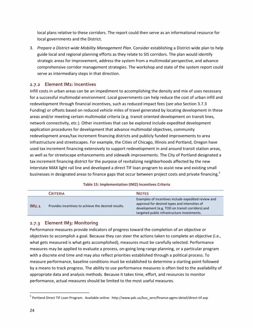
24
local plans relative to these corridors. The report could then serve as an informational resource for
local governments and the District.
3. Prepare a District‐wide Mobility Management Plan. Consider establishing a District‐wide plan to help
guide local and regional planning efforts as they relate to SIS corridors. The plan would identify
strategic areas for improvement, address the system from a multimodal perspective, and advance
comprehensive corridor management strategies. The workshop and state of the system report could
serve as intermediary steps in that direction.
2.7.2 Element IM2: Incentives
Infill costs in urban areas can be an impediment to accomplishing the density and mix of uses necessary
for a successful multimodal environment. Local governments can help reduce the cost of urban infill and
redevelopment through financial incentives, such as reduced impact fees (see also Section 3.7.3
Funding) or offsets based on reduced vehicle miles of travel generated by locating development in these
areas and/or meeting certain multimodal criteria (e.g. transit oriented development on transit lines,
network connectivity, etc.). Other incentives that can be explored include expedited development
application procedures for development that advance multimodal objectives, community
redevelopment areas/tax increment financing districts and publicly funded improvements to area
infrastructure and streetscapes. For example, the Cities of Chicago, Illinois and Portland, Oregon have
used tax increment financing extensively to support redevelopment in and around transit station areas,
as well as for streetscape enhancements and sidewalk improvements. The City of Portland designated a
tax increment financing district for the purpose of revitalizing neighborhoods affected by the new
Interstate MAX light rail line and developed a direct TIF loan program to assist new and existing small
businesses in designated areas to finance gaps that occur between project costs and private financing.5
Table 15: Implementation (IM2) Incentives Criteria
CRITERIA NOTES
IM2.1 Provides incentives to achieve the desired results.
Examples of incentives include expedited review and approval for desired types and intensities of development (e.g. TOD on transit corridors) and targeted public infrastructure investments.
2.7.3 Element IM3: Monitoring
Performance measures provide indicators of progress toward the completion of an objective or
objectives to accomplish a goal. Because they can steer the actions taken to complete an objective (i.e.,
what gets measured is what gets accomplished), measures must be carefully selected. Performance
measures may be applied to evaluate a process, on‐going long‐range planning, or a particular program
with a discrete end time and may also reflect priorities established through a political process. To
measure performance, baseline conditions must be established to determine a starting point followed
by a means to track progress. The ability to use performance measures is often tied to the availability of
appropriate data and analysis methods. Because it takes time, effort, and resources to monitor
performance, actual measures should be limited to the most useful measures.
5 Portland Direct TIF Loan Program. Available online: http://www.pdc.us/bus_serv/finance‐pgms‐detail/direct‐tif.asp

25
Table 16: Implementation (IM3) Monitoring Criteria
CRITERIA NOTES
IM3.1 Includes policies for adoption of regulations, including design criteria, into appropriate land development regulations by a specified date.
A specific policy (not to exceed two years) should be established for implementing regulations.
IM3.2 Includes a performance measurement system. For example, plan amendments should specify QLOS for both vehicular and non‐vehicular modes as well as non‐SOV mode share/split goals.
2.7.4 Element IM4: Funding
Perhaps the most crucial implementation element is funding. Because local governments must develop
transportation and land strategies to support and fund mobility, it follows that funding should be
addressed. Funding should be appropriately addressed in a financially feasible capital improvement
element (CIE). Local governments and FDOT reviewers should obtain specific guidance on funding and
related CIE requirements from DCA.
The scarcity of transportation funding in Florida has resulted in the use of a variety of funding
mechanisms to fund transportation systems strategies and improvements. They include:
Motor Fuel Tax Options
Federal Gas Tax
State Gas Tax
Constitutional Gas Tax
County Gas Tax
1st Local Option Gas Tax
2nd Local Option Gas Tax
Ninth Cent Motor Fuel Tax
Other Tax Options
Local Government Infrastructure Surtax
Local Option Sales Tax
Ad Valorem Tax
Municipal Services Benefit District (MSBU)
Municipal Services Taxing Unit (MSTU)
Other Options
Tolls
Public/Private Partnerships
Transportation Regional Incentive Program (TRIP): The TRIP provides matching funds for
regionally significant facilities (Section 339.2819, F.S.) included in regional transportation plans.
To qualify, the facilities must be developed within regional transportation areas established by
interlocal agreement (Section 339.155[5], F.S.) and subsequently included in participating local
government comprehensive plans. Eligible projects must support transportation facilities that
serve national, statewide, or regional functions, be included in the capital improvements
element, be consistent with the SIS goals, and have a commitment for local, regional, or private
matching funds. Priority will be given to projects that, among other things, provide connectivity
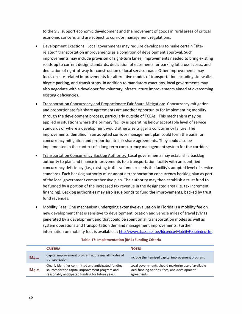
26
to the SIS, support economic development and the movement of goods in rural areas of critical
economic concern, and are subject to corridor management regulations.
Development Exactions: Local governments may require developers to make certain “site‐
related” transportation improvements as a condition of development approval. Such
improvements may include provision of right‐turn lanes, improvements needed to bring existing
roads up to current design standards, dedication of easements for parking lot cross access, and
dedication of right‐of‐way for construction of local service roads. Other improvements may
focus on site‐related improvements for alternative modes of transportation including sidewalks,
bicycle parking, and transit stops. In addition to mandatory exactions, local governments may
also negotiate with a developer for voluntary infrastructure improvements aimed at overcoming
existing deficiencies.
Transportation Concurrency and Proportionate Fair Share Mitigation: Concurrency mitigation
and proportionate fair share agreements are another opportunity for implementing mobility
through the development process, particularly outside of TCEAs. This mechanism may be
applied in situations where the primary facility is operating below acceptable level of service
standards or where a development would otherwise trigger a concurrency failure. The
improvements identified in an adopted corridor management plan could form the basis for
concurrency mitigation and proportionate fair share agreements. They could also be
implemented in the context of a long term concurrency management system for the corridor.
Transportation Concurrency Backlog Authority: Local governments may establish a backlog
authority to plan and finance improvements to a transportation facility with an identified
concurrency deficiency (i.e., existing traffic volume exceeds the facility’s adopted level of service
standard). Each backlog authority must adopt a transportation concurrency backlog plan as part
of the local government comprehensive plan. The authority may then establish a trust fund to
be funded by a portion of the increased tax revenue in the designated area (i.e. tax increment
financing). Backlog authorities may also issue bonds to fund the improvements, backed by trust
fund revenues.
Mobility Fees: One mechanism undergoing extensive evaluation in Florida is a mobility fee on
new development that is sensitive to development location and vehicle miles of travel (VMT)
generated by a development and that could be spent on all transportation modes as well as
system operations and transportation demand management improvements. Further
information on mobility fees is available at http://www.dca.state.fl.us/fdcp/dcp/MobilityFees/index.cfm.
Table 17: Implementation (IM4) Funding Criteria
CRITERIA NOTES
IM4.1 Capital improvement program addresses all modes of transportation.
Include the itemized capital improvement program.
IM4.2 Clearly identifies committed and anticipated funding sources for the capital improvement program and reasonably anticipated funding for future years.
Local governments should maximize use of available local funding options, fees, and development agreements.

27
3 Summarize and Apply Findings Upon initial completion of the checklist, the FDOT reviewer will have an understanding of the relative
strengths and potential shortcomings of the comprehensive plan amendment as it relates to the
transportation system. As noted in Section 2.1, it is also suggested that local governments be advised to
complete a self review and provide this along with their CPA submittal for FDOT staff review. FDOT staff
are strongly encouraged to discuss the results of their review with the appropriate local government
contact prior to completing the final staff report. This will ensure accuracy of the assessment and offer
opportunities to identify additional strategies that may be beneficial.
3.1 Complete Staff Report
Using the results of the checklist, the FDOT or other agency reviewers may identify the need for specific
strategies to be more clearly defined or the need for additional planning measures. District staff should
meet with the appropriate local government representatives and/or share their checklist results in
advance of completing the staff report to identify concerns relative to specific categories, elements or
strategies. Reviewers should identify perceived deficiencies of the plan based on the checklist and ask
local governments to revise the plan amendment, SIS mitigation, or corridor plan with a strengthened
approach as to how specific elements will be accomplished. Resources and technical assistance for
accomplishing these improvement measures should be identified or provided. The FDOT reviewer
should also work with the submitting local government and other agencies to lend support in
implementation of the plan. Support may include technical support, expedited programming of state
funded projects, and other appropriate incentives.
3.2 A Final Word on the Guide and Checklist
This report represents a proposed practice for use by FDOT and other reviewing agencies in the review
of proposed land use and transportation strategies to support and fund mobility submitted through the
CPA review process as they relate to the function of the state transportation system. The guide and
checklist may also be used in the review of proposed SIS mitigation plans or corridor management plans
for major highway corridors. This practice is not an official policy, procedure. It is suggested as a
technical assistance tool for use by FDOT reviewers and local governments.

28
29
Appendix A: FDOT’s Role in Growth Management FDOT’s role in growth management has evolved considerably over the past decade and continues to
evolve. This section reviews key aspects of that role and emerging considerations to help guide state
and local coordination in advancing land use and transportation strategies to support and fund mobility.
2005 Growth Management Legislation
In 2005, amendments to Florida’s growth management legislation elevated the role of FDOT in
development review and impact mitigation on the Strategic Intermodal System (SIS), the Florida
Intrastate Highway System (FIHS), and facilities funded through the Transportation Regional Incentive
Program (TRIP).
FDOT was given a direct role in reviewing local government concurrency management,
proportionate fair share, and proportionate share development agreements for mitigation of
impacts on these facilities.
Where impacts of proposed developments would cause a facility to fall below the level of
service established by Rule 14‐94, F.A.C., plans must be developed by local governments in
cooperation with FDOT to mitigate those impacts.
FDOT concurrence was needed on mitigation plans and proportionate fair share mitigation on
the SIS.
The need for local government mitigation plans for these important corridors has historically arisen in
the context of the following situations:
1. Local governments proposing new or applying existing transportation concurrency alternatives6
that are projected to cause a level of service (LOS) deficiency on the SIS, FIHS, or TRIP‐funded
facilities.
2. Local government future land use plans or comprehensive plan amendments (other than those
noted in item 1 above) that are projected to cause an LOS deficiency on the SIS, FIHS, or TRIP‐
funded facilities.
3. Any development impacting the SIS or other state highway in the local government’s jurisdiction
that is not operating at the required level of service (backlogged) and cannot reasonably be
widened or improved to address the deficiency.
Mechanisms for local government mitigation plans in this context included level of service variance
requests, long term concurrency management system plans, multimodal transportation districts,
transportation concurrency exception area plans and proportionate fair share agreements. These
mechanisms and requirements for local government mitigation planning for the SIS are no longer
required in statutorily designated dense urban land areas or DULAs established by the 2009 Community
Renewal Act. However, FDOT encourages partnerships with local governments in DULA areas in
6 These alternatives include: transportation concurrency exception areas (TCEAs), transportation concurrency management areas (TCMAs), or multimodal transportation districts (MMTDs).

30
identifying and prioritizing SIS mobility enhancements. The requirements continue to be applicable
outside of DULA areas and are described in Section A5 below.
2008 Legislation to Reduce Greenhouse Gases
In 2008, additional legislation was enacted relative to reduction of greenhouse gas (GhG) emissions and
energy‐efficient land use that has implications for transportation plans and comprehensive plan
amendments submitted for state review by local governments. HB 697 required local governments to
achieve more energy‐efficient land use patterns in their comprehensive plans and to enact
transportation strategies to address GhG reductions. HB 7135 imposed similar requirements relative to
GhG reductions on metropolitan planning organizations in long range transportation planning.
Transportation elements of local comprehensive plans will need to be amended to address these
requirements. The Florida Department of Community Affairs (DCA) is working on revisions to Rule 9J‐5
to provide guidance to local governments on achieving GhG reductions and energy efficient land use
patterns. DCA has provided the following additional guidance:7
Future land use map amendments must be supported by data and analysis relating to urban
sprawl, energy efficient land use patterns and greenhouse gas reduction strategies.
Future land use element text amendments with significant potential to impact development
patterns must comply with the new data and analysis requirements.
Major textual amendments to transportation/traffic elements and large future land use map
amendments must address new greenhouse gas reduction requirements.
These new local comprehensive planning and metropolitan long range transportation planning
requirements reinforce the need to implement land use and transportation strategies that reduce
vehicle miles of travel, improve system operations, increase multimodal options, promote compact and
mixed use development and thereby, reduce GhG emissions and improve energy efficiency.
2009 Community Renewal Act
In June 2009, the Community Renewal Act changed FDOT’s role in growth management in urban areas
of the state. The provisions designated local governments meeting certain population density criteria as
“dense urban land areas” (DULAs) and exempted these areas from transportation concurrency
requirements with the intent of reinforcing compact urban growth.8 The requirement for local
governments to adopt and maintain state level of service standards for the Strategic Intermodal System
(SIS) was also suspended in these areas, as was the development of regional impact process.
Specifically, the DRI requirements are no longer applicable in the following:
DULA municipalities,
Urban service areas of DULA counties, and
7 Tom Pelham, “The Role of Local Land Use and Transportation Planning in Reducing GhG,”Florida Department of Community Affairs, http://www.dca.state.fl.us/fdcp/DCP/Legislation/2008/Files/LocalLandUseGHGPresentation.pdf. 8 Section 163.3180 (5) a.4, F.S.

31
Counties with a population of at least 900,000 persons qualifying as DULAs, but having no urban service area.
In addition, a qualified job creation project outside of a DULA may be exempted from SIS level of service
standards by a local government if the Office of Tourism, Trade and Economic Development (OTTED)
concurs in writing that the proposed development is a qualified job creation project pursuant to the
Rural Economic Development Initiative (REDI) or the expedited permitting process. OTTED is first
required to consult with FDOT on the designation.
Within two years after the designated DULAs become exempt from transportation concurrency, 9 local
governments must adopt into their local comprehensive plan land use and transportation strategies to
support and fund mobility within the exception area, including alternative modes of transportation.
These strategies are sometimes referred to as local government mobility plans. The legislation further
encouraged local governments to adopt complementary land use and transportation strategies that
reflect the region's shared vision for its future. In anticipation of these provisions, many local
governments in the designated DULAs have initiated planning efforts to develop the required land use
and transportation strategies to support and fund mobility.
Summary of FDOT’s Growth Management Role
In summary, although FDOT had a direct role in review and approval of mitigation plans for SIS impacts
during the comprehensive plan review process under the 2005 growth management legislation, FDOT’s
growth management role is now less formal in designated dense urban land areas of Florida. The
current role of FDOT staff in review of proposed local government land use and transportation strategies
to support and fund mobility may be broadly categorized as follows: 10
1. As a review agency, FDOT will continue to review comprehensive plans, comprehensive plan
amendments, comprehensive planning evaluation and appraisal reports (EARs) and EAR‐based
comprehensive plan amendments for impacts to the state transportation system. Review
comments are submitted to DCA.
2. Within TCEAs, the focus of that review is on local land use and transportation strategies to
support and fund mobility, including alternative modes.
a) Through this review process, FDOT should ensure that the proposed land use and
transportation strategies to support and fund mobility serve to maintain mobility on the
SIS and other parts of the state transportation system while remaining sensitive to local
9 The Florida Department of Community Affairs has provided guidance relative to this requirement in a Notice to
Local Governments of Transportation Planning Options Under Senate Bill 360 For Transportation Concurrency
Exception Areas in Dense Urban Land Areas available on the Department’s website ‐
http://www.dca.state.fl.us/fdcp/dcp/Legislation/2009/Notice.cfm.
10 Maria Cahill, FDOT Office of Policy Planning, “DULAs and Implications for Transportation Concurrency/DRIs,” Florida ITE Winter Workshop, February 10, 2010, Orlando, Florida.
32
multimodal and livability objectives and funding availability. This may include concerns
related to operations, safety and access to state roads.
b) FDOT’s review within DULA‐based TCEAs should also be based upon the adopted
comprehensive plan in effect at the time of the review and address internal consistency
between the proposed land use and transportation strategies to support and fund
mobility and other pertinent policies and elements of the local comprehensive plan.
3. The reviewing agencies (e.g. FDOT, DCA) no longer have authority to review future land use plan
amendments in TCEAs for compliance with the requirement to “achieve and maintain level of
service standards for transportation” established in Rule 14‐94, F.A.C. In dense urban land areas
designated as transportation concurrency exception areas, local governments are therefore no
longer required to consult with FDOT on impacts or mitigation to the SIS. However, FDOT
reviewers may comment on potential impacts to the state transportation system that may result
from proposed comprehensive plan amendments.
Outside of DULA TCEAs, local governments must adopt FDOT level of service (LOS) standards in
accordance with Rule 14‐94, F.A.C. for the SIS and FDOT will continue to review comprehensive plan
amendments and proposed DRIs to ensure these standards are achieved and maintained. In both cases,
specific mitigation of impacts may be required.
SIS Mitigation Plan Mechanisms
The 2005 growth management legislation gave FDOT a direct role in reviewing local government
concurrency management, proportionate fair share, and proportionate share development agreements
for mitigation of impacts on the Strategic Intermodal System (SIS), the Florida Intrastate Highway
System (FIHS), and facilities funded through the Transportation Regional Incentive Program (TRIP). The
legislation required local governments to develop plans in cooperation with FDOT to mitigate impacts of
proposed developments that would cause a facility to fall below the level of service established by Rule
14‐94, F.A.C. FDOT must in turn concur on the proposed mitigation plans and any proportionate fair
share mitigation on the SIS.
To maintain mobility along SIS corridors, local government should develop a proactive mitigation plan
that includes alternative transportation modes and alternative corridors. Local government SIS
mitigation plans have been proposed in the context of the following mechanisms: 1) level of service
variance, 2) long term concurrency management systems, and 3) transportation concurrency
alternatives. These requirements and mechanisms are still applicable outside of “dense urban land
areas” designated in the 2009 Community Renewal Act and are described below.
Level of Service (LOS) Variance
A variance to the state’s minimum level of service standards11 may be sought at the FDOT District level
through the procedures outlined in Section 120.542, F.S., requiring illustration of hardship and a strategy
for mitigation. An LOS variance is only a temporary mechanism and allows a designated facility to fall
11 Rule 14‐94, Florida Administrative Code (F.A.C.) establishes LOS standards for SIS, SIS connectors, or TRIP‐funded facilities in accordance with Section 120.542, Florida Statutes (FS).

33
below the LOS standard for a specified period, while the jurisdiction implements long term plans to
remedy the LOS deficiency, typically through a long term concurrency management system plan.
Sample Level of Service Variance Application
Contents Supporting Information
Purpose Temporary relief from state highway LOS standard, while plans are enacted to remedy an LOS deficiency.
Statement of Hardship Evidence of impending moratorium.
Proposed Variance Identify segments, existing & proposed LOS standard, Map.
Conditions of Variance/Mitigation Plan
Existing and proposed milestones; Evidence of network plans, trip reduction strategies, corridor management.
Vision or Sector Plan Specific vision, objectives, policies and implementation strategies.
Proposed Improvements
All relevant transit and roadway improvements and strategies to mitigate projected impacts.
Traffic/Mobility Analysis
Analysis results of proposed improvements, (e.g. local traffic diversion, reduced delay, reduced VMT, improved safety).
Proposed long term CIP 10 or 15 year schedule of capital improvements, cost, priority, funding sources.
Appendices Supporting data, memos, and agreements.
Long Term Concurrency Management Systems
Local governments may adopt a long term transportation concurrency management system with a
planning period of up to 10 years (Rule 9J‐5.0055(4), F.A.C). This allows local governments time to
prioritize and fund projects to reduce the backlog of transportation projects. For severe backlogs and
under specific conditions a local government may request approval from the DCA for a planning period
of up to 15 years.
Sample Long Term CMS Application
Contents Supporting Information
Purpose Prioritize and fund projects to correct existing deficiencies on backlogged transportation facilities.
Proposed LTCMS Designated backlogged facilities in comprehensive plan, map, Interim level of service (LOS) standards may be adopted.*
Mitigation Plan Adopted long‐term schedule of capital improvements and trip reduction/ corridor management strategies
Vision or Sector Plan(s) Specific vision, objectives, policies and implementation strategies.
Proposed Improvements
All relevant transit and roadway improvements and strategies to mitigate projected impacts.
Traffic/Mobility Analysis
Analysis results of proposed improvements, (e.g. local traffic diversion, reduced delay, reduced VMT, improved safety).
Proposed long term CIP 10‐ or 15‐ year schedule of improvements (incl. project commencement & completion dates), cost, priority, funding sources, statement of financial feasibility.

34
Appendices Supporting data, memos, agreements.
* If improvements are not made as scheduled, the comprehensive plan must be amended to establish a
default LOS standard for issuing development orders or permits.
Transportation Concurrency Exception Areas
Transportation concurrency alternatives allow relief from standard concurrency requirements primarily
to reduce barriers to infill development and redevelopment in urban areas and/or to promote
alternative modes of transportation. They include transportation concurrency exception areas (TCEA),
transportation concurrency management areas (TCMA), and multimodal transportation districts
(MMTD) each with slightly different planning requirements. Local governments must consult with the
Florida Department of Community Affairs (DCA) and FDOT prior to the designation to assess any impact
these proposed designations may have on the Strategic Intermodal System (SIS), and develop plans in
cooperation with FDOT and DCA to mitigate any impact.
1. TCEA: This alternative allows development to proceed within the area despite a deteriorating level
of service on roadways. Local comprehensive plans must support and fund mobility strategies that
increase mobility within the designated area. Mobility plans must emphasize alternative
transportation modes and urban form that will reduce single occupant vehicle trips. Mobility
strategies should address urban design, land use mix, and network connectivity. Revenue sources to
fund the mobility strategies must be identified and short‐term improvements must be adopted into
the capital improvement schedule of a financially‐feasible capital improvement element.
Sample TCEA Application
Contents Supporting Information
Purpose Reduce barriers to infill and redevelopment in urban areas and reduce single occupant vehicle trips.
Proposed TCEA Designated area in comprehensive plan, mobility plan, funding strategy. Note: LOS does not apply.
Vision or Sector Plan(s)
Specific vision, objectives, policies and implementation strategies with emphasis on alternative transportation modes, network connectivity, urban design/land use mix, trip reduction strategies.
Mitigation Plan Plan for addressing impacts on SIS, FIHS, TRIP‐funded facility(s)
Proposed improvements Strategies and improvements to mitigate projected impacts.*
Traffic/Mobility Analysis
Analysis results of proposed improvements, (e.g. local traffic diversion, reduced delay, reduced VMT, improved safety).
Proposed CIP Schedule of short and long term improvements, cost, priority, funding sources, statement of financial feasibility.
Appendices Supporting data, memos, and agreements.
* May include multimodal corridor management and demand management strategies.
2. MMTD: This alternative places primary emphasis on alternative modes of transportation and
secondary emphasis on the automobile. Concurrency determinations may be based on multimodal
performance measures. Local governments may issue development permits in reliance upon all

35
planned community design capital improvements that are financially feasible over the development
or redevelopment timeframe. Local governments must demonstrate that an area qualifies as an
MMTD based upon the following existing or planned future design elements defined in Chapter
163.3180(15)(b), F.S.:
A complementary mix and range of land uses;
An interconnected network of streets to encourage walking and bicycling, with traffic
calming where desirable;
Appropriate densities and intensities of use within walking distance of transit stops;
Daily activities within walking distance of residences, allowing independence to persons who
do not drive;
Public uses, streets, and squares that are safe, comfortable, and attractive for the
pedestrian, with adjoining buildings open to the street and with parking not interfering with
pedestrian, transit, automobile, and truck travel modes.
Sample MMTD Planning & Mitigation Criteria
Contents Supporting Information
Purpose Place primary emphasis on alternative modes of transportation and secondary emphasis on the automobile.
Proposed MMTD Designated area in comprehensive plan, multimodal plan, funding strategy, multimodal performance measures.
Statement of qualification
Evidence of existing or planned future design elements defined in Chapter 163.3180(15)(b), F.S.
MMTD plan
Specific vision, objectives, policies and implementation strategies with emphasis on alternative transportation modes, network connectivity, urban design/land use mix , transit, walkability, trip reduction strategies, etc.
Mitigation Plan Plan for addressing impacts on SIS, FIHS, TRIP‐funded facility(s)
Proposed improvements
Strategies and improvements to mitigate projected impacts.*
Traffic/Mobility Analysis
Analysis results of proposed improvements, ( e.g. local traffic diversion, reduced delay, reduced VMT, improved safety).
Proposed CIP Schedule of short and long term improvements, cost, priority, funding sources, statement of financial feasibility.
Appendices Supporting data, memos, and agreements.
* May include multimodal corridor management and demand management strategies.
3. TCMA: The TCMA allows an LOS standard to be applied areawide, rather than on individual road
segments. A TCMA “must be a compact geographic area with an existing network of roads where
multiple, viable alternative travel paths or modes are available for common trips.” (163.3180(70).

36
Sample TCMA Planning & Mitigation Criteria
Contents Supporting Information
Purpose Reduce barriers to infill and redevelopment in urban areas and reduce single occupant vehicle trips.
Proposed MMTD Designated area in comprehensive plan, areawide LOS methodology, funding strategy.
Statement of qualification
Evidence of existing or planned future design elements defined in Chapter 163.3180(7), F.S.
MMTD plan Specific vision, objectives, policies and implementation strategies with emphasis on maintaining areawide LOS standards.
Mitigation Plan Plan for addressing impacts on SIS, FIHS, TRIP‐funded facility(s)
Proposed improvements
Strategies and improvements to mitigate projected impacts.*
Traffic/Mobility Analysis
Analysis results of proposed improvements, (e.g. local traffic diversion, reduced delay, reduced VMT, improved safety).
Proposed CIP Schedule of improvements, cost, priority, funding sources, statement of financial feasibility.
Appendices Supporting data, memos, and agreements.
* May include multimodal corridor management and demand management strategies.
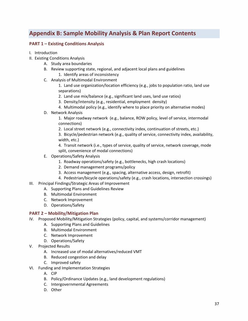
37
Appendix B: Sample Mobility Analysis & Plan Report Contents
PART 1 – Existing Conditions Analysis
I. Introduction II. Existing Conditions Analysis
A. Study area boundaries B. Review supporting state, regional, and adjacent local plans and guidelines
1. Identify areas of inconsistency C. Analysis of Multimodal Environment
1. Land use organization/location efficiency (e.g., jobs to population ratio, land use separations) 2. Land use mix/balance (e.g., significant land uses, land use ratios) 3. Density/intensity (e.g., residential, employment density) 4. Multimodal policy (e.g., identify where to place priority on alternative modes)
D. Network Analysis 1. Major roadway network (e.g., balance, ROW policy, level of service, intermodal connections) 2. Local street network (e.g., connectivity index, continuation of streets, etc.) 3. Bicycle/pedestrian network (e.g., quality of service, connectivity index, availability, width, etc.) 4. Transit network (i.e., types of service, quality of service, network coverage, mode split, convenience of modal connections)
E. Operations/Safety Analysis 1. Roadway operations/safety (e.g., bottlenecks, high crash locations) 2. Demand management programs/policy 3. Access management (e.g., spacing, alternative access, design, retrofit) 4. Pedestrian/bicycle operations/safety (e.g., crash locations, intersection crossings)
III. Principal Findings/Strategic Areas of Improvement A. Supporting Plans and Guidelines Review B. Multimodal Environment C. Network Improvement D. Operations/Safety
PART 2 – Mobility/Mitigation Plan IV. Proposed Mobility/Mitigation Strategies (policy, capital, and systems/corridor management)
A. Supporting Plans and Guidelines B. Multimodal Environment C. Network Improvement D. Operations/Safety
V. Projected Results A. Increased use of modal alternatives/reduced VMT B. Reduced congestion and delay C. Improved safety
VI. Funding and Implementation Strategies A. CIP B. Policy/Ordinance Updates (e.g., land development regulations) C. Intergovernmental Agreements D. Other

38

39
Appendix C: Mobility Plan Assessment Checklist

40

41
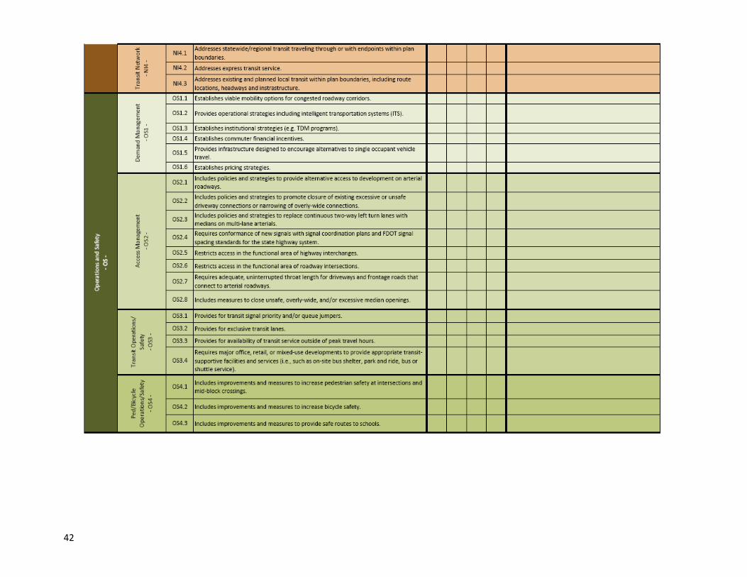
42
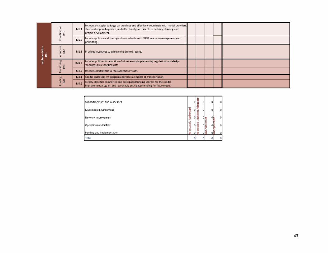
43


