j ourna l homepage: www.e lsev ie r.com/ locate /enggeo
Modeling the influences of land reclamation on groundwater systems: A case studyin Shekou peninsula, Shenzhen, China
Litang Hu a,⁎, Jiu Jimmy Jiao b,1
a College of Water Sciences, Engineering Research Center of Groundwater Pollution Control and Remediation of Ministry of Education, Beijing Normal University, Beijing, 100875, Chinab Department of Earth Sciences, The University of Hong Kong, Hong Kong, China
Land has been reclaimed along the coastal areas in many parts of the world to meet the growing demand forhouses and other land use. Over 15 km2 of land has been reclaimed around the Shekou peninsula, Shenzhen,China. Land reclamation may have significant influences on groundwater systems but this problem has notbeen adequately studied. Using FEFLOW (Diersch, 2005), a three-dimensional finite element groundwatermodel, the response of the groundwater system on the impact of land reclamation in the Shekou peninsulafrom 1983 to 2007 was simulated. The model was calibrated against observed groundwater levels in threeobservation wells. The results showed that, after reclamation, there was a regional increase of groundwaterlevel in the study area. The groundwater divide between western and eastern coastlines moved duringdifferent reclamation stages. The results also showed that, submarine groundwater discharge along thecoastlines was increased due to the increase of recharge in the newly reclaimed land. The model predictschange of groundwater level between 2007 and 2025, which demonstrates that the response of the aquifersystem to land reclamation is a long lasting process. There will be a further increase in groundwater level andit may take about 10 years for the systems to reach a new equilibrium. It is suggested that the changes of thegroundwater flow system due to large-scale land reclamation should be modeled before reclamation toinvestigate possible engineering and environmental consequences.
The Shekou peninsula is located near the border between HongKong and the Shenzhen, Guangdong Province on the southeast coastof China (Fig. 1). It has a length of 17 km, and a width varying from 4to 8 km. Due to rapid economic growth in southern China and tradebetween Hong Kong and Guangdong Province, the economy aroundthe Shekou peninsula has rapidly developed. As a result of the rapidpopulation growth and industry expansion, there has been a greatdemand for land for new towns and housing. From 1983 to 2005, landhas been reclaimed from the sea by dumping various fill materialsalong the south and east coastline of the Shekou peninsula (Fig. 1).Land reclamation has been a common practice to reduce theincreasing housing pressure in coastal areas in many countriesincluding China, UK, USA, Korea, Japan, and The Netherlands (Lumb,1976; Kim et al., 2003; Suzuki, 2003; Hoeksema, 2007).
It's well recognized that land reclamation will have variousadverse effects on marine environment, local ecology, and coastalprocesses (Barnes, 1991; Suh et al., 2004; Chen and Jiao, 2007);however, the influence of land reclamation on the groundwater
@hku.hk (J.J. Jiao).52 2517 6912.
10 Published by Elsevier B.V. All rig
regime has received much less attention until recently (Jiao, 2000).Coastal areas are usually the ultimate discharge zones of regionalgroundwater flow systems and large-scale land reclamation maydramatically modify the regional groundwater regime by changingsubmarine groundwater discharge and increasing the groundwaterflow path to the sea (Jiao et al., 2006). Because the response ofgroundwater regime to land reclamation may be slow and notobvious, these influences have been largely ignored. A research teamin the Department of Earth Sciences at the University of Hong Konghas carried out a series of studies on the influence of land reclamationon groundwater systems (Jiao, 2000, 2002; Jiao et al., 2001; Chen andJiao, 2007; Guo and Jiao, 2007; Hu et al., 2008). Most of these studies,however, focus on analytical solutions. Case studies on the impact ofland reclamation on a real aquifer system using regional numericalmodels are very limited. This paper assesses quantitatively theinfluence of land reclamation on groundwater flow in the Shekoupeninsula by using groundwater modeling.
2. Background of study area
2.1. Study area
Shenzhen has a humid subtropical climate. Mean annual rainfall isabout 1900 mm and mean annual evaporation is 1750 mm. The study
area covers an area of approximately 148 km2 and the elevationranges from 430 m on Tanglang hill to zero at the coastline (Fig. 1).The surface elevation for most of the areas is between 5 and 25 m. TheSand River is the only river in the study area, which originates in themountains beyond the north boundary of the study area and flowssouth into Deep Bay. The length of the Sand River in the study area isabout 18 km. The mean annual runoff of the Sand River is0.57×108 m3 and is large due to rainfall.
Land was reclaimed along the coastline in different years since1983. Major reclamation occurred in 4 different periods: 1983–1994,1994–1998, 2000–2001, and 2002–2005. Fig. 1 shows the change ofthe coastline corresponding to different years. The coastline in thestudy area has been pushed seaward by about 1 km. All togetherabout 15 km2 area was reclaimed between 1983 and 2005.
2.2. Geology
The study area is dominated by granite, which is stronglyweathered and decomposed near the surface in most of the studyarea (Chen and Jiao, 2007). Quaternary materials are well developedalong the Sand River and they change from alluvial deposits near theupper reaches of the river to delta deposits near the river mouth.Between Nantou and Nanshan Hill there are largely lagoon andmarine deposits.
Over 8000 boreholes were drilled for various engineering projectsin the study area and geological information from these holes wasused to build up the three-dimensional stratigraphical model of thesite (Chen et al., 2004). Fig. 2 shows two hydrogeological cross-
sections along A–A′ and B–B′ in Fig. 1. The soil and rock are dividedinto six model layers from the ground to the bedrock (see layers 1–6in Fig. 2a–b). Layers 1–3 are porous medium and the layercompositions and thicknesses are largely based on the geology andborehole data. The lithology of Layer 1 is fill material and sandy clay.The first layer is dominantly fill materials and agricultural soil, with athickness ranging from 2 to 7 m, increasing from north to south. Thehydraulic conductivity of the first model layer varies significantly overthe space. Layer 2 consists of gravel and sand and is the main aquifer.This layer is Quaternary materials consisting primarily of sand andgravel alluvium located along the Sand River floodplain. The hydraulicconductivity of the alluvial Layer 2 is large. An aquifer test inBaishizhou shows that the hydraulic conductivity is about 57 m/d.This model layer is the main aquifer. The thickness of the layer is8–15 m and the average thickness is 10 m. The third model layerconsists of sandy clay with low hydraulic conductivity, and a thick-ness ranging from 5 to 20 m. The fourth and fifth model layers aredecomposed granite and their thicknesses are usually 26–43 m. Thepermeability is relatively high and the hydraulic conductivity canreach 2.3 m/d on the basis of the pumping test in Shazui. Thesemodellayers are generally distributed all over the study area. Layers 4–6are granitic bedrock. Among them, Layer 4 is completely decomposedgranite; Layer 5 is the fracture zone above relatively fresh granite;and Layer 6 is the relative fresh granite. Jiao et al. (2005) studiedthe hydraulic properties of weathered granitic rock in Hong Kong,which is very near to the study area, by examining direct and indirectaquifer hydraulic information scattered in various sources and dem-onstrates that there is a fracture zone between the completely
Fig. 2. Two hydrogeology cross-sections in the study area located in Fig. 1 (Chen et al. 2004). (a)cross-section along A′A; (b) cross-section along B′B.
decomposed granite and the relatively fresh granite and the hy-draulic conductivity of the fracture zone is one or two orders ofmagnitude greater than the decomposed and fresh granite. Conse-quently, a relatively much greater hydraulic conductivity is given toLayer 5 compared to Layers 4 and 6.
3. Conceptual model
For simplicity of modeling, the whole system is treated as a poroussystem. The northern boundary is chosen to be far away from thecoastal area and is set at the mountain ridge of Tanglang and Meitinghills (Fig. 1). The east boundary is set at the east boundary of the SandRiver catchment (Antuo Hill). The west boundary is the west side ofthe Shekou peninsula. All the boundaries are approximated by a no-flow boundary except for the south.
Traditionally, coastal groundwater flow models terminate themodel domain at the coastal line and represent the boundary a fixedhead Dirichlet condition (He et al., 2008; Datta et al., 2009). However,groundwater continues to flow beyond this boundary. How far the
groundwater can go seaward is a great concern for those who studysubmarine groundwater discharge. They believe that submarinegroundwater discharge decreases exponentially from shore andmost of the flow occurs within 100 m or so off the shoreline, butthis distance can be quite variable (Scientific Committee on OceanicResearch, 2004). Some hydrogeologists used the so called equivalentseaward boundary with an upper limit of 2 km away from the coast(Cheng et al., 2004). Jiao et al. (2006) set up a two-dimensional coastalgroundwater flowmodel in Hong Kong using an equivalent boundaryat about 200 m from the coastal line. The equivalent boundary wastreated as no-flow boundary. The groundwater can discharge to thesea through the seabed, the surface of which has a head fixed at thesea level, between the coastline and the equivalent boundary.
The model in this study has 6 layers. The top two layers aresuperficial soil or fill materials and they terminate approximately atthe coastline and the seaward boundary of the two layers has a headfixed at sea level. The other layers extend beyond the coastal line.Following the approach used before (Cheng et al., 2004; Jiao et al.,2006) an equivalent boundary which is assumed to terminate 1 km
away fromthe coastline of 1983 is set for these layers and the equivalentseaward boundary is treated as no-flow boundary. A deliberately greatboundary is chosen so that even after the final reclamation in 2005, theequivalent boundary is still about 500 m away from the new coastlineand almost all the seaward groundwater discharge is included in themodel. The surface (or seabed) of the offshore part of the third layer hasa head fixed at sea level. The groundwater in the lower 4 layers candischarge into the sea through the surface of the third layer. It is believedthat this boundary condition is physically much more reasonable thanthe simple fixed head boundary at the coastline used bymany previousstudies (Jiao et al., 2006).
Rainfall is the main recharge of the system and the main dischargeis the seaward flow through Layers 1 and 2. There is a hydraulicinteraction between the Sand River and groundwater. The bottom ofthe model is set at 150 m below the sea level. The rock at this depth isbelieved to be very fresh and this bottom boundary is represented as ano-flow boundary.
On the basis of the geologic lithologies (Fig. 1) and the boreholeinformation, the system is divided into various parameter zones. Fig. 3shows the 9 hydraulic conductivity zones (Fig. 3a–d) and rainfallrecharge zone (Fig. 3e). Parameter values based on local aquifer testsandmodel parameters from flowmodeling in areas of similar geologicalconditions in HongKong (Jiao et al., 2006) are used as initial parametersand the final parameters are obtained by calibrating the model againstthe observed water levels. Sea level, which is known during the modelperiod, also provides a constraint for the modeled groundwater level.On the basis of laboratory tests in Hong Kong (Jiao et al., 2005), thetypical range of permeability for compacted fill material of completelydecomposedgranite are 10−6–10−7 m/s to 10−6–10−8 m/s. The typicalpermeability of marine sand is 1.0×10⁻⁴ m/s. Recharge is the sourceof the increased water levels. Recharge zones (Fig. 3e) are traced basedon the infiltrations and evaporation rate and the property of the rock-type (Fig. 1).
Groundwater in this area was exploited extensively in the 1980swhen Shenzhen began to expand very quickly from a fishing village to amodern city, but unfortunately detailed information on groundwaterusage such as pumping rate andwell location is not available (Chen andJiao, 2007). Since 1989, when a public water supply was established,pumping of groundwater by government-run companies is significantlyreduced, if not entirely ended. However, it is speculated that someprivate companies treat groundwater as a cheap supply and still pumpwater illegally (Chen and Jiao, 2007). In the numerical model, ground-water pumping is ignored due to a lack of detailed information but thepossible impact of pumping on the model results will be discussed.
The reclamation mainly occurred in 4 periods: 1983–1994, 1994–1998, 2000–2001, and 2002–2005. The model domain and the messsystemarefixed at the beginning of 1983. The aquifer areas in themodeldomain, however, expend with land reclamation. For example, duringthe simulation period of 1983–1994, the model uses the old coastline.During the period of 1994–1998, the model uses the new coastline in1994. The first two layers extend from the coastline from 1983 to 1994,with the hydraulic properties taken as those of the fill materials. Theseaside fixed head of the two layers are set at the new boundary.
FEFLOW, a three-dimensional finite element groundwater model(Diersch, 2005), is chosen for this modeling study. The main purposeof this paper is to address the influence of land reclamation on theregional groundwater flow systems, the density difference of water isignored in the model due to a lack of transport parameters and con-centration data.
4. Data preparation and model calibration
4.1. Borehole data
Well log information from about 8500 boreholes drilled in thestudy area was collected. There are 10 boreholes with hydraulic
conductivity data, including the data from two pumping tests withmonitoring wells.
4.2. Rainfall and evaporation
The mean annual rainfall is 1900 mm. On the basis of modelingexperience in Hong Kong which has geological conditions similarto the study area, the recharge coefficient, which is defined as per-centage of rainfall that becomes groundwater, ranges from 5% to 20%.The model time period is selected from 1983 to 2007. Rainfall andevaporation data during this period were collected and put into themodel.
4.3. Water level monitoring data
There are only three observation wells in the study area. They arelocated at Baishizhou (OBS1), Baishizhou (OBS2), andWanxia (OBS3)(Fig. 4). Unfortunately the monitoring data do not cover the entiremodeling period. OBS1 is located in the fractured aquifer, and the datacovers the period from January, 1984 to December, 2000. OBS2 andOBS3 are in the quaternary aquifer and the data cover the period fromJanuary, 2004 to December, 2006.
4.4. Interaction between Sand River and groundwater
The exchanged flux between Sand River and groundwater iscalculated based on Darcy's law including data of groundwater level,river stage, the thickness and permeability of semi-permeable layer(Layer 3) below the Sand River (Diersch, 2005). The parameter ofinflow and outflow transfer rate is introduced in the software FEFLOW.The value of flux is calculated as the product of the coefficient oftransfer rate and head difference between groundwater head and riverstage (Diersch, 2005). The stage of the Sand River for each node isinterpolated based on the river stage at Xili reservoir, Xintang, and atthe river mouth into the Deep Bay. The difference of river stagebetween Xili reservoir and the river mouth is about 4 m. Inflow andoutflow transfer rate is taken as 500 and 800×10−4 1/d respectively.
4.5. Model calibration
The study area is discretised into 31,752 nodes and 53,160elements in total. The time interval is one month. In this model, theaverage sea level in each month is input as constant head along thecoastline. There were not enough monitoring wells to provide theinitial head distribution in 1983. Groundwater extraction before 1983was minor and the groundwater at that time is assumed to becontrolled mainly by rainfall. It is further assumed that the ground-water flow before 1983 is under steady-state. So the steady-statesolution was used as the initial head distribution for the simulationperiod from January 1983 to December 2007.
After calibrating the model with the observed groundwater level,the key aquifer hydrogeology parameters (horizontal and verticalhydraulic conductivities (Kh and Kz), storativities (Ss), and specificyield (Sy)) used in the model are listed in Table 1. The rechargecoefficient with the sum of infiltration and evaporation rate is listed inTable 2.
The comparison between simulated values and observed values atthree observation wells is displayed in Fig. 5a–c. The differentreclamation periods are also shown symbolically by the grey bars.The degree of satisfaction in the match between the observed andsimulated water levels varies among the three wells. Overall, thefitting of OBS3 is reasonably good and the model can reproducethe dynamic process of the response of the flow system to landreclamation. The observed data shows a slight increase of groundwa-ter level in response to land reclamation, which is in contrast withabrupt increases simulated by the model. This is probably because the
Fig. 3. Parameter zonations for hydraulic conductivity and storage coefficient for different layers (a–d) and recharge coefficient (e).
model assumes that the reclamation occurs at the end of a rec-lamation period while the actual reclamation occurs gradually overthe entire reclamation period. The fitting of OBS3 is not too bad, butthe fitting in OBS2 is unsatisfactory. Overall, the simulated water levelis higher than observed. This is probably because the model ignorespumping due to a lack of data. The soil in the reclamation site hasundergone slow consolidation, causing the gradual decrease in thehydraulic conductivity, so that the groundwater discharge to the sea is
Table 1Hydrogeology parameters used in the model for each zone.
Modellayer
Zone Horizontal hydraulicconductivity(10−4 m/s)
Vertical hydraulicconductivity(10−4 m/s)
Specificyield
Storativities(10−4 1/m)
1 1 0.02000 1/5 of the valueof the horizontalhydraulicconductivity
slower thanwhat ismodeled. Thismay be another factor whichmakesthe simulated water level higher than the observed one.
Fig. 5a shows that the hydraulic head was largely below 2 mbetween 1984 and 1996, and above 2 m between 1998 and 2002,suggesting that there was an appreciable water table increase inresponse to reclamation. The observed water level fluctuation isgreater than the simulated one, suggesting that there may be somegroundwater pumping in the model area. Data of groundwater usageare not available to the authors and ignored in the model.
Also from Fig. 5b–c, it can be seen that the simulated headincreases evidently in response to land reclamation. For example, inthe OBS1 well there is an increase of 2.5 m during the period between2001 and 2002.
5. Discussions
5.1. Modification of groundwater system by land reclamation
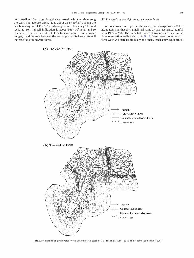
Fig. 6a–c is the contour maps of simulated groundwater head inmodel Layer 2 and the distribution of groundwater velocity corre-sponding to different coastlines as a result of land reclamation. It canbe seen that there generally exists an increase of groundwater headand a change in flow pattern. With the shifting of the coastlinesseaward the path of groundwater flow becomes longer.
Table 2Recharge coefficient of rainfall and evaporation rates.
Zone Recharge coefficient
1 0.0202 0.0103 0.0054 0.000
Fig. 5. Comparison of groundwater head between simulated and observed values in three observation wells. (a) Obs1; (b) Obs2; (c) Obs3.
Fig. 6a shows the simulated water level before 1988 when thereclamation was minor. There is a water mound around Nanshan Hill.Toward the north, water level decreases to the north but increasesagain somewhere near Shenzhen University. Overall the water level inthe Shekou peninsula is typically less than 1 m. However, after a fewmajor reclamation projects, the water level in the peninsula istypically over 2.5 m and it increases progressively to the north, asshown in Fig. 6c.
Under the impact of land reclamation, the groundwater dividealong the Shekou peninsula has also changed to some extent.Compared with the location of the groundwater divide in 1988, thegroundwater divide in 1998 moved slightly towards the west;
however, the groundwater divide in 2005 moved east because ofthe reclamation project on the east coast.
5.2. Groundwater discharge to the sea
Due to the seawardmovement of the coastline, an additional pieceof aquifer is created and overall the recharge from the rainfall isincreased. This leads to an increase of groundwater storage and thengroundwater discharge to the sea. Fig. 7 demonstrates the change ofseaward discharge along the western and eastern boundaries. It canbe seen that seaward discharge along the west and east coastlines ofthe peninsula increased as a result of increased recharge in the newly
reclaimed land. Discharge along the east coastline is larger than alongthe west. The average discharge is about 2.66×10⁴ m3/d along theeast boundary, and 1.41×10⁴ m3/d along thewest boundary. The totalrecharge from rainfall infiltration is about 4.66×10⁴ m3/d, and sodischarge to the sea is about 87% of the total recharge. From the waterbudget, the difference between the recharge and discharge rate willincrease the groundwater level.
Fig. 6. Modification of groundwater system under different coastlines
5.3. Predicted change of future groundwater levels
A model was run to predict the water level change from 2008 to2025, assuming that the rainfall maintains the average annual rainfallfrom 1983 to 2007. The predicted change of groundwater head in thethree observation wells is shown in Fig. 8. From three curves, head inthree wells will increase gradually, and finally reach a new equilibrium.
. (a) The end of 1988; (b) the end of 1998; (c) the end of 2007.
The biggest increase of groundwater head in the three wells over17 years will be about 1 m. The time consumed in reaching the newequilibrium is about 10 years. This prediction shows that the response ofthe coastal aquifer system to land reclamation is a slow process andtakes a long time for the system to reach a new equilibrium.
6. Conclusions
Land reclamation is a common engineering practice to increaseland along the coastline almost all over the world, but the impact ofthis practice on regional groundwater systems is not well documen-ted. The case studies presented in this paper explains what happenedto the groundwater system around the Shekou peninsula, Shenzhen,China as a result of land reclamation. A three-dimensional ground-water flow model was established to simulate the change of ground-water system in response to land reclamation. The model wascalibrated against the observed water level and can reproduce the
Fig. 7. The change of simulated seaward groundwater dischar
observed water level reasonably well. The results demonstrate thatlarge-scale land reclamation will significantly modify the ground-water flow system, including changing the location of groundwaterdivide, flow pattern, increasing water level, and modifying the sea-ward groundwater discharge. Additional groundwater resources canbe gained because of the reclaimed land. For the specific ground-water system in the Shekou peninsula, the water level locallyincreased by over 2 m two years after the land reclamation wascompleted. The modification is transient and a slow process and itmay take another 10 years for the groundwater system to reach a newequilibrium. A further increase of about 1 m is expected 10 years after2007.
The model has many limitations. The observed water level dataare very limited so the calibration of the model is not vigorous.Groundwater pumping is not included in the model due to a lack ofdetailed pumping data. The model ignored the density difference andslow consolidation process of the soil in the reclamation site. It is
ge along the western and eastern boundary of the model.
Fig. 8. The predicted change of groundwater level by 2025 with no additionalreclamation.
suggested that groundwater level should be carefully observed beforeandafter land reclamationand rigorous assessmentof the impact of landreclamation on groundwater flow system should be carried out for anymajor coastal land reclamation project. A long-term change in the flowsystem should be carefully studied and the possible engineering andenvironmental consequences as a result of the change should beassessed before a large-scale land reclamation project is launched.
Acknowledgments
The study was partially supported by the Research Grants Councilproject of the Hong Kong Special Administrative Region (HKU 7028/06P) and the project of “Studies on seawater intrusion and counter-measures in Shenzhen” funded by the Land and Resources Department,Shenzhen Government, China. We give thanks for the constructivecomments for three anonymous reviewers.
References
Barnes, R.S.K., 1991. Dilemmas in the theory and practice of biological conservation asexemplified by British coastal lagoons. Biological Conservation 55 (3), 315–328.
Chen, K.P., Jiao, J.J., 2007. Seawater intrusion and aquifer freshening near reclaimed coastalarea of Shenzhen. Water Science and Technology: Water Supply 7 (2), 137–145.
Chen, Z.H., Chen, G., Lu, J.Q., Fan, L.F., 2004. Investigation report of the current status ofseawater intrusion in typical coastal areas in Shenzhen City (unpublished report).China University of Geosciences, Wuhan, P.R.China.
Cheng, J.M., Chen, C.X., Ji, M.R., 2004. Determination of aquifer roof extending under thesea from variable-density flowmodeling of groundwater response to tidal loading:case study of the Jahe River Basin, Shandong Province, China. Hydrogeology Journal12, 408–423.
Datta, B., Vennalakanti, H., Dhar, A., 2009. Modeling and control of saltwater intrusionin a coastal aquifer of Andhra Pradesh, India. Journal of Hydro-environmentResearch 3 (3), 148–159.
Diersch, H.-J.G., 2005. WASY Software FEFLOW (R) — Finite Element Subsurface Flow &Transport Simulation System: Reference Manual. WASY GmbH Institute for WaterResources Planning and Systems Research, Berlin, Germany.
Guo, H.P., Jiao, J.J., 2007. Impact of coastal land reclamation on groundwater level andthe sea water interface. Ground Water 45 (3), 362–367.
He, B., Takase, K.J., Wang, Y., 2008. Numerical simulation of groundwater flow for a coastalplain in Japan: data collection and model calibration. Environmental Geology 55 (8),1745–1753.
Hoeksema, R.J., 2007. Three stages in the history of land reclamation in TheNetherlands. Irrigation and Drainage 56, 113–126.
Hu, L.T., Jiao, J.J., Guo, H.P., 2008. Analytical studies on transient groundwater flow inducedby land reclamation.Water Resources Research44 (11). doi:10.1029/2008WR006926.
Jiao, J.J., 2000. Modification of regional groundwater regimes by land reclamation. HongKong Geologist 6, 29–36.
Jiao, J.J., 2002. Preliminary conceptual studyon impactof land reclamationongroundwaterflow and contaminant migration in Penny's Bay. Hong Kong Geologist 8, 14–20.
Jiao, J.J., Nandy, S., Li, H., 2001. Analytical studies on the impact of reclamation ongroundwater flow. Ground Water 39 (6), 912–920.
Jiao, J.J., Wang, X.S., Nandy, S., 2005. Confined groundwater zone and slope instability inweathered igneous rocks in Hong Kong. Engineering Geology 80, 71–92.
Jiao, J.J., Wang, X.S., Nandy, S., 2006. Preliminary assessment of the impacts of deepfoundations and land reclamation on groundwater flow in a coastal area in HongKong, China. Hydrogeology Journal 14, 100–114.
Kim, J.H., Kim, R.H., Lee, J., Chang, H.W., 2003. Hydrogeochemical characterization ofmajor factors affecting the quality of shallow groundwater in the coastal area atKimje in South Korea. Environmental Geology 44 (4), 478–489.
Lumb, P., 1976. Land reclamation in Hong Kong. Proceedings of Residential Workshopon Materials and Methods for Low Coast Road, Rail and Reclamation Works, Leura,Australia, pp. 299–314.
Scientific Committee on Oceanic Research (SCOR), 2004. Submarine groundwaterdischarge: management implications, measurements and effects. IHP-VI, Series onGroundwater NO. 5, IOC Manuals and Guides NO. 44 (http://unesdoc.unesco.org/images/0013/001344/134436e.pdf).
Suh, J.Y., Birch, G.F., Hughes, K., Matthai, C., 2004. Spatial distribution and source of heavymetals in reclaimed lands of Homebush Bay: the venue of the 2000 Olympic Games,Sydney, New South Wales. Australian Journal of Earth Sciences 51 (1), 53–66.
Suzuki, T., 2003. Economic and geographic backgrounds of land reclamation in Japaneseports. Marine Pollution Bulletin 47, 226–229.