ABSTRACTThe aim of this paper is to examine available homogenous data on urban conversion of land in Western European countries and determine whether they are suitable to make an international comparison between land policies and management behaviour at the local level. This paper provides some results obtained from currently available information, but it stresses major data production criticalities which hinder the perfor-mance of comparable and reliable overall statistical studies. Conclusions stress the need for greater detail in the production of primary data on the features and magnitude of territorial urbanisation in Europe, as the EEA is doing for main cities. Moreover, this paper includes some remarks on the contents of the preliminary documents of EU soil directive. In particular, it focuses on the issue of urban transformation thresholds over time, a topic that has already been tackled by some northern European countries, however using techniques which cannot be applied as they are to all other countries.
Models of Urban Land Use in Europe:
Assessment Tools and CriticalitiesBernardino Romano, DICEAA, University of L’Aquila, L’Aquila, Italy
Francesco Zullo, DICEAA, University of L’Aquila, L’Aquila, Italy
Keywords: Land Uptake, Land Use Change, Soil Consumption, Urban Sprawl
INTRODUCTION
The issue of excessive urban conversion of natural land has been raised at European level only in recent years, mainly through initiatives undertaken by the European Environmental Agency (EEA, 2004. 2006) to analyse this phenomenon and its consequences.
Furthermore, it is worth recalling that the European Commission, based on a need to tackle soil productivity, risks to human health and environment, and to provide opportuni-
ties for climate mitigation and adaptation as well as stimulating business opportunities for soil remediation, proposed a Soil Framework Directive in 2006, which amends directive 2004/35/EC (on environmental liability with regard to the prevention and remedying of en-vironmental damage) and reaffirms the status of “non-renewable resource” for this particular territorial component and the need for its con-servation. The European Parliament adopted its first reading on the proposal in November 2007 by a majority of about two thirds. During
International Journal of Agricultural and Environmental Information Systems, 4(3), 80-97, July-September 2013 81
March 2010 Environment Council, a minority of Member States blocked further progress on grounds of subsidiarity, excessive cost and administrative burden. No further progress has since been made by the Council. The proposal remains on the Council’s table.
The 2006 EEA report states:
All available evidence demonstrates conclu-sively that urban sprawl has accompanied the growth of urban areas across Europe over the past 50 years. This is shown from a recent European perspective. The areas with the most visible impacts of urban sprawl are in countries or regions with high population density and economic activity (Belgium, the Netherlands, southern and western Germany, northern Italy, the Paris region) and/or rapid economic growth (Ireland, Portugal, eastern Germany, the Madrid region). Sprawl is particularly evident where countries or regions have benefited from EU regional policies.
The aim of this paper is to examine avail-able homogenous data on urban conversion of land in Western European countries and determine whether they are suitable to make an international comparison between land policies and management behaviour at the local level. Our paper provides some results obtained from currently available information, but it stresses major data production criticalities which hinder the performance of comparable and reliable overall statistical studies.
BACKGROUND
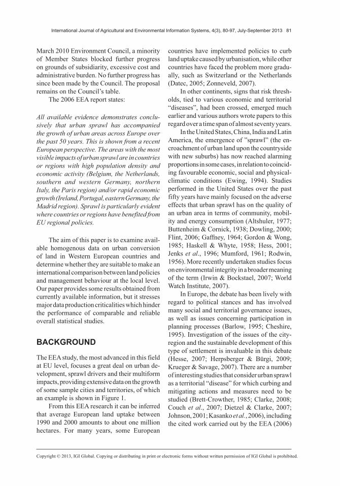
The EEA study, the most advanced in this field at EU level, focuses a great deal on urban de-velopment, sprawl drivers and their multiform impacts, providing extensive data on the growth of some sample cities and territories, of which an example is shown in Figure 1.
From this EEA research it can be inferred that average European land uptake between 1990 and 2000 amounts to about one million hectares. For many years, some European
countries have implemented policies to curb land uptake caused by urbanisation, while other countries have faced the problem more gradu-ally, such as Switzerland or the Netherlands (Datec, 2005; Zonneveld, 2007).
In other continents, signs that risk thresh-olds, tied to various economic and territorial “diseases”, had been crossed, emerged much earlier and various authors wrote papers to this regard over a time span of almost seventy years.
In the United States, China, India and Latin America, the emergence of ”sprawl” (the en-croachment of urban land upon the countryside with new suburbs) has now reached alarming proportions in some cases, in relation to coincid-ing favourable economic, social and physical-climatic conditions (Ewing, 1994). Studies performed in the United States over the past fifty years have mainly focused on the adverse effects that urban sprawl has on the quality of an urban area in terms of community, mobil-ity and energy consumption (Altshuler, 1977; Buttenheim & Cornick, 1938; Dowling, 2000; Flint, 2006; Gaffney, 1964; Gordon & Wong, 1985; Haskell & Whyte, 1958; Hess, 2001; Jenks et al., 1996; Mumford, 1961; Rodwin, 1956). More recently undertaken studies focus on environmental integrity in a broader meaning of the term (Irwin & Bockstael, 2007; World Watch Institute, 2007).
In Europe, the debate has been lively with regard to political stances and has involved many social and territorial governance issues, as well as issues concerning participation in planning processes (Barlow, 1995; Cheshire, 1995). Investigation of the issues of the city-region and the sustainable development of this type of settlement is invaluable in this debate (Hesse, 2007; Herpsberger & Bürgi, 2009; Krueger & Savage, 2007). There are a number of interesting studies that consider urban sprawl as a territorial “disease” for which curbing and mitigating actions and measures need to be studied (Brett-Crowther, 1985; Clarke, 2008; Couch et al., 2007; Dietzel & Clarke, 2007; Johnson, 2001; Kasanko et al., 2006), including the cited work carried out by the EEA (2006)
82 International Journal of Agricultural and Environmental Information Systems, 4(3), 80-97, July-September 2013
which examined urban development in various European countries using a land uptake index.
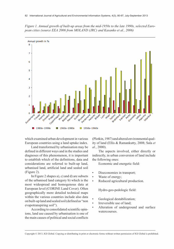
Land transformed by urbanisation may be defined in different ways and in the studies and diagnoses of this phenomenon, it is important to establish which of the definitions, data and considerations are referred to built-up land, urbanised land, artificial land and sealed soil (Figure 2).
In Figure 2 shapes a), c) and d) are subsets of the urbanised land category b) which is the most widespread and homogenous data at European level (CORINE Land Cover). Often geographically more detailed technical maps within the various countries include also data on built-up land and sealed soil (defined as “non evapotranspiring soil”).
According to consolidated scientific opin-ions, land use caused by urbanisation is one of the main causes of political and social conflicts
(Plotkin, 1987) and altered environmental qual-ity of land (Ellis & Ramankutty, 2008; Sala et al., 2000).
The aspects involved, either directly or indirectly, in urban conversion of land include the following ones:
Economic and energetic field:
• Diseconomies in transport;• Waste of energy;• Reduced agricultural production.
Hydro-geo-pedologic field:
• Geological destabilization;• Irreversible use of land;• Alteration of underground and surface
watercourses.
Figure 1. Annual growth of built-up areas from the mid-1950s to the late 1990s, selected Euro-pean cities (source EEA 2006 from MOLAND (JRC) and Kasanko et al., 2006)
International Journal of Agricultural and Environmental Information Systems, 4(3), 80-97, July-September 2013 83
Physico-climatic field:
• Increased thermal reflection and climate change;
• Reduced emission absorption capacity;• Effects on carbon sequestration;• Spatial propagation of physico-chemical
disturbances.
Eco-biological field:
• Physical erosion and destruction of habitats;
• Ecosystem fragmentation;• Dystrophy of ecological and biological
processes;• Penalization of the ecosystem services of
the environment;
• Reduction in overall ecological “resilience”.
The foregoing effects occur to a varying extent depending on landform types, highly dif-ferentiated by sprawl, and may be grouped into two main models depending on their dynamics: aggregate growth and “metastatic-like” growth (Fina & Siedentop, 2009).
In the first case, city centres expand over time always retaining, however, their seamless fabric and close-knit shapes without interstitial gaps. In the second case, urban expansion oc-curs through the multiplication of many small groups of buildings or isolated buildings which sometimes are joined in linear shapes along roads (Figure 3).
For example, assuming that all other im-pacts are the same, the second model leads to
84 International Journal of Agricultural and Environmental Information Systems, 4(3), 80-97, July-September 2013
greater inefficiencies in transport, higher ex-penses for power distribution and the operation of grid services, and more severe consequences for the fragmentation of ecosystems.
SIZE OF THE PHENOMENON IN EUROPEAN COUNTRIES
Recently, responsibility for planning and the pathology of land uptake is becoming more and more important for the public opinion. Therefore we believe that future planning tools should curb these trends, by imposing rules to fight or mitigate land uptake. The control action should be effective mainly when urban sprawl concerns broad agricultural flat areas, with loss of crop production and ecosystem services (Eigenbrod et al., 2011; Harrison, 2011; Maes, 2011; Mur-gante & Danese, 2011; Scolozzi et al., 2012). Moreover, urban sprawl has serious effects on soil sealing, with a devastating hydrogeological impact on settled human communities (Jaeger et al., 2010; MEA, 2005).
Some European countries, that are more sensitive to the foregoing consequences, have already adopted regulations to curb this phe-nomenon and one of the most significant expe-riences is the German one (Bundesregierung, 1985, 2002, 2004; Henger & Bizer, 2010; Illy et al., 2009). The German government has also introduced some daily land uptake limits fixed at 30 ha per day for 2020, with the prospect of bringing this phenomenon down to zero by 2050 (Siedentop, 2007).
There are few studies in international litera-ture on the Italian case (Bonifazi & Heins, 2001; Capello, 2001; Salvati et al.,2012; Romano & Zullo, 2012, 2013) and not many regions (only 4 out of 20) have vector information on land use over the past 50 years on their institutional geo-portals. There are also very few cases in which data covering a shorter time span is available (1970s - 2000), regarding both overall magni-tude of urbanisation and statistically significant historical series and there are no coordinated survey activities among local governments
Figure 3. Differential chart, urban development in seamless aggregates, and the generalized, metastatic-like
International Journal of Agricultural and Environmental Information Systems, 4(3), 80-97, July-September 2013 85
(regions, provinces and municipalities). The negative aspects of this phenomenon are still only marginally considered by scientific, com-munication and land governance agencies.
In other countries, such as the United Kingdom, the Netherlands, France, Switzerland and Spain information and publications are far more numerous (Garcia-Call, 2011; Hall et al., 1973; Hauri et al., 2006; Irwin & Bockstael, 2007; Mellor, 1983; Yanitsky, 1986; Zaninetti, 2006;). The need to set up mechanisms to moni-tor urban transformation dynamics has emerged only recently, but we are still far from having systematic and consistent data collection that would make credible comparisons and assess-ments possible (Batty, 2008; Lowry, 1990; Sharma et al., 2012).
The more recent analytical data, homog-enous for all Western European countries, come from CLC (CORINE Land Cover) 2006 satellite remote sensing and some of the results are shown in Table 1 (EEA, 2004).
Table 1 shows some information of consid-erable interest concerning, first and foremost, the urbanisation rate in the countries considered,
which amounts to almost 4.5%. However, what are even more significant to this regard are the differences in behaviour of the various countries, with a standard deviation of the mean of 126%. On the other hand, Table 1 clearly shows that the urbanisation rate in Western Europe is marked by varying peaks: 20% in Belgium, 14% in the Netherlands, 8% in Germany, just over 7% in Denmark and the UK, down to the absolute lowest rate of 0.8% in Norway.
These differences in urbanisation rates can be easily ascribed to a mix of various factors, such as historical differences in economies, cultural relationships with land and type of agricultural productivity.
Further information may be gathered by ex-amining per capita urbanisation index obtained from the relationship between total urban cover-age and number of inhabitants. In Table 1 this index is organised in increasing order of values, and countries falling within given thresholds (300, 400 and 500 m2/inhabitant) have been identified. In this case, the standard deviation of the mean (53%), albeit considerable, is far lower than the one obtained for urbanisation
86 International Journal of Agricultural and Environmental Information Systems, 4(3), 80-97, July-September 2013
rate, thus evidencing that most countries have conformed to the need for urban spaces of social communities. This aspect is particularly evident in some Scandinavian countries where the number of inhabitants is lower, but produc-tion and industrial sites, of either European or global importance, are large.
To this regard, it is interesting to examine the same data related to some Eastern European countries that overall have a per capita index that is 25% higher than that of Western Europe (over 466 versus almost 354 m2/inhab.). Furthermore, we can see that some countries which, as we all know, are facing economic difficulties (e.g. Hungary and Romania) have per capita indices similar to those of very advanced countries in Western Europe, such as Denmark and Belgium. In these cases, land transformation driven by policy and government-related events in the Eastern block, despite significant economic inequalities within society in individual terms, has probably led to extensive changes in settle-ments prompted by public initiatives which persist even today, albeit with different drivers, in the attempt to bridge the development gap.
Some of these data suggest that urban conversion of land in the post-World War II years should be ascribed more to behavioural aspects of national societies, rather than their actual average economic conditions.
In fact, the diagram in Figure 4 shows that there is no significant dependence in the relationship between urbanised land and per capita GDP, even if we include in the diagram the Eastern European countries listed in Table 2.
At European level, it is very difficult to obtain homogenous data on the course of ur-banisation for the various countries broken down for specific time periods. The only information available today to this regard is still the previ-ously mentioned CLC data and their updates in 1990, 2000 and 2006. Table 3 shows that, in the 15 years spanning from 1990 to 2006, urban surfaces in the Western European countries examined, excluding the Scandinavian penin-sula, have increased by almost one and a half million hectares (slightly less than the size of an Italian region like Sardinia) at the speed of 450 ha per day (almost 20 ha per hour). However, it is important to mention that, between 2000
Figure 4. Correlation between per urbanisation and per capita GDP in the Western and Eastern European countries considered
International Journal of Agricultural and Environmental Information Systems, 4(3), 80-97, July-September 2013 87
and 2006, the pace has slowed down a little thanks to Germany which has complied with its limit of 30 ha per day set in 2000. Table 3 also highlights that the increase in urban areas between 1990 and 2006 has occurred almost exclusively to the detriment of agricultural areas, with a mean incidence of 83% in these areas. In countries, such as Germany, Italy, the Netherlands, the UK, Ireland and Denmark, 90% of new urbanisation concerns agricultural areas, while only Portugal has a figure below 70%. This is a problem that is taking on its own distinctive features and is tied to the significant loss of agricultural production, and is therefore considered one of the major impacts of land consumption. The issue has been raised in the recent paper by the European Commission COM (2012) 46 (“The implementation of the Soil Thematic Strategy and ongoing activities”) which based on the same sources of data used in Table 3, states that:
In the period 1990-2006, 19 Member States lost a potential agricultural production capability equivalent to a total of 6.1 million tonnes of wheat, with large regional variations. This is a far from insignificant figure, given the level-ling off of agricultural productivity increases that has already been experienced and the fact that, to compensate for the loss of one hectare of fertile land in Europe, it would be necessary to bring into use an area up to ten times larger in another part of the world.
VALIDATING THE RELIABILITY OF EUROPEAN DATA
Going back to the information in Table 1, mean urbanisation rate in Western Europe amounting to some 358 m2/inhabitant for all 13 considered countries deserves specific attention. An almost identical result has emerged recently from a study carried out on the Italian territory and in the process of being concluded (Romano & Zullo, 2012). This study has shown that the threshold ranging between 350 and 400 m2/inhabitant in per capita urbanisation is characteristic of many Italian regions too, both individually and in different geographical aggregations.
Table 4 shows the urbanisation data of 12 Italian regions taken from more detailed cartographic sources than CLC, that is to say regional land use maps obtained by means of photo-interpretation on a 1:10.000 scale. In the considered territory, which covers over half of the country, the mean urbanisation rate is 6%, while per capita urbanisation amounts to about 370 m2/inhabitant. Moreover, the latter figure is fairly consistent across all the regions considered, since the standard deviation of the mean is 30%.
The comparison of these data with those relating to Italy included in Table 1 shows that there is approximately a 1% difference in urbanisation rate and this can be ascribed to at least two reasons. The first is tied to the present-day incompleteness of data about Italy included
88 International Journal of Agricultural and Environmental Information Systems, 4(3), 80-97, July-September 2013
in Table 4 (only half of the national territory has been analysed so far) and, as a result, there is still some uncertainty regarding the overall figure. It is reasonable to believe that, since
high urban density regions, such as Piedmont, Tuscany, Campania and Sicily, have not yet been included in the computation of urbanisa-tion rate, the final value will be closer to 6-7%.
Table 4. Urbanisation data of some Italian regions updated at 2001
Table 3. Agricultural land uptake between 1990 and 2006 in some countries of Western Europe
International Journal of Agricultural and Environmental Information Systems, 4(3), 80-97, July-September 2013 89
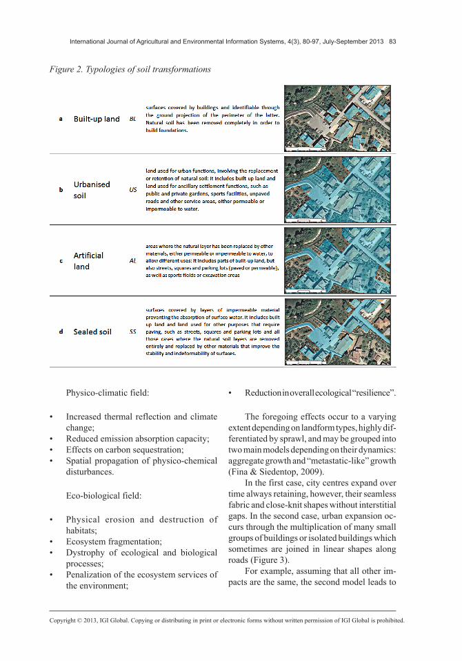
The second and most important reason for the difference between these two figures is tied to the primary data which they were obtained from: in the case of the European comparison in Table 1 urbanised areas were taken from the CORINE Land Cover (CLC) 2006 satellite remote sensing, while in the case of the Italian study, as mentioned earlier, the same surfaces were obtained from regional land use maps, plotted between 2002 and 2008, by means of photo-interpretation on a scale of considerable detail (1:10.000 – 1:5.000).
As it is well known, CLC data are on a nominal scale of 1:100.000, with a legend in-cluding 44 items divided into three hierarchical units, and are referred to homogenous spatial units with elementary zones belonging to the same class, clearly distinguishable from sur-rounding units. For these reasons, CLC data have many shortcomings in the accuracy of measured urbanised areas, since the minimum mappable unit is 25 hectares (equivalent to a
square of 500 m per side) and the minimum width of polygons that can be surveyed is 100 m. This makes it impossible for CLC to capture urban aggregates with boundaries below 100 metres (sprinkling housing and small villages), while secondary roads (state, provincial and municipal roads) cannot be considered for the same technical reasons. The previously mentioned studies (Romano & Zullo, 2012) on Italian regional samples have ascertained that urbanisation values derived from CLC data greatly underestimate the magnitude of this phenomenon compared to technical maps on regional land use on a 1:10.000 scale (Table 5).
Differences between CLC data and real life, better reflected by regional land use maps, in the best cases amount to 30%, but are even larger when urbanisation is more scattered, with many isolated houses in agricultural areas and numerous tiny urban aggregations consisting of a few buildings. The aforementioned differ-ences near or exceed 100% in regions, such as
Table 5. Differential test based on the surveys of urbanised areas taken from Corine Land Cover (CLC) and those obtained from technical maps or regional land use maps (CUS) after 2000
90 International Journal of Agricultural and Environmental Information Systems, 4(3), 80-97, July-September 2013
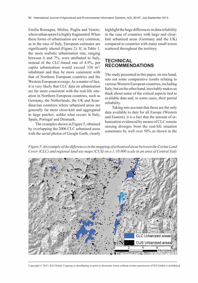
Emilia Romagna, Molise, Puglia and Veneto, where urban sprawl is highly fragmented. When these forms of urbanisation are very common, as in the case of Italy, European estimates are significantly altered (Figure 2). If, in Table 1, the more realistic urbanisation rate, ranging between 6 and 7%, were attributed to Italy, instead of the CLC-based rate of 4.9%, per capita urbanisation would exceed 330 m2/inhabitant and thus be more consistent with that of Northern European countries and the Western European average. As a matter of fact, it is very likely that CLC data on urbanisation are far more consistent with the real-life situ-ation in Northern European countries, such as Germany, the Netherlands, the UK and Scan-dinavian countries where urbanised areas are generally far more close-knit and aggregated in large patches, unlike what occurs in Italy, Spain, Portugal and Denmark.
The examples shown in Figure 5, obtained by overlapping the 2006 CLC urbanised areas with the aerial photos of Google Earth, clearly
highlight the huge differences in data reliability in the case of countries with large and close-knit urbanised areas (Germany and the UK) compared to countries with many small towns scattered throughout the territory.
TECHNICAL RECOMMENDATIONS
The study presented in this paper, on one hand, sets out some comparative results relating to various Western European countries, including Italy, but on the other hand, inevitably makes us think about some of the critical aspects tied to available data and, in some cases, their partial reliability.
Taking into account that these are the only data available to date for all Europe (Western and Eastern), it is a fact that the amount of ur-banisation evidenced by means of CLC remote sensing diverges from the real-life situation sometimes by well over 50% as shown in the
Figure 5. An example of the differences in the mapping of urbanised areas between the Corine Land Cover (CLC) and regional land use maps (CUS) on a 1:10.000 scale in an area of Central Italy
International Journal of Agricultural and Environmental Information Systems, 4(3), 80-97, July-September 2013 91
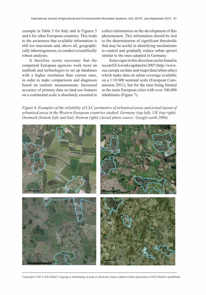
example in Table 5 for Italy and in Figures 5 and 6 for other European countries. This leads to the awareness that available information is still too inaccurate and, above all, geographi-cally inhomogeneous, to conduct scientifically robust analyses.
It therefore seems necessary that the competent European agencies work more on methods and technologies to set up databases with a higher resolution than current ones, in order to make comparisons and diagnoses based on realistic measurements. Increased accuracy of primary data on land use features on a continental scale is absolutely essential to
collect information on the development of this phenomenon. This information should be tied to the determination of significant thresholds that may be useful in identifying mechanisms to control and gradually reduce urban sprawl similar to the ones adopted in Germany.
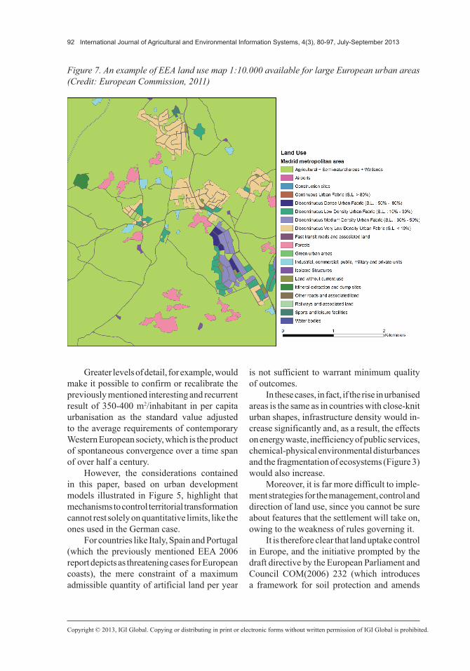
Some signs in this direction can be found in recent EEA works updated to 2007 (http://www.eea.europa.eu/data-and-maps/data/urban-atlas) which make data on urban coverage available on a 1:10.000 nominal scale (European Com-mission 2011), but for the time being limited to the main European cities with over 100,000 inhabitants (Figure 7).
Figure 6. Examples of the reliability of CLC perimeters of urbanised areas and actual layout of urbanised areas in the Western European countries studied: Germany (top left), UK (top right), Denmark (bottom left) and Italy (bottom right) (Aerial photo source: Google earth 2006)
92 International Journal of Agricultural and Environmental Information Systems, 4(3), 80-97, July-September 2013
Greater levels of detail, for example, would make it possible to confirm or recalibrate the previously mentioned interesting and recurrent result of 350-400 m2/inhabitant in per capita urbanisation as the standard value adjusted to the average requirements of contemporary Western European society, which is the product of spontaneous convergence over a time span of over half a century.
However, the considerations contained in this paper, based on urban development models illustrated in Figure 5, highlight that mechanisms to control territorial transformation cannot rest solely on quantitative limits, like the ones used in the German case.
For countries like Italy, Spain and Portugal (which the previously mentioned EEA 2006 report depicts as threatening cases for European coasts), the mere constraint of a maximum admissible quantity of artificial land per year
is not sufficient to warrant minimum quality of outcomes.
In these cases, in fact, if the rise in urbanised areas is the same as in countries with close-knit urban shapes, infrastructure density would in-crease significantly and, as a result, the effects on energy waste, inefficiency of public services, chemical-physical environmental disturbances and the fragmentation of ecosystems (Figure 3) would also increase.
Moreover, it is far more difficult to imple-ment strategies for the management, control and direction of land use, since you cannot be sure about features that the settlement will take on, owing to the weakness of rules governing it.
It is therefore clear that land uptake control in Europe, and the initiative prompted by the draft directive by the European Parliament and Council COM(2006) 232 (which introduces a framework for soil protection and amends
Figure 7. An example of EEA land use map 1:10.000 available for large European urban areas (Credit: European Commission, 2011)
International Journal of Agricultural and Environmental Information Systems, 4(3), 80-97, July-September 2013 93
directive 2004/35/CE), will have to take these aspects into due account and be modulated adequately. Almost certainly, the prospective directive resulting from the 2006 proposal will not contain indications limiting urbanisation, since the same proposal states that:
Most of the recommendations from the Working Groups as well as concerns expressed in the Internet consultation have been taken on board. Abundant calls for mandatory restrictions on urban and touristic developments have not been endorsed as the Community has limited competences on restricting land use.
This is why, despite the fact that proposal COM (2006) 232 mentions soil sealing as one of the key soil-related issues in Europe (ero-sion by water or wind, organic matter decline brought about by a steady downward trend in the organic fraction of the soil, soil contamination, salinisation through the accumulation in soil of soluble salts, compaction through an increase in bulk density and a decrease in soil porosity, landslides brought about by the down-slope, moderately rapid to rapid movement of masses of soil and rock material), it only explicitly mentions the phenomenon of urbanisation once (13-Sealing is becoming significantly more intense in the Community as a result of urban sprawl and increasing demand for land from many sectors of the economy, and this calls for a more sustainable use of soil) and fails to insist further on this point in the sections on risk prevention, mitigation and restoration.
The subsequent document COM (2012) 46 (The implementation of the Soil Thematic Strategy and ongoing activities) goes back to the issues of contamination, desertification and degradation, but remains rather superficial regarding the responsibility of urbanisation for the adverse consequences of soil sealing.
These concise remarks make it desirable that the text of the “soil directive”, if adopted, be greatly amended and reviewed, by clearly attributing to urbanisation the role it deserves
as an activator of territorial and environmental diseases.
For reasons of EU competence, it seems evident that only National States are directly responsible for the control of urban conversion of soil, which for the previously mentioned reasons, will have to independently identify tailor-made sets of suitable parameters to moni-tor and limit the growth of urban coverage.
CONCLUSION
From this paper, it may be inferred that for many countries it will not be sufficient to introduce only quantitative limits to the admis-sible increase in urbanised areas, but additional parameters will be needed, such as the shape of such areas, territorial dispersion indices and density and types of transport networks.
It should be added that many countries currently lack accurate information on the dynamics of urban use of land, as well as tech-nical and administrative systems to track this phenomenon using adequate and homogeneous details for the entire country and over a shorter period of time than that usually needed (five or ten years) to update present-day regional maps.
Unlike the USA, where many in-depth studies on sprawl have been carried out, some of which have been mentioned earlier (Brueckner, 2000, 2001; Glaeser & Kahn, 2001; Nechyba & Walsh, 2004), there are still relatively few similar studies in Europe (Patacchini et al., 2009) and they are generally broadly affected by data uniformity issues, which this paper has tried to bring to the surface with regard to the territorial sector.
Owing to the lack of information platforms (land registers) and Regional Observatories (communicating with government entities capable of compiling overall data) on land and types and size of abandoned areas, it will be almost impossible to manage forms of checks and balances of this phenomenon both at sub-national and national level.
94 International Journal of Agricultural and Environmental Information Systems, 4(3), 80-97, July-September 2013
ACKNOWLEDGMENT
We would like to thank the Region of Umbria (Biodiversity and Landscape Observatory) for economic support of this research. We are also grateful to Mirko Dell’Aguzzo, for his col-laboration for data providing and elaboration.
REFERENCES
Altshuler, A. (1977). Review of the costs of sprawl, environmental and economic costs of alternative residential development patterns at the urban fringe. Journal of the American Planning Association. American Planning Association, 43(2), 207–209.
Barlow, J. (1995). The politics of urban growth: “Boosterism” and “Numbysm” in European boom regions. International Journal of Ur-ban and Regional Research, 19(1), 129–144. doi:10.1111/j.1468-2427.1995.tb00494.x
Batty, M. (2008). The size, scale and shapes of cities. Science, 319, 769–771. doi:10.1126/science.1151419 PMID:18258906
Bonifazi, C., & Heins, F. (2001). Dynamics of ur-banisation in Italy. In Proceedings of XXIV General Population Conference IUSSP (pp. 1-26) Salvador, Brazil.
Brett-Crowther, M. R. (1985). European urbaniza-tion 1500–1800. London, UK: Jan de Vries Methuen & Co Ltd.
Brueckner, J. K. (2000). Urban sprawl: Diagnosis and remedies. International Regional Science Review, 23(2), 60–171. doi:10.1177/016001700761012710
Brueckner, J. K. (2001). Urban sprawl: Lessons from urban economics. In W. G. Gale, & J. R. Pack (Eds.), Brookings-Wharton papers on urban affairs (pp. 65–97). Washington, DC: Brookings Institution.
Bundesregierung. (1985). Unterrichtung durch die Bundesregierung. Bodenschutzkonzepte der Bundes-regierung. Bonn, Drucksache 10.2977, Deutscher Bundenstag.
Bundesregierung. (2002). Perspektiven fur Deutsch-land. Unsere Strategie fur eine nachhaltige Ent-wicklung. Berlin, Drucksache 15/4100, Deutscher Bundestag.
Bundesregierung. (2004). Perspektiven für Deutsch-land. Unsere Strategie für eine nachhaltige Entwick-lung. Fortschrittsbericht 2004, Berlin, Drucksache 15/4100,Deutscher Bundestag.
Buttenheim, H. S., & Cornick, P. H. (1938). Land reserves for American cities. The Journal of Land Public Utility Economics, 14, 254–265. doi:10.2307/3158681
Capello, R. (2001). Urban growth in Italy: Economic determinants and socio-environmental consequences. In Proceedings of the International Symposium in Urban Design on Urban Systems and Public Place (pp. 1-37), Umeå, Sweden.
Cheshire, P. (1995). A new phase of urban devel-opment in Western Europe? The evidence for the 1980s. Urban Studies (Edinburgh, Scotland), 32(7), 1045–1063. doi:10.1080/00420989550012564
Clarke, K. C. (2008). Mapping and modelling land use change: An application of the SLEUTH model. In C. Cartwright, I. Bishop, K. Lowell, D. Pullar, & D. Duncan (Eds.), Landscape analysis and visualisation: Spatial models for natural resource management and planning (pp. 353–366). Berlin, Germany: Springer. doi:10.1007/978-3-540-69168-6_17
Couch, C., Leontidou, L., & Petschel-Held, G. (2007). Urban sprawl in Europe: Landscape, land-use change and policy. Blackwell. doi:10.1002/9780470692066
DATEC. (Federal Department of Environment, Transport, Energy and Communications). (2005). Rapporto sullo sviluppo territoriale in Svizzera. ARE (Federal Office of Land Development).
Dietzel, C., & Clarke, K. C. (2007). Toward optimal calibration of the SLEUTH land use change model. Transactions in GIS, 11(1), 29–45. doi:10.1111/j.1467-9671.2007.01031.x
Dowling, T. J. (2000). Reflections on urban sprawl, smart growth, and the Fifth Amendment. University of Pennsylvania Law Review, 148(3), 873–887. doi:10.2307/3312828
EEA. (2004). Corine land cover 2000: Mapping a decade of change. EEA.
EEA. (2006). Urban sprawl in Europe, The ignored challenge. Copenaghen, Directorate general Joint Researche Center.
International Journal of Agricultural and Environmental Information Systems, 4(3), 80-97, July-September 2013 95
Eigenbrod, F., Bell, V. A., Davies, H. N., Heinemeyer, A., Armsworth, P. R., & Gaston, K. J. (2011). The impact of projected increases in urbanization on ecosystem services. Proceedings. Biological Sci-ences, 278, 3201–3208. doi:10.1098/rspb.2010.2754 PMID:21389035
Ellis, C. E., & Ramankutty, N. (2008). Putting people in the map: Anthropogenic biomes of the world. Frontier in Ecology and the Environment, 6.
European Commission. (2011). Mapping guide for a urban atlas. Gmes, Urban Atlas Project.
Ewing, R. H. (1994). Characteristics, causes, and effects of sprawl. A Literature Review Environmental and Urban Studies, 21(2), 1-15.
Fina, S., & Siedentop, S. (2009). The riddled city – where demographic change adds to the woes of urban sprawl. In Schrenk, M., Popovich, V. V., Engelke, D., & Elisei, P. (Eds.), Proceedings REAL CORP 2009, 14th International Conference on Urban Planning, Regional Development and Information Society (pp. 507-517), Sitges, Catalonia.
Flint, A. (2006). This land: The battle over sprawl and the future of America. Baltimore, MD: Johns Hopkins University.
Gaffney, M. (1964). Containment policies for urban sprawl. In R. Stauber (Ed.), Approaches to the study of urbanisation. Governmental Research Center, The University of the Kansas.
Garcia-Call, A. (2011). The process of residential sprawl in Spain: Is it really a problem? Urban Re-search and Practice, 4(3), 250–263. doi:10.1080/17535069.2011.616744
Glaeser, E., & Kahn, M. (2001). Decentralized em-ployment and the transformation of the American city. Brookings-Wharton Papers on Urban Affairs, 2, 1–47. doi:10.1353/urb.2001.0008
Gordon, P., & Wong, H. L. (1985). The costs of urban sprawl: Some new evidence. Environment & Planning A, 17(5), 661–666. doi:10.1068/a170661
Hall, P., Gracey, H., Drewett, R., & Thomas, R. (1973). The containment of urban England (Vol. I). London, Beverly Hills.
Harrison, P. (2011). Conservation of Biodiversity And Ecosystem Services in Europe: From threat to action. RUBICODE Consortium, Pensoft.
Haskell, D., & Whyte, W. (1958). The city’s threat to open land. The Architectural Forum, 108, 86–90.
Hauri, E., Steiner, V., & Vinzens, M. (2006). Human settlement in Switzerland, spatial development and housing. Housing Bulletin, 78, 1–80.
Henger, R., & Bizer, K. (2010). Tradable planning permits for land use control in Germany. Land Use Policy, 27(3), 843–852. doi:10.1016/j.landuse-pol.2009.11.003
Hersperger, A. M., & Bürgi, M. (2009). Going be-yond landscape change description: Quantifying the importance of driving forces of landscape change in a Central Europe case study. Land Use Policy, 26(3), 640–648. doi:10.1016/j.landusepol.2008.08.015
Hess, G. (2001). Just what is sprawl, anyway? Carolina Planning Journal, 26(2).
Hesse, M. (2007). The polycentric metropolis: Learn-ing from mega-city regions in Europe. International Journal of Urban and Regional Research, 31(2), 496–498. doi:10.1111/j.1468-2427.2007.00734_2.x
Illy, A., Hornych, C., Schwartz, M., & Rosenfeld, M. T. W. (2009). Urban growth in Germany – The impact of localization and urbanization economies. IWH Discussion Papers, 19(1)-53. Halle Institute for Economic Research.
Irwin, E. G., & Bockstael, N. E. (2007). The evolution of urban sprawl: Evidence of spatial heterogeneity and increasing land fragmentation. Proceedings of the National Academy of Sciences of the United States of America, 104(52), 20672–20677. doi:10.1073/pnas.0705527105 PMID:18093930
Jaeger, J. A. G., Bertiller, R., Schwick, C., Cavens, D., & Kienast, F. (2010). Urban permeation of landscapes and sprawl per capita: New measures of urban sprawl. Ecological Indicators, 10(2), 427–441. doi:10.1016/j.ecolind.2009.07.010
Jenks, M., Burton, E., & Williams, K. (Eds.). (1996). The compact city. A sustainable urban form? New York, NY: E&FN Spon. doi:10.4324/9780203362372
Johnson, M. P. (2001). Environmental impacts of urban sprawl: A survey of the literature and proposed research agenda. Environment & Planning A, 33(4), 717–735. doi:10.1068/a3327
Kasanko, M., Barredo, J. I., Lavalle, C., McCormick, N., Sagris, V., & Brezger, A. (2006). Are European cities becoming dispersed? A comparative analysis of 15 European urban areas. Landscape and Urban Planning, 77, 111–130. doi:10.1016/j.landurb-plan.2005.02.003
96 International Journal of Agricultural and Environmental Information Systems, 4(3), 80-97, July-September 2013
Krueger, R., & Savage, L. (2007). City-regions and social reproduction: A ‘place’ for sustainable develop-ment? International Journal of Urban and Regional Research, 31(1), 215–223. doi:10.1111/j.1468-2427.2007.00716.x
Lowry, I. S. (1990). World urbanization in perspec-tive. Population and Development Review, 16, 148–176. doi:10.2307/2808068
Maes, J. (Ed.). (2011). A spatial assessment of eco-system services in Europe: Methods, case studies and policy analysis (Report No 3). PEER.
Mellor, R. (1983). The urbanization of Britain, a review. IJURR, 7(3), 380–403. doi:10.1111/j.1468-2427.1983.tb00600.x
Millennium Ecosystem Assessment (MEA). (2005). Ecosystems and human well-being: Synthesis. Wash-ington: Island Press.
Mumford, L. (1961). The city in history. Harcourt, Brace and Jovanovich Inc.
Murgante, B., & Danese, M. (2011). Urban versus rural: The decrease of agricultural areas and the development of urban zones analyzed with spatial statistics. International Journal of Agricultural and Environmental Information Systems, 2(2), 16–28. doi:10.4018/jaeis.2011070102
Nechyba, T. J., & Walsh, R. P. (2004). urban sprawl. The Journal of Economic Perspectives, 18(4), 177–200. doi:10.1257/0895330042632681
Patacchini, E., Zenou, Y., Henderson, J. V., & Epple, D. (2009). Urban sprawl in Europe. In Brookings-Wharton Papers on Urban Affairs (Vol. 10, pp. 125–149). Washington, DC: Brookings Institution.
Plotkin, S. (1987). Property, policy and politics: Towards a theory of urban land-use conflict. IJURR, 11(3), 382–404. doi:10.1111/j.1468-2427.1987.tb00056.x
Rodwin, L. (1956). The British new town policy. Cambridge, MA: Harvard University Press.
Romano, B., & Zullo, F. (2012). Landscape frag-mentation in Italy. Indices implementation to support territorial policies. In M. Campagna, A. De Montis, F. Isola, S. Lai, C. Pira, & C. Zoppi (Eds.), Planning support tools: Policy analysis, implementation and evaluation (pp. 399–414). Milano: Franco Angeli.
Romano, B., & Zullo, F. (2012). Land urbanization in Central Italy: 50 years of evolution. Journal of Land Use Science. DOI:10.1080/1747423X.2012.754963.
Romano B., Zullo F., 2014. The urban transformation of Italy’s Adriatic Coast Strip: fifty years of unsustain-ability. Land Use Policy 38:26-36 -DOI:10.1016/j.landusepol.2013.10.001
Sala, E. O., Chapin, F. S., Armesto, J. J., Berlow, E., Bloomfield, J., & Dirzo, R. et al. (2000). Global biodiversity scenarios for the year 2100. Science, 287(5459), 1770–1774. doi:10.1126/sci-ence.287.5459.1770 PMID:10710299
Salvati, L., Munafò, M., Gargiulio, Morelli, V., Sabbi, A., 2012. Low-density settlements and land use changes in a Mediterranean urban region, Landscape and Urban Planning 105(1-2), 43-52.
Scolozzi, R., Morri, E., & Santolini, R. (2012). Delphi-based change assessment in ecosystem ser-vices to support strategic spatial planning in Italian landscapes. Ecological Indicators. doi:10.1016/j.ecolind.2011.07.019 PMID:23470886
Sharma, L., Pandey, P. C., & Nathawat, M. S. (2012). Assessment of land consumption rate with urban dy-namics change using geospatial techniques. Journal of Land Use Science, 7(2), 135–148. doi:10.1080/1747423X.2010.537790
Siedentop, S. (2007), Monitoring urban sprawl in Germany: Towards a GIS-based measurement and assessment approach. In Proceedings of the IALE World Congress, Wageningen, NL.
World Watch Institute. (2007). State of the world, our urban future. Washington, DC.
Yanitsky, O. (1986). Urbanization in the USSR, the-ory, tendencies and policy. IJURR, 10(2), 265–287. doi:10.1111/j.1468-2427.1986.tb00015.x
Zaninetti, J. M. (2006). Urban sprawl in France, a regional typology of urbanization trends and its demographics and economy background. Bulletin of Geography, 5, 5–20.
Zonneveld, W. (2007). Sea of houses: Preserving open space in an urbanised country. Journal of Environ-mental Planning and Management, 50(5), 657–675. Retrieved from http://www.informaworld.com/smpp/title~content=t713429786~db=all~tab=issueslist~branches=50-v50 doi:10.1080/09640560701475303
International Journal of Agricultural and Environmental Information Systems, 4(3), 80-97, July-September 2013 97
Bernardino Romano, an Associate Professor in Land Planning at the University of L’Aquila, performs research in land use change, sustainable urban planning, landscape ecology, GIS techniques. He is member of National Scientific Committee of WWF Italy and is consultant of several Italian regions for Ecological Network Project and sustainable land transformation programs. Is author of 150 scientific publication on environmental research issues.
Francesco Zullo is a Ph.D. in Environmental Science at the University of L’Aquila, where he performs research in Landscape Ecology and Environmental GIS Application. His research interests include ecological network planning, land use change, GIS techniques for territorial analysis and spatial statistics.