IUCN Eastern Africa Programme Somali Natural Resources Management Programme BIODIVERSITY ASSESSMENT OF THE NORTHERN SOMALI COAST EAST OF BERBERA Michael H. Schleyer Oceanographic Research Institute Durban [email protected]Robert Baldwin P.O. Box 2531, Muscat, CPO 111 Oman [email protected]IUCN Contract No. EARO/75561/417 March 1999
Transcript
IUCN Eastern Africa Programme
Somali Natural ResourcesManagement Programme
BIODIVERSITY ASSESSMENT OF THE NORTHERN SOMALI COAST EAST OF BERBERA
Michael H. SchleyerOceanographic Research Institute
CONCLUSIONS AND RECOMMENDATIONS ..........................................................5
****************
INTRODUCTION ........................................................................................................6OBJECTIVES AND TERMS OF REFERENCE .........................................................6METHODS..................................................................................................................7RESULTS...................................................................................................................8
FISH .........................................................................................................................10Reef fishes................................................................................................................10Pelagic fishes............................................................................................................11
CETACEANS ...........................................................................................................11BIRDS ......................................................................................................................12BEACHES AND SANDY SUBSTRATA ...................................................................13TURTLES .................................................................................................................13ROCKY SHORES.....................................................................................................14CORAL REEFS ........................................................................................................15SEAWEED................................................................................................................16MANGROVE.............................................................................................................17HUMAN ACTIVITY AND FISHERIES.......................................................................17
PRELIMINARY CONCLUSIONS AND RECOMMENDATIONS ...............................18Threats and safeguards to the Somali environment .................................................18A review of the legal and institutional framework......................................................19Potential future development....................................................................................19Biodiversity conservation ..........................................................................................19
BIODIVERSITY ASSESSMENT OF THENORTHERN SOMALI COAST EAST OF BERBERA
EXECUTIVE SUMMARYA coastal biodiversity survey was undertaken on the northern Somali coast to establishthe status of the marine resources in the region, threats to the biodiversity andappropriate measures for the sustainable use and conservation of the resources. Itformed part of the IUCN Somali Natural Resources Management Programme, funded bythe EC, which aims to improve the socio-economic well-being of the Somali people byenhancing the ecological sustainability of their natural resource use. Fieldwork wascarried out in collaboration with Cooperazione Internationale (COOPI).
Extremely wide-ranging activities were commissioned, aimed at determining:
1. The conservation and biodiversity value of the coast between Berbera and Raas-Khansir.
2. The extent and nature of marine resource use, the user groups and theirdependence on the resources.
3. The level and nature of threats to the biodiversity in the area.4. Appropriate conservation measures needed to promote sustainable use of the area.
The survey was undertaken between 4-11 March 1999 from 15 km west of Berbera tothe mangrove known as Khoor Shoora approximately 150 km to the east. Data werecollected on the nature and biodiversity of the shoreline, mangrove, seaweed, coral reefand pelagic environments. A record was kept on the abundance of turtles, dolphins andseabirds, as well as of the extent of turtle nesting on beaches.
The oceanographic conditions in the study area are primarily influenced by seasonalmonsoons, complex seasonal currents and physical conditions. Nutrient levels arelargely determined by variable current patterns and annual fluctuations in upwellingintensity. In terms of primary productivity, the study area is thought to fall in a transitionzone between the richly productive water to the north-east and the East African shelfenvironment to the west. Daily winds generally blow parallel to the shore and generateinshore currents and a choppy sea. This disturbs the fine sediments and the inshorewaters become milky and turbid. This diurnal increase in turbidity and sedimenttransport is probably a limiting factor on coral settlement and growth.
The marine environment off Berbera is very productive. Seaweeds flourish in manyareas in the inshore region and wind-generated water movement promotes their growthas well as the transport and breakdown of algal detritus in the system. Large shoals offish were observed in the region and these provide food for numerous dolphins, afurther indication of high productivity. The seaweed beds, associated detritus andclimatic energy subsidy make a contribution towards the productivity of the area. Further study would be needed to establish the importance of seaweed productionrelative to that derived from upwelling.
The coastline is relatively straight and consists mainly of beaches; very small rockypromontories occur only in a few localities. A raised fossilised seabed backs many of
the beaches. The dunes behind the beaches are generally low and sparsely colonisedby xerophytic grasses and shrubs, as is the coastal plain. A high dune field, which isalmost devoid of vegetation, occurs in one locality and arid rocky mountains are foundat three sites.
At the time of the study, the beaches had a clear monsoon storm berm above thepresent high water mark. The latter was littered with seaweed, some coral fragmentsand large numbers of shells, particularly shells of gastropods occupied by scavenginghermit crabs. Remarkably little pollution was found. Ghost crabs were prolific on somebeaches.
The subtidal sandy substratum appears to be relatively sterile. Seaweed detritus hadaccumulated in the sand ripples in certain areas and a single concentration ofholothurians was found next to one reef. However, very few observations were made onthe sand substratum because of time constraints and this environment may be inhabitedby burrowing organisms such as bivalves. No evidence of their presence was found inbeach litter.
As stated, rocky shores were sparse. The intertidal zone had a clear band of Saccostreacucullata, some whelks (Nerita sp.) and grapsid crabs. No corals were observed in thesubtidal region, which was also sparsely vegetated with few algae, probably because ofsurf energy.
Reefs were found between 1-10 m and appeared to originate from fossilised beach rock.They thus appear to represent a submerged coastline and were patchy. The coralcommunities on the reefs varied considerably in their condition. All had been affectedby bleaching to some degree. The shallow reefs (1-2 m) to the west of Berbera wereslightly bleached and those <1 m appeared to have died from tidal exposure. Theshallow reefs to the east of Berbera were far more severely affected by bleaching and,in many instances, had suffered nearly total mortality and become both encrusted andaccreted by coralline algae. Montipora stellata had commenced recolonisation of theseareas.
Deeper reefs (2-5 m) were in better condition. Patchy reefs subject to considerablesedimentation were dominated by sediment tolerant faviids, while more establishedreefs were dominated by Porites spp. and plate Montipora spp. Astreoporamyriophthalma was conspicuous on the deepest reefs (5-10 m) and manifestedrecovery from crown-of-thorns (COTS) predation. Three COTS were found on one reef.
A total of 69 species of scleractinian coral, 11 species of alcyonacean (soft) coraland two species of fire coral were found during the survey. Other reef organismsencountered during the field work were sparse and included only five Panulirusversicolor, two specimens of two species of anemones, five specimens of Tridacnaspp. and various sponges, ascidians, holothurians, echinoids, crinoids, molluscsand zoanthids.
Seaweed were widespread in patches on hard substrata, both in the inshore areaand in deeper water (<10 m) that is sedimented to a varying degree. Theirprevalence on substrata which would otherwise appear more suitable for corals isprobably due to a combination of physico-chemical factors. These would include
the levels of turbidity and sedimentation that were observed, as well as the nutrientenrichment emanating from these factors and regional upwelling. A range of green,brown and red algae were recorded. Sheets of Zoanthus sansibaricus and a numberof sponges were associated with the deeper algal beds.
Reef fish were diverse and the presence of large schools of fish as well as anabundance of large fishes indicated a relatively unexploited resource and pristineenvironment. The diversity of reef fish was greatest in the coral reef environmentand substantially lower in areas with a rocky or sandy substratum and in algaldominated assemblages. However, the abundance of fishes, including juveniles, inthe latter environment was higher. The reef fish community differs considerablyfrom that of the eastern Arabian Peninsula to the north, and the fish communities ofeastern Africa to the south and the Red Sea to the west.
Large shoals of pelagic fish were conspicuous. Pelagic fishes observed at seaincluded schooling tuna (e.g. bonito), carcharinid sharks and whale sharks.
Small cetaceans are abundant in waters off Somaliland. A total of 35 sightings offive species of dolphins (common, spinner, spotted, bottle-nose and humpbackdolphins) were recorded during the survey.
More than 20 species of sea and shore birds were recorded but, in the case of gullsand terns, these were not as numerous as anticipated, particularly as feedingaggregations over shoaling fishes.
Evidence of turtle nesting was found on beaches distant from Berbera. A total of 36nests was the highest density encountered along a five km stretch of coast. Turtleremains and sightings at sea suggested that green turtles and hawksbill turtles arethe commonest species in the area, while a single loggerhead turtle was seen atsea. The major threat to turtles arises from the opportunistic harvest of green turtleswhich includes incidental gill net entrapment. Natural threats to the eggs includethe flooding of nests and the likelihood of egg consumption by land mammals. Humans apparently collect turtle eggs during the Southwest Monsoon season.
The extensive lagoon at Khoor Shoora is bounded by a fringe of Avicennia marina. Itis characterised by clean sediment, clear water and prolific seaweed growth; thereappeared to be little freshwater input. Little evidence of timber extraction was foundand very little appears to be used as firewood. The fauna in the area included anumber of birds, abundant juvenile fishes and mud crabs.
Marine resources are used only on a small scale in the study area, canoes beingused to set a limited number of 7, 15 and 30 cm stretch mesh size gill nets. Hand-line fishing was observed on one occasion. Sharks are especially targeted in theseoperations with only the valuable fins being landed; this is largely due to a lack ofrefrigeration.
Turtles appear to be harvested opportunistically, both by jigging and harpooning atsea and through the capture of nesting turtles. Both fishermen and nomadicherdsmen are probably responsible for the latter; herders have temporary sheltersand animal pens on certain beaches.
The mangrove crab, Scylla serrata, appears to be the only invertebrate which isharvested. These were seen in the market in Berbera but their origin was unknown.
CONCLUSIONS AND RECOMMENDATIONSThe area surveyed is both productive and relatively pristine apart from thedeleterious effects of coral bleaching and, to a lesser extent, COTS predation on thecoral reefs. The effects of human activity on the environment appear to be minimal,the only exceptions being the relatively heavy, opportunistic exploitation of turtlesand wasteful harvest of sharks. The coast thus provides a number of opportunitiesfor forward planning to accommodate biodiversity conservation and sustainabledevelopment. Actions taken now will safeguard the potential value of the Somalilandcoast for future use. Recommendations including the following were thus made for:
1. The proclamation of small reserves or marine protected areas (MPAs).2. Regulation of the harvesting of turtles and their eggs.3. The continued, limited use of fishing nets and an investigation of alternative
techniques for the sustainable exploitation of fisheries resources.4. Coastal mapping and zonation in terms of sensitivity and suitability for
development.5. A review of existing legal and institutional requirements for conservation
management.6. Investigation of the establishment of small ecotourism ventures.7. Investigation of the sustainable harvest of algae for conversion into fertiliser with
the presently wasted shark harvest.8. Extension of the biodiversity surveys to both the west and east.9. Monitoring of the coral reefs for further deterioration or recovery from COTS
outbreaks and bleaching.
INTRODUCTIONA coastal biodiversity survey was undertaken on the northern Somali coast to establishthe status of the marine resources in the region, threats to the biodiversity andappropriate measures for the sustainable use and conservation of the resources. Itformed part of Phase II of the IUCN (EARO) Somali Natural Resources ManagementProgramme, funded by the EC, which aims to improve the socio-economic well-being ofthe Somali people by enhancing the ecological sustainability of their natural resourceuse.
The coastal and marine resources of Somalia are of great importance in this semi-desert country. They have been identified as having high economic value and potentialfor the rehabilitation and development of the country. The coastal reef and offshorefisheries are, according to many accounts, highly productive in terms of demersal andpelagic species.
Phase II of the Somali Natural Resources Management Programme has the broad aimsof establishing:
"• Priority environmental management systems implemented at local level atdesignated sites in the realms of wood fuel conservation, fisheries monitoring andmanagement, marine conservation and land use planning for sustainable naturalresource management.
• Institutional and human resource capacity strengthened in support of the above-mentioned priority environmental management systems through awareness raisingand training.
• Knowledge base and understanding of ecological and natural resource dynamicsincreased within context of priority environmental management systems.”
OBJECTIVES AND TERMS OF REFERENCEExtremely wide-ranging activities were commissioned, aimed at determining:
1. The conservation and biodiversity value of the coast between Berbera and Raas-Khansir.
2. The extent and nature of marine resource use, the user groups and theirdependence on the resources.
3. The level and nature of threats to the biodiversity in the area.4. Appropriate conservation measures needed to promote sustainable use of the area.
The terms of reference of the consultancy were to undertake a preliminary ecologicalassessment of the area to the east of Berbera for a distance of about 150km based onfield work in the area. The following specific tasks were commissioned:
“ • Detailed identification, description, classification and mapping of land and marinehabitats of the area, including for example beach types (sandy/rocky), seagrassbeds, mangroves, shrubs, coral reefs, etc. and definition of coordinates for thesedetermined from a GPS;
• Detailed description of land-based ecological indicators including evidence of turtle
nesting, seabird and shorebird nesting and migration, and human-based utilisationof resources;
• Detailed description of marine-based ecological indicators including evidence ofthreatened marine species (e.g. turtles, tridacnid clams, etc.), human-basedutilisation of marine resources (e.g. coral);
• Rapid assessment of fish populations having commercial and conservation value,including other harvestable species such as spiny lobsters that might be identifiedduring the course of the survey;
• Rapid assessment surveys of coral reef diversity and status (e.g. coral cover,condition, etc.);
• Identification of fishing activities and their nature;
• Based on the above-mentioned findings, identify conservation issues andrecommend practical measures for the development of conservation and sustainableutilisation of the land and marine-based resources of the area.
• The final Assessment Report should … include the following:
⇒ description of the methods used for the ecological assessment;
⇒ detailed description of the results of the assessment highlighting the ecologicalimportance and conservation value of coastal and marine habitats, and their usesand threats;
⇒ recommendations for further action to develop conservation and sustainableutilisation measures (emphasizing sensitive habitats and vulnerable species).
⇒ appendices containing maps, habitat description, species list and other data.”
METHODSThe survey was undertaken between 4-11 March 1999 from 15 km west of Berbera tothe mangrove known as Khoor Shoora approximately 150 km to the east (Fig. 1).Berbera was used as a base during the survey and access to the coast was gained byroad and sea. Data were collected on the nature and biodiversity of the shoreline,mangrove, seaweed, coral reef and pelagic environments. A record was kept on theabundance of turtles, dolphins and seabirds, as well as of the extent of turtle nesting onbeaches. While the shore surveys were conducted by foot , many of the marineobservations were made while travelling to the survey sites by boat and the reef surveyswere undertaken by breath-hold diving. Comprehensive species lists were kept of thebiota encountered as far as possible as well as visual estimates of their density whereappropriate. GPS co-ordinates of all the survey sites were recorded. Photographs weretaken of interesting features above and below the water.
Fig. 1. Map of the study area.
RESULTSThe coastline is relatively straight and consists mainly of beaches; very small rockypromontories occur only near Raas Khansir, at Raas Cuuda and at the foot of the cliffsat Siyara (Fig. 1). A raised fossilised seabed backs many of the beaches. The dunesbehind the beaches are generally low and sparsely colonised by xerophytic grasses andshrubs, as is the coastal plain. A high dune field, which is almost devoid of vegetation,occurs on a brief stretch of coast at Raas Xaatib (Fig.1). Arid rocky mountains arefound close to the coast at Raas Khansir, Siyara and El Girdi (Fig. 1).
The oceanographic conditions along the coast of the Gulf of Aden between Berbera andRaas Khansir are primarily influenced by seasonal monsoons, complex seasonalcurrents and physical conditions. Currents generally flow eastward during the SouthwestMonsoon between March and October. This monsoon drives the flow of nutrientsderived from cold-water upwelling generated by the powerful Somali Gyre (June to
September) further north off the Horn. The Northeast Monsoon reverses the prevailingcurrents along the shore of Somaliland during the rest of the year, which then flowwestward. Variable current patterns and annual fluctuations in upwelling intensity largelydetermine nutrient levels along the coast of the Gulf of Aden. In terms of primaryproductivity, the study area is thought to fall in a transition zone between the richlyproductive water to the north-east and the more typical East African shelf environment tothe west.
A difference was noted between the beaches and coastal plain on either side ofBerbera. Beaches east of Berbera consisted of fairly coarse sand that appears tobe derived largely from the adjacent beach rock. Rich deposits of heavy, blackmineral sand were a feature of this stretch of coast. The associated dunes andcoastal plain had markedly xerophytic vegetation which was overgrazed in certainareas. Genera recognised amongst the dune vegetation were Limonium, Cyperus,?Halopeplis and low halophytic shrubs similar to the Cornulaca/Sphaeracomacommunity on the Arabian peninsula. Tamarisks up to 3m in height wereconspicuous in wadis and low, scrubby trees such as Acacia tortilis were commonon the coastal plain. An unidentified shrub known locally ‘Mora’ and used forweaving water-tight containers was also found in some localities. Gazelles wereobserved in the region.
The beaches west of Berbera consisted of finer, more bioclastic marine sedimentand had less heavy mineral sand. The dunes were more densely covered withsucculent xerophytic shrubs and the coastal plain had a sparse covering of openscrub forest consisting of 1-3 m tall specimens of Acacia and ?Maytenus spp. Thearea is noticeably less arid and more densely vegetated. Several small, temporaryshelters were encountered here with nomadic herdsmen and their camels. Gazelles,dik-dik and a wild cat were observed on the plain.
Most of the subtidal substratum likewise consisted largely of sand. Reefs, where found,had developed on exposed bedrock and were colonised to a varying degree by coral orseaweed.
The winds blew parallel to the coast from the north-east during the survey period (theprevailing direction based on the evidence of dune field movement). The morningswere frequently calm but the wind generally rose before noon and generated currentsand a choppy sea (up to Sea State 4 on the Beaufort Scale). This disturbed the finesediments and the inshore waters became milky and turbid. This diurnal increase inturbidity and sediment transport is probably a limiting factor on coral settlement andgrowth. The sporadic outflow of silt laden water from wadis in flood would add to theturbidity and contribute nutrients to the marine environment.
The marine environment off Berbera is clearly very productive. Seaweeds flourish inmany areas in the inshore region and wind-generated water movement promotes theirgrowth as well as the transport and breakdown of algal detritus in the system. Largeshoals of fish were observed in the region and these provide food for numerousdolphins, a further indication of high productivity. The seaweed beds, associateddetritus and climatic energy subsidy make a contribution towards the productivity of thearea. Further study would be needed to establish the importance of seaweedproduction relative to that derived from upwelling.
Specific findings of the survey were as follows:
FISHReef fishesReef fish were studied in conjunction with coral surveys and to a lesser extent on rockyand seaweed dominated reefs. The generally diverse fish fauna (140 species wererecorded; Table 1) and the presence of large schools of fish (such as lutjanids andcarangids) as well as an abundance of large fishes (such as serranids andplectorhynchids) is indicative of a relatively unexploited resource and pristineenvironment. The diversity of reef fish was greatest in the coral reef environment andsubstantially lower in areas with a rocky or sandy substratum and in algal dominatedassemblages. However, the abundance of fishes, including juveniles, in the latterenvironment was higher. Degraded reefs that were colonised by filamentous andcoralline algae had a greater proportion of herbivorous fish which, in some instances,were numerous and formed large shoals. Surgeon fishes were conspicuous in thisregard.
The reef fish community differs considerably from that of the eastern Arabian Peninsulato the north, and the fish communities of eastern Africa to the south and the Red Sea tothe west (even of the Saad ed Din Islands in western Somaliland). This was particularlythe case in families characteristic of coral reefs, such as the Chaetodontidae,Acanthuridae and Balistidae. Nevertheless, the reef fish community shows affinities toall three regions.
Table 1. List of fish recorded during the reef surveys.
Pelagic fishesPelagic fish were not a specific focus of the survey, but large shoals of fish wereconspicuous (including clupeids and Rastrelliger sp.), particularly between Berbera andRaas Cuuda to the east. Other pelagic fishes that were observed at sea includedschooling tuna (e.g. bonito), carcharinid sharks and whale sharks.
Pelagic fish were also frequently sighted during coral reef surveys, including largespecimens of Sphyraena barracuda, Scomberomorus commerson and Trachinotusrussellii.
CETACEANSSmall cetaceans are abundant in waters off Somaliland. A total of 35 sightings(Appendix 1) and five different species were recorded during the six day, boat-basedsurvey, with the sighting frequency increasing with distance travelled. The majority ofsightings were recorded in offshore waters.
School sizes varied between and within species, but included remarkably large schoolsof delphinids. One school of common dolphins (Delphinus delphis cf. capensis)numbered between 1 500 and 1 800 individuals, and both common and spinnerdolphins (Stenella longirostris) were frequently observed in schools of between 300-1000 individuals. Mixed schools of these two species were recorded on several
occasions, and spinner dolphins were also recorded in association with spotted dolphins(S. attenuata) on one occasion.
The other two species recorded, the Indo-Pacific humpback dolphin (Sousa chinensis)and bottlenose dolphin (Tursiops cf. aduncus), also formed mixed groups, althoughbottlenose dolphins were more commonly sighted alone and further offshore than thecharacteristically coastal humpback dolphins. School sizes of bottlenose dolphinsgenerally varied between 2-35 animals (including an apparently resident group of 8-12animals at the mouth of Berbera harbour) with one exceptionally large school ofapproximately 150 individuals. Indo-Pacific humpback dolphins were seen in typicallysmall groups up to a maximum of 15 individuals per group.
Mating behaviour was observed among spinner dolphins and calves of several specieswere recorded (Appendix 1). Feeding was observed in the vicinity of large shoals offish in the case of the delphinids and bottlenose dolphins, and close inshore in the caseof Indo-Pacific humpback dolphins, often in association with terns and gulls. With theexception of the humpback dolphins, the majority of dolphins approached the surveyvessel, riding the bow wave and frequently leaping close to the boat. Fishermenindicated that this is a common behaviour and that they consider dolphins to be ‘man’sfriend’.
Large cetaceans were not observed but anecdotal reports indicated that baleen whalesoccur in the area (particularly further east) and apparently feed in Somaliland waters.The large numbers of small schooling fishes probably form the major prey of baleenwhales as they do in the Arabian Sea to the north.
BIRDSSea and shore birds were recorded incidentally during boat surveys at sea and beachsurveys. Crested Terns (S. bergii) were most commonly observed at sea, frequentlyfeeding, and generally in pairs or small flocks. Terns and Gulls were expected to occurin larger numbers but were generally poorly represented, particularly as feedingaggregations over shoaling fishes.
Saunders’s Little Terns (Sterna saundersi), Gull-billed Terns (Sterna gelochelidon) andWhite-eyed Gulls (Larus leucophthalmus) were observed in the greatest numbers (up to140 individuals), both at sea (Appendix 1) and roosting on beaches (Appendix 2).Phalaropes (Phalaropus lobatus) were also observed in relatively large flocks (between20-120 individuals per flock), either settled on the water surface or flying, generally in aneasterly direction (Appendix 1). Other species common at sea, albeit mostly in verysmall numbers, were Sooty Gulls (Larus hemprichii) and Herring Gulls (L. argentatus),whilst a number of tern species were seen on just one or two occasions, includingSandwich Terns (Sterna sandvicensis) and Bridled Terns (S. anaethetus). Anunidentified juvenile Petrel and a juvenile Masked Booby (Sula dactylatra melanops)were seen on one occasion (Appendix 1). Species such as the latter may occur morefrequently later in the year.
Waders and shorebirds were encountered relatively infrequently and in small numbers.These included Greater Flamingo (Phoenicopterus ruber roseus), Redshank (Tringatotanus), Terek Sandpiper (Xenus cinereus), Reef Heron (Egretta gularis), Crab Plover
Wheatears (Oenanthe spp.) and Hoopoe Larks (Alaemon alaudipes) were conspicuousin primary dunes behind beaches. Two Ospreys (Pandion haliaetus) were seen roosting,one on a rocky headland and the other on the beach. No nesting by this species, or anyother species, was noted.
BEACHES AND SANDY SUBSTRATABeaches and subtidal sandy substrata constituted the most extensive habitat on thenorth Somali coast. The beaches showed a clear monsoon storm berm above thepresent high water mark. The latter was littered with seaweed, some coral fragmentsand large numbers of shells, particularly shells of gastropods occupied by scavenginghermit crabs. Remarkably little pollution was found. Ghost crabs (Ocypode saratans)were prolific on some beaches. The origin and other attributes of the beaches havebeen described above. The details of the beaches surveyed are listed in Appendix 2.
The subtidal sandy substratum appears to be relatively sterile. Seaweed detritus hadaccumulated in the sand ripples in certain areas and a single concentration ofholothurians was found next to one reef. Relatively dense concentrations (1 m-2 ) of thenon-scleractinian coral ?Heterocyathus were found at another site, together with sparsealgal growth and scattered Clypeaster sp., hydroids and sponges. However, very fewobservations were made on the sand substratum because of time constraints and thisenvironment may be inhabited by burrowing organisms such as bivalves. No evidenceof their presence was found in beach litter.
TURTLESThe most significant turtle nesting beaches in the area were found between Raas Xaatiband Raas Cuuda (10°39.80'N; 45°90’70E to 10°26.55'N; 45°58.60'E. See Appendix 2).Concentrations of up to 14 nests were found on raised beach cusps and a total of 36nests were recorded over a five km stretch of sandy beach in this region, representingthe greatest nesting density encountered. Scattered nesting also occurs in areas east ofRaas Cuuda. A single visit to beaches west of Berbera revealed additional nesting there(Appendix 2).
With just one exception, nests were from a previous season’s activity, and wereinconspicuous, having been largely covered by wind-blown sand. All nests were abovethe monsoon storm berm and it is likely that monsoon weather periodically washes awaythe evidence of nesting. Both of these factors may have lead to an underestimation ofnesting activity.
Nests could rarely be attributed to species for these reasons as well as the lack ofcurrent nesting activity. A recent green turtle nest (Chelonia mydas) and several othernests from a previous season indicate that this species nests on beaches between RaasXaatib and Raas Cuuda. Anecdotal evidence also suggests that this is the mainspecies that nests here. Tracks (without a nest) of just one other turtle were found inthis area, probably a hawksbill (Eretmochelys imbricata) but possibly a loggerhead(Caretta caretta) or olive ridley turtle (Lepidochelys olivacea).
With the exception of cuspate beaches between Raas Xaatib and Raas Cuuda, thebeaches between Berbera and Raas Khansir are generally unsuitable for nestingturtles. This is largely due to natural geomorphological features, including monsoon-induced-erosion extending up to the primary dunes on most beaches. Wind andcurrent-induced erosion outside the monsoon season result in ‘stepped’ beaches with extensive flooding between the beach crest and the primary dunes.
The evidence of turtle remains and sightings at sea suggest that green turtles andhawksbill turtles are the most common species in the area, while a single loggerheadturtle was seen at sea. A turtle tag from Oman was recently recovered in Somalilandand one from South Africa was recovered on the east coast of Somalia, indicating therange of these animals. The tag from Oman came from a female green turtle tagged ona nesting beach at Ra's al Hadd and was recovered after the animal drowned in afishing net near Berbera.
Turtles were rarely observed at sea or underwater and were not observed feeding.However, algal beds and coral reefs provide suitable habitat for this purpose. Seagrassbeds, a favoured feeding ground of the green turtle, were not encountered, butscattered seagrasses were found among algal and coral communities and in beachlitter. These included Halophila ovalis, Thalassia hemprichii and Thalassodendronciliatum. Turtles were reported to feed in waters to the west of Berbera and particularlyto the east of Raas Khansir.
The major threat to turtles arises from the opportunistic harvest of green turtles.Incidental gill net entrapment also results in some mortality. Natural threats to the eggsinclude the flooding of nests mentioned above and the likelihood of egg consumption byland mammals such as the hyena and jackal, the spoor of which were frequently seen.Humans apparently collect turtle eggs during the Southwest Monsoon season. However, no evidence of disturbed nests was found. Hatchlings are likely to fall victimto predators on land and at sea.
Harvesting of green turtles is widespread and appears to be most intense at KhoorShoora and near the seasonal fishing village of Karin. Evidence suggested that onlygreen turtles are harvested. The carapace of one was offered for sale in Berbera forUS$5. A total of four hawksbill turtle remains and the remains of six unidentified turtleswere also found. The number of turtle remains on beaches may have beenunderestimated due to scavenging by hyenas and jackals.
Nesting by turtles has apparently declined substantially during the past ten years andthe ongoing harvest of turtles and their eggs is a cause for concern and managementintervention.
ROCKY SHORESAs stated, these were only found near Raas Khansir, at Raas Cuuda and at the foot ofthe cliffs at Siyara. The intertidal zone had a clear band of Saccostrea cucullata, somewhelks (Nerita sp.) and grapsid crabs. No corals were observed in the subtidal region,which was also sparsely vegetated with few algae, probably because of surf energy.
CORAL REEFSReefs were found between 1-10 m and appeared to originate from fossilised beach rock.They thus appear to represent a submerged coastline and were patchy. Coral reefs oflimited extent were found near Raas Khansir, of fairly limited extent at Raas Cuuda andSiyara, and of considerable extent off El Girdi and west of Berbera (Fig.1, Appendix 3).
The coral communities varied considerably in their condition (Appendix 3). Bleachinghad affected all of the reefs to some degree. The shallow reefs (1-2 m) to the west ofBerbera were slightly bleached and those <1 m appeared to have died from tidalexposure. The shallow reefs to the east of Berbera were far more severely affected bybleaching and, in many instances, had suffered nearly total mortality and become bothencrusted and accreted by coralline algae. Montipora stellata had commencedrecolonisation of these areas.
Deeper reefs (2-5 m) were in better condition. Patchy reefs subject to considerablesedimentation were dominated by sediment tolerant faviids, while more establishedreefs were dominated by Porites spp. and plate Montipora spp. Astreoporamyriophthalma was conspicuous on the deepest reefs (5-10 m) and manifestedrecovery from crown-of-thorns (COTS) predation. Three COTS were found on one reef.
The living coral cover varied between 0-60% on reefs affected by the bleaching andCOTS phenomena, the average being between 2-5%. Reefs not so affected had acoral cover ranging between 60-80%. As these constituted a fairly narrow fringingband on the outer perimeter of the reefs, there was relatively little healthy coral.
A total of 74 species of scleractinian coral, 11 species of alcyonacean (soft) coral andtwo species of fire coral were found during the survey (Table 2). The identities of someof the corals, and therefore the species list, is provisional until microscopic work on theirtaxonomy can be completed in the laboratory. Other reef organisms encountered duringthe field work were sparse and included only five Panulirus versicolor, two specimens oftwo species of anemones, five specimens of Tridacna spp. and various sponges,ascidians, holothurians, echinoids, crinoids, molluscs and zoanthids (Table 3).
Table 2. List of corals recorded during the survey.
SEAWEEDSeaweed (Table 4) were widespread in patches and beds on hard substratum, both inthe inshore area and in deeper water (<10 m) that is sedimented to a varying degree.Their prevalence on substrata, which would otherwise appear more suitable for corals,is probably due to a combination of physico-chemical factors. These would include thelevels of turbidity and sedimentation that were observed, as well as the nutrientenrichment emanating from these factors and regional upwelling. A range of green,brown and red algae were recorded (including alginophytes, agarophytes andcarrageenophytes). Extensive stands of large brown macrophytes were often thedominant algae, including Nizamuddinia zanardinii (a species previously thought to berestricted to the Arabian region and the Socotra Archipelago) and Sargassum spp. (3).Sheets of Zoanthus sansibaricus and a number of sponges were associated with thedeeper algal beds.Table 4. Seaweed recorded during the survey.
Rafts of algal detritus were seen drifting over the seabed, floating on the sea surface inthe inshore region and stranded on the beach. The algal production and detrituspossibly provide a key driving force in the productivity of the area and bear further study.
MANGROVEThe extensive lagoon at Khoor Shoora is bounded by a fringe of Avicennia marina. It ischaracterised by clean sediment, clear water and prolific seaweed growth; thereappeared to be little freshwater input. There are a few temporary fishing shelters at thelagoon near which a small number of gill nets were found. Fishermen reported theoccasional capture of a "sea cow" in the lagoon but no skeletal remains of dugongswere found. However, Somaliland may lie within the range of the Red Sea populationand dugong migrations were reported in early literature. A number of turtle skeletonswere found in the vicinity of the shelters but the fishermen denied their consumption.Little evidence of timber extraction was found and very little appears to be used asfirewood. The fauna in the area included a number of birds, abundant juvenile fishesand mud crabs.
HUMAN ACTIVITY AND FISHERIESThe most extensive use of the marine resources in the study area occurs at Berbera,Siyara and Karin, yet on a small scale. Small canoes are launched from these sites toset a limited number of 7, 15 and 30cm stretch mesh size gill nets. Handling fishing wasobserved on one occasion. The greatest number of canoes seen at any time at seabetween Berbera and Raas Khansir was 6 and only 20 such craft were reported tooperate between Zeila and Karin. Turtles appear to be harvested opportunistically, bothby jigging and harpooning at sea and through the capture of nesting turtles (asdescribed above). Both fishermen and nomadic herdsmen are probably responsible forthe latter; herders have temporary shelters and animal pens on certain beaches.
Apart from the COOPI operation at Berbera, the most organised fishing activity wasfound at the temporary fishing village at Karin. Fish drying racks, a generator and twochest freezers were observed and 30 fishermen counted during a visit to the village. Thefishing also appears to be fairly organised at Siyara as gill nets are permanently setaround the coral reefs at this site. Sharks are especially targeted in these operationswith only the valuable fins being landed; this is largely due to a lack of refrigeration.
The mangrove crab, Scylla serrata, appears to be the only invertebrate, which isharvested. These were seen in the market in Berbera but their origin was unknown.
PRELIMINARY CONCLUSIONS AND KEY RECOMMENDATIONSThe area surveyed is both productive and relatively pristine apart from the deleteriouseffects of coral bleaching and, to a lesser extent, COTS predation on the coral reefs.The effects of human activity on the environment appear to be minimal, the onlyexceptions being the relatively heavy, opportunistic exploitation of turtles and wastefulharvest of sharks. The coast thus provides a number of opportunities for forwardplanning to accommodate biodiversity conservation and sustainable development.Actions taken now will safeguard the potential value of the Somaliland coast for futureuse. The following key recommendations should thus be considered with regard to:
Threats and safeguards to the Somali environment• The proclamation of small ”biosphere” reserves or marine protected areas (MPAs)
between Raas Xaatib and Raas Cuuda, west of the lighthouse near Berbera Airportand around the coral reefs opposite Siyara. This will provide protection forrepresentative seaweed beds, coral reefs and turtle nesting beaches in each areaand safeguard these valuable resources for future use (see below). Biospherereserves would attract more donor support from agencies such as UNESCO thanMPAs.
• Regulation of the harvesting of turtles and their eggs to alleviate their presentendangerment. This could be achieved through co-operation between Somalitechnical personnel and foreign fisheries agencies under the auspices of theSomaliland Aid Co-ordination Body.
• The continued, limited use of fishing nets and an investigation of alternativetechniques for the sustainable exploitation of fisheries resources withoutendangering turtles, marine mammals and other marine life ofbiodiversity/conservation value. The fisheries are lightly exploited at this stage butshould not be extended without undertaking the assessments needed to ensure theirsustainability (see below). The fish stocks associated with the limited and depletedcoral reefs should be given special attention and protection.
• A more detailed investigation of the coastal resources in participation with the usergroups (nomads, fishermen etc) to develop an understanding of their seasonalexploitation and use, leading to a joint development of resource managementprocedures.
• Coastal mapping and zonation in terms of sensitivity and suitability for developmentshould be commenced with the ultimate objective of coastal zone policydevelopment and administration.
A review of the legal and institutional framework• Review existing legal, institutional and resource requirements for conservation
management. Develop these, as appropriate, and make provision for co-operationbetween government, non-government and private sectors.
• Review relevant international and regional conventions and the options for
participation in international and regional initiatives.
• Review, develop and implement existing Environmental Impact Assessment policiesand instruments in Somaliland with regard to the marine and coastal environment. Any new fishery proposals should be subject to EIAs to alleviate deleterious effectsof the fishery on the environment, target species, bycatch and endangered speciessuch as turtles. This could again be executed under the auspices of the SomalilandAid Co-ordination Body.
• Integrate environmental education into existing community and educationalprogrammes and curricula.
Potential future development• Investigate the establishment of small ecotourism ventures near Berbera and Siyara
for the eventual development of tourism in the area. These resorts would make useof the proposed conservation areas and would focus on reef diving, dolphinwatching, seasonal turtle nesting and water sports.
• Investigate the sustainable harvest of algae and its conversion into fertiliser withlivestock manure and the presently wasted shark harvest.
• Investigate the viability of seaweed culture on the shallow sand flats in the upperreaches of Berbera Harbour.
• Consider the appointment of an environmental officer at Berbera Harbour to initiate aprogramme of marine environmental management and pollution control.
Biodiversity conservation• Extend the turtle surveys to both the west and east.
• Extend the coral reef surveys both to the west and east. The degraded condition ofthis valuable and limited resource and its importance in the Somali marineenvironment render this essential.
• Monitor the coral reefs for further deterioration or recovery from COTS outbreaksand bleaching.
• Further investigate the biodiversity of the reef fishes and extend the work into aregional study of their zoogeography. This will establish the extent of endemism andthe effects of reef degradation on this important resource.
• Further assess the extent and role of the seaweed beds and associated detritus inthe productivity of the area, both regionally and seasonally.
• Assess the effects of overgrazing on soil erosion and its consequences on themarine environment.
• Further study the distribution, abundance and stock affinities of cetaceans in Somaliwaters.
ACKNOWLEDGEMENTSWe are grateful to the following for assistance with this study:
Mr Tony Potterton and Dr Rod Salm of the IUCN (EARO) provided funding andlogistical support for the survey as well as valuable comments and advice in theproduction of the manuscript. Ms Amina Abdalla of the IUCN office in Somalilandassisted us with our arrangements in Hargeisa.
Mr Tiziano Pagliara and Ms Paola Polese provided accommodation and excellentcatering within the COOPI hostel in Berbera. Tiziano Pagliara also piloted theCOOPI craft, which was generously made available for the sea work, with his boatcrew, Faisal and Mohammed Hassan. Messrs Yussuf Abdullahi Nur, AhmedAbdullahi Yassin and Osman Daror Hassan of COOPI provided office facilities, fieldsupport and translations when needed.
The Somaliland Minister of Fisheries, Mr Ahmed Hussein Omane, and the Director-General of Fisheries, Mr Ahmed Jama Hurreh, supported and facilitated the work inSomaliland. Sultan Abdillahi Cali Muusa and Sultan Mohamoud Guleed Miresimilarly hosted and facilitated our visit to the fishing village at Karin.
Ms Charlene Nell kindly assisted with the final lay out and production of themanuscript at ORI.
BIBLIOGRAPHYALLEN, G.R. & STEENE, R. 1994. Indo-Pacific coral reef field guide. Tropical Reef
the Indo-Pacific. Sea Challengers, Monterey, California. 314p.RICHMOND, M.D., ed., 1997. A guide to the seashores of eastern Africa and the
Western Indian Ocean islands. Swedish International Development CooperationAgency (SIDA), Stockholm. 448p.
SHEPPARD, C.R.C. & SHEPPARD, A.L.S. 1991. Corals and coral communities ofArabia. Fauna of Saudi Arabia 12: 1-170.
SOMMER, C., SCHNEIDER, W. & POUTIERS, J-M., 1996. The living marineresources of Somalia. FAO, Rome. 376p., 32 colour plates.
VERON, J.E.N., 1993. Corals of Australia and the Indo-Pacific. University ofHawaii Press, Honolulu. 644p.
APPENDIX 1Cetacean Sightings
(Sea state in Beaufort Scale)
DATE TIME SPECIES NO. OFINDIVIDUALS
INITIALSIGHTING CUE
LOCATION SEASTATE
DEPTH(m)
5-3-99 0715 Tursiops cfaduncus
12-15 Dorsal fin 10°26.55'N,44°58.60'E
1 5-10
Juveniles/calves 3 juveniles, 1 calf.Max/min size 2.5 m max, juveniles 1.75 m.Appearance Long snout and pale undersides – aduncus type.Behaviour Feeding along sand bank at edge of spit at mouth of Berbera harbour. Bowriding, leaping occasionally.Direction of travel Heading slowly east into harbour.Associated species Delphinus delphis less than 500 m away, just outside harbour (see separate sighting record).Human activity in area 13 large (>45 m) vessels in port and 10-15 smaller boats. Two to three people fishing using handlines
from end of spit at mouth of harbour.
DATE TIME SPECIES NO. OFINDIVIDUALS
INITIALSIGHTING CUE
LOCATION SEASTATE
DEPTH(m)
5-3-99 0720 Delphinusdelphis
350-400 Splash 10°26.’65'N,44°58.63'E
1 20-35
Juveniles/calves Juveniles and calves present.Max/min size 2 m max, calves less than 1 m.Appearance Long snout – capensis type.Behaviour Feeding, bowriding, leaping, travelling.Direction of travel East.Associated species Tursiops less than 500 m away, in mouth of Berbera harbour (see separate sighting record).Human activity in area 13 large (>45 m) vessels in port and 10-15 smaller boats. Two to three people fishing using handlines
from end of spit at mouth of harbour.
DATE TIME SPECIES NO. OFINDIVIDUALS
INITIALSIGHTING CUE
LOCATION SEASTATE
DEPTH(m)
5-3-99 0800 Tursiops cfaduncus
50-60 Dorsal fin 10°32.18'N,45°08.28'E
1-2 ?
Juveniles/calves 8-10 juveniles.Max/min size 3 m max, juveniles 1.75 m.Appearance Long snout and pale undersides – aduncus type.Behaviour Bowriding, milling.Direction of travel Gradually east.Associated species None.Human activity in area Not far from Berbera harbour.
DATE TIME SPECIES NO. OFINDIVIDUALS
INITIALSIGHTING CUE
LOCATION SEASTATE
DEPTH(m)
5-3-99 0830 Tursiops cfaduncus
25-35 Splash 10°36.17'N,45°14.12'E
1-2 ?
Juveniles/calves Few juveniles.Max/min size 2.75 m max, juveniles 1.50 m.Appearance Long snout and pale undersides – aduncus typeBehaviour Feeding, leaping.Direction of travel Slowly east.Associated species Two flocks of 20-40 terns/flock, mostly Saunders’s Little Terns, few Crested Terns.Human activity in area None.
DATE TIME SPECIES NO. OFINDIVIDUALS
INITIALSIGHTING CUE
LOCATION SEASTATE
DEPTH(m)
5-3-99 1035 Tursiops cfaduncus
6-12 Dorsal fin 10°46.23'N,45°35.05'E (1 km west ofRaas Cuuda)
1-2 ?
Juveniles/calves None.Max/min size 2.5-3 m.Appearance Long snout and pale undersides – aduncus type.Behaviour Feeding near fish shoals.Direction of travel No definite direction.Associated species 3-4 Crested Terns, 1 Sooty Gull.Human activity in area None.
DATE TIME SPECIES NO. OFINDIVIDUALS
INITIALSIGHTING CUE
LOCATION SEASTATE
DEPTH(m)
5-3-99 1115 Tursiops cfaduncus
6-8 Dorsal fin 10°49.’50'N,45°42.00'E(Raas Xamra)
1-2 ?
Juveniles/calves None.Max/min size 2.5-3 m.Appearance Long snout and pale undersides – aduncus type.Behaviour Feeding near fish shoals.Direction of travel No definite direction.Associated species 2 Sooty Gulls.Human activity in area None.
DATE TIME SPECIES NO. OFINDIVIDUALS
INITIALSIGHTING CUE
LOCATION SEASTATE
DEPTH(m)
5-3-99 1200 Delphinusdelphis
1500-1800 Splash 10°50.80'N,45°44.76'E
2 26
Juveniles/calves Juveniles and calves present.Max/min size 2 m max, calves less than 0.8 m.Appearance Long snout – capensis type.Behaviour Feeding, bowriding, leaping, travelling.Direction of travel Northeast.Associated species Crested Terns (8-10), Sooty Gulls (5-6), Herring Gulls (2-3).Human activity in area Two fishing boats moored off the seasonal fishing village of Karin approximately 2 km to the south.
DATE TIME SPECIES NO. OFINDIVIDUALS
INITIALSIGHTING CUE
LOCATION SEASTATE
DEPTH(m)
5-3-99 1340 Tursiops cfaduncus
6 Dorsal fin 10°50.50'N,45°43.70'E(approx. 2km west ofKarin village)
2 4-8, overPorites‘bommie’field
Juveniles/calves None.Max/min size 2.5 m.Appearance Long snout and pale undersides – aduncus type.Behaviour Milling.Direction of travel No definite direction.Associated species None.Human activity in area Two fishing vessels moored at seasonal fishing village of Karin, 2 km to the east.
Juveniles/calves Few juveniles of S. longirostris.Max/min size 1-2 m (S. longirostris), 2-2.5m (S. attenutata).Appearance S. longirostris showing typical tripartite colour pattern; some smaller animals pink-bellied. S. attenutata
showing typical colour pattern, strongly falcate dorsal fins.Behaviour S. longirostris feeding, mating, spinning, bowriding, S. attenutata ?feeding.Direction of travel No definite direction.Associated species Mixed school.Human activity in area None.
DATE TIME SPECIES NO. OFINDIVIDUALS
INITIALSIGHTING CUE
LOCATION SEASTATE
DEPTH(m)
6-3-99 0745 Tursiops cfaduncus
8-10 Dorsal fin 10°26.55'N,44°58.60'E
1 8
Juveniles/calves One juvenile, one calf.Max/min size 1-2.5 m.Appearance Long snout and pale undersides – aduncus type.Behaviour Milling.Direction of travel No definite direction.Associated species None.Human activity in area 17 large (>45 m) vessels in port and 10-15 smaller boats in Berbera harbour.
DATE TIME SPECIES NO. OFINDIVIDUALS
INITIALSIGHTING CUE
LOCATION SEASTATE
DEPTH(m)
6-3-99 0815 Delphinusdelphis
250-300 Splash 10°30.99'N,45°05.08'E
1 46
Juveniles/calves Juveniles and calves present.Max/min size 2 m max, calves less than 0.7 m.Appearance Long snout – capensis type.Behaviour Bowriding, leaping, travelling, three groups dispersed linearly over 1-2 kms.Direction of travel East.Associated species Unidentified Terns (20-30).Human activity in area Two small fishing crafts (hand-held paddles) approximately 2 km to the west.
DATE TIME SPECIES NO. OFINDIVIDUALS
INITIALSIGHTING CUE
LOCATION SEASTATE
DEPTH(m)
6-3-99 0840 Tursiops cfaduncus
120-150 Dorsal fin 10°35.75'N,45°14.75'E
1-2 35
Juveniles/calves Juveniles and calves present.Max/min size 0.75-2.5 m.Appearance Long snout and pale undersides – aduncus type.Behaviour Feeding (3 large fish shoals in the area).Direction of travel No definite direction.Associated species Crested Terns (5), Herring Gulls (4), fish shoals.Human activity in area None.
DATE TIME SPECIES NO. OFINDIVIDUALS
INITIALSIGHTING CUE
LOCATION SEASTATE
DEPTH(m)
6-3-99 0900 Stenellalongirostris
400-500 Splash 10°37.21'N,45°15.95'E
2 ?20-40
Juveniles/calves Juveniles and calves present.Max/min size 0.7-1.75 m.Appearance Typical tripartite colour pattern. Some smaller animals pink-bellied.Behaviour Spinning, bowriding, travelling.Direction of travel East.Associated species Unidentified Tern, fish shoals in the area.Human activity in area None.
DATE TIME SPECIES NO. OFINDIVIDUALS
INITIALSIGHTING CUE
LOCATION SEASTATE
DEPTH(m)
6-3-99 0915 Tursiops cfaduncus
30-40 Dorsal fin 10°35.75'N,45°17.35'E
1-2 36
Juveniles/calves Juveniles.Max/min size 1.75-2.5 m.Appearance Long snout and pale undersides – aduncus type.Behaviour Travelling.Direction of travel East.Associated species Fish shoals in the area.Human activity in area None.
DATE TIME SPECIES NO. OFINDIVIDUALS
INITIALSIGHTING CUE
LOCATION SEASTATE
DEPTH(m)
6-3-99 1025 Tursiops cfaduncus
6-8 Dorsal fin 10°40.70'N,45°21.29'E
2 25-35
Juveniles/calves None.Max/min size 2.75 m.Appearance Long snout and pale undersides – aduncus type.Behaviour Milling, ?feeding.Direction of travel No definite direction.Associated species One juvenile unidentified Petrel, fish shoals in the areaHuman activity in area None.
DATE TIME SPECIES NO. OFINDIVIDUALS
INITIALSIGHTING CUE
LOCATION SEASTATE
DEPTH(m)
6-3-99 1100 Tursiops cfaduncus andSousachinensis
6-8 Tursiops,12-15 Sousa
Dorsal fin 10°41.01'N,45°28.07'E
2 4
Juveniles/calves 2-3 Juvenile Sousa.Max/min size 2.75 m.Appearance Tursiops with long snout and pale undersides – aduncus type. Sousa slate grey with very pronounced
hump, pale undersides and flanks, spreading over tailstock.Behaviour Shy, slowly moving NE along coast.Direction of travel Northeast.Associated species Mixed school. Large fish shoals in the area.Human activity in area None.
DATE TIME SPECIES NO. OFINDIVIDUALS
INITIALSIGHTING CUE
LOCATION SEASTATE
DEPTH(m)
6-3-99 1200 Sousachinensisand Tursiopstruncatus
4 Sousa, 2Tursiops
Dorsal fin 10°50.50'N,45°45.65'E
2 2-3
Juveniles/calves None.Max/min size 2.5 m.Appearance ?Behaviour ?Feeding in surf.Direction of travel No definite direction.Associated species None.Human activity in area 500 m from two moored fishing vessels associated with seasonal fishing village of Karin.
DATE TIME SPECIES NO. OFINDIVIDUALS
INITIALSIGHTING CUE
LOCATION SEASTATE
DEPTH(m)
6-3-99 1330 Sousachinensis
4-5 Dorsal fin 10°42.86'N,45°32.19'E
2 2-3
Juveniles/calves None.Max/min size 2.75 m.Appearance Slate grey with very pronounced hump, pale undersides and flanks, spreading over tailstock.Behaviour Feeding in surf.Direction of travel No definite direction.Associated species None.Human activity in area None.
DATE TIME SPECIES NO. OFINDIVIDUALS
INITIALSIGHTING CUE
LOCATION SEASTATE
DEPTH(m)
7-3-99 0715 Tursiops cfaduncus
6-8 Dorsal fin 10°26.55'N,44°58.60'E(mouth ofBerberaharbour)
2 3-15
Juveniles/calves None.Max/min size 2.75 m.Appearance Long snout and pale undersides – aduncus type.Behaviour Milling, ?feeding.Direction of travel No definite direction.Associated species None.Human activity in area 17 large (>45 m) vessels in port and 10-15 smaller boats. 2-3 people fishing using handlines from end of
spit at mouth of harbour.
DATE TIME SPECIES NO. OFINDIVIDUALS
INITIALSIGHTING CUE
LOCATION SEASTATE
DEPTH(m)
7-3-99 0815 Delphinusdelphis
Approx. 800 Splash 10°33.49'N,45°10.05'E
3 ?
Juveniles/calves Juveniles and calves present.Max/min size 2 m max, calves less than 1 m.Appearance Long snout – capensis type.Behaviour Travelling, leaping.Direction of travel East.Associated species None.Human activity in area None.
DATE TIME SPECIES NO. OFINDIVIDUALS
INITIALSIGHTING CUE
LOCATION SEASTATE
DEPTH(m)
7-3-99 0830 Tursiops cfaduncus
2? Dorsal fin 10°35.40'N,45°13.11'E
3 ?
Juveniles/calves None.Max/min size 2.75 m.Appearance Long snout and pale undersides – aduncus type.Behaviour Travelling.Direction of travel Southwest.Associated species None.Human activity in area None.
DATE TIME SPECIES NO. OFINDIVIDUALS
INITIALSIGHTING CUE
LOCATION SEASTATE
DEPTH(m)
7-3-99 0845 Stenellalongirostris
500-600 Splash 10°35.40'N,45°15.00'E
3 ?
Juveniles/calves Juveniles and calves present.Max/min size 0.5-1.75 m.Appearance Typical tripartite colour pattern. Some smaller animals pink-bellied.Behaviour Travelling, spinning, leaping.Direction of travel West.Associated species None.Human activity in area None.
DATE TIME SPECIES NO. OFINDIVIDUALS
INITIALSIGHTING CUE
LOCATION SEASTATE
DEPTH(m)
7-3-99 0915 Tursiops cfaduncus
25-35 Dorsal fin 10°39.82'N,45°18.76'E
3 ?
Juveniles/calves None.Max/min size 2.75 m.Appearance Long snout and pale undersides – aduncus type.Behaviour Travelling.Direction of travel West.Associated species None.Human activity in area None.
Juveniles/calves Juveniles and calves of both species present.Max/min size Stenella longirostris 0.5-1.75 m, Delphinus delphis 0.5-2 m.Appearance Typical tripartite colour pattern. Some smaller animals pink-bellied.Behaviour Travelling, spinning, leaping.Direction of travel West.Associated species None.Human activity in area None.
DATE TIME SPECIES NO. OFINDIVIDUALS
INITIALSIGHTING CUE
LOCATION SEASTATE
DEPTH(m)
7-3-99 1045 Tursiops cfaduncus
8-10 Dorsal fin 10°38.22'N,45°18.65'E
3 2-3
Juveniles/calves 2 juveniles, 1 calf.Max/min size 0.75-2.75 m.Appearance Long snout and pale undersides – aduncus type.Behaviour Milling.Direction of travel No definite direction.Associated species None.Human activity in area None.
DATE TIME SPECIES NO. OFINDIVIDUALS
INITIALSIGHTING CUE
LOCATION SEASTATE
DEPTH(m)
8-3-99 0750 Tursiops cfaduncus
2-4 Dorsal fin 10°26.55'N,44°58.60'E(mouth ofBerberaharbour)
2-3 8-15
Juveniles/calves None.Max/min size 2.75 m.Appearance Long snout and pale undersides – aduncus type.Behaviour Feeding on shoaling fish.Direction of travel No definite direction.Associated species None.Human activity in area 17 large (>45 m) vessels in port and 10-15 smaller boats. 2-3 people fishing using handlines from end of
spit at mouth of harbour.
DATE TIME SPECIES NO. OFINDIVIDUALS
INITIALSIGHTING CUE
LOCATION SEASTATE
DEPTH(m)
8-3-99 0800 Delphinusdelphis
350-400 Leap 10°32.18'N,45°08.28'E
4 35
Juveniles/calves ?Max/min size ?Appearance Long snout – capensis type.Behaviour Travelling, leaping.Direction of travel East.Associated species 1 juvenile Masked Booby.Human activity in area None.
DATE TIME SPECIES NO. OFINDIVIDUALS
INITIALSIGHTING CUE
LOCATION SEASTATE
DEPTH(m)
10-3-99 0700 Tursiops cfaduncus
3-5 Dorsal fin 10°26.55'N,44°58.60'E
1-2 5-15
Juveniles/calves None.Max/min size 2.5 m.Appearance Long snout and pale undersides – aduncus type.Behaviour Feeding along sand bank at edge of spit at mouth of Berbera harbour.Direction of travel Heading slowly east into harbour.Associated species None.Human activity in area 17 large (>45 m) vessels in port and 10-15 smaller boats. 2-3 people fishing using handlines from end of
spit at mouth of harbour.
DATE TIME SPECIES NO. OFINDIVIDUALS
INITIALSIGHTING CUE
LOCATION SEASTATE
DEPTH(m)
10-3-99 0715 Tursiops cfaduncus
35-45 Dorsal fin 10°30.50'N,45°06.04'E
2-3 ?50
Juveniles/calves Juveniles present.Max/min size 2-2.5 m.Appearance Long snout and pale undersides – aduncus type.Behaviour Dispersed groups of 2-15 animals/per group, feeding, travelling.Direction of travel East.Associated species Crested Terns (3).Human activity in area Two small, paddle-driven fishing boats within 1 km.
Juveniles/calves ?Max/min size ?Appearance ?Behaviour Travelling.Direction of travel East.Associated species Phalaropes (50-60).Human activity in area One small, paddle-driven fishing boat within 2 km.
DATE TIME SPECIES NO. OFINDIVIDUALS
INITIALSIGHTING CUE
LOCATION SEASTATE
DEPTH(m)
10-3-99 0745 Tursiops cfaduncus
15-20 Dorsal fin 10°33.55'N,45°11.17'E
3 ?
Juveniles/calves Juveniles and one calf.Max/min size 1-2.5 m.Appearance Long snout and pale undersides – aduncus type.Behaviour Travelling.Direction of travel East.Associated species Crested Terns (3), Phalaropes (30-35).Human activity in area One small, paddle-driven fishing boat within 1 km.
DATE TIME SPECIES NO. OFINDIVIDUALS
INITIALSIGHTING CUE
LOCATION SEASTATE
DEPTH(m)
10-3-99 0805 Stenellalongirostris
150-200 Splash 10°35.40'N,45°14.04'E
3 ?
Juveniles/calves Juveniles and calves present.Max/min size 0.6-1.75 m.Appearance Typical tripartite colour pattern. Some smaller animals pink-bellied.Behaviour Spinning, leaping, travelling.Direction of travel East.Associated species Phalaropes (35-40).Human activity in area None.
DATE TIME SPECIES NO. OFINDIVIDUALS
INITIALSIGHTING CUE
LOCATION SEASTATE
DEPTH(m)
10-3-99 0815 Delphinusdelphis
800-1000 Splash 10°36.85'N,45°17.90'E
3 6-25
Juveniles/calves Juveniles and calves present.Max/min size 2 m max, calves less than 1 m.Appearance Long snout – capensis type.Behaviour Feeding on steep underwater sandbank 0.5 from shore. Bowriding, leaping, travelling.Direction of travel East.Associated species Tursiops less than 1 km away (see separate sighting record).Human activity in area Fishermen in two small, hand-paddled fishing boats using hook and line.
DATE TIME SPECIES NO. OFINDIVIDUALS
INITIALSIGHTING CUE
LOCATION SEASTATE
DEPTH(m)
10-3-99 0825 Tursiops cfaduncus
15-20 Dorsal fin 10°36.72'N,45°16.01'E
2-3 6
Juveniles/calves Juveniles present.Max/min size 2-2.5 m.Appearance Long snout and pale undersides – aduncus type.Behaviour Milling 200 m from shore.Direction of travel No definite direction.Associated species None.Human activity in area One small fishing boats (hand paddled) within 1 km laying gill net and two fishermen on the beach
repairing a gill net.
DATE TIME SPECIES NO. OFINDIVIDUALS
INITIALSIGHTING CUE
LOCATION SEASTATE
DEPTH(m)
11-3-99 0945 Tursiops cfaduncus
15-20 Dorsal fin 10°24.63'N,44°54.94'E
2 3
Juveniles/calves Juveniles present.Max/min size 2-2.5 m.Appearance Long snout and pale undersides – aduncus type.Behaviour Over sand and coral reef, milling, bowriding.Direction of travel Slowly west.Associated species None.Human activity in area None.
APPENDIX 2
Beach Surveys
DATE GPS LOCATIONSTART TO FINISH
SITE DESCRIPTION
5-3-99 10°48.58'N,45°42.07'E
(see site description)
Beach surveyed 1 km to the east and 700 m to the west of a headland near Karinvillage.
Medium coarse sand (largely non-biogenic). Gently sloping beach with low primarydunes (1-2.5 m). Distinct erosion feature is a low cliff (5-30 cm) marking the hightide berm at several points. Also notable is the monsoon storm berm, just 1-2 mfrom primary dunes. Primary dunes colonised by dune grass (?Halopyrom).Scattered halophytes on sabkha beyond. Beach to the west of the headland backedby steep rocky slope.
Other observations:Sand/mud flats associated with Khor environment which runs along the easternside of the headland (at 10°48.58'N, 45°42.07'E). Relatively dense vegetation alongthe banks of the standing water of the khor, with bird song indicating abundantbirdlife. Khor connected to the sea only at high tide. Sand bars (exposed at lowtide) fringe much of this beach 10 to 100 m from shore.
TURTLE NESTS One nest found by MS at approximately 10°48’08N, 45°41’50E, including tracks. Thought to be C. mydasTURTLE REMAINS NoneBIRDS Sooty Gulls (4), Herring Gulls (4), Reef Heron, grey phase (1).BEACH FAUNA Abundant hermit crabs. Hyena tracks on beach east of start location.BEACH FLORA Relatively sparse vegetation (?Halopyrom and low halophytes) on primary dunes and sabkha.STRANDLINE Dictyota, Stoechospermum, Padina. Abundant shells washed ashore.HUMAN ACTIVITY Use of the Khor environment, evidenced by human footprints. No direct evidence of use of the beach.
DATE GPS LOCATIONSTART TO FINISH
SITE DESCRIPTION
5-3-99 10°46.38'N,45°37.96'E
to
10°45.99'N,45°36.95'E
Gently sloping beach of medium sand, with large proportion of large shell and coralfragments (including fungiid corals - ?Fungia) and many beached shells (includinglarge Lambis truncata) above high tide line. High tide berm forming a small erodedcliff (5-30cm in height) in many places and monsoon storm berm reaching lowprimary dunes (1-2.5 m in height). Rock/dead coral visible at low tide. Sabkha withsparse, low halophtyic vegetation beyond narrow primary dune belt (30-40 m).
Other obstervations:Several piles of 6-8 Lambis truncata (in neat piles) above high tide line.
TURTLE NESTS One shallow nest from a previous season, possibly of Eretmochelys imbricata. No tracks.TURTLE REMAINS One carapace and bones of Eretmochelys imbricataBIRDS Sooty Gulls (6), Herring Gulls (3), Ringed Plover (2).BEACH FAUNA Abundant hermit crabs and some Ocypode cf saratans. Jackal tracks.BEACH FLORA Relatively sparse vegetation (?Halopyrom and low halophytes) on primary dunes and sabkha.STRANDLINE Abundant shells washed ashore. Also Stoechospermum, Padina.HUMAN ACTIVITY Human footprints on beach.
DATE GPS LOCATIONSTART TO FINISH
SITE DESCRIPTION
6-3-99 10°44.13'N,45°33.15'E
to
10°45.53'N,45°35.86'E
Beach immediately west of Raas Cuuda, between this headland and the nextheadland to the west. Gently sloping beach of medium sand (largely non-biogenic),but with large proportion of large shell fragments. Many beached shells above hightide line. High tide berm forming a small eroded cliff (5-30 cm in height) in manyplaces and monsoon storm berm reaching low primary dunes (1-3 m in height).Secondary dunes extend beyond the primary dune belt (30-50 m wide) up to thearid jebel. Dip in beach after crest in places suggests possibility of floodingbetween crest and primary dunes in places. Beach has evidently accreted 6 m ormore in places following monsoon erosion.
Pollution:Very little litter (two tin cans, one plastic bag around fires at Raas Cuuda).
Other observations:Raas Cuuda headland – raised beach rock and seabed, with abundant fossilbivalves and gastropods, but little coral. Scattered Limonium, Cyprus and?Halopeplis, growing on headland. Saccostrea cucullata on intertidal rocks. Sandexposed at low tide fringing headland and sloping gently seaward. Currents scourheadland from east to west.
TURTLE NESTS Four shallow nests (one half way along beach and three in lee of Raas Cuuda headland) from aprevious season, possibly of Eretmochelys imbricata. No tracks.
TURTLE REMAINS One carapace of Chelonia mydas (butchered) and two remains of Eretmochelys imbricata, (no evidenceof butchering).
BEACH FAUNA Hyena tracks (relatively abundant), jackal and camel tracks. Abundant hermit crabs and some Ocypode cfsaratans. Jackal tracks. Abundant hermit crabs in places.
BEACH FLORA Primary dunes dominated by sparse dune grass (?Halopyrom), secondary dunes dominated by Cyprus cfconglomeratus. Scattered Acacia noticeable on distant jebel.
STRANDLINE Adundant shells washed ashore. Also relatively abundant algae, including Dictyota, Hypnea, Eucheuma,Stoechospermum, Padina, ?Jania, Ulva, Colpomenia.
HUMAN ACTIVITY Human footprints on beach. Two fires on beach at Raas Cuuda.
DATE GPS LOCATIONSTART TO FINISH
SITE DESCRIPTION
7-3-99 10°41.55'N,45°3.46'E
to
10°40.06'N,45°28.46'E
Long beach between Raas Cuuda and Raas Xaatib. Relatively steeply sloping (upto 5°), cuspate beach. Coarse, shelly sand to medium sand (largely biogenic), withlarge shell and coral fragments. Many beached shells and coral fragments abovehigh tide line. Monsoon storm berm typically reaching primary dunes, except wherethere are raised beach cusps. Primary dunes 1-3 m in height, beyond which aresecondary dunes and distant jebel.
Other observations:Gazelle tracks observed in secondary dunes.
TURTLE NESTS Two shallow nests at approximately 10°41.50'N, 45°31.32'E and a total of 22-23 nests scattered betweenthis point and 10°40.06'N, 45°28.40'E, where there is a denser concentration of 12 nests. One false crawl ofEretmochelys imbricata 500 m to the east of this point. Nests are all shallow and from a previous season,with no tracks. Their depth suggests E. imbricata, but anecdotal evidence suggests that this is an importantChelonia mydas nesting beach.
TURTLE REMAINS Two carapaces of Eretmochelys imbricata, two Chelonia mydas skulls and four skeletal remains ofunidentified turtles.
BEACH FAUNA Jackal and ?honey badger tracks. Few hermit crabs, Ocypode cf saratans.BEACH FLORA Primary dunes dominated by sparse dune grass (?Halopyrom), secondary dunes dominated by Cyperus cf
conglomeratus.STRANDLINE Abundant shells washed ashore. Relatively little algae - Dictyota, Padina.HUMAN ACTIVITY Human footprints on beach and fishing camp (named 'Abu Saif'), consisting of a grass windbreak made
from dune grass with a fire hearth. Nearby were three relatively large middens (1-1.5 m in height)comprising almost exclusively Pinctada shells (reputedly no longer fished). Pearl oyster beds occur inshallow water near to this site.
DATE GPS LOCATIONSTART TO FINISH
SITE DESCRIPTION
7-3-99 10°39.11'N,45°19.20'E
to
10°38.22'N,45°18.65'E
Long beach west of Raas Xaatib. Gently sloping, cuspate beach (1-2°), vely steeplysloping beach (up to 5°). Medium to coarse sand (largely biogenic). Relatively fewshells/coral fragments. Monsoon storm berm typically reaching primary dunes,except where there are raised beach cusps. Dunes of up to 8 m in height reachingbeach, beyond which dunes may be significantly higher and bank up steeplyagainst jebel.
Pollution:Little litter.
TURTLE NESTS 14 shallow nests from a previous season at approximately 10°38.23'N, 45°18.01'E, possibly Eretmochelysimbricata (no tracks). One additional old nest at 10°38.22'N, 45°18.65'E.
TURTLE REMAINS One Chelonia mydas skull and bones.BIRDS Sooty Gulls (4), Crested Terns (2), Saunders Little Terns (9), Hoopoe Larks (1) in primary dunes.BEACH FAUNA Few hermit crabs.BEACH FLORA Very sparse dune grass (?Halopyrom) and low halophytes in places.STRANDLINE Relatively abundant algae in places, mostly Sargassum sp., and some Padina, Ulva, Gracilaria.HUMAN ACTIVITY People on beach, including women cutting dune grass (apparently to construct water containers) and men
with makeshift raft.
DATE GPS LOCATIONSTART TO FINISH
SITE DESCRIPTION
8-3-99 10°32.380'N,45°10.945'E
to
10°31.068'N,45°08.648'E
Started at Khor west of El Girdi. Wadi reaching sea as a khor containing smallamount of fresh water and supporting relatively dense vegetation, most notablyaTamarisk, small shrubs (woody succulent halophyte - ?Zygophyllum) andgrasses. Wadi noticeably eroded at edges. The beach in this area and for a further2 km west is littered with dead wood, abundant camel droppings and heavily fouledby mud from this wadi and several other tributary wadis. Overgrazing by livestockis very noticeable on the coastal plains and eroded soils may be impacting offshoreareas.
Beach at the start of the walk sloped quite steeply, with eroded berms 1-2 m fromthe start of the primary dunes, which range in height from 1-4 m. Beach becameprogressively less steep westwards (although monsoon storm berm still reachesprimary dunes), and the general geomorphology included a low beach crest andgently sloping depression between the crest and primary dunes, resulting inflooding up to the primary dunes at high tides. Heavy black mineral sand depositson beach (ilmenite, rutile).
A raised shoreline ran parallel to the coast approximately 750-1000 m inland.Shells (semi-fossilised) lie scattered in great abundance in between the primarydunes and the raised shoreline, including Lambis truncata, Strombus tricornis,Tectus dentatus, Chicoreus ramosus.
Pollution:Very little litter, mostly flip-flop sandals (used as fishing floats?).
Other observations:Sea state 3-4 (Beaufort Scale) causing wave-generated turbidity to a distance of200-250 m offshore
TURTLE NESTS None.TURTLE REMAINS Bones of two unidentified turtles.BIRDS Saunders Little Tern (16+8), Crested Tern (4), Grey Reef Heron, white phase (1), Crab Plovers (6),
Sanderling (5), Whimbrel (2).BEACH FAUNA Relatively few hermit crabs. Jackal, hyena, honey badger (?), camel and goat tracks on beach.BEACH FLORA Relatively sparse vegetation (Tamarisk and low shrubby halophytes) on primary dunes and dunes rolling
inland to coastal plain.STRANDLINE Relatively sparse Padina (attached to coral rubble/pebbles), also other scattered algae including Dictyota,
Halimeda, Hypnea, Rhizoclonium, Centroceras, ?Sarconema, Stoechospermum, unidentified brown alga. Thalassia hemprichii on beach near tidal inlet created by sand bar. Few shells.
HUMAN ACTIVITY Fishing nets spread on beach, including one 32mm mesh cotton-nylon gill net (with polystyrene head floatsand crude stone foot weights) and two 75 mm mesh cotton-nylon gill nets. Also a makeshift raft with twopaddles and high strength monofilament fishing line with a ‘jig’ to foul-hook turtles in shallows.
DATE GPS LOCATIONSTART TO FINISH
SITE DESCRIPTION
8-3-99 10°28.919'N,45°03.657'E
to
10°28.365'N,45°02.859'E
Gently sloping beach, with flooding beyond beach crest to primary dunes, whichrange in height from 1-3 m. Black mineral sand deposits on beach (ilmenite, rutile).Primary dunes colonised sparsely by low shrubby halophytes.
A raised shoreline (fossilised reef and beach rock) runs parallel to the coastapproximately 50-100 m from shore, beyond which a flat sandy, coastal plain withscattered Acacia extends to the distant jebel.
Other observations:Sea state 3-4 (Beaufort Scale) causing wave-generated turbidity to a distance of200-250 m offshore.
TURTLE NESTS None.TURTLE REMAINS None.BIRDS Saunders Little Tern (25), Crested Tern (2), Redshank (2).BEACH FAUNA Jackal and camel tracks on beachBEACH FLORA Relatively sparse vegetation (tamarisk and low shrubby halophytes) on primary dunes and dunes with some
tamarisk.STRANDLINE Very few shells, and scattered coral fragments. No algae.HUMAN ACTIVITY Shack on beach constructed from Tamarisk.
DATE GPS LOCATIONSTART TO FINISH
SITE DESCRIPTION
9-3-99 10°24.200'N,44°53.250'E
Approximately 12kms west of Berbera harbour. Relatively gently sloping beach(3°), with extensive flat intertidal/shallow water area, with breakers approx. 100 mfrom beach. Sabkha behind beach, beyond which is open scrub forest. Beach ofmedium, largely biogenic sand. Intertidal area with much scattered coral/rockrubble.
TURTLE NESTS None.TURTLE REMAINS NoneBIRDS None observedBEACH FAUNA Few Ocypode cf saratans, camel tracksBEACH FLORA Very little halophytic vegetation on beach or sabkhaSTRANDLINE Abundant algae, including Nizamuddinia, Sargassum (2 spp.), Dictyota, Halymenia, Halimeda, Amphiroa,
Centroceras, Gelidiella, Gelidium, Galaxura, Turbinaria, Padina, calcareous reds. Also scattered Thalassiahemprichii and Halophila ovalis. Acanthella sponges.
HUMAN ACTIVITY None observed
DATE GPS LOCATIONSTART TO FINISH
SITE DESCRIPTION
9-3-99 10°24.476'N,44°51.073'E
to
10°24.599'N,44°50.478'E
Approximately 17 km west of Berbera harbour. Gently sloping beach (1-2°), withextensive shallow water area - breakers on sand bar approx. 100-150 m frombeach. High primary dunes (up to 5 m) forming hummocks extending 0.5 kmsinland. Very densely vegetated dunes (a succulent, woody halophyte -?Zygophyllum). Sand largely biogenic and medium-fine. Coral rubble and driftwood abundant on upper shore. Beach broken by occasional rock outcrops,extending into intertidal area, but not colonised by sessile marine organisms (fewSaccostrea cucculata).
Other observations:Camel herders unfriendly and aggressive
TURTLE NESTS Two from previous season, probably Chelonia mydas at approximately 10°24.476'N, 44°50.950'ETURTLE REMAINS One butchered Chelonia mydas in dunes, two butchered Chelonia mydas on beach near wooden shacks,
one scute from Eretmochelys imbricata.BIRDS Very abundant in dunes, as evidenced by song, including Larks and Wheatears. 4-5 Sooty Gulls, 1
Sandwich TernBEACH FAUNA Few Ocypode cf saratans, camels, jackal tracksBEACH FLORA Very densely vegetated dunes (a succulent, woody halophyte - ?Zygophyllum) and some tamarisk,
especially in wadi areas (e.g. at 10°24.599'N, 44°50.478'E).STRANDLINE Abundant algae in places, including Nizamuddinia, Sargassum (2 spp.), Dictyota, Hypnea, Ulva,
Enteromorpha, Rhizoclonium, Padina, calcareous reds. Also scattered Thalassia hemprichii. Few shells.HUMAN ACTIVITY Camels on beach, particularly youngsters coralled in makeshift shelters. Adults grazing in dunes. Camel
herders on beach.
APPENDIX 3
REEF SURVEYS
DATE GPS LOCATION SITE DESCRIPTION DEPTH VISIBILITY DIVE TIME4-3-99 10°24.88'N,
44°57.55'EApprox. 1 km west of lighthouse, west ofBerbera harbour. Low-cliffed (2-3 m)shore line of fossilized seabed.Subtidally, rock boulders and rubble withscattered coral communities and algalbeds at 1-4.5 m, sloping gently to sand.
1-4.5 m 2-5 m 1 h
NUMBER OF SPECIES COMMENTS
CORALS 32 species
Scattered and mostly dead with a max. of 5%live cover. Small colonies, most being <20 cmin diameter. Silty conditions favouring faviids,which are dominant. Note: Coral rubbleincluded Acropora cf. formosa (or A. nobilis).
Relatively dense, but not extensive bedsdominated by Nizamuddinia zanardinii andSargassum spp. (2) on bedrock/rubble withthin sand veneer in 1-4 m depth. Padina sp.,Halimeda sp., Chlorodesmis sp., Galaxura sp.,Caulerpa sp. unidentified small, brown alga onrocks in shallower water. Small quantities ofthe genera Gelidium, Caulerpa,Stoechosperma, Amphiroa and Turbinaria.
OTHER -
Xestospongia sp., Dysidea cf herbacea,Cryptodendron adhaesivum, Palythoa cf.natalensis, Lambis truncata, Pinctadamargaritifera, hawksbill (45 cm) and green (70cm) turtles, unidentified hydrozoan.
DATE GPS LOCATION SITE DESCRIPTION DEPTH VISIBILITY DIVE TIME5-3-99 10°49.01'N,
45°44.79'EApprox. 1 km west of Karin village nearRaas Khansir. Scattered Poritesbommie field on sand in 2-4 m depth,apparently extending westwards fromKarin to the next headland and possiblybeyond.
2-4 m 2-5 m 20 min
NUMBER OF SPECIES COMMENTS
CORALS 8 speciesScattered on sandy substratum, with a max. of5% live cover. Porites solida dominant,forming small ‘bommies’. Silty conditions.
FISHES 17 species Notably abundant, but low in diversity.
DATE GPS LOCATION SITE DESCRIPTION DEPTH VISIBILITY DIVE TIME6-3-99 10°42.98'N,
45°33.37'EA site just west of Raas Cuuda. Shallow"reef" comprising a flat and algalcovered area interspersed with mats ofpale and dark mats of zoanthids(Zoanthus sansibaricus?); someappeared a deep blue in the dim light.Clearly a productive area (see below).
4-5 m 2-3 m 10 min
NUMBER OF SPECIES COMMENTS
CORALS -Very sparse and small, a few faviids andStylophora pistillata.
ALGAE -Sargassum spp. (2) dominant but nonethelesssparse, growing on rock rubble.
OTHER - Xestospongia sp., Zoanthus sansibaricus.
DATE GPS LOCATION SITE DESCRIPTION DEPTH VISIBILITY DIVE TIME6-3-99 10°42.21'N,
45°31.30'EApprox. 1 km west of Raas Cuuda.Shallow reef composed largely of standsof Millepora squarrosa and Porites luteabommies ranging from 0.5-4 m indiameter. Also considerable Pocilloporaverrucosa. Most of the coral was dead,apparently from bleaching, and themortality ranged from 60-100%.
2-5 m 2-5 m 30 min
NUMBER OF SPECIES COMMENTS
CORALS 27 species
Millepora and Porites previously dominant,now 99% dead, apparently from a bleachingevent. Note: Evidence of continued bleachingwas observed. Two very small Acroporacolonies were totally bleached and a colony ofGalaxea and a small Montipora were partiallybleached. This site was photographed.
FISHES 35 species Notably abundant.
ALGAE -
Relatively abundant, particularly Gracilaria cfcrassa, which occurs in the cavities of thedead colonies of Millepora sp. Other algaegrowing on rock and coral rubble, includingUlva, Halymenia, Dictyota, Halimeda, Hypnea,Padina, Galaxura and some coralline algae.
OTHER -Xestospongia sp., Acanthella sp., Dysidea cf.herbacea, Panulirus versicolor (4), Palythoasp. and a single Tridacna sp.
DATE GPS LOCATION SITE DESCRIPTION DEPTH VISIBILITY DIVE TIME7-3-99 10°41.55'N;
45°31.46'E -
to
10°41.22'N;45°30.69'E -
to
10°40.63'N;45°28.37'E
Initially sparse rubble (with very corals)interspersed with sand inhabited bynumerous holothurians at 4-5 m depth. A few alive and dead specimens (40cm) of Lobophyllia cf. corymbosa wereconspicuous here. One Acanthasterplanci (40 cm) was observed under asmall bommie and one (30 cm) wasmoving rapidly across the sand. NoCOTS feeding scars were seen. A large, almost mono-specific standof Pocillopora verrucosa with somePorites lutea emerged at the aboveGPS fix in bold, ranging in depth from2-5 m. Patches of this were dead andovergrown with turf algae; the averagecover being +/-60%. A single A. planci(35 cm) was associated with a deadpatch but no feeding scars wereobserved. The approx. size of theoutcrop was 50 x 50 m. The individual,massed Pocillopora colonies, ifdiscriminated on the basis of colour,were the size of Porites domes and hadpossibly overgrown such. The outcropwas inhabited by a rich fish fauna. The above outcrop appeared to befairly unique and gave way to ashallower (1-2 m) area of broken reefconsisting almost entirely of dead coralwith very few faviids, a singleStylophora pistillata, a few specimens ofMontipora stellata and sponge(Haliclona sp.). The dead coralcommunity was mixed but mostlyunidentifiable as it was largely encrustedby coralline algae. This reef petered outat at the western GPS fix; it is thus +/-7km long.
4-5 m
2-5 m
1-2 m
3-5 m 1 h
NUMBER OF SPECIES COMMENTS
CORALS 8 species.
Note: The site was photographed. No COTSfeeding scars were observed; the reef damageappeared to have arisen from bleaching ratherthan COTS.
FISHES 28 speciesMost of the fishes were observed on andaround the Pocillopora outcrop. Very few wereobserved on the shallow, dead part of the reef.
ALGAE - Padina sp.
OTHER -
Holothuria atra, H. scabra, Acanthaster planci,Asterodiscides belli, Heteractis magnifica,Hyotissa hyotis, Haliclona cf. tulearensis andCiocalypta sp., green and hawksbill turtle.
DATE GPS LOCATION SITE DESCRIPTION DEPTH VISIBILITY DIVE TIME7-3-99 10°39’02'N,
45°26’21'EIn between Raas Cuuda and RaasXaatib. Coarse sandy substrate at 6.5metres depth.
6.5 m 3-5 m 10 min
NUMBER OF SPECIES COMMENTSCORALS - ?Heterocyathus sp.
FISHES -Very few observed, but include Cryptocentrus?lutheri, Scomberomorus commerson.
ALGAE - Unidentified brown and red algae.
OTHER -Clypeaster ?humilis, Cerianthus sp., both at adensity of approximately 1 per 10 sq. m,unidentified hydroids and urchins.
DATE GPS LOCATION SITE DESCRIPTION DEPTH VISIBILITY DIVE TIME7-3-99 10°39’91'N,
45°25’27'EIn between Raas Cuuda and RaasXaatib. Coral and rock rubble, withsome bedrock under coarse sandveneer at 6.5 metres depth.
6.5 m 3-5 m 15 min
NUMBER OF SPECIES COMMENTS
CORALS -Very scattered live corals, including Platygyradaedalea, Favia sp., Porites solida, P. lutea,Coscinarea sp.
FISHES 7 speciesVery abundant (particularly Sphyraena sp.),but low in diversity.
ALGAE -
Relatively dense, but not extensive, bedsdominated by Nizamuddinia zanardinii andSargassum sp. A.. Other algae present in verylow density, including Hypnea, Ulva andHalimeda.
DATE GPS LOCATION SITE DESCRIPTION DEPTH VISIBILITY DIVE TIME7-3-99 10°39’65'N,
45°25’04'EIn between Raas Cuuda and RaasXaatib. Coral rock rubble at 2-3 metresdepth.
2-3 m 3-5 m 15 min
NUMBER OF SPECIES COMMENTSCORALS 14 species Scattered live corals forming max 1-2% live
cover in very silty conditions.FISHES 28 species Abundant.
ALGAE -
Relatively dense bed dominated bySargassum spp. (2), Nizamuddinia zanardinii,Padina sp. also relatively abundant. Otheralgae included Gracilaria, Galaxura, Halimeda,Turbinaria, Gelidium, Dictyota, Udotea,unidentified brown algae.
OTHER -Thalassodendron ciliatum (scattered amongalgae), Holothuria edulis, Sepia pharaonis,unidentified sponges.
DATE GPS LOCATION SITE DESCRIPTION DEPTH VISIBILITY DIVE TIME10-3-99 10°36.09'N;
45°15.85'EReef off village at Siyara at base of 40m cliff. The reef commences withexposed rock immediately offshore offSiyara and slopes to a depth of 10 mwhere the substratum again becomessand. The reef covers ±40% of theseafloor and generally consists ofboulders overgrown with coral andsmall bommies. The rocks at a depthof 1-3 m have a few encrusting algaeand sponges. Scattered sponges andsome Litophyton cf. liltveldi were foundup to a depth of 6 m with a number ofhard corals, the average coral coverbeing 40%. The extent of the rockcover diminished from 6-10 m,averaging 30% of the seafloor, with acoral cover of ±40%. The coral coveris diverse and uniformly mixed up to6-7 m, whereafter Astreopora moundswith a few Montipora plates wereconspicuous. Many of the former boreold COTS feeding scars; those thathad not been entirely eaten wereshowing good recovery.
1-10 m 8 m 1 h
NUMBER OF SPECIES COMMENTSCORALS 33 spp. -
FISHES 70 species Abundant and diverse.
ALGAE -Small patches of Enteromorpha sp., a slimygreen film overgrowing some of the COTSscars on some of the Astreopora mounds.
OTHER -Exceptionally large specimens ofXestospongia; Dysidea cf. herbacea, Palythoacf. natalensis.
DATE GPS LOCATION SITE DESCRIPTION DEPTH VISIBILITY DIVE TIME10-3-99 10°33.65'N
45°13.15'E(approx.)
Reef east of El Girdi adjacent to anarrow dune belt on the shore backedby a steeply sloping jebel. On theapproach to El Girdi, the subtidal sandgradually gives way to broken,submerged rock which develops intoreef, probably ±1 sq. km in extent. In itsshallow reaches (1-2 m to the reef top),the reef consists of what appears to bevery regular spurs, raised up to 2 mabove the intervening patches of sand.The spurs are at right angles to theshore-line, giving the clear impressionthat they are fossilized dune rock whichhas been overgrown by coral so that thereef tops are flat and the sides vertical.The deeper margin of the reef (2-3 m tothe reef top) forms a complete fringingreef which falls away to reef similar tothat found at Siyara, i.e. Porites andAstreopora bommies in water ranging indepth from 5-10 m, giving way to sand. The shallower regions of the reef werealmost entirely dead and encrusted andaccreted with coralline algae. Therewere only very few small fragments ofMontipora stellata on the reef andisolated colonies of e.g. Pocillopora andStylophora. The mortality was souniform and complete that it must haveresulted from bleaching some time ago. More coral had survived on the outerfringe of the reef and Porites bommiesof up to 3 m were conspicuous; one of 4m was observed. These gave way to acoral community similar to that found inthe deeper water at Siyara. Plates ofMontipora were more conspicuous andthere were no COTS feeding scars. The reef cover ranged from ±40-100% and the coral cover on the reefaveraged from 0-60% depending on theregion under consideration. Despite the heavy mortality frombleaching, some species wereencountered on this reef not foundheretofore.
1-10 m 3-6 m 1h
NUMBER OF SPECIES COMMENTSCORALS 38 spp. See above.
FISHES 65 spp.Diverse and abundant (especiallysurgeonfishes and parrotfishes, Flammeosammara also abundant in shallows).
OTHER -3 individuals of Tridacna sp., Holothuriascabra, grey holothurian, Haliclona cf.tulearensis, several large Lambis truncata.
DATE GPS LOCATION SITE DESCRIPTION DEPTH VISIBILITY DIVE TIME11-3-99 10°24.75'N;
44°56.56'EReef west of Berbera lighthouse in frontof a low cliff (1-2 m) backed by a plainof scrub forest. The reef appears to bevery long, stretching for kilometres tothe west. It starts close to the beach asbroken rubble interspersed by sand andalgae, develops into a flat platformwhich is shallow and causes thebackline surf to break, and then dropsaway from well-developed, fringing reefto scattered boulders and bommies at10 m. The shallow, inshore area is typifiedby small Porites bommies, a fewcolonies of Acropora and a few faviidswith quite a large number of stands ofalgae, particularly Sargassum. Thedepth ranges from 0.75-1 m. Sandcovers ±60% of the seabed, and thecoral cover on the rock averages 0-40%. The reef platform is nearly all deadwhere it is shallowest (0.5 m), probablyfrom tidal exposure. It is accreted withcoralline algae. Before and behind thebackline, though, it is heavily colonisedwith a low forest of Montipora stellata(70-100%). The offshore reef falls rapidly away to10 m and is heavily colonised by thebest coral community encounteredduring the survey. Porites domes and amix of plate and digitate Montiporacolonies were dominant with a good mixof faviids. The cover ranged from 60-100%.
1-10 m 8 m 1.75 h
NUMBER OF SPECIES COMMENTSCORALS 59 spp. See above.
An isolated clump of Thalassodendronciliatum in the inshore region, largeXestospongia, Acanthella sp., Tridacna sp.,Lambis ?lambis, Palythoa ?natalensis,Holothuria scabra, H. edulis, 3 Cheloniamydas at surface.
DATE GPS LOCATION SITE DESCRIPTION DEPTH VISIBILITY DIVE TIME11-3-99 10°24.63’N;
44°54.94’EA less differentiated version of theprevious site, consisting of brokenspurs and grooves runningperpendicular to the coast. The reefshelved gradually from 1-10 m. Afaviid dominated site due to increasedsedimentation. Coral cover was lower,being in the region of 40%.
1-10 m 5-7 m 30 min
NUMBER OF SPECIES COMMENTSCORALS 47 spp. See above.FISHES 49 spp. Diverse and abundant.


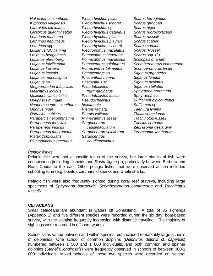

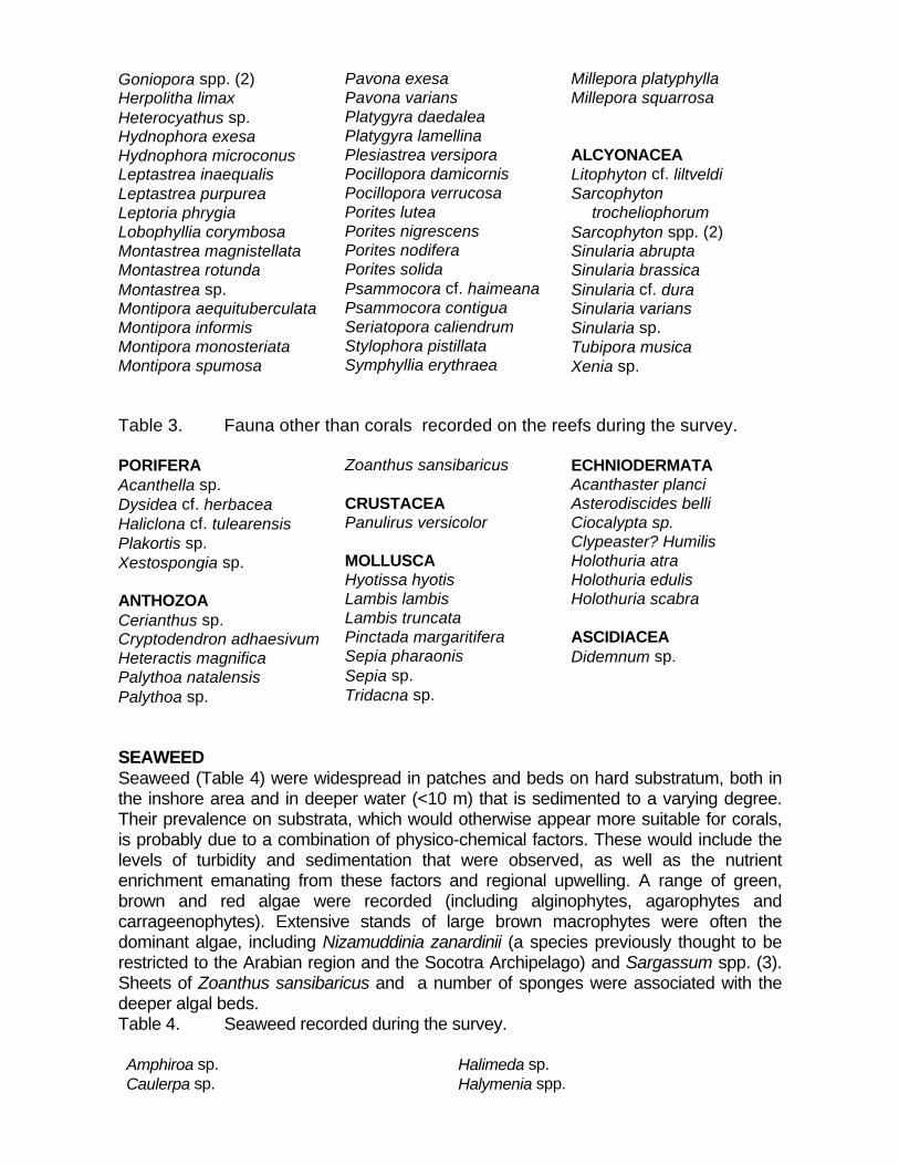


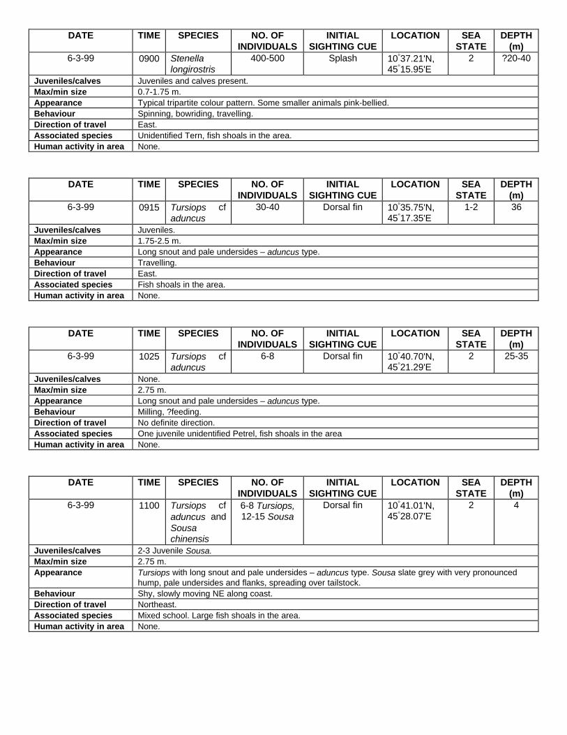

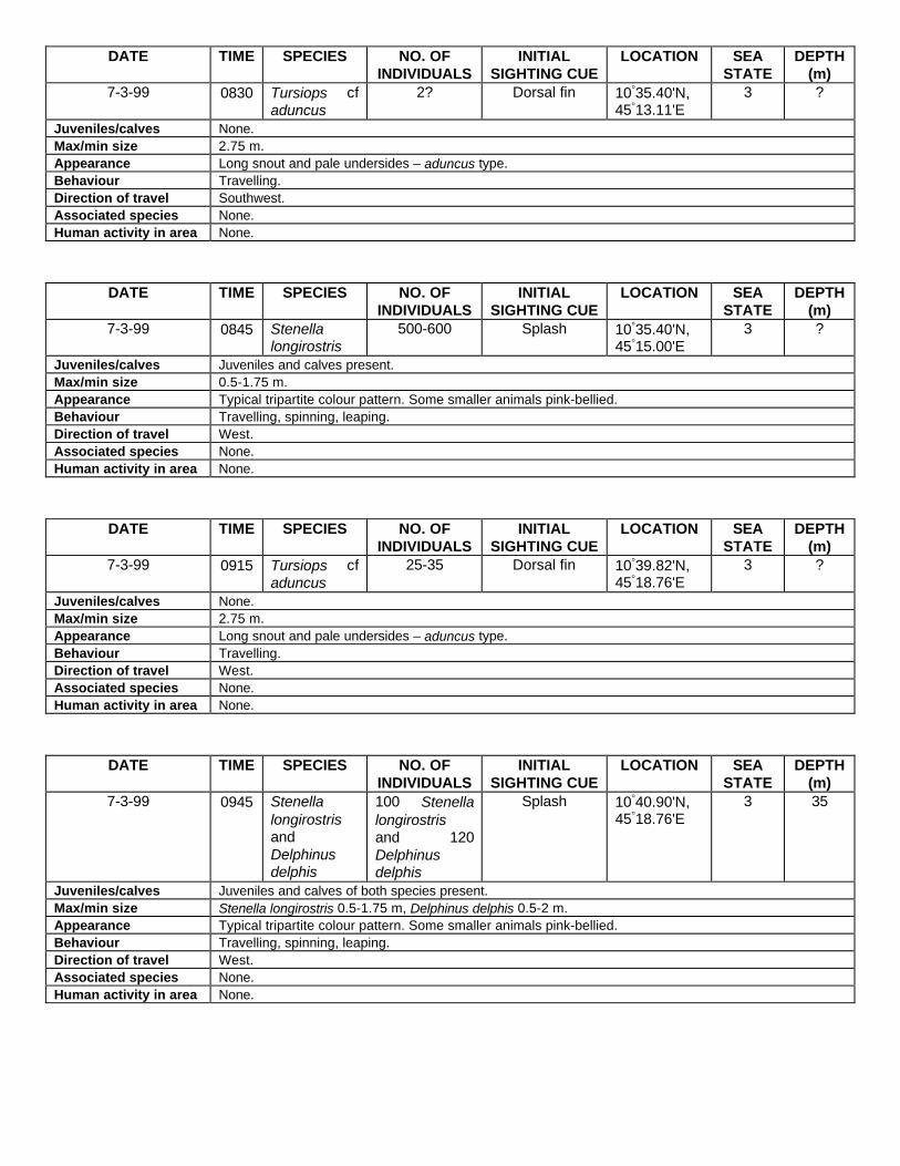

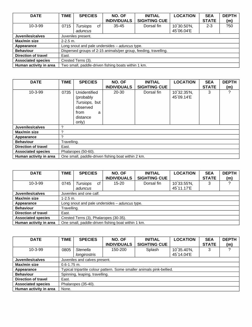

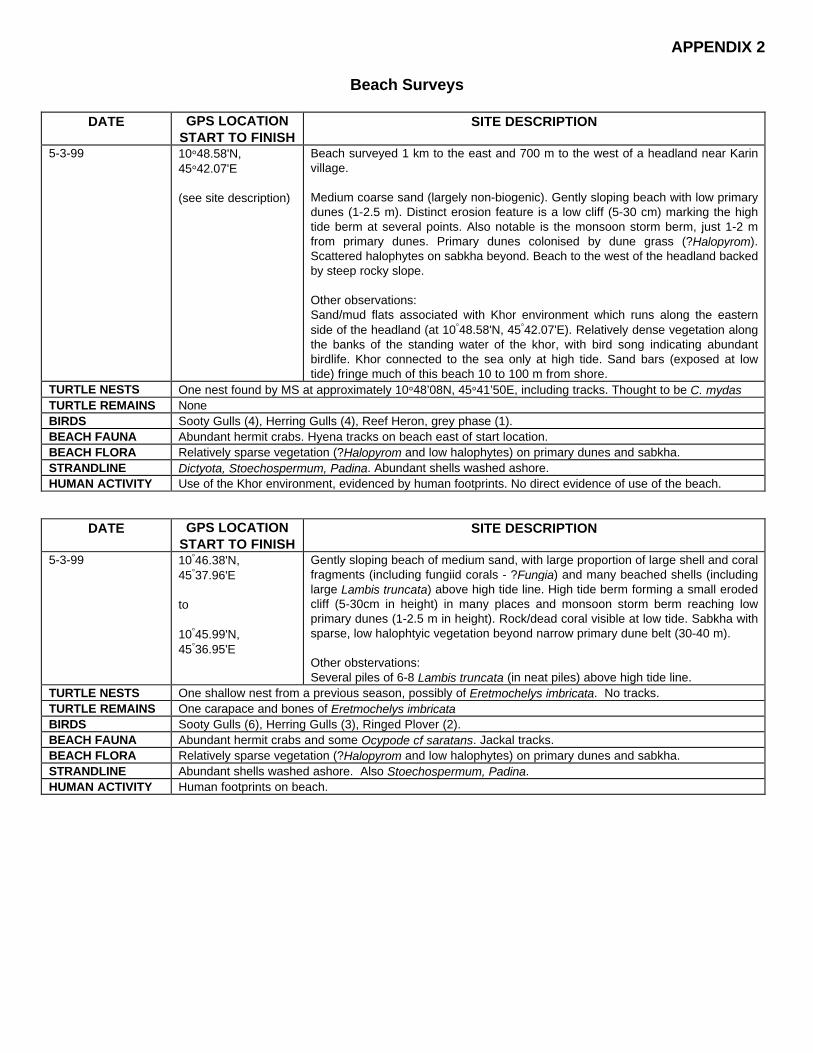


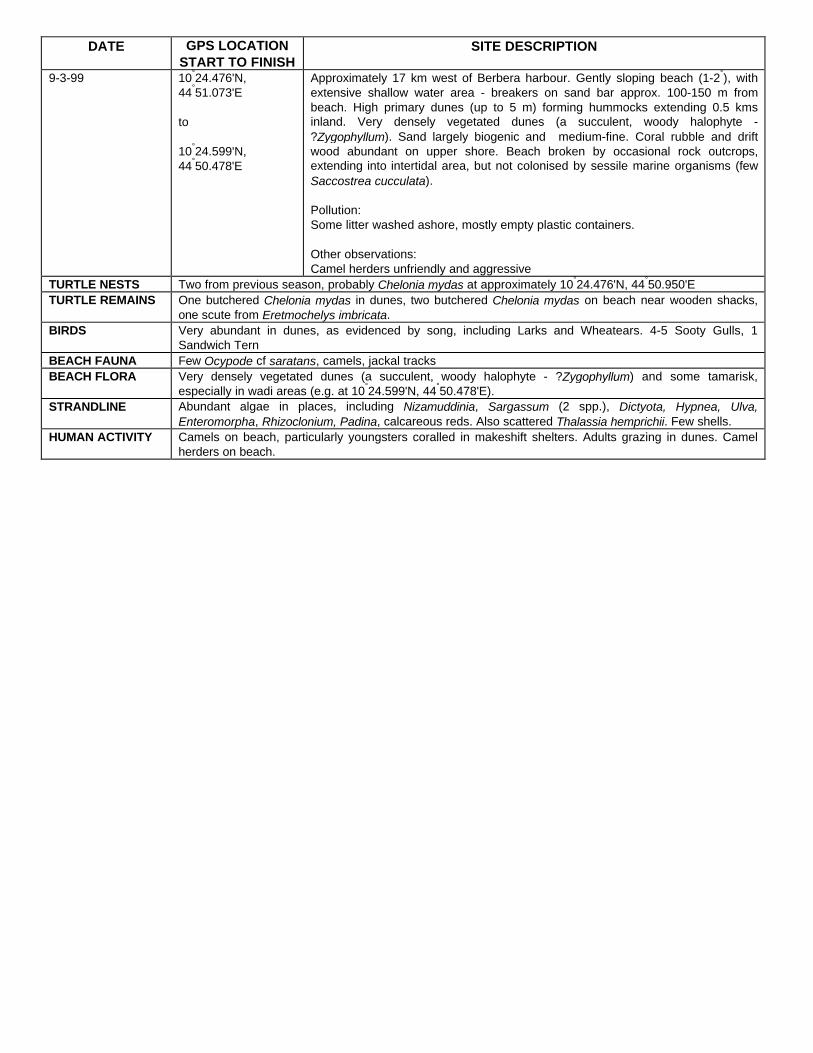

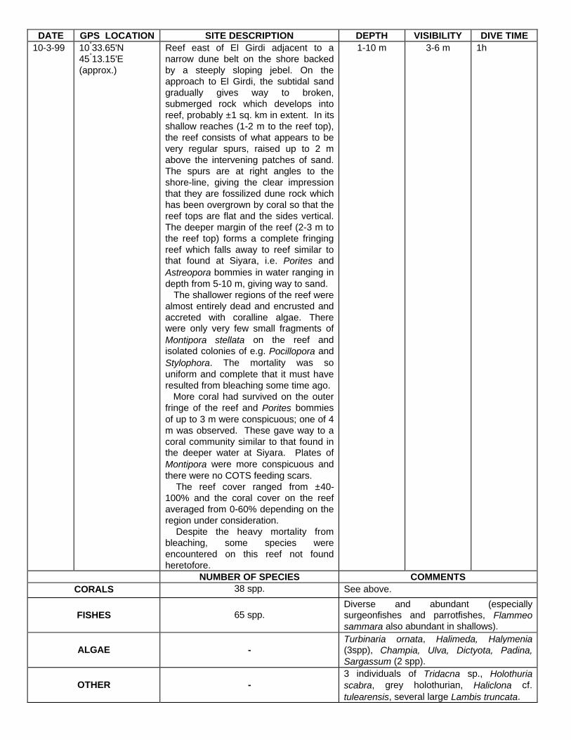


![Firm Frobenius monads and rm Frobenius algebras · the category of comodules over a Frobenius algebra. In [21], Frobenius algebras were treated by Street in the broader framework](https://static.documents.pub/doc/80x56/5f5f95d25ff49b10287be37f/firm-frobenius-monads-and-rm-frobenius-algebras-the-category-of-comodules-over-a.jpg)


