MappingOurWorldUsingArcGISOnline©Esri,2002-2016;CCAttribution-NonCommercial-ShareAlikelicense
http://edcommunity.esri.com/MOWModule1:Lesson1
1
Module1,Lesson1ThebasicsandgeographicinquirymethodThiscomputeractivitywillshowyouhowtostarttheArcGISOnlineprogram.YouwillbeguidedthroughthebasicsofusingArcGISOnlinemapviewertoexploremaps.Afteryoudothisactivity,youwillbepreparedtocompleteotherGISactivities.Task1:Openthemap
1. Launchaninternetbrowser.a) Gotothislink:
http://www.arcgis.com/home/webmap/viewer.html?webmap=8bbb186907f5421682383f0cb90b6e7aAmapdocumenthasbeencreatedforyoutouseinthisexercise.Whenthemapdocumentopens,youseeamapoftheworld.TheArcGISOnlineMapViewertitleisinthetopleftcornerofthewindow.
2. ClickontheModifyMaplink.
3. Ifyouwouldliketocompletethislessonandsaveyourwork,clickontheSaveAsbutton,provideyourloginandpasswordandprovideanewnameforyourMap.Ifyoudonotwanttosaveyourwork,proceedtoStep4withoutclickingontheSaveAsbutton.
MappingOurWorldUsingArcGISOnline©Esri,2002-2016;CCAttribution-NonCommercial-ShareAlikelicense
http://edcommunity.esri.com/MOWModule1:Lesson1
2
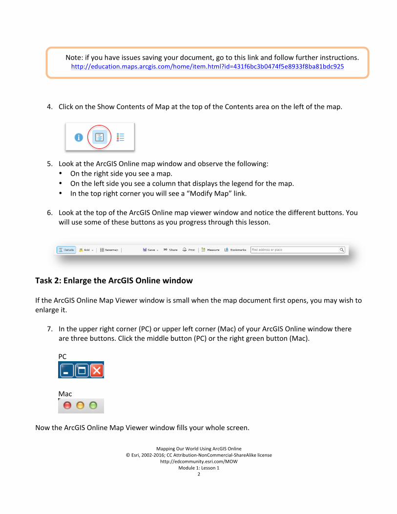
4. ClickontheShowContentsofMapatthetopoftheContentsareaontheleftofthemap.
5. LookattheArcGISOnlinemapwindowandobservethefollowing:• Ontherightsideyouseeamap.• Ontheleftsideyouseeacolumnthatdisplaysthelegendforthemap.• Inthetoprightcorneryouwillseea“ModifyMap”link.
6. LookatthetopoftheArcGISOnlinemapviewerwindowandnoticethedifferentbuttons.Youwillusesomeofthesebuttonsasyouprogressthroughthislesson.
Task2:EnlargetheArcGISOnlinewindowIftheArcGISOnlineMapViewerwindowissmallwhenthemapdocumentfirstopens,youmaywishtoenlargeit.
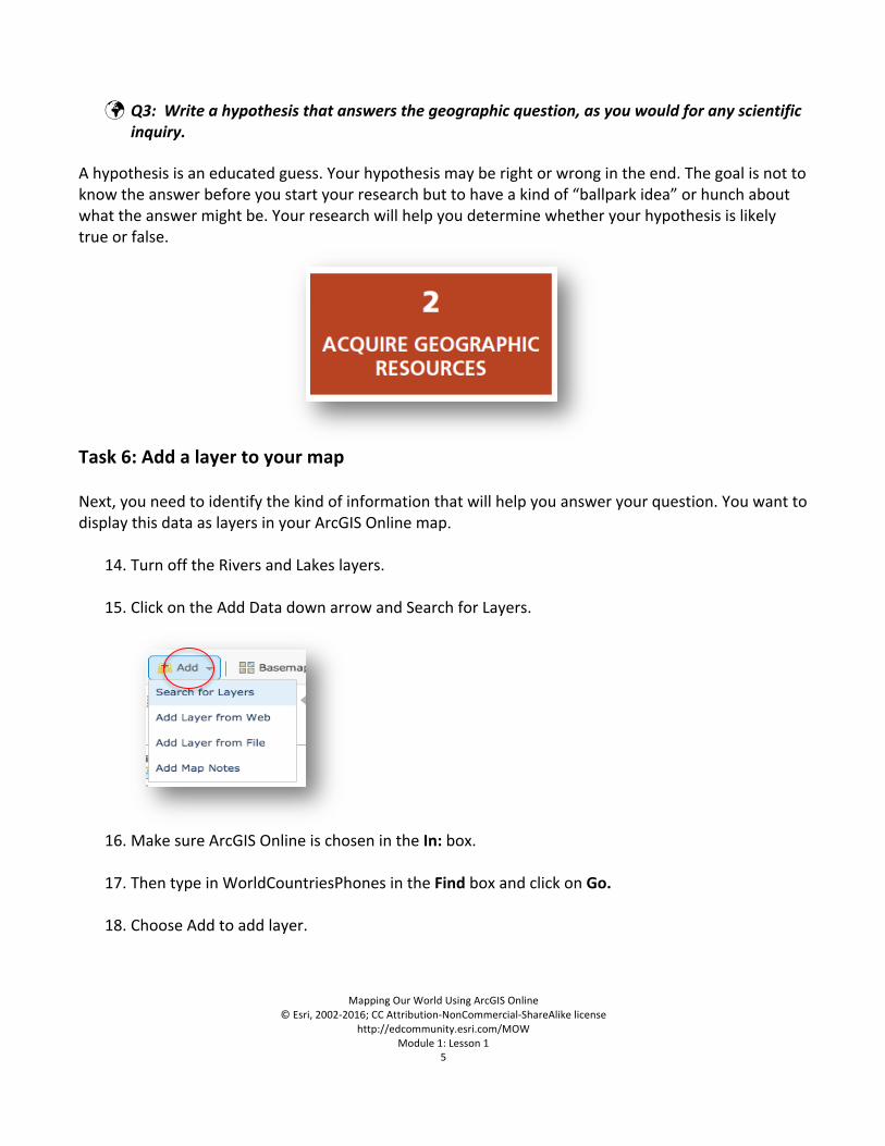
7. Intheupperrightcorner(PC)orupperleftcorner(Mac)ofyourArcGISOnlinewindowthere
arethreebuttons.Clickthemiddlebutton(PC)ortherightgreenbutton(Mac).PC
Mac
NowtheArcGISOnlineMapViewerwindowfillsyourwholescreen.
Note:ifyouhaveissuessavingyourdocument,gotothislinkandfollowfurtherinstructions.http://education.maps.arcgis.com/home/item.html?id=431f6bc3b0474f5e8933f8ba81bdc925
MappingOurWorldUsingArcGISOnline©Esri,2002-2016;CCAttribution-NonCommercial-ShareAlikelicense
http://edcommunity.esri.com/MOWModule1:Lesson1
3
YoucanalsochangethesizeofyourArcGISOnlinewindowbystretchingit.Stretchingthewindowinsteadofmaximizingitallowsyoutoorganizeotherwindowsanddialogboxesastheyappear.
8. PlacethecursoronanycorneroftheArcGISOnlinewindowthatisnotattheedgeofyour
screen.Thecursorchangestoadiagonaldouble-headedarrow.ClickanddragthewindowoutwarduntiltheArcGISOnlinewindowfillsabouttwo-thirdsofthescreen.Letgoofthemousebutton.
Task3:WorkwithlayersInArcGISOnlineMapViewer,amapismadeupoflayers.
9. LookattheContentsareaontheleftofthemapandobservethefollowing:
• Therearesixlayers:LargeCitiesgreaterthan100K,LargeCities,Rivers,Lakes,andCountriesandBasemapCoordinateSystem.
• Eachlayerexceptthelastlayer(BasemapCoordinateSystem)hasasmallboxinfrontofit.• TheboxforCountriesischecked.• Theotherboxesinfrontofthelayersareunchecked.
Nextyouwilllearnhowtoturnlayersoffandonandhowtochangetheirorder.
10. ClickthecheckmarknexttoLargeCities.ThecheckmarkshowsupandtheLargeCitiesaroundtheworlddisplays.
Thisiscalledturningonalayer.
11. ClickthecheckmarknexttoLargeCitiesagain,andthedisplayofLargeCitiesonthemaparea
alsodisappears.
12. ClicktheboxnexttotheLargeCitieslayertoturniton.
13. TurnontheRiversandLakeslayers.
MappingOurWorldUsingArcGISOnline©Esri,2002-2016;CCAttribution-NonCommercial-ShareAlikelicense
http://edcommunity.esri.com/MOWModule1:Lesson1
4
Answerstoquestionsinthisactivityshouldberecordedontheanswersheet.
Q1:WhichlayersareturnedonintheContentsandvisibleonthemap?Task4:ThegeographicinquiryprocessMuchlikescientificanalysis,geographicinquiryinvolvesaprocessofaskingquestionsandlookingforanswers.Thegeographicinquiryprocessconsistsofthefollowingfivesteps:
Innextpartofthisactivity,youwilllearnhowmapsandGIScanhelpyouinthegeographicinquiryprocess.Atthesametime,youwillbepracticingArcGISOnlineskills.
Task5:AskageographicquestionanddevelopahypothesisYoumightlookatamapandthenthinkofaquestionthatitmighthelpyouanswer.OryoumightthinkofthequestionfirstandthenlookformapsorGISlayersthatmighthelpyouanswerthequestion.Inthislessonyouwilltrytoanswerthefollowinggeographicquestion:Dothenumberofphonelinesvaryproportionatelywiththenumberofpeopleamongtheworld’smostpopulouscountries?
! Q2:Whatmakesthisageographicquestion?
MappingOurWorldUsingArcGISOnline©Esri,2002-2016;CCAttribution-NonCommercial-ShareAlikelicense
http://edcommunity.esri.com/MOWModule1:Lesson1
5
! Q3:Writeahypothesisthatanswersthegeographicquestion,asyouwouldforanyscientific
inquiry. Ahypothesisisaneducatedguess.Yourhypothesismayberightorwrongintheend.Thegoalisnottoknowtheanswerbeforeyoustartyourresearchbuttohaveakindof“ballparkidea”orhunchaboutwhattheanswermightbe.Yourresearchwillhelpyoudeterminewhetheryourhypothesisislikelytrueorfalse.
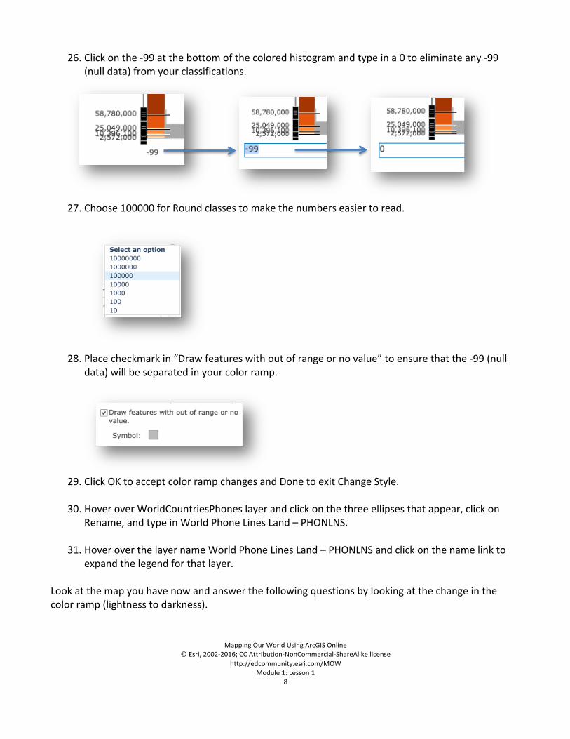
Task6:AddalayertoyourmapNext,youneedtoidentifythekindofinformationthatwillhelpyouansweryourquestion.YouwanttodisplaythisdataaslayersinyourArcGISOnlinemap.
14. TurnofftheRiversandLakeslayers.
15. ClickontheAddDatadownarrowandSearchforLayers.
16. MakesureArcGISOnlineischosenintheIn:box.
17. ThentypeinWorldCountriesPhonesintheFindboxandclickonGo.
18. ChooseAddtoaddlayer.
MappingOurWorldUsingArcGISOnline©Esri,2002-2016;CCAttribution-NonCommercial-ShareAlikelicense
http://edcommunity.esri.com/MOWModule1:Lesson1
6
19. ClicktheDONEADDINGLAYERSbuttonatthebottomoftheContents.
! Q4:Whatisthenameofthelayerthathasbeenaddedtoyourtableofcontents?
! Q5:Canyouguessastowhatdatathislayerhasinitbyitsname?
Task7:ExploretheWorldPhoneLinesLandmapCurrentlytheWorldCountriesPhoneslayerisonecolor.Youwillthematicallymap(mapbycolor)thelayerthatwillarrangethedataforthecountriesbycolorfromlighttodark.Thiswillenableyoutovisuallyexplorethedata.
20. HoveroverWorldCountriesPhonesslayerandclickontheChangeStylebutton.
Note:Ifatanytimethecountriesdon’tfitontopofthemap,zoomoutandzoominonceandtheywilllayeroneontopoftheother.
MappingOurWorldUsingArcGISOnline©Esri,2002-2016;CCAttribution-NonCommercial-ShareAlikelicense
http://edcommunity.esri.com/MOWModule1:Lesson1
7
21. ChangeChooseanattributetoshowtoPHONLNS.
NotetheCountsandAmounts(Color)drawingstyleisnowchosen.
22. ClickonOPTIONS.
23. ClickonSymbolsandchoosetheorangecolorrampinthesixthrowofcolorramps.
24. ClickOK.
25. PlacecheckmarkinClassifyDataboxandchooseNaturalBreaksand5classesfromthepulldownmenus.
MappingOurWorldUsingArcGISOnline©Esri,2002-2016;CCAttribution-NonCommercial-ShareAlikelicense
http://edcommunity.esri.com/MOWModule1:Lesson1
8
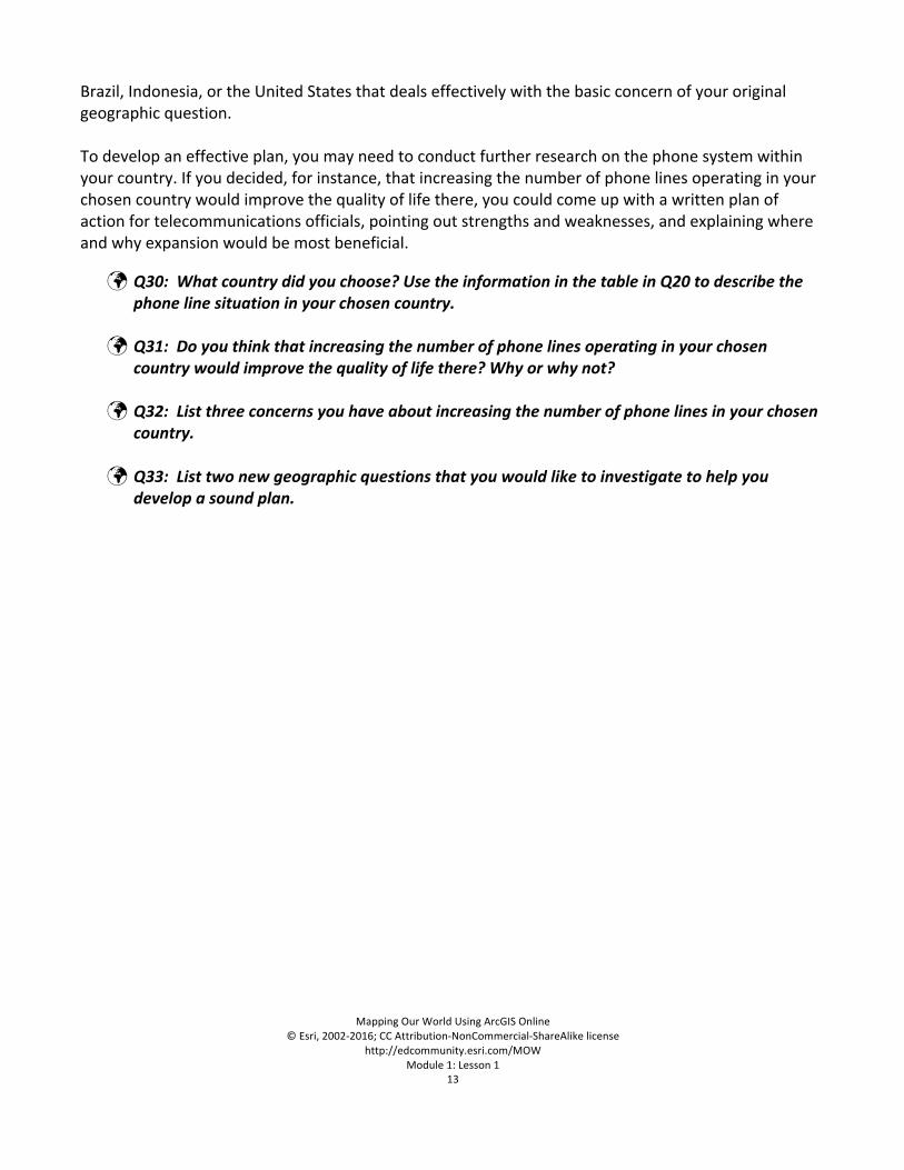
26. Clickonthe-99atthebottomofthecoloredhistogramandtypeina0toeliminateany-99(nulldata)fromyourclassifications.
27. Choose100000forRoundclassestomakethenumberseasiertoread.
28. Placecheckmarkin“Drawfeatureswithoutofrangeornovalue”toensurethatthe-99(nulldata)willbeseparatedinyourcolorramp.
29. ClickOKtoacceptcolorrampchangesandDonetoexitChangeStyle.
30. HoveroverWorldCountriesPhoneslayerandclickonthethreeellipsesthatappear,clickonRename,andtypeinWorldPhoneLinesLand–PHONLNS.
31. HoveroverthelayernameWorldPhoneLinesLand–PHONLNSandclickonthenamelinkto
expandthelegendforthatlayer.Lookatthemapyouhavenowandanswerthefollowingquestionsbylookingatthechangeinthecolorramp(lightnesstodarkness).
MappingOurWorldUsingArcGISOnline©Esri,2002-2016;CCAttribution-NonCommercial-ShareAlikelicense
http://edcommunity.esri.com/MOWModule1:Lesson1
9
! Q6:WhatcolorinthelegendfortheWorldPhoneLinesLandlayerindicatescountrieswiththefewestphonelines?
! Q7:Whatcolorindicatescountrieswiththemostphonelines?
! Q8:Whatcolorindicatescountrieswithnodataavailableforthislayer?Noticethatthecolorsinthelegendchangegraduallyfromlightesttodarkest.Thenameforthistypeoflegendisagraduatedcolorlegend.
! Q9:Doesanyotherlayerinyourmaphaveagraduatedcolorlegend?
Toanswerthefollowingquestions,youwillneedtomakeacopyoftheWorldCountrieslayer.
32. HoverontheWorldPhoneLinesLand–PHONLNSlayerandclickonthethreeellipses.Clickoncopytomakeacopyofthislayer.
33. FollowSteps19–29tocolorthenewmaplayerusingtheseChangeSymbolschoices.RemembertoclickontheOKandDonebuttonstoapplyyournewgraduatedcoloring.
34. ClickonOKandDone.
35. HoveroverWorldPhoneLinesLand–PHONLNSCopylayerandclickonthethreeellipsesthatappear,clickonRename,andtypeinWorldCountriesPopulation–POP2007.
Youwillnowturnlayersonorofftoidentifyandfindoutacountry’sname.Toidentifyacountryname,clickonthecountryshape.Youmayneedtoclickonthearrowinthetoprightcorneroftheidentifywindowuntilyoucometothecountryname.
AttributetoShow:
POP2007
Symbols: BlueRampClassifyData:By
NaturalBreaks
ClassifyData:With
5Classes
Round 100000NoValue: CheckMark
MappingOurWorldUsingArcGISOnline©Esri,2002-2016;CCAttribution-NonCommercial-ShareAlikelicense
http://edcommunity.esri.com/MOWModule1:Lesson1
10
36. ClickontheWorldCountriesPopulation–POP2007layernametodisplaythelegend.
! Q10:Whichtwocountrieshavethemostphonelines?
! Q11:Onwhichcontinentaremostofthecountrieswiththefewestphonelines?
! Q12:Whichtwocountrieshavethelargestpopulations?
! Q13:Namethetwocountriesthatareinthesamepopulationclass(color)astheUnited
States.
! Q14:Whichofthetwocountries,ifany,areinthesamephonelineclass(color)astheUnitedStates?
37. ClickontheUnitedStatesonthemap.
38. Readthegeographicquestionagain.
Geographicquestion:Dothenumberofphonelinesvaryproportionatelywiththenumberofpeopleamongtheworld’smostpopulouscountries?
39. ScrolldownslowlyintheIdentifywindowandlookatthedifferentfields.
! Q15:Whattwofieldsmighthelpinansweringthegeographicquestion?
40. ClosetheIdentifypopupwindow.Task8:InvestigatetherelationshipbetweenphonelinesandpopulationinChina
41. ClickintheFindaddressorplacewindowatthetoprightofthemapandtypeinChina.
MappingOurWorldUsingArcGISOnline©Esri,2002-2016;CCAttribution-NonCommercial-ShareAlikelicense
http://edcommunity.esri.com/MOWModule1:Lesson1
11
Chinawillbecenteredonthemap.
42. ClickonChinatoopentheIdentifywindow.
! Q16WhatwasthepopulationofChinain2007?
! Q17HowmanyphonelinesdidChinahavein2007?(ScrolldownandlookforthePHONLNSattribute.)
Remembernottoworryaboutthedisparitybetweenthepopulationyearandtheyearthatphonelinedatawascollected.
43. ClosetheIdentifypopupwindow.
44. Onyourcomputer,clickStart,Programs,Accessories,Calculator(PC)ortheApplicationsfolder(Mac)tostartthecalculator.
45. DividethepopulationofChinabythenumberofphonelines.ThisnumberisthephonelinedensityorthenumberofpeopleperphonelinesinChina.
! Q18:WhatwasthenumberofpeopleperphonelineinChina?(Roundofftheresulttothe
nearesttwodecimalplaces.)Task9:Investigatetherelationshipbetweenpopulationandphonelinesforallcountriesinthelist
46. Enterthepopulation,phonelines,andphonelinedensityforChinaontheanswersheetonQ19.(Thesenumbershavebeenenteredforyouasanexample.)
! Q19:Foreachcountryinthetable,whatisthepopulation,numberofphonelines,and
numberofpeopleperphoneline?(UseSteps25–29tofilloutthetable.) Task10:Analyzetheresultsofyourresearch
! Q20:Inthetableontheanswersheet,thecolumnontheleftranksthecountriesbypopulationfromhighesttolowest.Inthecolumnontheright,rankthecountriesfromthelowestnumberofpeopleperphonelinetothehighestnumberofpeopleperphoneline,usingthedatafromQ18.Thendrawlinesconnectingthenameofeachcountryinonecolumnwiththenameofthesamecountryintheothercolumn.
L2 ! Q21:Whichcountryhasthefewestpeopleperphoneline?Whatisthenumberofpeopleper
phonelineinthiscountry?
MappingOurWorldUsingArcGISOnline©Esri,2002-2016;CCAttribution-NonCommercial-ShareAlikelicense
http://edcommunity.esri.com/MOWModule1:Lesson1
12
! Q22:HowdoesthecountryinQ21rankinpopulationsizeamongtheeightcountriesinyour
table?
! Q23:Whichcountryhasthemostpeopleperphoneline?Whatisthenumberofpeopleperphonelineinthiscountry?
! Q24:HowdoesthecountryinQ23rankinpopulationsizeamongtheeightcountriesinyourtable?
! Q25:WhatisthepopulationofJapan?WhatisthenumberofpeopleperphonelineinJapan?
! Q26:Whatcountryhasthemostphonelines?Howdoesthenumberofpeopleperphonelineinthiscountrycomparewiththenumbersofpeopleperphonelineinthesevenothercountriesinyourtable?
! Q27:RussiaandPakistanhaveaboutthesamenumberofpeople.Whydoyousupposethesetwocountrieshavesuchdifferentnumbersofpeopleperphoneline?Whatfactorsdoyouthinkcontributetothisdisparity?
! Q28:Whatistheanswertothegeographicquestion:Dothenumberofphonelinesvaryproportionatelywiththenumberofpeopleamongtheworld’smostpopulouscountries?
! Q29:Compareyourinitialhypothesis(Q2)withyouranswerinQ28.Howdoesyourhypothesiscomparewithyouranswertothegeographicquestion?
Task11:Developaplanofaction Thelaststepofthegeographicinquiryprocessistoactonwhatyouhavelearned.Youractionplanmightbesimplytorepeattheprocess;thinkingaboutwhatyou’velearnedoftenleadstodeeper,moreinterestinggeographicquestions.Imaginethatyouareanexpertspecializingintelecommunications.YouneedtodeviseaplanforChina,
MappingOurWorldUsingArcGISOnline©Esri,2002-2016;CCAttribution-NonCommercial-ShareAlikelicense
http://edcommunity.esri.com/MOWModule1:Lesson1
13
Brazil,Indonesia,ortheUnitedStatesthatdealseffectivelywiththebasicconcernofyouroriginalgeographicquestion.Todevelopaneffectiveplan,youmayneedtoconductfurtherresearchonthephonesystemwithinyourcountry.Ifyoudecided,forinstance,thatincreasingthenumberofphonelinesoperatinginyourchosencountrywouldimprovethequalityoflifethere,youcouldcomeupwithawrittenplanofactionfortelecommunicationsofficials,pointingoutstrengthsandweaknesses,andexplainingwhereandwhyexpansionwouldbemostbeneficial.
! Q30:Whatcountrydidyouchoose?UsetheinformationinthetableinQ20todescribethephonelinesituationinyourchosencountry.
! Q31:Doyouthinkthatincreasingthenumberofphonelinesoperatinginyourchosencountrywouldimprovethequalityoflifethere?Whyorwhynot?
! Q32:Listthreeconcernsyouhaveaboutincreasingthenumberofphonelinesinyourchosencountry.
! Q33:Listtwonewgeographicquestionsthatyouwouldliketoinvestigatetohelpyoudevelopasoundplan.