1 Introduction An aquatic macrophyte survey of the Montgomery Canal Reserves was carried out from 27 June to 1 July, 2003. The survey assessed the present status of the aquatic and bankside plants within seven reserves. These were: • The Weston Arm, grid reference SJ 369 311, 100 linear metres • Rednal Basin, grid reference SJ 351 278 • Aston Locks Nature Reserve, grid reference SJ 336264 • Guilsfield Arm, grid reference SJ 252 148 to SJ 243 137, approximately 1600 linear metres • Wern Reserve, grid reference SJ 252 141 • Whitehouse Bridge Reserve, grid reference SJ 223 061 • Brithdir Reserve, grid reference SJ 200 023 The first three reserves are in England and the remaining four are in Wales. All the reserves are thus geographically spaced along the canal starting at the junction with the Llangollen Canal at Lower Frankton, Shropshire and ending at the Brithdir Reserve approximately 6 kilometres south west of Welshpool. The reserves attempt to encapsulate the flora found in that section of the canal and overall be representative of the canal flora found throughout its length. A previous survey of the canal flora was undertaken in September, 2001 and the reserve survey has several objectives. First the condition of each reserve is to be assessed from the flora found comparing each reserve with historical data and consideration given as to whether or not the management of each reserve and the water quality is appropriate for conserving the intended flora. The second is to compare the flora of the canal with that found in the seven side reserves and discuss the effectiveness of the reserves in conserving a representative cross section of that flora. Thirdly to address any shortfall in the present geographical cover of the reserves as intended representatives of the present flora found within the canal. Fourthly to consider the most effective design for any future reserve. Background The Montgomery Canal at present extends from Frankton Junction (NGR SJ 371 317) to just south of Freestone Lock (SO 137 927) near to Newtown. It is part navigable, in part a remainder canal in water with a disused section between Gronwyn Bridge (SJ 305 246) and the Old Railway Bridge (SJ 271 214), Llanymynech. The total in-water length is 48 km with 12 km in England and 36 km in Wales. At present there are navigable sections in England from the junction with the Llangollen Canal (Shropshire Union Canal) at Lower Frankton (NGR SJ 371 317) to Queens Head (SJ 338 268). In Wales, there is a further section used by narrow boats from Burgedin Locks, near Wern (SJ 252 146) to Berriew (SJ 190 008) a few miles south of Welshpool. Sections not open to navigation and in water have exceptional wildlife value. Of particular importance is the aquatic and bankside flora. The canal is a Site of Special Scientific Interest (SSSI) mainly for its flora a kilometre north of Rednal (SJ 351 287) to Maesbury Marsh (SJ 310 249) in England and from Llanymynech (SJ 273 216) just in England to Newtown in Wales. The Welsh section is internationally important for floating water plantain Luronium natans and as such is a Candidate Special Area of Conservation (cSAC).
Transcript
1
Introduction
An aquatic macrophyte survey of the Montgomery Canal Reserves was carried outfrom 27 June to 1 July, 2003. The survey assessed the present status of the aquaticand bankside plants within seven reserves. These were:
• The Weston Arm, grid reference SJ 369 311, 100 linear metres• Rednal Basin, grid reference SJ 351 278• Aston Locks Nature Reserve, grid reference SJ 336264• Guilsfield Arm, grid reference SJ 252 148 to SJ 243 137, approximately 1600
The first three reserves are in England and the remaining four are in Wales. All thereserves are thus geographically spaced along the canal starting at the junction withthe Llangollen Canal at Lower Frankton, Shropshire and ending at the BrithdirReserve approximately 6 kilometres south west of Welshpool. The reserves attemptto encapsulate the flora found in that section of the canal and overall be representativeof the canal flora found throughout its length. A previous survey of the canal florawas undertaken in September, 2001 and the reserve survey has several objectives.First the condition of each reserve is to be assessed from the flora found comparingeach reserve with historical data and consideration given as to whether or not themanagement of each reserve and the water quality is appropriate for conserving theintended flora. The second is to compare the flora of the canal with that found in theseven side reserves and discuss the effectiveness of the reserves in conserving arepresentative cross section of that flora. Thirdly to address any shortfall in thepresent geographical cover of the reserves as intended representatives of the presentflora found within the canal. Fourthly to consider the most effective design for anyfuture reserve.
Background
The Montgomery Canal at present extends from Frankton Junction (NGR SJ 371 317)to just south of Freestone Lock (SO 137 927) near to Newtown. It is part navigable,in part a remainder canal in water with a disused section between Gronwyn Bridge (SJ305 246) and the Old Railway Bridge (SJ 271 214), Llanymynech. The total in-waterlength is 48 km with 12 km in England and 36 km in Wales. At present there arenavigable sections in England from the junction with the Llangollen Canal(Shropshire Union Canal) at Lower Frankton (NGR SJ 371 317) to Queens Head (SJ338 268). In Wales, there is a further section used by narrow boats from BurgedinLocks, near Wern (SJ 252 146) to Berriew (SJ 190 008) a few miles south ofWelshpool. Sections not open to navigation and in water have exceptional wildlifevalue. Of particular importance is the aquatic and bankside flora. The canal is a Siteof Special Scientific Interest (SSSI) mainly for its flora a kilometre north of Rednal(SJ 351 287) to Maesbury Marsh (SJ 310 249) in England and from Llanymynech (SJ273 216) just in England to Newtown in Wales. The Welsh section is internationallyimportant for floating water plantain Luronium natans and as such is a CandidateSpecial Area of Conservation (cSAC).
2
Over the last thirty years sections of the Montgomery Canal have been restored tonavigation. The restoration is ongoing with works currently being undertaken onsections of the canal and its structures. It is due to be completely restored tonavigation over the next few years. It is important that the restoration is carried out ina manner sympathetic to the flora and animal life of the canal. A number of surveyshave been carried out notably in 1988 and 1997 resulting in a comprehensive specieslist for the canal. A full survey was undertaken in September 2001 giving both acomprehensive species list and abundance assessments for the flora found in or by thecanal. Such an assessment was thought necessary to inform the process of restorationand after use of the canal but it also serves as a useful measure against which theseven side reserves can be assessed for their effectiveness in representing the flora ofthe canal as a whole.
Methodology
The survey was undertaken between 27 June and 1 July 2003. It was restricted to thereserve and its margins and the methodology provides a detailed assessment of thedistribution and abundance of this flora. At the Whitehouse Bridge reserve part of thecanal was also surveyed as this served as the inflow to the reserve and was abackwater to the main channel. All assessments of the flora were made from thetowpath (where present) or bankside. The Whitehouse Bridge Reserve was alsosurveyed using a boat. The bankside flora and the visible aquatic vegetation withinthe “channel” were mapped using the DAFOR scale (Dominant, Abundant, Frequent,Occasional and Rare). In all reserves except the Guilsfield Arm and the last section ofthe Wern Reserve, visibility was excellent and accurate mapping was possible. Thechannel vegetation was also sampled using a double-sided rake. The distancebetween each “throw” or transect was variable dependent on the size of the reserve.For the Weston Arm, the Rednal Basin and the Aston Ponds this distance wasapproximately every 5 metres, for the Whitehouse Bridge and Wern Reserves thedistance was every 10 metres and for the Guilsfield Arm every 50 metres. All speciescollected were identified and recorded and the abundance noted using the DAFORscale. Any species not capable of being identified in the field was identified using alow power microscope during the same evening. BSBI recording cards werecompleted for each reserve.
Conductivity and pH readings were taken at all the reserves.
The vegetation was recorded on maps to a variable scale and they are as follows:• The Weston Arm 1:250• Rednal Basin 1:250• Aston Locks Nature Reserve 1:416• Guilsfield Arm 1:1250• Wern Reserve 1:250• Whitehouse Bridge 1:416• Brithdir Reserve 1:200
The scale was determined as the largest practical size given the detailed amount ofinformation recorded during the survey.
3
Results.
The species found in each reserve are given in Appendix 1. The numbers 1-7represent,
1. The Weston Arm given as the Western Arm on the British Waterways Map2. Rednal Basin3. The Aston Locks Nature Reserve4. The Guilsfield Arm5. The Wern Reserve6. Whitehouse Bridge7. Brithdir Reserve.
Conductivity and pH.Conductivity and pH readings were taken at all the reserves (Table 1). These werecompared against those results obtained for the canal as a whole in September 2001(Newbold 2001).
Table 1. The conductivity and pH for the Seven Reserves recorded in June 2003(in bold type) and as a comparison the conductivity and pH recorded for thoseeleven sites on the Montgomery Canal in September 2001 (Newbold 2001).
Site Conductivity pHFrankton Junction (SJ 371 317), 600 7.8The Weston Arm Reserve (SJ 369 311) 500 8.6Rednal Basin (SJ 351 278) 275 8.7Queens Head (SJ 338 268) 600 7.9Aston Locks Reserve (SJ 336 264) 600 8.0Aston Locks Reserve (SJ 336 264) 220 to 200 8.0to7.5Guilsfield Arm connected to main canal(SJ 252 148 to SJ 243 137)
175 7.6
Guilsfield Arm disused section(SJ 252 148 to SJ 243 137)
This is a 100metre long reserve at the end of a side-arm which, in total, isapproximately 200metres long (Map 1). The side arm is approximately 1km from theFrankton Junction with the Llangollen Canal where the water is very turbid with aSecchi disc of only 40cms. The water is also probably hypertrophic since theconductivity was 500 microsiemens and the pH recorded was 8.6 at 10.00hrs at anambient temperature of 20C. The water at the reserve had the same pH andconductivity. The flora of the reserve was dominated by Elodea nuttallii withoccasional dominant overgrowths of the filamentous algal generaMougeotia/Spyrogyra (Maps 2 and 3). Despite extensive searching no othersubmerged species could be found. Species such as Ceratophyllum demersum mighthave been present. Lemna minor occurred occasionally mainly at the extreme end ofthe reserve. The emergent species Typha latifolia and Glyceria maxima were found inroughly equal amounts on the northern side only. The inner landward zone of thesespecies was dominated by Carex acutiformis, Phalaris arundinacea and Juncuseffusus. The full assemblage of the aquatic and bankside species is given on Maps 2and 3 and on the spreadsheet (Appendix 1).
Whilst the Weston Arm contained a limited number of species, this was to beexpected as the nearby main canal contained only small amounts of Elodea nuttallii,Persicaria amphibia and a very small amount of Ranunculus circinatus whensurveyed in September 2001 (Newbold 2001). These species were found again in thecanal in 2003 in approximately the same areas. The pH and conductivity of the waterwithin the reserve suggest the canal is greatly influenced by the hypertrophic waterfound in the Llangollen Canal. In many ways the flora of the reserve is representativeof the nearby Montgomery Canal but it has a greater abundance of Elodea nuttalliithan that of the canal. The absence of species such as Persicaria amphibia andRanunculus circinatus may be the result of spatial competition from the totallydominant Elodea nuttallii.
Rednal Basin
Rednal Basin is found approximately 4.825km away from Frankton Junction. Thewater quality is considered to be eutrophic having a lower conductivity of 275microsiemens but a pH of 8.7 was recorded at 14.00hrs at an ambient temperature of26C. The increase in pH over that of the Weston reserve could reflect the increasingambient temperature as the day progressed with increasing algal activity increasingthe pH.
The aquatic flora within the reserve was diverse with species such as Ceratophyllumdemersum, Elodea nuttallii, Hydrocharis morsus-ranae, Myriophyllum spicatum,Nuphar lutea, Persicaria amphibia, Potamogeton alpinus, Potamogeton obtusifolius,and Potamogeton natans being found. The abundant species were Potamogetonobtusifolius, Potamogeton natans,and Elodea nuttallii. The remainder were onlyoccasionally found except for Ceratophyllum demersum which was rare (Maps 5,6and 7). The edge species along the channel were not very diverse due to intenseshading with occasional growths of Carex paniculata, Glyceria maxima, Iris
5
pseudacorus and Rumex hydrolapathum (Maps 5 and 6). The old quay wasdominated in the western corner by Glyceria maxima and occasional growths ofPhalaris arundinacea and Caltha palustris. Growing under the Salix along thewestern edge were occasional growths of Iris pseudacorus, Sparganium erectum andAlisma plantago-aquatica (Map 7).
The diversity of Rednal Basin is not reflected in the generally impoverished nearbycanal (Map 4) where only Elodea nuttallii, Nuphar lutea and Potamogeton alpinuswere found in this survey. The latter two species were growing abundantly along thefar edge (the non towpath side). In September, 2001 only Nuphar lutea was found inthe immediate vicinity on the main canal. Potamogeton alpinus was not found in thereserve in 2001. Clearly the diversity found in the reserve suggests that it is morethan representative of this section of the canal. Introductions were made in the mid1980’s of several of the presently found recorded species (see Discussion).
The Aston Lock Nature Reserve
The Aston Locks Nature Reserve is 7kms from the Frankton Junction and theycomprise of five interlinked ponds (Map 8) with a through-flow of water. This is fedby gravity using the fall of the Aston locks. Another three ponds are separated fromthis source and appear to be fed by rain water and leakage from the canal. All the fivemain ponds are butyl lined. The water is eutrophic having a pH of 8.0 and aconductivity of 220 microsiemens at the inflow. As the water flows through the fiveponds so the pH gradually reduces from pH 8.0 to pH 7.8 to pH 7.6 to pH 7.5 with theconductivity remaining the same until the final pond where 200 microsiemens wasrecorded (Maps 9 to 13). Ponds six, seven and eight were situated on mildly acidsoils of pH 6.5. Pond 6 had a 1cm depth of water and Pond 7 had a 10-20cm depth ofwater. In Pond 7 the pH was 9.5 which reflected the high oxygen production from theChara globularis during the afternoon of the 28th June with an ambient temperature of28C.
The aquatic flora in Pond 1 is locally dominated by surface growths of Hydrocharismorsus-ranae and Nuphar lutea. Elodea nuttallii, Ceratophyllum demersum,Myriophyllum spicatum, Persicaria amphibia, Potamogeton natans and Zannichelliapalustris were found occasionally and Potamogeton compressus was found being rarein only one location (Map 9). The edge of this pond was dominated by Carexacutiformis, Glyceria maxima and Typha latifolia. Iris pseudacorus and Alismaplantago-aquatica were found occasionally (Map 9).
Pond 2 was less diverse with the possible hybrid Elodea Canadensis x nuttallii beingfrequently found alongside Hydrocharis morsus-ranae. Potamogeton alpinus wasfound rarely. Parts of the pond and the edge were dominated by Typha latifolia andoccasional growths of Nasturtium aquaticum and Sparganium erectum (Map 10).
Pond 3 had more open water in it but Elodea canadensis was the only frequentlyfound plant with Potamogeton alpinus and Hydrocharis morsus-ranae being locallydominant. Typha latifolia dominated the edge with occasional growths of Alismaplantago-aquatica and Alisma lanceolatum (Map 11).
6
Pond 4 was dominated by Potamogeton alpinus with Hydrocharis morsus-ranaebeing locally dominant. The edge was again dominated by Typha latifolia (Map 12).
Pond 5 was more diverse but again was dominated by Potamogeton alpinus.Hydrocharis morsus-ranae Nuphar lutea and Sparganium emersum were locallydominant. Elodea canadensis was the only frequently found plant and Hottoniapalustris and Ranunculus circinatus were occasionally found. The edge wasdominated by Typha latifolia and Sparganium erectum with small areas of Nasturtiumaquaticum and Butomus umbellatus and one tussosk of Carex paniculata (Map 13).The narrowing of the pond towards the outflow had three small wettish depressionswhich were the only areas where Juncus sub-nodulosus and Carex rostrata werefound
Pond 6 was dominated by Chara globularis and Ranunculus flammula withoccasional growths of Hydrocotyle vulgaris. The last two species reflect the acidnature of the soil (Map 14).
Pond 7 was dominated in the dry area by sparse growths of Phragmites australis andstunted growths of Typha latifolia. The small area of shallow water (10 –20cm depth)was dominated by Chara globularis. The acid loving Juncus bulbosus was thedominat plant found around the edge of this water. It was also the main component ofthe understorey to the Phragmites growth. Ranunculus flammula was locallydominant. (Map 14).
Pond 8 was a deeper water body approximately 60 to 80cms deep but one which wastotally overgrown with Chara globularis which in turn was 70% covered byfilamentous algal growths of the genera Mougeotia and Spirogyra. Phragmitesaustralis dominated the eastern side whilst on the more open western side Juncuseffusus was dominant. In the corner, between these stands, a small area ofSparganium erectum was recorded. To the north the pond narrowed down and wasovergrown by carr of Alnus glutinosa, Salix sp. and Betula sp.. The shading andpotentially toxic leaf litter precluded any plant growth. In the poor fen surroundingthis pond, Anagallis tenella the bog pimpernel was found in one small area (Map 15).This again reflected the acidity of the soil in this corner of the reserve but no suchacidity was reflected by the true aquatic flora found in any of the ponds 6, 7 and 8.
The Aston Ponds have an introduced flora but they are nevertheless representative ofwhat might be found in the nearby canal. However the first pond is suffering from theeffects of both highly eutrophic canal water and the effects of swan grazing and this isthe only pond in which Potamogeton compressus was found. The leaves of thisspecies were stressed by coverings of algae and diatoms and its long term survivalmust be questioned if the pollution is not addressed. Remedial measures areconsidered in the Discussion (Blockage of Inflow by Emergent Plants).
The Guilsfield Arm
The Guilsfield Arm shown at a scale of 1:2500(Maps 16) is approximately 26kmsfrom Frankton Junction and approximately 8kms “downstream” of the Tanat feeder.This feeder gives the canal a mildly acid mesotrophic water of pH 6.7 with a low
7
conductivity of 120 microsiemens (Newbold 2001). By the time this water hasreached the junction with the Guilsfield Arm it is again eutrophic with a pH of 7.6 anda conductivity of 175 microsiemens. Additionally the stagnant water in theovergrown disused Guilsfield Arm attracts nutrients from the surrounding fieldswhich although sheep and cattle grazed do nevertheless receive fertiliser treatments.The water in this section has a pH of 7.7 and a conductivity of 275 microsiemens.
There are two sections to the Guilsfield Arm. One is connected to the MontgomeryCanal and is approximately 115metres long (Map 17). The other, the main arm of theGuilsfield Canal is a disused overgrown section 1650metres long starting atSpringbank and ending at Varchoel. It is cut off from the first section by a “controlpaddle” and a culverted bridge (Maps 18 to 23). At the junction with theMontgomery Canal the Guilsfield Arm contains Elodea nutalli as the only aquaticplant but it does have occasional stands of Glyceria maxima and Sparganium erectum.Acorus calamus is present at the far end near to the “control paddle” and there areoccasional growths of Berula erecta. The flora in the disused section of the canalcontains some remnants of its former diversity, Oenanthe fistulosa (Map 21) andLuronium natans (Map 22) were both recorded but in reality the canal wasovergrown by Glyceria maxima or shaded by trees up to the end of the “DeepCutting” (Map 25). There were occasional “stands” of Berula erecta, Irispseudacorus, Juncus effusus, Juncus inflexus, Lycopus europaeus, Myosotisscorpioides, Oenanthe crocata, Rumex hydrolapathum, Sparganium erectum,Equiseteum palustre and Equiseteum litorale. In general a narrow ribbon of openwater meandered through the middle of the Glyceria maxima. Occasionally theribbon of water was totally cut off and small pools were formed. The water in generalwas either dominated by Lemna minor, contained occasional growths of Elodeanuttallii or was void of any aquatic vegetation. Maps 20 to 25 accurately depict thesepools, the ribbon of water and the flora found. Beyond the “Deep Cutting” (Maps 25and 26) cattle had grazed and puddled the edge growth and muddied the water in themuch reduced canal width. Notwithstanding this, the edge flora was diverse andcontained the following; Alisma plantago- aquatica, Berula ercta, Carex acutiformis,Cirsium palustre, Filipendula ulmaria, Glyceria maxima, Iris pseudacorus, Juncuseffusus, Juncus inflexus, Lycopus europaeus, Mimulus guttatus, Myosotis scorpioides,Oenanthe crocata, Rumex hydrolapathum, Sparganium erectum, Typha latifolia,Equiseteum palustre and Equiseteum fluviatile. The aquatic flora was dominated byLemna minor with occasional growths of Elodea nuttallii.
The efforts made in restoring this section of the canal in 1986 have now been negated.It is much as it was in 1985 except that the Deep Cutting then had a diverse flora.
The Wern Reserve
The Wern Reserve (Map 24) has been constructed with a feeder pond and weir,another pond, four meanders and a final arm. All have one conjoined through-flow ofwater. The reserve is approximately 26.5kms from Frankton Junction. There are twomain problems with the Wern Reserve, one is the lack of management with anovergrowth of Salix carr shading out any potential growths of aquatic plants. In placesthe Salix has been cut back and is some 5 to 10 metres distant from the edge. Hereshade does not limit plant growth and as such there is an overgrowth of emergentmacrophytes. The second but lesser issue is one of water quality. This is at the
8
lowest point, “the sump”, of the canal. Although only 8.5kms from the Tanat feederthe water has a pH of 8.2 and a conductivity of 375 microsiemens. It also shouldreceive reasonably clean water from the Severn feeder (Table 1) but both suppliesseem to be enriched from fertiliser run-off and the use of slurries on the surroundingfarmland. At this low point of the canal the farmland is mainly re-seeded grasslandused for cattle, sheep, hay and silage production. Additionally cattle have access tothe canal as a source of drinking water and have been observed defaecating in thecanal (Newbold, 2001). Not withstanding these water quality issues the though-flowof water reduces the residence time of algal species common in the canal, such asSpirogyra sp. and Mougeotia sp. and other species such as Lemna minor such thatwhere there are areas of open water (Maps 30 and 31) these nuisance species are onlyoccasionally found. It is also possible that the blockage of Glyceria maxima in thefirst pond and first meander is removing a lot of nitrogen due both to denitrificationprocesses and it being locked up in the biomass of the Glyceria (Table 1 and Maps 26,27). Although macrophytes in general are “poor removers” of phosphorus it issuggested the blockage of Glyceria in the pond and in part of the first meander is notremoved (see Discussion, Blockage of Inflow by Emergent Plants).
The flora of the reserve is considered in several sections. The first section is thefeeder pond and weir. This is mainly dominated by Elodea nuttallii with occasionalgrowths of Berula erecta. The edge is dominated by Oenanthe crocata (Map 25).
The first pond is dominated by Elodea nuttallii with occasional growths of Lemnaminor and an edge of Glyceria maxima. There are occasional growths of Berulaerecta, Rumex hydrolapathum and Solanum dulcamara (Map 26).The first meander is not shaded at first and Glyceria maxima is again dominant withabundant growths of Phalaris arundinacea and Sparganium erectum. In the channelgrowing to the channel depth of 0.9metre are abundant growths of Elodea nuttallii.The water is remarkedly clear. Eventually Elodea nuttallii and Elodea nuttallii xcanadensis and Lemna minor are only occasionally found in the turbid leaf litterstained water as shading from the Salix carr precludes most plant growth in the secondand third meanders (Maps 27 and 28 and 29).
The fourth meander and the final arm are the most diverse sections due to the absenceof shading. There is a diverse marsh (Map 30) containing species such as Carexpseudocyperus, Filipendula ulmaria, Galium palustre, Glyceria maxima, Juncuseffusus, Iris pseudacorus, Oenanthe crocata, Oenanthe fistulosa, Phalarisarundinacea, Rumex hydrolapathum, Solanum dulcamara and Typha latifolia. Thereare two species of note here Carex pseudocyperus and Oenanthe fistulosa. The openwater contains occasional growths of Potamogeton natans, Elodea canadensis andrarely Luronium natans. The latter two species are a sign that the water quality isimproving as it passes though the reserve.
Clearly the reserve is not in a favourable condition. Water quality issues need to beaddressed outside the reserve, within the canal. In 1986 the canal and the old clay pitcontained species such as Potamogeton compressus and abundant growths ofLuronium natans. Whilst the water quality issues are difficult to rectify as they aremainly diffuse pollution problems, tree removal could do much to improve thediversity of the aquatic and bankside flora (see Discussion).
9
Whitehouse Bridge Reserve
The Whitehouse Bridge Reserve is just below Welshpool, and is approximately37kms from Frankton Junction. The reserve comprises of one large pondapproximately 160metres long and a smaller one with culverted water passing underthe A 490 (Map 32). The water is fed through the reserve but the shallow gradientmeans the water flow is hardly noticeable. A conductivity reading of 125microsiemens and a pH of 7.8 were recorded in the large pond but the smaller pondhad a conductivity of 140 microsiemens and a pH of 8.0. This small increase may bedue to the increased production of macrophytes presumably due to accumulatedsediments.
The large pond was surveyed by boat and it contained a diverse assemblage of plants.Species such as Callitriche stagnalis, Ceratophyllum demersum, Elodea nuttallii,Lemna minor, Luronium natans, Myriophyllum spicatum, Nuphar lutea, Potamogetoncompressus, Potamogeton natans, Potamogeton obtusilfolius, Potamogetonperfoliatus and Sparganium emersum were recorded. Some idea of their relativeabundance is given in Maps 33, 34, 35 and 36. One oddity, was two very smallspecimens of Callitrche hermaphroditica found at the inflow end (Map 33). This is amesotrophic species being found only in the area of the Vyrnwy Aqueduct close to theTanat feeder. Its presence here is aberrant and cannot be explained. The two speciesof note here are Luronium natans and Potamogeton compressus.
The emergent flora was nowhere dominant containing species such as Acoruscalamus, Filipendula ulmaria, Glyceria maxima, Oenanthe crocata, Scrophulariaauriculata and Sparganium erectum (Maps 33 and 34).
It should be noted that the only areas of open water were where the anglers hadcleared their “swims”. This practice could be of benefit to the management of thepond if it could be targeted at the “less desirable” species such as Elodea nuttallii andCeratophyllum demersum.
The smaller pond was dominated by Potamogeton natans and Elodea nuttallii withoccasional growths of Ceratophyllum demersum, Lemna minor and Lemna trisulca.At the inflow was found a small amount of Potamogeton compressus andPotamogeton obtusifolius. These had presumably entered from the large pondthrough the culvert (Maps 37 and 38).
The southern edge of the pond was dominated by Glyceria maxima whereas thenorthern edge was dominated by Juncus effusus. Occasional growths of Persicariaamphibia, Sparganium erectum and Typha latifolia were also recorded.
The flora within the reserve is affected by a water quality which is stressing thosespecies less able to tolerate the obvious nutrient enrichment. Overgrowth of Elodeanuttallii could in time exclude the more desirable species such as Luronium natansand Potamogeton compressus. Remedial measures are suggested in the (Discussion,Blockage of Inflow by Emergent Plants).
10
Brithdir Ponds
The Brithdir Ponds reserve contains two ponds but the old quay now the inflow areawas also surveyed (Map 39). Both ponds are approximately 41.25kms from FranktonJunction. The old quay was very overgrown with Glyceria maxima and this containedfrequent growths of Berula erecta (Map 40). It is suggested this might act as anutrient trap and filter for the pond water and as such should be left. A conductivityreading of 150 microsiemens and a pH of 7.2 were recorded in the smaller pond butthe lower larger pond had a conductivity of 180 microsiemens and a pH of 7.6. Thissmall increase may be due to accumulated sediments.
The first pond was only 25metres long and approximately 1.25metres deep but it wasdominated by Potamogeton compressus and Luronium natans. There were occasionalgrowths of Nuphar lutea and Sparganium emersum. There were occasional edgegrowths of Glyceria maxima, Berula erecta, Galium palustre, Lycopus europaeus,Oenanthe crocata and Solanum dulcamara (Map 41).
The second pond again contained dominant growths of Potamogeton compressus andLuronium natans. There were occasional growths of Nuphar lutea but Elodeacanadensis x nuttallii had occasional to abundant growths. Lemna minor was alsoevident particularly in a “backwater” by the outflow where the algal speciesMougeotia sp. and Spirogyra sp. were abundant. As the pond is longer and deeper(approximately 1.75 metres deep) than the first pond sediment accretion may haveoccurred resulting in a potentially more nutrient rich water. The north western edgecontained a large linear stand of Glyceria maxima with occasional growths of Typhalatifolia whereas the opposite side had a narrow sparse edge of Glyceria maxima.Other species were recorded here namely Berula erecta, Galium palustre, Glyceriafluitans, Lycopus europaeus, Oenanthe crocata, Ranunculus flammula, Solanumdulcamara and Sparganium erectum.
The Brithdir Ponds are in a favourable condition. The only design fault is the angledoutflow culvert which gives “dead” water at the end of the second pond resulting inalgal growth.
Discussion
Historical Comparisons with the Present Day Survey.
In 1997 (British Waterways 1999) the whole canal was surveyed and this reportincluded five of the seven reserves surveyed in the present study. These reserveswere the Rednal Basin, the Aston Locks Nature Reserve, the Guilsfield Canal, theWern Reserve and the Whitehouse Bridge Reserve. There appear to be nocomparative surveys for the Weston Arm and the Brithdir Reserve. The species listgiven in 1997 is not as comprehensive as that used in the present survey so for directcomparisons in this section of the report the 1997 species list is used. The fullspecies list found in the reserves is presented on a spreadsheet (Appendix 2). Insummary the Wern Reserve and the Guilsfield Arm (Table 2) have lost species since1997 and the greatest loss has occurred in the Guilsfield Arm which is now a derelictunmanaged overgrown side arm. The losses are of greater importance than appears.
11
Many of the species lost were aquatic species and the replacement species found in2003 were all emergent species (Appendix 2). In all reserves the original complementof species has been manipulated by attempting to introduce species once found in thearea. This strategy has largely failed and the reserves are a mix of both introducedspecies, species that have naturally colonised and their original floras. The reservesbest documented for their introductions are the Rednal Basin, the Guilsfield Arm andthe Wern Reserve (Briggs 1989). However possible introductions to the Aston LocksNature Reserve and the Brithdir Ponds seem to have been mostly successful. Thesetwo ponds represent a large component of the flora found within the canal.
Table 2. A Comparison between the Number of Species found in the Present Day Survey with that of 1997
Numberofspecies
RednalBasin
Aston LocksNatureReserve
WernReserve
WhitehouseBridgeReserve
GuilsfieldArm
1997 19 31 35 16 342003 29 55 34 31 28N.B. Bryophytes, Charophytes, Nitellids and Algal species have been excluded fromthe comparison
Rednal Basin. Butomus umbellatus, Cerotophyllum demersum, Elodea canadensis,Ranunculus circinatus and Spirodela polyrhiza were all introduced into the RednalBasin in 1985 whilst they were found in 1997 they could not be found in the presentsurvey. Other species introduced into the Rednal Reserve in 1985 such as Calthapalustris, Callitriche obtusangula, Hottonia palustris, Luronium natans, Oenanthefistulosa, Potamogeton compressus and Potamogeton praelongus were not found inboth the 1997 survey and only one of these Caltha palustris was found in the presentsurvey. Successful introductions were made of Hydrocharis morsus ranae andNuphar lutea. Potamogeton obtusifolius now abundant in the reserve grew naturallyfollowing management of the reserve in 1986 (Briggs 1989). Potamogeton natans isnot mentioned in the Briggs (1989) report but it was recorded in 1997 and now formsan abundant component of the community. Ironically great efforts were made tointroduce Potamogeton alpinus into the reserve in 1985 and 1986, these failed but itwas recorded in the inflow area of the reserve for the first time this year. This mayreflect its increasing abundance in the canal in this area, with a large bed growingalmost opposite the entrance to the reserve. Such a bed was not recorded here in the2001 survey but a large bed was found approximately 600 metres away towardsFrankton Junction.
Guilsfield Arm. In 1985 a range of interesting species were found from Springbankto Deep Cutting although it was only in the Deep Cutting that the following werefound; Potamogeton berchtoldii, P. crispus, P. friesii, P. natans, P. obtusifolius, P.pectinatus, Luronium natans and Riccia fluitans. From the Deep Cutting to Varchoelcattle trampling had produced a rich emergent fringing vegetation. From Springbankto Deep Cutting the canal was heavily shaded and overgrown with Glyceria maxima.In 1986 restoration work started with tree thinning along the Deep Cutting and treeclearance and shallow dredging from Spring Bank to Deep Cutting. In this lattersection Potamogeton crispus, P. natans, P. obtusifolius, P. pectinatus “appeared inquantity” with Lemna trisulca, L. minor and Riccia fluitans frequent in the shallow
12
water at the margins. Potamogeton alpinus, P. compressus, P. friesii, P. praelongusand Luronium natans were all introduced. By 1997 only Potamogeton berchtoldii, P.crispus, P. obtusifolius, L. minor and Lemna trisulca were recorded amongst achannel containing emergent species similar to the present day. In 2003 the channelwas again overgrown by Glyceria maxima with occasional pools and linear channelsof open water mainly dominated by Lemna minor and Elodea nuttallii. In onerecently cleared area possibly by the landowner wanting to keep the cattle drinkingarea as open water a small amount of Luronium natans was found. Additionally in asection of the fringing vegetation mainly dominated by Berula erecta a few plants ofOenanthe fistulosa were recorded. The Deep Cutting was very heavily shaded in thepresent survey and the lack of light precluded the growth of any plants. From theDeep Cutting to Varchoel cattle trampling had produced a rich but very overgrazedemergent fringing vegetation and these results mirrored the observations made in1985. A linear uninterrupted strip of muddy water in 2003 only contained Lemnaminor and Elodea nuttallii.
The Wern Reserve. Following the construction of the reserve in April 1987 Briggsreported that colonisation was rapid and apparently natural. As the puddled clay basewas lined with 2-3 year old dredgings it is logical to assume that most of the rapidcolonisation came from these dredgings. Species such as Alisma plantago-aquatica,Butomus umbellatus, Callitriche hamulata, Elodea canadensis, Lemna gibba, L.minor, L. trisulca, Persicaria amphibia, Potamogeton berchtoldii, P. crispus, P.natans, P. obtusifolius, P. pectinatus, Spirodela polyrhiza, Sparganium erectum andGlyceria maxima “had appeared by mid-summer”. Sparganium emersum,Potamogeton compressus and P. praelongus were all introduced. Luronium natanswas also introduced but this had been previously recorded in the old overgrown claypit from which the site was built around.
By 1997 only Alisma plantago-aquatica, Elodea canadensis, Lemna gibba, L. minor,Potamogeton natans, P. praelongus, P. obtusifolius, and Glyceria maxima survivedwith losses of Butomus umbellatus, Callitriche hamulata, Lemna trisulca, Luroniumnatans, Potamogeton berchtoldii, P. compressus, P. crispus, P. pectinatus, Spirodelapolyrhiza and Sparganium erectum. In the present survey Luronium natans was re-found but the past site for P. praelongus had been heavily shaded and only leaf littercould be found on the bottom sediments. Likewise Potamogeton obtusifolius andLemna gibba were not found but the more open habitat and water quality seemedsuitable for their survival. Thus of all the “introductions” only Elodea canadensis,Lemna minor, Luronium natans, Potamogeton natans and Glyceria maxima survived.
The Aston Ponds Nature Reserve. In the report by Briggs (1989) the Aston Pondshad not yet been constructed. Information on any introductions is therefore notavailable but it is thought that Potamogeton alpinus, Hottonia palustris, Hydrocharismorsus-ranae, Ranunculus circinatus and Butomus umbellatus were introduced to thereserve. All five species were recorded in 1997 and all were recorded in 2003. In twoareas of this pond young growths of Potamogeton crispus were found. This specieswas abundant in September 2001. The floral assemblage for the reserve appears to
13
remain the same today as it did in 1997 despite the apparent increase in speciesnumber from 31 to 55 plant species. It is thought that the recorder failed to visit thearea around Ponds 6, 7 and 8 since Phragmits australis dominates the eastern side ofPond 8 and this species was not recorded in 1997. The flora in the peaty area aroundPonds 6, 7 and 8 is very diverse and unique to the reserve and must have been a wetmildly acid flush before the reserve was built. Briggs (1989) certainly mentions theneed to conserve the floral importance of areas of the land prior to the construction ofthe Aston Ponds.
The Whitehouse Bridge Reserve. In 1989 the site had yet to be constructed but thecanal in this section was noted for the amount of Luronium natans and Potamogetoncompressus it supported. In 1988 P. compressus was mysteriously replaced by Nitellaflexilis the implication being that it had re-appeared in 1989 (Briggs 1989).Potamogeton compressus was recorded in 1997 but Luronium natans was not found.In the present 2003 survey both species were found with P. compressus abundant tolocally dominant. At the outflow to the first pond Potamogeton obtusifolius wasrecorded and this was not mentioned by Briggs (1989) nor was it recorded in 1997.
Species found in the Reserves compared with those Species found in the Canalduring the 2001 Survey.
The spreadsheet gives all those species found in the canal as a whole during theSeptember 2001 survey (Appendix 1). This easily facilitates comparison whenassessing the reserves as potentially representing the flora found in the canal. Overall128 species were found in the reserves against a possible total for the canal of 153species (Newbold 2001). Appendix 1 however does give species which are notconsidered to be “wetland” species in the list compiled by Williams et. al (1996).Thus the recorded flora was divided into wetland species using the lists compiledby Willams et. al. (1996).
The wetland species have been further split into three, aquatic macrophytes andemergent species, with the remainder of the wetland flora being classified as banksidespecies. This split has been necessary in order that comparisons can be made with theresults of two previous surveys in 1988 and 1997 (Briggs, 1988 and BritishWaterways, 1999). It is accepted that the divisions for some species are subjectiveand arbitrary particularly those found on the bankside. However, it was consideredthat if a species is assigned to an identified category, even if not fully in agreementwith other researchers, valuable comparisons can be made on the impact or otherwiseof future restoration. Table 3 gives the aquatic species recorded, in total, for both thecanal and the reserves.
Overall, a total of 26 aquatic macrophytes were recorded for the reserves whichincluded one macrophyte namely Hottonia palustris not recorded in the canal. Inaddition one charophyte namely Chara globularis was found (Table 3). Overall39 aquatic macrophyte species, no Chara species and 2 species of Nitellid wererecorded for the canal in 2001. Thus the reserves have a shortfall of 14 aquatic species(16 if the Nitellids are included in the total). In addition, 1 aquatic bryophyte and twogenera of algae were recorded in the reserves as against 2 species of bryophyte andtwo genera of algae and two species of algae recorded in the canal in 2001.
14
Table 3. The aquatic flora found in the Montgomery Canal and in the SevenSide Reserves, Weston Arm (1), Rednal Basin (2), Aston Reserve (3), GuilsfieldArm (4), Wern Reserve (5), Whitehouse Bridge (6), and the Brithdir Ponds (7).Code Species Reserve Code Species ReserveAz fi Azolla
filliculoidesAbsent P cri Potamogeton crispus 3
Calham
Callitrichehamulata
Absent P. fri Potamogeton friesii Absent
Calher
Callitrichehermaphroditica
6 P nat Potamogeton natans 2,3,5,6.
Calobt
Callitricheobtusangula
Absent P obt Potamogetonobtusifolius
2,6.
Cal pl Callitricheplatycarpa
Absent P. pect Potamogetonpectinatus
Absent
Calstag
Callitrichestagnalis
7 P perf Potamogetonperfoliatus
6
Cdem
Ceratophyllumdemersum
1,2,3,6. P pra Potamogetonpraelongus
Absent
E can Elodea canadensis 3,5. P pus Potamogeton pusillus AbsentE nut Elodea nuttallii All,1 to 7. P tri Potamogeton
trichoidesAbsent
En xEc
Elodea canadensisx Elodea nuttallii
2,3,5. R cir Ranunculuscircinatus
3
Gl fl Glyceria fluitans 7 R flam Ranunculus flammula 3,7.Hot p Hottonia palustris 3 Sp em Sparganium emersum 3,6,7H mra Hydrocharis
morsus-ranae2,3. Sp pol Spirodela polyrhiza Absent
J bul Juncus bulbosusvar. fluitans
3 Za pa Zannichellia palustris 3
L gib Lemna gibba Absent CharophytesL min Lemna minor All, 1to7. C glob Chara globularis 3L. m Lemna minuta All, 1 to 7. Ni fl Nitella flexilis agg. AbsentL tri Lemna trisulca 2,3,4,5,6,7. N m g Nitella mucronata
var. gracillimaAbsent
L nat Luronium natans 4,5,6,7. AlgaeM alt Myriophyllum
alterniflorumAbsent C
glomCladophoraglomerata
Absent
M spi M. spicatum 2,6. Mou Mougeotia sp. 123467N lut Nuphar lutea 2,36,7. Spi Spirogyra sp. 123467N alb Nymphaea alba Absent Hyd Hydrodictium
reticulatumAbsent
P alp Potamogetonalpinus
2,3. Bryophytes
P ber Potamogetonberchtoldii
Absent Fo an Fontinalisantipyretica
3
P com Potamogetoncompressus
3,6,7. Ri fl Riccia fluitans Absent
15
Table 4. The Emergent Species growing in the Montgomery Canal and in theSeven Side Reserves, Weston Arm (1), Rednal Basin (2), Aston Reserve (3),Guilsfield Arm (4), Wern Reserve (5), Whitehouse Bridge (6), and the BrithdirPonds (7).
Code Species Reserve Code Species ReserveA cal Acorus calamus 3,4,6 G max Glyceria maxima All, 1-7.A lan Alisma
lanceolatum3 I ps Iris pseudacorus 2,3,4,5.
A nod Apiumnodiflorum
3 J e Juncus effusus 1,2,3,4,5,6.
A paq Alisma plantago-aquatica
2,3,4,6,7. M aq Mentha aquatica 1,3,4,7.
B er Berula erecta 2,3,4,5,7. My sc Myosotis scorpioides 2,3,5,7.B umb Butomus
umbellatus3 N aq Nasturtium
aquaticum3
C pal Caltha palustris 2,3. O fist Oenanthe fistulosa 4,5.C ac Carex acutiformis 1,3. P amp Persicaria amphibia 2,36.C el Carex elata 3 Phal Phalaris arundinacea 1,3,5.C pan Carex paniculata 2,3,4. Phrag Phragmites australis 3C rip Carex riparia 3 Ru hy Rumex
hydrolapathum2,3,4,5,6.
Eq fl Equiseteumfluviatile
4 Sp er Sparganium erectum 3,4,5,6,7.
Eq pa Equiseteumpalustre
4 Sc lac Schoenoplectuslacustris
Absent
Eq l Equiseteum xlitorale
3,4. Ty lat Typha latifolia 1,3,4,5,6,7.
V bec Veronica beccabunga Absent
The emergent species recorded for the reserves and the canal are presented in Table 4.Overall 27 emergent species were recorded in the reserves and 29 emergentspecies were recorded for the canal as a whole. One species found in the reserves butnot in the main canal was Oenanthe fistulosa.
Overall 42 bankside species thought to be associated with water were recorded asagainst 38 species recorded for the canal as a whole (Table 5). Eleven species wererecorded in the reserves but not in the canal. These were Anagallis tenella, Carexpseudocyperus, Carex rostrata, Dactylorchis fuchsii, Dactylorchis purpurella,Eleocharis palustris, Galium saxatile, Hydrocotyle vulgaris, Juncus acutiflorus,Juncus sub-nodulosus and Myosotis secunda.
The two orchis species are associated with marshes and were only recorded in theAston Reserve. The other nine species except one are all associated with more acidsoils and were only found in the boggy ground in the Aston Reserve by ponds 7, 8 and9. Carex pseudocyperus was found in the Wern Reserve.
16
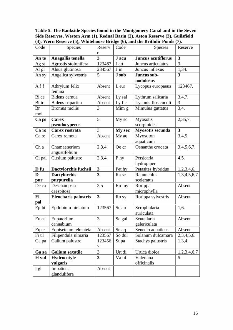
Table 5. The Bankside Species found in the Montgomery Canal and in the SevenSide Reserves, Weston Arm (1), Rednal Basin (2), Aston Reserve (3), Guilsfield(4), Wern Reserve (5), Whitehouse Bridge (6), and the Brithdir Ponds (7).Code Species Reserv
eCode Species Reserve
An te Anagallis tenella 3 J acu Juncus acutiflorus 3Ag st Agrostis stolonifera 123467 J art Juncus articulatus 3Al gl Alnus glutinosa 234567 J in Juncus inflexus 1,34.An sy Angelica sylvestris 5 J sub Juncus sub-
nodulosus3
A f f Athryium felixfemina
Absent L eur Lycopus europaeus 123467.
Bi ce Bidens cernua Absent Ly sal Lythrum salicaria 3,4,7.Bi tr Bidens tripartita Absent Ly f c Lychnis flos cuculi 3Brmol
Bromus mollis 3 Mim g Mimulus guttatus 3,4.
Ca ps Carexpseudocyperus
5 My sc Myosotisscorpioides
2,35,7.
Ca ro Carex rostrata 3 My sec Myosotis secunda 3Ca re Carex remota Absent My aq Myosoton
aquaticum3,4,5.
Ch a Chamaeneriumangustifolium
2,3,4. Oe cr Oenanthe crocata 3,4,5,6,7.
Ci pal Cirsium palustre 2,3,4. P hy Persicariahydropiper
4,5.
D fu Dactylorchis fuchsii 3 Pet hy Petasites hybridus 1,2,3,4,6.Dpur
Dactylorchispurpurella
3 Ra sc Ranunculussceleratus
1,3,4,5,6,7
De ca Deschampsiacaespitosa
3,5 Ro my Rorippamicrophylla
Absent
Elpal
Eleocharis palustris 3 Ro sy Rorippa sylvestris Absent
Ep hi Epilobium hirsutum 123567 Sc au Scrophulariaauriculata
1,6.
Eu ca Eupatoriumcannabium
3 Sc gal Scutellariagalericulata
Absent
Eq te Equiseteum telmateia Absent Se aq Senecio aquaticus AbsentFi ul Filipendula ulmaria 123567 So dul Solanum dulcamara 2,3,4,5,6.Ga pa Galium palustre 123456
7St pa Stachys palustris 1,3,4.
Ga sa Galium saxatile 3 Urt di Urtica dioica 1,2,3,4,6,7H vul Hydrocotyle
vulgaris3 Va of Valeriana
officinalis5
I gl Impatiensglandulifera
Absent
17
The emergent and the bankside species when combined become the marginal plantsas recorded in the 1988 and 1997 surveys. Thus in total 69 marginal plants wererecorded in the reserves in 2003 and 67 for the canal as a whole in 2001.
With the 26 aquatic plant species, 95 plant species found in or by water wererecorded in the reserves (see Discussion). This compares with the 39 aquaticplant species and two species of Nitellid found in the canal as a whole in 2001when an overall total of 108 plant species were recorded.
The highest number of and most noteworthy omissions in the reserves were thoserepresenting the true aquatic species (Table 6). Callitriche hermaphoditica hasbeen included in Table 6 as it is considered to be aberrant record for the WhitehouseBridge reserve. The two specimens found were small and seemingly stressed.
Table 6. Aquatic Plants Species not found in the Reserves
Code Species Reserve Code Species ReserveAz fi Azolla filiculoides Absent P pus Potamogeton pusillus AbsentCalham
Callitrichehamulata
Absent P tri Potamogetontrichoides
Absent
Calher
Callitrichehermaphroditica
6 Sp pol Spirodela polyrhiza Absent
Calobt
Callitricheobtusangula
Absent Charophytes
Cal pl Callitricheplatycarpa
Absent Ni fl Nitella flexilis agg. Absent
L gib Lemna gibba Absent N m g Nitella mucronatavar. gracillima
Absent
M alt Myriophyllumalterniflorum
Absent Algae
N alb Nymphaea alba Absent Cglom
Cladophoraglomerata
Absent
P ber Potamogetonberchtoldii
Absent Hyd Hydrodictiumreticulatum
Absent
P. fri Potamogetonfriesii
Absent Liverworts
P.pect
Potamogetonpectinatus
Absent Ri fl Riccia fluitans Absent
P pra Potamogetonpraelongus
Absent
Some species have little conservation value as they are species of tolerant of pollutionor are aggressive colonists. Both categories can dominate communities to theexclusion of other species and are often found in the canal in polluted sections. Onespecies not to be encouraged is Azolla filiculoides whereas others as part of acommunity are acceptable species worthy of conservation effort namely;Potamogeton pectinatus and Nitella flexilis agg.
In all 14 aquatic plant species and two species of Nitellid are absent from the reserves.Some of these 14 (16) species are more important than others either as locally
18
important or nationally important species and efforts should be made to conservethese species either by providing additional reserves or more controversially, possiblypurposefully introducing them into the most suitable existing reserve.
Generally there are two groups of species absent from the ponds which need to beconserved. These are those species only tolerant of a mesotrophic water quality andthose representative of eutrophic conditions. The former group is best found in thecanal 200 metres east of Carreghofa Locks and thence westwards from the Tanatfeeder to the Vyrnwy aqueduct. Four mesotrophic species, absent from the reserves,were recorded in the canal in this section; Callitriche platycarpa, Myriophyllumalterniflorum, Nymphaea alba and Potamogeton praelongus. This is also the bestarea for Callitriche hermaphroditica and this species does need a reserve having theappropriate water quality.
A section of canal on the English side by Maesbury Marsh in September, 2001contained small amounts of Potamogeton friesii. The latter is an important eutrophicspecies to conserve. In 1988 it was recorded in abundance here “in the spring survey(June) but not at all in the survey during September-October”(Briggs, Ed.,1988).This section could well contain the densest populations of this species on the canal.
A section of canal between Pool Quay and Welshpool contained the following speciesmissing from the reserves namely; Potamogeton berchtoldii, Potamogeton friesii,Potamogeton pectinatus, Nitella flexilis agg, and Nitella mucronata var. gracillima.
Three relatively discrete sections of canal thus contain 9 of the 16 species. If Azollafiliculoides is not considered worthy of conservation effort then in reality this totalbecomes 9 of the 15 desirable species not found on the reserves. The remainingspecies not represented excluding Azolla filiculoides are Callitriche hamulata,Callitriche obtusangula, Lemna gibba, Potamogeton pusillus, Potamogeton trichoidesand Spirodela polyrhiza.
However between kilometres 18 and 19 several “missing species” were recordednamely three of the aquatic species; Lemna gibba, Potamogeton pusillus andSpirodela polyrhiza.
Callitriche obtusangula was recorded in September, 2001 just north east of Queen’sHead, around kilometre 6, close to the Aston Reserve. Potamogeton trichoides wasrecorded September, 2001 in the centre of Welshpool. Callitriche hamulata wasfound commonly at the extreme south western end of the canal close to the RiverSevern feeder in September 2001.
There is only one emergent species, not found in the reserves worthy of conservationeffort that of Veronica beccabunga but it is possible that it was missed in the presentsurvey. Veronica beccabunga was only recorded in kilometres 37,40 and 43 inSeptember 2001 geographically far removed from any reserve. The otherunrepresented species is Schoenoplectus lacustris. This is a commonplace speciesand it can be aggressive and it could jeopardise diverse aquatic communities
19
In summary there are four areas where new reserves might be targeted to allow analmost complete representation of the aquatic flora and the best of the emergentspecies. These are;
• An area 200 metres east of Carreghofa Locks and thence westwards from theTanat feeder to the Vyrnwy aqueduct.
• A section of canal between Pool Quay and Welshpool.• A representative section between kilometres 18 and 19.• A section of canal on the English side by Maesbury Marsh
Reserve Design
Through-flow of Water and Gradient.
All the reserves have a water quality which is either eutrophic or suggestive ofhypertrophy (Table 1). Hypertrophic water feeds the side arm reserve at Weston.Eutrophic water feeds the Rednal Basin, the Aston Locks Reserve, WhitehouseBridge and probably the Wern Reserve although the water could be bordering onhypertrophy. Low eutrophy water seems to feed the Brithdir Ponds. The mostsuccessful of the reserves in terms of their overall plant diversity are those having athrough-flow of water. These are the Aston Locks Reserve, the Brithdir Ponds,Whitehouse Bridge and the Wern Reserve, although the last two reserves seem tohave some design faults. Through-flow prevents any marked dominance by algae orLemna minor but where there is a shallow gradient between the inflow point and theoutflow, as at Whitehouse Bridge the flora can become dominated by pollutiontolerant species such as Elodea nuttallii or Ceratophyllum demersum.
Recommendation: A through flow of water seems an essential pre-requisite togood reserve design but a gradient of one lock depth between inflow and outflowis desirable.
Blockage of the Inflow by Emergent Plants
Emergent plant or any aquatic macrophyte can lock up plant nutrients in their biomassand so improve water quality. Nitrogen can also be lost into the atmosphere asgaseous nitrogen through denitrification processes when oxygen levels at the mud-water interface are high. The reverse conditions release phosphorus from theparticulate matter making up the sediments. This can be “scavenged” by plant rootsfor their growth. However there is a limit to plant root uptake and some phosphatephosphorus will escape into the water column to be scavenged by floatingmacrophytes or algal species. None is released into the atmosphere. Thus the only netloss of phosphorus is that bound up in the biomass of plants whether they are algae orhigher plants. Only approximately 2.5% of the plants dry weight is made up ofphosphorus but some 25% of this weight will be nitrogen. Thus the benefits of ablockage by plants at the inflow are three fold. First the blockage locks up nutrientsin its biomass, secondly, during the day time some denitrification will occur whenoxygen is leaked through the root hairs and thirdly and very importantly, it acts as asediment trap. The dis-benefit of a blockage is that the biomass will result in loweredoxygen levels particularly during night-time respiration resulting in phosphorusrelease. It should be emphasised that nutrient removal will only occur if the plants are
20
removed when still actively growing in August as their natural decay in Septemberwill release any locked up nutrients back into the water for use next spring. Howeverif such a strategy of total plant removal were adopted this would negate the benefits ofa winter time sediment trap. Ideally some plants, up to 25% of the biomass andhence nutrients should be removed annually preferably during August when theplants have reached peak biomass and are not beginning to decay.
The Aston Reserve might have benefited from a narrow feeder channel “blocked”with emergent species to help remove some nutrients. At present the first pond in theAston Reserve is acting as a sediment trap and hence nutrient “sump”. The waterquality gradually improves as it flows through the reserve (Maps 9 to 13). There is afall in pH and conductivity from pH 8.0 at the entrance to the reserve to pH 7.5 in thefinal pond and a conductivity fall from 240 to 200 microsiemens. One element of aManagement Plan for this reserve might be to allow a “blockage” of emergents togrow at the inflow point. It is also recommended that the blockage of emergents atthe entrance to the second and third ponds are not removed but controlled to coveraround 25% of the pond surface.
The Wern Reserve seems to be benefiting from a blockage of Glyceria at the firstpond and part of the first meander (see section on the Wern Reserve)
The Whitehouse Bridge Reserve might benefit from creating and managing ablockage of Glyceria in the canal by the inflow to the reserve.
Recommendations: It is recommended that the potential benefits caused by ablockage of emergent plants is explored for the following reserves, the AstonNature Reserve and the Whitehouse Bridge Reserve.
The blockage at the inflow in the Wern reserve is retained but managed fromspreading any further into the reserve.
Meanders
Meanders create “dead” stagnant water and this is more marked if they are greaterthan a 6 to 8 metre canal width and the gradient between inflow and outflow islimited. Thus the 20 metre wide “gentle” meanders at the Aston Reserve in Ponds 1and 5 have “dead” water but the gradient between inflow and outflow is one lockdepth. As a consequence plants such as Nuphar lutea or Hydrocharis still grow in thecorners of the meanders.
The Wern Reserve could be argued as suffering from three “design” errors but inreality only “suffers” from one major management problem. First the reserve doesnot seem to have the fall of a reserve situated by a lock. Second the meanderingdesign is extreme but this is understandable as it makes best use of the groundavailable. The meanders for the most part are only a canal width, 6 to 8 metres widebut this could still create “dead” stagnant water but thirdly the most important factorpreventing greater plant diversity is the shading caused by the overgrowth of Salix(willow) carr (see next section). The meanders at Wern where narrow shouldmitigate against any dead water but there are three broad and extreme meanders(Maps 28, 29 and 30) which would create “dead” water and sediment accretion.
21
However the effects of these extreme meanders on the ecology of this reserve isdifficult to judge due to effects of shading.
Recommendation: Meanders should be avoided if possible in future reservedesign or if necessary should only be incorporated where there is a “lock depth”gradient between inflow and outflow. They should be no wider than 6 to 8metres.
Shading
Shading is one the major reasons for lack of plant growth on the canal as a whole andwithin the Rednal Basin Reserve and the Wern Reserve. The Wern Reserve willnever reach its full potential until upwards of 75% of the overgrowth of Salix at leastone tree height from the edge is removed. Additionally too much leaf litter can resultin a sterile detritus covered mud layer.
Recommendation: Avoid areas where shading by trees cannot be controlled andavoid over-planting. Retain approximately 75% of the edge as open areas ofwater.
Width and Linearity
A long linear reserve divided into a series of linear ponds preferably no wider than 6to 8 metres such as at the Aston Reserve has yielded the greatest plant diversity. Along narrow linear design seems preferable to that of a meander, rectilinear or squarepond. First, linearity visually simulates a canal. Secondly, the through flow of watercan spread across most if not the whole width. “Dead areas” would be created if thedesign was rectilinear or square. This happens naturally in many lakes for example atDerwent Water or Bassenthwaite Lake, where there are many bays cut off from thecentral through-flow of water. Here the bays are protected from the effects of windand the water quality is so good that macrophyte diversity is not affected by theincreased water retention time. The water quality, in general, in the presentMontgomery Canal Reserves is so close to being hypertrophic that any increase inretention time should be avoided. A square design would create “dead” areas notreached by any through-flow water thus increasing nutrient retention times in theseareas and this in turn would exacerbate algal and Lemna growth. A square design alsocould increase exposure to wind effects pushing algal and Lemna growth into thewind exposed emergents plants and stifling aquatic plant growth in these zones. Alsothe larger the open water area the more is the danger of it being an attractive habitat toBranta canadensis (Canada geese). These birds can be extremely damaging to plantgrowth through the effects of grazing and to water quality through enrichment fromtheir droppings.
In summary it is suggested that the best design for a reserve is encapsulated in that ofthe Aston Ponds save that the first pond may too square as it suffers from grazing andpollution by Cygnus olor (Mute swans).
22
Anglers as Management Tools
At the Whitehouse Bridge Reserve anglers have removed both Elodea nuttallii and aspecies of high conservation importance that of Potamogeton compressus to createtheir fish “swims”. Ecologically this has the advantage of creating some open waterpotentially allowing the re-growth of desirable species such as Potamogetoncompressus or undesirable species such as Elodea nuttallii or Ceratophyllumdemersum. The practice of creating “swims” could be put to good conservation use iftargeted only at pollution tolerant species such as Elodea nuttallii or Ceratophyllumdemersum. Some informal training of the anglers is suggested.
Recommendation: Anglers could be trained to remove pollution tolerant plantsto create their “swims” and to leave behind the more desirable plant species.
Some Criteria for a Possible Ideal Reserve Design
It is suggested that the ideal reserve might contain the following design features;
1. A source of water appropriate to the survival of the target community ofplants.
2. A through-flow of water.3. The reserve preferably sited by a lock giving a gradient between inflow and
outflow of one lock depth.4. A linear design no greater than 6 to 8 metres in width and avoiding where
possible meanders.5. A narrow channel at the inflow point blocked by emergent plants. These will
act both as a sediment trap and retain some nutrients in their biomass. Thedesign should allow for the easy management of the plants.
6. Shaded sites should be avoided if at all possible and tree planting should be setat least one mature tree height away from the water’s edge. Up to 25% of theedge could be shaded.
References
Briggs J. D., Ed., (1988). Montgomery Canal, Ecological Survey, Survey Report.Montgomery Canal Ecological Survey, Canal Wharf, Llanymynech, Powys SY226EA.
British Waterways, (1999). Montgomery Canal, Ecological Surveys, The Report onthe1997 Surveys with comparisons to the 1980’s Surveys, Environmental & ScientificServices, Llanthony Warehouse, Gloucester Docks Gloucester GL1 2 EJ.
Newbold, C., (2001). The Montgomery Canal, A Macrophyte Survey. Report toBritish Waterways, Ellesmere, Shropshire
23
Williams, P.J., Biggs, J., Barr, C.J., Cummins, C.P., Gillespie, M.K., Rich, T.C.G.,Baker, A., Baker, J., Beesley, I., Corfield, A., Dobson, D., Culling, A.S., Fox, G.,Howard, D.C., Luurseema, K., Rich, M., Samson, D., Scott, W.A., White, R., andWhitfield, M. 1998. Lowland Pond Survey 1996. Department of the Environment,Transport and the Regions, London.
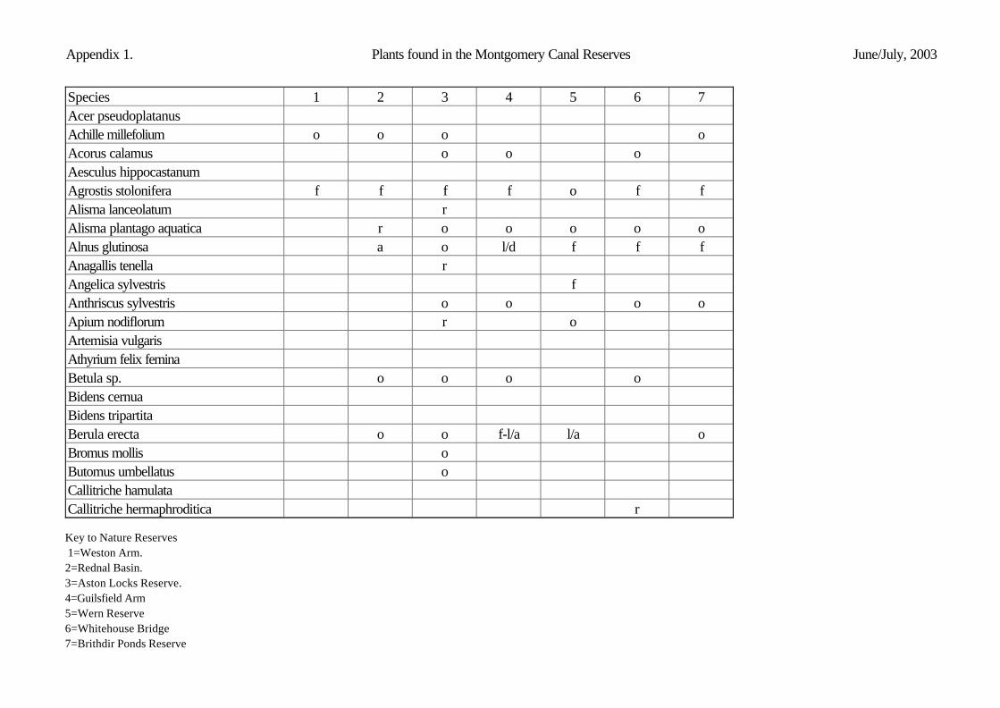
Appendix 1. Plants found in the Montgomery Canal Reserves June/July, 2003
Species 1 2 3 4 5 6 7Acer pseudoplatanusAchille millefolium o o o oAcorus calamus o o oAesculus hippocastanumAgrostis stolonifera f f f f o f fAlisma lanceolatum rAlisma plantago aquatica r o o o o oAlnus glutinosa a o l/d f f fAnagallis tenella rAngelica sylvestris fAnthriscus sylvestris o o o oApium nodiflorum r oArtemisia vulgarisAthyrium felix feminaBetula sp. o o o oBidens cernuaBidens tripartitaBerula erecta o o f-l/a l/a oBromus mollis oButomus umbellatus oCallitriche hamulataCallitriche hermaphroditica r
Appendix 1. Plants found in the Montgomery Canal Reserves June/July, 2003
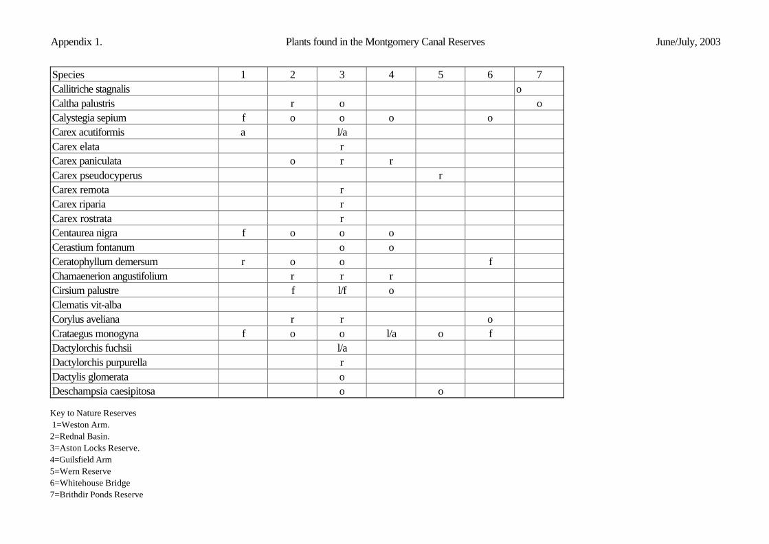
Species 1 2 3 4 5 6 7Callitriche stagnalis oCaltha palustris r o oCalystegia sepium f o o o oCarex acutiformis a l/aCarex elata rCarex paniculata o r rCarex pseudocyperus rCarex remota rCarex riparia rCarex rostrata rCentaurea nigra f o o oCerastium fontanum o oCeratophyllum demersum r o o fChamaenerion angustifolium r r rCirsium palustre f l/f oClematis vit-albaCorylus aveliana r r oCrataegus monogyna f o o l/a o fDactylorchis fuchsii l/aDactylorchis purpurella rDactylis glomerata oDeschampsia caesipitosa o o
Appendix 1. Plants found in the Montgomery Canal Reserves June/July, 2003
Species 1 2 3 4 5 6 7Eleocharis palustris oElodea canadensis l/a oElodea nuttallii d a l/d o a-d l/d aElodea canadensis x nuttallii o l/f l/d aEpilobium hirsutum f f f o o l/dEquiseteum fluviatile oEquiseteum litorale o oEquiseteum palustre oEquiseteum telmatiaFagus sylvaticaFilipendula ulmaria a o f f f oFraxinus excelsior o oGalium palustre o r o o o o oGalium saxatile rGlyceria fluitans oGlyceria maxima a f l/d d l/d l/a l/aHeracleum spondylium o o f o o l/aHottonia palustris oHydrocharis morsus-ranae f l/aHydrocotyle vulgaris l/aImpatiens glanduliferaIris pseudacorus o o o o o
Appendix 1. Plants found in the Montgomery Canal Reserves June/July, 2003
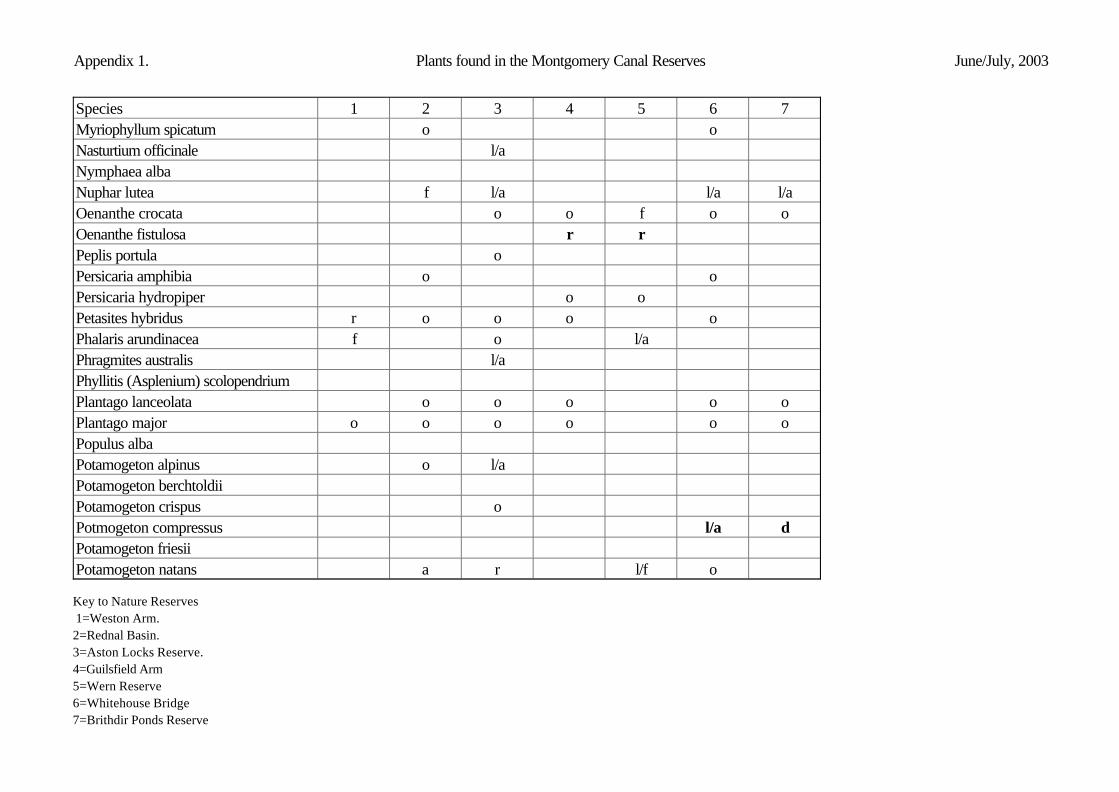
Species 1 2 3 4 5 6 7Juncus acutiflorus oJuncus articulatus o oJuncus bulbosus var. fluitans l/aJuncus conglomeratus o oJuncus effusus a o o l/a l/f rJuncus inflexus f o o o oJuncus sub-nodulosus rLemna gibbaLemna minor o o o l/d l/d o l/aLemna minutaLemna trisulca o o o o o oLotus corniculatus f oLuronium natans r r o o/fLycopus europaeus o o o o o o oLychnis-flos-cuculi oLythrum salicaria o o oMentha aquatica o o o o oMimulus guttatus o oMyosotis scorpioides o o o oMyosotis secunda rMyosoton aquaticum o o oMyriophyllum alterniflorum
Appendix 1. Plants found in the Montgomery Canal Reserves June/July, 2003
Species 1 2 3 4 5 6 7Myriophyllum spicatum o oNasturtium officinale l/aNymphaea albaNuphar lutea f l/a l/a l/aOenanthe crocata o o f o oOenanthe fistulosa r rPeplis portula oPersicaria amphibia o oPersicaria hydropiper o oPetasites hybridus r o o o oPhalaris arundinacea f o l/aPhragmites australis l/aPhyllitis (Asplenium) scolopendriumPlantago lanceolata o o o o oPlantago major o o o o o oPopulus albaPotamogeton alpinus o l/aPotamogeton berchtoldiiPotamogeton crispus oPotmogeton compressus l/a dPotamogeton friesiiPotamogeton natans a r l/f o
Appendix 1. Plants found in the Montgomery Canal Reserves June/July, 2003
Species 1 2 3 4 5 6 7Potamogeton obtusifolius a fPotamogeton pectinatusPotamogeton perfoliatus oPotamogeton praelongusPotamogeton pusillusPotamogeton trichoidesPteridium aquilinum rQuercus sp. o oRanunculus circinatus oRanunculus flammula l/d oRanunculus repensRanunculus sceleratus o oRorippa microphyllaRorippa sylvestrisRosa canina r r rRubus fruticosus agg. r a o o o oRumex conglomeratus o oRumex hydrolapathum o o l/f l/f oRumex obtusifolius rSalix alba r o l/dSalix aurita
Appendix 1. Plants found in the Montgomery Canal Reserves June/July, 2003
Species 1 2 3 4 5 6 7Salix cinerea o o o l/d oSalix fragilisSambucus nigra o o oSarothamnus scapariusSchoenoplectus lacustrisScrophularia auriculata o o oScutellaria galericulataSenecio aquaticusSenecio jacobea oSonchus arvensis r o o o o oSolanum dulcamara o o o l/a oSparganium emersum l/f o oSparganium erectum f/a l/f l/a f fSpirodela polyrhizaStachys palustris o o o o oSymphytum officinale o o l/a oTaraxacum officinale agg. o o o o o oTussilago farfara o oTypha latifolia a l/a l/a l/a o l/fUlmus glabra rUlex europaeus l/a l/a
Appendix 1. Plants found in the Montgomery Canal Reserves June/July, 2003
Species 1 2 3 4 5 6 7Urtica dioica o o o o o oVicia cracca f o o o oValeriana officinalis rVeronica beccabungaZannichellia palustris oCharophytesChara globularis l/dNitellidsNitella flexilis Nitella mucronata var. gracillimaMosses/BryophytesFontinalis antipyretica rLiverwortsRiccia fluitansAlgaeMougeotia/Spirogyra a/ ld r l/d o o l/aCladophera glomerata agg.Hydrodictium reticulatumBlue green alga o


![CANAL [T] Canal Soth Florida](https://static.documents.pub/doc/80x56/55cf9803550346d03395034f/canal-t-canal-soth-florida.jpg)


