KUO DING et al: MONITORING AND MECHANISM OF GROUND MOVEMENT AND FISSURES FORMED . . . DOI 10.5013/IJSSST.a.17.28.29 29.1 ISSN: 1473-804x online, 1473-8031 print Monitoring and Mechanism of Ground Movement and Fissures Formed by Block Caving and Sublevel Filling in the Jingerquan Nickel Mine, China Kuo Ding 1* , Fengshan Ma 1 , Haijun Zhao 1 , jie Guo 1 , Jianjun Zhu 2 , Maohua Tian 2 1. Key Laboratory of Shale Gas and Geoengineering Institute of Geology and Geophysics Chinese Academy of Sciences Beijing 100029, China 2. Hami Jingerquan Mining Co. Ltd. Hami 839000, China * Corresponding author: Ding Kuo; Email: [email protected]Abstract -- The Jingerquan Nickle Mine is a large underground mine in China, where block caving mining was used before 2010 when huge ground fissures occurred above the ore body. Consequently, sublevel filling was adopted to control ground pressure and prevent rock mass displacement. But the result was not as good as expected. In this paper, we first introduce the engineering geological conditions and mechanical attributes of the rock, then analyse the mechanism of surface subsidence and ground fissures induced by block caving and sublevel filling. It seems that a combination of factors provide the trigger, including: i) hidden gulfs formed by block caving, ii) unfilled void space and deformation surrounding the filling body spaces, iii) well-developed fracture zones, iv) high situ stress and low strength of filling body conditions, and v) long-term and large-scale repeated excavations. Also, surface ground shows obvious segmental features based on mechanisms of displacement variations. It shows the coexistence of artesian zone and unloading zone, compression zone and relaxation zone, tension stress zone and compressive stress zone, as well as continuous as well as discontinuous deformation zones. We emphasize the importance of a deeper understanding of this complex phenomenon. Keywords -- block caving, sub-level filling, ground movement, ground fissures I. INTRODUCTION Now deep underground mining is increasing owing to the rapid development of national economy and the increasing demand for mineral resources, the two most important issues are work safety and protection of ground environment when carrying on underground mining activities. These issues have been studied worldwide. Block caving mining method is one of the most effective underground mining techniques. While high efficiency and high risk to ground environment coupled during the excavation. Most of ground movement was caused by this way [1,2.3]. Research on ground movement by block caving received numerous attentions all the time due to the remarkable threaten to upper rock mass. The characteristic and mechanism was obviously revealed [4,5,6]. As an advanced underground mining method, sublevel filling is increasingly applied around the [7,8,9], In China, filling mining technique is adopted in 45 % of non-ferrous metal underground mines and 37 % of gold mines[10], And it was generally believed that it could control ground pressure and prevent the development of surface subsidence effectively [11,12],There’s nearly no instances of surface movement and deformation occurred where the mined void has been filled. While it has been found large scale ground movement and ground fissures by dynamic monitoring of twenties years in Jinchuan[13,14,15], Overall, filling method provided a positive effect to the ground environment undeniably. In fact, a few mines chose block caving due to limitations of materials and funds, while ground deformation and even severe ground fissures appeared during excavation, as a result, it is necessary that transforming block caving to filling method. However, the ground movement characteristics by this way are greatly different from block caving or filling method separately. This is of great significance to analysis the coexistence of these two mining methods. Jingerquan presents a prime example related to block caving and sublevel filling. Jingerquan nickel mine was put into production in 2005 and block caving was adopt in the early mining stage, Surface subsidence caused severe damage to buildings, roads, shafts and other facilities, consequently . Sublevel filling method was carried instead of block caving in 2010. In 2013, a systematic investigation of subsidence region was conducted and dynamic monitoring has been applied every 4 months from 2013 to now. Based on field survey results and monitoring data, this study analyses the characteristics and mechanism of surface subsidence and ground fissures. Through this research, a deeper understanding of the surface
Transcript
KUO DING et al: MONITORING AND MECHANISM OF GROUND MOVEMENT AND FISSURES FORMED . . .
DOI 10.5013/IJSSST.a.17.28.29 29.1 ISSN: 1473-804x online, 1473-8031 print
Monitoring and Mechanism of Ground Movement and Fissures Formed by Block Caving and Sublevel Filling in the Jingerquan Nickel Mine, China
Kuo Ding 1*, Fengshan Ma 1, Haijun Zhao 1, jie Guo 1, Jianjun Zhu 2, Maohua Tian 2
1. Key Laboratory of Shale Gas and Geoengineering Institute of Geology and Geophysics
Chinese Academy of Sciences Beijing 100029, China
2. Hami Jingerquan Mining Co. Ltd. Hami 839000, China
Abstract -- The Jingerquan Nickle Mine is a large underground mine in China, where block caving mining was used before 2010 when huge ground fissures occurred above the ore body. Consequently, sublevel filling was adopted to control ground pressure and prevent rock mass displacement. But the result was not as good as expected. In this paper, we first introduce the engineering geological conditions and mechanical attributes of the rock, then analyse the mechanism of surface subsidence and ground fissures induced by block caving and sublevel filling. It seems that a combination of factors provide the trigger, including: i) hidden gulfs formed by block caving, ii) unfilled void space and deformation surrounding the filling body spaces, iii) well-developed fracture zones, iv) high situ stress and low strength of filling body conditions, and v) long-term and large-scale repeated excavations. Also, surface ground shows obvious segmental features based on mechanisms of displacement variations. It shows the coexistence of artesian zone and unloading zone, compression zone and relaxation zone, tension stress zone and compressive stress zone, as well as continuous as well as discontinuous deformation zones. We emphasize the importance of a deeper understanding of this complex phenomenon. Keywords -- block caving, sub-level filling, ground movement, ground fissures
I. INTRODUCTION
Now deep underground mining is increasing owing to the rapid development of national economy and the increasing demand for mineral resources, the two most important issues are work safety and protection of ground environment when carrying on underground mining activities. These issues have been studied worldwide.
Block caving mining method is one of the most effective underground mining techniques. While high efficiency and high risk to ground environment coupled during the excavation. Most of ground movement was caused by this way [1,2.3]. Research on ground movement by block caving received numerous attentions all the time due to the remarkable threaten to upper rock mass. The characteristic and mechanism was obviously revealed [4,5,6].
As an advanced underground mining method, sublevel filling is increasingly applied around the [7,8,9], In China, filling mining technique is adopted in 45 % of non-ferrous metal underground mines and 37 % of gold mines[10], And it was generally believed that it could control ground pressure and prevent the development of surface subsidence effectively [11,12],There’s nearly no instances of surface movement and deformation occurred where the mined void has been filled. While it has been found large
scale ground movement and ground fissures by dynamic monitoring of twenties years in Jinchuan[13,14,15], Overall, filling method provided a positive effect to the ground environment undeniably.
In fact, a few mines chose block caving due to limitations of materials and funds, while ground deformation and even severe ground fissures appeared during excavation, as a result, it is necessary that transforming block caving to filling method. However, the ground movement characteristics by this way are greatly different from block caving or filling method separately. This is of great significance to analysis the coexistence of these two mining methods. Jingerquan presents a prime example related to block caving and sublevel filling.
Jingerquan nickel mine was put into production in 2005 and block caving was adopt in the early mining stage, Surface subsidence caused severe damage to buildings, roads, shafts and other facilities, consequently . Sublevel filling method was carried instead of block caving in 2010. In 2013, a systematic investigation of subsidence region was conducted and dynamic monitoring has been applied every 4 months from 2013 to now. Based on field survey results and monitoring data, this study analyses the characteristics and mechanism of surface subsidence and ground fissures. Through this research, a deeper understanding of the surface
KUO DING et al: MONITORING AND MECHANISM OF GROUND MOVEMENT AND FISSURES FORMED . . .
DOI 10.5013/IJSSST.a.17.28.29 29.2 ISSN: 1473-804x online, 1473-8031 print
deformation and ground fissures caused by multiplex mining methods is achieved and illustrates that whether the transition projects can be successfully carried out.
II. STUDY AREA
The Jingerquan Nickle Mine is located in the east border of Hami, Xinjiang Province, in West China[16].
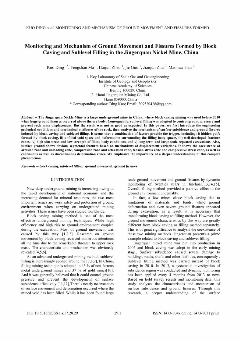
Geo-tectonically, there are four faults zones in the survey area and Jingerquan fault zone which lies in the south of survey area is the main fault zone. The strike is NEE, dipping 80°-85°to the SSE. The ore-bearing rocks lie to the north of Jingerquan fault and show a shape of “calabash” (Fig.1).
Fig.(1). Geological sketch map of Jingerquan Nickle Mine
Totally four ore bodies are delineated in mining area,
which are known as No. I, II, III, IV separately. No. I, II, III lie in the left of the calabash and No. IV lies at the other side. At present, most of the nickel mineral resource is mainly extracted from the No. III and the others still remain undeveloped. As the primary mine ore body, No. III extends from 200 meters below the surface into over 600 meters underground. The ore body is stratiform or stratoid structure, it strikes almost NE and dips southwardly with dip angle range from 55°to 65°. Owing to the intrusion of diorite, the ore body is fragmented specially and show appearance of irregular and lenticular.
The lithology in mine area is ultrabasic composed of dunite, pyroxenite, anorthosite and amphibolite, under the compressive action of rough north-south tectonic stress, two groups of shear joints orienting NE and NW appeared and were filled by late-aged dikes. According to the data of sample drilling, the floor rock of ore bodies is generally mica-plagioclase leptynite with high hardness and the roof rock is dunite with medium hardness. Affected by latest tectonic movement, weak structure planes with cleaved, schisteous or mylonitization texture are formed between surrounding rock and rock mass. The superficial and shallow of rock mass hold the features of strong alteration and weathering; all of the weak structure planes, fracture
zone and weak structural discontinuities greatly weaken the mechanical attributes of the rock mass.
Tectonic stress is a dominant factor induced the deformation of the surrounding rock mass in the Jingerquan mine area. Field tests and measurements have been taken on the virgin stresses by the stress releasing technique. The results showed that the maximum principal stress trends NE with value of 34.9 MPa and it is horizontal, which is basically parallel to the regional tectonic stress field. The shear stress reaches 8.55MPa which is liable to damage the tunnel. The vertical stress is 18.5MPa, which exceed the weight of overlying strata, obviously, it’s unfavourable to the stability of roadway roof.
III. GROUND SURFACE DEFORMATION AND FISSURES
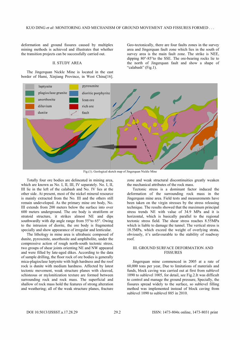
Jingerquan mine commenced in 2005 at a rate of
60,000 tons per year, Due to limitations of materials and funds, block caving was carried out at first from sublevel 1090 to sublevel 1005, for detail, see Fig.2.It was difficult to control and manage the ground pressure, Specially, the fissures spread widely to the surface, so sublevel filling method was implemented instead of block caving from sublevel 1090 to sublevel 885 in 2010.
KUO DING et al: MONITORING AND MECHANISM OF GROUND MOVEMENT AND FISSURES FORMED . . .
DOI 10.5013/IJSSST.a.17.28.29 29.3 ISSN: 1473-804x online, 1473-8031 print
Fig.(2). Cross-sectional profile of the underground mining
Being mined with backfill mining method for over3
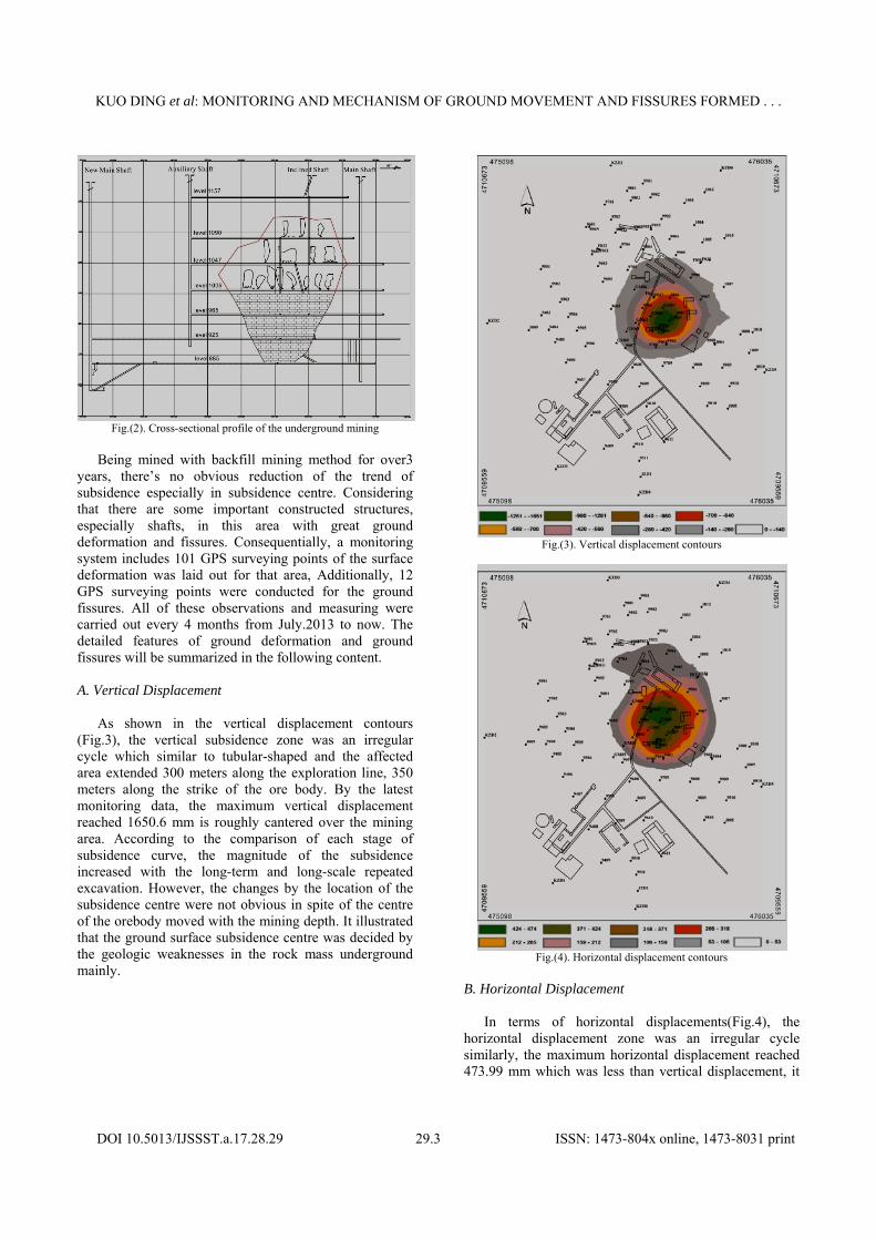
years, there’s no obvious reduction of the trend of subsidence especially in subsidence centre. Considering that there are some important constructed structures, especially shafts, in this area with great ground deformation and fissures. Consequentially, a monitoring system includes 101 GPS surveying points of the surface deformation was laid out for that area, Additionally, 12 GPS surveying points were conducted for the ground fissures. All of these observations and measuring were carried out every 4 months from July.2013 to now. The detailed features of ground deformation and ground fissures will be summarized in the following content. A. Vertical Displacement
As shown in the vertical displacement contours (Fig.3), the vertical subsidence zone was an irregular cycle which similar to tubular-shaped and the affected area extended 300 meters along the exploration line, 350 meters along the strike of the ore body. By the latest monitoring data, the maximum vertical displacement reached 1650.6 mm is roughly cantered over the mining area. According to the comparison of each stage of subsidence curve, the magnitude of the subsidence increased with the long-term and long-scale repeated excavation. However, the changes by the location of the subsidence centre were not obvious in spite of the centre of the orebody moved with the mining depth. It illustrated that the ground surface subsidence centre was decided by the geologic weaknesses in the rock mass underground mainly.
Fig.(3). Vertical displacement contours
Fig.(4). Horizontal displacement contours
B. Horizontal Displacement
In terms of horizontal displacements(Fig.4), the horizontal displacement zone was an irregular cycle similarly, the maximum horizontal displacement reached 473.99 mm which was less than vertical displacement, it
KUO DING et al: MONITORING AND MECHANISM OF GROUND MOVEMENT AND FISSURES FORMED . . .
DOI 10.5013/IJSSST.a.17.28.29 29.4 ISSN: 1473-804x online, 1473-8031 print
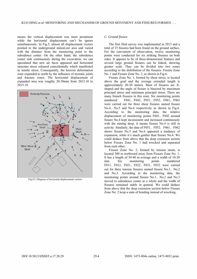
means the vertical displacement was more prominent while the horizontal displacement can’t be ignore simultaneously. In Fig.5, almost all displacement vectors pointed to the underground mined-out area and varied with the distance from the monitoring point to the subsidence center. On the other hand, the subsidence center sink continuously during the excavation, we can speculated that new air faces appeared and horizontal structure stress released coincidentally which manifested as tensile stress. Consequently, the horizon deformation zone expanded to north by the influence of tectonic joints and fracture zones. The horizontal displacement of expanded area was roughly 20-30mm from 2013.10 to 2015.10.
Fig.(5). Diagram of horizontal displacement vectors
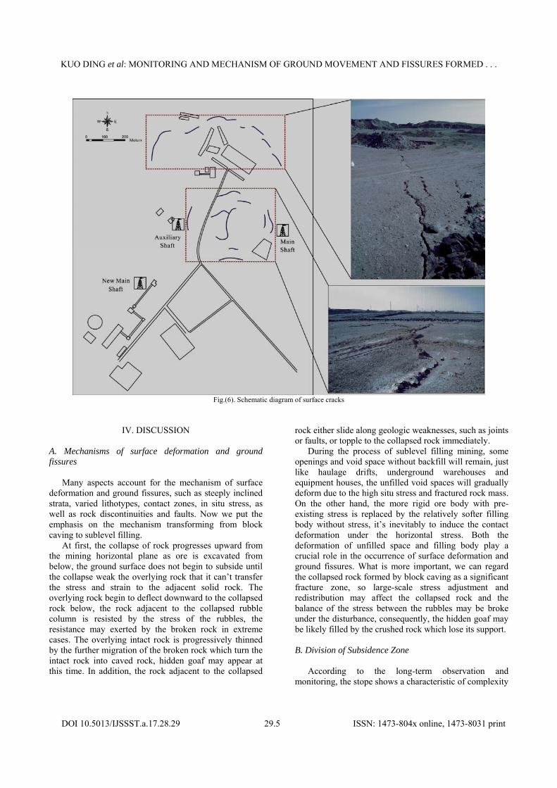
C. Ground fissure
The first filed survey was implemented in 2013 and a total of 15 fissures had been found on the ground surface. For the convenient of observation, twelve monitoring points were conducted for six striking fissures on both sides. It appears to be of three-dimensional features and several large ground fissures can be linked, showing greater scale. They can be divided into two zones according to the distribution of the fissures: Fissure Zone No. 1 and Fissure Zone No. 2, as shown in Fig.6.
Fissure Zone No. 1, formed by shear stress, is located above the goaf and the average extended length is approximately 20-30 meters. Most of fissures are X-shaped and the angle of fissure is bisected by maximum principal stress and minimum principal stress. There are many branch fissures in this zone. Six monitoring points numbered F041、F042、F051、F052、F061、F062 were carried out for three shear fissures named fissure No.4、No.5 and No.6 respectively as shown in Fig.6. According to the monitoring data, the relative displacement of monitoring points F041、F042 around fissure No.4 kept inconsistent and increased continuously with the mining deep, it means fissure No.4 is still in activity. Similarly, the data of F051、F052、F061、F062 shows fissure No.5 and No.6 appeared a tendency of expansion, while it’s much gentler than fissure No.4. We could deduce from above that the deep extension section below Fissure Zone No. 1 had wrecked and separated from each other.
Fissure Zone No. 2, formed by tension strain, is located 300 m northward away from Fissure Zone No. 1. It has a length of 30-40 m average and a width of 10-20 mm. Six monitoring points numbered F011、F012、F021、F022、F031、F032 were carried out for three tension fissures named fissure No.1、No.2 and No.3. According to the monitoring data, the monitoring points around fissure No.1、No.2 and No.3 moved to subsidence center as a whole and the width of fissures remained stable in general. We could deduce from above that the deep extension section below Fissure Zone No. 2 keep a state of bending instead of wrecking.
KUO DING et al: MONITORING AND MECHANISM OF GROUND MOVEMENT AND FISSURES FORMED . . .
DOI 10.5013/IJSSST.a.17.28.29 29.5 ISSN: 1473-804x online, 1473-8031 print
Fig.(6). Schematic diagram of surface cracks
IV. DISCUSSION A. Mechanisms of surface deformation and ground fissures
Many aspects account for the mechanism of surface deformation and ground fissures, such as steeply inclined strata, varied lithotypes, contact zones, in situ stress, as well as rock discontinuities and faults. Now we put the emphasis on the mechanism transforming from block caving to sublevel filling.
At first, the collapse of rock progresses upward from the mining horizontal plane as ore is excavated from below, the ground surface does not begin to subside until the collapse weak the overlying rock that it can’t transfer the stress and strain to the adjacent solid rock. The overlying rock begin to deflect downward to the collapsed rock below, the rock adjacent to the collapsed rubble column is resisted by the stress of the rubbles, the resistance may exerted by the broken rock in extreme cases. The overlying intact rock is progressively thinned by the further migration of the broken rock which turn the intact rock into caved rock, hidden goaf may appear at this time. In addition, the rock adjacent to the collapsed
rock either slide along geologic weaknesses, such as joints or faults, or topple to the collapsed rock immediately.
During the process of sublevel filling mining, some openings and void space without backfill will remain, just like haulage drifts, underground warehouses and equipment houses, the unfilled void spaces will gradually deform due to the high situ stress and fractured rock mass. On the other hand, the more rigid ore body with pre-existing stress is replaced by the relatively softer filling body without stress, it’s inevitably to induce the contact deformation under the horizontal stress. Both the deformation of unfilled space and filling body play a crucial role in the occurrence of surface deformation and ground fissures. What is more important, we can regard the collapsed rock formed by block caving as a significant fracture zone, so large-scale stress adjustment and redistribution may affect the collapsed rock and the balance of the stress between the rubbles may be broke under the disturbance, consequently, the hidden goaf may be likely filled by the crushed rock which lose its support. B. Division of Subsidence Zone
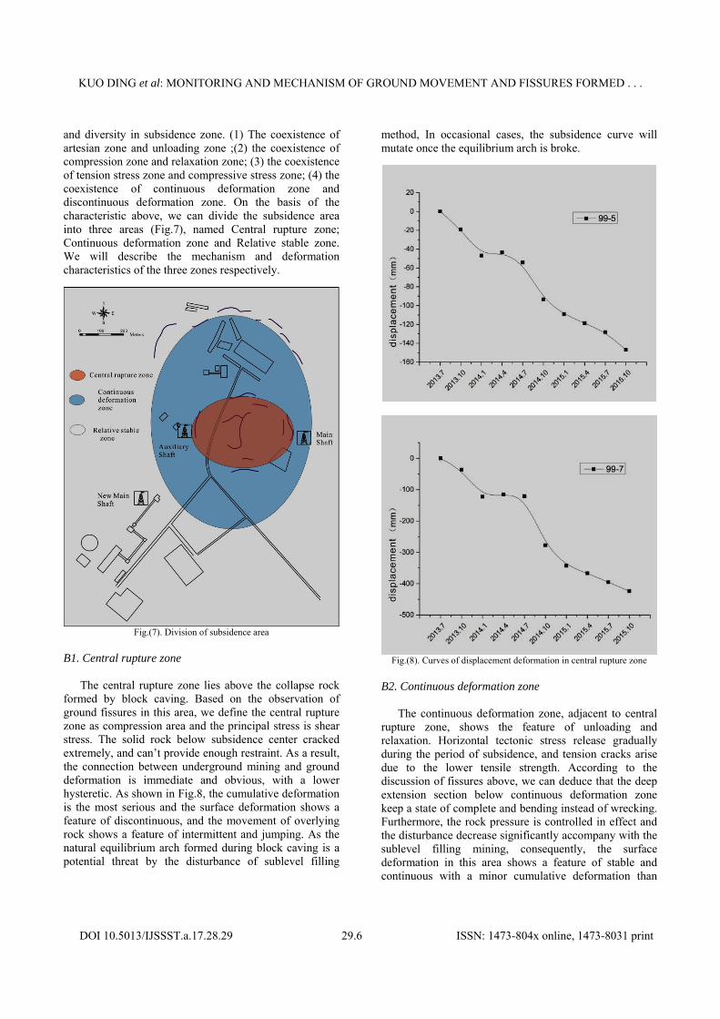
According to the long-term observation and monitoring, the stope shows a characteristic of complexity
KUO DING et al: MONITORING AND MECHANISM OF GROUND MOVEMENT AND FISSURES FORMED . . .
DOI 10.5013/IJSSST.a.17.28.29 29.6 ISSN: 1473-804x online, 1473-8031 print
and diversity in subsidence zone. (1) The coexistence of artesian zone and unloading zone ;(2) the coexistence of compression zone and relaxation zone; (3) the coexistence of tension stress zone and compressive stress zone; (4) the coexistence of continuous deformation zone and discontinuous deformation zone. On the basis of the characteristic above, we can divide the subsidence area into three areas (Fig.7), named Central rupture zone; Continuous deformation zone and Relative stable zone. We will describe the mechanism and deformation characteristics of the three zones respectively.
Fig.(7). Division of subsidence area
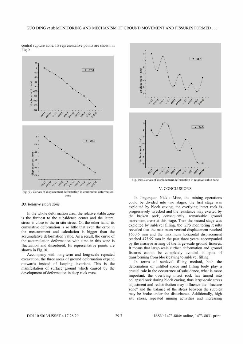
B1. Central rupture zone
The central rupture zone lies above the collapse rock formed by block caving. Based on the observation of ground fissures in this area, we define the central rupture zone as compression area and the principal stress is shear stress. The solid rock below subsidence center cracked extremely, and can’t provide enough restraint. As a result, the connection between underground mining and ground deformation is immediate and obvious, with a lower hysteretic. As shown in Fig.8, the cumulative deformation is the most serious and the surface deformation shows a feature of discontinuous, and the movement of overlying rock shows a feature of intermittent and jumping. As the natural equilibrium arch formed during block caving is a potential threat by the disturbance of sublevel filling
method, In occasional cases, the subsidence curve will mutate once the equilibrium arch is broke.
Fig.(8). Curves of displacement deformation in central rupture zone
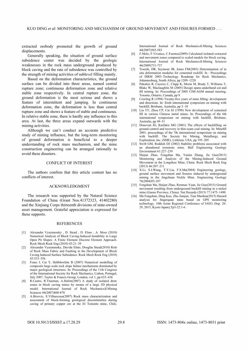
B2. Continuous deformation zone
The continuous deformation zone, adjacent to central rupture zone, shows the feature of unloading and relaxation. Horizontal tectonic stress release gradually during the period of subsidence, and tension cracks arise due to the lower tensile strength. According to the discussion of fissures above, we can deduce that the deep extension section below continuous deformation zone keep a state of complete and bending instead of wrecking. Furthermore, the rock pressure is controlled in effect and the disturbance decrease significantly accompany with the sublevel filling mining, consequently, the surface deformation in this area shows a feature of stable and continuous with a minor cumulative deformation than
KUO DING et al: MONITORING AND MECHANISM OF GROUND MOVEMENT AND FISSURES FORMED . . .
DOI 10.5013/IJSSST.a.17.28.29 29.7 ISSN: 1473-804x online, 1473-8031 print
central rupture zone. Its representative points are shown in Fig.9.
Fig.(9). Curves of displacement deformation in continuous deformation
zone
B3. Relative stable zone
In the whole deformation area, the relative stable zone is the furthest to the subsidence center and the lateral stress is close to the in situ stress. On the other hand, its cumulative deformation is so little that even the error in the measurement and calculation is bigger than the accumulative deformation value. As a result, the curve of the accumulation deformation with time in this zone is fluctuation and disordered. Its representative points are shown in Fig.10.
Accompany with long-term and long-scale repeated excavation, the three areas of ground deformation expand outwards instead of keeping invariant. This is the manifestation of surface ground which caused by the development of deformation in deep rock mass.
Fig.(10):.Curves of displacement deformation in relative stable zone
V. CONCLUSIONS
In Jingerquan Nickle Mine, the mining operations
could be divided into two stages, the first stage was exploited by block caving, the overlying intact rock is progressively wrecked and the resistance may exerted by the broken rock, consequently, remarkable ground movement arose at this stage. Then the second stage was exploited by sublevel filling, the GPS monitoring results revealed that the maximum vertical displacement reached 1650.6 mm and the maximum horizontal displacement reached 473.99 mm in the past three years, accompanied by the massive arising of the large-scale ground fissures. It means that large-scale surface deformation and ground fissures cannot be completely avoided in spite of transforming from block caving to sublevel filling.
In terms of sublevel filling method, both the deformation of unfilled space and filling body play a crucial role in the occurrence of subsidence, what is more important, the overlying intact rock has turned into collapsed rock during block caving, thus large-scale stress adjustment and redistribution may influence the “fracture zone” and the balance of the stress between the rubbles may be broke under the disturbance. Additionally, high situ stress, repeated mining activities and increasing
KUO DING et al: MONITORING AND MECHANISM OF GROUND MOVEMENT AND FISSURES FORMED . . .
DOI 10.5013/IJSSST.a.17.28.29 29.8 ISSN: 1473-804x online, 1473-8031 print
extracted orebody promoted the growth of ground displacements.
Generally speaking, the situation of ground surface subsidence center was decided by the geologic weaknesses in the rock mass underground produced by block caving and the rate of subsidence was controlled by the strength of mining activities of sublevel filling mainly.
Based on the deformation characteristics, the ground surface can be divided into three areas, named central rupture zone; continuous deformation zone and relative stable zone respectively. In central rupture zone, the ground deformation is the most serious and shows a feature of intermittent and jumping. In continuous deformation zone, the deformation is less than central rupture zone and shows a feature of stable and continuous. In relative stable zone, there is hardly any influence to this area. At last, the three areas expand outwards with the mining activities.
Although we can’t conduct an accurate predictive study of mining influence, but the long-term monitoring of ground deformation is beneficial to a deeper understanding of rock mass mechanism, and the mine construction engineering can be arranged rationally to avoid these disasters.
CONFLICT OF INTEREST
The authors confirm that this article content has no conflicts of interest.
ACKNOWLEDGMENT
The research was supported by the Natural Science Foundation of China (Grant Nos.41372323, 41402280) and the Xinjiang Corps thirteenth divisions of state-owned asset management. Grateful appreciation is expressed for these supports.
REFERENCES [1] Alexander Vyazmensky , D. Stead , D. Elmo , A. Moss (2010)
Numerical Analysis of Block Caving-Induced Instability in Large Open Pit Slopes: A Finite Element Discrete Element Approach. Rock Mech Rock Eng (2010) 43:21–39
[2] Alexander Vyazmensky, Davide Elmo, Douglas Stead(2010) Role of Rock Mass Fabric and Faulting in the Development of Block Caving Induced Surface Subsidence. Rock Mech Rock Eng (2010) 43:533–556
[3] Franz J, Cai Y, Hebblewhite B (2007) Numerical modelling of composite large scale rock slope failure mechanisms dominated by major geological structures. In: Proceedings of the 11th Congress of the International Society for Rock Mechanics, Lisbon, Portugal, July 2007. Taylor & Francis Group, London, vol 1, pp 633–636
[4] R.Castro, R.Trueman, A.Halim(2007) A study of isolated draw zones in block caving mines by means of a large 3D physical model. International Journal of Rock Mechanics&Mining Sciences 44(2007)860-870
[5] A.Brzovic, E.Villaescusa(2007) Rock mass characterization and assessment of block-forming geological discontinuities during caving of primary copper ore at the EI Teniente mine, Chile.
International Journal of Rock Mechanics&Mining Sciences 44(2007)565-583
[6] F.Melo, F.Vivanco, C.Fuentes(2009) Calculated isolated extracted and movement zones compared to scaled models for block caving. International Journal of Rock Mechanics&Mining Sciences 46(2009)731-737
[7] Teserik, DR, Seymour JB, Jones FM(2003) Determination of in situ deformation modulus for cemented rockfill. In : Proceedings of ISRM 2003–Technology Roadmap for Rock Mechanics, Johannesburg, South Africa, pp 1209–1220
[8] Pakalnis R, Caceres C, Clapp K, Morin M, Brady T, Williams T, Blake W, Maclaughlin M (2005) Design spans-underhand cut and fill mining. In: Proceedings of 2005 CIM-AGM annual meeting, Toronto, Ontario, Canada, pp 9
[9] Cowling R (1998) Twenty-five years of mine filling: development and directions. In: Sixth international symposium on mining with backfill, Brisbane, Australia, pp 3–10
[10] Liu TY, Zhou CP, Cai SJ (1998) New development of cemented fill in various Chinese metal mines. In: Proceedings of the 6th international symposium on mining with backfill, Brisbane, Australia, pp 49–51
[11] Donovan JG, Karfakis MG (2001) The effects of backfilling on ground control and recovery in thin-seam coal mining. In: Minefill 2001: proceedings of the 7th international symposium on mining with backfill. The Society for Mining, Metallurgy, and Exploration, Inc. (SME), Littleton, USA, pp 195–205
[12] Swift GM, Reddish DJ (2002) Stability problems associated with an abandoned ironstone mine. Bull Engineering Geology Environment 61:227–239
[13] Haijun Zhao, Fengshan Ma, Yamin Zhang, Jie Guo(2013) Monitoring and Analysis of the Mining-Induced Ground Movement in the Longshou Mine, China. Rock Mech Rock Eng (2013) 46:207–211
[14] X.Li, S.J.Wang, T.Y.Liu, F.S.Ma(2004) Engineering geology, ground surface movement and fissures induced by underground mining in the Jingchuan Nickle Mine. Engineering Geology 76(2004)93-107
[15] Fengshan Ma, Haijun Zhao, Renmao Yuan, Jie Guo(2015) Ground movement resulting from underground backfill mining in a nickel mine (Gansu Province, China). Nat Hazards (2015) 77:1475–1490
[16] Ma Fengshan, Ding Kuo, Zhu Jianjun, Tian Maohua(2015) Hazard analysis for Jingerquan mine based on GPS monitoring technology. 10th Asian Regional Conference of IAEG (Sep. 26-29, 2015, Kyoto Japan),Tp3-22:1-6.