Monitoring of Ruppia tuberosa in the southern Coorong, summer 2016-17. David C. Paton, Fiona L. Paton and Colin P. Bailey School of Biological Sciences University of Adelaide Adelaide May 2017
Transcript
Monitoring of Ruppia tuberosa in the southern Coorong, summer
2016-17.
David C. Paton, Fiona L. Paton and Colin P. Bailey
Three of four regional targets and two of five local population scale targets for a healthy population
of Ruppia tuberosa were met in the 2016-17 summer season, reflecting an improvement in cover
and abundance of the plant. However, the ability of R. tuberosa to complete its reproductive cycle,
and secure future resilience, was disrupted by filamentous green algae. As a consequence,
R. tuberosa failed to meet targets for flowering, and the production of seeds and turions for the
2016-17 summer season.
The increased cover and abundance of R. tuberosa in the southern Coorong was expected, given that
for the first time in more than a decade, water levels were maintained through spring and did not
drop rapidly before plants were able to produce flowers. The enhanced flowering that was observed
compared with previous seasons was consistent with this. However, flowering was hampered by the
presence of heavy loads of filamentous green algae (Ulva sp.) that became entangled in flower-
heads, resulting in most flower-heads being lost before seeds were produced. So, despite increased
flowering, there was no net increase in seed banks and hence resilience, with on-going low seed
densities being reported. High algal loads were also not unexpected, as salinities in the southern
Coorong in January 2017 were much lower than previous years, ranging from 58-82 gL-1. Although
this range of salinities is still within the targeted salinity range for R. tuberosa of 60-100 gL-1, all
populations of R. tuberosa were being affected by the algae, indicating that the lower limit of this
range may need to be raised to at least 80gL-1 if R. tuberosa is to escape interference from algae.
Enhanced algal loads are also likely to have interfered with waterbird interactions. Firstly, the algae
may have prevented waterfowl from accessing the plants, reflected in only moderate levels of
grazing of R. tuberosa, although this was also likely to be indicative of an increase in the availability
of food (plant material and turions) for herbivorous waterfowl. Secondly, algal loads that were
smothering the mudflats would have prohibited shorebirds from reaching food resources, such as
turions and seeds. Turion abundances were low and those found were predominantly only partially-
formed. A rapid drop in water levels of 0.6 m in January is also likely to have hampered any potential
increase in turion abundance following sampling in early January. Finally, the presence of galls was
detected on R. tuberosa for the first time in the Coorong. These galls are believed to be a response
to the parasitic fungus, Tetramyxa parasitica. While plants with galls showed no signs of ill-health,
the fungus is a potential cause for concern and should be monitored.
These findings confirm that falling water levels in spring is the critical issue that first needs to be
addressed, as these falling water levels reduce the time available for plants to establish, grow and
reproduce. However, rapidly falling water levels in summer must also be addressed to increase the
extent of asexual reproduction. Consequently, a barrier across the middle of the Coorong to reduce
the rate at which water levels drop in the southern Coorong over spring and summer, must be
considered. Further, the interference caused by filamentous green algae to the productivity of this
plant, which ultimately affects its capacity for future resilience, must be addressed. Given that many
of the waterbirds that use the southern Coorong over summer depend on healthy and resilient
populations of R. tuberosa, there is no time to lose.
iii
iv
Table of Contents
Executive Summary ii
1 Preamble 1
2 Introduction 1
3 Methods 4
3.1 Assessment of flowering levels in November and December 2016 4
3.2 Distribution and abundance of R. tuberosa in the southern Coorong in January 2017 4
4 Results and Preliminary Discussion 6
4.1 Water levels in the southern Coorong in spring 2016 6
4.2 Assessment of flowering levels in November and December 2016 6
4.2.1 Flowering levels 6
4.2.2 Algae 8
4.3 Distribution and abundance of R. tuberosa in the southern Coorong in January 2017 8
4.3.1 Vegetative Cover 8
4.3.2 Turions 12
4.3.3 Seeds 12
4.3.4 Algae 12
4.3.5 Galls 15
4.3.6 Extent of grazing on R. tuberosa 15
4.4 Changes in seed abundances along the Coorong 2011-2017 15
4.5 Status of R. tuberosa in the southern Coorong for January 2017 17
5 General Discussion and Conclusions 19
6 Acknowledgments 21
7 References 22
8 Appendix A 24
1
1 Preamble This report builds on a series of annual reports on Ruppia tuberosa in the Coorong. Substantial parts
of previous reports are reiterated, so that relevant background and historical perspectives, as well as
details of methods and monitoring targets, are provided within this report, reducing the need to
revisit previous reports for those details. However, previous reports, most of which are cited in this
report, contain specific discussion of results and issues arising in those years and those reports
should be consulted for those details.
2 Introduction Ruppia tuberosa was once widespread along the length of the South Lagoon of the Coorong.
However, during the millennium drought, the River Murray did not flow to its mouth for extended
periods and R. tuberosa disappeared from the South Lagoon and its seed bank was severely eroded
(Paton 2010; Paton & Bailey 2012). This loss of R. tuberosa from the southern Coorong is linked to an
absence of flows over the Barrages that resulted in low water levels during spring, which left the
plants exposed and unable to complete their reproductive cycle.
Seasonal changes in sea level, changes in evaporation and precipitation, plus flows over the Barrages
all contribute to changes in water levels (Webster 2010). These factors combine to result in water
levels in the southern Coorong varying seasonally by up to a metre. Water levels are usually lowest
in autumn and highest in early spring. On a day-to-day basis, water levels are also influenced by
changes in wind speed and direction, with wind-induced changes to water levels approaching 30 cm
(Paton 2010).
Ruppia tuberosa generally germinates from seeds or resprouts from turions when water levels
increase in late autumn and re-inundate exposed mudflats around the margins of the southern
Coorong. If these mudflats remain covered with water, R. tuberosa grows and reproduces, flowering
in late spring. Historically, and in the absence of extraction of water for human uses, flows over the
Barrages peaked in late spring, and maintained water levels into summer. However, with increased
extraction, the volumes reaching the Barrages were reduced particularly in late spring. As a
consequence, water levels dropped earlier in the southern Coorong, reducing the period of time
available to R. tuberosa to grow and reproduce. This was exacerbated further during the millennium
drought, when no water reached the Murray Mouth. Without flows to the Murray Mouth in spring,
water levels in the Coorong dropped in spring, exposing the beds of R. tuberosa to desiccation
before the plants had set seeds or produced turions.
Salinity may also play a role. Ruppia tuberosa performs poorly when salinities exceed 100 g/L and as
the salinities in the South Lagoon were consistently above 100 g/L, and at times exceeded 150 g/L
during the millennium drought, high salinity has been implicated in the loss of R. tuberosa. When
salinities are high (> 100 g/L), germination of seeds and growth of seedlings are impeded (Paton et
al. 2011; Paton & Bailey 2010, 2012; Kim et al. 2013). However, R. tuberosa declined and had largely
disappeared from much of the South Lagoon by June 2004, before high salinities were reached,
suggesting other influences were responsible for its decline (Paton 2010). When substantial flows
returned to the River Murray in the latter half of 2010, an emphasis was placed on restoring
salinities to more typical levels, with little emphasis placed on water levels. The expectation was that
2
R. tuberosa would quickly recover like other aquatic biota once the salinities returned to more
typical levels. This did not happen.
As the freshwater flows returned to the region, there was some recovery of R. tuberosa in the South
Lagoon, although this was slow and limited (Paton & Bailey 2012, 2013a, 2013b; Paton et al. 2015a,
2016a,b). Additionally, the extensive beds that had gradually established in the North Lagoon
between 2006 and 2010 were also quickly lost, probably due to interference from filamentous green
algae (e.g., Paton & Bailey 2012; unpubl.). The net result was that R. tuberosa became even less
abundant following the return of freshwater flows to the Murray Mouth, than immediately prior to
the end of the drought, and there was limited improvement in the few years following (Paton &
Bailey 2013a,b; Paton et al. 2015a; 2016a,b,d,e). Furthermore, in 2016, rather than observing any
further recovery, Ruppia tuberosa deteriorated again (Paton et al. 2016d,e). Two factors have
contributed to this poor recovery. First, the quantities of propagules (seeds) remaining in the
sediments are extremely low and on their own unlikely to facilitate the rapid recovery of R. tuberosa
throughout most of the South Lagoon (Paton & Bailey 2012, 2013a, 2013b; Paton et al. 2015a;
2016a,b,d,e). Second, although flows returned to the region in spring 2010, during each of the next
five years (2011-2015), flows diminished dramatically in spring, resulting in water levels once again
falling at critical times for R. tuberosa production.
This intervention monitoring report summarises the distribution, abundance and resilience of
R. tuberosa in the southern Coorong in January 2017 but includes some observations made on
flowering levels conducted in November and December 2016. Two basic questions are asked:
(1) Has there been any improvement in the summer distribution and abundance of R. tuberosa
over the last year?, and
(2) Has R. tuberosa recovered sufficiently to be considered healthy and resilient?
Assessing the second question requires defining some quantitative measures for healthy and
resilient populations of R. tuberosa. In February and March 2014, the Murray Darling Basin Authority
used an expert panel to define some quantitative measures that could be applied at a regional scale
and applied at a local population scale (Table 1; see Paton et al. 2015b for details). The following
were defined. At a regional scale, a healthy southern Coorong would have: (a) R. tuberosa with an
extent of occurrence (EOO) along the southern Coorong of 50 km, excluding outliers; (b) within this
distribution, 80% of the sites monitored would have R. tuberosa plants present in winter and
summer; (c) 50% of the sites would have vigorous populations of R. tuberosa and (d) 50% of the sites
monitored would have at least 2000 seeds/m2 (the 2019 population resilience target). The 50 km
EOO was adjusted subsequently to 43 km because the spread of regular monitoring sites where
R. tuberosa was expected to perform well was 43 km and not 50 km. A vigorous population of
R. tuberosa at a local site scale would have: (a) 30% cover of R. tuberosa in winter and summer; (b)
at least 10 shoots per 75 mm diameter core; (c) at least 50% of cores with seeds; (d) at least 50
flower-heads/m2 for 50% of the area sampled at a site level during the spring flowering season; and
(e) at least 50% of cores taken across the R. tuberosa beds containing turions in late summer.
Further, by 2029, the population resilience target has been set at an increased 10,000 seeds/m2 at
50% of sites. These targets have been applied where relevant to the results discussed in this report.
3
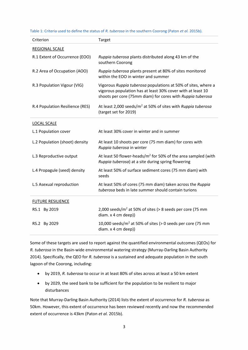
Table 1: Criteria used to define the status of R. tuberosa in the southern Coorong (Paton et al. 2015b).
Criterion Target
REGIONAL SCALE
R.1 Extent of Occurrence (EOO) Ruppia tuberosa plants distributed along 43 km of the southern Coorong
R.2 Area of Occupation (AOO) Ruppia tuberosa plants present at 80% of sites monitored within the EOO in winter and summer
R.3 Population Vigour (VIG) Vigorous Ruppia tuberosa populations at 50% of sites, where a vigorous population has at least 30% cover with at least 10 shoots per core (75mm diam) for cores with Ruppia tuberosa
R.4 Population Resilience (RES) At least 2,000 seeds/m2 at 50% of sites with Ruppia tuberosa (target set for 2019)
LOCAL SCALE
L.1 Population cover At least 30% cover in winter and in summer
L.2 Population (shoot) density At least 10 shoots per core (75 mm diam) for cores with Ruppia tuberosa in winter
L.3 Reproductive output At least 50 flower-heads/m2 for 50% of the area sampled (with Ruppia tuberosa) at a site during spring flowering
L.4 Propagule (seed) density At least 50% of surface sediment cores (75 mm diam) with seeds
L.5 Asexual reproduction At least 50% of cores (75 mm diam) taken across the Ruppia tuberosa beds in late summer should contain turions
FUTURE RESILIENCE
RS.1 By 2019 2,000 seeds/m2 at 50% of sites (> 8 seeds per core (75 mm diam. x 4 cm deep))
RS.2 By 2029 10,000 seeds/m2 at 50% of sites (> 0 seeds per core (75 mm diam. x 4 cm deep))
Some of these targets are used to report against the quantified environmental outcomes (QEOs) for
R. tuberosa in the Basin-wide environmental watering strategy (Murray-Darling Basin Authority
2014). Specifically, the QEO for R. tuberosa is a sustained and adequate population in the south
lagoon of the Coorong, including:
by 2019, R. tuberosa to occur in at least 80% of sites across at least a 50 km extent
by 2029, the seed bank to be sufficient for the population to be resilient to major
disturbances
Note that Murray-Darling Basin Authority (2014) lists the extent of occurrence for R. tuberosa as
50km. However, this extent of occurrence has been reviewed recently and now the recommended
extent of occurrence is 43km (Paton et al. 2015b).
4
3 Methods
3.1 Assessment of flowering levels in November and December 2016
Assessment of flowering activity was undertaken on 11 and 13 November 2016, when Lake Cantara
and eight sites on the eastern side of the southern Coorong were visited, namely N02E, S02E, S06E,
S18E, S26E, S33E, S36E and S41E (Table 2 and Figure 5 in Appendix A). With the exception of S41E
and Lake Cantara, flowering activity was reassessed at these sites on 16 December 2016, with S21E
(Table 2 and Figure 5 in Appendix A) also assessed on this day. For sites where R. tuberosa plants
were present, an assessment was made as to the extent of flowering and the filamentous green algal
load (Ulva sp.). Assessments of flowering were made by locating flower-heads at a site and then
counting the number of visible flower-heads produced in 1 m x 1 m quadrats (note that visibility was
poor due to turbid water, so in some instances only flower-heads on the surface and within 15cm of
the surface could be counted). The flower heads that were counted were assigned to the closest of
four water depths in which the plants were growing: 0.2, 0.4, 0.6 or 0.8m. In November, 30 quadrats
were generally sampled at each site where R. tuberosa occurred, while, in December, 20 quadrats
were generally sampled for each of the depths at each site where R. tuberosa occurred.
3.2 Distribution and abundance of R. tuberosa in the southern Coorong in January 2017
The main assessment of the distribution and abundance of R. tuberosa in the southern Coorong was
conducted in January 2017, in line with the timing of monitoring in previous years. During January
2017, the abundance and reproductive activity of R. tuberosa was assessed at eight sites on the
eastern side of the South Lagoon of the Coorong, and eight sites on the western side of the South
Lagoon (Table 2, Figure 5 in Appendix A). These sites are spread along the shoreline at intervals of
approximately 5 km. The western sites are approximately opposite the eastern sites. These 16 sites
coincide with sites that were originally sampled in 1984-85 as part of an initial monitoring program
for the South Lagoon. Ruppia tuberosa was detected at all sites in 1984-5. In January 2017, four sites
were additionally sampled along the eastern shoreline of the North Lagoon (Table 2 and Figure 5 in
Appendix A), where R. tuberosa was recorded during the latter parts of the millennium drought. The
eight sites along the eastern shoreline in the South Lagoon of the Coorong and the four sites in the
North Lagoon form part of an annual monitoring program that has run since 2000, while the eight
sites on the western side of the South Lagoon were added to the monitoring program in January
2013. A system for defining sites was adopted that incorporated the lagoon, the distance (km) north
or south from the junction of the North and South Lagoons (respectively), and the eastern or
western shoreline, unless the site also had a well-defined place name. For example, site S06W is in
the South Lagoon, 6 km south of the junction and on the western side of the Coorong. In addition to
these 20 sites, one additional site on the eastern shore in the South Lagoon (S33E, Gemini Downs
Bay; Table 2) has been assessed in previous years. This site does not experience the same extent of
water level changes as other parts of the South Lagoon because a sandbar helps retain water in that
Bay when water levels are low in the rest of the southern Coorong. The population of R. tuberosa in
this Bay remained during the millennium drought (despite high salinities) and has not experienced
the same extent of low water levels as other sites since the return of flows in late 2010. For this
reason, it presents an interesting comparison to sites which have regularly experienced reduced
water levels.
5
Table 2: Location details for sampling sites used for assessing the distribution and abundance of R. tuberosa in January 2017. The table provides the average easting and northing of the sampling depths at each site. See Appendix A for locational map of sites.
Site Distance from Mouth
(km)
Eastern shore Western shore
Zone Easting Northing Zone Easting Northing
N19 37 54H 342533 6042174
N12 44 54H 347959 6037285
N08 48 54H 350522 6034249
N02 54 54H 354684 6029538
S06 62 54H 360454 6024694 54H 358067 6024263
S11 67 54H 363123 6022500 54H 360914 6020398
S16 72 54H 367049 6018086 54H 363817 6016002
S21 77 54H 370278 6013457 54H 367502 6012315
S26 82 54H 372526 6008937 54H 369874 6007766
S31 87 54H 374401 6004315 54H 372631 6003931
S33 89 54H 376381 6003588
S36 92 54H 377502 6000803 54H 375476 5999686
S41 97 54H 378547 5996472 54H 377511 5995712
At each site, 25 core samples (75 mm diam., 4 cm deep) were taken at each of four water depths: (1)
dry mud surface, approximately midway between the current waterline and the high water line (and,
if known, positioned on areas where R. tuberosa was growing in winter); (2) waterline; (3) 30 cm
water depth; and (4) 60 cm water depth. Each core sample was assessed for presence of R. tuberosa
shoots and then sieved through 500 µm Endecott sieves, enabling seeds and turions to be extracted
and counted. However, water levels in January 2017 were extremely high (see Section 4.1), resulting
in 14 sample sites having no dry mud surface, with water abutting terrestrial vegetation (commonly
samphire) and often smothered in algae several centimetres thick. This was also the case at the
waterline for three sites. It was impossible to sample under these conditions, so core samples for the
dry mud surface and waterline for these sites were not taken in January 2017. However, these
samples are not considered a vital component of the assessment of R. tuberosa, as with water levels
so high, these sample locations are outside the usual range of R. tuberosa.
6
4 Results and Preliminary Discussion
4.1 Water levels in the southern Coorong in spring 2016
In winter 2016, and similar to previous years, water levels fluctuated in the southern Coorong
around 0.35-0.9 m AHD, but, unlike previous years, water levels increased steadily in early spring
2016, peaking in mid-spring at about 1.05 m AHD (Figure 1). Water levels then steadily declined, but
unlike the preceding six years, water levels by the end of spring 2016 in the southern Coorong were
still relatively high at around 0.5 m AHD (Figure 1). During December 2016, water levels steadied and
even increased, which again was in contrast to the previous five years; however, water levels
dropped sharply thereafter, losing 0.4 m in the first half of January 2017, and another 0.2 m over the
next couple of weeks, resulting in a water level of 0.16 m AHD at the end of January 2017 (Figure 1).
Considering that most of the R. tuberosa beds that establish in winter are centred around the 0.0 to
0.2 m AHD contour, and given that R. tuberosa needs an appropriate cover of water (0.3-0.9 m) to
prosper in the Coorong, when water levels start to drop below about 0.3 m AHD, those R. tuberosa
plants that germinated in winter will progressively be exposed to desiccation. From 2011-2015, this
0.3 m AHD threshold was breached either at the beginning of spring (2014, 2015) or towards the end
of spring (2011-2013) (Figure 1), resulting in poor years for R. tuberosa in the southern Coorong
(Paton et al. 2016d). In contrast, the maintenance of water levels above 0.3 m AHD through spring
2016 and into mid-summer 2017, should provide suitable water levels for R. tuberosa to have a good
season in the southern Coorong. However, there was still a sharp drop of 0.6 m over the course of
January 2017 (Figure 1), following the closure of most of the barrage gates and a sharp reduction in
total flow over the barrages in early January (Figure 2).
4.2 Assessment of flowering levels in November and December 2016
4.2.1 Flowering levels
In mid-November 2016, evidence of flowering was detected at six out of eight sites in the Coorong
where R. tuberosa is expected to perform well, ranging from N02E to S33E, and by mid-December,
the range had increased to include S36E (Table 3). Similarly, flowering densities generally improved
at all sites from November to December 2016 (Table 3). In mid-November, the greatest density of
flower-heads of 44.8 flower-heads/m2 in the Coorong was observed at S26E at a water depth of
0.8 m, which was similar to that in mid-December, with 45.6 flower-heads/m2 recorded at S06E in
0.6 m-deep water (Table 3) (note that water levels in the South Lagoon had decreased by about
0.2 m over this time; Figure 1). While the flowering of R. tuberosa in the Coorong in November and
December 2016 was better than in previous years (see Paton et al. 2016a, 2016d), even the
maximum densities observed for these two sampling periods fall short of the local population scale
target of at least 50 flower-heads/m2 for 50% of the area sampled (Table 1). This may in part be due
to the turbid water conditions and poor visibility, which resulted in only flower-heads within about
15 cm of the water surface being easily detectable. Consequently, the counts did not include flower-
heads in early stages of development on short peduncles, so the true number of flower-heads,
particularly at the greater depths, were likely to have been higher than reported. However, even if
some flower-heads were not counted, the densities are still far inferior to the mean density of 213.6
flower-heads/m2 observed at Lake Cantara in November 2016 (Table 3) and representative of a
7
Figure 1: Changes in water levels (m AHD) for the South Lagoon from 2010 to 2016 for the period June 1st to January 31st of the following year. Data are mean levels reported from three telemetered stations in the South Lagoon (NW Snipe Island, near Woods Well and Parnka Point) (Government of South Australia, 2017).
Figure 2: Total daily flow over the barrages (Adrienne Rumbelow, 2017, pers. comm., 12 May) and number of barrage gates open per day (Murray-Darling Basin Authority, 2017) from 1st December 2016 to 28th February 2017. Note that there is a difference in scale for the x-axis between Figure 1 (June 1st to Jan 31st) and Figure 2 (Dec 1st to Feb 28th).
healthy flowering event. Notably, most of the flower-heads that were counted on the surface in
November and December 2016 were in their male phase.
8
Table 3: Assessment of flowering by R. tuberosa for various depths at Lake Cantara and selected sites in the Coorong where R. tuberosa is expected to perform well in November and December 2016. Data are the abundances of flower-heads (mean and standard error (s.e.)) per square metre, generally based on 20 1m x 1m quadrat samples, although values italicised indicate data were based on fewer than 10 samples.
Site Depth (cm) Mean (± s.e.) flower-heads per m2
November December
Lake Cantara 20 213.6 ± 30.1 did not sample
N02E 40 12.5 ± 3.5 25.8 ± 3.3
60 21.2 ± 4.0 21.1 ± 3.1
S02E
40 4.0 ± 1.2 8.1 ± 1.0
60 29.6 ± 4.6 30.2 ± 3.2
80 9.5 ± 1.5 26.8 ± 2.5
S06E 40 14.7 ± 1.6
60 7.3 ± 0.8 45.6 ± 3.5
S18E
20 3.2 ± 0.6
40 11.8 ± 1.3
60 7.9 ± 1.9 28.5 ± 2.8
S21E 40
did not sample 6.1 ± 2.0 5.8 ± 1.2 60
S26E
20 1.5 ± 0.3
40 8.8 ± 3.8 8.6 ± 1.4
60 7.1 ± 1.3 32.4 ± 3.6
80 44.8 ± 11.3
S33E 40
# 3.8 ± 0.7
18.2 ± 2.2 60
S36E 40 6.3 ± 1.3
60 16.8 ± 4.0 N.B. When no value is provided in the table, the area at the depth was scouted for R. tuberosa flower-heads but either none were observed, or occurrences were rare. S41E was also sampled in November, but no flower-heads were observed. # Some plants flowering but impossible to sample due to gale-force winds.
4.2.2 Algae
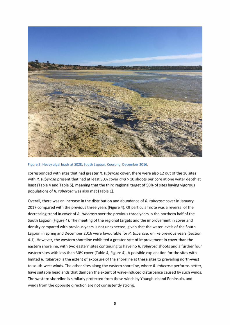
Filamentous green algae (Ulva sp.) was present at every site with R. tuberosa during November and
December 2016, sometimes causing a blanket cover when abundant (e.g., Figure 3) and interfering
with flower-heads in either of two ways: (a) preventing flower-heads from reaching the surface; or
(b) entangling around the flower-heads on the surface, in small to large amounts. The dense cover of
algae also contributed to the difficulty in seeing and counting the flower-heads.
4.3 Distribution and abundance of R. tuberosa in the southern Coorong in January 2017
4.3.1 Vegetative Cover
Ruppia tuberosa shoots were detected at sites over a linear distance of 43 km from N02 to S41
(Table 4). Consequently, the extent of occurrence (EOO) for R. tuberosa within the southern Coorong
was at least 43 km in January 2017, and the first of the four regional targets was met (Table 1).
Similarly, the second regional target (concerning area of occupation – see Table 1) was also met,
with R. tuberosa plants present at 89% of sites (16 out of 18 sites) within the EOO (Table 4). Twelve
sites exceeded the local population scale target of 30% or more cover at one water depth at least
(Table 4), while 13 sites had average densities of shoots that met or exceeded the local population
scale target of 10 shoots per core at one water depth at least (Table 5). As greater shoot densities
9
Figure 3: Heavy algal loads at S02E, South Lagoon, Coorong, December 2016.
corresponded with sites that had greater R. tuberosa cover, there were also 12 out of the 16 sites
with R. tuberosa present that had at least 30% cover and > 10 shoots per core at one water depth at
least (Table 4 and Table 5), meaning that the third regional target of 50% of sites having vigorous
populations of R. tuberosa was also met (Table 1).
Overall, there was an increase in the distribution and abundance of R. tuberosa cover in January
2017 compared with the previous three years (Figure 4). Of particular note was a reversal of the
decreasing trend in cover of R. tuberosa over the previous three years in the northern half of the
South Lagoon (Figure 4). The meeting of the regional targets and the improvement in cover and
density compared with previous years is not unexpected, given that the water levels of the South
Lagoon in spring and December 2016 were favourable for R. tuberosa, unlike previous years (Section
4.1). However, the western shoreline exhibited a greater rate of improvement in cover than the
eastern shoreline, with two eastern sites continuing to have no R. tuberosa shoots and a further four
eastern sites with less than 30% cover (Table 4; Figure 4). A possible explanation for the sites with
limited R. tuberosa is the extent of exposure of the shoreline at these sites to prevailing north-west
to south-west winds. The other sites along the eastern shoreline, where R. tuberosa performs better,
have suitable headlands that dampen the extent of wave-induced disturbance caused by such winds.
The western shoreline is similarly protected from these winds by Younghusband Peninsula, and
winds from the opposite direction are not consistently strong.
10
Table 4: Percent of cores (75 mm diameter x 4 cm deep) with R. tuberosa shoots present taken at four water depths at 21 sites spread across the southern Coorong in January 2017. Data are based on 25 cores taken at each water depth at each site. If percent of cores with green shoots were different, they are shown in brackets.
Site km from
Mouth
East West
dry waterline 30cm 60cm dry waterline 30cm 60cm
N19 38 0 0 0
N12 45 0 0 0
N07 50 0 0
N02 55 0 0 96 64
S06 62 0 100 96 0 100 40 (32)
S11 67 0 0 0 0 0 92 (72) 100
S16 72 0 0 0 0 32 (20) 96
S21 77 0 0 0 12 0 100 (64) 100
S26 82 0 0 100 (56) 100 0 8 88
S31 87 0 0 0 4 0 0 68
S33 89 36 100
S36 92 0 8 28 0 0 64
S41 97 0 0 0 12 0 40 (20) 100
Table 5: Mean numbers of R. tuberosa shoots present in cores (75 mm diameter x 4 cm deep) taken at four water depths at 21 sites spread across the southern Coorong in January 2017. Data are based on 25 cores taken at each water depth at each site. To express these data as shoots/m2 multiply by 226.
Site km from
Mouth
East West
dry waterline 30cm 60cm dry waterline 30cm 60cm
N19 38 0 0 0
N12 45 0 0 0
N07 50 0 0
N02 55 0 0 46.9 45.2
S06 62 0 17.4 35.7 0 33.6 1.7
S11 67 0 0 0 0 0 10.9 34.6
S16 72 0 0 0 0 6.8 48.0
S21 77 0 0 0 2.2 0 31.6 67.1
S26 82 0 0 51.6 70.8 0 1.3 44.9
S31 87 0 0 0 0.3 0 0 32.2
S33 89 12.1 73.4
S36 92 0 1.0 10.5 0 0 16.6
S41 97 0 0 0 2.7 0 5.4 44.6
11
Figure 4: Changes in distribution and abundance of R. tuberosa along the Coorong in January 2014, 2015, 2016 and 2017. The data show the maximum percent of cores with R. tuberosa shoots for cores taken from sediments covered by 30 cm or 60 cm of water). Red spots show areas where there were no R. tuberosa shoots at these depths, orange spots where the cover was less than 30% and green spots where the cover exceeded 30% (i.e., > 30% of cores had shoots). The actual percentages are shown on each Figure.
2014 2015
2016 2017
12
4.3.2 Turions
Propagules (or turions) of R. tuberosa were observed at 14 sites, although only nine sites exceeded
the local population scale target of at least 50% of cores containing turions (Table 6). Furthermore,
only three sites had cores with an average of >10 turions/core (Table 7). Consequently, the
abundances of propagules (or turions) associated with R. tuberosa were generally low in January
2017. Furthermore, fully-developed turions (described as Type II by Brock 1982b) were only
detected at three sites, so the majority of the propagules reported (Table 6) are partially-developed
turions (described as Type I by Brock 1982b), which carry much smaller reserves than
fully-developed turions and have limited capacity to survive any extended period of desiccation.
Herein, fully-developed turions will be referred to as full turions, and partially-developed turions as
half turions, with the use of the terms Type I and Type II turions avoided for clarity.
Sites with high abundances of turions tended to be the sites with large numbers of shoots and so the
turion counts reflect the shoot data.
4.3.3 Seeds
Seeds of R. tuberosa were detected at 18 of the 21 sites sampled in January 2017 (Table 8).
However, only eight of these sites met the local population scale target of more than 50% of cores
containing seeds for at least one of the four sampling depths (Table 8). Furthermore, of the 18 sites
with seeds detected, only one of these sites had > 8 seeds/core (≈ 2,000 seeds/m2) and at 60cm only
(S06W) (Table 9). Consequently, the fourth and final regional target (representing population
resilience) of at least 2,000 seeds/m2 at 50% of sites with R. tuberosa was not met (Table 1). This is
particularly concerning, as even though the other three regional targets have been met in January
2017, the seedbank has once again failed to show signs of recovery. Without a reasonable seedbank,
the ability of R. tuberosa to cope with long-term perturbations, such as a series of years with
inadequate water levels in spring, in the future remains minimal.
4.3.4 Algae
In January 2017, high algal loads (e.g., Figure 3) persisted at all sites with R. tuberosa, at times
forming a blanket cover. This is likely to have affected both the growth and reproduction of R.
tuberosa.
Firstly, given that R. tuberosa in water deeper than 0.8m often shows signs of deterioration and this
is likely due to limited light availability, then the presence of high algal loads in the water column
above plants, may dampen the growth of plants by reducing light availability to an even greater
extent.
Secondly, and more importantly for the future longevity of R. tuberosa in the southern Coorong,
algae can considerably affect the reproductive cycle of R. tuberosa. The flowers of R. tuberosa are
pollinated when on the surface of the water and, to do this, the inflorescences are produced at the
tip of long, fine spiral peduncles. These peduncles enable the flower-head, with its two
inflorescences, to stay on the surface of the water when flowering, first shedding pollen and then
receiving pollen that is dispersed on the water surface. When present even in low levels, filamentous
13
Table 6: Percent of cores containing R. tuberosa turions across four water depths at 21 sites in the southern Coorong in January 2017. Data are based on 25 cores taken at each depth at each site. Sites and depths where the percent of cores with turions exceeded the target 50% are shown in red.
Site km from
Mouth
East West
Dry waterline 30cm 60cm dry waterline 30cm 60cm
N19 38 0 0 0
N12 45 0 0 0
N07 50 0 0
N02 55 8 0 68 8
S06 62 0 80 80 0 100 88
S11 67 0 0 0 0 0 76 92
S16 72 0 0 0 0 16 96
S21 77 0 0 0 0 0 84 92
S26 82 0 0 100 92 0 8 44
S31 87 0 0 0 0 0 0 40
S33 89 28 100
S36 92 0 4 0 0 0 24
S41 97 0 0 0 4 0 32 88
Table 7: Mean number of turions per core (75 mm x 4 cm) across four water depths and at 21 sites within the southern Coorong in January 2017. Data are based on 25 cores taken at each water depth at each site. To express these data as turions/m2 multiply by 226. Sites and depths where there were >10 turions/core are shown in red.
Site km from
Mouth
East West
dry waterline 30cm 60cm dry waterline 30cm 60cm
N19 38 0 0 0
N12 45 0 0 0
N07 50 0 0
N02 55 0.3 0 4.4 0.1
S06 62 0 9.4 5.6 0 6.8 10.0
S11 67 0 0 0 0 0 14.5 7.4
S16 72 0 0 0 0 0.8 4.0
S21 77 0 0 0 0 0 12.0 6.2
S26 82 0 0 13.7 7.4 0 1.0 5.0
S31 87 0 0 0 0 0 0 3.8
S33 89 2.5 10.0
S36 92 0 0 1.4 0 0 1.4
S41 97 0 0 0 0.1 0 0.8 8.1
14
Table 8: Percent of cores containing R. tuberosa seeds at 21 locations in the southern Coorong at four different water depths in January 2017. Data are based on 25 cores taken at each depth at each site. Sites and depths where the target of having at least 50% of cores with seeds are shown in red.
Site km from
Mouth
East West
Dry waterline 30cm 60cm dry waterline 30cm 60cm
N19 38 0 4 16
N12 45 0 0 0
N07 50 0 0
N02 55 32 56 56 8
S06 62 80 36 96 76 92 88
S11 67 20 8 0 4 48 40 52
S16 72 8 4 0 8 16 64
S21 77 16 28 16 56 4 48 4
S26 82 52 76 52 72 12 0 12
S31 87 0 4 4 0 4 4 4
S33 89 64 100
S36 92 32 28 40 0 0 0
S41 97 8 0 32 40 4 0 0
Table 9: Mean number of R. tuberosa seeds per core (75 mm diameter x 4 cm deep) at 21 sites along the southern Coorong across four water depths in January 2017. Data are based on 25 cores taken at each depth at each site. To convert these data to seeds/m2 multiply by 226. Sites and depths where > 8 seeds/core were detected are shown in red.
Site km from
Mouth
East West
dry waterline 30cm 60cm dry waterline 30cm 60cm
N19 38 0 0.04 0.24
N12 45 0 0 0
N07 50 0 0
N02 55 1.00 0.88 5.20 0.12
S06 62 2.28 2.40 3.24 4.40 3.36 9.96
S11 67 0.28 0.08 0 0.04 1.96 0.64 1.60
S16 72 0.16 0.04 0 0.16 0.40 1.60
S21 77 0.16 0.04 0.24 1.04 0.04 1.76 0.04
S26 82 1.20 2.08 0.96 1.88 0.12 0 0.36
S31 87 0 0.04 0.04 0 0.04 0.04 0.04
S33 89 1.68 4.08
S36 92 1.24 0.44 0.84 0 0 0
S41 97 0.28 0 0.52 0.60 0.04 0 0
15
green algae readily attach to flower-heads increasing drag, such that the force of wave action snaps
the peduncle and subsequent seed production is prevented. An extended period of time is needed
on the surface, because of the protandrous nature of R. tuberosa, meaning the flower-heads
function first as males and then as females. Consequently, there is an extended period of exposure
to algal interference during the flowering process. Most of the flower-heads that were counted on
the surface in November and December 2016 were in their male phase (Section 4.2.1), with small to
large amounts of attached algae (Section 4.2.2). This suggests that female flowers had already been
lost, because for pollination to occur, male and female flowers must both be present on the surface
of the water. Furthermore, high algal loads can blanket R. tuberosa plants, preventing the floral
spikes from even reaching the surface. Therefore, given the prominence of filamentous algae along
the entire southern Coorong in 2016-17, and the extent to which filamentous algae interferes with
ability of R. tuberosa to produce seeds, the lack of significant seed production (Section 4.3.2) was
not unsurprising.
4.3.5 Galls
In January 2017, and for the first time, small rounded swellings on the rhizomes of R. tuberosa
(known as galls or tubercles) were observed in a total of 71 cores (16% of cores with R. tuberosa) at
10 sites (63% of sites with R. tuberosa), ranging from N02 to S41. For cores with galls, there were
2.9 galls per core on average, although cores ranged from 1 to 19 galls. These galls are believed to be
a pathological response to the fungus Tetramyxa parasitica Goebel, as described by Brock (1982b).
4.3.6 Extent of grazing on R. tuberosa
Grazing was moderate at many sites in January 2017, with an overall average of 57% of shoots being
grazed across the sampling sites. On average, grazed shoots were around 1.2 cm in length, while
ungrazed shoots were around 4.4 cm in length (Table 10). These levels of grazing were lower than in
previous years where over 80% of shoots were grazed (e.g. Paton et al. 2016d). The lower levels of
grazing in January 2017 are likely to be indicative of an increase in the availability of food (R.
tuberosa plant material and turions) to herbivorous waterfowl (ducks and swan). However, the high
algal loads (Section 4.3.4) could also have reduced the grazing level, as waterfowl may not have been
able to access the plants growing on the bottom through the algae.
4.4 Changes in seed abundances along the Coorong 2011-2017
The abundances of seeds detected in sediment cores in January 2017 were similar to the
abundances of seeds detected in January in each of the six previous years (Table 11). However, this
is inconsistent with an improvement in flowering of R. tuberosa in the Coorong in November and
December 2016 compared with previous years (Section 4.2.1). Given the relatively good level of
flowering this season (Table 3), the quantities of seeds produced per square metre should have
resulted in a measurable increase in seed abundances during the January sampling. A square metre
with 50 flower-heads should produce in the order of 1000 seeds because a flower-head of
R. tuberosa contains two inflorescences, each with the potential to produce 2-19 carpels (11 on
average) (Brock 1982a). If such a level of productivity had been secured by R. tuberosa this season,
then cores in January 2017 should have contained around 5 seeds, rather than less than 1 seed per
core found at most sites (Table 11). As discussed in Section 4.3.4, failure of the plants to set
16
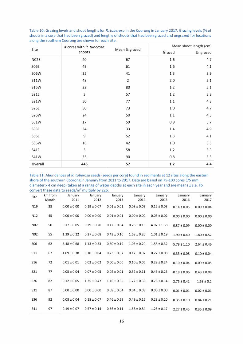
Table 10: Grazing levels and shoot lengths for R. tuberosa in the Coorong in January 2017. Grazing levels (% of shoots in a core that had been grazed) and lengths of shoots that had been grazed and ungrazed for locations along the southern Coorong are shown for each site.
Site # cores with R. tuberosa
shoots Mean % grazed
Mean shoot length (cm)
Grazed Ungrazed
N02E 40 67 1.6 4.7
S06E 49 61 1.6 4.1
S06W 35 41 1.3 3.9
S11W 48 2 2.0 5.1
S16W 32 80 1.2 5.1
S21E 3 57 1.2 3.8
S21W 50 77 1.1 4.3
S26E 50 73 1.0 4.7
S26W 24 50 1.1 4.3
S31W 17 59 0.9 3.7
S33E 34 33 1.4 4.9
S36E 9 52 1.3 4.1
S36W 16 42 1.0 3.5
S41E 3 58 1.2 3.3
S41W 35 90 0.8 3.3
Overall 446 57 1.2 4.4
Table 11: Abundances of R. tuberosa seeds (seeds per core) found in sediments at 12 sites along the eastern shore of the southern Coorong in January from 2011 to 2017. Data are based on 75-100 cores (75 mm diameter x 4 cm deep) taken at a range of water depths at each site in each year and are means ± s.e. To convert these data to seeds/m2 multiply by 226.
significant numbers of seeds, despite producing many more floral-heads than in previous years, is
likely due to interference from high algal loads.
4.5 Status of R. tuberosa in the southern Coorong for January 2017
Table 12 provides summary statistics for the status of R. tuberosa in January 2017 (including
November and December 2016) and the previous six years, and against the stated benchmarks for a
healthy and resilient R. tuberosa system. Ruppia tuberosa was least prominent in January 2012,
when shoots of R. tuberosa were found at only one site (Table 12). Over the next three years,
R. tuberosa increased in prominence; however, in 2016, R. tuberosa suffered an overall decline
within the Coorong. In January 2017, this decline was reversed to some extent, with the first three
regional targets met and the first two local population targets met (Table 12). However, given that
these targets all relate to plant cover and abundance, R. tuberosa still performed poorly against
targets for flowering, turions and seeds in January 2017. Therefore, while there were considerable
immediate benefits of increased R. tuberosa cover, such as providing food for herbivorous waterfowl
from spring 2016 through summer 2017, any considerable long-standing benefit in the future is
unlikely to arise. Most importantly, the abundances of seeds at all sites and depths (Table 8, Table 9
and Table 11) were well below the levels needed for some level of resilience.
18
Table 12: Extent of occurrence, area of occupation and prominence of R. tuberosa at sites across the southern Coorong in January from 2011-2017. Flowering levels were assessed in the preceding Nov-Dec period in each year. The target values for a healthy and resilient system for R. tuberosa are also given. Where targets were met, they are shown in red.
Performance Indicator Target
Year
2011 2012 2013 2014 2015 2016 2017
# sites sampled
13 12 21 23 21 21 21
REGIONAL SCALE
R.1. Extent of Occurrence
(km, main region)
43 22 1 43
(53*)
43
(60*)
43
(53*)
43 43
R.2. Area of Occupation (%
sites with R. tuberosa
shoots)
80 31 8 57 73 76 48 89
R.3. Population vigour (%
sites with R. tuberosa
present that have
> 30% cover and > 10
shoots/core)
50 15 0 5 39 29 5 75
R.4. Population resilience
(% sites with R.
tuberosa present that
have > ≈ 8 seeds/core)
50 8 0 0 0 10 5 6
SITE SCALE
L.1. % sites with > 30%
cover (cores) with
shoots
50 15 0 24 39 52 33 57
L.2. % sites with > 10
shoots/core for one
depth
50 23 0 5 39 29 5 62
L.3. % sites with > 50
flower-heads/m2
50 0 0 0 0# 0 0 0
L.4. % sites with > 50%
cores with seeds at
one depth
50 15 17 24 53 52 38 38
L.5. % sites with > 50%
cores with turions at
one depth
50 0 0 0 23 26 52 43
*extent of occurrence with outliers; #evidence of flower production noted for at least five sites in December 2013 when fewer than 10 sites examined but no sites would have exceeded 50 flower-heads/m2.
19
5 General Discussion and Conclusions
While the first three of four regional targets set for healthy and resilient populations of R. tuberosa
in the southern Coorong were met in January 2017, the on-going lack of an adequate seed bank, and
hence population resilience within the system, is still a major concern. As far as local site targets are
concerned, two of the five targets were reached in January 2017 (Table 12), and one of the two
quantified environmental outcomes of the Basin Wide Environmental Watering Strategy (Section 2).
However, like the regional targets, these targets related to the cover and abundance of plants, and
do not reflect the ability of R. tuberosa to sustain this increased cover and abundance much beyond
this particular annual growing season. The ability of this plant to complete its reproductive cycle, and
so secure future resilience, is still limited, which is reflected by not meeting the local targets for
flowering, seeds and turions in January 2017 (Table 12). Furthermore, and as in previous years
(Paton et al., 2016a,d), the predominant turions were the smaller half turions (type I of Brock
1982b), which carry much smaller reserves than full turions (type II of Brock 1982b) and have limited
capacity to survive any extended period of desiccation.
As has been stated previously, the key factor contributing to the slow recovery of R. tuberosa in
recent years (Table 12) has been the inability to maintain water levels in the southern Coorong over
spring (Paton et al. 2016a,b,d,e). The maintenance of adequate water levels through spring 2016,
maintained the growth of plants and allowed substantial production of flowers. This confirms that
inadequate water levels in other years were limiting the ability of the plant to grow and flower, thus
preventing the recovery of R. tuberosa in the southern Coorong. As such, the performance of R.
tuberosa in November and December 2016 provides “proof of concept” that the performance of R.
tuberosa will be enhanced if water levels can be maintained through spring and into summer.
However, the maintenance of adequate water levels through spring and into summer in itself may
not be all that is required. There may also be a need to dampen the rate at which water levels drop
because a rapid and unnatural drop in water levels is likely to result in plants having insufficient time
prior to desiccation to respond by transferring resources into asexual propagules (turions). Only low
levels of turions were present in January 2017 when sampling was undertaken (Table 6 and Table 7),
with any additional turion production highly unlikely, given the dramatic drop in water levels of
around 0.6m during January (Figure 1). Under more natural and lower rates of water level change
(comparable to evaporative losses), the plants would have had time to sequester resources into
more turions before desiccation, improving the ability of the plants to re-establish next season.
Consequently, there is a need to address rapidly falling water levels in the southern Coorong.
Currently, the only option to slow water leaving the southern Coorong is to change the operating
rules and constraints to allow the delivery of environmental water at appropriate times to benefit
the South Lagoon of the Coorong, for example by reducing the rate of barrage gate closure.
However, the critical issue is that due to inadequate flows, barrage gates in recent years have been
closed in spring before R. tuberosa can reproduce. In the future, even when the Murray-Darling
Basin Plan is fully implemented, flows over the barrages are unlikely to be adequate to maintain
water levels. Consequently, a barrier across the Coorong, to slow water leaving the southern
20
Coorong when barrage gates are closed, will be required to improve conditions for R. tuberosa in
most years.
The findings in this report also highlight a further problem to the recovery of R. tuberosa in the
southern Coorong: filamentous green algae. In November and December 2016, most of the
R. tuberosa beds were heavily covered in algae (e.g., Figure 3), with the algae interfering with both
the growth, flowering and seed production of the plants. Enhanced algal interference was expected
in spring and summer of 2016-2017, due to the salinities in the southern Coorong being lower than
in previous years due in part to increased flows over the barrages throughout spring and into
summer. Although salinities were lower in the southern Coorong (from N02-S41), ranging from
58-82 gL-1 in summer 2017 (Paton et al. 2017), they remained largely within the target range of
60-100 gL-1 for R. tuberosa. Salinities below this range have been assumed to favour growth of
filamentous green algae. Given the extent and prominence of filamentous algae in the southern
Coorong in January 2017 at salinities within the bottom half of the targeted salinity range for
R. tuberosa, the targeted salinity range may need to be adjusted upwards with the lower salinity
threshold set at 80 gL-1. Further work is clearly required to determine how the performance of
filamentous algae is influenced by salinity and the extent to which its growth is limited at salinities
on or above 80 gL-1. Strategies that dampen interference from filamentous algae will also be needed
to secure the recovery of R. tuberosa across the southern Coorong. Precautionary measures to
prevent exacerbation of the current problem should include prevention of influxes of fresh water
into the southern Coorong, as these will reduce salinity and may carry nutrients. Lower salinities and
increased availability of nutrients will favour algal growth. However, the greatly improved
performance of R. tuberosa in 2016-17 demonstrates the importance of maintaining adequate water
levels through spring as the most critical first step to ensuring good growth and flowering of
R. tuberosa.
The higher water levels and prominence of algae around the southern Coorong in 2016-17 is likely to
have caused issues for other biota, for example, by restricting the availability and access to mudflats
for shorebirds. With higher water levels, suitable mudflats for shorebirds are less available, and any
mudflats that were available in January 2017, were largely covered with a dense layer of algae that
had been washed ashore. In many areas, this layer was several centimetres thick. These thick
blankets of algae prevented shorebirds from accessing benthic surface-dwelling invertebrates, like
chironomid larvae, as well as seeds and turions of R. tuberosa, which are also components of their
diet (e.g., Paton 1986). Thus, if the algal loads in the southern Coorong are not addressed and
continue to recur, then shorebirds may struggle to secure the food they need, not only because the
algae reduces the resource base of seeds and turions of R. tuberosa, but also because the algae
prohibits the ability of the shorebirds to reach whatever resource base is present. If the cover of
filamentous algae is prominent, the habitat quality of the southern Coorong for shorebirds is much
diminished. This was reflected in low numbers of small shorebirds during the annual waterbird
census of January 2017, with both Red-necked Stint (Calidris ruficollis) and Sharp-tailed Sandpipers
(Calidris acuminate) registering their lowest abundances for the past 18 years (Paton et al. 2017).
21
The presence of galls on R. tuberosa, believed to be a response to the parasitic fungus, T. parasitica,
in the southern Coorong for the first time is also a potential cause for concern, because this parasite
is known to reduce the growth of the host plant and probably reduce the formation of
inflorescences (Neuhauser et al. 2011). Furthermore, in marine systems, parasitic fungi have been
flagged as potential agents to spread viruses that may have further ramifications for plants
(Neuhauser et al. 2011). However, R. tuberosa plants with galls showed no signs of ill-health, as
might be expected in a balanced plant-parasite relationship. Although, continued monitoring would
be prudent, in case of deterioration of the health of R. tuberosa.
The findings from this report illustrates (a) how interference from filamentous algae dampens the
recovery of R. tuberosa in the southern Coorong, and (b) how important maintaining water levels in
the southern Coorong in spring is for R. tuberosa. So, a new challenge is now apparent, which is to
prevent the interference caused by filamentous green algae to the productivity of this plant, which
ultimately affects its capacity for future resilience in the southern Coorong. At present there are no
simple solutions for dampening the impact of filamentous algae. Harvesting algae might ultimately
assist in reducing algal impacts, because this has the potential to remove some of the nutrients, but
further work is required to determine if there are feasible methods to achieve this. At the very least,
as a precautionary measure, influxes of freshwater into the southern lagoon that will lower salinity
and potentially increase nutrient loads should cease. Ultimately, the findings of this report confirm
findings from previous reports that falling water levels in spring is the critical issue that first needs to
be addressed, as these falling water levels reduce the time available for plants to establish, grow and
reproduce (Paton et al. 2016a,d). The only option currently available to dampen rates of water level
change in the southern Coorong is to adjust the rates at which barrage gates are closed. However,
given that flows over the barrages in the future are unlikely to be adequate to maintain water levels
in spring, even when the Murray-Darling Basin Plan is fully implemented, alternatives, such as a
barrier across the middle of the Coorong to reduce the rate at which water levels drop in the
southern Coorong over spring, should be implemented. There is added motivation to act because
many of the waterbirds that use the southern Coorong over summer depend on R. tuberosa, either
directly or indirectly, for food.
6 Acknowledgments
The 2016-17 work was commissioned and funded by the Murray-Darling Basin Authority. Funding for
this work in 2015-16 was part of the South Australian Government’s Murray Futures’ program,
funded by the Australian Government’s Water for the Future initiative, while funding from 2012 to
2015 was through The Living Murray initiative, with funding provided by the Murray-Darling Basin
Authority. Donna Belder, Tom Bradley, Tom Hunt, Grace Hodder, Emily Hoffmann, Hayley Merigot,
Victoria McCarron, Casey O’Brien, Hannah Bannister, Kimberley McCallum, Alexander Harland,
Katherine Hill, Michelle Sargent, Alastair Wood and Stephanie Fisher provided able field assistance.
The research was conducted under a DEWNR wildlife research permit issued to David Paton.
22
7 References
Brock, MA 1982a. Biology of the salinity tolerant genus Ruppia L. in saline lakes in South Australia I. Morphological variation within and between species and ecophysiology. Aquatic Botany 13: 219-248.
Brock, MA 1982b. Biology of the salinity tolerant genus Ruppia L. in saline lakes in South Australia II. Population ecology and reproductive biology. Aquatic Botany 13: 249-268.
Government of South Australia 2017. Surface Water Data in Water Connect, retrieved from www.waterconnect.sa.gov.au.
Kim DH, Aldridge KT, Brookes JD & Ganf GG 2013. The effect of salinity on the germination of Ruppia tuberosa and Ruppia megacarpa and implications for the Coorong: A coastal lagoon of southern Australia. Aquatic Botany 111: 81-88.
Murray-Darling Basin Authority 2017. Flow to the sea through Lower Lakes Barrages (Murray) in
River Murray Data, retrieved from https://riverdata.mdba.gov.au/flow-sea-through-lower-lakes-
barrages.
Neuhauser S, Kirchmair M & Gleason, FH 2011. Ecological roles of the parasitic phytomyxids (plasmodiophorids) in marine ecosystems–a review. Marine and Freshwater Research 62(4), 365-371.
Paton DC 2010. At the End of the River. The Coorong and Lower Lakes. ATF Press, Hindmarsh.
Paton DC & Bailey CP 2010. Restoring Ruppia tuberosa to the southern Coorong. Report for the Department of Environment and Natural Heritage. (University of Adelaide, Adelaide).
Paton DC & Bailey CP 2012. Annual monitoring of Ruppia tuberosa in the Coorong region of South Australia, July 2011. Report for the Department of Environment, Water and Natural Resources. (University of Adelaide, Adelaide).
Paton DC & Bailey CP 2013a. Annual monitoring of Ruppia tuberosa in the Coorong region of South Australia, July 2012. Report for the Department of Environment, Water and Natural Resources. (University of Adelaide, Adelaide).
Paton DC & Bailey CP 2013b. Response of Ruppia tuberosa in the Coorong South Lagoon to environmental water delivery over summer 2012-13. (University of Adelaide, Adelaide).
Paton DC & Bailey CP 2014. Intervention monitoring of Ruppia tuberosa in the southern Coorong, summer 2013-14. (University of Adelaide, Adelaide).
Paton DC, McKillop T & Bailey CP 2011. Developing ecological knowledge to inform the re-establishment of Ruppia tuberosa in the southern Coorong. Report for the Department of Environment, Water and Natural Resources. (University of Adelaide, Adelaide).
Paton DC, Bailey CP & Paton FL 2015a. Annual winter monitoring of Ruppia tuberosa in the Coorong region of South Australia, July 2014. Report for the Department of Environment, Water and Natural Resources. (University of Adelaide, Adelaide).
23
Paton DC, Paton FL & Bailey CP 2015b. Refinement of the Condition Monitoring Plan for Ruppia tuberosa in the Coorong, Lower Lakes and Murray Mouth Icon Site. Report for the Department of Environment, Water and Natural Resources (University of Adelaide, Adelaide).
Paton DC, Bailey CP &Paton FL 2016a. Intervention monitoring of Ruppia tuberosa in the southern Coorong, summer 2014-5. Report for the Department of Environment, Water and Natural Resources. (University of Adelaide, Adelaide)
Paton DC, Bailey CP & Paton FL 2016b. Annual winter monitoring of Ruppia tuberosa in the Coorong region of South Australia, July 2015. Report for the Department of Environment, Water and Natural Resources. (University of Adelaide, Adelaide).
Paton DC, Paton FL & Bailey CP 2016c. Condition monitoring of the Coorong, Lower Lakes and Murray Mouth Icon Site: Waterbirds in the Coorong and Lower Lakes 2016. Report for the Department of Environment and Natural Resources. (University of Adelaide, Adelaide).
Paton, DC, Paton, FL & Bailey, CP 2016d. Monitoring of Ruppia tuberosa in the southern Coorong, summer 2015-16. Report for the Department of Environment, Water and Natural Resources. (University of Adelaide, Adelaide).
Paton DC, Paton FL & Bailey CP 2016e. Annual winter monitoring of Ruppia tuberosa in the Coorong region of South Australia, July 2016. Report for the Department of Environment, Water and Natural Resources. (University of Adelaide, Adelaide).
Paton DC, Paton FL & Bailey CP 2017. Condition monitoring of the Coorong, Lower Lakes and Murray Mouth Icon Site: Waterbirds in the Coorong and Lower Lakes 2017. Report for Murray-Darling Basin Authority. (University of Adelaide, Adelaide).
Paton PA 1986. Use of aquatic plants by birds in the Coorong, South Australia, pp 94-101, in HA Ford & DC Paton (eds). The dynamic partnership: birds and plants in southern Australia. (SA Govt Printer, Adelaide).
Webster IT. 2010. The hydrodynamics and salinity regime of a coastal lagoon - The Coorong, Australia - Seasonal to multi-decadal timescales. Estuarine, Coastal and Shelf Science 90:264-274.
24
8 Appendix A
Figure 5: Map of the Coorong showing sites used to sample Ruppia tuberosa during January 2017 (yellow dots) and to assess Ruppia tuberosa flowering during November and December 2016 (some yellow dots and orange dots). Codes for sites have been indicated.