PTTEPAA 04.doc October 8 th 2009 Montara Monitoring Plan Version 0 1 Monitoring Plan for the Montara Well Release Timor Sea As agreed between PTTEP Australasia (Ashmore Cartier) Pty. Ltd. and the Department of the Environment, Water, Heritage and the Arts Document Number: PTTEPAA 04 / Interwoven # 142768 October 9 th 2009
Transcript
PTTEPAA 04.doc October 8th 2009 Montara Monitoring Plan Version 0
1
Monitoring Plan
for the Montara Well Release
Timor Sea
As agreed between PTTEP Australasia (Ashmore Cartier) Pty. Ltd.
and the Department of the Environment, Water,
Heritage and the Arts
Document Number: PTTEPAA 04 / Interwoven # 142768
October 9th
2009
Montara Monitoring Plan
PTTEPAA 04.doc October 8th 2009 Montara Monitoring Plan Version 0
2
DOCUMENT CONTROL
Title: Montara Monitoring Plan Status: Non Confidential Doc. No. PTTEPAA 04
Interwoven # 142768 Date: 9th October 2009
REVISION RECORD Submitted for PTTEPAA Review: Rev A 20/09/09 By Wardrop Consulting Submitted for DEWHA Review: Rev A 20/09/09 By PTTEPAA Revised and Reissued for Review: Rev B 22/09/09 By Wardrop Consulting Submitted for DEWHA Review: Rev B 22/09/09 By PTTEPAA Revised (not submitted for review): Rev C 01/09/09 By Wardrop Consulting Revised as per DEWHA. Reissued for PTTEP Review: Rev D 03/10/09 By Wardrop Consulting Submitted for DEWHA Review Rev D 05/10/09 By PTTEPAA Submitted for DEWHA/AMSA/PTTEP final review Rev E 07/10/09 By Wardrop Consulting Issued: Rev 0 09/10/09 PTTEPAA/DEWHA
This document is formatted for single or double sided printing on A4 paper Prepared for PTTEPAA and DEWHA by
Wardrop Consulting 28 Station Street, Drysdale, Victoria. Australia, 3222 Telephone: 03 5252 1303 Mobile 0417 536 162 E-mail [email protected] A.C.N. 073 690 767 A.B.N: 84 073 690 767
Montara Monitoring Plan
PTTEPAA 04.doc October 8th 2009 Montara Monitoring Plan Version 0
3
TABLE OF CONTENTS Title Page 1 Document Control 2 Revision Record 2 Table of Contents 3 1.0 INTRODUCTION 41.1 Rationale 41.2 Programme Limitations and Considerations 41..3 Types of Monitoring 4 1.3.1 Type I Monitoring (Operational Monitoring), 4 1.3.2 Type II Monitoring (Non Operational or Scientific Monitoring) 5 1.3.3 Integration of Type I and Type II Monitoring 5 2.0 MONITORING PROGRAMME OVERVIEW 62.1 Operational Monitoring 62.2 Scientific Monitoring 62.3 Programme Justification 72.4 Managing the Monitoring Programme 7 2.4.1 Operational Monitoring 7 2.4.2 Scientific Monitoring 8 2.4.3 Commissioning Monitoring Studies 10 3.0 OPERATIONAL MONITORING PROGRAMME 113.1 Study 01: Monitoring of Oil Distribution Marine and Coastal Megafauna 113.2 Study 02: Monitoring of Oil Character fate and Effects 123.3 Study 03: Shoreline Assessment Ground Surveys 123.4 Study O4: Monitoring of Dispersant Efficiency and Fate of Dispersed Oil 133.5 Study O5: Wildlife Impact Monitoring 13 4.0 SCIENTIFIC MONITORING PROGRAMME 154.1 Study S1: Marine Megafauna Aerial Assessment Surveys 154.2 Study S2: Shoreline Ecological Assessment Aerial Surveys 154.3 Study S3: Assessment of Fish Catch for the Presence of Oil 154.4 Study S4: Assessment of Effects on Timor Sea Fish and Fisheries 164.5 Study S5: Offshore Banks Assessment Survey 164.6 Study S6: Shoreline Ecological Ground Surveys 164.7 Study S7: Oil Fate and Effects Assessment 17 5.0 REFERENCES 18 ATTACHMENT A: OUTLINE OF OPERATIONAL MONITORING PROGRAMMES 19ATTACHMENT B: OPERATIONAL MONITORING PROGRAMME DATA REQUIRED FOR THE SCIENTIFIC MONITORING 36ATTACHMENT C: OUTLINE OF SCIENTIFIC MONITORING PROGRAMMES 39ATTACHMENT D: RAMSAR SITES IN THE REGION 60ATTACHMENT E: GUIDELINES FOR SUBMISSION OF STUDY PROPOSALS 62
Montara Monitoring Plan
PTTEPAA 04.doc October 8th 2009 Montara Monitoring Plan Version 0
4
1.0 INTRODUCTION The Monitoring Programme contained in this report has been prepared at the request of
PTTEP Australasia (Ashmore Cartier) Pty. Ltd. (PTTEPAA). 1.1 Rationale A well release on Friday 21st August 2009 has resulted in the release of gas,
condensate and crude oil into the Timor Sea and this release is currently ongoing. The isolated rig location and limited trajectory of the slick (to date) indicate a low risk of
coastal impact; either to the mainland or reefs (Ashmore-Cartier). Claims of impact to fisheries and natural resources have been made in the media. These have not been substantiated.
The broad objectives of the proposed Monitoring Programme are to:
• Obtain information which will assist in the planning and execution of the oil spill
response and the achieving of its stated aim of minimising environmental harm (Operational or Type I monitoring).
• Obtain information which will provide indicative or quantitative data for short term and longer term environmental effects assessment (Scientific or Type II monitoring).
These differing objectives are achieved by studies requiring different levels of expertise
and data with different levels of scientific rigour. This is discussed in Section 1.3. The programme contains integrated Operational and Scientific components. This programme does not cover all circumstances that may arise as a consequence of
the spill. PTTEPAA will continue to liaise with the relevant State and Commonwealth agencies regarding the scale, design and composition of the programme and individual and to make amendments accordingly.
1.2 Programme Limitations and Considerations The outlines of the proposed studies in this report are not detailed and are based on
information to hand. Methodologies, particularly for the Scientific Monitoring studies will need to be modified according to incident events (e.g. habitats or fauna impacted and degree of impact) and specific study requirements as identified by pertinent experts.
1.3 Types of Monitoring Oil spill related monitoring has been divided, in Australia, into two types (see AMSA,
2003a). 1.3.1 Type I Monitoring (Operational Monitoring) This is undertaken during a response and is focussed on providing information of use in
planning or executing the response. As such it is usually undertaken as part of the response and managed by the Incident Management Team (IMT). Information must be acquired and processed quickly so that it can be quickly acted upon.
Montara Monitoring Plan
PTTEPAA 04.doc October 8th 2009 Montara Monitoring Plan Version 0
5
1.3.2 Type II Monitoring (Non Operational or Scientific Monitoring) This is focused on non-response objectives such as estimating environmental damage
and post response recovery. Type II monitoring may be undertaken over extended periods.
Type II monitoring has a high requirement for accuracy and data may be challenged. 1.3.3 Integration of Type I and Type II Monitoring Type I monitoring may become Type II monitoring if it continues after response
termination. An example of this is studies of oil in sediment. This is of operational significance when used to monitor the success (or otherwise) of cleanup but may also be required for longer term study of oil persistence, perhaps linked to studies of habitat recovery. For this reason, it is important that Type I monitoring is undertaken in a manner that will allow data to be used for Type II studies if required.
Type I monitoring provides data in a usable time-frame and this sometimes
compromises scientific rigour. However, as noted above, data obtained under this monitoring may be required to support longer term Type II studies and this must be considered in the design of Type I studies.
In this document the terms “Operational Monitoring” (for Type I) and “Scientific
Monitoring” (for Type II) are used henceforth.
Montara Monitoring Plan
PTTEPAA 04.doc October 8th 2009 Montara Monitoring Plan Version 0
6
2.0 MONITORING PROGRAMME OVERVIEW 2.1 Operational Monitoring Operational monitoring will be carried out by the Australian Maritime Safety Authority
(AMSA) in accordance with the National Marine Oil Spill Contingency Plan. As such, decisions in respect of the implementation of operational monitoring will ultimately rest with AMSA. The Operational Monitoring Programme comprise a number of studies including:
• Monitoring of Oil Distribution and Marine and Coastal Resources (Study O1). This is
routine monitoring using aerial surveillance and vessels associated with the response. It may be undertaken by general surveillance and/or by dedicated flights.
• Monitoring of Oil Character Fate and Effects (Study O2). This involves the sampling and subsequent analysis of oil from the sea and from any impacted shorelines.
• Shoreline Assessment Ground Surveys (Study O3). Impacted shorelines or shorelines at risk will be surveyed and assessed with regards to their sensitivity and amenability to cleanup options.
• Monitoring of Dispersant Efficiency and Fate of Dispersed Oil (Study O4). • Wildlife Impact Monitoring (Study O5). This will include determination of cause of
death for wildlife carcases and ground surveys. All Operational Monitoring studies provide data of sufficient strength and integrity to
form a basis for any subsequent Scientific Monitoring. All five studies allow for an escalation to incorporate higher levels of expertise or more relevant expertise should the need arise. The studies are described in Section 3 and detailed in Attachment A.
2.2 Scientific Monitoring A number of longer term Scientific Monitoring studies are proposed including:
• Marine Megafauna Aerial Assessment Surveys (Study S1). These are designed to assess any disturbance of harm to megafauna in the open sea.
• Shoreline Ecological Assessment Aerial Surveys (Study S2). This is designed to assess any disturbance of harm to shoreline habitats including ecological character of the mainland shorelines and associated islands, Ashmore Reef and other reefs, Ramsar wetlands or other coastal areas that may be disturbed by oil discharge.
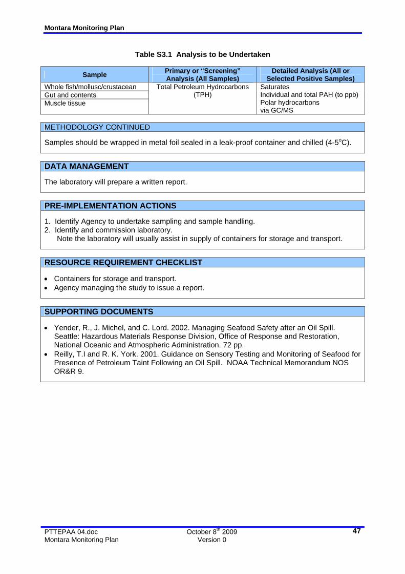
• Assessment of Fish Catch for the Presence of Oil (Study S3). This study is designed to determine whether commercial fish have acquired a taint or other undesirable characteristics through contact with the spilt oil.
• Assessment of Effects on Timor Sea Fish and Fisheries (Study S4). This study is designed to assess any effects on fish species (all life stages) of impacted waters.
• Offshore Banks Assessment Survey (Study S5). To determine whether there has been any impact of, or effect on, the marine banks in the region.
• Shoreline Ecological Ground Surveys (Study S6). As with Study S2, this is designed to quantify any effects on coastal fauna or flora. As a priority, the study will look at resources and areas identified as sensitive.
• Oil Fate and Effects Assessment (Study S7). This study extends Study O2 and investigates the distribution, weathering fates and effects of residual (post response) oil at sea. It encompasses an assessment of, untreated oil and dispersant treated oil and oil in waters and sediments (if any).
Montara Monitoring Plan
PTTEPAA 04.doc October 8th 2009 Montara Monitoring Plan Version 0
7
These are described in Section 4 and more detailed outlines are provided in Attachment
C. The outlines contained in Attachment C will be refined and documented in detailed
Study Plans. Operational Study plans will be approved by AMSA in consultation with PTTEPAA and the Department of the Environment, Water Heritage and the Arts (DEWHA). Scientific Study Plans will be agreed between PTTEPAA and DEWHA as per Section 2.4.2 of this document.
The need for some of these is not yet established and each study outline includes a
number of “triggers” which, should they occur, should prompt the initiation or reassessment of the study. This process is set out in Section 2.4.2.
It should be noted that the Scientific Monitoring Programme outlines provide only
indicative scopes and guidance. The design of the component studies does require specialist input (see Attachment C) and this should be commissioned prior to any anticipated need for any particular study.
Some Scientific Monitoring studies require considerable time and effort to establish a
design that will produce meaningful data. The selection and verification of control areas is often difficult and natural variation in the number, distribution and fitness of biota may require considerable sample sizes to resolve.
PTTEPAA will liaise with DEWHA to ensure that the Scientific Monitoring study is
successfully implemented by PTTEPAA and to decide the point at which detailed study design and implementation of monitoring is implemented (see Section 2.4.2).
2.3 Programme Justification Each of the study outlines in this document provides a justification for undertaking the
monitoring. In some cases, notably the Operational Monitoring, the fact that there has been a spill and the information needs of the response are sufficient justification for the study and it is proposed that these should be initiated immediately.
In the case of others, justifications are supplied but they are only applicable under
certain conditions, and these conditions may not yet be met. For example, detailed surveys of shorelines are not justified if there is no chance of them being impacted by oil. As noted in Section 2.2, the outlines provided in Attachments A and C include indicative “triggers”, i.e. the conditions under which each study is likely to be required.
The current and future position of the oil slick together with the status of the release and
of the response must be monitored so that the implemented monitoring study is sufficient and focussed.
2.4 Managing the Monitoring Programme 2.4.1 Operational Monitoring Responsibility for the management of the Operational Monitoring studies rests with the
Incident Controller for the spill response (a nominated officer of AMSA) or other nominated member of the Incident Management Team (IMT).
Montara Monitoring Plan
PTTEPAA 04.doc October 8th 2009 Montara Monitoring Plan Version 0
8
Information Management All data generated from the Operational Monitoring studies will be supplied to the
response Incident Controller (AMSA) or other nominated AMSA officer as soon as possible together with relevant interpretation.
The reporting format will be as required by the IC. Information required for the use in Scientific Monitoring studies will be supplied by
AMSA to the nominated officer of the Department of the Environment, Water, Environment Heritage and the Arts (see Section 2.4.2).
Duration of Operational Monitoring These studies will be undertaken as needed during the response and, generally, will not
continue beyond the duration of the response. Possible “triggers” for each study are provided in the outlines provided in Attachment C. Termination of the response will be determined by the Statutory Authority and Control Agency as defined by the National Plan. This is AMSA. Some studies may continue as Scientific studies. This will be determined in consultation with DEWHA and PTTEPAA.
2.4.2 Scientific Monitoring
Figure 1 Monitoring Management Arrangements
AMSA
Incident Controller
Operational Monitoring
DEWHA
Marine Division
State and
Commonwealth Agencies
PTTEP
Monitoring Manager
Scientific Monitoring
Study TeamsInformationManagement
The Scientific Monitoring study will be managed by PTTEPAA. Individual studies may be undertaken by contracted companies or institutions, government agencies or other parties as agreed with DEWHA. Personnel or agencies will be assigned responsibility for studies on the basis of their recognised expertise and independence.
Responsibility for the management of the each study will be assigned to a qualified
expert approved by the relevant state and Commonwealth agencies following the provision of qualifications to the relevant agencies. Studies will be designed and commissioned in a timely manner.
Detailed Scopes of Work will be developed for each study. These will be submitted via
PTTEPA to the DEWHA for approval prior to approval and initiation. Study S3 will be coordinated by Commonwealth, State or NT fisheries departments. Information Management Data obtained through the Scientific Monitoring study, by PTTEPAA, or any person(s)
contracted by PTTEPAA, will be provided to DEWHA in individual reports at the completion of each component study by PTTEPA. Draft or interim reports may be prepared as required by DEWHA and agreed by PTTEPAA.
Montara Monitoring Plan
PTTEPAA 04.doc October 8th 2009 Montara Monitoring Plan Version 0
9
A copy of each report will be supplied to the relevant State and Commonwealth
agencies by DEWHA. The schedule for any interim reporting will be as agreed by DEWHA and PTTEPAA for each component study.
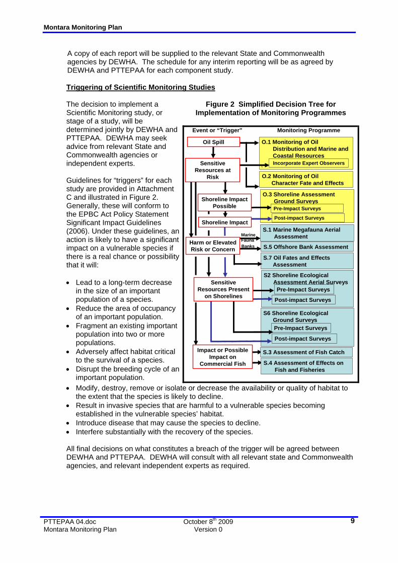
Triggering of Scientific Monitoring Studies Figure 2 Simplified Decision Tree for
Implementation of Monitoring Programmes
The decision to implement a Scientific Monitoring study, or stage of a study, will be determined jointly by DEWHA and PTTEPAA. DEWHA may seek advice from relevant State and Commonwealth agencies or independent experts. Guidelines for “triggers” for each study are provided in Attachment C and illustrated in Figure 2. Generally, these will conform to the EPBC Act Policy Statement Significant Impact Guidelines (2006). Under these guidelines, an action is likely to have a significant impact on a vulnerable species if there is a real chance or possibility that it will: • Lead to a long-term decrease
in the size of an important population of a species.
• Reduce the area of occupancy of an important population.
• Fragment an existing important population into two or more populations.
• Adversely affect habitat critical to the survival of a species.
• Disrupt the breeding cycle of an important population.
O.3 Shoreline AssessmentGround Surveys
Oil Spill
Sensitive Resources at
Risk
O.1 Monitoring of OilDistribution and Marine andCoastal Resources
• Modify, destroy, remove or isolate or decrease the availability or quality of habitat to the extent that the species is likely to decline.
• Result in invasive species that are harmful to a vulnerable species becoming established in the vulnerable species’ habitat.
• Introduce disease that may cause the species to decline. • Interfere substantially with the recovery of the species.
All final decisions on what constitutes a breach of the trigger will be agreed between
DEWHA and PTTEPAA. DEWHA will consult with all relevant state and Commonwealth agencies, and relevant independent experts as required.
Montara Monitoring Plan
PTTEPAA 04.doc October 8th 2009 Montara Monitoring Plan Version 0
10
Duration of Scientific Monitoring
Studies may be undertaken in order to establish a baseline. If a trigger does not occur then the main study will not proceed.
The duration of studies will be determined at initiation and reviewed annually by
agreement between PTTEPAA and DEWHA. Indicative durations are shown in Attachments C and E.
Priorities
Priorities will be set by DEWHA in consultation with PTTEPAA and State, NT and Commonwealth agencies.
Sensitive and vulnerable resources, areas and Ramsar sites (Attachment D) will be given a high priority.
2.4.3 Commissioning Monitoring Studies Operational Monitoring Operational Monitoring is commissioned by AMSA or by PTTEPAA with the agreement
of, or at the request of, AMSA. Scientific Monitoring Scientific Monitoring studies are commissioned by PTTEPAA as agreed with DEWHA
(see Section 2.4.2). Proposals and detailed study outlines must be requested by, and submitted to,
PTTEPAA for review and PTTEPAA will then seek DEWHA approval. Guidelines for submissions are provided in Attachment E.
Study scope and design should conform to the Guidelines provided in Attachment C and
should address the objectives provided. However, it is recognised that other studies may be required and these will be accepted for review.
Montara Monitoring Plan
PTTEPAA 04.doc October 8th 2009 Montara Monitoring Plan Version 0
11
3.0 OPERATIONAL MONITORING PROGRAMME As previously noted, the focus of these studies is on the provision of information to be
used in planning and executing the response. 3.1 Study O1: Monitoring of Oil Distribution and Marine and Coastal Megafauna The proximity of the oil and response activities to sensitive resources needs to be
monitored in order to reduce potential exposure and to determine the extent (and possible significance) of any exposure.
The monitoring study will include modelling of dispersed oil trajectory. Sampling and
further modelling to determine the: potential effects of oil and dispersants on marine and coastal ecosystems will be undertaken as part of the scientific monitoring study (Study S7). This will include determining concentrations of the oil/dispersant mix with depth.
It should be noted that some of the megafauna (e.g. turtles) are subject to existing
tagging and tracking studies and the location of some individuals is known. This data can assist in surveillance and should be accessed.
This study will be implemented through regular surveillance flights and vessel
movements. The frequency of these surveys are contingent upon operational needs and the triggers noted in Attachment A.
The need for aerial observers with specific wildlife expertise will depend on the
frequency of observation and need to interpret sightings to species level and interpret behaviour. Nevertheless identification of personnel with such skills is required. Relevant state and Commonwealth agencies can provide advice as appropriate on survey size, method, and timing. Nevertheless identification of personnel with such skills is required.
Montara Monitoring Plan
PTTEPAA 04.doc October 8th 2009 Montara Monitoring Plan Version 0
12
Note aerial surveys of shorelines will be undertake prior to any anticipated oil impact
and also after impact. Pre-impact data may indicate areas of existing damage (e.g. dieback of mangroves).
3.2 Study O2: Monitoring of Oil Character Fates and Effects Montara oil is a waxy oil with a pour point close to that of ambient sea temperatures.
Consequently, it will vary in its physical character according to ambient temperatures and this will significantly influence the effectiveness of some oil spill response strategies.
Sampling and analysis of the oil will provide valuable data on the behaviour of the oil. Chemical changes in the oil may assist in later assessments of oil fate and effects. It is proposed to routinely take samples during oil recovery operations logging sampling
time, location and other data as per Attachment C. Dedicated sampling voyages will be commissioned if deemed necessary by AMSA. Samples will include:
• Surface oils.
• Oil in the water column including dissolved components, physically and chemically dispersed oil at sea. This will include samples taken in clean seawater and under surface slicks.
• Dispersant –treated oil trajectory, distribution and concentrations of hydrocarbons in the water as a result of natural and dispersant-induced dispersion will be measured.
• Oil on and in sediments (if impacted). Note: Samples may also be obtained via Studies O3 and S6. The distribution of oil on and in sediment will be recorded and removal by cleanup or natural processes will be monitored. Residual oil will be analysed for physical and chemical properties in order to evaluate likely persistence and potential effects.
Field readings will be taken using a fluorometer and verified by analysis. Samples will
be taken at various depths as per the outline in Attachment C. The approximate age of each oil sample (i.e. time at sea) can be calculated using the
output from the oil spill trajectory modelling. This can be confirmed by analysis of oil character (loss of volatiles). Routine sampling and monitoring will also collect data on dispersants and oil/dispersant mix including vertical and horizontal distribution in the water column.
Samples will be “fingerprinted” and analysed as per the Study O2 outline (Attachment
C). Assessments will be supported by oil spill trajectory modelling (both 2D and 3D). These
may be undertaken to cover extended periods. 3.3 Study O3: Shoreline Assessment Ground Surveys If shorelines (islands, reef or mainland) are threatened then these will be surveyed in
order to obtain baseline data relating to: • Physical character. This will assist in planning of cleanup methods.
Montara Monitoring Plan
PTTEPAA 04.doc October 8th 2009 Montara Monitoring Plan Version 0
13
• Biological character. This will assist in establishing conditions before and after
impact by oil or cleanup, planning of cleanup methods and determination of sensitivities and protection priorities.
• Oiling character. This will be used to monitor cleanup effectiveness of natural recovery of shorelines.
Assessment teams will contain personnel with skills relevant to specific shorelines and
parameters of interest to ensure that collected data is accurate and is suitable for use by later Scientific Monitoring studies; e.g. assessment of reef shorelines would include turtle experts to enable an assessment of nesting activity.
Both pre and post-impact assessments will be undertaken. Existing available
information will also be used. Shoreline assessment will require careful planning and the provision of logistics support. Without compromising the scientific integrity or accuracy of the monitoring, where
possible Operational and Scientific surveys will be combined within survey trips to avoid unnecessary financial or logistical impost
3.4 Study O4: Monitoring of Dispersant Efficiency and Fate of Dispersed Oil This study supports the visual assessment of dispersant effectiveness. Oil in water will
be measured before and after dispersant use using a fluorometer. Measurements will include fluorometric reading of: • Clean seawater (no oil exposure and no oil). This will detect and measure any
natural fluorescence in the water (e.g. from plankton). • Seawater under a dispersant application to un-oiled waters. This will detect and
measure any fluorescence due to the dispersant. • Seawater under a slick before dispersant application. Some hydrocarbons may be
present in suspension due to wave action. • Seawater under a dispersant treated slick.
Water samples will also be taken in order to check the calibration of the fluorometer.
These will include: • Water below an untreated slick.
• Water below a treated slick. Surface oil samples before dispersant application should also be taken for later testing
in the laboratory (see Study O2). The fate of dispersed oil, particularly the distribution and dilution of the dispersed oil
plume will be modelled throughout the response and further investigated by Study O2 (see Section 3.2 and Attachment A).
3.5 Study O5: Wildlife Impact Monitoring This study includes:
• Assessment of fauna impacted by oil (numbers, species, degree of oiling, treatment).
Montara Monitoring Plan
PTTEPAA 04.doc October 8th 2009 Montara Monitoring Plan Version 0
14
• Determination of cause of death for wildlife carcases and
• Vessel surveys and ground surveys.
These assessments will be undertaken by personnel with relevant expertise under the direction of the Incident Controller (AMSA) or nominated Environmental and Scientific Coordinator (DEWHA).
Montara Monitoring Plan
PTTEPAA 04.doc October 8th 2009 Montara Monitoring Plan Version 0
15
4.0 SCIENTIFIC MONITORING PROGRAMME As noted in Section 1.3.3, the focus of these studies is on the provision of longer term
scientific information. The emphasis of the proposed studies is on the assessment of ecological damage and recovery. Study S3 and Study S4 are focussed on assessing the possibility of damage to commercial fisheries.
It should be noted that these studies may be required only if resources are exposed, or
are potentially exposed to the oil or the response. However, if needed they may need to be implemented quickly and so study design and planning may be required in any case.
The precise scale and design of Scientific Monitoring studies will depend on the specific
location and nature of exposure and on the species affected. This Section and Attachment B provide outlines only.
4.1 Study S1: Marine Megafauna Aerial Assessment Surveys If significant exposure of megafauna is observed or anticipated, then dedicated
surveillance of key marine species may be required. Surveillance data relating to wildlife will be compiled by AMSA and supplied to DEWHA for assessment.
If required (i.e. if “triggered”), dedicated aerial surveys may be scheduled using
observers with relevant expertise (e.g. whale behaviour). 4.2 Study S2: Shoreline Ecological Assessment Aerial Surveys Pre-impact assessments for assessing the effects of oil impact may be undertaken as
part of Operational Monitoring Study 3. If large areas of shoreline are potentially impacted aerial surveys will be undertaken. Vessel based surveys may be required to support these and to assess areas where aerial surveillance is difficult e.g. mangroves and sub-tidal areas such as shallow seagrass meadows, or reef systems.
Aerial videos can provide a system for the rapid assessment of large areas and are
particularly useful for shorelines communities. Infrared or false-colour imagery can assist in the assessment of the fitness of plant communities and also in mapping oil impacts. They will be used wherever possible to support any required ground surveys (Study S6).
Aerial surveys can also be used to survey areas where access is limited or where there
are safety concerns (e.g. crocodiles). Assessments would be undertaken using suitable aircraft and expert observers. The availability of these must be determined.
4.3 Study S3: Assessment of Fish Catch for the Presence of Oil Claims may be made that commercial fish are tainted or impacted by oil spills or are
unsafe to eat. This rarely occurs but the mere suggestion may cause adverse consumer reaction. Testing of fish catch can detect the presence or absence of hydrocarbons.
The study should be based on a sampling of possibly exposed and “control” (non-
exposed) commercial catches rather than based on independently caught catches. This is to ensure that the tested fish are representative of the commercial catch. The locations of each catch must be recorded. Ideally, each area of commercial the catch should be sampled.
Montara Monitoring Plan
PTTEPAA 04.doc October 8th 2009 Montara Monitoring Plan Version 0
16
Sampling must be undertaken by independent personnel and it is recommended that
these be State of NT fisheries officers. 4.4 Study S4: Assessment of Effects on Timor Sea Fish and Fisheries This study is designed to assess any effects on fish species (all life stages) of impacted
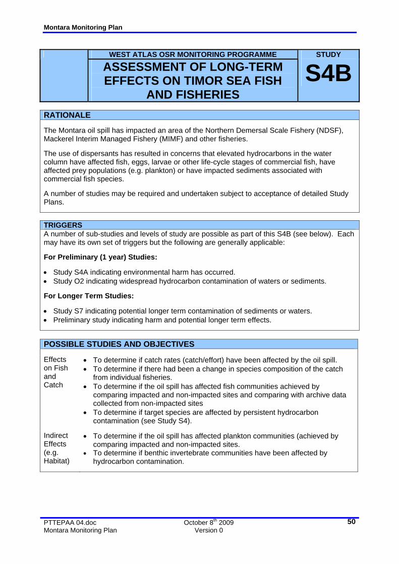
waters. This study will assess the potential immediate and long-term impacts of the oil spill on State and Commonwealth fisheries.
Although oil spills rarely effect open sea fisheries oil can affect fish at adult or other
stages of the life cycle if oil impact occurs and also indirectly through effects on prey or predatory species. Oil may affect eggs, larvae, juveniles or other life stages of commercial fish and other fauna if they are impacted by oil or oil fractions. This study will determine whether exposure has occurred and if so, the distribution and scale of any effects. Future effects on fisheries may then be predicted. It should be noted that detecting effects on plankton and interpreting these is difficult. Longer term studies may be required should large scale effects on plankton or early life stages be detected. This study is divided into monitoring and assessment of current stocks (Study 4A) and longer term studies (Study 4B). These are outlined in Attachment C.
Because stock individuals are often not recruited into a fishery until they are 5-6 years
old, any effects on catch may not be evident until after this time. Consequently, this study will incorporate an assessment of fishing effort and catch over a number of years. Assessment of effort-catch data may continue for 7-8 years.
. This data should be readily available from State and Commonwealth agencies. This
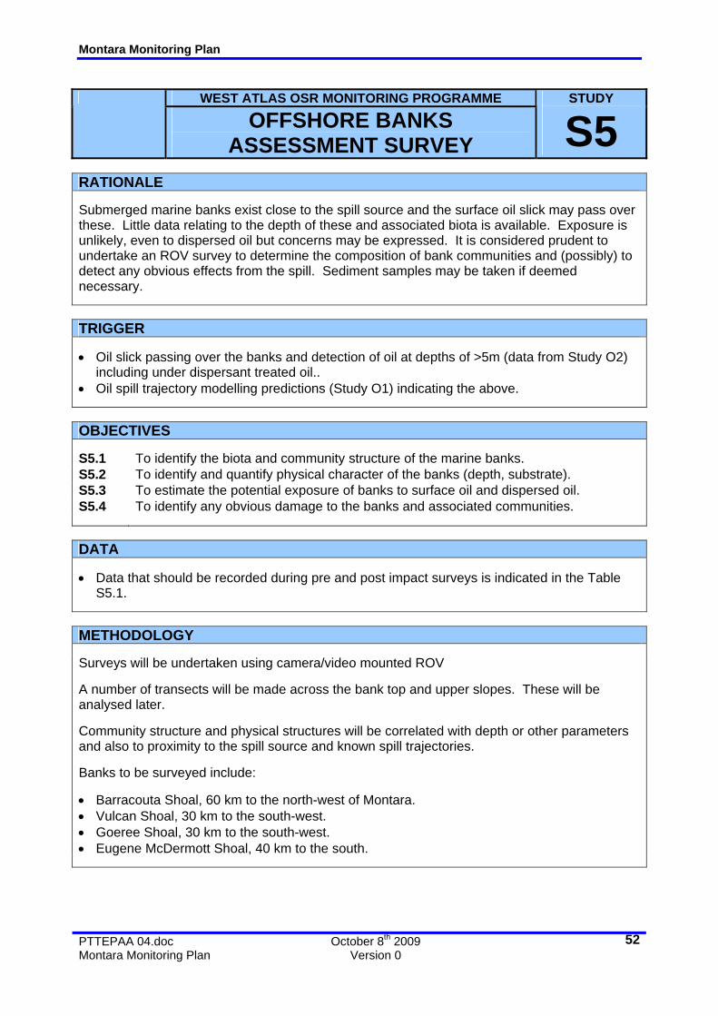
need will be assessed by the relevant state and federal fisheries agencies and DEWHA. 4.5 Study S5: Offshore Banks Assessment Survey It is highly unlikely that marine banks will be exposed to oil due to their depth. However
if such impact, or risk of impact, is deemed possible then a survey is recommended as a matter of precaution.
Video recording of transects by ROV or other appropriate imaging technology will allow
the composition of bank communities to be determined. Comparison of any pre and post “impact” surveys may allow any effects from surface oil or response activities to be determined.
Sediment samples can also be taken using vessel-based “grabs”. These can be
analysed for hydrocarbon content (see Study S7). 4.6 Study S6: Shoreline Ecological Ground Surveys If shoreline impact is anticipated (either reefs, islands or mainland) and adverse effects
are anticipated on associated fauna, flora, habitats or communities, then both baseline (pre-impact) and post impact data is required.
Montara Monitoring Plan
PTTEPAA 04.doc October 8th 2009 Montara Monitoring Plan Version 0
17
Pre-impact data will be collected by Shoreline Assessment teams (Study 03) but this
may not be of sufficient detail for ongoing scientific study. Data will be assessed and if necessary a team will be despatched comprised of personnel with more relevant expertise.
The precise design of the various components of this study will depend on the species,
community or area under study and the nature of any observed impact. Individual components of this study may include studies of:
• Turtles (nesting).
• Dugongs. • Sea snakes. • Corals. • Lagoons. • Seagrasses. • Mangroves and other wetlands. • Birds (nesting, roosting).
• Intertidal algal and/or invertebrate (epifauna and infauna) communities, including; - Inter-tidal filter feeders (e.g. oysters). - Primary producers (e.g. algal turfs). • Sediment hydrocarbon (character, distribution and retention). These may be
analysed as part of Study S7. 4.7 Study S7: Oil Fate and Effects Assessment This study will assess the distribution, fates (weathering) and effects of oil. This Study
will encompass data and findings from Operational Monitoring Study O2 and will include: • Oil on the sea surface. Samples and data obtained from Study O2 will be
supplemented by longer term sampling of oil at sea. Persistence and changes in the physical and chemical composition of the oil will be determined.
• Oil in the water column including dissolved components, physically and chemically dispersed oil at sea.
• Oil on and in sediments (if impacted). Samples will be obtained via Study S6. The distribution of oil on and in sediment will be recorded and removal by cleanup or natural processes will be assessed or monitored. Residual oil will be analysed for physical and chemical properties in order to evaluate likely persistence and potential effects.
• Trajectory modelling (both 2D and 3D) may be undertaken to cover extended periods as defined by Study O2 or other studies.
Note: Additional sea water samples may be taken from vessels engaged in other
monitoring studies. Baseline seawater and sediment samples may be taken in coastal areas deemed at risk.
Montara Monitoring Plan
PTTEPAA 04.doc October 8th 2009 Montara Monitoring Plan Version 0
18
5.0 REFERENCES • AMSA, 2003a. Post Spill Monitoring: Background Paper. Prepared by Wardrop
Consulting and the Cawthron Institute for the Australian Maritime Safety Authority (AMSA) and the Marine Safety Authority of New Zealand (MSA). Published by AMSA, Canberra. ISBN: 0 642 70991 2.
• AMSA. 2003b. Oil Spill Monitoring Handbook. Prepared by Wardrop Consulting and the Cawthron Institute for the Australian Maritime Safety Authority (AMSA) and the Marine Safety Authority of New Zealand (MSA). Published by AMSA, Canberra. ISBN 0642709920.
• Bonn Agreement. Aerial Surveillance Handbook Bonn Agreement Working Group on Operational, Technical and Scientific questions concerning Counter-Pollution Activities OTSOPA.
• CEDRE. Aerial Observation of Oil Pollution at Sea. • Department of the Environment and Heritage (DEH). 2005. Whale Shark (Rhincodon
typus) Recovery Plan: Issues Paper. • Department of Environment, Water, Heritage and the Arts (DEWHA). 2009a. Species
Profile and Threats Database Megaptera novaeangliae - Humpback Whale. • Department of Environment, Water, Heritage and the Arts (DEWHA). 2009b.
Environment Protection and Biodiversity Conservation Act. • Department of Environment, Water, Heritage and the Arts (DEWHA). 2009c.
Ashmore Reef National Nature Reserve and Cartier Island Marine Reserve. Director of National Parks. Australian Government.
• Environment Australia. Whale Identification Chart. • Guinea, ML, Whiting, SD. 2005. Insights into the distribution and abundance of sea
snakes at Ashmore Reef. The Beagle, Supplement 1: 199-205. • Heyward, A., Edward Pinceratto and Luke Smith.1995. Big Bank Shoals of the
Timor Sea: An Environmental Resource Atlas. Australian Institute of Marine Science and BHP Petroleum.
• Milton, DA. 1999. Survey and stock size estimates of the shallow reef (0–15 m deep) and shoal area (15–50 m deep) marine resources and habitat mapping within the Timor Sea MOU74 Box: Volume 3 Seabirds and shorebirds of Ashmore Reef. CSIRO Marine Research.
• NOAA. Open Water Oil Identification Job Aid. • Reilly, T.I and R. K. York. 2001. Guidance on Sensory Testing and Monitoring of
Seafood for Presence of Petroleum Taint Following an Oil Spill. NOAA Technical Memorandum NOS OR&R 9.
• United Nations Environment Programme (UNEP). 2000. Dugong: Status Report and Action Plans for Countries and Territories. Early Warning and Assessment Report Series.
• Wardrop, John A. 1999. Assessment of Oiled Shoreline: A Simplified Approach. 2nd Edition. ISBN 0-646-37636-5.
• Whiting, SD. 1999. Use of the remote Sahul Banks, Northwestern Australia by dugongs including breeding females. Marine Mammal Science 15 (2), 609-615
• Whiting, SD, Guinea, ML and Pike, GD. 2000. Sea turtle nesting in the Australian Territory of Ashmore and Cartier Islands, Eastern Indian Ocean. 2nd ASEAN Symposium and Workshop on Sea Turtle Biology and Conservation, ASEAN Academic Press Ltd, London.
• Yender, R., J. Michel, and C. Lord. 2002. Managing Seafood Safety after an Oil Spill. Seattle: Hazardous Materials Response Division, Office of Response and Restoration, National Oceanic and Atmospheric Administration. 72 pp.
Montara Monitoring Plan
PTTEPAA 04.doc October 8th 2009 Montara Monitoring Plan Version 0
19
ATTACHMENT A
OUTLINE OF OPERATIONAL MONITORING PROGRAMMES
Montara Monitoring Plan
PTTEPAA 04.doc October 8th 2009 Montara Monitoring Plan Version 0
20
WEST ATLAS OSR MONITORING PROGRAMME
MONITORING OF OIL DISTRIBUTION AND MARINE AND
COASTAL RESOURCES
STUDY
O1 RATIONALE Monitoring of oil distribution is required for marine response planning and also for anticipating shoreline and fauna impact and consequent response needs. The proximity of the oil, oil-dispersant and response activities to megafauna (cetaceans, turtles, sea snakes, birds, dugongs), commercial activities (fishing vessels), key habitats (corals, lagoons, seagrass beds) and coastlines (including mangroves) is an important consideration in the planning and execution of the response. It is also important in determining the possibility or likelihood of adverse effects on these resources and so can be used to assess the need for more detailed, perhaps longer term, assessment of possible effects (Refer to Study S1). Aerial surveillance and integrated oil spill trajectory modelling is undertaken routinely during the response and response vessels are operating on site. These will be used to systematically record the presence of these resources and the distribution of the oil and oil/dispersant mix and to and to send this information to the Incident Management Team (IMT). TRIGGER Marine:
• Required for spill response planning and execution. Immediate
implementation. Reefs: • Oil impact of reefs predicted by spill trajectory modelling and/or surveillance. Coastline: • Oil impact predicted by spill trajectory modelling and/or surveillance.
OBJECTIVES The following objectives apply to all aerial and vessel based monitoring activities: O1.1 To determine the distribution of the surface oil slick and the horizontal and vertical distribution
of the subsurface dispersed oil plume. To identify the presence of megafauna in the response area (i.e. near the oil slick, dispersed oil, response vessels or aircraft) in order to implement mitigation strategies e.g: Reduce vessel speeds, halt operations, move vessels or aircraft from the area,
increase flight altitude).
O1.2
Consider “hazing” strategies. O1.3 Determine possible exposure incidents. O1.4 Identify the presence of resources in areas under threat (i.e. before oil impact). DATA • Fauna data that should be recorded is indicated in the Table O1.1. • Note: Some observations may require expert observers. The need for these must be
assessed on an ongoing basis.
Montara Monitoring Plan
PTTEPAA 04.doc October 8th 2009 Montara Monitoring Plan Version 0
21
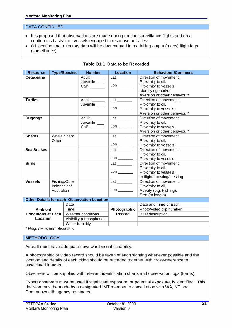
DATA CONTINUED • It is proposed that observations are made during routine surveillance flights and on a
continuous basis from vessels engaged in response activities. • Oil location and trajectory data will be documented in modelling output (maps) flight logs
(surveillance).
Table O1.1 Data to be Recorded
Resource Type/Species Number Location Behaviour /Comment
Cetaceans Adult ______ Juvenile ___ Calf _______
Lat _______ Lon _______
Direction of movement. Proximity to oil. Proximity to vessels. Identifying marks* Aversion or other behaviour*
Turtles Adult ______ Juvenile ___
Lat _______ Lon _______
Direction of movement. Proximity to oil. Proximity to vessels. Aversion or other behaviour*
Dugongs - Adult ______ Juvenile ___ Calf _______
Lat _______ Lon _______
Direction of movement. Proximity to oil. Proximity to vessels. Aversion or other behaviour*
Sharks Whale Shark Other
Lat _______ Lon _______
Direction of movement. Proximity to oil. Proximity to vessels.
Sea Snakes Lat _______ Lon _______
Direction of movement. Proximity to oil. Proximity to vessels.
Birds Lat _______ Lon _______
Direction of movement. Proximity to oil. Proximity to vessels. In flight/ roosting/ nesting
Vessels Fishing/Other Indonesian/ Australian
Lat _______ Lon _______
Direction of movement. Proximity to oil. Activity (e.g. Fishing). Size (m length)
Other Details for each Observation Location Date Date and Time of Each Time Photo/video clip number Weather conditions Brief description Visibility (atmospheric)
Photographic Record
Ambient Conditions at Each
Location Water turbidity
* Requires expert observers. METHODOLOGY Aircraft must have adequate downward visual capability. A photographic or video record should be taken of each sighting whenever possible and the location and details of each citing should be recorded together with cross-reference to associated images.. . Observers will be supplied with relevant identification charts and observation logs (forms). Expert observers must be used if significant exposure, or potential exposure, is identified. This decision must be made by a designated IMT member in consultation with WA, NT and Commonwealth agency nominees.
Montara Monitoring Plan
PTTEPAA 04.doc October 8th 2009 Montara Monitoring Plan Version 0
22
METHODOLOGY CONTINUED If required, separate flights may be scheduled, e.g. if it is deemed necessary to track exposed fauna or vessels. Note: The commissioning of independent wildlife surveillance is not recommended at this time due to the low risk of exposure. This should be reassessed during the response. DATA MANAGEMENT It is proposed that all data (including photographs) be entered onto a suitable database, preferably linked to GIS for ease of illustration. PRE-IMPLEMENTATION ACTIONS 1. Revise observer logs and forms and re-issue. 2. Obtain and distribute identification keys and other aids). 3. Establish or confirm surveillance schedule and guidelines (i.e. conditions under which surveillance is undertaken or not undertaken). Note: These are probably already in place. 4. Identify and contract observers with broad (general) wildlife identification expertise. These can be sourced through and from State, NT and Commonwealth Govt. agencies. 5. Identify and contract observers with specialist skills (e.g. cetaceans, dugongs or birds etc.). 6. Assign IMT responsibility for data management. 7. Develop data management system. RESOURCE REQUIREMENT CHECKLIST • Aircraft. • Observation forms • Identification charts and other aids. • List of available expert observers (plus required agreements and contracts) SUPPORTING DOCUMENTS • Environment Australia. Whale Identification Chart. • Bonn Agreement. Aerial Surveillance Handbook Bonn Agreement Working Group on
Operational, Technical and Scientific questions concerning Counter-Pollution Activities OTSOPA
• CEDRE. Aerial Observation of Oil Pollution at Sea. • NOAA. Open Water Oil Identification Job Aid.
Montara Monitoring Plan
PTTEPAA 04.doc October 8th 2009 Montara Monitoring Plan Version 0
23
WEST ATLAS OSR MONITORING PROGRAMME
MONITORING OF OIL CHARACTER FATE AND
EFFECTS
STUDY
O2 RATIONALE Montara oil is a waxy oil with a pour point close to that of ambient sea temperatures. Consequently, this crude will vary in its physical character according to ambient temperatures and this will significantly influence the effectiveness of some oil spill response strategies. The nature and speed of the physical and chemical weathering of the oil will also depend largely on its temperature and consequent viscosity. Theoretical analysis of the oil suggests that the oil when liquid (i.e. >27oC) will breakup quickly under wind and wave energy but may also emulsify (with consequent increases in viscosity). Below its pour point neither are likely. Pour point may vary with weathering. Sampling and analysis of the oil and waters will provide valuable data on the behaviour of the oil and dispersed oil. This will allow for response strategies to be evaluated, reviewed and revised as necessary to minimise the overall impact of the spill and the response on the environment. Given the ongoing nature of the release this information could be obtained within the response period and used to support routine Net Environmental Benefit Analysis. TRIGGER Marine:
• Required for spill response planning and execution. Immediate
implementation. Coastline: • Oil impact on shorelines.
OBJECTIVES O2.1 To determine the physical properties of the oil as it weathers at sea in order to better
predict the effectiveness of response methods, primarily dispersant use and recovery (skimmers)
O2.2 To determine the physical properties of the oil as it weathers on shorelines in order to better predict the effectiveness of cleanup methods and natural removal.
O2.3 To determine the chemical properties of the oil as it weathers at sea in order to better predict the potential fates and effects of the oil.
O2.4 To determine the chemical properties of the oil as it weathers on shorelines or in sediments in order to better predict the potential fates and effects of the oil.
DATA • The time, date and location at which each sample is taken should be recorded together with
the name of the sampler (see attached Sampling Protocol). • Analysis should be undertaken as per Table O2.1.
Montara Monitoring Plan
PTTEPAA 04.doc October 8th 2009 Montara Monitoring Plan Version 0
24
METHODOLOGY Surface Oil Sampling: It is proposed that sampling of oil at sea be undertaken during oil containment and recovery operations. An assessment must be made as to whether these samples are a true representation of the range of “ages” of oil at sea and it may be necessary to undertake sampling in a more structured sampling study (see Study S7).
Table O2.1 Data to be Obtained through Analysis of Oil Samples
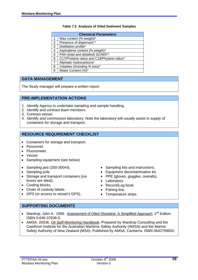
Physical Parameters Chemical Parameters
1 Specific Gravity 1 Wax content (% weight)* 2 @ 20oC 2 Presence of dispersant * 3
4 Pour Pont (oC) 4 Asphaltene content (% weight)* 5 Flash Point (oC)** 5 PAH (total and detailed) GC/MS** 6 Spreading Coefficient* 6 C17/Pristane ratios and C18/Phytane ratios* 7 Stickiness 7 Aliphatic hydrocarbons* 8 Volatiles (including % loss)* 9 Water Content (%)* * Analysis of key samples only ** Fresh crude sample only . METHODOLOGY CONTINUED Sampling and sample handling procedures are provided in Attachment O2.A. If specific sampling runs are required In order to obtain a cross section of this oil, samples should be taken at a number of locations: • Leading edge of the visible slick (i.e. the point furthest away from the source). • Regular intervals along the slick or patches of oil along the spill trajectory (number and
location determined on the basis of slick length). • Closest oil to the spill source (at minimum safe distance). Samples should be analysed for physical parameters as per Table O2.1. Key samples will be selected on the basis of their SG, other physical characters and sampling times and locations for more detailed analysis. Water Samples: Water samples will be taken at depths of: • Just below surface (0m). • 1m. • 2m. • 3m. • 5m. • 10m (if either 3m or 5m samples show +ve for hydrocarbons with fluorometer). • 20 (if either 5m or 10m samples show +ve for hydrocarbons with fluorometer). All samples will be measured for hydrocarbons using a fluorometer and samples taken for analysis as per Table O2.2.
Montara Monitoring Plan
PTTEPAA 04.doc October 8th 2009 Montara Monitoring Plan Version 0
25
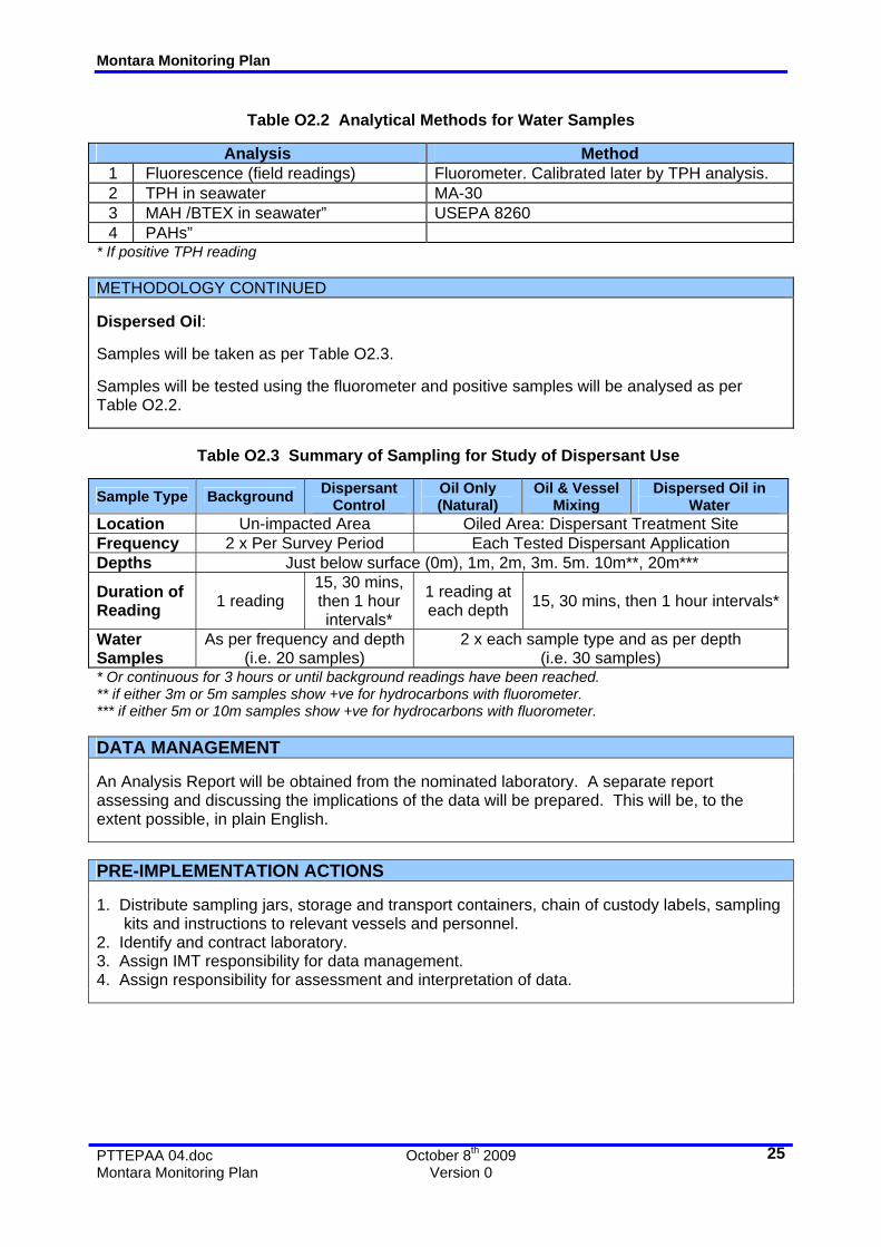
Table O2.2 Analytical Methods for Water Samples
Analysis Method
1 Fluorescence (field readings) Fluorometer. Calibrated later by TPH analysis. 2 TPH in seawater MA-30 3 MAH /BTEX in seawater” USEPA 8260 4 PAHs”
* If positive TPH reading METHODOLOGY CONTINUED Dispersed Oil: Samples will be taken as per Table O2.3. Samples will be tested using the fluorometer and positive samples will be analysed as per Table O2.2.
Table O2.3 Summary of Sampling for Study of Dispersant Use
Sample Type Background Dispersant Control
Oil Only (Natural)
Oil & Vessel Mixing
Dispersed Oil in Water
Location Un-impacted Area Oiled Area: Dispersant Treatment Site Frequency 2 x Per Survey Period Each Tested Dispersant Application Depths Just below surface (0m), 1m, 2m, 3m. 5m. 10m**, 20m***
Duration of Reading 1 reading
15, 30 mins, then 1 hour intervals*
1 reading at each depth 15, 30 mins, then 1 hour intervals*
Water Samples
As per frequency and depth (i.e. 20 samples)
2 x each sample type and as per depth (i.e. 30 samples)
* Or continuous for 3 hours or until background readings have been reached. ** if either 3m or 5m samples show +ve for hydrocarbons with fluorometer. *** if either 5m or 10m samples show +ve for hydrocarbons with fluorometer. DATA MANAGEMENT An Analysis Report will be obtained from the nominated laboratory. A separate report assessing and discussing the implications of the data will be prepared. This will be, to the extent possible, in plain English. PRE-IMPLEMENTATION ACTIONS 1. Distribute sampling jars, storage and transport containers, chain of custody labels, sampling kits and instructions to relevant vessels and personnel. 2. Identify and contract laboratory. 3. Assign IMT responsibility for data management. 4. Assign responsibility for assessment and interpretation of data.
Montara Monitoring Plan
PTTEPAA 04.doc October 8th 2009 Montara Monitoring Plan Version 0
26
RESOURCE REQUIREMENT CHECKLIST • Fluorometer and operator. • Sampling jars (250-300ml). • Sampling pole • Storage and transport containers (ice
boxes are ideal). • Cooling blocks. • Chain of custody labels. • GPS (or access to vessel’s GPS).
• Sampling kits and instructions. • Equipment decontamination kit. • PPE (gloves, goggles, overalls). • Laboratory. • Record/Log book. • Fishing line. • Temperature strips. • Water sampler (Niskin, van Doorn or other).
Montara Monitoring Plan
PTTEPAA 04.doc October 8th 2009 Montara Monitoring Plan Version 0
27
WEST ATLAS OSR MONITORING PROGRAMME
SAMPLING AND SAMPLE HANDLING PROTOCOL Attachment
O2.A
Note: This Guideline is for general sampling and is not a procedure for sampling vessels for prosecution purposes.
Task Action
Obtain any specific sampling, sample handling requirements or equipment requirements from the receiving laboratory. In particular: a Number of replicate samples. b Type of container. c Volume of sample needed.
1
d Cooling needs and time needed to get to laboratory. Prepare Sample Jars etc. Option 1: Use of separate sampling and storage jars a If the jar used to store the sample is different from the jar used to take the sample
then labels should be affixed to the jar in advance. Note individual sample details should not be entered until the jar is actually filled.
Option 2: Use of the same jar for sampling and storage.
2
a In this case make sure that labels will adhere to cleaned (wiped) jars after sampling.At each sampling location enter the following into the log book: Date: Time: Position (lat and long): Sample Description Name of Sampler Sample Identification Codes
3
Oil Description: Sampling from the surface of water: Thin films
i Use sorbent discs/pads made from glass wool, teflon (PTFE) wool or stainless steel gauze.
ii If using a sampling pole then sorbent can be attached to this but it is essential that the pole has been decontaminated. Tying material to disposable fishing line is preferred.
iii Applied lightly to the water surface and then placed inside an airtight container (see 6) for transport to the laboratory.
2
iv The use of synthetic sorbents is not recommended. If used send a clean sample of the sorbent to the laboratory also.
Sampling from the surface of water: Thick slicks: i Use the sampling rod. Secure jar into place and collect surface oil (minimize water
intake). ii Sample a part of the slick which is uniform in colour and consistency, preferably at
the most dense part of the slick. iii Skimming the pole/jar into the oily surface layer. Do not fill the sample container
completely.
3
iv Pour sample into clean labelled jar or clean and apply label to sampling jar (see 6). Sampling from solid surfaces:
i Viscous oils and tarballs can be scraped off surfaces using clean steel or wooden spatulas or spoons, and placed into sample containers.
ii Oil adhering to sediment, seaweed, small pieces of wood, plastic materials or other debris may be collected by placing the oil and substrate material, into the sample container.
4
iii Note: Oil samples should not be taken by washing oil from surfaces and no attempt should be made to heat or melt samples taken from solid surfaces so as to enable them to flow into a container.
Montara Monitoring Plan
PTTEPAA 04.doc October 8th 2009 Montara Monitoring Plan Version 0
28
WEST ATLAS OSR MONITORING PROGRAMME
SAMPLING AND SAMPLE HANDLING PROTOCOL CONTINUED Attachment
O2.A
Task Action Sampling from wildlife:
i Cut oiled feathers or fur and place in containers. ii Cut unoiled feathers or fur and send for analysis also.
5
iii Avoid taking samples from specimens that have been stored in plastic containers. Place each sample into a jar:
i Clean glass jars (250-300ml) with wide mouth should be used ii Caps of the glass jars or bottles should be lined with either metal foil or be made of
teflon (PTFE). iii Tighten the lid on the sample jar firmly. iv Store in a dark, cool and secure place onboard the vessel (refrigerator set at 4-5oC)
see “10” below.
6
v For transport transfer to cooler boxes with ice/cooling block and (ideally) temperature strip.
Label each sample container with: i Identification code or sample number. ii Date and time of sampling. iii Brief description of sample and collection point location.
7
iv Name of person taking sample (and witness). Complete and attach a Chain of Custody label to each jar. This should contain the information on the label (see 6) and also:
i Signature and printed name of person who collected the sample. i Signature and printed name of person who witnesses the sample collection.
Chain of Custody record, i.e. repeated sequence of: a Sample handed/sent to. b Signature. c Date. d Sample received by. e Signature.
8
iii
f Date. 9 Send copy of the sample record to the laboratory.
Storage of samples sample: i In refrigerators or cold rooms (at not more than 5°C) and in the dark. ii Ensure that room is secure or else place sample bottles/jars in containers with
tamper proof seals. iii For samples that may be stored for more than 24 hrs:
To prevent biological degradation of wet samples, the addition of 1ml of 50% hydrochloric acid per litre of water samples is recommended. Additionally, displacement of air from the container with nitrogen or carbon dioxide can help to prevent degradation of the sample.
10
iv Ensure sufficient space has been allowed in the container for any expansion of the sample that might occur.
11 Transport samples safely. Contact aerial carrier for specific conditions.
Montara Monitoring Plan
PTTEPAA 04.doc October 8th 2009 Montara Monitoring Plan Version 0
29
WEST ATLAS OSR MONITORING PROGRAMME
SHORELINE ASSESSMENT GROUND SURVEY
PROGRAMME
O3 RATIONALE If shoreline impact is anticipated it is useful to obtain information relating to the physical and biological character of the shoreline prior to impact. This information assists in determining the most suitable response and cleanup methods and also in predicting oil behaviour (persistence, burial, distribution). It also provides a baseline for determining the degree of success of response strategies. Once impacted shoreline can be monitored for oil distribution in order to measure the success (or otherwise) of cleanup methods. This information is also of use in interpreting observed ecological damage and/or in predicting longer term fates and effects (including recovery). TRIGGER • Australia: Oil impact on reefs and/or shorelines predicted by oil spill trajectory modelling
(Study O1) and/or aerial surveillance. • Indonesia or Timor: Oil impact on shorelines. OBJECTIVES Pre-impact Surveys O3.1 To determine the physical, biological and dynamic properties of shorelines in order to O3.1.1 Predict the oil behaviour and distribution O3.1.2 Determine the most appropriate cleanup methods O.3.1.3 Establish a baseline for shoreline conditions, including sediment quality
(background hydrocarbons). O.3.1.4 Establish a baseline for ecological fitness or health. O.3.1.4 To identify sensitive or vulnerable areas or resources. Post-impact Surveys
To determine the physical and biological character of the shoreline and the distribution of the oil in order to: O3.2.1 Determine the most appropriate cleanup methods O3.2.2 Predict the potential for oil persistence and/or natural removal
O3.2
Q3.2.3 Identify areas of potential ecological damage and vulnerable and sensitive resources
O3.3 To determine the degree of success of shoreline cleanup strategies. O3.4 To determine the degree of success of shoreline cleanup strategies in protecting
shoreline resources. O3.5 To identify impacted and /or damaged resources (species, habitats etc) as a baseline
for subsequent damage and recovery assessments. DATA • Data to be recorded during pre and post impact surveys is indicated in the Table O3.1.
Montara Monitoring Plan
PTTEPAA 04.doc October 8th 2009 Montara Monitoring Plan Version 0
30
METHODOLOGY Shoreline assessment methods are detailed in Wardrop, 1999. A photographic record will also be established for each impacted, or potentially impacted site. Assessment teams will be formed of personnel with relevant experience for each location but will generally comprise a team of 3-4 people as per: • A person with knowledge of shoreline assessment, oil behaviour and response. • A person (or persons) with relevant wildlife or ecological expertise. • Communications and logistics person. It is intended that all shorelines will be surveyed and assessed prior to any impact. Shorelines will be monitored throughout the response and immediately prior to the cessation of any shoreline cleanup. For oiled shorelines that are not cleaned or which still have residual oil after cessation of cleanup, a post spill monitoring schedule will be developed.
Mud/silts Water content Cliff Height, slope type Reef/platform Beach
Length width, gradient Form
Swamp/wetland Type Birds Roosting, nesting, species Turtles Nesting, species Sea snakes Nesting, species Corals Depth, area, % live, Mangroves Height, canopy, species Other wetland Species, form
Shoreline Character
Biological Character
Crocodiles Presence/absence Physical Oil Character Chemical
Samples to be taken. Refer to Table O.2.1.
Position GPS and tidal elevation Band length m Band width m % Cover % Thickness mm Depth Maximum and minimum
Oil Distribution
Total oiled area m2 Oil mass Total oil presence Tonnes and/or m3
Oil Character and Distribution
Oil Content As per sample analysis PPM, % weight of sed. DATA MANAGEMENT It is proposed that all data (including photographs) be entered onto a suitable database, preferably linked to GIS for ease of illustration.
Montara Monitoring Plan
PTTEPAA 04.doc October 8th 2009 Montara Monitoring Plan Version 0
31
PRE-IMPLEMENTATION ACTIONS 1. Identify members of Shoreline Assessment Teams. Identify and contract personnel with specialist skills (e.g. seagrass beds, corals, mangroves, dugongs or birds etc.). 2. Provide training as required (note: This can be done as part of the initial surveys). 3. Obtain and distribute forms and other support materials.. 4. Identify responsibilities within the IMT for coordination of Shoreline Assessment. 5. Assign IMT responsibility for data management. 6. Develop data management system. RESOURCE REQUIREMENT CHECKLIST • Transport (Aircraft). • Forms, guidelines and other documents (see below). • Other logistics support as required. SUPPORTING DOCUMENTS • Wardrop, John A. 1999. Assessment of Oiled Shoreline: A Simplified Approach. 2nd Edition.
ISBN 0-646-37636-5.
Montara Monitoring Plan
PTTEPAA 04.doc October 8th 2009 Montara Monitoring Plan Version 0
32
WEST ATLAS OSR MONITORING PROGRAMME
MONITORING OF DISPERSANT EFFICIENCY AND FATE OF
DISPERSED OIL
STUDY
O4 RATIONALE Dispersant application to surface oil results in the penetration of the oil into the water column. This can result in the exposure of marine organisms to dispersant, oil and dispersed oil. Rapid dilution reduces this potential for harm and this should be demonstrated so that the net environmental benefit of the strategy can be assessed. The effectiveness of the strategy should also be monitored. TRIGGER • Application of dispersants. OBJECTIVES O4.1 To determine the effectiveness of dispersant use. O4.2 To identify the initial vertical distribution and concentration of dispersed oil in the
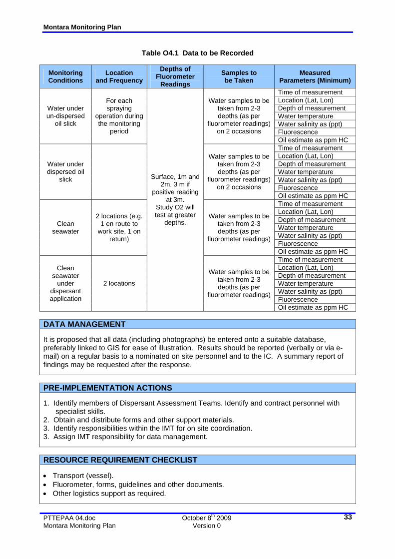
water column. DATA • Data that should be recorded during pre and post application of dispersants as indicated in
the Table O4.1. METHODOLOGY Using a flourometer, the hydrocarbon concentrations of the following will be measured: • Background fluorescence levels (no oil, no dispersant). These should really be taken over a
24 hour period (some of the fluorescent plankton move up and down the water column on a cycle).
• Dispersant Control: Flourometer reading of dispersant spray over clean water (if any). This is used to detect any fluorescence from the dispersant.
• Oil Control: under oil slick before dispersants are used. • Dispersed oil. 15 mins after spraying as per AMSA protocol. Longer times and drift samples
will be done by Study O2. Water at a number of depths should be measured; Surface (as near as possible depending on sea states), 1m, 2m and 3m. If 3m reading is HC positive a 5m depth should be sampled if possible. If the 5m depth is positive then a 10m depth should be sampled if possible. Samples of seawater (pre and post dispersant use) should be taken from some locations for later analysis. A corresponding sample of oil (pre dispersant use) should be taken for analysis.
Montara Monitoring Plan
PTTEPAA 04.doc October 8th 2009 Montara Monitoring Plan Version 0
33
Table O4.1 Data to be Recorded
Monitoring Conditions
Location and Frequency
Depths of Fluorometer
Readings Samples to be Taken
Measured Parameters (Minimum)
Time of measurement Location (Lat, Lon) Depth of measurement Water temperature Water salinity as (ppt) Fluorescence
Water under un-dispersed
oil slick
For each spraying
operation during the monitoring
period
Water samples to be taken from 2-3 depths (as per
fluorometer readings) on 2 occasions
Oil estimate as ppm HC Time of measurement Location (Lat, Lon) Depth of measurement Water temperature Water salinity as (ppt) Fluorescence
Water under dispersed oil
slick
Water samples to be taken from 2-3 depths (as per
fluorometer readings) on 2 occasions
Oil estimate as ppm HC Time of measurement Location (Lat, Lon) Depth of measurement Water temperature Water salinity as (ppt) Fluorescence
Clean seawater
2 locations (e.g. 1 en route to
work site, 1 on return)
Water samples to be taken from 2-3 depths (as per
fluorometer readings)
Oil estimate as ppm HC Time of measurement Location (Lat, Lon) Depth of measurement Water temperature Water salinity as (ppt) Fluorescence
Clean seawater
under dispersant application
2 locations
Surface, 1m and 2m. 3 m if
positive reading at 3m.
Study O2 will test at greater
depths.
Water samples to be taken from 2-3 depths (as per
fluorometer readings)
Oil estimate as ppm HC DATA MANAGEMENT It is proposed that all data (including photographs) be entered onto a suitable database, preferably linked to GIS for ease of illustration. Results should be reported (verbally or via e-mail) on a regular basis to a nominated on site personnel and to the IC. A summary report of findings may be requested after the response. PRE-IMPLEMENTATION ACTIONS 1. Identify members of Dispersant Assessment Teams. Identify and contract personnel with specialist skills. 2. Obtain and distribute forms and other support materials. 3. Identify responsibilities within the IMT for on site coordination. 3. Assign IMT responsibility for data management. RESOURCE REQUIREMENT CHECKLIST • Transport (vessel). • Fluorometer, forms, guidelines and other documents. • Other logistics support as required.
Montara Monitoring Plan
PTTEPAA 04.doc October 8th 2009 Montara Monitoring Plan Version 0
34
WEST ATLAS OSR MONITORING PROGRAMME
WILDLIFE IMPACT MONITORING
STUDY
O5 RATIONALE The potential for impact of wildlife by of the oil, oil-dispersant or other response activities is evaluated by Study O1 and routine trajectory modelling undertaken by the IMT. Impacted wildlife must be located, assessed and, if necessary, treated. The levels of harm to important species must be assessed. Carcases obtained should be assessed to determine whether the oil or other factors were the cause of death. TRIGGER • Observed impact of oil on wildlife. • Observed or predicted impact of oil on wildlife habitat, roosting areas etc. (reefs and/or
shorelines). OBJECTIVES Pre-impact Surveys O5.1 To determine the number and type of wildlife that could be impacted by oil in order to: O5.1.1 Design and implement protection strategies. O5.1.2 Determine and implement the appropriate cleanup methods (scale,
methods). O.5.1.3 Determine and implement the appropriate rehabilitation methods (scale,
methods). O.5.1.4 Establish a baseline for ecological fitness or health. O.5.1.4 To identify and rank sensitive or vulnerable areas or resources. Post-impact Surveys
To determine the number and type of wildlife impacted by oil in order to O5.2.1 Review the effectiveness of cleanup methods.
O5.2
O5.2.2 Plan ongoing logistics and resources requirements. O5.3 To determine the degree harm to wildlife. DATA • Data that should be recorded during pre and post impact surveys is indicated in the Table
O5.1.
Montara Monitoring Plan
PTTEPAA 04.doc October 8th 2009 Montara Monitoring Plan Version 0
35
METHODOLOGY A photographic record will also be established for each impacted, or potentially impacted site. Assessment and cleanup teams will be formed of personnel with relevant experience for each habitat, location or species. It is intended that all habitats or other identified areas will be surveyed and assessed prior to any impact. Wildlife areas will be monitored throughout the response and may be required after the cessation of the marine or shoreline response.
Table O5.1 Data to be Recorded
Resource Indicative Parameters Species Location Habitat
Type Species Affected
No Dead
No Oiled
Percentage Oiling
Sublethal Effects
Habitat Location Species Composition
Species Affected
Area Dead(1)
Area Oiled
Percentage Oiling
Sublethal Effects
DATA It is proposed that all data (including photographs) be entered onto a suitable database, preferably linked to GIS for ease of illustration. Regular status reports should be sent to the IMT and DEWHA. A summary report may be requested after the response. PRE-IMPLEMENTATION ACTIONS 1. Identify members of Wildlife Impact Assessment Teams. Identify and contract personnel with specialist skills (e.g. corals, mangroves, dugongs or birds etc.). 2. Obtain and distribute forms and other support materials. 3. Identify responsibilities within the IMT for coordination of Wildlife Response. 4. Assign responsibility for data management. 5. Develop data management system. RESOURCE REQUIREMENT CHECKLIST • Transport (Aircraft, vessels for personnel and wildlife). • Forms, guidelines and other documents. • Establish wildlife response centre if needed. • Other logistics support as required. SUPPORTING DOCUMENTS • Oiled Wildlife Response Plan. • AMSA. 2003b. Oil Spill Monitoring Handbook. Prepared by Wardrop Consulting and the
Cawthron Institute for the Australian Maritime Safety Authority (AMSA) and the Marine Safety Authority of New Zealand (MSA). Published by AMSA, Canberra. ISBN 0642709920.
Montara Monitoring Plan
PTTEPAA 04.doc October 8th 2009 Montara Monitoring Plan Version 0
36
ATTACHMENT B
OPERATIONAL MONITORING PROGRAMME DATA REQUIRED FOR THE
SCIENTIFIC MONITORING PROGRAMME
Montara Monitoring Plan
PTTEPAA 04.doc October 8th 2009 Montara Monitoring Plan Version 0
37
Table C.1 Data or Other Needs for Scientific Monitoring Studies
Ref Data or Other Requirement Rationale Relevant Study
Source/ Responsibility Status(1-4)
1.0 General 1.1 Oil Samples (see 5.3, 6.7 also). S7 1.2 Photographs pr video of oil at sea.
Oil behaviour and fate calculations and implications for response and environmental damage assessment.
1.3 Oiled biota samples. Environmental effects assessment 2.0 Satellite Imagery All available, dated. 3.0 Modelling Output 3.1 Surface oil trajectories, stochastic projections. 3.2 3D dispersed oil trajectory predictions. 4.0 Aerial Surveillance Data 4.1 GS logs of surveillance aircraft. 4.2 Ladder search patterns, times. Locations. 4.3 Photographs of oil on water with time and location
(if available).
4.4 Dornier digital records. 4.5 Aerial photographs.
Oil behaviour and fate calculations and implications for response and environmental damage assessment. Determination of “impact” area (study area).
5.0 Containment and Recovery Vessel Data 5.1 Record of oil volumes (and/or oil-water volumes)
recovered. Mass balance calculations.
5.2 Photographs from response vessels. 5.3 Oil samples from boom and after pumping.
Oil behaviour studies and implications for recovery.
6.0 Dispersant Spraying Operations (Vessel) 6.1 Location of spraying (all). 6.2 Type of dispersant used. 6.3 Volume applied (all operations). 6.4 Oil samples (pre-spray) + location, time date etc. 6.5 Photographs . 6.6 Results of on-site testing. 6.7 Data and samples from Study O4.
Required for environmental assessment of dispersant use and post response NEBA. Required for mass balance and fates of oil estimates.
Montara Monitoring Plan
PTTEPAA 04.doc October 8th 2009 Montara Monitoring Plan Version 0
38
Table C.1 Continued Data or Other Needs for Scientific Monitoring Studies
Ref Data or Other Requirement Rationale Relevant Study
Source/ Responsibility Status
7.0 Dispersant Spraying Operations (Aerial). Location of spraying (all). Type of dispersant used. Volume applied (all operations) – with dates etc. Photographs or video.
Required for environmental assessment of dispersant use and post response NEBA. Required for mass balance and fates of oil estimates.
(1) Not taken/ not recorded. (2) Obtained but not to be made available. (3) Delivery in progress. (4) Available but incomplete.
Montara Monitoring Plan
PTTEPAA 04.doc October 8th 2009 Montara Monitoring Plan Version 0
39
ATTACHMENT C
OUTLINE OF SCIENTIFIC MONITORING PROGRAMMES
Montara Monitoring Plan
PTTEPAA 04.doc October 8th 2009 Montara Monitoring Plan Version 0
40
WEST ATLAS OSR MONITORING PROGRAMME
MARINE MEGAFAUNA ASSESSMENT SURVEYS
STUDY
S1 RATIONALE Effects of oil spills on whales are unlikely but any disturbance due to the oil or response may require dedicated monitoring of whale behaviour, i.e. above the level of monitoring provided by Study O.1. Large accumulations of marine birds, should they exist at sea, may also need to be monitored independently of the operational monitoring study. Concern may also be applied to turtles, sea snakes and dugongs but aerial monitoring of these at sea is difficult due to their sparse distribution and small size. Monitoring of these at sea is unlikely to be feasible. TRIGGER • Observed proximity of marine megafauna to oil slick or response operations combined with
suggestion of significant harm (i.e. not an isolated incident) or • Observed incident of harm attributable to oil or the response. OBJECTIVES S1.1 To quantify the presence of megafauna in the response area (i.e. near the oil slick,
response vessels or aircraft) or wider region in order to determine the level of potential exposure to oil.
S1.2 To observe and if possible quantify exposure of megafauna to surface oil or to the response.
S1.3 To detect and quantify lethal effects. S1.4 Observe and to assess the significance of sublethal effects (e.g. avoidance
behaviour) of this exposure or interactions. DATA • Data to be recorded during surveys is indicated in the Table S1.1. METHODOLOGY It is proposed that observations are made during dedicated monitoring flights supported where necessary by ground (vessel based) surveys. Flights would normally be dedicated to the monitoring of only one fauna group but multi-objective flights may be required. Observers must have relevant skills and expertise in the identification of the subject fauna and in interpreting their behaviour. Aircraft must have adequate downward visual capability. A photographic or video record should be taken of each sighting and precise locations recorded on GPS. A detailed methodology must be developed prior to commissioning this study.
Montara Monitoring Plan
PTTEPAA 04.doc October 8th 2009 Montara Monitoring Plan Version 0
41
Table S1.1 Data to be Recorded During Aerial Megafauna Surveys
Resource Type/ Species Number Location Behaviour /Comment
Cetaceans Adult _____ Juvenile __ Calf ______
Lat _______ Lon _______
Direction of movement. Proximity to oil. Proximity to vessels. Identifying marks* Aversion or other behaviour* Carcases
Birds Lat _______ Lon _______
Direction of movement. Proximity to oil. Proximity to vessels. In flight/ roosting/ nesting Carcases
Other Details for each Observation Location Date Date and Time of Each Time Photo/video clip number Weather conditions Brief description
Ambient Conditions at Each Location
Visibility
Photographic/ Video Record
GPS link
METHODOLOGY CONTINUED The detailed monitoring plan will need to be developed the scope and design of which must: • State objectives, if different from those above. • Reflect the level and distribution of observed or anticipated exposure and effects ,e.g; - Geographic distribution. - Study duration • Stipulate the strength of data likely to be acquired. • Stipulate the expected flight frequency. • Indicate comparison to be made e.g. - Impacted vs control (un-impacted) areas. - Before and after spill observations, including the duration of pre-spill data. • State statistical methods. • Indicate format of data storage and presentation. DATA MANAGEMENT This must be determined as part of detailed study design. PRE-IMPLEMENTATION ACTIONS 1. Identify personnel or agencies with skills to design and undertake scientific monitoring of: - Whales. - Birds. 2. Undertake detailed study; - Design. - Costing. - Schedule and - Resource requirements. 3. Identify and assign responsibilities for management of the study. 4. Procure identified resources.
Montara Monitoring Plan
PTTEPAA 04.doc October 8th 2009 Montara Monitoring Plan Version 0
42
RESOURCE REQUIREMENT CHECKLIST • Transport (Aircraft). • Species identification manuals. • Aerial camera (still and video). Video should be GPS linked. • Skilled personnel. SUPPORTING DOCUMENTS • AFMA Protected Species Identification Guide.
Montara Monitoring Plan
PTTEPAA 04.doc October 8th 2009 Montara Monitoring Plan Version 0
43
WEST ATLAS OSR MONITORING PROGRAMME
SHORELINE ECOLOGICAL ASSESSMENT AERIAL SURVEYS
STUDY
S2 RATIONALE If shoreline impact, and subsequent harm, is anticipated it is useful to obtain baseline information relating to the fitness of coastal species and habitats prior to impact. This information assists in determining the whether damage observed after an impact is due to the oil, cleanup or was pre existing. This is particularly important in habitats such as mangroves or seagrasses where seasonal “dieback” is known to occur or for species where carcases on shorelines are not uncommon. If impacted shoreline biota and habitats can continue to be monitored to assess the extent and duration of any damage. It should be noted that quantifying damage to species usually requires ground survey (see Study S6). TRIGGER • Impact of oil on reef, islands or mainland shorelines observed or predicted by trajectory
modelling (Study O1). OBJECTIVES S2.1 To quantify the presence of megafauna (dugongs, birds, turtle nesting sites) in the
subject area pre-impact in order to determine the level of potential exposure to oil. S2.2 To observe and if possible quantify actual exposure of megafauna to surface oil (i.e.
post impact) or to the response. S2.3 To quantify the presence and extent of communities or habitats (corals, seagrass,
mangroves and other wetlands, or shoreline types) in the subject area before impact by oil in order to determine the level of potential exposure to oil.
S2.4 To identify and quantify any pre-existing (i.e. pre-impact) damage in communities or habitats (e.g. dieback, bare areas) in the subject area.
S2.5 To quantify the actual area or extent of oil impact on habitat or communities in the subject area in order to determine the level of potential exposure.
S2.6 To quantify actual area or extent of the effects of oil impact on habitats or communities in the subject area in order to determine the level of potential exposure.
S2.7 To quantify area or extent of recovery from any harmful effect of oil impact on habitat or communities in the subject area.
DATA • Data that should be recorded during pre and post impact surveys is indicated in the Table
S2.1. METHODOLOGY It is proposed that observations are made during dedicated monitoring flights with concurrent vessel or ground-based surveillance where required. Flights may be dedicated to the monitoring of specific fauna group but generally multi-objective flights would be undertaken.
Montara Monitoring Plan
PTTEPAA 04.doc October 8th 2009 Montara Monitoring Plan Version 0
44
Table S2.1 Data to be Recorded
Megafauna
Group Description Number Location Behaviour /Comment Turtles Species
Age/size Adult ______ Juvenile ___
Lat _______ Lon _______
Direction of movement. Proximity to oil. Proximity to vessels. Aversion or other behaviour*
Direction of movement. Proximity to oil. Proximity to vessels. Aversion or other behaviour*
Birds Species Age/size
Lat _______ Lon _______
Direction of movement. Proximity to oil. Proximity to vessels. In flight/ roosting/ nesting Associated shoreline type or habitat.
Habitat/ Community Type Form Location Description
Seagrass Species Intertidal Emergent Subtidal
Start and stop: Lat _______ Lon _______
Length along shore. Distance from shore to seaward edge Percentage cover Percentage dead/discoloured (location if isolated)
Corals Form Emergent Subtidal
Start and stop: Lat _______ Lon _______
Length along shore. Distance from shore to seaward edge Percentage cover Percentage dead/bleached (location if isolated)
Mangroves (wetlands)
Species Form
Start and stop: Lat _______ Lon _______
Length along shore. Distance from seaward edge to inner edge. Zonation if evident Percentage cover Percentage dead/discoloured (location if isolated)
Other Details for each Observation Location Date Date and Time of Each Time Photo/video clip number Weather conditions Brief description
Ambient Conditions at Each Time and
Location Visibility
Photographic and Video
Record GPS link
Shoreline Character See Table O3.1 Oil Distribution See Table O3.1
METHODOLOGY CONTINUED Observers must have relevant skills and expertise in the identification of the subject fauna and in interpreting their behaviour. Composition of observers on each flight will be determined by the carrying capacity of aircraft and the distribution of the fauna, flora and habitats to be monitored. Aircraft must have adequate downward visual capability. A photographic or video record should be taken of fauna sightings. Video transects of habitats or shorelines should be made. Video should be GPS linked. Video may be recorded directly to laptop depending on the availability of suitable hardware. A detailed methodology must be developed prior to commissioning this study.
Montara Monitoring Plan
PTTEPAA 04.doc October 8th 2009 Montara Monitoring Plan Version 0
45
METHODOLOGY CONTINUED The area or length of coastline covered will be indicated by computer-based trajectory studies. Additional “control” (non-impact) areas must be identified and surveyed also. Comparisons to be made include impacted vs un-impacted “control” areas as well as pre and post-impact observations. The use of infra red and false colour aerial video may be used on wetlands (e.g. mangroves). Other remote sensing options will be explored. If possible or required this study will be supported by ground surveys (see Study S5). DATA MANAGEMENT Pre and post impact data will be compared. Seasonal variation will be assessed by comparing impacted areas with controls. PRE-IMPLEMENTATION ACTIONS 1. Identify personnel or agencies with skills to design and undertake scientific monitoring of fauna and shoreline habitats and communities 2. Undertake detailed study - Design. - Costing. - Schedule and - Resource requirements 3. Identify and assign responsibilities for management of the study. 4. Procure identified resources. RESOURCE REQUIREMENT CHECKLIST • Transport (Aircraft). • Forms, guidelines and other documents. • Other logistics support as required. • Suitable personnel SUPPORTING DOCUMENTS • Wardrop, John A. 1999. Assessment of Oiled Shoreline: A Simplified Approach. 2nd Edition.
ISBN 0-646-37636-5. • Video survey text to be sourced.
Montara Monitoring Plan
PTTEPAA 04.doc October 8th 2009 Montara Monitoring Plan Version 0
46
WEST ATLAS OSR MONITORING PROGRAMME
ASSESSMENT OF FISH CATCH FOR THE PRESENCE OF OIL
STUDY
S3 RATIONALE Claims may be made that commercial fish are tainted by oil spills or are unsafe to eat. This rarely occurs but the mere suggestion may cause adverse consumer reaction. This can lead to damages claims even in the absence of oiling. Testing of fish catch can easily detect the presence or absence of hydrocarbons and allay (or confirm) such fears. TRIGGER • Exposure of fishing vessels, or potential impact on commercial fish stocks, fishing equipment
or catch by oil. • Public reports of tainting. OBJECTIVES S3.1 To determine the presence of hydrocarbons in commercial fish, crustaceans or
molluscs, i.e. to determine S3.1.1 Potential health risks. S3.1.2 Determine the most appropriate cleanup methods DATA • Hydrocarbon levels in fish or fish tissues. • Presence of particular hydrocarbons in fish of fish tissues. • Data that should be recorded during pre and post impact surveys is indicated in the Table
S3.1. METHODOLOGY If contamination of a particular catch or fishery stock is suspected then samples of the commercial catch will be sampled. Note: The commercial catch should be sampled rather than independently caught samples of the fish. This will ensure that the sampled fish are representative of the commercial catch. Fish samples should be taken by an authorised Govt. Fisheries Officer to ensure independence. Samples may be taken by a State, NT or Commonwealth fisheries officer at the point of landing or from the vessel at sea. Samples of the same species from an un-impacted (or non-suspect) catch should also be sampled and analysed as a “control” If more than one species is involved then samples of each should be taken
Montara Monitoring Plan
PTTEPAA 04.doc October 8th 2009 Montara Monitoring Plan Version 0
47
Table S3.1 Analysis to be Undertaken
Sample Primary or “Screening” Analysis (All Samples)
Detailed Analysis (All or Selected Positive Samples)
Whole fish/mollusc/crustacean Gut and contents Muscle tissue
Total Petroleum Hydrocarbons (TPH)
Saturates Individual and total PAH (to ppb) Polar hydrocarbons via GC/MS
METHODOLOGY CONTINUED Samples should be wrapped in metal foil sealed in a leak-proof container and chilled (4-5oC). DATA MANAGEMENT The laboratory will prepare a written report. PRE-IMPLEMENTATION ACTIONS 1. Identify Agency to undertake sampling and sample handling. 2. Identify and commission laboratory. Note the laboratory will usually assist in supply of containers for storage and transport. RESOURCE REQUIREMENT CHECKLIST • Containers for storage and transport. • Agency managing the study to issue a report. SUPPORTING DOCUMENTS • Yender, R., J. Michel, and C. Lord. 2002. Managing Seafood Safety after an Oil Spill.
Seattle: Hazardous Materials Response Division, Office of Response and Restoration, National Oceanic and Atmospheric Administration. 72 pp.
• Reilly, T.I and R. K. York. 2001. Guidance on Sensory Testing and Monitoring of Seafood for Presence of Petroleum Taint Following an Oil Spill. NOAA Technical Memorandum NOS OR&R 9.
Montara Monitoring Plan
PTTEPAA 04.doc October 8th 2009 Montara Monitoring Plan Version 0
48
WEST ATLAS OSR MONITORING PROGRAMME
ASSESSMENT OF CURRENT EFFECTS ON TIMOR SEA FISH
AND FISHERIES
STUDY
S4A RATIONALE Claims may be made that commercial fish stocks have been damaged by the oil spill. This rarely occurs at sea and is considered unlikely in the case of the Montara release. However, it may be prudent to establish that no harm is evident or to quantify harm if it is shown to have occurred. A number of “biomarkers” can be used to detect any exposure of adult fish to oil. In association with Study S3 this can identify the potential for any immediate effects on adult fish or associated fisheries. TRIGGERS • Spill impacting significant proportion of a fishing area • Claims of damage or possible damage to fish stocks. • Declarations of intent by commercial fisheries or govt agencies to seek compensation
alleged or possible damage. OBJECTIVES S4.1 To identify and evaluate the geographical extent of exposure of fish to petroleum
hydrocarbons. S4.2 To evaluate if fish health, including reproductive health, is affected by exposure to
petroleum hydrocarbons. DATA • Levels of biomarkers in fish or fish tissues. • Distribution of fish with elevated biomarkers (if any). METHODOLOGY This study will obtain specimens of commercial fish from oil-impacted seas and un-impacted “control” areas and compare the levels of biomarkers. Biomarkers to be measured are: • Liver detoxification enzymes: the petroleum hydrocarbons absorbed by the fish are
metabolised by the liver using detoxification enzymes. These are quantified in the liver. • PAH Biliary Metabolites: petroleum compounds are directed to the bile for elimination out of
the body. Biliary metabolites of petroleum compounds represent the most sensitive biomarker of exposure to crude oil, and can inform on the temporal and geographical extent of the exposure to very low levels.
• DNA Damage: several contaminants, including petroleum compounds, can alter the integrity of the DNA molecule. This biomarker evaluates the damage done to the DNA molecules.
Montara Monitoring Plan
PTTEPAA 04.doc October 8th 2009 Montara Monitoring Plan Version 0
49
METHODOLOGY CONTINUED • Serum SDH: serum sorbitol dehydrogenase informs on liver integrity and liver functions,
which might be affected if exposure is high. • Other physiological biomarkers such as condition factor, liver somatic index and gonado-
somatic index will be determined along total weight, length, condition, parasites, egg development, testing development, etc. All abnormalities, if any, will be photographed.
Fish specimens will be obtained via a dedicated fishing run and possibly also from sampling the commercial catch (see also Study S3). Fish species targeted will be commercial species (to be identified in the detailed study design) but any species taken in the catch may be assessed for impact. DATA MANAGEMENT The Study Manager will prepare a written report after each survey. This will be accompanied by all related data. PRE-IMPLEMENTATION ACTIONS 1. Identify and contract Study Manager (Agency or Contractor) to undertake study management and execution. 2. Study Manager to identify and commission laboratory for analysis. 3. Contract vessel and crew. RESOURCE REQUIREMENT CHECKLIST • Vessel • Materials for sampling, handling, storage and transport of samples. • Supporting laboratory services. • Detailed protocols re the above and sample integrity etc. SUPPORTING DOCUMENTS • Yender, R., J. Michel, and C. Lord. 2002. Managing Seafood Safety after an Oil Spill.
Seattle: Hazardous Materials Response Division, Office of Response and Restoration, National Oceanic and Atmospheric Administration. 72 pp.
• Varanasi U, Stein JE, Nishimoto M (1989) Biotransformation and disposition of polycyclic aromatichydrocarbons (PAH) in fish. In: Varanasi U (Ed) Metabolism of polycyclic aromatic hydrocarbons in theenvironment. CRC Press, Boca Raton, Florida, pages 93-150.
• Gagnon MM, Grice K, Kagi RI (1999) Biochemical and Chemical Parameters for Aquatic EcosystemHealth Assessments Adapted to the Australian Oil and Gas Industry. APPEA Journal, 39:584-599.
Montara Monitoring Plan
PTTEPAA 04.doc October 8th 2009 Montara Monitoring Plan Version 0
50
WEST ATLAS OSR MONITORING PROGRAMME
ASSESSMENT OF LONG-TERM EFFECTS ON TIMOR SEA FISH
AND FISHERIES
STUDY
S4B RATIONALE The Montara oil spill has impacted an area of the Northern Demersal Scale Fishery (NDSF), Mackerel Interim Managed Fishery (MIMF) and other fisheries. The use of dispersants has resulted in concerns that elevated hydrocarbons in the water column have affected fish, eggs, larvae or other life-cycle stages of commercial fish, have affected prey populations (e.g. plankton) or have impacted sediments associated with commercial fish species. A number of studies may be required and undertaken subject to acceptance of detailed Study Plans. TRIGGERS A number of sub-studies and levels of study are possible as part of this S4B (see below). Each may have its own set of triggers but the following are generally applicable: For Preliminary (1 year) Studies: • Study S4A indicating environmental harm has occurred. • Study O2 indicating widespread hydrocarbon contamination of waters or sediments. For Longer Term Studies: • Study S7 indicating potential longer term contamination of sediments or waters. • Preliminary study indicating harm and potential longer term effects. POSSIBLE STUDIES AND OBJECTIVES Effects on Fish and Catch
• To determine if catch rates (catch/effort) have been affected by the oil spill. • To determine if there had been a change in species composition of the catch
from individual fisheries. • To determine if the oil spill has affected fish communities achieved by
comparing impacted and non-impacted sites and comparing with archive data collected from non-impacted sites
• To determine if target species are affected by persistent hydrocarbon contamination (see Study S4).
Indirect Effects (e.g. Habitat)
• To determine if the oil spill has affected plankton communities (achieved by comparing impacted and non-impacted sites.
• To determine if benthic invertebrate communities have been affected by hydrocarbon contamination.
Montara Monitoring Plan
PTTEPAA 04.doc October 8th 2009 Montara Monitoring Plan Version 0
51
DATA • Logbook data. • Onboard monitoring of commercial fishing catches to evaluate the physical condition of fish
for traces of oil. • Onboard monitoring of commercial fishing catches to record site species catch rates and
species composition. • Plankton or habitat composition data. • Other data specific to sub-studies. • Historical data.
METHODOLOGY These will depend on individual studies but in general: • Both affected and Control (non-affected areas) will be sampled. • Surveys will include spatial and temporal considerations. Temporal sampling can be
conducted yearly or biannually. • Fish samples will be obtained through normal fishing activities or using methods and
materials identical to commercial fishing activities. • Comparability of “Impacted” and “Control” sites and specimens must be established. • Sites selected may be random or targeted (e.g. congregation areas, specific habitat etc.). • Each sub-study and components must be undertaken by personnel with relevant
experience. • Relevant Govt. fisheries data will be used as much as possible. Historical logbook data
from the affected and control areas will be analysed in conjunction with catch rate. • Water and sediment samples will be sent to an appropriate lab/expert for analysis (see
Study O2). DATA MANAGEMENT All data will be entered into a suitable database compatible with GIS analysis. PRE-IMPLEMENTATION ACTIONS 1. Identify and contract personnel with specialist skills. 2. Develop and data management systems 3. Identify and contract suitable vessel and crew RESOURCE REQUIREMENT CHECKLIST • Video equipment. • Vessel • Sampling equipment for water, sediment sampling and for benthic community assessment • Forms, guidelines and other documents • Other logistical support as required.
Montara Monitoring Plan
PTTEPAA 04.doc October 8th 2009 Montara Monitoring Plan Version 0
52
WEST ATLAS OSR MONITORING PROGRAMME
OFFSHORE BANKS ASSESSMENT SURVEY
STUDY
S5 RATIONALE Submerged marine banks exist close to the spill source and the surface oil slick may pass over these. Little data relating to the depth of these and associated biota is available. Exposure is unlikely, even to dispersed oil but concerns may be expressed. It is considered prudent to undertake an ROV survey to determine the composition of bank communities and (possibly) to detect any obvious effects from the spill. Sediment samples may be taken if deemed necessary. TRIGGER • Oil slick passing over the banks and detection of oil at depths of >5m (data from Study O2)
including under dispersant treated oil.. • Oil spill trajectory modelling predictions (Study O1) indicating the above. OBJECTIVES S5.1 To identify the biota and community structure of the marine banks. S5.2 To identify and quantify physical character of the banks (depth, substrate). S5.3 To estimate the potential exposure of banks to surface oil and dispersed oil. S5.4 To identify any obvious damage to the banks and associated communities. DATA • Data that should be recorded during pre and post impact surveys is indicated in the Table
S5.1. METHODOLOGY Surveys will be undertaken using camera/video mounted ROV A number of transects will be made across the bank top and upper slopes. These will be analysed later. Community structure and physical structures will be correlated with depth or other parameters and also to proximity to the spill source and known spill trajectories. Banks to be surveyed include: • Barracouta Shoal, 60 km to the north-west of Montara. • Vulcan Shoal, 30 km to the south-west. • Goeree Shoal, 30 km to the south-west. • Eugene McDermott Shoal, 40 km to the south.
Montara Monitoring Plan
PTTEPAA 04.doc October 8th 2009 Montara Monitoring Plan Version 0
53
Table S5.1 Data to be Recorded
Component Description
Fauna (including coral)
Phylum - species Number/ surface coverage
Depth distribution
Flora Phylum - species Number/ surface coverage
Depth distribution
Substrate Type (see Table O.3.1)
Signs of disturbance
Physical Character
Depth (cap) Depth (base) DATA MANAGEMENT Video data will be stored. Description of bank communities and analysis of community structure to be presented in a written report. PRE-IMPLEMENTATION ACTIONS 1. Examine oil spill trajectories (past and predicted) to determine whether the study is required (see “triggers”). RESOURCE REQUIREMENT CHECKLIST • ROV and operator. • Vessel. • Other logistics support as required. SUPPORTING DOCUMENTS • Andrew Heyward, Edward Pinceratto and Luke Smith.1995. Big Bank Shoals of the Timor
Sea: An Environmental Resource Atlas. Australian Institute of Marine Science and BHP Petroleum.
Montara Monitoring Plan
PTTEPAA 04.doc October 8th 2009 Montara Monitoring Plan Version 0
54
WEST ATLAS OSR MONITORING PROGRAMME
SHORELINE ECOLOGICAL GROUND SURVEYS
STUDY
S6 RATIONALE If shoreline impact, and subsequent harm, is anticipated it is useful to obtain baseline information relating to the fitness of coastal species and habitats prior to impact. This information assists in determining the whether damage observed after an impact is due to the oil, cleanup or was pre existing. If impacted, shoreline biota and habitats can continue to be monitored to assess the extent and duration of any damage. Quantifying damage to species may require ground survey; aerial surveys (Study S2) will not allow detailed assessments of fauna, flora or habitats. TRIGGER • Impact of oil on sensitive reef, island or mainland shorelines or inshore habitats (seagrasses,
corals) observed or predicted by oil spill trajectory modelling (Studies O1, O3 or O5). • Impact of oil on shoreline associated fauna (e.g. seabirds, sea snakes, turtles, dugongs or
other species as advised by DEWHA) observed or predicted by oil spill trajectory modelling (Studies O1, O3, O5).
OBJECTIVES S6.1 To quantify the presence of fauna and flora in the subject area pre-impact in order to
determine the level of potential exposure to oil. S6.2 To observe and if possible quantify actual exposure of fauna and flora to oil (i.e. post
impact) or to the response. S6.3 To identify and quantify the pre-impact status of fauna (e.g. nesting activity) and
health of flora (leaf fitness etc) in he subject area. S6.4 To identify and quantify the post-impact status of fauna (e.g. nesting activity) and
health of flora (leaf fitness etc) in he subject area. S6.5 To quantify recovery from any harmful effect of oil impact on flora, fauna, habitat or
communities in the subject area. DATA • Data that should be recorded during pre and post impact surveys is indicated in the Table
S6.1. METHODOLOGY It is proposed that observations are made during ground surveys. Individual study teams may be assigned to the monitoring of specific fauna or flora groups or else multidisciplinary teams may be formed. Team members must have relevant skills and expertise in the identification of the subject fauna and in interpreting their fitness and behaviour. A photographic or video record should be taken.
Montara Monitoring Plan
PTTEPAA 04.doc October 8th 2009 Montara Monitoring Plan Version 0
55
Table S6.1 Data to be Recorded
Megafauna
Group Description Number Location Behaviour /Comment Turtles Species
Age/size Adult ______ Juvenile ___
Lat _______ Lon _______
Nesting activity. Proximity of oil to nests (surface and subsurface). Observed oiling of turtles. Observed behaviour/fitness of turtles if present. Carcases.
Proximity of oil; oiling of associated areas (seagrass) Observed oiling of dugongs. Observed behaviour/fitness. Carcases.
Sea Snakes Lat _______ Lon _______
Breeding or other activity. Observed oiling of snakes. Observed behaviour/fitness of snakes Carcases.
Birds Species Age/size
Nesting Roosting
Lat _______ Lon _______
Proximity to oil to nests and roosting areas. Location of roosting/ nesting activity Observed oiling. Observed behaviour/fitness of birds. Presence of oil on eggs (if present). Carcases.
Habitat/ Community Type Form Location Description
Seagrass Species Intertidal Emergent Subtidal
Start and stop: Lat _______ Lon _______
Length along shore. Distance from shore to seaward edge Percentage plant cover Percentage dead/discoloured (location if isolated). Percentage oiled. Sediment distribution of oil (depth). Observed discoloration etc
Lagoons and associated biota
Form Emergent Subtidal
Start and stop: Lat _______ Lon _______
ROV transect surveys of abundance and distribution. Percentage cover/occurrence of species Percentage dead/bleached (location if isolated). General, fitness.
Mangroves (wetlands)
Species Form
Start and stop: Lat _______ Lon _______
Length along shore. Distance from seaward edge to inner edge. Zonation if evident. Percentage canopy cover. Height, elevation of canopy etc. Percentage dead/discoloured (location if isolated). Fitness; Leaf damage.
Other Details for each Observation Location Date Date and Time of Each Time Photo/video clip number Weather conditions Brief description
Ambient Conditions at Each Time and
Location Visibility
Photographic and Video
Record GPS link
Shoreline Character See Table O3.1. Oil Distribution See Table O3.1.
Montara Monitoring Plan
PTTEPAA 04.doc October 8th 2009 Montara Monitoring Plan Version 0
56
METHODOLOGY CONTINUED Lagoons and bays may require ROV surveys, but generally only if shallow (e.g reef lagoons). Video transects of habitats (lagoons) or shorelines should be made. Video should be GPS linked. Detailed methodologies must be developed prior to commissioning this study. The area or length of coastline covered will be indicated by computer-based trajectory studies. Additional “control” (non-impact) areas must be identified and surveyed also. Comparisons to be made include impacted vs un-impacted control areas as well as before and after impact observations. If possible or required this study will be supported by aerial surveys (see Study S2). DATA MANAGEMENT Data management must be part of detailed study design. Data should be entered on a suitable database and preferably linked to GIS. PRE-IMPLEMENTATION ACTIONS 1. Identify personnel or agencies with skills to design and undertake scientific monitoring of fauna, flora, shoreline habitats and communities 2. Undertake detailed study - Design. - Costing. - Schedule and - Resource requirements. 3. Identify and assign responsibilities for management of the study. 4. Procure identified resources. RESOURCE REQUIREMENT CHECKLIST • Transport (aircraft, vessels). • Forms, guidelines and other documents. • Other logistics support as required. • Suitable personnel. SUPPORTING DOCUMENTS • AMSA, 2003a. Post Spill Monitoring: Background Paper. Prepared by Wardrop Consulting
and the Cawthron Institute for the Australian Maritime Safety Authority (AMSA) and the Marine Safety Authority of New Zealand (MSA). Published by AMSA, Canberra. ISBN: 0 642 70991 2.
• AMSA. 2003b. Oil Spill Monitoring Handbook. Prepared by Wardrop Consulting and the Cawthron Institute for the Australian Maritime Safety Authority (AMSA) and the Marine Safety Authority of New Zealand (MSA). Published by AMSA, Canberra. ISBN 0642709920.
• Wardrop, John A. 1999. Assessment of Oiled Shoreline: A Simplified Approach. 2nd Edition. ISBN 0-646-37636-5.
Montara Monitoring Plan
PTTEPAA 04.doc October 8th 2009 Montara Monitoring Plan Version 0
57
WEST ATLAS OSR MONITORING PROGRAMME
OIL FATE AND EFFECTS ASSESSMENT
STUDY
S7 RATIONALE The nature and speed of physical and chemical weathering of Montara crude oil will contribute to the effects of the spill on the regional ecology. Sampling and analysis of the oil, waters and sediments will provide data on the behaviour of the oil, in particular its persistence and weathering. This can be used to assess the potential for environmental harm. The presence of hydrocarbons in the water column; either through dissolution, physical dispersion of chemical dispersion is unlikely to be extensive or persistent but concerns have nevertheless been expressed regarding potential harm from these. TRIGGER Marine Surface Waters:
• Persistent oil or oil components on waters at the end of the
response (Study O2). Marine Water Column: • Persistent oil or oil components in waters at the end of the
response (Study O2). Marine Sediments • Persistent oil or oil components in or on sediments at the end of
the response (Studies O2, O3 or O5). This includes banks and shoals (see Study S5).
Coastal Waters • Actual or potential (baseline) oil impact on coastal waters. Coastal Sediments • Actual or potential (baseline) oil impact on shorelines. OBJECTIVES S7.1 To determine the physical properties of the oil as it weathers on the sea, on
shorelines and in marine sediments in order to predict and monitor persistence. S7.2 To determine the chemical properties of the oil as it weathers at sea, on shorelines
and in marine sediments in order to predict the potential fates and effects of the oil. S7.3 To determine the past, current and potential future distribution of oil at sea, in marine
sediments and on or in shorelines sediments in order to determine past and future environmental harm.
DATA • Physical parameters of fresh and weathered oils at sea, in waters, marine sediments and
in/on sediments. • Chemical parameters of fresh and weathered oils at sea, in waters, marine sediments and
in/on sediments. • Data that should be recorded as per Table S7.1.
Montara Monitoring Plan
PTTEPAA 04.doc October 8th 2009 Montara Monitoring Plan Version 0
58
METHODOLOGY Water and sediment samples will be taken during a dedicated marine survey. Data from Operational Monitoring studies will also be used. Samples from these may also be accessed for further analysis if suitable and required. Water Samples: Water samples may be taken at the following depths: • Om. • 1m. • 2m. • 3m. • 5m. • 10m. • 20m. • 40m. • Regular 20m or 40m increments to the seafloor. Analysis will be as per Table S7.1 although further analysis may be required. Data from Operational Monitoring studies will also be used. Samples from these may also be accessed for further analysis if suitable and required,
Table O7.1 Analytical Methods for Water Samples
Analysis Method
1 TPH in seawater MA-30 2 MAH /BTEX in seawater” USEPA 8260 3 PAHs”
* If positive TPH reading METHODOLOGY CONTINUED Marine and Coastal Sediment Samples: Depending on the observed distribution of the oil and results of Operational Monitoring studies depths: • Sediments of marine banks (see Study S5). • Marine sediments around the well site (including radial transects based on seafloor and
surface currents). • Coastal sub-tidal sediments, if adjoining coastal sediments are impacted. • Intertidal sediments of impacted shorelines. Analysis will be as per Table S7.2 although further analysis may be required. Data from Operational Monitoring studies will also be used. Samples from these may also be accessed for further analysis if suitable and required.
Montara Monitoring Plan
PTTEPAA 04.doc October 8th 2009 Montara Monitoring Plan Version 0
DATA MANAGEMENT The Study manager will prepare a written report. PRE-IMPLEMENTATION ACTIONS 1. Identify Agency to undertake sampling and sample handling. 2. Identify and contract team members. 3. Contract vessel. 4. Identify and commission laboratory. Note the laboratory will usually assist in supply of containers for storage and transport. RESOURCE REQUIREMENT CHECKLIST • Containers for storage and transport. • Personnel • Fluorometer. • Vessel • Sampling equipment (see below) • Sampling jars (250-300ml). • Sampling pole • Storage and transport containers (ice
boxes are ideal). • Cooling blocks. • Chain of custody labels. • GPS (or access to vessel’s GPS).
• Sampling kits and instructions. • Equipment decontamination kit. • PPE (gloves, goggles, overalls). • Laboratory. • Record/Log book. • Fishing line. • Temperature strips.
SUPPORTING DOCUMENTS • Wardrop, John A. 1999. Assessment of Oiled Shoreline: A Simplified Approach. 2nd Edition.
ISBN 0-646-37636-5. • AMSA. 2003b. Oil Spill Monitoring Handbook. Prepared by Wardrop Consulting and the
Cawthron Institute for the Australian Maritime Safety Authority (AMSA) and the Marine Safety Authority of New Zealand (MSA). Published by AMSA, Canberra. ISBN 0642709920.
Montara Monitoring Plan
PTTEPAA 04.doc October 8th 2009 Montara Monitoring Plan Version 0
60
ATTACHMENT D
RAMSAR SITES IN THE REGION
Montara Monitoring Plan
PTTEPAA 04.doc October 8th 2009 Montara Monitoring Plan Version 0
61
Ramsar Sites in the Region: Name Ashmore Reef National Nature Reserve Ramsar Site No. 1220 Date of Declaration 21/10/02
External Territory of Ashmore & Cartier Islands Location 12°20'S 123°0'E
Description 58,300 ha Nature Reserve. The reef itself is one of only three emergent oceanic reefs in the northeastern Indian Ocean and the only one in the region with vegetated islands. The site comprises numerous marine habitats, including seagrass meadows, intertidal sand flats, coral reef flats, and lagoons, and it supports an important and diverse range of species, including a significant sea snake community, a possibly genetically distinct population of Dugong, highly diverse marine invertebrate fauna, and numerous endemic species, particularly of sea snakes and molluscs. Nesting and feeding sites are supported for Hawksbill, Loggerhead, and especially Green Turtles, as well as an estimated 50,000 breeding pairs of various species of seabirds. A high abundance and diversity of sea cucumbers, over-exploited near other reefs in the region, can be found, with some 45 species recorded. The site is located some 500 nautical miles west of Darwin. Traditional fishers from Indonesia are permitted partial access for shelter and fresh water, but there are otherwise few visitors because of the site's isolation. Feral introductions pose a threat, though the alien rat population is now thought to have been eradicated; poachers constitute another possible concern. A management plan is in place. Most recent RIS information: 2002 Name Eighty Mile Beach Ramsar Site No. 480 Date of Declaration 07/06/90
Western Australia Location 19º31’S 120º40’E
Description 125,000 ha. A long section of coastline, extensive white sand beaches, tidal mudflats, with dunes and the most inland occurrence of mangroves in Western Australia. The site includes saltmarsh and a raised peat bog more than 7,000 years old. The area contains the most important wetland for waders in northwestern Australia, supporting up to 336,000 birds, and is especially important as a land fall for waders migrating south for the austral summer. The freshwater springs support unusual plant assemblages. Human activities include tourism and cattle grazing. Most recent RIS information: 1998. Name Roebuck Bay Ramsar Site No> 479. Date of Declaration 07/06/90
55,000 ha; 18º07’S 122º16’E Location Western Australia
Description A tropical, marine embayment of extensive intertidal flats, sand beaches, extensive mudflats supporting various species of mangroves, and grasslands above high tide mark. Northwestern Australia is the continent’s most important region for waders, regularly supporting up to half a million birds. The bay regularly supports over 100,000 other waterbirds, with numbers being highest in the austral spring when migrant species breeding in the Palearctic stop to feed during migration. There is light recreational usage and a bird observatory. Most recent RIS information: 1998.
Montara Monitoring Plan
PTTEPAA 04.doc October 8th 2009 Montara Monitoring Plan Version 0
62
ATTACHMENT E
GUIDELINES FOR SUBMISSION OF STUDY PROPOSALS
Montara Monitoring Plan
PTTEPAA 04.doc October 8th 2009 Montara Monitoring Plan Version 0
63
E1.0 REQUIRED QUALIFICATIONS AND EXPERIENCE Proposals are being requested from identified individuals, consultancies or academic
institutions with relevant qualifications and experience. Proposals are sought for studies which are either currently required of which may be
required in the future. As noted in Attachments A and C of the Montara Monitoring Plan some studies will be “triggered” only if certain events occur or are deemed likely to occur.
E2.0 SUBMISSION OF PROPOSALS Proposals should be sent to: Eleanor Stoney.
PTTEP Australasia. Level 1, 162 Colins Street. West Perth WA 6005 [email protected]
Submissions must be via e-mail in MS Word format. Pdf versions will also be accepted
but this may slow the revision and review process if not accompanied by a Word format document. Hard copies may be sent in addition to electronic formats if desired.
E3.0 RECOMMENDED FORMAT AND CONTENTS Proposals should include a detailed justification, study design, costings and statement
of qualifications. The recommended format is shown overpage (see Attachment C also). E4.0 REVIEW AND REVISION PROCESS Upon submission to PTTEPAA, PTTEPAA may request revision of the Proposal. This
will generally be done in order to: • Minimise overlaps between proposals. • Ensure full coverage of study objectives as outlined in Attachment C of the Montara
Monitoring Plan. • Clarify deliverables (e.g. data, reporting schedule and other study output). • Ensure integrity of data and validity of approach/ • Ensure efficiency and cost effectiveness. • Ensure clarity of the Proposal.
Once revised and accepted by PTTEPAA the Proposal will be submitted to DEWHA for
approval as per Section G5 below. E5.0 APPROVAL AND IMPLEMENTATION As noted in Sections 2.4.2 and 2.4.3 of the Montara Monitoring Plan all Scientific
Monitoring Studies will be approved by DEWHA. Individual studies will be managed by the nominated Study manager (proponent) and coordinated by PTTEPAA.
Montara Monitoring Plan
PTTEPAA 04.doc October 8th 2009 Montara Monitoring Plan Version 0
64
Recommended Study Proposal Format
1.0 Introduction 1.1 Study Justification This Section should state the need for the study and also state the “triggers” which
would indicate its implementation. 1.2 Study Objectives These should set out the focus of the study, any hypothesise being tested and the type
of output that should be achieved. 1.3 Study Team This Section should clearly state the Proponent (individual, company or institution) Study
Manager and identify all institutions and personnel to be involved. 2.0 Methods This Section should set out in detail the methods to be employed in the study. It should cover
the following as are applicable: 2.1 Field Methods This should detail sampling methods, selection of “test” and “control sites”. Numbers of
samples and sites, parameters to be measured, replicates, equipment used and quality assurance and control procedures.
2.2 Analysis and Data Management This Section should detail any chemical analysis undertaken and methods used.
Reference to standard methods is sufficient. Non standard methods should be accompanied by a brief outline of methods (preferably in an Attachment to the Proposal. Statistical methods to be used should be noted or outlined only. The format and storage of data should be noted.
2.3 Reporting This should set out frequency or schedule for progress and interim reports, draft report
and final report. 3.0 Cost Estimates This should include costs as fees (without GST and GST) and expenses. Contingencies or
uncertainties should be clearly indicated. For studies that may extend over a number of years, costs for the first year and subsequent years should be shown separately.
4.0 Schedule and Logistics This should indicate the schedule for the first year study and indicate any constraints (weather,
availability of resources etc.) 5.0 References Relevant references materials should be listed. Attachment A Qualification and experience of company or institution and individuals (CVs).