+ All Categories
Home > Documents > Monroe Connector/Bypass · Monroe Connector/Bypass Record of Decision ... materials site assessment...

Monroe Connector/Bypass · Monroe Connector/Bypass Record of Decision ... materials site assessment...

Date post: 30-May-2018
Category:
Upload: lediep
View: 222 times
Download: 1 times
Share this document with a friend
35
Monroe Connector/Bypass Record of Decision Administrative Action May 2014 Monroe Connector/Bypass Administrative Action Record of Decision May 2014 Submitted Pursuant to the National Environmental Policy Act 23 CFR 771.119 and 42 USC 4332(2)(c) Lead Agencies: US Department of Transportation Federal Highway Administration North Carolina Department of Transportation Cooperating Agency: US Army Corps of Engineers A Division of NCDOT
Transcript

Monroe Connector/Bypass

Record of DecisionAdministrative Action

May 2014

Monroe Connector/BypassAdministrative ActionRecord of Decision

May 2014

Submitted Pursuant to the National Environmental Policy Act23 CFR 771.119 and 42 USC 4332(2)(c)

Lead Agencies: US Department of Transportation

Federal Highway Administration

North Carolina Department of Transportation

Cooperating Agency: US Army Corps of Engineers

A Division of NCDOT

This page was intentionally left blank.


MAY 2014 MONROE CONNECTOR/BYPASS RECORD OF DECISION

i

TABLE OF CONTENTS

PAGE TABLE OF CONTENTS ......................................................................... i

PC SPECIAL PROJECT COMMITMENTS ....................................... PC-1

1 DECISION .................................................................................. 1

2 PROJECT HISTORY .................................................................... 2

3 COMBINED FINAL SUPPLEMENTAL FINAL EIS AND RECORD OF DECISION .................................................................................. 6

4 ALTERNATIVES CONSIDERED .................................................... 9 4.1 RANGE OF ALTERNATIVES .................................................................... 9 4.2 BASIS FOR CHOOSING THE SELECTED ALTERNATIVE ............................. 11 4.3 DESCRIPTION OF THE SELECTED ALTERNATIVE ..................................... 13 4.4 IMPACTS OF THE SELECTED ALTERNATIVE ............................................ 14

5 SECTION 4(F) STATEMENT ...................................................... 20

6 MEASURES TO MINIMIZE HARM .............................................. 20

7 MONITORING AND ENFORCEMENT PROGRAM ......................... 26

8 CONCLUSION ........................................................................... 27

This page was intentionally left blank.

MAY 2014 MONROE CONNECTOR/BYPASS

RECORD OF DECISION

PC-1

PC. SPECIAL PROJECT COMMITMENTS

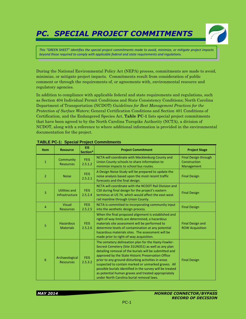
During the National Environmental Policy Act (NEPA) process, commitments are made to avoid,

minimize, or mitigate project impacts. Commitments result from consideration of public

comment or through the requirements of, or agreements with, environmental resource and

regulatory agencies.

In addition to compliance with applicable federal and state requirements and regulations, such

as Section 404 Individual Permit Conditions and State Consistency Conditions; North Carolina

Department of Transportation (NCDOT) Guidelines for Best Management Practices for the

Protection of Surface Waters; General Certification Conditions and Section 401 Conditions of

Certification, and the Endangered Species Act, Table PC-1 lists special project commitments

that have been agreed to by the North Carolina Turnpike Authority (NCTA), a division of

NCDOT, along with a reference to where additional information is provided in the environmental

documentation for the project.

TABLE PC-1: Special Project Commitments

Item Resource EIS

Section* Project Commitment Project Stage

1 Community Resources

FEIS 2.5.1.2

NCTA will coordinate with Mecklenburg County and Union County schools to share information to minimize impacts to school bus routes.

Final Design through Construction Management

2 Noise FEIS

2.5.2.1

A Design Noise Study will be prepared to update the noise analysis based upon the most recent traffic forecasts and the final design.

Final Design

3 Utilities and

Infrastructure FEIS

2.5.2.4

NCTA will coordinate with the NCDOT Rail Division and CSX during final design for the project’s eastern terminus at US 74, which would affect the east-west rail mainline through Union County.

Final Design

4 Visual

Resources FEIS

2.5.2.5 NCTA is committed to incorporating community input into the aesthetic design process.

Final Design

5 Hazardous Materials

FEIS 2.5.2.6

When the final proposed alignment is established and right-of-way limits are determined, a hazardous materials site assessment will be performed to determine levels of contamination at any potential hazardous materials sites. The assessment will be made prior to right-of-way acquisition.

Final Design and ROW Acquisition

6 Archaeological

Resources FEIS

2.5.3.2

The cemetery delineation plan for the Hasty-Fowler-Secrest Cemetery (Site 31UN351) as well as any plan detailing removal of the burials will be submitted and approved by the State Historic Preservation Office prior to any ground-disturbing activities in areas suspected to contain marked or unmarked graves. All possible burials identified in the survey will be treated as potential human graves and treated appropriately under North Carolina burial removal laws.

Final Design

This “GREEN SHEET” identifies the special project commitments made to avoid, minimize, or mitigate project impacts beyond those required to comply with applicable federal and state requirements and regulations.

SPECIAL PROJECT COMMITMENTS Section PC

MAY 2014 MONROE CONNECTOR/BYPASS

RECORD OF DECISION PC-2

TABLE PC-1: Special Project Commitments

Item Resource EIS

Section* Project Commitment Project Stage

7 Water

Resources FEIS

2.5.4.2

For any construction staging, storage, refueling, borrow pit or spoil area that is considered within the Goose Creek or Sixmile Creek watersheds, the NCDOT will coordinate with the USFWS, NCDOT Division Environmental Officer, and the contractor to determine if BMPs can be implemented for each site that avoid/minimize the potential for adverse effects to listed species and critical habitat.

Construction Management

8 Water

Resources FEIS

2.5.4.2

NCTA will follow NCDOT’s Design Standards in Sensitive Watersheds for implementing erosion and sediment control BMPs along the entire project.

Construction Management

9 Water

Resources FEIS

2.5.4.2 Seeding will be required within 14 calendar days of completing construction activities in an area.

Construction Management

10 Water

Resources FEIS

2.5.4.2

Final designs will incorporate hazardous spill basins along the project corridor within the designated hazardous spill basin area associated with Lake Twitty. These basins will be designed in accordance with NCDOT’s Best Management Practices for Protection of Surface Waters, Guidelines for the Location and Design of Hazardous Spill Basins, and Guidelines for Drainage Studies and Hydraulic Design.

Final Design

11 Water

Resources FEIS

2.5.4.2

A turbidity water quality testing program for the main stem of Stewarts Creek will be implemented to evaluate the performance of BMPs. Testing will be completed upstream and downstream of the construction area, as well as before, during, and after storm events.

Construction Management

12 Protected

Species

FSFEIS App. B-1

NCTA will take the following actions to protect and preserve two known populations of Schweinitz’s sunflower (EO#77 and EO#230):

“No Mow” signs have been posted by the NCDOT at both EOs

The populations are being managed by the NCDOT in accordance with the NCDOT Roadside Vegetation Management Guidelines in Marked Areas plan

The populations have been incorporated into the Union Power Schweinitz’s Sunflower Restricted Sites plan as Site R and will be managed accordingly

The Design-Build Team will clearly demark the two Schweinitz’s sunflower populations with tree-protection fencing

Prior to commencing construction, the Design-Build Team and the NCTA/NCDOT will meet with USFWS to discuss the protection and preservation of EO #77 and #230.

Construction Management

13 Protected

Species DSFEIS 4.4.5

NCDOT and FHWA will coordinate with USFWS to monitor the status of the potential listing of Georgia Aster (Symphyotrichum georgianum) and Savannah Lilliput (Toxolasma pullus) throughout construction. .

Construction Management

SPECIAL PROJECT COMMITMENTS Section PC

MAY 2014 MONROE CONNECTOR/BYPASS

RECORD OF DECISION PC-3

TABLE PC-1: Special Project Commitments

Item Resource EIS

Section* Project Commitment Project Stage

In addition, NCDOT and FHWA will coordinate with USFWS when the management plan and guidance become available for the northern long-eared bat (Myotis septentrionalis), which was proposed for listing as Endangered in October 2013.

14 Air Quality FEIS 3.3.3

Dust suppression measures will be implemented to reduce dust generated by construction when the control of dust is necessary for the protection of motorists and residents.

Construction Management

*FEIS – Final Environmental Impact Statement

DSFEIS – Draft Supplemental Final Environmental Impact Statement

FSFEIS – Final Supplemental Final Environmental Impact Statement

This page was intentionally left blank.

MAY 2014 MONROE CONNECTOR/BYPASS RECORD OF DECISION

1

RECORD OF DECISION

1. DECISION

The Federal Highway Administration (FHWA) and the North Carolina Department of

Transportation (NCDOT) have identified the Selected Alternative for the Monroe Connector/Bypass

in Mecklenburg and Union Counties, North Carolina. The Selected Alternative identified and

discussed in this Record of Decision (ROD) is the Preferred Alternative identified in the Final EIS

(May 2010), Draft Supplemental Final EIS (November 2013) and Final Supplemental Final EIS

(May 2014). The proposed action includes constructing a new location controlled-access toll road

from US 74 near I-485 in Mecklenburg County to US 74 between the towns of Wingate and

Marshville in Union County, a distance of approximately 20 miles. The project is included in the

Charlotte Regional Transportation Planning Organization’s (CRTPO) 2040 Metropolitan

Transportation Plan (MTP) and Transportation Improvement Program (TIP). The project is

included in the NCDOT 2012-2018 State TIP (STIP) as Project R-3329 (Monroe Connector) and

Project R-2559 (Monroe Bypass) as a toll facility.

The proposed action will improve mobility and capacity within the project study area by providing a

facility for the US 74 corridor that allows for high-speed regional travel consistent with the

designations of the North Carolina Strategic Highway Corridor (SHC) program1, while maintaining

access to properties along existing US 74.

As presented in Section 2 of the Final EIS, the FHWA and NCTA (a division of NCDOT as of July

27, 2009) identified DSA D as the Preferred Alternative, based on the information in the Draft EIS

(March 2009) and input received during the public comment period. DSA D was identified as the

Recommended Alternative in the Draft EIS. After consideration of comments received on the Final

EIS and additional studies completed since the Final EIS, NCDOT reaffirmed DSA D as the

Preferred Alternative in the Draft Supplemental Final EIS. Alternative D was selected because it

has lower overall impacts to the natural environment and residential areas than the other

alternatives considered. The Final EIS and Draft Supplemental Final EIS include details of the

decision-making process and reasons for selecting Alternative D for the project. A complete

description of the Preferred Alternative and its anticipated impacts is also included in the Draft

Supplemental Final EIS.

In accordance with 42 USC 4312 et seq and the requirements set forth by the Council of

Environmental Quality (CEQ) 40 CFR 1502.2), this ROD:

1. Identifies the Selected Alternative for the Monroe Connector/Bypass;

2. Summarizes all alternatives considered by the FHWA and the values which were important

factors in the evaluation process;

3. Describes the measures adopted to avoid and/or minimize environmental harm; and,

1 As reported in the Draft EIS and Final EIS, the US 74 corridor was also designated as part of the North Carolina Intrastate System until the

Intrastate System (defined in NC General Statutes 136-179) was repealed in July 2013 by NC Session Law 2013-183 as part of the Strategic Prioritization Funding Plan for Transportation Investments. As described in Appendix D of the Final Supplemental Final EIS, the essential elements of the need and purpose statement remain the same, therefore no additional screening of alternatives was required.

RECORD OF DECISION

MAY 2014 MONROE CONNECTOR/BYPASS RECORD OF DECISION

2

4. Identifies monitoring and enforcement programs for the implementation of mitigation

measures.

2. PROJECT HISTORY

The North Carolina Department of Transportation (NCDOT) previously studied two projects in this

area – the Monroe Bypass (North Carolina State Transportation Improvement Program [STIP]

Project R-2559) and the Monroe Connector (STIP Project R-3329). They are now being advanced by

the North Carolina Turnpike Authority (NCTA), a division of NCDOT, as a single project, which was

the subject of the Draft Environmental Impact Statement (EIS) (March 2009), Final EIS (May 2010),

Draft Supplemental Final EIS (November 2013), and now this combined Final Supplemental Final

EIS and Record of Decision (ROD). Previous studies are summarized below.

It should be noted that prior to 2005, the Monroe Bypass and the Monroe Connector were being

advanced by NCDOT. The NCTA was created by the NC General Assembly in October 2002. The

Monroe Connector/Bypass was adopted as a candidate toll facility by the NCTA in February 2005.

On July 27, 2009, the NCTA became a division of the NCDOT (NC Session Law 2009-243).

PREVIOUS STUDIES OF THE MONROE BYPASS

The Monroe Bypass project was the first of the two projects studied by NCDOT. The western

terminus of this project was US 74 near Rocky River Road (Secondary Road [SR] 1514). From there,

the project extended east around the north side of Monroe, and connected to US 74 between the

towns of Wingate and Marshville.

NCDOT completed the original planning and environmental process for the Monroe Bypass in 1997.

The process included an Environmental Assessment (EA) issued on March 14, 1996, and a Finding of

No Significant Impact (FONSI) issued on June 20, 1997. The process resulted in a Selected

Alternative. For right-of-way acquisition and construction purposes, the Monroe Bypass was divided

into three sections:

Section A from US 74 near Rocky River Road (SR 1514) east to US 601

Section B from US 601 to just east of Walkup Avenue (SR 1751)

Section C from just east of Walkup Avenue and connecting with US 74 west of Marshville

In May 1997, a Public Hearing was held to present final designs for Sections B and C. It was

determined that Section A would be replaced by NCDOT’s Monroe Connector project; therefore,

FHWA and NCDOT temporarily suspended Section A while feasibility studies for the Monroe

Connector were initiated by NCDOT. In 2000 and 2001, right of way was purchased for Sections B

and C. However, during the environmental permitting process (prior to construction), issues arose

regarding the federally-endangered Carolina heelsplitter mussel, and construction was postponed.

PREVIOUS STUDIES OF MONROE CONNECTOR

NCDOT began the planning process for the Monroe Connector in 1999. As the name suggests, the

Monroe Connector was intended to “connect” the Monroe Bypass (Sections B and C) from US 601

west to I-485. A Draft EIS for the Monroe Connector was issued on October 17, 2003, and released

for review and comment by the public and environmental resource and regulatory agencies in

November 2003. However, a Public Hearing was not held following completion of the Draft EIS.

FHWA elected to suspend the process in order to consider the project in relation to issues associated

with the Monroe Bypass.

RECORD OF DECISION

MAY 2014 MONROE CONNECTOR/BYPASS RECORD OF DECISION

3

The 2003 Draft EIS for the Monroe Connector was rescinded on January 30, 2006, by notice in the

Federal Register (Vol. 71, No. 19, page 4958). The notice stated: “Based on the comments received

from various Federal and state agencies and the public and a recent decision to change the eastern

terminus of the project from US 601 to the proposed Monroe Bypass, the FHWA and NCDOT have

agreed not to prepare a Final EIS for the proposed US 74 improvements from I-485 to US 601.

FHWA, NCDOT, and the North Carolina Turnpike Authority (NCTA) plan to prepare a new Draft

EIS for the proposed project. A notice of intent to prepare the EIS will be issued subsequent to this

rescinding notice. The new Draft EIS will include a toll alternative among the full range of

alternatives that will be analyzed as well as a change in the location of the eastern terminus.”

MONROE BYPASS AND MONROE CONNECTOR COMBINED

In February 2005, at the request of the Mecklenburg-Union Metropolitan Planning Organization

(MUMPO) (now known as the Charlotte Regional Transportation Planning Organization [CRTPO]),

NCTA adopted the Monroe Connector as a candidate toll facility. At that time, the 2005–2011 STIP

included funding for construction of Sections B and C of the Monroe Bypass and NCDOT was moving

forward with the Monroe Bypass as a separate project. However, due to the age of the original

EA/FONSI for the Monroe Bypass (approximately 10 years), FHWA required a reevaluation of the

document prior to the start of any construction. All sections of the Monroe Bypass (A, B, and C)

needed to be considered in the reevaluation because they provide the logical endpoints for the

project, enabling it to function as a stand-alone bypass.

During the course of the reevaluation, it was discovered that the MUMPO 2030 Long Range

Transportation Plan (LRTP) did not include Section A of the Monroe Bypass; it included the Monroe

Connector instead. A project must be in the LRTP in order for it to receive FHWA approval and

funding. As originally envisioned, the Monroe Connector was meant to function as a replacement for

Section A of the Monroe Bypass. Without the Monroe Bypass Sections B and C, the Monroe

Connector did not have a logical eastern terminus. Likewise, without Section A (or the Monroe

Connector serving as a replacement for Section A), Sections B and C of the Monroe Bypass did not

have a logical western terminus and could not serve as a stand-alone bypass. FHWA and NCDOT

elected to discontinue the reevaluation process to consider combining the Monroe Bypass and

Monroe Connector projects into a single viable project with logical termini.

On September 20, 2006, MUMPO adopted a resolution recommending that the Monroe Bypass and

Monroe Connector be combined into a single environmental study under the administration of

NCTA. On January 19, 2007, FHWA issued a Notice of Intent (NOI) in the Federal Register

announcing its intention to prepare a Draft EIS for the combined Monroe Connector/Bypass project

(Federal Register, Vol. 72, No. 12, pages 2582 to 2583).

ACTIVITIES BETWEEN THE DRAFT EIS AND FINAL EIS

The Monroe Connector/Bypass Administrative Action Draft Environmental Impact Statement was

signed on March 31, 2009 and made available for public and agency review on April 2, 2009 on

NCTA’s Web site. Copies of the document were distributed to public review locations and agencies

on April 17, 2009. The public comment period for the Draft EIS ended on June 15, 2009.

Public and Agency Coordination. Four Pre-Hearing Open Houses, two of which were followed by

Combined Corridor Design Public Hearings, were held in May 2009. Comment sheets were made

available at all Pre-Hearing Open Houses and Public Hearings and on the project Web site.

RECORD OF DECISION

MAY 2014 MONROE CONNECTOR/BYPASS RECORD OF DECISION

4

The NCTA/NCDOT conducted regularly scheduled agency coordination meetings throughout the

project development process. These Turnpike Environmental Agency Coordination (TEAC) meetings

were held to review the status of current NCTA projects, to discuss and agree upon study

methodologies, and to discuss and resolve environmental concerns and adherence to permitting

requirements. The six TEAC meetings held between the Draft EIS and Final EIS included

discussions on the selection of the Preferred Alternative for the Monroe Connector/Bypass project.

Additional information on coordination efforts with the public, as well as federal, state, and local

agencies, between the Draft EIS and Final EIS is included in Section 3 of the Final EIS.

Updates and Refinements to the Preferred Alternative. Refinements were made to the

functional design of the Preferred Alternative prior to the Final EIS based on input received from

state and federal agencies and the public. Refinements included changes to interchange

configurations and further consideration of potential service road locations (Monroe

Connector/Bypass Service Road Study, PBS&J, April 2010). These are described in detail in Section

2.3 of the Final EIS. Cost estimates also were updated for the Preferred Alternative in the Final

EIS Section 2.3.4.

Additional Studies of the Preferred Alternative in the Final EIS. Additional studies

prepared for the Preferred Alternative and presented in the Final EIS included updated traffic

forecasts, an updated traffic noise study, an updated hazardous materials evaluation, an additional

archaeological assessment, an assessment of critical habitat and preparation of a Biological

Assessment for federally protected species, a review of potential on-site mitigation for jurisdictional

resources impacts, and a quantitative indirect and cumulative effects analysis, which includes a

water quality analysis.

ACTIVITIES BETWEEN THE FINAL EIS AND THE DRAFT SUPPLEMENTAL FINAL EIS

Following publication of the Final EIS in May 2010, the Preferred Alternative (Alternative D) was

selected for implementation, as documented in the Record of Decision (ROD) (August 2010) for the

project. The Selected Alternative in the August 2010 ROD was a controlled-access toll facility,

approximately 20 miles in length, on a new location.

After the August 2010 ROD was published, the Southern Environmental Law Center (SELC), on

behalf of Clean Air Carolina, NC Wildlife Federation, and Yadkin Riverkeeper, brought suit against

the FHWA and NCDOT regarding the project’s environmental documentation, alleging that the

study did not comply with the requirements of NEPA. FHWA and NCDOT prevailed in a federal

District Court decision issued on October 24, 2011.

On May 3, 2012 the United States Court of Appeals for the Fourth Circuit in North Carolina Wildlife

Federation, Clean Air Carolina; Yadkin Riverkeeper v. North Carolina Department of Transportation

and Federal Highway Administration, No. 11-2210, held that FHWA and NCDOT had not complied

with the provisions of NEPA by failing to disclose critical assumptions underlying their decision to

build the proposed project and by providing the public with incorrect information. Specifically, in

addressing public comments on the project as to whether the data set used as the project’s no-build

scenario for the indirect and cumulative analysis contained the project, the agencies responded “TAZ

socioeconomic forecasts for the No Build Scenario did not include the Monroe Connector. MUMPO

confirmed our assumption regarding the reasonableness of the 2030 TAZ forecasts for use as a No

Build basis.” The second sentence accurately reflects the agencies’ final conclusion, but the first

sentence is not correct. Travel time to employment, one of eight land development factors used to

project no-build growth estimates for Union County for the year 2030, presumed the presence of the

RECORD OF DECISION

MAY 2014 MONROE CONNECTOR/BYPASS RECORD OF DECISION

5

proposed Monroe Connector/Bypass. This was not clear until after the ROD had been signed. In

addition, three of the twelve local jurisdictions reporting future land use data to the CRTPO

assumed construction of the project. FHWA and NCDOT, in consultation with the CRTPO,

determined the CRTPO data based on the future land use plans supplied by the twelve jurisdictions

nevertheless better represented a no-build scenario than a build scenario for the project. A portion of

the data relied upon to reflect the No Build Scenario included a build assumption. In response to the

court’s decision, FHWA rescinded the ROD for this project on July 3, 2012. NCDOT then re-initiated

the NEPA process which led to the development of the Draft Supplemental Final EIS.

Numerous updated studies were prepared between publication of the Final EIS in May 2010 and the

Draft Supplemental Final EIS in November 2013. These studies are summarized in the Draft

Supplemental Final EIS and include updated traffic studies, noise analysis, indirect and cumulative

effects analyses, endangered species surveys, and a biological assessment.

Additional public involvement and agency coordination between the Final EIS and the Draft

Supplemental Final EIS included:

Two community workshops held in June 2012

Ten small group meetings with regional and local agencies and elected officials

Seven coordination meetings with environmental resource and regulatory agencies

Re-initiation of Section 7 informal consultation with USFWS

Table P-1 in the Draft Supplemental Final EIS presents a summary of changes in the affected

environment or impacts since the Final EIS was published.

ACTIVITIES SINCE THE DRAFT SUPPLEMENTAL FINAL EIS

The Draft Supplemental Final EIS was signed by FHWA on November 8, 2013, and a Notice of

Availability was published in the Federal Register on November 22, 2013. Public hearings were held

at three different locations along the project corridor on December 9, 10, and 11, 2013, as described

in Section 3.2 of the Final Supplemental Final EIS. There has also been additional coordination

with environmental resource and regulatory agencies, as described in Section 3.3 of the Final

Supplemental Final EIS.

Data released since the Draft Supplemental Final EIS was published has been reviewed and

evaluated, including INRIX travel speed data for 2013 (see Section 1.1.1 of the Final Supplemental

Final EIS), output from a new version of the regional travel demand model (see Section 2.1 of the

Final Supplemental Final EIS), and new socioeconomic projections from CRTPO (see Section 2.4 of

the Final Supplemental Final EIS). FHWA issued a conformity determination on the CRTPO 2040

MTP on May 2, 2014, as described in Section P.4.6 of the Final Supplemental Final EIS. Updated

cost estimates were prepared for the Preferred Alternative, as presented in Section 2.4 of the Final

Supplemental Final EIS and summarized in Section 4.4 of this ROD.

RECORD OF DECISION

MAY 2014 MONROE CONNECTOR/BYPASS RECORD OF DECISION

6

3. COMBINED FINAL SUPPLEMENTAL

FINAL EIS AND RECORD OF DECISION

The FHWA is using the Draft Supplemental Final EIS, together with public and agency input and

comments received on that document, as the basis for a combined Final Supplemental Final EIS/

Record of Decision (ROD), which will be the final document prepared under the National

Environmental Policy Act (NEPA) process. The intention to prepare a combined Final Supplemental

Final EIS/ROD was stated on the signature page of the Draft Supplemental Final EIS, as well as in

Section P.2 of that document. Section 1319(b) of MAP-21 directs the lead agency, to the maximum

extent practicable, to expeditiously develop a single document that consists of a Final EIS and ROD,

unless the following conditions exist:

1. The Final EIS makes substantial changes to the proposed action that are relevant to

environmental or safety concerns; or

2. There are significant new circumstances or information relevant to environmental concerns

and that bear on the proposed action or the impacts of the proposed action.

The proposed project does not meet either of the conditions listed above. This Final Supplemental

Final EIS/ROD does not make any changes to the proposed action as presented in the Draft

Supplemental Final EIS and there are no significant new circumstances or information that would

change the proposed action or its impacts as presented in the Draft Supplemental Final EIS.

According to FHWA’s Interim Guidance on MAP-21 Section 1319 Accelerated Decisionmaking in

Environmental Reviews (January 2013), the following questions should be considered in deciding

whether the use of a combined Final EIS/ROD is practicable for a particular project. Notes are

included after each question to show how each was considered for the current project. The guidance

uses the term “FEIS”, which also applies to a Final Supplemental Final EIS.

1. Are there any coordination activities that are more effectively completed after the Final EIS

is available? For example, if there is a need to develop a more detailed mitigation plan, or if

a joint lead or cooperating agency requests separate FEIS and ROD documents in order to

accommodate its decisionmaking requirements, then FHWA may determine that a separate

Final EIS and ROD provides a more effective and efficient decisionmaking process.

Agency and public coordination has been ongoing throughout the project development

process. There are no outstanding coordination concerns and no agencies have requested

separate Final Supplemental Final EIS and ROD documents to accommodate their

decisionmaking requirements.

2. Are there any unresolved interagency disagreements over issues that need identification in

the Final EIS under 23 CFR 771.125(a)(2)?

There are no unresolved interagency disagreements with regard to the project. Appendix

A-1 of the Final Supplemental Final EIS includes all comment letters received from

environmental resource and regulatory agencies on the Draft Supplemental Final EIS.

In addition, Appendix B-1 of the Final Supplemental Final EIS includes a December 16,

2013 letter from the USFWS concurring with the Biological Conclusions for protected

species under Section 7 of the Endangered Species Act.

3. Is there a substantial degree of controversy? FHWA may decide not to combine a Final EIS

and ROD in these situations if the agencies believe that issuing the Final EIS as a separate

RECORD OF DECISION

MAY 2014 MONROE CONNECTOR/BYPASS RECORD OF DECISION

7

document could help to resolve the controversy. For example, the opportunity to review

additional comments submitted after the Final EIS may assist FHWA to develop additional

mitigation commitments that could be included in the ROD to address the controversy.

All interested agencies have reviewed and provided comments on the Draft Supplemental

Final EIS. Based on these comments, there are no interagency issues or disagreements.

The USFWS issued their concurrence under Section 7 of the Endangered Species Act on

December 16, 2013. There is a certain level of controversy as evidenced by comments

received from the Southern Environmental Law Center (SELC) and some others.

However, per the terms of the interim guidance on MAP-21, it does not appear that

issuing a separate Final Supplemental Final EIS and ROD would help resolve this

controversy in the eyes of these commenters.

The substantive issues raised by these commenters have been examined in consultation

with agency subject matter specialists. The analysis of these issues appears in the

responses provided in the Final Supplemental Final EIS and in related supporting

documentation contained in the Final Supplemental Final EIS appendices. The

comments and criticisms regarding the worthiness of the project as a whole are a matter

beyond the purview of any review conducted under the National Environmental Policy

Act (NEPA). Local MPOs are empowered under applicable federal laws and regulations

with the authority to prioritize project development. The Federal Highway

Administration’s role is to ensure that that any projects submitted for Federal-aid

funding comply with NEPA. Throughout the life of this project a number of alternatives

have been studied, including a no-build alternative whose validity was re-assessed in the

course of the Supplemental Final EIS. The selected alternative was chosen over the no-

build alternative, because the selected alternative meets the project need and purpose

while the no-build alternative does not. The comments and criticisms of the project’s

traffic forecasting and modeling amount to differences of opinion. For the reasons

discussed in the technical memorandum addressing Dr. Hartgen’s report, and elsewhere,

the project modeling and forecasting are reasonable and appropriate. Submitted

comments are discussed in responses to comments and in the memoranda prepared for

issues warranting more detailed responses, such as the memorandum titled Review of the

report titled, Review of Traffic Forecasting: Monroe Connector/Bypass Draft

Supplemental Final EIS, November 2013, prepared by The Hartgen Group for the SELC

(HNTB May 2014) found in Final Supplemental Final EIS Appendix E-4 and the

memorandum titled Review of New CRTPO Socioeconomic Projections (Michael Baker

Engineering, Inc., May 2014) found in Final Supplemental Final EIS Appendix E-3.

Even though a separate Final Supplemental Final EIS is not being circulated, NCDOT

received two sets of additional comments from the SELC in April, well after the close of

the comment period, and those comments were considered and addressed (see Final

Supplemental Final EIS Appendix A-2). For example, this included requests for

additional commitments regarding the northern long-eared bat (Myotis septentrionalis).

NCDOT and FHWA had previously committed to coordinate with USFWS to monitor the

status of the potential listing of the Georgia Aster (Symphyotrichum georgianum) and

Savannah Lilliput (Toxolasma pullus). Responses to these issues and the others raised

in these comments are located in Final Supplemental Final EIS Appendix A-2,

Table A-2.4.

Since publication of the Draft Supplemental Final EIS and public comments, CRTPO has

adopted new socioeconomic projections developed for the 2040 Metropolitan

RECORD OF DECISION

MAY 2014 MONROE CONNECTOR/BYPASS RECORD OF DECISION

8

Transportation Plan (MTP). NCDOT analyzed the draft 2014 socioeconomic projections

that became available in January 2014 to ascertain whether it appeared the new data

differed significantly enough from the most recently approved 2009 socioeconomic data to

warrant revisiting traffic forecasting for the project. For the reasons discussed in the

Review of New CRTPO Socioeconomic Projections Memorandum (Michael Baker

Engineering, Inc., May 2014) and the Monroe Connector/Bypass Traffic Forecast

Summary (HNTB, May 2014), NCDOT concluded new traffic forecasting was not

warranted (see Final Supplemental Final EIS Appendix E-4). FHWA independently

reviewed this analysis and concurred (see Final Supplemental Final EIS Appendix E-8).

FHWA issued a conformity determination for the CRTPO 2040 MTP on May 2, 2014 (see

Final Supplemental Final EIS Appendix E-7). There were no changes to the 2014

socioeconomic data between January 2014 and the date CRTPO adopted the 2040 MTP

(April 16, 2014).

4. Does the Draft EIS identify the preferred alternative from among the comparatively

evaluated reasonable alternatives? If the Draft EIS does not identify the preferred

alternative, then FHWA should provide agencies and the public with an opportunity after

issuance of the Final EIS for an informed assessment related to impacted resources and

environmental concerns of the preferred alternative. Whenever possible, FHWA should work

with project applicants and appropriate participating agencies to identify the preferred

alternative prior to issuing the Draft EIS.

The Draft Supplemental Final EIS identifies the Preferred Alternative, which is the

same as the Preferred Alternative presented in the Final EIS (May 2010). Agencies and

the public have had ample opportunity to make an informed assessment related to

impacted resources and environmental concerns of the Preferred Alternative.

5. Are there compliance issues with substantive requirements that must be resolved before

issuance of the ROD, or that FHWA wants to resolve before signing the ROD, but that do not

merit deferring issuance of the Final EIS? Section 1319 does not alter the compliance timing

requirements under substantive environmental laws. If FHWA determines there are

reasonable assurances of compliance so that FHWA can issue the Final EIS pursuant to 23

CFR 771.125(a)(1) and 771.133, and the agency believes there are important benefits to the

overall decisionmaking process if the Final EIS is issued before such compliance matters are

fully resolved, then FHWA may decide that it should not combine the Final EIS and ROD.

In such cases, FHWA can publish the Final EIS using the reasonable assurances provisions

in sections 771.125(a) and 771.133, and can update compliance status in the ROD. For

example, if FHWA cannot sign the ROD until conforming amendments are made to planning

documents due to the need for a new Clean Air Act conformity determination, it may be

beneficial for purposes of both transparency and the overall project timeline to issue the

Final EIS separately. This provides the agencies and the public access to the Final EIS

information while the amendments are being made to the planning documents.

Agency comments have not identified, nor are NCDOT and FHWA aware of, any

compliance issues with substantive requirements that must be resolved prior to issuance

of the ROD.

Based on the information presented in the discussion above, FHWA has determined that the use of a

combined Final Supplemental Final EIS/ROD process for this project is practicable. In reaching this

conclusion, the FHWA North Carolina Division has consulted with FHWA headquarters offices,

including the Office of Planning, Environment, and Realty.

RECORD OF DECISION

MAY 2014 MONROE CONNECTOR/BYPASS RECORD OF DECISION

9

This ROD identifies the Selected Alternative corridor and presents the basis for the decision. It

should be noted that the ROD identifies a corridor, not a specific design. The functional design for

the Selected Alternative presented in this document may change during final design activities

occurring after approval of this ROD, provided the modifications are within the Selected Alternative

corridor.

The FHWA NEPA process for transportation projects fosters project decisions that balance

engineering and transportation needs with social, economic, and natural environmental factors.

During the process, a wide range of partners (including the public, businesses, interest groups, and

agencies at all levels of government) provides input into project and environmental decisions (FHWA

Web site: http://environment.fhwa.dot.gov/projdev/pd3tdm.asp). FHWA plans to file a Notice of

Limitation on Claims for Judicial Review for this Final Supplemental Final EIS/ROD in the Federal

Register. The date that the notice appears in the Federal Register will begin the 150-day statute of

limitations.

4. ALTERNATIVES CONSIDERED

This section describes the consideration of preliminary alternatives and the basis for choosing the

Selected Alternative. This section also describes the Selected Alternative and documents the

anticipated impacts associated with it.

4.1 RANGE OF ALTERNATIVES

A typical alternatives screening process for a transportation project starts with an initial

qualitative screening of a large number of alternatives. Further screening steps refine the

remaining alternatives and implement progressively more detailed qualitative and quantitative

evaluation criteria. The NCDOT followed a multi-step alternatives screening process for the

Monroe Connector/Bypass, and incorporated additional comparative and detailed analyses as

part of the Final EIS and after the Final EIS, including in response to comments received from

the public and resource agencies.

A range of alternative concepts was considered for this project, including:

No-Build or No-Action Alternative

Transportation Demand Management (TDM) Alternative

Transportation System Management (TSM) Alternative

Mass Transit/Multi-Modal Alternative

Improving Existing US 74 Alternative

New Location Alternative

New Location/Improve Existing Roadways Hybrid Alternative

The development and evaluation of alternatives for determination of the Detailed Study

Alternatives (DSA) included in the Draft EIS is documented in detail in the Alternatives

Development and Analysis Report (PBS&J, April 2008), and further studies of existing US 74 are

documented in the Upgrade Existing US 74 Alternatives Study (HNTB, April 2009). Additional

studies of improving existing US 74 conducted after the Final EIS are documented in the US 74

Corridor Analysis Scenarios (HNTB, December 2010).

RECORD OF DECISION

MAY 2014 MONROE CONNECTOR/BYPASS RECORD OF DECISION

10

The Draft Supplemental Final EIS summarizes the alternatives development process, including

the process used to identify the Detailed Study Alternatives in the Draft EIS (Section 2.2 of the

Draft Supplemental Final EIS); additional analyses conducted and included in the Final EIS as a

result of public and agency comment (Section 2.3 of the Draft Supplemental Final EIS); and

updates and analyses conducted after the Final EIS (Section 2.4 of the Draft Supplemental Final

EIS). Finally, Section 2.5 of the Draft Supplemental Final EIS summarizes a review of traffic

forecasts and operations analyses for the Build Alternatives.

Following publication of the Draft Supplemental Final EIS, output from a new version of the

regional travel demand model, Metrolina Regional Model (MRM) 14v1.0, was provided by the

Charlotte Regional Transportation Planning Organization (CRTPO, formerly MUMPO).

MRM 14v1.0 has since been adopted by CRTPO (April 16, 2014), and FHWA issued a conformity

determination on May 2, 2014. This adopted MRM incorporates updated socioeconomic

projections (2014 SE Data). The adopted MRM 14v1.0 data was considered in the Monroe

Connector/Bypass Traffic Forecast Summary (HNTB, November 2013, superseded May 2014), as

summarized in Section 2.1 of the Final Supplemental Final EIS. After consideration of the

adopted MRM14v1.0 (with 2014 SE Data) output, the conclusions summarized in Draft

Supplemental Final EIS Section 2.5.2 remain unchanged; namely, the Build Scenario forecasts

remain valid and an updated forecast is not warranted.

The majority of the public comments received on alternatives are related to the alternative

analysis, including comments received after the Final EIS; and many of these comments are

related to the alternatives for upgrading existing US 74. The history of the evaluation of the

Improve Existing US 74 Alternative also is summarized in a table in Appendix B of the Draft

Supplemental Final EIS. Responses to comments received on the Final EIS are documented in

Appendix A in the Draft Supplemental Final EIS and responses to comments received on the

Draft Supplemental Final EIS are summarized in the Appendix A of the Final Supplemental

Final EIS.

The screening-level process and decisions in the Monroe Connector/Bypass EIS remain valid.

Based on a review of new information and analyses in the Draft Supplemental Final EIS and the

Final Supplemental Final EIS, and consideration of public and agency comments, including all

comments received as a result of the December 2013 Public Hearings, there were no conditions

that warranted considering new alternatives or updating previous screening decisions.

The NCDOT complied with its obligation to rigorously explore and objectively evaluate all

reasonable alternatives and gave extensive treatment to preliminary and detailed study

alternatives in their comparison. Poor existing and projected travel conditions in the project area

are well-documented and demonstrated. The NCDOT examined “minor” improvements and

evaluated and re-examined others (i.e. improve existing US 74 alternatives and TSM alternatives)

with a “hard look” and subsequently determined that they were not reasonable and/or did not

meet the project’s purpose and need and did not require more detailed study.

The NCDOT followed a widely-accepted screening process in alternatives evaluation for the

Monroe Connector/Bypass. In addition, NCDOT generally conformed to legal principles and

practitioner guidelines prescribed by the Council on Environmental Quality (CEQ), FHWA, and

the American Association of State Highway and Transportation Officials (AASHTO) throughout

the process.

RECORD OF DECISION

MAY 2014 MONROE CONNECTOR/BYPASS RECORD OF DECISION

11

4.2 BASIS FOR CHOOSING THE SELECTED ALTERNATIVE

As presented in Section 2 of the Final EIS, the FHWA and NCTA identified DSA D as the Preferred

Alternative, based on the information in the Draft EIS and input received during the public

comment period. DSA D was identified as the Recommended Alternative in the Draft EIS. After

considering comments received on the Final EIS and additional studies completed since the Final

EIS, FHWA and NCDOT reaffirmed DSA D as the Preferred Alternative in the Draft Supplemental

Final EIS. After reviewing comments regarding the Draft Supplemental Final EIS, the selection of

DSA D as the Preferred Alternative was reaffirmed in the Final Supplemental Final EIS.

The following bullets summarize the basis for selecting the Preferred Alternative as the Selected

Alternative. The comparisons listed below were made between all DSAs at the same level of design

to allow for accurate comparisons of impacts. These comparisons do not include design refinements

for the Preferred Alternative described in Section 3.3 of the Draft Supplemental Final EIS.

However, the relative comparisons listed below still apply, since it is expected that if designs were

refined for each DSA, the relative values would remain similar.

Additional information regarding input received during the Draft EIS, Final EIS, and Draft

Supplemental Final EIS public review periods is included at the end of this section under “Public

Involvement.” Please note this list is not in order of importance and does not represent all benefits

or impacts of the Preferred Alternative, just those elements that differentiated the Preferred

Alternative when compared to the other DSAs.

Cost and Design Considerations

The Selected Alternative is one of the shortest alternatives at 19.7 miles (all alternatives

range from 19.6 to 20.6 miles).

The Selected Alternative is one of the eight alternatives that would not require the relocation

of Rocky River Road and the associated wetland impacts. The relocation of Rocky River Road

is required for the eight alternatives that include DSA Segment 22A.

The Selected Alternative is higher in the range of median total project costs with a median

cost of $777.4 million (the median costs of the DSAs range from $752.5 million for DSA A2 to

$785.3 million for DSA D1). The higher cost of the Preferred Alternative is offset by lower

impacts in several other areas as described below. Updated cost estimates for the Selected

Alternative are presented in Section 4.4. It is expected that relative costs amongst the

DSAs would remain similar if updated costs were provided for all DSAs, and therefore the

conclusions listed in this bullet would not change.

Human Environment Considerations

The Selected Alternative is one of the alternatives with the fewest residential relocations at

95 (the range being 94 to 149 residential relocations).

The Selected Alternative is higher in the range of business relocations at 47 (the range being

14 to 49 business relocations). Most of the impacted businesses are located along existing US

74 at the western end of the project. The relocation of these businesses allows for the other

positive factors associated with the Selected Alternative, including having the roadway

located farther away from densely developed residential subdivisions and farther from

Stallings Elementary School.

The Selected Alternative has no direct impacts to schools and impacts only three church

properties.

RECORD OF DECISION

MAY 2014 MONROE CONNECTOR/BYPASS RECORD OF DECISION

12

The Selected Alternative avoids impacts to the Matthews Sportsplex property, a public park

operated by the Mecklenburg County Park and Recreation Department. (See also Cultural

Resource Considerations.)

Physical Environment Considerations

The Selected Alternative is one of the alternatives that impact the least acreage of active

agricultural lands at 499 acres. Impacts for all alternatives ranged from 494 acres to

627 acres.

The Selected Alternative impacts the least hazardous materials sites. The anticipated

impact severity is “low” for all potentially impacted sites.

Cultural Resources Considerations

The Selected Alternative avoids impacts to the Matthews Sportsplex property, a public park

and Section 4(f) resource.

Natural Resources Considerations

The Selected Alternative is in the middle range of impacts to upland forest at 446 acres (all

alternatives range from 354 to 514 acres).

The Selected Alternative is lower in the range of impacts to ponds at 2.6 acres (all

alternatives range from 2.5 to 3.8 acres).

The Selected Alternative is in the middle range of impacts to wetlands at 8.1 acres (all

alternatives range from 6.2 to 11.0 acres).

The Selected Alternative would have the least impacts to perennial streams with

9,794 linear feet of impact (all alternatives range from 9,794 to 12,383 linear feet).

The Selected Alternative is lower in the range of impacts to intermittent streams at

11,915 linear feet (all alternatives range from 10,767 to 13,020 linear feet).

DSA D would have the least linear feet of streams requiring mitigation at 12,550 linear feet

(all alternatives range from 12,550 to 16,387 linear feet). While final decisions with respect

to mitigation requirements had not been made by the regulatory agencies at the time of this

comparison, for estimation purposes, streams were considered to require mitigation if they

were perennial or if they were intermittent and had a stream rating issued by the NCDENR-

DWQ (now part of the Division of Water Resources [DWR]) of greater than or equal to 26.

This implies that streams impacted by DSA D are of lower quality than those impacted by

other DSAs. (Note: stream impacts from the refined design of the Selected Alternative are

discussed in Section 4.4.)

The Selected Alternative crosses three 303(d)-listed streams, all of which are proposed to be

bridged.

Public Involvement

Substantial public input regarding the DSAs, particularly at the western end of the project

(DSA Segment 2 versus DSA Segment 18A), was received throughout the alternatives

screening process. Much of this public input has been generated by C.A.R.E., a community-

based group focused on informing and mobilizing residents against DSA Segment 18A of the

Monroe Connector/Bypass (included in DSAs A, B, A1, B1, A2, B2, A3, and B3). C.A.R.E.

submitted more than 2,000 signatures in opposition to DSA Segment 18A. Specifically, the

group is concerned about noise, visual, and air quality impacts to the new Stallings

RECORD OF DECISION

MAY 2014 MONROE CONNECTOR/BYPASS RECORD OF DECISION

13

Elementary School and adjacent neighborhoods, as well as impacts to North Fork Crooked

Creek, which is a 303(d)-listed stream. While this input was a factor in the decision to

recommend DSA D, the recommendation was based on a wide range of factors included in the

comprehensive review and analysis of the potential impacts of all DSAs, as described above.

A series of Public Hearings and Open Houses was held the week of May 18, 2009, following

publication of the Draft EIS. The purpose of the public review period and the Pre-Hearing

Open Houses/Public Hearings was to receive input on the Draft EIS and project corridors

and design, as well as the selection of DSA D as the Recommended Alternative. Section 3.1.2

of the Final EIS has additional information on this topic. Of the comments received during

the public review period that expressed an opinion on the selection of DSA D as the

Recommended Alternative, 382 were in favor of DSA D and 50 were opposed to it. An

additional 150 names were submitted on an electronic petition opposing DSA D; however,

NCDOT cannot verify the validity of the signatures on this petition.

Detailed information regarding comments received from the public on the Final EIS, as well

as local, state, and federal agencies, is presented in Section 5 of the Draft Supplemental

Final EIS. All comments received on the Final EIS and responses to the comments are

included in Appendix A of the Draft Supplemental Final EIS. None of the comments

received resulted in a change in the Preferred Alternative.

A series of Public Hearings was held on December 9, 10, and 11, 2013, following publication

of the Draft Supplemental Final EIS. The purpose of the public review period and Public

Hearings was to receive input on the Draft Supplemental Final EIS. A total of 524 people

signed in at the Public Hearings and a total of 124 comment forms, verbal comments, emails

and letters were received during the comment period. None of the comments received

resulted in a change in the Preferred Alternative.

4.3 DESCRIPTION OF THE SELECTED ALTERNATIVE

The Selected Alternative is a four to six-lane controlled-access toll facility. Tolls would be collected

by an electronic toll collection (ETC) system. There would be no cash toll booths. The Selected

Alternative follows existing US 74 for approximately one mile from just east of I-485 to east of

Stallings Road (SR 1365) and then proceeds eastward on a new location alignment from east of

Stallings Road (SR 1365) to the project terminus at existing US 74 between the towns of Wingate

and Marshville. The total length of the Selected Alternative is approximately 19.7 miles.

From west to east, interchanges are located at US 74, Indian Trail-Fairview Road (SR 1520),

Unionville-Indian Trail Road (SR 1367), Rocky River Road (SR 1514), US 601, NC 200, and Austin

Chaney Road (SR 1758). Partial interchanges are located at Forest Hills School Road (SR 1754) and

US 74 at the eastern end of the project.

The Selected Alternative includes upgrading an approximately one-mile segment of existing US 74

at the western end of the project to a controlled-access highway facility with frontage roads. For this

segment, the toll road is six lanes wide and elevated on retained fill, with one-way frontage roads of

two to three lanes on either side, for a total of ten to twelve lanes. The right of way required for this

section would be approximately 260 feet.

For the remainder of the new location portion, the Selected Alternative has four 12-foot travel lanes

and a 70-foot median. The facility includes 12-foot inside shoulders (4-foot paved) and 14-foot

outside shoulders (12-foot paved). The right of way required for this section is approximately 300

RECORD OF DECISION

MAY 2014 MONROE CONNECTOR/BYPASS RECORD OF DECISION

14

feet, with additional right of way required for interchanges, frontage roads, and improvements to

intersecting roads.

The design speed for the tolled highway segments is 70 miles per hour (mph), which would

accommodate a posted speed limit of 65 mph. The design speed for the frontage roads is 40 mph,

which would allow for a posted speed limit of 35 mph. The general design criteria for the project are

presented in Appendix B of the Draft EIS.

The project is being developed as a Design-Build project. Through this process, the design and

design criteria will be re-evaluated to determine if any cost savings could be realized through

activities such as reduction of the median width or the overall right of way. Any changes to these

criteria will be implemented only if they will result in a net reduction in costs or impacts without loss

of service. For instance, it is likely that a reduction in median width and/or reduction in paved

shoulder widths will be considered.

4.4 IMPACTS OF THE SELECTED ALTERNATIVE

Impacts of the Selected Alternative are discussed in detail in Section 2 of the Final EIS and any

updates to those impacts are presented in Section 4 of the Draft Supplemental Final EIS. A

summary of the impacts from the Selected Alternative, including updates presented in the Draft

Supplemental Final EIS, is included in the Final Supplemental Final EIS and is presented in the

following sections. The impacts presented below include the design refinements and service roads

summarized in Section 3.3.1 and Section 3.3.2, respectively, of the Draft Supplemental Final EIS.

HUMAN ENVIRONMENT

Impacts to the human environment are documented in the Community Impact Assessment (PBS&J,

2009), Section 3 of the Draft EIS, Section 2.5.1 of the Final EIS, and Section 4.1 of the Draft

Supplemental Final EIS.

The Selected Alternative impacts seven neighborhoods:

o Forest Park (relocation of homes on end of road or at edge of neighborhood and

change in access)

o Acorn Woods (relocation of homes in neighborhood and change in access)

o Bonterra (change in access)

o Poplin Farms (relocation of homes in neighborhood)

o Avondale Park (right-of-way encroachment only)

o Silverthorn (right-of-way encroachment only)

o Glencroft (right-of-way encroachment only)

The Selected Alternative does not directly impact any schools in the project study area.

However, implementation of the Selected Alternative will alter access to Central Piedmont

Community College (CPCC). CPCC Lane, which provides access to the campus from existing

US 74, will be closed to allow for control of access in the vicinity of the I-485 interchange.

New access would be provided from existing US 74 via the proposed McKee Road. The

Preferred Alternative also may alter traffic patterns on existing US 74 and Forest Hills

School Road in the vicinity of Forest Hills High School. None of these changes would

preclude operations of the schools.

RECORD OF DECISION

MAY 2014 MONROE CONNECTOR/BYPASS RECORD OF DECISION

15

The Selected Alternative may impact three church properties (no church buildings would be

taken):

o Benton Heights Presbyterian Church – right of way required along US 601 to

accommodate improvements associated with the proposed US 601 interchange;

control of access requirements may necessitate altering existing entrances.

o Trinity Baptist Church – right of way required along US 601 to accommodate

improvements associated with proposed US 601 interchange.

o Lee Park Baptist Church (formerly Morgan Mill Road Baptist Church) – right of way

required along NC 200 to accommodate improvements associated with the proposed

NC 200 interchange.

The Selected Alternative requires relocation of approximately 95 residences, 47 businesses,

and 3 farms. Business relocations are concentrated along existing US 74. These total

numbers have not changed since the Final EIS. However, since the approval of the original

ROD in August 2010 (rescinded July 2012), NCDOT has acquired three commercial

properties, 26 residential properties, and one vacant parcel. Fifteen of these properties (one

commercial, one vacant, and 13 residential) were acquired under hardship situations.

Requests for right-of-way acquisition for hardship situations are being considered on a case

by case basis. The purchase of this right of way did not influence NCDOT’s or FHWA’s

decision to move forward with the Preferred Alternative as the Selected Alternative. If there

was a change in the Preferred Alternative, the purchased right of way would be sold and new

right of way acquired for a different alternative.

As evaluated in accordance with Executive Order 12898, the construction of the Selected

Alternative does not have a disproportionately high and adverse impact on minority and low-

income populations.

PHYSICAL ENVIRONMENT

Impacts to the physical environment are documented in a variety of technical memorandums as

noted below, as well as in Section 4 of the Draft EIS, Section 2.5.2 of the Final EIS, and Section 4.2

of the Draft Supplemental Final EIS.

Noise impacts are documented in Final Traffic Noise Technical Memorandum (PBS&J,

March 2009), Addendum Traffic Noise Technical Memorandum (PBS&J, January 2010), and

Traffic Noise Analysis Update for the Monroe Connector/Bypass (Atkins, November 2013).

The number of impacted receptors is estimated to be 153. Five preliminary feasible and

reasonable noise barriers have been identified for the Selected Alternative:

o Noise wall NW2C – Along the shoulder of westbound Monroe Connector/Bypass near

White Oak Lane and Strand Drive.

o Noise wall NW4 (Previously N4-1) – Along the shoulder of eastbound Monroe

Connector/Bypass near Beverly Drive.

o Noise wall NW7B (Previously N7-1) – Along the shoulder of eastbound Monroe

Connector/Bypass near Avondale neighborhood (Dusty Hollow Road).

o Noise wall NW11 (Previously N9-1) – Along the shoulder of westbound Monroe

Connector/Bypass near Glencroft Drive.

o Noise wall NW12 - Along the cut slope of eastbound Monroe Connector/Bypass near

Phifer Circle.

RECORD OF DECISION

MAY 2014 MONROE CONNECTOR/BYPASS RECORD OF DECISION

16

A Design Noise Study will be prepared during the final design process to update the noise

analysis based upon the most recent traffic forecasts and the final design of the Selected

Alternative.

An assessment of air quality is documented in the Final Air Quality Technical Memorandum

(PBS&J, February 2009). The project will not cause or contribute to any new localized

carbon monoxide violations or increase the frequency or severity of any existing carbon

monoxide violations, and a quantitative carbon monoxide hot-spot analysis is not required.

The Monroe Connector/Bypass was included in the approved MUMPO 2035 LRTP, which

conformed to the intent of the State Implementation Plan (SIP). The USDOT made a

conformity determination on the 2035 LRTP on May 3, 2010, with subsequent approvals by

FHWA and the Federal Transit Administration (FTA) on May 3, 2011 (LRTP/TIP

amendment); December 16, 2011 (FY 12-18 TIP) ; July 6, 2012 (LRTP/TIP amendment); October

25, 2012 (LRTP/TIP amendment); May 29, 2013 (2008 8-hour ozone standard); and May 31, 2013

(LRTP/TIP amendment). The Monroe Connector/Bypass is included in the CRTPO 2040 MTP

and FY 12-18 TIP. USDOT issued a conformity determination for the CRTPO 2040 MTP

and the FY 12-18 TIP on May 2, 2014 (Appendix E-7). This conformity determination

meets all of the applicable Clean Air Act (CAA) Section 176(c) requirements for federally

funded or approved transportation projects. Specifically, the requirements for carbon

monoxide hot-spot analysis are codified at 40 CFR 93.116 and 40 CFR 93.123. By meeting

these regulatory requirements as well as other requirements in the conformity regulations,

this conformity determination demonstrates compliance with the requirements of CAA

Section 176(c)(1).

The Selected Alternative impacts approximately 184 acres of prime farmland soils and

751 acres of statewide important farmland soils. There are no farmland soils classified as

unique or locally important within the right of way for the Selected Alternative.

Utility coordination will be conducted during final design. All utility providers will be

contacted and coordinated with to ensure that the proposed design and construction of the

project does not substantially disrupt service.

On the eastern end of the project, the Selected Alternative crosses the CSX Railroad line that

parallels existing US 74. NCTA will coordinate with the NCDOT Rail Division and CSX

Railroad during final design for the project’s eastern terminus at US 74, which would affect

the east-west rail mainline through Union County.

Five potentially contaminated parcels are within the project corridor. When the final design

is complete and right-of-way limits are determined, a hazardous materials site assessment

will be performed to determine levels of contamination at any potential hazardous materials

sites. The assessment will be made prior to right-of-way acquisition.

The Selected Alternative includes six bridge crossings and 35 major culverts or pipes. There

would be five crossings of floodways and 11 crossings of floodplains. During final design, a

detailed hydrologic and hydraulic analysis will be performed for each crossing location to

determine the actual size and configuration of each structure. Also, for all crossings on

FEMA-regulated streams, NCDOT will coordinate with the NC Floodplain Mapping Program

to determine whether NCDOT’s memorandum of Agreement (MOA) is applicable, or whether

a Conditional Letter of Map Revision (CLOMR) and subsequent final Letter of Map Revision

(LOMR) will be required. In National Flood Insurance Program flood hazard areas, the final

RECORD OF DECISION

MAY 2014 MONROE CONNECTOR/BYPASS RECORD OF DECISION

17

hydraulic designs for the Selected Alternative would be such that the crossing would convey

the 100-year flood without a substantial increase in flood elevation.

CULTURAL RESOURCES

Impacts to cultural resources are documented in Section 5.2 of the Draft EIS, Section 2.5.3 of the

Final EIS, and Section 4.3 of the Draft Supplemental Final EIS.

The Selected Alternative would not result in an Adverse Effect to any historic property on, or

eligible for listing on, the National Register of Historic Places (NRHP). No property would be

acquired from any of the historic resources identified within the project corridor. The effects

determinations are No Adverse Effect for Secrest Farm, Hiram Secrest House, and Perry-

McIntyre House. The effects determination for William Bivens House is No Effect. These

determinations were confirmed with the Historic Preservation Office (HPO) on

September 29, 2009. The NCDOT Historic Architecture Group confirmed on August 17, 2012

that there are no changes to the findings presented in the Final EIS.

The Selected Alternative would have no effects on any archaeological resource on or eligible

for listing on the NRHP. An intensive ground penetrating radar survey was conducted at the

Hasty-Fowler-Secrest Cemetery (Site 31UN351**) in May 2012, where human remains are

suspected to be present. According to the survey, there is no indication of possible burials

outside the area with extant markers. As included in the project commitments, all possible

burials identified in the survey will be treated as potential human graves and treated

appropriately under North Carolina burial removal laws. The NCDOT Archaeology Group

confirmed on August 8, 2012 that there are no changes to the findings presented in the

Final EIS.

The Selected Alternative would not impact any Section 4(f) or Section 6(f) resources.

NATURAL ENVIRONMENT

Impacts to the natural environment are documented in Section 6 of the Draft EIS, Section 2.5.4 of

the Final EIS, and Section 4.4 of the Draft Supplemental Final EIS.

Terrestrial communities will be impacted permanently by project construction from clearing

and paving, as follows:

o Agriculturally maintained – 489 acres

o Basic mesic forest (Piedmont subtype) – 22 acres

o Mesic mixed hardwood forest (Piedmont subtype) – 390 acres

o Piedmont/Low mountain alluvial forest – 21 acres

o Pine forest – 13 acres

o Successional – 97 acres

o Urban/disturbed – 216 acres

o Open water – 6 acres

o Impervious surface – 58 acres

The Selected Alternative will impact 8.1 acres of wetlands and 23,082 linear feet of streams,

including 10,353 linear feet of perennial stream and 12,729 linear feet of intermittent

stream. Impacts were calculated using the refined functional design estimated construction

limits, plus 40 feet, in accordance with NCDOT procedures for functional level designs. It is

RECORD OF DECISION

MAY 2014 MONROE CONNECTOR/BYPASS RECORD OF DECISION

18

expected that the stream and wetland impact estimates likely will decrease as the level of

design detail increases, since smaller buffers are used in estimating impacts from

preliminary design (construction limits plus 25 feet) and from final design (construction

limits plus 5-10 feet).

Protected species information is summarized in Section 4.4.5 in the Draft Supplemental

Final EIS. Since the publication of the Draft Supplemental Final EIS, NCDOT submitted a

revised Biological Assessment (The Catena Group, November 2013) and technical report in

response to comments received from USFWS. The USFWS concurred with the findings of

the Biological Assessment in a letter dated December 16, 2013 (Appendix B of the Final

Supplemental Final EIS). The biological conclusions for federally protected species are listed

below:

o Michaux’s sumac – No Effect

o Smooth coneflower – No Effect

o Schweinitz’s sunflower – May Affect/Not Likely to Adversely Affect

o Carolina heelsplitter – May Affect/Not Likely to Adversely Affect

o Carolina heelsplitter Designated Critical Habitat – May Affect/Not Likely to

Adversely Affect

Additional information regarding coordination with USFWS is provided in Section 3.3.2 of

the Final Supplemental Final EIS.

LAND USE AND TRANSPORTATION PLANNING

The project is consistent with local land use plans and the CRTPO 2040 MTP.

COST

Cost estimates for the Preferred Alternative were originally presented in Section 2.3.4 of the Final

EIS and assumed a construction contract award date of December 2010 and a project opening in

December 2014. The estimated project cost presented in the Final EIS was $802.0 million with a 70

percent confidence level (70 percent probability the cost will be less than or equal to this cost).

Updated cost estimates for the Preferred Alternative were provided in Section 3.3.4 of the Draft

Supplemental Final EIS based on a notice to proceed date of October 2014 and a project opening in

October 2018. The estimated project cost presented in the Draft Supplemental Final EIS was $898.0

million with a 70 percent confidence level. No other assumptions or data were changed; the

resulting $96 million increase in project costs was based on simply inflating the cost estimates

presented in Section 2.3.4 of the Final EIS to reflect a delay in the project opening date from

December 2014 to October 2018.

Updated cost estimates for the Preferred Alternative since the Draft Supplemental Final EIS are

presented in Table 2-1 of the Final Supplemental Final EIS. As described in the table notes, these

estimates still assume a notice to proceed date of October 2014 and a project opening in October

2018. However, adjustments were made to reflect the October 2010 design-build price proposal, the

work completed by the design-build team to date, the right-of-way acquisition completed to date, and

actual environmental mitigation costs paid for the project. The updated total project cost is $838.6

million with a 70 percent confidence level.

It should also be noted that costs were expended prior to the award of the design-build contract in

November 2011, including costs expended on the Monroe Bypass project (STIP Project R-2559) prior

RECORD OF DECISION

MAY 2014 MONROE CONNECTOR/BYPASS RECORD OF DECISION

19

to 2007 when studies began for the current combined Monroe Connector/Bypass project. Costs

expended prior to 2007 included $11.2 million in engineering costs and $20.5 million for right-of-way

acquisition for the Monroe Bypass project. As noted in Section 2.7 of the Draft EIS (March 2009),

the cost of previously purchased right of way was not included in the right-of-way costs for the

current project since all of the DSAs included a portion of this right of way and adding these costs

would not make a significant difference in comparing the costs of the DSAs. Preliminary

engineering costs associated with the current Monroe Connector/Bypass project between 2007 and

November 2011 were $15.6 million while costs related to right-of-way activities were $0.8 million

during this period.

INDIRECT AND CUMULATIVE EFFECTS

Potential indirect and cumulative effects of the project are documented in Indirect and Cumulative

Effects Assessment (HNTB, January 2009), Monroe Connector/Bypass (R-3329/R-2559) Indirect and

Cumulative Effects Quantitative Analysis (Michael Baker Engineering, Inc., April 2010), and Monroe

Connector/Bypass (R-3329/R-2559) Indirect and Cumulative Effects Water Quality Analysis

(PBS&J, April 2010).

Since the Final EIS was published, an updated quantitative analysis of indirect and cumulative

effects was prepared for the project. The Indirect and Cumulative Effects Quantitative Analysis

Update (Michael Baker Engineering, Inc., November 2013) (ICE Update) addresses questions raised

about the assumptions used in the previous quantitative ICE and incorporates new information

gathered since the previous report. The ICE Update is summarized in Section 4.5 of the Draft

Supplemental Final EIS and the full report is included in Appendix E of the Draft Supplemental

Final EIS. Conclusions from the updated quantitative analysis are summarized as follows (Note: the

Preferred Alternative in the ICE Update is the same as the Selected Alternative):

All changes in land use within the entire study area from the Baseline to the 2030 Preferred

Alternative are within approximately two percent (i.e., between negative one percent and one

percent) of the change that is predicted from the Baseline to the 2030 No-Build Scenario.

The indirect land use effects are modest, totaling about 2,100 acres of additional development,

an increase of less than two percent over the No-Build Scenario and an increase in

development of about one percent of the total land area within the study area.

The incremental effect of the 2030 Preferred Alternative will be an approximately one percent

increase in impervious surface throughout the study area as compared to the change predicted

for the 2030 No-Build Scenario. These increases in percent impervious surface as compared to

the change predicted for the 2030 No-Build Scenario are found in 7 of the 18 watersheds in the

study area.

No measurable differences in impervious surface were found between the 2030 No-Build and

the 2030 Build Scenario within the Goose Creek or Sixmile Creek watersheds (habitat for the

endangered Carolina heelsplitter). Therefore, no indirect effects are anticipated to the

Carolina heelsplitter. As there are no indirect effects anticipated, the project does not

contribute an incremental effect that would yield potential cumulative effects. Potential direct

effects are not anticipated, and are addressed in the Biological Assessment (The Catena Group,

November 2013) discussed in greater detail in Section 3.3.2 of the Final Supplemental Final

EIS.

The November 2013 ICE Update used socioeconomic projections developed by MUMPO (now

CRTPO) for its 2035 LRTP (MUMPO 2009 socioeconomic projections). Following publication of the

RECORD OF DECISION

MAY 2014 MONROE CONNECTOR/BYPASS RECORD OF DECISION

20

Draft Supplemental Final EIS, draft socioeconomic projections were obtained from CRTPO in

January 2014. The CRTPO adopted the 2040 MTP on April 16, 2014. There were no changes to the

2014 socioeconomic projections between the draft version provided to NCDOT by CRTPO and the

final adopted version. FHWA issued a conformity determination for the CRTPO 2040 MTP on May

2, 2014. As discussed in Section 2.4 of the Final Supplemental Final EIS, the MUMPO 2009

socioeconomic projections used in the November 2013 ICE Update were compared to the CRTPO

2014 socioeconomic projections to estimate the effect of differences between the projections on the

conclusions of the ICE Update as presented in the Draft Supplemental Final EIS. Based on a

thorough review of the CRTPO 2014 socioeconomic projections compared to the MUMPO 2009

socioeconomic projections used in the November 2013 ICE Update, the conclusions regarding impacts

to sensitive resources would be highly unlikely to change and the overall assessment of impacts

would likely show lower impacts; therefore, an updated analysis of indirect and cumulative effects is

not necessary.

As presented in Section 2.5.5.2 of the Final EIS, a water quality modeling analysis was conducted to

determine if induced land use change resulting from the Selected Alternative would affect water

quality within the project study area. Specifically, the modeling effort attempted to quantify the

differences between the stream flow and pollutant loadings (total sediment, nitrogen, and

phosphorous) of the Build and No-Build future land use scenarios.

The results of the analysis generally suggest that the water quality effects of the project are

relatively minor compared to those expected from growth under the No-Build Scenario. Based upon

the findings of the updated ICE analysis summarized above, which were very similar to the results

of the original quantitative ICE, as well as review of CRTPO 2014 socioeconomic projections,

NCDOT determined that additional water quality modeling is not necessary as the differences are

not large enough to see substantial differences compared to the prior water quality analysis.

Therefore, the conclusions of the water quality modeling analysis presented in the Final EIS are still

valid.

5. SECTION 4(f) STATEMENT The US Department of Transportation’s Section 4(f) law (49 USC 303) states that federal funds may

not be approved for projects that use land from a significant publicly-owned park, recreation area,

wildlife or waterfowl refuge, or any significant historic site unless it is determined that there is no

feasible and prudent alternative to the use of land from such properties, and the action includes all

possible planning to minimize harm to the property resulting from such use.

Implementation of the Selected Alternative will not result in the direct or constructive use of land

from any public park, recreation area, historic site, wildlife or waterfowl refuge as defined in

Section 4(f) of the US Department of Transportation Act of 1966, as amended.

6. MEASURES TO MINIMIZE HARM All practicable means to minimize environmental harm have been incorporated into the decision

process and coordinated with environmental resource and regulatory agencies. Avoidance and

minimization measures were incorporated throughout the project planning and design process to

minimize impacts to human and natural resources. These measures to minimize impacts are

summarized below.

RECORD OF DECISION

MAY 2014 MONROE CONNECTOR/BYPASS RECORD OF DECISION

21

RELOCATIONS

The Selected Alternative will result in the relocation of 95 residences, 47 businesses and 3 farms.

These relocations reflect the design refinements made to the Preferred Alternative as an outcome of

the public involvement activities and public review period associated with this project after the Draft

EIS was published. These design refinements resulted in a reduction of 12 residential relocations

and one business relocation.

NCDOT will follow the state and federal regulations as well as NCDOT policies for right-of-way

acquisition and relocation. The policies ensure that comparable replacement housing is available for

relocatees prior to construction of state and/or federally assisted projects. Furthermore, three

NCDOT programs are available to minimize the inconvenience of relocation: Relocation Assistance,

Relocation Moving Payments, and Relocation Replacement Housing Payments or Rent Supplement.

The relocation program for the Selected Alternative will be conducted in accordance with the federal

Uniform Relocation Assistance and Real Property Acquisition Policies Act of 1970 (Public Law

91-646) and the North Carolina Relocation Assistance Act (NCGS 133-5 through 133-18).

COMMUNITY SERVICES AND FACILITIES

The Selected Alternative for the Monroe Connector/Bypass was chosen in part to minimize impacts

to community facilities. The Selected Alternative does not directly impact any schools, but would

alter access to CPCC. The Selected Alternative avoids direct impacts to CPCC as well as indirect

impacts to Stalling Elementary School. The Selected Alternative may impact three church

properties, but no church buildings would require relocation. Compared to other DSAs, the Selected

Alternative avoids impacts to a proposed public park, two church properties, and two schools.

PUBLIC SAFETY

The Selected Alternative was chosen in part because it avoids impacts on the safety of pedestrians

and drivers accessing Stallings Elementary School. Substantial public input was received stating

concerns with increasing the volume of traffic in proximity to the school; the Selected Alternative

avoids all impacts to Stallings Elementary School and is located more than one mile from the school.

COMMUNITY COHESION

The Selected Alternative includes design refinements made to minimize disruptions to communities

in the study area. These design refinements include:

Addition of a second entrance to the Forest Park neighborhood;

Modifications to allow the Monroe Connector/Bypass to remain at grade at the entrance to

Bonterra Village, reducing the potential for visual and perceived noise impacts to this

neighborhood;

Modification of the Unionville-Indian Trail Road interchange to eliminate the need to

relocate Secrest Shortcut Road, minimizing impacts to adjacent landowners and maintaining

access to planned commercial development in the Town of Indian Trail; and

Modification of the Austin Chaney Road interchange to allow McIntyre Road to maintain its

existing connections to Austin Chaney Road, based on concerns expressed by MUMPO and

the Town of Wingate.

RECORD OF DECISION

MAY 2014 MONROE CONNECTOR/BYPASS RECORD OF DECISION

22

UTILITIES AND INFRASTRUCTURE

The Selected Alternative will require some adjustment, relocation, or modification to existing public

utilities in the project area. On the eastern end of the project, the Selected Alternative would cross

the CSX Railroad line that parallels existing US 74. NCTA will coordinate with the NCDOT Rail

Division and CSX Railroad during final design for the project’s eastern terminus at US-74, which

would affect the east-west rail mainline through Union County.

Utility coordination would be conducted during final design. All utility providers would be contacted

and coordinated with to ensure that the proposed design and construction of the project would not

substantially disrupt service.

SECTION 4(F) AND 6(F) RESOURCES

There are no properties within the project study area that are subject to Section 6(f) of the Land and

Water Conservation Fund Act. The Selected Alternative avoids impacts to the only Section 4(f)

resource in the project study area, the Matthews Sportsplex.

NOISE

Traffic noise abatement measures are preliminarily recommended as feasible and reasonable in five

locations for the benefit of 144 noise receptors in the vicinity of the Selected Alternative. A Design

Noise Study will be prepared to update the noise analysis based upon the most recent traffic

forecasts and the final design of the Selected Alternative.

FLOODWAYS AND FLOODPLAINS

Executive Order 11988 directs federal agencies to refrain from conducting, supporting, or allowing

actions in floodplains unless it is the only practicable alternative. The FHWA requirements for

compliance with this Executive Order are included in 23 CFR 650 Subpart A. In accordance with

23 CFR 650.113, “A proposed action which includes a significant encroachment shall not be approved

unless the FHWA finds that the proposed significant encroachment is the only practicable

alternative.”

The Selected Alternative will impact 100-year floodplains associated with major drainages within

the study area, including North Fork Crooked Creek, South Fork Crooked Creek, East Fork Stewarts

Creek, Stewarts Creek, Richardson Creek, Rays Fork Creek, Stumplick Branch, Meadow Branch,

and Salem Creek. All of the stream crossings would be perpendicular or near to perpendicular,

which would minimize impacts to the associated floodplains. All bridges or culverts designed for the

project will be sized to ensure that no increases to the extent and level of flood hazard risk will result

from such encroachments.

The Selected Alternative was selected based on a consideration of impacts to natural resources, and

the human and physical environments, and on the ability to minimize impacts. As such, there is no

other practicable alternative to reduce impacts to floodplains.

NATURAL RESOURCES IMPACTS

Executive Order 11990, Protection of Wetlands, and DOT Order 5660.1A, Preservation of the

Nation's Wetlands, emphasize the important functions and values inherent in the Nation's wetlands.

Federal agencies are directed to avoid new construction in wetlands unless there is no practicable

alternative to such construction, and the proposed action includes all practicable measures to

minimize harm to wetlands which may result from such use.

RECORD OF DECISION

MAY 2014 MONROE CONNECTOR/BYPASS RECORD OF DECISION

23

During the development of the Project Study Area, consideration was given to known sensitive areas

such as the Goose Creek watershed and Lake Twitty (a water supply). Previous studies included

these areas, but because of concerns surrounding the presence of the federally protected Carolina

Heelsplitter mussel in Goose Creek and because Lake Twitty is a critical watershed, these areas

were eliminated from the current project’s study area to avoid potential direct impacts. Additional

minimization of natural resource impacts are described below.

All alternatives incorporated measures to avoid and minimize impacts to Waters of the US. The

horizontal alignment of the functional design was adjusted where possible to minimize or avoid

impacts to streams, wetlands, and ponds. The presence of wetlands and streams, and the

minimization or avoidance of impacts to these resources, were factors in considering interchange

configurations.

Impacts to wetlands and streams were further reduced through the design refinements made to the

Preferred Alternative. Specific areas where design refinements for the Preferred Alternative

resulted in net reductions to stream impacts included the area around Beverly Drive where a bridge

was removed, the area around Bobwhite Circle where a service road was removed and a bridge was

modified, the area surrounding the Austin Chaney Road interchange, and the area east of the Forest

Hills School Road interchange where a previously shown NCDOT service road was shortened. These

design refinements resulted in a decrease of 709 linear feet of jurisdictional stream impacts.

The service roads added an additional 1,489 linear feet of total stream impacts.2 With the inclusion

of service roads, the total stream impacts for the Selected Alternative increased by 1,020 linear feet

from the impacts for Preferred Alternative reported in the Final EIS. Wetland impact acreage

stayed approximately the same between the Preferred Alternative in the Final EIS and the Selected

Alternative. Pond impacts increased by approximately one-half acre for the Selected Alternative

compared to Alternative D in the Draft EIS.

As a result of coordination with environmental resource and regulatory agencies during Turnpike

Environmental Agency Coordination (TEAC) meetings, as discussed in Section 2.3.3 of the Final

EIS, 2.28 acres of wetland impacts were avoided. In addition, during the preliminary design of the

proposed service roads, efforts to avoid impacting jurisdictional resources were made by adjusting

the horizontal alignments and/or reducing “footprint” impacts to these environmental features to the

extent possible by tightly controlling the profile and steepening side slopes as necessary through

these areas. There have been no changes to the refined functional design for the Selected

Alternative since the Final EIS; therefore, the estimated impacts to jurisdictional resources

presented in Table 2-11 of the Final EIS are still valid.

Mitigation would be required for the anticipated impacts to Waters of the US, and will be provided

through the in-lieu fee program of the NCDENR Ecosystem Enhancement Program (EEP). A

conceptual mitigation plan for the Preferred Alternative that includes the EEP is described in

Section 2.5.4.4 of the Final EIS. The plan considered both on-site mitigation and mitigation via the

in-lieu fee program. On-site mitigation was determined to not be practicable. In investigating the

availability of on-site mitigation locations, the Review for Potential On-Site Mitigation technical

memorandum (ESI, January 2010) was prepared and is discussed in Section 2.5.4.4 of the Final EIS.

Four potential on-site mitigation sites were identified in this memorandum which could offer stream

mitigation opportunities within and nearby to the Selected Alternative corridor.

2 It should be noted that additional impacts for the service roads were calculated with a 40-foot buffer; excluding

this buffer, the total stream impacts for the service roads would be reduced to 942 feet.

RECORD OF DECISION

MAY 2014 MONROE CONNECTOR/BYPASS RECORD OF DECISION

24

Subsequent analysis documented in the On-Site Mitigation Feasibility Assessment technical

memorandum (Atkins, November 16, 2011) determined that three of the four sites were not feasible

primarily because of lack of property owner interest. It was determined that the fourth site could

provide stream mitigation but it was determined to be not practicable and was eliminated from

further consideration for the following reasons:

1) Relatively small size of the potential mitigation site (1000 linear feet);

2) Stream s161b will be culverted at both ends; and

3) Potential impacts associated with stormwater discharges.

The above referenced memos along with the identified EEP mitigation credits for this project are

included in Appendix C of the Final Supplemental Final EIS. Prior to revocation on April 17, 2013,

the Section 404 permit (SAW-2009-00876) issued to the NCTA for construction of the Monroe

Connector/Bypass did agree to the use of off-site mitigation for the project.

CONSTRUCTION IMPACTS

NCTA will follow local ordinances for open burning and dust control; therefore, significant air

quality impacts due to construction of the proposed project are not anticipated. The proposed project

would be constructed in sections, limiting the overall construction activity occurring at any one

location. There would also be emissions related to construction equipment and vehicles. However,

these impacts related to construction would be temporary.

WATER QUALITY

For the benefit of the sensitive watersheds located near the project, the NCTA will ensure that all

construction activities will be located outside of the Goose Creek watershed. For any construction

staging, storage, refueling, borrow pit or spoil area that is considered with the Goose Creek or

Sixmile Creek watershed, the NCDOT will coordinate with the USFWS, NCDOT Division

Environmental Officer, and the contractor to determine if BMPs can be implemented for each site to

avoid/minimize the potential for adverse effects to listed species and critical habitat. In addition,

NCTA will follow NCDOT’s Design Standards in Sensitive Watersheds for implementing erosion and

sediment control BMPs along the entire project.

Final designs will incorporate hazardous spill basins along the project corridor within the designated

hazardous spill basin area associated with Lake Twitty. These basins will be designed in accordance

with NCDOT’s Best Management Practices for Protection of Surface Waters, Guidelines for the

Location and Design of Hazardous Spill Basins, and Guidelines for Drainage Studies and Hydraulic

Design. A turbidity water quality testing program for the main stem of Stewarts Creek will also be

implemented to evaluate the performance of BMPs. Testing will be completed upstream and

downstream of the construction area, as well as before, during, and after storm events.

The Standard Specifications for Roads and Structures requires proper handling and use of

construction materials (NCDOT, January 2012) (NCDOT Web site:

https://connect.ncdot.gov/resources/Specifications/Specification%20Resources/2012%20Standard%20

Specifications.pdf/). The contractor would be responsible for taking every reasonable precaution

throughout the construction of the project to prevent the pollution of any body of water. Seeding will

be required within 14 calendar days of completing construction activities in an area and the

contractor shall be responsible for preventing soil erosion and stream siltation.

RECORD OF DECISION

MAY 2014 MONROE CONNECTOR/BYPASS RECORD OF DECISION

25

PROTECTED SPECIES

As discussed in Section 4.4, the USFWS concurred with the findings of the Biological Assessment in

a letter dated December 16, 2013. Initial coordination with USFWS raised concerns regarding

potential cumulative impacts of the Monroe Connector/Bypass to habitat of the federally endangered

Carolina heelsplitter. As part of conservation efforts to offset these potential impacts, the

NCTA committed to the following measures:

Stream gauge – In 2010 the NCTA committed over $75,000 to a Joint Funding Agreement

with the US Geological Survey (USGS) to fund the water quality monitoring gauge on Goose

Creek at US 601 in Union County for a period of 5 years, through September 2015.

Mussel bank – In August 2010, NCTA contributed $150,000 to the Carolina Heelsplitter

Conservation Bank in Lancaster, SC to support ongoing research and surveying efforts to

provide long-term protection and re-establishment of the endangered Carolina heelsplitter.

NC Wildlife Resources Commission (NCWRC) positions – From December 1996 to December

2007, NCDOT funded a Watershed Enhancement Biologist position to assist with

environmental conservation initiatives in the Goose Creek watershed. A second Watershed

Stewardship Specialist position was added in FY 2003 through FY 2007 to provide additional

support in identifying potential restoration projects and to help procure conservation

easements.

NC Ecosystem Enhancement Program – The NCDOT, both directly and through the EEP, is

actively pursuing water quality initiatives in the Goose and Crooked Creek watersheds.

Several different initiatives in the Goose Creek watershed have taken place since the early

2000’s. In 2004, Centralina Council of Governments (COG) participated in a technical

working group to identify specific threats to the watershed. The working group included

individuals from public agencies including: USFWS, NCWRC and the NC Division of Water

Quality (NCDWQ – now part of the Division of Water Resources [DWR]). In parallel with its

participation with this working group, Centralina COG also provided technical assistance to

the Town of Fairview to evaluate the impacts of Goose Creek being designated critical

habitat and to identify actions the Town could take to reduce its impact on the Carolina

heelsplitter. From this work, the Town of Fairview adopted specific provisions in its Land

Use Ordinance that addressed the Carolina heelsplitter.

In late 2005, the NCDOT contracted with Centralina COG to facilitate a stakeholder process

that included the development of a draft “Conservation Strategy” for the Carolina

heelsplitter and the development of a Memorandum of Understanding between the local

jurisdictions and transportation agencies to implement protective measures for the

watershed through land use regulations. Also coming out of this stakeholder process,

NCDOT contracted with the Catena Group to do “groundtruthing” of streams in the

watershed that is expected to increase the accuracy of stream data from an estimated

60 percent to 95 percent. A report and mapping data was completed and released in

January 2007. NCDOT also contracted with Centralina COG to develop an educational

outreach program aimed at citizen awareness about the Goose Creek watershed. This project

began in the fall of 2006. In addition to a comprehensive educational website geared to

landowners and citizens, key workshops with knowledgeable speakers took place in 2007.

In 2009, EEP began to the development of the Goose and Crooked Creek Local Watershed

Plan (LWP). Its purpose is to identify and guide activities and projects that will protect

water quality, improve hydrology and natural habitats in these two watersheds. Phase I

RECORD OF DECISION

MAY 2014 MONROE CONNECTOR/BYPASS RECORD OF DECISION

26

(characterizing existing conditions) was completed in 2009. Phase II (collecting additional

data to fill gaps identified in Phase I and modeling existing and future conditions) was

completed in 2012. Phase III paralleled Phase II by integrating watershed assessment data

with stakeholder recommendations. The Watershed Management Plan and Project Atlas

were completed during Phase III to identify water quality improvement projects and make

recommendations for implementation of the LWP. The (Final) Phase IV of the Watershed

Plan was completed in 2013. It lists and prioritizes ten potential projects within the Goose

and Crooked Creek watersheds. Implementation of these projects will be facilitated by the

Goose and Crooked Creek Watershed Technical Team.

Two populations of Schweinitz’s sunflower were identified along Secrest Shortcut Road in the

vicinity of the proposed Unionville-Indian Trail Road interchange; however, there are no known

populations within the proposed project alignment, right of way, or clearing limits. These

populations are partly within Union Power right of way. During the early stages of the roadway

development, design changes were made in concert with resource agencies to minimize the footprint

of the Unionville-Indian Trail Road Interchange to avoid encroachment on these two populations. In

addition, NCTA will take the following actions to protect and preserve these populations:

“No Mow” signs have been posted by the NCDOT at both locations.

The populations are being managed by the NCDOT in accordance with the NCDOT Roadside

Vegetation Management Guidelines in Marked Areas plan.

The populations have been incorporated into the Union Power Schweinitz’s Sunflower

Restricted Sites plan as Site R and will be managed accordingly.

The Design-Build team will clearly demark the two Schweinitz’s sunflower populations with

tree-protection fencing.

Prior to commencing construction, the Design-Build team and the NCTA/NCDOT will meet

with USFWS to discuss the protection and preservation of these two populations.

As a result, no direct effects to the Schweinitz’s sunflower are anticipated.

7. MONITORING AND ENFORCEMENT

PROGRAM

Coordination will be maintained with all regulatory and resource agencies during final design,

permitting, right-of-way acquisition, and construction to ensure that avoidance, minimization, and

compensatory mitigation measures are implemented. The NCDOT and FHWA will enforce all

pertinent specifications and contract provisions in accordance with the intent of the Final EIS and

Final Supplemental Final EIS and the welfare of the public. Many of the avoidance, minimization,

and compensatory mitigation measures included in this document are likely to be conditions of

federal or state permits that are enforceable by regulatory agencies.


Recommended