Troy Mine Draft Environmental Assessment for Amendment 006 to Operating Permit No. 00093 Prepared by: State of Montana Department of Environmental Quality P.O. Box 200901 Helena, MT 59620-0901 September 2017
Transcript
Troy Mine Draft Environmental Assessment
for Amendment 006 to Operating Permit No. 00093
Prepared by:
State of Montana Department of Environmental Quality P.O. Box 200901
Helena, MT 59620-0901
September 2017
Table of Contents Chapter 1 Purpose and Benefits of Action ........................................................ 1
List of Tables Table 1-1 Troy Mine Operating Permit, Amendments, and Revisions .................................7
Table 2-1 Comparison of Troy Mine Closure EA Alternatives ............................................15
Table 2-2 Vegetation Planned for Upland Forest Types (186 Acres in Cells 1, 2, and 3) ..........................................................................................................................16
Table 2-3 Vegetation Planned for Moist Forest Types (80 acres in Cells 1, 2, and 3) ..................................................................................................................................17
Table 2-4 Vegetation Planned for Cell 4 (35 acres) .................................................................17
Table 3-1 Summary of TSF Soil Stockpiles (KC Harvey 2016)..............................................23
Table 3-2 Cover Soil, Subsoil Borrow (gravel) Volumes for Each Alternative...................25
Table 4-1 List of Preparers .........................................................................................................35
List of Figures Figure 1-1. Location Map .............................................................................................................3
Figure 1-2. Tailings Storage Facility Site Features ....................................................................6
Figure 2-1. No Action Alternative ............................................................................................11
Figure 2-2. Proposed Action Alternative .................................................................................12
Figure 2-3. Subsoil Alternative ..................................................................................................13
Figure 2-4. Mosaic Alternative ..................................................................................................14
ii
Chapter 1 Purpose and Benefits of Action
1.1 Introduction On December 16, 2016, the Department of Environmental Quality (DEQ) received an application to amend Operating Permit No. 00093 from Troy Mine, Inc. (TMI). The proposed amendment (Amendment 006) would modify the soil cover for the tailings storage facility (TSF) at the Troy Mine. The Troy Mine is 12 miles south of the town of Troy, in Lincoln County, Montana (Figure 1-1). The mine is currently in reclamation and closure status.
The current reclamation plan requires TMI to rip the tailings and to place 18 inches of soil cover over the tailings storage facility (TSF). The proposed amendment would modify the 18-inch soil cover with an 8-inch soil cover. DEQ reviewed the proposed amendment to the operating permit and provided a deficiency letter to TMI on January 27, 2017. DEQ noted general and specific deficiencies in the application and determined the proposed amendment would be a major amendment. TMI responded to the deficiency letter on March 16, 2017 and acknowledged that, based on DEQ’s definitions and rules; the application is for a major amendment. On June 19, 2017, DEQ completed its review of the application to amend, found it to be complete and compliant, and issued a draft amendment approval (DEQ 2017a).
The current reclamation plan incorporates all modifications from previous reviews and changes from the 2012 Record of Decision (ROD) and Environmental Impact Statement (EIS) (DEQ and Forest Service 2012). TMI is proposing to amend the soil cover depth based on its determination that there is an insufficient volume of soil material to implement the 18-inch cover. The available volume of stockpile soil was investigated to determine if it would provide a sufficiently deep soil cover (approximately 8 inches) to reclaim the TSF to comparable utility and stability as the surrounding areas. Based on the investigation results, TMI submitted the amendment to change the soil cover depth for reclamation of the TSF.
The Montana Environmental Policy Act (MEPA) requires an environmental review of actions taken by the State of Montana that may significantly affect the quality of the human environment. DEQ’s approval or disapproval of TMI’s amendment application is a state action. Thus, this EA was prepared to fulfill the MEPA requirements and includes an analysis of the alternatives. The declarations of acres throughout the document are considered approximate.
1.2 Proposed Action Under the Proposed Action, DEQ would approve TMI’s application for Amendment 006 to the Troy Mine Operating Permit #00093. If approved, the proposed amendment
1
Chapter 1 Propose and Benefits
would allow the reclamation cover soil depth for the TSF to be reduced from 18 inches to 8 inches. The Proposed Action is described in more detail in Chapter 2.
2
FIGURE 1-1Location Map
TROY MINE, INC
Figure 1-1 Location Map.indd - JHD - 6/27/2017
Chapter 1 Propose and Benefits
1.3 Purpose and Need DEQ's purpose and need in conducting the environmental review is to act upon TMI’s proposal to amend Operating Permit #00093 under the Metal Mine Reclamation Act (MMRA). The proposed amendment would modify the soil cover for the tailings storage facility (TSF) at the Troy Mine.
1.4 Project Location and History
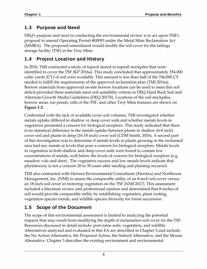
In 2016, TMI contracted a study of topsoil stored in topsoil stockpiles that were identified to cover the TSF (KP 2016a). This study concluded that approximately 354,000 cubic yards (CY) of soil were available. This amount is less than half of the 766,000 CY needed to fulfill the requirements of the approved reclamation plan (TMI 2016a). Borrow materials from approved on-site borrow locations can be used to meet this soil deficit provided these materials meet soil suitability criteria in DEQ Hard Rock Soil and Alternate Growth Media Guidelines (DEQ 2017b). Locations of the soil stockpiles, borrow areas, toe ponds, cells of the TSF, and other Troy Mine features are shown on Figure 1-2.
Confronted with the lack of available cover soil volumes, TMI investigated whether metals uptake differed in shallow or deep cover soils and whether metals levels in vegetation presented a concern for biological receptors. This study indicated that there is no statistical difference in the metals uptake between plants in shallow (6-8 inch) cover soil and plants in deep (16-18 inch) cover soil (CDM Smith, 2016). A second part of this investigation was to determine if metals levels in plants growing in the reclaimed area had any metals at levels that pose a concern for biological receptors. Metals levels in vegetation in both shallow and deep cover soils were found to contain low concentrations of metals, well below the levels of concern for biological receptors (e.g. meadow vole and deer). The vegetative success and low metals levels indicate that phytotoxicty is not a concern 20 to 30 years after seeding and planting occurred.
TMI also contracted with Herrera Environmental Consultants (Herrera) and Northwest Management, Inc. (NMI) to assess the comparable utility of an 8-inch soil cover versus an 18-inch soil cover in restoring vegetation on the TSF (NMI 2017). This assessment included a literature review and professional opinion and determined that 8-inches of soil would provide comparable utility by establishing vegetation, plant rooting, vegetation species trends, and wildlife species diversity for forest succession.
1.5 Scope of the Document The scope of this environmental assessment is limited to analyzing the potential impacts that may result from modifying the depth of reclamation soil cover for the TSF. Resources discussed in detail include: post-mine soils, vegetation, and wildlife. Alternatives analyzed and evaluated in this EA are described in Chapter 2 and include: the No Action Alternative, the Proposed Action, the Subsoil Alternative, and the Mosaic Alternative. Chapter 3 describes the existing environment and environmental
4
Chapter 1 Propose and Benefits
consequences from implementation of the alternatives. Chapter 4 lists the preparers and Chapter 5 has the references.
5
FIGURE 1-2Tailings Storage Facility Site Features
TROY MINE, INC
Figure 1-2 Facility Map.indd - JHD - 7/08/2017
Lake
Cre
ek
Lake Cree
k
Chapter 1 Propose and Benefits
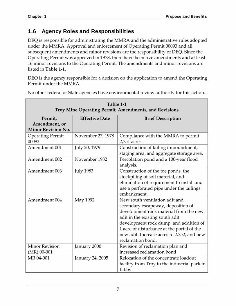
1.6 Agency Roles and Responsibilities DEQ is responsible for administrating the MMRA and the administrative rules adopted under the MMRA. Approval and enforcement of Operating Permit 00093 and all subsequent amendments and minor revisions are the responsibility of DEQ. Since the Operating Permit was approved in 1978, there have been five amendments and at least 16 minor revisions to the Operating Permit. The amendments and minor revisions are listed in Table 1-1.
DEQ is the agency responsible for a decision on the application to amend the Operating Permit under the MMRA.
No other federal or State agencies have environmental review authority for this action.
Table 1-1 Troy Mine Operating Permit, Amendments, and Revisions
Permit, Amendment, or
Minor Revision No.
Effective Date Brief Description
Operating Permit 00093
November 27, 1978 Compliance with the MMRA to permit 2,751 acres.
Amendment 001 July 20, 1979 Construction of tailing impoundment, staging area, and aggregate storage area.
Amendment 002 November 1982 Percolation pond and a 100-year flood analysis.
Amendment 003 July 1983 Construction of the toe ponds, the stockpiling of soil material, and elimination of requirement to install and use a perforated pipe under the tailings embankment.
Amendment 004 May 1992 New south ventilation adit and secondary escapeway, deposition of development rock material from the new adit in the existing south adit development rock dump, and addition of 1 acre of disturbance at the portal of the new adit. Increase acres to 2,752, and new reclamation bond.
Minor Revision (MR) 00-001
January 2000 Revision of reclamation plan and increased reclamation bond
MR 04-001 January 24, 2005 Relocation of the concentrate loadout facility from Troy to the industrial park in Libby.
7
Chapter 1 Propose and Benefits
Table 1-1 Troy Mine Operating Permit, Amendments, and Revisions
Permit, Amendment, or
Minor Revision No.
Effective Date Brief Description
MR 05-002 June 23, 2005 Approval of Weed Control Plan for use of Forest Service approved herbicides
MR 05-003 January 5, 2006 Installation of two pump back systems below the TSF
MR 07-001 March 16, 2007 Cost of reclaiming potential subsidence area along the East Fault resulting from underground mining
MR 09-002 November 5, 2009 Mining of the C-Beds at Troy, and a permit boundary relocation at the mine site increasing permit area to 2,782.3 acres
MR 10-001 May 26, 2010 Installation of new water monitoring wells and a piezometer for sampling at the tailings impoundment
MR 10-002 July 25, 2011 Raise height of tailings impoundment MR 10-003 September 3, 2010 Approval of pipeline spill response plan MR 10-004 May 10, 2010 Temporary loadout site in the industrial
park in Libby to replace the loadout facility destroyed by fire
MR 10-005 December 21, 2010 Safety improvements along FS Road #4626
MR 11-001 February 16, 2011 Permanent loadout facility to replace the one that was destroyed by fire
MR 12-001 May 27, 2012 Mining I-Bed resource Amendment 005 September 11, 2012 Revised Reclamation Plan MR 14-001 September 24, 2014 Fissure monitoring and remediation Draft Amendment 006
Submitted December 16, 2016
Revised Reclamation Plan to allow 8-inch soil cover on TSF (purpose of this EA)
MR 17-001 April 10, 2017 Clarifying the soil laydown language allowing multiple soil lifts
MR 17-002 May 16, 2017 Additional potential decant pond locations on the Eastern Side of the tailings impoundment
8
Chapter 1 Propose and Benefits
1.7 Public Participation DEQ announced on February 7, 2017 that TMI submitted an application for a permit amendment. The announcement took the form of a legal notice published in the Western News, a press release and article in the Western News, information on DEQ’s website, and a post on the DEQ Facebook page. The public will have an opportunity to submit comments on this Draft EA. In the Final EA, DEQ will respond to the public comments received on the Draft EA.
9
Chapter 2 Description of Alternatives
2.1 Introduction The No Action Alternative reflects the current, approved reclamation plan for the TSF and is a benchmark the Proposed Action and other alternatives can be evaluated against. For this analysis, the No Action Alternative is TMI’s 2016 Approved Reclamation Plan (TMI 2016a) that describes reclamation elements for final closure of the Troy Mine (Figure 2-1). The 2016 Approved Reclamation Plan incorporates modifications and changes required from the 2012 ROD and EIS (United States Department of Agriculture [USDA] Forest Service, Kootenai National Forest [KNF] and DEQ 2012). The 2016 Approved Reclamation Plan requires an 18-inch soil cover over the entire TSF.
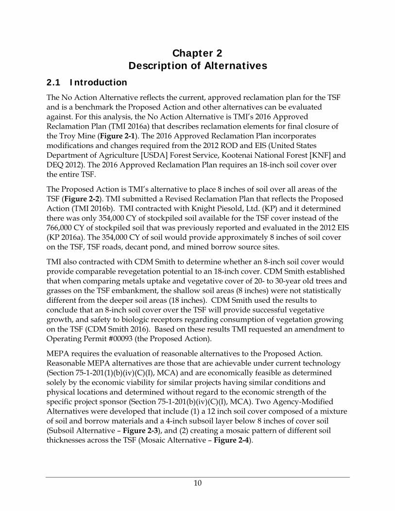
The Proposed Action is TMI’s alternative to place 8 inches of soil over all areas of the TSF (Figure 2-2). TMI submitted a Revised Reclamation Plan that reflects the Proposed Action (TMI 2016b). TMI contracted with Knight Piesold, Ltd. (KP) and it determined there was only 354,000 CY of stockpiled soil available for the TSF cover instead of the 766,000 CY of stockpiled soil that was previously reported and evaluated in the 2012 EIS (KP 2016a). The 354,000 CY of soil would provide approximately 8 inches of soil cover on the TSF, TSF roads, decant pond, and mined borrow source sites.
TMI also contracted with CDM Smith to determine whether an 8-inch soil cover would provide comparable revegetation potential to an 18-inch cover. CDM Smith established that when comparing metals uptake and vegetative cover of 20- to 30-year old trees and grasses on the TSF embankment, the shallow soil areas (8 inches) were not statistically different from the deeper soil areas (18 inches). CDM Smith used the results to conclude that an 8-inch soil cover over the TSF will provide successful vegetative growth, and safety to biologic receptors regarding consumption of vegetation growing on the TSF (CDM Smith 2016). Based on these results TMI requested an amendment to Operating Permit #00093 (the Proposed Action).
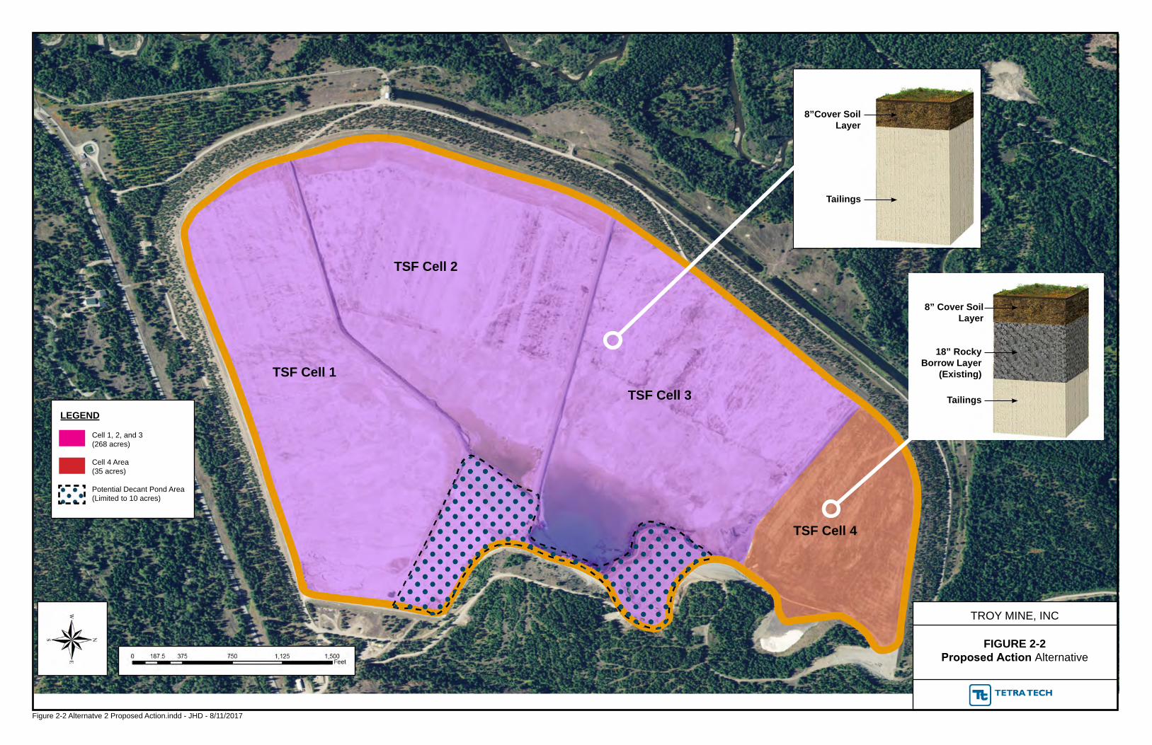
MEPA requires the evaluation of reasonable alternatives to the Proposed Action. Reasonable MEPA alternatives are those that are achievable under current technology (Section 75-1-201(1)(b)(iv)(C)(I), MCA) and are economically feasible as determined solely by the economic viability for similar projects having similar conditions and physical locations and determined without regard to the economic strength of the specific project sponsor (Section 75-1-201(b)(iv)(C)(I), MCA). Two Agency-Modified Alternatives were developed that include (1) a 12 inch soil cover composed of a mixture of soil and borrow materials and a 4-inch subsoil layer below 8 inches of cover soil (Subsoil Alternative – Figure 2-3), and (2) creating a mosaic pattern of different soil thicknesses across the TSF (Mosaic Alternative – Figure 2-4).
10
18” Mixed Soil/Borrow
Layer
Tailings
FIGURE 2-1 No Action Alternative
TROY MINE, INC
LEGEND
TSF Cell 1
TSF Cell 2
TSF Cell 3
TSF Cell 4
18” Mixed Soil/Borrow
Layer
18” Rocky Borrow Layer
(Existing)
Tailings
Cell 1, 2, and 3(268 acres)
Cell 4 Area(35 acres)
Potential Decant Pond Area (Limited to 10 acres)
Figure 2-1 Alternative 1 No Action.indd - JHD - 8/11/2017
Figure 2-3 Alternative 3 Subsoil Option.indd - JHD - 6/27/2017
12” Mixed Soil/Borrow
Layer
Tailings
8” Cover Soil Layer
Tailings
6” Cover Soil Layer
Tailings
18” RockyBorrow Layer
(Existing)
8” Cover Soil Layer
Tailings
FIGURE 2-4Mosaic Option Alternative
TROY MINE, INC
TSF Cell 1TSF Cell 3
TSF Cell 4
10” Subsoil Layer
Figure 2-4 Alternative 4 Mosaic Option.indd - JHD - 6/27/2017
Phase 1 Proposed Reclamation Area (138 Acres)
Phase 2 Proposed Reclamation Area (130 acres)
Cell 4 Area(35 acres)
Potential Decant Pond Area(Limited to 10 acres)
Conceptual Border BetweenAreas
LEGEND
Chapter 2 Description of Alternatives
The Subsoil Alternative would result in 12 inches of cover soil, subsoil, or a mixture over Cells 1, 2, and 3, and 6 inches of cover soil over the existing 18 inches of rocky borrow material in Cell 4. The Mosaic Alternative would result in areas with 8 inches of cover soil, areas with 10 inches of subsoil below 8 inches of cover soil, and areas with 6 inches of cover soil over the existing 18 inches of borrow material in Cell 4.
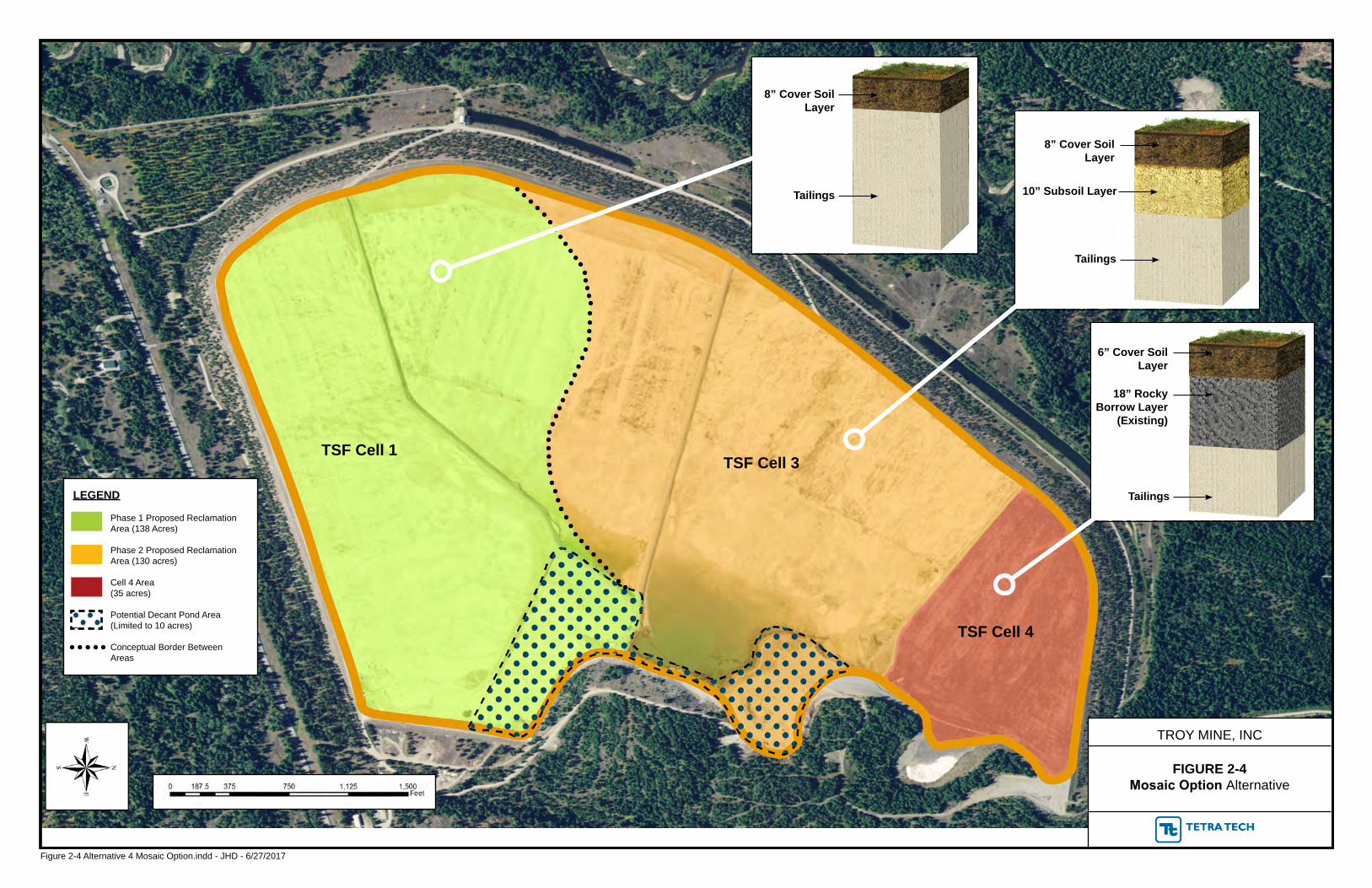
Table 2-1 provides a comparison of the components and activities for the No Action Alternative, Proposed Action, and the two Agency-Modified Alternatives. All alternatives would have the current tailings surface ripped to approximately 12 inches to alleviate compaction prior to placing the cover soil on the TSF.
Additional alternatives were considered, but were dismissed from detail consideration. See discussion in Section 2.5.
Table 2-1 Comparison of Troy Mine Closure EA Alternatives
Alternative Component Additional CY of Material Needed
No Action (Approved Reclamation Plan)
Place 18 inches of cover soil (could include borrow material) on 303 acres (all Cells in TSF)
379,260
Proposed Action (Amendment 006)
Place 8 inches of cover soil on 303 acres (all Cells in TSF)
0
Subsoil Alternative Place 12 inches of mixed soil/borrow on approximately 138 acres (Season 1 Proposed Reclamation). Place 8 inches of cover soil over 4 inches of subsoil on about 130 acres (Season 2 Proposed Reclamation). Place 6 inches of cover soil over 18 inches of existing rocky borrow material on approximately 35 acres in Cell 4.
106,607
Mosaic Alternative Place 8 inches of cover soil on about 138 acres (Season 1 Proposed Reclamation). Place 8 inches of cover soil over 10 inches of subsoil on about 130 acres (Season 2 Proposed Reclamation). Place 6 inches of cover soil over 18 inches of existing rocky borrow material on approximately 35 acres in Cell 4.
137,260
2.2 No Action Alternative
For this EA, the 2016 approved Revised Reclamation Plan (TMI 2016a) is considered to be the No Action Alternative. The main feature of the No Action Alternative is to place
15
Chapter 2 Description of Alternatives
18 inches of cover soil (could include a mix of soil and borrow material), with the upper 6 inches meeting DEQ Hard Rock Soil and Alternative Growth Media Guidelines (DEQ 2017b), on approximately 303 acres of the TSF. The Troy Mine originally reported 766,000 CY of cover soil in the 44-acre toe-pond soil stockpiles. The No Action Alternative would require about 733,260 CY of soil to cover the TSF with 18 inches.
Recent work to accurately determine the volume of cover soil at the Troy Mine site found only 354,000 CY of soil in the toe-pond soil stockpiles (KP 2016a). TMI would need to identify sources for up to an additional 379,260 CY of cover soil or borrow materials from an onsite source, or for purchase and haul, to construct the 18-inch TSF soil cover. Currently, Cell 4 has been temporarily covered with 18 inches of rocky borrow material to help minimize wind erosion, but the rocky borrow material does not meet soil suitability criteria in DEQ Hard Rock Soil and Alternate Growth Media Guidelines (DEQ 2017b). Under the approved reclamation plan, Cell 4 must have combined 18-inches of cover soil (could be a mix of soil and borrow). Prior to any additional cover soil applications, Cell 4 would be ripped to reduce compaction in the rocky borrow materials and to incorporate the existing vegetation. The additional cover soil would be placed on top of the ripped surface. An approved borrow source on the Troy Mine site has been identified on the east side of the TSF and just north of the decant pond. This area has already been disturbed and additional disturbance would need to occur to provide the volume of subsoil necessary to achieve 18 inches of cover soil.
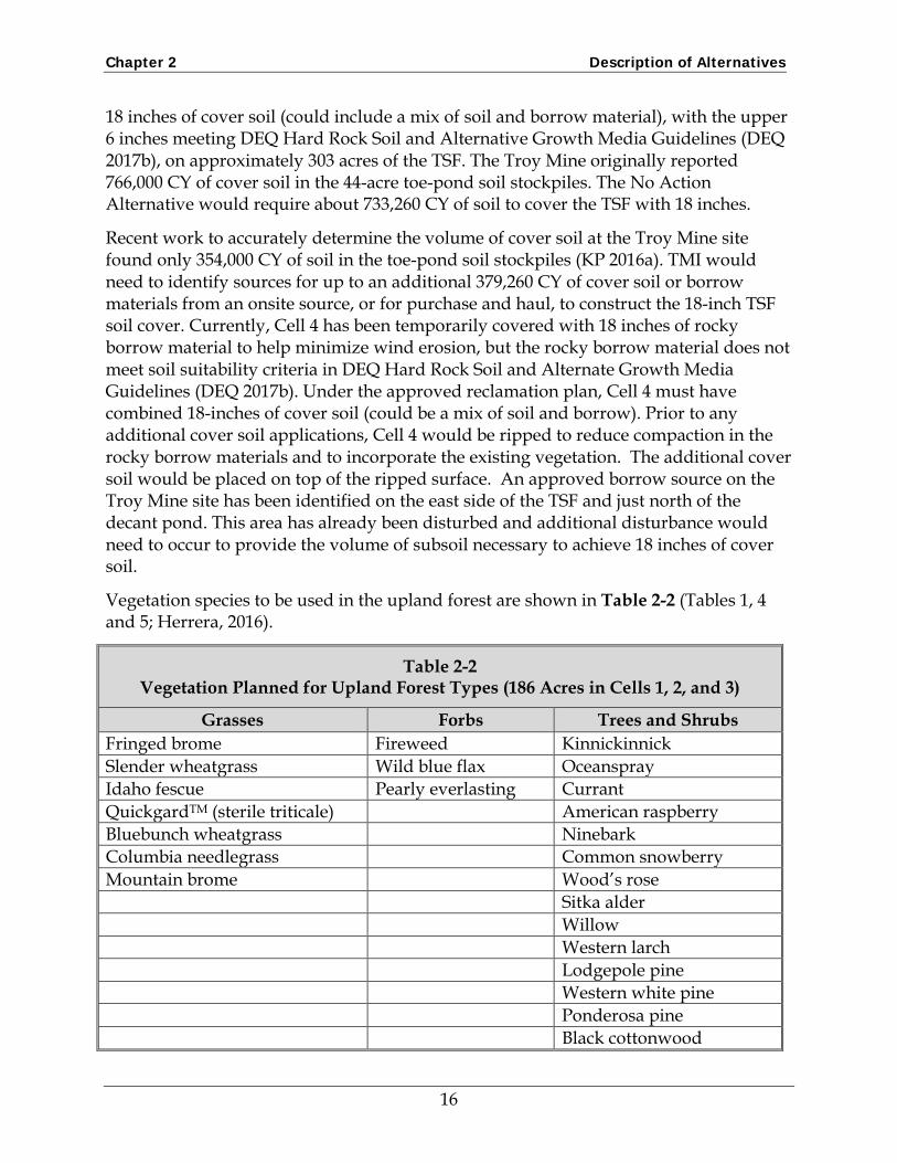
Vegetation species to be used in the upland forest are shown in Table 2-2 (Tables 1, 4 and 5; Herrera, 2016).
Table 2-2 Vegetation Planned for Upland Forest Types (186 Acres in Cells 1, 2, and 3)
Grasses Forbs Trees and Shrubs Fringed brome Fireweed Kinnickinnick Slender wheatgrass Wild blue flax Oceanspray Idaho fescue Pearly everlasting Currant QuickgardTM (sterile triticale) American raspberry Bluebunch wheatgrass Ninebark Columbia needlegrass Common snowberry Mountain brome Wood’s rose Sitka alder Willow Western larch Lodgepole pine Western white pine Ponderosa pine Black cottonwood
16
Chapter 2 Description of Alternatives
Table 2-2 Vegetation Planned for Upland Forest Types (186 Acres in Cells 1, 2, and 3)
Grasses Forbs Trees and Shrubs Douglas-fir
Vegetation species to be planted in the moist forest types are shown in Table 2-3 (Tables 3, 4, and 7; Herrera 2016).
Table 2-3 Vegetation Planned for Moist Forest Types (80 acres in Cells 1, 2, and 3)
Grasses Forbs Trees and Shrubs Tall mannagrass Fireweed Kinnickinnick Streambank wheatgrass Wild blue flax Oceanspray Slender wheatgrass Pearly everlasting Common snowberry Quickguard TM (sterile triticale) Wood’s rose Slender rush Sitka alder Tufted hairgrass Rocky Mtn. Maple Bluejoint reedgrass Red-osier dogwood Blue wildrye Lodgepole pine Total Black cottonwood Common snowberry
Vegetation species to be used on Cell 4 are shown in Table 2-4 (Tables 2, 4, and 6; Herrera, 2016).
Table 2-4 Vegetation Planned for Cell 4 (35 acres)
Grasses Forbs Trees and Shrubs Fringed brome Fireweed Oceanspray Slender wheatgrass Wild blue flax Currant Idaho fescue Pearly everlasting American raspberry Quickguard TM (sterile triticale) Ninebark Sandberg bluegrass Common snowberry Bluebunch wheatgrass Wood’s rose Columbia needlegrass
17
Chapter 2 Description of Alternatives
2.3 Proposed Action The Proposed Action consists of TMI’s application for amendment to their Troy Mine Operating Permit #00093. As part of the TSF reclamation and closure, TMI and their contractors investigated the available volume of stockpile soil and its soil quality for application toward successfully reclaiming the TSF to a comparable utility and stability as the surrounding areas. KP determined the volume of soil in the toe-pond soil stockpiles at the Troy Mine site was approximately 354,000 CY (KP 2016a). CDM Smith’s investigation focused on metals uptake in plants growing on reclaimed areas of the tailings embankment with shallow soils compared to plants growing on areas with deeper soils, and if metals levels in the plants were at levels that pose a concern for biological receptors. CDM Smith’s investigation (2016) found no statistical difference in metals levels in plants growing in the two soil depths, and that plant metals levels were below the levels of concern for biological receptors.
Because the volume of soil available is insufficient for an 18-inch soil cover and the tailings embankment reclamation grasses and trees have continued to grow and develop after 20 to 30 years in areas with less than 18 inches of soil, TMI is seeking an amendment to reduce the soil cover depth. The Proposed Action would allow for an 8-inch soil cover on the TSF.
Approximately 325,893 CY of cover soil materials would be required to construct an 8-inch soil cover over the approximately 303-acre TSF. KP estimated approximately 354,000 bank CY of cover soil in the 44 acres of soil stockpiles which could swell approximately 10 percent to an estimated volume of 389,400 CY of soil. This volume of soil would be sufficient to cover the TSF surface with 8 inches of soil and also reclaim the TSF roads, decant pond, and borrow source areas.
If there is a shortage of cover soil materials during construction, additional cover soil could be excavated from the approved borrow source areas east of the tailings impoundment (Attachment 8 of the ROD). Cover soil materials from borrow areas would need to meet the DEQ Hard Rock Soil and Alternative Growth Media Guidelines (DEQ 2017b) prior to use for reclamation. Alternatively, TMI agreed to work with DEQ to identify and use other potential cover soil borrow areas on Troy Mine owned property immediately surrounding the TSF.
TMI would use the cover soil in the 44 acres of toe-pond stockpiles first, and then would use borrow source materials to make up the difference, if needed. The TSF reclamation plan includes placing 8 inches of cover soil on top of a ripped TSF surface to minimize compaction. The existing vegetation on Cell 4 would be incorporated into 18 inches of rocky borrow material that was temporarily placed on Cell 4 to reduce wind erosion. Cell 4 would be ripped to reduce compaction and additional soil placed on top to satisfy the DEQ Growth Media Guidelines.
18
Chapter 2 Description of Alternatives
Additional areas around the TSF would require reclamation (regrading, soil cover, seeding); these include the toe-pond soil stockpile areas, reclaim pump station pond, maintenance pond, tailings impoundment roads, and the east borrow sites.
2.4 Agency-Modified Alternatives
DEQ developed two Agency-Modified Alternatives (Subsoil Alternative and Mosaic Alternative) to evaluate potential benefits associated with:
1. Providing additional plant-available water in the root-zone soil layer, particularly during periods of potential drought.
2. Diverse soil depths for a variety of potential habitats for shallow and deeper rooting plants.
3. Diverse soil depths and textures to increase vegetation diversity for reclamation and revegetation with comparable utility and stability as the surrounding areas, minimize future reseedings, and delayed revegetation bond release.
DEQ developed the Subsoil and Mosaic Alternatives to provide soil for increased rooting depths in certain areas on the TSF, increased plant-available water, and provide varying soil depths and textures for variable habitats.
2.4.1 Subsoil Alternative
The current approved reclamation plan (No Action Alternative) requires 18 inches of cover soil on the 303 acres of the TSF. The Subsoil Alternative would modify the cover soil depth by providing approximately 12 inches of a cover soil on about 268 acres of the TSF and 6 inches of soil over 18 inches of rocky borrow material on 35 acres in Cell 4 (Figure 2-3). The approximate 138 acres in the Season 1 Proposed Reclamation area would receive a total of 12 inches of cover soil consisting of a mixed soil and borrow material that meets DEQ Hard Rock Soil and Alternate Growth Media Guidelines criteria (DEQ 2017b). The approximate 130 acres in the Season 2 Proposed Reclamation area would also receive a total of 12 inches of cover soil, but would be composed of an 8 inch layer of fine-textured soil over a 4-inch layer of coarse-textured subsoil material. Because the existing tailings surface would be ripped prior to spreading the subsoil, the subsoil layer would have a variable thickness and undulating lower boundary, but would have the volume equal to a 4-inch layer. The subsoil material would be obtained from the onsite, approved borrow source area east of the TSF. The approximately 35 acres in Cell 4 currently have 18 inches of rocky borrow material in place. Cell 4 would be ripped to reduce compaction in the rocky borrow materials (similar to all alternatives) and to incorporate the current vegetation. The ripped areas would then receive 6 inches of cover soil.
19
Chapter 2 Description of Alternatives
2.4.2 Mosaic Alternative
The Mosaic Alternative was conceptually based on pre-mine soil surveys that showed variations in soil depth (Stearns-Roger 1975). The Mosaic Alternative would reclaim about 138 acres in the first year of reclamation with 8 inches of cover soil, similar to the Proposed Action. The approximately 130 acres in the second year of reclamation would first receive a 10-inch subsoil layer and then be covered with 8 inches of soil, for a combined 18 inches of cover soil. The subsoil material would be obtained from an onsite borrow source area east of the TSF, which is already approved and disturbed.
Similar to the Subsoil Alternative, the about 35 acres in Cell 4 would be ripped to incorporate the current vegetation and reduce compaction in the rocky borrow materials (similar to all alternatives), and the ripped areas would then receive 6 inches of soil.
2.5 Alternatives Considered But Dismissed
Additional alternatives were considered and evaluated. Those dismissed from detailed consideration are explained in Table 2-5.
Table 2-5 Alternatives Considered But Dismissed
Alternative Considered Reason for Dismissing Locate, permit, and obtain soil and soil-like materials from undisturbed areas near TSF.
Would create additional disturbed areas and remove functioning ecosystems; would require additional reclamation.
Import soil materials from commercial pits outside the TSF area.
Would create additional disturbance and remove functioning ecosystems that would need to be reclaimed.
Purchase soil amendments (compost, other organics) from commercial vendors to mix with soil to improve soil quality and somewhat increase quantity.
Soil physical properties and organic matter content of stockpiled soils are not restrictive to plant growth. Soil amendments may provide short-term benefits, but would have minimal long-term utility.
Purchase soil amendments (compost, other organics) from commercial vendors to till into the upper tailings materials.
The benefits of adding amendments needed to ameliorate lack of nutrients, soil microorganisms, lack of nutrient cycling, and uniform particle size may provide short-term benefits, but would have minimal long-term utility.
20
Chapter 2 Description of Alternatives
2.6 Agency Preferred Alternative At the Draft EA stage, DEQ’s preferred alternative is the Mosaic Alternative. After public comment, DEQ may select one of the other alternatives.
21
Chapter 3 Affected Environment and Environmental Consequences
Chapter 3 Affected Environment and Environmental Consequences
Information in this chapter describes the relevant resource components of the existing environment. Only resources that could be affected by the alternatives are described. The resources are post-mine soils, vegetation, and wildlife. After the environment of each resource is described, the impacts of the No Action Alternative, Proposed Action, Subsoil Alternative, and Mosaic Soil Cover Alternative are discussed.
3.1 Location Description and Study Area The project location and associated study area include the entire TSF, soil stockpiles in the toe-pond area, the approved borrow areas, plus any additional areas identified by the technical disciplines as "resource analysis areas" that are beyond the mine permit area. Resource analysis areas are identified for certain technical disciplines, but not all. By definition, the resource analysis areas that extend beyond the mine permit boundary are included in the "study area".
3.2 Soils
3.2.1 Affected Environment
The pre-mine soils were salvaged from the TSF footprint and stockpiled for ultimate reclamation of the TSF. The 44-acre toe-pond soil stockpiles were sampled and characterized by KC Harvey Environmental (KC Harvey) in August 2015, by excavating six backhoe test pits across the stockpiles. The soils were analyzed for soil physical and chemical properties important for reclamation (Table 3-1). The stockpiled soils varied in coarse fragment percentage, texture, and organic matter percentage due to the inherent variability in the native soils salvaged, but were similar in pH.
TMI discontinued active mining and began mine closure activities in 2016. An initial effort to reclaim the TSF included a soil investigation to assess the volume of available soil in the existing toe-pond soil stockpiles (KP 2016a). This soil investigation found the volume of stockpiled soil was not sufficient to cover the TSF with 18 inches of cover soil as prescribed in the approved Reclamation Plan (TMI 2016a). Excavation to remove the soil stockpiled in the toe-ponds area would retain the toe ponds and result in removing approximately 354,000 CY of stockpiled cover soil.
The tailings contain a higher percentage of sand particle size; have lower water holding capacity, and a lighter bulk density compared to the stockpiled cover soils. The tailings are nutrient deficient and have moderately alkaline pH (8 to 8.4). The tailings would tend to be droughty, but not so much as to prohibit their use in the soil profile (DEQ 2016).
DEQ evaluated the KP reported total metals and plant-available metals levels in the tailings to determine if metal levels could impact revegetation if the tailings were used
22
Chapter 3 Affected Environment and Environmental Consequences
as subsoil (DEQ 2016). Copper levels were the greatest concern with total copper levels in the tailings from 437 to 964 milligrams per kilogram and plant-available copper levels from 41 to 86 milligrams per kilogram. The level of plant-available copper in soil that may be detrimental is highly variable between plant types and soil types; however, in literature review 100 milligrams per kilogram is a level of copper in surface soil that could be phytotoxic and excessive (Kabata-Pendias and Pendias 1984).
Cell 4 was covered with approximately 18 inches of pit-run borrow material in 2010 to reduce wind-blown dust from the dry TSF surface. The rocky borrow materials were sampled and characterized in August 2015 (KC Harvey 2016) and found to have a general loam to silt loam soil texture and 49 to 70 percent coarse fragments. The high coarse fragment content with resulting lower percentage of fine-size particles cause these materials to have low water-holding capacity and low nutrient content. The rocky borrow materials were effective at reducing wind-blown dust.
Table 3-1 Summary of TSF Soil Stockpiles (KC Harvey 2016)
Sample ID
Depth (in)
Coarse Fragment (%)
Sand (%)
Silt (%)
Clay (%)
Texture pH OM (%)
SP-1 0-18 27 44 43 13 L 6.0 1.8 18-96 16 30 55 15 SiL 6.1 3.4 102 + <2 30 55 15 SiL 6.0 3.1
SP-2 0-18 46 52 37 11 L 6.0 1.3 18-96 <2 12 79 9 SiL 6.1 1.1
SP-3 0-18 6 26 59 15 SiL 5.9 6.7 18-96 <2 13 72 15 SiL 5.9 3.1
SP-4 0-18 27 46 45 9 L 5.8 3.6 18-96 <2 8 75 17 SiL 6.1 3.8
SP-5 0-18 9 20 65 15 SiL 6.0 2.6 18-96 <2 30 55 15 SiL 5.8 4.1
3.2.2 Environmental Consequences Common to All Alternatives
Soil salvage, handling, stockpiling, and redistribution would result in some degradation of soil aggregation and structure that are key factors affecting soil-water interactions, erosion, nutrient cycling, susceptibility to compaction, and the support of plant life. Some inherent reduction in soil quality and function, compared to pre-mine soils, would be expected under all alternatives, especially during soil handling, storage, and redistribution. After the soil would be respread and the areas reseeded, the soil structure and aggregation (physical properties) and pH, electrical conductivity, cation-
23
Chapter 3 Affected Environment and Environmental Consequences
exchange capacity, and organic matter content (chemical properties) would be expected to improve under pedigenic (soil forming) processes that could take decades for the soil to return to pre-mine conditions.
All alternatives would include ripping the current upper surface (tailings for Cells 1, 2, and 3; rocky borrow material in Cell 4), to approximately 12 inches to alleviate compaction prior to placing any cover soil on those areas (deeper in Cell 4). The ripping of the rocky borrow material in Cell 4 would reduce the compaction and incorporate the existing vegetation into the materials. Cover soil handling would use standard reclamation techniques to minimize soil compaction and prepare the soil for seeding.
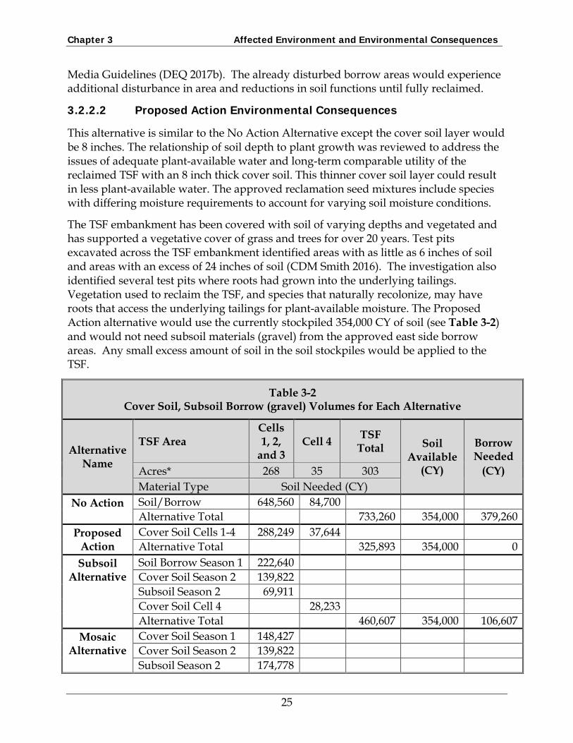
The approved reclamation plan (No Action alternative) requires 18 inches of soil on top of the TSF surface which equates to a volume of 733,260 CY (Table 3-2). The other three alternatives would have variable depths of cover soil, or cover soil and subsoil, and the calculated volumes of soil needed are also provided in Table 3-2. The exact volume of stockpiled soil for the TSF reclamation was unknown when the current reclamation plan was approved. The approved plan provided for using subsoil materials (gravel) located in the east side borrow area to make up potential deficits in the needed cover soil volume. The cover soil and subsoil materials (gravel) volume deficits and surpluses for the four alternatives are in Table 3-2.
The tailings contain a higher percentage of sand particle size; have lower water holding capacity, and a lighter bulk density compared to the stockpiled cover soils. The tailings are nutrient deficient and have moderately alkaline pH (8 to 8.4). The tailings would tend to be droughty, but not so much as to prohibit their use in the soil profile (DEQ 2016). Feld observations described in the embankment vegetation sampling data summary report document tree and forb roots penetrating into the tailings material (CDM-Smith 2016). The utilization of tailings for plant root-zone development is further supported within the scientific literature through research regarding reclamation of forest vegetation and plant root-biomass over surface mine tailings in Canada and the United States (NMI 2017).
The following sections describe additional environmental consequences specific to each alternative.
3.2.2.1 No Action Alternative Environmental Consequences
This alternative would provide 18 inches of cover composed of stockpiled soil and subsoil materials (gravel).
To implement this alternative, 379,260 CY of subsoil materials (gravel) would need to be obtained and transported to the TSF, in addition to the 354,000 CY of soil currently in the toe-pond soil stockpiles (see Table 3-2). Consequently, this alternative would result in additional disturbance in the approved subsoil borrow source area located east of the TSF. This would provide subsoil materials (gravel) that would meet DEQ Soil Growth
24
Chapter 3 Affected Environment and Environmental Consequences
Media Guidelines (DEQ 2017b). The already disturbed borrow areas would experience additional disturbance in area and reductions in soil functions until fully reclaimed.
This alternative is similar to the No Action Alternative except the cover soil layer would be 8 inches. The relationship of soil depth to plant growth was reviewed to address the issues of adequate plant-available water and long-term comparable utility of the reclaimed TSF with an 8 inch thick cover soil. This thinner cover soil layer could result in less plant-available water. The approved reclamation seed mixtures include species with differing moisture requirements to account for varying soil moisture conditions.
The TSF embankment has been covered with soil of varying depths and vegetated and has supported a vegetative cover of grass and trees for over 20 years. Test pits excavated across the TSF embankment identified areas with as little as 6 inches of soil and areas with an excess of 24 inches of soil (CDM Smith 2016). The investigation also identified several test pits where roots had grown into the underlying tailings. Vegetation used to reclaim the TSF, and species that naturally recolonize, may have roots that access the underlying tailings for plant-available moisture. The Proposed Action alternative would use the currently stockpiled 354,000 CY of soil (see Table 3-2) and would not need subsoil materials (gravel) from the approved east side borrow areas. Any small excess amount of soil in the soil stockpiles would be applied to the TSF.
Table 3-2 Cover Soil, Subsoil Borrow (gravel) Volumes for Each Alternative
Alternative Name
TSF Area Cells 1, 2,
and 3 Cell 4 TSF
Total Soil Available
(CY)
Borrow Needed
(CY) Acres* 268 35 303 Material Type Soil Needed (CY)
No Action Soil/Borrow 648,560 84,700 Alternative Total 733,260 354,000 379,260
Proposed Action
Cover Soil Cells 1-4 288,249 37,644 Alternative Total 325,893 354,000 0
Subsoil Alternative
Soil Borrow Season 1 222,640 Cover Soil Season 2 139,822 Subsoil Season 2 69,911 Cover Soil Cell 4 28,233 Alternative Total 460,607 354,000 106,607
Mosaic Alternative
Cover Soil Season 1 148,427 Cover Soil Season 2 139,822 Subsoil Season 2 174,778
25
Chapter 3 Affected Environment and Environmental Consequences
Table 3-2 Cover Soil, Subsoil Borrow (gravel) Volumes for Each Alternative
Alternative Name
TSF Area Cells 1, 2,
and 3 Cell 4 TSF
Total Soil Available
(CY)
Borrow Needed
(CY) Acres* 268 35 303 Material Type Soil Needed (CY) Cover Soil Cell 4 28,233 Alternative Total 491,260 354,000 137,260
* All acres are approximate Season 1 = 138 Acres Season 2 = 130 Acres Cell 4 = 35 Acres
3.2.2.3 Subsoil Alternative Environmental Consequences
The Subsoil Alternative was developed to provide deeper soils in areas of the TSF for additional plant-available water in the root-zone and to promote deeper rooting.
For this alternative the subsoil materials would have the volume equal to a 4-inch layer placed under the 8 inch soil cover. Cell 4 would have 6 inches of stockpiled cover soil on top of the existing 18 inches of borrow material (gravel). (Cell 4 Area – Figure 2-3).
This alternative would result in three different cover soil/subsoil variations across the TSF. The Season 1 Proposed Reclamation would have a 12-inch layer of mixed cover soil and borrow material that would provide a mid-range of cover soil thickness and resulting soil and plant relationships (e.g., water-holding capacity).
The Season 2 Proposed Reclamation Area would provide a total of 12 inches of soil over the TSF, and would have discrete subsoil and surface soil layers. The subsoil layer below the cover soil would provide additional plant-available water compared to no subsoil layer, or to additional soil with the same fine texture. Water movement (internal drainage and redistribution) through layered soil systems, composed of alternating layers of fine-textured soils and coarse-textured soils, is a well-documented process (Hillel 1982). Water is held in soil pore spaces under different capillary tensions depending on the pore size.
The coarse-textured subsoil, below the fine-textured cover soil, in the Season 2 Proposed Reclamation Area would provide plant-available water in two ways: (1) water would be held in the upper 8-inch layer and it would be uniformly and laterally distributed, and (2) water in the coarse-textured subsoil would be held under low capillary tension and would be readily available for plant roots that reach that horizon.
Cell 4 would have 6 inches of soil placed over the existing 18 inches of borrow.
26
Chapter 3 Affected Environment and Environmental Consequences
The Subsoil Alternative would require an additional 106,607 CY of subsoil borrow materials from the east side borrow areas (see Table 3-2). Excavation of the subsoil borrow on the east side of the TSF would disturb additional permitted acres which would experience impacts and reductions in soil functions until fully reclaimed.
3.2.2.4 Mosaic Alternative Environmental Consequences
The Mosaic Alternative would provide deeper soils in areas of the TSF to mimic natural soil occurrences as opposed to uniform soil depths.
The Mosaic Alternative would include three different cover soil/subsoil variations to reclaim the TSF (Figure 2-4). The cover soil and thickness for Cell 4 under the Mosaic Alternative would be identical to the Subsoil Alternative (described in section 3.2.3.3).
The variations in soil depths would provide for variations in vegetation cover. The shallow soil profile in the Season 1 Proposed Reclamation Area (Figure 2-4) favors vegetation that can be sustained on drier, shallower soils.
The relatively thick 10-inch subsoil horizon (Season 2 Proposed Reclamation Area – Figure 2-4) would provide the soil hydraulic conductivity benefits of the fine- over coarse-textured cover soil properties, water holding capacity, and rooting depth for plants. On Cell 4 the 6 inches of cover soil applied to the deep ripped 18-inch rocky borrow layer would result in the same benefits for efficient use of available cover soil as was discussed for the Subsoil Alternative (see section 3.2.3.3).
The Mosaic Alternative would require an additional 137,260 CY of subsoil borrow materials in addition to the 354,000 CY of stockpiled soil (see Table 3-2). Excavation of the subsoil borrow on the east side of the TSF would disturb additional permitted acres which would experience impacts and reductions in soil functions until fully reclaimed.
3.3 Vegetation
3.3.1 Affected Environment
A study was completed to evaluate current and native site vegetation (KC Harvey 2016). Based on adjacent sites north and west of the tailings, native vegetation includes forest habitat types western hemlock/queencup beadlily and the grand fir habitat type series (Pfister, et al. 1977). These types support mature grand fir, western larch, western hemlock, lodgepole pine, ponderosa pine, and western white pine tree species. Alder brush is present. Depending on the density of the overstory, shrubs may include alder, Oregon grape, rose, snowberry, spiraea, and bunchberry. Forbs noted include Soloman’s seal, oak fern, sweet cicely, pearly everlasting, and twinflower. Timothy was the only grass found. Another site was inventoried on the east side of the tailings where the forest is a Douglas-fir/pinegrass habitat type (Pfister, et al. 1977), with Douglas-fir, larch, and lodgepole trees; Douglas-fir, grand fir, and hemlock seedlings; Oregon grape, ninebark, and spiraea shrubs; oak fern, western yarrow, and strawberry forbs; and pinegrass as the only grass species. Some bare ground was observed. Noxious weeds
27
Chapter 3 Affected Environment and Environmental Consequences
present were Oxeye daisy and spotted knapweed. St. John’s wort, Dalmatian toadflax, meadow knapweed, Canada thistle, hawkweeds, and common tansy have also been observed on the site (Herrera 2016). Weed cover was sparse in native communities.
Troy Mine revegetated Cell 4 to control dust. Sample sites have non-native grass cover (sheep fescue and hard fescue with a small percentage of orchardgrass, Kentucky bluegrass, and timothy). Other plants found in trace amounts were common mullein, red clover, shiny leaf ceanothus, and white sweetclover. Noxious weeds were oxeye daisy, spotted knapweed, and St. Johnswort distributed as scattered individuals or in small patches (KC Harvey 2016).
The tailings embankment on the west side of the tailings impoundment has been revegetated. In general the ground cover and overstory are well established on the tailing embankment regardless of the soil depth over the tailings which range from 6 inches to at least 22 inches. Non-native seeded sheep fescue is present, as are trees that are sapling-sized (1 to 5 inches diameter at breast height) and pole-sized (5 to 9 inches diameter), generally 10 to 20 feet tall. Natural and seeded trees, shrubs, forbs, and grasses have reestablished in most areas of the tailings embankment, except in limited areas where the soil cover is thin (tailings showing through the soil). The upper embankment has not been planted to trees but trees are naturally colonizing. Ponderosa pine and lodgepole pine dominate with larch and western white pine saplings, and grand fir and spruce seedlings. Common native understory species are snowberry, kinnickinnick, buckwheat, and Oregon grape. Noxious weeds found were spotted knapweed, St. Johnswort, oxeye daisy, and Dalmatian toadflax (KC Harvey 2016, DEQ 2016).
3.3.1.1 Environmental Consequences Common to All Alternatives
Forest vegetation would become established through seeding and planting and natural regeneration, and the forest ecosystem would continue through successional stages over the long-term. There are hemlock seed sources adjacent to the TSF that would help revegetate the climax species as shade becomes more prominent. Over the very long term, a diversity of native species would reestablish from seeded and adjacent undisturbed areas.
At the TSF site the loamy texture, lower relative soil density low relative SAR, annual precipitation and deep (>100 inches) profile of the tailings will enable grasses, forbs, shrubs and tree species, native to the local climate conditions, to establish a complex ecosystem that is expected to trend toward the desired future climax conditions. Initial growth into the underlying tailings by grasses, forbs and tree seedlings will be limited. However, within as little as 4 to 10 years the hydrology and vegetative influences of this site are expected to promote increased site productivity and reduce near-surface pH in the underlying tailings. Within an expected natural progression, the forest ecosystem developed on the TSF site are expected to use the tailings as a rooting medium beyond
28
Chapter 3 Affected Environment and Environmental Consequences
the soil cover depth, further muting any differences in utility between 8 inches or 18 inches of soil depth (NMI 2017).
The utilization of tailings for plant root-zone development is further supported within the scientific literature through research regarding reclamation of forest vegetation and plant root-biomass over surface mine tailings in Canada and the United States (NMI 2017).
From the survey of current conditions on reclaimed areas, the spread of noxious weeds is well controlled by vigorous re-establishment of vegetation that soon covers disturbed areas before weeds can become established. This, along with the continued monitoring and treatment of any weeds found should minimize the spread and colonization of noxious weeds on the site.
DEQ reviewed the technical memorandum and reclamation and closure design investigation work completed by KP for TMI (DEQ 2016). DEQ concluded the tailings contain a higher percentage of sand particle size, have lower water holding capacity, and a lighter bulk density compared to the stockpiled cover soils. The tailings are nutrient deficient and have moderately alkaline pH (8 to 8.4). The tailings would tend to be droughty, but not so much as to prohibit their use in the soil profile.
DEQ evaluated the total metals and plant-available metals levels in the tailings to determine if metal levels could impact revegetation if the tailings were used as subsoil (DEQ 2016). Copper levels were the greatest concern with total copper levels in the tailings from 437 to 964 milligrams per kilogram and plant-available copper levels from 41 to 86 milligrams per kilogram. The level of plant-available copper in soil that may be detrimental is highly variable between plant types and soil types; however, in literature review 100 milligrams per kilogram is a level of copper in surface soil that could be phytotoxic and excessive (Kabata-Pendias and Pendias 1984).
The establishment of vegetation on reclaimed soils in the Troy Mine TSF area is expected to follow a similar trajectory as would the surrounding native forests following disturbance such as mechanical removal of all vegetation, or a wildfire. The fire-return-interval within the area of the Troy Mine TSF is approximately 50 to 100 years for moderate severity fires and 150 to 500 years for high severity fire (NMI 2017).
3.3.1.2 No Action Alternative Environmental Consequences
The 18 inches of cover soil would result in favorable conditions for plant establishment and growth because the deep cover soil would provide water-holding capacity, nutrient cycling, erosion protection, and opportunities for establishment of a diverse plant community. The current reclamation vegetation seed and planting mixes are for grasslands, low elevation forest, upper elevation forest, herbaceous wetlands, and forested wetlands, and include native species in each mix. Seeding methods (broadcast seeding, drilling, or hydroseeding), application of fertilizer and organic soil amendments, mulch (where needed), and irrigation would help vegetation become
29
Chapter 3 Affected Environment and Environmental Consequences
established and reduce the potential for noxious weeds to spread. Ongoing weed monitoring and control, use of weed-free seed and mulch would avoid spreading weeds during revegetation and help prevent their spread.
The need to supplement the available soil with additional subsoil borrow material would result in additional disturbance, which would result in additional impacts on vegetation.
Placement of soil on a level topography in a uniform thickness could negatively impact vegetation diversity. A monoculture could develop.
The Proposed Action includes a detailed revegetation plan describing cover soil placement, revegetation sequence, planting zones, seedbed preparation, woody debris, fertilization, seeding, trees and shrub planting, weed control, monitoring, and maintenance. The soil cover thickness on Cells 1, 2, and 3 would be approximately 8 inches, placed immediately on top of ripped tailings with similar textural characteristics. Trees growing in toe pond soil stockpiles will be excavated with a tree spade, kept in a tree nursery, and transplanted onto the TSF.
Native grasses and trees have continued to grow and develop after 20 to 30 years on the embankment. Based on the precipitation this area receives, proximity to water in the tailings, and fertilization and soil amendments planned, 8 inches of soil placed as described would provide sufficient plant-available water and the species composition would be similar to offsite native vegetation (NMI 2017).
Placement of soil on a level topography in a uniform thickness could negatively impact vegetation diversity. A monoculture could develop.
3.3.1.4 Subsoil Alternative Environmental Consequences
Tree transplanting and seed mixes as described in the Proposed Action would be the same in the Subsoil Alternative. Subsoil would be placed that would provide 12 to 18 inches of root zone material on top of the tailings and provide sufficient plant-available water for the revegetation species. Varying root zone depths would assist medium- to deep-rooting plant roots. The Subsoil Alternative would be expected to support tree establishment and growth. The forest establishment would be through successional stages.
3.3.1.5 Mosaic Alternative Environmental Consequences
Tree transplanting and seed mixes as described in the Proposed Action would be the same in the Mosaic Alternative. In this alternative, thicker soils would be placed in specific areas and thinner in others. Approximately 131 acres would have 8 inches of cover soil, 110 acres would have 18 inches of cover soil, and 35 acres would have 6 inches of cover soil over 18 inches of rocky borrow material. Providing varying rooting
30
Chapter 3 Affected Environment and Environmental Consequences
depths would increase vegetation diversity. The varying soil cover depths under the Mosaic Alternative would provide potential habitat for shallow rooting plants (grasses and forbs) and for deeper rooting plants (shrubs and trees). The Mosaic Alternative would be expected to support tree establishment and growth. The forest establishment would be through successional stages.
Placing soil of different thicknesses and varying textural materials would enhance vegetation diversity by providing distinct rooting depths and variations in water holding capacities.
3.4 Wildlife
3.4.1 Affected Environment
TMI’s current approved reclamation plan is to reclaim the area to wildlife habitat. The plan was developed from the ROD for Troy Mine Revised Reclamation Plan (DEQ and Forest Service 2012). The reclamation plan incorporates the changes from the 2012 ROD and EIS. DEQ may only approve a reclamation plan or an amendment to a reclamation plan that is consistent with the requirements and standards set forth in Section 82-4-336, MCA. The reclamation standard, for areas such as the TSF, is for the reclamation of the disturbed land to have comparable utility and stability as that of adjacent areas. DEQ determined the proposed modification to the depth of cover soil over the TSF meets the substantive requirements of the MMRA and associated rules and retains the authority to place stipulations on the final permit amendment.
The area provides habitat for federally listed threatened and endangered species (Canada lynx, wolverine, and grizzly bear), Forest Service sensitive species (black-backed-woodpecker, Coeur d’Alene salamander, common loon, fisher, flammulated owl, gray wolves, harlequin duck, peregrine falcon, townsend’s big-eared bat, and western toad) (U.S. Forest Service 2012) and other birds, ungulates, and amphibians. These species use the forested habitats with interspersed meadow grasslands in and around the mine facilities. Other species were evaluated and habitat was not found within the area (bald eagles, bighorn sheep, northern bog lemming, northern leopard frog). There is no old growth forest habitat that would be affected, therefore wildlife that use old growth, such as fisher, would not be affected.
The toe ponds have developed well established wetlands and open water habitats providing unique and beneficial wildlife and aquatic habitat including breeding habitat for the western toad, a Montana species of concern.
3.4.2 Environmental Consequences Common to All Alternatives
Local climax forest would be expected to develop over the next 150 and 500 years on the TSF in any alternative. Furthermore, as the forest trends toward climax species, wildlife species that use the habitat will change.
31
Chapter 3 Affected Environment and Environmental Consequences
As the vegetation on this site becomes established research has shown foraging ungulates (i.e., deer, elk and moose) and large omnivores (bears) as well as smaller mammal species and birds are expected to frequent this site for forage and habitat. As vegetation develops, increasing the height and density of the canopy, there will be a shift in timing of use by wildlife species as cover, forage, and vegetation go through natural successional changes. As the seral species begin to succeed into what will be the climax forest species composition of the area, it is expected there will be a parallel transition of wildlife species diversity and use that favors dense, closed-canopy forest conditions for thermal cover, nesting locations and other habitat characteristics of value (NMI 2017).
The 2012 EIS (DEQ and Forest Service 2012) evaluated impacts of the No Action Alternative. Impacts on wildlife from the other alternatives would be the same. The EIS concluded that there would be no impacts on grizzly bear. The EIS analysis also indicated that there would be no impacts on black-backed woodpeckers, common loon, flammulated owls, gray wolves, harlequin ducks or peregrine falcons. Some individuals such as salamanders and toad could be affected by heavy equipment crossing wet areas but not to the degree that their populations would be affected. Human activities and noise under any alternative could disturb some wildlife and cause them to avoid the area temporarily, but would have no long-term adverse effects. Revegetating with native vegetation will improve all types of wildlife habitat in the long term. All alternatives would retain the toe ponds and the wetlands habitat it provides. There would be no impact on the wetlands habitat or the western toad.
A study into metals uptake on existing shallow and deep cover soils showed that there is not statistical difference in the metals uptake between plants in shallow (6-8 inch) cover soil and plants in deep (16-18 inch) cover soil. Additionally, metals levels in vegetation in both shallow and deep cover soils were found to contain metals well below the levels of concern for biological receptors (e.g. meadow vole and deer). (CDM-Smith 2016).
3.4.2.1 No Action Alternative Environmental Consequences
The No Action Alternative is TMI’s current revised reclamation plan developed from the ROD for Troy Mine. The approved reclamation plan (TMI 2016a) requires TMI to place an 18-inch soil cover over the TSF. Implementing the approved reclamation plan could provide suitable habitat for wildlife species common to the area.
The Proposed Action would modify the approved reclamation plan to allow an 8-inch soil cover on the TSF. Placing 8 inches of soil and additional fertilizer and amendments would support vegetation diversity similar to off-site areas and consequently support similar wildlife habitat, and that the forest would eventually reach climax conditions. (NMI 2017). Implementing the proposed action could provide suitable habitat for wildlife species common to the area.
32
Chapter 3 Affected Environment and Environmental Consequences
3.4.2.3 Subsoil Alternative Environmental Consequences
The subsoil layer would provide some vegetation diversity which could provide additional wildlife habitat. Vegetation diversity could be a benefit to wildlife. Implementing the subsoil alternative could provide suitable habitat for wildlife species common to the area.
3.4.2.4 Mosaic Alternative Environmental Consequences
The mosaic alternative would provide additional vegetation diversity which could provide additional wildlife habitat. The areas of shallow cover soil could have preferential effects for vegetation that thrives on drier, less deep soils benefiting wildlife that utilizes this type of vegetation. The areas with varying soil depths would provide additional vegetation diversity and therefore likely greater wildlife diversity across the TSF. Vegetation diversity could be a benefit to wildlife.
Implementing the mosaic alternative could provide additional suitable habitat for wildlife species common to the area.
3.5 Cumulative Impacts
Cumulative effects are the collective effects on the human environment when considered in conjunction with other past, present, and future actions. Cumulative impact analysis under the MEPA rules requires DEQ to consider all past and present state and non-state actions. For future actions, DEQ needs only to evaluate those actions under concurrent consideration by any state agency. Concurrent actions include state agency actions through pre-impact statement studies, separate impact statement evaluation, or permit process procedures.
Analysis of cumulative environmental effects includes other actions that are related to all action alternatives by location or generic type. The purpose of this cumulative effects analysis is to ensure that DEQ’s decision considers the full range of effects of its action on the human environment.
The impacts of the proposed action and alternatives are limited to the geographical extent of the past mining with no potential for impacts from the current proposal to extend beyond the mine area. Therefore, the cumulative impacts study area for the post-mine soils, vegetation, reclamation, and wildlife resources is the mine permit area, including the TSF, the toe-pond soil stockpiles, and the approved borrow areas. The cumulative impacts study area includes all areas in which planned or expected actions could cumulatively affect the resources within the study area.
Present and past actions on soils, vegetation, reclamation, and wildlife include livestock grazing, hunting, general recreation, weed management, road maintenance, and the Troy Mine. These activities have probably had minimal overall effects on resources in the area which have been ongoing for many years and will continue to have negligible
33
Chapter 3 Affected Environment and Environmental Consequences
effects. No identified future actions are under current consideration by another state or federal agency within the cumulative impacts analysis area.
The soil cover alternatives would generally lead to successful reclamation, which, would also improve vegetation conditions and wildlife habitat. The soil cover alternatives and the past and reasonably foreseeable actions would cumulatively result in a minor and general improvement in the conditions of soils, vegetation, and wildlife habitat.
34
Chapter 4 List of Preparers
Chapter 4 List of Preparers
Table 4-1 List of Preparers
Department of Environmental Quality John Koerth Project Manager, MEPA
Coordinator, Reclamation Specialist
B.S., Agriculture
Craig Jones MEPA Asst. Coordinator B.A., Political Science Herb Rolfes Hard Rock Operating
Permit Section Supervisor, EA Reviewer
M.S., Land Rehabilitation B.A., Earth Space Science A.S., Chemical Engineering
Tetra Tech J. Edward Surbrugg
Project Manager, Soils and Reclamation
Ph.D., Soil Science M.S., Land Rehabilitation B.S., Range Ecology
Cameo Flood Asst. PM, Vegetation and Wildlife
B.S., Forestry
Shane Matolyak Reclamation Specialist M.S., Land Rehabilitation B.S., Environmental Science and Biology
Colin McCoy, P.E. Engineering B.S., Biological Systems Engineering
Mike DaSilva Technical Editing M.S., Biology B.A., Biology
Jim Dushin Graphics B.S., Wildlife Biology B.A., Forestry
35
Chapter 5 References
Chapter 5 References
CDM Smith. 2016. Data Summary Report, Troy Mine Tailings Storage Facility Embankment Vegetation Sampling, Troy Montana. December 15.
Herrera Environmental Consultants, Inc. (Herrera), 2016. Revegetation Plan. Troy Mine Tailings Storage Facility. Lincoln County, Montana. Prepared for Troy Mine, Inc. August 22.
Hillel, Daniel, 1982. Introduction to Soil Physics. Academic Press, Inc. p 236.
KC Harvey Environmental, LLC (KC Harvey). 2016. Characterization of Vegetation and Soil Properties at the Troy Mine, Lincoln County, Montana. Prepared for Troy Mine, Inc. January.
Knight Piesold Ltd. (KP). 2016a. Technical Memorandum: Troy Mine Soil Cover – Available Topsoil Volume and Cover soil Thickness Recommendations. August 8.
KP 2016b. Reclamation and Closure Design – Site Investigation Report. Knight Piesold Ltd. July 15.
Montana Department of Environmental Quality (DEQ). 2016. Review. Troy Mine Cover, Troy Mine Inc. Operating Permit 00093. Helena, Montana.
DEQ. 2016. Troy Mine Inspection Report, October 24-25.
DEQ. 2017a. Compliance Documentation and Draft Amendment, Amendment 006 to Operating Permit 00093. June 19.
DEQ. 2017b. DEQ Hard Rock Soil and Alternative Growth Media Guidelines. Draft. February.
Kabata-Pendias, A. and H. Pendias. 1984. Trace Elements in Soils and Plants. CRC Press, Inc. Boca Raton, Florida.
Montana DEQ and Forest Service. 2012. Final Environmental Impact Statement. Troy Mine Revised Reclamation Plan. Montana DEQ and Kootenai National Forest Three Rivers Ranger District. June.
Natural Resources Conservation Service (NRCS), 2014. Soil Map-Kootenai National Forest Area, Montana-Idaho. Web Soil Survey, National Cooperative Soil Survey.
Northwest Management, Inc. (NMI) 2017. A Comparative Soil Utility Report for the Troy Mine Tailings Storage Facility, Montana. March 10.
37
Chapter 5 References
Pfister, R.D., Kovalchik, B.L., Arno, S.F., and Presby, R.C. 1977. Forest habitat types of Montana. Gen. Tech. Rep. INT-GTR-34. Ogden, UT: U.S. Department of Agriculture, Forest Service, Intermountain Forest & Range Experiment Station. p 174. Available online https://www.fs.fed.us/rm/pubs_int/int_gtr034.pdf.
Stearns-Roger Inc. 1975. Baseline Soils for the Troy Mine. Included in the Mine Operating Permit.