16
2021 WOLF MONTANA FWP HUNTING AND TRAPPING REGULATIONS Gray Wolf Canis lupus photo by Donald M. Jones TURN IN POACHERS: CALL 1-800-TIP-MONT fwp.mt.gov UPDATED: Nov. 3, 2021

2021 WOLFMONTANA FWP HUNTING AND TRAPPING REGULATIONS
Gray Wolf Canis lupus photo by Donald M. Jones
TURN IN POACHERS: CALL 1-800-TIP-MONTfwp.mt.gov
UPDATED: Nov. 3, 2021
2 Turn In Poachers. Enough is Enough! Make the call: 1-800-847-6668
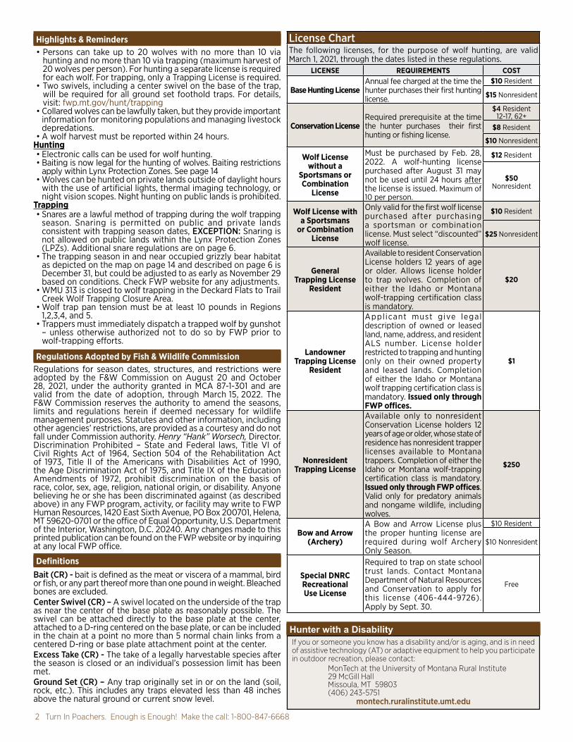
License ChartThe following licenses, for the purpose of wolf hunting, are valid March 1, 2021, through the dates listed in these regulations.
LICENSE REQUIREMENTS COST
Base Hunting LicenseAnnual fee charged at the time the hunter purchases their first hunting license.
$10 Resident
$15 Nonresident
Conservation LicenseRequired prerequisite at the time the hunter purchases their first hunting or fishing license.
$4 Resident 12-17, 62+
$8 Resident
$10 Nonresident
Wolf Licensewithout a
Sportsmans or Combination
License
Must be purchased by Feb. 28, 2022. A wolf-hunting license purchased after August 31 may not be used until 24 hours after the license is issued. Maximum of 10 per person.
$12 Resident
$50 Nonresident
Wolf License with a Sportsmans
or Combination License
Only valid for the first wolf license purchased after purchasing a sportsman or combination license. Must select “discounted” wolf license.
$10 Resident
$25 Nonresident
General Trapping License
Resident
Available to resident Conservation License holders 12 years of age or older. Allows license holder to trap wolves. Completion of either the Idaho or Montana wolf-trapping certification class is mandatory.
$20
Landowner Trapping License
Resident
Appl icant must give legal description of owned or leased land, name, address, and resident ALS number. License holder restricted to trapping and hunting only on their owned property and leased lands. Completion of either the Idaho or Montana wolf trapping certification class is mandatory. Issued only through FWP offices.
$1
Nonresident Trapping License
Available only to nonresident Conservation License holders 12 years of age or older, whose state of residence has nonresident trapper licenses available to Montana trappers. Completion of either the Idaho or Montana wolf-trapping certification class is mandatory. Issued only through FWP offices. Valid only for predatory animals and nongame wildlife, including wolves.
$250
Bow and Arrow (Archery)
A Bow and Arrow License plus the proper hunting license are required during wolf Archery Only Season.
$10 Resident
$10 Nonresident
Special DNRC Recreational Use License
Required to trap on state school trust lands. Contact Montana Department of Natural Resources and Conservation to apply for this license (406-444-9726). Apply by Sept. 30.
Free
Highlights & Reminders• Persons can take up to 20 wolves with no more than 10 via
hunting and no more than 10 via trapping (maximum harvest of 20 wolves per person). For hunting a separate license is required for each wolf. For trapping, only a Trapping License is required.
• Two swivels, including a center swivel on the base of the trap, will be required for all ground set foothold traps. For details, visit: fwp.mt.gov/hunt/trapping
• Collared wolves can be lawfully taken, but they provide important information for monitoring populations and managing livestock depredations.
• A wolf harvest must be reported within 24 hours.Hunting• Electronic calls can be used for wolf hunting.• Baiting is now legal for the hunting of wolves. Baiting restrictions
apply within Lynx Protection Zones. See page 14 • Wolves can be hunted on private lands outside of daylight hours
with the use of artificial lights, thermal imaging technology, or night vision scopes. Night hunting on public lands is prohibited.
Trapping• Snares are a lawful method of trapping during the wolf trapping
season. Snaring is permitted on public and private lands consistent with trapping season dates, EXCEPTION: Snaring is not allowed on public lands within the Lynx Protection Zones (LPZs). Additional snare regulations are on page 6.
• The trapping season in and near occupied grizzly bear habitat as depicted on the map on page 14 and described on page 6 is December 31, but could be adjusted to as early as November 29 based on conditions. Check FWP website for any adjustments.
• WMU 313 is closed to wolf trapping in the Deckard Flats to Trail Creek Wolf Trapping Closure Area.
• Wolf trap pan tension must be at least 10 pounds in Regions 1,2,3,4, and 5.
• Trappers must immediately dispatch a trapped wolf by gunshot – unless otherwise authorized not to do so by FWP prior to wolf-trapping efforts.
Regulations Adopted by Fish & Wildlife CommissionRegulations for season dates, structures, and restrictions were adopted by the F&W Commission on August 20 and October 28, 2021, under the authority granted in MCA 87-1-301 and are valid from the date of adoption, through March 15, 2022. The F&W Commission reserves the authority to amend the seasons, limits and regulations herein if deemed necessary for wildlife management purposes. Statutes and other information, including other agencies’ restrictions, are provided as a courtesy and do not fall under Commission authority. Henry “Hank” Worsech, Director.Discrimination Prohibited – State and Federal laws, Title VI of Civil Rights Act of 1964, Section 504 of the Rehabilitation Act of 1973, Title II of the Americans with Disabilities Act of 1990, the Age Discrimination Act of 1975, and Title IX of the Education Amendments of 1972, prohibit discrimination on the basis of race, color, sex, age, religion, national origin, or disability. Anyone believing he or she has been discriminated against (as described above) in any FWP program, activity, or facility may write to FWP Human Resources, 1420 East Sixth Avenue, PO Box 200701, Helena, MT 59620-0701 or the office of Equal Opportunity, U.S. Department of the Interior, Washington, D.C. 20240. Any changes made to this printed publication can be found on the FWP website or by inquiring at any local FWP office.
DefinitionsBait (CR) - bait is defined as the meat or viscera of a mammal, bird or fish, or any part thereof more than one pound in weight. Bleached bones are excluded.Center Swivel (CR) – A swivel located on the underside of the trap as near the center of the base plate as reasonably possible. The swivel can be attached directly to the base plate at the center, attached to a D-ring centered on the base plate, or can be included in the chain at a point no more than 5 normal chain links from a centered D-ring or base plate attachment point at the center.Excess Take (CR) - The take of a legally harvestable species after the season is closed or an individual’s possession limit has been met.Ground Set (CR) – Any trap originally set in or on the land (soil, rock, etc.). This includes any traps elevated less than 48 inches above the natural ground or current snow level.
Hunter with a DisabilityIf you or someone you know has a disability and/or is aging, and is in need of assistive technology (AT) or adaptive equipment to help you participate in outdoor recreation, please contact:
MonTech at the University of Montana Rural Institute29 McGill HallMissoula, MT 59803(406) 243-5751
montech.ruralinstitute.umt.edu
Visit fwp.mt.gov 32021 Wolf Hunting & Trapping Regulations
Legal Wolf – Any male or female wolf, including young-of-the-year.Non-target Capture (CR)- Capture of any animal that cannot be lawfully trapped, including domestic animals.Relaxing Snare – A relaxing snare has a snare lock that allows the snare loop to release constriction pressure on the captured animal when the cable is not taut (e.g., when the animal stops pulling, it will loosen). This means that the locking device on the snare cable operates both ways allowing the snare cable to move back and forth to some degree. Locks that only close or that use springs or other powering devices to hold them closed are not considered relaxing snares. See page 15 for examples of relaxing snares.Trap (MCA 87-6-101) – to take or harvest or participate in the taking or harvesting of any wildlife protected by the laws of the state by setting or placing any mechanical device, snare, deadfall, pit, or device intended to take wildlife or to remove wildlife from any of these devices.Wolf Management Unit (WMU) – Areas that define Montana’s wolf-hunting and trapping districts as specified under “Wolf Management Unit (WMU) Legal Descriptions.Obtain a License
Persons can take up to 20 wolves with no more than 10 via hunting and no more than 10 via trapping (maximum harvest of 20 wolves per person). For hunting, a separate license is required for each wolf. For trapping, only a trapping license is required. Completion of mandatory wolf trapping certification is required to trap wolves.
• A Wolf License is available at all Fish, Wildlife & Parks offices, FWP license providers, and online at fwp.mt.gov.
• A Wolf License must be purchased by February 28, 2022.• A Wolf License purchased after August 31 may not be used
until 24 hours after the license is issued.• The Conservation License allows hunters, anglers, and trappers
access to all legally accessible state school trust lands. Contact a DNRC office for regulations.
Licensing – Youth Hunting OpportunitiesA resident or nonresident youth 12 years of age or older may hunt any game species for which their license is valid. Those who will reach 12 years of age by January 16, 2022, may hunt any game species, for which their license is valid, after August 15 of the 2021 license year. Proof of hunter education must be presented at the time of purchase.• Apprentice Hunters - are not eligible to hunt wolves. Visit fwp.
mt.gov for details.• In order to carry or use a firearm for any reason, a youth under 14
years of age must be accompanied by a person having charge or custody of the youth, or be under the supervision of a qualified firearms safety instructor or an adult 18 years of age or older who has been authorized by the youth’s parent or guardian, MCA 45-8-344.
Residency It is unlawful to swear to or to affirm a false statement in order to obtain an original or duplicate resident hunting and/or fishing license OR to assist an unqualified applicant in obtaining a resident license.Resident
• To be a legal Montana resident and eligible to purchase any Montana resident fishing, hunting, and trapping licenses, as per MCA 87-2-102, you must: - Claim Montana as your principal or primary home or place of abode
- Have been physically living in Montana for at least 180 consecutive days immediately prior to purchasing a resident license
- Register your vehicle(s) in Montana - Be registered to vote in Montana if you’re registered to vote - Not possess current (or have applied for any) resident hunting, fishing, or trapping privileges in another state or country
- File Montana state income tax returns as a resident, if you are required to file
• Once you have established your residency, you must continue to meet all these requirements and physically reside in
Montana as your principal or primary place of abode for not less than 120 days per year (days need not be consecutive).
• To purchase an annual resident Conservation License, you will be required to show a valid Montana Driver’s License (MDL), a valid Montana Identification Card (MIC), or a valid Tribal Identification Card.
• If your MDL or MIC has been issued for less than six months, you may be required to show additional proof of residency. An out-of-state driver’s license is NOT an acceptable form of ID for resident license purchases. Contact your local FWP office for specifics.
• A person is NOT considered a resident for the purposes of this section if the person claims residence in any other state or country for any purpose.
Hunter/Trapper Education Requirements
Hunter Education for Firearm and Archery• If you were born after January 1, 1985, you are required to show
proof of completing a Montana Hunter Safety and Education Course (or an approved Hunter Safety Course from any other state or province) prior to applying for or purchasing a hunting license, whether the hunting license is for the rifle or archery season.
• Bowhunter requirements - in order to purchase a Montana Bow and Arrow license, a hunter must provide a certificate of completion of a National Bowhunter Education Course or provide any prior year’s archery license from any state or province.
• Montana law requires members of the armed forces and their dependents stationed in Montana to present a Montana hunter education certificate or similar certificate from any state or province when purchasing any Montana hunting license.
• Duplicates – Montana certificates of completion for the Montana hunter education and/or bowhunter education courses may be obtained from FWP’s website.
Wolf Trapper Certification – A person must attend and complete a wolf-trapping certification class before setting any trap for a wolf. Completion of either the Idaho or Montana wolf-trapping certification class will be recognized as meeting this requirement. A certificate will be awarded to those completing the Montana trapping certification class. This certification must be in possession of any person setting wolf traps and/or harvesting a wolf by trap.
LAWS AND RULESLawful Methods for Hunting Wolves MCA 87-6-401, CR
- Statute denoted by MCA.- Commission Rule denoted by CR.- Arm Rule denoted by ARM.
As a species in need of management, wolves may only be taken by hunting (firearms or archery) or trapping during the designated seasons.Archery Equipment (CR)• It is unlawful to use any chemical or explosive device attached to
an arrow to aid in the taking of wolves. • The following criteria define Archery Equipment: It is unlawful to
use, while hunting game during any Archery Only Season and in Archery Equipment Only areas, archery equipment that does not meet the following criteria:
Hunting Bow: A hunting bow for wolves shall be a longbow, flatbow, recurve bow, compound bow, or any combination of these designs.
- The bow must be a device for launching an arrow, which derives its propulsive energy solely from the bending and recovery of two limbs (includes bows with split limbs).
- The bow must be hand drawn by a single and direct uninterrupted pulling action of the shooter. The bowstring must be moved from brace height to the full draw position by the muscle power of the shooter’s body. The energy used to propel the arrow shall not be derived from any other source such as hydraulic, pneumatic, mechanical, or similar devices. These limitations shall not exclude the mechanical leverage advantage provided by eccentric wheels or cams, so long as the available energy stored in the bent limbs of the bow is the sole result of a single, continuous, and direct pulling effort by the shooter.
- The bow must be hand-held. One hand shall hold the bow and the other hand draw the bowstring. The bowstring must be moved and/or held at all points in the draw cycle entirely by muscle power

4 Turn In Poachers. Enough is Enough! Make the call: 1-800-847-6668
Firearms (CR)• Firearms, including rifles, handguns, muzzleloaders and shotguns
with 0, 00, or slugs; archery equipment; and crossbows are lawful for taking wolves. All other methods of take are prohibited.
• There is no rifle or handgun caliber limitation or magazine/round capacity restrictions for the taking of wolves.
• Rifle scopes with illuminated reticles, built-in range -finding capabilities, and “red dot” scopes are lawful for the taking of wolves.
Hunter Harassment (MCA 87-6-215)It is unlawful to:
• intentionally interfere with the lawful taking of a wild animal.• disturb an individual engaged in the lawful taking of a wild animal
with intent to prevent the taking of the animal.Hunting Hours (CR) - Authorized hunting hours for the taking of wolves on public lands begin one-half hour before sunrise and end one-half hour after sunset each day of the hunting season. See the official Sunrise-Sunset Tables listed on page 15. Hunter Orange Requirement (MCA 87-6-414) - A person may not hunt any game animals in this state or accompany any hunter as an outfitter or guide under any of the provisions of the laws of this state without wearing as exterior garments, above the waist, a total of not less than 400 square inches of hunter orange (fluorescent) material visible at all times while hunting. This section does not apply to a person hunting with a bow and arrow during the special archery season; or hunting wolves outside the general deer and elk season as authorized by commission rules. However, bowhunters hunting wolf during any portion of the general (firearm) seasons for deer, elk, antelope, moose, sheep, mountain goat, black bear, mountain lion must meet the hunter orange requirement while hunting.Indian Reservations• The F&W Commission has by rule, closed all lands within the
exterior boundaries of Montana’s Indian Reservations to the hunting of wolves with the use of state licenses unless provided for in a cooperative agreement between the Tribal Government and the State of Montana.
• Currently, there are no cooperative agreements between FWP and any of the Tribal Governments in Montana and as such the season for the hunting of wolves, by nonmembers, with a state license is closed. Please contact FWP for further information.
Interstate Wildlife Violator Compact (IWVC) - Montana is a member of the IWVC. Under the compact, member states recognize suspensions of hunting, fishing, or trapping privileges. It is unlawful for a violator whose privilege to hunt, fish, or trap is suspended to obtain or attempt to obtain a license, tag, or permit in a member state. For more information, call 406-444-2452.Kill Site Verification (ARM 12.6.1005) - At the request of a department Game Warden, it is required to return to the kill site of any game animal, game bird, wolf, or furbearer that has been hunted or trapped.Landowner Permission (MCA 87-6-415) - A person may not hunt or attempt to hunt furbearers, game animals, migratory game birds, nongame wildlife, predatory animals, upland game birds, or wolves while hunting on private property without first obtaining permission of the landowner, the lessee, or their agents. Regardless of whether the land is posted or not, hunters must have permission from the land owner, lessee, or their agent before hunting on private property. For the purposes of this section, the term “hunt” has the same meaning as provided in 87-6-101 and includes entering private land to: (a) retrieve wildlife; or (b) access public land to hunt.License and Permit Possession and Use MCA 87-6-301-314It is unlawful to:• Hunt or attempt to hunt for any wolf unless the person is carrying
the required license or permit at the time.• Refuse to produce a license or permit and the identification
used in purchasing a license or permit for inspection to a game warden.
• Alter or change a license in any material manner.• Loan or transfer any license to another person.
of the shooter until release. The bowstring must be released as a direct and conscious action of the shooter, either relaxing the tension of the fingers or triggering the release action of a hand-held release aid.
Exception: Physically disabled bowhunters certified by FWP with the Permit To Modify Archery Equipment (PTMAE) are exempted from the requirement of holding or shooting the bow with their hands.
> A bow is considered legal if it is at least 28 inches in total length. > The nominal percent of let-off for hunting bows shall be a maximum of 80 percent as advertised by the manufacturer.
Arrow: An arrow is a projectile at least 20 inches in overall length. The length of the arrow is measured from the rearward point of the nock to the tip of the broadhead.
- A broadhead is mounted on the fore end. - The arrow shall weigh no less than 300 grains with the broadhead attached.
- Arrows must have broadheads with at least two cutting edges and be at least 7/8 inch at the widest point. Expandable broadheads are legal as long as when expanded they are at least 7/8 inch at the widest point and weigh no less than 70 grains.
- Arrows equipped with lighted nocks are allowedThe following are not considered a hunting bow or legal archery equipment during the Archery Only Season or in an Archery Equipment Only area or hunting district:
- Crossbow - Any device with a gun-type stock or incorporating any device
or mechanism that holds the bowstring at partial or full draw without the shooter’s muscle power.
- Any bow for which a portion of the bow’s riser (handle) or any track, trough, channel, or other device that attaches directly to the bow’s riser contacts, supports, and/or guides the arrow from a point rearward of the bow’s brace height. This is not intended to restrict the use of standard overdraw systems.
- Electronic or battery-powered devices attached to a hunting bow or arrow. Exception: Camera devices attached to bows for the sole purpose of filming is allowed.
- A bow sight or arrow that uses artificial light, luminous chemicals such as tritium, or electronics. Exception: an arrow may have a lighted nock.
Check Stations (MCA 87-6-218) - All hunters are required by law to stop as directed at all designated check stations on their way to and from hunting areas, even if they have nothing to be checked.Disturbing Traps or Trapped Animals (MCA 87-6-601(4)) – A person may not destroy, disturb, or remove any trap or snare belonging to another person or remove wildlife from a trap or snare belonging to another person without permission of the owner of the trap or snare, except that from March 1 to Oct. 1 of each year a person may remove any snare from land owned or leased by the person if the snare would endanger livestock. This requirement does not apply to a law enforcement officer acting within the scope of the officer’s duty. Excess Take Resulting in an Unlawfully Harvested Animal (CR) - Excess take is defined as the take of a legally harvestable species after the season is closed or an individual’s possession limit has been met. • Hunters: If you or a member of your hunting party shoots a wolf
that results in an unlawfully taken animal, you should notify an FWP game warden or 1-800-TIP-MONT (1-800-847-6668) immediately and follow their instructions. DO NOT transport the animal until you’ve received instructions.
• Trappers: If a wolf trapper catches a wolf beyond the legal limit, the wolf must be released. FWP requests to be contacted to assess the potential to fit the wolf with a radio collar for management purposes.
Exposed Carcass or Baiting (CR) – Baiting is allowed for the hunting of wolves. No trap or snare may be set within 30 feet of an exposed carcass or bait that is visible from above. Restrictions apply within Lynx Protection Zones, see page 14.
Private Lands – Night Hunting• Wolves may be hunted on private lands at all hours of the day or night.• For night hunting on private lands, the use of artificial light, night vision scopes, infrared and thermal imaging
technology is allowed.

Visit fwp.mt.gov 52021 Wolf Hunting & Trapping Regulations
• Use a license issued to another person. • Attach the person’s license to a wolf killed by another person. • Have physical control over a valid and unused hunting license
or permit issued to another person while in any location that the species to be hunted may inhabit. This prohibition does not apply to a person who is carrying or has physical control over a license or permit issued to that person’s spouse or to any minor when the spouse or minor is hunting with that person.
License Validation and Tagging• A hunter must cut out the proper month and day of the kill from
the appropriate license and attach it to the animal before the carcass/hide is removed from the site of the kill or before the hunter leaves the site of the kill.
• To properly validate a license (sometimes referred to as a tag):• The triangles denoting the month and day the animal was
killed must be completely cut out and removed. Littering (MCA 75-10-212) - A holder of a Montana resident or nonresident hunting license or camping permit convicted of littering campgrounds, public or private lands, streams, or lakes while hunting, fishing, or camping shall forfeit any current Montana hunting, fishing or trapping license and the privilege to hunt, fish, camp, or trap in Montana for a period of one year.Marked or Radio-Collared Animals (CR) - It is lawful to shoot wolves that have radio collars, neck bands, ear tags, and/or other markers, but markers and radio collars must be returned to FWP. Please report the killing of a marked animal to the local FWP office.Motorized Vehicles (MCA 87-6-405) It is unlawful for anyone to:• Use a motor-driven vehicle off road on state land.• Use a motor-driven vehicle on a road or trail on state land if
that road or trail is posted as closed by the land management agency. This restriction applies only to state land and not to federal land. For more information related to state school trust lands, see page 13.
• Use a motor-driven vehicle other than on a road or trail designated for travel by a landowner unless permission has been given by that landowner.Off Road - Federal lands (CR)• Operate, on federal public lands, a motorized wheeled vehicle
off legal routes (including game retrieval). All federally approved travel plans on public lands in Montana have been adopted by the F&W Commission. Contact the appropriate land management agencies for travel plan information.
Outfitters and Guides (MCA 37-47-301)• A person may not act as an outfitter or guide or advertise or
otherwise represent to the public that the person is an outfitter or guide without first securing a license.
• It is unlawful to engage in outfitting/guiding while not licensed.• It is unlawful to hire an outfitter or guide not licensed by the
Department of Labor and Industry. For information, call 406-841-2300.
Predators and Nongame Hunting - Predators and nongame species are unprotected by federal and/or state law or regulation and can be hunted in Montana year-round without a license by both resident and nonresident hunters. The State Lands Recreational License is included in the Conservation License for the purpose of hunting, fishing, and trapping and is required to hunt predators and nongame species on state school trust lands. Permission must be obtained to hunt predators and nongame species on private land.• Predators are classified as coyote, weasel, (striped) skunk, and
civet cat (spotted skunk).
• Nongame species are defined as any wild animal not otherwise legally classified by statute or regulation in Montana. Examples include badger, raccoon, red fox, hares, rabbits, ground squirrels, marmots, tree squirrels, porcupines, and prairie dog.
Recorded Animal Sounds - It is lawful to use recorded or electrically amplified bird or animal calls or sounds or imitations of bird or animal calls or sounds to assist in the hunting, taking, killing or capturing of wolves.Transport of Wildlife• An individual other than the license holder may transport lawfully
taken, properly tagged wolves.• It is unlawful to ship, possess, transport, or take out of state
unlawfully killed wolves.• It is a violation of the Federal Lacey Act to transport an unlawfully
taken game animal across state boundaries.• If you are transporting lawfully taken wildlife (including parts
and/or products of live or dead animals) between the United States and any foreign country, you must complete a U.S. Fish and Wildlife Service declaration form. For further information contact the USFWS Wildlife inspector at 406-335-4350 or fws.gov.
• Questions concerning carcass transport may be directed to FWP Enforcement at 406-444-2452 or to your home state’s Wildlife Division.
Two-way Communication (ARM 12.6.1010)The use of two-way electronic communication is prohibited:
• While in the act of hunting game animals or wolves to aid in the taking or locating of live animals.
• While in the act of hunting mountain lion or bobcats with dogs, beginning when the dogs are placed or physically released on tracks or a scent trail.
• To avoid game check stations or FWP enforcement personnel.• To facilitate unlawful hunting activity. The use of two-way
electronic communication for the use of safety or other legitimate purposes is exempt.Two-way electronic communication includes, but is not limited to, the following; radios (walkie-talkies/CB), cell phones, text messages, and the use of social media or other electronic platforms, applications, or programs.
Unmanned Aerial Vehicles (CR) - The use of unmanned aerial vehicles (UAV) for the purposes of hunting wolves is prohibited. Waste of Game - Wolves are excluded from being considered as “suitable for food.” The remaining carcass may be taken in possession or be left in the field as per Montana law.
/
Wolf Trapping Laws and Rules Capture of Domestic Dogs (CR)– To improve the understanding
of accidental dog captures in traps, trappers must report such captures, excluding a trapper’s dog, to an FWP regional office within 24 hours of identifying the capture.
Checking and Placing Traps (CR)• Wolf traps shall be visually checked at least once every 48 hours.• Wolf traps must be removed within 24 hours of capturing an
individual trapper’s last legally harvested wolf. • Failure to pick up traps at the end of the trapping season or
attending them in a manner that wastes animals constitutes a misdemeanor per Montana law.
• A trapper must immediately dispatch any uncollared wolf captured that may be legally possessed.
• A trapper with an unfilled bag limit may release an uninjured collared wolf.
Closures (CR)– see page 8 for details. Landowner Permission (MCA 87-6-601)– Trappers must obtain permission of the landowner, lessee, or their agent before trapping on private land. Lynx Season Closed (CR)– Trapped lynx that are uninjured must be released immediately and the incident must be reported to a designated FWP employee within 24 hours of release. If a lynx is injured, trappers must immediately notify a designated FWP employee or an FWP regional office, to determine disposition and/or collection of the animal.Non-target Capture Requirement (CR) - The capture of any animal that cannot be lawfully trapped or snared, including domestic animals, must be reported to FWP within 24 hours. Any such animal that is uninjured must be released prior to the trapper leaving the

6 Turn In Poachers. Enough is Enough! Make the call: 1-800-847-6668
trap site. If unable to safely release the animal, call FWP. Exception: Any such animal that is injured or dead must promptly (with little or no delay) be reported to FWP to determine disposition and/or collection of the animal. Animals that may be lawfully trapped or snared are furbearers or wolves for which the season is open and an individual possession limit has not been reached, nongame wildlife and predators. A trapper may NOT trap any game animal, game bird or migratory bird. Occupied Dwellings (CR) – Killing ground sets, including all snares, set for animals larger than ground squirrels are unlawful within 1,000 feet of an occupied dwelling without written notification to the inhabitant.Setbacks (CR) - see page 8 for details. Snares (CR) - Snares are a lawful method of trapping during the wolf trapping season. Snaring is permitted on public and private lands consistent with trapping season dates, EXCEPTION: Snaring is not allowed on public lands within the Lynx Protection Zones (LPZs). Snares must be equipped with a loop stop that will close to a loop no smaller than 2.5 inches in diameter (stop placed at no less than 8 inches from end of loop). Snares must have a breakaway device rated at 1,000 lbs. or less installed on the loop end. Snares must be placed such that the bottom of the snare loop is at least 18 inches above the surface. Power-assisted (e.g., spring-loaded) snare locks are prohibited on wolf snares on public lands.Trap Identification (MCA-87-6-601(1)(a)) - A person may not use a trap or snare for the purpose of trapping or snaring a fur-bearing animal, a predatory animal, or a nongame species unless: the trap or snare is tagged with a numbered metal device identifying tag bearing an individual identifying number issued by the department or the owner’s name, and address, and telephone number unless the person is trapping or snaring on the person’s land or an irrigation ditch right-of-way contiguous to the person’s land.Trapped Wolves (CR) – Trappers must immediately dispatch wolves via gunshot. Trappers will be allowed to dispatch trapped wolves during all hours, including night time. You cannot “high-grade” your take by releasing a wolf that you do not want. If the wolf is radio-collared, see the section “Marked or Radio-Collared Animals.”Traps (CR) - Foothold traps are lawful methods during the wolf trapping season. The inside jaw spread of foothold traps must not exceed 9 inches. A minimum trap pan tension setting of 10 pounds is required in Regions 1, 2, 3, 4 & 5. Two swivels, including a center swivel on the base of the trap, are required for all ground set foothold traps. The swivel can be attached directly to the base plate at the center, attached to a D-ring centered on the base plate, or can be included in the chain at a point no more than 5 normal chain links from a centered D-ring or base plate attachment point at the center. Conibears may not be used to take wolves.
Procedures to Follow After Harvesting a WolfReporting Requirements• All successful wolf hunters and trappers must personally
report their wolf kill within 24 hours regardless of their intent to retain possession of the hide and skull by calling the Wolf Reporting Number at 1 877-FWP-WILD (1-877-397-9453) or 406-444-0356 so that FWP can monitor harvest. Hunters and trappers are required to provide: name, telephone number, ALS number, species, date of harvest, WMU, specific location (legal description), and sex when reporting a wolf harvest. Hunters could also report their harvest online at fwp.mt.gov through myfwp.
• When reporting a wolf harvest, it is unlawful to subscribe to or make any statement that is materially false.
Wolf 24-hour Harvest Reporting1-877-FWP-WILD (397-9453) or 406-444-0356 or at fwp.mt.gov
through myfwp - Successful hunters in backcountry areas will be allowed to report a wolf harvest within 24 hours of reaching a trailhead.
• A hunter or trapper that lawfully harvests a wolf and wishes to retain possession of the hide and skull, or captures a wolf that must be dispatched, is required to present the hide and skull to a designated FWP employee within 10 days after harvest for the purpose of:
- Inspection and registration of kill - Tagging the hide. The hide tag must thereafter remain attached to the hide until tanned.
• Any hide or skull not presented or registered to FWP personnel
within 10 days of harvest is subject to confiscation.• A person licensed to hunt and authorized to possess a carcass
of a wolf that requires mandatory department biological inspection may, after validating and attaching the license or tag in accordance with 87-6-411, transfer possession of all or part of that wolf to any person at any time after leaving the site of the kill, provided a statement of possession has been completed. The statement of possession must be on a form prescribed by the department and signed by the licensed person and the person or persons receiving possession, and must accompany the carcass or portion of carcass presented for inspection.
REMINDER: The hunter must still personally report their harvest by phone as required even if a transfer form is completed.• It is unlawful for anyone to possess, ship, transport, sell, or
purchase any wild wolf harvested in Montana, or part thereof, unless the animal has been tagged as prescribed.
• A hunter or trapper that lawfully harvests a wolf and does not wish to retain possession of the hide and skull, is still required to call the wolf reporting number within 24 hours as described above and personally present (by direct communication in person or on the phone) the above harvest information to a designated FWP employee within 10 days after harvest.
Harvest Monitoring and ClosureHarvest Monitoring:Harvests will be updated on the MTFWP website at myfwp.
mt.gov/fwpPub/speciesHuntingGuide?wmrSpeciesCd=GW between 11am and 1 pm daily. • A harvest of 450 wolves shall initiate a commission review
with potential for rapid in-season adjustments to hunting and trapping regulations. Thereafter the commission shall be similarly re-engaged at intervals of additional 50 wolves harvested, if season adjustments allow for additional wolf harvest. The following harvests by any Region alone shall initiate a commission review:
• Region 1: 195 wolves, Region 2: 116 wolves, Region 3: 82 wolves, Region 4: 39 wolves, Region 5: 11 wolves, Region 6: 3 wolves, Region 7: 4 wolves
• A non-target capture of one lynx or one grizzly bear shall initiate a commission review with potential for rapid in-season adjustments to trapping regulations. The commission shall be similarly re-engaged for any additional non-target capture of lynx or grizzly bear.
Resident and nonresident hunters and trappers may harvest any wolf in any open WMU statewide during the archery only, general and trapping seasons. A person can take up to 20 wolves with no more than 10 via hunting and no more than 10 via trapping (maximum harvest of 20 wolves per person). For hunting, a separate license is required for each wolf. For trapping, only a Trapping License is required.
Archery Only Season: September 4 - September 14, 2021 General Season: September 15 - March 15, 2022Trapping Season: Season dates for trapping wolves will be the first Monday after Thanksgiving to March 15 for the entire state. For those districts in and near occupied grizzly bear habitat as depicted on the map on page 14, the department will apply a floating open season date that could start the Monday after Thanksgiving (November 29, 2021), or any day thereafter as determined by the department based upon a real time reading of conditions. If the department does not select a date prior to December 31, then the season will open on December 31 and close on March 15. For more information see fwp.mt.gov/hunt/regulations/wolf.In and near occupied grizzly bear habitat is defined as the following (map on page 14):
• Wolf Management Units 100, 101, 110, 121, 130, 150• That portion of WMU 200 that includes the Ninemile
watershed north of I-90.• WMUs 210, 280, 290, 310, 313, 316, 320.• The western portion of WMU 390 (west of Hwy 310, South
of I-90, and west of I-15/Hwy 69).• The western portion of WMU 400 (north and west of I-15/
Hwy 87, west of Hwy 223 between Fort Benton and Hwy 2 at Chester, south of Hwy 2 between Chester and I-15 at Shelby, and west of I-15 between Shelby and the Canadian border).
Wolf Hunting and Trapping Seasons

Wol
f Man
agem
ent U
nits
(WM
U)
BLAC
KFEE
TIN
DIA
N
RES
ERVA
TIO
N
RO
CKY
BO
Y’S
IND
IAN
RES
ERVA
TIO
N
FORT
BEL
KNAP
IND
IAN
RES
ERVA
TIO
N
FORT
PEC
KIN
DIA
NR
ESER
VATI
ON
CR
OW
IN
DIA
N R
ESER
VATI
ON
NO
RTH
ERN
CH
EYEN
NE
IND
IAN
RES
ERVA
TIO
N
FLAT
HEA
DIN
DIA
NR
ESER
VATI
ON
!(
!(
!(
!(
!(
!(
!(
!(
!(
!(
!(
050
100
Mile
s¢
Hill
Valle
y
Philli
ps
Blai
ne
Ferg
usG
arfie
ld
Park
Flat
head
Big
Hor
n
Cus
ter
Ros
ebud
Car
ter
Linc
oln
Beav
erhe
adGla
cier
Mad
ison
Teto
nC
hout
eau
Tool
e
Rav
alli
Pow
ell
Gal
latin
Lake
Sand
ers
McC
one
Cas
cade
Mis
soul
a
Daw
son
Car
bon
Mea
gher
Prai
rie
Fallo
n
Pow
der R
iver
Ric
hlan
d
Roo
seve
lt
Gra
nite
Yello
wst
one
Lew
isan
dC
lark
Libe
rty
Stillw
ater
Pond
era
Dan
iels
Sher
idan
Jeffe
rson
Min
eral
Petro
leum
Mus
sels
hell
Judi
thBa
sin
Swee
tG
rass
Whe
atla
nd
Wib
aux
Trea
sure
Broa
dwat
er
Gol
den
Valle
y
Silv
er B
ow
Dee
r Lo
dge
Hav
re
Hel
ena
Gla
sgow
Boz
eman
Mis
soul
a
Bill
ings
Lew
isto
wn
Kal
ispe
ll
Mile
s C
ity
Gre
at F
alls
But
te
Hav
re
Hel
ena
Gla
sgow
Boz
eman
Mis
soul
a
Bill
ings
Lew
isto
wn
Kal
ispe
ll
Mile
s C
ity
Gre
at F
alls
But
te7
6
4
35
1
2
320
100
290
101
310
400
390
130
121
150
20011
0
210
320
290
100
101
310
400
390
130
121
150
20011
0
210
250
250
3 30
330
313
280
280
316
316
313
YELL
OW
STO
NE
NAT
ION
AL P
ARK
GLA
CIE
R N
ATIO
NAL
PAR
K
SUN
RIV
ERG
AME
PRES
ERVE
Clo
sed
to h
untin
g
Clo
sed
to h
untin
g fo
r ga
me
anim
als
Min
imum
10
poun
d tr
ap p
an te
nsio
n ar
eaW
olf M
anag
emen
t Uni
ts
FWP
Regi
ons
Lynx
Pro
tect
ion
Zone
s
8 Turn In Poachers. Enough is Enough! Make the call: 1-800-847-6668
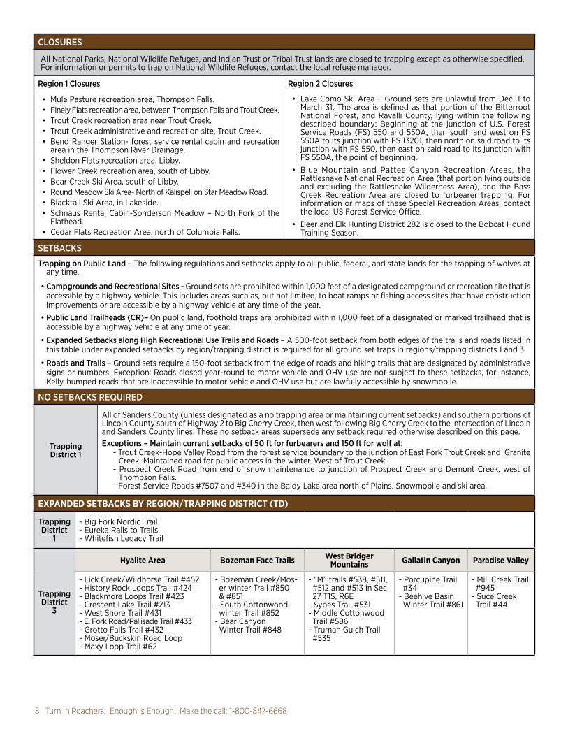
CLOSURES
All National Parks, National Wildlife Refuges, and Indian Trust or Tribal Trust lands are closed to trapping except as otherwise specified. For information or permits to trap on National Wildlife Refuges, contact the local refuge manager.
Region 1 Closures Region 2 Closures
• Mule Pasture recreation area, Thompson Falls.• Finely Flats recreation area, between Thompson Falls and Trout Creek.• Trout Creek recreation area near Trout Creek.• Trout Creek administrative and recreation site, Trout Creek.• Bend Ranger Station- forest service rental cabin and recreation
area in the Thompson River Drainage.• Sheldon Flats recreation area, Libby.• Flower Creek recreation area, south of Libby.• Bear Creek Ski Area, south of Libby.• Round Meadow Ski Area- North of Kalispell on Star Meadow Road.• Blacktail Ski Area, in Lakeside. • Schnaus Rental Cabin-Sonderson Meadow – North Fork of the
Flathead.• Cedar Flats Recreation Area, north of Columbia Falls.
• Lake Como Ski Area – Ground sets are unlawful from Dec. 1 to March 31. The area is defined as that portion of the Bitterroot National Forest, and Ravalli County, lying within the following described boundary: Beginning at the junction of U.S. Forest Service Roads (FS) 550 and 550A, then south and west on FS 550A to its junction with FS 13201, then north on said road to its junction with FS 550, then east on said road to its junction with FS 550A, the point of beginning.
• Blue Mountain and Pattee Canyon Recreation Areas, the Rattlesnake National Recreation Area (that portion lying outside and excluding the Rattlesnake Wilderness Area), and the Bass Creek Recreation Area are closed to furbearer trapping. For information or maps of these Special Recreation Areas, contact the local US Forest Service Office.
• Deer and Elk Hunting District 282 is closed to the Bobcat Hound Training Season.
SETBACKS
Trapping on Public Land – The following regulations and setbacks apply to all public, federal, and state lands for the trapping of wolves at any time.
• Campgrounds and Recreational Sites - Ground sets are prohibited within 1,000 feet of a designated campground or recreation site that is accessible by a highway vehicle. This includes areas such as, but not limited, to boat ramps or fishing access sites that have construction improvements or are accessible by a highway vehicle at any time of the year.
• Public Land Trailheads (CR)– On public land, foothold traps are prohibited within 1,000 feet of a designated or marked trailhead that is accessible by a highway vehicle at any time of year.
• Expanded Setbacks along High Recreational Use Trails and Roads – A 500-foot setback from both edges of the trails and roads listed in this table under expanded setbacks by region/trapping district is required for all ground set traps in regions/trapping districts 1 and 3.
• Roads and Trails – Ground sets require a 150-foot setback from the edge of roads and hiking trails that are designated by administrative signs or numbers. Exception: Roads closed year-round to motor vehicle and OHV use are not subject to these setbacks, for instance, Kelly-humped roads that are inaccessible to motor vehicle and OHV use but are lawfully accessible by snowmobile.
NO SETBACKS REQUIRED
Trapping District 1
All of Sanders County (unless designated as a no trapping area or maintaining current setbacks) and southern portions of Lincoln County south of Highway 2 to Big Cherry Creek, then west following Big Cherry Creek to the intersection of Lincoln and Sanders County lines. These no setback areas supersede any setback required otherwise described on this page.Exceptions – Maintain current setbacks of 50 ft for furbearers and 150 ft for wolf at:
- Trout Creek-Hope Valley Road from the forest service boundary to the junction of East Fork Trout Creek and Granite Creek. Maintained road for public access in the winter. West of Trout Creek.
- Prospect Creek Road from end of snow maintenance to junction of Prospect Creek and Demont Creek, west of Thompson Falls.
- Forest Service Roads #7507 and #340 in the Baldy Lake area north of Plains. Snowmobile and ski area.
EXPANDED SETBACKS BY REGION/TRAPPING DISTRICT (TD)
Trapping District
1
- Big Fork Nordic Trail - Eureka Rails to Trails- Whitefish Legacy Trail
Trapping District
3
Hyalite Area Bozeman Face Trails West Bridger Mountains Gallatin Canyon Paradise Valley
- Lick Creek/Wildhorse Trail #452- History Rock Loops Trail #424- Blackmore Loops Trail #423- Crescent Lake Trail #213- West Shore Trail #431- E. Fork Road/Pallisade Trail #433- Grotto Falls Trail #432- Moser/Buckskin Road Loop - Maxy Loop Trail #62
- Bozeman Creek/Mos-er winter Trail #850 & #851
- South Cottonwood winter Trail #852
- Bear Canyon Winter Trail #848
- “M” trails #538, #511, #512 and #513 in Sec 27 T1S, R6E
- Sypes Trail #531- Middle Cottonwood Trail #586
- Truman Gulch Trail #535
- Porcupine Trail #34
- Beehive Basin Winter Trail #861
- Mill Creek Trail #945
- Suce Creek Trail #44

Visit fwp.mt.gov 92021 Wolf Hunting & Trapping Regulations
Federal Land Access• National Parks Service: National Parks
are closed to hunting. For other lands administered by the National Park Service, please contact the specific site managers for additional information.
• National Wildlife Refuges – More restrictive regulations, including species specific restrictions and closures, may apply to national wildlife refuges open to public hunting. Contact the specific refuge and/or visit fws.gov/refuges for additional information.
• U.S. Forest Service: Area specific closures or restrictions may apply. Inquire at the appropriate Regional Forest Service Office.
• Bureau of Land Management: Area specific closures or restrictions may apply. Inquire at the appropriate BLM Field Office.
• Other Federal lands: Area specific closures or restrictions may apply. Inquire at the local federal land management agency office.Unlawful Posting of State or Federal Land (MCA 45-8-115) It is unlawful for a person to knowingly post land that is under the ownership or control of the state or federal government to restrict access or use of state or federal land.
Fishing Access Sites - Many of Montana’s Fishing Access Sites (FAS) offer hunting opportunities; however, certain restrictions may apply such as no-hunting safety zones and/or restrictions on the type of hunting weapon or firearm that may be used. Refer to the Fishing Access Site website at myfwp.mt.gov/fishMT/explore for site-specific information, opportunities, and restrictions.Indian Reservation Trust Lands - Some reservations may offer game animal hunting opportunities with the use of tribal licenses to non-members. Please contact the appropriate Tribal Government. See “Contacts Outside FWP” on page 16 for contact information. Montana State Parks - Some of Montana’s State Parks provide hunting opportunities; however, certain restrictions may apply such as no-hunting safety zones and/or restrictions on the type of hunting weapon or firearm that may be used. Contact the specific park and/or refer to the Montana State Parks website at fwp.mt.gov/stateparks/ for site-specific information regarding hunting opportunities and restrictions.Private Land Access - Montana law requires permission for all hunting on private land. Railroad Access - Railroads and railroad right-of-ways are private property and may not be hunted without permission, nor should they be used as access to other lands (private or public) without explicit permission from the railroad.State Game Preserves - See Restricted Area Descriptions.State School Trust LandsAdditional information, including closures and restrictions, is available from the DNRC at 406-444-2074• A Conservation License provides hunters,
anglers and trappers access to lawfully accessible State School Trust lands for related activities during applicable
Blackfoot-Clearwater Wildlife Management Area – The Blackfoot-Clearwater has one (1) wolf trapping unit. One trapper will be selected by random drawing each season and permitted to trap up to one limit of wolves. Trapping will be permitted for wolf only; no other furbearing or predatory species may be taken within the wolf trapping unit. Because the trapping unit is within the WMA’s winter closure area, all trapping activity will be limited to nonmotorized travel only. In addition, because the wolf trapping unit includes state school trust land, trappers are reminded to obtain a Special Recreational Use License (application deadline September 30) from the Montana Department of Natural Resources and Conservation (DNRC) prior to trapping on school trust lands. Applicants must possess a valid Trapper License and a valid wolf trapping certification number to apply for this permit. Applicants must submit their name, address, phone number, and ALS number by September 15 to:
Scott Eggeman, Blackfoot-Clearwater WMAMontana Fish, Wildlife & Parks3201 Spurgin Road,Missoula, MT 59801
Fish Creek Wildlife Management Area – The Fish Creek Wildlife Management Area is divided into seven (7) trapping units. Permitted trappers will be selected by random drawing. Trappers will be able to select a unit to trap in the order that names are drawn. Each selected trapper shall be permitted to trap one limit of furbearers and wolves, excluding beaver (the entire Fish Creek drainage is closed to beaver trapping). Trappers may also take predatory species within their permitted unit. Note: Because Trapping Unit #5 is within the WMA’s winter closure area, trapping activity within Trapping Unit #5 will be limited to nonmotorized travel only after December 1. In addition, because Trapping Units #1 - #7 include state school trust land, trappers are reminded to obtain a Special Recreational Use License (application deadline September 30) from the Montana Department of Natural Resources and Conservation (DNRC) prior to trapping or snaring on School Trust Lands. All applicants must possess a valid Trapper License and, if they wish to trap wolves, a valid wolf trapping certification number to apply for this permit. Applicants must submit their name, address, phone number, and ALS number by September 15 to:
Liz Bradley, Fish Creek WMAMontana Fish, Wildlife & Parks3201 Spurgin RoadMissoula, MT 59804
Mt. Haggin Wildlife Management Area – The Mt. Haggin WMA consists of four (4) trapping units where a quota of four (4) licensed trappers shall be permitted to trap a limit of furbearers and wolves each, including ten (10) beaver. Trappers will be selected by a random drawing. Trappers will be able to select an area to trap in the order that names are drawn. The last trapper selected will be assigned the remaining trapping area. Permission to trap wolves on Mt. Haggin WMA is extended only to those trappers that were successful in the drawing. Note: Because Trapping Unit #4 is within the winter closure area of the WMA (closed to all motorized travel December 2 – May 15), trapping activity in this unit will be limited to nonmotorized travel only after December 1. In addition, because Trapping Units #3 and #4 include state school trust land, trappers are reminded to obtain a Special Recreational Use License (application deadline September 30) from the Montana Department of Natural Resources and Conservation (DNRC) prior to trapping on school trust lands. Trappers wishing to take predators must contact Vanna Boccadori for a predator permit. The predator permit is valid for animals classified as predators only (i.e. coyotes)—it does NOT apply to wolves. All applicants must possess a valid Trapper License and, if they wish to trap wolves, a valid wolf trapping certification number to apply for this permit. Applicants must submit their name, address, phone number, and ALS number by September 15 to:
Hunter and Trapper Land Access seasons. Additional permitting is required through the Department of Natural Resources and Conservation (DNRC) for trapping on trust lands.
• Overnight use must not exceed the following limits: two consecutive days on leased land, 16 consecutive days within designated campgrounds or on unleased land.
• Motorized travel is only allowed on public roads or on roads designated as open. This restriction applies to all activity including game retrieval.
• Firearms may not be discharged upon trust lands within one-quarter mile of inhabited dwellings or outbuildings on state trust lands without permission of the inhabitant.
Open fires are prohibited outside of fire pits within designated campgrounds.State Wildlife Management Areas (WMA)- FWP’s Wildlife Management Areas are generally open to hunting during the game animal hunting season. WMAs with big game winter range are closed to public entry, unless otherwise posted, from the day following the end of the general deer-elk season or December 1, whichever is later,
Special RegulationsFish, Wildlife & Parks-owned Wildlife Management Areas (WMAs) are generally open to trapping, although special regulations apply to most WMAs. Contact the local WMA manager or FWP regional office for information on how to obtain permission to trap on WMAs in the state. The following WMAs have special regulations in effect that require wolf trappers to apply for a special permit by September 15 to trap all or a portion of the area.

10 Turn In Poachers. Enough is Enough! Make the call: 1-800-847-6668
along said creek to its confluence with Bear Creek, then northerly along said creek to the confluence of Pine Creek, then easterly along said creek to the intersection with the USFS Absaroka-Beartooth Wilderness Boundary, then southerly along said boundary to the boundary with Yellowstone National Park, then westerly along said boundary to the confluence of the Yellowstone River and Reese Creek west of the town of Gardiner, then westerly along the Yellowstone River to its confluence with Little Trail Creek, the point of beginning.Flathead Weapons Restriction Area: That portion of Flathead County lying within the following described boundary: Beginning at the junction of State Route 35 and State Route 206, then northerly along State Route 206 to US Highway 2, then westerly along said highway onto State Route 40 to US Highway 93, then south on said highway to Rocky Cliff Drive, then easterly to Demersville Road, then northerly along said road to Foys Bend Lane, then easterly along said road onto Lower Valley Road to the Bonneville Power Administration powerline at Foys Bend, then northerly along said powerline across the Flathead River to the easterly shore, then up the most easterly shore of said river to State Route 35 (Old Highway 2 bridge), then easterly along said route to its junction with State Route 206, the point of beginning. Freezout Lake WMA, Teton County: As posted.Gallatin Valley Weapons Restriction Area (GVWRA): Rifles may not be used to hunt wolves in the GVWRA. Beginning at the intersection of Cottonwood Road and Enders Road, continuing southeast from that intersection along Cottonwood Road, north to South 19th, then east on South 19th to Nash Road, then east on Nash Road to Sourdough Canyon Road, then south on Sourdough Canyon Road, to the National Forest Boundary, then east along said boundary to boundary of State Lands Sections 4, 3, 34, 35 and 1 to Bear Canyon Road, then northerly on Bear Canyon Road to the Bear Canyon Interchange with Interstate 90, then northerly to Rocky Creek, northwesterly along Rocky Creek to L Street, then north on L Street to Story Mill Road, then north on Story Mill Road to Deer Creek Drive, northeast on Deer Creek Drive to Lookfar Way, north on Lookfar Way to Rolling Hills Drive, north on Rolling Hills Drive to Sypes Canyon Road, northwesterly on Sypes Canyon Road to Summer Cuttoff Road, then Saddle Mountain Road, then east on Saddle Mountain Road to Bostwick Road, then north along Bostwick Road to Baseline East Road, then west on Baseline East Road to Walker Road, then north on Walker Road to Penwell Bridge Road, then west on Penwell Bridge Road to Wes Davis Road, then north and west on Wes Davis Road to Hamilton Road, then west and north on Hamilton Road to Cactus Road, then west on Cactus Road to Highway 290, then south on Highway 290 to Weaver Road, then west on Weaver Road to Highway 10, then northwesterly on Highway 10 to Heeb Road, then south on Heeb Road to Amsterdam Road, east on Amsterdan Road, to Linney Road, south on
BNSF right-of-way from Marias Pass to the Java Creek Bridge: The BNSF right-of-way from Marias Pass to the Java Creek Bridge is closed to hunting.Brinkman Game Preserve: The S1/2 Section 7, and E1/2, NE1/4 Section 7, and S1/2 Section 8, and NW 1/4 Section 8, S1/2 Section 9, S1/2 and E1/2, NE 1/4 Section 10. All of sections 11, 14, 15, 16, 17, 18, 19, 20, 21, 22, 23, 25, 26, 27, 28, 29, 35, 36; all in T29N, R7E, M.P.M. Liberty County.Deckard Flats to Trail Creek Wolf Trapping Closure Area: The following described area is closed to all wolf trapping: Those portions of Park County lying within the following described boundary: Beginning at the confluence of the Yellowstone River and Little Trail Creek northwest of Gardiner, then northeasterly along Little Trail Creek up to its headwaters, then easterly to the USFS Absaroka-Beartooth Wilderness Boundary, then easterly along said boundary to the North Fork of Bear Creek, then southeasterly
Restricted Area Legal Descriptions
The following equipment restrictions apply to Weapons Restriction Areas:
ArcherySee legal archery equipment in the “Lawful Methods of Hunting” section on page 3.
CrossbowsLegal in weapons restriction areas unless exception noted in specific hunting district regulations.
Muzzleloader• must not be capable of being loaded from
the breech of the barrel• may not be loaded with any pre-prepared
paper or metallic cartridges• must be charged with black powder,
pyrodex, or an equivalent• must be ignited by a percussion, flintlock,
matchlock, or wheelock mechanism• must be a minimum of .45 caliber• may have no more than two barrels• must only use plain lead projectiles• Sabots or other similar power and range-
enhancing manufactured loads that enclose the projectile from the rifling or bore of the firearm are prohibited. “Skirts” or gas checks on the base of a projectile are acceptable.
Traditional Handguns• are not capable of being shoulder mounted;• have a barrel length of less than 10½ inches;• chamber only a straight wall cartridge, not
originally developed for riflesShotgun
Must be shouldered, breech-loaded or muzzle-loaded firearm with a smooth bore and/or rifled barrel and/or rifled choke device designed to fire shot or slugs.
Weapons Restriction Areas Weapons restrictions are in effect in some hunting districts. Such restrictions are stated in the license/permit description and/or with a specific date range.
Vanna Boccadori, Mt. Haggin WMAMontana Fish, Wildlife & Parks 1820 Meadowlark LaneButte, MT 59701
Spotted Dog Wildlife Management Area – The Spotted Dog area has one (1) wolf trapping unit. One trapper will be selected by random drawing each season and permitted to trap up to one limit of wolves. Trapping will be permitted for wolf only; no other furbearing or predatory species may be taken within the wolf trapping unit. Because the trapping unit is within the WMA’s winter closure area, all trapping activity will be limited to non-motorized travel only (except for access across the groomed snowmobile Route 314, which is open to over-the-snow vehicles). In addition, because the wolf trapping unit includes state school trust land, trappers are reminded to obtain a Special Recreational Use License (application deadline September 30) from the Montana Department of Natural Resources and Conservation (DNRC) prior to trapping on school trust lands. Applicants must possess a valid Trapper License and a valid wolf trapping certification number to apply for this permit. Applicants must submit their name, address, phone number, and ALS number by September 15 to:
FWP Region 2Montana Fish, Wildlife & Parks3201 Spurgin RoadMissoula, MT 59804
Wolf Parasites
Mange - Some wolves have mange – a skin parasite that results in the loss of fur on the wolf. In mild cases, the wolf can lose hair on its tail, lower belly, or the lower parts of its legs. In severe cases, a wolf can lose hair across a large part of its body. Hunters can visually scan a wolf to see if it shows signs of hair loss. If it does, you may choose to not take the animal, as its fur will likely not be in prime condition for tanning. If you shoot a wolf that does show signs of mange, tag the animal and report the kill to FWP. You may be issued another Wolf License.Tape Worm - Wolves commonly carry tapeworm in their intestinal tract called Echinococcus granulosus. There is some risk of humans becoming infected with this parasite. Hunters should wear gloves when field dressing a wolf, coyote, or fox carcass, and wash hands and forearms thoroughly, since they may have come into contact with contaminated feces or fur. When skinning any animal, use common sense precautions: wear rubber (latex) gloves, minimize contact with animal fluids, brain and spinal tissues, and wash hands and instruments thoroughly after field dressing. Carry and use hand sanitizer.
• For more information visit the FWP website at: fwp.mt.gov/hunt/regulations/wolf

Visit fwp.mt.gov 112021 Wolf Hunting & Trapping Regulations
Linney Road to Cameron Bridge Road, then east on Cameron Bridge Road to River Road, then south on River Road to Highway 84, then east on Highway 84 to Shedds Bridge, then south up western most channel of the Gallatin River to Gallatin Gateway Bridge, then east on Gallatin Gateway Road to US Highway 191, then south on US Highway 191 to Cottonwood Road, to point of beginning. NOTE: Sourdough Exclusion Zone from SWRA within HD 309: Beginning at the intersection of Nash and Sourdough Canyon Road, then south on Sourdough Canyon Road to the USFS boundary, then east, north and east along said boundary in Section 8, then along said boundary in Section 8 to the intersection with State Lands in Section 9, then north along the section line of Sections 4 and 5, then west along section line of Sections 5 and 32 to the intersection with Sourdough Road, then south on Sourdough Road, then west on Nash Road, the point of beginning.Gates of the Mountains Game Preserve: Beginning in Section 2, T12N, R3W at the southeast corner of Upper Holter Lake, then proceeding westerly along the northern shoreline of Upper Holter Lake in the Gates of the Mountains area located in Lewis and Clark County, then northerly along Stoney Point Beacon Road, then northerly along the powerline to said beacon, then along Bulldozer Road to the point of the ridge in Section 23, T13 N, R3W, then northerly to the Missouri River, then easterly across said river and lake to the USFS boundary to the wilderness boundary, then south along wilderness boundary to the southeast corner of Section 1, T12N, R3W, then west back to Upper Holter Lake, the point of beginning. Intending hereby to include in said game preserve all the territory adjacent of the Gates of the Mountains area, shall be called and known as the Gates of the Mountains Game Preserve.Grant Kohrs Ranch near Deer Lodge: Closed to all hunting.Helena Valley Regulating Reservoir: The Bureau of Reclamation Regulating Reservoir located in Sections 4, 5, 8, 9, 16 and 17, T10N, R2W in Lewis and Clark County of the Helena Valley as posted. (This area will be open to hunting until the opening of the waterfowl season, then it will be closed to all hunting).Helena Valley Weapons Restriction Area: That portion of Deer/Elk HD 388 west of the following boundary: From the intersection of US Highway 12-287 and Lake Helena Drive, then north on said drive to the south shore of the Causeway Arm, then north and east on said shore to Hauser Lake.Kuhns WMA: Legal description and map available from FWP Region 1, Kalispell office 406-752-5501.Lee Metcalf Refuge: Legal description, map and regulations available from the Lee Metcalf Refuge, 406-777-5552.Libby Big Game Archery Only Hunting Area: That portion of Lincoln County lying within the following described boundary: Beginning at the junction of U.S. Highway 2 and Port Blvd. (the old Stimpson mill site entrance) on the south edge of Libby, then heading east
on Port Blvd. to the Champion Haul Road, across Libby Creek on said road to National Forest Road #4813, then southerly on Road #4813 to National Forest Road #533, the Swede Mountain Road, then southerly along said road to the Farm-to-Market Road, then northerly along the Farm-to-Market Road to U.S. Highway 2, then northerly along U.S. Highway 2 to Port Blvd., the point of beginning.Muskrat Valley Weapons Restriction Area: (Restricted to archery, shotgun, traditional handgun or muzzleloader): That portion of Jefferson County lying within the following described boundary: Beginning at Boulder, then east along Muskrat Lane to the intersection of Upper Valley Road, then north along said road to the intersection of Sloan Lane, then west along said lane to the Interstate 15 frontage road, then west to Interstate 15, then south along said interstate to Boulder, the point of beginning. Restricted to archery, shotgun, traditional handgun or muzzleloader only.Poindexter Slough FAS south of Dillon: Sections 26, 27, 34, and 35, T7S, R9W.Prison Ranch Archery Only Area: The following MCE Ranch lands are open to hunting of big game only with Lawful Archery Equipment as outlined in the hunting regulations provided by Montana FWP: Beginning at the junction of the Old Stage Road (county road) and Elk Ridge Road (Forest Service Road 5149) in Section 22, T8N, R10W and proceeding west along the Elk Ridge Road to the power line road (prison fence line) in the southeast 1/4 of Section 22, T8N, R10W, then south along the power line road (prison fence line) to the southwest corner of the prison fence in Section 28, T7N, R10 W, then east along the south boundary Section 28, T7N, R10W (prison fence line) to the southwest corner of Section 27, T7N, R10W, then south to the southwest corner of Section 34, T7N, R10W, then east to the southeast corner of Section 34, T7N R10W, then south to the southwest corner of Section 2, T6N, R10W, then east along the prison fence line to the Dempsey Lake Road (county road), then northeasterly along Dempsey Lake Road (prison fence line) to the southeast corner of Section 36 T7N R10W, then north along the prison fence line on east edge of Section 36 and 25, T7N, R10W to corner of the prison fence line in Section 25, T7N, R10W, then east along prison fence line in N2 Section 30, T7N, R9W to the corner of the prison fence line at Lake Hill Road (county road); then north approx. 1/2 mile along the east side of Sections 30 and 19, T7N, R9W to the corner of prison fence line on the eastern edge of Section 19, T7N, R9W, then follow the prison fence west and northerly in Sections 19 and 18 T7N R9W to the northeast corner of Section 18, T7N, R9W, then follow the prison fence east approx. 1/2 mile along the southern boundary of Section 8, T7N, R9W, then follow the prison fence north approx. 1/2 mile to the junction of the airport fence, then proceeding northwesterly, follow the fence bordering the airport, golf course and National Guard Armory through sections 8, 5 and 6, T7N, R9W to the Old Stage Road (county road), then follow the
Old Stage Road northwest through Sections 36, 26, and 22, T8N, R10W to the junction of the Elk Ridge Road (USFS Road 5149), the point of beginning.Seeley Lake Game Preserve: Closed to all hunting. That portion of Missoula County lying within the following described boundary: Beginning at a point where US Forest Service land and private land meet next to Boy Scout Road in Section 20, T17N, R15W, then east on the boundary between US Forest Service and private land, then north on same boundary to the section line between Sections 17 and 20, then east on said section line and east on north line of Section 21, T17N, R15W to State Route 83, then south on State Route 83 to Riverview Drive in Section 3, T16N, R15W, then west on Riverview Drive to Snowmass Drive in Section 9, T16N, R15W, then north on Snowmass Drive to section line between Sections 4 and 5, T16N, R15W, then north on said section line to Clearwater River, then north along west shore of Clearwater River to Boy Scout Road in Section 33, T17N, R15W, then west and north on said road to where USFS land and private land meet next to Boy Scout Road in Section 20, T17N, R15W, the point of beginning.Slippery Ann Elk Viewing Area: Closed to all hunting per refuge regulation: Portions of Section 36, T22N, R24E and Sections 31 and 32, T22N, R25E, as posted.Townsend Weapon Restriction Area: Beginning at the intersection of US Highway 12 and Route 284, then northerly along said route to its intersection with Riley Road, then west along said road to the Canyon Ferry Wildlife Management Area boundary fence as signed, then northerly and westerly along said boundary fence to the end of said boundary fence in Section 28, T8N, R2E, near Canyon Ferry Reservoir, then westerly across said reservoir to Hahn Road, then westerly along said road to US Highway 287, then south along said highway to its intersection with the Kimber Gulch Road, then westerly along said road to its intersection with the railroad tracks, then southerly along said railroad tracks to their intersection with Springville Lane, then westerly and southerly along said lane to its intersection with the Indian Creek Road, then southerly along the west boundary of Sections 25 and 36 in T7N, R1E to the SW corner of Section 36, then easterly along the southern boundary of Section 36 and easterly along the southern boundary of Section 31 in T7N, R2E to its intersection with US Highway 287, then southeasterly along said highway to its intersection with Lower Deep Creek Road, then easterly along said road to its intersection with Jack Farm Road, then northwesterly along said road to its intersection with Cemetery Road, then east and north along said road to its intersection with US Highway 12, then east along said highway to its intersection with Route 284, the point of beginning.Yellowstone River Islands: Restricted to ArchEquip Only – islands in the Yellowstone River between the East Park Street Bridge at Livingston and one mile downstream of US Highway 89 Bridge.

12 Turn In Poachers. Enough is Enough! Make the call: 1-800-847-6668
WMU 100 Purcell: That portion of Lincoln County lying within the following described boundary: Beginning where the Montana-Idaho-Canadian border meets at the northwest corner of Montana, then easterly along the Canadian border to the east shore of Lake Koocanusa (Kootenai River), then southerly along said shore to Libby Dam and the east shore of the Kootenai River, then southerly along and westerly along said shore of the Kootenai River to US Highway 2 in Libby, then southerly and easterly along said highway to USFS Road 9991 between Upper and Lower Thompson Lakes, then southerly along said road to USFS Road 6769, then southerly and westerly along said road to the hydrologic divide, T26N, R27W,S30, then first south, then generally west and north along said county line to the Montana-Idaho border, then northerly along said border to where the Montana-Idaho-Canadian border meets, the point of the beginning.WMU 101 Salish: Those portions of Lincoln and Flathead counties lying within the following described boundary: Beginning where the east shore of Lake Koocanusa and the Canadian border meet, then easterly along said border to the Whitefish Divide, T37N, R24W,S4, then southerly along said divide to the top of Big Mountain and the head of Canyon Creek, then down Canyon Creek to the North Fork of the Flathead River, then southerly along said river to the Flathead River, then westerly along said river to US Highway 2, then westerly along said highway to 12th Avenue West, Columbia Falls, then northerly to Tamarack Lane, then westerly to East Edgewood Drive and continue westerly to East 2nd Street, Whitefish, then south and westerly to US Highway 93, then west and northerly along said highway to Farm-to-Market Road, then southerly along said road to West Spring Creek Road across US highway 2 on to Dern Road then east on Whalebone Drive to Foys Lake Road, then southerly along said highway to the Somers Fishing Access Site and the north shore of Flathead Lake, then west and southerly along said shore to the Flathead Indian Reservation Boundary, then west along said boundary to USFS Trail 290, then westerly along said trail to USFS Trail 132, then westerly along said trail to USFS Trail 137 and Schroeder Creek Road to the Thompson River County Road, then northerly long said road to US Highway 2, then westerly along said highway to the south shore of the Kootenai River in Libby, then easterly and northerly along said shore to Libby Dam and the east shore of Lake Koocanusa (Kootenai River), then northerly along said shore to the Canadian border, the point of the beginning.WMU 110 North Fork: Those portions of Lincoln and Flathead Counties lying within the following described boundary: Beginning on the U.S./British Columbia border west of Frozen Lake, proceeding southerly along the Whitefish Divide to the top of Big Mountain, then proceeding easterly from the top of Big Mountain down Canyon Creek to the North Fork of the Flathead River, then northerly up the middle of the North Fork of the Flathead River to the U.S./British Columbia border, then westerly along the U.S./British Columbia border to the Whitefish Divide, the point of beginning.WMU 121 Lower Clark Fork North: Those portions of Lincoln and Flathead Counties lying within the following described boundary: Beginning where the Sanders-Lincoln County line intersects the Idaho border, then easterly along said county boundary line through Silver Butte Pass, Willow Creek Pass and Davis Peak to USFS Road 6769, T26N, R28W, S12, then northeasterly along said road to US Highway 2, then easterly along said highway to the Thompson River County Road, then southerly along said road to the Schroeder Creek Road and USFS Trail 137, then easterly along said road and trail to USFS Trail 132, then southeasterly to USFS Tail 290, then along said trail to the Flathead Indian Reservation Boundary, then southerly along said boundary to the Sanders County Line, then
westerly along said line to the Clark Fork-Ninemile Divide, then westerly along said divide to USFS Trail 242, then northerly along said trail to the Clark Fork River, Then southwesterly up said river to USFS Trail 1714, then northerly along said trail to USFS Road 7592, then north and westerly along said trail through Compest Peak to the Mineral-Sanders County Line, then westerly along said line to the Montana-Idaho border, then northwesterly along said border to the Sanders-Lincoln County Line, the point of beginning.WMU 130 Flathead-Swan: Those portions of Flathead, Lake, and Missoula Counties lying within the following described boundary: Beginning where US Highway 93 and Farm-to-Market Road meet northwest of Whitefish, then southerly along Farm-to-Market Road to West Spring Creek Road across US Highway 2 on to Dern Road then east on Whalebone Drive to Foys Lake Road, then southerly along said highway to the Somers Fishing Access Site and the north shore of Flathead Lake, then easterly and southerly along said shore to the Flathead Indian Reservation boundary, then easterly and southerly along said boundary to the Clearwater River/Swan River Divide, Section 27, T18N, R17W, then northeasterly along said divide (Flathead NF/Lolo NF boundary) to the Swan Divide at Wolverine Peak, then northerly along said divide to Inspiration Point and the Middle Fork Creek/Inspiration Creek Divide, then northeasterly along said creek divide to USFS Trail 218, then easterly along said trail to USFS Trail 226 (Picture Peak Trail), then easterly along said trail to USFS Trail 107 near Picture Peak, then northerly along said trail to the south side of Sarah Peak, then easterly along the main creek to the South Fork Flathead River and the mouth of Mid Creek/USFS Trail 103, then northeasterly along said trail to USFS Trail 89 at Mid Mtn., then easterly and northerly along said trail to USFS Trail 83 (near Silvertip Cabin), then northwesterly along said trail to USFS Trail 43, then northwesterly along said trail to USFS Trail 327 east of Whitcomb Peak, then northwesterly along said trail to USFS Trail 81, then northerly along said trail to USFS Trail 155, then easterly along said trail to USFS Trail 154, then northeasterly along said trail to USFS Trail 179, then northeasterly and northerly along said trail to the Continental Divide (east of Big Lodge Mountain), then northerly along said divide to the Glacier National Park Boundary (near Marias Pass), then southwesterly and northwesterly along said boundary to where the Middle Fork and the North Fork of the Flathead River meets to form the Flathead River, then westerly along said river to US Highway 2, then westerly along said highway to 12th Avenue West, Columbia Falls, then northerly to Tamarack Lane, then westerly to East Edgewood Drive and continue westerly to East 2nd Street, Whitefish, then south and westerly to US Highway 93, then west and northerly along said highway to Farm-to-Market Road, the point of beginning.WMU 150 Bob Marshall: Those portions of Flathead, Missoula, Powell and Lewis and Clark Counties lying within the following described boundary: Beginning at Inspiration Point on the Swan Divide and the Middle Fork Creek/Inspiration Creek Divide, then Northeasterly along said creek divide to USFS Trail 218, then easterly along said trail to USFS Trail 226 (Picture Peak Trail), then easterly along said trail to USFS Trail 107 near Picture Peak, then northerly along said trail to the south side of Sarah Peak, then easterly along the main creek to the South Fork Flathead River and the mouth of Mid Creek/USFS Trail 103, then northeasterly along said trail to USFS Trail 89 at Mid Mtn., then easterly and northerly along said trail to USFS Trail 83 (near Silvertip Cabin), then northwesterly along said trail to USFS Trail 43, then northwesterly along said trail to USFS Trail 327 east of Whitcomb Peak, then northwesterly along said trail to USFS Trail 81, then northerly along said trail to USFS Trail 155, then easterly along said trail to USFS Trail 154, then northeasterly along said trail to USFS Trail 179, then northeasterly and northerly along said trail to the Continental Divide (east of Big Lodge Mountain), then Southerly along said divide to the Lolo NF/ Flathead NF Boundary at Triple Divide
Peak, then westerly along said boundary to the Swan Divide at Wolverine Peak, then northerly along said divide to Inspiration Point, the point of beginning.WMU 200 Lower Clark Fork South: Those portions of Mineral, Sanders and Missoula Counties lying within the following described boundary: Beginning at the Flathead Indian Reservation Boundary near Evaro, then south along US Highway 93 to its junction with Interstate 90, then northwesterly along said interstate to the first bridge over Clark Fork River west of Frenchtown (second bridge east of Alberton), then easterly along the west and south side of said river to the old Harpers Bridge and County Road 30 (Big Flat Road), then southerly along said road to its junction with the Blue Mountain Road, then south along said road to its junction with US Highway 93, then south along said highway to Lolo, then westerly along US Highway 12 to the Montana-Idaho border (Lolo Pass), then northwest along said border to Lookout Pass, then northerly along said border to the Mineral-Sanders County Line, then in an easterly and southerly direction along said county line (C-C Divide) to USFS Trail 404 near Combest Peak, then easterly on said trail to the Miller Creek Loop USFS Road 7592, then easterly along said road to its junction with USFS Trail 415, then easterly on said trail to its junction with USFS Trail 1714, then southerly on said trail to the Clark Fork River, then easterly along said river downstream to Cascade Campground, then south along USFS Trail 242 to Ninemile-Seigel Creek Divide (Sanders-Mineral County Line), then easterly along said divide crossing Seigel Pass to the Flathead Indian Reservation Boundary, then southeasterly along said reservation boundary and divide to Evaro, the point of beginning.WMU 210 Bitterroot/Upper Clark Fork: Those portions of Granite, Powell, Deer Lodge, and Silver Bow counties lying within the following described boundary: Beginning at the Rock Creek Interchange on Interstate Highway 90 (I-90), then easterly along I-90 to its junction with US Highway 12 at Garrison, then east along said highway to the Continental Divide at MacDonald Pass, then southerly along said divide to Interstate Highway 15 (I-15) at Elk Park Pass, then south along I-15 to its junction with I-90, then west along I-90 to its junction with I-15 (west of Rocker), then south on I-15 to USFS Road 96 (Divide Creek Road), then westerly along said road to Fleecer Ridge, then northerly along said ridge to the Continental Divide at Burnt Mountain, then westerly along said divide to the head of American Creek, then northwesterly down said creek to State Route 274, then northerly along said route to the Continental Divide, then westerly along said divide to the Rock Creek-Bitterroot River Divide at West Pintler Peak, then northerly along said divide to USFS Trail 215, then east along said trail to Eagle Creek Cable Crossing and Rock Creek Road, then north along said road to the Rock Creek Interchange on I- 90, the point of beginning.WMU 250 West Fork Bitterroot: Those portions of Ravalli, Missoula and Granite Counties lying within the following described boundary: Beginning at the Montana/Idaho border on US Highway 93 at Lost Trail Pass, then southwesterly, northerly and westerly along said border to US Highway 12 at Lolo Pass, then easterly along said highway to its junction with US Highway 93 at Lolo, then north on said highway to the Blue Mountain Road, then northwesterly along said road to Big Flat Road, then northwesterly along said road to Deep Creek then east down said creek to the west shoreline of the Clark Fork River, then northerly and westerly down said shoreline to the first Interstate Highway 90 bridge west of the Ninemile Interchange, then southeasterly along said highway to the Rock Creek Interchange, then south along Rock Creek Road to Eagle Creek Cable Crossing, then west on USFS Trail 215 to the Rock Creek-Bitterroot River Divide, then southerly along said divide to the Continental Divide (at West Pintler Peak), then southwesterly along said divide to the Montana-
Wolf Management Unit (WMU) Legal Descriptions

Visit fwp.mt.gov 132021 Wolf Hunting & Trapping Regulations
Idaho border, then westerly long said border to US Highway 93, the point of beginning.WMU 280 North Blackfoot: Those portions of Powell and Lewis and Clark Counties lying within the following described boundary: Beginning on Monture Creek Trail 27 at its junction with Falls Creek Trail 16, then north along Monture Creek Trail 27 to Center Creek Trail 463, then west along said trail to Center Creek Trail 246, then west along said trail to Youngs Pass and the Flathead-Blackfoot Divide, then northeast along said Divide to Triple Divide Mountain and the Continental Divide, then southeasterly along said Divide to Falls Creek (of the Landers Fork of the Blackfoot River), then southwest along said creek to the Sanders Fork, then up said river to Heart Lake Trail 478, then southerly along said trail to its intersection with Trail 481 at Heart Lake, then westerly along Trail 481 to Red Mountain-Ringeye Creek Trail 423, then southwesterly along said trail to Red Mountain, then southwesterly along the Scapegoat Wilderness Boundary (divide between Copper and Beaver Creeks on the south and East Fork of North Fork Blackfoot River on the north) to Arrastra Mountain then northwest along Scapegoat Wilderness Boundary to Windy Pass Trail 484, then southwesterly along said trail to the Bear Creek North Fork Blackfoot Trail 17, then northwesterly along said trail to its intersection with North Fork Blackfoot Trail 32, then southwesterly along said trail to North Fork Blackfoot Trailhead and Lake Creek Trail 61, then northwest along said trail to its junction with Trail 16 near Lake Otatsy, then northwesterly along said trail through Camp Pass to Monture Creek Trail 27, the point of beginning.WMU 290 Blackfoot: Those portions of Granite, Lewis and Clark, Missoula and Powell Counties lying within the following described boundary: Beginning at Missoula, then northwest along Interstate 90 to US Highway 93, then north on said highway to the Flathead Indian Reservation boundary near Evaro, then northeast and north along said boundary to the Swan-Clearwater Divide, then northeast along said divide, crossing State Route 83 to Wolverine Peak, then southeast along the Flathead-Blackfoot River Divide to USFS Trail 246 (Youngs Pass), then east along said trail to Center Creek Trail 463, then east along said trail to Monture Creek Trail 27, then south on Monture Creek Trail 27 to Falls Creek Trail 16, then easterly along said trail through Camp Pass to Lake Creek Trail 61 near Lake Otatsy, then southeasterly along said trail to the North Fork Blackfoot Trailhead, then north on North Fork Blackfoot Trail 32 to Bear Creek-Northfork Blackfoot Trail 17, then southeasterly along said trail to its intersection with Windy Pass Trail 484, then northeasterly, along said trail to Windy Pass, then southeasterly along the Scapegoat Wilderness Boundary to Arrastra Mountain, then northeasterly along Scapegoat Wilderness Boundary to Red Mountain, then northeasterly on Red Mountain-Ringeye Creek Trail 423 to its junction with Webb Lake Trail 481, then east along said trail to its junction with Heart Lake-Bighorn Creek Trail 478 near Heart Lake, then north along said trail to Landers Fork River, then southeasterly along said river to Falls Creek (of the Landers Fork River), then northeasterly along said creek to the Continental Divide, the southeast along said divide to Rogers Pass and the Continental Divide, then south along said divide to MacDonald Pass, then west along US Highway 12 to its junction with Interstate 90 at Garrison, then west on said interstate to Missoula, the point of beginning.WMU 310 Gallatin-Madison: Those portions of Gallatin, Madison and Park Counties within the following boundary. Beginning at the Montana-Idaho border at Raynolds Pass, then northerly along Highway 87 to the junction with Highway 287, then northerly along Highway 287 to the junction with Interstate 90 at Three Forks, then easterly along Interstate 90 to the Meadow Creek Road, then southerly along the Meadow Creek Road to the Goose Creek Road, then southerly along the Goose
Creek Road to the Gallatin- Yellowstone Divide near the Old Cooper Reservoir, then south along the Gallatin-Yellowstone Divide to the Yellowstone National Park boundary, then westerly and southerly along the Yellowstone National Park boundary to the Montana-Idaho border, then northwesterly along the Montana-Idaho border to Raynolds Pass, the point of beginning.WMU 313 Gardiner: Those portions of Park county lying within the following described boundary: beginning at the intersection of the Cottonwood-Hellroaring Creek divide and Yellowstone National Park Boundary, then westerly along said boundary to USFS Trail #106, then northeasterly along said trail to the head of Mill Creek, then northeasterly along said creek to Cinnabar Creek, then easterly along said creek to the Yellowstone River, then northerly along said river to Cedar Creek, and then easterly along said creek to USFS Trail #72 at the head of Cedar Creek, then easterly along said trail to the Cedar-Bear Creek Divide, then easterly along said divide to Monitor Peak, then southeasterly along the Mill-Hellroaring-Bear Creek divide to Ash Mountain, then southerly along Crevice-Hellroaring Creek divide and Cottonwood-Hellroaring Creek divide to the Yellowstone National Park Boundary, the point of the beginning.WMU 316 Absaroka: Those portions of Carbon, Sweet Grass and Park Counties lying within the following described boundary: Beginning at the junction of the Montana-Wyoming border and the Custer-Gallatin National Forest boundary southeast of Albino Lake, then northerly and westerly along said boundary to Granite Mountain, then north one-half mile to the Stillwater County Line, then west along said county line to the Custer-Gallatin National Forest Boundary near Timberline Mountain, then northerly along said boundary to the Slough Creek-Boulder River Divide near Columbine Pass, then southwesterly along the Boulder River-Slough Creek Divide and northwesterly along the Boulder River-Buffalo Fork Divide and the Hellroaring Creek-Boulder River Divide to the Hellroaring-Mill Creeks Divide near Crow Mountain, then southwesterly along the Mill-Hellroaring Creeks Divide to the Bear-Hellroaring Creeks Divide to Ash Mountain, then southerly along the Crevice-Hellroaring Creeks Divide to the Crevice-Cottonwood Creeks Divide, then southerly along the Crevice-Cottonwood Creeks Divide to the Yellowstone National Park Boundary, then easterly and southerly along said boundary to the Montana-Wyoming border, then easterly along said border to the Custer-Gallatin National Forest boundary southeast of Albino Lake, the point of beginning. WMU 316 encompasses deer/elk hunting district 316.WMU 320 Highlands-Tobacco Roots-Gravelly-Snowcrest: Those portions of Beaverhead, Broadwater, Gallatin, Jefferson, Madison and Silver Bow counties within the following boundary. Beginning at the Montana-Idaho border at Monida Pass, then northerly along Interstate 15 to the junction with Interstate 90 at Rocker, then easterly along Interstate 90 to the junction with Highway 287 at Three Forks, then southerly along Highway 287 to the junction with Highway 87, then southerly along Highway 87 to the Montana-Idaho border at Raynolds Pass, then westerly along the Montana-Idaho border to Monida Pass, the point of beginning.WMU 330 Big Hole/Tendoys: Those portions of Silver Bow, Beaverhead, and Deer Lodge Counties lying within the following described boundary: Beginning at the junction of USFS Road 96 (Divide Creek Road) and Interstate Highway 15 (I-15, south of Rocker), then southerly along said highway to the Montana/Idaho border (Continental Divide), then west and northerly along said border/divide to its junction with the boundary between Ravalli and Beaverhead Counties (in Sec 3, T2S, R19W), then continuing northeasterly along said divide to State Route 274, then southerly along said route to American Creek, then southeasterly up said creek to its head at the Continental Divide, then easterly along said divide to Fleecer Ridge at
Burnt Mountain, then southerly along said ridge to USFS Road 96, then easterly along said road to its junction with I-15, the point of beginning.WMU 390 South Central Montana: Those portions of Silverbow, Jefferson, Lewis & Clark, Cascade, Meagher, Gallatin, Park, Judith Basin, Wheatland, Sweet Grass, Stillwater, Carbon, Golden Valley, Fergus, Petroleum, Musselshell, Yellowstone, Big Horn, Treasure, Rosebud, Garfield, McCone, Prairie, Custer, Powder River, Carter, Fallon, Wibaux, Dawson and Richland Counties within the following boundary. Beginning at the junction of Interstate 90 and Interstate 15 at Butte, then northerly along Interstate 15 to the Continental Divide at Elk Park Pass, then northerly along the Continental Divide to the North Fork of Lyons Creek (northwest of Flesher Pass), then southeasterly down said creek to Interstate 15, then northeasterly along said interstate to the junction with Highway 200, then easterly along said highway to the Montana-North Dakota border, then southerly along said border to the Montana-South Dakota border, then southerly along said border to the Montana-Wyoming border, then westerly along said border to the Custer-Gallatin National Forest boundary southeast of Albino Lake, then northerly and westerly along said boundary to Granite Mountain, then north one-half mile to the Stillwater County Line, then west along said county line to the Custer-Gallatin National Forest Boundary near Timberline Mountain, then northerly along said boundary to the Slough Creek-Boulder River Divide near Columbine Pass, then southwesterly along the Boulder River-Slough Creek Divide and northwesterly along the Boulder River-Buffalo Fork Divide and the Hellroaring Creek-Boulder River Divide to the Hellroaring-Mill Creek Divide near Crow Mountain, then southwesterly along the Mill-Hellroaring Creeks Divide to the Bear-Hellroaring divide, then westerly along the Mill - Bear Creeks Divide to Monitor Peak, then westerly along the Cedar-Bear Creek Divide to USFS Trail #72, then southwesterly along said trail to the head of Cedar Creek, then westerly along Cedar Creek to the Yellowstone River, southerly along said river to Cinnabar Creek, then westerly along said creek to Mill Creek, then southwesterly along said creek to USFS Trail #106 westerly to the Yellowstone National Park boundary on the Yellowstone-Gallatin River Divide, then northerly along said divide to the Goose Creek Road, then northwesterly along said road to Meadow Creek Road (west of Livingston), then westerly along said road to Interstate 90, then westerly along said interstate to Butte, the point of beginning. WMU 390 encompasses deer/elk hunting districts 309 (north of I-90), 312, (a portion of) 313, 314, 315, 317, 318, 335, 339, 343, 350, 370, 380, 388, 390, 391,392, and 393 AND all of Region 5, all of Region 7 south of US Hwy 200 and a portion of Region 4 south of US Hwy 200 and east of I-15.WMU 400 North Central Montana: Those portions of Glacier, Pondera, Teton, Lewis and Clark, Cascade, Chouteau, Judith Basin, Toole, Liberty, Hill, Blaine, Fergus, Petroleum, Phillips, Valley, Garfield, McCone, Richland, Roosevelt, Sheridan, Daniels and Dawson Counties within the following described boundary: beginning at the intersection of Interstate Highway 15 and State Highway 200 near Great Falls, then easterly along Highway 200 to the Montana – North Dakota border, then northerly along said border to the Montana – Canada border, then westerly along the Montana – Canada border to its intersection with the continental divide in Glacier National Park, then southerly along said continental divide, through Rogers Pass, to the North Fork of Lyons Creek, then southeasterly down Lyons Creek to Interstate Highway 15, then northerly along Interstate Highway 15 to its intersection with State Highway 200 near Great Falls, the point of beginning.
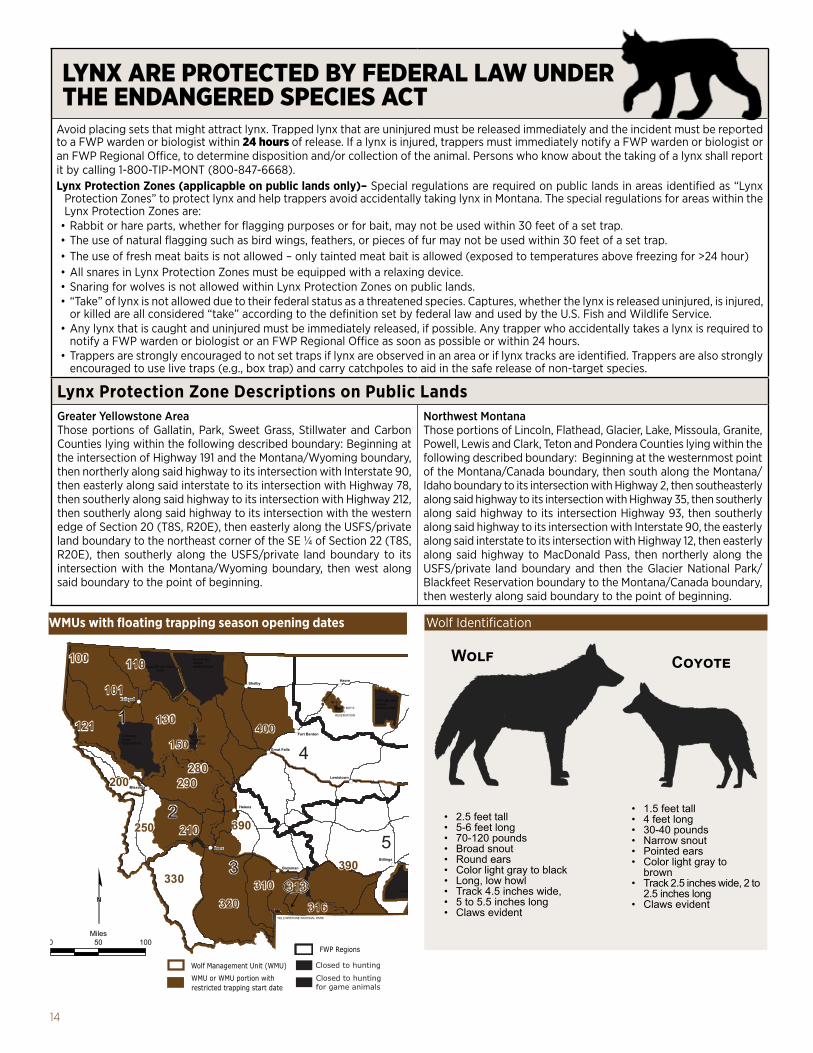
14
LYNX ARE PROTECTED BY FEDERAL LAW UNDER THE ENDANGERED SPECIES ACT
Avoid placing sets that might attract lynx. Trapped lynx that are uninjured must be released immediately and the incident must be reported to a FWP warden or biologist within 24 hours of release. If a lynx is injured, trappers must immediately notify a FWP warden or biologist or an FWP Regional Office, to determine disposition and/or collection of the animal. Persons who know about the taking of a lynx shall report it by calling 1-800-TIP-MONT (800-847-6668).Lynx Protection Zones (applicapble on public lands only)– Special regulations are required on public lands in areas identified as “Lynx
Protection Zones” to protect lynx and help trappers avoid accidentally taking lynx in Montana. The special regulations for areas within the Lynx Protection Zones are:
• Rabbit or hare parts, whether for flagging purposes or for bait, may not be used within 30 feet of a set trap.• The use of natural flagging such as bird wings, feathers, or pieces of fur may not be used within 30 feet of a set trap.• The use of fresh meat baits is not allowed – only tainted meat bait is allowed (exposed to temperatures above freezing for >24 hour)• All snares in Lynx Protection Zones must be equipped with a relaxing device.• Snaring for wolves is not allowed within Lynx Protection Zones on public lands.• “Take” of lynx is not allowed due to their federal status as a threatened species. Captures, whether the lynx is released uninjured, is injured,
or killed are all considered “take” according to the definition set by federal law and used by the U.S. Fish and Wildlife Service.• Any lynx that is caught and uninjured must be immediately released, if possible. Any trapper who accidentally takes a lynx is required to
notify a FWP warden or biologist or an FWP Regional Office as soon as possible or within 24 hours. • Trappers are strongly encouraged to not set traps if lynx are observed in an area or if lynx tracks are identified. Trappers are also strongly
encouraged to use live traps (e.g., box trap) and carry catchpoles to aid in the safe release of non-target species.
Lynx Protection Zone Descriptions on Public LandsGreater Yellowstone AreaThose portions of Gallatin, Park, Sweet Grass, Stillwater and Carbon Counties lying within the following described boundary: Beginning at the intersection of Highway 191 and the Montana/Wyoming boundary, then northerly along said highway to its intersection with Interstate 90, then easterly along said interstate to its intersection with Highway 78, then southerly along said highway to its intersection with Highway 212, then southerly along said highway to its intersection with the western edge of Section 20 (T8S, R20E), then easterly along the USFS/private land boundary to the northeast corner of the SE ¼ of Section 22 (T8S, R20E), then southerly along the USFS/private land boundary to its intersection with the Montana/Wyoming boundary, then west along said boundary to the point of beginning.
Northwest MontanaThose portions of Lincoln, Flathead, Glacier, Lake, Missoula, Granite, Powell, Lewis and Clark, Teton and Pondera Counties lying within the following described boundary: Beginning at the westernmost point of the Montana/Canada boundary, then south along the Montana/Idaho boundary to its intersection with Highway 2, then southeasterly along said highway to its intersection with Highway 35, then southerly along said highway to its intersection Highway 93, then southerly along said highway to its intersection with Interstate 90, the easterly along said interstate to its intersection with Highway 12, then easterly along said highway to MacDonald Pass, then northerly along the USFS/private land boundary and then the Glacier National Park/Blackfeet Reservation boundary to the Montana/Canada boundary, then westerly along said boundary to the point of beginning.
WMUs with floating trapping season opening dates Wolf Identification
CoyoteWolf
• 2.5 feet tall• 5-6 feet long• 70-120 pounds• Broad snout• Round ears• Color light gray to black • Long, low howl• Track 4.5 inches wide, • 5 to 5.5 inches long• Claws evident
• 1.5 feet tall • 4 feet long• 30-40 pounds• Narrow snout• Pointed ears• Color light gray to
brown• Track 2.5 inches wide, 2 to
2.5 inches long• Claws evident
BLACKFEETINDIAN RESERVATION
ROCKY BOY’SINDIANRESERVATION
FORT BELKNAPINDIANRESERVATION
FORT PECKINDIANRESERVATION
CROW INDIAN RESERVATION
NORTHERN CHEYENNEINDIAN RESERVATION
FLATHEADINDIANRESERVATION
!(
!(
!(
!(
!(
!(
!(
!(
!(
!(
!
!
! (
(
(
0 50 100Miles¢
Havre
Helena
Glasgow
Bozeman
Missoula
Billings
Lewistown
Kalispell
Miles City
Great Falls
Butte
Havre
Helena
Glasgow
Bozeman
Missoula
Billings
Lewistown
Kalispell
Miles City
Great Falls
Fort Benton
Shelby
Butte 7
6
4
35
1
2
320
100
290
101
310
400
390
130121150
200
110
210
320
290
100
101
310
400
390
390390
130121150
200
110
210250250
330330 313
280280
316316313
YELLOWSTONE NATIONAL PARK
GLACIER NATIONALPARK
SUN RIVERGAME
PRESERVE
Closed to hunting
Closed to hunting for game animals
Wolf Management Unit (WMU)
FWP Regions
WMU or WMU portion withrestricted trapping start date
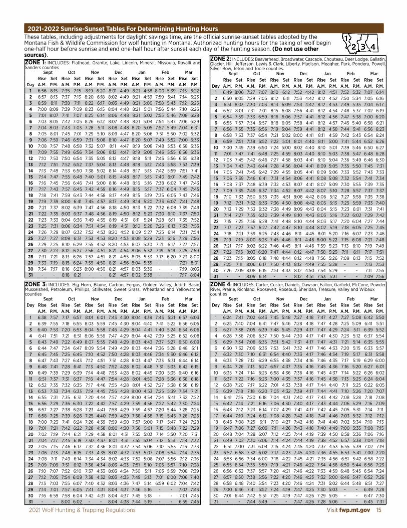
Visit fwp.mt.gov 152021 Wolf Hunting & Trapping Regulations
These tables, including adjustments for daylight savings time, are the official sunrise-sunset tables adopted by the Montana Fish & Wildlife Commission for wolf hunting in Montana. Authorized hunting hours for the taking of wolf begin one-half hour before sunrise and end one-half hour after sunset each day of the hunting season. (Do not use other sources).
2021-2022 Sunrise-Sunset Tables For Determining Hunting Hours
ZONE 1: INCLUDES: Flathead, Granite, Lake, Lincoln, Mineral, Missoula, Ravalli and Sanders counties
Sept Oct Nov Dec Jan Feb MarRise Set Rise Set Rise Set Rise Set Rise Set Rise Set Rise Set
Day A.M. P.M. A.M. P.M. A.M. P.M. A.M. P.M. A.M. P.M. A.M. P.M. A.M. P.M.1 6:56 8:15 7:35 7:15 8:19 6:20 8:01 4:49 8:21 4:58 8:00 5:39 7:15 6:222 6:57 8:13 7:37 7:13 8:20 6:18 8:02 4:49 8:21 4:59 7:59 5:41 7:14 6:233 6:59 8:11 7:38 7:11 8:22 6:17 8:03 4:49 8:21 5:00 7:58 5:43 7:12 6:254 7:00 8:09 7:39 7:09 8:23 6:15 8:04 4:48 8:21 5:01 7:56 5:44 7:10 6:265 7:01 8:07 7:41 7:07 8:25 6:14 8:06 4:48 8:21 5:02 7:55 5:46 7:08 6:286 7:03 8:05 7:42 7:05 8:26 6:12 8:07 4:48 8:21 5:04 7:54 5:47 7:06 6:297 7:04 8:03 7:43 7:03 7:28 5:11 8:08 4:48 8:20 5:05 7:52 5:49 7:04 6:318 7:05 8:01 7:45 7:01 7:29 5:10 8:09 4:47 8:20 5:06 7:51 5:50 7:02 6:329 7:06 7:59 7:46 6:59 7:31 5:08 8:10 4:47 8:20 5:07 7:49 5:52 7:00 6:3310 7:08 7:57 7:48 6:58 7:32 5:07 8:11 4:47 8:19 5:08 7:48 5:53 6:58 6:3511 7:09 7:55 7:49 6:56 7:34 5:06 8:12 4:47 8:19 5:09 7:46 5:55 6:56 6:3612 7:10 7:53 7:50 6:54 7:35 5:05 8:12 4:47 8:18 5:11 7:45 5:56 6:55 6:3813 7:12 7:51 7:52 6:52 7:37 5:04 8:13 4:48 8:18 5:12 7:43 5:58 7:53 7:3914 7:13 7:49 7:53 6:50 7:38 5:02 8:14 4:48 8:17 5:13 7:42 5:59 7:51 7:4115 7:14 7:47 7:55 6:48 7:40 5:01 8:15 4:48 8:17 5:15 7:40 6:01 7:49 7:4216 7:16 7:45 7:56 6:46 7:41 5:00 8:16 4:48 8:16 5:16 7:38 6:02 7:47 7:4317 7:17 7:43 7:57 6:45 7:42 4:59 8:16 4:49 8:15 5:17 7:37 6:04 7:45 7:4518 7:18 7:41 7:59 6:43 7:44 4:58 8:17 4:49 8:15 5:19 7:35 6:05 7:43 7:4619 7:19 7:39 8:00 6:41 7:45 4:57 8:17 4:49 8:14 5:20 7:33 6:07 7:41 7:4820 7:21 7:37 8:02 6:39 7:47 4:56 8:18 4:50 8:13 5:22 7:32 6:08 7:39 7:4921 7:22 7:35 8:03 6:37 7:48 4:56 8:19 4:50 8:12 5:23 7:30 6:10 7:37 7:5022 7:23 7:33 8:04 6:36 7:49 4:55 8:19 4:51 8:11 5:24 7:28 6:11 7:35 7:5223 7:25 7:31 8:06 6:34 7:51 4:54 8:19 4:51 8:10 5:26 7:26 6:13 7:33 7:5324 7:26 7:29 8:07 6:32 7:52 4:53 8:20 4:52 8:09 5:27 7:25 6:14 7:31 7:5425 7:27 7:27 8:09 6:31 7:53 4:53 8:20 4:53 8:08 5:29 7:23 6:16 7:29 7:5626 7:29 7:25 8:10 6:29 7:55 4:52 8:20 4:53 8:07 5:30 7:21 6:17 7:27 7:5727 7:30 7:23 8:12 6:27 7:56 4:51 8:21 4:54 8:06 5:32 7:19 6:19 7:25 7:5928 7:31 7:21 8:13 6:26 7:57 4:51 8:21 4:55 8:05 5:33 7:17 6:20 7:23 8:0029 7:33 7:19 8:15 6:24 7:59 4:50 8:21 4:56 8:04 5:35 - - 7:21 8:0130 7:34 7:17 8:16 6:23 8:00 4:50 8:21 4:57 8:03 5:36 - - 7:19 8:0331 - - 8:18 6:21 - - 8:21 4:57 8:02 5:38 - - 7:17 8:04
ZONE 2: INCLUDES: Beaverhead, Broadwater, Cascade, Chouteau, Deer Lodge, Gallatin, Glacier, Hill, Jefferson, Lewis & Clark, Liberty, Madison, Meagher, Park, Pondera, Powell, Silver Bow, Teton and Toole counties.
Sept Oct Nov Dec Jan Feb MarRise Set Rise Set Rise Set Rise Set Rise Set Rise Set Rise Set
Day A.M. P.M. A.M. P.M. A.M. P.M. A.M. P.M. A.M. P.M. A.M. P.M. A.M. P.M.1 6:49 8:06 7:27 7:07 8:10 6:12 7:52 4:42 8:12 4:51 7:52 5:32 7:07 6:142 6:50 8:05 7:29 7:05 8:12 6:11 7:53 4:42 8:12 4:52 7:50 5:34 7:05 6:163 6:51 8:03 7:30 7:03 8:13 6:09 7:54 4:42 8:12 4:53 7:49 5:35 7:04 6:174 6:52 8:01 7:31 7:01 8:15 6:08 7:56 4:41 8:12 4:54 7:48 5:37 7:02 6:195 6:54 7:59 7:33 6:59 8:16 6:06 7:57 4:41 8:12 4:56 7:47 5:38 7:00 6:206 6:55 7:57 7:34 6:57 8:18 6:05 7:58 4:41 8:12 4:57 7:45 5:40 6:58 6:217 6:56 7:55 7:35 6:56 7:19 5:04 7:59 4:41 8:12 4:58 7:44 5:41 6:56 6:238 6:58 7:53 7:37 6:54 7:21 5:02 8:00 4:41 8:11 4:59 7:42 5:43 6:54 6:249 6:59 7:51 7:38 6:52 7:22 5:01 8:01 4:40 8:11 5:00 7:41 5:44 6:52 6:2610 7:00 7:49 7:39 6:50 7:24 5:00 8:02 4:40 8:10 5:01 7:39 5:46 6:50 6:2711 7:01 7:47 7:41 6:48 7:25 4:59 8:03 4:40 8:10 5:03 7:38 5:47 6:48 6:2812 7:03 7:45 7:42 6:46 7:27 4:58 8:03 4:41 8:10 5:04 7:36 5:49 6:46 6:3013 7:04 7:43 7:43 6:44 7:28 4:56 8:04 4:41 8:09 5:05 7:35 5:50 7:45 7:3114 7:05 7:41 7:45 6:42 7:29 4:55 8:05 4:41 8:09 5:06 7:33 5:52 7:43 7:3315 7:06 7:39 7:46 6:41 7:31 4:54 8:06 4:41 8:08 5:08 7:32 5:54 7:41 7:3416 7:08 7:37 7:48 6:39 7:32 4:53 8:07 4:41 8:07 5:09 7:30 5:55 7:39 7:3517 7:09 7:35 7:49 6:37 7:34 4:52 8:07 4:42 8:07 5:10 7:28 5:57 7:37 7:3718 7:10 7:33 7:50 6:35 7:35 4:51 8:08 4:42 8:06 5:12 7:27 5:58 7:35 7:3819 7:12 7:31 7:52 6:33 7:36 4:50 8:08 4:42 8:05 5:13 7:25 5:59 7:33 7:4020 7:13 7:29 7:53 6:32 7:38 4:49 8:09 4:43 8:04 5:15 7:23 6:01 7:31 7:4121 7:14 7:27 7:55 6:30 7:39 4:49 8:10 4:43 8:03 5:16 7:22 6:02 7:29 7:4222 7:15 7:25 7:56 6:28 7:41 4:48 8:10 4:44 8:03 5:17 7:20 6:04 7:27 7:4423 7:17 7:23 7:57 6:27 7:42 4:47 8:10 4:44 8:02 5:19 7:18 6:05 7:25 7:4524 7:18 7:21 7:59 6:25 7:43 4:46 8:11 4:45 8:01 5:20 7:16 6:07 7:23 7:4625 7:19 7:19 8:00 6:23 7:45 4:46 8:11 4:46 8:00 5:22 7:15 6:08 7:21 7:4826 7:21 7:17 8:02 6:22 7:46 4:45 8:11 4:46 7:59 5:23 7:13 6:10 7:19 7:4927 7:22 7:15 8:03 6:20 7:47 4:44 8:12 4:47 7:58 5:25 7:11 6:11 7:17 7:5128 7:23 7:13 8:05 6:18 7:48 4:44 8:12 4:48 7:56 5:26 7:09 6:13 7:15 7:5229 7:25 7:11 8:06 6:17 7:50 4:43 8:12 4:49 7:55 5:28 - - 7:13 7:5330 7:26 7:09 8:08 6:15 7:51 4:43 8:12 4:50 7:54 5:29 - - 7:11 7:5531 - - 8:09 6:14 - - 8:12 4:51 7:53 5:31 - - 7:09 7:56
ZONE 3: INCLUDES: Big Horn, Blaine, Carbon, Fergus, Golden Valley, Judith Basin, Musselshell, Petroleum, Phillips, Stillwater, Sweet Grass, Wheatland and Yellowstone counties
Sept Oct Nov Dec Jan Feb MarDay Rise Set Rise Set Rise Set Rise Set Rise Set Rise Set Rise Set
A.M. P.M. A.M. P.M. A.M. P.M. A.M. P.M. A.M. P.M. A.M. P.M. A.M. P.M.1 6:38 7:57 7:17 6:57 8:01 6:01 7:43 4:30 8:04 4:39 7:43 5:21 6:57 6:032 6:39 7:55 7:18 6:55 8:03 5:59 7:45 4:30 8:04 4:40 7:41 5:22 6:56 6:053 6:40 7:53 7:20 6:53 8:04 5:58 7:46 4:29 8:04 4:41 7:40 5:24 6:54 6:064 6:41 7:51 7:21 6:51 8:06 5:56 7:47 4:29 8:04 4:42 7:39 5:25 6:52 6:085 6:43 7:49 7:22 6:49 8:07 5:55 7:48 4:29 8:03 4:43 7:37 5:27 6:50 6:096 6:44 7:47 7:24 6:47 8:09 5:54 7:49 4:29 8:03 4:44 7:36 5:28 6:48 6:117 6:45 7:45 7:25 6:45 7:10 4:52 7:50 4:28 8:03 4:46 7:34 5:30 6:46 6:128 6:47 7:43 7:27 6:43 7:12 4:51 7:51 4:28 8:03 4:47 7:33 5:31 6:44 6:149 6:48 7:41 7:28 6:41 7:13 4:50 7:52 4:28 8:02 4:48 7:31 5:33 6:42 6:1510 6:49 7:39 7:29 6:39 7:14 4:48 7:53 4:28 8:02 4:49 7:30 5:35 6:40 6:1611 6:51 7:37 7:31 6:37 7:16 4:47 7:54 4:28 8:01 4:50 7:28 5:36 6:38 6:1812 6:52 7:35 7:32 6:35 7:17 4:46 7:55 4:28 8:01 4:52 7:27 5:38 6:36 6:1913 6:53 7:33 7:34 6:33 7:19 4:45 7:56 4:28 8:00 4:53 7:25 5:39 7:34 7:2114 6:55 7:31 7:35 6:31 7:20 4:44 7:57 4:29 8:00 4:54 7:24 5:41 7:32 7:2215 6:56 7:29 7:36 6:30 7:22 4:42 7:57 4:29 7:59 4:56 7:22 5:42 7:30 7:2416 6:57 7:27 7:38 6:28 7:23 4:41 7:58 4:29 7:59 4:57 7:20 5:44 7:28 7:2517 6:58 7:25 7:39 6:26 7:25 4:40 7:59 4:29 7:58 4:58 7:19 5:45 7:26 7:2618 7:00 7:23 7:41 6:24 7:26 4:39 7:59 4:30 7:57 5:00 7:17 5:47 7:24 7:2819 7:01 7:21 7:42 6:22 7:28 4:38 8:00 4:30 7:56 5:01 7:15 5:48 7:22 7:2920 7:02 7:19 7:44 6:21 7:29 4:38 8:01 4:31 7:55 5:03 7:14 5:50 7:20 7:3121 7:04 7:17 7:45 6:19 7:30 4:37 8:01 4:31 7:55 5:04 7:12 5:51 7:18 7:3222 7:05 7:15 7:46 6:17 7:32 4:36 8:01 4:32 7:54 5:06 7:10 5:53 7:16 7:3323 7:06 7:13 7:48 6:15 7:33 4:35 8:02 4:32 7:53 5:07 7:08 5:54 7:14 7:3524 7:08 7:11 7:49 6:14 7:34 4:34 8:02 4:33 7:52 5:08 7:07 5:56 7:12 7:3625 7:09 7:09 7:51 6:12 7:36 4:34 8:03 4:33 7:51 5:10 7:05 5:57 7:10 7:3826 7:10 7:07 7:52 6:10 7:37 4:33 8:03 4:34 7:50 5:11 7:03 5:59 7:08 7:3927 7:12 7:05 7:54 6:09 7:38 4:32 8:03 4:35 7:49 5:13 7:01 6:00 7:06 7:4028 7:13 7:03 7:55 6:07 7:40 4:32 8:03 4:36 7:47 5:14 6:59 6:02 7:04 7:4229 7:14 7:01 7:57 6:05 7:41 4:31 8:04 4:37 7:46 5:16 - - 7:03 7:4330 7:16 6:59 7:58 6:04 7:42 4:31 8:04 4:37 7:45 5:18 - - 7:01 7:4531 - - 8:00 6:02 - - 8:04 4:38 7:44 5:19 - - 6:59 7:46
ZONE 4: INCLUDES: Carter, Custer, Daniels, Dawson, Fallon, Garfield, McCone, Powder River, Prairie, Richland, Roosevelt, Rosebud, Sheridan, Treasure, Valley and Wibaux counties
Sept Oct Nov Dec Jan Feb MarDay Rise Set Rise Set Rise Set Rise Set Rise Set Rise Set Rise Set
A.M. P.M. A.M. P.M. A.M. P.M. A.M. P.M. A.M. P.M. A.M. P.M. A.M. P.M.1 6:24 7:41 7:02 6:43 7:45 5:48 7:27 4:18 7:47 4:27 7:27 5:08 6:42 5:502 6:25 7:40 7:04 6:41 7:47 5:46 7:28 4:18 7:47 4:28 7:25 5:09 6:41 5:513 6:27 7:38 7:05 6:39 7:48 5:45 7:29 4:17 7:47 4:29 7:24 5:11 6:39 5:524 6:28 7:36 7:06 6:37 7:50 5:44 7:30 4:17 7:47 4:30 7:23 5:12 6:37 5:545 6:29 7:34 7:08 6:35 7:51 5:42 7:31 4:17 7:47 4:31 7:21 5:14 6:35 5:556 6:30 7:32 7:09 6:33 7:53 5:41 7:32 4:17 7:46 4:33 7:20 5:15 6:33 5:577 6:32 7:30 7:10 6:31 6:54 4:40 7:33 4:17 7:46 4:34 7:19 5:17 6:31 5:588 6:33 7:28 7:12 6:29 6:55 4:38 7:34 4:16 7:46 4:35 7:17 5:19 6:29 6:009 6:34 7:26 7:13 6:27 6:57 4:37 7:35 4:16 7:45 4:36 7:16 5:20 6:27 6:0110 6:35 7:24 7:14 6:25 6:58 4:36 7:36 4:16 7:45 4:37 7:14 5:22 6:26 6:0211 6:37 7:22 7:16 6:23 7:00 4:35 7:37 4:16 7:45 4:38 7:13 5:23 6:24 6:0412 6:38 7:20 7:17 6:22 7:01 4:33 7:38 4:17 7:44 4:40 7:11 5:25 6:22 6:0513 6:39 7:18 7:18 6:20 7:03 4:32 7:39 4:17 7:44 4:41 7:10 5:26 7:20 7:0714 6:41 7:16 7:20 6:18 7:04 4:31 7:40 4:17 7:43 4:42 7:08 5:28 7:18 7:0815 6:42 7:14 7:21 6:16 7:06 4:30 7:40 4:17 7:43 4:44 7:06 5:29 7:16 7:0916 6:43 7:12 7:23 6:14 7:07 4:29 7:41 4:17 7:42 4:45 7:05 5:31 7:14 7:1117 6:44 7:10 7:24 6:12 7:08 4:28 7:42 4:18 7:41 4:46 7:03 5:32 7:12 7:1218 6:46 7:08 7:25 6:11 7:10 4:27 7:42 4:18 7:41 4:48 7:02 5:34 7:10 7:1319 6:47 7:06 7:27 6:09 7:11 4:26 7:43 4:18 7:40 4:49 7:00 5:35 7:08 7:1520 6:48 7:04 7:28 6:07 7:12 4:25 7:44 4:19 7:39 4:50 6:58 5:36 7:06 7:1621 6:49 7:02 7:30 6:06 7:14 4:24 7:44 4:19 7:38 4:52 6:57 5:38 7:04 7:1822 6:51 7:00 7:31 6:04 7:15 4:24 7:45 4:20 7:37 4:53 6:55 5:39 7:02 7:1923 6:52 6:58 7:32 6:02 7:17 4:23 7:45 4:20 7:36 4:55 6:53 5:41 7:00 7:2024 6:53 6:56 7:34 6:00 7:18 4:22 7:45 4:21 7:35 4:56 6:51 5:42 6:58 7:2225 6:55 6:54 7:35 5:59 7:19 4:21 7:46 4:22 7:34 4:58 6:50 5:44 6:56 7:2326 6:56 6:52 7:37 5:57 7:20 4:21 7:46 4:22 7:33 4:59 6:48 5:45 6:54 7:2427 6:57 6:50 7:38 5:56 7:22 4:20 7:46 4:23 7:32 5:00 6:46 5:47 6:52 7:2628 6:58 6:48 7:40 5:54 7:23 4:20 7:46 4:24 7:31 5:02 6:44 5:48 6:51 7:2729 7:00 6:46 7:41 5:52 7:24 4:19 7:47 4:25 7:30 5:03 - - 6:49 7:2830 7:01 6:44 7:42 5:51 7:25 4:19 7:47 4:26 7:29 5:05 - - 6:47 7:3031 - - 7:44 5:49 - - 7:47 4:26 7:28 5:06 - - 6:45 7:31

16 Turn In Poachers. Enough is Enough! Make the call: 1-800-847-6668
Contacts
Contacts Outside Fish, Wildlife & Parks
Region 1 490 N Meridian Rd Kalispell, MT 59901 406-752-5501
Region 2 3201 Spurgin Rd Missoula, MT 59804 406-542-5500
Region 3 1400 South 19th Ave Bozeman, MT 59718 406-577-7900
Helena Area Res Office (HARO) 930 Custer Ave W Helena, MT 59620 406-495-3260
Butte Area Res Office (BARO) 1820 Meadowlark Ln Butte, MT 59701 406-494-1953
Region 4 4600 Giant Springs Rd Great Falls, MT 59405 406-454-5840
Lewistown Area Res Office (LARO) 333 Airport Rd, Ste. 1 PO Box 938 Lewistown, MT 59457 406-538-4658
Region 5 2300 Lake Elmo Dr Billings, MT 59105 406-247-2940
Region 6 1 Airport Rd Glasgow, MT 59230 406-228-3700
Havre Area Res Office (HvARO) 2165 Hwy 2 East Havre, MT 59501 406-265-6177
Region 7 352 I-94 Business Loop PO Box 1630 Miles City, MT 59301 406-234-0900
Montana Fish, Wildlife & Parks Regional Headquarters
Tribal Governments Blackfeet Reservation 406-338-7276 Crow Reservation 406-638-2179 Flathead Reservation 406-883-2888 ext 7200 Fort Belknap 406-353-2205 Fort Peck Reservation 406-768-5305 Northern Cheyenne Reservation 406-477-6526 Rocky Boy Reservation 406-395-4207
Montana State Agencies Agriculture 406-444-3144 Guides & Outfitters 406-841-2300 Livestock 406-444-7323 State Lands (DNRC) 406-444-2074 Tourism 406-841-2870
Federal Agencies US Department of Interior (USDI) 202-208-3100 USDI Fish & Wildlife Service 406-449-5225 USDA Forest Service 406-329-3511USDA Wildlife Services 406-657-6464
1420 East 6th Avenue, PO Box 200701, Helena, MT 59620-0701 .................................................406-444-2535 Wildlife ................................................................................406-444-2612 Enforcement ......................................................................406-444-2452 Montana State Parks .......................................................406-444-3750 Licensing .............................................................................406-444-2950 Resident and nonresident licensing for fishing, upland game birds, migratory birds, wolf black bear, and mountain lion ......................................406-444-2535 Hearing Impaired (use MontanaRelay).......7-1-1 or 1-800-253-4091
Montana Fish, Wildlife & Parks State Headquarters
Wolf 24-hour Harvest Reporting Number.......................406-444-0356 OR .................................................................. 1-877-FWP-WILD (397-9453)
FWP Wolf Management Specialists – Bozeman....................................................................................406-577-7879 Butte...........................................................................................406-425-3355 Great Falls.................................................................................406-750-4279 Kalispell......................................................................................406-751-4586 Missoula.....................................................................................406-542-5523
Federal Agencies continued USDI Bureau of Land Management 406-896-5000 National Weather Service (Missoula) 406-329-4840
The tracks shown below represent a “stride length” measurement comparison between a wolf and coyote.
Track identification for both wolf and coyote. Reference page 14 for actual track size and wolf/coyote identification.
• Claws evident• Track generally square shape• Track is longer than wide• Four toes symmetrical• Single lobe on the front of the main foot pad
Tracks Stride Length
41-55”
Wolf
25-34”
Coyote
50,000 of copies of this public document were published at an estimated cost of $0.15 per copy, for a total estimated cost of $8,288.24, which includes $7,594.24 for printing and an estimated $694.00 for distribution.


