40
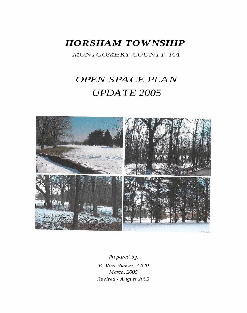
HORSHAM TOWNSHIP MONTGOMERY COUNTY, PA OPEN SPACE PLAN UPDATE 2005 Prepared by: E. Van Rieker, AICP March, 2005 Revised - August 2005
| Date post: | 26-May-2018 |
| Category: |
Documents |
| Upload: | nguyendung |
| View: | 222 times |
| Download: | 1 times |
HORSHAM TOWNSHIPMONTGOMERY COUNTY, PA
OPEN SPACE PLAN
UPDATE 2005
Prepared by:
E. Van Rieker, AICPMarch, 2005
Revised - August 2005
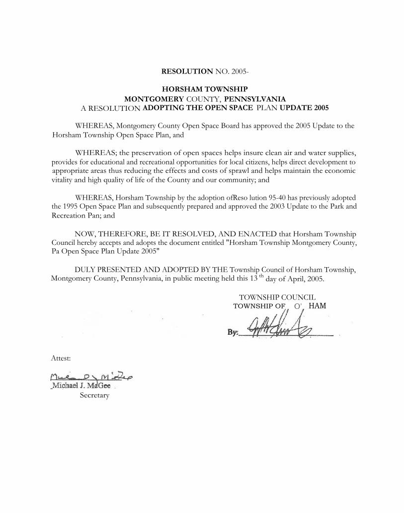
RESOLUTION NO. 2005-
HORSHAM TOWNSHIPMONTGOMERY COUNTY, PENNSYLVANIA
A RESOLUTION ADOPTING THE OPEN SPACE PLAN UPDATE 2005
WHEREAS, Montgomery County Open Space Board has approved the 2005 Update to theHorsham Township Open Space Plan, and
WHEREAS; the preservation of open spaces helps insure clean air and water supplies,provides for educational and recreational opportunities for local citizens, helps direct development toappropriate areas thus reducing the effects and costs of sprawl and helps maintain the economicvitality and high quality of life of the County and our community; and
WHEREAS, Horsham Township by the adoption ofReso lution 95-40 has previously adoptedthe 1995 Open Space Plan and subsequently prepared and approved the 2003 Update to the Park andRecreation Pan; and
NOW, THEREFORE, BE IT RESOLVED, AND ENACTED that Horsham TownshipCouncil hereby accepts and adopts the document entitled "Horsham Township Montgomery County,Pa Open Space Plan Update 2005"
DULY PRESENTED AND ADOPTED BY THE Township Council of Horsham Township,Montgomery County, Pennsylvania, in public meeting held this 13 th day of April, 2005.
TOWNSHIP COUNCILTOWNSHIP OF O' HAM
By:
Attest:
Secretary
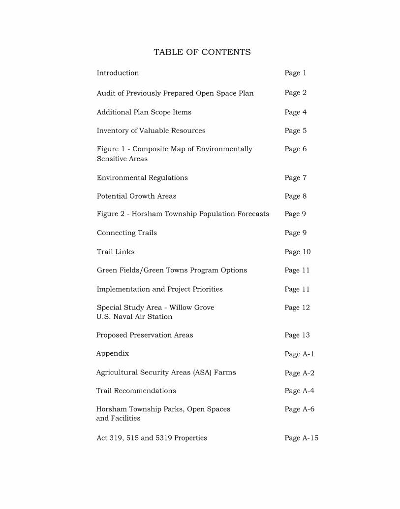
TABLE OF CONTENTS
Introduction Page 1
Audit of Previously Prepared Open Space Plan
Page 2
Additional Plan Scope Items
Page 4
Inventory of Valuable Resources
Page 5
Figure 1 - Composite Map of Environmentally
Page 6Sensitive Areas
Environmental Regulations
Page 7
Potential Growth Areas Page 8
Figure 2 - Horsham Township Population Forecasts Page 9
Connecting Trails
Page 9
Trail Links
Page 10
Green Fields/Green Towns Program Options
Page 11
Implementation and Project Priorities
Page 11
Special Study Area - Willow Grove
Page 12U.S. Naval Air Station
Proposed Preservation Areas
Page 13
Appendix
Page A-1
Agricultural Security Areas (ASA) Farms
Page A-2
Trail Recommendations
Page A-4
Horsham Township Parks, Open Spaces
Page A-6and Facilities
Act 319, 515 and 5319 Properties Page A-15

Protected Lands Map Rear Pocket
Recommendations Plan Map Rear Pocket
U
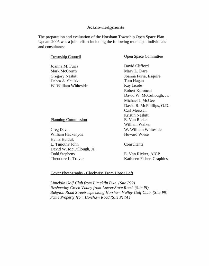
Acknowledgments
The preparation and evaluation of the Horsham Township Open Space PlanUpdate 2005 was a joint effort including the following municipal individualsand consultants:
Township Council
Joanna M. FuriaMark McCouchGregory NesbittDebra A. ShulskiW. William Whiteside
Planning Commission
Greg DavisWilliam HackenyosHeinz HeidukL. Timothy JohnDavid W. McCullough, Jr.Todd StephensTheodore L. Truver
Open Space Committee
David CliffordMary L. DareJoanna Furia, EsquireTom HaganKay JacobsRobert KoroncaiDavid W. McCullough, Jr.Michael J. McGeeDavid R. McPhillips, O.D.Carl MeixsellKristin NesbittE. Van RiekerWilliam WalkerW. William WhitesideHoward Wiese
Consultants
E. Van Ricker, AICPKathleen Fisher, Graphics
Cover Photographs - Clockwise From Upper Left
Limekiln Golf Club from Limekiln Pike. (Site P22)Neshaminy Creek Valley from Lower State Road. (Site PI)Babylon Road Streetscape along Horsham Valley Golf Club. (Site P9)Fame Property from Horsham Road (Site P17A)

HORSHAM TOWNSHIP OPEN SPACE PLAN UPDATE 2005
Introduction
The initial Horsham Township Open Space Plan was completed in 1995 andadopted by Resolution No. 95-40 August 9, 1995. That plan was prepared inaccordance with the recommendations of the Montgomery County Open SpacePreservation Task Force circa 1993.
In 2003 Horsham Township published the Horsham Township Park andRecreation Plan Update. This plan was a follow up to a Park and RecreationPlan that was prepared in 1991 and an Open Space Plan that was completed in1995. This plan incorporated extensive public input through citizen surveys,public meetings and key person interviews. The plan reported on customeranalysis (consisting of residents and non-residents); supply analysis whichincluded an inventory and assessment of the existing supply of available parks,recreation facilities, and recreation programs; a needs analysis which included astudy of the spatial distribution and physical accessibility of parks andrecreation facilities, and related existing facilities to national standards;opportunities, strategic goals and a system plan which identified new parks to beacquired. Trail, sidewalk, and on-road bicycle facility improvements were alsoaddressed; and numerous land use exhibits such as: Existing Land Use Map,presentation of demographic characteristics and future population forecastsbased on census data for 2000, and exhibits which identified parks and openspace areas throughout the Township. Much of this information can be utilizedin connection with specific open space planning guidelines developed in theMontgomery County Green Field/Green Towns Program Requirements .
The Horsham Township Park and Recreation Plan Update 2003 and theHorsham Township Open Space Plan Update 2005 reflect the most currentplanning for recreation and open space in Horsham Township and should beused as joint planning documents.
The following sections address elements outlined by the Montgomery CountyOpen Space Board letter of June 3, 2004.
1

Audit of Previously Prepared Open Space Plan
The 1995 Open Space Plan included numerous properties which received aPriority I or Priority II for preservation. The following is a list of thoseproperties preserved subsequent to the 1995 Plan:
1. Lukens Park at Dresher Road (designated as a Priority I: Essential in the1995 Open Space Plan). This property consists of 50.68 acres, isidentified as a community park, protects over 1,800 linear feet of animportant tributary of the Pennypack Creek, and includes the followingfacilities:
• Three adult size softball fields;
• Two multi-purpose play fields;
• Trails which interconnect to the new Power Line Trail;
• Handicapped accessible playground apparatus;
• One picnic pavilion;
• Restrooms.
2. The Hearne property (designated as a Priority I: Essential forpreservation in the 1995 Open Space Plan).
• This property consists of 78.4 acres, is situated on both sides ofJarrett Road, and is currently passive open space and used foragricultural purposes.
3. Horsham Township Library property. This was a ten (10) acre portionof the Hearne property (see above) situate the corner of Babylon Roadand Jarrett Road (this was designated as a Priority I: Essential forpreservation in the 1995 Open Space Plan).
• This property has been developed for a new Township libraryand support parking facilities.
2

4. Chestnut Creek Park. This is an area in part designated as Priority II:Important for preservation in the 1995 Open Space Plan. This park areaconsists of 64.6 acres with frontage along the easterly side of LowerState Road and the southerly side of Limekiln Pike. It is open spacededicated as a result of cluster residential development option andconsists of:
• Three full size lighted football fields.
• Two half-size lighted football fields.
• Concession stand.
• Restroom.
5. Chestnut Creek Park open space (designated as Priority II: Important forpreservation in the 1995 Open Space Plan). This area consists of 16.09acres and includes riparian corridor and other wetland and naturalfeature preservation areas associated with the tributary of the LittleNeshaminy Creek.
6. Highgate open space (designated as Priority I: Essential for preservationin the 1995 Open Space Plan). The property consists of 30.52 acresalong an important tributary of the Park Creek and protects valuablewetlands and vegetation.
7. Squires Knoll open space (designated as Priority I: Essential forpreservation in the 1995 Open Space Plan). The property consists of30.7 acres of open space adjacent to the north and south edges of theSquires Knoll residential development acquired as a part of the clusterresidential development option and protects an important tributary of thePark Creek and forest area.
8. Kingswood Estate open space (designated as Priority II: Important forpreservation in the 1995 Open Space Plan). This property consists of14.83 acres of wetland and heavily wooded open space along thewesterly perimeter of Kohler Park and helps preserve the setting of thepark as well as extensive natural features. This land was obtainedpursuant to the cluster option.
3

9. Power Line Trail. The Township has successfully negotiated withPECO for permission to develop a paved walking trail for a distance ofapproximately 2.4 miles connecting Dresher Road to Babylon Road.This trail implements a portion of the County-wide Power Trail systemwhile locally providing a link between the Lukens Park and otherTownship open spaces such as the Hearne property, the HorshamTownship Library, and the previously preserved Wichard property of12.16 acres.
10. The following additional open space properties were preserved since the1995 Open Space Plan:
• Strawbridge property, 102.9 acres. This is land currently ownedby Horsham Township that was previously identified as NaturalLands Trust property. The land borders the Willow Grove U.S.Naval Air Station and significant alluvial lands associated withthe tributary of the Park Creek and the easterly and southerlyboundary of Graeme State Park.
It should further be noted that all previous properties recommended forpreservation in the 1995 Open Space Plan are identified in the 2003 Park andRecreation Plan as a proposed preservation area, with the exception of a smallparcel along the westerly side of Cedar Hill Road previously identified as aPriority II. These properties are incorporated on the Open Space Plan Update2005.
Additional Plan Scope Items
Temporarily Protected Lands
The Montgomery County Farm Land Preservation office reports that fourteenproperties which total 686.86 acres are a part of an Agricultural Security Areain Horsham Township. Please see the Appendix for complete list. Of these,three properties are currently preserved as a part of Township open space: Seethe portion of the Cedar Hill Road Park and Strawbridge property formerlyowned by the Natural Lands Trust. Additional properties identified as ProposedPreservation Areas include:
• David Ambler property (29.5 acres) situate 1111 Grindleton Lane.
• Kuhn Day Camp property (65 acres) situate the northerly side of WitmerRoad
4

• College Settlement Farm of Philadelphia property (134 acres) withfrontage along Witmer, Mann and Welsh Roads.
• The Natural Lands Trust property (C. Peter Smyrl) consisting of 71acres along the upper reach of the Pennypack Creek between Mann Roadand Norristown Road.
Numerous properties in Horsham Township are enrolled in the Open SpaceCovenants program for preferential tax assessment, including:
Under Act 515: Horsham Valley Golf ClubSquires Golf ClubLimekiln Golf CourseHorsham Friends Meeting (17 acres)Singer, Jacob and Pamela (19.1 acres)
Under Act 319: Twenty-four properties (see Appendix) including 14properties which are a part of the Agricultural SecurityArea (see Appendix, page A-2).
While all properties currently enrolled in the Open Space Covenant program(Acts 319 or 515) are desirable for open space, specific properties which arerecommended as a Proposed Preservation Property are identified on theRecommendations Plan (located in the rear pocket of the report). SeeAppendix, page A-15 for a complete list of Act 319 and 515 properties.
See Protected Lands Map (attached) for a complete inventory and mapping ofboth Temporarily Protected and Permanently Protected land in HorshamTownship.
Inventory of Vulnerable Resources
See exhibit identified as Figure 1 Composite Map of Environmentally SensitiveAreas. This map was excerpted from the 1995 Horsham Township Open SpacePlan. It includes an inventory of the following vulnerable resources:
• Areas which are a part of the Floodplain Conservation District.
• Woodland areas and areas of high scenic value.
• Wetlands.
• Prime agricultural soils.
5

HORSHAM TOWNSHIP MONTGOMERY COUNTY, PENNSYLVANIA
.D,mm Ix
~,. .OM
Ci
Woodland And Areas Of Scenic Value (Typ.)
Flood Plains And Wetlands (Typ.)
FIGURE 1 - COMPOSITE MAP OFENVIRONMENTALLY SENSITIVE AREAS

In Horsham Township, areas of steep slopes (over 15%) are concentrated alongthe edges of riparian corridors and are generally located within the areasidentified as "floodplains".
Significant portions of the Little Neshaminy and Park Creeks are permanentlypreserved in open space areas and preserved park land owned by the Townshipor State or temporarily preserved by private golf courses and properties inAgricultural Security Areas.
Upper reaches of the Pennypack Watershed, particularly areas west of WitmerRoad and north of Blair Mill Road, are preserved as portions of permanent andtemporarily preserved lands as well - see Blair Mill Elementary School,Clearbrook Park open space, and Springbrook Park along the north branch; andfloodplain conservation district areas associated with the aforementioned KuhnDay Camp, Natural Lands Trust property, and College Settlement Farm ofPhiladelphia area help protect the headwaters of the Pennypack Creek in thesoutheast quadrant of the Township.
Potential open space linkages have been identified on Figure 49, System PlanMap, of the 2003 Park and Recreation Plan and are superimposed over the2005 Open Space Plan Update attached to this supplement.
Environmental Regulations
Horsham Township Council amended the Horsham Township Zoning Ordinancewith Ordinance No. 1147 (September 1998) to provide environmental protectionstandards, including regulations for the protection of wetlands, wetlandtransition areas, woodlands, steep slopes, and riparian corridors. The ordinancerequires that each site calculate the protected area as determined by variousenvironmentally sensitive areas.
In addition to wetland delineations, which require that wetlands not be altered,regraded, developed or built upon, a wetland transition area was established toprevent ground water contamination, reduce surface water runoff andsedimentation, and to protect hydrology and wildlife habitats. Wetlandtransition areas shall have a minimum of 25 feet and are increased dependingupon the presence of slopes in excess of 10% or the presence of herbaceous orscrub-shrub vegetational communities.
Riparian Corridor Conservation Districts (RCCD) were established to protectthe outer zones beyond floodplains that apply to the Stream Valley Network,Figure 5 as identified in the Horsham Township Open Space Plan 1995,including all tributaries, perennial and intermittent streams . . .
7
Measurement of the RCCD boundary follows conventional methodology whichestablishes two distinct zones:
• Zone 1 begins at the edge of each identified waterway and extendsdistances determined by slope and the presence of sensitive vegetation.
• Zone 2 begins at the outer edge of Zone 1 and extends an additionalwidth of 50 feet.
The RCCD also requires a "Corridor Management Plan" which is identified atthe time of subdivision and land development and helps ensure the continuedpreservation and integrity of the riparian corridor.
This environmental protection ordinance is currently in place, has been utilizedsince 1998, and is a direct outgrowth of previous inventory andrecommendations from the 1995 Open Space Plan.
Potential Growth Areas
The Township has elected to pursue a position of gradual in-fill, believing thatmajor growth areas of residential, commercial, and industrial sections of theTownship have previously been established, are consistent with the currentZoning Ordinance, and no significant expansion is contemplated.
The Township also contains a large presence of institutional land uses - seeFigure 2, Land Use Map, from the 2003 Park and Recreation Plan. In additionto uses already identified, large institutional land uses include the following:
• Willow Grove Naval Air Station Joint Reserve Base (approximately1,100 acres).
• Horsham Township schools including Hatboro Horsham High School,Simmons Elementary School, the old Simmons School, Keith ValleyMiddle School.
• The Horsham Clinic and Whitemarsh Memorial Cemetery and places ofworship such as: St. Catherine of Sienna Church and School, St.Matthew's Episcopal Church; and the Philadelphia Geriatric Centercampus along the westerly boundary with Montgomery Townshipaccount for nearly 250 acres of privately protected land.
8
• Large privately owned open space recreation areas such as LimekilnGolf Club, Talamore Golf Course (deed restricted), Squires Golf Club,Commonwealth National Country Club (partly deed restricted), and theUkrainian-American Sports Center make a significant presence in thenorth-northwest portions of the Township and are expected to remainunchanged for the foreseeable future.
Only modest population growth is contemplated through the years 2010 and2020.
Figure 2 - Horsham Township Population Forecasts
Existing Population Estimated PopulationPercent Percent
2000 2010 Increase 2020 Increase
24,232 26,050 7.5% 28,850 19.1%
Source: Year 2025 County & Municipal Population & Employment Forecasts,Delaware Valley Regional Planning Commission April 2000.
Connecting Trails
The 2005 Open Space Plan identifies existing and proposed trails. The trailsare identified on pages ES-15 and ES-16 of the 2003 Horsham Township Parkand Recreation Plan. A description of the trail recommendations as discussed inthe 2003 Horsham Township Park and Recreation Plan Update is appended tothis report for ready reference. In addition, multiple greenway initiatives areidentified including:
• Little Neshaminy Creek Greenway - The greenway opportunity along theLittle Neshaminy Creek (P1) would be a short segment of a broaderpreservation initiative in other communities through which the creekpasses. The greenway segment in Horsham Township has merit on itsown standing because of its environmental significance for the role itplays in the proposed trail network for the Township.
9
• Pennypack Greenway - The Pennypack Ecological Restoration Truststrives to protect open space within the Pennypack Creek watershed,which extends into much of the eastern portion of Horsham Township.It is suggested the Township support the Trust in its activities tocomplement the open space along the creek and elsewhere in thewatershed. Proposed Preservation Areas P11, P12, and P13 are ofparticular relevance, as they represent the headwaters of the PennypackCreek (excerpted in part from the 2003 Park and Recreation Plan). Itshould be further noted that Horsham Township and other municipalitiesare participating with the Temple University Center for SustainableCommunities, which will study and make recommendations foracquisition and preservation techniques.
• Power Line Trail. The Township is coordinating with PECO Energy toenhance the existing electric transmission corridor through theconstruction of additional sections of the Power Line Trail (in additionto the 2.4 miles that presently exist between Dresher Road and BabylonRoad). The corridor functions as a de facto greenway and its value as aresource in the community can be improved by more actively managingthe vegetation.
It should be noted the Power Line Trail is identified on the MontgomeryCounty Draft Transportation Plan at Figure 14, Planned RegionalTrails, as one of the important County-wide trail systems.
Horsham Township desires to continue the trail through the Township andconsiders this a priority undertaking.
Trail Links
Trail linkages with adjoining municipalities will be coordinated with adjoiningmunicipal open space plans as they are completed. For the time being, the 2003Park and Recreation Plan identifies ten key pedestrian and bicycle linkages toneighboring communities which are summarized below and illustrated on theRecommendations Plan (see attached):
Li Little Neshaminy Creek Greenway/Trail access points into MontgomeryTownship and Warrington Township.
L2 Power Line Trail extension into Montgomery Township.
L3 Lower Gwynedd Township link at McKean Road and possibleconnection to future municipal trail.
10
IA Warrington Township connection at Kansas Road to Bradford (Dam 611)Park.
L5 Upper Dublin Township link to Maple Glen retail center.
L6 Warminster Township link as a primary route to municipal and regionalrecreation areas.
L7 Warminster Township link as a primary route to municipal communitypark.
L8 Hatboro Borough link as a primary route to municipal community parkand pool.
L9 Connection to regional Cross County Trail.
L10 Upper Dublin Township link as a primary route to municipal recreationareas.
In addition, the Upper Dublin Township Comprehensive Park, Recreation andOpen Space Plan published 1998 includes primary Montgomery County on-roadbike routes recommended for Welsh Road along the entire boundary with UpperDublin (from Tennis Avenue to Blair Mill Road), and along Norristown Roadand Butler Pike as these roads enter Horsham Township from the direction ofUpper Dublin Township.
Green Fields/Green Towns Program Options
The Township intends to focus on the preservation of the properties identifiedon the Open Space Plan Update 2005, the addition of open space propertiesadjacent to existing parks as the opportunity may arise, and complete the PowerLine Trail through the Township if practicable. As such, at this time theTownship wishes not to pursue the optional program items: Floodplainrestoration, heritage resources conservation, and farmland preservation.
Implementation and Project Priorities
The Table which follows enumerates the various preservation areas identified onthe Open Space Plan Map. Priorities indicated are estimated and could changeas preservation priorities having a high ranking are achieved. All propertiesproposed for preservation are considered significant and are ranked as eitherhaving a high or medium importance.
11

Special StudyArea -Willow Grove U.S. Naval Air Station
The Willow Grove U.S. Naval Air Station property consists of over 1,100 acresand has been in operation since 1942. Nearly half of this land along HorshamRoad and Privet Road between Maple Avenue to the south and Keith ValleyRoad to the north functions as largely undeveloped buffers and protection zonesassociated with the current operations.
In the event the Air Station property discontinues or significantly reducescurrent operations, a comprehensive land use study should be performed todetermine desired alternate uses for the facility. This study would determineappropriate future land use, including the desirability of maintaining orimproving the quality of existing open space on unused and undeveloped lands(see Recommendations Plan).
12
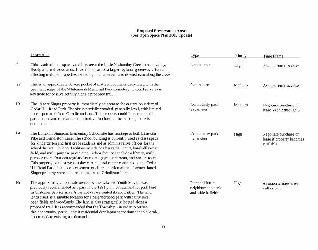
Proposed Preservation Areas(See Open Space Plan 2005 Update)
Description
P1 This swath of open space would preserve the Little Neshaminy Creek stream valley,floodplain, and woodlands. It would be part of a larger regional greenway effort aaffecting multiple properties extending both upstream and downstream along the creek.
P2 This is an approximate 20 acre pocket of mature woodlands associated with theopen landscape of the Whitemarsh Memorial Park Cemetery. It could serve as akey node for passive activity along a proposed trail.
P3 The 19 acre Singer property is immediately adjacent to the eastern boundary ofCedar Hill Road Park. The site is partially wooded, generally level, with limitedaccess potential from Grindleton Lane. This property could "square out" thepark and expand recreation opportunity. Purchase of the existing house isnot intended.
P4 The Limekiln Simmons Elementary School site has frontage to both LimekilnPike and Grindleton Lane. The school building is currently used as class spacefor kindergarten and first grade students and as administrative offices for theschool district. Outdoor facilities include one basketball court, baseballlsoccerfield, and multi-purpose paved area. Indoor facilities include a library, multi-purpose room, fourteen regular classrooms, gym/lunchroom, and one art room.This property could serve as a day care cultural center connected to the CedarHill Road Park if an access easement or all or a portion of the aforementionedSinger property were acquired at the end of Grindleton Lane.
P5 This approximate 20 acre site owned by the Lakeside Youth Service waspreviously recommended as a park in the 1991 plan, but demand for park landin Customer Service Area A has not yet warranted its acquisition. The landlends itself as a suitable location for a neighborhood park with fairly levelopen fields and woodlands. The land is also strategically located along aproposed trail. It is recommended that the Township - in order to pursuethis opportunity, particularly if residential development continues in this locale,accommodate existing use demands.
Type Priority Time Frame
Natural area High As opportunities arise
Natural area Medium As opportunities arise
Community park Medium Negotiate purchase orexpansion lease Year 2 through 5
Community park High Negotiate purchase orexpansion lease if property becomes
available
Potential future High As opportunities ariseneighborhood parks - all or partand athletic fields
13

Description
P6 About 15 additional acres of the Heffernan property is expected to be dedicatedas open space to the Township when the site is developed as an industrial park.
P7 This site is part of a larger unique natural area comprised of a good quality forest,which is uncommon in Horsham Township. The mapped area of the RoMynalo Inc.property coincides with the approximate acreage to be set aside as open space anddedicated to t he Township as part of a planned business campus.
P8 This triangular vacant parcel is the 30 acre Larocca property. It has extensivefrontage along County Line Road and could be acquired to enlarge and enhancethe overall scenic qualities" of the adjacent Township-owned Strawbridge propertyopen space and historic area, including the landscape surrounding Graeme Park.
P9 The Horsham Valley Golf Club is an 18-hole public golf course spread out overapproximately 66 acres. The site is a visual and recreational amenity in thecommunity that also abuts Kohler Park, one of the Township's community parks.Acquisition of the golf course and its operation as a municipal facility is contemplatedonly as a means to ensure preservation of this open space landmark and only if itcould be financially self-sustaining. It is further recommended that a studyexamining the feasibility of such an undertaking be prepared if and when theTownship eventually takes action on this proposal.
P10 In Customer Service Area D (see 2003 Horsham Township Park and Recreation Potential future Medium As opportunities arisePlan), this 9 acre open space owned by Willow Grove Bank (formerly Braccia neighborhood park - all or partproperty) is mostly surrounded by existing development. Open space is at apremium in this fairly densely developed geographic area, especially along thefringes near neighboring Upper Dublin Township. This site is an open spaceopportunity that could function as a small recreation area for a part of theTownship that is not currently served by a neighborhood park.
P11 The 71 acre Natural Lands Trust Inc. property consists of a mix of open and Natural area High As opportunities arisewooded lands, traversed along its westerly frontage by a stream valley and itsaccompanying floodplain soils. It provides natural wildlife habitat and scenic values.
Type Priority Time Frame
Natural area High As opportunities arise
Natural area Medium As opportunities arise- all or part
Natural area Medium As opportunities arise- all or part
Potential community High Acquire if property ispark - Municipal placed for sale or isgolf course in jeopardy of being
developed
- all or part
14
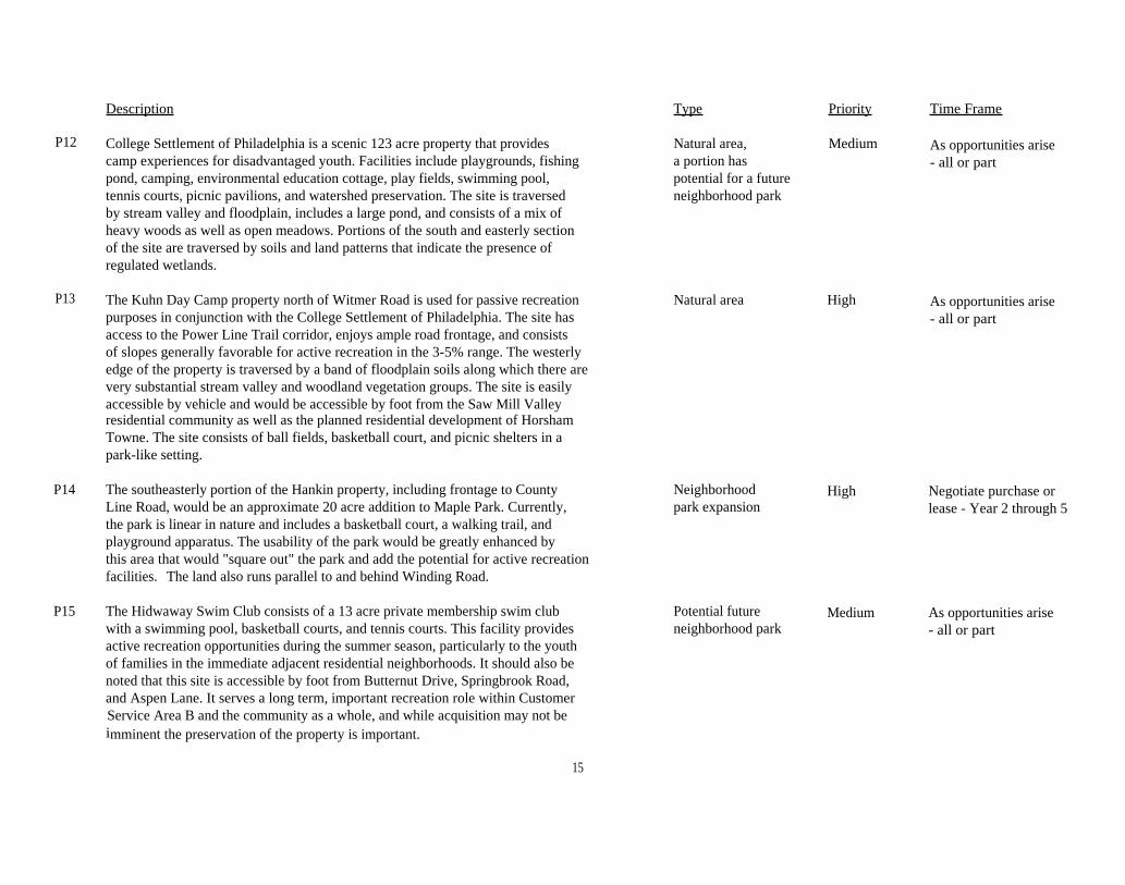
Description Type Priority Time Frame
P12 College Settlement of Philadelphia is a scenic 123 acre property that provides Natural area, Medium As opportunities arisecamp experiences for disadvantaged youth. Facilities include playgrounds, fishing a portion has - all or partpond, camping, environmental education cottage, play fields, swimming pool, potential for a futuretennis courts, picnic pavilions, and watershed preservation. The site is traversed neighborhood parkby stream valley and floodplain, includes a large pond, and consists of a mix ofheavy woods as well as open meadows. Portions of the south and easterly sectionof the site are traversed by soils and land patterns that indicate the presence ofregulated wetlands.
P13 The Kuhn Day Camp property north of Witmer Road is used for passive recreationpurposes in conjunction with the College Settlement of Philadelphia. The site hasaccess to the Power Line Trail corridor, enjoys ample road frontage, and consistsof slopes generally favorable for active recreation in the 3-5% range. The westerlyedge of the property is traversed by a band of floodplain soils along which there arevery substantial stream valley and woodland vegetation groups. The site is easilyaccessible by vehicle and would be accessible by foot from the Saw Mill Valleyresidential community as well as the planned residential development of HorshamTowne. The site consists of ball fields, basketball court, and picnic shelters in apark-like setting.
P14 The southeasterly portion of the Hankin property, including frontage to CountyLine Road, would be an approximate 20 acre addition to Maple Park. Currently,the park is linear in nature and includes a basketball court, a walking trail, andplayground apparatus. The usability of the park would be greatly enhanced bythis area that would "square out" the park and add the potential for active recreationfacilities. The land also runs parallel to and behind Winding Road.
P15 The Hidwaway Swim Club consists of a 13 acre private membership swim club Potential future Medium As opportunities arisewith a swimming pool, basketball courts, and tennis courts. This facility provides neighborhood park - all or partactive recreation opportunities during the summer season, particularly to the youthof families in the immediate adjacent residential neighborhoods. It should also benoted that this site is accessible by foot from Butternut Drive, Springbrook Road,and Aspen Lane. It serves a long term, important recreation role within CustomerService Area B and the community as a whole, and while acquisition may not beimminent the preservation of the property is important.
Natural area High As opportunities arise- all or part
Neighborhood High Negotiate purchase orpark expansion lease - Year 2 through 5
15
Description Type Priority Time Frame
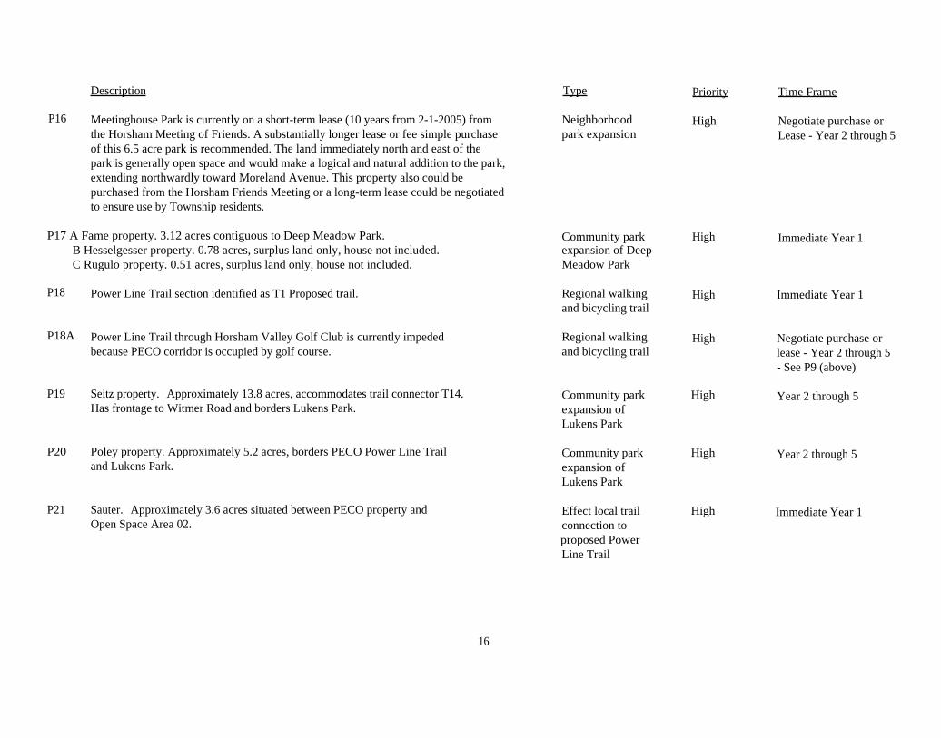
P16 Meetinghouse Park is currently on a short-term lease (10 years from 2-1-2005) fromthe Horsham Meeting of Friends. A substantially longer lease or fee simple purchaseof this 6.5 acre park is recommended. The land immediately north and east of thepark is generally open space and would make a logical and natural addition to the park,extending northwardly toward Moreland Avenue. This property also could bepurchased from the Horsham Friends Meeting or a long-term lease could be negotiatedto ensure use by Township residents.
P17 A Fame property. 3.12 acres contiguous to Deep Meadow Park.B Hesselgesser property. 0.78 acres, surplus land only, house not included.C Rugulo property. 0.51 acres, surplus land only, house not included.
Neighborhood Highpark expansion
Community park Highexpansion of DeepMeadow Park
Negotiate purchase orLease - Year 2 through 5
Immediate Year 1
P18 Power Line Trail section identified as T1 Proposed trail. Regional walkingand bicycling trail
Immediate Year 1High
P18A Power Line Trail through Horsham Valley Golf Club is currently impededbecause PECO corridor is occupied by golf course.
P19 Seitz property. Approximately 13.8 acres, accommodates trail connector T14.Has frontage to Witmer Road and borders Lukens Park.
P20 Poley property. Approximately 5.2 acres, borders PECO Power Line Trailand Lukens Park.
P21 Sauter. Approximately 3.6 acres situated between PECO property andOpen Space Area 02.
Regional walkingand bicycling trail
Community parkexpansion ofLukens Park
Community parkexpansion ofLukens Park
Effect local trailconnection toproposed PowerLine Trail
High Negotiate purchase orlease - Year 2 through 5- See P9 (above)
High
High
High Year 2 through 5
Year 2 through 5
Immediate Year 1
16

Description Type Priority Time Frame
P22 Limekiln Valley Golf Club. A 27 hole public golf course occupying Potential communityapproximately 207.86 acres. This is a strategic open space property for park - Municipalmany reasons: Large portions of the golf course contain woodland golf coursevegetation, ponds, and help to provide protection for the flight linesassociated with the Willow Grove U.S. Naval Air Station. The northerlyportion of the property could also provide an expansion to the soccerfields owned by Lakeside Youth Service (see P5). Acquisition of thegolf course and its operation as a municipal facility is contemplatedonly as a means to ensure preservation of this open space landmarkand only if it could be financially self-sustaining. It is furtherrecommended that a study examining the feasibility of such anundertaking be prepared if and when the Township eventually takesaction on this proposal.
P23 Squires Golf Club. A 137 acre private golf club with extensive frontage Private golf course High As opportunitiesalong Cedar Hill Road, Stongs Lane and McKean Road. Includes a wide arisevariety of wooded areas, floodplain and minor tributaries of the Park Creek.The property is currently enrolled under Open Space Covenant Act 515.
P24 Opportunity Preservation Areas adjacent to existing parks that would be Expansion of High As opportunitiesuseful in expanding park facilities, vehicular and pedestrian access, or existing Township arisepreserve natural resources and important viewsheds which enhance parks or preservedthe visitor's experience. (Not individually mapped.) open space
A complete list of Township Parks and Open Space is appended.
Acquire if property isplaced for sale or is injeopardy of beingdeveloped
High
17

APPENDIX

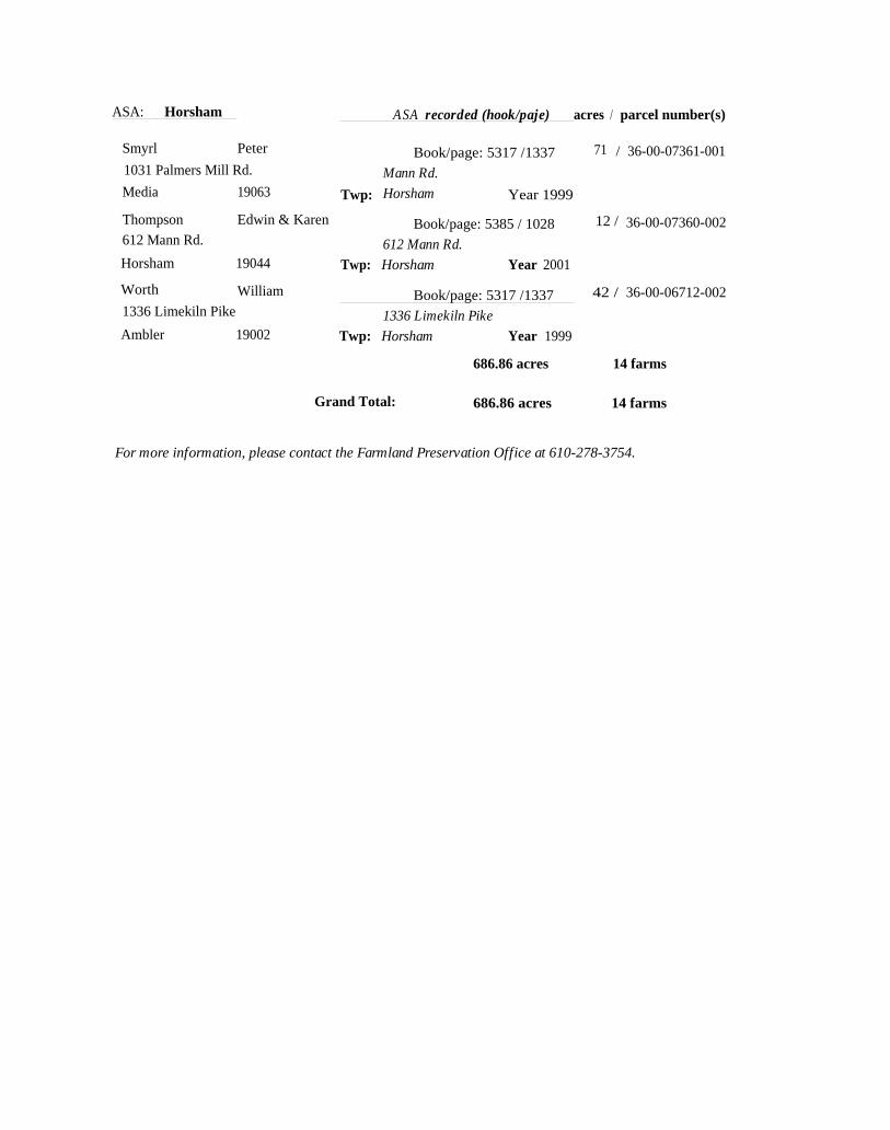
Agricultural Security Area (ASA) Farms
SEP
31-Aug-04
LU lf
ASA: Horsham ASA recorded (book/page) acres / parcel number(s)
HorshamAmbler David
Book/page:29.5 / 36-00-10657-008,
238 Walden St. 1111 Grindleton La.
Cambridge, MA 02140 Twp: Horsham Year 2004
36-00-10660-005
Bertholf Dorothea & William Book/page: 5317 / 1337 ; 15 /
1159 Horsham Rd. 1159 Horsham Rd.Ambler 19002 Twp: Horsham Year 1999
36-00-05696-001
Can Thomas & Debra Book/page: 5317 / 1337 ! 39 /
118 Park Rd. 110 Park Rd.
Ambler 19002 Twp: Horsham Year 1999
36-00-09550-008
Gerome Frank Book/page: 5317 / 1337 134 / 36-00-11743-002,
600 Witmer Rd. 600 Witmer Rd. & Welsh Rd. 36 00 11719 008,
Horsham 19044 Twp: Horsham Year 199936-00-11425-005
Horsham Twp McGee, M Mgr. Book/page: 5317 / 1337 120 / 36-00-04774-005,
1025 Horsham Rd. Governors Rd Cedar Hill Rd. 36 00-04783 005,
Horsham 19044 Twp: Horsham Year 199936-00-01981-107
Kohler Patricia Book/page: / - 58.36 / 36-00-03034-017,
1262 Limekiln Pike County Line Rd.Ambler 19002 Twp: Horsham Year 2004
36 00 03034-026
Kohler fam. of Charles ' Book/page: 5317 / 1337 38 / 36-00-06701-004,
1262 Limekiln Pike 1262 Limekiln Pike
Ambler 19002 Twp: Horsham Year 1999
36-00-06703-002
Kuhn Henry J. Book/page: 5317 / 1337 65 / 36-00-11713-005,
600 Witmer Rd. 600 Witmer Rd. 36-00-11716-002,
Horsham 19044 Twp: Horsham Year 199936-00-11716-011
Lightcap, et al. David LBook/page_ 5317 /1337 I 12 / 36-00-06865-002
162 Limekiln Pike Limekiln Pike
Ambler 19002 Twp: Horsham Year 1999
Redwith, Esq. James Book/page: 53. 17 / 1337 32 /2001 The Fidelity Building Mann Rd, HorshamPhiladelphia 19109 Twp: Horsham Year 1999
36-00-07375-005
Singer Jacob & Pamela i Book/page: 5317 / 1337 19 /
1119 Grindleton La. Horsham Rd.
Ambler 19002 Twp: Horsham Year 1999
36-00-05701-005
A-2
ASA: Horsham ASA recorded (hook/paje) acres / parcel number(s)
Smyrl Peter Book/page: 5317 /1337
Mann Rd.
71 / 36-00-07361-0011031 Palmers Mill Rd.
Media 19063 Twp: Horsham Year 1999
Thompson
612 Mann Rd.
Horsham
Edwin & Karen
19044
Book/page: 5385 / 1028
612 Mann Rd.
Twp: Horsham Year 2001
12 / 36-00-07360-002
Worth William Book/page: 5317 /1337 42 / 36-00-06712-0021336 Limekiln Pike
Ambler 190021336 Limekiln Pike
Twp: Horsham Year 1999
686.86 acres 14 farms
Grand Total: 686.86 acres 14 farms
For more information, please contact the Farmland Preservation Office at 610-278-3754.

Chapter 7 — System Plan 2003 Horsham Township Park and Recreation Plan Update
ROLE AND RESPONSIBILITY: Provide open space connectors, greenways, andtrails as major components of the park system.
Recommendations (refer to Figure 49 located on page 117)17. TRAILS – The public input gathered for this plan points to an overwhelming
agreement that trails are important in the township. According to surveyresults, trails of various types are more popular than any other recreationfacility. Aside from recreation, trails can be used for transportation if they areappropriately designed, constructed, and part of an interconnected network ofother supportive facilities for pedestrians and bicyclists.
To date, the trails that exist are essentially disconnected. It is difficult, if notimpossible, for customers in many geographic areas to safely travel by foot oron bicycle from their homes or workplaces to the trails or betweendestinations using only trails. Therefore, it is recommended that the townshipstrive to establish a well-integrated community-wide system in which trailswork hand-in-hand with sidewalks as well as streets and roads that are safefor bicyclists. The trail component to such a system shown in Figure 49includes the following:• Power Line Trail Fxtension (T1) – This is the 2.1-mile westward
continuation of the Power Line Trail between Kohler Park and MontgomeryTownship.
• Park Creek Trail (T2) – This 1.9-mile trail passes through Cedar Hill RoadPark and township-owned open spaces along the Park Creek valley. Italso includes the spur connections to Worthington Court, Colby Lane, SunValley Drive, and Biwood Road.
• Little Neshaminy Trail (T3) – This 0.7-mile trail is located within the LittleNeshaminy Creek Greenway between Montgomery and Warringtontownships.
• Greenway Spur Trail (T4) – This 0.7-mile trail connects the LittleNeshaminy Creek Greenway Trail to Fairway Drive.
• Chestnut I imekiln Trail (T5) – This 0.21-mile trail is located betweenChestnut Lane and Limekiln Pike and is intended to link the Park CreekTrail and the Keith Valley Spur Trail by means of connections to sidewalksand residential streets.
▪ Keith Valley Spur Trail (T6) – This 1-mile trail connects Wedge Way to theKeith Valley Park Open Space.
• Keith Valley Trail (T7) – This 1.7-mile trail passes through the Park Creekvalley between Samuel Carpenter Park and the intersection of CountyLine Road and Keith Valley Road.
▪ Strawbridge Trail (T8) – This 1-mile trail passes through the StrawbridgeProperty Open Space between the Keith Valley Trail and County LineRoad.
A-4

Chapter 7 — System Plan 2003 Horsham Township Park and Recreation Plan Update
▪ Kohler Park Connector and Loop Trail (T9) – This 0.4-mile trail andcrosswalk across Horsham Road connects Deep Meadow and Kohlerparks and completes the loop trail between the soccer fields and the in-line skating hockey court.
• Library Trail (T10) – This 0.19-mile trail traverses the perimeter of theDorothea H. Simmons Elementary School grounds and connects to thetrail provided by the township at the Library.
. Nature Area Link Trail (T11) – This 0.24-mile trail connects the JarrettNature Center Trail to the trail provided by the township at the Library.Sawyers Trail (T12) – This 0.15-mile trail passes through the township'sSawyers Way Park and a vacant undeveloped lot as a connectionbetween Walnut Avenue and the dense residential area serviced bySawyers Way.
• Settlement Trail (T13) – This 0.44-mile trail passes through the CollegeSettlement of Philadelphia Property as a linkage between Witmer Roadand Tall Pines Lane.
• Camp Trail (T14) – This 0.25-mile trail passes through the Kuhn DayCamp Property as a link between Witmer Road and the Power Line Trail.
▪ Meetinghouse Trail (T15) This 0.15-mile trail passes through theHorsham Meeting of Friends property and a residential lot to connectWayne Avenue and Meetinghouse Parks.
• Blair Mill Trail (T16)– This 0.45-mile trail passes along the perimeter ofthe Blair Mill Elementary School property and Hatboro Borough's Blair MillPark (baseball complex) and connects to Upper Moreland Township'sBlair Mill Park playground and picnic area.
The preferred surface for these proposed trails is asphalt paving, but acompacted fine gravel mix would be a suitable alternative. The character ofthe corridor through which the trail passes should be taken into considerationin the trail surface selection. For example, the use of a soft surface or evenan elevated boardwalk segment might be most compatible for a trail in anenvironmentally sensitive area.
18. GREENWAYS – There are multiple greenway initiatives that should beundertaken, all of which are related to other recommendations alreadypresented:• Little Neshaminy Greenway – Recommendation 12 of this chapter
addressed an important greenway opportunity along the Little NeshaminyCreek (P1), which would be a short segment of a broader preservationinitiative in other communities through which the creek passes. But thegreenway segment in Horsham has merit on its own standing because ofits environmental significance and for the role it plays in the proposed trailnetwork for the township.
• Pennypack Greenway – The Pennypack Ecological Restoration Truststrives to protect open space within the Pennypack Creek watershed,which extends into much of the eastern portion of the community. Thetownship should support the Trust in its activities to complement the openspace along the creek and elsewhere in the watershed. Proposed
A-5

Horsham Township - Parks & Recreation
• Current Township Newsletter. Contact Information
. Directory & Site Map
• Online Feedback Form
HomeBreaking Township Parks
Police CodeWebsite
Finance Highway Library NewsletterNews Information Recreation Enforcement Resources
Wednesday, February 9, 2005 Home Parks & Recreation
Township Parks, Open Spaces & Facilities
Horsham Township residents are fortunate to have one of the largest park systems inMontgomery County. The Horsham Park System contains more than 814 acres in 46 sitesranging from community parks to neighborhood parks to open space.
(C) = Community Park(N) = Neighborhood Park(0) = Open Space area
(C) Kohler Park, 1013 Horsham Road, 71.42 acres
Parks & Recreation
Home
Recreation Programs &Registration
Adult Softball
Bus Trips
Discount Tickets
Horsham Day 2005
Park Permit
Parks & Facilities
Parks & Recreation Plan Update
Program Registration
Seniors Club
Seniors Club Newsletter
Wachovia Center Specials
Youth Sports Organizations
Website Resources
• Contact Phone List
4 Helpful Links
« Horsham Township Maps« Online Calendar
« Online Feedback Form« Website Directory
• Website Disclaimer. What's New at the Horsham
Township Website•
•Horsham Township Parks & •Recreation Updates
Enter Email Address Here
Sign-Up
▪ Fishing pond with two aerators
• Picnic tables, barbecue grills and one pavilionTwo areas of playground apparatus
• Asphalt walking trail
• One lighted in-line street hockey courtSix lighted soccer fieldsTwo restrooms
▪ One concession stand/clubhouse
▪ One storage garage
▪ Home to Horsham Soccer Association
• Gazebo
(C) Deep Meadow Park, 1020 Horsham Road, 51.88 acres
http://www.horsham.org/parks/parklist.aspx A-62/9/2005

Horsham Township - Parks & Recreation
▪ 11 baseball fields• Concession stand• Restrooms• 1-mile limestone walking/jogging trail▪ Playground apparatus• One 10-station outdoor exercise center▪ Picnic tables▪ One storage garage▪ One batting cage▪ Home to the Horsham Little League Association▪ Picnic Pavilion with tables and grills
(C) Samuel Carpenter Park, 1000 Horsham Road, 30.98 acres
▪ Built in 1995, improvements funded by grants and with funds from developers• Received Montgomery County Planning Commission "Outstanding Land Development"• Three basketball courts▪ Three tennis courts▪ Two sand volleyball courts• One adult size softball field• One 90 ft. baseball field▪ One official size football field▪ One pavilion▪ Barbecue grills and picnic tables▪ 3/4 mile limestone walking/jogging trail• Restrooms▪ Two multipurpose fields
(C) Chestnut Creek Park, 273 Lower State Road, 80 acres
• Home of the Horsham Hawks Football Association▪ Includes three full size lighted football fields, two half size lighted football fields,
concession stand and restrooms
(0) Strawbridge Property, County Line Road, 102.9 acres
▪ Open Space▪ Local farmer farms 60 acres of property• The property includes an old farm manor house, garage and several small buildings
Horsham Township1025 Horsham RoadHorsham, PA 19044
Phone: (215) 643-3131Fax: (215) 643-0448Email: horsham@horsham,orq
Hours: Monday - Friday, 8:30 AMto 4:30 PM
Horsham Twp Police
Phone: (215) 643-3600Fax: (215) 643-0390Email: police horsham,om
Hours: 24 Hours
Horsham Twp. MaintenanceBuilding & Garage1005 Horsham RoadHorsham, PA 19044
Phone: (215) 672-6913Fax: (215) 672-0849
Hours: Monday - Friday, 7:00 AMba 3:30 PM
Horsham Twp. Library435 Babylon RoadHorsham, PA 19044
iAww,H orsham L ibrary .orq
Phone: (215) 443-2609Fax: (215) 443-2697
Hours: Monday: 12:30 PM to6:30 PM
Hours: Tues - Thurs: 10:00 ,8MIn 6:30 PM
Hours: Friday: 10:00 AM to 6:00PM
Hours: Saturday: 10:00 PM to5:00 PM
http://vvwvv.horsham.org/parks/parklist.aspx A-7 2/9/2005

Horsham Township - Parks & Recreation
(C) Cedar Hill Road Park, 449 Cedar Hill Road, 87 acres
▪ Phase one was constructed in Nov. 2000• Park opened on Oct. 10, 2001▪ Playground apparatus• Li mestone walking trail▪ One adult sized softball field• One open play field▪ Two grass volleyball courts• Nature Trail with 3 nature blinds▪ Future plans include two picnic shelters, two horseshoe pits and restrooms• Future environmental studies area▪ Outdoor classroom
(N) Maple Park, 606 A Brumar Drive, 7.46 acres
▪ Playground apparatus▪ One basketball court▪ Swing set▪ Asphalt path
(C) Meetinghouse Park, 238 Meetinghouse Road, 6.5 acres
• Leased from Horsham Monthly Meeting of Friends▪ Picnic grove with tables and grills▪ Playground apparatus
(N) Wayne Avenue Park, Girard Avenue, 1.4 acres
http://www.horsham.org/parks/parklist.aspx A-82/9/2005
Horsham Township - Parks & Recreation
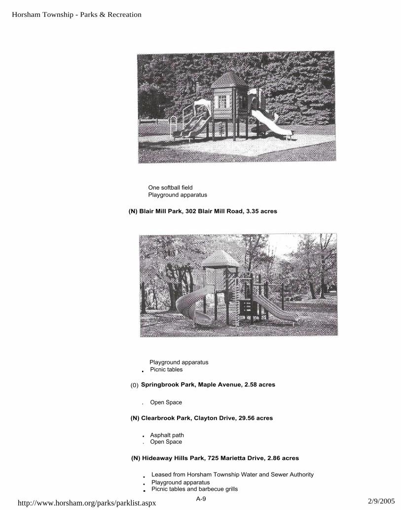
One softball fieldPlayground apparatus
(N) Blair Mill Park, 302 Blair Mill Road, 3.35 acres
Playground apparatus▪ Picnic tables
(0) Springbrook Park, Maple Avenue, 2.58 acres
. Open Space
(N) Clearbrook Park, Clayton Drive, 29.56 acres
• Asphalt path. Open Space
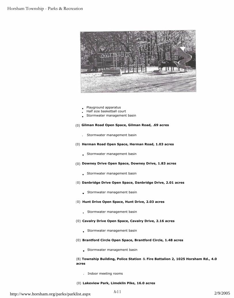
(N) Hideaway Hills Park, 725 Marietta Drive, 2.86 acres
• Leased from Horsham Township Water and Sewer Authority
• Playground apparatus▪ Picnic tables and barbecue grills
http://www.horsham.org/parks/parklist.aspxA-9 2/9/2005

Horsham Township - Parks & Recreation
(0) Keith Valley Park, Keith Valley Road, 29.20 acres
. Open Space
(0) Pemmapecka Park, 331 Summer Avenue, .45 acres
▪ Open Space
(N) Jarrett Road Park, 726 Jarrett Road, 2.31 acres
. Playground apparatus
• Gazebo, August 2004
(N) Sawyer 's Way Park, Sawyer's Way, 11.66 acres
• Easement for .35 acres from Horsham Township Water Authority• Stormwater management basins
• Playground apparatus in basin off Firewood Drive
(N) Saw Mill Lane Tot-lot and Open Space, Saw Mill Lane, 1.97 acres
http : //www. hor sham. org/p ark s/p arkli st. asp x A-10 2/9/2005
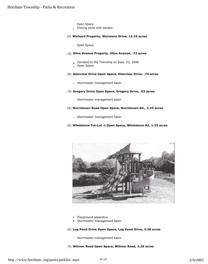
Horsham Township - Parks & Recreation
• Playground apparatus
▪ Half size basketball court
• Stormwater management basin
(0) Gilman Road Open Space, Gilman Road, .69 acres
. Stormwater management basin
(0) Herman Road Open Space, Herman Road, 1.03 acres
• Stormwater management basin
(0) Downey Drive Open Space, Downey Drive, 1.83 acres
• Stormwater management basin
(0) Danbridge Drive Open Space, Danbridge Drive, 2.01 acres
• Stormwater management basin
(0) Hunt Drive Open Space, Hunt Drive, 2.03 acres
▪ Stormwater management basin
(0) Cavalry Drive Open Space, Cavalry Drive, 2.16 acres
• Stormwater management basin
(0) Brantford Circle Open Space, Brantford Circle, 1.48 acres
• Stormwater management basin
(B) Township Building, Police Station & Fire Battalion 2, 1025 Horsham Rd., 4.0acres
. Indoor meeting rooms
(0) Lakeview Park, Limekiln Pike, 16.0 acres
http://www.horsham.org/parks/parklist.aspx A-1 1 2/9/2005
Horsham Township - Parks & Recreation
Open Space
▪ Fishing pond with aerator
(0) Wichard Property, Wynmere Drive, 12.16 acres
. Open Space
( 0) Olive Avenue Property, Olive Avenue, .72 acres
• Donated to the Township on Sept. 23, 1998
▪ Open Space
(0) Glenview Drive Open Space, Glenview Drive, .74 acres
. Stormwater management basin
( 0) Gregory Drive Open Space, Gregory Drive, .93 acres
. Stormwater management basin
(0) Norristown Road Open Space, Norristown Rd., 2.33 acres
. Stormwater management basin
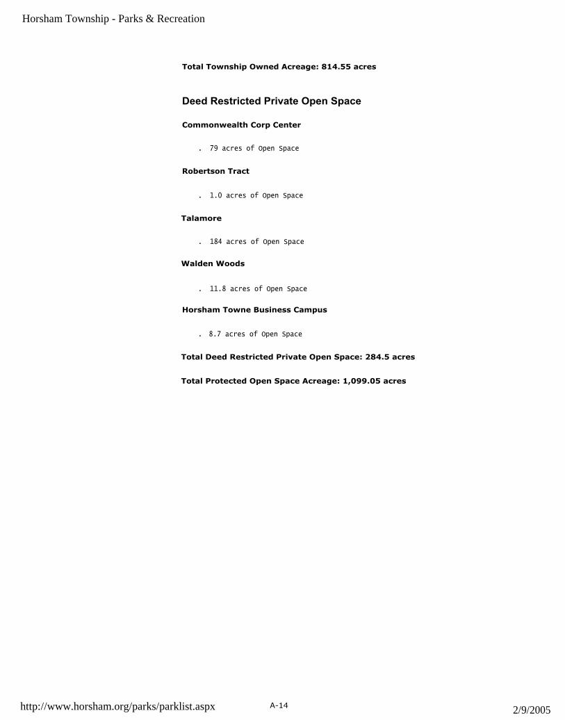
(0) Whetstone Tot-Lot & Open Space, Whetstone Rd, 1.32 acres
• Playground apparatus• Stormwater management basin
(0) Log Pond Drive Open Space, Log Pond Drive, 3.38 acres
. Stormwater management basin
(0) Witmer Road Open Space, Witmer Road, 3.26 acres
http ://www.horsham. org/parks/parklist. aspx A-12 2/9/2005

Horsham Township - Parks & Recreation
. Stormwater management basin
(0) Babylon Rd. and Horsham Rd. Property, 1.24 acres
. Open Space
(0) Township Wide Walk/Bike Powerline Trail
. When completed trail will be a six mile asphalt trail, 12 ft. wide
(0) Hill Avenue Property, 0.71 acres
. Open Space
(C) Lukins Park, 54ODresher Road, 50.68 acres
▪ Township purchased in April 1999
• Includes 5.9 acres of PECO property purchased by the Township
▪ Walking Trails
• Everybody's Playground, June 2003
• Pavilion/Restroom, September 2004
(0) Kingswood Estates, Limekiln Pike, 14.83 acres
. Adjacent to Kohler Park and dedicated as part of Kingswood
(0) Squires Knoll, Cedar Hill Road, 30.7 acres
. Adjacent to Cedar Hill Road Park and dedicated as part of subdivision
(0) Hearne Property 78.4 acres
. Aquired in Jan 1999
(0) Park Ridge Open Space 14.29 acres
▪ Adjacent to Sewer Treatment Plant. Acquired May 2, 2000.
(0) Plymouth Tube Property 10.28 acres 1005 Horsham Road
• Acquired May 11, 2001
(0) Remmy Tract 3.26 acres 437 Babylon Road
. Purchased on Dec. 18, 2001
(0) Highgate Open Space (Bauer Tract) 30.52 acres
• To be dedicated in the future
▪ Horsham Rd. and Lower State Rd.
(0) 327 Olive Avenue .09 acres
• Acquired on June 13th, 2002
http://www.horsham.org/parks/parklist.aspx A-13 2/9/2005
Horsham Township - Parks & Recreation
Total Township Owned Acreage: 814.55 acres
Deed Restricted Private Open Space
Commonwealth Corp Center
. 79 acres of Open Space
Robertson Tract
. 1.0 acres of Open Space
Talamore
. 184 acres of Open Space
Walden Woods
. 11.8 acres of Open Space
Horsham Towne Business Campus
. 8.7 acres of Open Space
Total Deed Restricted Private Open Space: 284.5 acres
Total Protected Open Space Acreage: 1,099.05 acres
http://www.horsham.org/parks/parklist.aspx A-14 2/9/2005
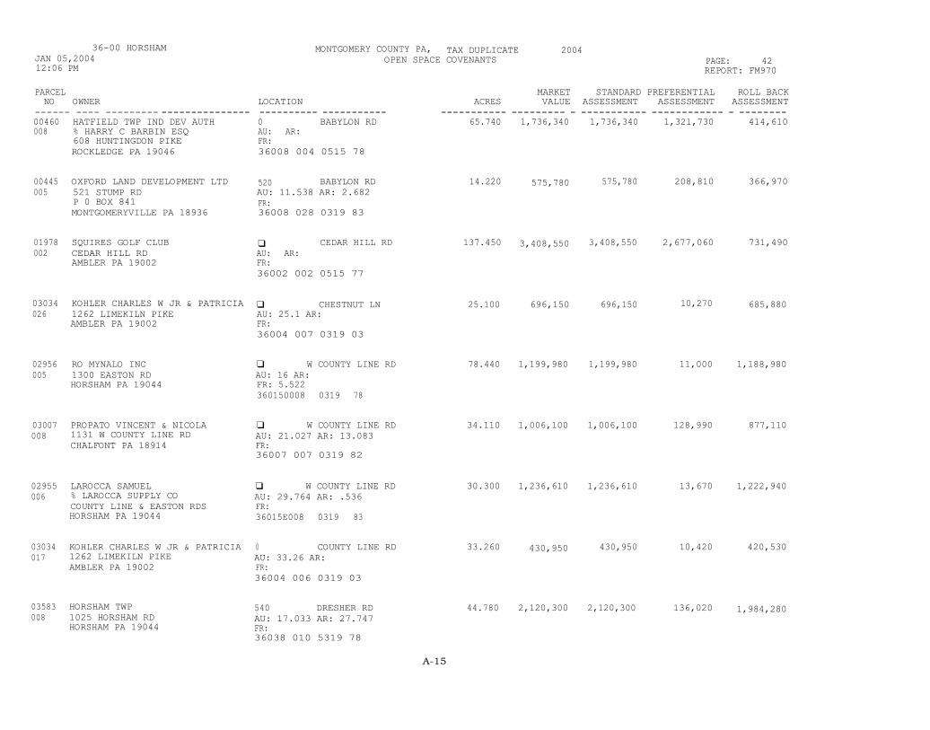
36-00 HORSHAMJAN 05,200412:06 PM
MONTGOMERY COUNTY PA, TAX DUPLICATE 2004OPEN SPACE COVENANTS PAGE: 42
REPORT: FM970
LOCATION---------- -----------0 BABYLON RDAU: AR:FR:36008 004 0515 78
520 BABYLON RDAU: 11.538 AR: 2.682FR:36008 028 0319 83
q CEDAR HILL RDAU: AR:FR:36002 002 0515 77
q CHESTNUT LNAU: 25.1 AR:FR:36004 007 0319 03
q W COUNTY LINE RDAU: 16 AR:FR: 5.522360150008 0319 78
q W COUNTY LINE RDAU: 21.027 AR: 13.083FR:36007 007 0319 82
q W COUNTY LINE RDAU: 29.764 AR: .536FR:36015E008 0319 83
0 COUNTY LINE RDAU: 33.26 AR:FR:36004 006 0319 03
540 DRESHER RDAU: 17.033 AR: 27.747FR:36038 010 5319 78
PARCELNO OWNER
------ ---- --------- ---------------00460 HATFIELD TWP IND DEV AUTH008 % HARRY C BARBIN ESQ
608 HUNTINGDON PIKEROCKLEDGE PA 19046
00445 OXFORD LAND DEVELOPMENT LTD005 521 STUMP RD
P 0 BOX 841MONTGOMERYVILLE PA 18936
01978 SQUIRES GOLF CLUB002 CEDAR HILL RD
AMBLER PA 19002
03034 KOHLER CHARLES W JR & PATRICIA026 1262 LIMEKILN PIKE
AMBLER PA 19002
02956 RO MYNALO INC005 1300 EASTON RD
HORSHAM PA 19044
03007 PROPATO VINCENT & NICOLA008 1131 W COUNTY LINE RD
CHALFONT PA 18914
02955 LAROCCA SAMUEL006 % LAROCCA SUPPLY CO
COUNTY LINE & EASTON RDSHORSHAM PA 19044
03034 KOHLER CHARLES W JR & PATRICIA017 1262 LIMEKILN PIKE
AMBLER PA 19002
03583 HORSHAM TWP008 1025 HORSHAM RD
HORSHAM PA 19044
MARKET STANDARD PREFERENTIAL ROLL BACKACRES VALUE ASSESSMENT ASSESSMENT ASSESSMENT
----------- --------- - ----------- ------------ - --------65.740 1,736,340 1,736,340 1,321,730 414,610
14.220 575,780 575,780 208,810 366,970
137.450 3,408,550 3,408,550 2,677,060 731,490
25.100 696,150 696,150 10,270 685,880
78.440 1,199,980 1,199,980 11,000 1,188,980
34.110 1,006,100 1,006,100 128,990 877,110
30.300 1,236,610 1,236,610 13,670 1,222,940
33.260 430,950 430,950 10,420 420,530
44.780 2,120,300 2,120,300 136,020 1,984,280
A-15

36-00 HORSHAMJAN 05,200412:06 PM
MONTGOMERY COUNTY PA, TAX DUPLICATE 2004OPEN SPACE COVENANTS PAGE: 43
REPORT: FM970
PARCEL MARKET STANDARD PREFERENTIAL ROLL BACKNO OWNER LOCATION ACRES VALUE ASSESSMENT ASSESSMENT ASSESSMENT
------ -- - --------------------------- ------------------------------- ----------- ----------- ----------- ------------ ------------04774 HORSHAM TWP 0 GOVERNORS RD 102.520 2,574,860 2,574,860 281,340 2,293,520005 1025 HORSHAM RD AU: 78.182 AR: 24.338
HORSHAM PA 19044 FR:36015E002 5319 79
05696 BERTHOLF WILLIAM A & DOROTHEA 1159 HORSHAM RD 15.350 331,600 331,600 169,360 162,240001 1159 HORSHAM RD AU: 13.622 AR: 1.728
AMBLER PA 19002 FR:36003 069 0319 01
05701 SINGER JACOB & PAMELA HORSHAM RD 19.190 475,000 475,000 458,930 16,070005 1119 GRINDLETON LN AU: AR:
AMBLER PA 19002 FR:36003 006 0515 94
06571 SELF ROBT N & LOIS E 0 LIMEKILN PIKE 20.900 732,250 732,250 190,710 541,540008 1012 LIMEKILN PIKE AU: AR: 20.9
AMBLER PA 19002 FR:36008 012 0319 79
06701 KOHLER CHARLES W JR & PATRICIA 0 LIMEKILN PIKE 15.190 310,700 310,700 97,670 213,030004 1262 LIMEKILN PIKE AU: .358 AR: 14.832
AMBLER PA 19002 FR:36004 068 0319 80
06865 KOHLER CHARLES W JR & PATRICIA 0 LIMEKILN PIKE 12.000 252,370 252,370 8,370 244,000002 LIGHTCAP DAVID H III-ETAL AU: 3.604 AR: 8.396
162 & 168 LIMEKILN PK FR:AMBLER PA 19002 36004 012 0319 78
06703 KOHLER CHARLES W & PATRICIA K 1262 LIMEKILN PIKE 22.910 689,620 689,620 285,570 404,050002 1262 LIMEKILN PIKE AU: 17.65 AR: 5.26
AMBLER PA 19002 FR:36004 009 0319 78
06712 WORTH FAMILY IRREVOCABLE TRUST 1336 LIMEKILN PIKE 42.350 1,134,140 1,134,140 145,290 988,850002 % WILLIAM WORTH TRUSTEE AU: 32.499 AR: 9.851
1336 LIMEKILN PIKE FR:AMBLER PA 19002 36004 005 0319 78
07327 NASIFE JOSEPH 0 & CATHERINE Y 519 LOWER STATE RD 17.500 656,930 656,930 165,070 491,860008 2200 N BROAD ST AU: 5.815 AR: 11.685
COLMAR PA 18915 FR:36001 051 0319 78
A-16

36-00 HORSHAMJAN 05,200412:06 PM
MONTGOMERY COUNTY PA, TAX DUPLICATE 2004OPEN SPACE COVENANTS PAGE: 44
REPORT: FM970
LOCATION
537 LOWER STATE RDAU: AR: 15.06FR:36001 045 0319 00
q MANN RDAU: 48.102 AR: 23.538FR:36011 021 0319 78
612 MANN RDAU: 4.818 AR: 7.682FR:36011 019 0319 78
q MEETINGHOUSE RDAU: AR:FR:36030 024T 0515
q PARK RDAU: AR:FR:36006 004 0515 77
q PARK RDAU: AR:FR:36006A004 0515 98
110 PARK RDAU: 34.343 AR: 4.197FR:36006 003 0319 78
q SIMMONS LNAU: 8.82 AR: 18FR:36003 013 0319 00
q TENNIS AVEAU: .021 AR: 16.099FR:36002 023 0319 81
PARCELNO OWNER
07324 KRON EDWARD A &002 PEZZUOLO GARLAND P
537 LOWER STATE RDNORTH WALES PA 19454
07361 NATURAL LAND TRUST INC001 HILDACY FARM
1031 PALMERS MILL RDMEDIA PA 19063
07360 THOMPSON EDWIN R & KAREN J002 612 MANN RD
HORSHAM PA 19044
08020 HORSHAM MTG OF FRIENDS008 P 0 BOX 172
HORSHAM PA 19044
09544 LIMEKILN GOLF COURSE ASSOCIATE005 1176 LIMEKILN PIKE
AMBLER PA 19002
09529 LIMEKILN GOLF COURSE ASSOCIATE002 1176 LIMEKILN PIKE
AMBLER PA 19002
09550 CARR THOMAS B & DEBRA K008 118 PARK ROAD
AMBLER PA 19002
10657 AMBLER DAVID M R & SARAH H C008 238 WALDEN ST
CAMBRIDGE MA 02140
11032 WILLIAMS MARK F002 949 TENNIS AVE
AMBLER PA 19002
MARKET STANDARD PREFERENTIAL ROLL BACKACRES VALUE ASSESSMENT ASSESSMENT ASSESSMENT
15.060 558,540 558,540 261,310 297,230
71.640 1,652,630 1,652,630 30,640 1,621,990
12.500 1,620,480 1,620,480 1,309,600 310,880
17.000 463,510 463,510 324,460 139,050
163.900 3,918,190 3,918,190 2,891,710 1,026,480
43.960 1,117,370 1,117,370 782,180 335,190
38.540 999,650 999,650 279,620 720,030
26.820 659,000 659,000 108,460 550,540
16.120 586,800 586,800 142,680 444,120
A-17

36-00 HORSHAMJAN 05,200412:06 PM
MONTGOMERY COUNTY PA, TAX DUPLICATE 2004OPEN SPACE COVENANTS PAGE: 45
REPORT: FM970
PARCEL MARKET STANDARD PREFERENTIAL ROLL BACKNO OWNER LOCATION ACRES VALUE ASSESSMENT ASSESSMENT ASSESSMENT
------ ---------------- - ------------- ------------------------------- ----------- ----------- ---------- ------------ ------------11434 ALTER DENNIS 624 WELSH RD 39.470 1,133,680 1,133,680 16,120 1,117,560005 PO BOX 844
SPRING HOUSE PA 19477AU: 39.47 AR:FR:36011 020 0319 78
11442 WERTHER NORMAN M & ELLEN K 740 WELSH RD 10.050 1,100,000 1,100,000 801,600 298,400006 740 WELSH RD
HORSHAM PA 19044AU: 4.551 AR: 5.499FR:36011 030 0319 00
11701 SEIZ WALTER WILLIAM & 328 WITMER RD 13.150 649,160 649,160 168,040 481,120008 LARGE HELEN
328 WHITMER RDAU:FR:
AR: 13.15
HORSHAM PA 19044 36038 008 0319 78
----------- ----------- ----------- ----------- --------1,199.520 34,027,240 34,027,240 13,436,700 20,590,540
A-18


