1 Summary MONTGOMERY COUNTY PLANNING DEPARTMENT THE MARYLAND-NATIONAL CAPITAL PARK AND PLANNING COMMISSION MCPB Item No. 6 12/20/12 4831 West Lane LLC, Local Map Amendment G-954 & Development Plan Amendment DPA 13-01 Erin Grayson, AICP, Senior Planner, Area 1, [email protected](301) 495-4598 Robert Kronenberg, Acting Chief, Area 1 [email protected](301) 495-2187 Location: 4831 West Lane, Bethesda G-954 Tract Size: 12,521 square feet Request: Rezoning from R-60 zone to TS-R zone Sector Plan: Bethesda-Central Business District (CBD) DPA 13-01 Tract Size: 38,804 square feet Request: amendment to increase the number of residential units from 48 w/6 MPDUs to a maximum of 120 units including 15% MPDUs Applicant: 4831 West Lane, LLC Planning Board: December 20, 2012 Hearing Examiner: January 11, 2012 Filing Date: November 2, 2012 The staff recommends approval of Local Map Amendment (G-954) The staff recommends approval of Development Plan Amendment (DPA 13-01) The local map amendment application, G-954, seeks to rezone Lot 26 and previous right-of-way dedications attributable to Lot 26, Lot 24, and Lot 25 from the R-60 zone to the TS-R zone located in the northwest quadrant of the intersection of Montgomery Lane and West Lane from the R-60 zone to the TS-R zone. If Lot 26 and the previous right-of-way dedications are approved for reclassification into the TS-R zone, the applicant seeks to incorporate this land area into a previously approved development plan, necessitating a development plan amendment. The applicant has submitted a concurrent development plan amendment application, DPA 13-01, which proposes a seven story, 70 foot tall building of approximately 118,000 square feet for up to 120 multi-family residential units. Approval of DPA 13-01 will allow for the applicant to proceed to the preliminary plan amendment and site plan amendment application stage. Description Staff Report Date: 12/7/12
Transcript
1
Summary
MONTGOMERY COUNTY PLANNING DEPARTMENT
THE MARYLAND-NATIONAL CAPITAL PARK AND PLANNING COMMISSION
MCPB Item No. 6 12/20/12 999999/9222/122/23/122
02/23/1202/12
4831 West Lane LLC, Local Map Amendment G-954 & Development Plan Amendment DPA 13-01
Robert Kronenberg, Acting Chief, Area 1 [email protected] (301) 495-2187
Location: 4831 West Lane, Bethesda G-954 Tract Size: 12,521 square feet Request: Rezoning from R-60 zone to TS-R zone Sector Plan: Bethesda-Central Business District
(CBD) DPA 13-01 Tract Size: 38,804 square feet Request: amendment to increase the number of
residential units from 48 w/6 MPDUs to a maximum of 120 units including 15% MPDUs
Applicant: 4831 West Lane, LLC Planning Board: December 20, 2012 Hearing Examiner: January 11, 2012 Filing Date: November 2, 2012
The staff recommends approval of Local Map Amendment (G-954) The staff recommends approval of Development Plan Amendment (DPA 13-01) The local map amendment application, G-954, seeks to rezone Lot 26 and previous right-of-way dedications
attributable to Lot 26, Lot 24, and Lot 25 from the R-60 zone to the TS-R zone located in the northwest quadrant of the intersection of Montgomery Lane and West Lane from the R-60 zone to the TS-R zone.
If Lot 26 and the previous right-of-way dedications are approved for reclassification into the TS-R zone, the applicant seeks to incorporate this land area into a previously approved development plan, necessitating a development plan amendment.
The applicant has submitted a concurrent development plan amendment application, DPA 13-01, which proposes a seven story, 70 foot tall building of approximately 118,000 square feet for up to 120 multi-family residential units.
Approval of DPA 13-01 will allow for the applicant to proceed to the preliminary plan amendment and site plan amendment application stage.
RECOMMENDATION: Staff recommends approval of Local Map Amendment G-594 and DPA 13-01 for
the following reasons:
1) The requested TS-R zone is compatible with the surrounding uses. 2) The proposed Local Map Amendment and Development Plan Amendment are consistent
with the purpose clause of the Transit Station Residential (TSR) Zone. 3) The proposed Local Map Amendment and Development Plan Amendment conform to the
Bethesda CBD Sector Plan. 4) Public facilities are adequate to serve this site.
G-954 ANALYSIS PROJECT HISTORY Application G-912 was previously filed on October 14, 2012 with an associated development plan amendment, DPA 12-03. G-912 requested the rezoning of Lot 26, Block 13 in the Edgemoor Subdivision, which contains 5,989 square feet. The applicant inadvertently failed to include previously dedicated right-of-way for West Lane as part of the rezoning request. As a result, the applicant withdrew both applications and submitted new applications, now G-954 and DPA 13-01. G-594 now requests the rezoning of Lot 26 and previous right-of-way dedications for West Lane attributable to Lot 26, Lot 24, and Lot 25 from the R-60 zone to the TS-R zone. Two adjacent lots to Lot 26, lots 25 and 27, in addition to nearby lot 24, were rezoned under application G-843 from the R-60 zone to the TS-R zone in a resolution adopted by the District Council on July 10, 2007 (#16-246). Application G-843 rezoned these recorded lots but did not rezone previously dedicated right-of-way for West Lane from the R-60 zone to the TS-R zone. G-843 had an associated development plan that was also approved. The site and proposed building in G-843 was essentially L-shaped with the absence of Lot 26 from the project. The previous applicant, Holladay Corporation, did not implement the original development plan. In 2009, the current applicant, 4831 West Lane, LLC, acquired lots 24, 25, and 27 as well as lot 26. If the applicant’s request to rezone Lot 26 and previous right-of-way dedications attributable to Lot 26, Lot 24, and Lot 25 from the R-60 zone to the TS-R zone is approved, it will allow for a contiguous gross tract area of 38,804 square feet available for redevelopment under the TS-R zoning requirements. The applicant has applied for a new development plan amendment, DPA 13-01, to permit a larger building than was previously approved under the original development plan. Such a building is feasible with a larger, more rectangularly-shaped tract area. The development plan amendment application proposes to redesign the building to incorporate additional units and increase the overall density. The Hearing Examiner has permitted applications G-954 and DPA 13-01 to be processed concurrently. DEVELOPMENT STANDARDS The applicant is seeking to rezone Lot 26 and previous right-of-way dedications from the R-60 Zone to the TS-R zone. The rezoning of these areas must first meet the requirements of the TS-R Zone. The following chart shows the site‘s compliance with the TS-R Zone and the Sector Plan:
3
Lot 26 and ROW Proposed Zoning : TS-R Development Standards
Required Proposed Lot 26 and ROW
Minimum area §59-C-8.41 18,000 sq ft1 12,521 sq ft
Max. Building Height §59-C-8.51
No height limit, to be determined at site plan
To be determined at site plan
Density of Development §59-C-8.42
(a) FAR 2.52(118,000 sf.) To be determined at site
plan
(b) Dwelling units per acre
1503 To be determined at site plan
Building Setback from Street R-O-W
NA To be determined at site plan
Setback from other lot lines NA To be determined at site plan
Min. Open Space §59-C-8.43 30% (1,865 sf.) To be determined at site plan
(a) Min. Public Use Space
10% ( 622 sf)
To be determined at site plan
(b) Min. Recreational Space
20% (1,244 sf)
To be determined at site plan
1 (ZTA) 12-08 became effective on July 30, 2012, and allows a smaller parcel (less than 18,000 square feet) to be approved for either the TS-R or TS-M Zone if the parcel is designated in an approved and adopted master or sector plan and located adjacent to or confronting another parcel either classified in or under application for either zone.
2 Projects can utilize the full density bonus (0.55 FAR) by constructing a minimum of 15% MPDUs onsite per Section 59-D-1.61(a)(1)(A) of the Zoning Ordinance which permits a development plan to exceed the dwelling units per acre recommended in a master or sector plan if it allows for the construction of all MPDUs under Chapter 25A including any bonus density units, on-site in zones with a maximum permitted density of more than 30 dwelling units per acre or a residential FAR more than 0.9. 3 The TS-R zone allows 150 dwelling units per acre. The Bethesda CBD sector Plan recommends 45-100 dwelling units per acre in the Transit Station Residential District. Section 59-D-1.61(a)(1)(A) of the Zoning Ordinance permits a development plan to exceed the dwelling units per acre recommended in a master or sector plan if it allows for the construction of all MPDUs under Chapter 25A including any bonus density units, on-site in zones with a maximum permitted density of more than 30 dwelling units per acre or a residential FAR more than 0.9.
Under Section 59-D-1.1 of the Zoning Ordinance, an application for reclassification to the TS-R Zone requires that a development plan be submitted with the rezoning application. As aforementioned, the applicant wishes to include Lot 26 and previously dedicated right-of-way areas into a previously approved development plan, necessitating a development plan amendment. While Lot 26 can be developed separately, consolidation with adjacent and nearby lots makes for a larger site area that can accommodate a building that can more readily meet the sector plan objectives and recommendations. DESCRIPTION OF PROPERTY Lot 26 and the previously dedicated right of way are located at the northwest quadrant of the intersection of Montgomery Lane and West Lane, approximately 200 feet east of Arlington Road and approximately 400 feet west of Woodmont Avenue. Lot 26 is rectangular in shape and has approximately 60 feet of frontage on Montgomery Lane and approximately 85 feet of frontage on West
4
Lane. Presently, it is developed with a one-family detached house used for commercial purposes. Adjacent to the area requested for rezoning is Lots 24, 25, and 27, which are also improved with one-family detached homes used for commercial purposes. Previously dedicated right-of-way associated with Lots 26, 24, and 25 is part of West Lane, which is a tertiary residential street with a pavement width of 20 feet. The land area requested for rezoning to the TS-R zone is located approximately 950 feet walking distance from the Bethesda Metro Station. The land area is located at the southern end of the Transit Station Residential District as delineated by the Bethesda CBD Sector Plan.
5
Pictures of site from West Lane
PROPOSAL The applicant, 4831 West Lane LLC, has submitted an application for a Local Map Amendment to reclassify property located in the northwest quadrant of the intersection of Montgomery and West Lanes in Bethesda. The request is to rezone 12,521 square feet of R-60 zoned land to the TS-R zone. Adjacent lots 25 and 27 as well as lot 24 were rezoned as part of zoning application G-843 to TS-R per County Council Resolution 16-246 adopted on July 10, 2007. The applicant, 4831 West Lane LLC, has also submitted an application for a Development Plan Amendment to amend the development plan approved in conjunction with Zoning Application G-843 that included adjacent lots 25 and 27 and lot 24 to now include the area included in application G-954. Amending the Development Plan for the surrounding lots that were rezoned to TS-R to include the subject property of G-954 allows the applicant to request an increase in the building size of the multifamily residential building from a 48 unit, six story building to a maximum 120 unit, seven story building. The height of the building is therefore proposed to be 70 feet rather than the previously approved 65 feet. Parking for the units is provided in garage spaces located on two levels below the building, accessed from West Lane. The proposed building will have its pedestrian entrance at the corner of West Lane and Montgomery Lane. Public pedestrian access will be provided via sidewalks along both Montgomery and West Lanes. If the proposed applications are approved by the Hearing Examiner, the applicant will be required to submit preliminary plan and site plan amendment applications to amend previously approved site plan 820080030 and preliminary plan 120080050. SURROUNDING AREA As part of a floating zone application the neighborhood boundary or surrounding area must be properly identified so that compatibility can be properly evaluated. For this application, staff defines the surrounding area by the following boundaries: Moorland Lane on the north, Arlington Road on the west, Woodmont Avenue on the east, and Elm Street on the south. This area includes the Transit
6
Station Residential Development Area in the Sector Plan and is outlined in red in the surrounding area map below. Surrounding lots 24, 25, 26, and 27 is a mix of primarily residential and some commercial uses. To the west are one and a half to two-story one-family homes currently operating as offices, though the properties have been approved for redevelopment under applications G-779 and G-865 to be rezoned from R-60 to TS-R for the eventual construction of a 46 foot high building containing 11 dwelling units. Northwest of the site is the Villages of Bethesda townhouse community, consisting of 21 dwelling units with a partially below-grade parking garage to serve the units. The units extend up to 42 feet in height.
7
Directly to the north is a partially below grade parking structure for the Chase apartment homes that also provides an outdoor recreation area on the top of the structure for residents of the Chase. The residential building for the Chase is a 12-story multi-family building in the TS-R zone northeast of the site with access from Woodmont Avenue. The building height of the Chase is 120 feet. Also northeast of the subject site, there is R-60 zoned property on the north side of West Lane improved with a one family detached dwelling unit. Directly to the east across West Lane are Lots 20 and 22. Lot 20 contains a one-family home currently used for commercial purposes but is part of rezoning application LMA G-908 to reclassify the site from the R-60 to the TS-R zone. The Planning Board reviewed this zoning application and the associated development plan to construct a 65-foot tall building (69 feet to the parapet) containing four residential units, a partial cellar, and eight garage parking spaces. The Planning Board recommended approval of the application on September 13, 2012 and the application was approved by the Hearing Examiner on September 21, 2012. The application was recently approved by the County Council on December 4, 2012. Lot 22 contains a one-family detached residential dwelling unit. Further east along Montgomery Lane is property developed under the TS-R zone in accordance with LMA G-763, as a 10 story (100 foot height) multi-family building known as the Edgemoor. Across Montgomery Lane to the south is the City Homes townhouse development in the TS-R zone. City Homes consists of 29 dwelling units, developed in five rows that run perpendicular to Montgomery Lane. These units are approximately 48 feet in height. Per Section 59-C-8.24 of the Zoning Ordinance, “the TS-R and TS-M zones are permitted only in a Transit Station Development Area and in accordance with an approved and adopted master plan or sector plan.” The rezoning application site was recommended for reclassification to the TS-R zone in the Plan, and is in a Transit Station Development Area designated by the Plan.
8
Figure 4.13, from Approved and Adopted 1994 Bethesda CBD Sector Plan, pg. 81
PURPOSE CLAUSE OF TS-R ZONE Sect 59-C-8.23 Purpose (a) To promote the effective use of the transit station development area and access thereto; (b) To provide residential uses and certain compatible non-residential uses within walking distance of the transit stations; (c) To provide a range of densities that will afford planning choices to match the diverse characteristics of the several transit station development areas within the county; and
SUBJECT SITE
9
(d) Design of buildings to stimulate the coordinated, harmonious and systematic development; prevent detrimental effects to the use or development of adjacent properties or the surrounding neighborhood; to provide housing for persons of all economic levels; The rezoning request promotes the effective use of the Metrorail Station because it can permit greater residential density within close proximity to mass transit facilities. Reclassification of the application tract area from the R-60 zone to the TS-R zone furthers the goals outlined in the purpose clause of the TS-R zone. In the development plan amendment section that follows, the specific density requested, building design proposed, and potential impacts of such a development are addressed. ZONING HISTORY
1. 1954 - Countywide Comprehensive Zoning confirmed R-60 Zone 2. 1958 – Countywide Comprehensive Zoning confirmed R-60 Zone 3. F-736 - Adopted 8/15/72 reconfirmed R-60 Zone 4. G-20- Bethesda CBD adopted 12/6/77 reconfirmed R-60 Zone 5. G-665 - Georgetown Branch Master Plan adopted 6/26/90, reconfirmed R-60 Zone 6. G-666 - Bethesda Chevy Chase Map Plan adopted 6/26/90, reconfirmed R-60 Zone 7. G-711 - Bethesda CBD Sector Plan, adopted 10/11/94 reconfirmed R-60 zone,
recommended TS-R Zone CONCLUSION The proposed Local Map Amendment is consistent with the purpose clause and all applicable standards for the TS-R Zone and will be in substantial conformance with the zoning recommendations for the site contained in the 1994 Bethesda CBD Sector Plan. Therefore, staff recommends approval of Local Map Amendment G-954. ANALYSIS OF DPA 13-01 BACKGROUND The applicant, 4831 West Lane, LLC, is requesting an amendment to the Development Plan approved under LMA G-843, which was filed on November 3, 2005 to redevelop Lots 24, 25, and 27 once rezoned from the R-60 Zone to the TS-R Zone. Technical staff recommended denial of the application because adequate right-of-way for West Lane was not provided to accommodate 50 feet of right-of-way for the street. The Planning Board recommended denial to the Hearing Examiner as well on April 20, 2006. After the Planning Board recommended denial, the Applicant filed a revised application. Staff then recommended approval of the revised application in a report to the Planning Board dated October 25, 2006 and at its November 9, 2006 public meeting the Planning Board recommended approval to the Hearing Examiner. The application went before the Hearing Examiner on December 5, 2006 and the Hearing Examiner recommended that the application be deferred and remanded so that additional information could be provided regarding the application. The Applicant submitted a revised development plan on April 16, 2007 and the Hearing Examiner issued a recommendation of approval on
10
June 21, 2007. The application was ultimately approved in Resolution 16-246 adopted by the Montgomery County Council on July 10, 2007. On June 5, 2008, Preliminary Plan 120080050 and Site Plan 820080030 were approved by the Planning Board to implement the development plan. A certified site plan was approved on February 18, 2009. A record plat has not been submitted.
Original Development Plan approved under G-843
11
Building elevations for Holladay at Edgemoor, from Certified Site Plan 820080030 dated February 18, 2009
The original development plan proposed a multi-family building containing 48 dwelling units, including six MPDUs. Seventy-eight parking spaces were shown below grade for the 48 units, with vehicular access to the garage from West Lane. A loading area was provided via a lay-by area in front of the building along West Lane. The building was L-shaped since Lot 26 was not included in the application, and the primary pedestrian entrance to the building was set back from and not clearly visible from the street. The height of the proposed building was 65 feet. The building massing was varied to complement the existing and adjacent uses. Along Montgomery Lane, the building was four stories, comparable to City Homes across the street, and the height increased to five and then six stories as it progressed into the block towards taller buildings to the northeast along Woodmont Avenue. Setbacks along the northern and western property boundaries were the subject of much discussion in the original development plan. Binding elements required a six foot building setback from the western property line and 20 feet from the northern property line. PROJECT DESCRIPTON This amendment seeks to include Lot 26 in addition to Lots 24, 25, and 27 and increase the number of multi-family dwelling units from 48 to a building containing 100 to 120 units. Inclusion of lot 26 allows for a rectangular building rather than an L-shaped building and provides for consolidation of smaller properties within the TS-R district. Proposed setbacks of the residential units along the western property line in the current application are 15 feet at grade level (the garage below the building extends to the property line) and 15 feet from the northern property line. The entire building is approximately 118,000 square feet in size as currently proposed.
12
The proposed height of the building is now 70 feet with a step-down to 50 feet at the Montgomery Lane building façade. The sixth and seventh floors are setback nine feet from the face of the building along this façade. Parking for the units is again provided below the building, but with 117 rather than 78 underground spaces located off of West Lane. A loading space is proposed within the garage for tenants of the building, and the applicant will seek approval from DOT to retain the lay-by space in the front of the building along the property’s West Lane street frontage. The applicant recently revised the loading concept for the building to add an at-grade loading bay 11 feet in height, located along the site’s West Lane frontage near the underground garage entrance. The applicant intends to require service vehicles to make all deliveries via this loading bay, which will also have a door to the building within it. The proposed building will have its primary entrance at the corner of the building near the intersection of West Lane and Montgomery Lane. Public pedestrian access will be provided via improved sidewalks along West and Montgomery Lanes.
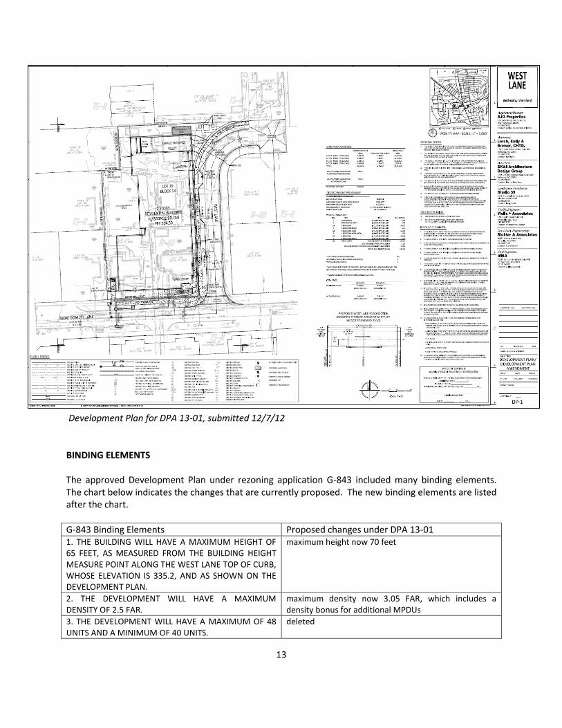
13
Development Plan for DPA 13-01, submitted 12/7/12 BINDING ELEMENTS The approved Development Plan under rezoning application G-843 included many binding elements. The chart below indicates the changes that are currently proposed. The new binding elements are listed after the chart.
G-843 Binding Elements Proposed changes under DPA 13-01 1. THE BUILDING WILL HAVE A MAXIMUM HEIGHT OF 65 FEET, AS MEASURED FROM THE BUILDING HEIGHT MEASURE POINT ALONG THE WEST LANE TOP OF CURB, WHOSE ELEVATION IS 335.2, AND AS SHOWN ON THE DEVELOPMENT PLAN.
maximum height now 70 feet
2. THE DEVELOPMENT WILL HAVE A MAXIMUM DENSITY OF 2.5 FAR.
maximum density now 3.05 FAR, which includes a density bonus for additional MPDUs
3. THE DEVELOPMENT WILL HAVE A MAXIMUM OF 48 UNITS AND A MINIMUM OF 40 UNITS.
deleted
14
4. THE DEVELOPMENT WILL PROVIDE 12.5 PERCENT OF THE UNITS ULTIMATELY PERMITTED FOR CONSTRUCTION AS MPDUs.
now 15 percent MPDUs proposed
5. THE DEVELOPMENT WILL PROVIDE A MINIMUM OF 10 PERCENT PUBLIC USE SPACE.
No change
6. THE DEVELOPMENT WILL PROVIDE A MINIMUM OF 20 PERCENT ACTIVE / PASSIVE RECREATIONAL SPACE.
No change
7. THE DEVELOPMENT WILL PROVIDE AN EVERGREEN LANDSCAPE SCREEN OF NOT LESS THAN TEN (10) EVERGREEN TREES OF NOT LESS THAN 8 TO 10 FEET TALL AT TIME OF PLANTING TO BE PLANTED ALONG THE NORTHWESTERN PROPERTY LINE TO SERVE AS A LANDSCAPE BUFFER.
deleted
8. ANY EXPOSED TERRACE OR RETAINING WALL ALONG THE WESTERN PROPERTY LINE WILL BE IMPROVED WITH SIMILAR MATERIALS AS FAÇADE OF THE BUILDING.
deleted
9. THE DEVELOPMENT WILL BE SET BACK FROM THE NORTHERN PROPERTY LINE A MINIMUM OF 20 FEET EXCLUSIVE OF BAY WINDOWS AND OTHER BUILDING PROJECTIONS.
deleted
10. THE WESTERN FAÇADE OF THE DEVELOPMENT WILL BE LOCATED SIX FEET FROM THE WESTERN PROPERTY LINE, EXCLUSIVE OF BAY WINDOWS AND OTHER BUILDING PROJECTIONS.
deleted
11. THE WESTERN FAÇADE OF THE DEVELOPMENT WILL INCLUDE A MINIMUM OF 20 PERCENT WINDOWS.
No change
12. THE WESTERN FAÇADE OF THE DEVELOPMENT WILL INCLUDE GREEN SCREENS.
deleted
13. THE GARAGE DOOR TO THE BELOW-GRADE PARKING WILL BE PROVIDED UNDERNEATH AND WITHIN THE BUILDING.
No change
14. THE APPLICANT WILL ENTER INTO A CONSTRUCTION AGREEMENT WITH THE VILLAGES OF BETHESDA PRIOR TO THE COMMENCEMENT OF CONSTRUCTION WICH SHALL INCLUDE, BUT NOT BE LIMITED TO UNDERPINNING PROVISIONS, CRANE SWING PROVISIONS AND AN AGREEMENT TO CONDUCT PRE AND POST CONSTRUCTION EVALUATIONS OF THE GARAGE AND FOUNDATION OF THE VILLAGES OF BETHESDA.
No change
15. ANY FENCE NEEDED ALONG THE WESTERN PROPERTY LINE AS A RESULT OF THE GRADE DIFFERENTIAL WILL BE AN OPEN RAIL DESIGN.
deleted
16. ADDITIONAL FAÇADE DETAILING WILL BE PROVIDED ALONG THE WESTERN FAÇADE.
deleted
17. APPLICANT WILL DEDICATE 2 ½ FEET ALONG THE WEST LANE FRONTAGE OF THE PROPERTY AND SUBJECT TO DPTW, DPS AND M-NCPPC REQUIREMENTS WILL PROVIDE AS FOLLOWS: 11’ PAVING FROM CENTER LINE TO FACE OF CURB; 5’ PLANTING STRIP FROM FACE OF
No change
15
CURB TO SIDEWALK; 5’ SIDEWALK; AND 4’ BUILDING SETBACK FROM THE PROPERTY LINE.
18. IN CONNECTION WITH THE DEVELOPMENT, APPLICANT SHALL PAVE AND PROVIDE CURB ALONG WEST LANE IN ITS ENTIRETY TO 22 FEET IN WIDTH. THAT PORTION OF WEST LANE IN EXCESS OF 22 FEET AT NORTHEAST TERMINUS SHALL ONLY BE REPAVED TO CURRENT PAVED BOUNDARIES AS DELINEATED ON THE PLAN. PAVING OF SOUTHERN TERMINUS OF WEST LANE TO EXCEED 22 FEET IN WIDTH IN ORDER TO PROVIDE APPROPRIATE INTERSECTION WITH MONTGOMERY LANE, AS DETERMINED BY DPW&T. SEE PROPOSED WEST LANE ROAD SECTION, THIS SHEET.
No change
19. DECLARANT AND/OR ITS SUCCESSORS WILL MAINTAIN ON-SITE LANDSCAPING.
No change
20. DEVELOPMENT TO BE LEED CERTIFIED, CERTIFICATION TO BE ACHIEVED BY IMPLEMENTATION OF VARIOUS GREEN BUILDING ELEMENTS. •PROVISION OF GREEN BUILDING ELEMENTS SUCH AS PARTIAL SEDUM (GREEN) ROOF, ENERGY STAR APPLICANCES, AND GREEN INTERIOR FINISHES PACKAGE OPTION AND RECYCLED BUILDING MATERIALS.
more general now, stating development will comply with the Montgomery County green buildings law and achieve a minimum certified level rating in the appropriate LEED rating system, or equivalent rating in another energy and environmental standard as verified by DPS
21. THE FOLLOWING FEATURES WILL FORM THE BASIS FOR THE FINAL DESIGN TO BE DETERMINED AT SITE PLAN: •THE NUMBER OF STORIES AND GENERAL MASSING, EXCLUDING BALCONIES AND BAY WINDOW PROJECTIONS, WILL BE AS PROVIDED ON ELEVATIONS AND 3-D DRAWINGS SET FORTH ON DEVELOPMENT PLAN. •PREDOMINATELY MASONRY FAÇADE, EXCLUSING ACCENT DETAILS, WHICH MAY INCLUDE, BUT NOT BE LIMITED TO BRICK, STONE, OR MANUFACTURED STONE, PRECAST OR CERAMIC TILES. •LANDSCAPING TO INCLUDE STREET TREES ALONG WEST LANE AND MONTGOMERY LANE IN CONFORMANCE WITH BETHESDA STREETSCAPE PLAN, LANDSCAPING ALONG MEWS, AND GROUND COVER ALONG THE WESTERN PROPERTY LINE. •WINDOWS ON ALL FACADES. •FLAT ROOFS •VECHICULAR ACCESS TO BE LOCATED IN NORTHEAST CORNER OF PROPERTY OFF OF WEST LANE. •ON-SITE PARKING LOCATED BELOW GRADE. •FINAL LOCATION AND CONFIGURATION OF 5TH FLOOR ROOF TOP ACCESS PENTHOUSE TO BE DETERMINED AT SITE PLAN.
deletion of the following: • The number of stories and general massing, excluding balconies and bay window projections, will be as provided on elevations and 3-D drawings set forth on development plan. • Windows on all facades. • Final location and configuration of 5
th floor roof top
access penthouse to be determined at site plan.
16
Binding Elements proposed for DPA 13-01
1. This building will have a maximum height of 70 feet, as measured from the building height measure point along the West Lane top of curb whose elevation is 335.5, and as shown on the development plan.
2. The development will have a maximum density of 3.05 FAR. 3. The development will provide 15 percent of the units ultimately permitted for construction as
MPDUs. 4. The development will provide a minimum of 10 percent public use space. 5. The development will provide a minimum of 20 percent active/passive recreational space. 6. The western façade of the development will include a minimum of 20 percent windows. 7. The garage door to the below-grade parking will be provided underneath and within the
building. 8. The applicant will enter into a construction agreement with the Villages of Bethesda prior to the
commencement of construction which shall include, but not be limited to underpinning provisions, crane swing provisions and an agreement to conduct pre and post construction of the garage and foundations of the Villages of Bethesda.
9. Applicant will dedicate 2 ½ feet along the West Lane frontage of the property and subject to DOT, DPS and M-NCPPC requirements and will provide 11’ paving from center line to face of curb.
10. In connection with the development, applicant shall pave and provide curb along West Lane in its entirety to 22 feet in width except for that portion of West Lane from the center line east, along the frontage of Lot 20. That portion of West Lane in excess of 22 feet at northeast terminus shall only be repaved to current paved boundaries as delineated on the plan. Paving of southern terminus of West Lane to exceed 22 feet in width in order to provide appropriate intersection with Montgomery Lane, as determined by DOT. See proposed West Lane road section, this sheet.
11. Declarant and/or its successors will maintain on-site landscaping. 12. Development will comply with the Montgomery County green buildings law and achieve a
minimum certified level rating in the appropriate LEED rating system, or equivalent rating in another energy and environmental standard as verified by DPS.
13. The following features will form the basis for the final design to be determined at site plan:
Predominantly masonry façade, excluding accenting details, which may include, but not be limited to brick, stone, or manufactured stone, precast or ceramic tiles.
Landscaping to include street trees along West Lane and Montgomery Lane in conformance with the Bethesda streetscape standards, as amended; and landscaping provided on the plaza edges along the western property line.
Flat roofs
Vehicular access to be located in northeast corner of property off West Lane
Bay window projections
On-site parking located below grade. 14. The Management Entity of the building (whether rental or condominium) must provide written
requirements that all service deliveries shall occur through the service entry on located on West Lane.
17
Staff recommends the following binding element be incorporated by the Planning Board to achieve compatibility to surrounding development:
15. The final building design must include the following setbacks:
a minimum of 15 feet from the western property line
a minimum of 15 feet from the northern property line. Staff recommends the following binding element be incorporated by the Planning Board to ensure usability of the proposed public use space along the northern facade of the building at site plan review:
16. Public Use Space provided along the northern property line must be accessible at grade and must include activating elements that clearly indicate the area is intended for public use.
Proposed Building Elevation looking north along Montgomery Lane in relation to surrounding buildings (approved but not yet built projects superimposed)
East building elevation
18
East building elevation
South building elevation
DEVELOPMENT PLAN FINDINGS Sect 59-D-1.61. Findings. Before approving a development plan amendment, specific findings must be made under Sect 59-D-1.61 of the Zoning Ordinance. Based on the extent of the changes included in the proposed amendment and the lapse in time since the application’s approval in 2007, staff has revisited all the required findings. These findings relate to conformance with the master or sector plan, compatibility with surrounding development, circulation and access, preservation of natural features and perpetual maintenance of common areas. The required findings are set forth below with analysis following:
19
Sect 59-D-1.61 (a) The proposed development plan substantially complies with the use and density indicated by the master plan or sector plan, and does not conflict with the general plan, the county capital improvements program, or other applicable county plans and policies. However: (1) To permit the construction of all MPDUs under Chapter 25A, including any bonus density units, on-site in zones with a maximum permitted density more than 39 dwelling units per acre or a residential FAR more than .9, a development plan may exceed: (A) any dwelling unit per acre or FAR limit recommended in a master plan or sector plan, but must not exceed the maximum density of the zone; and (B) any building height limit recommended in a master plan or sector plan, but must not exceed the maximum height of the zone. The additional FAR and height allowed by this subsection is limited to the FAR and height necessary to accommodate the number of MPDUs built on site plus the number of bonus density units. (2) To permit the construction of workforce housing units under § 59-A-6.18 and Chapter 25B on site, the District Council may permit: (A) any residential density or residential FAR limit of the applicable zone to be exceeded to the extent required for the number of workforce housing units that are constructed, but not by more than 10 percent. (B) any residential density or residential FAR limit recommended in a master or sector plan to be exceeded to the extent required for the number of workforce housing units that are constructed, but not to more than the maximum density and FAR of the zone, except as provided in paragraph (1); and (C) any building height limit recommended in a master or sector plan to be exceeded to the extent required for the number of workforce housing units that are constructed, but not to more than the maximum height of the zone. The Bethesda CBD Sector plan (“The Plan”) recommends the TS-R zone for the entire tract area included in the Development Plan Amendment. The Council approved rezoning application G-843 in July 2007 to rezone three of the four lots in the tract area for DPA 12-03 from R-60 to TS-R. Application G-954 currently seeks approval of TS-R zoning for adjacent Lot 26 and previously dedicated right-of-way for West Lane. The Plan recommends residential uses for this site, which is located in the Transit Station Residential District, at a density of 45 to 100 dwelling units per acre. The submitted amendment continues to be in substantial compliance with the recommendations for residential uses. However, the maximum proposed density is 135 units per acre if the maximum 120 units are constructed. The maximum density permitted in the TS-R zone is 150 units per acre. A density of 135 units per acre is permissible in this instance per Section 59-D-1.61(a)(1)(A) of the Zoning Ordinance, which permits a development plan to exceed the dwelling units per acre recommended in a master or sector plan if it allows for the construction of all MPDUs under Chapter 25A, including any bonus density units, on-site in zones with a maximum permitted density of more than 30 dwelling units per acre or a residential FAR more than 0.9. Not all properties in the nearby vicinity of the subject site have been developed to provide a density of 45 to 100 dwelling units per acre near the transit station. The increase proposed by
20
the applicant in this instance will help fulfill the overall density envisioned in the Bethesda CBD Sector Plan for the TS-R district. The amendment application is proposing to construct a minimum of 15% of the total number of units as MPDUs. Because the total number of units will range from 100 to 120 units depending on the final unit count, approximately 15 to 18 MPDUs will be constructed under this amendment if approved. The lower range of units proposed will more than double the number of MPDUs originally approved for this site. One of the objectives of the Sector Plan is to create more housing stock in Bethesda and to offer a variety of housing options including MPDUs. The Plan recommends a height of no more than 65 feet for this area. As mentioned earlier, the original development plan for G-843 proposed a maximum height of 65 feet. The applicant now seeks approval of 70 feet for the maximum height of the building. This request is permissible by the District Council per section 59-D-1.61(a)(1)(B) of the Zoning Ordinance which allows a development plan to exceed the maximum height limit recommended in a master plan or sector plan that does not exceed the limit of the zone if exceeding such a recommended maximum height permits the construction of all MPDUS under Chapter 25A. There is no height maximum in the TS-R zone. The applicant states that a five foot increase in height is necessary to accommodate the construction of onsite MPDUs. If the applicant constructs the 15 percent MPDUs on site, a height of 70 feet will continue to meet the Plan’s dual objectives of more housing stock and adding MPDUs to downtown Bethesda. Other nearby projects that exceeded the recommended 65 foot height limit by providing 15% MPDUs include the Hampden Lane project south of the City Homes townhome development (G-842, DPA 06-2) and the 4901 Hampden Lane project on the west side of Woodmont Avenue between Montgomery Lane and Hampden Lane (G-819, DPA 12-02). The applicant is not proposing workforce housing units under this amendment. There is no conflict with the general plan or the county capital improvements program. SECTOR PLAN CONFORMANCE Further conformance to the Bethesda CBD Sector Plan must be evaluated in the review of this Development Plan Amendment, particularly since the size and scale of the building has increased. The property is located in the Transit Station Residential District; the Plan recommends that development follow the recommendations and guidelines for that district, as well as the Sector Plan. “The Plan recommends a minimum of 45 dwelling units per acre everywhere except Arlington Road, where there would not be a minimum density in order to allow townhouse development at lower densities. The Plan anticipates that some projects will incorporate higher densities, and the full 2.5 FAR densities (about 100 dwelling units per acre) would be allowed.” (p. 82). The original Development Plan was approved for 48 multi-family dwelling units, which yielded 73 dwelling units per acre. This range was within the Plan recommendation of 45 to 100 dwelling units per acre. This amendment seeks to increase the number of units to a range of 100 to 120 units. If approved for the construction of up to 120 units, the amendment would yield a density of 135 units per acre. As stated earlier in this report, Section 59-D-1.61(a)(1)(A) of the Zoning Ordinance permits a development plan to exceed the dwelling units per acre or FAR limit recommended in a master or sector plan if it allows for the construction of all MPDUs under Chapter 25A including any bonus density units, on-site in zones with a maximum permitted density of more than 30 dwelling units per acre or a residential FAR
21
more than 0.9. This is the only scenario in which the applicant could exceed the Sector Plan density recommendation. The property is proposed to be developed at a FAR of 3.05. The Plan recommends a FAR of 2.5, however, under this application a minimum of 15% MPDUs will be constructed on site. The applicant is receiving a 22% bonus density allowed in the Zoning Ordinance in return for the additional MPDUs which results in an additional FAR of 0.55. Much like the unit per acre count, the FAR can be exceeded per Section 59-D-1.61(a)(1)(A) of the Zoning Ordinance. Therefore, the 3.05 FAR is allowable in this instance. The Sector Plan also recommends “a combination of private and public open space both within and outside the TS-R district to serve new residents. Open space within the TS-R neighborhood would be developed as private recreational areas, possibly with both housing and private outdoor areas located above structured parking”(p. 82). The development plan amendment shows active and passive recreation space for residents in a rear garden, common ground-level outdoor amenity areas, roof top amenity space, and indoor community rooms. Twenty-six percent of the site area includes active and passive recreation areas. Fourteen percent of the site is proposed as public open space, and this requirement will be met via new streetscape construction along Montgomery and West Lanes and within the open area located on the north side of the building. With the inclusion of lighting, landscaping, and sidewalks, such features will create a usable public open space on Montgomery and West Lanes where it does not presently exist. Members of the surrounding community have advocated for the majority of public open space to be provided in the front of the building along Montgomery Lane, necessitating the building be set back further from the street. Staff also has concerns that public use space along the northern building facade will be hidden from the public eye and be difficult to activate, however, Staff does not believe that a deeper building setback to accommodate public open space on Montgomery Lane is necessarily the answer. A small lawn area in front of the building is appropriate in a more suburban environment where maintaining a cohesive building line is less important. Staff suggests an additional binding element be included to insure that proposed public use space in this location is not under-utilized. The Sector Plan’s Urban Design guidelines applicable to this amendment application are as follows: 1. Permit projects with a minimum lot size of 18,000 square feet to encourage smaller scale projects. Projects should not leave isolated parcels. The Development Plan Amendment proposes a gross tract area of 38,804 square feet, which exceeds the minimum lot size. In the original development plan, Lot 26 was left as an isolated parcel. By including Lot 26 in the application, more cohesive streetscape and building lines will be present along West and Montgomery Lanes. Additionally, a more functionally efficient building can be designed for the site.
22
2. Encourage low-rise buildings to fill out the parcel. The original Holladay at Edgemoor mid-rise building was proposed to be 65 feet in height, and filled out the portions of the parcel included in the application. This amendment now shows a building with a height of 70 feet, which is an increase of 5 feet, or 7 percent. The Sector Plan recommends building heights ranging from 35 feet to 200 feet, and recommends a height of 65 feet for the majority of the TS-R zone, while also recommending that the TS-R area include low-rise development. Since a building height of less than 5 stories is generally considered a low-rise building, and buildings greater than 10 stories are generally considered a high-rise building, a mid-rise building is generally considered to be 5 to 9 stories in height. As such, a mid-rise building is once again suitable for this site, since a building within this height range can ensure the inclusion of affordable housing units. The proposed building reaches a height of 70 feet but the revised design includes a building height of 50 feet along Montgomery Lane. The 70 foot tall building has a more prominent building design than the design of the first building, where the rectangular shape of the larger site area which includes Lot 26, and makes for a rectangular building that creates a defined edge along the street. The building has been designed to fill out most of the tract area while still providing adequate active and passive recreation space for future residents. The proposed design satisfies this objective of the Sector Plan. 3. Maintain low-rise building heights which step down to three floors along Arlington Road. Heights of up to six floors are preferred along Woodmont Avenue to achieve the desired urban form.
Image depicting building footprints and site areas. Left, original
development plan building footprint. Right, development plan
amendment building footprint.
23
The site fronts on neither Arlington Road nor Woodmont Avenue. However, the proposed 70 foot building height does fall within a range of building heights that will create a transition from Woodmont Avenue to Arlington Road. At Woodmont Avenue, the Edgemoor is 100 feet high, then the mid-rise building approved east of the subject property under G-908 will be 65 feet, followed by the subject building at 70 feet high, stepping down to the building fronting Arlington Road approved under G-865 at 46 feet in height. 4. Provide 25-foot building setbacks from the curb (15 feet from the Sector Plan right of-way) along Arlington Road. Setbacks in the remaining portion of the TS-R District will be decided on a case by case basis as redevelopment proceeds through the Planning Board approval process The building does not front on Arlington Road. The Montgomery Lane façade will be set back 10 feet from the property line and 26 feet from the curb of the street. The proposed setback will be consistent with the setbacks of existing and approved but not yet built projects along Montgomery Lane. The proposed West Lane façade will be setback 4 feet from the property line and 18 feet from the curb of West Lane. 5. Design roof tops to achieve a residential image using hip roofs, gables, turrets, and other types of pitched roof lines. The varied roof line is desirable to improve character and reduce the sense of bulk. This project achieves the broader intent of this design guideline of projecting a “modern, residential image” through various design features. For this reason, the provision of a “pitched roof line” or similar design feature is not essential to achieve the intent. First, the primary architectural material is a red brick base, which corresponds with the existing low-rise residential development to the west and south, as well as the existing high-rise development to the east and north. Second, a partially set-back metal top breaks up the height of the building and expanse of red brick, as does the recently added corner canopy element. Third, a metal and glass corner element breaks up the width of the building, while at the same time highlighting the building’s entrance and residential lobby. Finally, the applicant has added additional balconies on the first floor of the building which clearly indicate the residential character of the building while at the same time enlivening the fenestration. Previously approved projects such as Edgemoor at Arlington North (LMA G-779) and 4825 Montgomery Lane project (LMA G-908) provide flat roofs much like the subject application. 6. Locate front unit entrances along the street when residences are provided on the first floor to encourage street life. The previous development plan included an entry to the building located off West Lane that was less than obvious. The proposed development plan amendment shows the building’s primary entrance at the intersection of Montgomery and West Lanes. A lobby in this area will be provided for the comfort of residences and visitors. To establish a uniform building design, the applicant has not elected to provide unit entrances along West or Montgomery Lanes, as was the case in the previous development plan. Such entrances would impact the outdoor amenity areas that are intended for residents of the entire building and for the public along the street. The applicant has, however, revised the design to include balconies along the first floor units which will achieve a more active street presence.
24
7. Locate required parking either underground or in rear decks, so as not to be seen from surrounding streets. As outlined in the Development Plan Amendment and described in this report, the development plan shows an underground parking garage with access from West Lane to service this project. Loading is provided within the building and along West Lane. ZONING ORDINANCE CONFORMANCE This application is subject to Section 59-D-1.61 (b), which requires that the proposed development comply with the purposes, standards, and regulations of the zone as set forth in article 59-C, which would provide for the maximum safety, convenience, and amenity of the residents of the development and would be compatible with adjacent development. In its approval on July 10, 2007, the Council established that the proposal complied with the purpose and standards of the TS-R Zone as it provided for a maximum of safety, convenience and amenity of residents of the development and would be compatible with adjacent developments. Because of the expanded tract area and building footprint, staff has revisited the intent, purposes, standards and regulations of the TS-R Zone. 59-C-8.21. Intent (a)The TS-R and TS-M zones are intended to be used in a Transit Station Development Area as defined in section 59-A-2.1. However, the TS-R zone may also be used in an area adjacent to a Central Business District, within 1,500 feet of a metro transit station, and the TS-M zone may be also be used within a Central Business District if the property immediately adjoins another property outside a Central Business District that is eligible for classification in the TS-M zone or separated only by a public right-of-way from property outside a Central Business District that is eligible for classification in the TS-M zone. The property is located within a Transit Station Development Area and District. It is located approximately 950 feet from the Bethesda Metrorail Station. (b)The TS-R zone is intended for locations where multiple-family residential development already exists or where such development is recommended by an approved and adopted master plan. The Plan recommended the TS-R zone for this property as a way to achieve multi-family residential development in this location. The Chase and Edgemoor buildings within close proximity to the subject site were developed as high-rise multi-family buildings. This Development Plan Amendment continues to implement the Plan’s recommendation for multi-family development in this area as a mid-rise building. (c)The TS-M zone is intended for locations where substantial commercial or office uses already exist or where such uses are recommended by an approved and adopted master plan. Not applicable to subject application, the site is zoned TS-R. (d)In order to facilitate and encourage innovative and creative design and the development of the most compatible and desirable pattern of land uses, some of the specific restrictions which regulate, in some
25
other zoning categories, the height, bulk and arrangement of buildings and the location of the various land uses are eliminated and the requirement substituted that all development be in accordance with a plan of development meeting the requirements of this division. In redeveloping the site, the applicant has employed the flexible standards of the TS-R Zone to incorporate the proposed building into the surrounding area. The building is larger than previously approved but the provided setbacks have been adjusted to attempt to mitigate this change. The building’s design will contribute to a cohesive building line on Montgomery Lane, once projects on the east and west of the site are constructed. This amendment continues to achieve a compatible and desirable land use on the subject property. Sect 59-C-8.23 Purpose (a) To promote the effective use of the transit station development area and access thereto; The amendment promotes the effective use of the Metrorail Station by adding new residential uses at this location and in close proximity to the station. (b)To provide residential uses and certain compatible non-residential uses within walking distance of the transit stations; The proposal will be providing up to 120 multi- family units within 950 feet of the Bethesda Metrorail station. (c) To provide a range of densities that will afford planning choices to match the diverse characteristics of the several transit station development areas within the county; and As originally approved, the density for the development was 73 dwelling units per acre. The development plan amendment proposes more units thereby increasing the density to a maximum of 135 dwelling units per acre, depending on the final unit count. This density exceeds the Plan’s recommendation of 45 to 100 dwelling units per acre but will contribute to creating greater diversity of housing choices found within the Bethesda CBD. In addition to adding more MPDUs in the vicinity, the applicant intends to offer smaller units in an area of Bethesda where residential units are generally larger in size. (d) Design of buildings to stimulate the coordinated, harmonious and systematic development; prevent detrimental effects to the use or development of adjacent properties or the surrounding neighborhood; to provide housing for persons of all economic levels; The provided setbacks ensure that detrimental effects to adjacent residential properties will be minimized. The proposal will offer housing for persons of varying economic levels. With a building mass and height comparable to the surrounding existing and proposed residential developments, this amendment continues to provide a coordinated, harmonious and systematic development of this area as envisioned by the Sector Plan. Sect 59-C-8.24. Location. According to Section 59-C-8.24 of the Zoning Ordinance, “the TS-R and TS-M zones are permitted only in a Transit Station Development Area and in accordance with an approved and adopted master plan or sector plan.”
26
The DPA application site was recommended for reclassification to the TS-R zone in the Plan, and is in a Transit Station Development Area designated by the Plan. Sect 59-C-8.25. Public facilities and amenities. A development must conform substantially to the facilities and amenities recommended by the approved and adopted master or sector plan, including and granting such easements or making such dedications to the public as may be shown thereon or are deemed necessary by the Planning Board to provide for safe and efficient circulation, adequate public open space and recreation, and insure compatibility of the development with the surrounding area, and assure the ability of the area to accommodate the uses proposed by the application. The provision of MPDUs does not authorize a reduction in any public facility and amenity or active or passive recreation space recommended in a master plan or sector plan. The subject property is served by existing sewer and water mains. The site is located within the school service areas of the Bethesda Chevy Chase Cluster (B-CC) which includes Bethesda Elementary School, Westland Middle School, and Bethesda-Chevy Chase High School. The FY 2013 Subdivision Staging Policy school test finds that the elementary and middle school capacity to be adequate in the B-CC cluster. At the high school level a school facility payment is required for subdivision approval in FY 2013. The July 1994 Approved and Adopted Bethesda CBD Sector Plan recommends the following nearby transportation facilities: 1. Montgomery Lane, between Arlington Road to the west and Woodmont Avenue to the east, as a two-lane business district “mixed” street with parking on one side, and with a minimum right-of-way width of 52 feet. 2. West Lane, between Montgomery Lane and its terminus to the north, as a two-lane business district street with a minimum right-of-way width of 45 feet. The submitted development plan shows one foot of right-of-way dedication along the site’s Montgomery Lane frontage and two and a half feet of right-of-way dedication along site’s West Lane street frontage. These dedications accommodate the 52 foot right-of-way for Montgomery Lane by providing 26 feet from the centerline to the property line and also accommodate the 50 foot right-of-way for West Lane by providing 25 feet from the centerline. The Plan recommends dedication to ensure safe and efficient circulation along the public sidewalks for residents, workers and visitors in the Bethesda downtown as well as future residents of this project. Sect 59-8.3 Land uses. Dwelling units are permitted in the TS-R Zone. Multi-family units are included in the definition for “dwelling units” contained in Sect 59- A-2.1 of the Zoning Ordinance. Sec. 59-C-8.4. Development standards. The table below notes how the amendment continues to meet the development standards required in the TS-R zone.
27
Development Standard
Permitted/Required Approved G-843 DPA 13-01 Zoning Provision if applicable
Minimum Area 18,000 sq. ft. 23,260 sf 38,804 sf Sect 59-C-8.41
Number of Dwelling Units
NA 48 units 100-120 units NA
Dwelling Units per Acre
1501
73
135 max. Sect 59-C-8.42(b)
MPDUs 12.5% 12.5% 15% NA
MPDUs (#) NA 6 15-18 NA
FAR 2.5 2.5
3.052 Sect 59-C-8.42(a)
Building Height Determined at site plan 65 feet
70 feet Sect 59-C-8.51
Setbacks from western
NA
property line NA 6 ft 15 ft
Setback from northern property line
NA 20 ft 15 ft NA
Setback from West Lane ROW
NA 0 ft 4 ft NA
Setback from Montgomery Lane ROW
NA 15 ft 10 ft NA
Minimum Percent Public Use Space
10% 10% 14% Sect 59-C-8.43 (a)
Minimum Percent Active/Passive Recreational Space
20% 20% 26% Sect 59-C-8.43 (b)
Total minimum open space
30% 30%
40% Sect 59-C-8.43
Parking NA 78 spaces 117 spaces3 Sect 59-E 3.7
1The TS-R zone allows 150 dwelling units per acre. The Bethesda CBD sector Plan recommends 45-100 dwelling units per acre in
the Transit Station Residential District. 2FAR – Floor Area Ratio is calculated on gross tract area of the site. The project is utilizing the full density bonus of (0.55 FAR) by
constructing a minimum of 15% MPDUs onsite. 3 If up to 120 units are approved, the final parking count will be evaluated in detail at the time of site plan amendment review,
and will be based on the final unit count and mix. 59-C-8.45 Procedures for application and approval. This development plan amendment will need to be approved by District Council in accordance with provisions contained in section 59-D-1 of Zoning Ordinance entitled “Development Plan”. The applicant is not seeking partial cost developer participation for the subject site which is allowed in the transit station development area zone. Sect 59-C-8.5. Special requirements in the TS-R zone Sect 59-C-8.51. Building height limit. There is no building height limit in the TS-R zone, it is established at site plan review. If approved, the building height will be a maximum of 70 feet with 15 percent MPDUs, as permitted by the zoning ordinance.
28
59-C-8.52. Off-street parking, minimal impact on adjoining residential properties. Parking shall be located as to have a minimal impact on any adjoining residential properties. An underground parking garage containing approximately 117 spaces will provide parking for the development, with access to the garage from West Lane. Underground parking will minimize the sight and sounds that above ground parking can create, thereby lessening the impact on adjoining residential uses. The final parking calculations will be determined at site plan once the final unit count and unit mix is provided. 59-C-8.53. Streets, interior and right of -way. There are no interior streets proposed under this application. As outlined in the public facilities section on the previous page, right-of-way dedication is adequate. 59-C-8.54. Ancillary commercial uses. This development plan amendment does not propose any ancillary commercial uses. Sect 59-D-1.61 (c) That the proposed internal vehicular and pedestrian circulation systems and points of external access are safe, adequate, and efficient. The amendment proposes pedestrian circulation along the site’s borders. Public sidewalks on Montgomery and West Lanes will provide access that is efficient and adequate for internal and external pedestrian movement patterns of future residents and workers in the Bethesda CBD. The active and passive recreation space along a portion of the site’s western property line will provide a safe, adequate and efficient means to move around the property and into the building for future residents. The provision of only one vehicular access point along West Lane was designed to minimize pedestrian and vehicular conflicts. This access point serves as the entrance to the underground parking garage and will be clearly delineated. The peak-hour trip generation estimate for the proposed development based on trip generation rates included in the LATR/PAMR Guidelines is provided in Table 1. As shown in Table 1, the proposed 120-unit residential development (previously approved 48 units plus currently proposed 72 units) is estimated to generate 36 peak-hour trips during weekday morning and evening peak periods. The site is currently occupied with four buildings (6,735 SF of office uses) that generate 16 peak-hour trips during the morning peak period and 11 peak-hour trips during the evening peak period. With removal of these trips, the proposed development will add a total of 20 peak-hour trips during the morning peak period and 25 peak-hour trips during the evening peak period to the road network.
A traffic study (dated September 21, 2012) was submitted by the consultant for the Applicant for the subject application per the LATR/PAMR Guidelines since the proposed development was estimated to generate 30 or more peak-hour trips during the typical weekday morning (6:30 a.m. – 9:30 a.m.) and evening (4:00 p.m. – 7:00 p.m.) peak periods. The traffic study determined traffic-related impacts of the proposed development on nearby roadway intersections during weekday morning and evening peak periods. A summary of the capacity analysis/Critical Lane Volume (CLV) analysis results for the study intersections for the weekday morning and evening peak-hours within the respective peak periods from the traffic study is presented in Table 2. As shown in Table 2, under Total (Build) traffic conditions, CLV values for intersections included in the study were estimated to be below the respective policy area congestion standards (1,800 CLV for the Bethesda CBD Policy Area). Based on the above analysis presented in the traffic study, the subject application satisfies the LATR requirements of the APF test.
To satisfy the PAMR requirements of the APF test, and per the policy in place that offer a PAMR trip credit for CBD developments, a development located within the Bethesda CBD Policy Area is required to mitigate 25 percent of “new” peak-hour trips generated by the development using Countywide trip generation rates, and is then offered a credit on the PAMR trip mitigation requirement equivalent to any reduction in peak-hour trips achieved by the development as a result of its location within the CBD.
30
As shown in Table 3, using Countywide trip generation rates, the density proposed on the site after credit for existing density would generate 37 peak-hour trips during the weekday morning peak period and 38 peak-hour trips during the weekday evening peak period (Line C1). With the requirement to mitigate 25% of the “new” peak-hour trips, the PAMR mitigation requirement for the development is mitigation of 11 peak-hour trips during the weekday morning and evening peak periods (Line D1). Using the Bethesda CBD trip generation rates, as shown in Table 1 (and Table 3), the density proposed on the site after credit for existing density on the site would generate 20 peak-hour trips during the weekday morning peak period and 25 peak-hour trips during the weekday evening peak period (Line G1). The PAMR CBD trip credit, which is the difference in trips between the Countywide and CBD trip generation for the density proposed on the site, is 17 peak-hour trips during the weekday morning peak period and 13 peak-hour trips during the weekday evening peak period (Line H1). With the above credits, it is seen that the PAMR mitigation requirement for the development is fully mitigated during both the morning and evening peak-hours. Based on the above analysis presented in the traffic study, the subject application satisfies the PAMR requirements of the APF test.
TABLE 3
PAMR MITIGATION REQUIREMENT CALCULATION PROPOSED WEST LANE RESIDENTIAL DEVELOPMENT
Morning Peak-Hour Evening Peak-Hour
Site Trip Generation – (Countywide Rates) A. Existing Density
6,735 SF Office (A1) 9 15 B. Proposed Density
120 High-Rise DU’s (B1) 46 53 C. Net New Trips (C1 = B1 – A1) 37 38 D. PAMR Mitigation Requirement (D1 = C1 x 0.25) 11 11
Site Trip Generation – (CBD Rates) E. Existing Density
6,735 SF Office (E1) [Observed] 16 11 F. Proposed Density
120 High-Rise DU’s (F1) 36 36 G. Net New Trips (G1 = F1 – E1) 20 25
31
Morning Peak-Hour Evening Peak-Hour
H. Trip Credit for CBD Location (H1 = C1 – G1) 17 13 I. Adjusted PAMR Mitigation Requirement (I1 = H1 – D1) +6 +2
Source: Wells and Associates, Inc. LATR/PAMR Traffic Study. September 21, 2012.
The following transportation planning comments are recommended to be part of the Planning Board recommendations for the subject applications, noting that these comments may or may not satisfy APFO or other Plan requirements at the time of filing future preliminary plan and site plan amendments. 1. The Applicant must limit future development on the site to 120 dwelling units.
2. The Applicant must provide necessary frontage dedication, corner truncation, as well as
roadway and sidewalk improvements along Montgomery Lane and West Lane as recommended by the Bethesda CBD Sector Plan. These improvements must be coordinated with the frontage improvement requirements proposed for Rezoning Application No. G-908 (4825 Montgomery Lane) and with the Montgomery County Department of Transportation.
3. The Applicant must satisfy Local Area Transportation Review (LATR) and Policy Area Mobility
Review (PAMR) requirements of the APF test required under the regulatory requirements in effect at the time of the filing of the preliminary plan amendment application.
Sect 59-1.6 (d) That by its design, by minimizing grading and by other means, the proposed development would tend to prevent erosion of the soil and to preserve natural vegetation and other natural features of the site. Any applicable requirements for forest conservation under Chapter 22A and for water resource protection under Chapter 19 also must be satisfied. The district council may require more detailed findings on these matters by the planning board at the time of site plan approval as provided in division 59-D-3. The site is exempt from forest conservation requirements due to its size and the lack of existing forest cover. The stormwater management concept for the site must be in accordance with the 2010 Maryland Department of the Environment Stormwater Design Manual requirements. The applicant anticipates employing a vegetated green roof, planter-style micro biolfilters, and a traditional underground stormwater vault to satisfy the requirements. Sect 59- 1.6 (e) That any documents showing the ownership and method of assuring perpetual maintenance of any areas intended to be used for recreational or other common or quasi-public purposes are adequate and sufficient. Binding element #11 states that the declarant and/or its successors will maintain on-site landscaping. Compliance with this element will be reiterated at the time of site plan review to ensure the perpetual maintenance of the common areas.
32
ENVIRONMENTAL REVIEW As mentioned above, the applicant was granted an exemption from the requirements of Chapter 22A, the Forest Conservation Law. The exemption was granted because the proposed redevelopment will occur on a tract area that is less than one acre and activity will not result in the clearing of more than 20,000 total square feet of existing forest, or any existing specimen or champion tree. There are no forested areas on the property, and the property does not contain any significant environmental features. CITIZEN CORRESPONDENCE The Applicant has met all proper signage and noticing requirements. Staff has met with and spoken to a number of residents in the immediate area who are concerned with the proposed project’s effect on their living environment in this area of Bethesda. Staff has also received a great deal of correspondenc in opposition to the project. Citizen correspondence received as of the date of this report is included in Attachment F. The issues are summarized below: Density Citizens expressed concern that the density of the project greatly exceeds what was previously approved in G-843 and the increase in density is not proportional to the additional 5,989 square feet of land area that Lot 26 adds. Increasing the number of units in the area from 48 up to 120 will yield 72 more units and effectively increases the number of units by 150% while the net tract area has only increased by 20% and the gross tract area by 26%. Compatibility/Building massing Another concern brought to staff’s attention is the size and scale of the building and the overall effect of the building’s mass. These interested parties believe the tent concept in the Sector Plan of gradually reducing building heights from Woodmont Avenue to Arlington Road is not achieved with a seven story, flat roof building. Furthermore, they believe the building will not be compatible with City Homes to the South of the site and the redevelopment project approved under applications G-779 and G-865 to west of the site at the intersection of Arlington Road and Montgomery Lane, but many do believe a step-down approach to the height could greatly increase compatibility. The residents of 4828 West Lane directly across the street from the project’s West Lane lay-by area are concerned that users of the lay-by will use their driveway to turnaround and maneuver into the lay-by. These residents have also asked that replacement aprons serving their driveway be constructed as West Lane improvements are made. Montgomery Lane character The citizens whom staff has talked with also strongly believe that the character of Montgomery Lane will be eroded with the addition of 120 units and the residents that will live in the building. Such residents will place the typical demands on traffic. For instance, delivery vehicles will be much more frequent on the 20 foot wide street. The location of the building’s entrance at the corner of the building near the
33
Montgomery Lane and West Lane intersection will encourage delivery vehicles to use Montgomery Lane to park the trucks and then deliver packages. Montgomery Lane is two-way at this location which residents of the area believe will be particularly problematic because traffic traveling west will have to enter oncoming traffic in order to maneuver past such delivery vehicles. Increased congestion, they argue, will impact the areas of respite that are provided for pedestrians along Montgomery Lane and add to the levels of noise and traffic that infringes upon the pedestrian environment. Public Use Space Another issue that citizens have found with the project is location of the public use space. Since these residents are potential users of the space, they believe placing it north of the building off of West Lane is not suitable because it will be isolated and not have a public feel. Many individuals suggest moving the public use space to the front of the building along Montgomery Lane. They believe the public use space in this area will achieve two things: create a more usable environment for pedestrians and set the building back further on the site to achieve greater compatibility with City Homes and a more peaceful environment along Montgomery Lane. Staff has looked into these issues considerably in this report, and continues to find that the project is in compliance with the applicable sector plan and zoning code requirements. The site’s close proximity to the Bethesda metro station and more dense development to the east make this a logical location to construct a building 70 feet in height that includes 15% MPDUs. While the density (number of units) does not seem to be proportional to the size of the lot included in the application, the previous Holladay at Edgemoor building did not achieve the maximum density allowed in the Sector Plan and the zone. The square footage gained from prior right-of-way dedication attributable to Lot 26 increased the gross tract area and thus allowed for the increased number of units provided in the development plan amendment application. Building design does evolve over time, and a flat roof building with smaller units reflects the changing nature of the condominium and apartment real estate market. Building design is conceptual during the zoning stage, but the proposed design does include materials and articulations emphasizing the character of Montgomery Lane and adds to the concept of a mixed street for pedestrians with a variety of building facades. Public use space and onsite recreation space will surpass requirements, which suggest that the scale of the project is not excessive. The applicant has slightly revised the building design to include a step-down to 50 feet for the Montgomery Lane façade of the building, and has included balconies for the first floor units to make the building appear more residential in character. Based upon discussions with the applicant, a third loading area was added along the building’s West Lane façade near the garage entry. The applicant has added a binding element so that operators of the building must require all deliveries be made through this loading bay and the interior door to the building. This additional loading bay will better facilitate deliveries from West Lane so as not to impede Montgomery Lane vehicular traffic. This driveway will also be the obvious turnaround point for users of the lay-by, rather than the driveway for the 4828 West Lane residence across the street. The driveway aprons for this residence should be addressed in the preliminary and site plan stage for application LMA G-908 which is immediately adjacent to that property. Staff considered the alternative of a primary entry to the building from West Lane but believed the primary entry should remain from Montgomery Lane to emphasize a more prominent front façade and
34
to enliven Montgomery Lane in a fashion that emphasizes pedestrian activity on the street, which is consistent with objectives of the Sector Plan. The additional peak-hour trips created by the proposed development and its impact on the overall traffic flow in the area will not severely degrade the pedestrian and vehicular environment on Montgomery Lane. If the proposed project is approved and eventually constructed, the values for the critical lane volume of intersections included in the study are estimated to be below the respective policy area congestion standards. An enforcement problem on Montgomery Lane does exist where visitors and delivery vehicles park illegally on the street. Staff suggests either the Planning Board or the County Council write a letter to the Montgomery County Department of Transportation urging more vigilance on Montgomery Lane. CONCLUSION The proposed Local Map Amendment and its associated Development Plan Amendment dated December 7, 2012 is consistent with the purpose clause and all applicable standards for the TS-R Zone and will be in substantial conformance with the land use recommendations contained in the 1994 Bethesda CBD Plan. Furthermore, the Development Plan Amendment is consistent with the findings in Section 59-D-1.61. Therefore, staff recommends approval of the rezoning application and the proposed Development Plan Amendment. Attachments Attachment A – Council Resolution 16-246 Attachment B – Resolution Preliminary Plan 120080050 Attachment C – Resolution Site Plan 820080030 Attachment D – Interoffice transportation memorandum Attachment E – Forest conservation exemption #42012159E Attachment F – Citizen Correspondence