155
GENERAL PLAN MORAGA 2002 June 2002

GENERAL PLAN
MORAGA 2002
June 2002

‐This page left intentionally blank ‐

Moraga 2002 General Plan ADOPTED: June 4, 2002 (Resolution 21-2002) AMENDED: January 27, 2010 (Resolution 15-2010) June 22, 2011 (Resolution 26-2011) September 10, 2014 (Resolution 70-2014) January 28, 2015 (Resolution 07-2015) April 11, 2018 (Resolution 21-2018) 329 Rheem Boulevard / Moraga, CA 94556 / 925-888-7050 / www.moraga.ca.us
June 2002 ii
Note to the Reader The Moraga 2002 General Plan culminates nearly three years of planning analysis and community discussion regarding Moraga’s past, present and future, including more than a year of review and discussion in joint study sessions and public hearings with Moraga’s Planning Commission and Town Council. The Moraga 2002 General Plan revises and updates the Town’s 1990 General Plan, establishing a framework for development decision making for the next ten to twenty years. Major changes in the Plan as compared to the previous plan include:
New Sections
New introductory material describing the Plan’s purpose, planning area, and background (Chapter 1).
Summary of the Plan’s ‘Values and Guiding Principles’ (Chapter 2).
New Community Design Element (Chapter 4). An integrated ‘Action Plan’ to consolidate implementing
programs, identify near-term priorities, and provide a tool for facilitating the annual General Plan review process (Chapter 11 and Appendix F).
Land Use Changes
Reductions in maximum potential densities in environmentally sensitive outlying areas of the Town, resulting in an overall reduction of approximately 20 percent in remaining build-out capacity.
A revised General Plan Diagram to help implement the Plan’s goals and policies (Appendix A).
Addition of a table summarizing the Town’s ‘Residential Development Potential’ (Appendix C).
New Policies and Action Programs
Identification of two Specific Plan areas on the General Plan Diagram and implementing actions to undertake the specific planning process in both areas in the immediate future.
A stronger emphasis on open space preservation, with new programs to strengthen and implement the Town’s ‘Transfer of Development Rights’ policies and to develop a comprehensive Open Space Preservation Program.
A renewed emphasis on providing housing to meet a variety of needs, including seniors, ‘empty-nesters’ and people who work in the Town, by allowing residential development at higher densities in centrally located areas, sited and designed in accordance with Town standards and guidelines.

June 2002 iii
Format and Style Changes
Presentation of the Plan in a standard size format. Consolidation of the Plan’s goals to eliminate redundancy. Consistent numbering and titling of all policies. Identification of the implementing programs for each policy. Consolidation of the Plan’s implementing action programs.
In addition there have been many minor changes to clarify policy language, eliminate inconsistencies, reduce redundancy, meet regulatory requirements, and respond to recent changes in the Town. Town Manager’s Office Town of Moraga 329 Rheem Boulevard Moraga, CA 94556 925-888-7022

Moraga 2002 General Plan
iv June 2002
Acknowledgements
Town Council, 2001-2002 Planning Commission, 2001-2002
Michael Majchrzak, Mayor Michael Metcalf, Chairman Lori Landis, Vice-Mayor Ben Burch, Vice-Chairman Dennis Cunnane Richard Brown William Vaughn John Carey Dale Walwark Lisa Edwards Fitzinger Matthew Rei Steve Woehleke
Town Council, 2000-2001
William Vaughn, Mayor Michael Majchrzak, Vice Mayor Dennis Cunnane Lori Landis Dale Walwark
Planning Commission, 2000-2001
Michael Metcalf, Acting Chair Richard Brown Ben Burch John Carey Lisa Edwards Fitzinger Matthew Rei Steve Woehleke
Town Council, 1999-2000
Dennis Cunnane, Mayor William Vaughn, Vice Mayor John Connors Ron Enzweiler Michael Majchrzak
Planning Commission, 1999-2000
Lee VanDeKerchove, Chair Michael Metcalf, Vice-Chair Ben Burch John Carey Matthew Rei Eugene Tomine Steve Woehleke
General Plan Steering Committee, 1999-2000
Dennis Cunnane, Mayor John Connors, Councilmember Eugene Tomine, Planning Commission Michael Metcalf, Planning Commission Laszlo Bonnyay, Parks and Recreation Commission Jim Stroupe, Design Review Board Dexter Louie, Moraga School Board Gordon Nathan, Moraga-Orinda Fire District Michael Ferrigno, Saint Mary’s College Leo Rosi, Moraga Chamber of Commerce David Bruzzone, major landowner

June 2002 v
Allen Sayles, citizen at large Dan Dahlen, citizen at large Lori Landis, citizen at large Geoffrey White, citizen at large Alternates Dale Walwark, Park and Recreation Commission Phyllis Kofman, Design Review Board Chief Jim Johnston, Moraga-Orinda Fire District Ed Torres, Moraga Chamber of Commerce
Town Staff
Karen Stein, Town Manager Carol Lau, Assistant to the Town Manager Lori Salamack, Planning Director Pat Wallis, Senior Planner Richard Chamberlain, Associate Planner Karen Alley, Assistant to the Planning Director Michelle Kenyon, Town Attorney Nancy Richardson, Recreation Director Dan Bernie, Parks/Public Works Superintendent Brad Kearns, Chief of Police
Former Town Staff
Ross Hubbard, Town Manager Jay Tashiro, Planning Director Tom Sullivan, AICP; Planning Director Chip Griffin, AICP; Senior Planner Barry Kalar, Police Chief Selena Aguilar, Planning Intern Sara Melena, Planning Intern
Consultants
Baird+Driskell Community Planning, planning and community participation Parsons Harland Bartholomew Associates, planning and environmental analysis Fehr and Peers Associates, Inc., traffic and circulation Gast-Hilmer Urban Design, community design Strategic Economics, fiscal analysis Farallon Geographics, Inc., geographic information systems David Driskell, AICP; Planning Manager Rob Brueck; EIR Manager

June 2002 vi
CONTENTS
1 Introduction
Purpose of the General Plan ............................................................. 1-1 Area Covered by the Plan .................................................................. 1-2 Organization of the General Plan ................................................... 1-3 Mandated and Optional Elements ................................................. 1-4 How the Plan Was Developed .......................................................... 1-5 Reviewing, Amending and Managing the Plan ......................... 1-6 Relation to Other Documents .......................................................... 1-7 General Plan Background Report and EIR ................................. 1-9
2 Values and Guiding Principles …………………………2-1
3 Land Use
LU1 Residential ............................................................................... 3-1 LU2 Commercial ............................................................................. 3-6 LU3 Community Focal Points .................................................... 3-8 LU4 Institutional Uses ................................................................3-10 LU5 Agriculture .............................................................................3-11 LU6 Bollinger Canyon Special Study Area………………… 3-12
4 Community Design
CD1 Natural Setting ....................................................................... 4-1 CD2 Public Places ........................................................................... 4-4 CD3 Scenic Corridors .................................................................... 4-6 CD4 Single Family Neighborhoods .......................................... 4-8 CD5 Multi-Family Residential Developments...................4-10 CD6 Commercial Areas ..............................................................4-11 CD7 Historic Resources .............................................................4-14 CD8 Hillside Areas and Ridgelines…………………………... 4-16
5 Housing
The 2015 – 2023 Housing Element has been adopted separately.
6 Circulation
C1 Traffic Circulation and Safety .......................................... 6-1 C2 Regional Coordination ........................................................ 6-4 C3 Commercial Area Traffic and Parking .......................... 6-5 C4 Pedestrians, Bicycles and Transit .................................. 6-6
7 Open Space and Conservation

June 2002 vii
OS1 Open Space Preservation .................................................. 7-1 OS2 Environmental Quality ....................................................... 7-4 OS3 Water Quality and Conservation .................................... 7-7 OS4 Air Quality ................................................................................ 7-8 OS5 Energy Conservation ......................................................... 7-10 OS6 Noise ........................................................................................ 7-11
8 Public Safety
PS1 General Public Safety .......................................................... 8-1 PS2 Police Services ....................................................................... 8-3 PS3 Fire Safety and Emergency Services ............................. 8-4 PS4 Seismic and Geologic Hazards ......................................... 8-7 PS5 Flooding and Streambank Erosion .............................. 8-11
9 Community Facilities and Services
FS1 Town Administration .......................................................... 9-1 FS2 Schools ...................................................................................... 9-2 FS3 Parks and Recreation .......................................................... 9-3
10 Growth Management
GM1 Growth Management ......................................................... 10-1
11 Action Plan
Implementing Programs for the Moraga 2002 Plan ............ 11-1 A. General Programs ............................................................... 11-2 B. Ordinances............................................................................. 11-4 C. Development Review ........................................................ 11-8 D. Codes and Enforcement ................................................ 11-11 E. Design Guidelines ............................................................ 11-12 F. Other Guidelines and Standards................................ 11-16 G. Ongoing Programs ........................................................... 11-17 H. Housing Specific Programs .......................................... 11-20 I. Circulation Specific Programs .................................... 11-22 J. Open Space Specific Programs ................................... 11-23 K. Special Plans and Projects ........................................... 11-24 L. Intergovernmental Coordination .............................. 11-26 M. Public Information and Education ........................... 11-29

Moraga 2002 General Plan
viii June 2002
Appendixes
A. General Plan Diagram
B. Specific Plan Area Diagrams
C. Residential Development Potential
D. Definitions
E. Text of the Moraga Open Space Ordinance (MOSO)
F. Action Plan Summary: Schedule, Responsibilities,
Financing and Quantified Objectives
June 2002 (Amended April 2018, Resolution 21-2018) 1-1
1 INTRODUCTION
Purpose of the General Plan
A Statement of Community Values and a Shared Vision
The Moraga 2002 General Plan is a statement of community values and priorities. It describes the type of community we want to be in the future and sets forth goals, policies and action programs across a range of issue areas to help us achieve our aims. It also describes how the General Plan should be managed over time and identifies near-term priorities for putting the General Plan into action.
A Strategic, Pro-Active Planning Tool
The Moraga 2002 General Plan is a strategic tool for guiding the Town’s physical development. It is based on a comprehensive understanding of the issues that we face and a clear sense of what we hope to accomplish. It has been developed with the extensive involvement of community members who have helped identify key planning issues; evaluate alternative planning strategies; and define the key policy directions to guide the Town successfully into the new millennium.
A Guide for Land Use and Development Decisions
The General Plan guides the Town’s long-term development by establishing the overall policy framework for development decision-making. As the Town faces tough development decisions, the Moraga 2002 General Plan will serve as a guide to ensure that each decision is made in the best interest of the Town’s long-term future. It provides guidance for the preparation of specific plans, implementing ordinances, development policy statements, and ongoing planning activities. The General Plan should be followed as closely as reason and justice make practical and possible. If a project is proposed that is considered inconsistent with the General Plan, then the project must be either modified or denied, or the General Plan must be amended.
A Balanced Approach
The goals, policies and action programs contained in the General Plan establish clear community priorities and development policies to ensure the protection of public health, safety and welfare and to further community goals while respecting the needs of individual property owners and businesses in the Town. The Plan does not take any land for public purposes or place a cloud on the title to any property or require that any property be sold or dedicated to the public. The General Plan also recognizes that many factors beyond the Town’s control will have significant influence over future development activities. These include market forces that drive private development decisions, as well as the land use and transportation decisions taken by other jurisdictions. The General Plan acknowledges and responds to these factors in its policies and action programs.

Introduction Moraga 2002 General Plan
1-2 (Amended April 2018, Resolution 21-2018) June 2002
A Living Document and Action Plan
The Moraga 2002 General Plan has been written and designed to provide a user-friendly resource for Town staff and officials, property owners, developers, and residents. To ensure the Plan’s usefulness and relevance over time, the Plan includes policies and programs regarding its ongoing management and coordination. Also, to ensure a close link between the long-term perspective of the Plan and near-term actions, the General Plan defines action programs across the full range of issue areas in a consolidated ‘Action Plan’ (Chapter 11) and identifies implementation priorities to respond to pressing issues and special planning needs (Appendix F). It is expected that the Action Plan and implementation priorities will be reviewed on an annual basis to monitor achievements and identify new implementation priorities.
A State Law Requirement
All local government jurisdictions in California are required to have a General Plan, and to keep it up to date. The previous Town of Moraga General Plan was adopted in 1990. The current update brings the Plan into conformance with changes in State law and other legal requirements; reflects changes in local issues and conditions over the past ten years; incorporates the most recent projections and assumptions regarding future growth; and responds to the issues, challenges and opportunities created by recent trends and developments.
Area Covered by the Plan The Moraga 2002 General Plan provides a comprehensive, integrated and internally consistent statement of Moraga’s development policies. It covers all lands located within the Town limits as well as the Town’s Sphere of Influence area. The Sphere of Influence is ‘the probable ultimate physical boundaries and service area of a city or district as approved by the Local Agency Formation Commission of the County’ (Government Code Section 56076). The Town Limits and Sphere of Influence area are illustrated in the General Plan Diagram (Appendix A). The General Plan Diagram also identifies the Contra Costa County Urban Limit Line (ULL) in relation to the Town Boundary. County voters adopted the ULL in 1990 to preserve agricultural and open space uses in the County. The ULL was established based on a 65/35 Land Preservation Plan, which seeks to preserve at least 65 percent of all land in the County as agriculture, open space, wetlands, parks and other non-urban uses. Large-scale development is prohibited on lands outside the ULL under the County’s General Plan. However, public facilities such as educational institutions (including Saint Mary’s College, which is located outside the ULL boundary) are exempt from the ULL restrictions. Because of Moraga’s geographic location and limited roadway access, the Moraga General Plan is also concerned with issues that extend beyond its boundaries and Sphere of Influence. This larger area of interest is generally defined as including those lands that (a) can be seen from Moraga; (b) provide access to Moraga; (c) have their primary source of access through Moraga; (d) may contain uses that significantly affect the air, water or other environmental quality of Moraga; and/or (e) could create demands for public service from Moraga. While the Town does not have planning authority in the area beyond the Town boundaries, it shall seek to proactively participate in the

Moraga 2002 General Plan Introduction
June 2002 (Amended April 2018, Resolution 21-2018) 1-3
planning process for these lands through coordination with other jurisdictions and agencies, including the cities of Orinda and Lafayette, Contra Costa County, East Bay Municipal Utilities District, and the East Bay Regional Park District.
Organization of the General Plan The Moraga 2002 General Plan is written and designed for use by all members of the Moraga community: residents, businesses, property owners, developers, Town staff, and elected and appointed officials. Following is a brief overview of the Plan’s key structural components to help you understand how the Plan is organized.
Values and Guiding Principles (Chapter 2)
These community values and guiding principles—developed through the public participation process—serve as overarching goals for the Moraga 2002 General Plan and provide the basic foundation for its goals, policies and implementing programs.
Goals, Policies, and Implementing Programs (Chapters 3 – 10)
The main body of the General Plan consists of eight ‘elements’: Chapter 3 Land Use
Chapter 4 Community Design Chapter 5 Housing Chapter 6 Circulation Chapter 7 Open Space and Conservation Chapter 8 Public Safety Chapter 9 Community Facilities and Services Chapter 10 Growth Management The specific issues addressed in each element are listed in the Table of Contents. A list of how the Plan’s elements relate to the State’s mandated and optional element is provided in Figure 1 (page 1-6). Each ‘element’ presents goals, policies, and implementing programs that state the Plan’s intent across a range of planning and development issues. A Goal is a general statement of values or aspirations held by the community in relation to each
issue area. It is the end towards which the Town will direct its efforts. A Policy is a more precise expression regarding the community’s position on a particular issue,
or how a particular goal will be interpreted or implemented. Policies may include guidelines, standards, objectives, maps, diagrams, or a combination of these components.
An Implementing Program is something that is done by the Town to put the goals and policies into practice. This might include ongoing programs sponsored by the Town (e.g., road maintenance); discrete, time-specific actions (e.g., adopt an ordinance); or further planning actions (e.g., develop a specific plan).

Introduction Moraga 2002 General Plan
1-4 (Amended April 2018, Resolution 21-2018) June 2002
Action Plan (Chapter 11)
To provide an integrated approach to the Plan’s implementation, the Moraga 2002 General Plan presents a consolidated ‘Action Plan,’ summarizing all of the implementing programs in the Plan, organized by type.
Appendixes
The General Plan appendixes include:
General Plan Diagram—a map illustrating the land use designations for all areas within the Town and its Sphere of Influence.
Residential Development Potential—a summary of the Plan’s potential ‘build out’ for residential units.
Definitions—a glossary of key terms.
Action Plan Summary—identifying the schedule for implementation of each program (including near-term priorities), responsibilities and quantified objectives.
Mandated and Optional Elements Under California law, cities are required to address seven issue areas or ‘elements’ in their general plans: land use, transportation, housing, safety, open space, conservation, and noise. The State allows considerable flexibility in how these elements are organized, and encourages the inclusion of additional elements to ensure that plans are truly comprehensive and effective in addressing local issues. The Moraga 2002 General Plan includes the seven State-mandated elements as well as several optional elements (Community Design, Community Facilities and Services, and Growth Management), although it organizes them in a modified format. Figure 1 lists both the State-mandated and optional elements, indicating where they are covered in the General Plan document. Figure 1
State Mandated Elements and Optional Elements in the Moraga 2002 General Plan
State-Mandated Elements Moraga 2002 General Plan
Land Use Element 3: Land Use
Transportation Element 6: Circulation
Housing Element 5: Housing
Open Space Element 7: Open Space and Conservation
Conservation Element 7: Open Space and Conservation
Safety Element 8: Public Safety
Noise Element 7: Open Space and Conservation
‘Optional’ Elements
Community Design Element 4: Community Design
Community Facilities and Services
Element
9: Community Facilities and Services
Growth Management Element 10: Growth Management

Moraga 2002 General Plan Introduction
June 2002 (Amended April 2018, Resolution 21-2018) 1-5
How the Plan Was Developed The Moraga 2002 General Plan is the product of a three-year planning effort involving community residents, staff, and elected and appointed officials in a series of meetings and workshops to identify key issues; review current plan policies; review data on current conditions and trends; define values and guiding principles, explore alternative planning strategies, and establish key policy directions. The update process was overseen by a General Plan Steering Committee (GPSC) to ensure broad community representation in the update process and to provide the community with a direct voice in the Plan’s development. The 15-member GPSC included representatives from the Town Council, Planning Commission, Parks and Recreation Commission, Design Review Board, Moraga-Orinda Fire District, Moraga School District, Saint Mary’s College, and Chamber of Commerce as well as a representative from the Town’s major landowner and four citizens at large. A complete list of GPSC members and alternates is provided in the acknowledgements at the beginning of this document. The planning process began with the GPSC’s first meeting in July 1999 and culminated with adoption of the Plan in June 2002. GPSC members and Town staff also played key roles in supporting community outreach and involvement activities, which involved more than 1500 Moraga residents in the update process. These activities included:
Three Special Issues of the Town Crier Newsletter sent to every Moraga household and business address at three points in the update process, providing a summary of key information, an overview of the update activities, and an invitation for community participation.
Community Questionnaire included in the first special issue of the Town Crier to get community input on key planning issues, alternative planning strategies, and community priorities. More than 650 Moraga households responded to the questionnaire.
Moraga 2000 Displays and Activities at the Town Festival in October 1999, celebrating Moraga’s 25th Anniversary, provided an opportunity to disseminate information on the update and the existing conditions analysis, and to foster community discussion on key planning issues. More than 500 people visited the Moraga 2000 festival area.
Nineteen (19) Community Workshops in February and March 2000 led by GPSC members and Town staff to facilitate community discussion and input on the planning alternatives. The community workshops involved more than 300 Moraga residents and business owners in the alternatives analysis process.
Town Meeting on March 29, 2000 to culminate the alternatives analysis process and begin to outline a preferred alternative for the Draft Plan. The meeting was attended by nearly 60 Moraga residents, business owners, and other interested parties.
Members of the public were also invited to attend all of the GPSC meetings (nine meetings were held between July 1999 and April 2000) as well as a special ‘Preferred Alternative Workshop’ with the Town Council and Planning Commission on April 20, 2000. Subsequent ‘study sessions’ and public hearings were held in joint meetings with the Town Council and Planning Commission. These meetings were also noticed and open to the public.

Introduction Moraga 2002 General Plan
1-6 (Amended April 2018, Resolution 21-2018) June 2002
The public was kept informed on the project’s progress through the Town newsletter, coverage in the local media, and the Town’s website, where all of the project documents have been posted (www.ci.moraga.ca.us).
Reviewing, Amending and Managing the Plan
To remain a viable and effective planning tool, the Moraga 2002 General Plan must be reviewed on an annual basis and modified over time in response to changing conditions, needs, and priorities. This section of the Plan establishes basic guidelines for reviewing the General Plan and considering potential amendments to its text and/or diagram.
Annual Review
The General Plan is the Town’s most significant policy document and, therefore, must receive regular, annual appraisal to ensure that its policies are consistent with social and economic conditions, the needs and desires of Town residents, and the public welfare in general. The Planning Commission shall report annually to the Town Council regarding the status of the General Plan and progress in implementing its action programs. As part of the annual review process, the Planning Commission shall hold at least one public hearing.
Amendments to the General Plan
Each year, the Town may consider amendments to the General Plan in response to findings of the annual review; changes in the planning context; or requests from property owners. In undertaking amendments to the General Plan, Town staff, Planning Commission, and Council shall follow the provisions set forth below:
Types of Amendments
Amendments to the General Plan may take the form of either text changes (revisions to the Plan’s goals, policies, or actions) or map changes (revisions to the General Plan Diagram).
Consideration of Amendments
The Planning Commission shall hold at least one public hearing in October each year to consider any amendments to the Plan. An exception may be authorized by the Town Council or the Planning Commission when a finding is made in the public interest to expedite the processing of an amendment. However, in accordance with State planning law, General Plan amendments may be considered no more than three (3) times per year (i.e., in October and at most two other times per year in response to authorized exceptions).
Application Deadline
Applications for annual General Plan amendments (for October review) shall be filed no later than the first week in August each year on appropriate forms provided by the Town.
Fees
Fees shall be as prescribed by resolution of the Town Council. The Town Council may waive the prescribed fees if an application is accompanied by a petition of not less than fifty (50) affected registered voters of the Town.

Moraga 2002 General Plan Introduction
June 2002 (Amended April 2018, Resolution 21-2018) 1-7
Environmental Review
Each application shall be accompanied by statements and data justifying the application, including an appropriate environmental assessment. Upon receipt of the application by the Planning Commission, the application shall be reviewed by staff and the Planning Commission, as necessary, to assure compliance with the Town’s environmental review guidelines and the California Environmental Quality Act.
Evaluation Criteria
General Plan amendments affect the entire Town and General Plan area and any evaluation must give primary concern to the community as a whole. Therefore, a fundamental question must be asked in each case: Will this amendment, if adopted, generally improve the quality of the environment socially, economically and physically consistent with the life-style of the community in general? Additionally, in reviewing General Plan amendments the Town shall consider the relationship of the proposal to the status quo, the additional costs to the community that might be anticipated (social, economic or environmental), and if and how levels of public and private service might be affected. In each case, in order to take affirmative action regarding the application, it must be found that: The General Plan amendment will maintain a balanced and logical land use pattern; The General Plan amendment will generally improve the quality of the environment socially,
economically and physically, and is consistent with the lifestyle of the community; The Town and other affected governmental agencies will be able to maintain levels of service
consistent with the ability of the governmental agencies to provide a reasonable level of service.
California Environmental Quality Act
All development proposals are subject to the California Environmental Quality Act (CEQA). The purpose of the CEQA process is to assure that major consideration is given to preventing environmental damage and that impacts are properly identified and can be mitigated to a level consistent with the Goals and Policies of the General Plan.
Ongoing Public Participation in the Planning Process The Town shall continue to promote citizen participation in the development, review and implementation of the General Plan and its goals, policies and programs. This shall include residents of the community as well as those regularly employed or conducting business in the community. To support meaningful and effective citizen participation, the Town shall also strive to provide timely, accurate and adequate information on conditions in the Town and planning issues, constraints, resources, opportunities, and strategy options.
Relation to Other Documents There are a number of other planning regulations adopted by the Town and planning activities that are undertaken on a regular basis that will help implement the General Plan. The General Plan is the guiding document for all these regulations and activities. Following adoption of the General Plan, any regulations that are not consistent with the Plan will be amended to ensure consistency.

Introduction Moraga 2002 General Plan
1-8 (Amended April 2018, Resolution 21-2018) June 2002
Zoning Ordinance
Government Code Section 65860 requires that the Town’s Zoning Ordinance be consistent with its General Plan. Consistency means that the land uses authorized by the Zoning Ordinance, and the distribution of these permitted land uses, must serve to implement the goals and policies of the General Plan. The Zoning Ordinance and Zoning Map are parcel-specific regulations pertaining to how land may be used, and the specific conditions of use that the Town will impose, consistent with the overall policy framework of the General Plan and General Plan Diagram.
Subdivision Ordinance
Government Code Section 66410 et seq. requires that local jurisdictions regulate and control subdivision activity through adoption and use of a Subdivision Ordinance. The Town may not approve a proposed subdivision map unless the subdivision, including its design and proposed land uses, is consistent with the General Plan. Similar to the consistency requirements of the Zoning Ordinance, the proposed subdivision must be consistent with the goals, policies, and implementing actions included in the General Plan. This requirement applies to subdivisions for which parcel maps (minor subdivisions) are filed, as well as tentative and final maps.
Capital Improvement Programs
Government Code 65401 requires the Town Council to obtain from Town officials and staff, and from special districts operating within the Town limits, lists of all public works projects recommended for study, design, or construction during each ensuing year. In Moraga, the Town’s capital improvement programs are set forth in the annual Town budget. The Town must ensure that the budget and its components are consistent with the General Plan.
Environmental Impact Review
The California Environmental Quality Act (CEQA) (California Administrative Code Section 14100 et seq.) establishes the relationship between environmental review as prescribed by CEQA and the General Plan. Section 15080 requires that the environmental review process be “combined with the existing planning, review, and project approval process” used by the Town. Section 15125(b) requires environmental review to discuss any inconsistencies between a proposed project and the General Plan. Projects should be found to have a “significant adverse effect on the environment” if they conflict with “adopted environmental plans and goals of the community…” (including the General Plan). Future public and private projects, even if they are consistent with the General Plan, are still subject to environmental review requirements under CEQA.
Building Codes and Standards
State Housing Law (Health and Safety Code Sections 17910 et seq.) requires the Town to adopt regulations imposing substantially the same standards as those contained in the various uniform industry codes. State law also imposes special standards, which may be more stringent than the uniform industry codes (e.g., the Uniform Building Code), designed to protect against certain types of hazards (fire, noise, earthquakes, unstable soils) and to achieve certain resource management goals (such as energy conservation). The Town of Moraga may adopt regulations and standards that vary from those mandated by State law, if justified by local conditions. If such variance is appropriate, the General Plan can serve as the vehicle for documenting local conditions and specifying the necessary regulatory response.

Moraga 2002 General Plan Introduction
June 2002 (Amended April 2018, Resolution 21-2018) 1-9
General Plan Background Report and EIR
The Moraga 2002 General Plan is a policy document designed for ease of use and readability. To achieve this goal, the Plan’s technical documentation and environmental analysis have been compiled separately in companion documents to the General Plan.
General Plan Background Report
In the process of preparing the Moraga 2002 General Plan, various technical data were collected, analyzed, and summarized. Much of this information was presented in two key reports prepared during the planning process: the Existing Conditions and Trends Report (November 1999) and the Alternatives Analysis Technical Report (April 2000). Additional information was compiled and presented as needed to support the discussions of the General Plan Steering Committee. The General Plan Background Report is a compilation of this technical information. It also provides documentation of the project’s various outreach activities and input received from the public through those activities. The information it contains serves as the technical appendix of the General Plan as well as supplemental baseline data for the Draft EIR.
Environmental Impact Report
State law requires preparation of an Environmental Impact Report (EIR) if “any aspect of the general plan element or amendment, either individually or cumulatively, leads to a significant effect on the environment, regardless of whether or not its total effect is adverse or beneficial….” (Title 14, California Administrative Code, Section 15080). The Moraga 2002 General Plan is accompanied by a EIR, under separate cover, analyzing and documenting the updated General Plan’s potential environmental impacts and, where applicable, associated mitigation measures (i.e., actions that can be taken to reduce or eliminate adverse impacts). It also addresses other State-mandated components of a Draft EIR for a General Plan. Following circulation of the Draft Moraga 2002 General Plan and Draft EIR, responses were prepared for the comments received. The Final EIR was be certified prior to adoption of the final Moraga 2002 General Plan.
Hillsides and Ridgelines General Plan Amendments
On April 11, 2018, the Town Council adopted General Plan amendments as part of the Hillsides and Ridgelines project. Among other things, these amendments clarify the Town’s regulations that apply to hillsides and ridgelines, maintain consistency with the voter-approved Moraga Open Space Ordinance (MOSO) and ensure that new development maintains Moraga’s unique semi-rural feel and scenic natural setting. The Hillsides and Ridgelines General Plan Amendments adopted by the Town Council on April 11, 2018 are as follows (collectively, the “Hillsides and Ridgelines Amendments”):
New policies LU1.6 and LU1.7 were added to the Land Use Element regarding development densities and grading in High Risk MOSO land.

Introduction Moraga 2002 General Plan
1-10 (Amended April 2018, Resolution 21-2018) June 2002
A new Section CD8 was added to the Community Design Element regarding hillside areas and designated ridgeline. This section contains a new map (Figure CD-1) that shows the location of designated ridgelines.
New policies OS-16, OS1.7, and OS1.8 were added to the Open Space Element regarding development restrictions within proximity of designated ridgelines.
The definitions of the following terms in Appendix D (Definitions) were revised: Development, Centerline or Crest, Hillside Area, Predevelopment Slope, and Ridgelines.
The following types of development projects are exempt from the Hillsides and Ridgelines Amendments:
1. Proposed development projects within the Moraga Center Specific Plan (MCSP) area, which shall be governed by the provisions of the MCSP, as may be amended from time to time, and any amendments to the Moraga General Plan adopted in conjunction with any amendment to the MCSP.
2. Subdivisions approved by the Town where a Final Map has been recorded for the subdivision prior to the effective date of the Hillsides and Ridgelines Amendments.
3. Pending development project applications with a published Draft EIR or IS/MND as of the effective date of the Hillsides and Ridgelines Amendments, provided no entitlements have been granted. Such pending development project applications shall be governed by the provisions of the Moraga General Plan and all other applicable policies, standards and regulations in effect prior to the adoption of the Hillsides and Ridgeline Amendments. Notwithstanding such exemption, once any pending development project application has been acted upon by the final reviewing body or is withdrawn by the applicant, this exemption shall no longer apply to any such application.
For any development project not specifically exempt from the Hillsides and Ridgelines Amendments, such amendments govern in accordance with and to the fullest extent permissible under law.
June 2002 2-1
2 VALUES and GUIDING PRINCIPLES
The Moraga 2002 planning process focused on the core values that define Moraga as a community and, based on those values, defined a set of principles that guided the update effort. These community values and guiding principles are summarized below, and serve as overarching goals for the Moraga 2002 General Plan.
Environmental Preservation
We value our beautiful natural setting, including its open spaces, environmental resources, and natural recreation opportunities.
Guiding Principle 1: Preserve the Town’s natural setting and environmental resources, including its undeveloped ridgelines and significant open space areas.
Community Design and Character
We value our attractive community environment and our semi-rural setting, and we take pride in our well-maintained homes, abundant landscaping, and high design standards.
We value our sense of community and the opportunities we have to get together, formally and informally.
Guiding Principle 2: Protect and enhance the character and quality of residential neighborhoods, maintaining a predominantly single family, character in a semi-rural setting.
Guiding Principle 3: Ensure that the design and quality of new development contributes to a positive community aesthetic and enhancement of the Town’s scenic corridors, in keeping with Moraga’s natural setting and high standards for good design.
Guiding Principle 4: Create a community ‘focal point’ in the vicinity of the Moraga Center shopping area and Moraga Commons.

Values and Guiding Principles Moraga 2002 General Plan
2-2 June 2002
Mobility
We value being able to get to and from work in other communities with relative ease.
We value having convenient and free parking in our commercial areas.
We value being able to get around town easily and being able to bike and walk safely between our homes, schools, and other places we need to go.
We value the potential benefits offered by new communication technologies that may allow us to both live and work in Moraga, either in home offices or small office spaces within the Town.
Guiding Principle 5: Strive to maintain traffic levels of service within the Town and to improve the traffic conditions on Lamorinda roadways leading to Highway 24.
Guiding Principle 6: Facilitate bicycle and pedestrian circulation in the Town for transportation and recreational uses, and encourage alternatives to single-occupancy motor vehicles on roadways leading to Highway 24 and BART.
Guiding Principle 7: Encourage land uses, development patterns, and utilization of new communication and transportation technologies that may help reduce automobile trips and air pollution, ensuring that new wireless communication facilities are sited and designed to preserve the Town’s unique visual character.
Shopping and Services
We value our local business community and the convenient shopping and services they provide as well as their ongoing civic and community involvement.
Guiding Principle 8: Work closely with local businesses to ensure a positive business environment in keeping with local needs and priorities.
Housing
We value having a variety of quality housing options available in our community so that our children, seniors, and local work force can continue to call Moraga home.

Moraga 2002 General Plan Values and Guiding Principles
June 2002 2-3
Guiding Principle 9: Encourage a mix of housing types to help meet the needs of different households and different levels of affordability.
Community Facilities and Services
We value our excellent schools, beautiful parks, library, youth activities, senior services, community events, and recreational opportunities.
We value Saint Mary’s College as part of our community and are committed to maintaining a positive, collaborative relationship with its administration, faculty and students.
Guiding Principle 10: Provide high quality, cost-effective community facilities to meet the needs of all age groups and people of all abilities, within the means of the Town.
Guiding Principle 11: Work closely with the local school districts and Saint Mary’s College to ensure coordination on issues of mutual concern and enhance the quality of life in Moraga.
Public Safety
We value living in a safe environment.
Guiding Principle 12: Protect public health and safety, taking into consideration both natural and man-made hazards.
Community Decision-making
We value our tradition of citizen activism and volunteerism, where all citizens have a voice in decision-making.
We value having productive working relations with our neighbors to ensure effective solutions to local and regional issues.
Guiding Principle 13: Ensure ongoing, meaningful citizen participation in the Town’s decision-making processes.
Guiding Principle 14: Work closely with adjacent jurisdictions and other relevant agencies to ensure coordination on issues of mutual concern.

June 2002 (Amended January 2010, Resolution 15-2010, September 2014, Resolution 70-2014 and April 2018, Resolution 21-2018) 3-1
3 LAND USE
LU1 Residential
GOAL: A high quality residential environment consisting
primarily of detached single-family homes.
LU1.1 Neighborhood Preservation. Protect existing residential
neighborhoods from potential adverse impacts of new residential development and additions to existing structures. Implementing Programs: IP-A1 General Plan Diagram IP-B1 Zoning and Subdivision Ordinances IP-C1 Development Review IP-C3 Design Review
LU1.2 Residential Densities. Restrict residential densities to the
maximum allowable indicated on the General Plan Diagram and in the table below. The densities indicated are not guaranteed and are contingent upon a review of environmental constraints, the availability of public services and acceptable service levels, proper site planning and the provision of suitable open space and recreational areas consistent with the applicable goals and policies of the General Plan. NOTE: ‘DUA’ = Dwelling Units per Acre
Designation Density Range (units per acre)
Max. with Density Bonus
1
Residential – 1 DUA up to 1 up to 1.25
Residential – 2 DUA up to 2 up to 2.5
Residential – 3 DUA up to 3 up to 3.75
Residential – 6 DUA 4 – 6 5 – 7.5
Residential – 10 DUA2 7 – 10 8.75 – 12.5
Residential – 20 DUA2 20
5,6 27
Open Space (MOSO and non-MOSO)
3
0.05, 0.1 or 0.2 max.
To be determined
4
1 In accordance with State mandated policy allowing 25% density bonus for senior
housing projects and/or projects meeting specific affordability criteria. 2 These residential designations will be used in the Moraga Center Area and Rheem
Park Area Specific Plans. See Policy LU3.3. 3 ‘Open space’ may be developed at very low densities, subject to site-specific
review and restrictions to protect ridgelines, steep slopes, and high risk areas. See
LU1.5. 4 Density within Open Space areas is to be determined by the Town at the time of an
application. 5 Projects subject to ministerial review shall be a minimum of 20 DUA and up to 30
DUA for senior housing projects. 6 Projects subject to discretionary review may be less than 20 DUA and up to 30
DUA for senior housing projects.

Land Use Moraga 2002 General Plan
3-2 June 2002 (Amended January 2010, Resolution 15-2010, September 2014, Resolution 70-2014, and April 2018, Resolution 21-2018)
Implementing Programs: IP-A1 General Plan Diagram IP-B1 Zoning and Subdivision Ordinances IP-C1 Development Review
LU1.3 Residential Building Height. Restrict residential building
heights to limit visual impacts on adjacent properties and protect views. Residential buildings should not have more than one story or portion thereof directly over another story, inclusive of garages. Exceptions to this rule may be allowed in the specific plan areas.
Implementing Programs: IP-B1 Zoning and Subdivision Ordinances IP-C1 Development Review IP-C3 Design Review
LU1.4 Housing Types. Allow only conventional detached single-
family homes in those residential areas designated on the General Plan Diagram as 3 units per acre or less.
Implementing Programs: IP-A1 General Plan Diagram IP-B1 Zoning and Subdivision Ordinances IP-C1 Development Review
LU1.5 Development Densities in Open Space Lands. Notwithstanding
any other provision of the General Plan, any development on lands depicted on the General Plan Diagram or by the Moraga Open Space Ordinance as “Public Open Space-Study” or “Private Open Space” (now designated as MOSO Open Space in the General Plan Diagram) shall be limited to a maximum density of one (1) dwelling unit per twenty (20), ten (10), or five (5) acres, but in no case shall density on such lands exceed one (1) dwelling unit per five (5) acres. Areas identified as “high risk” areas, as defined by the Moraga Open Space Ordinance, shall be limited to a maximum density of one (1) dwelling per twenty (20) acres.5 Implementing Programs: IP-A1 General Plan Diagram IP-B1 Zoning and Subdivision Ordinances IP-C1 Development Review
LU1.6 Development Densities in High Risk MOSO Open Space
Lands. After the Town makes a final determination in accordance with the MOSO Guidelines that an area in MOSO Open Space is classified as “high risk” as defined in the
5 Wording from Section 3.c of the Moraga Open Space Ordinance. MOSO Open
Space is identified as Open Space Lands in the Moraga Open Space Ordinance.

Moraga 2002 General Plan Land Use
June 2002 (Amended January 2010, Resolution 15-2010, September 2014, Resolution 70-2014 and April 2018, Resolution 21-2018) 3-3
Moraga Open Space Ordinance, the area may not be changed from that classification as a result of any physical alteration of the area, including but not limited to any remediation of geologic hazards that may occur on the site in connection with a development project. After a final determination that an area in MOSO Open Space is classified as “high risk,” the maximum permitted density in the area shall be 1 unit per 20 acres and may not be reduced for any reason.
LU1.7 Grading Allowed in High Risk MOSO Open Space Lands.
Within areas in MOSO Open Space classified as high risk, provided the grading complies with all applicable Town regulations, the Town may allow grading to: accommodate development at 1 unit per 20 acres; reasonably accommodate development in other areas adjacent to the high risk area; and protect the community from geological hazards. Grading shall comply with all applicable Town regulations, including permit requirements, and may not be considered as a basis to change the “high risk” classification of the area to allow increased density for future development on the site.
LU1.8 Minimum Lot Sizes and Percentage Mix for Single Family
Developments. Use the following table to establish minimum lot sizes for single family developments. The permitted mix of lot sizes may differ from the percentages indicated, provided the aggregate number of lots proposed does not exceed 100 percent of Theoretical Residential Holding Capacity, as initially calculated. Developments in areas designated Residential – 6 DUA should refer to Policy LU1.7.
General Plan Designation
Minimum Lot Size
Lot Size Mix
MOSO Open Space 40,000 sq. ft. NA
Non-MOSO Open Space 40,000 sq. ft. NA
1 DUA 30,000 sq. ft. 45% min.
20,000 sq. ft. 45% max.
10,000 sq. ft. 10% max.
2 DUA 20,000 sq. ft. 45% min.
15,000 sq. ft. 45% max.
10,000 sq. ft. 10% max.
3 DUA 10,000 sq. ft. NA NOTE: ‘DUA’ = Dwelling Units per Acre
When applying the preceding table, apply following qualifications, if
supported by environmental analysis: a) Additional Lots for TDRs and Density Bonuses. Allow additional lots of
10,000 square feet or larger (beyond the percentages listed) to accommodate Transfer of Development Rights or Density Bonus.

Land Use Moraga 2002 General Plan
3-4 June 2002 (Amended January 2010, Resolution 15-2010, September 2014, Resolution 70-2014, and April 2018, Resolution 21-2018)
b) Variations in the Mix of Lot Sizes. Allow, subject to approval of the Town Council, any percentage category listed in the Table to be increased by no more than 20 percent of the specific percentage listed as long as the total allowable lots are not increased in the aggregate. Allow the mix of lot sizes to vary by more than 20 percent for projects incorporating major outdoor recreational facilities, subject to the review and determination of the Planning Commission.
c) Clustering on Smaller Lot Sizes. In 2 DUA and 3 DUA categories, allow
units to be clustered on lots less than 10,000 square feet, subject to Planning Commission review and approval, so long as the clustered units result in permanent open space areas, the design of the units is compatible with the adjacent residential neighborhood, and existing single family developments are not adversely impacted.
d) Lot Size and Slope. Generally, locate smaller lots on the more level
sites and larger lots on the steeper slopes. Require larger lot sizes if necessary to mitigate negative visual impacts and/or geologic hazards.
e) Lot Sizes in Open Space Areas. Lot sizes in areas designated “Non-
MOSO Open Space or MOSO Open Space” on the General Plan Diagram may be less than 40,000 sq. ft., but not less than 15,000 sq. ft., when part of the overall project will provide outdoor recreational facilities with guaranteed permanent access to the general public. This policy may not be used to alter the density on lands designated MOSO Open Space.
Implementing Programs: IP-A1 General Plan Diagram IP-B1 Zoning and Subdivision Ordinances IP-C1 Development Review IP-C3 Design Review
LU1.9 Residential - 6 DUA Developments. The Residential - 6 DUA
designation provides for developments that are primarily single family in character but may include the use of zero lot line, attached, or duplex units. Townhouse projects with recreational and open space amenities are also appropriate in this designation. Planning for these areas should utilize Planned District Zoning to provide for reasonable common open space and/or recreational areas and facilities.
LU1.10 Slope Restrictions. The soil characteristics in Moraga are
prone to landslide conditions which can cause damage to property, injury to persons, public cost and inconvenience; therefore, development shall be avoided on slopes of 20 percent or steeper, but may be permitted if supported by site-specific analysis. No new residential structures may be placed on after-graded average slopes of 25 percent or steeper within the development area, except that this provision shall not apply to new residential structures on

Moraga 2002 General Plan Land Use
June 2002 (Amended January 2010, Resolution 15-2010, September 2014, Resolution 70-2014 and April 2018, Resolution 21-2018) 3-5
existing lots that were either legally created after March 1, 1951 or specifically approved by the Town Council after April 15, 2002. All new non-MOSO lots shall contain an appropriate development area with an average after-graded slope of less than 25%. Grading on any non-MOSO land with an average predevelopment slope of 25% or more within the proposed development area shall be prohibited unless formally approved by the Town Council where it can be supported by site-specific analysis and shown that a minimum amount of grading is proposed in the spirit of and not incompatible with all other policies of the General Plan.
Under the terms of the Moraga Open Space Ordinance,
development is prohibited on slopes greater than 20 percent in areas designated MOSO Open Space. The Zoning Ordinance, Chapter 8.52 (Open Space District) of the Moraga Municipal Code, defines the methodology for MOSO Open Space designation.
Implementing Programs: IP-B1 Zoning and Subdivision Ordinances IP-B7 High Risk Areas Zoning Overlay IP-B8 Moderate Risk Areas Zoning Overlay IP-B9 Hillside Zoning Overlay IP-C1 Development Review
LU1.11 Cluster Housing to Protect Open Space. Provide for the
permanent preservation of open space by allowing clustered housing designs in areas designated MOSO Open Space or Non-MOSO Open Space or Residential on the General Plan Diagram. However, do not place cluster housing in locations that are visually prominent from the scenic corridor or where it would adversely impact existing residential areas.
Implementing Programs: IP-A1 General Plan Diagram IP-B1 Zoning and Subdivision Ordinances IP-C1 Development Review IP-C3 Design Review
LU1.12 Planned District Zoning. Apply Planned District zoning for all
new residential development on parcels in excess of ten (10) acres (with the exception of MOSO Open Space areas) and on parcels designated as Residential - 6 DUA. The Planning Commission may, at its option, require any residential development to be processed by Planned District when issues relating to access, visual impact, geologic hazards, environmental sensitivity, community design and other related factors are deemed to be significant.
Implementing Programs:

Land Use Moraga 2002 General Plan
3-6 June 2002 (Amended January 2010, Resolution 15-2010, September 2014, Resolution 70-2014, and April 2018, Resolution 21-2018)
IP-B1 Zoning and Subdivision Ordinances IP-C1 Development Review IP-C6 Environmental Impact Reports
LU1.13 Animal Ownership and Maintenance. Recognizing animal
ownership and maintenance on residential land as a privilege, control it in a manner consistent with surrounding land use and the well being of the animals. When appropriate and possible, the density and design of subdivisions in selected locations may provide for the keeping of horses.
Implementing Programs: IP-B1 Zoning and Subdivision Ordinances IP-C1 Development Review
LU1.14 Residual Parcels as Open Space. Except in MOSO Open Space,
residual parcels characterized by constraints such as geologic hazards, restricted access, an established riparian habitat, an historically significant feature or visibility from a scenic corridor shall be designated Non-MOSO Open Space. Residual parcels within designated MOSO Open Space shall remain designated MOSO Open Space as required by the Moraga Open Space Ordinance.
Implementing Programs: IP-A1 General Plan Diagram IP-B1 Zoning and Subdivision Ordinances IP-C1 Development Review
LU1.15 Development on Residual Parcels. Permit the development of
residual parcels only when it is found that such development will: 1) not have an adverse visual impact and is compatible with existing development; 2) provide properly sited open space; 3) generally provide for lots that are larger than the average lot size of adjacent subdivisions with setbacks from property lines greater than those in adjacent subdivisions; and 4) respect the natural features and development patterns of surrounding areas.
Implementing Programs: IP-C1 Development Review IP-C3 Design Review
LU2 Commercial
GOAL: A commercial environment that is compatible with Moraga’s
predominantly residential character.
LU2.1 Commercial Building Height. Restrict heights for office and
commercial structures to minimize visual impacts on

Moraga 2002 General Plan Land Use
June 2002 (Amended January 2010, Resolution 15-2010, September 2014, Resolution 70-2014 and April 2018, Resolution 21-2018) 3-7
adjacent properties and protect views. Office and commercial structures shall be limited to two stories or 35 feet, whichever is less, unless such height is found to create a significant adverse impact on neighboring residential properties or on scenic corridors, and in such cases, the maximum height shall be lowered. Exceptions to this rule may be allowed in the specific plan areas for mixed-use development.
Implementing Programs: IP-B1 Zoning and Subdivision Ordinances IP-C1 Development Review IP-C3 Design Review
LU2.2 New Commercial Uses. Encourage new business and office
uses that enhance existing uses, respond to local resident and business needs, employ local residents, and strengthen the character and attractiveness of the Town’s commercial centers.
Implementing Programs: IP-C1 Development Review IP-K1 Moraga Center / Rheem Park Area Specific Plans
LU2.3 Location of New Commercial Development. Locate new
commercial developments in the vicinity of existing commercial areas (as designated on the General Plan Diagram and in the Moraga Center Area and Rheem Park Area Specific Plans), with appropriate review and evaluation of potential traffic impacts to ensure adequate street capacity.
Implementing Programs: IP-A1 General Plan Diagram IP-C1 Development Review IP-C5 Traffic Impact Studies IP-K1 Moraga Center / Rheem Park Area Specific Plans
LU2.4 Phased Development. Require that office and commercial
areas be master-planned when development on a phased basis is proposed.
Implementing Programs: IP-C1 Development Review IP-K1 Moraga Center / Rheem Park Area Specific Plans
LU2.5 Traffic Access and Impacts. Provide direct access from major
arterials to commercial uses so that traffic generated by the use does not traverse existing residential neighborhoods.
Implementing Programs:
Land Use Moraga 2002 General Plan
3-8 June 2002 (Amended January 2010, Resolution 15-2010, September 2014, Resolution 70-2014, and April 2018, Resolution 21-2018)
IP-C1 Development Review IP-C5 Traffic Impact Studies IP-K1 Moraga Center / Rheem Park Area Specific Plans
LU2.6 Buffering from Adjacent Uses. Properly buffer commercial
uses from adjacent noncommercial uses.
Implementing Programs: IP-C1 Development Review IP-K1 Moraga Center / Rheem Park Area Specific Plans
LU2.7 Automobile Service Uses. Locate automobile service and
related uses only in areas where compatible with adjacent uses, and ensure that any needed outside areas are properly screened from view. Properly mitigate noise, light, glare and other adverse impacts. Implementing Programs: IP-C1 Development Review IP-K1 Moraga Center / Rheem Park Area Specific Plans
LU2.8 Home-Based Occupations. Allow Moraga residents to work
from their homes so long as their home-based occupation does not create adverse impacts on adjacent residences (such as increased traffic, noise, exterior signage, or other nuisances).
Implementing Programs: IP-B1 Zoning and Subdivision Ordinances IP-C1 Development Review
LU3 Community Focal Points
GOAL: Vibrant, attractive, and functional community focal points in
and around the Moraga Center and Rheem Park shopping centers
that enhance community character and livability.
LU3.1 Moraga Center Area Specific Plan. Implement the Moraga
Center Specific Plan and coordinate as appropriate with the planning for the Rheem Park Area Specific Plan.
Implementing Programs: IP-K1 Moraga Center / Rheem Park Area Specific Plans
LU3.2 Rheem Park Area Specific Plan. Undertake a specific planning
process for the area designated on the General Plan Diagram as the ‘Rheem Park Area Specific Plan,’ coordinated as appropriate with the planning for the Moraga Center Area Specific Plan. Address the following issues through the specific plan process:

Moraga 2002 General Plan Land Use
June 2002 (Amended January 2010, Resolution 15-2010, September 2014, Resolution 70-2014 and April 2018, Resolution 21-2018) 3-9
a) Vision. Define a long-term vision for the area’s development and redevelopment as a community focal point and activity center, defining specifically the area’s role within the larger structure of the Town and its relation to the Moraga Center Specific Plan Area.
b) Mix of Uses. Consider an appropriate mix of residential
and commercial uses in addition to community facilities. Focus in particular on those parcels that are undeveloped, under-utilized, or subject to potential redevelopment.
c) Housing. Explore appropriate locations and densities to
achieve the Town’s fair share of ‘Regional Housing Need’ in keeping with the goals and policies of the Housing Element. Provide a mix of housing types that is fitting with Moraga’s community character and responds to the needs of lower and moderate income households, the local workforce, seniors, and ‘empty-nesters.’
d) Retail and Office Uses. Define appropriate locations and
densities for new or redeveloped retail and office uses. Explore opportunities for new types of specialty retail stores and/or flexible small office arrangements that may respond to Moraga’s evolving community needs.
e) Research and Development Uses. Consider the desirability
of strengthening or expanding the area’s ‘research and development’ emphasis and establish use controls and guidelines as appropriate.
f) Design Quality. Establish design guidelines to create an
attractive and functional environment that reflects Moraga’s community character.
g) Traffic Access, Circulation and Parking. Address traffic
access and circulation issues and provide adequate parking to meet current and projected needs, located and designed consistent with the area’s pedestrian orientation.
h) Pedestrian and Bicycle Circulation. Create an environment
that encourages walking and biking, with appropriate amenities and connections to adjacent residential neighborhoods. Consider providing some flexibility in parking standards in return for effective strategies and amenities that promote the use of alternative transportation modes.
i) Transit. Provide a comfortable and attractive central
transit stop with park and ride facilities, passenger

Land Use Moraga 2002 General Plan
3-10 June 2002 (Amended January 2010, Resolution 15-2010, September 2014, Resolution 70-2014, and April 2018, Resolution 21-2018)
amenities, and pedestrian/bicycle connections to residential areas.
Implementing Programs: IP-K1 Moraga Center / Rheem Park Area Specific Plans
LU3.3 Residential Densities in the Specific Plan Areas. Utilize the
Specific Plan process to establish and map two new residential land use designations and provide adequate housing sites to meet the Town’s Regional Housing Need. The two new residential designations shall be ‘Residential – 10 DUA’ (with a maximum of 12.5 units per acre through application of the 25-percent density bonus program) and ‘Residential – 20 DUA’ (with up to 30 DUA for Senior Housing and a maximum of 27 units per acre through application of the density bonus program). The Residential – 10 DUA designation is consistent with the Rheem Park Specific Plan Area land use designation as to the 1.95-acre parcel located at 489 Moraga Road and designated as Assessor’s Parcel Number 256-070-002, which may be designated as such through a zoning map amendment or rezoning without the requirement to adopt a specific plan or revise the General Plan Land Use Diagram.
Implementing Programs: IP-K1 Moraga Center / Rheem Park Area Specific Plans
LU4 Institutional Uses
GOAL: Promotion and preservation of public and private institutional
uses that serve the public interest and enhance the quality of life in
Moraga, including Saint Mary’s College, churches, and public and
private schools.
LU4.1 Institutional Building Heights. Apply building height standards
in areas designated “Community Facilities” on the General Plan Diagram in accordance with approved master plans, Specific Plans, or the zoning district within which the structure is located.
Implementing Programs: IP-B1 Zoning and Subdivision Ordinances IP-C1 Development Review IP-K1 Moraga Center / Rheem Park Area Specific Plans
LU4.2 Off-Street Parking and Circulation. Require adequate off-street
parking and circulation for all institutional facilities.
Implementing Programs: IP-B1 Zoning and Subdivision Ordinances

Moraga 2002 General Plan Land Use
June 2002 (Amended January 2010, Resolution 15-2010, September 2014, Resolution 70-2014 and April 2018, Resolution 21-2018) 3-11
IP-C1 Development Review LU4.3 Community Access. Locate institutional uses so that they have
easy access to and from the community, with direct access to major arterials.
Implementing Programs: IP-C1 Development Review
LU4.4 Access for People with Disabilities. Design institutional uses to
facilitate access by people with disabilities.
Implementing Programs: IP-C1 Development Review IP-C3 Design Review
LU4.5 Facility Siting. Site institutional facilities so that they
complement the natural environment and so that they will not intrude upon areas of adjacent land uses.
Implementing Programs: IP-C1 Development Review
LU4.6 Public Safety Facility Compatibility. Ensure that uses and
buildings located in the vicinity of public safety facilities and training operations are compatible by design and siting.
Implementing Programs: IP-C1 Development Review IP-C2 Development Review for Emergency Services
LU4.7 Saint Mary’s College. Continue the ‘good neighbor’
relationship between the Town and the College to maintain the College’s viability as an integral part of the Town.
Implementing Programs: IP-L10 Coordination with Saint Mary’s College
LU5 Agriculture
GOAL: Promotion and preservation of Moraga’s remaining agricultural
resources as an important part of the Town’s heritage and character.
LU5.1 Agricultural Uses and Activities. Allow agricultural and
horticultural uses and activities on lands within the Town so

Land Use Moraga 2002 General Plan
3-12 June 2002 (Amended January 2010, Resolution 15-2010, September 2014, Resolution 70-2014, and April 2018, Resolution 21-2018)
long as they are low intensity and compatible with adjacent uses. Examples include small orchards and cattle grazing.
Implementing Programs: IP-B1 Zoning and Subdivision Ordinances
LU5.2 Preservation of Agricultural Resources. Strive to preserve the
Town’s remaining agricultural resources, such as pear and walnut orchards.
Implementing Programs: IP-B1 Zoning and Subdivision Ordinances IP-C1 Development Review IP-K1 Moraga Center / Rheem Park Area Specific Plans
LU6 Bollinger Canyon Special Study Area
GOAL: Consideration of development of this area is subject to
completion of a detailed study and preparation of an area plan by
the property owner for the Town’s review and approval to guide
development and conservation efforts in the Bollinger Canyon area.
LU6.1 Bollinger Canyon Study Area. Due to the special character of
the Bollinger Canyon area, its unique development issues, and its status as one of the few remaining areas of development potential in the Town, the Bollinger Canyon Area will be the subject of a ‘special study’ conducted by area property owners to document the site’s opportunities and constraints and define a conceptual plan of development consistent with the goals and policies of the Town’s General Plan. This study will focus on that area identified on the General Plan Diagram as ‘Study Area’. The Action Plan may include:
An ‘Opportunities and Constraints’ Analysis. A Conceptual Development and Conservation Plan A General Plan Amendment to Implement the
Conceptual Development and Conservation Plan in Town Policies
Implementing Program:
IP-K7 Bollinger Canyon Special Study

1
4 COMMUNITY DESIGN
CD1 Natural Setting
GOAL: Protection and preservation of the natural scenic qualities
that make Moraga unique.
CD1.1 Location of New Development. To the extent possible, concentrate new development in
areas that are least sensitive in terms of environmental and visual resources, including: a) Areas of flat or gently sloping topography outside of flood plain or natural drainage
areas. b) The Moraga Center area and Rheem Park area. c) Infill parcels in areas of existing development.
Implementing Programs: IP-A1 General Plan Diagram IP-B1 Zoning and Subdivision Ordinances IP-B2 Moraga Open Space Ordinance
CD1.2 Site Planning, Building Design and Landscaping. Retain natural topographic features and
scenic qualities through sensitive site planning, architectural design and landscaping. Design buildings and other improvements to retain a low visual profile and provide dense landscaping to blend structures with the natural setting.
Implementing Programs: IP-B1 Zoning and Subdivision Ordinances IP-C1 Development Review IP-C3 Design Review
IP-E1 thru E4 Design Guidelines
Development should follow natural contours, with low-profile buildings and landscaping to enhance the natural setting.

Subdivision design should retain natural topographic features.
CD1.3 View Protection. Protect important elements of the natural setting to maintain the Town’s semi-rural character. Give particular attention to viewsheds along the Town’s scenic corridors, protecting ridgelines, hillside areas, mature native tree groupings, and other significant natural features. Consideration should be given to views both from within the Town and from adjacent jurisdictions. Likewise, the Town should work with adjacent jurisdictions to protect views from Moraga to adjacent areas.
Implementing Programs: IP-B2 Moraga Open Space Ordinance IP-C1 Development Review IP-C3 Design Review IP-E1 Scenic Corridor Design Guidelines
CD1.4 Canyon and Valley Areas. Protect the scenic and environmental qualities of canyon and valley areas to retain the Town’s semi-rural character. Preserve both close-up and distant views of the natural hillside landscape from valley areas, and preserve significant linear open spaces in major canyons and grassland valleys with floodplain zones as the visual focus.
Implementing Programs: IP-B1 Zoning and Subdivision Ordinances IP-C1 Development Review IP-C3 Design Review IP-E1 thru E4 Design Guidelines

3
Viewsheds such as this one on Moraga Road contribute to the Town’s semi-rural character and should be protected.
CD1.5 Ridgelines and Hillside Areas. Protect ridgelines from development. In hillside areas, require new developments to conform to the site’s natural setting, retaining the character of existing landforms preserving significant native vegetation and with respect to ridgelines, encourage location of building sites so that visual impacts are minimized. When grading land with an average slope of 20% of more, require ‘natural contour’ grading to minimize soil displacement and use of retainer walls. Design buildings and other improvements in accordance with the natural setting, maintaining a low profile and providing dense native landscaping to blend hillside structures with the natural setting.
Implementing Programs: IP-B1 Zoning and Subdivision Ordinances IP-B2 Moraga Open Space Ordinance IP-C1 Development Review IP-C3 Design Review IP-E1 thru E3 Design Guidelines
CD1.6 Vegetation. Emphasize and complement existing mature tree groupings by planting additional trees of similar species at Town entries, along major street corridors, in and around commercial centers, in areas of new development, and along drainageways. Encourage the use of native, fire-resistive, and drought-tolerant species.
Implementing Programs: IP-C1 Development Review IP-C3 Design Review IP-E1 Scenic Corridor Design Guidelines IP-G5 Beautification Program IP-G6 Tree Planting Program
CD1.7 Wireless Communications Facilities. Regulate the location and design of wireless communications facilities, satellite dishes and other miscellaneous antennas in accordance with the Town’s Ordinance No. 176 and the Federal Communications Act.

Implementing Programs: IP-C1 Development Review IP-C3 Design Review
Enhance scenic corridors with additional tree plantings (emphasizing native and drought-tolerant species) and through conversion of overhead utility lines to underground utilities.
CD1.8 Utility Lines. Whenever and wherever possible, convert overhead utility lines to
underground and require underground utilities in areas of new development.
Implementing Programs: IP-L9 Underground Utilities Program
CD2 Public Places
GOAL: A network of accessible and prominent public places with clear visual and circulation
connections between them.
CD2.1 Public Places as Focal Points. Provide and maintain public parks and facilities that serve
as community focal points, gathering places, and activity centers, with pedestrian and bicycle path connections to residential neighborhoods and commercial centers. Provide public views and inviting pedestrian entries into public places from adjacent streets and neighborhoods.
Implementing Programs: IP-A1 General Plan Diagram IP-C3 Design Guidelines IP-K1 Moraga Center / Rheem Park Area Specific Plans IP-K2 Pedestrian, Bicycle and Trails Master Plan

5
Preservation of natural features, such as the small hilltop area in this example, can enhance neighborhood quality by providing neighborhood open space areas or small neighborhood parks.
CD2.2 Town Center Facility. Promote development of the potential Town Center facility as a central community-gathering place and activity center, utilizing the Specific Plan process to ensure the facility has both visual and physical access from adjacent roadways and public areas.
Implementing Programs: IP-K1 Moraga Center / Rheem Park Area Specific Plans
CD2.3 Commercial Centers as Community Places. Encourage design improvements at the Moraga Center and Rheem Park centers to create a stronger pedestrian orientation and support their role as community gathering spots and activity centers. Incorporate amenities such as plaza spaces, outdoor seating, shade, and landscaping to promote their use as social spaces. Consider the use of flexible setbacks (for example, with new buildings at or near the public sidewalk and parking located to the side or rear) to achieve pedestrian-oriented design goals.
Implementing Programs: IP-K1 Moraga Center / Rheem Park Area Specific Plans
CD2.4 Schools, Schoolyards and Playfields as Neighborhood Places. Work with the school districts
to enhance the function of schools, schoolyards and playfields as neighborhood gathering places and activity centers during after-school hours and on weekends, addressing design, access, use, safety, management and maintenance issues.
Implementing Programs: IP-L11 Coordination with Moraga School Districts
CD2.5 Connections. Designate pedestrian and bicycle routes that connect selected public places with each other and with residential neighborhoods, schools, and commercial centers.
Implementing Programs: IP-K2 Pedestrian, Bicycle and Trails Master Plan
CD3 Scenic Corridors
GOAL: Scenic roadways leading into and through the Town that strengthen community identity
and reflect Moraga’s semi-rural character.
CD3.1 Designation of Scenic Corridors. Designate the following routes as the Town’s ‘Scenic
Corridors’: a) St. Mary’s Road b) Canyon Road c) Moraga Way d) Moraga Road e) Rheem Boulevard f) Camino Pablo g) Bollinger Canyon Road Implementing Programs: IP-A1 General Plan Diagram
CD3.2 Visual Character. Improve the visual character along Scenic Corridors with lighting,
landscaping and signage. Implementing Programs: IP-E1 Scenic Corridor Design Guidelines IP-G5 Beautification Program
CD3.3 Gateways. Create prominent ‘gateways’ at Town entrance points with landscaping and
signage improvements. Implementing Programs: IP-E1 Scenic Corridor Design Guidelines IP-G5 Beautification Program
CD3.4 Moraga Road. Improve the design quality and consistency of Moraga Road as the Town’s primary boulevard linking the two major commercial centers. Implementing Programs: IP-E1 Scenic Corridor Design Guidelines IP-K1 Moraga Center / Rheem Park Area Specific Plans IP-G5 Beautification Program
CD3.5 Landscaping and Amenities. Use additional street tree planting, berms, fencing and ornamental landscaping to enhance the visual continuity along the Town’s Scenic Corridors. Require appropriate landscaping for both public and private developments located on designated Scenic Corridors, including pedestrian lighting and street trees within existing commercial areas. Encourage use of native and drought-tolerant species and, where applicable, preservation of orchard trees.

7
Implementing Programs: IP-C3 Design Review IP-E1 Scenic Corridor Design Guidelines IP-G5 Beautification Program IP-G6 Tree Planting Program
CD3.6 Development Standards and Design Guidelines. Adopt development standards and design guidelines for Scenic Corridors to control site design and setbacks, landscaping, infrastructure locations, grading and signage.
Implementing Programs: IP-B1 Zoning and Subdivision Ordinances IP-E1 Scenic Corridor Design Guidelines
CD3.7 Underground Utilities in Scenic Corridors. Convert all overhead wiring in scenic corridor
areas to underground as soon as possible.
Implementing Programs: IP-L9 Underground Utilities Program
TODAY – Moraga Road at Via Granada

FUTURE – Moraga Road at Via Granada A typical roadway segment as it appears today and as it might appear after implementation of policies to place utilities underground, screen parking areas with shrubs and trees, and protect ridge views.
CD4 Single Family Neighborhoods
GOAL: High quality residential neighborhoods that preserve their existing scale, character and
quality and provide an inviting pedestrian environment to promote walking and biking between
neighborhoods.
CD4.1 Property Development Standards. Maintain and enforce existing property development
standards for the Town’s single-family residential neighborhoods. Implementing Programs: IP-C1 Development Review
CD4.2 Neighborhood Character and Improvements. Work with individual neighborhoods to
define their architectural and landscape character and identify improvements to strengthen and enhance that character. Examples of potential improvements include tree planting, sidewalks, bike paths and landscaping. Implementing Programs: IP-B1 Zoning and Subdivision Ordinances IP-E2 Residential Design Guidelines IP-G5 Beautification Program IP-G6 Tree Planting Program
CD4.3 Infill Development. Ensure that new residential development in existing neighborhoods
reflects the size, scale, height, setbacks, and character of existing development. While new homes, home additions, and remodels should be allowed, they should not create adverse impacts on adjacent properties or detract from overall neighborhood character. All projects should be subject to discretionary review by staff. Implementing Programs: IP-B1 Zoning and Subdivision Ordinances IP-C1 Development Review IPC3 Design Review IP-E2 Residential Design Guidelines IP-G5 Beautification Program

9
New housing should be consistent with the scale and character of existing neighborhoods.
Residential developments should provide high quality pedestrian environments with connections to adjacent neighborhoods and, where feasible, commercial areas.
CD4.4 New Residential Developments. Design new single family developments to create high
quality pedestrian environments with pathways to adjacent neighborhoods and, where feasible, commercial areas. Ensure that the layout of new residential lots respect the site topography and natural features. Where feasible, avoid standard repetitive lot sizes and shapes in hillside areas. Implementing Programs: IP-B1 Zoning and Subdivision Ordinances IP-C1 Development Review IPC3 Design Review IP-E2 Residential Design Guidelines

CD5 Multi-Family Residential Developments
GOAL: Multi-family developments that are centrally located, well designed, and appropriate to
Moraga’s context and character.
CD5.1 Location. Locate new multi-family developments in close proximity to commercial
centers, transit stops, and community facilities such as parks and schools, with site design and landscaping to create buffers between adjacent uses while providing connection to pedestrian and bicycle paths. Implementing Programs: IP-A1 General Plan Diagram IP-B1 Zoning and Subdivision Ordinances IP-C1 Design Review IP-E3 Multi-Family Residential Design Guidelines
CD5.2 Design. Ensure that new multi-family developments are planned, designed and
constructed to enhance the local area, reflecting the scale and quality of their surroundings. Encourage designs that help to break up large building masses, for example by breaking one large building into several smaller buildings; providing variations in rooflines; creating a three-dimensional façade rather than a massive, flat façade; and using landscaping to soften building edges. Architectural styles and materials should reflect the character of existing residential neighborhoods, with landscaping to enhance the natural setting. Implementing Programs: IP-C1 Development Review IP-C3 Design Review IP-E3 Multi-Family Residential Design Guidelines
CD5.3 Open Space. Require usable private and common open space in all new multi-family residential development. Implementing Programs: IP-B1 Zoning and Subdivision Ordinances IP-C3 Design Review IP-E3 Multi-Family Residential Design Guidelines
CD5.4 Pedestrian Amenities. Design new multi-family developments to create high quality
pedestrian environments, with connections to the Town’s pedestrian path and trail system. Implementing Programs: IP-C3 Design Review IP-E3 Multi-Family Residential Design Guidelines IP-K2 Pedestrian, Bicycle and Trails Master Plan

11
The design of multi-family residential developments should reflect the scale and character of nearby residential developments. Through proper site and architectural design, high-density developments can look and feel less dense than they actually are and help create a positive, pedestrian-friendly neighborhood environment.
CD6 Commercial Areas
GOAL: High quality commercial districts that serve as important community focal points,
gathering places, and activity centers.
CD6.1 Design Quality. Improve the design quality of the Town’s commercial centers, creating
an attractive and inviting environment for shopping and socializing and enhancing their function as community focal points. Enhancements might include more landscaping; configuration of parking areas to incorporate more landscaping and create better pedestrian connections and entrances; architectural improvements to create visual focal points; creation of pedestrian walkways, plazas and seating areas; and signage improvements. Implementing Programs: IP-C3 Design Review IP-E4 Commercial Design Guidelines IP-K1 Moraga Center / Rheem Park Area Specific Plans

Entrances to commercial areas can be enhanced through reconfiguration of parking areas, landscaping, signage, lighting and a stronger pedestrian orientation.
CD6.2 Traffic Access and Circulation. Ensure adequate traffic access, circulation and parking in the Town’s commercial centers. Reduce potential safety hazards by minimizing the number of driveway openings onto public streets, encouraging side street access to commercial developments, and encouraging connections between developments. Implementing Programs: IP-C1 Development Review IP-C3 Design Review IP-E4 Commercial Design Guidelines IP-K1 Moraga Center / Rheem Park Area Specific Plans
CD6.3 Pedestrian Orientation. Create a safe, inviting and functional pedestrian environment in
commercial areas, with interconnected walkways; pedestrian amenities (e.g., seating, lighting, signage, landscaping); plaza areas; and outdoor café spaces. Where pedestrian paths cross parking areas or vehicle lanes, give clear priority to pedestrians through pavement markings, differentiation in the pavement surface, and signage. Implementing Programs: IP-C3 Design Review IP-E4 Commercial Design Guidelines IP-K1 Moraga Center / Rheem Park Area Specific Plans

13
Site design, landscaping, architectural design and other amenities can combine to create a pedestrian-friendly environment that enhances the shopping centers’ role as a community gathering place.
CD6.4 Office Development. Encourage high quality office development projects in close proximity to the Town’s retail centers, with pedestrian connections between them. Encourage office building designs that respect the visual dominance of the landscape, reflect the scale and character of adjacent neighborhoods, and create buffers between residential neighborhoods and arterial roadways. Implementing Programs: IP-C3 Design Review IP-E4 Commercial Design Guidelines IP-K1 Moraga Center / Rheem Park Area Specific Plans
CD6.5 Moraga Center Area. Allow Development within the Moraga Center Area consistent with
the Moraga Center Specific Plan. Implementing Programs: IP-K1 Moraga Center / Rheem Park Area Specific Plans
CD6.6 Rheem Park Area. Use the Rheem Park Area Specific Plan to create a community focal
point and mixed-use activity center in the vicinity of the Rheem Park shopping center. Provide a land use and zoning plan, design theme and circulation system (traffic, pedestrian and bicycle) for the entire Rheem Park area, including the shopping center; existing and potential future ‘research and development’ facilities; potential redevelopment of the bowling alley and old fire station sites; infill development opportunities; potential new residential development; and adjacent existing residential neighborhoods. Consider also the pathways between the Specific Plan Area andother Town facilities and attractions, including school facilities, Saint Mary’s College, the proposed new golf course at Palos Colorados, Hacienda de las Flores, and the Moraga Center area.
A sketch illustrating a possible land use scheme for the Rheem Park Area is shown in Appendix B. The sketch is provided for illustrative purposes only to show the

configuration of the Specific Plan Area and potential opportunities. It is in no way meant to represent an approved plan or policy direction for the Specific Plan Area. Implementing Programs: IP-K1 Moraga Center / Rheem Park Area Specific Plans
CD7 Historic Resources
GOAL: Preservation of historically significant buildings and sites as a valued part of the
community’s character and a link to its past.
CD7.1 Designation of Historic Resources. Identify and protect buildings, sites and other
resources in the community that give residents a tie with the past, which may include: a) Hacienda de las Flores b) Older buildings at Saint Mary’s College c) Trees with historical significance d) Moraga Ranch e) Moraga Barn Implementing Programs: IP-B13 Historic Preservation Ordinance IP-B15 Moraga Tree Ordinance
CD7.2 Historic Preservation. Promote the preservation and conservation of historic buildings
and sites, providing incentives as appropriate for their retention and rehabilitation. Implementing Programs: IP-B13 Historic Preservation Ordinance IP-E6 Historic Resource Design Guidelines
Hacienda de las Flores is an important historical resource as well as a valued community activity center.

15
CD7.3 Adjacent Sites. Ensure that adjacent infill development is complementary to designated historic buildings and sites. Implementing Programs: IP-B13 Historic Preservation Ordinance IP-C3 Design Review IP-E6 Historic Resource Design Guidelines
CD7.4 ‘Spanish Heritage’ Districts. Designate areas with significant ‘Spanish Heritage’
architecture as ‘Spanish Heritage Districts,’ including Saint Mary’s College and the Hacienda de las Flores. In these areas, encourage the use of basic elements of ‘Spanish Heritage’ architecture, with flexibility for invention, variety, and incorporation of contemporary design elements. Examples of architectural elements that may be encouraged in ‘Spanish Heritage’ Districts include: a) simple white stucco walls b) red clay tile roofs c) porches across the building front or side, with or without arches d) arches as an architectural feature over driveways and entrances e) buildings adapted to topography, for example through use of terraced gardens and
porches f) bay windows g) garden walls h) lattices over carports and porches i) distinctive rooflines with low pitches j) balconies and verandas k) covered walkways and passages (arcades, colonnades) Implementing Programs: IP-B13 Historic Preservation Ordinance IP-C3 Design Review IP-E6 Historic Resource Design Guidelines
CD7.5 Landscaping in Historic Areas. Use landscaping to enhance the historic character of designated buildings, sites and districts, emphasizing the use of native and drought tolerant species. Implementing Programs: IP-B13 Historic Preservation Ordinance IP-C3 Design Review IP-E6 Historic Resource Design Guidelines IP-G5 Beautification Program
CD7.6 Public Information on Historic Resources and Preservation. Promote and support educational and informational programs regarding Moraga’s history to help residents better understand and appreciate the Town’s past and the historic resources that remain in the Town. Implementing Programs: IP-M2 Information on Historic Preservation and Resources

Saint Mary’s College contains excellent examples of Spanish Heritage architecture.
CD 8 Hillside Areas and Ridgelines
The goals and policies in this section apply to those areas defined below as Hillside Areas and
Ridgelines. Hillside Areas and Ridgelines are a core component of Moraga’s unique character and
are highly valued by residents as important scenic and environmental resources.
For the purpose of this section, a Hillside Area is defined in Appendix D.
Figure CD-1 shows the location of four types of Ridgelines in Moraga: Major MOSO Ridgelines,
Minor MOSO Ridgelines, Significant Non-MOSO Ridgelines, and Other Non-MOSO Ridgelines.
Definitions for these types of Ridgelines are provided in Appendix D. The term “Ridgeline” as used
in the policies below refers to all four types of Ridgelines. A policy that applies only to one or more
specific type of Ridgeline is so noted in the policy.
In addition to the policies below, the General Plan contains other policies related to Hillside Areas
and Ridgelines, including in the Land Use Element and the Open Space and Conservation Element.
GOAL: Currently undeveloped Hillside Areas and Ridgelines shall maintain their scenic natural
setting and environmental resources shall be protected.
CD8.1: Community Character. Ensure that new development and conservation in Hillside Areas
and on and near Ridgelines maintains Moraga’s unique semi-rural feel and scenic natural
setting.
CD8.2: Natural State. Encourage new development to maintain currently undeveloped and
publicly visible Hillside Areas and Ridgelines in an undeveloped and natural state to the
greatest extent possible while considering private property rights and other community
goals such as economic vitality, public health and safety, and housing availability.
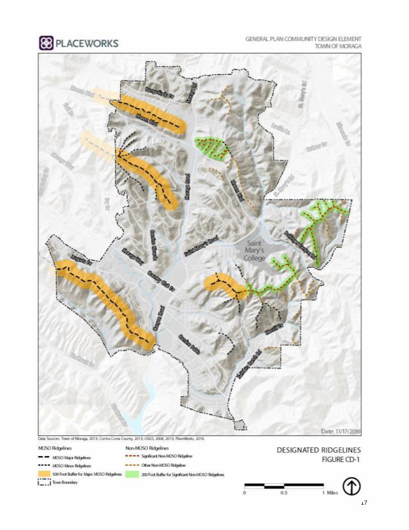
17

June 2002 (Amended January 2010, Reso.15-2010 and April 2018, Reso. 21-2018)4-18
CD8.3: Public Safety. Regulate land use and development in Hillside
Areas and on and near Ridgelines in a manner that prioritizes the
protection of residents, neighbors, and the community at large
from landslides, earthquakes, and other natural hazards.
CD8.4: Scenic Vistas. Ensure that new development in Hillside Areas,
on and near Ridgelines, and within the Town’s scenic corridors
does not diminish the visual quality of Moraga’s scenic vistas
and the public’s enjoyment of these vistas. Development that
complies with all applicable guidelines and all other requirements
for hillside and scenic corridor development shall be considered
to comply with this policy.
CD8.5: Hillside Development. To the maximum extent possible,
require that development of new homes and non-residential uses
in Hillside Areas retains the natural character of the existing
landscape uninterrupted by visible manmade features. For
example, development shall seek to conform to and blend with
the site’s natural setting, retain and respect the character of
existing landforms, preserve natural vegetation, utilize contour
grading to minimize soil displacement and use of retaining walls,
maintain a low visual profile, and incorporate appropriate
screening using native vegetation. Development that complies
with all applicable guidelines and all other requirements for
hillside development shall be considered to comply with this
policy.
CD8.6: Existing Uses and Structures. Allow the continued use of
legally established and permitted uses and structures in Hillside
Areas and on and near Ridgelines. Interpret and apply Hillside
and Ridgeline regulations to existing uses and structures in a
manner that allows for reasonable repair and improvements
consistent with applicable Town standards and regulations.
CD8.7: Property Rights. The Town’s General Plan, including the
Hillside and Ridgeline regulations, should be interpreted and
applied in a manner that would not constitute a taking of
property under the Constitutions of the United States and the
State of California.
CD8.8: Hillside and Ridgeline Protection. Require development to
be located and designed so that Major MOSO Ridgelines, Minor
MOSO Ridgelines, Significant Non-MOSO Ridgelines, and the
Hillside Areas below them remain the dominant visual features
when viewed from the Town’s scenic corridors.

Moraga 2002 General Plan Community Design
June 2002 (Amended January 2010, Reso 15-2010 and April 2018, Reso. 21-2018)4-19
CD8.9: Roads Crossing Ridgeline. The Town may allow roads to cross a designated Major MOSO Ridgeline, Minor MOSO Ridgeline, or Significant Non-MOSO Ridgeline only if the crossing is necessary for the orderly development of the Town and the crossing complies with all applicable requirements in Municipal Code Section 8.128.070.A (Crossing Ridgeline Allowed).”
June 2002 (Amended January 2015, Resolution 07-2015) 5-1
HOUSING
The housing element identifies opportunities, challenges and resources associated with the provision of housing in the Town of Moraga. While it is required by the State, the housing element is a local document with a local impact. It is a chance for us to think strategically about housing in Moraga, to consider our changing communities, and to plan how to best meet their needs. It is an opportunity to evaluate existing policies, and prepare to meet future challenges. Housing in Moraga is generally working well. The housing stock is in good shape and the Town is a desirable place to live. Residents are, by and large, happy with current conditions. Some of the major issues in Moraga today include the aging population, the need for sustainability and the desire for workforce housing. Many of these issues are addressed through the Moraga Center Specific Plan, which lays the groundwork for a walkable, mixed use village center for Moraga. Because of its length, the housing element is bound separately from the General Plan.
5

June 2002 6-1
6 CIRCULATION C1 Traffic Circulation and Safety GOAL: A circulation system that provides reasonable and safe access to the Town, egress from the Town, and internal movement.
C1.1 Roadway Engineering and Maintenance. Apply standard
engineering principles in the design, construction and maintenance of all roadways to make them safe for all users, including bicyclists, pedestrians and equestrians. In support of community design and environmental goals, consider allowing narrower street widths, consistent with Town standards, when it can be demonstrated that public safety concerns are adequately addressed.
Implementing Programs: IP-A1 General Plan Diagram IP-A2 Annual Town Budget IP-C1 Development Review IP-C2 Development Review for Emergency Services IP-G3 Pavement Management Program IP-K2 Pedestrian, Bicycle and Trails Master Plan
C1.2 Traffic Impact Costs. Require each new development to pay its
fair share of the cost of improvements for both the local and regional transportation system in accordance with policy GM1.6 and implementing program IP-C8. Implementing Programs: IP-B4 Traffic Impacts Ordinance IP-C1 Development Review IP-C5 Traffic Impact Studies IP-C8 Fee Waivers/Deferrals and Expedited Permit Processing IP-G2 Traffic Monitoring Program IP-I1 Transportation Systems Management Plan IP-L1 Development Review Referral to Adjacent Jurisdictions IP-L7 Lamorinda Transportation Planning
C1.3 Effective Mitigation Measures. Ensure that traffic mitigation
measures are specifically identified and reasonably demonstrated to be feasible and effective. Traffic mitigation measures may include a roadway or intersection improvement,

Circulation Moraga 2002 General Plan
6-2 June 2002
public or private mass transportation improvement, or any other feasible solution that reduces trip volumes or enhances roadway capacity. Implementing Programs: IP-B4 Traffic Impacts Ordinance IP-C1 Development Review IP-C5 Traffic Impact Studies IP-C8 Fee Waivers/Deferrals and Expedited Permit Processing IP-G2 Traffic Monitoring Program IP-I1 Transportation Systems Management Plan IP-L1 Development Review Referral to Adjacent Jurisdictions IP-L7 Lamorinda Transportation Planning
C1.4 Private Streets. Allow private streets, at the Town Council’s
discretion, if they are constructed consistent with Town street standards, are not gated or similarly restricted, and provide their own maintenance and liability coverage.
Implementing Programs: IP-I1 Transportation Systems Management Plan IP-C1 Development Review IP-C2 Development Review for Emergency Services
C1.5 Collector Street Buffering. Design new areas of development
so that residential areas are properly buffered from collector streets, with adequate distance, landscaping or other buffer to protect residences from adverse impacts. Traffic from major new residential developments should not be diverted through nor adversely affect existing neighborhoods. Implementing Programs: IP-I1 Transportation Systems Management Plan IP-C1 Development Review
C1.6 Street Maintenance. Conduct street maintenance at reasonably
high standards to avoid long-term repair and replacement costs and to ensure a safe and comfortable street system. Implementing Programs: IP-G3 Pavement Management Program
C1.7 Street Names. Do not duplicate existing street names in the
Lamorinda area when naming new streets. Whenever possible, utilize names of historical significance to Moraga when naming or renaming streets.
Implementing Programs:

Moraga 2002 General Plan Circulation
June 2002 6-3
IP-C1 Development Review IP-C2 Development Review for Emergency Services
C1.8 Priority Roadway Improvements. Identify priority roadway
improvement projects to guide project funding decisions, including both capacity-enhancing projects and safety related projects. Implementing Programs: IP-A2 Annual Town Budget IP-C5 Traffic Impact Studies IP-G3 Pavement Management Program
C1.9 Traffic Enforcement. Provide sufficient resources to maintain a
high level of traffic safety through law enforcement.
Implementing Programs: IP-A2 Annual Town Budget IP-M3 Traffic Safety Education Program
C1.10 Traffic Education. Disseminate traffic educational materials to
transportation users to encourage ridesharing, bus transit, and the safe use of streets and highways.
Implementing Programs: IP-I1 Transportation Systems Management Plan IP-M3 Traffic Education Program
C1.11 Emergency Vehicle Access. Maintain and improve critical
transportation facilities for emergency vehicle access and emergency evacuation needs.
Implementing Programs: IP-A1 General Plan Diagram IP-I1 Transportation Systems Management Plan IP-C2 Development Review for Emergency Services
C1.12 Right-of-Way Safety. Ensure that private recreational vehicles,
trailers and other large vehicles are parked off the public right-of-way and out of the front building setback in order to promote traffic safety and good visibility.
Implementing Programs: IP-I1 Transportation Systems Management Plan IP-M3 Traffic Education Program

Circulation Moraga 2002 General Plan
6-4 June 2002
C2 Regional Coordination GOAL: A regional circulation system that meets the expectations and needs of Lamorinda residents.
C2.1 Regional Collaboration and Problem-solving. Work
collaboratively with the other Lamorinda jurisdictions and agencies to define and pursue a clear regional transportation agenda and to address traffic flow and safety issues, particularly on the three roadways leading from Moraga to State Route 24 (Moraga Way, Moraga Road, and St. Mary’s Road/Glenside Road/Reliez Station Road). Cooperate with Lafayette, Orinda and the County in planning and approving new development to ensure that cumulative development impacts do not lower the levels of service on these roadways below the adopted ‘Measure C’ standards. Use data from the Traffic Monitoring Program to monitor compliance with adopted standards and to determine remaining roadway capacity.
Implementing Programs: IP-G2 Traffic Monitoring Program IP-L7 Lamorinda Transportation Planning IP-L8 Transit Improvements
C2.2 Regional Transportation Improvements. Work collaboratively
with the other Lamorinda jurisdictions and agencies to develop workable solutions to regional traffic issues and to identify and pursue potential funding sources, including regional and sub-regional development impact fees as well as funds from County, State and Federal sources.
Implementing Programs: IP-B4 Traffic Impacts Ordinance IP-C8 Fee Waivers/Deferrals and Expedited Permit Processing IP-L7 Lamorinda Transportation Planning IP-L8 Transit Improvements

Moraga 2002 General Plan Circulation
June 2002 6-5
C3 Commercial Area Traffic and Parking GOAL: Properly designed and managed circulation and parking to promote safety and minimize traffic congestion within and adjacent to commercial areas.
C3.1 Commercial Area Traffic Safety. Maintain effective and safe
vehicle circulation into, out of, and within commercial areas.
Implementing Programs: IP-I1 Transportation Systems Management Plan IP-C1 Development Review IP-C2 Development Review for Emergency Services
plus application of standard traffic engineering principles C3.2 Traffic Volume Impacts. Utilize the Specific Plan process as
well as the development review process to consider and address potential traffic impacts from new commercial development, in accordance with policies C1.2, C1.3 and C1.4. As one possible mitigation measure for commercial developments, consider establishing time restrictions on commercial deliveries to prohibit deliveries during peak traffic hours.
Implementing Programs: IP-B4 Traffic Impacts Ordinance IP-C1 Development Review IP-C5 Traffic Impact Studies IP-C8 Fee Waivers/Deferrals and Expedited Permit Processing IP-G2 Traffic Monitoring Program IP-I1 Transportation Systems Management Plan IP-K1 Moraga Center Area and Rheem Park Area Specific Plans
C3.3 Commercial Area Parking. Maintain sufficient, convenient,
free parking within all commercial areas to accommodate actual and anticipated parking needs.
Implementing Programs: IP-C1 Development Review
plus application of standard traffic engineering principles C3.4 Through Traffic. Discourage traffic from traveling through the
commercial centers.
Implementing Programs: IP-C1 Development Review IP-I1 Transportation Systems Management Plan
Circulation Moraga 2002 General Plan
6-6 June 2002
C4 Pedestrians, Bicycles and Transit GOAL: Encourage Moragans to walk, bike, take transit or rideshare as a means of reducing traffic trips, improving environmental quality, and maintaining a healthy lifestyle.
C4.1 Pedestrian Circulation. Provide a safe, continuous and
connected system of pedestrian pathways through the Town, including sidewalks, paths, trails and appropriate crosswalks along all principal streets, to link residential neighborhoods, commercial areas, community facilities such as schools and parks, and other important destinations. Link this network as appropriate with the regional trails system.
Implementing Programs: IP-K2 Pedestrian, Bicycle and Trails Master Plan
C4.2 Bicycle Circulation. Develop a complete bicycle system with
direct, continuous, interconnected pathways between residential and commercial areas, community facilities, commuter corridors and transit hubs.
Implementing Programs: IP-G3 Pavement Management Program IP-K2 Pedestrian, Bicycle and Trails Master Plan
C4.3 Transit. Encourage the use of transit to and from the
Lamorinda BART stations by providing: Efficient, comfortable, frequent and reliable bus service; Roadways that are properly designed to accommodate bus
maneuvering, stopping and parking; Adequate, free, convenient all-day ‘park and ride’ facilities
at major transit stops in the Town; Public information programs to make the public aware of
the service and promote its use; Comfortable, safe and attractive amenities at bus stops.
Implementing Programs: IP-L8 Transit Improvements
C4.4 Trip-Reduction Strategies. Encourage development patterns
and other strategies that may help reduce traffic trips, especially during the morning and afternoon peak hours. For example:

Moraga 2002 General Plan Circulation
June 2002 6-7
Encourage home-based occupations and telecommuting; Encourage mixed use, small office, and live-work
developments in centrally located areas of the Town (i.e., in the Specific Plan areas);
Encourage higher density housing to locate near transit facilities;
Encourage young people to bike, walk or take the school bus to school; and
Encourage ridesharing.
Implementing Programs: IP-C1 Development Review IP-C5 Traffic Impact Studies IP-B4 Traffic Impacts Ordinance IP-K2 Pedestrian, Bicycle and Trails Master Plan IP-L7 Lamorinda Transportation Planning IP-L8 Transit Improvements IP-M3 Traffic Safety Education Program

June 2002 7-1
7 OPEN SPACE and
CONSERVATION
OS1 Open Space Preservation
GOAL: Preservation of as much open space land as
possible, including protection of all major and minor
ridgelines and lands that help meet residents’ recreational needs.
OS1.1 Open Space Preservation. Preserve open space to the maximum extent possible, using tools such as acquisition, lease, dedication, easements, donations, regulation or tax incentive programs.
Implementing Programs: IP-A1 General Plan Diagram IP-B1 Zoning and Subdivision Ordinances IP-B2 Moraga Open Space Ordinance IP-J1 Open Space Preservation Program
OS1.2 Ridgelines. Moraga’s designated Ridgelines are identified in
Figure CD-1 (Designated Ridgelines).
OS1.3 Development Densities in Open Space Areas. Any use of or development on lands designated on the General Plan Diagram or by the Moraga Open Space Ordinance as ‘Public Open Space-Study’ or ‘Private Open Space’ (now designated as MOSO Open Space in the General Plan Diagram) shall be limited to a maximum density of one (1) dwelling unit per twenty (20), ten (10), or five (5) acres, but in no case shall density on such lands exceed one (1) dwelling unit per five (5) acres. Areas identified as ‘High Risk’ areas, as defined by the Moraga Open Space Ordinance, shall be limited to a maximum density of one (1) dwelling unit per twenty (20) acres. Transfers of Development Rights (referred to as ‘Density Transfer’ as in MOSO) from any open space designation to other lands shall be encouraged; provided that in no event shall dwelling units be transferred to another open space designation or to ‘High Risk’ areas. The Town Council shall identify ‘High Risk’ areas after taking into

Open Space and Conservation Moraga 2002 General Plan
7-2 June 2002
account soil stability, history of soil slippage, slope grade, accessibility, and drainage conditions.1
Implementing Programs: IP-A1 General Plan Diagram IP-B3 Zoning and Subdivision Ordinances IP-B2 Moraga Open Space Ordinance IP-C1 Development Review
OS1.4 Private Ownership and Use of Open Space Areas. Areas
designated on the General Plan Diagram as MOSO Open Space or Non-MOSO Open Space may be retained in private ownership, may be used for such purposes as are found to be compatible with the corresponding open space designation and may or may not be accessible to the general public.
Implementing Programs: IP-B1 Zoning and Subdivision Ordinances IP-C1 Development Review
OS1.5 Development on Slopes and Ridgelines in Open Space Lands. In MOSO Open Space, development shall be prohibited on slopes with grades of twenty percent (20%) or greater and on the crests of minor ridgelines. The Town Council shall reduce the allowable densities on slopes of less than twenty percent (20%) through appropriate means such as requiring proportionally larger lot sizes or other appropriate siting limitations. For the purposes of this paragraph the term ‘minor ridgeline’ means any ridgeline, including lateral ridges, with an elevation greater than 800 feet above mean sea level, other than a major ridgeline.2
Implementing Programs: IP-B1 Zoning and Subdivision Ordinances IP-B2 Moraga Open Space Ordinance IP-C1 Development Review
OS1.6 Ridgeline Development Restrictions – Significant Non-
MOSO Ridgelines. Development is prohibited within 200
feet of the centerline of a Significant Non-MOSO Ridgeline
(measured horizontally in plan view), except as allowed by
Municipal Code Section 8.128.030.B.
1 Wording taken from Section 3.a of the Moraga Open Space Ordinance. 2 Wording taken from Section 3.b of the Moraga Open Space Ordinance. MOSO
Open Space is identified as Open Space Lands in the Ordinance.

Moraga 2002 General Plan Open Space and Conservation
June 2002 7-3
OS1.7 Visual Separation - Designated Ridgelines. For designated
Ridgelines, locate new hillside development such that a
minimum of 35 percent of the vertical distance from the
crest of the Ridgeline to the toe of the slope below remains
visible as undeveloped open space when viewed from the
view corridors described in Moraga Municipal Code Chapter
8.128. This policy is intended to maintain the Ridgeline and
the undeveloped Hillside Area below as the dominant visual
features when viewed from the Town’s scenic corridors. The
Town Council may grant exceptions to this visual separation
requirement in unique circumstances in accordance with
criteria in Moraga Municipal Code Chapter 8.128.
OS1.8 Exceptions to Development Prohibitions in MOSO Open Space. Notwithstanding Policy OS1.5 above, the Town may allow the following types of development on and near Major MOSO Ridgelines and Minor MOSO Ridgelines and in areas in MOSO Open Space with a slope of 20 percent or more:
(1) Work necessary to eliminate or prevent a condition which is determined by the Town to be a menace to life, limb or property or adversely affects the safety, use or stability of a public way or drainage way or channel.
(2) The establishment of a fire trail approved by the Moraga-Orinda Fire Protection District.
OS1.9 Transfer of Development Rights (TDRs). Encourage the transfer of development rights from Open Space lands to centrally located ‘receiving areas.’ In no event shall dwelling units be transferred to Open Space lands or to ‘High Risk’ areas, as identified by the Town Council based on soil stability, slope considerations, accessibility and drainage conditions.
Implementing Programs: IP-J2 Transfer of Development Rights Program
OS1.10 Receiving Areas for TDRs. Designate the two specific plan
areas—the Moraga Center Area and Rheem Park Area—as ‘receiving areas’ for the transfer of development rights.
Implementing Programs: IP-J2 Transfer of Development Rights Program IP-K1 Moraga Center / Rheem Park Area Specific Plans

Open Space and Conservation Moraga 2002 General Plan
7-4 June 2002
OS1.11 Open Space Access and Recreational Use. Where appropriate and consistent with other General Plan goals and policies, areas with a MOSO Open Space or Non-MOSO Open Space designation on the General Plan Diagram should be made available to the public for recreational use.
Implementing Programs: IP-J3 Open Space Management Plan IP-K2 Pedestrian, Bicycle and Trails Master Plan
OS1.12 Open Space Management. Maintain and manage public-use open space areas in keeping with community priorities, relevant deed restrictions, budget constraints, hazard and risk considerations, and best management practices. Develop management plans for open space areas as necessary, including the Mulholland Ridge open space area.
Implementing Programs: IP-J3 Open Space Management Plan
OS1.13 Open Space for Grazing. Allow use of open space land for
farm animals when such use does not have adverse impacts upon adjacent residential areas, wildlife, or the land itself. Implementing Programs: IP-J3 Open Space Management Plan
OS2 Environmental Quality
GOAL: Environmental quality in the future that is as good or better
than today.
OS2.1 Protection of Wildlife Areas. Prohibit development in
locations where it will have a significantly adverse effect on wildlife areas. When development is permitted in the vicinity of wildlife areas, require implementation of appropriate mitigation measures to reduce any adverse impact upon the wildlife.
Implementing Programs: IP-C1 Development Review IP-C3 Design Review IP-C6 CEQA / Environmental Impact Reports
OS2.2 Preservation of Riparian Environments. Preserve creeks, streams and other waterways in their natural state whenever possible.

Moraga 2002 General Plan Open Space and Conservation
June 2002 7-5
Implementing Programs: IP-C1 Development Review IP-C3 Design Review IP-J1 Open Space Preservation Program
OS2.3 Natural Carrying Capacity. Require that land development be
consistent with the natural carrying capacity of creeks, streams and other waterways to preserve their natural environment.
Implementing Programs: IP-C6 CEQA / Environmental Impact Reports
OS2.4 Areas of Natural Significance. Preserve and protect, insofar as
possible, areas that are recognized as having natural significance. These areas include but are not limited to: a) The Lake LaSalle area for its scenic value and wildlife
habitat. b) Flicker Ridge for its significant contribution to the
wildlife of the area and because it represents a unique knob-cone pine forest.
c) Remaining laguna environment of Laguna de los Palos Colorados.
Implementing Programs: IP-J1 Open Space Preservation Program
OS2.5 Wildlife Corridors. To the extent possible, connect open space areas so that wildlife can have free movement through the area, bypass urban areas and have proper access to adjacent regional parks and related open space systems.
Implementing Programs: IP-J1 Open Space Preservation Program
OS2.6 Reintroduction of Wildlife Species. Consider reintroduction
into the natural environment of those wildlife species that could survive, would not be detrimental to the urban development, and which could be economically accomplished. Implementing Programs: IP-J3 Open Space Management Plan
OS2.7 Reintroduction of Native Plant Species. Consider
reintroduction into the natural environment of plant species that are indigenous to the area and encourage programs to manage, reduce or eliminate the use and proliferation of non-native, invasive species. Encourage the use of native plant species in new landscaping plans.

Open Space and Conservation Moraga 2002 General Plan
7-6 June 2002
Implementing Programs: IP-C3 Design Review IP-J3 Open Space Management Plan
OS2.8 Tree Preservation. Preserve and protect trees wherever they
are located in the community as they contribute to the beauty and environmental quality of the Town.
Implementing Programs: IP-B1 Zoning and Subdivision Ordinances IP-B17 Moraga Tree Ordinance IP-G6 Tree Planting Program IP-J1 Open Space Preservation Program
OS2.9 Tree-covered Areas. Preserve or substantially maintain in
their present form certain tree-covered areas, especially with respect to their value as wildlife habitats, even if development in those areas is permitted. Give preference to the retention of original growth over replanting. These areas include, but are not limited to: d) Mulholland Hill (both northeast and southwest slopes) e) Indian Ridge f) Bollinger Canyon g) Sanders Ranch properties h) St. Mary’s Road northeast of Bollinger Canyon Road i) The “Black Forest” area located northerly of the terminus
of Camino Ricardo j) Coyote Gulch west of St. Mary’s Road, to the north k) Wooded area to the east and south of St. Mary’s Gardens l) Wooded area behind Donald Rheem School m) Wooded area on the ridge south of Sanders Drive.
Implementing Programs: IP-J1 Open Space Preservation Program IP-G6 Tree Planting Program
OS2.10 Quarrying. Prohibit quarrying and similar activities that tend
to erode the terrain or otherwise damage ecologically sensitive areas.
Implementing Programs: IP-B1 Zoning and Subdivision Ordinances IP-C6 CEQA / Environmental Impact Reports
OS2.11 Recycling and Source Reduction. Enhance the long-term
viability of natural resources and reduce the volume of material sent to solid waste sites by continuing source reduction and recyling programs, encouraging participation of all residents and businesses.

Moraga 2002 General Plan Open Space and Conservation
June 2002 7-7
Implementing Programs: IP-M4 Information on Resource Conservation…
OS3 Water Quality and Conservation
GOAL: Protection of water resources through protection of
underground water aquifers and recharge areas; maintenance of
watercourses in their natural condition; and efficient water use.
OS3.1 Sewer Connections. Require all development to be connected
to a sewage system, with exceptions granted only in those areas where it is demonstrated that a sewer connection is not feasible and it has been confirmed by a competent technical counsel that septic system effluent will not infiltrate underground aquifers.
Implementing Programs: IP-B1 Zoning and Subdivision Ordinances IP-C1 Development Review IP-C6 CEQA / Environmental Impact Reports
OS3.2 Polluting Materials. Prohibit the accumulation and dumping of
trash, garbage, vehicle lubricant wastes and other materials that might cause pollution.
Implementing Programs: IP-D2 Building Inspection, Code Enforcement, Hazard Abatement
OS3.3 Street and Gutter Maintenance. Maintain streets and gutters to
prevent accumulation of debris and litter.
Implementing Programs: IP-G4 Storm Drain Management Program
OS3.4 Watercourse Capacity. Ensure that the design capacity of
watercourses is not exceeded when approving new development.
Implementing Programs: IP-C1 Development Review IP-C6 CEQA / Environmental Impact Reports
OS3.5 Watercourse Preservation. Whenever possible, preserve and protect natural watercourse areas that will reflect a replica of flora and fauna of early historical conditions.
Implementing Programs: IP-J1 Open Space Preservation Program

Open Space and Conservation Moraga 2002 General Plan
7-8 June 2002
OS3.6 Run-off from New Developments. Engineer future major
developments to reduce peak storm runoff and non-point source pollution to local creeks and streams, taking into consideration economically viable Best Management Practices (BMPs) in the design of the project as well as factors such as the physical constraints of the site, the potential impact on public health and safety and the practicability of possible mitigation measures.
Implementing Programs: IP-C1 Development Review IP-C6 CEQA / Environmental Impact Reports
OS3.7 Water Conservation Measures. Encourage water conservation
in new building construction and retrofits, through measures such as low-flow toilets and drought-tolerant landscaping.
Implementing Programs: IP-C1 Development Review IP-C3 Design Review IP-D1 Building and Grading Codes
OS3.8 Water Recycling. When and where feasible and appropriate,
encourage the use of recycled water for landscape irrigation purposes.
Implementing Programs: IP-C1 Development Review IP-B16 Recycled Water Ordinance
OS3.9 East Bay MUD Lands. Encourage the preservation of East Bay Municipal Utility District Lands for watershed use.
Implementing Programs: IP-L12 Coordination with Utility Providers
OS4 Air Quality
GOAL: Preservation and maintenance of air quality.
OS4.1 Development Design. Conserve air quality and minimize
direct and indirect emissions of air contaminants through the design and construction of new development. For example, direct emissions may be reduced through energy conserving construction that minimizes space heating, while indirect emissions may be reduced through uses and development
Moraga 2002 General Plan Open Space and Conservation
June 2002 7-9
patterns that reduce motor vehicle trips generated by the project.
Implementing Programs: IP-C1 Development Review IP-C6 CEQA / Environmental Impact Reports IP-G7 Air Quality Management Program
OS4.2 Development Approval and Mitigation. Prohibit development
projects which, separately or cumulatively with other projects, would cause air quality standards to be exceeded or would have significant adverse air quality effects through direct and/or indirect emissions. Such projects may only be approved if, after consulting with the Bay Area Air Quality Management District (BAAQMD), the Town Council explicitly finds that the project incorporates feasible mitigation measures or that there are overriding reasons for approving the project.
Implementing Programs: IP-C1 Development Review IP-C6 CEQA / Environmental Impact Reports IP-G7 Air Quality Management Program
OS4.3 Development Setbacks. Provide setbacks along high intensity
use roadways to reduce resident exposure to air pollutants.
Implementing Programs: IP-C1 Development Review IP-C6 CEQA / Environmental Impact Reports IP-G7 Air Quality Management Program
OS4.4 Landscaping to Reduce Air Quality Impacts. Encourage the use
of vegetative buffers along roads to assist in pollutant dispersion.
Implementing Programs: IP-C1 Development Review IP-C6 CEQA / Environmental Impact Reports IP-G6 Tree Planting Program IP-G7 Air Quality Management Program
OS4.5 Alternate Transportation Modes. Encourage transportation
modes that minimize motor vehicle use and the resulting contaminant emissions. Alternate modes to be encouraged include public transit, ride-sharing, combined motor vehicle trips to work and the use of bicycles and walking.
Implementing Programs: IP-G7 Air Quality Management Program

Open Space and Conservation Moraga 2002 General Plan
7-10 June 2002
IP-K2 Pedestrian, Bicycle and Trails Master Plan IP-L8 Transit Improvements
OS4.6 New Transportation Technologies. Encourage use of new transportation technologies such as alternative fuel vehicles that may provide environmental benefits such as reduced air pollution, lower energy consumption, and less noise.
Implementing Programs: IP-G7 Air Quality Management Program
OS4.7 Trip Reduction Programs. Encourage employers to foster
employer-based transportation control measures such as ride-sharing, use of public transportation, bicycling and walking to work.
Implementing Programs: IP-G7 Air Quality Management Program IP-K2 Pedestrian, Bicycle and Trails Master Plan IP-L8 Transit Improvements
OS4.8 Smoking in Public Areas. Discourage smoking in enclosed
public places and work places.
Implementing Programs: IP-B17 Non-smoking Ordinance
OS4.9 Public Information on Air Pollution. Encourage public
education programs that demonstrate the benefits of reduced air pollution.
Implementing Programs: IP-M4 Information on Resource Conservation
OS5 Energy Conservation
GOAL: Lower levels of energy consumption and use of more
environmentally friendly energy alternatives.
OS5.1 Building Standards. Require that all new buildings and
additions be in compliance with the energy efficiency standards of the California Building Standards Code (Title 24, California Code of Regulations).
Implementing Programs: IP-C1 Development Review IP-D1 Building and Grading Codes IP-D2 Building Inspection, Code Enforcement and Hazard Abatement

Moraga 2002 General Plan Open Space and Conservation
June 2002 7-11
IP-E2 Residential Design Guidelines OS5.2 Energy Conservation Measures. Encourage energy
conservation in new construction and through retrofitting of existing buildings, utilizing passive solar design, use of alternative energy systems, solar space and water heating, adequate insulation, and other measures where feasible and cost effective.
Implementing Programs: IP-C1 Development Review IP-E2 Residential Design Guidelines
OS5.3 Trip Reduction. Encourage energy conservation through
measures that reduce automobile trips, such as transit-supportive development, provisions for pedestrian and bicycle circulation, and promotion of home-based offices and telecommuting.
Implementing Programs: IP-B1 Zoning and Subdivision Ordinances IP-G7 Air Quality Management Program IP-K2 Pedestrian, Bicycle and Trails Master Plan IP-L8 Transit Improvements
OS6 Noise
GOAL: A peaceful and tranquil community.
OS6.1 Acoustical Standards. Develop acoustical standards that properly reflect acceptable sound emission levels.
Implementing Programs: IP-B1 Zoning and Subdivision Ordinances IP-D1 Building and Grading Codes
OS6.2 Noise Levels. Ensure that noise from all sources is
maintained at levels that will not adversely affect adjacent properties or the community, especially during evening and early morning hours. Reasonable exceptions may be made in the interest of public safety.
Implementing Programs: IP-C1 Development Review IP-G8 Noise Monitoring Program
OS6.3 Noise Sensitive Uses. Locate uses where they will be most
acoustically compatible with elements of the man-made and natural environment.

Open Space and Conservation Moraga 2002 General Plan
7-12 June 2002
Implementing Programs: IP-B1 Zoning and Subdivision Ordinances IP-G8 Noise Monitoring Program
OS6.4 Noise Impacts of New Development. Ensure that new
development will not raise noise levels above acceptable levels on the Town's arterials and major local streets.
Implementing Programs: IP-C1 Development Review IP-C6 CEQA / Environmental Impact Reports
OS6.5 Acoustical Data with Development Applications. Require the
submittal of acoustical data, when and where appropriate, as part of the development application process so that the noise impacts of proposed uses can be properly evaluated and mitigated.
Implementing Programs: IP-C1 Development Review IP-C6 CEQA / Environmental Impact Reports
OS6.6 Temporary Noise Sources. Permit temporary noise-generating activities such as construction only for the shortest reasonable duration and in locations that will have the least possible adverse effect.
Implementing Programs: IP-G8 Noise Monitoring Program
OS6.7 Vehicle Noise. Require that vehicles, including those used for
recreational purposes, be used in such a manner that they will not intrude on the peace and quiet of residential areas. Reasonable exceptions may be made in the interest of public safety.
Implementing Programs: IP-G8 Noise Monitoring Program
OS6.8 Public Information on Noise Pollution. Whenever appropriate,
use public information programs to educate the public on the value of an environment that is free of noise pollution.
Implementing Programs: IP-M5 Information on Noise Pollution

June 2002 8-1
8 PUBLIC SAFETY PS1 General Public Safety GOAL: A semi-rural environment that is relatively free from hazards and as safe as practicable.
PS1.1 Assessment of Risk. Include an environmental assessment
of natural hazard risks in development proposals to permit an adequate understanding of those risks and the possible consequent public costs in order to achieve a level of ‘acceptable risk.’ Public costs should be expressed in terms of effect on life and property.
Implementing Programs: IP-C6 CEQA / Environmental Impact Reports
PS1.2 Public Review of Risk Data. Include appropriate cost-
effective data in the evaluation of existing and potential hazards and make that data available for citizen review and comment in order to determine what public resources should be allocated to mitigate risk conditions.
Implementing Programs: IP-C6 CEQA / Environmental Impact Reports
PS1.3 High Risk Areas. Prohibit development in ‘high risk’ areas,
which are defined as being (1) upon active or inactive slides, (2) within 100 feet of active slides, as defined in Figure 4 of the Safety Element Appendix, or (3) at the base of the centerline of a swale, as shown on the Town’s Development Capability Map.
Implementing Programs: IP-B5 High Risk Areas Zoning Overlay IP-C1 Development Review
PS1.4 Moderate Risk Areas. Avoid building in ‘moderate risk’
areas, which are defined as being (1) those areas within 100 yards of an active or inactive landslide, as defined by the Town’s Landslide Map, or (2) upon a body of colluvium, as shown in Figure 2 of the Public Safety Element background information. Where it is not possible to avoid building in such areas entirely, due to parcel size and configuration, limit development accordingly through

Public Safety Moraga 2002 General Plan
8-2 June 2002
density regulations, subdivision designs that cluster structures in the most stable portions of the subdivision, site designs that locate structures in the most stable portion of the parcel, and specific requirements for site engineering, road design, and drainage control.
Implementing Programs: IP-B6 Moderate Risk Areas Zoning Overlay IP-C1 Development Review
PS1.5 Control of Nuisances and Unsafe Conditions. Identify any
structures and conditions that are unsafe or constitute nuisances, and take measures to make them conform to appropriate safety codes or remove them.
Implementing Programs: IP-D2 Building Inspections, Code Enforcement, Hazard Abatement
PS1.6 Public Safety Improvements. Give high priority to those
public improvements that are related to public safety.
Implementing Programs: IP-A2 Annual Town Budget
PS1.7 Federal and State Aid. Utilize available Federal and State
sources of economic and technical aid to supplement local resources when problems exist that are directly related to public health and safety.
Implementing Programs: IP-G15 Federal Insurance Qualifications IP-L4 Inter-jurisdictional Public Safety Programs
PS1.8 Hazardous Wastes. Require permits in accordance with
State and Federal regulations any time that hazardous materials are proposed to be transmitted into, out of, or through the Town.
Implementing Programs: IP-G9 Hazardous Waste Management Program

Moraga 2002 General Plan Public Safety
June 2002 8-3
PS2 Police and Emergency Services GOAL: A community environment that is free from crime and prepared for any potential disaster.
PS2.1 Police Services. Provide police services to maintain the
peace, respond to localized emergencies and calls for service, and undertake crime prevention within the Town.
Implementing Programs: IP-A2 Annual Town Budget
PS2.2 Address Visibility. Encourage the placement of residential
and business addresses so that they can be easily seen from the street.
Implementing Programs: IP-D1 Building and Grading Codes IP-D2 Building Inspection, Code Enforcements, Hazard Abatement IP-E5 Public Safety Guidelines
PS2.3 Public Safety and Design. Develop guidelines for the
design and siting of buildings to reduce the opportunity for crime, and apply such considerations in the review of development proposals. Provide related information to the public to educate them on the benefits of appropriate home designs and other preventive steps they can take to reduce the incidence of crime in their neighborhood.
Implementing Programs: IP-E5 Public Safety Guidelines IP-M10 Information on Public Safety
PS2.4 Disaster Preparedness. Participate, to the extent feasible, in
programs relating to multi-jurisdictional disaster preparedness and cooperate with the County Office of Emergency Services and other appropriate agencies to revise and update the Town’s Disaster Preparedness Plan.
Implementing Programs: IP-G10 Earthquake Emergency and Disaster Preparedness Plans IP-L4 Inter-jurisdictional Public Safety Programs

Public Safety Moraga 2002 General Plan
8-4 June 2002
PS3 Fire Safety and Emergency Services GOAL: A high level of fire and life safety.
PS3.1 Cooperation with the Moraga-Orinda Fire District.
Cooperate with the Moraga-Orinda Fire District in developing standards, guidelines and local ordinances to assure provision of adequate fire protection and emergency medical service for all persons and property in the community.
Implementing Programs: IP-L4 Inter-jurisdictional Public Safety Programs
PS3.2 Fire Stations. Maintain two fire stations in the Town. Work
with the Moraga-Orinda Fire District to support its ongoing facility improvement program, including but not limited to the relocation of Station 42 from Rheem Boulevard to Moraga Road (as indicated on the General Plan Diagram).
Implementing Programs: IP-L4 Inter-jurisdictional Public Safety Programs
PS3.3 Response Times. Provide a maximum emergency response
driving time of 3 minutes and/or a travel distance of not more than 1.5 miles for response vehicles from the closest fire station to arrive and effectively control fires and respond to medical and other emergencies in the community.
Implementing Programs: IP-L4 Inter-jurisdictional Public Safety Programs
PS3.4 Fire Flows. Deploy the fire-fighting forces of the Moraga-
Orinda Fire District to deliver a minimum fire flow in accordance with the adopted standards of the Moraga-Orinda Fire District. Major fires requiring fire flows in excess of the adopted standards will exceed the initial fire attack capability of local fire-fighting forces and structures involved in such fires are expected to incur major fire damage unless protected by fire resistive interiors and fire sprinkler systems.
Implementing Programs: IP-B8 Fire Safety Ordinance IP-C2 Development Review for Emergency Services

Moraga 2002 General Plan Public Safety
June 2002 8-5
IP-L4 Inter-jurisdictional Public Safety Programs
PS3.5 Development Review for Emergency Response Needs. Evaluate new development proposals to ascertain and mitigate problems associated with emergency response needs.
Implementing Programs: IP-C2 Development Review for Emergency Services
PS3.6 Fire Vehicle Access. Provide access for fire-fighting
vehicles to all new developments in accordance with fire access standards of the Moraga-Orinda Fire District and Town of Moraga Ordinances.
Implementing Programs: IP-B1 Zoning and Subdivision Ordinances IP-B8 Fire Safety Ordinance IP-C2 Development Review for Emergency Services
PS3.7 Preemptive Devices at Traffic Signals. Equip all new traffic
signals with preemptive devices for emergency response services. Existing traffic signals significantly impacted by new developments shall be retrofitted with preemptive devices at developer’s cost.
Implementing Programs: IP-B4 Traffic Impacts Ordinance IP-C2 Development Review for Emergency Services IP-I1 Transportation Systems Management Plan
PS3.8 Fire Safety Devices in Buildings. Require the installation
of appropriate fire safety devices in all structures at the time of original construction, additions, or remodeling, in accordance with adopted building codes and standards.
Implementing Programs: IP-C2 Development Review for Emergency Services IP-D1 Building and Grading Codes IP-D2 Building Inspection, Code Enforcements, Hazard Abatement
PS3.9 High Occupancy Residential Buildings. Require approved
built-in fire protection systems in new construction in high occupancy residential buildings (such as multi-story/multi-unit structures, group quarters, etc.) in accordance with Moraga-Orinda Fire District standards. For each new building or addition exceeding 5,000 square feet of fire

Public Safety Moraga 2002 General Plan
8-6 June 2002
area in high occupancy residential buildings, a comparable amount of existing fire area shall be equipped with approved built-in fire protection systems.
Implementing Programs: IP-B8 Fire Safety Ordinance IP-C2 Development Review for Emergency Services IP-D1 Building and Grading Codes IP-D2 Building Inspection, Code Enforcements, Hazard Abatement
PS3.10 Fire Protection Systems. Cooperate with the Moraga-
Orinda Fire District to enforce requirements for built-in fire protection systems as required by ordinance, including specialized built-in fire protection systems that may be required based upon building size, use or location.
Implementing Programs: IP-B8 Fire Safety Ordinance IP-C2 Development Review for Emergency Services IP-D1 Building and Grading Codes IP-D2 Building Inspection, Code Enforcements, Hazard Abatement
PS3.11 Development Review by the Moraga-Orinda Fire District.
Require proposed construction projects that meet criteria established by the Moraga-Orinda Fire District (MOFD) to be reviewed by the MOFD at the beginning of the Town review process and before permits are issued. The MOFD shall submit conditions of approval for such projects to ensure that they meet adopted fire safety standards. Implementing Programs: IP-C2 Development Review for Emergency Services
PS3.12 Hazardous Fire Areas. Apply special fire protection
standards to all new developments in hillside, open space, and wildland interface areas. Fire prevention measures such as removal of dry grass and brush, landscaping with fire and drought-resistant vegetation, provision of adequate water supplies and access for fire-fighting vehicles shall be required to reduce the risk of wildland fires. All new structures located in hazardous fire areas shall be constructed with fire resistant exterior materials consistent with applicable building codes and standards.
Implementing Programs: IP-B8 Fire Safety Ordinance
Moraga 2002 General Plan Public Safety
June 2002 8-7
IP-C2 Development Review for Emergency Services IP-D1 Building and Grading Codes IP-D2 Building Inspection, Code Enforcements, Hazard Abatement IP-G11 External Hazard Control Program
PS3.13 Dry Grass and Brush Control. Require that all properties be
maintained so as to preclude the existence of dry grass and brush that would permit the spread of fire from one property to another. Encourage preventive measures by homeowners to reduce fire risks.
Implementing Programs: IP-G11 External Hazard Control Program IP-M10 Public Safety Information
PS3.14 Fire Retardant Roofing. Require fire retardant roofing of
Class B or better in all new construction and when replacing roofs on existing structures.
Implementing Programs: IP-B8 Fire Safety Ordinance IP-C2 Development Review for Emergency Services IP-D1 Building and Grading Codes IP-D2 Building Inspection, Code Enforcements, Hazard Abatement
PS3.15 Fire Roads and Trails. Require adequate fire access to open
space areas in accordance with Moraga-Orinda Fire District standards.
Implementing Programs: IP-B8 Fire Safety Ordinance IP-C2 Development Review for Emergency Services
PS4 Seismic and Geologic Hazards GOAL: Minimal risk to lives and property due to earthquakes and other geologic hazards.
PS4.1 Development in Geologic Hazard Areas. Prohibit
development in geologically hazardous areas, such as slide areas or near known fault lines, until appropriate technical evaluation of qualified independent professional geologists, soils engineers and structural engineers is completed to the Town’s satisfaction. Allow development only where and to

Public Safety Moraga 2002 General Plan
8-8 June 2002
the extent that the geologic hazards have been eliminated, corrected or mitigated to acceptable levels.
Implementing Programs: IP-B10 Geologic Hazards Abatement District Ordinance
PS4.2 Development Review for Geologic Hazards. Require
development proposals to address geologic hazards, including but not limited to landslide, surface instability, erosion, shrink-swell (expansiveness) and seismically active faults. Technical reports addressing the geologic hazards of the site shall be prepared by an independent licensed soil engineer, geologist and/or structural engineer, approved by the Town and at the expense of the developer. All technical reports shall be reviewed by the Town and found to be complete prior to approval of a development plan.
Implementing Programs: IP-B10 Geologic Hazards Abatement District Ordinance IP-C1 Development Review IP-C4 Seismic Safety Checklist IP-C7 Geotechnical Reports
PS4.3 Development Densities in Hazard Areas. Minimize the
density of new development in areas prone to seismic and other geologic hazards.
Implementing Programs: IP-B7 Hillside Zoning Overlay IP-B10 Geologic Hazards Abatement District Ordinance IP-C1 Development Review
PS4.4 High Occupancy Structures. Do not locate community
buildings or other structures designed to accommodate large numbers of people near fault lines or any area where seismically induced slides are possible.
Implementing Programs: IP-B7 Hillside Zoning Overlay IP-B10 Geologic Hazards Abatement District Ordinance IP-C1 Development Review IP-C7 Geotechnical Reports
PS4.5 Public Facilities and Utilities in Landslide Areas. Prohibit
the financing and construction of public facilities or utilities in potential landslide areas.

Moraga 2002 General Plan Public Safety
June 2002 8-9
Implementing Programs: IP-B7 Hillside Zoning Overlay IP-B10 Geologic Hazards Abatement District Ordinance IP-C1 Development Review IP-C7 Geotechnical Reports
PS4.6 Construction Standards. Ensure that all new construction and applicable remodeling/reconstruction projects are built to established standards with respect to seismic and geologic safety.
Implementing Programs: IP-C1 Development Review IP-C4 Seismic Safety Checklist IP-C7 Geotechnical Reports IP-D1 Building and Grading Codes
PS4.7 Construction Oversight. Adopt and follow procedures to
ensure that the recommendations of the project engineer and the design and mitigating measures incorporated in approved plans are followed through the construction phase.
Implementing Programs: IP-C1 Development Review IP-C4 Seismic Safety Checklist IP-D2 Building Inspections, Code Enforcement, Hazard Abatement
PS4.8 Unsafe Structures. Properly disclose information pertaining
to structures and facilities found to be unsafe and remove or rebuild such structures and facilities to adequate construction standards.
Implementing Programs: IP-B9 Seismic Safety Ordinance IP-K6 Seismic Safety Study
PS4.9 Water Storage Reservoirs. Permit properly designed
storage reservoirs for domestic water supply only in those locations that will pose no hazard to neighboring development.
Implementing Programs: IP-B9 Seismic Safety Ordinance; IP-C1 Development Review IP-C7 Geotechnical Reports

Public Safety Moraga 2002 General Plan
8-10 June 2002
PS4.10 Grading. Grading for any purpose whatsoever may be permitted only in accordance with an approved development plan that is found to be geologically safe and aesthetically consistent with the Town’s Design Guidelines. Land with a predevelopment average slope of 25% or greater within the development area shall not be graded except at the specific direction of the Town Council and only where it can be shown that a minimum amount of grading is proposed in the spirit of, and not incompatible with, the intention and purpose of all other policies of the General Plan. The Town shall develop an average slope limit beyond which grading shall be prohibited unless grading is required for landslide repair or slope stabilization.
Implementing Programs: IP-C1 Development Review IP-C7 Geotechnical Reports IP-D1 Building and Grading Codes
PS4.11 Retaining Walls. Discourage the use of retaining walls and
other man-made grading features to mitigate geologic hazards, permitting them only when: Required to decrease the possibility of personal injury
or property damage; Designed to blend with the natural terrain and avoid an
artificial or structural appearance; Appropriately screened by landscaping; Designed to avoid creating a tunnel effect along
roadways and to ensure unrestricted views for vehicular and pedestrian safety; and
Designed to ensure minimal public and/or private maintenance costs.
Implementing Programs: IP-C1 Development Review IP-C3 Design Review IP-C7 Geotechnical Reports IP-D1 Building and Grading Codes
PS4.12 Maintenance of Hillside Areas. Facilitate successful long-term maintenance of hillside areas held as common open space.
Implementing Programs: IP-J3 Open Space Management Plan

Moraga 2002 General Plan Public Safety
June 2002 8-11
PS4.13 Public Information on Seismic and Geologic Safety. Educate the general public regarding methods to improve seismic safety, with specific information targeted to hillside homeowners on ways to minimize landslide and erosion hazards.
Implementing Programs: IP-M6 Seismic Safety Information IP-M7 Landslide Information
PS5 Flooding and Streambank Erosion GOAL: Minimal risk to lives and property due to flooding and streambank erosion.
PS5.1 Public Information on Flood Hazard Mitigation.
Educate streamside property owners regarding potential flooding and streambank erosion hazards, their responsibilities for streambank maintenance and repair, and mitigation measures that may be used to address potential hazards. Implementing Programs: IP-M8 Information on Streamside Guidelines and Flood Insurance
PS5.2 Development in Floodways. Restrict new development
in floodways in accordance with FEMA requirements.
Implementing Programs: IP-B12 Flood Control Ordinance 1P-CI Development Review
PS5.3 New Structures in Flood Hazard Areas. Avoid placing
new structures within potentially hazardous areas along stream courses.
Implementing Programs: IP-B12 Flood Control Ordinance IP-C1 Development Review
PS5.4 Existing Structures in Flood Hazard Areas. Require the
rehabilitation or removal of structures that are subject to flooding or streambank erosion hazards.
Implementing Programs: IP-B12 Flood Control Ordinanc
Streambank Maintenance and Repair Responsibilities
Private property owners are responsible for all long- and short-term maintenance on natural creeks and drainage facilities located on or across their property. The only exceptions are those areas where the Town has specifically accepted maintenance responsibility.

Public Safety Moraga 2002 General Plan
8-12 June 2002
IP-C1 Development Review IP-F2 Stream Channel Standards
PS5.5 Streambank Erosion and Flooding Potential. Reduce the
potential for future streambank erosion and flooding by requiring appropriate mitigation measures.
Implementing Programs: IP-B12 Flood Control Ordinance IP-C1 Development Review IP-F2 Stream Channel Standards
PS5.6 On-site Storm Water Retention. Require on-site storm
water retention for new developments.
Implementing Programs: IP-B12 Flood Control Ordinance IP-C1 Development Review
PS5.7 Flood Control. Utilize flood control measures where appropriate to avoid damage to sensitive and critical slope areas, coordinating with the County Flood Control and Water Conservation District to evaluate watersheds and design flood control projects.
Implementing Programs: IP-B12 Flood Control Ordinance P-C1 Development Review IP-L4 Inter-jurisdictional Public Safety Programs

June 2002 9-1
9 COMMUNITY FACILITIES and SERVICES
FS1 Town Administration GOAL: Efficient and effective management of the Town, including maximum economies from the expenditure of public monies and involvement of citizens as human resources to research problems and recommend solutions.
FS1.1 Efficient Town Services. Operate the Town to achieve
maximum efficiency in its service delivery, utilizing a minimum number of permanent service employees and keeping capital expenditures and operating costs to a minimum while responding to community needs and priorities. Continue to seek improved methods of governmental administration that will be as cost-effective as possible, and avoid the incremental growth of government service except for urgent short-term situations
Implementing Programs: IP-A2 Annual Town Budget
FS1.2 Contract Services. Encourage the continuation of Moraga
as essentially a contract service Town when it is cost-effective, contracting out all work that is beyond the capability of Town staff.
Implementing Programs: IP-A2 Annual Town Budget
FS1.3 Town Library. Continue to work closely with the Contra
Costa County Library Commission, County Librarian, Lamorinda Library Board and the Friends of Moraga Library to improve and enhance library services, including additional library hours.
Implementing Programs: IP-L6 Library Services
FS1.4 Citizen Expertise. Solicit and utilize citizen expertise in
non-paid committee and special service functions, using citizens committees as an extension of staff whenever possible. Strive for broad numbers in terms of numbers and diversity.
Town Facilities The Town of Moraga owns and manages the following community facilities: Moraga Commons Park Rancho Laguna Park Hacienda de las Flores
The Town also owns, but leases, two other community facilities: Moraga Library Mullberry Tree Preschool
Community Facilities and Services Moraga 2002 General Plan
9-2 June 2002
Implementing Programs IP-A6 Citizen Participation
FS1.5 Annual General Plan Review and Town Budget. Conduct
the annual review of the General Plan (IP-A4) prior to initiating the Town Budget process.
Implementing Programs: IP-A2 Annual Town Budget IP-A4 Annual General Plan Review
FS1.6 Areas of Potential Annexation. Consider annexation of
areas within Moraga’s Sphere of Influence that will receive services from the Town or other urban service providers (water, sanitation, etc.).
Implementing Programs: IP-K5 Annexation Review
FS2 Schools GOAL: Continued high quality schools.
FS2.1 Population Growth and School Capacity. Ensure that
potential impacts on school facilities are considered when reviewing and approving development proposals, working with the Moraga School District and Acalanes Union High School District to determine potential impacts and establish appropriate mitigations, as necessary.
Implementing Programs: IP-C1 Development Review IP-L11 Coordination with the School Districts
FS2.2 Pace of Growth. Control the timing and location of new residential development in a way that allows the Moraga School District and Acalanes Union High School District to plan and finance facility expansion in an orderly fashion.
Implementing Programs: IP-C1 Development Review IP-L11 Coordination with the School Districts
FS2.3 School Impact Fees. Cooperate with the School Districts to
assess an impact fee on new subdivision developments to offset the costs of facility expansion and other school

Moraga 2002 General Plan Community Facilities and Services
June 2002 9-3
impacts resulting from those developments, in accordance with State law.
Implementing Programs: IP-C1 Development Review IP-C8 Fee Waivers/Deferrals and Expedited Permit Processing IP-L11 Coordination with the School Districts
FS2.4 Cooperation with Schools. Maintain an ongoing collaborative working relationship with the Moraga School District, the Acalanes Union High School District, and private schools in the Town to address growth, facility planning, neighborhood impacts, and other issues of mutual concern.
Implementing Programs: IP-L11 Coordination with the School Districts
FS2.5 Schools and Schoolyards as Neighborhood Places. See
Policy CD2.4.
Implementing Programs: IP-L11 Coordination with the School Districts
FS3 Parks and Recreation GOAL: Parks and recreational facilities that respond to community needs and priorities and are consistent with Town resources.
FS3.1 Parks and Recreation Commission. Continue to appoint and
support the Parks and Recreation Commission to advise the Town Council on parks and recreation matters. The Parks and Recreation Commission shall: Advise the Town Council concerning the establishment,
implementation and evaluation of goals and policies relating to Parks and Recreation facilities and services.
Maintain and biennially review and update the master plans for individual parks.
Evaluate the need for additional park and recreation facilities.
Review development proposals for adequacy of parks and recreation facilities and open space requirements.
Advise the Town Council regarding the acceptance of park dedication funds and/or facilities.
Implementing Programs:

Community Facilities and Services Moraga 2002 General Plan
9-4 June 2002
IP-A7 Citizen Commissions FS3.2 Parks and Recreation Facilities in New Developments.
Ensure that adequate recreation facilities are provided in areas of new residential development as a condition of development approval. Recreation facilities may include but need not be limited to amenities such as playgrounds, drinking fountains, trails, restrooms, picnic tables, play fields, and natural areas.
Implementing Programs: IP-C1 Development Review
FS3.3 Park Dedication Requirements. Require residential and
business developments to make appropriate provisions for park land dedication, trails, trail easements and/or in-lieu fees as part of the planning and development process. Land and/or facilities provided by the developer can be considered for credit toward the park dedication requirement.
Implementing Programs: IP-C1 Development Review
FS3.4 Facility Maintenance. Provide a high level of maintenance
at all park and recreation facilities.
Implementing Programs: IP-G14 Facility Management
FS3.5 Maintenance and Operation Costs. Strive to achieve self-
sustaining parks and recreation activities through appropriate fee structures.
Implementing Programs: IP-A6 Citizen Participation IP-G12 Recreation Programs IP-G14 Facility Management
FS3.6 Access for People of All Abilities. Design and manage park
and recreation facilities, including trail facilities, so that people of all abilities can access and enjoy Moraga’s recreational opportunities, consistent with the requirements of the Americans with Disabilities Act (ADA).
Implementing Programs: IP-A Annual Town Budget IP-G14 Facility Management

Moraga 2002 General Plan Community Facilities and Services
June 2002 9-5
FS3.7 Parking at Parks and Recreation Facilities. Strive to ensure
adequate parking at all parks and recreation facilities.
Implementing Programs: IP-G13 Facility Master Plans
FS3.8 Hacienda de las Flores. Continue to use Hacienda de las
Flores as a recreation center, botanical garden and historical complex.
Implementing Programs: IP-G12 Recreation Programs IP-G13 Facility Master Plans
FS3.9 Moraga Commons. Continue to use Moraga Commons as
the central site for community events.
Implementing Programs: IP-G12 Recreation Programs IP-G13 Facility Master Plans
FS3.10 Land Management. Manage parks, open space lands and
trails in accordance with recognized land management principles.
Implementing Programs: IP-G14 Facility Management IP-J3 Open Space Management Plan
FS3.11 Mulholland Ridge Use and Management. Develop a plan
for use and management of the Mulholland Ridge area as a community open space, involving Moraga residents in the planning process.
Implementing Programs: IP-J3 Open Space Management Plan
FS3.12 Recreation Programs. Develop recreation programs
consistent with the carrying capacities of available park lands and facilities.
Implementing Programs: IP-G12 Recreation Programs IP-G14 Facility Management
Community Facilities and Services Moraga 2002 General Plan
9-6 June 2002
FS3.13 Age-Appropriate Activities. Provide a range of recreational facilities and programs to meet the needs of all age groups.
Implementing Programs: IP-G12 Recreation Programs IP-G13 Facility Master Plans IP-G14 Facility Management
FS3.14 Neighborhood Compatibility. Ensure that recreational
facilities and activities are compatible with the neighboring environment.
Implementing Programs: IP-G12 Recreation Programs IP-G13 Facility Master Plans IP-G14 Facility Management
FS3.15 Recreational Use of School Facilities. Consider school properties for recreational programming and joint facilities development to the extent feasible.
Implementing Programs: IP-G12 Recreation Programs IP-L11 Coordination with the School Districts
FS3.16 Recreation Programs, Activities and Events. Encourage the
development and coordination of recreational facilities, activities, programs and special events, independently or with other governmental agencies, service organizations, local schools and businesses.
Implementing Programs: IP-G12 Recreation Programs IP-L5 Inter-jurisdictional Recreation Planning
FS3.17 Joint Programs with Saint Mary’s College. Encourage joint
recreational programs between the Town of Moraga and Saint Mary’s College.
Implementing Programs: IP-G12 Recreation Programs IP-L10 Coordination with Saint Mary’s College
FS3.18 Community Education Activities. Encourage activities
from which Moraga residents can learn about the community, its history, resources and residents.
Implementing Programs: IP-G12 Recreation Programs

Moraga 2002 General Plan Community Facilities and Services
June 2002 9-7
FS3.19 Recreation Staff. Hire local residents as leaders and
instructors whenever possible.
Implementing Programs: IP-A6 Citizen Participation IP-G12 Recreation Programs
FS3.20 Trails Master Plan. Implement the Moraga Trails Master
Plan through ownership and easements to establish and maintain a comprehensive trails network in the Town. Adjust the plan as necessary to take advantage of any new trail opportunities that may arise.
Implementing Programs: IP-A2 Annual Town Budget IP-C1 Development Review IP-K2 Pedestrian, Bicycle and Trails Master Plan
FS3.21 Trail Design and Maintenance. Consider the following
when planning, designing, implementing and maintaining trail facilities: Environmental Impacts. Design trails for a minimum
adverse environmental impact. Fiscal Impacts. Consider the fiscal impacts of accepting
ownership and maintenance responsibility of trail facilities.
Safety. Separate trail routes from motor vehicle routes whenever possible.
Use of Fire Trails. In undeveloped areas, improve existing fire trails for trail use in cooperation with landowners.
Implementing Programs: IP-A2 Annual Town Budget IP-C1 Development Review IP-K2 Pedestrian, Bicycle and Trails Master Plan IP-J3 Open Space Management Plan
FS3.22 Regional Trail System. Encourage and cooperate with other
jurisdictions and agencies to develop and maintain a unified regional trail system, including hiking, biking and equestrian trails. Support development of regional trail projects such as the Bay Ridge Trail.
Implementing Programs: IP-K2 Pedestrian, Bicycle and Trails Master Plan IP-L5 Inter-jurisdictional Recreation Planning

June 2002 (Amended June 2011 – Resolution 26-2011) 10-1
10 GROWTH MANAGEMENT
GM1 Growth Management GOAL: Maintenance of approved Performance Standards for Town facilities, services and infrastructure.
GM1.1 Purpose of the Growth Management Element. Establish policies
and standards for traffic levels of service and performance standards for fire, police, parks, sanitary facilities, water and flood control to ensure that public facilities are provided consistent with adopted standards.
GM1.2 Authority to Adopt the Element and ‘Measure J’ Consistency.
Adopt the Growth Management Element pursuant to the authority granted to local jurisdictions by Section 65303 of the Government Code, and ensure consistency with the requirements of the Contra Costa Transportation Improvement and Growth Management Program (Measure J), approved by Contra Costa voters in 2004.
GM1.3 Implementation of the Growth Management Element. Establish a
comprehensive long-range program that will match the demands for public facilities generated by new development with plans, capital improvements, and development programs.
Implementing Programs: IP-A2 Annual Town Budget IP-C1 Development Review IP-C5 Traffic Impact Studies IP-C8 Fee Waivers/Deferrals and Expedited Permit Processing IP-L7 Lamorinda Transportation Planning
GM1.4 Traffic Service Standards. Establish the LOS standard for all
Moraga roads, urban and suburban, as a ‘high C’ (0.75 to 0.79 volume to capacity ratio).
GM1.5 Other Performance Standards. Establish the following
performance standards for other Town facilities, services and infrastructure. These standards pertain to the development review process and should not be construed as applying to existing developed lands. Proposed developments must include mitigation measures to assure that these standards or their equivalent are maintained. Modifications to these standards may be accomplished by a resolution of the Town Council.
‘Levels of Service’ (LOS)
To evaluate circulation standards, traffic conditions are described in terms of Levels of Service, or LOS. A range of ‘A’ to ‘F’ indicates the service level, ‘A’ being effective, and continuing to ‘F’ being the worst. Level of Service can be measured in terms of the percentage of capacity under which a particular roadway operates. When a road segment is operating at 100 percent of capacity, LOS ‘F’ has been reached.
Roadway Classifications
The Contra Costa Transportation Authority has differentiated between Basic Routes and routes of Regional Significance. All of Moraga’s roadways are Basic Routes and all can be classified as Suburban Roads with the exception of Moraga Road and Moraga Way, which are designated Urban.

Growth Management Moraga 2002 General Plan
10-2 June 2002 (Amended June 2011 – Resolution 26-2011)
Parks. Three acres of parkland per 1000 residents. Fire. A fire station within 1.5 miles of all residential and nonresidential development in the Town, in the absence of appropriate mitigation measures.
Police. Maintain a three-minute response time for all life-threatening calls and those involving criminal misconduct. Maintain a seven-minute response time for the majority of non-emergency calls.
Sanitary Facilities. The capacity to transport and treat residential and non-residential wastewater as indicated by the Central Contra Costa Sanitary District.
Water. The capacity to provide sufficient water to all residents and businesses in the Town as indicated by the East Bay Municipal Utility District.
Flood Control. Containment of the 100-year flood event (as determined by FEMA) by the flood control/drainage system.
GM1.6 Development Impacts and Share of Costs. Require all new
development to contribute to or participate in the improvement of traffic service, parks, fire, police, sanitary, water and flood control systems in proportion to the demand generated by project occupants and users.
Implementing Programs: IP-C1 Development Review IP-C5 Traffic Impact Studies IP-C8 Fee Waivers/Deferrals and Expedited Permit Processing
GM1.7 Development Review and Approval. Approve development
projects only after making findings that one or more of the following conditions are met: a) Standards for traffic level of service and facility/service
performance will be maintained following project occupancy;
b) Mitigation measures are available and will be required of the applicant in order to insure maintenance of standards;
c) Capital projects planned by the Town or by a special district will result in maintenance of standards.
Implementing Programs: IP-A2 Annual Town Budget IP-C1 Development Review IP-C5 Traffic Impact Studies IP-C8 Fee Waivers/Deferrals and Expedited Permit Processing IP-L1 Development Review Referral IP-L7 Lamorinda Transportation Planning
Moraga 2002 General Plan Growth Management
June 2002 (Amended June 2011 – Resolution 26-2011) 10-3
GM1.8 Transportation System Improvements. Implement actions in the
Lamorinda Action Plan for which the Town is responsible.
Implementing Programs: IP-I1 Transportation Systems Management Plan
GM1.9 Concurrency. Require that improvements to traffic service and/or
other Town facilities and services that are a condition of project approval be implemented and in place at the time of project completion and occupation.
Implementing Programs: IP-A2 Annual Town Budget IP-C1 Development Review IP-C5 Traffic Impact Studies IP-C8 Fee Waivers/Deferrals and Expedited Permit Processing
GM1.10 Findings of Consistency. The Contra Costa Transportation Authority requires that projects estimated to generate over 100 peak-hour vehicle trips to conduct a traffic impact study. In addition, the Lamorinda Project Management Committee (LPMC) is required to review projects that are expected to add an additional 50 peak-hour trips. In such instances, the approval body must make Findings of Consistency with the adopted Level of Service standards and approved action plans in order to approve the project; unless mitigations are programmed to be completed within five years or Findings of Special Circumstances have been made. Implementing Programs: IP-C1 Development Review IP-C5 Traffic Impact Studies IP-C8 Fee Waivers/Deferrals and Expedited Permit Processing IP-L7 Lamorinda Transportation Planning
GM1.11 Reviewing and Monitoring Performance Standards. Periodically
review and monitor all performance standards.
Implementing Programs: IP-A4 Annual General Plan Review
GM1.12 Conflict Resolution. Follow the Contra Costa Transportation
Authority’s conflict resolution process to resolve disputes related to the Action Plans and other parts of the regional Growth Management Program (Measure J).
Implementing Programs: IP-A9 Conflict Resolution
Growth Management Moraga 2002 General Plan
10-4 June 2002 (Amended June 2011 – Resolution 26-2011)
See also policies C2.1, Regional Collaboration and Problem-solving (page 6-4) and C2.2, Regional Transportation Improvements (page 6-5).
GM1.13 Implement the Contra Costa County voter approved Urban Limit Line (ULL). Use the Development Review process to oppose urban development that is contrary to the Contra Costa County approved Urban Limit Line (ULL).
Implementation Programs: IP-C1 Development Review

June 2002 11-1
11 ACTION PLAN This chapter presents a comprehensive list of the implementing programs for the Moraga 2002 General Plan, as referenced for each policy in Chapters 3 through 10. These are the programs that put the Plan’s goals and policies into action. The programs are organized by type, including:
A General Programs
B Ordinances
C Development Review
D Codes and Enforcement
E Design Guidelines
F Other Guidelines and Standards
G Ongoing Programs
H Housing Specific Programs
I Circulation Specific Programs
J Open Space Specific Programs
K Special Plans and Projects
L Intergovernmental Coordination
M Public Information And Education Appendix F provides a summary matrix identifying the Town department(s) responsible for implementing each program, schedule for implementation (highlighting programs to be implemented in the coming year), financing sources (when other than or in addition to Town funds), and, where applicable, quantified objectives for the production of housing units affordable to various income levels (in accordance with State law requirements). Quantified objectives are also summarized at the end of the Housing Element (Chapter 5). The Action Plan, in keeping with Implementing Program IP-A4, should be revisited on an annual basis as part of the General Plan Annual Review to report on the status of each implementing program and revise the schedules to reflect implementation priorities for the coming year.

Action Plan Moraga 2002 General Plan
11-2 June 2002
A. General Programs IP-A1 General Plan Diagram
Use the General Plan Diagram to guide land use planning activities in the Town and its Sphere of Influence area. Use the Circulation System of the General Plan Diagram to guide activities related to goods movement, emergency vehicle routes, street closures and other activities that affect the transportation system, local businesses and residents. Review and update the General Plan Diagram as part of the annual General Plan review process.
IP-A2 Annual Town Budget
Prepare, review and adopt an Annual Budget to identify and fund ongoing Town programs, services, activities, and projects, including capital improvement projects needed to maintain and enhance the community's character, quality and livability. Capital improvement projects shall include park and recreation facility improvements; public safety improvements; and improvements to the circulation system that are necessary to maintain and improve traffic operations and/or levels of facility performance, identifying funding sources (Town funds and other) as well as intended project phasing.
IP-A3 Annual Needs Assessment
Conduct an annual assessment of service levels in relation to community needs as part of the Town budget process.
IP-A4 Annual General Plan Review
Conduct an annual review of the General Plan prior to initiating the Town budget process, reporting on the status of the Plan’s implementing programs and revising the schedules for implementation accordingly to reflect implementation priorities for the coming year and ensuring linkage between implementation priorities and the Town’s annual budget. Additionally, the review should identify current issues in need of attention and recommend new or revised goals, policies or implementing programs, as appropriate, including proposed General Plan amendments.
IP-A5 Public Opinion Surveys
Conduct periodic surveys of public opinion on the Town’s various programs and activities.
Moraga 2002 General Plan Action Plan
June 2002 11-3
IP-A6 Citizen Participation
Continue to encourage citizen participation in all Town activities, including ongoing review and management of the General Plan and development decision-making. Other areas in which to emphasize citizen participation include:
Recreation Programs. Encourage resident participation in community events and activities, including recreation programs, both as participants and as leaders, instructors or coaches.
Public Safety Activities. Involve residents, businesses and service organizations in citizen task forces to study special areas of safety concern, and in safety education activities, such as neighborhood watch, drug awareness, disaster preparedness, and similar programs.
IP-A7 Citizen Commissions
Continue to appoint and support Moraga residents to serve on commissions related to the Town’s planning and development and service delivery. Commissions include the Planning Commission, Design Review Board, Parks and Recreation Commission, and Youth Involvement Committee. Each Committee shall have a designated charge and shall be involved in the review and discussion of relevant issues, making recommendations as appropriate to staff and the Town Council.
IP-A8 Homeowner Assistance
Provide long-term technical assistance to homeowner associations to address public safety issues and concerns, for an appropriate fee or assessment. Assistance shall also be provided in the form of public information and education programs.
IP-A9 Conflict Resolution
Participate in the Contra Costa Transportation Authority’s conflict resolution process as needed to resolve disputes related to the development and implementation of policies described in the Growth Management Element.

Action Plan Moraga 2002 General Plan
11-4 June 2002
IP-A10 Private Sector Support
Encourage the donation of funds, goods and services by the private sector according to the established guidelines and policies of the Town.
B. Ordinances IP-B1 Zoning and Subdivision Ordinances
Revise the Town’s Zoning Map, Zoning Ordinance and Subdivision Ordinance, as needed, to maintain consistency with the adopted General Plan and, specifically, to achieve the following:
Incorporate the land use plans of the Moraga Center Area and Rheem Park Area Specific Plans, when completed. Until such time that the new Specific Plans are completed, the 1990 General Plan designations and existing zoning shall apply in the specific plan areas.
Retain existing residential zoning and discourage non-residential uses in these zones.
Provide for density bonuses in residential districts, consistent with State law requirements (California Govt. Code 65915).
Continue to allow the renting of rooms/quarters in single-family homes as a permitted use in single-family zones.
Permit emergency and transitional housing in the Community Commercial Zoning District.
Continue to allow manufactured housing on single-family lots if placed on permanent foundations and subject to compliance with Town Design Guidelines.
Review the requirements for second units and implement changes, including permitting detached units under certain circumstances.
Prohibit the creation of new non-MOSO lots unless the after-graded average slope of the proposed development area is less than 25%.
IP-B2 Moraga Open Space Ordinance
Continue to implement the development policies and standards set forth in the Moraga Open Space Ordinance, in accordance with its Interpreting and Implementing Guidelines.

Moraga 2002 General Plan Action Plan
June 2002 11-5
IP-B3 Condominium Conversions Ordinance
Revise the Condominium Conversion Ordinance to exempt limited equity residential cooperatives that meet all of the following requirements to the extent necessary to comply with State Law: Minimum of 20 percent of the units as housing affordable
to very-low to moderate income households, Resale controls to assure long term affordability of the low-
and moderate-income units, Right of first refusal of purchase of units by occupants, and Relocation assistance to low- or moderate-income
households who are unable to afford the purchase of units that are converted.
IP-B4 Traffic Impacts Ordinance
Require developers to fund or construct their “fair share” of transportation improvements.
IP-B5 High Risk Areas Zoning Overlay
Establish a zoning overlay district for all high-risk areas. Development may be permitted only if geologic and geotechnical investigations or project mitigations result in a very low level of risk to life and property. If so, require the project geotechnical engineer and the engineering geologist to make explicit findings that this is the case, and require review by the Town’s consulting geotechnical engineer and engineering geologist. Mitigations, if necessary, should be made conditions of project approval.
IP-B6 Moderate Risk Areas Zoning Overlay
Establish a zoning overlay district for all moderate-risk areas and discourage development in areas so designated. Where possible, avoid building in moderate risk areas. Where it is not possible to avoid building in such areas entirely, due to parcel size and configuration, limit development accordingly through density regulations, subdivision designs that cluster structures in the most stable portions of the subdivision, site designs that locate structures in the most stable portion of the parcel, and specific requirements for site engineering, road design, and drainage control.

Action Plan Moraga 2002 General Plan
11-6 June 2002
IP-B7 Hillside Zoning Overlay
Establish a Hillside Zoning Overlay for all hillside sites with greater than 20 percent slope. Regulate densities and require that permitted structures be built in the most stable portion of each parcel. Prohibit the construction of new residences on average slopes of 25 percent or more within the proposed development area of a lot, with the exception of existing lots that were either legally created after March 1, 1951 or specifically approved by the Town Council after April 15, 2002. In the case of existing lots with an average slope of 25% or more within the proposed development area, the design of all new residences shall be subject to design review approval.
IP-B8 Fire Safety Ordinance
Work in conjunction with the Moraga-Orinda Fire District to enact appropriate ordinances to require the use of built-in fire protection systems in all new commercial buildings and in single family residential buildings where water supply and access do not meet fire code requirements or distance to a fire station exceeds 1.5 miles, or square footage exceeds 5,000. The ordinance should also establish guidelines for fire trails and fuel breaks in open space areas, for minimum roofing requirements, and for the design, use and management of Emergency Vehicle Access routes.
IP-B9 Seismic Safety Ordinance
Adopt an ordinance requiring the reinforcement of hazardous buildings. The ordinance should: Identify critical facilities such as public facilities and
infrastructure, evaluate their seismic safety, and develop a schedule for strengthening those facilities found to be below standard.
Require critical facilities, such as schools and medical facilities, to meet the highest possible standards.
Set priorities for non-critical facilities and establish procedures and a schedule for achieving compliance.
Require basic elements of seismic retrofitting upon transfer of property, including inexpensive and cost-effective measures such as bolting of houses to foundations, reinforcement of chimneys, sheathing of cripple walls and bracing of hot water heaters.
Include guidelines for post-earthquake decisions regarding evacuation and condemnation of damaged buildings.

Moraga 2002 General Plan Action Plan
June 2002 11-7
IP-B10 Geologic Hazards Abatement District Ordinance
Consider adopting a Geologic Hazards Abatement District Ordinance, in accordance with State enabling legislation.
IP-B11 Transportation Systems Management Ordinance
To attain traffic service standards, adopt and implement a Transportation Systems Management (TSM) ordinance or alternative mitigation program.
IP-B12 Flood Control Ordinance
Establish a flood control ordinance using FEMA guidelines. The ordinance should establish standards for structural setbacks along streams, set standards for property line setbacks, and require that streamside property be owned and managed in common.
IP-B13 Historic Preservation Ordinance
Develop and adopt a Historic Preservation Ordinance to preserve designated historic buildings and sites and to allow owners of designated historic buildings to apply for tax relief through Mills Act Agreements. Issues to address include definition and designation of historic buildings and sites (including historic orchards); demolition procedures and permits; review of structural modifications and use changes; and design and development review criteria and procedures. Establish guidelines for site and building use, rehabilitation, relocation, and adaptive reuse, and implement discretionary design reviews.
IP-B14 Non-smoking Ordinance
Periodically evaluate the effectiveness and scope of the Town’s non-smoking ordinance, and revise as appropriate.
IP-B15 Moraga Tree Ordinance
Implement and monitor the Moraga Tree Ordinance to preserve and protect trees in the community as they contribute to the beauty and environmental quality of the Town, with particular attention to designated ‘tree-covered areas’ (OS2-9) and ‘trees of historical significance’ (CD7.1), as defined in the Ordinance.

Action Plan Moraga 2002 General Plan
11-8 June 2002
IP-B16 Recycled Water Ordinance
Consider adopting a Recycled Water Ordinance in accordance with State law.
IP-B17 Moraga Grading and Erosion Control Ordinance
Adopt a comprehensive grading and erosion control ordinance. Require all grading on average slopes of 25% or more within the development area to be considered by the Town Council following a recommendation by the Planning Commission. In addition, identify the maximum average slope within a development area that can be graded and prohibit grading of average slopes in excess of the limit. Require natural contour grading of all slopes in excess of 20%.
C. Development Review IP-C1 Development Review
Undertake development reviews to ensure compliance with applicable local, regional, state, and federal laws and adopted policies. Ensure that developers contribute funding for on-site and off-site improvements that mitigate impacts of development. Specifically, review development proposals to ensure:
Neighborhood Quality. Continue to examine site and building plans to ensure that layout and design meet Town objectives for neighborhood quality (including minimizing burglary, vandalism, and other crimes).
Performance Standards. Ensure that one or more of the following conditions will be met: Performance standards will be maintained consistent
with adopted mitigation programs following project occupancy;
Additional mitigation measures are available and will be required of the project sponsor in order to insure maintenance standards; or
Capital projects planned by the Town or special districts will result in the maintenance of standards. Improvements should be in place at the time of project implementation.
Acceptable Noise Levels. Discourage the siting of residences adjacent to major arterials unless noise can be reduced to acceptable levels, consistent with State law. Encourage designs that orient sensitive portions of

Moraga 2002 General Plan Action Plan
June 2002 11-9
buildings away from noise sources, utilize the natural terrain to screen structures from major arterials or other noise sources, and use appropriate design techniques to reduce adverse noise impacts.
Solar Access. Discourage the design and siting of buildings in a manner that may reduce solar access for adjacent buildings or properties.
Emergency Response. Appropriate consideration of emergency response planning.
Fire Prevention. Appropriate fire prevention measures, including fire protection systems and fire-retardant roofs in accordance with adopted ordinances and standards.
Safe Subdivision Design. Subdivision design and platting of each parcel so that there is a safe building location.
Slope Stability. Location of development in the most stable portion of each subdivision and/or parcel, with a statement from the project engineering geologist and geotechnical engineer to this effect, subject to review of the Town’s consulting geotechnical engineer and engineering geologist.
Seismic Safety. Design and construction according to the seismic standards of the latest edition of the Uniform Building Code, with public buildings, multi-story buildings, office and commercial buildings, and public infrastructure designed to the highest feasible standards of seismic design by a structural engineer according to expected levels of seismic shaking, with review by a qualified structural engineer.
IP-C2 Development Review for Emergency Services
Ensure that developments are designed to provide adequate emergency vehicle access, including alternative emergency vehicle access for all new developments with 40 or more units. Ensure that new subdivisions conform to Town standards and are reviewed by officials at the Moraga-Orinda Fire District.
IP-C3 Design Review
Submit all applicable development proposals to the Design Review Board to ensure consistency with the design goals and policies of the General Plan and the Town Design Guidelines.

Action Plan Moraga 2002 General Plan
11-10 June 2002
IP-C4 Seismic Safety Checklist
Create a checklist of seismic design features to be verified in plan review and building inspection.
IP-C5 Traffic Impact Studies
Conduct a Traffic Impact Study as part of the application review process for projects estimated to generate more than 50 peak hour trips per day, consistent with the technical guidelines published by the Contra Costa Transportation Authority.
IP-C6 CEQA / Environmental Impact Reports
Continue to utilize the CEQA process to evaluate and document the potential environmental impacts of proposed development and avoid environmental degradation, requiring environmental impact analysis and appropriate mitigations as necessary in accordance with applicable laws.
IP-C7 Geotechnical Reports
Require a geotechnical report to accompany building permit applications for all new construction, except minor building additions. For hillside sites with slopes steeper than 20 percent, require an engineering geologic report and retain a geotechnical engineer and engineering geologist to review such reports on behalf of the Town, according to established guidelines and procedures for review and approval. Ensure that all geologic and geotechnical reports are made a part of the public record, organized in such a manner that they will become an evolving source of local geotechnical information.
IP-C8 Fee Waivers/Deferrals and Expedited Permit Processing
Review the Town’s fee structure to ensure that development pays no more than its fair share of providing public service improvements consistent with the General Plan. Provide fee waivers or deferrals for projects that contain low- or moderate-income housing. Fee waivers or deferrals should be commensurate with the percentage and income levels of the affordable units proposed, and should be offered only when necessary to assure the financial feasibility of the project and/or the affordability of the low- or moderate-income units.
Provide expedited permit processing and permit assistance
to developers providing affordable housing to ensure that

Moraga 2002 General Plan Action Plan
June 2002 11-11
unnecessary delays do not occur that could jeopardize project funding or result in substantial increases in project costs.
D. Codes and Enforcement IP-D1 Building and Grading Codes
Review and revise the Town’s building and grading codes, as necessary, to ensure that the highest standards of the geotechnical engineering profession are being followed. Specifically, aim for the highest standards in the areas of: Foundation design for expansive soils Hillside drainage Fill settlement Slope stability analysis Liquefaction analysis and mitigation Landslide repair
In the grading code, require that roads constructed in hillside areas be engineered to standards that facilitate proper emergency access and the delivery of necessary services, while reducing the potential for excessive maintenance and repair costs. Develop an average slope limit beyond which grading shall be prohibited unless grading is required for landslide repair or slope stabilization.
IP-D2 Building Inspection, Code Enforcement and Hazard Abatement
Encourage the County to continue to respond to complaints of substandard property conditions by inspecting properties and enforcing applicable building, health and safety codes. Regularly inform elected and appointed officials regarding code compliance and enforcement issues. For critical structures and development in risk areas, encourage the County to implement a pro-active program of building inspection, code enforcement, and hazard and nuisance abatement. Specifically:
Substandard Structures. Inspect and vacate or condemn structures that are damaged or are in imminent peril, using public nuisance abatement powers.
Hazards in Town Buildings. Reduce non-structural hazards in all Town buildings.

Action Plan Moraga 2002 General Plan
11-12 June 2002
Continuing Education for Seismic Safety. Require inspectors to attend continuing education programs to ensure their familiarity with principles of seismic design and with seismic code requirements.
Grading and Foundation Inspections. Establish inspection procedures to ensure that all grading and foundation work is observed and documented at specific critical stages. For sensitive sites, require periodic grading and foundation inspection by the Town’s engineering geologist and/or geotechnical engineer.
Inspection of Critical Public Buildings. For particularly critical public buildings, require periodic inspection by the Town’s structural engineer for seismic safety.
E. Design Guidelines Review and update the Town Design Guidelines to implement the goals and policies of the General Plan, including its Community Design Element. Specific areas to address include: IP-E1 Scenic Corridor Design Guidelines
Review and update design guidelines and development standards for the Town’s designated Scenic Corridors to provide consistent landscaping, design features, and development controls. Guidelines should address:
Street tree selection and spacing and, where appropriate, median trees and groundcover plantings.
View protection, especially to ridgeline and hillside areas.
Signage and/or graphic systems to identify the two commercial centers and important community facilities.
Private signage (location, size and materials).
Building setbacks, heights and architectural features.
Landscaping in setback areas, yards and planted courtyards visible from the street.
Provisions for drought-tolerant species, use of recycled water, and other water conservation measures.
Pedestrian-oriented lighting.
Sidewalk design, along the frontage of residential and commercial areas.

Moraga 2002 General Plan Action Plan
June 2002 11-13
Particular attention should be given to the Scenic Corridors in the Moraga Center Area and Rheem Park Area, establishing points of entry and reinforcing the special design character of these two areas.
IP-E2 Residential Design Guidelines
Review and update design standards and guidelines to address residential design issues in existing and potential future single-family residential developments, including:
Subdivision Design to encourage lot and street configurations adapted to topography and natural features.
Street Design to discourage closed loop streets.
Landscape Character, to encourage street trees and landscaping and retain significant views, with provisions for drought-tolerant species, use of recycled water, and other water conservation measures.
Pedestrian Environment to create interconnected sidewalk/pathway linkages to adjacent neighborhoods, commercial centers and community facilities such as parks and schools; provide for pedestrian-oriented lighting; and, where feasible, encourage landscape strips between the sidewalk and curb to buffer pedestrians from automobiles.
Home Design to encourage home designs that are consistent with existing residential character, with appropriate height, scale and setback requirements; and to discourage the visual dominance of garages on streets by limiting the frontage (by percentage and by location) occupied by garage doors.
Energy Efficiency to encourage home designs and retrofitting conserve energy through use of active and/or passive solar energy systems, ceiling insulation, ceiling fans, low-energy appliances, and/or other measures.
Equipment Screening to encourage appropriate screening of mechanical equipment, solar collectors, satellite dishes, communication devices and similar devices, with special attention given to buildings whose roofs are viewed from higher elevations.
Infill Development to promote more sensitive building additions and infill projects that preserve the scale and character of the existing neighborhood.

Action Plan Moraga 2002 General Plan
11-14 June 2002
Public Places to provide facilities and amenities appropriate to the neighborhood, such as neighborhood parks, childcare centers, schools and churches, ensuring appropriate siting and design.
Clustering to preserve natural features and open spaces and minimize grading.
Landscaping in Hillside Areas to address issues such as fire resistance, erosion control, drought tolerance, and visual buffering for privacy.
Estate Housing to address issues specific to large-lot developments in outlying areas.
IP-E3 Multi-Family Residential Design Guidelines
Review and update design standards and guidelines to address issues specific to the planning, design and management of multi-family residential developments, including:
Site Design to encourage developments that are oriented towards the public street rather than to an internal parking area.
Density and Housing Type Mix to encourage a variety of housing types and discourage too high a concentration of any one unit or building type in a single area.
Building Design to encourage buildings that reflect the scale and quality of their surroundings and which fit the character of existing residential neighborhoods.
Landscaping to encourage developments that blend with the natural setting, with provisions for drought-tolerant species and fire resistive plan species, use of recycled water, and other water conservation measures.
Sense of Entry and Individuality to provide a public entry point and a ‘sense of address’ toward the street or directly to an open space on the site.
Outdoor Spaces and Amenities to encourage garden spaces and outdoor play spaces on the site.
Pedestrian Environment to create a place where it is pleasant and safe to walk, orienting buildings towards public sidewalks and providing yards and landscaped setbacks.

Moraga 2002 General Plan Action Plan
June 2002 11-15
Pedestrian and Bicycle Linkages to encourage walking and biking to nearby community facilities and commercial centers.
Automobile Access and Parking to minimize large parking areas or garage door openings along public streets, encouraging screened parking areas, side-yard parking, and/or ‘alleys’ to access parking at the rear of developments.
Public Places to provide facilities and amenities appropriate to the development and neighborhood, such as park space or childcare centers, ensuring appropriate siting and design.
IP-E4 Commercial Design Guidelines
Review and update design standards and guidelines for Moraga’s commercial centers as part of the Moraga Center Area and Rheem Park Area Specific Plans. Issues to address include:
Building Design to establish appropriate building heights, setbacks and architectural design standards and create a pleasant village-like atmosphere with a strong ‘sense of place.’
Visual Environment to create a more pleasing and inviting visual environment by locating and screening storage yards, parking areas, service areas and other ground level paved areas shall be screened from off site views by perimeter and tree canopy planting. Special attention should be given to views from nearby and distant hillside neighborhoods. Large flat-roofed areas and rooftop equipment shall be screened from off-site views.
Pedestrian Environment to create a strong pedestrian orientation, with buildings sited and designed to create a pleasant pedestrian experience along public street frontages and active uses adjacent to the public sidewalk; and to create pedestrian places and amenities such as covered walkways, courtyards, and plazas with appropriate landscaping and lighting.
Landscaping to provide consistent tree planting along all major streets and pedestrian paths; encourage more extensive on-site landscaping, including use of drought

Action Plan Moraga 2002 General Plan
11-16 June 2002
tolerant and fire resistive plant species, use of recycled water, and other water conservation measures.
Traffic Access and Circulation to minimize the number of driveway openings on major public streets, encourage side street access when feasible, and create a grid or modified grid of streets similar to traditional town or village streets.
Redesigned Parking Areas to create a stronger pedestrian orientation, with parking lots divided into smaller ‘parking courts’ alternated with building frontages.'
Pedestrian and Bicycle Linkages to promote walking and biking between residential neighborhoods and nearby commercial services.
Signage to improve consistency of appearance and wayfinding.
Transit to locate transit-supportive uses within close proximity of transit stops, incorporate stops in convenient locations in commercial areas, and provide linkages between commercial areas and regional destinations.
IP-E5 Public Safety Guidelines
Develop planning and design guidelines for implementation of design ideas that can help prevent or reduce crime (e.g., through attention to sight-lines to front doors and windows and from front windows to the street).
IP-E6 Historic Resource Design Guidelines
Establish guidelines for the design and review of rehabilitation, retrofit, and new construction projects in or adjacent to historic buildings, sites and other resources as designated by the Town. The guidelines shall address issues related to preservation and conservation (CD7.2), infill development (CD7.3), ‘Spanish Heritage’ design (CD7.4) and landscaping (CD7.5).
F. Other Guidelines and Standards Develop and implement guidelines and standards to address issues of special concern in the community, particularly in relation to public safety. Specific areas to address include:

Moraga 2002 General Plan Action Plan
June 2002 11-17
IP-F1 Guidelines for Development in Swales
Prepare siting and engineering guidelines to control development at the base of swales, as shown on the Town’s Development Capability Maps. These should address location of structures, setbacks, and need for special drainage or diversionary structures.
IP-F2 Stream Channel Standards
Prepare Town standards for the design and maintenance of natural stream channels, addressing: Vegetation removal Re-vegetation Permitted bank and bed stabilization techniques Irrigation setbacks from top of bank Energy dissipation at outlets Design of storm drain inlets and outlets Maintenance of culverts and inlets Bank modifications
These standards can be used as a guide throughout all stages of the environmental and development review processes, as well as in providing guidelines to common owners of streamside property.
IP-F3 Storm Drain Standards
Develop and adopt standards for storm drain inlets and outlets to reduce potential for erosion or blockage.
IP-F4 Post-Earthquake Reconstruction Guidelines
Prepare guidelines for post-earthquake reconstruction, addressing: identification of risk areas, establishment of a reconstruction authority (similar to redevelopment authority), and determination of where uses and occupancies should be changed to reduce future risk. Require post-earthquake reconstruction to conform to all Town codes and ordinances.
G. Ongoing Programs IP-G1 Vacant Land Inventory
Maintain and update an inventory of vacant and under-utilized parcels in the Town, including an assessment of their potential development capacity.

Action Plan Moraga 2002 General Plan
11-18 June 2002
IP-G2 Traffic Monitoring Program
Monitor the traffic levels on major arterial roads and the intersection capacity at the Town’s signalized intersections on a bi-annual basis.
IP-G3 Pavement Management Program
Maintain a pavement management program to identify and prioritize maintenance projects in the Town’s Annual Budget. Maintenance should also include regular cleaning of bicycle routes to remove debris and poor pavement conditions that discourage bicycle riding.
IP-G4 Storm Drain Management Program
Revise our Storm Drain Management Program to document current storm drain system conditions, define system improvement priorities, and establish ongoing management and maintenance needs and procedures. Utilize the Town’s Geographic Information System (GIS) to map and monitor system conditions.
IP-G5 Town Beautification Program
Develop and implement a beautification program to enhance the natural beauty and aesthetic qualities of the Town’s scenic corridors, commercial centers, community facilities, and residential neighborhoods.
IP-G6 Tree Planting Program
Develop and implement a comprehensive tree-planting program.
IP-G7 Air Quality Management Program
Refer significant development proposals to the Bay Area Air Quality Management District for review, and maintain consistency with the Bay Area Regional Air Quality Management Plan, as updated from time to time.
IP-G8 Noise Monitoring Program
Monitor noise problems and evaluate complaints regarding new noise sources in order to develop the most practical solutions.

Moraga 2002 General Plan Action Plan
June 2002 11-19
IP-G9 Hazardous Waste Management Program
Develop and implement a Hazardous Waste Management Program to: Locate and identify hazardous materials stored in the
Town. Based on initial evaluation, identify regulations, as
appropriate, for the storage of hazardous materials and/or reinforcement of structures.
Coordinate permitting procedures for the transmission of hazardous or toxic materials into, out of or through the Town, consistent with County, State and Federal regulations.
IP-G10 Earthquake Emergency and Disaster Preparedness Plans
Periodically review and update the Town’s Earthquake Emergency and Disaster Preparedness Plans in cooperation with the County Office of Emergency Services.
IP-G11 External Hazard Control Program
Cooperate with the Moraga-Orinda Fire District in development and enforcement of weed abatement and vegetation management programs.
IP-G12 Recreation Programs
Schedule year-round classes in topics such as arts, sports, physical fitness, music, ecology, photography, cooking, drama, video and special interest needs.
IP-G13 Facility Master Plans
Regularly review and amend as necessary the Master Plans for all Town facilities, prioritizing capital improvement projects and maintenance activities as necessary in response to community needs and priorities and in light of resource constraints.
IP-G14 Facility Management
Maintain all Town facilities, including parks and recreational facilities, at the highest standard achievable in light of resource constraints and staff limitations. Repair acts of vandalism as soon as possible.

Action Plan Moraga 2002 General Plan
11-20 June 2002
IP-G15 Federal Insurance Qualifications
Undertake such actions as necessary to become and remain qualified for Federally subsidized flood and mudslide insurance.
H. Housing Specific Programs IP-H1 Regional Housing Need
Continue to zone sufficient sites to meet Moraga’s regional share of housing need as established by the Association of Bay Area Governments Regional Housing Needs Determination for the period 1999 through 2006.
IP-H2 Housing Partnerships
Work with Saint Mary’s College, the Moraga School District, affordable housing developers, and other groups and organizations to define opportunities for collaboration in the development of new affordable housing to meet the needs of local employees and special needs populations. Identify potential sites, financial resources and regulatory mechanisms to facilitate the development of new units that can help meet the Town’s ‘fair share’ housing requirements.
IP-H3 Housing Rehabilitation Program
Participate in the County Housing Authority’s Housing Rehabilitation Program which provides low interest loans for the rehabilitation of homes owned or occupied by very-low to moderate income households. Improve citizen awareness of this rehabilitation loan program by making pamphlets on this program available at the Planning Department and the public library.
IP-H4 Affordable Housing Subsidies
Seek to increase the availability of state and federal subsidies for affordable housing in Moraga through the following actions:
Petition the County Housing Authority for additional Section 8 subsidies if rental dwelling units can be located that are within federal fair market rent guidelines. If necessary, collect documentation on rent levels and need to
Moraga 2002 General Plan Action Plan
June 2002 11-21
substantiate an increase in the number of Section 8 certificates or vouchers.
Assist developers in accessing funding for the construction of senior housing or other low- or moderate-income housing for which state or federal subsidies are available.
Participate in future issuances of mortgage revenue bonds or mortgage tax credit programs by Contra Costa County to support home ownership opportunities for low- and moderate-income Moraga residents.
Support a waiver exemption of Lamorinda Fee and Financing Authority (LFFA) Impact Fees for affordable housing development.
Encourage future development to consider a fair share affordable housing component for work force housing.
IP-H5 Affordable Housing Trust Fund
Establish an Affordable Housing Trust Fund to which financial contributions can be directed to support affordable housing development in Moraga. Establish procedures and criteria for determining how the Fund’s proceeds are to be managed and expended to support affordable housing development in the Town.
IP-H6 Homeless Services and Referral
Provide referrals to private and public agencies that offer assistance and shelter to homeless individuals and families, and participate with designated inter-agency organizations to address homeless needs.
IP-H7 Equal Housing Opportunities Coordinator and Information
Facilitate fair and equal housing opportunity by designating the Planning Director as the Town's Equal Opportunity Coordinator with responsibility to refer complaints to a district office of the California Department of Fair Employment and Housing. Provide information to the public regarding equal housing opportunity laws and the Town's Equal Housing Opportunities Coordinator. Prepare and distribute a pamphlet on equal housing opportunity to the public at Town Administration offices.

Action Plan Moraga 2002 General Plan
11-22 June 2002
IP-H8 Nondiscrimination Clauses
Continue to provide nondiscrimination clauses in rental agreements and deed restrictions for affordable housing constructed pursuant to this Element.
IP-H9 Accessible Housing Information and Referral
Provide information to developers, homeowners and other interested parties on the needs and techniques for producing adaptable and accessible housing for people with disabilities. Encourage consideration of such techniques in both new and rehabilitated housing, and provide referrals for people with disabilities who desire specially designed housing to meet their needs.
I. Circulation Specific Programs IP-I1 Transportation Systems Management Plan
Review and Update the Town’s Transportation Systems Management Plan to identify/define: Level-of-service standards for traffic operations, reflecting
service levels for all street users (i.e., cars, buses, pedestrians, and bicycles);
Designated routes for commercial trucks, transit, and emergency evacuation;
Street design guidelines for improving arterial corridors and streets within commercial areas and residential neighborhoods; and
Priority improvements to the existing arterial network to accommodate current and anticipated future traffic.
Traffic monitoring program. J. Open Space Specific Programs IP-J1 Open Space Preservation Program
Develop and adopt a program to preserve and/or protect important open space lands and natural resource areas in accordance with the Moraga Open Space Ordinance (MOSO). Areas to protect include: Major and minor ridgeline areas Steep slope areas

Moraga 2002 General Plan Action Plan
June 2002 11-23
Significant wildlife and waterway areas Agricultural lands Scenic areas
The program should identify priority preservation areas not already protected under MOSO, and strategies to achieve preservation goals. Potential preservation strategies include but are not limited to: Acquisition through use of Town funds, formation of an
assessment district, participation in a land trust, or other means;
Transfer of development rights; Long-term leases; Dedication, easements, or donations of land through
development agreements or other means; Development and use regulations; Tax incentive programs.
IP-J2 Transfer of Development Rights Program
Review and update a Transfer of Development Rights (TDR) program to define both sending and receiving sites, transfer ratios, incentive strategies, and application and approval procedures.
IP-J3 Open Space Management Plan
Develop and adopt an Open Space Management Plan to establish management practices for the Town’s natural habitat and open space areas. For open space areas under public ownership or control, clearly delineate public access and use areas, and those areas to be protected from human disturbance. Establish appropriate use controls and, where appropriate, provide compatible support facilities for activities such as hiking and picnicking while ensuring public safety and protection of adjacent private property.
K. Special Plans and Projects IP-K1 Moraga Center Area and Rheem Park Area Specific Plans
Undertake a coordinated specific plan process to address planning issues in the Town’s two centrally located mixed use areas (the Moraga Center Area and Rheem Park Area, as shown on the General Plan Diagram) in accordance with the goals and policies of the General Plan.

Action Plan Moraga 2002 General Plan
11-24 June 2002
IP-K2 Pedestrian, Bicycle and Trails Master Plan
Review, update and expand upon the Town’s ‘Trails Master Plan’ to provide a comprehensive plan for addressing pedestrian and bicycle circulation issues as well as recreational trail use. The updated and expanded Plan should:
Actively involve the public in the review and update process.
Designate trails according to their intended use, by pedestrians, bicycles and/or equestrians.
Establish annual priorities for trail construction as well as pedestrian and bicycle improvements, and identify the resources to build them.
Review pedestrian circulation issues to identify constraints to walking, develop improvement plans at constrained locations, and incorporate pedestrian enhancement projects into the Town’s Annual Budget, with particular attention to pedestrian connections between residential areas, commercial areas, and community facilities such as schools.
Address bicycle circulation issues in compliance with the thirteen elements outlined in the California Bicycle Lane Account (BLA) to open the opportunity for state funding of local and regional bicycle transportation improvements. Elements of the plan should include design standards for bicycle facilities; bicycle education and outreach; and bicycle enhancement projects for the Town’s Annual Budget.
IP-K3 Town Center Project
Continue to support the Town Center assessment and planning process to consolidate Town offices (including a new police station) and develop a multi-use community facility.
IP-K4 Corporation Yard
Evaluate the corporation yard location and consider alternate sites.
IP-K5 Annexation Review
Consider annexation of areas within Moraga’s Sphere of Influence when and if property owners in those areas request connection to the water and sanitation systems.

Moraga 2002 General Plan Action Plan
June 2002 11-25
IP-K6 Seismic Safety Study
Consider appointing a Technical Seismic Advisory Committee to develop a detailed assessment of risk in public and community buildings, recommend a comprehensive action program in conjunction with adoption of the Seismic Safety Ordinance, and research State and Federal sources of economic aid related to public safety concerns. The assessment should include an inventory of potentially hazardous buildings, such as unreinforced masonry buildings, tilt-up buildings, and buildings with soft stories, focusing on buildings with the highest occupancy. At a minimum, hazardous unreinforced masonry buildings must be identified according to the requirements of the Unreinforced Masonry Law of 1986 (Government Code, Section 8875).
IP-K7 Bollinger Canyon Special Study Coordinate with property owners in the Bollinger Canyon area to support their effort in preparing a special study for the Bollinger Canyon area, as shown on the General Plan Diagram, in accordance with the goals and policies of the General Plan. The Bollinger Canyon Special Study may include the following: a) A ‘Opportunities and Constraints’ Analysis. Supplementing the information already collected in the General Plan Update and EIR process, as well as in previous Town planning efforts, an analysis of opportunities and constraints will be conducted and a summary prepared for review by Town staff, officials, and residents. This document shall summarize data on the site and surrounding areas as they relate to development and potential development impacts in the following areas:
Environmental Quality, including wildlife, vegetation, water quality, air quality, noise and view.
Safety, including seismic and geologic hazards (including slope stability), grading, flooding, streambank erosion, fire safety, and public safety (police) issues.
Traffic, including site access and circulation, potential traffic impacts on adjacent areas as well as on roadways connecting the site to regional transportation corridors, and opportunities for pedestrian, bicycle and transit access from the site to the Town center.
Infrastructure, including existing capacity of water, sewer, storm drains, electric and gas utilities to support development at the site, as well potential impacts of development on public facilities such as schools and parks.

Action Plan Moraga 2002 General Plan
11-26 June 2002
Housing Affordability, demonstrating how development at the site could contribute to helping the Town meet its need for housing affordable to low and very low income households.
b) A Conceptual Development and Conservation Plan.. Based on
information contained in the Opportunities and Constraints Analysis, a Conceptual Development and Conservation Plan will be developed to illustrate how the site could be developed in a manner consistent with the goals and policies of the Town’s General Plan. The plan will include:
Illustrative Site Plan, showing proposed development parcels and uses, building footprints, road alignments, easements, and grading.
Proposed Land Use Designations, including both parcels proposed for development and areas proposed for conservation.
Impacts, summarizing the impacts to be expected from development at the scale, type and configuration proposed.
Mitigations and Conservation Plan, demonstrating how the site’s environmental qualities will be protected and its significant natural features conserved.
General Plan Consistency demonstrating that the proposed development is consistent with the goals and policies set forth in the Moraga General Plan.
Proposed General Plan Amendments that may be needed to ensure ongoing consistency between the proposed development and the Moraga General Plan.
Additional requirements for the Conceptual Plan may be established by the Town, consistent with requirements typically expected of similar development proposals. This may include a requirement to provide an opportunity for input by Town residents regarding the Opportunities and Constraints Analysis and the conceptual development plan.
c) A General Plan Amendment to Implement the Conceptual
Development and Conservation Plan in Town Policies. Upon review, refinement and approval of the Conceptual Development and Conservation Plan by the Town Council, a General Plan Amendment should be proposed by the property owner group working with Town staff to establish a policy framework for implementation of the plan. This would include adoption of appropriate land use designations for the subject properties, and any other goal and policy revisions or amendments deemed necessary for implementation.
Moraga 2002 General Plan Action Plan
June 2002 11-27
L. Intergovernmental Coordination Coordinate with other relevant jurisdictions and agencies to address issues of mutual concern. Specific programs of intergovernmental coordination should include the following: IP-L1 Development Review Referral to Adjacent Jurisdictions
Refer all subdivisions of more than ten (10) lots or within one (1) mile of an adjacent jurisdiction to that neighboring jurisdiction for review and comment.
IP-L2 Agenda Referral to Adjacent Jurisdictions
Refer all Town Council, Planning Commission, and Design Review Board agendas to adjacent jurisdictions to encourage inquiry regarding proposals deemed to be of interest to the adjacent jurisdiction.
IP-L3 County Housing Programs
Continue a cooperative relationship with Contra Costa County in the administration of housing programs that benefit Moraga residents. Provide interested residents and developers with information about housing programs available through the County.
IP-L4 Inter-jurisdictional Public Safety Programs
Coordinate with the Office of Emergency Services of Contra Costa County, the Moraga-Orinda Fire District, schools districts, adjacent jurisdictions and other agencies to address public safety issues and concerns.
IP-L5 Inter-jurisdictional Recreation Planning
Cooperate with Orinda, Lafayette, the County, East Bay Regional Park District, and other jurisdictions, agencies, and service organizations to provide recreational activities for Moraga and surrounding communities.
IP-L6 Library Services
Cooperate with the Contra Costa County Library Commission, County Librarian, and the Friends of Moraga Library to

Action Plan Moraga 2002 General Plan
11-28 June 2002
improve and enhance library services, including additional library hours.
IP-L7 Lamorinda Transportation Planning
Participate in multi-jurisdictional transportation planning by taking part in activities of regional transportation agencies and cooperating with other jurisdictions to alleviate substandard roadway conditions. Specifically, coordinate with Lafayette, Orinda, and the County to undertake the following actions:
Attract state/federal funding for transportation projects in Contra Costa County through work with the Lamorinda Project Management Committee and CCTA.
Support regional and/or sub-regional transportation fees on new development to address traffic impacts on the regional road system between the Town of Moraga and State Route 24.
Pursue joint efforts to address major traffic problems where Moraga traffic contributes significantly to such problems.
Consider establishing a program of ‘trip rights’ or similar mechanism to link development approvals in the three Lamorinda communities with the available traffic capacity on the major roadways leading to State Route 24.
Encourage expanded Travel Demand Management Programs that reduce single-occupant driving.
Support CCCTA bus service expansion between Moraga and the Lamorinda BART stations.
Support BART strategies that enhance transit ridership, encourage casual carpools for one-way BART ridership, and reduce parking impacts at Lamorinda BART stations.
Seek to expand and enhance pedestrian and bike corridor connections with adjacent jurisdictions.
Review General Plan Amendments to ensure that proposed developments do not violate multi-jurisdictional agreements.
Support improvements to the regional transportation system such as State Route 24, Interstate 680, and Interstate 80.
Moraga 2002 General Plan Action Plan
June 2002 11-29
IP-L8 Transit Improvements
Work with the Contra Costa County Transportation Authority (County Connection) to identify and implement improvements to the local bus system to increase transit patronage. In particular, explore opportunities to increase daily service, coordinate park-and-ride lots adjacent to transit stops, and provide transit-friendly amenities like benches, bike racks, and transit route information.
IP-L9 Underground Utilities Program
Work with Pacific Gas and Electric, Pacific Bell, and other utility providers to convert overhead utility lines to underground lines, with priority given to lines located in scenic corridors. Utilize the Public Utility Commission’s ‘Rule 20’ to fund Underground Utility District Projects, and require underground utilities in all new development.
IP-L10 Coordination with Saint Mary’s College
Work collaboratively with Saint Mary’s College to:
Coordinate calendars of events.
Regularly communicate on plans in progress and upcoming opportunities.
Encourage Saint Mary’s employees residing in Moraga to serve on local boards and committees.
Create a process to address proposals and issues of mutual concern in an expeditious manner.
Meet annually to review the progress of the approved Master Plan’s implementation.
Discuss student housing needs and solutions, as needed. These may include: a) assistance in accessing funding for student housing; b) approving an affordable housing development that includes student units in multifamily residential zones, or c) permitting second units, the renting of rooms, and/or other uses of existing single family properties, consistent with neighborhood quality objectives.
IP-L11 Coordination with School Districts
Work collaboratively with the leadership and staff at the Moraga School District and the Acalanes Union High School District to address school facility planning and use issues, including the coordination of long-range planning and

Action Plan Moraga 2002 General Plan
11-30 June 2002
population growth forecasting; land use and circulation issues in the vicinity of school facilities; review and evaluation of development impacts (and impact fees, as necessary); community use of school facilities; and other issues of mutual concern. The Town will also encourage school district employees residing in Moraga to serve on local boards and committees.
IP-L12 Coordination with Utility Providers
Work collaboratively with utility service providers to support ongoing utility provision, maintenance and service improvements. Also, work with the East Bay Municipal Utility District (EBMUD) to preserve and protect watershed lands adjacent to the Town.
M. Public Information and Education Provide public information and education materials and programs to raise public awareness about key community issues and encourage resident participation in Town activities and programs. Specific public information and education programs should include: IP-M1 Information on Town Programs, Events and Activities
Maintain a regular and periodic public information device to disseminate information on the Town’s programs, events and activities.
IP-M2 Information on Historic Preservation and Resources
Work with the Moraga Historical Society and other groups to support public information and education programs regarding Moraga’s history.
IP-M3 Traffic Safety Education Program
Conduct a traffic safety and education program, including an elementary school outreach program to educate children on traffic safety and courteous driving activities; adult outreach program addressing vehicle impacts on the environment, courteous driving behavior and carpool/transit opportunities; senior outreach program addressing traffic safety and changing traffic laws and driving activities; and topical education sheets for the Town newsletter.

Moraga 2002 General Plan Action Plan
June 2002 11-31
IP-M4 Information on Resource Conservation and Environmental Preservation
Provide public information and education materials to encourage recycling, resource conservation, and environmental preservation efforts.
IP-M5 Information on Noise Pollution
Publicize practical mitigation measures that Town residents and businesses can use to help reduce noise.
IP-M6 Information on Seismic Safety
Provide public information to help residents and businesses understand what to expect during an earthquake, how best to respond, and what they can do to prepare themselves. Specifically, provide the following:
Community Information. Provide educational materials to community organizations. Materials should address general earthquake hazards and also describe expected effects within the Town of Moraga, making use of existing materials from the Seismic Safety Commission and the Bay Area Region Earthquake Preparedness Project.
Schools Curriculum. Work with the schools to teach about earthquakes. This would include handouts on family earthquake preparedness in addition to establishing emergency preparedness procedures in the schools.
IP-M7 Information Landslides
Consider preparation and distribution of informational brochures, identifying landslide areas within the Town, describing the causes of landslides and presenting guidelines for property maintenance so as to minimize the potential for earth movement problems.
IP-M8 Information on Streamside Guidelines and Flood Insurance
Consider the distribution of maintenance and property management guidelines to all streamside property owners, and inform all property owners within 200 feet of a creek, to identify stream and drainage areas for which the Town is responsible and those areas for which private property owners are responsible. Educate property owners on their responsibilities for streambank maintenance and repairs, and

Action Plan Moraga 2002 General Plan
11-32 June 2002
make them aware of the availability of flood insurance under the National Flood Insurance Program.
IP-M9 Information for Homeowners Associations
Provide information to homeowner associations regarding their responsibilities and to keep them informed regarding Town issues and activities.
IP-M10 Public Safety Information
Provide information to the public to promote crime and hazard prevention and general disaster preparedness, including information on public safety design, fire safety devices, and the removal of dry grass and brush that pose fire hazards.

APPENDIXES


June 2002 A-1
APPENDIX A GENERAL PLAN DIAGRAM The General Plan Diagram defines the general pattern of future development within the Town boundaries and Sphere of Influence. It is a graphic expression of the General Plan’s goals and policies and is the single most important policy implementation measure of the General Plan. The General Plan Diagram is not a map. Although it may be to scale, the uses or alignments displayed on the Diagram should not be measured directly. Also, the Diagram should not be used interchangeably with the Town’s Zoning Map. The Diagram is a long-term planning tool that depicts the desired pattern of future development at a generalized level. The Zoning Map is a current planning tool that depicts permitted uses on a parcel level. In cases where the land use designation of a parcel is unclear based on the General Plan Diagram, the Planning Commission shall make a determination as to the appropriate designation. The General Plan Diagram presents four general categories of land use: Residential Neighborhoods, Mixed Use Areas, Parks and Open Space, and Community Facilities. It also displays the Town’s circulation system. The General Plan Diagram of the Moraga 2002 General Plan is displayed on the following page. Appendix C provides a summary of the projected residential development potential of remaining undeveloped lands in the Town based on the General Plan Diagram.


June 2002 B-1
APPENDIX B SPECIFIC PLAN AREA DIAGRAMS Land Use policies LU3.1 and LU3.2 as well as Community Design policies CD6.5 and CD6.6 call for development of ‘specific plans’ for the areas around the Town’s two major shopping centers—the Moraga Center and Rheem Park. These policies provide a detailed overview of the intent for each specific plan and desired outcomes. The policies are implemented by action IP-K1, identified as a near-term priority in the Action Plan Summary (Appendix F). The diagrams on the following two pages identify the specific plan area boundaries, major features, and adjacent uses. The diagrams are provided for illustrative purposes only to show the configuration of the Specific Plan areas and potential opportunities. They are in no way meant to represent an approved plan or policy direction.

Appendix B: Specific Plan Area Diagrams Moraga 2002 General Plan
B-2 June 2002
Moraga Center Area Specific Plan Key opportunities and a possible configuration of land uses in the Moraga Center Area. 1 Shopping Center – potential redevelopment, redesign, intensification or site improvements to create
stronger pedestrian orientation. 2 Under-utilized Land –potential for medium and medium-high density housing and/or commercial
development 3 Potential extension of School Street 4 Proposed Town Center Facility Site 5 Creek and Moraga Ranch historic structures—development setbacks and potential linear park 6 Orchard Area – mixed density housing, clustered to protect some of the orchard areas 7 Residential Area (3 units per acre; transition to existing neighborhoods) 8 Commercial / Office Areas (including existing assisted care facility, Moraga Barn, etc.) – some infill
potential (small offices and/or housing) 9 ‘Limited Commercial’ Area – some infill housing potential

Moraga 2002 General Plan Appendix B: Specific Plan Area Diagrams
June 2002 B-3
Rheem Park Area Specific Plan Key opportunities and a possible configuration of land uses in the Rheem Park Area. 1 Shopping Center – potential redevelopment, redesign, intensification or site improvements to create
stronger pedestrian orientation. 2 Under-utilized Land –‘research and development’ overlay district; potential for redevelopment, redesign,
intensification or site improvements 3 Area of existing commercial development and services, including new commercial space and fire station
(under development); opportunity for infill development at vacant bowling alley site and remaining vacant parcel.
4 Multi-family housing 5 Areas of existing commercial/service development with potential for re-use or redevelopment (including
old fire station site)

June 2002 C-1
APPENDIX C DEVELOPMENT POTENTIAL The following table summarizes the ‘Theoretical Maximum Development Capacity’ of the Town of Moraga based on the General Plan Diagrams of the 1990 General Plan and the Moraga 2002 General Plan. The 1990 General Plan figures are provided as a point of comparison. The ‘estimated actual’ development potential for the Moraga 2002 General Plan (shown in the last two columns) reflects assumptions, based on past experience, about the level of development that might be expected once site-specific reviews and considerations are taken into account (which typically result in fewer total units than would be allowed under the ‘theoretical maximum’).
Comparison of Total Development Potential, 1990 General Plan and Moraga 2002 General Plan
1990 GP Max Potential
2002 GP Max. Potential
2002 GP Estimated Actual*
total total change total change Housing Units Existing Units 5,778 Approved Units (12/99) 265 Projected New Units 839 698 -17% 558 -33% Total Units at Build-out 6,882 6,741 -2% 6,601 -4% Population 2000 Population 16,290 Projected Add’l. Pop. 3,691 3,187 -14% 2,826 -23% Population at Build-out 19,981 19,477 -2% 19,116 -4%
Year 2000 population from the US Census; Population projection based on assumption of 2.75 persons per household from ABAG Projections 2000. * Most projects are not designed and/or approved at maximum allowed density due to site-specific constraints, environmental review, and other factors. The build-out assessment in this table reflects an assumption of 80% build-out of the maximum capacity on undeveloped (and currently unapproved) sites. This is a conservative assumption (erring on the ‘high side) based on recent project’s approved densities in relation to maximum potential density. The ‘% change’ column is in comparison to theoretical maximum build-out of the 1990 General Plan. Also, see notes for Table C1.
June 2002 (Amended January 2015, Reso 7-2015 and April 2018, Reso 21-2018) D-1
APPENDIX D
DEFINITIONS The following definitions should be used in interpreting and implementing the Moraga 2002 General Plan. Affordable Housing. Under State and Federal statutes, housing which generally costs no more than 30 percent of gross household income. Housing costs typically include rent or mortgage payments, utilities, taxes, insurance, homeowner association fees, and other related costs. Census. The official United States decennial enumeration of the population conducted by the Federal government. Centerline or Crest. “Centerline” or “Crest” of a ridge means the line running along the highest portion of the ridge for the full length of the ridge. Cluster Housing. Cluster housing is defined as single family dwelling units sited on less than the minimum size lots permitted by the General Plan (see Policy LU1.6) to preserve open space. Condominium. A building or group of buildings in which units are owned individually, but the structure, common areas, and facilities are owned by all owners on a proportional, undivided basis. Critical Facility. Facilities housing or serving many people that are necessary in the event of an earthquake or flood, such as hospitals, fire, police and emergency service facilities; utility ‘lifeline’ facilities such as water, electricity and gas supply; and communications and transportation facilities. Dedication. The turning over by an owner or developer of private land for public use, and the acceptance of land for such use by the governmental agency having jurisdiction over the public function for which it will be used. Dedications for roads, parks, school sites, or other public uses often are made conditions for approval of a development by local governments. Dedication, In lieu of. Cash payments which may be required of an owner or developer as a substitute for a dedication of land, usually calculated in dollars per lot, and referred to as ‘in lieu fees’ or ‘in lieu contributions.’ Defensible Space. ‘Defensible space’ is a term used in relation to both crime prevention and fire prevention. In crime prevention, it describes a

Appendix D: Definitions Moraga 2002 General Plan
D-2 June 2002 (Amended January 28, 2015, Reso 7-2015 and April 2018, Reso 21-2018)
physical design approach that helps to deter crime and promote public safety by creating a sense of ownership for local residents over public spaces, encouraging more street activity and ‘eyes on the street’ (though sight lines from homes to the street and features such as front porches) and ensuring that front entryways are clearly visible from the street. In fire prevention, the term ‘defensible space’ is used to describe the area around a home that should be cleared of brush and other dry vegetation to help reduce fire hazards. Density (Residential). The number of permanent residential units per acre of land. Density may be controlled through zoning in the following ways: use restrictions, minimum lot-size requirements, floor area ratios, setback and yard requirements, minimum house-size requirements, limits on units per acre, and other means. Allowable density is the major distinction between residential districts.
Density Bonus. The allocation of development rights that allows a parcel to accommodate additional square footage or additional residential units beyond the maximum for which the parcel is zoned. Density bonus requirements are contained in Moraga Municipal Code Chapter 8.172 consistent with Government Code Section 65915. Development. Development means the placement, discharge, or disposal of any material; the grading or removing of any material; the change in the density or intensity of use of land; the subdivision of land; or the construction or erection of a structure (see Policy OS1.8 for permitted exceptions to development prohibitions in MOSO Open Space). Emergency Shelter. Housing with minimal supportive services that is designed for and occupied by homeless persons for no more than six-months in a consecutive 12-month period. No individual or household may be denied emergency shelter because of an inability to pay. Family. (1) Two or more persons related by birth, marriage, or adoption
[U.S. Bureau of the Census]. (2) An individual or a group of persons living
together who constitute a bona fide housekeeping unit in a dwelling unit, not
including a fraternity, sorority, club, or other group of persons occupying a
hotel, lodging house, or institution of any kind [California].
Flood, 100-Year. The magnitude of a flood expected to occur on the average every 100 years, based on historical data. The 100-year flood has a 1/100, or one percent, chance of occurring in any given year. General Plan Diagram. This is a multicolored map of the planning boundaries of the Town. It is a visual representation of some, but not all, of the elements of the General Plan. The Diagram is not intended to establish precise boundaries of the various sub-areas of the Town but only their general locations. The actual boundaries of each of the land uses, the precise location of the circulation system, and details of the other elements will be determined more precisely by reference to the

Moraga 2002 General Plan Appendix D: Definitions
June 2002 (Amended January 28, 2015, Reso 7-2015 and April 2018, Reso 21-2018) D-3
approved zoning map and/or subdivision proposals which have already been approved and developed, and in the context of consideration of development proposals for particular properties. An understanding of the General Plan Diagram and its relationship to the various elements can be achieved only by reviewing it in conjunction with the text of each of the Elements of the General Plan. The General Plan Diagram for the Draft Moraga 2000 General Plan is contained in Appendix A of the Plan document. Geologic Hazards. These are geologic conditions that could have an impact on the safety and welfare of the Town, such as, among other things, land flow or creep, surface erosion, creek erosion, fault movement, shrink/swell of soils and sub-surface water conditions. Hazardous Material. Any substance that, because of its quantity, concentration or physical or chemical characteristics, poses a significant present or potential hazard to human health and safety or to the environment if released into the workplace or the environment. The term includes, but is not limited to, hazardous substances and hazardous wastes. High Risk Areas. ‘High Risk Areas’ are areas with a MOSO Open Space designation on the General Plan Diagram and determined to be High Risk in accordance with Part II D. of the “Guidelines for the Interpretation and Implementation of the Moraga Open Space Ordinance – Measure A,” adopted as Resolution 14-92 by the Town Council on February 12, 1992 in accordance with the Moraga Open Space Ordinance (MOSO). Hillside Area. "Hillside Area" or “Hillside Land” means either of the following:
A parcel with an average predevelopment slope of twenty (20) percent or greater; or The area of a parcel where (i) the area of disturbance of a development project and/or (ii) the footprint of the primary structure, has an average predevelopment slope of twenty (20) percent or greater. These particular areas of a parcel shall be classified as a “Hillside Area” or “Hillside Land” regardless of the average predevelopment slope of the entire site or parcel in which the area of disturbance or the footprint of the primary structure is located.
Income Limits. Income limits are updated annually by the US Department of Housing and Urban Development (HUD) for Contra Costa County. For many State and local programs, State Department of Housing and Community Development (HCD) income eligibility limits are used. HCD income limit regulations are similar to those used by HUD and are categorized as follows:

Appendix D: Definitions Moraga 2002 General Plan
D-4 June 2002 (Amended January 28, 2015, Reso 7-2015 and April 2018, Reso 21-2018)
Very Low Income Households. Defined by California Housing Element law as households earning less than 50 percent of the median household income.
Low Income Households. Defined by California Housing Element law as households earning 51 to 80 percent of the median household income.
Moderate Income Households. Defined by California Housing Element law as households earning 81 to 120 percent of the median household income.
Above Moderate Income Households. Defined by California Housing Element law as households earning more than 120 percent of the median household income.
Lamorinda Area. This refers to the Lafayette-Moraga-Orinda area, consisting of all three jurisdictions. Large Household. According to State Housing Element law, a household with five or more members. Manufactured Housing. A manufactured home is a factory-built, single family structure that is built on a permanent chassis and transportable in one or more sections. This reduces construction costs considerably. Once built, a manufactured home may be difficult to distinguish from a site-built house. California law (Gov Code §65852.3) permits manufactured homes built under federal and state guidelines and on a foundation to be placed on lots zoned for conventional single-family residential dwellings. The homes must conform to the same development standards applied to a conventional single-family residence on the same lot, but may also be subject to three additional architectural requirements (roof overhang, roofing material and siding material) so long as such requirements are in accordance with State regulations (Gov Code §65852.5), do not exceed the standards for site-built homes on the same type of lot, and do not have the effect of precluding manufactured housing. Mixed-use. Properties on which various uses, such as office, commercial,
institutional, and residential, are combined in a single building or on a single
site in an integrated development project with significant functional
interrelationships and a coherent physical design. A "single site" may
include contiguous properties.
Moraga Open Space Ordinance (MOSO). Refers to Measure A, a voter approved Initiative adopted at the General Municipal Election held on April 8, 1986. The Initiative regulates the uses and development of lands designated by the Initiative measure, and provides that the Town Council shall not amend or modify any requirement of this Ordinance without approval by the electorate at a general election. The ballot text is attached as Appendix E and made a mandatory requirement of this General Plan.

Moraga 2002 General Plan Appendix D: Definitions
June 2002 (Amended January 28, 2015, Reso 7-2015 and April 2018, Reso 21-2018) D-5
Multi-Family Residential. A building containing two or more dwelling units for the use of individual households; an apartment or condominium building is an example of this dwelling unit type. The Multi-Family Residential designation refers to areas that are designated on the General Plan Diagram or in the land use diagrams of the Moraga Center Area and Rheem Park Area Specific Plans as six (6) dwelling units per acre or higher. Such areas may also be used for single-family residential development so long as minimum development densities are met. Predevelopment Slope. “Predevelopment Slope” means the slope existing at the time a development project application is submitted. For a site where the Town finds that slope conditions were previously modified in violation of the grading ordinance, the average predevelopment slope shall be calculated based on site conditions prior to the violation. Performance Standards. These are quantifiable rules or guidelines that are used to determine compliance with regulations or conditions of approval established by the Town. Examples include noise measurements and traffic levels of service. See Growth Management Policies GM1.4 and GM1.5. Reasonable Accommodation. Allowing for appropriate modifications and
adjustments to zoning laws and other land use regulations, policies, and
procedures where needed to ensure persons with disabilities equal
opportunity for housing under the federal Fair Housing Act and the
California Fair Employment and Housing Act.
Recreational Facility. A recreational facility is any development, structure, appurtenance or other man made amenity created for the express purpose of providing for leisure-time recreational opportunities. Region. This refers to the nine-county San Francisco Bay Area, including the counties of Alameda, Contra Costa, Marin, Napa, San Francisco, San Mateo, Santa Clara, Solano and Sonoma. Regional Housing Needs Allocation (RHNA). The Regional Housing Needs Allocation identifies each jurisdiction’s responsibility for planning for housing to meet its “fair share” of the regional housing need. The RHNA is divided into four income categories that encompass all levels of housing affordability. Once it receives its RHNA, each local government must update the Housing Element of its General Plan to show how it plans to meet the housing needs in its community. Regional Housing Needs Plan (RHNP). The Regional Housing Needs Plan (RHNP) is based on State of California projections of population growth and housing unit demand and assigns a share of the region’s future housing need to each jurisdiction in California. These housing need

Appendix D: Definitions Moraga 2002 General Plan
D-6 June 2002 (Amended January 28, 2015, Reso 7-2015 and April 2018, Reso 21-2018)
numbers serve as the basis for the update of the Housing Element in each California city and county. Residual Parcel. A residual parcel is a vacant lot of ten (10) acres or less in an area that is generally bounded by existing development. A residual parcel may have any land use designation. Land Use Element Policies LU1.11 and LU1.12 address issues related to residual parcels. Ridgelines. “Ridgeline” means one or more of the following, as shown in Figure CD-1:
A Major MOSO Ridgeline means the centerline or crest of the ridges known as Indian Ridge, Sanders Ridge, Mulholland Ridge and Campolindo Ridge, where the crest is above 800 feet above mean sea level and within an area with a MOSO Open Space designation on the General Plan Diagram. Major MOSO Ridgeline shall have the same meaning as “Major Ridgeline” as that term is used and defined in the Moraga Open Space Ordinance. A Minor MOSO Ridgeline means the centerline or crest of any ridge other than those identified as ‘Major Ridgelines,’ where the crest is above 800 feet above mean sea level and within an area with a MOSO Open Space designation on the General Plan Diagram. Minor MOSO Ridgeline shall have the same meaning as “Minor Ridgeline” as that term is used and defined in the Moraga Open Space Ordinance. A Significant Non-MOSO Ridgeline means those Ridgelines shown in Figure CD-1 as a Significant Non-MOSO Ridgeline. An Other Non-MOSO Ridgeline means those Ridgelines shown in Figure CD-1 as an Other Non-MOSO Ridgeline. If there is discrepancy between Figure CD-1 and the General Plan text as to the location of a Ridgeline, Figure CD-1 shall govern.
Second Unit. A self-contained living unit that is in addition to the primary residential unit on a single lot. Second units are also referred to as accessory units, in-law units, carriage houses, or granny flats. Section 8. This is a rental assistance program operated by the federal Department of Housing and Urban Development. It provides two forms of assistance: 1) certificate rent subsidies to owners of housing units on behalf of very low-income tenants; and 2) vouchers used in rental housing of the tenant’s choosing. The assistance is intended to help bridge the gap between the household’s income and the ‘fair market rate’ for rental housing. Section 8 is the largest rental assistance program in the country. Local Section 8 programs are operated by the County Housing Authority.

Moraga 2002 General Plan Appendix D: Definitions
June 2002 (Amended January 28, 2015, Reso 7-2015 and April 2018, Reso 21-2018) D-7
Senior Housing. Defined by California’s Housing Element law as projects developed for, and put to use as, housing for seniors. In State Housing Element law, seniors are defined as persons at least 65 years of age; however, some housing programs define seniors as 55 and older or 62 and older. Single Family Dwelling (Attached). A dwelling unit occupied or intended for occupancy by only one household that is structurally connected with at least one other such dwelling unit. Single Family Dwelling (Detached). A dwelling unit occupied or intended for occupancy by only one household that is structurally independent from any other such dwelling unit or structure intended for residential or other use. Special Needs Groups. Those segments of the population which have a more
difficult time finding decent affordable housing due to special
circumstances. Under California Housing Element statutes, these special
needs groups consist of the elderly, persons with disabilities (including
developmental disabilities), large families, female-headed households,
farmworkers, and the homeless. A jurisdiction may also choose to consider
additional special needs groups in the Housing Element, such as students,
military households, other groups present in their community.
Sphere of Influence. The probable ultimate physical boundaries and service area of a local agency (in this case, the Town) as determined by the Local Agency Formation Commission (LAFCO) of the County. Subdivision. The division of a tract of land into defined lots, either improved or unimproved, which can be separately conveyed by sale or lease, and which can be altered or developed. ‘Subdivision’ includes a condominium project as defined in Section 1350 of the California Civil Code and a community apartment project as defined in Section 11004 of the Business and Professions Code. The Subdivision Map Act (Division 2 of the California Government Code) gives local jurisdictions the authority to regulate and control the design and improvement of subdivisions. Supportive Housing. Housing with no limit on length of stay, that is
occupied by the target population and that is linked to onsite or offsite
services that assist the supportive housing resident in retaining the housing,
improving his or her health status, and maximizing his or her ability to live
and, when possible, work in the community. Supportive housing units are
residential uses subject only to those requirements and restrictions that apply
to other residential uses of the same type allowed in the district.
Theoretical Residential Holding Capacity. This is a planning tool to identify the potential, although theoretical, number of residential dwelling units that might be developed on a piece of property. The number is determined by multiplying the gross acreage of a property,

Appendix D: Definitions Moraga 2002 General Plan
D-8 June 2002 (Amended January 28, 2015, Reso 7-2015 and April 2018, Reso 21-2018)
exclusive of roads, by the residential density indicated on the General Plan Diagram. The number derived from this calculation shall not be the basis for transfer of development rights. The actual amount of acreage that may be subject to development will be determined at the time of the consideration of a development proposal when more precise information is available. The actual number of residential units that may be developed may be greater (due to density bonus or transfer of development rights) or less (due to site constraints or other factors) than the Theoretical Residential Holding Capacity. The actual number of units that may be developed on a site will be determined based upon information obtained through the appropriate environmental review process, including constraints identified by this General Plan and supporting studies and from the Town’s Development Capability Maps and site development standards, as expressed in the Town’s adopted ordinances and resolutions. Town Center Facility. A proposed new facility that would consolidate the Town’s administrative and planning offices, provide a new police station, and create a new multi-use community facility. At the time of the Moraga 2000 General Plan Update, the Town had selected a preferred site near the Moraga Center and was exploring options in terms of site acquisition, facility design, and facility financing. Transfer of Development Rights. Transfer of Development Rights (referred to as ‘Density Transfer’ in the Moraga Open Space Ordinance) is the process whereby development rights may be transferred from lands on the General Plan Diagram with an open space designation or 1, 2, or 3 dwelling units per acre, but only when the Town Council finds that such a transfer will result in the dedication, protection and preservation of open space and when appropriate guarantees are provided by the developer that the land shall be permanently preserved as open space. Development rights may be transferred to land residentially designated lands, but such transfer may not increase the Theoretical Residential Holding Capacity determined by the initial calculation (described in the definition for “Theoretical Residential Holding Capacity”) by more than 30 percent. Development rights may not be transferred to geologically hazardous areas or to any area with an open space designation on the General Plan Diagram. Transitional Housing. Rental housing operated under program requirements
that call for the termination of assistance and recirculation of the assisted
unit to another eligible program recipient at some predetermined future point
in time, which shall be no less than six (6) months, and in no case more than
two years. Transitional housing units are residential uses subject only to
those requirements and restrictions that apply to other residential uses of the
same type allowed in the district.
Moraga 2002 General Plan Appendix D: Definitions
June 2002 (Amended January 28, 2015, Reso 7-2015 and April 2018, Reso 21-2018) D-9
Uniform Building Code. A national, standard building code that sets forth minimum building standards for construction. Zoning. The division of a jurisdiction by legislative regulations into areas, or zones, which specify allowable uses for real property and size restrictions for buildings within these areas. Zoning is a key implementing program for the General Plan. The Zoning Map is a visual display of the geographic distribution of zones in a jurisdiction.

June 2002 E-1
APPENDIX E TEXT of the MORAGA OPEN SPACE ORDINANCE (MOSO) The people of the Town of Moraga DO ORDAIN as follows: SECTION 1. Short Title. This ordinance shall be known as the "Moraga Open Space Ordinance". SECTION 2. Findings. The people of the Town of Moraga find and declare the following:
a. The character and feel of the Town of Moraga is contingent upon the preservation of a substantial amount of open space, the protection of the scenic views of major and minor ridgelines, and the regulation of development in sensitive open space areas.
b. The Town has experienced significant development pressures in recent years which threaten the amount and quality of open space resources of the Town and which adversely affect the capacity of the Town's public facilities, such as drainage and traffic facilities, and are otherwise altering the character of the community.
c. It is the intent of the people of the Town to protect the remaining open space resources within the Town in the interest of: (1) preserving the feel and character of the community; (2) ensuring the adequacy of recreational opportunities which are contingent on such open spaces; (3) ensuring the protection of local and regional wildlife resources which are dependent on the habitat provided by such open space; (4) ensuring that development does not occur in sensitive viewshed areas; (5) protecting the health and safety of the residents of the Town by restricting development on steep or unstable slopes; and (6) ensuring that development within the Town is consistent with the capacity of local and regional streets and other public facilities and does not contribute to the degradation of local or regional air quality.
d. It is the purpose of this Ordinance to revise and augment the policies of the Town recorded in the General Plan and the ordinances of the Town relating to the preservation of open space and protection of ridgelines. This Ordinance is consistent with and implements the policy in General Plan Amendment 3, enacted November 18, 1981, which established a policy of minimum lot size designations of twenty (20), ten (10), and five (5) acres in some open space areas.
e. In addition to the reasons described above, this Ordinance is necessary to promote the general health, safety and welfare of the residents of Moraga.
SECTION 3. Protection of Open Space a. The following policy is added to Goal 1 of the Open Space Element of the
General Plan:

Appendix E: MOSO Text Moraga 2002 General Plan
E-2 June 2002
"3) Any use of or development on lands designated in the General Plan or by this Ordinance as 'Open Space Private' or 'Public Open Space-Study' (hereinafter 'Open Space Lands') shall be limited to a maximum density of one (1) dwelling per twenty (20), ten (10), or five (5) acres, but in no case shall density on such lands exceed one (1) dwelling unit per five (5) acres. Areas identified as 'high risk' areas, as defined in this Ordinance, shall be limited to a maximum density of one (1) dwelling unit per twenty (20) acres. Density transfers from Open Space Lands to other lands shall be encouraged; provided that in no event shall dwelling units be transferred to Open Space Lands or to 'high risk' areas. The Town Council shall identify 'high risk' areas after taking into account soil stability, history of soil slippage, slope grade, accessibility, and drainage conditions."
b. Policy Number 1 of Goal 4 of the Open Space Element of the General Plan is
revised to read as follows:
"1) Development shall be prohibited on slopes with grades of twenty percent (20%) or greater and on the crests of minor ridgelines. The Town Council shall reduce the allowable densities on slopes of less than twenty percent (20%) through appropriate means such as requiring proportionally larger lot sizes or other appropriate siting limitations. For the purposes of this paragraph, the term 'minor ridgeline' means any ridgeline, including lateral ridges, with an elevation greater than 800 feet above mean sea level, other than a major ridgeline."
c. The following policy is added to Goal 1 of the Land Use Element of the General
Plan:
"8) Notwithstanding any other provision of the General Plan, any development on lands depicted in the General Plan or by this Ordinance as 'Public Open Space-Study' or 'Private Open Space' shall be limited to a maximum density of one (1) dwelling per twenty (20), ten (10), or five (5) acres, but in no case shall density on such lands exceed one (1) dwelling unit per five (5) acres. Areas identified as 'high risk' areas, as defined in this Ordinance, shall be limited to a maximum density of one (1) dwelling unit per twenty (20) acres."
d. Section 8-3805 is added to chapter 38 of the Zoning Ordinance of the Town of
Moraga as follows:
"Section 8-3805. Open Space Density. "(a) Notwithstanding any other provision of the ordinances of the Town of Moraga: (1) all land within the Town of Moraga designated 'Public Open Space-Study' or 'Private Open Space' (hereinafter referred to as 'Open Space Lands') in the Moraga General Plan as such Plan existed on October 16, 1985, or which is designated such by this Ordinance is hereby zoned 'Open Space' ('OS'); and (2) any development on such Open Space Lands shall be limited to a maximum density of one (1) dwelling unit per twenty (20), ten (10), or five (5) acres, but in no case shall density on such lands exceed one (1) dwelling unit per five (5) acres. Areas identified as 'high risk' areas, as defined in this Ordinance, shall be limited to a maximum density of one (1) dwelling unit per twenty (20) acres. The Town Council may authorize density transfers from Open Space Lands to other lands pursuant to the procedures set forth in Chapter 47 herein; provided that in no event shall dwelling units be transferred to Open Space Lands or to high risk areas. In determining the appropriate density transfer credit applicable
Moraga 2002 General Plan Appendix E: MOSO Text
June 2002 E-3
to any such Open Space Lands, the Town Council may authorize the transfer of a net density of no greater than one (1) dwelling unit per ten (10) acres.
"Development shall be prohibited on slopes with grades of twenty percent (20%) or greater and on the crests of minor ridgelines. The Town Council shall reduce the allowable densities on slopes of less than twenty percent (20%) through appropriate means such as requiring proportionally larger lot sizes or other appropriate siting limitations. For the purpose of this Ordinance, the term 'minor ridgeline' means any ridgeline, including lateral ridges, with an elevation greater than 800 feet above mean sea level, other than a major ridgeline.
"(b) Development shall be prohibited on minor ridgelines immediately adjacent to and extending into Open Space Lands if slopes exceed twenty percent (20%) and elevation of said ridges is greater than 800 feet above mean sea level."
e. Section 8-5702 of Chapter 57 of the Zoning Ordinance of the Town of Moraga
is amended as follows:
"(a) Development shall be prohibited within 500 feet of the centerline of a major ridge (as defined in subsection (b)) located in an area designated on the General Plan as 'Private Open Space' or 'Public Open Space-Study' and development shall be subject to strict design review control in all other ridge areas. A road, together with the attendant underground utilities, may cross a ridge, if the Planning Commission finds that the crossing is necessary for the orderly development of the Town and does not otherwise conflict with the Municipal Code. "(b) For the purpose of this section, the centerline of a major ridge is the line running along the highest portion of the ridge located within those areas designated on the General Plan as 'Private Open Space' or 'Public Open Space 'Study."
f. Without limiting the generality of the Moraga Open Space Ordinance, General
Plan Amendments No. 6, adopted in resolution No. 28-83 on June 15, 1983, and No. 8, adopted in Resolution No. 39-83 on September 7, 1983, are hereby repealed and are of no further force or effect. Such lands as were affected by those amendments are hereby given a General Plan designation of "Public Open Space-Study" and are zoned "Open Space" as provided in Section 3d above.
SECTION 4. Applicability. The provisions of this Ordinance shall apply to any person who, as of the date of the election has not (a) obtained a building permit for the development project, and (b) incurred substantial construction expenses in good faith reliance on such building permit. SECTION 5. Implementation; Interim Development Controls; Interpretation. a. Promptly after the enactment of this Ordinance, the Town Council shall adopt
such revisions to the General Plan and the Zoning Ordinance as may be necessary to fully implement the Moraga Open Space Ordinance or to ensure the internal consistency of the General Plan or the consistency of the Moraga Open Space Ordinance with the General Plan; provided that the Town Council shall not amend or modify any requirement of this Ordinance without approval by the electorate at a general election.

Appendix E: MOSO Text Moraga 2002 General Plan
E-4 June 2002
b. Until the full implementation of the Moraga Open Space Ordinance as contemplated by subsection (a) or until January 1, 1987, whichever occurs first, the Town Council, or any other reviewing authority, shall not issue any permit or otherwise authorize or approve any use or development, including but not limited to divisions of land, with a density greater than one (1) dwelling unit per twenty (20) acres on: (1) any lands designated in the General Plan or by this Ordinance as "Open Space", "Public Open Space-Study" or "Private Open Space", or (2) major or minor ridgelines, or on slopes greater than twenty percent (20%), or on slopes which are unstable or subject to erosion or deterioration. Nothing in this subsection is intended to authorize issuance of any permit or approval of any development except in compliance with Section 3d above.
c. In the event of any conflict between the Moraga Open Space Ordinance and the
Zoning Ordinance, the provisions of the Moraga Open Space Ordinance shall prevail.
SECTION 6. Severability. If any section, subsection, paragraph, subparagraph, clause or phrase of this Ordinance, or any amendment or revision of this Ordinance is, for any reason, held to be invalid or unconstitutional, the remaining sections, subsections, paragraphs, subparagraphs, clauses and phrases shall not be affected, but shall remain in full force and effect.

June 2002 F-1
APPENDIX F ACTION PLAN SUMMARY The following pages provide a summary matrix of the Implementing Programs of the Moraga 2002 General Plan (Chapter 11) as a tool to support ongoing implementation, monitoring and management of plan-related activities. The summary matrix identifies:
Schedule for implementation of each program, highlighting implementation priorities for the coming year.
Reponsibility for program implementation, listing the relevant Town officials and/or department(s).
Financing sources to support program implementation, when other than or in addition to Town funds.
Quantified Objectives, where applicable, for the production of housing units affordable to various income levels (in accordance with State law requirements). Quantified objectives are also summarized at the end of the Housing Element (Chapter 5).
The Action Plan Summary provides a tool to support annual review and updating of the Plan’s implementation status. As part of the General Plan Annual Review, the list of implementing programs should be reviewed and evaluated, noting both program achievements and shortcomings. This information can then be used to strengthen the Plan’s implementation programs and identify priorities for the subsequent year.

Action Plan Summary: Schedule, Responsibilities, Financing and Quanitified Objectives
Very Low Low Mod Above Mod Total
A. General ProgramsIP-A1 General Plan Diagram Ongoing; with annual review TC; Admin; Planning; PW; PoliceIP-A2 Annual Town Budget Annual TC; Admin; and All DepartmentsIP-A3 Annual Needs Assessment Annual AdminIP-A4 Annual General Plan Review Annual TC; Admin; PlanningIP-A5 Public Opinion Surveys As needed AdminIP-A6 Citizen Participation Ongoing TC; AdminIP-A7 Citizen Commissions Ongoing TC; Admin; Planning; Parks and Rec; PW
IP-A8 Homeowner Assistance Ongoing TC; Admin; Police; PW; PlanningIP-A9 Conflict Resolution Ongoing TC; AdminIP-A10 Private Sector Support Ongoing Admin; Parks and Rec
B. OrdinancesIP-B1 Zoning and Subdivision Ordinances Revise by Dec 2004 Planning IP-B2 Moraga Open Space Ordinance Ongoing implementation TC; Planning IP-B3 Condominium Conversions Ordinance Revise by 2006 TC; Planning Depends on number of requests.IP-B4 Traffic Impacts Ordinance Adopt by Dec 2005 TC; Planning IP-B5 High Risk Areas Zoning Overlay Establish by Dec 2006 TC; Planning IP-B6 Moderate Risk Areas Zoning Overlay Establish by Dec 2006 TC; Planning IP-B7 Hillside Zoning Overlay Establish by Dec 2006 TC; Planning IP-B8 Fire Safety Ordinance Adopt by Dec 2005 TC; Planning IP-B9 Seismic Safety Ordinance Adopt by Dec 2005 TC; Planning; PWIP-B10 Geologic Hazards Abatement District Ord. Review/consider by 2008 TC; Planning; PW
IP-B11 Transportation Systems Management Ord. Adopt by Dec 2005 TC; Planning; PW
IP-B12 Flood Control Ordinance Adopt by Dec 2005 TC; Planning; PWIP-B13 Historic Preservation Ordinance Adopt by Dec 2005 TC; PlanningIP-B14 Non-smoking Ordinance Ongoing Planning IP-B15 Moraga Tree Ordinance Ongoing Planning IP-B16 Recycled Water Ordinance Adopt by Dec 2003 Planning IP-B17 Moraga Grading and Erosion Control
OrdinanceAdopt by Dec 2004 Planning
C. Development ReviewIP-C1 Development Review Ongoing Planning IP-C2 Development Review for Emergency Svcs. Ongoing Planning
IP-C3 Design Review Ongoing Planning IP-C4 Seismic Safety Checklist Develop by 2005 Planning IP-C5 Traffic Impact Studies Ongoing Planning IP-C6 CEQA / Environmental Impact Reports Ongoing Planning IP-C7 Geotechnical Reports Ongoing Planning IP-C8 Fee Waivers / Deferrals and Expedited
ProcessingAdopt/implement by Dec 2004 Planning
D. Codes and EnforcementIP-D1 Building and Grading Codes Ongoing Planning IP-D2 Building Inspection, Code Enforcement and
Hazard AbatementOngoing Planning
Quantified ObjectivesRef. Program Title Schedule Responsibility Financing
ADOPTED June 4, 2002 Moraga 2002 General Plan page 1 of 3

Action Plan Summary: Schedule, Responsibilities, Financing and Quanitified Objectives
Very Low Low Mod Above Mod TotalQuantified ObjectivesRef. Program Title Schedule Responsibility Financing
E. Design GuidelinesIP-E1 Scenic Corridor Design Guidelines Dec 2005 Planning; PW IP-E2 Residential Design Guidelines Dec 2005 Planning; PW IP-E3 Multi-Family Residential Design Guidelines Dec 2005 Planning; PW IP-E4 Commercial Design Guidelines Dec 2005 Planning; PW IP-E5 Public Safety Guidelines Dec 2005 Planning; PoliceIP-E6 Historic Resource Design Guidelines Dec 2005 Planning; PW
F. Other Guidelines and StandardsIP-F1 Guidelines for Development in Swales 2006 PlanningIP-F2 Stream Channel Standards 2006 Planning; PW IP-F3 Storm Drain Standards 2006 Planning; PW IP-F4 Post-Earthquake Reconstruction Guidelines 2007 Planning
G. Ongoing ProgramsIP-G1 Vacant Land Inventory Ongoing Planning IP-G2 Traffic Monitoring Program Bi-annual Planning IP-G3 Pavement Management Program Ongoing PW IP-G4 Storm Drain Management Program Ongoing PWIP-G5 Town Beautification Program Dec 2005; then ongoing Planning; PWIP-G6 Tree Planting Program Dec 2005; then ongoing Planning; PWIP-G7 Air Quality Management Program Ongoing Planning IP-G8 Noise Monitoring Program Ongoing Planning IP-G9 Hazardous Waste Management Program Ongoing Planning IP-G10 Earthquake and Emergency Prep. Plans Ongoing Planning IP-G11 External Hazard Control Program Ongoing PW IP-G12 Recreation Programs Ongoing Parks and RecIP-G13 Facility Master Plans Ongoing Parks and Rec; Planning; PW IP-G14 Facility Management Ongoing Parks/PW IP-G15 Federal Insurance Qualifications Ongoing Planning
H. Housing Specific ProgramsIP-H1 Regional Housing Need 2002 - 2008 Planning 32 17 45 120 214IP-H2 Housing Partnerships Ongoing PlanningIP-H3 Housing Rehabilitation Program Ongoing Planning CCC Hsg. Authority (CDBG, HOME) 2 3 5IP-H4 Affordable Housing Subsidies Depends on County and developers Planning HOME; CA Multi-family Hsg. Prog.;
Section 202/231 (senior hsg); State/ Fed. Low-Income Hsg. Tax Credits, Mortg. Bonds/Credit Certificates
IP-H5 Affordable Housing Trust Fund Establish by Dec 2004 Planning New development 5 5 20 30IP-H6 Homeless Services and Referral Ongoing Planning IP-H7 Equal Housing Opport. Coord. and Info. Ongoing PlanningIP-H8 Nondiscrimination Clauses Ongoing Planning IP-H9 Accessible Housing Info and Referral Ongoing Planning
I. Circulation Specific ProgramsIP-I1 Transportation Systems Management Plan Ongoing Planning; PW
J. Open Space Specific ProgramsIP-J1 Open Space Preservation Program Dec 2004 PlanningIP-J2 Transfer of Development Rights Program Dec 2005 Planning
ADOPTED June 4, 2002 Moraga 2002 General Plan page 2 of 3

Action Plan Summary: Schedule, Responsibilities, Financing and Quanitified Objectives
Very Low Low Mod Above Mod TotalQuantified ObjectivesRef. Program Title Schedule Responsibility Financing
IP-J3 Open Space Management Plan Dec 2006 Planning
K. Special Plans and ProjectsIP-K1 Moraga Ctr / Rheem Park Specific Plans Planning IP-K2 Pedestrian, Bicylce and Trails Master Plan Complete by 2004 Planning
IP-K3 Town Center Project Ongoing Planning IP-K4 Corporation Yard Evaluation and decision by 2004 Planning IP-K5 Annexation Review Ongoing Planning IP-K6 Seismic Safety Study Dec 2005 (w/ Seismic Safety Ord.) TC; Planning; PW IP-K7 Bollinger Canyon Special Study Complete by December 2004 Property Owners, Planning, TC Study costs paid by property owners
L. Intergovernmental CoordinationIP-L1 Development Review Referral Ongoing Planning IP-L2 Agenda Referral to Adjacent Jurisidictions Ongoing Admin
IP-L3 County Housing Programs Ongoing Planning IP-L4 Interjurisdictional Public Safety Programs Ongoing TC; Admin; Planning; Police; PW
IP-L5 Interjurisdictional Recreation Planning Ongoing Parks and RecreationIP-L6 Library Services Ongoing TC; AdminIP-L7 Lamorinda Transportation Planning Ongoing TC; Admin; Planning; PWIP-L8 Transit Improvements Ongoing TC; Admin; Planning; PWIP-L9 Underground Utilities Program Ongoing Planning; PWIP-L10 Coordination with Saint Mary’s College Ongoing TC; Admin; Planning; Parks and Rec IP-L11 Coordination with School Districts Ongoing TC; Admin; Planning; Parks and Rec IP-L12 Coordination with Utility Providers Ongoing Planning; PW
M. Public Information and EducationIP-M1 Info on Town Programs, Events etc. Ongoing Parks and RecIP-M2 Info onHistoric Preservation and Resources Ongoing Admin; Parks and Rec
IP-M3 Traffic Safety Program Ongoing Police IP-M4 Info on Resource Conserv./Environ. Pres. Ongoing Admin
IP-M5 Info on Noise Pollution Ongoing Admin; PlanningIP-M6 Info on Seismic Safety Ongoing Admin; Planning IP-M7 Info on Landslides Ongoing Admin; Planning IP-M8 Info on Streamside Guidelines, Flood Ins. Ongoing Admin; Planning
IP-M9 Information for Homeowners Associations Ongoing Admin; Planning; PW
IP-M10 Public Safety Information Ongoing Admin; Planning; PW
ADOPTED June 4, 2002 Moraga 2002 General Plan page 3 of 3


![Manterola C, Vial M, Moraga J, Astudillo P · [Intervention Review] Analgesia in patients with acute abdominal pain Carlos Manterola 1, Manuel Vial , Javier Moraga , Paula Astudillo](https://static.documents.pub/doc/80x56/5c8e224209d3f2d9168c354a/manterola-c-vial-m-moraga-j-astudillo-p-intervention-review-analgesia-in.jpg)


