48
Moss Lake Natural Area Site Management Guidelines December, 2007
Moss Lake Natural Area Site Management Guidelines
December, 2007

Moss Lake Natural Area Site Management Guidelines
December, 2007
__________________________________________________________
Mark Isaacson, Division Director
King County Water and Land Resources Division

Moss Lake Natural Area Page i Site Management Guidelines
Moss Lake Natural Area Site Management Guidelines
CONTENTS
Executive Summary v
Introduction 1
Part 1. General Property Information 1
Part 2. Acquisition, Funding Source and Deed Restrictions 2
Part 3. Ecological Resources 5 Topography and Soils 5 Hydrology 5
Existing Surface Drainage Features within Moss Lake Catchment 5 Drainage into Moss Lake 6 Drainage below Moss Lake 7
Existing Surface Drainage Features Outside Moss Lake Catchment 8 Habitat Patches/Vegetation Communities 9
Open Water Areas 9 Sphagnum Bog 12 Scrub-Shrub Wetland 13 Other Open-water Wetlands 14 Forested Wetland 16 Riparian Forest 17 Second-Growth Upland Forest 19 Mitigation Planting 20
Fish and Wildlife 20 Fish 20 Birds 21 Mammals 21 Amphibians and Reptiles 22 King County Species of Concern 22
Bald Eagle 22 Vaux's Swift 22 Red-Tailed Hawk 23 Pileated Woodpecker 23 Band-Tailed Pigeon 23 Western Toad 23 Oregon spotted frog 23 Olympic mudminnow 24 Beller’s ground beetle 24 Hatch’s click beetle 24 Osprey 24 Marbled Murrelet, Spotted Owl, Peregrine Falcon, Townsend’s Big-eared Bat 24

Moss Lake Natural Area Page ii Site Management Guidelines
Part 4. Site Use and Infrastructure 24 Public Use 25 Access 25 Trails and Roads 25
Part 5. Site Management Chronology 26
Part 6. Analysis 27 Landscape and Land Use 27 Ecological Processes, Structure, and Function 27 Species of Concern 29 Public Use 30 Information Gaps 30
Part 7. Management Goals, Objectives, and Recommendations 31 Goals for Moss Lake Natural Area 31 Management Objectives and Recommendations 31
Monitoring 31 Habitat Acquisition and Restoration 32 Invasive Species 32 Capital Improvement 32 Summary 32
References 34
Appendix A 37
Appendix B 40
LIST OF TABLES Table 1. Moss Lake Natural Area General Information. ..............................................................................1
Table 2. Moss Lake Natural Area Parcel Information..................................................................................1
Table 3. Matrix of Moss Lake Natural Area Management Recommendations…………………………..34
FIGURES Figure 1. Locator Map
Figure 2. Aerial Map
Figure 3. Aerial Map with Parcels
Figure 4. Contours and Hillshade Map
Figure 5. Soils Map
Figure 6. Hydrology Map
Figure 7. Survey Map
Figure 8. Roads and Trails Map

Moss Lake Natural Area Page iii Site Management Guidelines
PHOTOS
Photo 1. Beaver Dam at outlet of Moss Lake
Photo 2. Anchored log of unknown origin
Photo 3. Scrub-shrub wetland at data collection point W-10 (Figure 7)
Photo 4. Open water wetland at data collection point W-11 (Figure 7)
Photo 5. Open water wetland at data collection point W-4 (Figure 7)
Photo 6. Forested wetland at data collection point W-6 (Figure 7)
Photo 7. Evidence of water-level fluctuation in forested wetland
Photo 8. Large boulders and hardpan/clay substrate

Moss Lake Natural Area Page iv Site Management Guidelines
Planning Team:
Benj Wadsworth, Natural Resource Lands Planner, Project Manager
Jennifer Vanderhoof, Ecologist
Mike Crandall, Parks Resource Coordinator
Report produced by:
Natural Resource Lands Management Program Office of Rural and Resource Programs King County Department of Natural Resources and Parks 201 South Jackson Street, Suite 600 Seattle, WA 98104-3855 (206) 263-3723
Suggested citation for this report:
King County. 2007. Moss Lake Natural Area Site Management Guidelines. King County Department of Natural Resources and Parks, Water and Land Resources Division. Seattle, Washington.
Moss Lake Natural Area Page v Site Management Guidelines
Executive Summary
Moss Lake Natural Area is a King County Department of Natural Resources and Parks (DNRP) Ecological Land. The site is located 5 miles southeast of Duvall, 3.5 miles northeast of Carnation, and 1 mile east of Lake Joy in the Cascade foothills. The site is comprised of 372 acres of high-quality wetland and forested upland habitats. An extensive Class 1 wetland complex encompasses a large sphagnum bog, beaver dams, open water and forested wetland
Moss Lake Natural Area was acquired to protect the unique characteristics of the bog and wetland, and to provide opportunities for passive recreational activities. It was acquired in three phases using a combination of funding sources including the 1989 Open Space Bond, Interagency Committee for Outdoor Recreation funds, Conservation Futures, Real Estate Excise Tax funds and the Transfer of Development Rights Program. Several of these funding sources dictate that the site remain undeveloped in perpetuity.
The site is extremely valuable from an ecological standpoint. The lake and associated bog and wetland comprise a rare habitat in King County, and the relatively unaltered nature of the area make the site a unique resource. In addition, the surrounding upland forest provides valuable wildlife habitat. Several King County species of concern, including bald eagle, Vaux’s swift, red-tailed hawk, pileated woodpecker, bandtailed pigeon, western toad and Beller’s ground beetle.
Moss Lake NA receives a modest amount of public use. There is a limited trail system on the site, and users include hikers, equestrians and mountain bikers. In 2001, King County Parks developed a pit toilet and a parking lot for up to 16 cars. While the site has not received the level of use that was anticipated, the local residents do use the trails, and the wetland has been used on numerous occasions for nature study and birdwatching.
These guidelines make several recommendations with regard to additional monitoring and research needs, as well as several restoration efforts, including invasive species removal. There are relatively few capital improvements called for. The only significant projects involve trail work (maintenance, decommissioning and possibly new trail development) and the construction of some form of structure to limit impacts to the lake shore where visitors tend to wade into the water with their horses and/or dogs, and possibly launch small, non-motorized boats.
Moss Lake Natural Area Site Management Guidelines
Introduction Moss Lake Natural Area is a King County Department of Natural Resources and Parks (DNRP) Ecological Land. Ecological Lands are a category of Water and Land Resources Division (WLRD) properties managed for the protection of their ecological value. Appropriate public access and interpretive opportunities are accommodated on these sites where they do not harm the ecological value of the site.
This document provides general property and acquisition information, a description of existing site conditions, a chronology of recent events and management actions, and a list of management objectives and recommendations for Moss Lake Natural Area. These site management guidelines were developed using guidance established in the King County Water and Land Resources Division Ecological Lands Handbook (King County 2003; referred to hereafter as the Handbook).
Part 1. General Property Information Moss Lake Natural Area is located 5 miles southeast of Duvall, 3.5 miles northeast of Carnation, and 1 mile east of Lake Joy in the Cascade foothills (Figure 1). The site is comprised of 372 acres of high-quality wetland and forested upland habitats. An extensive Class 1 wetland complex encompasses a large sphagnum bog, beaver dams, open water and forested wetland (Figure 2).
The majority of the site is zoned RA-10, with a small part in the SW corner zoned RA-5. The land to the north and east is in the Forest Production District and is owned by the Hancock Timber Resource Group as part of the Snoqualmie Tree Farm. It is managed as working forest. Adjacent land to the west and south is designated for rural residential uses and is zoned RA-5 and RA-10. These parcels range from 5 – 20 acres and are gradually being developed as rural homesites. The parcels surrounding Lake Joy are zoned RA-2.5 and mostly developed. The northern section of the Tolt River Natural Area is approximately ¼ mile to the south.
Table 1. Moss Lake Natural Area General Information.
Best Available Address 10902 NE Moss Lake Rd Carnation WA 98014Thomas Guide Map Location NA – site is east of Thomas Guide coverage (closest page is 539) Legal Description Section 36, Township 26, Range 07 Acreage 372 Drainage Basin Tolt WRIA 7 Council District 3 King County Sensitive Areas Class 1 wetland
Table 2. Moss Lake Natural Area Parcel Information (Figure 3). Parcel Number Acreage* Purchase
Date Ownership type/price
Previous Names Zoning Funding Source Recording
Number 3626079057 3626079002 3626079001 3626079056 3626079051
21.63 22.57 20.76 21.69 21.87
9/1/1990 9/1/1990 9/1/1990 9/1/1990 9/1/1990
Owned in fee Owned in fee Owned in fee Owned in fee Owned in fee
Moss Lake Associates Moss Lake Associates Moss Lake Associates Moss Lake Associates Moss Lake
RA-10 RA-10 RA-10 RA-10 RA-10
1990 Open Space Bond 1990 Open Space Bond 1990 Open Space Bond 1990 Open Space Bond 1990 Open
9009061764 9009061764 9009061764 9009061764 9009061764
Moss Lake Natural Area Page 1 Site Management Guidelines
Parcel Number Acreage* Purchase
Date Ownership type/price
Previous Names Zoning Funding Source Recording
Number 3626079050 3626079049 3626079048 3626079047 3626079046 3626079063 3626079052 3626079062 3626079053 3626079054 3626079042 3626079045 3626079044 3626079064 3626079043 3626079061 3626079046
23.78 22.35 23.02 30.46 17.68 9.68 10.87 10.03 12.98 24.90 20 20.17 3.68 18.85 10 5.67 17.68
9/1/1990 9/1/1990 9/1/1990 9/1/1990 9/1/1990 9/1/1990 7/19/1995 7/19/1995 9/1/1990 9/1/1990 9/12/2002 9/12/2002 9/12/2002 7/19/1995 9/12/2002 7/19/1995 9/1/1990
Owned in fee Owned in fee Owned in fee Owned in fee Owned in fee Owned in fee Owned in fee Owned in fee Owned in fee Owned in fee Owned in fee Owned in fee Owned in fee Owned in fee $457,500 Owned in fee Owned in fee Owned in fee
Associates Moss Lake Associates Moss Lake Associates Moss Lake Associates Moss Lake Associates Moss Lake Associates Moss Lake Associates Moss Lake Associates Moss Lake Associates Moss Lake Associates Moss Lake Associates Moss Lake Associates Moss Lake Associates Moss Lake Associates Moss Lake Associates Moss Lake Associates Moss Lake Associates Moss Lake Associates
RA-10 RA-10 RA-10 RA-10 RA-10 RA-10 RA-10 RA-10 RA-10 RA-10 RA-10 RA-10 RA-10 RA-10 RA-10 RA-10 RA-10
Space Bond 1990 Open Space Bond 1990 Open Space Bond 1990 Open Space Bond 1990 Open Space Bond 1990 Open Space Bond 1990 Open Space Bond 1993 CFT Bond 1993 CFT Bond 1990 Open Space Bond 1990 Open Space Bond REET REET REET 1993 CFT Bond REET 1993 CFT Bond 1990 Open Space Bond
9009061764 9009061764 9009061764 9009061764 9009061764 9009061764 9507190761 9507190761 9009061764 9009061764 0912001790 0912001790 1227002556 9507190761 1227002556 9507190761 9009061764
*acreage from King County Assessor’s data.
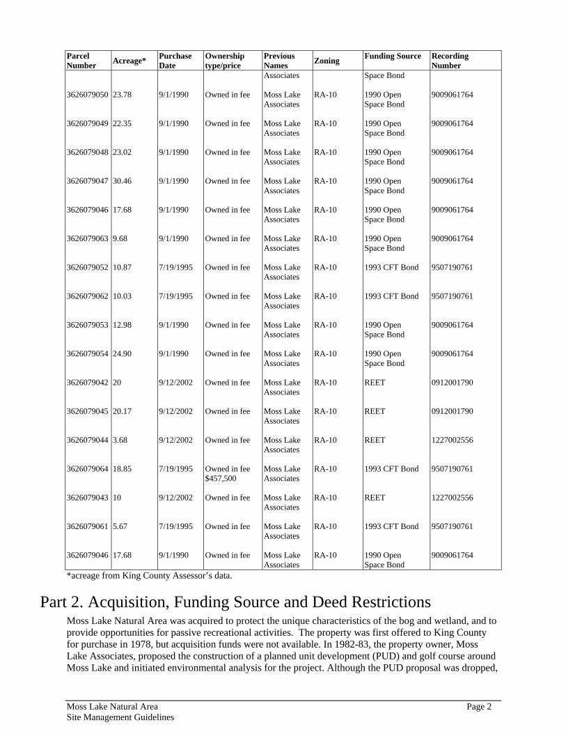
Part 2. Acquisition, Funding Source and Deed Restrictions Moss Lake Natural Area was acquired to protect the unique characteristics of the bog and wetland, and to provide opportunities for passive recreational activities. The property was first offered to King County for purchase in 1978, but acquisition funds were not available. In 1982-83, the property owner, Moss Lake Associates, proposed the construction of a planned unit development (PUD) and golf course around Moss Lake and initiated environmental analysis for the project. Although the PUD proposal was dropped,
Moss Lake Natural Area Page 2 Site Management Guidelines
the property was segregated into 20-acre parcels consistent with zoning and subdivision regulations in effect at that time.
Moss Lake Natural Area was eventually acquired in three phases. The first thirteen parcels, totaling 275 acres, were purchased in 1990 for $2,339,449. The funding for this acquisition came from the 1989 Open Space Bond and IAC. In 1995, an additional four parcels (plus a 3-acre conservation easement) were acquired for $457,500 generated through the 1993 Conservation Futures (CFT) Bond. The final four parcels, totaling 53.85 acres (including the above-mentioned conservation easement), were acquired in 2002 using $500,000 of Real Estate Excise Tax (REET) funds. The development rights to these parcels were removed by the landowner prior to the sale of the parcels as part of the Transfer of Development Rights Program (Recording # 20021227002555). As such, the previous landowner still owns the development rights and there is a restriction placed on the deed that prohibits residential development on the lots.
Additional information about each of these funding sources follows.
1989 Open Space Bond: King County voters authorized the $117,640,000 King County Open Space Bond initiative, described in King County Ordinance 9071, in November 1989 to provide funds for the acquisition, development, renovation and improvement of public green spaces, green belts, open space, parks and trails in King County. Specific goals included preserving wildlife, enhancing scenic vistas, providing access to the water and open space, and providing trail connections between virtually all the cities in King County to a regional trail system and trails within the suburban cities and unincorporated areas of King County (King County 1989).
King County Ordinance 9071 authorizes reclassification of bond funds in Section 8, part C. Land use restrictions associated with Open Space Bond funds are identified in Section 8, part D (King County, 1989).
“Projects carried out by a Governmental Agency in whole or part from bond proceeds shall not be transferred or conveyed except by agreement providing that such land shall continue to be used for the purposes contemplated by this ordinance; nor shall they be converted to a different use unless other equivalent lands and facilities within the Governmental Entity shall be received in exchange there for. The proceeds of any award in condemnation of any project shall be used for the acquisition or provision of other equivalent lands and facilities. However, nothing in this ordinance shall prevent the granting of easements, franchises, or concessions or the making of joint use agreements or other operations agreements compatible with the use of a Project as provided for in this ordinance.”
Conservation Futures Tax Levy: Washington state statute RCW 84.34.230 authorizes Washington counties to place a Conservation Futures Tax (CFT) levy on all taxable property within their jurisdiction to acquire open space land or rights to future development (termed “conservation futures” in RCW 84.34.220). Open space is defined in RCW 84.34.020 as land contributing to natural resources, streams, water supply, soils, wetlands, public land network, recreation opportunities, historic sites, or visual quality. King County Code 26.12 states that there should be “demonstrable regional visibility, use, ecological, cultural, historical, or other natural resource significance” in CFT funded projects.” (King County 2003) Ordinance 10750 and 11068 (March 8 and October 3, 1993) authorized the Regional Conservation Futures 1993 Bond Acquisition Program (per regulations in RCW 84.34.200).
Properties purchased with Conservation Futures funds are to be used for low-impact, passive-use recreation. They are also limited to non-motorized use, except as necessary for maintenance or staging areas, including entrance roads and parking to provide public access. Non-vegetative impervious surfaces should cover less than 15% of the site, excluding trail systems, unless specially authorized by the King County Council. Conservation futures interests shall not be transferred except with agreement that land interests shall be preserved in accordance with the intent and language of RCW 84.34.230; uses of lands shall not be altered unless equivalent lands within the geographic jurisdiction are provided. (King County 1993a).
Moss Lake Natural Area Page 3 Site Management Guidelines
The Real Estate Excise Tax is levied on the sale of all real estate in unincorporated King County. Originally, REET funds could be used only for the acquisition of property and capital improvements for King County parks. In 2002, the law was changed to allow REET funds to be used for maintenance of Parks and Natural Lands as well. King County code 4.32.012 reads as follows:
“There is hereby levied and there shall be collected by King County on each sale of real property situated in unincorporated King County an additional tax equal to one quarter of one percent of the selling price. The proceeds of the tax imposed by this section shall be credited to the real estate excise tax, number 2 fund and may only be used for the planning, construction, reconstruction, repair, rehabilitation or improvement of parks located in or providing a benefit and open to residents of the unincorporated area of King County. (Ord. 13667 § 3, 1999: Ord. 10455 §§ 1, 3, 4, 1992).”
In addition to the restrictions associated with the above mentioned funding sources, additional restrictions have been placed on the property as a result of transferring the IAC “Deed of Right to use Land for Public Recreation Purposes” from the Sammamish River Farm property to Moss Lake Natural Area (Recording #20060501000187). This occurred as a result of the fact that the Sammamish River Farm was acquired with IAC funding but was later leased to farmers to be used for agriculture, which is not consistent with the IAC requirement that public recreation be accommodated on a site. Information about the IAC funding source is as follows. Interagency Committee for Outdoor Recreation: Since 1964 the Interagency Committee for Outdoor Recreation has overseen the investment of public funds in parks, trails, beaches, boating facilities, wildlife habitat, and natural areas. Established by citizen Initiative 215 in 1964, the IAC administers several grant programs for recreation and habitat conservation purposes. Depending on the program, eligible project applicants can include municipal subdivisions of the state (cities, towns, and counties, or port, utility, park and recreation, and school districts), Native American tribes, state agencies, and in some cases, federal agencies and nonprofit organizations. To be considered for funding assistance, most grant programs require that the proposed project will be operated and maintained in perpetuity for the purposes for which funding is sought. Grants are awarded by the Committee based on a public, competitive process which weighs the merits of proposed projects against established program criteria.
Property acquired with this funding source must be managed in keeping with terms of the original Project Agreement between King County and the Washington State Interagency Committee for Outdoor Recreation ("IAC") for funding for the development of the Property. If the property is transferred, the new owner needs to agree that it shall execute an amendment to the Project Agreement that substitutes the new owner for the County as the "Contracting Party" in the Project Agreement so that the new owner shall become the "Project Sponsor." The new owner shall execute this amendment within fifteen (15) days of execution of this Agreement. (from King County’s template “Intergovernmental Land Transfer Agreement Between King County and Cities,” dated 2/21/2003)
Project agreements typically stipulate that “the contracting party shall not at any time convert any property or facility acquired or developed pursuant to this agreement to uses other than those for which state assistance was originally approved without the prior approval of the Interagency Committee.” (Section 13).
Project agreement states that the deed should contain the following language. This is often accomplished through a separate Deed of Right filed for this property.
“This conveyance is made in consideration of money coming in whole or in part from the Outdoor Recreation Account of the General fund of the State of Washington. The purchaser takes subject to the obligations of the project agreement contract between it and the Washington State Interagency Committee for Outdoor Recreation dated (insert date) , copies of which are in possession of the purchaser and the Interagency Committee. The project agreement contract provides, among other things, that the purchaser shall not at any time convert this property to uses other than for which state assistance was originally granted unless it has obtained prior approval of the Interagency Committee for Outdoor Recreation in the manner required by RCW 43.99.100 for marine recreation land, whether or not it is marine recreation land.”
Moss Lake Natural Area Page 4 Site Management Guidelines
Part 3. Ecological Resources This section describes the natural resources and ecological processes present at Moss Lake Natural Area. Further analysis of this information is provided in Part 6 below.
Topography and Soils Moss Lake Natural Area is located in the Cascade foothills at elevations ranging from 540 to 660 feet, and a canyon in the southeast corner slopes down to 440 feet on its way to the Tolt River (Figure 4). The site is fairly flat on the southwestern half but rises gradually in the northeast half. The canyon in the southeast corner of the site and a slope northeast of the lake are the two steep areas on site and are both classified as erosion hazard areas due to a greater than 15 percent slope and soils that are subject to severe erosion when disturbed (Title 21A.24.38 in the King County Critical Areas Ordinance).
According to mapped data from the University of Washington1, the soil types present in the upland portions of the property are classified as Tokul Gravelly Loam, with slopes ranging from 6 to 65 percent (Figure 5). Soils in wetlands include primarily Mukilteo Peat with Seattle Muck in one small portion of the property. These soils are classified as wetland (hydric) soils, have almost no slope, and are very poorly drained. Additionally, some areas mapped as Tokul Gravelly Loam support wetlands on the property: areas with slopes less than 6 percent in the southern portion of the Natural Area support an extensive complex of wetlands, and some of the steeper areas on the eastern edge of the site also contain wetlands. Tokul soils are volcanic ash and/or loess over glacial till and so are moderately permeable in the upper part and moderately well drained; however, perched water and saturated surface soils may occur in the early part of the growing season and thus promote the development of wetland characteristics if other conditions are right.
Hydrology Moss Lake Natural Area contains parts of three separate catchment basins, the largest of which includes the Moss Lake open water wetland complex (i.e., the lake, bog, and the surrounding scrub-shrub and forested wetlands). The following discussion is broken into drainage features within the Moss Lake catchment and drainage features outside the Moss Lake catchment. Much of the following hydrology information is excerpted from the Natural Resources Study for Moss Lake Master Plan (King County 1995). Names and numbers are updated where appropriate, and discussion is added where appropriate for those parcels acquired since 1995.
Existing Surface Drainage Features within Moss Lake Catchment
Most of the natural area is composed of the Moss Lake Catchment (Figure 6). The following description of existing hydrologic conditions within the Moss Lake Catchment is based largely on observations made during field visits to the site between January and March 1995 and on October 30, 1995, as well as on April 9, 2007. The goal of the hydrologic field reconnaissance was to determine the locations and relative sizes of surface flows into and out of the Moss Lake open water/wetland complex prior to development at the site. A parking lot has been installed since the 1990s field work was done, and conditions have likely been altered in some locations.
1 The University of Washington, in cooperation with King County Roads Department (Archaeology), Natural Resources Conservation Service (NRCS), United States Geological Survey (USGS), Washington Department of Natural Resources (DNR), and the University of Washington Soils Lab (http://soilslab.cfr.washington.edu) developed a spatial database for soil in Western Washington counties; the data is available as Uuw_soils.shp in King County’s GIS.
Moss Lake Natural Area Page 5 Site Management Guidelines
Drainage into Moss Lake The area of the basin that drains into the Moss Lake open water/wetland complex comprises approximately 540 acres of the 821-acre Moss Lake catchment (Figure 6). Of the 540 acres that drain into the Lake, approximately 200 acres are within the boundaries of the Natural Area. Therefore, the hydrology of Moss Lake is dictated to a large extent by drainage from the area outside the County-owned land. Beyond the property line, land cover in the drainage basin, which is northwest of the lake, is in forest, wetland, or partially forested rural residential properties of either 5 or 20 acres (for more information, see “Landscape and Land Use” in Analysis section).
Moss Lake receives inflows from several drainage channels around its perimeter. The following discussion of hydrologic features progresses in a clockwise manner beginning in the southwestern corner of Moss Lake near the parking lot. The density of surface inflow channels to Moss Lake is greatest along the southwestern and western edges of Moss Lake. Runoff originating from a gradually sloped hillside draining through a shrub wetland to the southwest of Moss Lake drains toward the lake through a series of channels located north of the site access road (note these channels are not mapped as streams in Figure 6). Throughout the west and southwest perimeter of Moss Lake, these inflow channels are seldom farther than 100 to 200 feet apart. The largest of these channels, which empties into a small open-water wetland located approximately 150 feet north of the parking lot and 350 feet west of Moss Lake, appears to periodically convey a significant amount of storm flow (i.e., several cubic feet per second). Outflows from this small open-water wetland disperse into several smaller channels flowing into Moss Lake.
The forested area along the southwest edge of Moss Lake appears to be “floating” ground overlying shallow groundwater in many places (see “Forested Wetlands” below). This water may be either a landward extension of the surface of Moss Lake or infiltrated adjacent upland ground water flowing into the lake. As a result of the presence of the water and numerous inflow channels, almost the entire site on the west edge of Moss Lake is in wetland. This broad wet area serves to naturally slow the rate of surface runoff to Moss Lake from the west.
It is along the outer edge of this forested wetland in an adjacent upland area that the parking lot was constructed. Approximately 0.5 acres of wetlands were removed during the construction process of pedestrian paths (1.6 acres) and the parking lot (approximately 0.5 acre), which can accommodate up to 12 cars and 3 school buses. Prior to construction, King County (1996) concluded that “Under current regulations, the preliminary calculations for storm water flows from proposed impervious surfaces indicate that storm water detention facilities would not be needed. Biofiltration swales will collect roadway and parking lot runoff for water quality treatment prior to discharge to the Moss Lake system of wetlands. The potential for adverse water quality impacts will be minimized by locating the discharge point for treated surface water runoff well downstream of the most sensitive sphagnum bog habitat.” The discharge area is separated from the bog by the previously mentioned forested wetlands. It is unknown how effective these methods are for dealing with surface runoff from the parking lot; no monitoring has been carried out. Additionally, wetland buffer and clearing regulations have changed since 1996, and it is unlikely the same conclusions would be drawn as to the adequacy of these buffers and water quality treatment methods by today’s standards.
Farther north along the western edge of the Moss Lake wetland complex’s bog, north of the open-water portion of the lake, the spatial separation of inflow drainage channels becomes greater. Only two distinct channels were observed in this vicinity, each flowing from west to east. These minor channels are located approximately 1,000 feet and 250 feet south of 112th Street, respectively. Small-open water sections in the forest near 112th Street are linked to the latter channel. In general, the forest in the northwest portion of the natural area is much drier than the area along the southwest edge of Moss Lake. Nevertheless, the Moss Lake Regional Park Master Plan (King County 1996) includes a map that indicates the northwest corner of the natural area that lies to the south of 112th Street is forested wetland (Figure 6).
A culvert located beneath 112th Street near the northwestern corner of the natural area (Figure 6) discharges flows from a large pond to the north. In mid-March of 1995 this culvert was conveying a
Moss Lake Natural Area Page 6 Site Management Guidelines

relatively significant amount of flow (estimated visually at approximately 2 cubic feet per second [cfs]) into a 5-foot-wide drainage channel that is the largest single inflow source to Moss Lake from the north. This drainage channel is well defined near 112th Street but appears to split into several meandering flow pathways as it enters the bog to the south.
Due north of Moss Lake, there are two flow channels that discharge runoff into the bog. The runoff in these two channels originates in a ravine located northeast of the lake, behind (i.e., east of) the ridge (Figure 6). This ridge is traversed by a pedestrian and bridle trail, which has been in place for many years as far as the western-most channel and now extends to connect with the trail to the north (Figure 6). The larger of these channels passes through a culvert beneath the trail, and the other flows over the trail. In mid-March 1995, approximately 1 cfs of flow was passing through the culvert. The other nearby channel, located approximately 200 feet north of the culvert, was barely flowing. Thus, it appears that the pathway culvert carries most of the ravine outflow into the Moss Lake bog, and the channel flowing over the path is an overflow feature that appears during extreme wet weather.
Along the hillside between Moss Lake and the ridge to the east there are no significant swales or other surface flow features. Because the length of the slope between the ridge and the lake is not very great (about 200 feet to the open water, and the shrub wetland is basically adjacent to the slope), and there are few topographic swales where flows would converge, surface drainage channels have not formed in this area. Most of the runoff on the eastern edge of Moss Lake probably infiltrates into the forest soil and emerges from the ground at the base of the slope, or passes through the duff layer as shallow subsurface sheet flow. The minor amount of runoff that occurs on this slope is most likely spread evenly over the hillside.
Drainage below Moss Lake The primary water feature below Moss Lake is its outlet stream, which empties into the Tolt River. The Catalog of Washington Streams and Salmon Utilization (Williams et al. 1975) identifies the outlet as unnamed stream #070298 at river mile 7.5 of the Tolt and lists the stream as 1.15 miles in length. According to the Tolt River Watershed Analysis (Weyerhaeuser 1993), the Moss Lake outlet stream is susceptible to degradation via sediment deposition, and the lower end of the stream exhibits poor flow conditions and is silty. For these reasons, the stream presents poor habitat conditions for all salmonids. The outlet stream's key vulnerabilities are coarse and fine sediment deposition and potential scouring in the event of breakage of the beaver dam that helps form Moss Lake (see below). This small stream is a very minor contributor to the total flow in the main stem of the Tolt River. The outlet of Moss Lake is partially blocked by a beaver dam (see further discussion below in the “Habitat Patches” section). Below the beaver dam, the outlet stream is approximately 50 feet wide during the wet season. The stream meanders over relatively flat terrain for approximately 1,500 feet through bog, shrub wetland, and forested wetland until it reaches another open-water section that was created by the damming effects of a second beaver dam and a road embankment crossing the stream. Two drainage channels of note discharge into this open-water area upstream of the road embankment. One of these channels, located at the tail of the ridge along the pedestrian/bridle trail along the boundary, carries flows from the east. This channel flows east to west through a culvert that appears to have been constructed within the past 1 to 2 years. In mid-March 1995, prior to culvert installation, it appeared that greater than 1 cfs was flowing over the trail from this channel. The second of the two channels flows from the western side of the wetland through a culvert beneath the north-south running portion of the trail. This culvert was also conveying what appeared to be greater than 1 cfs of flow in mid-March 1995. In addition to these channels, during times of heavy rain, water also flows down the trail on the eastern boundary and very likely flows into this lower open-water wetland.
The trail that leaves from the parking lot and heads east into the natural area is on an old road bed. About a quarter mile from the parking lot, the trail splits, and to the right it heads directly south into the forested wetland complex, and to the left it drops down to below the beaver dam wetland complex, crosses the Moss Lake outlet stream, and curves to the north again to skirt the property’s eastern boundary. This old road embankment appears to have been built directly through the forested wetlands, and now it serves to
Moss Lake Natural Area Page 7 Site Management Guidelines

either sever or impede the hydrology. Very few (two were observed) culverts are installed in this area, and water levels were almost uniformly higher on the upstream side of the trail. The exceptions were in spots where the road and water levels were very close to one another, and it is assumed that the water in those locations overtops the trail. Water may slowly filter through the embankment, but whether or not this occurs is unknown.
The unnamed Moss Lake outlet stream continues downstream of the open-water area, passing through two rusting culverts beneath the road embankment. This stream is reported to support salmonids, including coho and possibly steelhead trout; however, it is likely only used prior to a steep drop-off near the southeast corner of the property (for further discussion of salmonid usage, see “Fish and Wildlife” sections below). The stream below the road embankment receives flows from two channels that originate in wetlands to the west. An old trail runs from the currently maintained trail south, and the northern-most of these two channels passes under this old road bed via a culvert. The road ends just before a steep drop-off that leads to the southern-most of the two channels.
The entire southwest portion of the property is a large matrix of wetlands mixed with patches of uplands. The soils in this area, as with much of the property, are Tokul soils, which have a hardpan layer of glacial till at depths of less than 5 feet. The hardpan restricts downward percolation of runoff, and in this relatively flat area, many wetlands have formed. As the outlet stream curves east and approaches the property boundary, the channel gradient steepens, dropping approximately 160 feet over a distance of 2,000 feet, before it once again flattens near the confluence.
Existing Surface Drainage Features Outside Moss Lake Catchment Northeast and parallel to the bog, beyond the steep ridge, the topography slopes upwards to the northeast at a 6 to 15 percent gradient. In this area, approximately 48 acres drain into a catchment other than Moss Lake’s (Figure 6).
Along the west side of the trail along the eastern boundary, one or more small wetlands were observed during the June 2006 field work. It is possible these wetlands form in natural depressions. It is also possible that surface and ground water flow from upslope of the boundary trail are trapped by the embankment that forms this former logging road, and over time wetland conditions have formed. Additionally, water was observed flowing down the trail in June 2006 in this other catchment.
The Moss Lake Regional Park Master Plan (King County 1996) has a forested wetland mapped in the northeast portion of the property (Figure 6), but the presence of this wetland was not field verified in 2006. This mapped forested wetland meets a road outside the property of the Natural Area at a small open-water pond. Beyond the open-water portion of the wetland to the west, shrub wetland grows, and beyond that it is uncertain if forested wetland or a riparian area is present. An unnamed tributary is mapped to originate in this wetland and flow into the Tolt River; culverts are in place under the road at this location.
At least one wetland is also formed along an old trail that runs east-west across the northern portion of the property. Again it is possible that ground and surface water flow from upslope is trapped here by the embankment that forms a former logging road.
The third catchment that overlaps with the Moss Lake Natural Area has only a very small portion (0.4 acres) that extends into the natural area at its south-central portion (Figure 6). An open-water wetland lies in the Moss Lake catchment just to the northwest of this other catchment, and the National Wetlands Inventory map shows that open-water wetland connecting with other wetlands that cross catchment boundaries and include this third 0.4-acre catchment. It is possible some of these wetlands are mapped incorrectly; it is also possible they are all present and do drain into their respective catchment basins as mapped. Regardless, the hydrology of this third catchment is expected to affect the natural area very little if at all.
Moss Lake Natural Area Page 8 Site Management Guidelines

Habitat Patches/Vegetation Communities Moss Lake Natural Area is a matrix of both wetland and upland vegetation types. Field work was conducted in spring and summer of 2006 (Figure 7), and data obtained during field work are combined with current aerial images and soils data to provide information for this report. Additionally, much of the information presented in a prior wetlands study (Sheldon 1983) is still relevant, and when appropriate, that information is included in the plant communities synopses presented below. The Moss Lake Master Plan Natural Resources Study (King County 1995) also includes information on various plant communities that was compiled from a combination of field reconnaissance work and the use of maps and aerial photos. Information from the King County (1995) report is used to supplement and enhance the 2006 and 1983 data.
Open Water Areas The primary area of open water in this Natural Area is Moss Lake, which is entirely surrounded by sphagnum peat bog (see “Sphagnum Bog” section below). According to the Draft Environmental Impact Statement for Moss Lake Association (King County 1986), which was written when the land was proposed for development, the lake was created as a result of peat mining, during which the lake was excavated to a depth of 17 feet. Additionally, the “Wetland Delineation Memo; Parking Lot Area” included in the Wetland Mitigation Plan (King County 1997) maps out an area of upland that had been graded and/or filled during past peat extraction activities. It therefore seems that Moss Lake was created all or in large part by peat extraction. It is uncertain if an open water portion existed prior to this work.
Assuming the lake was formed by peat extraction, other information exists that clouds the precise history of the lake. A moss-drying plant was constructed in the southeast portion of the lake, and it subsequently burned down in 1920 (Rigg 1958). Rigg (1958) also notes “Some work was done in 1953 and 1954 preparatory to utilizing the moss peat in this deposit.” The Government Land Office map from 1885 does indicate a very small mark in the vicinity of Moss Lake that was possibly the open water body as it existed then. A USGS topographic map from 1923 indicates Moss Lake, but it is shown to have a more elongated shape than its present state. By the time a 1944 Army Corps of Engineers aerial photo was taken, the shape appeared generally round, as it is currently. Based upon this progression of maps and shapes, it is possible the bog formed over a very long period of time in a glacial depression and had never closed over (in other words, open water remained in the center). If peat mining occurred, it likely served to enlarge (as opposed to create) the open water portion. Additionally, if work “preparatory to mining the site” was not undertaken until the 1950s, and no change in size or shape appears to have taken place since the 1940s, it would seem that peat mining was limited. Evidence suggests that peat extraction has occurred in phases over several decades. And in fact, according to King County (1996): “Anecdotal reports of peat extraction as late as the 1960s have been noted through conversations with long-time residents of the area.” And furthermore, “The location of a sunken peat dredge near the northwest edge of the bog mat was noted by King County staff during site studies for the King County Sensitive Areas Inventory in the early 1980s.” Regardless of the precise history, it does appear that Moss Lake has been impacted by peat extraction, and yet the bog has seemingly remained viable despite that level of disturbance (see “Sphagnum Bog” below).
Maps and aerial photographs ranging from 1944 to 2005 indicate differences in the shape of the northwest portion of the lake, as well as some other areas around the periphery. These differences may simply be seasonal or annual fluctuations in vegetation or the effects of beaver activity from year to year, because no single trajectory of change emerges. Rather, in some years the shoreline appears complex with more open water, canals, and peninsulas, and in other years, including 2005, a “smoothening” of the shoreline appears to occur from emergent vegetation filling in some of the more shallow areas around the lake’s periphery.
Currently, the lake is approximately 8 acres in size and receives freshwater from surface flow around its east, north, and west perimeters. These hydrologic conditions appear to have been persistent for numerous decades, based on observations of the existing plant communities (Sheldon 1983). Historical aerial
Moss Lake Natural Area Page 9 Site Management Guidelines
photographs of the lake taken at different times of the year indicate that the lake experiences seasonal water level fluctuations.
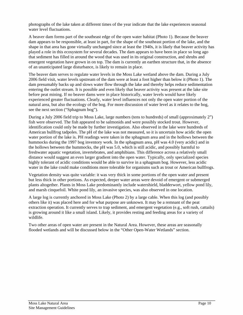
A beaver dam forms part of the southeast edge of the open water habitat (Photo 1). Because the beaver dam appears to be responsible, at least in part, for the shape of the southeast portion of the lake, and the shape in that area has gone virtually unchanged since at least the 1940s, it is likely that beaver activity has played a role in this ecosystem for several decades. The dam appears to have been in place so long ago that sediment has filled in around the wood that was used in its original construction, and shrubs and emergent vegetation have grown in on top. The dam is currently an earthen structure that, in the absence of an unanticipated large disturbance, is likely to remain in place.
The beaver dam serves to regulate water levels in the Moss Lake wetland above the dam. During a July 2006 field visit, water levels upstream of the dam were at least a foot higher than below it (Photo 1). The dam presumably backs up and slows water flow through the lake and thereby helps reduce sedimentation entering the outlet stream. It is possible and even likely that beaver activity was present at the lake site before peat mining. If no beaver dams were in place historically, water levels would have likely experienced greater fluctuations. Clearly, water level influences not only the open water portion of the natural area, but also the ecology of the bog. For more discussion of water level as it relates to the bog, see the next section (“Sphagnum bog”).
During a July 2006 field trip to Moss Lake, large numbers (tens to hundreds) of small (approximately 2”) fish were observed. The fish appeared to be salmonids and were possibly stocked trout. However, identification could only be made by further investigation. Also observed in the lake were hundreds of American bullfrog tadpoles. The pH of the lake was not measured, so it is uncertain how acidic the open water portion of the lake is. PH readings were taken in the sphagnum area and in the hollows between the hummocks during the 1997 bog inventory work. In the sphagnum area, pH was 4.0 (very acidic) and in the hollows between the hummocks, the pH was 5.0, which is still acidic, and possibly harmful to freshwater aquatic vegetation, invertebrates, and amphibians. This difference across a relatively small distance would suggest an even larger gradient into the open water. Typically, only specialized species highly tolerant of acidic conditions would be able to survive in a sphagnum bog. However, less acidic water in the lake could make conditions more tolerable for organisms such as trout or American bullfrogs.
Vegetation density was quite variable: it was very thick in some portions of the open water and present but less thick in other portions. As expected, deeper water areas were devoid of emergent or submerged plants altogether. Plants in Moss Lake predominantly include watershield, bladderwort, yellow pond lily, and marsh cinquefoil. White pond lily, an invasive species, was also observed in one location.
A large log is currently anchored in Moss Lake (Photo 2) by a large cable. When this log (and possibly others like it) was placed here and for what purpose are unknown. It may be a remnant of the peat extraction operation. It currently serves to trap sediment, and emergent vegetation (e.g., soft rush, cattails) is growing around it like a small island. Likely, it provides resting and feeding areas for a variety of wildlife.
Two other areas of open water are present in the Natural Area. However, these areas are seasonally flooded wetlands and will be discussed below in the “Other Open-Water Wetlands” section.
Moss Lake Natural Area Page 10 Site Management Guidelines
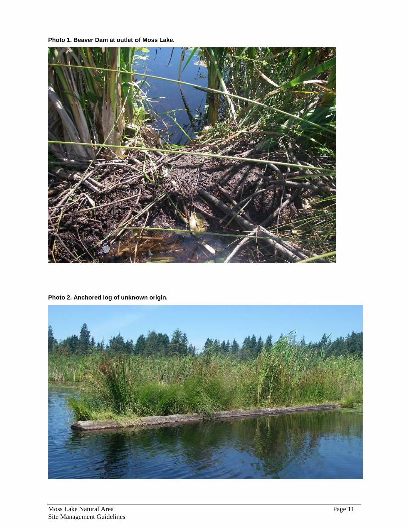
Photo 1. Beaver Dam at outlet of Moss Lake.
Photo 2. Anchored log of unknown origin.
Moss Lake Natural Area Page 11 Site Management Guidelines
Sphagnum Bog Moss Lake and its associated wetlands are identified by the Washington Department of Fish and Wildlife (WDFW) Priority Habitats and Species Information System as Tolt River wetlands priority habitat. The sphagnum peat bog is the most sensitive habitat type in the natural area. Sphagnum moss wetlands are unique plant communities composed of up to 25 feet or more of acidic peat deposits that build up over very long periods of time (hundreds to thousands of years). The physical and chemical characteristics of bogs result in plant and animal communities that demonstrate special adaptations to low nutrient levels, waterlogged conditions, and acidic waters. In King County (and across the Pacific Northwest) bogs are rare vegetation communities and of limited distribution and are very susceptible to impacts from development. Changes in hydrologic flow, water pollutants, and sediment deposition, as well as physical damage from foot traffic, can cause alterations to a bog to the extent that it may change into another more common plant community.
Rigg (1958) used two sites in King County to calculate rates of peat accumulation in the region, and one of these sites was at Moss Lake. Radio carbon dating was used on the peat deposit at the very bottom of the sedimentary deposit to determine when original deposition began. It was determined that sedimentary peat began forming in this bog 11,900 ± 360 years prior. According to Rigg (1958), sphagnum peat in Western Washington accumulates at an average rate of approximately 1 inch (2.5 cm) per 40 years. Rigg (1958) reports the results of two core samples from Moss Lake, one at the outlet and one in the bog on the east side of the lake. The sample taken east of the lake showed sphagnum moss to a depth of 5 feet, below that is a 4-foot layer of mixed sphagnum and fibrous peat, and below that lies an 11-foot layer of sedimentary peat before it hits clay. The sample at the outlet had sphagnum moss to a depth of 8 feet and a 3-foot mixed layer of sphagnum and fibrous peat below that. Using Rigg’s estimate, the 8 to 11 feet of moss peat in the two sampled layers that formed from sphagnum moss would indicate sphagnum moss was present beginning approximately between 3,800 and 5,300 years ago.
Peat accumulation rates are not constant and depend on many factors including climate and topography; nonetheless, it appears that the Moss Lake bog had its origins after the retreat of the glacier that formed its depression. Sedimentary peat is deposited in water and originates from aquatic plants, which are typically algae, diatoms, and bacteria (Rigg 1958). The origins of the Moss Lake bog appears to have been a glacial depression, which filled with water. Aquatic plants grew and died and formed sedimentary peat, and then sedges began to grow on top of the sedimentary peat, likely at the shallow margins of the lake. As the sedges grew and formed mats, they began to deposit the fibrous peat that subsequently gave rise to the sphagnum mosses, which have been growing here for the past 5,000 years or so. It is unknown whether these sedge and sphagnum mats ever completely covered the lake (see “Open Water” section above).
The sphagnum bog surrounds the open water of Moss Lake and covers approximately 40 acres. The National Wetlands Inventory identifies this bog as a palustrine scrub-shrub wetland. The Sensitive Areas Ordinance Wetlands Folio calls this bog a unique and outstanding wetland2. The dominant shrub species present include spirea, Labrador tea, bog laurel, bog cranberry, salal, willow species, and red-osier dogwood. Herb species include cattail, sedges (e.g., small-fruited bulrush, horsetail sedge, beaked sedge), rushes (e.g., soft rush), northern bugleweed, and cottongrass. All of these species grow on top of a thick layer of living sphagnum moss. Round-leaved sundew, a common but not abundant bog-specific carnivorous plant, is occasionally found growing on the moss at Moss Lake as well. Western hemlock and Sitka spruce are also growing throughout much of the bog area to the north of the lake.
It is not possible to know exactly what the historic conditions were at this site (see “Open Water Areas” above), and the lack of information makes understanding the succession of the bog more difficult. It
2 SAO Wetland rating of 1A/B/C/D, where 1 = Unique/outstanding wetland; A = Presence of species recognized by the federal government or State of Washington as endangered, threatened, or sensitive or outstanding potential habitat for those species; B = Wetlands with a near equal proportion of open water to vegetative cover in dispersed patches in combination with a high diversity or mix of wetland subclasses; C = Wetlands greater than 10 acres in size and having 3 or more wetland classes, one of which is open water; D = The presence of plant associations of infrequent occurrence. These include estuaries and bogs.
Moss Lake Natural Area Page 12 Site Management Guidelines

appears as though the lake was formed at least in part from a peat-extraction operation, and if so, the bog has undergone extensive and direct disturbance. However, the present set of circumstances continues to support the sphagnum areas, and it is unknown whether the live sphagnum mat is decreasing or increasing. The 1997 King County Bog Inventory noted “no significant changes” in vegetation communities from a 1981 survey to a 1997 survey. It is uncertain how extensive their investigation was and whether it would document changes that were not grossly apparent. They did categorize the bog mat as “healthy,” and it may be assumed that if no parts of the mat were observed dead or dying, that the mat is continuing to thrive. On the other hand, if the open water area is declining, that change could be indicative of other changes that might affect the bog.
As mentioned above, it is possible water levels have not remained constant over the history of the open water/bog complex. The water levels would depend on the presence of beaver dams and anything else downstream of the lake system that would restrict water flow (such as the road with its culverts). Fluctuating water levels would impact the shallow-water sphagnum bog proportionally more than the deeper open water area of the wetland. Although sphagnum bogs are able to withstand some water level fluctuations (Kulzer et al. 2001), extreme or recurring fluctuations will increase decomposition rates and thereby alter the water chemistry and potentially kill the sphagnum.
The presence of Beller’s ground beetles is reported in the 1997 King County Bog Inventory (King County 2002). These beetles are highly specialized and restricted to sphagnum bogs, and they are a Federal species of concern and a State candidate species. Only five records of them could be found in King County (three identified in WDFW’s Priority Habitat and Species information database and two identified in the 1997 King County Bog Inventory). Because of the rare ecosystem and its apparent high quality, it is possible other rare bog-dependent species may be present at Moss Lake Natural Area. The long-horned leaf beetle and Hatch’s click beetle are both species of low-elevation sphagnum bogs. Hatch’s click beetles are known to currently exist only in King County, Washington, whereas the long-horned leaf beetle is historically only known in Snohomish County in Washington, but also may still occur in British Columbia (Larsen et al. 1995). For further discussion, see “Fish and Wildlife” section below.
The Olympic mudminnow is a State Sensitive species that is almost always found in wetlands. A map depicting locations of where Olympic mudminnows have been collected is presented in Mongillo and Hallock (1999) and appears to indicate the species has been collected in the Cherry Creek basin, which is downstream two basins from the Tolt basin in the Snoqualmie Watershed. It is therefore conceivable (if not improbable) the species could be at Moss Lake. For further discussion, see “Fish and Wildlife” section below.
Two beaver lodges were observed in the bog during the July 2006 recon trip. One lodge was located at the northern-most edge of the open water and the other lodge was located in the southeast portion of the lake, but to the south and west of the outlet. Various bird species have been reported by different sources to use the lake; a list of these species is included in Appendix B.
Purple loosestrife, a noxious weed, is present in the bog. During the July 2006 recon trip, whenever possible the seed head of this weed was pulled. Additionally, the bog was treated with the leaf eating beetles, Galerucella spp., also during 2006 to attempt biocontrol of the loosestrife.
The bog transitions to shrub and forested wetlands at its periphery.
Scrub-Shrub Wetland Scrub-shrub wetland is a shrub-dominated freshwater wetland habitat type that can constitute a successional stage or can remain stable if hydrologic conditions favoring the shrub habitat persist. The sphagnum bog present at Moss Lake is a shrub wetland, but in this report, the sphagnum bog is differentiated by the mat of sphagnum moss and is discussed separately above. This section refers to shrub wetlands on site that do not contain sphagnum moss.
Patches of scrub-shrub wetlands occur at different locations in this Natural Area and are dominated by spirea, with red alder and willow saplings also present (Photo 3). These shrub wetlands typically occur in areas of beaver activity and have canals of open water running between shrub hummocks. Interspersed
Moss Lake Natural Area Page 13 Site Management Guidelines

with the shrubs are herb species including primarily soft rush as well as giant burreed, spikerush, potentilla, and Veronica.
Photo 3. Scrub-shrub wetland at data collection point W-10 (Figure 7)
The extent of scrub-shrub wetland includes a portion of the large area below the beaver dam in Moss Lake. Another area of scrub-shrub wetland also appears to be influenced by past or current beaver activity and is located in the southeast portion of the natural area just north of the trail.
Other Open-water Wetlands In addition to the open water that comprises Moss Lake, approximately three other areas of open water wetlands are present at this Natural Area. One area, located in the southeast portion of the Natural Area and north of the trail (Photo 4) is presumably a result of beaver dams. As with the beaver dam on Moss Lake, the beaver dam observed in this area is now a permanent earthen berm covered in shrub species. The National Wetlands Inventory characterizes this wetland as “Palustrine Emergent – Aquatic Bed – Seasonally Flooded – Beaver [Dam].”
Great Blue Heron feathers were found in this wetland. The still water of the wetland would be suitable feeding habitat for the herons, which may be feeding on frogs or potentially fish. The numerous feathers indicate something else, maybe a coyote, was feeding on the heron. A Belted Kingfisher was observed using this wetland as well; the presence of the kingfisher would also suggest frogs and/or fish are in the wetland. Beaver dens were observed in the bank, and some beaver sign on a nearby tree indicate beavers may be actively using the pond.
Based upon the presence of mud flats and the location of high water marks, this area undergoes significant water level fluctuations. During the July 2006 visit, water levels appeared to be approximately 12 inches below the level of the previous winter. Based upon the likely presence of beavers, it is assumed that part of this wetland remains underwater year-round. Several moderate-sized snags are present around the margins of this wetland, and down logs are somewhat common.
This area of open water wetland is surrounded on all sides except the southeast by scrub-shrub wetlands (see “Scrub-Shrub Wetlands” above). An abrupt ridge on the southeast margin of the wetland (and visible in the lidar image of Figure 4) rises immediately from wetland to upland forest.
Moss Lake Natural Area Page 14 Site Management Guidelines
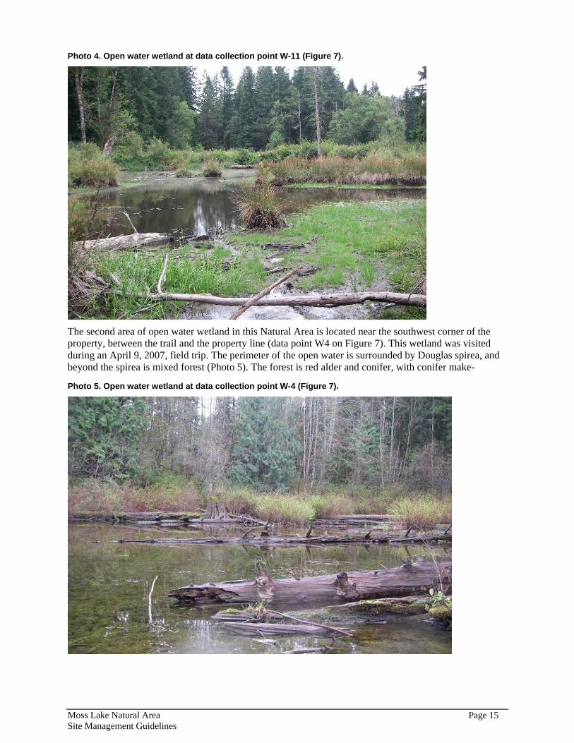
Photo 4. Open water wetland at data collection point W-11 (Figure 7).
The second area of open water wetland in this Natural Area is located near the southwest corner of the property, between the trail and the property line (data point W4 on Figure 7). This wetland was visited during an April 9, 2007, field trip. The perimeter of the open water is surrounded by Douglas spirea, and beyond the spirea is mixed forest (Photo 5). The forest is red alder and conifer, with conifer make-
Photo 5. Open water wetland at data collection point W-4 (Figure 7).
Moss Lake Natural Area Page 15 Site Management Guidelines

up about 70 percent western hemlock, 20 percent western redcedar, and 10 percent Douglas-fir. This second-growth forest is approximately 70-90 feet tall. Some old-growth stumps are present around the periphery of the wetland, and the wetland has a high amount of large woody debris in it (Photo 5).
The third area of open water wetland on this Natural Area is located just north of the parking lot and is relatively small at approximately 0.08 acres. This wetland has a large amount of large woody debris in it from the surrounding forest. Spirea, red alder, and willow species were the primary shrubs in the wetland, which was full of emergent grasses. The wetland was surrounded by upland vegetation and forest, including western hemlock, western redcedar, Douglas-fir, and cottonwood trees as well as a heavy ground story layer of salmonberry. Redcedar seedlings were observed growing. There was also evidence of past beaver activity.
Forested Wetland Forested wetlands are plant communities that are dominated by deciduous or coniferous trees in areas where the soils are saturated for the majority or all of the year. Typically, though not always, in forested wetlands the soil is saturated to within a few inches of the surface throughout the dry season.
Forested wetlands are present on a relatively large portion of the Natural Area among a matrix that also includes scrub-shrub wetlands and upland forest. In a Moss Lake wetlands study (Sheldon 1983), the different types of forested wetland communities surrounding the bog are described and include hemlock / open water; open water / hemlock / cedar; cedar / hemlock (cedar swamp); and cedar / hemlock / vine maple.
Sheldon (1983, pg. 8) nicely summarizes the forested wetlands and associated logging history around Moss Lake:
The area directly adjacent to Moss Lake is extremely complex because it has gone through radical alteration from human intervention several times. It has been logged at least twice; once when the original virgin timber was removed (stumps of plus 5 feet still remain), and again, more recently to harvest the second growth timber.
The logging process has several impacts on a site. First, and most obvious, is the removal of the tree canopy. This promotes the growth of dense stands of Red Alder because it is the primary colonizer after logging. Extensive Alder stands can be found throughout the whole site, especially along the old logging roads.
The logging roads themselves remain as compacted ridges of soil which interrupt the flow of water and provide seemingly dry areas in the midst of a wetland. Throughout the area to the west of Moss Lake there is a maze of small remnant Cedar and Hemlock stands (indicating long term wetness) and pockets and trails of Alder (usually a slightly drier species).
Small pools of water connected by rills and creeks in this wet season [sic] are products of the logging activities, not natural geology. And yet, beyond a doubt, the area is basically wet, and has always been wet, judging from the older vegetation and the soil studies.
The area to the northwest of the lake is a textbook example of succession in a wetland from open water, through bog mat, into a shrub zone, then open water and trees around the edge, into a wet forest, and finally to a slightly drier forest.
According to the Moss Lake Regional Park Master Plan (King County 1996), the forested wetlands located west of the lake and north of the access road have numerous downed trees, which may be a result of shallow and weakened root systems from fluctuating water levels over the past century. The forested wetland communities surrounding the Moss Lake bog generally do not exhibit well-developed understories. These areas do not vary significantly in structure or species diversity. These characteristics were observed at data collection point W-6 (Figure 7). In this location, conifer trees (western hemlock, western redcedar, Sitka spruce) were growing on hummocks above and matrixed with wetland soils;
Moss Lake Natural Area Page 16 Site Management Guidelines

almost no mid-story trees or shrubs were present, the ground story was either salal or patches of skunk cabbage, and much of the ground was covered in mosses (Photo 6).
Photo 6. Forested wetland at data collection point W-6 (Figure 7).
The network of forested wetlands in the southeastern portion of the property exhibits a substantial amount of water fluctuation annually. In some areas, the high water mark was approximately 16 inches above hydric soils (mud) (Photo 7). The wetlands observed in this area often had fairly well developed shrub and herb layers. Most wetlands observed in summer 2006 retained an open-water component, but in some places the water level had gone subsurface. The plant assemblages here were a mix of wetland and upland plants: skunk cabbage was found growing almost adjacent to salmonberry, for example.
Riparian Forest The largest area of riparian forest habitat in Moss Lake Natural Area is located along the outflow stream between the old road and the property boundary. The outlet stream was walked July 2006 and vegetation communities were characterized. As mentioned above in the “Hydrology” section, the channel increases in gradient after turning east towards the property boundary. In the first portion of the stream where the gradient is relatively flat, large woody debris is not as common, but it becomes common and then abundant progressively downstream. However, very few snags were observed. The bed material is typically a wide range of small (1/2 inch and smaller) pebbles to cobbles to large (plus 15 inches) boulders embedded in or on top of silt or clay (Photo 8). The layer of clay could be easily seen in the steep walls of the channel; it is presumed this is the same layer of clay that lies below the peat layers in the bog and that underlies the Tokul soils on site. Occasionally the stream bed was a solid “hardpan” that presumably lies below the clay. High sediment deposition was observed in some pools in the stream.
The riparian vegetation is mixed forest and exhibits distinct patchiness. Initially, the corridor is somewhat open and has a thick salmonberry ground story with some vine maple and a few red alder mixed in. Moving downstream, the stream abuts the edge of a conifer stand composed of western hemlock and western redcedar. Salmonberry and cascara are also thick here in the riparian zone. At this point (near data collection point RS-2, Figure 7), the channel begins to incise, and a bare wall approximately eight
Moss Lake Natural Area Page 17 Site Management Guidelines
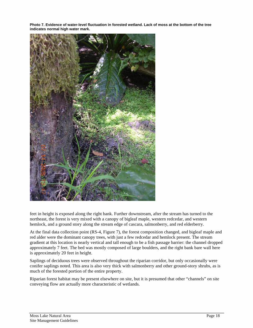
Photo 7. Evidence of water-level fluctuation in forested wetland. Lack of moss at the bottom of the tree indicates normal high water mark.
feet in height is exposed along the right bank. Further downstream, after the stream has turned to the northeast, the forest is very mixed with a canopy of bigleaf maple, western redcedar, and western hemlock, and a ground story along the stream edge of cascara, salmonberry, and red elderberry.
At the final data collection point (RS-4, Figure 7), the forest composition changed, and bigleaf maple and red alder were the dominant canopy trees, with just a few redcedar and hemlock present. The stream gradient at this location is nearly vertical and tall enough to be a fish passage barrier: the channel dropped approximately 7 feet. The bed was mostly composed of large boulders, and the right bank bare wall here is approximately 20 feet in height.
Saplings of deciduous trees were observed throughout the riparian corridor, but only occasionally were conifer saplings noted. This area is also very thick with salmonberry and other ground-story shrubs, as is much of the forested portion of the entire property.
Riparian forest habitat may be present elsewhere on site, but it is presumed that other “channels” on site conveying flow are actually more characteristic of wetlands.
Moss Lake Natural Area Page 18 Site Management Guidelines
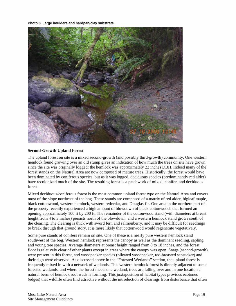
Photo 8. Large boulders and hardpan/clay substrate.
Second-Growth Upland Forest The upland forest on site is a mixed second-growth (and possibly third-growth) community. One western hemlock found growing over an old stump gives an indication of how much the trees on site have grown since the site was originally logged: the hemlock was approximately 22 inches DBH. Indeed many of the forest stands on the Natural Area are now composed of mature trees. Historically, the forest would have been dominated by coniferous species, but as it was logged, deciduous species (predominantly red alder) have recolonized much of the site. The resulting forest is a patchwork of mixed, conifer, and deciduous forest.
Mixed deciduous/coniferous forest is the most common upland forest type on the Natural Area and covers most of the slope northeast of the bog. These stands are composed of a matrix of red alder, bigleaf maple, black cottonwood, western hemlock, western redcedar, and Douglas-fir. One area in the northern part of the property recently experienced a high amount of blowdown of black cottonwoods that formed an opening approximately 100 ft by 200 ft. The remainder of the cottonwood stand (with diameters at breast height from 4 to 3 inches) persists north of the blowdown, and a western hemlock stand grows south of the clearing. The clearing is thick with sword fern and salmonberry, and it may be difficult for seedlings to break through that ground story. It is more likely that cottonwood would regenerate vegetatively.
Some pure stands of conifers remain on site. One of these is a nearly pure western hemlock stand southwest of the bog. Western hemlock represents the canopy as well as the dominant seedling, sapling, and young tree species. Average diameters at breast height ranged from 8 to 18 inches, and the forest floor is relatively clear of other plants except in areas where the canopy was open. Snags (second-growth) were present in this forest, and woodpecker species (pileated woodpecker, red-breasted sapsucker) and their sign were observed. As discussed above in the “Forested Wetlands” section, the upland forest is frequently mixed in with a network of wetlands. This western hemlock forest is directly adjacent to some forested wetlands, and where the forest meets one wetland, trees are falling over and in one location a natural berm of hemlock root wads is forming. This juxtaposition of habitat types provides ecotones (edges) that wildlife often find attractive without the introduction of clearings from disturbance that often
Moss Lake Natural Area Page 19 Site Management Guidelines
act as entry points for non-native and parasitic species. The forests and wetlands provide excellent feeding, roosting, and nesting opportunities for woodpeckers and other forest wildlife species. Additionally, this same conifer forest transitions to forested wetland without apparent change of species composition at its northeastern edge. Historically this may have been a cedar swamp; 5 foot diameter western redcedar stumps were observed in this forest whose trees were often surrounded by pockets of open water. According to King County (1986), most conifer stands remaining on site are adjacent to wetlands.
The third forest type found on site is deciduous forest. These patches are typically dominated by red alder. A large patch of this deciduous forest is present on the slope northeast of the lake amongst the mixed forest. Bigleaf maple trees are growing around the periphery of the alder forest in this location. This is a relatively young forest: the diameters at breast height are 6 to 8 inches on average. The soil is relatively dry. Salmonberry grows thickly in the ground story, and some young bigleaf maple trees are growing in the understory. Other patches of pure alder are growing in the swale area southwest of the bog. In this area, alder is sometimes mixed with black cottonwood, and these stands are adjacent to stands of mixed coniferous/deciduous forest.
Mitigation Planting A foot/bridle trail leading from the parking lot around the property provides access to Moss Lake at its southern shore. According to King County (1986), this area was a grassy area that hosted species such as reed canarygrass (highly invasive) and other non-native species. It was formerly the site of a boat launch for the lake, and it is still the only place that allows lake entrance and egress. A parking lot was built in former forested wetlands as Phase I of park development in anticipation of educational and other more extensive uses of the site, including an amphitheater that was never constructed (see King County 1997). Native plant planting projects were installed in different locations near the parking lot and at the boat launch access point into Moss Lake in order to partially mitigate for the wetland loss associated with the parking lot and road widening. Installed plants include soft rush, salal, deer fern, sword fern, snowberry, thimbleberry, salmonberry, gooseberry, willow species, spirea, dogwood, Douglas-fir, red alder, and western redcedar.
Fish and Wildlife Moss Lake Natural Area provides a wide diversity of wildlife habitat, including open water and bog wetlands, beaver-created wetlands, shrub and forested wetlands, stream and riparian habitat, and second -growth forest. Additionally, the site is large and adjacent to other forested properties, and such size and connectedness increases its wildlife use potential.
Fish and wildlife sighting information is available from several studies and field visits, including: October 1981 field work for the 1983 King County Wetlands Inventory; July and August 1986 field visits for the Moss Lake Draft Environmental Impact Statement; July 1997 Environmental Checklist prepared for the Moss Lake Regional Park plan (Atelier ps 1998); August 2004 East Lake Washington Audubon Society field trip; and June - August 2006 field work for this report. Although some of the field work was done more than 20 years ago, it may be reasonably assumed that because the wildlife habitat on site does not appear to have changed significantly since then, similar animal species assemblages may still be expected to use the site. Alterations including logging have occurred on adjacent properties; however, general on-site usage is likely approximately the same, with some shifts in abundance likely.
Fish Fish use of Moss Lake has not been well documented. During July 2006 field work, tens to hundreds of 2-inch fish were observed in the lake. These fish may have been trout or another salmonid, but further field work is required to identify the species. The Environmental Checklist (Atelier 1998) prepared for the Moss Lake Regional Park plan states that Moss Lake supports populations of shiners and cutthroat trout; however, no further information is provided as to how this information was obtained or how reliable it is.
Moss Lake Natural Area Page 20 Site Management Guidelines
A Draft EIS (King County 1986) notes that during field investigations, “fingerling fish of unknown species were observed in the stream below the beaver dam.” The Moss lake outlet stream 070298 is identified in the Catalog of Washington Streams and Salmon Utilization (the “Stream Catalog”) as coho salmon habitat (Williams et al. 1975). The Stream Catalog also indicates both passable and impassible fish barriers on the outlet stream; the impassable barrier is located where data collection point RS-4 (Figure 7) was taken in July 2006. A drop-off in the channel of several feet was present just beyond point RS-4. Nonetheless, WDFW’s PHS database documents potential anadromous fish presence in the stream: coho presence is documented3 and summer and winter steelhead presence is presumed4. Additionally, Haring (2002) reports coho distribution5 above the barrier, presumed distribution6 of bull trout above the barrier, and presumed distribution of steelhead trout below the barrier.
Birds An excerpt from the East Lake Washington Audubon Society (ELWAS) trip report of August 12, 2004, provides valuable bird-related information. They reported hearing greater yellowlegs, a shorebird that may have been using the bog. They also reported a flock of 40 evening grosbeak, as well as wood duck, willow and Pacific-slope flycatcher, pileated woodpecker*, many band-tailed pigeons*, a few turkey vultures, several Vaux's swifts*, a mourning dove, an American kestrel, red crossbills, a juvenile Cooper's hawk, cedar waxwing, and a brown creeper. Species with an asterisk are species of concern in King County (see below).
Many species were seen or heard during field investigations for this report, including red-breasted sapsuckers, Swainson’s thrushes, warbling vireos, Wilson’s warblers, winter wrens, spotted towhees, red-breasted nuthatches, and rufous hummingbirds, all of which are presumed to be breeding on site (based on hearing songs during breeding season). Most of these species require forested areas or wetlands or both.
Species that require open water or wetlands as part of their life history and were seen on site include great blue herons (another species of concern; see below), red-winged blackbirds, and a belted kingfisher. The red-winged blackbirds are breeding on site. The herons are presumably feeding on site; no rookery has been observed on site and the location of the nearest one is not known. The kingfisher may or may not be breeding on site.
Mammals As discussed above in the wetlands sections, beavers are present on site. Two lodges were observed around the periphery of Moss Lake, one in the northeast portion of the lake and the other in the southeast.
3 WDFW (2006) “Presence Documented (synonyms include “Known” and “Currently Occupied”). Aquatic habitat that is documented to be presently utilized by fish (based on reliable published sources, survey notes, firsthand sightings, etc.). This includes habitat used by any like history stage for any length of time. This designation is applied to all stream sections downstream of a documented sighting to the next documented habitat section (or to marine waters), unless otherwise indicated by a formal review group.).” 4 WDFW (2006) “Presence Presumed (synonyms include “Suitable Habitat”). Aquatic habitat lacking reliable documentation of fish use where, based on the available data and best biological judgment, fish are presumed to occur. For migratory fish, such habitat will extend upstream to the end of the stream OR to the first known natural barrier (including sustained 12% stream gradient or small stream size). Best biological judgment includes consideration of suitable (species specific) habitat availability, life history strategies, proximity and connectivity to adjacent documented habitat sections or logical extrapolation of range from similar systems.” 5 Known distribution includes habitat where the presence of salmonids has been documented by published sources, survey notes, first-hand sightings, or TAG knowledge. This includes habitat used by any life stage for any length of time, including intermittent streams that only contain water during peak flows when they provide off-channel refuge habitat. 6 Presumed distribution includes habitat for which there are no documented records or sightings of known salmonid use, but which is downstream of any known fish passage barrier (including sustained 8% or 12% gradient), and otherwise conforms to species-specific habitat criteria.
Moss Lake Natural Area Page 21 Site Management Guidelines

Additionally, possible bank dens were observed in the open water wetlands in the southeast portion of the property. The influence of beavers on these wetlands ecosystems is significant: their dams are relatively permanent structures that affect processes and functions of these bogs and wetlands and have for decades. The dams reduce water level fluctuations and limit the amount of sediment entering the outlet stream. Water levels that are more stable affect the plant communities present, as aquatic plants are allowed to thrive. Black bear scat and mountain beaver dens were observed during summer 2006 surveys. Additionally, mammals observed during the 1983 wetland inventory include coyote, raccoon, muskrat, and bobcat. Based on habitat present, additional mammals likely to be present on site include deer, squirrels, opossum, mice, voles, moles, and possibly bats, weasels, skunks, porcupines, foxes, and rabbits. Local residents report seeing cougars on the site as well.
Amphibians and Reptiles Field work conducted in summer 2006 turned up observations of amphibians and reptiles (collectively called “herps”) almost identical to observations made during field work for the Draft EIS (King County 1986): American bullfrogs, Pacific tree frogs, and garter snakes are all present. The bullfrogs, an invasive species, may be the most ecologically important species at the site because of their impact on native species. It is probable other species of herps are present, including other species of frogs and salamanders. Surveys focused on herps (e.g., aquatic funnel trapping) would have to be employed to verify the presence of additional species.
King County Species of Concern Wildlife resources in King County are regulated primarily by the King County Critical Area Ordinance (CAO; King County Code Section 21A.24). The Washington State Growth Management Act requires the designation and protection of critical areas, which include wildlife conservation areas as defined in the 2004 King County Comprehensive Plan (“Comp Plan”). In particular, the CAO defines the protection requirements for the 10 terrestrial species that are most commonly encountered (out of the entire King County species of concern list), easily detected, or listed as threatened or endangered by the Endangered Species Act. These species include bald eagle, great blue heron, osprey, peregrine falcon, spotted owl, marbled murrelet, Townsend’s big-eared bat, Vaux’s swift, and northern goshawk. In addition, red-tailed hawk is called a “Species of Local Concern” in King County and is afforded the same protection. Active breeding sites of all other King County species of concern shall also be protected. Such species include the pileated woodpecker, western toad, Oregon spotted frog, Olympic mudminnow, Beller’s ground beetle, and Hatch’s click beetle. The potential for the presence of these species of concern is reviewed below.
Bald Eagle The 1983 Wetlands Inventory identifies the site as potential bald eagle habitat based on the availability of suitable snags, perches, and logs, and it also reports a bald eagle on site. Breeding eagles in Washington primarily consume live or dead marine and fresh-water fishes and also waterfowl and seabirds. Secondary food sources include mammals, mollusks, and crustaceans (Retfalvi 1970; Knight et al. 1990; Watson et al. 1991; Watson and Pierce 1998). It is unknown if Moss Lake maintains a food supply that could support the extensive use required by nesting bald eagles; however, the Natural Area could certainly be used occasionally for feeding, if not regularly.
Vaux's Swift Vaux's swift is designated as a state candidate species in Washington. Vaux’s Swifts are positively associated with old-growth forest (Bull and Hohmann 1993) and may be the only diurnal bird that depends on old-growth for its continued survival (Manuwal 1991). Nest sites are likely to be the critical limiting resource for this species (Manuwal 1991). Only large-diameter hollow trees can accommodate swifts (Bull and Blumton 1997), and as such, suitable roost trees are most likely to occur in old-growth
Moss Lake Natural Area Page 22 Site Management Guidelines
stands (Bull 1991). As noted above, ELWAS observed Vaux’s swifts flying overhead during a summer 2004 field visit. It is likely they feed in the Natural Area, and it is possible they nest on the property, although no large snags were observed.
Red-Tailed Hawk The red-tailed hawk is designated a raptor of local importance in the 2004 King County Comp Plan. Nest site characteristics for this species vary widely with vegetation and topography. Preston and Beane (1993) note that “common characteristics of all sites include an unobstructed access to nests from above and a commanding view of the adjacent environment.” Nest sites are often tall and in open areas and often close to water. This is a common species, and it is entirely possible red-tailed hawks are nesting and/or feeding on the property.
Pileated Woodpecker The pileated woodpecker is designated as a state candidate for endangered species listing in Washington. Numbers of this species have been declining recently due to destruction of habitat used by this species for breeding and foraging.
Pileated woodpeckers inhabit mature and old-growth forest, and may also breed in young forests if mature trees are present. These birds nest in cavities typically located in conifer snags with bark and broken tops. For foraging and feeding, these woodpeckers depend on habitat containing large trees; large, abundant snags; diseased trees; and dense forest stands (Rodrick and Milner 1991). Pileated woodpeckers are residents throughout the year in western Washington.
Oblong and rectangular excavations characteristic of this species were observed in the northwestern portion of the Moss Lake site. An individual was observed excavating a conifer during a field visit in spring 1995, and a pileated woodpecker was observed during the ELWAS field trip in summer 2004. The site is probably within the territory of one or more pileated woodpeckers. Dense forest vegetation with a significant number of conifers, habitat especially favored by pileated woodpeckers, occurs in numerous areas throughout the site.
Band-Tailed Pigeon The band-tailed pigeon is a species of local importance, as per the 2004 King County Comp Plan. Band-tailed pigeons breed in coniferous and deciduous forests at elevations below approximately 1,000 feet in western Washington (Jeffrey 1989). Principal food sources during the breeding season include cascara, elderberry, wild cherry, huckleberry, dogwood, and madrone (Jeffrey 1977). Band-tailed pigeons were observed by ELWAS in summer 2004. It is entirely possible they could be breeding on the Natural Area.
Western Toad Western toads, a Federal species of concern and State candidate for listing, has experienced rapid population declines in Washington, including King County, and the reasons for the decline are unclear. Breeding waters are usually permanent and include wetlands, ponds, lakes, reservoir coves and the stillwater off-channel habitats of rivers. Western toads have been observed at Moss Lake in the past, although efforts to more recently document them at the site have failed (Richter pers. comm.).
Oregon spotted frog Moss Lake Natural Area is within the historic range of the Oregon Spotted Frog (McAllister 1999), which is a State Endangered species and a Federal candidate for listing. Oregon Spotted frogs are no longer found across most their historical range in Washington. Three isolated populations still exist; but none of these populations is in King County (McAllister and Leonard 1997). Presumably this species has declined as a result of the introduction of invasive species such as American bullfrogs, habitat destruction, and perhaps diseases. The presence of non-native bullfrogs in this Natural Area makes it almost a foregone
Moss Lake Natural Area Page 23 Site Management Guidelines

conclusion that the spotted frog is not present at this site, which otherwise might have provided suitable habitat.
Olympic mudminnow The Olympic Mudminnow is a State Sensitive species that is most often found in wetlands in the southern and western lowlands of the Olympic Peninsula (Mongillo and Hallock 1999). Mongillo and Hallock (1999) describe their likely means of dispersal since the last ice age, and they state (citing others) that those Olympic mudminnows found in Puget Sound lowlands east of the Nisqually River were introduced by humans as opposed to arriving there as a natural extension of their range. Harris (1974) “concluded three habitat characteristics appear to be required: several centimeters of soft mud bottom substrate, little to no water flow, and abundant aquatic vegetation. If any of these characteristics were missing, no mudminnows were found.” All three of these characteristics are present at Moss Lake. During field investigations of mudminnows (e.g., Harris 1974; Meldrim 1968), this species has been captured most often in vegetation-choked portions of lakes, streams, and wetlands. The small fish observed during 2006 field surveys were found in open water and near the surface. Specific fish studies would have to be conducted to determine if the species inhabits Moss Lake.
Beller’s ground beetle Beller’s ground beetle is a Federal species of concern and a State candidate species. They are reported to be present at Moss Lake in the 1997 King County Bog Inventory. These beetles are highly specialized and restricted to sphagnum bogs. According to WDFW (1995), “The distribution of Beller's ground beetle populations has decreased from historic record. The species is in jeopardy of extinction due to its limited distribution and a dependence on low elevation, eutrophic sphagnum bogs.” Only five records of them could be found in King County (three identified in WDFW’s Priority Habitat and Species information database and two identified in the 1997 King County Bog Inventory).
Hatch’s click beetle Hatch’s click beetle is a rare, low-elevation, sphagnum-bog dependent species that may be present at Moss Lake Natural Area. Hatch’s click beetle are known only in King County, and because of the high quality sphagnum bog at Moss Lake Natural Area, it is possible, though unlikely, they are present.
Osprey Osprey nest in tall snags that are often located near water. As with bald eagles, it is unlikely Moss Lake contains a food supply that would support feeding by osprey. No osprey have been seen on site, and no nests have been observed.
Marbled Murrelet, Spotted Owl, Peregrine Falcon, Townsend’s Big-eared Bat Marbled murrelets, spotted owls, peregrine falcons, and Townsend’s big-eared bats are not expected to breed on site. Each of these species has specific habitat requirements that are not present at Moss Lake Natural Area. Marbled murrelets and spotted owls require old-growth forest, peregrine falcons require cliffs or cliff-like buildings, and Townsend’s big-eared bats require caves or mines. It is possible Townsend’s big-eared bats could forage at Moss Lake Natural Area.
Part 4. Site Use and Infrastructure This section describes public use, access points, and site infrastructure such as trails, roads, and utilities at Moss Lake Natural Area.
Moss Lake Natural Area Page 24 Site Management Guidelines
Public Use There is currently a low amount of public use at Moss Lake Natural Area. As discussed in Part 5 below, the original Master Plan for the site recommended the development of infrastructure to accommodate passive uses such as hiking, horseback riding and various naturalist activities that take advantage of the bog and wetland. While public use may have increased somewhat with the development of this infrastructure, it is not clear how significant this increase has been. It is likely that most of the individuals who use the site come from the surrounding area, but educational groups also come to the site somewhat regularly to study various aspects of the wetland ecosystem. Regardless, in general, it is not uncommon for the parking lot to be empty on any given day, especially during mid-week.
The majority of the use seems to be nature observation from the shore of Moss Lake itself and use of the trails by hikers, equestrians, and occasionally mountain bikers. It is likely that people are using the site to access the vast network of logging roads on the Snoqualmie Forest to the east, which is owned by Hancock Timber Resource Group. It is also possible that the occasional boater floats on the lake, but this seems to be relatively rare.
Aside from the allowed public uses mentioned above, illegal uses occur periodically on the property. In particular, there is reportedly some ORV riding occurring in the northwest corner of the property, most likely by neighboring landowners that access the site directly from their own land.
Access The vast majority of users access the site through the main entrance that leads to the parking lot at the end of Moss Lake Rd., which extends east from East Lake Joy Dr. NE. Moss Lake Rd. is a private road, and King County is party to a road maintenance agreement with the other landowners along the road. The following recording numbers relate to this agreement, which essentially states that King County is responsible for a percentage of road maintenance based on the amount of land that the road accesses.
198808170980 198808170981 198902060524 199009051674 199507190763 (this is the main document – “Second Modification of Easement and Road Maintenance
Agreement” – that describes the agreement in detail. (Appendix B)
When King County Parks developed the parking lot area in 2001, the road was widened to 20 feet. King County maintains two gates across the road; one at the entrance to the parking lot, and one a little ways back on the road beyond the last neighbor. King County Parks staff unlock these gates in the morning and the King County sheriff locks them in the evening.
Following completion of the 1996 Moss Lake Regional Park Master Plan, in 2001, the King County Parks Division completed construction of the parking lot, which accommodates as many as 16 cars or 10 cars and 3 busses. There is an outhouse, and a kiosk for interpretive signs that was added in 2006.
In addition to the Moss Lake Rd access, there is another access on the west side of the site at the end of an un-named private road that branches off of East Lake Joy Dr NE, but it is unlikely that anyone other than those who live on this road access the site from it because to do so involves crossing private property.
There are additional access points on the east side of the site from Hancock’s Snoqualmie Forest land. A logging road extends to the site from Stossel Creek Way and Swan Loop Rd to the north, but, according to Hancock personnel, it is gated to prevent vehicular access.
Trails and Roads There is one main trail that leaves the main parking area and heads east to the lake shore before heading southeast around the wetland and then splitting into two branches (Figure 8). The right branch curves to
Moss Lake Natural Area Page 25 Site Management Guidelines

the south and forms a loop that begins in the southwest corner of the property and ends on neighboring property where it rejoins the access road; the left branch curves around the wetland and then heads north along the eastern property boundary. This branch leads off of the property on the east side onto the Snoqualmie Forest owned by Hancock Timber Resource Group before intersecting with an east/west trail. The loop in the southwest corner is fairly overgrown and does not appear to get much use. The condition of the loop in the northeast corner varies along its length. On a July 2006 site visit, it appeared that someone had been doing some work on the western part of this trail (staff even found a machete in a tree by the side of the trail). However, the eastern section of the trail had not received much use at that time. By spring of 2007, the trail had been widened substantially by users, but by late summer, it had started to become quite overgrown.
Part 5. Site Management Chronology Moss Lake Natural Area has a long history of management activities. As mentioned in the Ecological Resources section, prior to being acquired by King County, the site was used for a variety of resource extraction activities extending back to when the Seattle area was settled in the late 1800s. The original forest was likely harvested in the early 1900s and subsequent second-growth harvest has left a patchwork of successional mixed coniferous and deciduous forest on the property. Peat moss extraction and drying are also known to have occurred here. In the 1920s, a moss drying plant was constructed on the east end of the lake. The plant subsequently burned to the ground and was not replaced. Preparatory work for additional peat excavation occurred in 1953-54; however, the project was abandoned before work began. Anecdotal reports of peat extraction as late as the 1960s have been noted through conversations with long-time residents of the area. Locals also report finding mining equipment in the bog in recent years, and the location of a sunken peat dredge near the northwest edge of the bog mat was noted by King County staff during site studies for the King County Sensitive Areas Inventory in the early 1980s. No remaining evidence of the moss drying plant or dredge was found during site investigations for master planning.
As mentioned above, Moss Lake Natural Area was acquired by King County in phases, beginning in 1990. Following this initial phase, the King County Parks Department worked with the Department of Construction and Facilities Management to develop a Master Plan for the site. This Plan was completed in 1996 and called for two development phases to establish the public use infrastructure. Phase 1 was completed in 2001 and included the parking area, the outhouse, a short boardwalk over part of the wetland adjacent to the parking lot, the widening of the access road, and gates. $394,000 was budgeted for this phase of construction, of which $220,000 was contributed by Seattle City light as FERC mitigation for their dam on the Tolt River. The final cost of the project was $584,020.98. Phase 1 also involved mitigation for the minor damage to wetlands caused by the construction of the parking lot. This mitigation involved planting native trees and plants in the vicinity of the parking lot. Per the agreement, KC Parks staff has monitored the growth of these trees and plants for five years, ending in 2006. In general, the plantings did quite well.
Per the Master Plan, Phase 2 was to include 30,000 linear feet of trail, an ADA accessible boardwalk, two amphitheaters, a viewing platform and tower, a picnic area, and a second outhouse at the far end of the trail. However, budget constraints prohibited this development for several years, and in 2003, management of Moss Lake Natural Area was transferred from the Parks Division to the Natural Lands Program, and the management focus changed somewhat.
Since the transfer, Moss Lake has been managed more passively, with less emphasis on public use and more on the protection of the natural resources. In 2005, a local Eagle Scout candidate constructed five bat boxes on the site in an effort to provide bat habitat and increase the bat population. In 2006, a kiosk for interpretive signage was installed.
Moss Lake Natural Area Page 26 Site Management Guidelines

Part 6. Analysis This section is intended to integrate site-specific information, public access considerations, and the larger landscape considerations described in the conservation principles section of the Handbook. This section presents the analysis from which site management recommendations will be made.
Landscape and Land Use Approximately 340 acres (62 percent) of the basin that drains into Moss Lake are outside the boundaries of the Natural Area. Of that area, about 120 acres are in timberland in the Forest Production District, about 150 acres are in 20-acre rural residential parcels, and the remaining area (approximately 75 acres) is in 5-acre parcels.
The 20-acre parcels are in two locations: at the northernmost part of the basin, and also southwest of the natural area, south of the road. The 20-acre parcels south of the road are owned by Moss Lake Associates and are posted for sale. From cursory observations, these forested properties appear to be very similar to the forested area in the southwest part of the County-owned land: mixed forest that is a matrix of wetland and upland. Because these lands drain to the Moss Lake system, and because they likely have wetlands throughout them, taking action to limit development on them in the future would have a positive impact on Moss Lake and its environs.
A long, narrow depressional wetland lies in a northwest-southeast orientation that begins in the uppermost part of the basin and directly connects to Moss Lake via open water as well as emergent components. This wetland covers parts of the timberland as well as the 20-acre rural-residential parcels at the headwaters. Each of these 20-acre parcels remains mostly forested (or in wetland) except for the area cleared for single-family (often very large) homes. One of the 20-acre parcels lies directly outside the boundaries of the natural area and is entirely wetland and therefore may not be buildable. Consequently this parcel would be a prime candidate for acquisition to enlarge the Moss Lake Natural Area and protect its hydrologic as well as other ecological functions.
The timberland surrounding the wetland (outside the natural area on private property) is a dog-hair stand of monoculture single-story Douglas-fir with diameters at breast height (DBH) of approximately 8-10 inches. The timber is likely too young at present to be harvested; however, in time it will mature, and logging around the wetland will likely have negative impacts on the water quality and hydrology of this wetland complex, which includes Moss Lake.
Most of the 5-acre parcels in the drainage basin have single-family residences on them; some of these developed parcels have forest remaining, and others have cleared all but a few trees. One parcel has been short-platted into four 1.2-acre parcels. It is unknown if other 5-acre parcels will be short-platted, but because these parcels are directly upslope of the large open-water wetland complex, further clearing of forestland in this area could have detrimental effects to the wetland.
As discussed above, because of a lack of monitoring information, it is uncertain whether the sphagnum bog is healthy. Even if it is healthy and functioning properly, there is likely a very delicate balance occurring at this site based on the amount of disturbance in the catchment, and what future change of conditions upstream of the bog may cause the system to go off balance is uncertain. It is unknown what level of future development may cause the bog to begin to die – if it could result from nothing more than the clearing and development of one more parcel of land or the next harvest of the timberland, either of which could potentially increase surface runoff (including harmful mineral-rich run-off) and affect the bog’s water table and pH. Because the Moss Lake system is unique and ecologically valuable, efforts should not be frugal in attempts at its conservation.
Ecological Processes, Structure, and Function Hydrology - One of the key processes in this drainage basin is the hydrology. Stormwater falling on non-impervious surfaces in the drainage basin is expected to infiltrate the organic layer, then hit the hardpan layer in the soil and move laterally until it resurfaces aboveground or reaches shallow ground water at the
Moss Lake Natural Area Page 27 Site Management Guidelines

edge of Moss Lake. This natural hydrologic pattern is effective at attenuating peak rates of runoff that could otherwise cause greater water level fluctuations. In addition, minerals and pollutants in infiltrated runoff are removed by forested organic soils. The subsurface saturation that occurs during the wet season also sustains prolonged discharges of base flows into downstream waters and feeds the bog well into the dry season. These flows thereby maintain summer water levels and support aquatic vegetation and habitat. (This paragraph paraphrased from King County 1996.)
The beaver dam (see below) controls the water level of the bog and keeps water levels from fluctuating. Relatively constant water levels are imperative for the survival of the bog, and anything occurring in the catchment that would cause water levels to fluctuate could be detrimental.
A parking lot (approximately 0.5 acres) large enough to support 12 cars and 3 school buses simultaneously was constructed on the natural area in 2000. It was determined (King County 1997) that stormwater detention ponds were unnecessary, and that biofiltration swales with water quality treatment (rock check dams, catch basin; see Atelier PS 1997) would be adequate to mitigate for the loss of permeable forest and forested wetland. The discharge point for the treated surface water is downstream of the bog.
Sphagnum Bog - Most of the bog seems to be only accessible by water and therefore appears protected from the physical damage of excessive wanderers and hikers. The exception is a trail that currently leads from the parking lot to the lake. Where the trail meets the lake, the shoreline has been highly disturbed and now resembles a mud flat. This unnatural situation and lack of shoreline vegetation in this location impacts the microclimate of the open water wetland as well as the adjacent shrub wetlands. Nevertheless, when exposed in late spring through late autumn this muddy area does provide habitat for invertebrates, which in turn may attract feeding shorebirds and waterbirds.
Other Wetlands - Scrub-shrub wetlands provide nesting and feeding opportunities for many bird species as well as small woody trees and branches for beaver forage. Moreover, scrub-shrub wetlands also provide protection and cover for beaver channels and terrestrial excursions. Other wildlife species that may use these wetlands for cover, feeding, resting and perhaps nesting include snakes, raccoons, and muskrat.
Forested wetlands are very important because they provide a mix of mature and larger live and dead trees interspersed by water and seasonally flooded soil. Consequently, they provide nesting, hibernation, and aestivation sites for larger birds (e.g., woodpeckers) and mammals. An old trail runs through the forested wetland. Trails are not allowed in wetlands in the King County Critical Areas Ordinance, and so this one should be decommissioned.
Beavers - Beavers are identified as “ecological engineers” because of their profound effects on aquatic systems. They help form wetlands that (1) attract wide varieties of plant and animal species, (2) form excellent rearing habitat for some salmonid species, and (3) help reduce flash flooding at one extreme and dry stream beds at the other. Because their protection favors the preservation of a whole series of other plants and animals with similar habitat requirements, beavers are considered an umbrella species; because their loss often equates to the loss of entire ecosystems, they are also considered a keystone species. In their creation and maintenance of dams and channels, and through their foraging activities, beavers are critical to the stability of the bog and the biological diversity of the wetlands. The dams are the hydrologic control in this system: they stabilize the water levels by establishing the deepest water levels the bog can reach during high flows, and they back up flows to the same elevations during low flows. The effect of the dams is to significantly dampen the water level fluctuations and thereby limit organic decomposition. (Organic decomposition is facilitated by cycles of flooding and exposure. Exposure enables oxidation, respiration, and other processes to function more quickly than in aerobic conditions found in areas that are constantly flooded.)
Stream/Riparian Areas - As discussed above, the primary stream/riparian system in this drainage basin is the outlet stream that leads from Moss Lake to the Tolt River. Although the stream is high-gradient, it had a lot of sediment in it. It is possible the sediment is from natural cutting and erosion processes; however, further water quality and hydrologic investigations would have to be made to determine if the stream is in
Moss Lake Natural Area Page 28 Site Management Guidelines
fact experiencing unnatural levels of siltation, and if so, why. The two metal culverts that lead from the southern-most wetlands to the outlet stream of Moss Lake and are located under the pedestrian trail are corroding/rusting. It is possible they are contributing unnatural levels of metals to the stream.
Forest Structure - The wildlife habitat quality of second-growth forest generally increases with increases in structural complexity and plant species diversity. There are basically two types of forests to consider: the forest stands that are mixed in with the wetlands and the upland forest on the slope. Both currently vary from patch to patch in their amounts of structure and diversity.
Each of these forest types is patchy and the ground story in both is thick with salmonberry. Salmonberry responds well to disturbances, especially disturbances from logging activities (Barber 1976). Thick mats of the species can preclude growth of conifers as well as other species (Franklin and Dyrness 1973). Although salmonberry is a native species, its preponderance as a monoculture in this natural area is likely not natural and is likely limiting the growth of other native species.
Trails through the upland forest have been created by neighboring landowners. The soils on these trails are not sensitive to trail building, and if any stream crossings are addressed to avoid erosion, well-maintained trails are not expected to negatively impact natural processes present on site.
Some of the trees on site are approaching the size of old-growth trees. Over time, the forest will continue to mature, and when some of the large trees begin to die, they may form large hollow cavity trees for species like Vaux’s swifts. Currently the amount of natural regeneration appears to vary from stand to stand. In some locations, especially in the conifer stands, little to no canopy species regeneration is occurring.
Non-native Invasive Plant Species - Invasive plants were observed in most of the areas that are presently disturbed on site, including trailside and areas near the parking lot, as well as at some undisturbed locations, including within the bog and associated lake. Japanese knotweed lines the trail from the parking lot to the lake, and it is currently undergoing injections of herbicide in an attempt to eradicate it. Scot’s broom is present along the trail as well. Other non-native invasive species present in upland areas include Himalayan blackberry, bird’s foot trefoil, morning glory, and English holly.
Purple loosestrife and white pond lily, both highly invasive aquatic species, are present in the bog. The purple loosestrife is currently being treated with predacious insects. Eradication of these two aquatic invasives as well as Japanese knotweed should be a top priority.
Whenever an invasive species can be eradicated, especially with a minimum of effort, such as when it is observed and before it spreads, it should be. A map is provided of some (not all) of the non-native invasive plant species observed in the natural area.
Species of Concern As discussed above, Beller’s ground beetles have been documented at the Moss Lake bog. Very little is known about Beller's ground beetle life history. According to WDFW (1995), “Activities that might alter the condition of sphagnum bogs where Beller's ground beetles are known to occur should be prevented. These activities include peat mining, filling, draining or construction within bogs, removing or damaging endemic vegetation, and other perturbations. Changing the natural water level or flow rate within bogs should also be prevented. Sediment inflow from surrounding land-use activities may affect survival of Beller's ground beetles and should be avoided (Johnson 1986).”
It is unlikely but possible that other species of concern are present and breeding on the natural area. These include the Oregon spotted frog and the Olympic mudminnow. Aquatic funnel trapping can be employed to determine if amphibian species are present at the Natural Area. More likely than these federally listed species, the site may still provide habitat for the historically sighted and currently state-listed western toad. Consequently, a scientifically defensible, species-appropriate monitoring program should be undertaken to document its potential presence and make recommendations for its management if found.
Moss Lake Natural Area Page 29 Site Management Guidelines

Comprehensive fish surveys in both Moss Lake and the stream that drains it would provide valuable information regarding fish presence and abundance. Such fish information informs management decisions regarding the fish, and equally importantly such data may provide valuable ecological information that can be extrapolated to the entire Natural Area. Specifically, capture data may inform whether non-native fish species are present, what nutrients are entering and leaving the system (in terms of fish carcasses), predation characteristics of amphibian population dynamics, and potential birds feeding on site (and therefore what bird presence should be managed for).
Public Use The sphagnum bog is a relatively unique and rare ecosystem in King County and the reason for the original acquisition of this natural area; therefore, any public use of the site should not negatively impact conservation of the bog. Because this natural area contains such a unique and sensitive ecosystem and may be home to as-yet-undiscovered rare species, only the least-impactive uses should be allowed.
Non-motorized boats are currently allowed in the lake; however, the number of people who actually use the lake is presumed to be very low. Over the past 5 years, only one or two boats have been observed on the lake that were not occupied by County personnel (M. Crandall, pers. comm.). Historically, a boat launch existed where the trail now meets the lake and likely the lake was used more frequently. Currently, a gate blocks the trail to the lake, so any boat would have to be portaged approximately 500 ft. Additionally, mud is deep and submerged and floating vegetation are very thick at the entry point into the water, so moving a boat into the open water part presents a challenge. Despite the challenges, the fishing public can launch their boats and fish. As a result, one can find discarded monofilament fishing line and an occasional lure amongst the shoreline vegetation and floating logs. These fishing remnants may pose serious harm to birds and other small wildlife that get entangled or peck at lures.
The pedestrian/bridle trail that runs north-south along the eastern boundary of the natural area carries water like a stream channel during the wet season. Water flowing down the trail causes unnatural erosion and is a source of sediment transport. This trail should be studied to determine if it could be re-engineered to reduce the amount of erosion and reduce any water quality impacts from sediment transport as well as horse and dog droppings. These nutrients, potential fecal coliforms, and sediments should be captured and channeled to some type of holding pond if possible rather than flowing directly into the lake.
An informal trail is currently being cut across the northern portion of the property by adjacent landowners. Because the trail is in the upland forest and well away from the bog, it is likely not causing harm to the bog. Further assessment should be used to verify it is not harmful, and any subsequent recommendations should be followed that address any runoff or erosion issues, should any be observed. This trail crosses at least one small wetland; it is possible a boardwalk should be installed to protect this wetland if it is determined any hydrologic or wildlife functions of the wetland are being affected by the trail.
Information Gaps Hydrological function is critical to this water-driven natural area with its unique bog and diverse wetland habitats. Nevertheless, gage data does not exist for Moss Lake nor the unnamed outlet stream. Similarly, there is no water quality data specific to Moss Lake, its outlet stream, or any of the other aquatic features on the property. Without historic hydrologic and water quality data, it is not possible to know definitively what changes have occurred as a result of development in the drainage basin and if such changes are adequately being naturally (or humanly) mitigated. Any data collected now would obviously be post-development data (both regionally and locally), but it would still be valuable for future analyses to try to detect changes in hydrologic conditions and water quality and perhaps develop a targeted management plan to maintain the existing ecology of the site.
Hydrologic conditions also need to be monitored and interpreted within the context of historic and present day beaver activity. Consequently, a careful up-to-date assessment and documentation of beaver numbers
Moss Lake Natural Area Page 30 Site Management Guidelines
and engineering activities (e.g., dam building) and habitat characteristics within the resource area is important.
Water quality-specific assessments and analyses should also target potential pollutants, specifically those that could be running off the parking lot. It would be very helpful to identify the direction, discharge, characteristics, and deposition of runoff to assess the potential impact to the receiving environment. Such information would help determine if the runoff has any long-term implications for the lake, bog, or other affected habitats.
As discussed above, the health of the sphagnum moss is critical to bog stability, yet its status is unknown. A monitoring program, if established with a standard scientific protocol, could help determine the rates of growth or loss and the physical condition of the sphagnum bog and its dependent and associated plant and animal communities. Again, such basic information can help in providing management guidance for the area.
Part 7. Management Goals, Objectives, and Recommendations
The objectives and recommendations in this section are derived from the analysis in the previous section. Office of Rural and Resource Programs staff will revise the recommendations for Moss Lake Natural Area within five years, or more frequently when new information from site monitoring programs and other initiatives indicates a need for a change in management strategies.
Goals for Moss Lake Natural Area The goals for all King County Ecological Lands are to:
• conserve and enhance ecological value, and
• accommodate appropriate public use that does not harm the ecological resources on site
The objectives and recommendations that follow are designed to support these goals when practicable at Moss Lake Natural Area.
Management Objectives and Recommendations The following recommendations are all intended to help conserve and restore the natural processes found on Moss Lake Natural Area, and provide for passive recreational opportunities that do not damage the property.
Monitoring Specific baseline surveys and monitoring would be helpful to answer specific ecological and management questions prior to employing management actions. Vegetation, invertebrate, and vertebrate surveys are all examples of work that could provide such data and guide any future work on the need for wildlife habitat restoration and native plant plantings, for example. Surveys for rare bog species should be undertaken. An assessment of beaver presence, abundance, and engineering activities (e.g., dam building) along with habitat characteristics is recommended.
A monitoring program should be established to determine whether water levels in the bog are stable over time. If it is determined they are not stable (where “stable” will have to be defined specifically for this bog and its hydrology), causes for fluctuations should be investigated, and subsequent to that, water level stabilization and maintenance would become the biggest priority on site if fluctuations were determined to be caused by human-related activities.
A monitoring program should be established to determine whether sediment and nutrient input are entering the Moss Lake bog wetland complex from (a) the parking lot, (b) the access road, and (c) various recreational trails whose runoff may enter the lake. If it is determined that runoff from any of these
Moss Lake Natural Area Page 31 Site Management Guidelines

sources is reaching the bog system, methods to treat or contain those water sources should be investigated and employed expeditiously.
Monitoring the bog to track the growth or loss of plant material over time is highly recommended. This work could be as simple as placing rods in the bog/wetland complex and checking them annually. Coring and/or sounding studies on the open-water portion of Moss Lake could also be used to help elucidate the history of this bog and help determine its trajectory. Without a complete understanding of the current health and trajectory of the bog, management of it can only be based on best professional judgment, which would include unverified assumptions.
Habitat Acquisition and Restoration Acquisition of properties surrounding the natural area should be examined. Specifically, properties upstream of the bog to the north and properties southwest of the natural area that are largely composed of wetlands would enhance the ecological value of this site.
Mixed species plantings should be considered for forested and riparian areas. Examples of planting programs that might benefit the natural area include: (a) conifer under-plantings in areas where salmonberry thickets are currently precluding native tree regeneration; and (b) plantings of cottonwoods, alder, and other native woody species for beaver forage.
Invasive Species Invasive species management is a primary concern. Work is currently underway at Moss Lake Natural Area to control invasive plant species, and this work should continue, especially the attempts to eradicate such species as Japanese/giant knotweed, purple loosestrife, and white pond lily. The areas that have been planted with native plants require continued maintenance (weed control) to allow the natives to become well established.
A pilot American bullfrog removal program should be considered for this natural area.
Capital Improvement The current trail system needs to be improved as illustrated in Figure 8. The primary loop trail should be cleared of brush annually and wet sections should be addressed with steps or turnpikes to attempt to keep erosion at a minimum. An assessment should be done to determine if it is feasible to develop a small loop trail in the southwest corner of the site. There is currently an old logging road in this area, and the local residents use it as a trail. However, it passes through a fairly wet area, so development of this trail may not be feasible. All other trails currently on site should be decommissioned, and their entry points should be blocked off and disguised to discourage use.
Various means for reducing erosion at the current boat launch area should be analyzed, including replanting with emergent wetland plants or bringing in gravel. An overlook structure should also be considered. Such an overlook could be constructed to prevent further erosion and facilitate revegetation while providing a place for visitors to observe the lake and launch small non-motorized craft without damaging the lakeshore.
The rusting/corroding culverts where the outlet stream from Moss Lake crosses beneath the main pedestrian trail should be assessed for mineral inputs into the stream (which eventually leads to the Tolt River), and they should be replaced if warranted.
Summary Table 3 summarizes these recommendations with detail regarding time frame, responsible party and cost estimates where feasible.
Moss Lake Natural Area Page 32 Site Management Guidelines
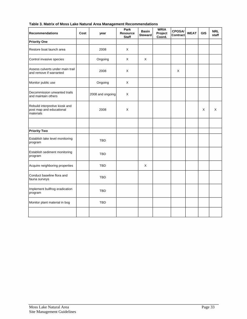
Table 3. Matrix of Moss Lake Natural Area Management Recommendations
Recommendations Cost year Park
Resource Staff
Basin Steward
WRIA Project Coord.
CPOSA/Contract WEAT GIS NRL
staff
Priority One
Restore boat launch area 2008 X
Control invasive species Ongoing X X
Assess culverts under main trail and remove if warranted 2008 X X
Monitor public use Ongoing X
Decommission unwanted trails and maintain others 2008 and ongoing X
Rebuild interpretive kiosk and post map and educational materials
2008 X X X
Priority Two
Establish lake level monitoring program TBD
Establish sediment monitoring program TBD
Acquire neighboring properties TBD X
Conduct baseline flora and fauna surveys TBD
Implement bullfrog eradication program TBD
Monitor plant material in bog TBD
Moss Lake Natural Area Page 33 Site Management Guidelines
References
Atelier. 1996. Memo: site characterization of recent acquisition parcel. June 19, 1996. 4 pp. In King County. 1996. Appendix D, Moss Lake Regional Park master plan. King County Department of Construction and Facilities Maintenance. Seattle, WA.
Atelier PS. 1997. Technical information report; Moss Lake Regional Park phase I, Moss Lake Regional Park, King County, Washington. Seattle, WA.
Atelier PS. 1998. Moss Lake Regional Park, King County, Washington, environmental checklist. Prepared for King County Parks CIP, Facilities Management Division.
Barber, W.H. Jr. 1976. An autoecological study of salmonberry (Rubus spectabilis, Pursh) in western Washington. MS Thesis, University of Washington, Seattle, WA.
Bull, E.L. 1991. Summer roosts and roosting behavior of Vaux’s swifts in old growth forests. Northwest Naturalist. 72(2):78-82.
Bull, E.L. and A.K. Blumton. 1997. Roosting behavior of post-fledging Vaux’s Swifts in northeastern Oregon. J. Field Orhithol. 68: 302-305.
Bull, E.L., and J.E. Hohman. 1993. The association between Vaux’s swifts and old growth forest in northeastern Oregon. Western Birds 24(1):38-42.
Franklin, J.F., and C.T. Dyrness. 1973. Natural Vegetation of Oregon and Washington, USDA Forest Service Pacific Northwest Forest and Range Experiment Station, General Technical Rerport. PNW-8. Portland, OR.
Haring, D. 2002. Salmonid habitat limiting factors analysis: Snohomish River Watershed, Water Resource Inventory Area 7. Washington State Conservation Commission. Salmonid distribution metadata available at: http://dnr-web.metrokc.gov/dnrtech/dnrpgislib/dnrplib_detail.cfm?DS_PID=515
Jeffrey, R. 1989. The band-tailed pigeon: Distribution, effects of harvest regulations, mortality rates, and habits, 1968-1979. Unpublished report to the Washington Department of Wildlife (as cited by Rodrick and Milner 1991).
Jeffrey, R. G. 1977. Band-tailed pigeon (Columba fasciata). Pages 210-245 in G. C. Sanderson, editor. Management of migratory shore and upland game birds in North America. International Association of Fish and Wildlife Agencies, Washington, D.C.
King County. 1983. King County wetland inventory. Vol. 1-3. King County Planning Division. Dept. of Planning and Community Development. Seattle, WA.
King County. 1986. Moss Lake draft environmental impact statement. King County Department of Planning and Community Development, Division of Building and Land Development.
King County. 1989. King County Council Ordinance No. 9071.
King County. 1993a. Ordinance 10750. Ordinance authorizing the Regional Conservation Futures 1993 Bond Acquisition Program. Seattle, WA
King County. 1995. Moss Lake Regional Park master plan, natural resource studies. Prepared by Herrera for Atelier and King County Department of Construction and Facilities Maintenance. Seattle, WA.
King County. 1996. Moss Lake Regional Park master plan, Technical Appendices. King County Parks, Planning, and Resource Department. Seattle, WA.
Moss Lake Natural Area Page 34 Site Management Guidelines
King County. 1997. Moss Lake Regional Park wetland mitigation plan. Prepared by Atelier for King County Department of Construction and Facilities Maintenance. Seattle, WA.
King County. 2002. Updated 1997 King County bog inventory. King County Surface Water Management. Prepared by Cooke Scientific Services, Inc., and Kulzer, L., King County Surface Water Management.
King County. 2003a. King County Code. Seattle, WA.
King County. 2003b. King County Ecological Lands Handbook. King County Department of Natural Resources and Parks, Water and Land Resources Division. Seattle, Washington.
Knight, R.L., P. J. Randolph, G. T. Allen, L. S. Young, and R. J. Wigen. 1990. Diets of nesting bald eagles, (Haliaeetus leucocephalus), in western Washington. Canadian Field Naturalist 104:545-551.
Kulzer, L., S. Luchessa, S. Cooke, R. Errington, and F. Weinmann. 2001. Characteristics of the low-elevation Sphagnum-dominated peatlands of western Washington: A community profile. Available online: http://dnr.metrokc.gov/wlr/dss/sphagnum-bogs.htm.
Larsen, E.M., E. Rodrick, and R. Milner, Eds. 1995. Management Recommendations for Washington's Priority Species; Volume I: Invertebrates. Washington Department of Fish and Wildlife, Olympia, WA.
Manuwal, D.A. 1991. Spring bird communities in the southern Washington Cascade Range. Pp. 161-174 in L.F. Ruggiero, K.B. Aubry, A.B. Carey, and M.H. Huff, technical coordinators. Wildlife and Vegetation of unmanaged Douglas-fir Forests. USDA Forest Service, Pacific Northwest Research Station, General Technical Report PNW-GTR-285, Portland, Oregon.
McAllister, K.R. 1999. Spotted frogs in the western Pacific Northwest. In Mac, M.J., P.A. Opler, C.E. Puckett Haeker, and P.D. Doran. 1998. Status and trends of the nation's biological resources. Vol. 1 and 2. U.S. Department of the Interior, U.S. Geological Survey, Reston, Va. 1-964 pp. Available online: http://biology.usgs.gov/s+t/SNT/
McAllister, K.R., and W.P. Leonard. 1997. Washington State status report for the Oregon spotted frog. Washington Department of Fish and Wildlife, Olympia, WA. 38 pp.
Meldrim, J.W. 1968. The ecological zoogeography of the Olympic mudminnow, Novumbra hubbsi Schultz. Ph.D. Thesis. Univ. Wash. Seattle.
Mongillo, P.E. and Hallock, M. 1999. Washington state status report for the Olympic mudminnow. Wash. Dept. Fish and Wildl., Olympia. 36 pp.
Omernik, J. M. 1995. Ecoregions: a spatial framework for environmental management. In: Davis, W., and T. Simon (Eds). Biological assessment and criteria: tools for water resource planning and decision making. Lewis Publishers, Boca Raton, FL. pp.49-62.
Preston, C.R., and R.D. Beane. 1993. Red-tailed hawk (Buteo jamaicensis). In: Poole, A., and F. Gill, eds The birds of North America, No. 52. Philadelphia: The Academy of Natural Sciences; Washington D.C.: The American Ornithologists’ Union.
Retfalvi, L. 1970. Food of nesting bald eagles on San Juan Island, Washington. Condor 72:358-361.
Rigg, G.B. 1919. Early stages in bog succession. Publication of Puget Sound Biological Station 2:195-210.
Rigg, G.B. 1958. Peat resources of Washington. Bulletin No. 44. Department of Conservation, Division of Mines and Geology, State of Washington. Olympia, WA.
Rodrick, E., and R. Milner 1991. Management Recommendations for Washington’s Priority Habitats and Species. Washington Department of Wildlife, Wildlife Management, Fish Management, and Habitat Management Divisions, Olympia, Washington.
Moss Lake Natural Area Page 35 Site Management Guidelines

Sheldon, D. 1983. Moss Lake wetland study. For Moss Lake Associates.
Watson, J.W., and D.J. Pierce. 1998. Migration, diets, and home ranges of bald eagles breeding along Hood Canal and at Indian Island, Washington. WDFW. Wildlife Research Division. Olympia.
Watson, J.W., M. G. Garrett, and R. G. Anthony. 1991. Foraging ecology of bald eagles in the Columbia River Estuary. Journal of Wildlife Management 55:492-499.
Weyerhaeuser. 1993. Tolt River watershed analysis.
Williams, R.W., R.M. Laramie, and J.J. Ames. 1975. A Catalog of Washington Streams and Salmon Utilization, Volume 1, Puget Sound. Washington Department of Fisheries, Olympia, WA.
Moss Lake Natural Area Page 36 Site Management Guidelines
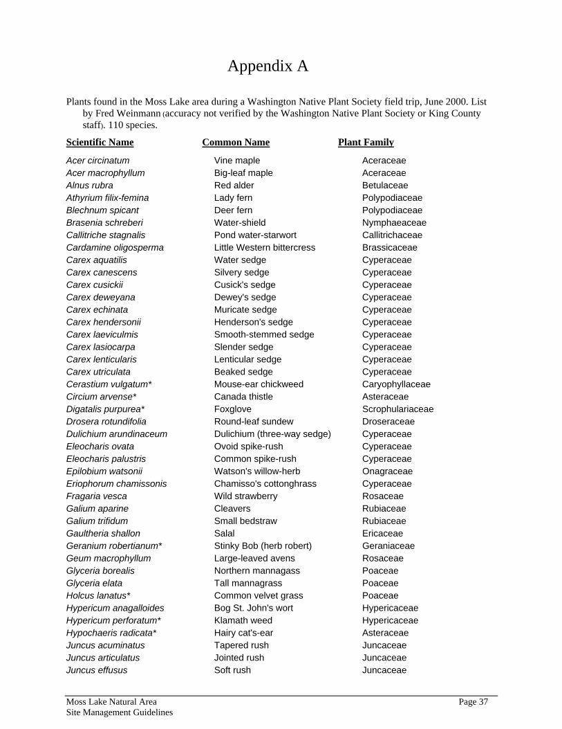
Appendix A
Plants found in the Moss Lake area during a Washington Native Plant Society field trip, June 2000. List by Fred Weinmann (accuracy not verified by the Washington Native Plant Society or King County staff). 110 species.
Scientific Name Common Name Plant Family
Acer circinatum Vine maple Aceraceae Acer macrophyllum Big-leaf maple Aceraceae Alnus rubra Red alder Betulaceae Athyrium filix-femina Lady fern Polypodiaceae Blechnum spicant Deer fern Polypodiaceae Brasenia schreberi Water-shield Nymphaeaceae Callitriche stagnalis Pond water-starwort Callitrichaceae Cardamine oligosperma Little Western bittercress Brassicaceae Carex aquatilis Water sedge Cyperaceae Carex canescens Silvery sedge Cyperaceae Carex cusickii Cusick's sedge Cyperaceae Carex deweyana Dewey's sedge Cyperaceae Carex echinata Muricate sedge Cyperaceae Carex hendersonii Henderson's sedge Cyperaceae Carex laeviculmis Smooth-stemmed sedge Cyperaceae Carex lasiocarpa Slender sedge Cyperaceae Carex lenticularis Lenticular sedge Cyperaceae Carex utriculata Beaked sedge Cyperaceae Cerastium vulgatum* Mouse-ear chickweed Caryophyllaceae Circium arvense* Canada thistle Asteraceae Digatalis purpurea* Foxglove Scrophulariaceae Drosera rotundifolia Round-leaf sundew Droseraceae Dulichium arundinaceum Dulichium (three-way sedge) Cyperaceae Eleocharis ovata Ovoid spike-rush Cyperaceae Eleocharis palustris Common spike-rush Cyperaceae Epilobium watsonii Watson's willow-herb Onagraceae Eriophorum chamissonis Chamisso's cottonghrass Cyperaceae Fragaria vesca Wild strawberry Rosaceae Galium aparine Cleavers Rubiaceae Galium trifidum Small bedstraw Rubiaceae Gaultheria shallon Salal Ericaceae Geranium robertianum* Stinky Bob (herb robert) Geraniaceae Geum macrophyllum Large-leaved avens Rosaceae Glyceria borealis Northern mannagass Poaceae Glyceria elata Tall mannagrass Poaceae Holcus lanatus* Common velvet grass Poaceae Hypericum anagalloides Bog St. John's wort Hypericaceae Hypericum perforatum* Klamath weed Hypericaceae Hypochaeris radicata* Hairy cat's-ear Asteraceae Juncus acuminatus Tapered rush Juncaceae Juncus articulatus Jointed rush Juncaceae Juncus effusus Soft rush Juncaceae
Moss Lake Natural Area Page 37 Site Management Guidelines

Juncus ensifolius Daggerleaf rush Juncaceae Juncus supinus Bulbous rush Juncaceae Kalmia occidentalis Western swamp laurel Ericaceae Lactuca muralis* Wall lettuce Asteraceae Lapsana communis* Nipplewort Asteraceae Ledum groendlandicum Labrador tea Ericaceae Lemna minor Water lentil Lemnaceae Linnaea borealis Twinflower Caprifoliaceae Lonicera involucrata Twinberry Caprifoliaceae Ludwigia palustris False loosestrife Onagraceae Luzula parviflora Small-flowered woodrush Juncaceae Lycopus americanus Water hoarhound Lamiaceae Lysimachia thrysiflora Tufted loosestrife Primulaceae Lythrum salicaria* Purple loosestrife Lythraceae Maianthemum dilatatum False lily-of-the-valley Liliaceae Montia perfoliata Miner's lettuce Portulacaceae Myosotis scorpioides Common forget-me-not Boraginaceae Nuphar polysepalum Pond lily Nymphaeaceae Oemlaria cerasiformus Indian plum Rosaceae Oplopanax horridum Devil's club Araliaceae Phalaris arundinacea* Reed canarygrass Poaceae Picea sitchensis Sitka spruce Pinaceae Plantago lanceolata* English plantain Plantaginaceae Plantago major* Common plantain Plantaginaceae Polygonum amphibium Water smartweed Polygonaceae Polygonum cuspidatum* Japanese knotweed Polygonaceae Polygonum sachalinense* Giant knotweed Polygonaceae Polystichum munitum Sword fern Polypodiaceae Populus trichocarpa Black cottonwood Salicaceae Potentilla palustris Marsh cinquefoil Rosaceae Prunella vulgaris Self-heal Lamiaceae Pseudotsuga menziesii Douglas-fir Pinaceae Pteridium aquilinum Bracken fern Polypodiaceae Ranunculus repens* Creeping buttercup Ranunculaceae Rhamnus purshiana Cascara Rhamnaceae Rhyncospora alba White-beaked rush Cyperaceae Rorippa curvisiliqua Western yellowcress Brassicaceae Rubus discolor* Himalayan blackberry Rosaceae Rubus laciniatus* Evergreen blackberry Rosaceae Rubus parviflorus Thimbleberry Rosaceae Rubus pedatus Strawberry bramble Rosaceae Rubus spectabilus Salmonberry Rosaceae Salix geyeriana Geyer willow Salicaceae Salix lasiandra Pacific willow Salicaceae Salix sitchensis Sitka willow Salicaceae Sambucus racemosa Red elderberry Caprifoliaceae Scirpus cyperinus Wool-grass Cyperaceae Scirpus microcarpus Small-flowered bulrush Cyperaceae Senecio jacobaea* Tansy ragwort Asteraceae Solanum dulcamara* Bittersweet nightshade Solanaceae
Moss Lake Natural Area Page 38 Site Management Guidelines
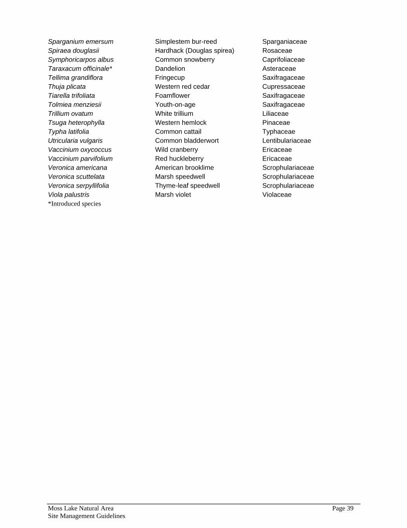
Sparganium emersum Simplestem bur-reed Sparganiaceae Spiraea douglasii Hardhack (Douglas spirea) Rosaceae Symphoricarpos albus Common snowberry Caprifoliaceae Taraxacum officinale* Dandelion Asteraceae Tellima grandiflora Fringecup Saxifragaceae Thuja plicata Western red cedar Cupressaceae Tiarella trifoliata Foamflower Saxifragaceae Tolmiea menziesii Youth-on-age Saxifragaceae Trillium ovatum White trillium Liliaceae Tsuga heterophylla Western hemlock Pinaceae Typha latifolia Common cattail Typhaceae Utricularia vulgaris Common bladderwort Lentibulariaceae Vaccinium oxycoccus Wild cranberry Ericaceae Vaccinium parvifolium Red huckleberry Ericaceae Veronica americana American brooklime Scrophulariaceae Veronica scuttelata Marsh speedwell Scrophulariaceae Veronica serpyllifolia Thyme-leaf speedwell Scrophulariaceae Viola palustris Marsh violet Violaceae *Introduced species
Moss Lake Natural Area Page 39 Site Management Guidelines

Appendix B
The following species were directly observed at Moss Lake by King County staff. Additionally, species indicated with an asterisk were observed during an East Lake Washington Audubon Society field trip, August 12, 2004. Many additional species are expected to be present on site but were not recorded during field visits.
M a m m a l s Mountain Beaver Aplondontia rufa
Beaver Castor canadensis
Douglas Squirrel (chickaree) Tamiasciurus douglasi
Black Bear Ursus americanus
B i r d American Kestrel* Falco sparverius
Cooper's Hawk* Accipiter cooperii
Turkey Vulture* Pandion haliaetus
Great Blue Heron Ardea herodias
Greater Yellowlegs* Tringa
Wood Duck* Aix sponsa
American Goldfinch Carduelis tristis
American Robin Turdus migratorius
Band-tailed Pigeon* Columba fasciata
Belted Kingfisher Ceryle alcyon
Black-Headed Grosbeak Pheucticus melanocephalus
Brown Creeper* Certhia americana
Cassin’s Vireo Vireo cassinii
Cedar Waxwing Bombycilla cedrorum
Chestnut-Backed Chickadee Poecile rufescens
Common Raven Corvus corax
Common Yellowthroat Geothlypis trichas
Downy Woodpecker Picoides pubescens
Evening Grosbeak* Coccothraustes vespertinus
Golden-crowned Kinglet Regulus satrapa
Hutton’s Vireo Vireo huttoni
Mourning Dove Zenaida macroura
Pacific-Slope Flycatcher Empidonax difficilis
Pileated Woodpecker Dryocopus pileatus
Moss Lake Natural Area Page 40 Site Management Guidelines
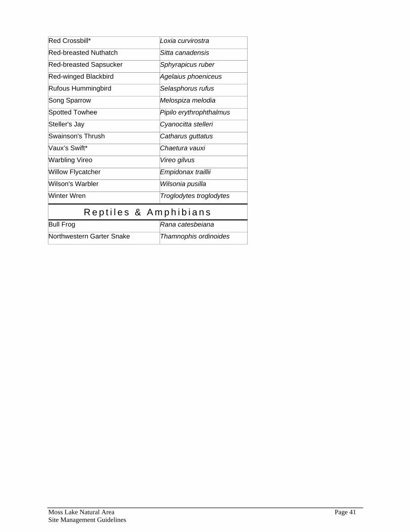
Red Crossbill* Loxia curvirostra
Red-breasted Nuthatch Sitta canadensis
Red-breasted Sapsucker Sphyrapicus ruber
Red-winged Blackbird Agelaius phoeniceus
Rufous Hummingbird Selasphorus rufus
Song Sparrow Melospiza melodia
Spotted Towhee Pipilo erythrophthalmus
Steller's Jay Cyanocitta stelleri
Swainson's Thrush Catharus guttatus
Vaux’s Swift* Chaetura vauxi
Warbling Vireo Vireo gilvus
Willow Flycatcher Empidonax traillii
Wilson's Warbler Wilsonia pusilla
Winter Wren Troglodytes troglodytes
R e p t i l e s & A m p h i b i a n s Bull Frog Rana catesbeiana
Northwestern Garter Snake Thamnophis ordinoides
Moss Lake Natural Area Page 41 Site Management Guidelines


