89
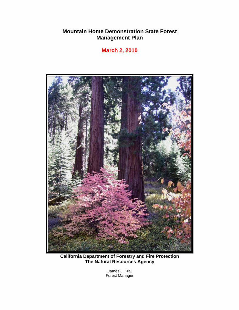
Mountain Home Demonstration State Forest Management Plan March 2, 2010 California Department of Forestry and Fire Protection The Natural Resources Agency James J. Kral Forest Manager
Mountain Home Demonstration State Forest Management Plan
March 2, 2010
California Department of Forestry and Fire Protection
The Natural Resources Agency
James J. Kral Forest Manager
ii
CERTIFICATION by REGISTERED PROFESSIONAL FORESTER
pursuant to California Code of Regulations
Title 14, §1602.1
I, James J. Kral, am responsible for the preparation of this Forest Management Plan for Mountain Home Demonstration State Forest.
_____________________________________________ James J. Kral, RPF #2588
_________________________ Date
APPROVAL of FOREST MANAGEMENT PLAN for
MOUNTAIN HOME DEMONSTRATION STATE FOREST
Approved by vote of the Board of Forestry and Fire Protection
______________________________________________ George Gentry, Executive Officer
_________________________ Date

iii
Table of Contents
I. INTRODUCTION .......................................................................................................................... 1 Authority and Statutes ................................................................................................................. 1 History of Mountain Home ........................................................................................................... 2 Management Goals and Guidelines ............................................................................................ 4
II PROPERTY DESCRIPTION ....................................................................................................... 6 Location ....................................................................................................................................... 6 Regional Setting and Adjacent Ownerships ................................................................................ 6 Climate......................................................................................................................................... 7 Soils ........................................................................................................................................... 10 Water Resources....................................................................................................................... 11 Vegetation.................................................................................................................................. 14 Improvements ............................................................................................................................ 14 Zoning........................................................................................................................................ 15
III. RECREATION .......................................................................................................................... 16 Facilities..................................................................................................................................... 16
Recreational Attractions ........................................................................................................ 18 Future Development .................................................................................................................. 19
Recreation Management Guidelines ..................................................................................... 21 Strategic Plan for Recreation................................................................................................. 22
IV. RESEARCH AND DEMONSTRATION.................................................................................... 25 Background................................................................................................................................ 25 Regional Setting ........................................................................................................................ 25 Research Priorities .................................................................................................................... 26 Research Projects ..................................................................................................................... 27
Historical and Ongoing Research Projects............................................................................ 27 Planned Future Research Projects........................................................................................ 28
Strategic Research Plan............................................................................................................ 29
V. FOREST MANAGEMENT......................................................................................................... 34 Vegetation Resources Inventory ............................................................................................... 34
Growth ................................................................................................................................... 41 Site Quality ............................................................................................................................ 41
Planned Management and Forest Structure ............................................................................. 41 Giant Sequoia Management.................................................................................................. 42
Silvicultural Systems.................................................................................................................. 44 Cutting Cycles........................................................................................................................ 47 Plantation Management......................................................................................................... 47
Sustainable Harvest Levels ....................................................................................................... 48 Harvest Methods........................................................................................................................ 48 Markets for Forest Products ...................................................................................................... 48 Forest Products ......................................................................................................................... 48
VI OTHER FOREST MANAGEMENT VALUES............................................................................ 51 Fisheries .................................................................................................................................... 51 Wildlife and Plants ..................................................................................................................... 52
Special Habitat Types............................................................................................................ 52 Mitigation Measures............................................................................................................... 53 Management Guidelines........................................................................................................ 54

iv
Wildlife Species of Concern................................................................................................... 55 Plant Species of Concern ...................................................................................................... 60
Prescribed Burning .................................................................................................................... 61 Training Opportunities ............................................................................................................... 62 Archaeological Resources......................................................................................................... 63 Range Resources...................................................................................................................... 63 Carbon Sequestration and Greenhouse Gas Emissions........................................................... 64
VII RESOURCE PROTECTION .................................................................................................... 66 Abiotic Factors ........................................................................................................................... 66 Insects and Diseases ................................................................................................................ 66 Animal Damage ......................................................................................................................... 69 Fire Protection ........................................................................................................................... 69
VIII REFERENCES........................................................................................................................ 71
IX. APPENDIXES .......................................................................................................................... 73 Appendix A. Management Guidelines ....................................................................................... 73 Appendix B. Historical Research and Demonstration Projects ................................................. 80 Appendix C. Potential Wildlife Species & Associated Habitats at Mountain Home .................. 82 Appendix D. Important Insect Pest Species at Mountain Home ............................................... 85

1
I. INTRODUCTION The forests of the Sierra Nevada provide important values to Californians. They supply many of the public trust resources that we use and enjoy, including clean water, fish, wildlife, oxygen, and forest products such as paper, lumber, mushrooms, herbs and landscape materials. California’s forests also provide an important destination for recreational activity. The majority of public wildlands in California are set aside as reserves and parks to preserve rare ecosystems. Demonstration State Forests, by contrast, are public lands that by legislative mandate have a unique and distinctly different purpose from parks and wilderness areas. Demonstration State Forests are mandated by law to provide opportunities to conduct research, demonstration, and education on sustainable forestry practices. Demonstration State Forests are required to balance periodic timber harvest with public trust resource values such as recreation, watershed, wildlife, range and forage, fisheries, and aesthetic enjoyment. The Demonstration State Forest system meets an important need to advance research and demonstration into sustainable forestry practices in a State with a large population that places high demands on forest lands for recreation, environmental protection and conversion to residential use. Given the often controversial role of timber production in California, the State Forests play an important role in helping maintain California’s leadership as an innovator in creating solutions to difficult and controversial forest management problems. The California Department of Forestry and Fire Protection (CAL FIRE) manages approximately 72,000 acres of Demonstration State Forests on behalf of the public. Mountain Home Demonstration State Forest, a 4,858-acre mixed conifer forest located in the southern Sierra Nevada in Tulare County, is 22 air miles northeast of Porterville, and is the third largest State Forest. This document contains a management plan for Mountain Home. The management plan lays out the planned on-the-ground management on the Forest for the next five to ten years. It serves as a guide to Forest managers as well as a public disclosure of the management direction at Mountain Home.
Authority and Statutes
CAL FIRE is responsible for the management of Mountain Home on behalf of the public. The legislative authority for the State Forest System is contained in Public Resources Code (PRC) §4631-4658 and §4701-4703. Chapter 9 of Title 14 of the California Administrative Code contains rules and regulations governing recreational use and the sale of timber and other forest products. The Public Resources Code provides that State Forests shall be in conformity with forest management practices designed to achieve maximum sustained production of high-quality forest products while giving consideration to values relating to recreation, watershed, wildlife, range and forage, fisheries, and aesthetic enjoyment. Specifically, this legislation also specifies that Mountain Home shall be maintained as a multiple use forest, primarily for public hunting, fishing, and recreation. Guided by these statutes, the Board of Forestry and Fire Protection establishes policy which governs Mountain Home and other State Forests in more detail. The following are some highlights of Board policy direction:
2
Recreation is the primary land use on Mountain Home, i.e. timber production is subordinate to recreation. The primary purpose of the State forest program is to conduct innovative demonstrations, experiments, and education in forest management. All State Forests land uses should serve this purpose in some way. Jackson, Latour, Mountain Home, and Boggs Mountain State Forests are commercial timberland areas managed by professional foresters who conduct programs in timber management, recreation, demonstration, and investigation in conformance with detailed management plans. The Department will conduct regular periodic timber sales on Jackson, Latour, Boggs Mountain, and Mountain Home State Forests. The Department will conduct a balanced program of demonstrations and investigations in silviculture, mensuration, logging methods, economics, hydrology, protection, and recreation; directed to the needs of the general public, small forest landowners, timber operators and the timber industry. State forest timberlands will be managed on the sustained yield principle, defined as management which will achieve and maintain continuous timber production consistent with environmental constraints. Economically and ecologically justifiable intensified forest management practices to increase total fiber production and timber quality will be pursued on the State forests. These practices will be designed and carried out for maximum applicability or demonstration values to private lands. Management Plans for Boggs Mountain, Jackson, Latour, Mountain Home and Soquel Demonstration State Forests shall be prepared by the Department, with appropriate public review, for approval by the Board. The Department shall present to the Board a thorough review of each existing plan at least every five years. After each review, the Board may direct the Department either to continue management under the existing plan, to prepare amendments to the plan, or to prepare a new plan for public review and Board approval. The Department shall submit the requested amendments or plan to the Board within one year after each request. The Department shall continue management under existing plans with appropriate consideration for changes in law or regulation, until amendments or new plans are approved by the Board.
History of Mountain Home
Mountain Home Demonstration State Forest lies within the recorded domain of the Foothill Yokuts Indian group. The Yokuts are unique among the California natives in being divided into true tribes, each with its own name, dialect, and territory. One of these tribes was known as the Yaudanchi or Yawdanchi. Their principal territory was the North Fork of the Tule River, to the northeast of modern-day Springville. Mountain Home State Forest was part of this territory although other groups, including the western Mono, Paiute, and Tabatulabal had access to the area (Otter, 1963). The high elevation dictated seasonal occupation, mainly in the summer. Aside from being a welcome retreat from the hot valley summers, the area around Mountain Home provided good food sources, such as black oak acorns and sugar pine nuts. Very little is known about the origins of the Yawdanchi or their use of the upper mountains. They were the last Native Americans to occupy the area, but not the only ones to do so. The mysterious prehistoric cultures that preceded them are known only through archeological investigations.

3
The 22 prehistoric and 14 historic sites recorded on Mountain Home attest to the long period of human occupancy there. The prehistoric sites consist of bedrock mortars and basins, lithic scatters, and combinations of the three. The bedrock basins and associated archeological remains found at Mountain Home are some of the most enigmatic phenomena in the Sierra Nevada, and are unique from a worldwide perspective. Additional undiscovered sites are thought to occur throughout the forest. The historic Euro-American sites consist mainly of early sawmill remains and trees and stumps with historic markings. The Mountain Home Tract has a long history of timbering and recreational use. People would come up to get relief from the heat of the San Joaquin Valley in the summer, hence the name “Mountain Home.” Logging began adjacent to the State Forest in the Happy Camp area about 1870 with the Rand-Haughton Mill. However, very little acreage was cut over until A. M. Coburn and L. B. Frasier built mills on Bear Creek in 1885. Records indicate the Coburn and Frasier mills could cut 20 MBF and 40 MBF per day respectively. Records also show Frasier was in financial trouble from the start. The Tule River Lumber Company became owners of the Frasier Mill and surrounding property in 1890. Yellow and white pine were the primary species that were harvested at Mountain Home until around 1900. It was during this period when the Enterprise Mill constructed a log skidway and began logging the giant sequoia from about 100 acres. The Elster Mill, which operated from 1903-1905, was the last of the early mills to operate on the forest. Virtually no harvest activity occurred from 1905 until the late 1930’s. In the early 1940’s, old growth sequoia were subject to accelerated harvesting throughout the southern Sierra Nevada. The rapid rate of sequoia harvesting instilled growing concern from local residents who believed that in little time there would be few of the giants remaining. In the Fresno-Visalia area, the Native Sons and Daughters of the Golden West made a special project of saving the mammoth trees of the Mountain Home Tract1. As a result of their efforts, the California State Legislature passed the enabling legislation for the purchase of the Mountain Home Tract under Senate Bill 934 in 1945. In 1946, the owners sold the Mountain Home Tract to the State of California for $548,762. Shortly after State acquisition in 1946, the first pack station lease was signed. Visitors to the forest tended to congregate in specific areas and in 1963 construction of the Frasier Mill Campground began. By 1979, all of the campgrounds in use at Mountain Home were finished. There have been some expansions done in a number of the campgrounds since then. Due to the unique nature of Mountain Home, particularly the presence of old growth giant sequoia, it has been subject to many demonstration projects not available on the other Demonstration State Forests. Numerous samples of fallen behemoths have been collected from the Forest and shipped around the world for use as exhibits. In 1952 a large sequoia round was sent to the Swedish Museum of Natural History. A year after the “Los Angeles” tree fell across the Camp Lena Road, a 17 foot diameter section was sent to the Los Angeles County Fairgrounds as a permanent exhibit in 1961. Also in 1961, a section of a windfelled giant sequoia was sent to the Geologic Museum at the University of Cologne in Germany. Additional segments were sent to Mooney Grove in Visalia. In 1980, a 16 foot diameter segment of sequoia was sent to Kobe, Japan to be displayed in a pavilllion called Portopia 81.
1 This tract had been consolidated between 1890 and 1915 by the Tule River Lumber Company and the well-known Michigan lumberman, George Hume. This land was later controlled by the Michigan Trust Company.

4
Management Goals and Guidelines
The following is a list of overall management goals for Mountain Home, used to guide decision-making. No ranking of these goals is implied. All these goals are of equal importance. In making management decisions, a balance will therefore be sought in order to optimize as many of these goals as possible. More specific management guidelines have been developed from these goals. These guidelines are described under each subject category in this management plan. In addition, all the management goals and guidelines are compiled in appendix A, for ease of reference. 1. Provide for recreational opportunities as the primary use of the State Forest. Work toward expansion and improvement of existing facilities and the development of new recreational opportunities in suitable areas. Maintain the system of campgrounds, picnic areas, trails, and roads in such a manner as to provide for safe and enjoyable use by the public. 2. Maintain an inventory of cultural resources and provide for their protection. Encourage research and interpretive use of these sites. 3. Harvest timber under sustained yield management on all productive areas while maintaining or enhancing recreational values. Harvest timber by the most economical methods that will protect the environmental values and maintain productivity. Ensure prompt regeneration following cutting and maintain optimal stocking throughout the life of the stand. Protect old growth giant sequoia from fire, cutting, and logging damage, and encourage reproduction. 4. Promote research and demonstration on the Forest. Research and demonstration projects will be aimed at providing practical information for forest landowners who need to manage a host of forest resources, including but not limited to, wildlife, water, soil, sensitive plants, and timber. Efforts at MHDSF will provide an opportunity for neighboring landowners and agencies to observe the application of different silvicultural methods in practice. Due to limited staff resources, cooperative research projects will be sought with other public and private researchers who share a common interest and direction in forest management. This information will be made available to landowners and the public. 5. Improve fire safety and forest health and optimize the use of dead and down trees, slash, bark, cull logs, and pre-commerical thinning for fuelwood, posts, pulpwood, and other specialty products. Utilize dead and down giant sequoia while protecting the recreational and scientific value of selected specimens. Make cone collections to satisfy the needs of the State nursery system and sell the excess to private collectors. 6. Improve and maintain watershed protection through forest practices and erosion control efforts. Develop water sources and assure safe drinking water for use at administrative and recreational facilities. 7. Prevent site degradation by using erosion controls and soil conservation practices in all management activities. 8. Enhance the existing habitat for as many wildlife species as possible. Manage cover, food, and water to sustain or increase wildlife populations. Prevent the degradation of stream and pond habitat that is suitable for fish populations. 9. Manage the forest to maintain an aesthetically pleasing forest environment for the recreational visitor. Harvest timber strategically to increase the visibility of old growth giant sequoia. Improve aesthetics in high use areas and along roads by controlling the density of leave stands, treating slash promptly, and promoting rapid regeneration.

5
10. Continue the fire prevention program utilizing education, enforcement, patrol, vegetation management, fuelbreaks, pre-fire planning, and suppression. 11. Continue an aggressive pest management program to improve forest health and reduce tree mortality due to insects and diseases utilizing monitoring, established control methods, and stand sanitation. 12. Continue research into forest-based carbon sequestration and forest management techniques to promote forest adaptation and resiliency to climate change. 13. Develop and maintain a fire resilient landscape within the MHDSF to protect the forest, the habitat it contains and the waters from which it drains. 14. Investigate and implement societal preferences for giant seuoia management and conservation. 15. Research and demonstration on silvicultural methods to establish and promote sugar pine and giant sequoia. 16. Maintain as wide a range of seral stages and forest structure types as possible, from regeneration to old growth, open and closed stands, in order to maintain options for future management and research. 17. Foster the development of giant sequoia stands, both young growth and old growth, to a point that is reflective of current natural forest conditions in this region. Establishing a more natural species mix will in many cases require a dedicated effort to decreasing the white fir component of stands and cultivating giant sequoia and pine species. Desired forest structure will typically be that of low density, fire resistant stands.

6
II PROPERTY DESCRIPTION
Location
Mountain Home is located on the west slopes of the southern Sierra Nevadas, in eastern Tulare County, approximately twenty-two air miles north east of Porterville. As indicated on figure 1, forest land in this area of the State is predominantly federal lands, National Forests and National Parks. Mountain Home It is situated in the drainages of the North Fork and the North Fork of the Middle Fork of the Tule River (figure 2). Mountain Home is located in Sections 25, 26 and 34-36, Township 19 South, Range 30 East; Sections 18 - 20 and 28 - 31, Township 19 South, Range 31 East and Sections 1, 2 and 12, Township 20 South, Range 30 East, Mount Diablo Base and Meridian. It ranges in elevation from 4,800 to 7,600 feet with all aspects present. The Forest comprises a total of 4,858 acres. An 80 acre parcel of land exists near the center of MHDSF in the E½, SW¼, Section 25, Township 19 South, Range 30 East, Mount Diablo Base and Meridian. MHDSF owns and actively manages this parcel. However, the Miller family, from which the parcel was obtained, maintains a recreational lease to camp on the property. The lease expires in 2013.
Regional Setting and Adjacent Ownerships
Owners adjacent to or within the boundaries of the State Forest include Tulare County Parks Department, U.S. Forest Service, and private individuals (figure 3). The 160-acres County-owned Balch Park lies almost entirely within the State Forest in Sections 1 and 36. Of the approximately 30 miles of exterior boundary on the forest, 24.5 miles are common with the U.S. Forest Service, three miles common with private owners, and 2.5 miles common with Tulare County. In a regional context, Mountain Home’s mandate as a working forest emphasizing sustainable forestry is an exception to the predominant land use. The vast majority of the giant sequoia forest type is federal land, on which active forest management currently only plays a very minor role (figure 1). Mountain Home is surrounded on the north, east and south by the southern section of the Giant Sequoia National Monument (the northern section surrounds Grant Grove and other parts of Kings Canyon National Park). The 328,000 acre Monument was created by President Clinton on April 15, 2000. It is administered by the United States Forest Service as part of the Sequoia National Forest and includes 38 of the 39 Giant Sequoia groves that located in the Sequoia National Forest, about half of the sequoia groves currently in existence. The management objectives for the Monument includes ecological restoration. Timber production is explicitly excluded. The Sequoia and Kings Canyon National Park is located approximately 50 miles north of Mountain Home. Mountain Home Demonstration State Forest shares a similar emphasis of protection of giant sequoias groves and management for public recreation and education, but unlike the Park, within the context of practicing sustainable forestry on a working forest. The Sequoia and Kings Canyon National Park has recently completed their Final General Management Plan and Comprehensive River Management Plan / Environmental Impact Statement. The plan establishes a 20-year vision for the park, as well as direction on the management of park lands within the corridors of the Middle and South Kings River and the North Fork of the Kern River. These rivers have been designated as part of the National Wild and Scenic Rivers system.

7
Climate
Mountain Home enjoys a Mediterranean climate characterized by warm dry summers and cold, wet winters. Average precipitation is estimated to be 42 inches per year with the majority falling in the form of snow. With the exception of sporadic and infrequent summer thunderstorms, the typical rainy season extends from November through April. April 1 average water content of snow at the Old Enterprise Mill Snow Course, at 6,600 feet, is 15.3 inches with an average snow depth of approximately 36.9 inches. The minimum winter temperature recorded at Mountain Home is 1° F. The maximum summer temperature on record is 90° F. Table one shows historical average monthly maximum and minimum temperatures at Mountain Home.

8
Figure 1. Location of Mountain Home Demonstration State Forest.
9
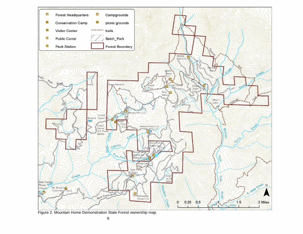
Figure 2. Mountain Home Demonstration State Forest ownership map.

10
Table 1. Average monthly maximum and minimum temperatures at Mountain Home (2002-2007). Month Maximum
Temperature (°F)
Minimum Temperature (°F)
January 44 23 February 44 23 March 47 26 April 51 29 May 63 37 June 72 43 July 80 51 August 78 48 September 73 42 October 61 36 November 48 28 December 44 25
Soils
Approximately two-thirds of the State Forest area is underlain by granite-granodiorite, most of which is decomposed at the surface. The remaining one-third of the area is underlain by metamorphic rocks including schists, quartzite, slate, metavolcanic rocks, lime/silicate hornfels and limestone. The main ridge between the North Fork and the North Fork of the Middle Fork of the Tule River forms the rough dividing line between these two basic parent materials, with the granitics lying to the west of the ridge and the metamorphics to the east. Known mineral commodities of possible economic value in the area include miscellaneous crushed rock, limestone, decomposed granite for road surfacing, complex copper-zinc ore with minor amounts of lead, silver, and gold, lead-zinc silver ore with minor amounts of gold and tungsten. All known occurrences of metallic minerals are restricted to the metamorphic rocks, particularly the limestone and limey horizons in the slates. Insufficient development work has been done on any mineral prospects in the area to determine whether ore is present in commercial quantities. The State holds all of the mineral rights on the State Forest and current policy prohibits prospecting by private individuals. Thirteen soil series have been identified on the State Forest area and are listed in table two below.

11
Table 2. Soil Series found on Mountain Home. SOIL SERIES PARENT MATERIAL DESCRIPTION COVER Boomer Greenstone Gravelly loam Pine, Mixed Conifer Chaix Granitic Coarse, sandy loam Mixed Conifer Cieneba Granitic Fine, gravelly loam Chaparral Crouch Crystalline igneous Very coarse, sandy
loam Pine, Mixed Conifer
Dome Granitic Sandy loam (deep) Pine, Fir Heitz Taxa Granitic Gravelly, loamy,
coarse sand Pine
Holland Quartz Loam Pine, Cedar Holland Taxa Quartz Loam Pine, Cedar Marpa Variant Shale Very gravelly, heavy
loam Mixed Conifer
Sheetiron Schist Gravelly loam Mixed Conifer Sierra Variant 2 Granitic Coarse, sandy loam Grass, Oak, Pine Tollhouse Variant Granitic Rocky, coarse, sandy
loam Chaparral, Oak
*Miscellaneous soil series include Childs, Cone, Decey and rock outcrops The high site timber producing soils exhibit moderate to high erosion hazard ratings. Some of the more shallow granitic soils exhibit high to extreme erosion hazard particularly on steep slopes. Caution should be exercised when planning harvesting activities on slopes that exceed 50 percent where these soils are present. Areas of geologic instability, such as slides and slumps, are generally associated with high amounts of surface water and springs. These areas should be avoided in harvesting and road construction. If these areas cannot feasibly be avoided, an engineering geologist shall be consulted to help mitigate disturbances.
Water Resources
Mountain Home encompasses five Calwater watersheds: Rancheria, Upper North Bear, Hossack, Silver, and Burro Creeks (figure 3). The forest is situated on the ridge that separates the North Fork of the Middle Fork of the Tule River (Wishon Fork) from the North Fork of the Tule River. The North Fork of the Middle Fork of the Tule River passes through the forest for approximately 1.5 miles of its length. Tributaries to the North Fork of the Tule River, which drain out of the forest, include Rancheria, Bear, and Hossack Creeks. Named tributaries to Bear Creek include Norway Creek, Coburn Creek, and Park Fork of Bear Creek. Named tributaries of the North Fork of the Middle Fork of the Tule River, which occur on State Forest land, include Moses Gulch, Galena Creek, Silver Creek, Burro Creek, and Shake Gulch. The headwaters of Rancheria Creek are located on the Sequoia National Forest, approximately one-half mile north of Mountain Home. The Rancheria Creek watershed is 7,819.65 acres in size; Mountain Home contains approximately 400 acres or 5.12 percent. The lower reaches of Rancheria Creek and some of its unnamed tributaries are Class I (fish bearing) watercourses. The lowest reach of this watershed that occurs downstream of the confluence with Upper North Bear Creek is named Bear Creek. There are no Class I watercourses present within the bounds of Mountain Home in the Rancheria Creek watershed. The headwaters of Upper North Bear Creek occur on Mountain Home at the topographic boundary that demarcates this watershed from Silver Creek, Burro Creek and Hossack Creek. The Upper North Bear Creek watershed is 8,638.07 acres in size; approximately 1,945 acres or
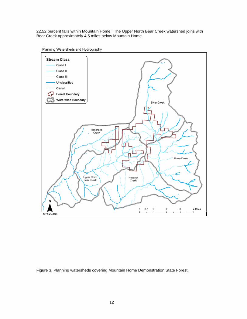
12
22.52 percent falls within Mountain Home. The Upper North Bear Creek watershed joins with Bear Creek approximately 4.5 miles below Mountain Home.
Figure 3. Planning watersheds covering Mountain Home Demonstration State Forest.

13
Named tributaries such as South Bear Creek and numerous unnamed tributaries of the Upper North Bear Creek watershed are Class I watercourses. The Hossack Creek watershed lies south of the Upper North Fork Bear Creek and Burro Creek watersheds. The Hossack Creek watershed is 7,882.11 acres in size; approximately 181 acres or 2.3 percent is located on Mountain Home. Those Mountain Home lands located within this watershed are flat to gently sloping. There are no classifiable watercourses in this watershed located on Mountain Home land. The headwaters of Silver Creek begin on the Sequoia National Forest about four miles north of Mountain Home. The Silver Creek watershed is 10,129.1 acres in size; 2,010 acres or 19.84 percent is within the boundaries of Mountain Home. The North Fork Tule River receives drainage from Galena Creek and Silver Creek, all of which, are Class I watercourses. The Burro Creek watershed lies south of the Silver Creek watershed and begins just south of the confluence of Silver Creek and the Middle Fork Tule River. The Burro Creek watershed is 8,595.52 acres in size; approximately 272 acres or 3.16 percent occurs in Mountain Home. Those Mountain Home lands located within the bounds of this watershed are steep and inaccessible to ground based equipment. There are no Class I or II watercourses located on Mountain Home within this watershed, except the Middle Fork of the Tule River which is located in the Silver Creek drainage. There are two man-made ponds on the Forest. Hedrick Pond, located near the center of Section 36, T19S, R30E, is an old mill pond constructed in 1939. Hedrick's sawmill was abandoned not long after State acquisition of the forest, but the pond remained and is now the focal point of a 14-unit campground. Hedrick Pond is near the headwaters of Coburn Creek, a tributary to Bear Creek. Another pond, located in the NE 1/4, Section 1, T20S, R30E, is partially on State Forest land and partially in Balch Park. It is commonly referred to as Upper Balch Pond. The pond was constructed in 1959 for recreational purposes. Balch Park campground is immediately adjacent to the pond on the north side. Springs are common in many areas of the forest. Many of these springs have been developed for domestic water supplies for campgrounds, picnic areas, and administrative sites. Developed springs exist in the Shake Camp area, Frasier Mill, Hidden Falls, Hedrick Pond, and the State Forest Headquarters. All but one of these springs now feed into a network of horizontal wells that provide drinking water to recreational and administrative facilities while reducing the possibility of contamination. Other springs are located throughout the Forest that provide unique habitats for wildlife. Many of the meadow areas at Mountain Home are the result of spring activity and marsh like conditions adjacent to watercourses. These areas provide habitat and ecological attributes not found elsewhere at Mountain Home.
14
Vegetation
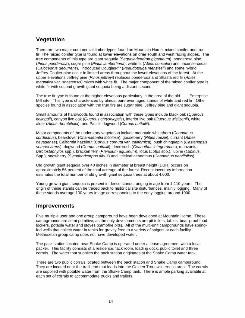
There are two major commercial timber types found on Mountain Home, mixed conifer and true fir. The mixed conifer type is found at lower elevations on drier south and west facing slopes. The tree components of this type are giant sequoia (Sequoiadendron giganteum), ponderosa pine (Pinus ponderosa), sugar pine (Pinus lambertiana), white fir (Abies concolor) and incense-cedar (Calocedrus decurrens). Introduced Douglas-fir (Pseudotsuga menziesii) and some hybrid Jeffrey-Coulter pine occur in limited areas throughout the lower elevations of the forest. At the upper elevations Jeffrey pine (Pinus jeffreyi) replaces ponderosa and Shasta red fir (Abies magnifica var. shastensis) mixes with white fir. The major component of the mixed conifer type is white fir with second growth giant sequoia being a distant second. The true fir type is found at the higher elevations particularly in the area of the old Enterprise Mill site. This type is characterized by almost pure even aged stands of white and red fir. Other species found in association with the true firs are sugar pine, Jeffrey pine and giant sequoia. Small amounts of hardwoods found in association with these types include black oak (Quercus kelloggii), canyon live oak (Quercus chrysolepsis), interior live oak (Quercus wislizenii), white alder (Alnus rhombifolia), and Pacific dogwood (Cornus nuttallii). Major components of the understory vegetation include mountain whitethorn (Ceanothus cordulatus), bearclover (Chamaebatia foliolosa), gooseberry (Ribes roezlii), currant (Ribes nevadense), California hazelnut (Corylus cornuta var. californica), bush chinquapin (Castanopsis sempervirens), dogwood (Cornus nuttallii), deerbrush (Ceanothus integerrimus), manzanita (Arctostaphylos spp.), bracken fern (Pteridium aquilinum), lotus (Lotus spp.), lupine (Lupinus. Spp.), snowberry (Symphoricarpos albus) and littleleaf ceanothus (Ceanothus parvifolius). Old growth giant sequoia over 40 inches in diameter at breast height (DBH) occurs on approximately 56 percent of the total acreage of the forest. Recent inventory information estimates the total number of old growth giant sequoia trees at about 4,000. Young growth giant sequoia is present in dense stands ranging in age from 1-110 years. The origin of these stands can be traced back to historical site disturbances, mainly logging. Many of these stands average 100 years in age corresponding to the early logging around 1900.
Improvements
Five multiple user and one group campground have been developed at Mountain Home. These campgrounds are semi-primitive, as the only developments are pit toilets, tables, bear-proof food lockers, potable water and stoves (campfire pits). All of the multi-unit campgrounds have spring-fed wells that collect water in tanks for gravity feed to a variety of spigots at each facility. Methuselah group camp does not have developed water. The pack station located near Shake Camp is operated under a lease agreement with a local packer. This facility consists of a residence, tack room, loading dock, public toilet and three corrals. The water that supplies the pack station originates at the Shake Camp water tank. There are two public corrals located between the pack station and Shake Camp campground. They are located near the trailhead that leads into the Golden Trout wilderness area. The corrals are supplied with potable water from the Shake Camp tank. There is ample parking available at each set of corrals to accommodate trucks and trailers.

15
The “House that Jack Built” otherwise known as “Jack’s Cabin” is a small, multi-room cabin located on the north bank of Bear Creek. It is used to house researchers and visiting foresters. Mountain Home summer headquarters is used during the non-winter period. During the winter the headquarters is inaccessible due to snow. The headquarters consist of a small historic office/museum/information center, a four bedroom barracks with kitchen, a historic warehouse, a concrete building that houses the electrical system, a hazardous materials storage room, 1,000 gallon fuel tank and pump, a 500 gallon propane tank and two 15,000 gallon water tanks. The headquarters barracks provides housing for seasonal forestry aides and visiting researchers. Mountain Home winter headquarters is located approximately seven miles below the forest on Bear Creek Road. This facility consists of an office building, a shop, two garages, and a residence. The residence was historically used by the Forest Manager or conservation camp Lieutenant. The residence was remodeled in 2008 and is currently being rented by the camp Lieutenant. Water for the winter headquarters is supplied by a well located at Mountain Home Conservation Camp. The water tanks located at Mountain Home are used for domestic purposes and fire control.
Zoning
The entire Forest has been zoned as Timberland Production Zone (TPZ). This means the land is devoted to and used for growing and harvesting timber and compatible uses. Compatible use is defined as any use that does not detract from the use of the land for growing and harvesting timber. Compatible uses include watershed management, fish and wildlife habitat management, recreation, hunting and fishing, and grazing.

16
III. RECREATION
Facilities This section describes existing recreation facilities at Mountain Home. Table 3 lists the camp grounds currently located on the Forest (see also figure 2). All campgrounds on the forest are rustic with accommodations for tent campers and small to medium sized, self-contained, recreational vehicles. A typical campsite consists of a stove / fire pit, table, bear-proof food locker, sign with site designation, and parking space. Within a short walking distance are garbage cans, pit toilets and potable water. Table 3. Campgrounds on Mountain Home Demonstration State Forest. Name Number of
Camp Sites Year Built
Frasier Mill 49 1963 Hedrick Pond 14 1969 Hidden Falls 8 1971 Shake Camp 11 1975 Moses Gulch 10 1979
Hidden Falls and a portion of the Moses Gulch campgrounds contain walk-in sites where a parking space is provided a short distance from the actual campsite. Campground roads and parking spaces are native soil with crushed rock surfacing in most cases. All campsites are currently available free of charge on a first-come, first-served basis. Group Campground – Methuselah Methuselah Group Camp consists of a large parking area, pit toilets, fire ring, amphitheater, barbecue, and tables. Capacity of the area is approximately 100 people. The group camp is available on a reservation basis, currently free of charge and is in very high demand. Handicapped Campsite – Frasier Mill Campground A wheelchair accessible campsite, site C2, was constructed in the “C” loop of Frasier Mill Campground in 2002. This site includes a specially designed table, stove/firepit, bear-proof food locker, pit toilet and concrete parking pad. This site is specifically designated for handicapped use and is available by reservation only. Picnic Areas – Old Mountain Home and Sunset Point Old Mountain Home picnic area has most of the amenities of a campground; tables, barbeques, water, and pit toilets are present, but there are no food lockers. The Old Mountain Home site also serves as an overflow camping area when the other campgrounds are full. No campfires are allowed when the site is used for camping. Overnight camping is only allowed with permission of the State Forest Manager. Sunset Point was converted to a picnic area in 1994 after an archaeological dig revealed the presence of a significant prehistoric Indian site. A self-guided interpretive trail was developed that is very popular with State Forest visitors. The picnic areas are normally for day use only with no overnight camping permitted unless authorized by the State Forest Manager.

17
Overflow Areas Camping overflow areas have been designated at Frasier Mill campground, Shake Camp campground, the Methuselah Group Camp, the Shake Camp public corral, and Old Mountain Home. These areas can be used for camping only when all regular campsites are totally occupied and with authorization of the State Forest Manager. Balch Park Pack Station The State maintains a pack station facility in the Shake Camp area that includes living quarters, a tack room, a public toilet, and corrals. The station is leased to a private concessionaire to provide a packing service to the public. Horses and pack stock can be rented for hour-long rides or for more extended trips into the backcountry. Public Corrals The State maintains two sets of public corrals in the Shake Camp area. The corrals are equipped with water and horse trailer parking is available adjacent to the corrals. Trails Currently, all trails on the Forest are for hiking or equestrian use. No motor vehicles are allowed on any of the trails. The trail system accesses various points within the State Forest (as described below) and leads from State land into the Sequoia National Monument’s Golden Trout Wilderness Area. Sunset Point – 0.1 Mile This trail is an interpretive trail exemplifying the prehistory of the Mountain Home area. This area was subject to an archaeological excavation in 1991 while the site was being used as a public campground. The excavation resulted in the discovery of deep cultural deposits and the campground was subsequently closed in 1994. However, given the close proximity to Bear Creek Road and the presence of toilets and running water, the archaeological team determined that the best use for the site was a self-guided interpretive trail. The trail is a simple loop that accesses a large granite outcrop containing a number of bedrock mortars and basins commonly referred to as “Indian bathtubs.” The trail is complete with signage that offers a brief interpretation of the area. A short spur trail accesses an overlook “Sunset Point” that provides a breathtaking view of the foothills and valley below. This site is a popular day use area that receives extensive use during the season. Forestry Information Trail - 1 Mile This trail is a self-guided interpretive walk that originates at Balch Park, leads into State Forest land, and loops back into Balch Park. A trail brochure is available at the trailhead; it describes the natural history and management activities in the area. Loop Trail - 2 Miles Beginning and ending at the public corrals, this trail is suitable for short day hikes or one-hour horseback rides. It leads through a beautiful giant sequoia / mixed conifer forest, and passes the Adam and Eve tree, Boxcar Rock, Indian bathtubs, 100-year-old giant sequoia stands, and harvested areas. Redwood Crossing Trail - 2 Miles

18
This trail originates at the Shake Camp trailhead parking area and continues in and out of the State Forest until it enters the Golden Trout Wilderness area at Redwood Crossing. This trail represents a main access point into the Golden Trout Wilderness from the State Forest and leads into backcountry areas of the Sequoia National Forest and Sequoia National Park. Wilderness permits are required for traveling on this trail beyond Redwood Crossing. Forest staff no longer issues wilderness permits. They must be obtained from the US Forest Service office in Springville. Eastside Trail - 3 Miles This trail connects the Griswold trail with the Redwood Crossing trail at Redwood Crossing. The trail skirts along the northeast boundary of the State Forest running in and out of State land. This trail is recommended only for foot traffic because of creek crossings that are difficult for horses to negotiate. McAnlis Trail – ½ Mile This short trail consists of a spur that connects the upper McAnlis access road east of the North Fork of the Middle Fork of the Tule River with the Eastside Trail. River Trail – 1½ Miles The River Trail runs along the North Fork of the Middle Fork of the Tule River from Moses Gulch to Redwood Crossing. It is mainly used as a fisherman's trail. Griswold Trail - 4 Miles This trail originates at Shake Camp, leads down into the Tule River Canyon, crosses the North Fork of the Middle Fork of the Tule River at Moses Gulch, follows the river downstream to Silver Creek, then heads uphill to the east up a dry ridge where it leaves the State Forest and enters the Golden Trout Wilderness area. Eventual destinations include Maggie Lakes and the Little Kern River. Because of the steep, arduous, dry climb, the trail is not used extensively and is maintained infrequently, especially on the upper reaches.
Recreational Attractions
The extensive groves of old growth giant sequoia trees are a major attraction of Mountain Home Demonstration State Forest. Views of more than 4000 old - growth trees have been opened up by the harvesting activity that has taken place in the area since the late 1800’s. No other public areas have comparable scenic vistas of old growth veterans. The young growth stands of giant sequoias and other species provide contrast to the old growth component. Because of the early exploitation of the giant sequoias in the Mountain Home area, sites of historical interest abound. These sites include: historical stumps, trees, logs, sawmills, and old resort locations. The Forest also has many examples of prehistoric rock basins and Indian bedrock mortars which are of archaeological significance. The two ponds on the State Forest are stocked with trout by the California Department of Fish and Game. These ponds are a major attraction to fishermen of all ages during the summer months. Fishing is also available in Bear Creek and the North Fork of the Middle Fork of the Tule River and its tributaries. The forest is open to hunting with the exception of a buffer area around campgrounds, Balch Park and the Forest Headquarters. Hunting is allowed in season for deer, bear, gray squirrels, quail, and grouse. Trails leading out of the State Forest to the north and east eventually lead into the Golden Trout Wilderness Area. This increases the popularity of trailhead areas at Shake Camp and Moses

19
Gulch. The Balch Park Pack Station provides pack trips for individuals and groups into the Golden Trout Wilderness and other areas in the Sequoia National Forest and the Sequoia National Park. Haughton’s Cave Haughton’s Cave, also known as Crystal 67 Cave, is a major attraction to speleologists (cavers) in the Mountain Home area. The cave is reported to have one of the largest underground chambers in the west. Recent maps show the large underground "Mountain Room" to be 360 feet long and 130 feet wide at its widest point. Total explored depth is 415 feet, making it the fourth deepest cavern in California. The cave is accessible only through an underground stream channel with precipitous drops of up to 65 feet. This makes entrance dangerous for all but the most experienced speleologists. Entry is now controlled through a locked entrance gate by special permit. An inspection of equipment and waiver of liability are required for admission. Early studies showed that commercial opportunities existed for the cave if a new and easier entrance could be found into the "Mountain Room". At present, no such entrance has been identified. Other caves may exist in the limestone areas on the Forest as evidenced by numerous sinkholes and disappearing streams.
Future Development
Mountain Home Demonstration State Forest is committed to placing strong emphasis on recreation as the primary use of the area. Past decisions have been made to construct and maintain recreational facilities in a rustic condition and discourage commercial recreational development on the Forest. Existing facilities continue to be adequate to meet public demand for camping facilities. Major campground expansion up to the present 92 sites was completed in 1976. The emphasis since then has been on maintenance of existing facilities. Forest staff tracks demand for overnight camping on the State Forest. Based on the historical camper day figures, projected future camper day use are as follows: Year Estimated Camper Days 2010 38,682 2015 41,944 2020 45,207 These projected figures indicate an annual rate of increase of about 2 percent. Any estimation of future use is difficult, with diminishing accuracy the longer the projection is carried out. The Sequoia National Monument was established in 2000. It will undoubtedly increase recreational use of the State Forest in the future. The magnitude of this increase is unknown and will depend on the attractions favored by visitors to the Monument. Once the Monument Plan is finalized and approved, a better assessment of potential visitor use can be developed. The existing recreational facilities can accommodate 30,000 - 40,000 camper days per year. When weather conditions allow, weekend recreational use tends to be near or over capacity from Memorial Day weekend through Labor Day. Weekday use is normally estimated to be around 25 percent of capacity. However, valley temperatures have the greatest influence on public use. When temperatures reach 100 degrees on the valley floor, public use spikes, even during the week. Visitor demographics have changed from the historic patterns seen in previous years. In the past, the average user was a single family with one tent and vehicle. Use now is often by large extended families or unrelated groups that may require as many as six tents and five vehicles.

20
Construction of more group camps is planned; sites for potential additional campgrounds have been identified and are listed below. In an effort to reduce traffic congestion, limits may also be set on the number of cars that can occupy a campsite. If this is done, larger groups will then need to occupy more camp sites, filling the campgrounds more often. Currently, visitor use is concentrated between Memorial Day and Labor Day. In the last 30 years, deer season use during the month of October has seen a steady decline. This is a result of declining deer populations, reduced interest in hunting, and new hunting regulations restricting hunters to one area of the State in a given season. Further expected decreases in hunting season use, coupled with higher total visitor use, will concentrate the camping season into a shorter time frame each year. This will tend to saturate the recreational facilities at a lower total visitor use rate per season. Another factor that will influence demand for State Forest recreational facilities is the availability of other recreation opportunities in the area. The only other campground in the immediate area is the County operated Balch Park. Demand for campsites at Balch Park has historically been higher than at State Forest campgrounds. Balch Park has undergone a steady expansion of its facilities and currently has 80 campsites. No additional expansion for Balch Park is planned. As utilization of Balch Park reaches capacity, State Forest use will increase. At present, there are no US Forest Service or private campgrounds in the immediate area and none are planned. Recreational development on private land adjoining the State Forest is also possible. Any such development would have an impact on State Forest use. Private commercial recreation development could be more sophisticated and include cabins, stores, ponds, swimming facilities, etc. This type of development would tend to increase use of the State Forest, especially day use. All State Forest recreational facilities are currently available to the public free of charge. Studies of a possible fee system for our campgrounds have shown that the expected revenue of a fee system equals the cost of collection. Because of the marginal economics, a fee system has yet to be instituted. However, adoption of a fee system may be instituted in the future for the following reasons: campers would be more accountable, the fee would serve as a deposit in the event the site is vandalized or left strewn with litter, the current informal system of leaving property (which must sometimes be removed by Forest staff) to “reserve” a site would be eliminated and the Forest would generate income. If a fee is charged for each vehicle, traffic congestion would also be reduced. Winter sports use of the forest is currently very low. Winter overnight use is virtually nonexistent. The Forest is occasionally used in winter by cross-country skiers, ice skaters, snow players and off road vehicle enthusiasts. Winter use is also limited by posted closures of the county road via a locked gate. There are plans to install locked gates on the Bear Creek and Balch Park access roads soon. Potential New Development Sites Group camps – More group camps are planned because of increased need. A number of sites have been identified that will accommodate large groups of campers. Two of these show great promise because of their proximity to the dumpster facility and to State Forest Headquarters. As with the Methuselah site water would not be available, simplifying the construction process if these sites are developed. Shake Camp - Room exists at the current Shake Camp location for expansion to approximately 40 sites. This would be an increase of 29 sites over the existing facility. The existing water system could be used until campsite locations higher in elevation than the present tank are

21
developed. At that time, another tank could be constructed above the present tank location. The spring source has an adequate flow to supply an expanded facility. Frasier Mill – An additional “loop” could be constructed west of the Camp Lena Road across from the existing Frasier Mill campground. An existing skid road could easily be upgraded to an access road with little earthwork being needed. The gentle topography of the area would require little work to install up to 20 additional campsites. A new pit toilet would need to be installed and water is already present upslope. Public Corrals – Many overnight users of the corrals are fearful that harm may come to their horses due to predation by mountain lions. Horses are not allowed within the campgrounds, and currently there are no facilities at the corrals to accommodate people. Therefore, it is prudent to develop these areas to make them more user-friendly for the equestrian users at Mountain Home. There is adequate room at each set of public corrals to accommodate the construction of campsites. At the westernmost corral, there is space to build two campsites complete with stoves, lockers, tables, trash cans, and a pit toilet. Water is already available at the corral. The easternmost corral has sufficient room to construct five to eight campsites. There is abundant young conifer growth present to visually screen each site. The sites can easily contain lockers, tables, stoves and trash cans. Water is available at the corral. A pit toilet is located nearby at the Shake Camp Campground or a new pit toilet could be installed. Enterprise Mill - This site has possibilities for a large 40-50 site campground because of its size and gentle topography. Water is available upslope from the proposed location. A suitable site for a group camp exists in the mosquito pond area or the Miller leased property in T19S, R30E, Section 25. This lease expires in 2015. Section 19, East of Tule River - Several small benches and flats in this area are suitable for moderately sized campground development. Vegetation is dense young growth that would give good shielding between campsites. Water is located upslope. Hidden Falls - This campground area is used heavily for day use. Several picnic sites could be developed immediately east of the river, which could be used for day use only. However, given the congested state of day use in this area on weekends, this kind of expansion must be carefully planned. Cabins – A number of sites have been identified that could accommodate small log cabins that the public could rent for a more personal and private camping experience. These sites are located near Tub Flat, Dogwood Meadow, Bogus Meadow and Brownie Meadow. The USFS currently rents the Guard Station that is located on the Balch Park Road adjacent to Mountain Home for $160.00 per night.
Recreation Management Guidelines
1. The State Forest is best suited for a rustic type of recreational facility that is less likely to impact the other management goals of the forest. This would eliminate consideration of capital improvements such as paved campground roads, flush toilets, hookups for electricity and sewer, and commercial concessionaires, other than the pack station. Campgrounds shall be designed for tent campers and small to moderate sized recreational vehicles. The existing design of campground facilities has proven to be vandal resistant, attractive, and economical. These standard designs should continue to be used with experimental use of any other designs that show promise of being superior. 2. Recreation areas will not be located in old - growth giant sequoia groves. These areas are highly hazardous to campers due to the chance of windthrow and loss of limbs from the old

22
growth trees. Also, site disturbance from campgrounds may have adverse effects on the old growth trees. 3. Maintenance of existing facilities is the top priority. Expansion should occur only if projected operating funds and manpower are adequate to maintain the expanded system. 4. Emphasis will be placed on expansion of existing facilities and concentration of use into moderate sized campgrounds. This will reduce development and maintenance costs. Numerous small facilities scattered over a large area should be discouraged. 5. Major winter sports development is not planned. Winter sports use, such as cross-country skiing and snowmobiling, will continue to be limited by controlling winter access to roads and parking areas. 6. Timber management activities must be coordinated with recreation planning. Proposed recreation sites should be harvested in such a way as to remove all current and projected hazardous trees while leaving the young growth stand and understory intact. Small sales will be planned to remove hazardous trees in existing campgrounds as needed. Roads and landings should be laid out with possible recreational use in mind. 7. ATV use on public roads is increasing. Some emphasis should be placed on designing a trail system that will allow for ATV use without the need for them to ride on the public access roads. A five to six mile ATV trail is being evaluated. Trail location should focus on using existing secondary roads and skid trails that will allow for minimal disturbance to vegetation and other sensitive areas. Trails should be located away from springs, watercourses and meadows to the greatest extent possible. Furthermore, off-highway recreational vehicle trails should be placed as far away from equestrian and hiking trails as possible. Erosion control structures to prevent soil displacement shall be installed to those standards set forth in the Forest Practice for tractor trails. 8. Use strategically placed and planned silvicultural treatments around and within old-growth giant sequoia groves to maintain scenic vistas. Similar treatments should be performed to enhance vistas of Maggie Peak, Moses Mountain and Dogwood Meadow. 9. Control competing vegetation in vista areas and high use areas, i.e. campgrounds, to lessen the threat of accidental wildfire and to maintain the scenic value. Vegetation shall be maintained through various methods, including but not limited to, prescribed burning, grubbing, mastication and herbicides.
Strategic Plan for Recreation
Campground Facilities – Signs indicating which sites will accommodate trailers have been ordered and will be installed soon. Stoves, vehicle bumper logs, handrails, foot bridges, and wooden table tops have the shortest usable life in our campgrounds. These items need to be replaced every 15 to 20 years; sooner if subjected to vandalism. Major maintenance, repairs and improvements have been performed at Frasier Mill, Hedrick Pond, Shake Camp, Moses Gulch and Hidden Falls Campgrounds within the last 15 years. Additional work has been performed at Frasier Mill and Hedrick Pond in 2009. Most maintenance work resulting from routine use can be planned for, i.e. roads, water systems and trash receptacles. However, repairs resulting from abuse, mistreatment and vandalism must be corrected immediately. Therefore, materials commonly used for such corrective action are kept in inventory when funds allow. Campground maintenance is a continuous process that varies from year to year. The emphasis will be to replace high maintenance structures with more durable materials, such as using boulders to replace wooden barriers. Table four delineates planned recreation maintenance and construction projects and a timeline for each. All these projects are contingent on adequate funding.

23
Roads - Campground road systems will require periodic maintenance depending on use and weather conditions. All roads and parking areas within campgrounds will be surfaced with crushed rock, which will provide for low maintenance and dust abatement while having a natural appearance. Rocked roads also provide an all - weather roadbed. At present, 90 percent of the campground road system is surfaced with crushed rock. The parking areas in some campgrounds need base rock applications and should be surfaced as soon as possible. These roads should then be graded as necessary to maintain the surface and improve drainage. Water Systems - State and County laws require that public water supplies be treated or protected by from sealed sources. Since no electricity is available at any of our campground facilities, we must rely upon sealed springs and gravity fed systems to supply water to campgrounds, picnic areas and administrative facilities. These systems must be maintained so that contamination will not result from surface water or outside sources. Sampling of all water sources for bacterial contamination will be continue to be performed monthly during the recreation season. Public Corrals - Two sets of public corrals exist in the Shake Camp area. Both sets of these corrals should be maintained for the use of public stock. Both sets of corrals could be expanded to hold more stock. Several small corral paddocks in a series is the preferred design to keep stock separated and increase utilization of the corrals. During the expansion phase of these corrals, durable and maintenance free materials should be utilized. Pack Station – The present lease at the State owned pack station facility should continue. A lease term of five to ten years should be encouraged to provide for consistency in the pack station operation. Demand for rented stock by backcountry users is expected to remain at or above present levels. Hunting and fishing - Collaborate with the Department of Fish and Game to encourage them to continue the program of stocking the two ponds on the Forest with trout. Expand opportunities for fishing in the North Fork of the Middle Fork of the Tule River and Bear River as feasible, through improved access such as trails. Investigate opportunities for improving opportunities for deer hunting on the Forest, given new hunting regulations restricting hunters to one area of the State in a given season. Campground Hazard Tree Program – The forest currently has a system of hazard tree evaluation in all of the recreational facilities. All trees which pose a potential hazard to any person, vehicle, or improvement within the recreation area are evaluated and mapped. This gives a permanent record of all trees and shows that they have been evaluated for hazard. In the event that a tree is determined to pose an immediate hazard, the campsite is closed to public use until the tree can be removed. Hazard trees are typically cut by contractors, Mountain Home staff or Mountain Home Conservation Camp. Salvageable logs are then transported to the Conservation Camp or Sierra Forest Products sawmill and the slash is disposed of. This system should be maintained and expanded to cover any new construction. Fee System - Continue to evaluate the possibilities of instituting a fee system for the State Forest campgrounds if this system can be made cost effective and beneficial to the total recreational program. The necessary infrastructure to support a user self-registration system has been partially installed. All campsites throughout the forest have been assigned numbers that are designated with redwood posts. A simple “drop-box” with tear off envelopes/registration cards should be placed at the entrance to each campground. A fee/registration system could generate much needed operational funds and provide some level of recourse should the site or facilities be damaged.

24
Table 4. Proposed timetable for recreational development and maintenance. Activity Timeline Maintain and repair campgrounds as needed Rock surface roads (Frasier Mill) 2010-2015 Rock surface roads (Hedrick Pond) 2010-2015 Rock surface roads (Moses Gulch) 2010-2015 Construct campsites at public corrals 2009-2010 Expand Shake Camp Campground 2010-2020 Expand Frasier Mill Campground 2010-2020 Construct Powerline Road Group Camp 2010-2020 Construct Hidden Falls Picnic and Parking Areas 2010-2020 Construct Enterprise Mill Campground 2010-2020 Construct Mosquito Pond Group Camp 2015-2025 Construct Section 19 Campground 2010-2020 Construct Rental Cabins 2010-2020

25
IV. RESEARCH AND DEMONSTRATION
Background
The mandate for Mountain Home research and demonstration program is found in both legislation and Board policy (see “Authority and Statutes”, page 4). Research in the past has been conducted by cooperators from the California Polytechnic State University at San Luis Obispo, California State University at Fresno, U.S. Forest Service, Pacific Southwest Research Station, University of California at Berkeley, University of Arizona, and private consultants. Additional projects have been carried out by Mountain Home personnel. Since 1981 variable levels of funding have been available through the Forest Resources Improvement Fund to contract with researchers to conduct studies on the State Forests. Information gained through these projects is reported in various forms. Project results have been written up and disseminated through the California Forestry Note system, peer reviewed journals, and conferences. Project tours are also given for education and demonstration purposes. Some of the research and demonstration done at Mountain Home is undertaken by CAL FIRE staff, with little or no funding. A joint study with the Sequoia National Forest of giant sequoia regeneration as affected by available light is planned for next field season.
Regional Setting
Mountain Home’s mandate as a working forest, emphasizing sustainable forestry, is an exception to the predominant land use in the southern Sierra Nevada. The vast majority of the giant sequoia forest type is federal land, on which active forest management currently only plays a very minor role (figure 1). It follows that Mountain Home plays a very important role as one of the few places where a wide range of silvicultural techniques, ranging from clearcutting to light thinning, can be used to address important research questions in this forest type. Several major research and assessment projects have taken place in the central and southern Sierra Nevada. Some of these are described below. The 3,200 acres Teakettle Experimental Forest is located about 50 miles east of Fresno. The area includes old-growth mixed-conifer and red fir forest at about 3500 to 9200 feet elevation. A large number of studies have been conducted since the inception in the 1930s, ranging from early studies of water yields to streamflow and sedimentation data through recent studies of the effects of fire and thinning on mixed-conifer ecosystems (North et al 2002). The Sierra Nevada Ecosystem Project (SNEP) is a 1996 assessment of the Sierra Nevada ecoregion conducted at the request of Congress in 1992 (SNEP 1996). The report is a scientific assessment that highlights what is known and presents judgments about what this means for meeting the stated goal of protecting the health and sustainability of the Sierra Nevada while providing resources to meet human needs. The Sierra Nevada Adaptive Management Program (SNAMP) attempts to answer the question of how to conduct forest vegetation treatments to prevent wildfire, and influence fire risk, wildlife, forest health, and water. SNAMP is made up of researchers from the University of California, University of Minnesota, US Forest Service, US Fish and Wildlife Service, the Natural Resources

26
Agency, and the public. Other participating agencies include the California Department of Fish and Game, the Department of Water Resources, and CAL FIRE. Mountain Home efforts to foster cooperative research projects with federal researchers are ongoing. There are numerous opportunities for joint research projects with the Giant Sequoia National Monument.
Research Priorities
Recent applied research on the effects of forest management and silviculture on giant sequoia have been done primarily at Mountain Home and at the University of California’s research forests, Blodgett and Whitaker. Federal lands have seen a preponderance of research on ecosystem function. Management and research at Mountain Home continues to focus on a set of broad themes: protection of old growth giant sequoia and recruiting new old growth trees, restoration of new age cohorts of young growth giant sequoia, growth and yield of giant sequoia in a mixed conifer landscape and resilience to fire and changes in climate. Giant sequoia reproduction problems and how this relates to past fire suppression and possibly other factors is not well understood. A century or more of aggressive fire suppression has resulted in a lack of regeneration and young age cohorts in giant sequoia stands (Bonnicksen and Stone 1982, Parsons and Debenedetti 1979). Restoring new age cohorts is a high management and research priority on Mountain Home. Long-lived pioneer species such as giant sequoia require relatively severe disturbances to facilitate cohort establishment and recruitment (York et al In Press). Roller (2004) concluded that a combination of silvicultural strategies such as prescribed fire, overstory thinning, and planting are optimal for establishment and growth of giant sequoia. We have a unique opportunity to investigate how different forest management techniques can modify the effects of possible climate change on forests in this region. The interaction between fire, climate change and survival and growth of giant sequoia is an increasingly important area of research. Research in this area has been predominantly historical. Swetnam (1993) investigated historical effects of fire and climate on giant sequoia. (Parsons and Debenedetti (1979) concluded that fire suppression caused changes in successional patterns, resulting in higher densities of small trees notably white fir and increased ground fuel. Given the uncertainty around extent and direction of climate change over the next several decades, an important area of research and demonstration on Mountain Home going forward will be identifying robust silvicultural prescriptions. Robust in this case means prescriptions that maintain resilient forests under the widest possible range of unknown future climate regimes. Spacing and gap openings have a significant effect on height and volume growth of giant sequoia ( Heald and Barrett 1999, York et al 2002, 2007), although Peracca and O’Hara (2008) suggest the relationship may not be as clear as previously thought. There is an ongoing need for further research on growth and yield of managed stands of giant sequoia. Recreation is the legally mandated primary land use at Mountain Home. Research on recreation experiences in a range of different managed and unmanaged forest conditions is a high priority. The Forest also provides an excellent opportunity to investigate forest management approaches to mitigate the effects of past fire suppression, and prevent future severe wildfires. Fire suppression has caused forests in this region to become denser in many areas, with increased dominance of shade-tolerant species. Woody debris has accumulated, causing a buildup of surface fuels. Young growth giant sequoia has the potential to become an important tree species for wood products utilization. Optimal stand structures, stocking levels and stand composition of giant sequoia in mixed conifer stands is an important research area. Results will be useful for

27
landowners throughout the Sierras who are currently planting or contemplating planting this species. Surveys, monitoring and protection measures for the identified listed, candidate listed and sensitive wildlife species in Appendix C and their habitats is a high priority. This includes, but is not limited to, Pacific fisher, Sierra Nevada red fox, northern goshawk, foothill yellow-legged frog, deer, fish and sensitive forest bat species. As a research forest, MHDSF continues to accumulate its knowledge base of these species. In addition to surveys, existing resource inventories such as the Continuous Forest Inventory and the old growth giant sequoia complete inventory will be used to characterize and monitor habitat on the Forest. We will seek to develop cooperative research priorities with academic institutions and State and Federal agencies. Examples of potential partners include California Polytechnic State University, The Giant Sequoia National Monument / Sequoia National Forest, Tule River Indian Reservation and the Department of Fish and Game. As funding allows, MHDSF plans to continue to conduct various wildlife inventory studies to improve our knowledge of wildlife species habitat use and improve the detection of rare, threatened, or endangered species. All detections of rare, threatened, or endangered species will be documented and assessed to determine if these biological resources are being impacted by any projects conducted under the guidance of this management plan.
Research Projects
Historical and Ongoing Research Projects
Appendix B contains a summary of historical research projects at Mountain Home. Ongoing research and demonstration projects at Mountain Home are summarized below. Growth and Yield of Young Growth Sierra Redwood - This study continues work published in California Forestry Note #72. A second Forestry Note, # 113, was published in 2000. Future plans call for continued measurement of the existing growth plots and further projections of yield based on volume. Photo Point Study – This ongoing experiment documents changes in the forest landscape over time, using a system of permanent photo points. Hybrid pines – Performance of 15-year-old hybrid pines was reported in California Forestry Note #81. This study may be continued to evaluate growth for a longer period of time. Blister Rust Virulent Race – This study documents long-term trends in the establishment and spread of the virulent race of white pine blister rust. Twenty-six potentially resistant sugar pines have been identified on the State Forest; all trees have been tagged and mapped. Seed was collected and tests for resistance are underway. This work will update the earlier Major Gene Resistance monitoring plantations that became infected by the virulent race. Vegetation Responses and Fire Hazard With and Without Burning in Uneven-aged Harvests. This study looks at vegetation responses in various sizes of group selection units to three methods of slash treatment: broadcast burning, lopping, and piling and burning. Scott Stevens published an article in Forest Ecology and Management in 1999. Re-measurement of these plots should be performed within the next five years. Response to Management Strategies in Young - Growth Giant Sequoia Stands at Mountain Home Demonstration State Forest – Contract with California Polytechnic State University at San Luis Obispo. This study investigates the growth response of young-growth giant sequoia to variable levels of thinning and prescribed fire. Field work is ongoing.

28
Old growth giant sequoia inventory. This is an exhaustive inventory of all old growth giant sequoia trees on the Forest. In addition to measurements of dimensional and structural characteristics, each tree is tagged and a GPS position recorded. Started in 2001, this inventory is approximately 40 percent completed. Forest staff including retired forest manager Dave Dulitz are undertaking this project.
Planned Future Research Projects
Mountain Home Demonstration State Forest is rich in biological and cultural resources. The Forest’s mandate emphasizes recreation, and conservation of old growth giant sequoia ecosystems. This combination of factors drives the priorities for research and demonstration projects identified below. The proposed projects identified below constitute a wish list under ideal conditions. Actual implementation of these projects is contingent on adequate funding Quantitative and qualitative study of recreation use. The study prepared in 1990 should be updated when funding is available to stay current on meeting the needs of the public. Outputs would include statistical information on recreational use; a new projection of campground capacity is also needed. The study will also document public perceptions on how well our existing facilities serve their needs. Visitor need for interpretive programs. Conduct a survey of preferred topics for show-me trips, nature trails, auto tours, and campfire talks. Determine level and type of program desired and how conservation messages can best be woven in. This will require additional staffing and funding to accomplish. Hardwood management. Study the effects of different levels of black oak management on production and growth of sprouts, mast production, growing stock levels, and growth of other species. Campground impact. Determine the condition of soils and vegetation in existing recreational sites, using points and soil profile measurements. Study tree growth rates, crown vigor, root development, physical damage, and seed production of each species and relate results to varying degrees of recreational impact. Monitor the status of old growth giant sequoia and investigate techniques to encourage giant sequoia regeneration and ecosystem sustainability. A 100 percent inventory of old growth giant sequoia (approximately 4,000 trees) will be completed. GPS location, size, and other attributes will be recorded. This will facilitate a monitoring of the sustainability of the old growth ecotypes. Group selection openings created a decade ago for regeneration status will be measured and analyzed. A study to examine methods to re-introduce fire into old growth giant sequoia groves will also be performed. Explore the utility of bedrock basins to pre-settlement Native Americans. Conduct a study to examine bedrock basin associations with other cultural evidence. This should indicate their use by Native Americans, and is a separate issue from the ongoing one regarding whether the bedrock basins are natural or man-made. Optimum stand structure for uneven-aged mixed conifer stands that include a young -growth giant sequoia component. Investigate the optimal stocking levels and stand composition of giant sequoia in mixed conifer stands. Conduct experiments to thin to low densities that approach natural spacing, and monitor over time to investigate effects of drought. This data will be useful for landowners throughout the Sierras who are currently planting this species. Uneven-aged management study. Proposed literature review and field study of uneven-aged management in different stand types on the State Forest.

29
Comparative fuel volumes. Conduct a study to compare fuel volumes in the undisturbed old-growth giant sequoia type, recently burned old-growth stands, slash in old cuts, slash in new cuts, and different slash treatments required by the Forest Practice Act. Campground rejuvenation. Document results of different techniques to revegetate deteriorating camp areas. Methods used could include planting, cultivation, fertilization, and irrigation. Visitors’ aesthetic preferences. Study visitor responses to scenic groves of giant sequoia in a virgin state and compare to appearance of stands harvested by different methods.
Strategic Research Plan
The goal of this plan is to build upon the current demonstration program by emphasizing research infrastructure, applied demonstration targeted towards small forest landowners and outreach. This plan identifies specific objectives to be accomplished within the life of this management plan, and resource requirements.
Research Infrastructure A demonstration forest is also a research forest. Some projects are accomplished by simply observing the process and the outcome (strictly demonstration). Many others, however, require the rigors of the scientific process to further the state of knowledge about forest resources (research or experimental). Infrastructure is defined as the basic elements necessary to facilitate further activity. For this plan, research infrastructure includes researcher facilities, baseline data and information systems. Objective: Maintain the available housing, office and outbuildings. This will be an ongoing function of Mountain Home staff that will include routine maintenance, materials for minor building repairs, and necessary supplies including propane, gasoline, and cleaning supplies. It also includes the need to replace items that are subject to exposure or have a limited lifespan, such as paint, roofing, siding and plumbing. Of top priority at this time, is a need to re-roof all of the structures that are located at the summer headquarters. Woodpeckers tend to peck holes into the siding of the summer office, however, given this building is a historic resource, State archaeologists require the shakes to be replaced with similar material. Maintaining historic buildings in their historic state takes additional time and manpower. The winter office facilities consist of an office/living quarters, a small shop, and a garage. The shop is relatively new but the garage and office are in need of repair. The office windows need replacing and the roofs of both building need to be replaced. Both buildings need a new coat of paint to prevent damage from the weather as well. When such repairs are made, some emphasis should be placed on using materials with a long useable lifespan, i.e. metal roofs as opposed to composite shingles. Objective: Collect, organize, and store data on tree and plant inventories; wildlife and fish inventories; and soil, geologic, meteorological, and watershed data so that it is available to researchers. CFI data is updated every five years. Significant Mountain Home staff time is allocated to collecting and managing this data. Both of these inventories will be periodically reviewed for appropriateness and efficiency by Mountain Home staff and the State Forests’ Biometrician and Research Coordinator. Documents relating to historical inventories of any of the above elements will be scanned so that they are available via either CD or the state forests web site. Raw data sets that are not currently

30
being used by the collecting researcher(s) for publication will be made available via flat data files that will be included along with the scanned documents. A key to the data fields shall be included with each data file. An information system will allow researchers to access data stored by the Forest. Relational databases containing the CFI data will be developed. User’s guides and installation wizards will be developed for these databases. GIS data layers will also be available for boundaries, public land survey, roads, watercourses, soils, and other attributes including CFI plot locations. Downloads of these databases and files will be available by request on CD or on the state forests web site. A key to all of these resources will be maintained. This list will be searchable by keyword, title, and author. Research Infrastructure Costs: The CFI data collection is part of the ongoing operational cost of Mountain Home. The plant survey and raptor study will be funded from Sacramento Research and Monitoring funds at approximately $50,000 and $30,000 respectively. The State Forests Publications Coordinator in Sacramento will scan research documents. Data set organization and key definitions will be the responsibility of the Research Coordinator in Sacramento in cooperation with the Forest Manager. The CFI database development, maintenance and support will be the responsibility of Sacramento. Data entry is the responsibility of Mountain Home. Forest staff will maintain a key to all of these resources with assistance from Sacramento staff. The existence of these research infrastructure elements will draw increased interest to Mountain Home from a variety of wildland researchers. This will entail additional workload requirements on Mountain Home and Sacramento staffs. An increased volume of proposals is expected with an associated increased request for funding from the research funds in Sacramento.
Applied Demonstration Objective: Projects dealing with impacts to sensitive species and their habitat from various harvesting methods should be emphasized. Objective: Demonstrate effects of various methods of managing younger forest stands. Because this is a general trend, work concentrated on young growth management should be considered. Studies concerning optimum growing stock levels, young growth harvesting equipment, reduction of stand damage during harvest, and comparisons of even-aged and uneven-aged management are possible examples. Objective: Experimental work in all aspects of regeneration is still needed. Also of prime importance in the Sierra Nevada are solutions to both natural and artificial regeneration problems. Objective: Investigate effect of the California Forest Practice Act on timber harvesting. Investigate effects in terms of costs, environmental impacts, mitigations, and productivity. Applied Demonstration costs: The 100 percent inventory of old growth trees will be conducted as a part of regular Forest operations, being done primarily by Seasonal Forestry Aides. The group selection measurement will either be funded or implemented by Sacramento in cooperation with the Forest Manager. Estimated cost is either $30,000 for a contract or three months of personnel time if done in-house. The fire and fuels study will be contracted out and funded by the Sacramento research fund for an approximate cost of $50,000.

31
The archeology study of rock basins will cost approximately $50,000 and will be funded by the Sacramento research fund. These projects also will result in Forest staff time requirements for outreach projects such as report writing, presentations, and tours.
Outreach Background: The State forest is utilized by approximately 40,000 – 60,000 visitors each year, including both overnight and day use. They are the primary target for existing educational efforts on the forest. At present, the State Forest is involved with a modest level of public education. Tours and programs are provided for various groups on request. Groups have included college students, environmental educators, resource managers, and groups from the general public. Special programs could be developed to draw additional groups, such as lawmakers or school teachers, to the forest. The focus of educational efforts on the forest has been three-fold: to explain visitor rules on topics such as hunting, fire use, and off-road vehicles; to provide site specific information on topics including the local natural history, archaeology, and history; and to include conservation messages such as explaining basic concepts of silviculture and multiple-use management. In order to convey these messages to as many people as possible, a variety of interpretive facilities have been developed. Since staffing on the forest is limited, most are self-guided or self explanatory. Methods used include self-guided trails and tours, outdoor displays, handout materials, and bulletin boards. All facilities are designed to be as vandal-resistant and maintenance free as possible. Inventory: A Visitor Center and outdoor kiosk have been added to the Headquarters facility. They provide visitors with interpretive information including handouts, maps, fire prevention information, and answers to other basic questions. An outdoor interpretive center was also constructed by the Mountain Home staff at Balch Park. Educational materials are also posted on bulletin boards at the visitor center, and at the entrance to most campgrounds. These emphasize campground rules, fire danger, and avoiding bear problems. The Forestry Information Trail, which starts at Balch Park, is used by a large number of people each year. There is a booklet describing the natural history and management of the area that accompanies this self-guided trail. Having been in existence for a number of years, the trail signs and information booklet are in need of being updated. A self-guided motor tour has been developed for State Forest and County roads. It uses road junctions and other landmarks as cues tied to descriptive information in a handout. Other stops have and will continue to be added to increase visitor education and enjoyment. Objectives: Develop additional interpretive trails near existing campgrounds and other heavily used areas. Possible locations include the Loop Trail at Shake Camp, Frasier Mill, and the River Trail from Hidden Falls to Moses Gulch. Descriptive handouts placed at these trailheads would increase the education and enjoyment of the public while explaining State forest management. Tours of different areas of the forest could be organized and led by staff. Topics and locations could include historical areas, recent or active timber sales, experimental plots, etc. The general public could be informed of tour dates and times through posting in campgrounds and press releases to local newspapers. Groups could be encouraged to request guided tours on specific topics. Development of an environmental program for various school groups should also be initiated.

32
A strong outreach program to convey information and display results complements the investment in research and demonstration. Outreach is accomplished through papers, articles, presentations, tours and the internet. Public outreach and education will require a significant time commitment by forest staff and will be somewhat limited without additional personnel. Objective: Research results from Mountain Home are provided to customers. Each project will be evaluated as to the most appropriate outlet for dissemination. The following table provides some guidance.
Guidelines for publications The following are ideas and guidelines for choosing the best types of publications for different research and demonstration studies. Peer reviewed scientific journal such as Forest Science, Canadian J. of Forestry, J. of Forestry, J. of Wildlife Mgmt. These are appropriate for rigorous scientific studies, and enforce objectivity and thorough review of methods. Applied peer reviewed scientific journal such as the Western J. of Applied Forestry. This is appropriate for studies with direct field applicability. Institution-specific publications such as Hilgardia (UC), General Technical Reports (USDA Forest Service). These are appropriate for lengthy publications. California Forestry Note. This is appropriate for applied articles of six pages or less, that may be a shorter summary of journal paper. California Forestry Report. This is appropriate for applied articles of greater than six pages. This may be a longer more detailed version of a journal paper. California Demonstration State Forests Newsletter. This is a quarterly publication that includes research, demonstration, recreation, and other news . All state forests staff contribute articles. Poster presentations at conferences, professional workshops, meetings and symposia. These are appropriate at any stage of development for a project. Oral Presentations at conferences, professional workshops, meetings and symposia. These are appropriate for critical research results Tours, educational . These may be conducted for any interest group including professionals, politicians, or students. Tours, workshop. These are usually directed towards natural resource professionals. State Forests Web Site (part of the CAL FIRE web site). This can contain electronic copies or links to all relevant publications, posters, etc. Objective: The public has access to information about the State Forest mission as well as past and current projects at Mountain Home. This will be facilitated by the California Demonstration State Forests web site, which will be housed at the CAL FIRE web site. Past and current project reports and publications will be available, as will data sets. This will encourage building on past projects and using multidisciplinary approaches when researchers are developing proposals.

33
Outreach Costs: Mountain Home staff time requirements for outreach will vary with the number of publications produced in-house and the number of tours and workshops put on. Editing of contracted publications by Mountain Home staff also consumes staff time and will vary with the number and complexity of projects. Many of the outreach costs are borne over the entire Demonstration State Forests system, such as the web site or newsletter. This assumes that the biometrician, research coordinator and publications coordinator positions in Sacramento are fully staffed and that operating funds are available. At least $10,000 per year will be needed in Sacramento to fund publishing costs.
Conclusion This research and demonstration plan for Mountain Home provides a planned direction for the continued success of Mountain Home. It is not an enforceable standard for management of Mountain Home, but rather a plan for what Forest staff would like to achieve given their desired ideal funding level. The plan is contingent on an ideal scenario of estimated funding becoming available. If funding fails to materialize, we will scale down implementation of this plan as necessary. The costs provided are intended to facilitate budgeting over the period. Growth in demonstrations and experiments will result from attention to research infrastructure and outreach. The specific demonstration projects outlined above will add significant value to current operational practices by using them as models for sustainable forest management.

34
V. FOREST MANAGEMENT
Vegetation Resources Inventory
Productive coniferous forest covers 4,834 acres out of a total of 4,858 acres of Mountain Home. The remaining 24 acres are covered with brush and rock. Figure four shows vegetation types and site classes on the Forest. Mountain Home is famous for its giant sequoia trees. They occur in small groves and as scattered individuals throughout the Forest. The sixth largest tree in the world, the Methuselah tree, is found on Mountain Home. Old growth giant sequoia trees are protected from harvesting. In addition to old growth giant sequoia, Mountain Home contains young growth giant sequoia, ponderosa pine, white fir, incense-cedar, black oak, white oak and white alder. The Forest is predominantly mixed conifer stand types of these species. Mountain Home is continually surveying resource conditions on the Forest through measurements of inventory plots. These form the information base for management planning and supporting research projects. Three complementary resource inventory and monitoring systems exist, the Continuous Forest Inventory (CFI) system, the Forest Resources Inventory (FRI) system and the old growth giant sequoia inventory. The CFI and old growth giant sequoia inventories are primarily for research purposes. The Forest Resources Inventory (FRI) system consists of temporary plots covering approximately one-tenth of the Forest are re-measured periodically, approximately every 10 years. In addition to timber characteristics, data measured includes snags, species, size and other characteristics of all live trees, and unique characteristics such as goose pens, fire scars and broken tops with potential wildlife habitat value. Mountain Home will seek to implement a pre and post harvest inventory of all major timber sales. By implementing a pre and post harvest inventory we will be able to verify that we are accomplishing the forest management objectives we have identified. The FRI provides a detailed picture of current resource conditions. A Continuous Forest Inventory (CFI) system of permanent plots that are re-measured every five years has been in place since 1970, and it continues to be measured. A 20 X 20 chain grid system was placed over the ownership and 114 permanent plots were established. Each tree is uniquely tagged and identified. The plots are re-measured every five years. Information gained from the CFI data includes gross and net merchantable volume, number of trees per acre, ingrowth, volume per acre, and volume growth per acre. This information is used to make forest management decisions, and to support research and demonstration activities. The CFI inventory provides a record of detailed re-measurements on the same trees over time and provide the most accurate record possible of forest development changes over time, such as growth. The old growth giant sequoia inventory is an exhaustive enumeration of all the old growth giant sequoia trees on the Forest. Each tree is identified with a uniquely numbered metal tag, and its location is recorded with a GPS system. Measurements include dimensional and structural characteristics. This inventory is approximately 40 percent completed. Primarily intended for research and monitoring, this inventory is going to be immensely valuable for tracking the status of the old growth giant sequoia resource in the region.

35
Figure 4. Vegetation types and site class map of Mountain Home.

36
Basal area per acre for all species including old growth giant sequoia averages 262 square feet per acre. The average standing volume per acre including old growth giant sequoia is about 56 thousand board feet per acre. Approximately 40 percent of that volume is made up of old growth giant sequoia. Hardwoods remain a small component of all stand types. The current inventory for the Forest is summarized in tables 5 through 7 below. Table 5. Summary of current Forest inventory conditions, including old growth giant sequoia.
Stratum (vegetation / site class) Acres TPA
(con) TPA (hwd)
TPA (all
spp)
BA/ ac
(con)
BA/ ac
(hwd)
BA/ ac (all
spp)
Con gross vol / ac, bf
Hwd gross
vol / ac, cf
Conifer/Hardwood-1 164.3 158 150 307 173 92 265 23,511 1,252 Conifer/Hardwood-2 135.2 116 72 188 197 54 251 31,920 1,305 Fir-1 934.2 108 5 113 288 3 291 73,925 42 Fir-2 245 148 6 154 270 7 276 57,298 171 Fir-4 103.9 76 76 222 0 222 58,710 Hardwood/Conifer-1 237.2 127 68 195 159 68 227 24,174 1,732 Hardwood/Conifer-2 109.6 129 130 259 154 94 248 19,286 1,921 Hardwood/Conifer-3 71.1 134 38 172 113 51 164 10,587 1,622 Mixed Conifer-1 2027.5 118 7 125 266 5 271 63,244 108 Mixed Conifer-2 547 143 20 163 239 12 251 50,629 165 Mixed Conifer-3 127.1 128 7 135 194 9 203 36,960 344 Mixed Conifer-4 61.2 47 47 166 0 166 43,168 Mixed Conifer-5 71.4 125 25 150 195 16 211 41,814 304 Rock 23.7 204 204 68 68 Totals 4858.4 121 22 142 246 16 262 56,030 324 SE, % 2.6% 7.3%

37
Table 6. Stand table2. Number of trees per acre by diameter class and species. DBH Class
YG GS OG GS WF IC SP PP RF Conifer
Subtotal BO LO WA Total
4-8 0.90 16.70 12.54 1.92 2.66 34.70 4.77 0.58 0.11 40.15 8-12 1.40 0.21 15.45 8.27 1.48 1.71 0.14 28.64 8.88 0.83 0.18 38.54
12-16 0.94 10.32 5.04 1.18 0.86 0.12 18.47 3.87 0.47 0.09 22.90 16-20 0.93 0.06 7.83 3.01 1.13 0.35 13.31 1.09 0.06 0.01 14.47 20-24 0.57 5.24 1.71 0.76 0.27 0.03 8.59 0.40 0.01 0.07 9.07 24-28 0.39 0.01 3.80 1.36 0.62 0.16 0.02 6.35 0.09 0.01 0.01 6.46 28-32 0.37 0.03 1.98 0.49 0.49 0.13 0.03 3.52 0.06 0.01 0.01 3.59 32-36 0.29 1.25 0.32 0.41 0.07 2.33 0.04 0.01 0.01 2.39 36-40 0.21 0.01 0.75 0.24 0.24 0.07 1.52 0.00 1.52 40-44 0.16 0.02 0.34 0.14 0.16 0.02 0.01 0.84 0.00 0.00 0.85 44-48 0.128 0.02 0.158 0.116 0.138 0.020 0.004 0.58 0.002 0.58 48-52 0.082 0.03 0.112 0.053 0.074 0.006 0.36 0.002 0.36 52-56 0.069 0.02 0.036 0.021 0.066 0.009 0.22 0.22 56-60 0.050 0.03 0.014 0.013 0.031 0.005 0.14 0.14 60-64 0.028 0.04 0.010 0.007 0.028 0.001 0.114 0.114 64-68 0.016 0.04 0.003 0.007 0.010 0.001 0.071 0.071 68-72 0.014 0.04 0.001 0.002 0.006 0.065 0.065 72-76 0.005 0.02 0.002 0.002 0.031 0.031 76-80 0.0040 0.04 0.0006 0.0010 0.048 0.048 80-84 0.0010 0.04 0.042 0.042 84-88 0.0030 0.03 0.035 0.035 88-92 0.0010 0.034 0.0010 0.036 0.036 92-96 0.0010 0.035 0.036 0.036
96-100 0.0010 0.031 0.0012 0.033 0.033 100-104 0.039 0.0004 0.039 0.039 104-108 0.032 0.032 0.032 108-112 0.039 0.039 0.039 112-116 0.0010 0.030 0.031 0.031 116-120 0.021 0.021 0.021 120-124 0.023 0.023 0.023 124-128 0.024 0.024 0.024 128-132 0.024 0.0003 0.024 0.024 132-136 0.018 0.018 0.018 136-140 0.022 0.022 0.022 140-144 0.015 0.015 0.015 144-148 0.018 0.018 0.018 148-152 0.016 0.0002 0.016 0.016 152-156 0.012 0.012 0.012 156-160 0.013 0.013 0.013 160-164 0.012 0.0006 0.012 0.012 164-168 0.012 0.012 0.012 168-172 0.008 0.008 0.008 172-176 0.008 0.008 0.008 176-180 0.005 0.005 0.005 180-184 0.009 0.009 0.009 184-188 0.0056 0.0056 0.0056 188-192 0.0045 0.0045 0.0045 192-196 0.0049 0.0049 0.0049 196-200 0.0039 0.0039 0.0039 200-204 0.0028 0.0028 0.0028 204-208 0.0035 0.0035 0.0035 208-212 0.0035 0.0035 0.0035 212-216 0.0015 0.0015 0.0015 216-220 0.0020 0.0020 0.0020 220-224 0.0016 0.0016 0.0016 224-228 0.0016 0.0016 0.0016 228-232 0.0016 0.0016 0.0016 232-236 0.00075 0.0001 0.00089 0.00089 236-240 0.00015 0.00015 0.00015
2 OG GS=old growth giant sequoia, YG GS=young growth giant sequoia, WF=white fir, IC=incense cedar, SP=sugar pine, PP=ponderosa pine, RF=red fir, BO=black oak, LO=live oak, WA=white alder.

38
Table 6, continued DBH Class
YG GS OG GS WF IC SP PP RF Conifer
Subtotal BO LO WA Total
240-244 0.00109 0.00109 0.00109 244-248 0.00042 0.00042 0.00042 248-252 0.00013 0.00013 0.00013 252-256 0.00051 0.00051 0.00051 256-260 0.00062 0.00062 0.00062 260-264 0.00012 0.00012 0.00012 264-268 0.00063 0.00063 0.00063 268-272 0.00032 0.00032 0.00032 272-276 0.00044 0.00044 0.00044 276-280 0.00033 0.00033 0.00033 288-292 0.00019 0.00019 0.00019 304-308 0.00006 0.00006 0.00006 312-316 0.00008 0.00008 0.00008 332-336 0.00007 0.00007 0.00007
Totals 6.56 1.22 63.99 33.34 8.75 6.32 0.35 120.53 19.21 1.98 0.48 142.19

39
Table 7. Stock table3. Conifer gross Scribner board feet volume by diameter class and species.
DBH Class YG GS OG GS WF IC SP PP RF Total
8-12 16 12 196 51 17 11 304 12-16 79 1,254 252 114 157 8 1,864 16-20 169 13 2,058 387 269 124 3,020 20-24 190 2,707 408 319 178 16 3,819 24-28 212 10 3,313 568 432 197 22 4,752 28-32 290 30 2,622 310 552 194 34 4,032 32-36 319 2,327 304 687 181 3,817 36-40 335 12 1,954 303 558 195 3,357 40-44 316 48 1,151 244 506 78 26 2,368 44-48 333 55 676 264 554 121 17 2,019 48-52 266 113 602 154 370 31 1,536 52-56 273 75 242 72 433 63 1,158 56-60 231 150 108 56 245 41 831 60-64 160 258 85 37 253 22 815 64-68 107 258 30 41 101 22 559 68-72 107 353 10 11 73 555 72-76 44 211 12 37 304 76-80 38 452 5 14 508 80-84 14 481 494 84-88 38 418 456 88-92 14 496 35 545 92-96 14 582 596 96-100 14 551 15 580 100-104 758 9 767 104-108 693 693 108-112 917 917 112-116 13 769 782 116-120 574 574 120-124 661 661 124-128 763 763 128-132 814 11 825 132-136 639 639 136-140 850 850 140-144 580 580 144-148 787 787 148-152 705 9 713 152-156 546 546 156-160 721 721 160-164 624 21 645 164-168 673 673 168-172 489 489 172-176 436 436 176-180 368 368 180-184 541 541 184-188 414 414 188-192 338 338 192-196 377 377 196-200 329 329 200-204 247 247 204-208 324 324 208-212 317 317 212-216 150 150 216-220 179 179 220-224 170 170 224-228 149 149 228-232 192 192 232-236 89 12 101
Table 7. Stock table, continued.
3 OG GS=old growth giant sequoia, YG GS=young growth giant sequoia, WF=white fir, IC=incense cedar, SP=sugar pine, PP=ponderosa pine, RF=red fir, BO=black oak, LO=live oak, WA=white alder.

40
DBH Class YG GS OG GS WF IC SP PP RF Total
236-240 12 12 240-244 148 148 244-248 57 57 248-252 20 20 252-256 78 78 256-260 91 91 260-264 18 18 264-268 93 93 268-272 57 57 272-276 72 72 276-280 60 60 288-292 32 32 304-308 3 3 312-316 16 16 332-336 21 21 Totals 3,591 22,533 19,358 3,536 5,555 1,628 123 56,324
In the future, we expect that white fir and incense cedar will make up more of the total forest volume, while sugar pine will decrease in both numbers and volume. This trend will be hastened by the current high mortality of sugar pine due to white pine blister rust (see the Insect and Disease section for further discussion). Prior to the purchase of the Mountain Home Tract in 1946, the entire tract was cruised at least twice. The first cruise was performed by the James D. Lacey Company of Portland, Oregon in 1907 or 1908. It is not known what merchantability standards or cull percentages were used in the Lacey cruise. The tract was partially cruised by the U. S. Forest Service in 1936 and the remainder in 1945 using a 10 percent sample. In 1945, the California Department of Forestry hired Belknap C. Goldsmith to appraise the value of the tract. According to his notes, the Mountain Home Tract had a total of 92.45 MMBF in whitewoods (young growth redwood was not counted). He arrived at this by subtracting the amount of lumber cut from the tract since the Lacey cruise. Goldsmith’s method of using 37-year-old cruise data and then subtracting the estimated amounts cut with no consideration for growth, gave a very conservative estimate of volume and value. In his notes he concedes that much of the cut redwood was from dead and down trees, but he was not able to estimate an exact amount. He, therefore, subtracted the entire amount of harvested redwood from Lacey’s estimate of standing redwood volume. It is therefore probable that his volume figures were under estimates of the actual stand condition. Table 8 summarizes these earlier inventory efforts and the most recent 2007 FRI. Table 8. Summary of historical forest resource inventories. Volume, gross board feet per acre
PP SP WF & IC Total WW GS Total, All
Spp Lacey (1908) 2,290 9,342 10,300 21,931 28,622 50,553Goldsmith (1945) 2,180 8,116 8,819 19,115 23,443 42,559USFS (1936,1945) 2,635 8,422 10,687 21,744 FRI (2007) 1,628 5,555 22,894 30,077 26,124 56,200
Clearly a comparison of these data must be tempered with a recognition of their differences. Because they are from different eras, objectives and priorities are different. Log rules, merchantability standards, cruising methods and analysis methods were no doubt different and are largely unknown for the older inventories. Nevertheless, we believe these data sets witness some general trends in vegetation dynamics on Mountain Home over the last 100 years: whether

41
through growth, fire exclusion, timber harvest or a combination of these and possibly other factors, the species mix on the Forest has changed since the early 1900's. The proportion of pine species has decreased somewhat, while the proportion of white fir has increased substantially. This mirrors the trend on forest land throughout the State. Implications for management on Mountain Home include the need for thinning to reduce stand density and protect old growth giant sequoia trees. Another priority highlighted by these data is the need to encourage shade intolerant species like ponderosa pine and sugar pine, and recruit new age cohorts of giant sequoia.
Growth
Table 9 shows the growth estimates for the two most recent CFI re-measurements. The growth on all species, not including old growth giant sequoia, has averaged about 900 board feet per acre per year. Table 9. Growth 1995-2007, gross board feet per acre per year4. YG GS PP SP WF IC Total Survivor 118.58 21.58 58.56 391.59 92.20 682.52 Mortality 2.85 0.00 36.96 63.62 3.90 107.33 Logged 0.00 3.81 40.30 66.05 11.68 121.84 Total 121.43 25.39 135.82 521.26 107.78 911.68
Ten one-acre plots were established on the forest in 1952 and 1953. They were used to determine tree mortality caused by insects and diseases, and compare growth data with that of areas recently cut. Nine plots were set up in mixed conifer stands and one was placed in a second-growth giant sequoia stand logged around 1885. The characteristics of the plots varied to represent the different conditions existing on the forest. All trees larger than 11.6 inches DBH were measured, numbered, and tagged. In addition to the growth and mortality data collected for these trees, the smaller trees were counted and seedlings were sampled. Plots were measured every five years from 1954 to 1976. Prior to the establishment of these plots, net growth in old growth giant sequoia had been considered to be nonexistent. Measurements from these plots indicated that the periodic annual increment ranged from 385 to 786 board feet per acre per year.
Site Quality
Site quality on the forest is generally very high. Ninety-one percent of the Forest is classified as Dunnings Site II or better. Mountain Home site quality estimates are based on a site map developed by a previous Forest Manager, Dave Dulitz (figure 4). Site determination is based on a combination of information gathered from the Dulitz site class map and actual measured site trees from the FRI and CFI inventories.
Planned Management and Forest Structure
This section describes the planned management of Mountain Home for the next ten to twenty years. The goals for management of the Forest are described in terms of desired forest structural conditions. Mountain Home balances protection of giant sequoia groves and other public trust resources with sustained productivity and the long term biological productivity of the timberland. The timber management program under this plan is expected to produce a moderate, perpetually 4 YG GS=young growth giant sequoia, PP=ponderosa pine, SP=sugar pine, WF=white fir, IC=incense cedar.

42
sustainable harvest level. Harvest levels will support a financially viable timber management program in order to remain relevant as a research laboratory for sustainable forestry on private timberlands. Planned harvest rates are somewhat lower than that of many private owners due to additional landscape and wildlife habitat constraints imposed on Mountain Home as a public forest, and the need to maintain the widest possible range of forest conditions in order to accommodate potential future research studies. A primary goal at MHDSF is to foster the development of giant sequoia stands, both young growth and old growth, to a point that is reflective of current natural forest conditions in this region. Stands will remain a mixture of conifer and hardwood species typical of the southern Sierra Nevada. As is typical of this area, barring regular fire disturbance or aggressive thinning operations, the characteristically shade tolerant white fir has in many areas of the Forest been able to affect a species shift towards white fir dominance over time, at the expense of pine and other less shade tolerant species. Establishing a more natural species mix will in many cases require a dedicated effort to decreasing the white fir component of stands and cultivating giant sequoia and pine species. Desired forest structure will typically be that of low density, fire resistant stands. Changes in forest ecosystems over time involve a substantial degree of unpredictability which renders static forest structure goals undesirable. We aim to maintain as wide a range of seral stages and forest structure types as possible, from regeneration to old growth, open and closed stands, in order to maintain options for future management and research. Maintaining a representation of all seral stages and forest structure types at Mountain Home is important for at least two reasons. First, directions of future research, and the associated need for different forest structures for research, is hard to predict. We wish to maintain maximum flexibility for research and demonstration, and not foreclose on future research options. Second, evidence of large-scale changes in climate is accumulating. There is massive uncertainty about the extent and direction of these changes. It is essential for Mountain Home to maintain the broadest possible range of seral stages and forest structure types to be able to evaluate species responses to different management regimes under a range of possible future climate situations. An important part of our management is to restore and maintain the full range of age cohorts on Mountain Home in order to be able to recruit old growth giant sequoia and replace old growth trees that are lost to natural forces.
Giant Sequoia Management
Giant sequoia occurs in distinct groves throughout its range. Numerous names have been assigned to the groves within the forest. The Mountain Home Grove is universally used to describe the central grove area. The western fringes of the Mountain Home Grove have also been called the Rancheria Grove. The southern fringes have been referred to as the Crystal Springs Grove. The grove along the North Fork of the Middle Fork of the Tule Rive is known as the Middle Fork Grove. This document refers to this entire area as the Mountain Home Grove. A separate grove exists in the Silver Creek drainage; it will be referred to as the Silver Creek Grove. This convention agrees with that used in Giant Sequoia Groves of the Sierra Nevada (Willard, 1994). Definitions differentiating old growth and young growth giant sequoia trees were developed during the initial years of the Continuous Forest Inventory system. The definitions are based on tree characteristics that indicate age. Table 10 below lists various tree characteristics to be used in determining the age category for giant sequoia trees.

43
Table 10. Structural characteristics of young growth and old growth giant sequoia trees. YOUNG GROWTH OLD GROWTH Branches (alive or dead) or knot indicators in the lower 1/3 of the trunk.
Lower 1.3 of the trunk free of branches or knot indicators.
Branches small, generally less than 4 inches in diameter.
Large branches, many larger than 4 inches in diameter.
Pointed crown, height growth rapid. Top of crown rounded. Growth rings large, averaging 0.1 inch or wider.
Narrow growth rings, less than 0.1 inch.
DBH generally less than 80 inches. DBH generally greater than 80 inches. No evidence of fire scars. Many trees with fire scars. Excessive taper in open grown trees. Very little taper in trunk. Shallow bark furrows. Deep bark furrows. Total height is generally less than 200 feet. Height is often more than 200 feet.
Diameter growth is highly variable and not a reliable indicator of age. It is also difficult and time consuming to determine the age of large standing trees. Height growth is less variable than diameter growth, and is one of the factors used in the definition. Maximum height of giant sequoias at the State Forest is approximately 240 feet. As this maximum is reached, the tree crown becomes more rounded. This begins at an approximate age of 200 years. Limb characteristics are another good indicator of age. Giant sequoias tend to retain the lower branches longer than most other trees. Limbs can also obtain a very large size. Young trees typically have limbs on the lower third of the bole. The trunks of old-growth trees will be clear except for an occasional large limb or burl. Old growth Inventory - Giant sequoia is present on approximately 2,677 acres of the forest. There are approximately 4,000 old growth trees, for an average of 1.5 trees per acre. The CFI indicates that old growth giant sequoias occupy about 63.7 square feet of basal area per acre. In 2001, staff began inventorying and mapping all the old growth giant sequoias on Mountain Home. Over 1,000 old growth trees have been measured and mapped using a Global Positioning System. Stand and stock tables will be developed to assist in the management of the giant sequoias. In addition, a stump inventory has been completed for all giant sequoias cut during the historical logging period. These inventories, along with research and development projects, will assist the staff in managing the giant sequoia groves. Young Growth Inventory – The 2000 inventory of young growth giant sequoias based on the Continuous Forest Inventory plots shows a total of 31,390 trees. There are an average of 6.53 young growth trees per acre. They represent a total net volume of 17,359 MBF. Additional planting of giant sequoia trees has occurred outside the giant sequoia groves. There are no statistics for these young trees because they have either not reached sufficient size to be included in the inventory plots or they were not included in the inventory plots. Other tree species - The stand structure for the other mixed conifer tree species on the forest will be primarily uneven-aged, in which individual trees of a range of ages and size classes are present in the stands. Once the desired long-term forest structure conditions have been accomplished, we anticipate that the oldest trees other than the giant sequoias on the State Forest will be in the neighborhood of 200 years old. Structural characteristics such as snags, downed woody debris, decadent trees and irregular tree characteristics (large branches, irregular form, hollows) will be retained to a density where they do not pose a safety hazard, fire hazard, impede the establishment and growth of new trees on the site, or provide a source of pest and disease to infect nearby healthy trees. No treatments are

44
planned to actively create snags by girdling or topping live trees, unless prescribed on individual research installations. A key component of late-succession forest stands are the decadent components, snags and down large logs. Snags from the dominant and predominant members of the stand are preferred, to later become down logs.
Forest Management Guidelines 1. Standing old-growth giant sequoias will not be harvested and shall be protected from damage during all management activities. Old growth trees will be protected during harvest activities. Care must also be taken to avoid cutting or removal of the shallow root system when constructing roads, skid trails, and landings. Timber falling must be done carefully so that damage to the tops or trunks of adjacent trees does not occur. 2. Young growth giant sequoias shall be managed primarily as replacements for old growth trees lost to natural death or historical logging (prior to the establishment of the State Forest). Young-growth trees will be commercially thinned where density is too great for all trees to grow into old growth replacements. Estimates of the density and distribution of old-growth giant sequoia trees prior to 1860 shall be used to determine the optimal stand structure. 3. It is recognized that reproduction of giant sequoia requires disturbance in the form of fire or timber harvesting. Harvesting will remain the primary means used to encourage giant sequoia reproduction. Prescribed fire will be used in certain situations to reduce fuel loading, clear the ground, and provide heat to open giant sequoia cones. 4. No timber harvesting will occur in the Silver Creek Grove. 5. Giant sequoia planted outside of the natural groves will be managed as a timber resource. No attempt will be made to expand the grove area by allowing these planted giant sequoias to become old growth. 6. Selective harvesting of white fir, pine, and incense cedar within the groves will be managed to improve vistas of individual old growth giant sequoia and protect them from wild fire. This harvesting can be performed effectively to enhance the aesthetic appearance of the forest for recreational visitors. 7. A harvest level of 2.4 to 3 million board feet annually will be implemented. This harvest level is less than the indicated net growth of the forest on a sustainable basis. It will permit harvests in perpetuity without depleting the productivity of the soil, the forest stands or other public trust resources. 8. Continue to use uneven-aged management as the primary silviculture system in future harvests on the State Forest. Artificially regenerate openings caused by the removal of trees in group selection cuts. Rely on natural regeneration in other areas. 9. The cutting cycle for operational management will range from 10 to 30 years.
Silvicultural Systems
A variety of silvicultural systems are applicable due to the diversity of the timber stands, age and size classes, species composition, and goals for research and demonstration, wildlife habitat diversity, etc., on Mountain Home. The wide variability in structure conditions within timber stands will necessitate mixing silvicultural systems in some stands while in other stands there may be large areas managed under one system.

45
Uneven-aged management is the primary silvicultural system, and is used on approximately 75 percent of State Forest lands. This system is the most compatible with the high recreational use of the forest because the stands still look aesthetically pleasing after logging. It is also desirable on sites where tree planting is difficult. Natural regeneration will mainly be used with this system, with some supplemental tree planting. This system can be used effectively where the current stands are of mixed species and ages. Even-aged management is used on the forest where the existing stands contain little or no understory trees or in areas of severe infestation or infection. The resulting small clearcuts have been limited to small areas no larger than ten acres; generally they are patch cuts under two acres. Artificial regeneration has been used in these areas, resulting in the growth of young ponderosa and Jeffrey pines throughout the forest. The majority of the forest management activities will be conducted using the following silvicultural methods: Selection (uneven-aged): Under the selection method, trees are harvested individually or in small groups sized from 0.25 acres to a maximum of 2.5 acres. Single tree selection will be the primary prescription for the true fir and mixed conifer stands. Group selection will be prescribed within the mixed conifer stands to avoid species conversion and to maintain species diversity. Openings will be created to obtain pine regeneration rather than the more shade tolerant species that are favored by single tree selection. Artificial regeneration will be used if necessary in order to supplement natural regeneration and prevent brush species from invading the site. Transition (uneven-aged): The transition method will be used to develop an uneven-aged stand from a stand that currently has an unbalanced, irregular, or even-aged structure. The transition method involves the removal of trees individually or in small groups from irregular or even-aged stands to create a balanced stand structure and to obtain natural reproduction. This method will be used no more than twice in any one stand. The residual stand will be managed by the single tree selection or group selection method during future harvests. Commercial thinning (Intermediate): Well-stocked plantations with trees at eight to ten foot spacing need pre-commercial thinning at 15 to 25 years. One or more commercial thinnings can be expected in these stands after approximately 25-40 years. Commercial thinning is the removal of trees in a stand to maintain or increase average stand diameter of the residual crop trees, promote timber growth, and/or improve forest health. The residual stand will consist primarily of healthy and vigorous dominant and co dominant trees from the preharvest stand. The residual stand will be managed by the single-tree selection or group selection methods during future harvests. Sanitation-Salvage (Intermediate): Sanitation is the removal of insect attacked or diseased trees in order to maintain or improve the health of the stand. Salvage is the removal of only those trees that are dead, dying, or deteriorating, because of damage from fire, wind, insects, disease, flood, or other injurious agents. Salvage provides for the economic recovery of trees prior to a total loss of their wood product value. These methods will be used judiciously to also consider the commitment to retain forest structural characteristics such as snags and downed woody debris. Sanitation and salvage may be combined into a single operation. Rehabilitation of Understocked Areas (Special): The rehabilitation prescription will be used for the purposes of restoring and enhancing the productivity of any forest land that does not meet the stocking standards defined in the California Forest Practice Rules. Fuelbreak/Defensible Space (Special): Trees and other vegetation and fuels are removed to create a shaded fuel break or defensible space in an area to reduce the potential for wildfires and the damage they might cause.

46
Shelterwood (even-aged): The shelterwood regeneration method reproduces a stand via a series of harvests (preparatory, seed, and removal). The preparatory step is utilized to improve the crown development, seed production capacity and wind firmness of designated seed trees. The seed step is utilized to promote natural reproduction from seed. The removal step is utilized when a fully stocked stand of reproduction has become established, and this step includes the removal of the protective overstory trees. The shelterwood regeneration method is normally utilized when some shade canopy is considered desirable for the establishment of regeneration. Seed tree (even-aged): The seed tree regeneration method can be viewed as a simplified version of the shelterwood method above. Using just the seed step, a number of mature seed bearing trees are left after harvest to ensure natural reproduction from seed. The overstory seed trees can be removed after new regeneration has become established, or they may be retained as legacy structure and habitat trees for the duration of the next generation of trees on the site. Older Seed Tree cuts on the forest have produced young stands with mixed species. Clearcutting (even-aged): under this method, all trees on a harvest area is removed. Harvest areas are limited by the State forest practice rules to 20 acres with exceptions up to 30 acres under special circumstances. Even-aged management at MHDSF has historically been used when the preharvest stand contained little or no understory trees. The resulting small clearcuts were usually less than ten acres in size with the majority of the “patch cuts” being under two acres. While this method maintains a soft, gap phase regeneration appearance and function, it is difficult to manage as a unit and would better be classified as group selection, an uneven-aged system. The majority of these patches at MHDSF have been neglected over time. The resulting edge effect often results in the planted species (predominantly pine) eventually succumbing to competition from more tolerant species. Aesthetic issues that sometimes arise from clearcutting will be mitigated by the following methods: Harvest areas will be designed to mimic natural features such as fires and wind storms, in order to avoid abrupt straight boundaries. Units will be planned to maintain the wildlife habitat characteristics of the preharvest stand. Clearcut openings will be staggered on the landscape so as to maximize the connectivity of interior forest conditions, thereby allowing for wildlife migration. The clearcutting prescription will be used in a balanced mix of prescriptions to maintain a spatially diverse forested landscape. Clearcutting will only be used in areas where soil erosion or other harmful environmental impacts can be avoided. Units will be planned on stable ground, where slopes generally do not exceed 40 percent. Clearcut openings will be located outside of WLPZs unless the harvest is for certain experimental reasons. Slash will be lopped to minimize negative aesthetic impacts. Brush will be controlled to maintain site productivity and protect the developing stand from fire. This shall be accomplished by hand piling and burning, grubbing, mastication, and/or chemical treatment. Clearcutting will be used on a limited portion of the Forest acreage. It will primarily be utilized where it is necessary to create gaps to establish regeneration, in connection with natural catastrophic events, such as fire, severe disease or insect damaged areas, or windthrow; or for research purposes. The clearcutting prescription will typically be used in the following situations:
• Promote species composition back to more intolerant species as was present historically. • Rehabilitate stands that have been severely damaged by fire, insects, disease or
weather. • Conduct experiments on regeneration methods (natural and artificial) for giant sequoia. • Restore a stand that has been “high-graded”. • Study different spacing regimes and management strategies to obtain optimal growth of
high quality timber products. • Transition to species more resilient to climate change.
47
• Demonstrate that properly planned, implemented and maintained harvest areas exhibit accelerated growth rates, are less costly to harvest, reduce fuel loads, protect water quality, enhance wildlife habitat, and aid in creating a landscape level mosaic of various forest attributes while being aesthetically pleasing.
Variable Retention (Special): Variable retention is an approach to harvesting based on the retention of structural elements or biological legacies (trees, snags, logs, etc,) from the pre-harvest stand for integration into the post-harvest stand to achieve various ecological and social objectives. The major variables in the variable retention harvest system are retention types, densities, and spatial arrangement of retained structures. Alternative Prescriptions: An alternative prescription will be used when, in the judgment of the Forest Manager, it offers a more effective or more feasible way of achieving the management objectives than any of the standard silvicultural methods provided in the Forest Practice Rules.
Cutting Cycles
Research projects may investigate any range of different cutting cycles. For management purposes outside of specific research projects the cutting cycle on the Forest has been approximately 30 years. The cycle will need to be adjusted as stand structure changes due to harvesting, mortality, vigor, and fuels reduction projects. It may be reduced to 10 years in some areas to create research opportunities in managed forest conditions that are representative of private land ownerships in the area. The shorter harvest cycle would tend to decrease the size of harvested areas, concentrate visual impacts to smaller areas, reduce mortality by removing high-risk trees more frequently, and make timber sales more manageable. The continuing goal is to maintain a healthy, vigorous forest that is aesthetically pleasing with a diverse assemblage of stand structures.
Plantation Management
Well stocked plantations with trees at eight to ten foot spacing need to be pre-commercially thinned at 8 to 15 years after planting. One or more commercial thinnings can be expected in these stands after approximately 25 to 40 years. The management of these plantations will vary, depending upon the plantation age, stocking level, site class, competing vegetation, and overall health of the trees. Plantation management activities will include, but not be limited to, pruning to improve log quality, pre-commercial thinning to maintain growth and remove defective trees, remove competing vegetation, control pests, inter-planting and possibly rehabilitation. Brush shall be controlled to maintain site productivity and protect the developing stand from fire. This shall be accomplished by hand piling and burning, grubbing, mastication, and/or chemical treatment. Should herbicides be used as a site preparation or release treatment, a Pest Control Advisor shall be utilized to prepare an appropriate recommendation and a holder of a Qualified Applicators License will oversee the application of chemicals. All herbicide applications will comply with the herbicide label and the PCA’s recommendation. Herbicides may also be used to maintain areas that have been designed to function as fuel breaks. Invasive Species Management Non-indigenous plants shall be managed by monitoring the forest and inspection of products (mainly erosion control) that may be introduced to the forest. Such plants may be accidently introduced by the public or a contractor to the forest. It shall be forest policy that all heavy equipment be cleaned and inspected before transport to MHDSF. This shall include logging and excavation equipment. Horses are not allowed within the campground areas to prevent the introduction of weeds from various kinds of feed (among other things). Should invasive plants be discovered at MHDSF, they will be treated with herbicides to prevent spread. Treated areas will

48
be monitored to insure that seed does not germinate and the plants do not proliferate. Herbicide treatment shall be performed as outlined above in the Plantation Management discussion.
Sustainable Harvest Levels
The annual volume of timber harvested between 1946 and 1973 averaged 2.2 MMBF, with a large amount of old growth remaining and the stocking and volume grown remaining constant. Figure five shows harvest history on the Forest from 1990 to the present. The long term sustainable harvest levels for the Forest, while accounting for limits on productivity due to constraints imposed from consideration of other forest values5, is between 2.4 and 3 million board feet per year, depending on silvicultural methods used. The unrestricted sustainable harvest level on the Forest is approximately 4.4 million board feet per year. Logistical considerations, such as the demand for logs from the local sawmill and limiting impacts on recreation from logging operations, is expected to influence the harvest levels in any given year. The harvest level may also vary from year to year to permit salvage of some of the younger large diameter trees, especially the sugar pine, insect-killed trees, fuel reduction treatments, and stand sanitation to maintain a healthy, vigorous forest.
Harvest Methods
Ground skidding equipment will continue to be the main yarding system utilized on the forest. This system has the advantages of being able to utilize existing roads and skid trails, resulting in associated reduced costs and environmental impacts that would be associated with new road construction. Areas potentially suitable for cable yarding are believed to exist in the North Fork of the Middle Fork of the Tule River and will be investigated in the future as opportunities arise.
Markets for Forest Products
The uncertain economy, decreased demand for lumber, increased regulation, and dedication of forestland to non-timber uses has significantly reduced the number of available mills within an economically-viable hauling distance of the State Forest. Currently, Sierra Forest Products has the only major sawmill in Tulare County. It is located in Terra Bella, 46 miles away. One small sawmill in the local area provides a market for salvaged timber.
Forest Products
Dead and Down Material – The forest contains a considerable amount of dead and down giant sequoia. This material consists of various sizes and types of material, ranging from smalls pieces and waste from logging operations 100 years ago to recent wind-thrown trees of various ages. Because of the remarkable decay resistance of the giant sequoia heartwood, some of the material may have fallen 500 years ago and still be marketable. 5 Recreation, watersheds, wildlife, range and forage, fisheries, regional economic vitality, employment and aesthetic enjoyment.

49
Figure 5. Harvest history on Mountain Home from 1990 to the present.

50
Some of the down material includes logs of special scenic, historical, or research value. All down giant sequoia that has historical, scenic, or research value should be protected. Therefore, any material that is sold must be approved by the Forest Manager. From 1974 to 1978 a cruise was done of all down material. Size, type, and condition of the material were recorded and volumes were calculated in cubic feet. The logs were numbered and plotted on maps. This information is updated periodically to document new wind-thrown trees and harvested material. The inventory of dead and down material increases with time as trees are lost to natural causes. Since State acquisition, wind throw tends to down one or two trees per year. This figure validates the calculated loss estimates based on the number of standing old growth trees and their life span of over 3000 years. Dead and down giant sequoia has been sold to private operators through small sales since 1946. Total volume removed from the forest from 1946 to 2001 was 5,165 thousand board feet. Downed material has also been utilized by State Forest staff on a regular basis. Mountain Home Conservation Camp harvests this material for manufacturing signs, lumber and displays that are used at Department facilities statewide. Dead and down sequoia is still available for purchase at MHDSF with a Class I timber sale permit. Given the sheer size of the logs and chunks from which the lumber or split products are derived, there are few sales of old-growth material from the forest. Recognizing the ecological value of large down sequoia logs, we have limited the sales of down sequoia logs not to exceed 2 MBF per purchaser per year. MHDSF sells an average of 4 MBF of down logs per year. We will continue to monitor the removal of down sequoia logs. If necessary, limits will be restricted further to ensure that removal of down sequoia logs at all times remains an insignificant portion of the inventory. With accumulation far exceeding utilization, there will continue to be an abundance of down sequoia logs at MHDSF. Fuel wood – Demand for fuel wood from the State Forest declined steadily this past decade. Fuel wood permits have remained constant with 20 to 25 permits issued per year. In recent years, fuel wood cutting has been limited to dead and down wood only. At the current level of cutting, the supply of wood exceeds demand. Allowing fuel wood cutting on the forest is desirable for reducing fire hazards along roads and cleaning up slash in harvested areas. We should continue to encourage the removal of dead and down fuel wood for commercial or personal use through the existing Class I timber sale permit process. Fuel wood can also be collected by the public for use at Mountain Home campgrounds without a permit. Salvage – Prompt removal of salvage logs is important in order to utilize recently dead or damaged trees before the wood deteriorates. Standing dead timber left in the woods for more than one year seriously degrades in value. Efforts should be made to sell this timber as quickly as possible. State policy allows for the removal of 100 MBF or $10,000 worth of timber on a small sales basis without a formal bid process. This is the most expedient way to remove salvage trees quickly and should be used as much as possible. Incidental sales of miscellaneous products will be made as conditions warrant and markets permit.

51
VI OTHER FOREST MANAGEMENT VALUES
Fisheries
Trout occur in the larger streams and ponds on the State Forest. During summer months the California Department of Fish and Game stocks the three man-made ponds in the forest and Balch Park. These ponds are stocked with catchable rainbow trout (Salmo gairdnerii), and constitute a “put and take” fishery with heavy fishing pressure and few fish that carry over to the winter. Various species of minnows and shiners have also become established in these ponds. Streams on the forest containing trout include: Bear Creek below Frasier Mill Campground; Coburn Creek below Hedrick pond; Park Fork of Bear Creek below Balch Park; North Fork of the Middle Fork of the Tulare River; and Galena and Silver Creeks below 6000 feet elevation. The North Fork of the Middle Fork of the Tulare River is stocked with rainbow trout periodically during the summer. All other streams contain self-sustaining native populations. Rainbow trout (Salmo gairdnerii) and brown trout (Salmo trutta) are found on Mountain Home. The desired future condition for watersheds and fisheries includes maintaining or improving current riparian conditions and in-stream habitat. Degradation of the fisheries can occur if stream or pond environments are altered by recreational use, litter, timber harvesting or road construction. The following general guidelines for watershed and fisheries resources will be adhered to on Mountain home: 1) Adequate watercourse protection shall be incorporated in timber sales adjacent to fisheries. Overstory and understory vegetation shall be retained in sufficient amounts within watercourse protection zones so that water temperatures will not increase. 2) Deposition of any substances in streams or ponds that will degrade fish habitat shall be avoided. 3) Road crossings of fish bearing streams must be designed to allow fish passage. 4) Allow for the natural recruitment of large woody debris to the stream channel to improve or maintain in-stream habitat quality and stream ecosystem function. 5) Minimize the number of temporary watercourse crossings. 6) Dredge Hedrick and Upper Balch Pond as needed to improve water depth, clarity, and oxygen content.

52
Wildlife and Plants
Due regard will be given to the conservation or enhancement of wildlife values during management activities at MHDSF. There are two existing primary California Wildlife Habitat Relationship (CWHR) System habitat types on MHDSF: Sierran mixed conifer and true fir. The Sierran mixed conifer habitat type consists primarily of ponderosa pine (Pinus ponderosa), giant sequoia (Sequoiadendron giganeum), incense cedar (Calocedrus decurrens), white fire (Abies concolor) and sugar pine (Pinus lambertiana), and is located throughout MHDSF The true-fir habitat type is located at the higher elevations in the northeaster section of MHDSF and consists of a mix of both red and white fir. Brush, rock or meadows cover approximately 0.5 percent of the total land base. Hunting, urbanization, and resource extraction have the potential to have adverse impacts to wildlife and their habitats in the State Forest. MHDSF is open to hunting in accordance with State Fish and Game laws and Section 4656 of the Public Resources Code.. Although the management of MHDSF has little control over hunting pressures, placed on wildlife and their habitat, which is regulated by DFG, it does have a responsibility to consider the maintenance and enhancement of biological diversity when proposing forest management projects. Biological diversity can be defined as the variety and variability of living organisms and the ecological complexes in which they occur. Biological diversity is an important ecosystem characteristic for a variety of ecological, economic, and aesthetic reasons. For snag recruitment, on a case by case basis, trees larger than 40 inches DBH (currently 0.2 per acre on average) will be evaluated for retention based on aesthetic, wildlife, and genetic values. The development of MHDSF as a true all-aged forest will provide for a more biologically diverse habitat than is found in the current predominantly young forest. A variety of silvicultural systems will be used. Single tree selection, group selection, commercial thinning, and sanitation-salvage harvesting will improve the forest habitat by developing and maintaining a variety of crown levels, stand densities, and small openings in at MHDSF. Group selection openings will provide habitat for wildlife species that prefer and need edge cover. The openings themselves will provide feeding habitat for rodents and the predators that feed on the rodents. The multilevel forest canopy will provide habitat for the wildlife that lives in the various levels of the forest canopy. The variable crown canopy density will allow varying amounts of light to reach the forest floor which will determine the amount and types of vegetation which may grow on the forest floor and provide cover, food, and shelter for wildlife that utilizes the forest floor. Critical wildlife habitat elements that are considered during project and forest management related activities include snags, large woody debris, decadent trees, plus hardwood, aquatic and riparian habitats. Each of these elements provides unique opportunities for wildlife foraging and reproduction that occurs within a sustainable, healthy forest ecosystem. Forest managers at MHDSF regularly monitor snags, hardwoods, and LWD during timber inventories. Projects developed for THPs or recreation consider these elements in the planning processes prior to implementation. High consideration is given to ensure that the most diverse array of wildlife habitats will be created, enhanced or maintained across the landscape.
Special Habitat Types
Big Trees Forest: The Big Trees Forest community of giant sequoias present at MHDSF has priority management objectives in research, recreation and forest management goal implementation. The overall ecological objective is to protect the current forest status and ensure that the giant sequoias at MHDSF will regenerate, maintain their existing overall ecosystem health and sustain growth and replacement numbers in the future. Further information is included in the research, recreation, and forest management sections.

53
Oaks: Hardwoods and California black oaks in particular, have been identified as a special management habitat element due to the wildlife foraging benefits and reproductive habitat (crevices, foliage) that these trees provide. Hardwoods, as a general practice, are retained at MHDSF, unless they pose a safety hazard. Hardwoods are also included in the discussion under forest and research management. Meadows: Meadows at MHDSF are often associated with springs at MHDSF and provide excellent foraging and reproduction opportunities for wildlife and add to the diversity of forest habitats over the landscape. General meadow management practices include removal of encroaching confer species, and riparian protection and restoration opportunities. Meadows at MHDSF are identified further in the forest management section. Riparian Hardwoods: Riparian habitats have established protections defined in the Forest Practice Rules under Watercourse and Lake Protection (14 CCR 916.4 [936.4, 956.4]). Also refered to as Watercourse and Lake Protection Zones, the provide additional cover, stormwater provisions, fish habitat, and wildlife corridors between managed and unmanaged forest vegetation types. Additional protections, if identified for forest health, sensitive plants or animal species assessed during management activities, will be developed in coordination with DFG as necessary. Chaparral/Shrub Habitats: Chaparral habitats provide unique foraging and refuge opportunities for numerous wildlife species. Management for forest health and diversity includes identifying key shrub habitats that provide the added diverse habitats that increase opportunities for wildlife foraging and nesting habitats. Rocky/Open (Primary Succession) Habitats: Open, rocky habitats and talus slopes provide unique habitats for reptiles, mollusks, invertebrates and a number of denning wildlife species. Management for rocky habitats increases forest diversity and health by offering additional wildlife foraging and reproductive opportunities within the forest area.
Mitigation Measures
Timber harvest activities on the State Forest could adversely impact biological resources, but such impacts can be avoided or reduced to less than significant impacts through mitigations. Some impacts of timber harvest activities are beneficial and enhance biological resources. The following mitigations will be followed to ensure that any impacts will be less than significant:
1. Utilize a wide range of management tools which will continue to maintain a landscape that is varied and has a mixture of various wildlife habitats. Mountain Home, as a multiple aged forest, including old growth giant sequoia, provides for a more biologically diverse habitat than is found in a predominantly young managed forest. The use of a variety of silvicultural systems will improve forest habitat by developing and maintaining a variety of crown levels, stand densities, and small openings in the forest. A management strategy of maintaining a variety of forest types and habitats provides a robust ecosystem that is resilient to disturbance and can mitigate impacts to less than significant.
2. Maintain, restore, and enhance the occurrence of special habitat elements and unique habitats to promote species diversity and habitat quality. It is anticipated that potential project impacts will be less than significant on species identified as a candidate, sensitive, or special status species.
3. Individual projects conducted under the guidance of this management plan will require a separate biological assessment based upon site-specific conditions. If during the project assessment, survey or project layout, species identified as candidate, sensitive, or special status or their habitats are identified, the management plan specifies that protection measures will be incorporated into the project. Protection measures will be developed in consultation with appropriate State or Federal wildlife agencies.

54
4. Incorporate protection measures for all riparian areas or other sensitive natural communities. Protect all natural wetlands, springs and ponds on the Forest.
5. Plan for additional pond construction where desirable. 6. Retain sufficient amounts of overstory and understory vegetation within watercourse protection zones so that water temperatures will not increase, and to provide other biological benefits. Allow for the natural recruitment of large woody debris to the stream channel to improve or maintain in-stream habitat quality and stream ecosystem function. Avoid deposition of any substances in streams or ponds that will degrade fish habitat. Design road crossings of fish-bearing streams to allow fish passage. 7. Design forest management activities based on criteria that include horizontal and vertical forest structure, vegetation density, edge effect, corridor size, and biological diversity, in order to allow unrestricted movement of wildlife species.
Management Guidelines
MHDSF will work to restore, maintain, or enhance the occurrence of special habitat elements and unique habitats to promote species diversity and habitat quality. Measures to achieve this include: 1. Minimize the number of temporary watercourse crossings. 2. Dredge Hedrick and Upper Balch Pond as needed to improve water depth, clarity, and oxygen content. 3. Retain oaks that produce quality mast. 4. Native grasses will be planted on landings and skid trails planned for re-use to provide an additional food source for wildlife. 5. Roads not needed for management access will be closed in certain areas to reduce wildlife disturbance. 6. Retain or enhance desirable brush species in the understory. 7. Enlarge meadows by removing encroaching trees and other vegetation. 8. Retain snags and down wood material as allowed by the Forest Practice Rules. Attempt to maintain a minimum of three snags and three dead and down logs per acre in recently harvested areas. 9. Protect and restore riparian zones. 10. Protect sensitive fauna and flora known to occur on the Forest. 11. As far as possible, utilize the existing road system thereby avoiding the need for new road construction. Wildlife habitat enhancement opportunities are identified during the planning and implementation of timber sales, demonstration and education activities, and recreational facilities. We will incorporate control or eradication of exotic plant species into management activities, as opportunities are identified. Several management goals of MHDSF describe the need to maintain the widest possible diversity of managed forest stands in different successional stages, maintain or increase functional wildlife

55
habitat, and provide research and demonstration opportunities for various biological resources. One of the goals of MHDSF is to balance sustained timber production with the long term biological productivity of the land and protection of public trust resources. The forest management program under the guidance of this plan is expected to produce a moderate perpetually sustainable harvest level. Because approximately 40 percent of the current standing inventory by volume is protected old growth giant sequoia, the need to maintain the widest possible range of successional stages for research, and the need to maintain an attractive recreation destination, it follows that timber harvest rates will be lower than that of most comparable managed timberlands. Watercourses will be provided protection measures that will meet or exceed the Forest Practice Rules. The buffer zones will assist in achieving the goals of MHDSF by providing filter strips for sediment and migration corridors for wildlife. MHDSF staff individually mark all harvest or leave trees. MHDSF maintains a marking guide to assist personnel in the marking of timber for timber sales. This management measure ensures that all trees will be evaluated for the presence of nesting structures, potential snag and LWD recruitment, and the existence of any other special habitat elements. It is also CAL FIRE policy that all harvest trees or leave trees are to be marked. As funding allows, MHDSF plans to continue to conduct various wildlife inventory studies to improve our knowledge of wildlife species habitat use and improve the detection of rare, threatened, or endangered species. All detections of rare, threatened, or endangered species will be documented and assessed to determine if these biological resources are being impacted by any projects conducted under the guidance of this Management Plan.
Initial Biological Scoping The tools used to identify potentially occurring sensitive plant communities, or sensitive wildlife or plant species and their associated habitats within the vicinity of Mountain Home Demonstration State Forest (MHDSF) includes the California Natural Diversity Database (CNDDB), USFWS species lists, the California Native Plant Society database, the 2003 Mountain Home Management Plan species list, the California Wildlife Habitat Relationships System (CWHR) and the USFS Sierra National Forest biological resources database. A nine quadrangle query of the CNDDB was conducted which included the Camp Wishon 7.5 minute quad and the surrounding eight quads. Appendix C identifies species that may occur at MHDSF, their listing status, habitat type, and whether they have the potential to occur at MHDSF. A detailed discussion of species in appendix C that are formally listed or candidate listed and known to occur on MHDSF is provided below. It is the intent of MHDSF to avoid potential significant impacts by developing biological resource management strategies that are compatible with other management strategies identified for recreation and sustainable forestry.
Wildlife Species of Concern
A nine quad search of processed CNDDB data centered on the Camp Wishon quad identified 3 bird, 6 mammal, 1 reptile, 2 amphibian, 2 fish and 3 insect species of concern. These include Sierra Madre (or Southern Mountain) yellow-legged frog (Rana. muscosa)(Federal candidate in the southern Sierra Nevada), Foothill yellow-legged frog (Rana boylii)(CDFG Species of Special Concern), western pond turtle (Actinemys marmorata)(CDFG Species of Special Concern) and Pacific fisher (Martes pennanti)(State candidate threatened). Other wildlife species of concern noted on the 9 quad CNDDB search include: Little Kern golden trout (Oncorhynchus mykiss white)(Federal threatened), Black Swift (Cypseloides niger)(CDFG Species of Special Concern), Western mastiff bat (Eumops perotis californicus)(CDFG Species of
56
Special Concern), palid bat (Antrozous pallidus)(CDFG Species of Special Concern), California wolverine (Gulo gulo)(State threatened), Sierra Nevada red fox (Vulpes vulpes necator)(State threatened). The American badger (Taxidea taxus)(CDFG Species of Special Concern) while not noted on the CNDDB query is expected to occur per the CWHR System (species life history note and distribution map). The following is a discussion of the life history requirements and potential protection measures for species that are formally/candidate listed and occur or potentially could occur on the Forest. If, during implementation of individual projects such as timber harvest plans, other species than those discussed here are encountered, determination of specific habitat needs and protection measures on the Forest will be made in consultation with the Department of Fish and Game biologists.
California Spotted Owl: The NDDB revealed the presence of two California spotted owl territories within the biological assessment area. The records indicate that the sightings were made in 1991 and 1992. Surveys conducted at MHDSF in 2003 yielded five spotted owl areas. Two of the sightings were in the biological assessment area within the Upper North Bear Creek watershed. The remaining occurrences were in the Rancheria Creek and Silver Creek watersheds and are over two miles from the project area outside of the biological assessment area. Only one of the Upper North Bear Creek occurrences is located closer than 1 mile of the project area. Carlson (2006) noted California spotted owls in the vicinity of Deer Ridge and Long Meadow on Federal land adjacent to MHDSF. Life history and habitat requirements: California spotted owls are an uncommon, permanent resident in suitable habitat. In this part of the Sierra Nevada it resides in dense, old-growth, multi-layered stands of mixed conifer, and oak-conifer habitats. This species requires mature forest stands with large trees and snags. It is very sensitive to habitat destruction and fragmentation. The owl’s breeding range extends west from the Cascades through the North Coast ranges, the Sierra Nevada, and in more localized areas of the Transverse and Peninsular Ranges. It may move downslope in winter along the eastern and western slopes of the Sierra Nevada. The species breeds from early March through June. It produces one brood per year, with a clutch size of 1 to 4, usually 2. Young owls may not be sexually mature for 3 years. A pair may use the same breeding site for 5-10 years but may not breed each year. The species usually nests in tree or snag cavities, or in broken tops of large trees. Less frequently it will nest in large mistletoe clumps, abandoned raptor or raven nests, in caves or crevices, on cliffs or on theground. Mature, multi-layered forest stands are required for breeding. Nests are generally located 30 to 180 feet above the ground. It requires blocks of 100-600 acres of mature forest with permanent water and suitable nesting trees and snags. This species tends to prefer narrow, steep-sided drainages with north aspects. Protection measures: in the event this species is observed at MHDSF, Department of Fish and Game protection measures will be implemented for this species where it occurs.
Northern Goshawk: Northern Goshawks breed in the North Coast Ranges, throughout the Sierra Nevada, Klamath, Cascade, and Warner mountains, and possibly in the San Jacinto, San Bernardino, and White Mountains. Northern Goshawks initiate breeding by mid-June in northern California. Nest construction can begin as early as two months before egg laying. Nests are constructed and many pairs will have two to four alternate nest areas within their home range. One nest may be used in sequential years, but often the pair switches to an alternate nest. The young fledge within 45 days and begin to hunt within 50 days. Only one brood per season is produced. After fledgling, the family group stays together and remains in the general vicinity of the nesting territory. This post-fledging area tends to be larger than the nesting territory. The diet of Goshawks consists
57
mostly of birds (from robin to grouse in size), though small mammals such as ground and tree squirrels are also taken. Throughout its range, the Northern Goshawk forages in diverse habitat, which can vary from open sagebrush to dense forests. However, in California mature and old growth forest with dbh greater than 20 inches (52 cm) and canopy closure greater 40 percent was used for foraging, and open habitats such as meadows and seedling or sapling stands were avoided. Carlson (2006) noted two Northern Goshawk nest sites on Mountain Home Demonstration State Forest in the vicinity of Hedrick Pond and within Section 34. Department of Fish and Game protection measures for this species (California Department of Fish and Game 2009) will be implemented for this species where it occurs.
Golden Eagle: Golden Eagles occur throughout California except in the Central Valley. Nesting by Golden Eagles typically occurs on cliffs or large trees in rugged open areas such as canyons and escarpments. Foraging occurs in open terrain such as grasslands, deserts, sage-juniper flats, and savannas, early successional stages of forest and shrub habitats, desert edges, farms, or ranches. Golden Eagles hunt over large open areas and feed on a variety of lagomorphs, other mammals, birds, reptiles, and occasionally carrion. Although no cliffs occur on MHDSF, Golden Eagles could nest in older conifer and mixed conifer stands. Should the species occur on the State Forest, consultation with Federal and State wildlife agencies concerning appropriate protections would be initiated.
Pacific Fisher: Pacific Fishers exhibit a discontinuous distribution in Washington, Oregon, and California from the more continuous populations of Canada and the eastern United States. Observations compiled between 1961 and 1982 show fishers occurring in the northwestern portion of the state and throughout the Sierra Nevada Mountains. Recent survey information indicates that the current distribution of fisher in California is now smaller with a gap between the northwestern population and the Sierra Nevada population (Zielinski et al. 1995). Currently, the primary threat to the Pacific fisher is the reduction and fragmentation of late-successional forests, and the associated loss of habitat components necessary for resting and denning. Breeding, resting, and foraging habitat for Pacific fisher usually consists of old-growth or late successional coniferous forests with greater than 50 percent canopy closure. Denning and resting occur in live trees with cavities, snags, downed logs, and a variety of other cavities. Young are born between February and May. In northern California, natal and maternal dens have been found in medium to large (21 to 58 inches dbh) live trees and snags, and in a 39-inch downed log. Riparian areas serve as travel corridors for Pacific fishers. Although Pacific fishers tend to avoid open areas with less than or equal to 40 percent canopy cover, they are known to use heavily harvested riparian areas for travel. Protection measures: in the event this species is observed at MHDSF, we will follow Department of Fish and Game guidelines for protection measures for this species (Department of Fish and Game 2009). Foothill Yellow-legged Frog: Range: Rana boylii is endemic to Oregon and California. Historically, foothill yellow-legged frogs ranged throughout the western slopes of the Sierra Nevada south to Kern County. They range from near sea level to 5,800 feet in California.

58
Foothill yellow-legged frogs have declined dramatically in the Sierra Nevada. Lanoo (2005) speculates that air-borne pesticides (that move east on the prevailing winds blowing across the highly agriculturalized Central Valley) are likely to be the primary threat to foothill yellow-legged frogs in the Sierra Nevada foothills. The populations of foothill yellow-legged frogs in greatest decline are all downwind of highly impacted (mostly agriculturalized) areas, while the largest, most robust frog populations are along the Pacific coast. Life history and habitat requirements: In the southern Sierra Nevada populations, breeding may occur later after the snows melt from April to July. Foothill yellow-legged frogs mate and lay eggs exclusively in streams and rivers. Tadpoles typically transform after 3 to 4 months. Foothill yellow-legged frogs are primarily stream dwelling. Stebbins (2003) describes foothill yellow-legged frogs as stream or river frogs found mostly near water with rocky substrate, as found in riffles, and on open, sunny banks. Critical habitat (i.e., habitat suitable for egg laying) is defined by Jennings and Hayes (1994a) as a stream with riffles containing cobble-sized (7.5 cm diameter) or larger rocks as substrate, which can be used as egg laying sites. These streams are generally small to mid sized with some shallow, flowing water. Habitat Protection: This species may occur in suitable habitat at lower elevations on the Forest, but extant populations are unknown. Given this species’ close association with streams and rivers, establishment of watercourse and lake protection zones as described in the Forest Practice Rules are expected to provide the necessary habitat protection. However, on identification of the species on the Mountain Home Demonstration State Forest site specific protection measures will be developed that potentially exceed those described in the Forest Practice Rules.
Sierra Madre (Southern Mountain) Yellow-legged Frog: Rana muscosa is endemic to California, U.S.A. The Southern Mountain Yellow-legged Frog once ranged from Palomar Mountain in San Diego County through the San Jacinto, San Bernardino and San Gabriel Mountains of Riverside, San Bernardino and Los Angeles counties in southern California. These formed four isolated clusters of montane populations. In addition the species occurred as an isolated cluster of populations on Breckenridge Mountain, south of the Kern River in Kern County, and in the Sierra Nevada mountains in Tulare, Inyo, and Fresno counties, extending north to Mather Pass. The distribution of Rana muscosa in the Sierra Nevada is bordered by the crest of Sierra Nevada. No populations occur east of the crest. The mountain ridges that separate the headwaters of the South Fork Kings River from the Middle Fork Kings River, from Mather Pass on the John Muir Trail to the Monarch Divide, form the northern border of the range. R. muscosa is extinct on Palomar and Breckenridge mountains. This amphibian species complex including Rana muscosa and Rana sierrae was once the most common vertebrate in the high elevation Sierra Nevada. Rana muscosa have declined dramatically despite the fact that most of the habitat is protected in National Parks and National Forest lands. A study that compared recent surveys (1995-2005) to historical localities (1899-1994; specimens from the Museum of Vertebrate Zoology and the California Academy of Sciences) found that 96.2% of populations had gone extinct, with only 3 remaining out of 79 resurveyed sites (Vredenburg et al. 2007). The two most important factors leading to declines in R. muscosa are introduced predators and disease. Life History and Habitat Requirements: In the southern Sierra Nevada populations, breeding may occur later after the snows melt from May to July. Fertilization is external. A cluster of eggs is laid in shallow water and is left unattached in still waters, but may be attached to vegetation in streams. Tadpoles in the Sierras may overwinter, possibly taking as many as 3 or 4 summers before they transform. The species inhabits lakes, meadow streams, isolated pools and sunny riverbanks in the Sierra Nevada. Open stream and lake edges with a gentle slope up to a depth of 5-8 cm. seem to be

59
preferred that range in elevation of 984 ft. to over 12,000 ft. (370 - 3,660 m.). In the Sierra Nevada, adult mountain yellow-legged frogs occupy wet meadows, streams, and lakes; adults typically are found sitting on rocks along the shoreline, usually where there is little or no vegetation. In the Sierra Nevada, most frogs are seen on a wet substrate within 1 m of the water's edge. Both adults and larvae are found most frequently in areas with shallow and warmer water. Although unlikely, the Mountain Home Demonstration State Forest may support a population of this now uncommon species. The California Natural Diversity Database notes two occurrences from 1904 in Sequoia/Kings Canyon National Park at the Middle Fork Tule River and Summitt Lake. Given this species’ close association with wet areas, establishment of watercourse and lake protection zones as described in the Forest Practice Rules are expected to provide the necessary habitat protection. However, on identification of the species on the Mountain Home Demonstration State Forest site specific protection measures will be developed that potentially exceed those described in the Forest Practice Rules.
Sierra Nevada Red Fox: The Sierra Nevada Red Fox (Vulpes vulpes necator) is a State Threatened species. Range: Grinnell (1937) described the distribution of the red fox as occupying “high elevations throughout the Sierra Nevada from Tulare County to Sierra County, and the vicinities around Mt. Lassen and Mt. Shasta. The current range and distribution of red fox is unknown. The only known current population is in the vicinity of Lassen Peak, with periodic sightings by inexperienced observers throughout its historic range. It is highly unlikely that the distribution of the Sierra Nevada red fox would include Mountain Home Demonstration State Forest. However, should the species occur on the State Forest consultation with Federal and State wildlife agencies concerning appropriate protections would be initiated.
Wolverine: The wolwerine is a State Threatened species. Verifiable wolverine sightings in California are very rare. California wolverine sightings within the 9 quadrangle CNDDB search area are no more recent than 1973 where one occurrence is noted on Blue Ridge within the Dennison Peak quadrangle near the Milo Fire Station. Earlier sighting include an observation in 1970 at the Quinn Ranger Station in Sequoia/Kings Canyon National Park; a 1962 observation on the Sequoia National Forest (T19S R31E Section 27); and a 1907 observation of wolverine sign by Grinnell at Grouse Flat 8 miles southeast of Lake Kaweah. In February 2008 a remote camera captured the image of a wolverine on the Tahoe National Forest, an area from which the species was believed to be extirpated since 1922. Genetic studies of this individual indicate that it is most closely related to Rocky Mountain populations, the nearest being 600 miles away in the Sawtooth Range of Idaho. Should the species occur on the State Forest consultation with Federal and State wildlife agencies concerning appropriate protections would be initiated.
California Condor: The California Condor (Gymnogyps californianus) is State and Federal endangered. Mountain Home is within the range of the California Condor, and the species has been known to historically occupy giant sequoia (Snyder et al 1986), however tree nesting by the species is thought unlikely given present numbers and habitat utilized. All recent California Condor nest sites have been located on public lands within the Los Padres, Angeles, and Sequoia National Forests. California Condor are not known from Mountain Home Demonstration State Forest. The California Natural Diversity Database does note however an important roosting area typically utilized from April through September on Blue Ridge within the Frazier quadrangle west of the

60
State Forest. Should the species occur on the State Forest, consultation with Federal and State wildlife agencies concerning appropriate protections would be initiated.
Terrestrial Vertebrate Species Richness The California Natural Diversity Data Base (CNDDB) and the Spotted Owl Database are based on actual observations of rare plant and animal species and communities statewide with the goal of providing the most current information available on the state's most imperiled elements of natural diversity. Consequently the data provided does not represent an exhaustive and comprehensive inventory. In order to assess the likelihood of additional terrestrial vertebrate species of concern occupying habitats present within the Mountain Home Demonstration State Forest, the California Wildlife Habitat Relationships System was queried6. Types and extent of CWHR types on MHDSF are shown in table 1 below. Inclusion of other uncommon habitat conditions on the forest such as pond, emergent wetland, chaparral brush etc. would add to the species list. The CWHR query yielded a total of 12 amphibian, 20 reptile, 127 bird and 68 mammal species. Table 1. Mountain Home Demonstration State Forest CWHR habitat types and extent. CWHR Type Acres MC5M 2771 MC5P 61 MHC4D 206 MHW4D 346 MHW5D 164 WFR4P 103 WFR5M 1177
Mountain Home is a research and demonstration forest, and we plan to continue to add to our knowledge of biological resources over time, and incorporate that knowledge into our management practices. An essential part of this adaptive management process is to collaborate with, and draw upon knowledge from neighboring landowners (Axtell and Terrell 2009).
Plant Species of Concern
A plant scoping assessment for the area including MHDSF is included in Appendix 1. A nine quad search of processed CNDDB data centered on the Camp Wishon quad and Mountain Home State Forest, identified 26 plant species. One plant species is listed as Federal threatened and state endangered (Clarkia springvillensis) and one state endangered (Brodiaea insignis). Twenty other species are considered CNPS List 1B species independent of the state or Federal listings described above. While it is unlikely that all or even most of these species would find suitable habitat on Mountain Home, the number of species provide a rough indicator of extent of plant species of concern in the general vicinity of the Forest. Additional survey effort for currently
6 The California Wildlife Habitat Relationships System (CWHR) is the principal model used to predict species occurrence and change in habitat capability. Habitat capability in this context is an acreage weighted numerical expression derived from the arithmetic mean of habitat values for breeding, feeding, and cover for each species in each CWHR habitat stage. The CWHR System (http://www.dfg.ca.gov/whdab/html/cwhr.html) contains life history, management, and habitat relationships information on 675 species of amphibians, reptiles, birds, and mammals known to occur in California. The model was developed to predict species occurrence and abundance response to habitat alteration. Species prediction accuracy varies based on habitat types, taxonomic class, presence or absence of special habitat elements, and level of habitat relationship model validation. CWHR Version 8.2 was used.
61
undocumented species may add to this list or make additional adjustments specific to species occurring on Mountain Home. Two plant species of concern are currently known from the southwest corner of the Mountain Home Demonstration State Forest (California Natural Diversity Data Base, accessed October 13, 2009). A botanical survey of MHDSF (Trayler and Mallory 1999) resulted in the discovery of Keil’s daisy and Greenhorn fritillary. Both plant species are listed as California Native Plant Society List 1B.3 (California Native Plant Society 2009). The plants on List 1B are rare throughout their range with the majority endemic to California. Most of the plants have declined significantly over the last century. List 1B plants constitute the majority of the plants in CNPS’ Inventory with more than 1,000 plants assigned to this category of rarity. Fritillaria brandegeei - greenhorn fritillary. A perennial herb found only in California in lower montane coniferous forest on granitic soils and at an elevation of 5000-7000 feet. The species exhibits a blooming period of April-June. Erigeron inornatus var. keilii - Keil’s daisy. A perennial herb found only in California in lower montane coniferous forest within meadows or near seeps and at an elevation of 5900-7200 feet. The species exhibits a blooming period of June-September. Protection Measures: surveys for plant species of concern will be conducted prior to implementation of individual projects. If any of the above species are encountered, a 50 feet no entry buffer will be flagged. No heavy equipment or herbicides will be used within the buffer. Directional falling away from the buffer will be implemented. The same protection measures will be used if other plant species of concern are encountered on individual projects.
Prescribed Burning
Prescribed fire is being used extensively in many giant sequoia stands to stimulate reproduction and reduce fuel loads. This is occurring mainly in parks, monuments, and wilderness areas where timber harvesting is not a management option. On the State Forest, timber harvesting provides the soil disturbance needed for giant sequoia reproduction. Prescribed burning may provide for increased production of natural giant sequoia seedlings, as well as serving to reduce the fire hazard from slash and facilitate planting in harvested areas. Prescribed fire was used experimentally in the Moses Mountain study area to compare giant sequoia reproduction following fire and logging activity. The results of this study were published in California Forestry Note #111, 1998. The ability to use prescribed fire at Mountain Home is somewhat limited. Typically, burning is restricted in the local air basin until sufficient precipitation occurs in the fall. At MHDSF this precipitation often occurs in the form of snow which, depending on the amount, may deny access to the prescription areas. MHDSF has historically relied on the Tulare Unit to obtain burn permits and prepare environmental documents to comply with the Air Pollution Control Board (APCD) rules and regulations. Mountain Home should prepare these documents for all forest burning because the conditions at MHDSF are quite different from those experienced on the valley floor. This may increase the number of days available for burning at the forest. The number of acres treated by fire will be dependant on the number of acres that are harvested or pre-treated by some method other than logging. It is reasonable to expect pre-fire treatments in the form of crushing, mastication, hand-piling, tractor piling, lopping, herbicide application or a combination of the above. During an average fall, under good climatic conditions, a prescribed burn resulting in 200 treated acres should be expected. However, this figure will tend to fluctuate from year to year.

62
Burning should be planned to occur following peak recreational activity so that smoke does not become a nuisance or threat to public safety. The nearest smoke sensitive area is Happy Camp, a small community of cabins and other forest dwellings with a population estimated to be about 25 individuals. The Mountain Home Conservation Camp is located 0.5 air miles west of the forest and Camp Wishon is located about 1.25 miles south. The prevailing winds usually direct smoke to the east. Prior to the onset of winter weather, MHDSF will prepare and file a Smoke Management Plan with the Tulare County APCD. Burning shall only occur on permissive burn days or under a variance if one is granted by the APCD. Burning shall be done in accordance with the Smoke Management Plan and Forest Practice Rules (if applicable). Signage to notify the public of prescribed burning will be placed around the forest during burning. Management Objectives: 1. Utilize prescribed fire to reduce fuel loads and provide a seedbed and heat to open giant sequoia cones. 2. Explore the use of broadcast burning for slash treatment and maintenance of shaded fuel breaks. 3. Utilize prescribed fire to maintain a fire resilient landscape within the bounds of Mountain Home Demonstration State Forest.
Training Opportunities
Mountain Home Demonstration State Forest provides a natural classroom for training. Training opportunities include all aspects of forest management, fire suppression, fire prevention, law enforcement, recreational studies, wildlife management, erosion control, hydrology, logging administration, logging, and road design. The following list of potential activities may occur at MHDSF as a training exercise. The list is not comprehensive and is intended to provide examples only. Timber Felling Fire-Line Construction Heavy Equipment Operation
Meadow Restoration Forest Practice Inspection Road Maintenance
Crossing Installation Erosion Control Methods Campground Design
Trail Improvements Pre Commercial Thinning Proper Herbicide Use
Cone Collection Wildlife Survey Methods Public Speaking
Timber Cruising Timber Marking Log Scaling
Watercourse Protection Archaeological Surveying Site Protection Techniques These are just examples of training opportunities that could be provided at MHDSF. These opportunities should be utilized whenever time and funding allows. It should be noted that many of these training categories could have an effect on the forest environment. Therefore, all training that takes place at MHDSF shall be done under the tutelage of a professional in any particular field.

63
Archaeological Resources
Starting in 1979, archaeological surveys of potential timber sale areas were performed by professional archaeologists and sites were recorded and protected. In 1982 and 1983 a seasonal archaeologist was hired to do a complete survey of the forest and record all known sites. Twenty-six sites were found and recorded during that major survey. To date, a total of 22 prehistoric and 14 historic sites have been recorded on Mountain Home. The prehistoric sites consist of bedrock mortars and basins, lithic scatters, and combinations of the three. The historic Euro-American sites consist mainly of early sawmill remains and trees and stumps with historic markings. Additional undiscovered sites are thought to occur throughout the forest. These sites are extremely important forest resources. They are an irreplaceable source of information providing clues about the prehistoric and historic occupation of the area, as well as having education, aesthetic, and recreational values for forest visitors. Management Objectives: 1. All known sites on the forest shall be protected during all management activities, especially road construction and logging. Procedures for protection of cultural resources will be followed; see Appendix for further discussion. Additional protective measures for specific sites may also be prescribed. 2. The cultural resource sites should also be managed for their educational information. Studies including surface collections, test excavations, site mapping and other projects should be encouraged when appropriate. The activities must be approved in advance by the CAL FIRE Archaeologist and the Forest Manager. Through archaeological study we will develop the interpretive value of these resources for the benefit of our forest visitors. 3. In general, there shall be a policy of allowing no collection of archeological artifacts and materials. When appropriate, commonly found specimens such as flakes, manos, pestles, pot shards, projectile points, shell objects, or bone tools may be collected and forwarded to a CAL FIRE Archaeologist for recording and analysis. 4. A public interpretive display should be developed and located at the Visitor Center or the State Forest headquarters. A pamphlet outlining the forest policy concerning collections and site protection should accompany the display. Artifacts recovered during previous surveys will eventually be curated on the forest, and can be used for public display and enjoyment. We want to encourage the public to enjoy, visit, and learn from the forest sites, but we also want to emphasize the rules that protect them. An artifact display could tend to encourage illegal digging and collecting if the policies were not also displayed. 5. Interpretive trails and signs at archaeological and historic sites should be developed and maintained. The location and wording used for the signs should be selected in consultation with the CAL FIRE Archaeologist in order to minimize potential losses from collecting, and to use accurate descriptive language.
Range Resources
The area of the State Forest has had a long history of livestock use dating back over 100 years. Extensive livestock use of the forest occurred until State acquisition in 1946. The effects of severe over-grazing were evident at that time, especially in meadow areas. Plant species composition had changed drastically in the meadows and the water table had dropped due to livestock trampling of stream channels. Drift fences were installed to end livestock access soon after State acquisition. No grazing permits have ever been issued by the State Forest, although

64
grazing has occurred over the years by stray cattle from adjacent US Forest Service grazing permit and nearby private land. A grazing survey of the State Forest was completed in 1956. Ten years after the removal of livestock, the meadow areas showed marked recovery from past abuses. Forage values for both the forest and meadow ecosystems were estimated and the grazing capacity was calculated. The total forest grazing capacity was estimated to be 80 animal unit months (AUM), with 26 AUMs in the 37 acres of meadows and 54 AUMs in the forest areas. Since livestock tend to concentrate use in the meadow areas, the actual carrying capacity was given as 26 AUMs. Because of the low carrying capacity and the conflicts between grazing and the other uses of the State Forest (especially recreation), the report recommended that grazing not be allowed. The range conditions on the State Forest have changed since 1956. An updated grazing study should be implemented to determine the current potential for livestock use. It is estimated that the carrying capacity has increased due to continued recovery from historic over-grazing. In some forested areas grazing can be managed to control vegetation in young stands. Any livestock management would require fencing to restrict stock to desired areas. The potential benefits of potential increased tree growth from livestock control of vegetation on the State Forest is unknown. The Balch Park Meadows, Methuselah Meadows, and Frasier Mill Campgrounds have all been constructed adjacent to prime grazing areas. Fencing of the meadows would be needed to limit livestock entry into the campground areas, although this would entail substantial investment of capital for installation and maintenance. Income from grazing permits would be minimal due to the low carrying capacity of the forest and the low value of the forage. Based on the current US Forest Service grazing fee of $1.43 per AUM, the total gross income to the State Forest would be $36.77. Management Objectives: 1. Due to the low value of grazing permits and the potential conflicts in the recreation areas, it is recommended that grazing not be permitted on the forest except for research purposes. 2. The existing drift fence system should be maintained to exclude cattle from adjacent private land and the US Forest Service. 3. Update the 1956 grazing study with a new survey and calculate an updated carrying capacity for livestock use. The main goals of a new forage study would be to document the recovery of the meadow system from past over-grazing and identify stands that could benefit from vegetation control. 4. Evaluate the cost of building and maintaining fences against the benefits of increased tree growth due to reduced competition in designated areas
Carbon Sequestration and Greenhouse Gas Emissions
The Sierra Nevada Ecosystem Project identified rapid anthropogenic climate change as one of five factors that are drastically affecting the long-term health of the Sierra ecosystems and that could drastically alter it (SNEP, 1996). In 2007 the State of California passed the Global Warming Solutions Act (AB 32), which set targets to reduce greenhouse gas emissions to 1990 levels by 2020 and 80 percent below 1990 levels by 2050. The California Air Resources Board was tasked with obtaining compliance with the cap through regulatory and market approaches. Planning is currently underway and definitive decisions by the Board have not yet been taken, however, it

65
appears that forests will play a significant role in non-regulated strategies to meet targets. This is anticipated to occur both as offsets within a cap and trade system and through voluntary measures. Recognized strategies to mitigate GHG emissions and enhance terrestrial sequestration include reforestation, forest management and fuels treatments to avoid catastrophic losses. Mountain Home will contribute to the targets of AB32 by increasing the resiliency of the Forest to catastrophic mortality by improving the general health of stands, pre-fire implementation of a shaded fuel break and maintenance of firefighting infrastructure such as roads, signage and water sources. The long-term carbon stocks of the Forest are anticipated to increase over time. Forest products produced from Mountain Home will sequester carbon during their life cycle. Further sequestration will occur when timber is harvested, made into forest products where it is stored for an indefinite period of time, and then regenerated. Biomass fuels produced on the Forest also provide an opportunity to replace fossil fuels with an alternative energy source that is close to carbon neutral. A detailed analysis of CAL FIRE carbon budgets as they pertain to Mountain Home will be included in the CEQA analysis associated with this management plan.

66
VII RESOURCE PROTECTION
Abiotic Factors
Human Activity - Human activities, including recreational use, timber harvesting, and road construction, can cause tree damage including scarring and debarking trunks, and severing or burying roots. These injuries weaken trees, making them more susceptible to insects, diseases, and windthrow. Activity around recreational sites may effect the growth and value of older conifers through soil compaction and scarring. Campground activities prevent establishment of seedlings and reduce the number of saplings and pole-sized trees. Trunks of campground trees are often damaged by nails used for hanging clothing, lanterns, tents, etc. Air Pollution – Ozone causes most of the air pollution damage to conifers in the forest. Ozone develops primarily from automobile emissions. Two by-products of engine combustion, nitrogen dioxide and gasoline vapors, combine with sunlight to produce ozone in the atmosphere. Prevailing wind currents move air pollution from the Central Valley into the forest. Ozone damage to conifers was monitored for a period of time at Mountain Home. However, ozone levels have been decreasing for several years and the damage is subsequently diminishing. Ozone effects needle retention. It does not usually cause the death of a tree, but predisposes it to attack from insects or disease. While there is some disagreement about the order of tree species’ sensitivity to ozone, sensitivity of species found on the forest (ranked from most to least sensitive) is thought to be: red fir, ponderosa pine, Jeffrey pine, white fir, incense cedar, sugar pine, and giant sequoia (USDA Handbook #521, 1993).
Insects and Diseases
Appendix D contains a list of the primary insects and diseases occurring on the forest. Insect Pests - Bark beetles attack trees by boring through the bark to the cambial region to lay eggs. The construction of their egg galleries causes injury or death to the host tree. Fungi introduced by insects cause additional injury and deterioration of wood fiber. Trees under stress, generally from over-crowding and lack of available water, are the most susceptible to insect attack. Methods for reducing beetle activity include felling and removal of infested trees, and lopping and scattering and/or removing the bark from downed wood to limit its use for beetle reproduction. Control can also be encouraged by thinning overstocked stands to help avoid initial attack by bark beetles. Bark beetles can travel long distances, and generally complete their life cycle and fly away before the attack is detected, limiting the usefulness of control efforts. Mistletoe – True mistletoe occurs on conifer and broadleaf tree species. They are disseminated by birds, which ingest seeds then excrete them onto a host tree. This tends to concentrate tree mistletoes in the tops of trees. They are primarily found in older trees. It takes years for their presence to build up and cause damage. Dwarf mistletoe is a parasite almost wholly dependent on the host tree for food and water. Generally, dwarf mistletoes do not kill their hosts directly, but predispose them to attack by bark

67
beetles or diseases. Dwarf mistletoes are host specific, and have long life cycles. The rate of spread through a stand is relatively slow. Heart Rot – Heart rots are caused by fungi entering and destroying the heartwood. As a rule heart rots do not invade sound wood, but need an opening or disease court providing access to the heartwood. Wounds caused by fires or human activity are common points of entry. Trees with heart rot are more prone to windthrow and breakage. Root Diseases – Armillaria root disease is usually present in stands with oaks. Armillaria has a very wide range of host species. Most conifers found in the west are at least moderately susceptible. The disease is dependent on stressed or dead oaks for the growth of root-like structures called rhizomorphs. The removal of standing oaks increases the risk of the infection moving into a stand. Annosus root rot damages tree roots. All conifers in California are susceptible to it, but most hardwoods are not. It can move from pine to fir, but not from fir to pine. The disease can also survive in the soil in the absence of trees for as long as 50 years. Annosus is spread by spores and through root contacts. Spores can be carried by the wind and become established on freshly cut tree stumps or basal wounds. Root contact with infected roots can spread the disease to adjacent trees, moving it primarily from pine to pine or from fir to fir. Annosus is an especially important disease on Mountain Home because it kills or weakens trees that may then pose a hazard to the public. The pines and firs will usually succumb to bark beetle attack after infection and need to be removed. Giant sequoia and incense cedar are resistant to insect attack; nevertheless, the fungus may rot most of their roots, making them more susceptible to windthrow. White Pine Blister Rust – White pine blister rust is native to Asia and was introduced to the United States around 1900. The blister rust has been known to infect almost all species of white, five-needle pines in the world. Blister rust was discovered on sugar pine in the State Forest in 1968. At that time the blister rust was confined to relatively small infection centers. Since then, the disease has spread throughout the forest and occurs on all sugar pine sites in the area. In 1980 a survey of blister rust was made in conjunction with the Continuous Forest Inventory measurements. That survey found that 27 percent of the sugar pine on the forest were infected with blister rust. Approximately 85 percent of the sugar pine around the State Forest Headquarters had been lost due to a combination of blister rust and bark beetle attacks. Young trees in particular have been impacted by the disease. The State Forest implemented control measures for the disease in an effort to reduce the loss of sugar pine. From 1968 to 1978, blister rust disease centers were scouted and their boundaries were identified. Trees with cankers within 12 inches of the trunk were cut down. Almost all sugar pine less than 36 feet tall were eventually removed from the disease centers. Trees to be retained were selected based on their size, spacing, and disease resistance. These trees were pruned to a height of 18 feet. During the early stages of control effort, it was thought that the disease could be eradicated by thorough treatment of all disease centers. By 1974, the control program had made some progress. The number of infected trees in the main disease centers had been reduced. At that time blister rust was confined mainly to the lower parts of the crown, and the remaining trees were thought to be protected from further infections by pruning. The thinning of the stand had also increased the growth of the remaining trees. However, it soon became evident that the cankers were too difficult to detect and the problem was too extensive to remove all infections. A marked increase in blister rust infections began in 1975. Cankers were found higher in the crown, above the 18-foot pruning height. Bole cankers

68
were more prevalent, with increased mortality and top kill. The disease spread rapidly to other areas of the forest and onto adjacent private land. Control strategies were changed; intensive blister rust control work was confined to campgrounds and road sides. Elsewhere, all non- or lightly-infected young sugar pines and sugar pines over ten inches DBH were retained until the next commercial harvest of the stand. In 1981, blister rust control again shifted direction, to developing resistant planting stock. A total of eight trees were identified as carrying major gene resistance (MGR). Seedlings grown from these resistant trees were planted in 12 test plots in 1983 and 1984. The hope was that the resistance could provide a temporary solution until a more permanent one was developed. These plantations seemed promising until 1996, when the virulent race of blister rust was discovered on Mountain Home. The virulent race is capable of overcoming MGR in sugar pine. These MGR plantations are slowly being eliminated by the virulent race. Future control strategies for white pine blister rust may include planting a mix of rust resistant and susceptible sugar pines. This may slow down the progression of the disease until more "slow rusting" seedlings become available (sugar pines that is not completely "immune" to the normal rust fungus but show partial resistance to the disease, and surviving the infection for long periods of time). Mountain Home State Demonstration Forest will do any planting in consultation with researchers on white pine blister rust genetics from the USDA Forest Service, possibly using the site with its virulent strain of the fungus as a test site for sugar pine genetic resistance. Management Objectives: 1. Minimize tree losses to insects and diseases and maintain thrifty and vigorous trees by thinning dense stands and removing high-risk trees during sanitation-salvage cuts. 2. Minimize injury to trees during logging operations. Harvest later in the summer when bark is less likely to be removed easily. Designate skid trails prior to harvesting. Adequately administer sales to minimize tree damage. Limbing and bucking should be required prior to skidding. Skinned-up trees will be evaluated by a qualified forest officer to determine if removal is required. 3. Expose slash to direct sunlight or time thinning and pruning operations for late summer to prevent build up of a breeding population of Ips. 4. Close camping areas for 10 to 15 years on a rotational basis to allow recreation area trees to grow and establish new seedlings. Further study is needed to provide a schedule. 5. Develop handout materials to educate the public on the damage caused by nails, defacing trees, and litter. 6. When artificial regeneration is utilized, plant a mixture of conifer species, thereby avoiding monocultures and reducing the threat of host-specific diseases. 7. When oaks are cut, leave a stump no more than eight inches high to allow sprouts to grow and keep the root system alive. Removing or chemically treating oak stumps is counter-productive to managing Armillaria. 8. Favor pine when planting in or near annosus disease centers. Do not plant the susceptible species, incense cedars or giant sequoia, in known or suspected disease centers in recreation areas. 9. Treat freshly-cut pine stumps with granular borax (sodium tetraborate decahydrate, also known by the product name, “Sporax”).

69
10. Use a two-pronged approach to blister rust control: silviculture and genetic selection. Continue to work with US Forest Service Geneticists and State Forest Pest Management Specialists on identifying slow-rusting trees and researching the rust outbreak. Use harvesting as an opportunity to remove trees infected with blister rust and improve the genetic resistance of the remaining stand. We have developed a blister rust silvicultural prescription. It allows retention of non-infected trees and trees with less than 20 percent of branches infected and with no unprunable lethal infections (defined as a canker within 24 inches of the trunk). Branches with cankers more than four inches from the trunk may be pruned off to keep the canker from reaching the trunk and girdling the tree. Pruning is practical only up to 16 feet due to the inordinate time and effort required to prune above this height. Present hopes for finding genetic resistance lies with 26 sugar pine trees identified as potentially being ontogenetic. These trees do not carry the MGR gene but have another form of genetic resistance. Cones will be collected from these trees for a future project. The goal will be to secure funding and develop a study design for out-plantings that could assist in identifying the resistance mechanism.
Animal Damage
Animal damage occurring on the forest can normally is attributed to either gophers (Thomamys sp) or deer (Ondocoillus halmonus). Deer browsing has not been a significant problem on the forest. There appears to be a very small resident population. The few Douglas-firs occurring on the forest are the only trees deer moderately browse. Where necessary, deer browsing could be controlled by spraying with an approved deer repellent. Pocket gophers are not normally a forest resident. They prefer open areas where their principle foods, grasses and broad-leafed herbs, grow in abundance. Logging may increase gopher habitat by expanding meadows and grassy areas. Planted trees may be damaged or killed by gophers cutting their roots. Pocket gophers will forage near their burrow openings and burrow through snow to gnaw the bark of young trees. Fan-shaped mounds and earth cores (winter casts) left from snow tunneling are indications of pocket gopher activity. Gophers can be controlled by vegetation management or by poison baits. Removal of grasses prior to planting is usually sufficient to cause gophers to move.
Fire Protection
Fire occurrence on the forest is low. A significant fire event has not occurred in the Mountain Home area in over 100 years. However, in 2004, Mountain Home was threatened by the Deep Fire that ran up the Wishon Fork of the Tule River. In 2008, a lightning strike caused a 1 acre fire to burn below the Vantage Point Road. Most fires that have occurred originate from illegal campfires or were started by careless smokers. A five-acre fire was the largest in the last decade; it was started by a careless smoker on a hiking trail. Fire prevention, fire suppression, and appropriate law enforcement are the keys to averting significant fires on the State Forest. This responsibility falls on the State Forest Manager. Mountain Home staff will take prompt action on fires occurring in or near Mountain Home. Upon the arrival of a Tulare Unit fire control representative, control and patrol activities pertaining to the fire will become their responsibility. State Forest staff will be available as needed. During fire season, all permanent forest personnel are on call day and night as required for the State Work Week group. Forest personnel will be fire trained, if possible.

70
During summer weekends, the forest will be patrolled by the State Forest Manager or assistant. It will be their responsibility to meet the public, explain State Forest rules and regulations, and report and take appropriate action if any fires occur on the forest. MHDSF maintains a number of strategically located water sources to be used for emergency fire fighting efforts. There are two fire fill stations located on the forest that are supplied by springs. These springs were developed to supply the Frasier Mill campground, Shake Camp campground, Pack Station and public corrals with drinking water. The Shake Camp filling station is located in the Shake camp area west of the first set of public corrals just north of the Pack Station. The second station is located at the entrance of the Frasier Mill campground on the side of the Camp Lena Road. Both filling stations are equipped with a 1½” fire hose to provide water to an engine or the State Forest pumper. Drafting locations are found at Hedrick Pond, Balch Park, and the Wishon Fork of the Tule River at Hidden Falls campground. A small pond located at the summer headquarters should be reconstructed for fire suppression needs. The pond was located on a class II watercourse that flows beneath the headquarters driveway. It is strategically located at the facility to provide water to all of the structures in the event of a wildfire. The dam reconstruction project would result in an area measuring roughly 90 feet long by 60 feet wide and approximately 12 feet deep. These dimensions would yield approximately 1.5 acre feet when full. .
71
VIII REFERENCES Bonnicksen, T., and E. C. Stone. 1982. Reconstruction of a Presettlement Giant Sequoia Mixed Conifer Forest Community Using the Aggregation Approach. Ecology 63:1134-1148. CAL FIRE, 2003. Mountain Home Demonstration State Forest Management Plan. California Department of Forestry and Fire Protection, Springville, California. CNPS. 2009. Inventory of Rare and Endangered Plants (online edition, v7-09d). California Native Plant Society. Sacramento, CA. Accessed on Wed, Oct. 14, 2009 from http://www.cnps.org/inventory. Dunning, Duncan, 1942. A site classification for the mixed-conifer selection forests of the Sierra Nevada. USDA Forest Service, California Forest and Range Experiment Station, Forest Research Note 28. 21 p. Heald, Robert C. and Tara M. Barrett, 1999. Effects of planting density on early growth of giant sequoia (Sequoiadendron giganteum). Western Journal of Applied Forestry, Volume 14, Number 2, pages 65-72. Hunter, M.L., 1990. Wildlife, forests and forestry: principles of managing forests for biological diversity. Regents/Prentice Hall, Englewood Cliffs, New Jersey. Mayer, K. E., and W. F. Laudenslayer. 1988. A guide to wildlife habitats of California. California Department of Forestry and Fire Protection, 1416 Ninth Street, Sacramento, CA 95814. Miles. S. R., and C. B. Goudey. 1997. Ecological subregions of California. R5-EM-TP-005. USDA Forest Service Pacific Southwest Region. San Francisco, California. Otter, F. L. 1963. The men of mammoth forest: a hundred-year history of a sequoia forest and its people in Tulare county, California. Self-published. 177p. Otter, F. L. and D. Dulitz. 2007. The history of a giant sequoia forest: the story of Mountain Home Demonstration State Forest. ISBN 978-0-9614459-3-5. Dr. J. I. Otter, 43860 Battle Mountain Drive, Springville, CA 93265. North, M., P. 2002. The Teakettle experiment. USDA Forest Service Gen. Tech. Rep. PSW-GTR-183. Parsons, D. J., and S. H. Debenedetti. 1979. Impact of Fire Suppression on a Mixed Conifer Forest. Forest Ecology & Management 2:21-33. Peracca, G. G., and K. L. O'Hara. 2008. Effects of growing space on growth for 20-year-old giant sequoia, ponderosa pine, and Douglas-fir in the Sierra Nevada. Western Journal of Applied Forestry 23:156-165. Pillsbury, N.H. and M. Kirkley. 1984. Equations for total, wood and saw-log volume for thirteen California hardwoods. Research note PSW-414: 52. Roller, G. 2004. Young growth giant sequoia response to management strategies at Mountain Home State Forest. California Polytechnic State University, San Luis Obispo, Master’s thesis

72
Sierra Nevada Ecosystem Project, 1996. Sierra Nevada Ecosystem Project: Final Report to Congress. Wildlands Resources Center Reports Nos. 36 and 37, Centers for Water and Wildlands Resources, University of California, Davis. Snyder, N.F.R., R.R. Ramey and F.C. Sibley. 1986. Nest-site biology of the California Condor. The Condor 88:228-241. Swetnam, T. W. 1993. Fire history and climate change in giant sequoia groves. Science 262:885–889. U.S. Department of Agriculture Forest Service, Diseases of Pacific Coast Conifers. Agriculture Handbook 521, 1993. U.S. Department of Agriculture Forest Service, California Wildlife and Their Habitats: Western Sierra Nevada, General Technical Report PSW-37 Wensel, L.C. and Olson, C.M., 1993. Tree volume equation for major California conifers. Northern California Forest Yield Cooperative, Dept. of Forestry and Res. Mgt., U of Cal, Berkeley., Research Note No. 37: 73. Willard, 1994. Giant Sequoia Groves of the Sierra Nevada. York, R. A., J. J. Battles, A. K. Eschtruth, and F. G. Schurr. In Press. Giant sequoia (sequoiadendron giganteum) regeneration in experimental canopy gaps. Restoration Ecology. York, Robert A, John J. Battles, and Robert C. Heald, 2007. Gap-based silviculture in a Sierran mixed-conifer forest; effects of gap size on early survival and 7-year seedling growth. USDA Forest Service General Technical Report PSW-GTR-203. York, Robert, John J. Battles, and Robert C. Heald, 2002. Edge effects in mixed conifer group selection openings: tree height response to resource gradients. Forest Ecology and Management, 61: 1-15.

73
IX. APPENDIXES
Appendix A. Management Guidelines
These guidelines represent goals for management of the different resource values on the Forest. They are not enforceable standards. They cannot all be accomplished on all projects at all times. Some of the guidelines for different resource values conflict with each other. The goal is to meet the optimal combination of these guidelines on each particular project. On some projects, one or a small subset of these guidelines may be overriding, to the exclusion of all others. On other projects it may be a case of meeting as many of the guidelines as possible.
Overall Forest Management Objectives 1. Provide for recreational opportunities as the primary use of the State Forest. Work toward expansion and improvement of existing facilities and the development of new recreational opportunities in suitable areas. Maintain the system of campgrounds, picnic areas, trails, and roads in such a manner as to provide for safe and enjoyable use by the public. 2. Maintain an inventory of cultural resources and provide for their protection. Encourage research and interpretive use of these sites. 3. Harvest timber under sustained yield management on all productive areas while maintaining or enhancing recreational values. Harvest timber by the most economical methods that will protect the environmental values and maintain productivity. Ensure prompt regeneration following cutting and maintain optimal stocking throughout the life of the stand. Protect old growth giant sequoia from fire, cutting, and logging damage, and encourage reproduction. 4. This information should be made available to the general public, small forest landowners, resource professionals, timber operators, and the timber industry. Research and demonstration projects will be aimed at providing practical information for forest landowners who need to manage a host of forest resources, including but not limited to, wildlife, water, soil, sensitive plants, and timber. Due to limited staff resources, cooperative research projects will be sought with other public and private researchers who share a common interest and direction in forest management. Staff will seek opportunities to disseminate information to landowners and the public regarding Best Management Practices to maintain a healthy forest ecosystems. Continue research into forest-based carbon sequestration and forest management techniques to promote forest adaptation and resiliency to climate change. 5. Improve fire safety and forest health and optimize the use of dead and down trees, slash, bark, cull logs, and precommerical thinning for fuelwood, posts, pulpwood, and other specialty products. Utilize dead and down giant sequoia while protecting the recreational and scientific value of selected specimens. Make cone collections to satisfy the needs of the State nursery system and sell the excess to private collectors. 6. Improve and maintain watershed protection through forest practices and erosion control efforts. Develop water sources and assure safe drinking water for use at administrative and recreational facilities. 7. Prevent site degradation by using erosion controls and soil conservation practices in all management activities.

74
8. Enhance the existing habitat for as many wildlife species as possible. Manage cover, food, and water to sustain or increase wildlife populations. Prevent the degradation of stream and pond habitat that is suitable for fish populations. 9. Manage the forest to maintain an aesthetically pleasing forest environment for the recreational visitor. Harvest timber strategically to increase the visibility of old growth giant sequoia. Improve aesthetics in high use areas and along roads by controlling the density of leave stands, treating slash promptly, and promoting rapid regeneration. 10. Continue the fire prevention program utilizing education, enforcement, patrol, vegetation management, fuelbreaks, pre-fire planning, and suppression. 11. Continue an aggressive pest management program to improve forest health and reduce tree mortality due to insects and diseases utilizing monitoring, established control methods, and stand sanitation. 12. Continue research into forest-based carbon sequestration and forest management techniques to promote forest adaptation and resiliency to climate change. 13. Develop and maintain a fire resilient landscape within the MHDSF to protect the forest, the habitat it contains and the waters from which it drains. 14. Investigate and implement societal preferences for giant seuoia management and conservation. 15. Research and demonstration on silvicultural methods to establish and promote sugar pine and giant sequoia. 16. Maintain as wide a range of seral stages and forest structure types as possible, from regeneration to old growth, open and closed stands, in order to maintain options for future management and research. 17. Foster the development of giant sequoia stands, both young growth and old growth, to a point that is reflective of current natural forest conditions in this region. Establishing a more natural species mix will in many cases require a dedicated effort to decreasing the white fir component of stands and cultivating giant sequoia and pine species. Desired forest structure will typically be that of low density, fire resistant stands.
Recreation Management 1. The State Forest is best suited for a rustic type of recreational facility that is less likely to impact the other management goals of the forest. This would eliminate consideration of capital improvements such as paved campground roads, flush toilets, hookups for electricity and sewer, and commercial concessionaires, other than the pack station. Campgrounds shall be designed for tent campers and small to moderate sized recreational vehicles. The existing design of campground facilities has proven to be vandal resistant, attractive, and economical. These standard designs should continue to be used with experimental use of any other designs that show promise of being superior. 2. Recreation areas will not be located in old - growth giant sequoia groves. These areas are highly hazardous to campers due to the chance of windthrow and loss of limbs from the old growth trees. Also, site disturbance from campgrounds may have adverse effects on the old growth trees. 3. Maintenance of existing facilities is the top priority. Expansion should occur only if projected operating funds and manpower are adequate to maintain the expanded system.

75
4. Emphasis will be placed on expansion of existing facilities and concentration of use into moderate sized campgrounds. This will reduce development and maintenance costs. Numerous small facilities scattered over a large area should be discouraged. 5. Major winter sports development is not planned. Winter sports use, such as cross-country skiing and snowmobiling, will continue to be limited by controlling winter access to roads and parking areas. 6. Timber management activities must be coordinated with recreation planning. Proposed recreation sites should be harvested in such a way as to remove all current and projected hazardous trees while leaving the young growth stand and understory intact. Small sales will be planned to remove hazardous trees in existing campgrounds as needed. Roads and landings should be laid out with possible recreational use in mind. 7. ATV use on public roads is increasing. Some emphasis should be placed on designing a trail system that will allow for ATV use without the need for them to ride on the public access roads. Currently, ATV travel is restricted to the secondary roads found at Mountain Home that are not secured with locked gates. These roads typically are not surfaced and do not access any campgrounds or day use areas. A five to six mile ATV trail is being evaluated. Trail location should focus on using existing secondary roads and skid trails that will allow for minimal disturbance to vegetation and other sensitive areas. Trails should be located away from giant sequoia, springs, watercourses, meadows and archaeological features to the greatest extent possible. Furthermore, off-highway recreational vehicle trails should be placed as far away from equestrian and hiking trails as possible. Erosion control structures to prevent soil displacement shall be installed to those standards set forth in the Forest Practice for tractor trails.
Research and Demonstration 1. Maintain the available housing. This will be an ongoing function of Mountain Home staff that will include routine maintenance, materials for minor building repairs, and necessary supplies including propane, gasoline, and cleaning supplies. 2. Collect, organize, and store data on tree and plant inventories; wildlife and fish inventories; and soil, geologic, meteorological, and watershed data so that it is available to researchers. 3. Projects dealing with impacts to sensitive species and their habitat from various harvesting methods should be emphasized. 4. Demonstrate effects of various methods of managing younger forest stands. Because this is a general trend, work concentrated on young growth management should be considered. Studies concerning optimum growing stock levels, young growth harvesting equipment, reduction of stand damage during harvest, and comparisons of even-aged and uneven-aged management are possible examples. 5. Experimental work in all aspects of regeneration is still needed. Also of prime importance in the Sierra Nevada are solutions to both natural and artificial regeneration problems. 6. Investigate effect of the California Forest Practice Act on timber harvesting. Investigate effects in terms of costs, environmental impacts, mitigations, and productivity. 7. Develop additional interpretive trails near existing campgrounds and other heavily used areas. Possible locations include the Loop Trail at Shake Camp, Frasier Mill, and the River Trail from Hidden Falls to Moses Gulch. Descriptive handouts placed at these trailheads would increase the education and enjoyment of the public while explaining State forest management.

76
8. Tours of different areas of the forest could be organized and led by staff. Topics and locations could include historical areas, recent or active timber sales, experimental plots, etc. The general public could be informed of tour dates and times through posting in campgrounds and press releases to local newspapers. Groups could be encouraged to request guided tours on specific topics. Development of an environmental program for various school groups should also be initiated. 9. Research results from Mountain Home are provided to customers. Each project will be evaluated as to the most appropriate outlet for dissemination. The CAL FIRE publications will be distributed to appropriate libraries in the State. Relevant abstract publishers will be asked to include references to these publications. Search engines will be contacted with the link to the web site and it will be advertised in applicable publications. 10. The public should have access to information about the State Forest mission as well as past and current projects at Mountain Home. This will be facilitated by the California Demonstration State Forests web site, which will be housed at the CAL FIRE web site. Past and current project reports and publications will be available, as will data sets. This will encourage building on past projects and using multidisciplinary approaches when researchers are developing proposals.
Forest Management 1. Standing old-growth giant sequoias will not be harvested and shall be protected from damage during all management activities. Old growth trees will be protected during harvest activities. Care must also be taken to avoid cutting or removal of the shallow root system when constructing roads, skid trails, and landings. Timber falling must be done carefully so that damage to the tops or trunks of adjacent trees does not occur. 2. Young growth giant sequoias shall be managed primarily as replacements for old growth trees lost to natural death or historical logging (prior to the establishment of the State Forest). Young-growth trees will be commercially thinned where density is too great for all trees to grow into old growth replacements. Estimates of the density and distribution of old-growth giant sequoia trees prior to 1860 shall be used to determine the optimal stand structure. 3. It is recognized that reproduction of giant sequoia requires disturbance in the form of fire or timber harvesting. Harvesting will remain the primary means used to encourage giant sequoia reproduction. Prescribed fire will be used in certain situations to reduce fuel loading, clear the ground, and provide heat to open giant sequoia cones. 4. No timber harvesting will occur in the Silver Creek Grove. 5. Giant sequoia planted outside of the natural groves will be managed as a timber resource. No attempt will be made to expand the grove area by allowing these planted giant sequoias to become old growth. 6. Selective harvesting of white fir, pine, and incense cedar within the groves will be managed to improve vistas of individual old growth giant sequoia and protect them from wild fire. This harvesting can be performed effectively to enhance the aesthetic appearance of the forest for recreational visitors. 7. A harvest level of 2.4 to 3 million board feet annually will be implemented. This harvest level is less than the indicated net growth of the forest on a sustainable basis. It will permit harvests in perpetuity without depleting the productivity of the soil, the forest stands or other public trust resources. 8. Continue to use uneven-aged management as the primary silviculture system in

77
future harvests on the State Forest. Artificially regenerate openings caused by the removal of trees in group selection cuts. Rely on natural regeneration in other areas. 9. The cutting cycle for operational management will range from 10 to 30 years.
Watershed and Fisheries 1) Adequate watercourse protection shall be incorporated in timber sales adjacent to fisheries. Overstory and understory vegetation shall be retained in sufficient amounts within watercourse protection zones so that water temperatures will not increase. 2) Deposition of any substances in streams or ponds that will degrade fish habitat shall be avoided. 3) Road crossings of fish bearing streams must be designed to allow fish passage. 4) Allow for the natural recruitment of large woody debris to the stream channel to improve or maintain in-stream habitat quality and stream ecosystem function. 5) Minimize the number of temporary watercourse crossings. 6) Dredge Hedrick and Upper Balch Pond as needed to improve water depth, clarity, and oxygen content.
Wildlife 1. Retention of oaks that produce quality mast. 2. Grass will be planted on landings and skid trails planned for re-use to provide an additional food source for wildlife. 3. Roads not needed for management access will be closed in certain areas to reduce hunting pressure. 4. Retain brushy sprouts beneath established trees. 5. Enlarge meadows by cutting encroaching trees and other vegetation. 6. Retain snags and down wood material as allowed by the Forest Practice Rules. Attempt to maintain a minimum of three snags and three dead and down logs per acre in recently cut areas. 7. Maintain natural springs and maintain ponds in a healthy manner. Plan for additional pond construction with little, if any human use. 8. Protect and restore riparian zones 9. Design forest management activities based on landscape perspectives. Components to consider will include horizontal and vertical forest structure, vegetation density, edge effect, corridor size, and biological diversity.
Prescribed Burning 1. Utilize prescribed fire to reduce fuel loads and provide a seed bed and heat to open giant sequoia cones. 2. Explore the use of broadcast burning for slash treatment and maintenance of shaded fuel breaks.

78
Archaeological Resources 1. All known sites on the forest shall be protected during all management activities, especially road construction and logging. Procedures for protection of cultural resources will be followed; see Appendix for further discussion. Additional protective measures for specific sites may also be prescribed. 2. The cultural resource sites should also be managed for their educational information. Studies including surface collections, test excavations, site mapping and other projects should be encouraged when appropriate. The activities must be approved in advance by the CAL FIRE Archaeologist and the Forest Manager. Through archaeological study we will develop the interpretive value of these resources for the benefit of our forest visitors. 3. In general, there shall be a policy of allowing no collection of archeological artifacts and materials. When appropriate, commonly found specimens such as flakes, manos, pestles, pot shards, projectile points, shell objects, or bone tools may be collected and forwarded to a CAL FIRE Archaeologist for recording and analysis. 4. A public interpretive display should be developed and located at the Visitor Center or the State Forest headquarters. A pamphlet outlining the forest policy concerning collections and site protection should accompany the display. Artifacts recovered during previous surveys will eventually be curated on the forest, and can be used for public display and enjoyment. We want to encourage the public to enjoy, visit, and learn from the forest sites, but we also want to emphasize the rules that protect them. An artifact display could tend to encourage illegal digging and collecting if the policies were not also displayed. 5. Interpretive trails and signs at archaeological and historic sites should be developed and maintained. The location and wording used for the signs should be selected in consultation with the CAL FIRE Archaeologist in order to minimize potential losses from collecting, and to use accurate descriptive language.
Range Resources 1. Due to the low value of grazing permits and the potential conflicts in the recreation areas, it is recommended that grazing not be permitted on the forest except for research purposes. 2. The existing drift fence system should be maintained to exclude cattle from adjacent private land and the US Forest Service. 3. Update the 1956 grazing study with a new survey and calculate an updated carrying capacity for livestock use. The main goals of a new forage study would be to document the recovery of the meadow system from past over-grazing and identify stands that could benefit from vegetation control. 4. Evaluate the cost of building and maintaining fences against the benefits of increased tree growth due to reduced competition in designated areas.
Resource Protection 1. Minimize tree losses to insects and diseases and maintain thrifty and vigorous trees by thinning dense stands and removing high-risk trees during sanitation-salvage cuts. 2. Minimize injury to trees during logging operations. Harvest later in the summer when bark is less likely to be removed easily. Designate skid trails prior to harvesting. Adequately administer sales to minimize tree damage. Limbing and bucking should be required prior to skidding. Skinned-up trees will be evaluated by a qualified forest officer to determine if removal is required.

79
3. Expose slash to direct sunlight or time thinning and pruning operations for late summer to prevent build up of a breeding population of Ips. 4. Close camping areas for 10 to 15 years on a rotational basis to allow recreation area trees to grow and establish new seedlings. Further study is needed to provide a schedule. 5. Develop handout materials to educate the public on the damage caused by nails, defacing trees, and litter. 6. When artificial regeneration is utilized, plant a mixture of conifer species, thereby avoiding monocultures and reducing the threat of host-specific diseases. 7. When oaks are cut, leave a stump no more than eight inches high to allow sprouts to grow and keep the root system alive. Removing or chemically treating oak stumps is counter-productive to managing Armillaria. 8. Favor pine when planting in or near annosus disease centers. Do not plant the susceptible species, incense cedars or giant sequoia, in known or suspected disease centers in recreation areas. 9. Treat freshly-cut pine stumps with granular borax (sodium tetraborate decahydrate, also known by the product name, “Sporax”). 10. Use a two-pronged approach to blister rust control: silviculture and genetic selection. Continue to work with US Forest Service Geneticists and State Forest Pest Management Specialists on identifying slow-rusting trees and researching the rust outbreak. Use harvesting as an opportunity to remove trees infected with blister rust and improve the genetic resistance of the remaining stand. We have developed a blister rust silvicultural prescription. It allows retention of non-infected trees and trees with less than 20 percent of branches infected and with no unprunable lethal infections (defined as a canker within 24 inches of the trunk). Branches with cankers more than four inches from the trunk may be pruned off to keep the canker from reaching the trunk and girdling the tree. Pruning is practical only up to 16 feet due to the inordinate time and effort required to prune above this height.

80
Appendix B. Historical Research and Demonstration Projects
The following is a summary of research and demonstration projects completed on Mountain Home from 1952 to the present: Western Speleological Survey Special Report #1: Preliminary Assessment of the Haughton’s Cave, Mountain Home State Park Tulare county, California – Arthur Lange, 1952 Sierra Redwood Christmas Trees from Natural Stands – unpublished report, 1954 Growth Plots on Mountain Home State Forest – California Forestry Note #1, 1960 Timber Stand Improvement by Poisoning Black Oak on Mountain Home State Forest - California Forestry Note #2, 1960 Tree Planting and Seeding on Mountain Home State Forest - California Forestry Note #18, 1963 Artificial Protection of First-Year Natural Seedlings on the Mountain Home State Forest in 1963 - California Forestry Note #22, 1964 Growth of Sierra Redwood and White Fir Trees Before and After Release as a Result of Harvesting Nearby Sawlog Trees – unpublished reports, 1964 and 1969 Quantitative Study of Recreation Use in the Mountain Home Area in 1964 – unpublished report, 1965 Chemical Control of Vegetation – unpublished report, 1967 Artificial Protection of Natural First-Year White Fir Increases Survival - California Forestry Note #32, 1967 Sierra Redwood Reproduction on the Mountain Home, a Preliminary Survey - unpublished report, 1967 Mulching Planted Trees – unpublished report, 1972 Growth of Young Sierra Redwood Stands on Mountain Home State Forest - California Forestry Note #72, 1978 Measuring the Adam Tree, Largest Sierra Redwood on the Mountain Home State Forest - California Forestry Note #73, 1979. Effects of Fertilizer Starter Pellets on Growth and Mortality of Planted Seedlings on Mountain Home Demonstration State Forest - California Forestry Note #80, 1982 Performance of 15 and 13 Year Old Hybrid Pines at Two Sites on Mountain Home Demonstration State Forest - California Forestry Note #81, 1982 Control of Western Bracken Fern with Asulam Herbicide on Mountain Home Demonstration State Forest - California Forestry Note #85, 1983 Mountain Home State Forest Recreation Needs Study: Final Report – Community Development by Design, Berkeley, California, 1990

81
Young-Growth Sierra Redwood Volume Equations for Mountain Home Demonstration State Forest - California Forestry Note #103, 1991 Tree Ring Reconstruction of Giant Sequoia Fire Regimes - Laboratory of Tree-Ring Research, University of Arizona, 1992 Excavation at Sunset Point Site (CA-TUL-1052), Mountain Home Demonstration State Forest – Dillon, 1992 An Annotated Species List of Terrestrial Vertebrates - Mountain Home Demonstration State Forest - Reginald H. Barrett and David W. Bise, UC Berkeley, 1995 Survey of Sensitive Wildlife on Mountain Home Demonstration State Forest – Reginald H. Barrett, UC Berkeley, 1996 Enterprise Mill Historic Site CA-TUL-814H. Mountain Home Demonstration State Forest – David Dulitz, 1998 Vegetation Responses Following Three Management Strategies in a Giant Sequoia Forest on Mountain Home Demonstration State Forest - California Forestry Note #111, 1998 Growth of Young Giant Sequoia Stand on Mountain Home Demonstration State Forest - California Forestry Note #113, 2000 Commercial Thinning to Reduce Forest Fuels, Mountain Home Demonstration State Forest - California Forestry Note #114, 2000 White Pine Blister Rust at Mountain Home Demonstration State Forest: A Case Study of the Epidemic and Prospect for Genetic Control – USDA, Pacific Southwest Publication, PSW-204 Preliminary Young-Growth Sierra Redwood Stem Analysis and Heartwood Volume Equations for Mountain Home Demonstration State Forest – Technical Report 10, California Polytechnic University, San Luis Obispo, CA 2000 Mountain Home Demonstration State Forest Botanical Survey – William Traylor and Thomas Mallory, California State University, Fresno, 2000 Mountain Home Demonstration State Forest on North Fork Tule River (Watershed Assessment) – prepared under contract by the US Forest Service, Sequoia National Forest, 2002 Forest Carnivore Survey Report, Mountain Home Demonstration State Forest, Fall 2001 and Spring 2002 Two-year raptor study started 2003. Cal Poly. Masters thesis by Jennifer Carlson. Young Growth Giant Sequoia Response to Management Strategies at Mountain Home State Forest . Cal Poly. Masters thesis by Gary Roller, 2004 Radial growth responses to gap creation in large, old sequoiadendron giganteum. 2004. University of California, Berkeley.

82
Appendix C. Potential Wildlife Species & Associated Habitats at Mountain Home
Common Name Species Name Status Habitat Types and Range Species or Suitable Habitat Present
MAMMALS California wolverine Gulo gulo ST, FP Generalist; remote, high
elevation habitats; forest, meadow, rocky.
Historic occurrences nearby, suitable habitat present
Pacific fisher Martes pennanti FC Mature forested habitats with hardwoods, snags, and LWD.
Known to occur, suitable habitat present
American (pine) marten
Martes iparian sierra
Native fur-bearer
Mature forested habitats with snags, rock outcrops, and LWD.
Known to occur, suitable habitat present
Southwestern river otter
Lontra canadensis sonora
SSC Perennial streams with well-developed riparian and aquatic components (forage/denning)
Marginal habitat present
Sierra Nevada red fox Vulpes vulpes necator
ST Generalist; remote, high elevation habitats; forest, meadow, rocky.
Historic occurrences nearby, suitable habitat present
Mountain lion Felis concolor Protected Generalist; remote, high elevation habitats; forest, meadow, rocky
Known to occur, suitable habitat present
Bobcat Felis rufus SSC Boreal zone riparian, deciduous thickets; often near meadows
Known to occur, suitable habitat present
Black bear Ursus americanus Harvest Mid-elevation shrubby/ forested habitats with rocky and iparian areas
Known to occur, suitable habitat present
Ring-tailed cat Bassariscus astutus FP Dense forest & shrubby riparian habitats with friable soils; dens in burrows
Known to occur, suitable habitat present
Sierra Nevada snowshoe hare
Lepus americanus tahoensis
SSC Generalist; caves and thickets used for denning
Known to occur, suitable habitat present
Townsend’s big-eared bat
Corynorhinus townsendii
SSC Mesic habitats; roosts/dens in mines, caves, or vacant buildings, maternity roosts sensitive
Known to occur, suitable habitat present
Spotted bat Euderma maculatum
SSC Deserts to forests; likely roosts in rock crevices, maternity roosts sensitive
Known to occur, suitable habitat present
Pallid bat Antrozous pallidus SSC Low to mid-elevation riparian habitats; roosts in trees, bridges, buildings; maternity roosts senstive
Known to occur, suitable habitat present
Red Bat Lasiurus borealis SSC Mature riparian hardwood forests; cottonwood; maternity roosts senstive
Known to occur, suitable habitat present
Long-legged myotis Myotis volans SSC 1998 proposed
Mixed conifer & giant sequoia forest habitats; tree & rock crevice roosts
Known to occur, suitable habitat present
Fringed bat Myotis thysanodes SSC 1998 proposed
Mixed conifer & giant sequoia forest habitats
Known to occur, suitable habitat present

83
Silver-haired bat Lasionycteris noctivagans
1998 WL proposed
Mixed conifer habitats w/black oak component; roosts in crevices and snags
Known to occur, suitable habitat present
Hoary bat Lasiurus cinereus 1998 WL proposed
Conifer and deciduous hardwood habitats; generally roosts in foliage
Known to occur, suitable habitat present
Long-eared myotis Myotis evotis 1998 WL proposed
Mixed conifer habitats w/black oak component; roosts under bark, hollow trees, rock crevices & soil fissures.
Known to occur, suitable habitat present
Badger Taxidea taxus 1998 WL proposed
Open areas and forest edges with porous soils for dens
Known to occur nearby, suitable habitat present
Black-tailed deer (migratory)
Odocoileus hemionus columbianus
Harvest Generalist; Beds down in dense forest thickets, hollows, and retention areas
Known to occur, suitable habitat present
BIRDS California condor Gymnogyps
californianus FE, SE Rocky, shrub or mixed conifer
habitats, cliff nesting sites & tall open-branched trees/snags for roosting
No suitable nesting habitat present
Great gray owl (nesting)
Strix nebulosa SE Forests near meadows; nests in broken-topped snags/trees.
Suitable habitat present
Golden eagle (nesting/wintering)
Aquila chrysaetos BOF, SSC Nests in large trees or cliffs near expansive open habitats.
Known to occur, suitable habitat present
Northern goshawk (nesting)
Accipiter gentilis BOF, SSC Nests in mature mixed conifer stands with an open understory.
Known to occur, suitable habitat present
Willow flycatcher (nesting)
Empidonax traillii SE Willow/alder thickets in wet meadows and along watercourses.
No suitable habitat present
Bank swallow ST Nests in sandy banks along streams
No suitable habitat present
Cooper’s hawk (nesting)
Accipiter cooperii WL Nests in dense conifer stands, mixed forests, and riparian areas.
Known to occur, suitable habitat present
Sharp-shinned hawk (nesting)
Accipiter striatus WL Early to mid-seral forest and riparian zones.
Known to occur, suitable habitat present
American peregrine falcon (nesting)
Falco peregrinum anatum
FP, FD Nests on cliffs and high ledges near open areas.
No suitable nesting habitat present
Flammulated owl (nesting)
Otus flammeolus WL Forests with snags and openings; nests in cavity in live or dead trees.
Known to occur, suitable habitat present
California spotted owl (nesting)
Strix occidentalis occidentalis
SSC Mature conifer forests; nests in abandoned cavity/platform in trees.
Known to occur, suitable habitat present
Long-eared owl Asio otus SSC Riparian areas and dense live oak stands near meadow edges.
Suitable habitat present
Pileated woodpecker Dryocopus pileatus WL Forested habitats with numerous large snags, logs, and stumps.
Known to occur, suitable habitat present

84
AMPHIBIANS California red-legged frog
Rana draytonii FT, SSC Ponds, marshes, and streams. Extirpated from Tulare County
Sierra Madre yellow-legged frog
Rana muscosa SSC Mountain streams, lakes, and ponds above 5900’ elevation.
Suitable habitat present
Foothill yellow-legged frog
Rana boylii SSC Streams and rivers, sea level to 5,800 feet.
Suitable habitat present
FISH Little Kern golden trout; critical habitat
Oncorhynchus aguabonita whitei
FT, FX Perennial stream tributaries to the Little Kern River
No suitable habitat present
California (Volcano Creek) golden trout
Oncorhynchus mykiss aguabonita
SSC Native to high elevation tributaries of the Kern River – also high elevation lakes of the Sierra Nevada Mts.
No suitable habitat present
FT = Federally Threatened; SE = State Endangered; ST = State Threatened; FC = Candidate for Federal listing as Threatened or Endangered; BOF = Board of Forestry Sensitive, Title 14 CCR 898.2(d); FP = Fully Protected (Title 14 CCR 3511or 4700; SSC = California Species of Special Concern. Federal listing refers to Central Valley ESU: Sacramento River and tributaries.

85
Appendix D. Important Insect Pest Species at Mountain Home
FAMILY GENERIC NAME COMMON NAME Scolytidae Dendroctonus brevicomis Western pine beetle D. ponderosae Mountain pine beetle D. valens Red turpentine beetle Scolytus ventralis Fir engraver beetle Ips spp Pine engraver beetle Buprestidae Melanophila californicae California flathead borer M. Drummondi Fir flathead borer
Biotic Diseases: MISTLETOES FAMILY GENERIC NAME COMMON NAME Loranthaceae Arceuthobium abietinum f. concoloris White fir dwarf mistletoe A. californicum Sugar pine dwarf mistletoe A. campylopodum Western dwarf mistletoe Phoradendron juniperium ssp. Libocedri Incense cedar mistletoe P. vilosum Oak mistletoe
FUNGI FAMILY GENERIC NAME COMMON NAME Basidiomycetes coleosporiaceae
Cronartium ribicola White pine blister rust
C. ribicola Blister rust Polyporaceae Echinodontium tinctorum Indian paint fungus Phellinus pini Red ring rot Fomes officinalis Brown trunk rot Heterobasidium annosus Annosus root disease Polyporos sulphureus Brown cubical rot P. schweinitzii Velvet top root rot P. amarus Pocket dry rot


