+ All Categories
Home > Documents > Moving from 1:100K NHD to 1:24K Resolution: Case Studies Paul Andrews (presenter), Peter Ilieve, Ken...

Moving from 1:100K NHD to 1:24K Resolution: Case Studies Paul Andrews (presenter), Peter Ilieve, Ken...

Date post: 16-Dec-2015
Category:
Upload: victoria-mills
View: 213 times
Download: 0 times
Share this document with a friend
36
T oxicology Research Support Services Moving from 1:100K NHD to 1:24K Resolution: Case Studies Paul Andrews (presenter), Peter Ilieve, Ken Gilland, Bill Cooter (RTI International) Bill Kramer, and Thomas Dewald (U.S. EPA)
Transcript

Toxicology Research Support ServicesMoving from 1:100K NHD to 1:24K Resolution: Case Studies

Paul Andrews (presenter), Peter Ilieve,

Ken Gilland, Bill Cooter (RTI International)

Bill Kramer, and Thomas Dewald (U.S. EPA)

Toxicology Research Support Services

Acknowledgements

• Thomas Dewald (U.S. EPA/AWPD)

• Bill Kramer (U.S EPA/OST)

• Thomas Dabolt (U.S. EPA/AWPD)

• Michael Plastino (U.S. EPA/IO)

Prepared by RTI International under contract with EPA Office of Water

Toxicology Research Support Services

Introduction

• Background Information

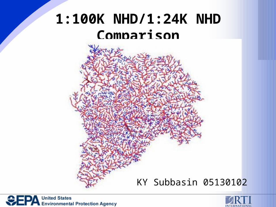
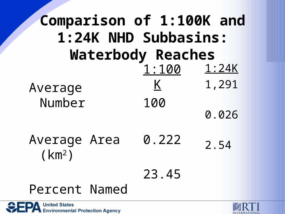
• Comparison of 1:100K NHD to 1:24K NHD

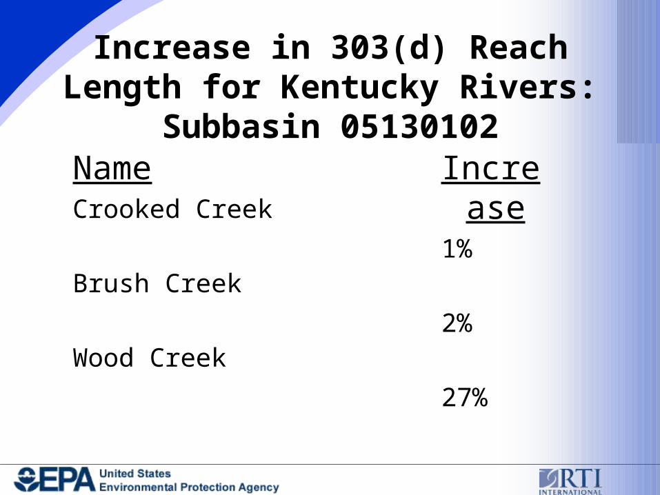
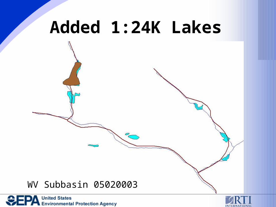
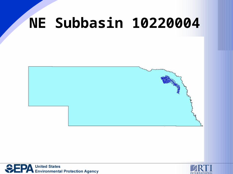
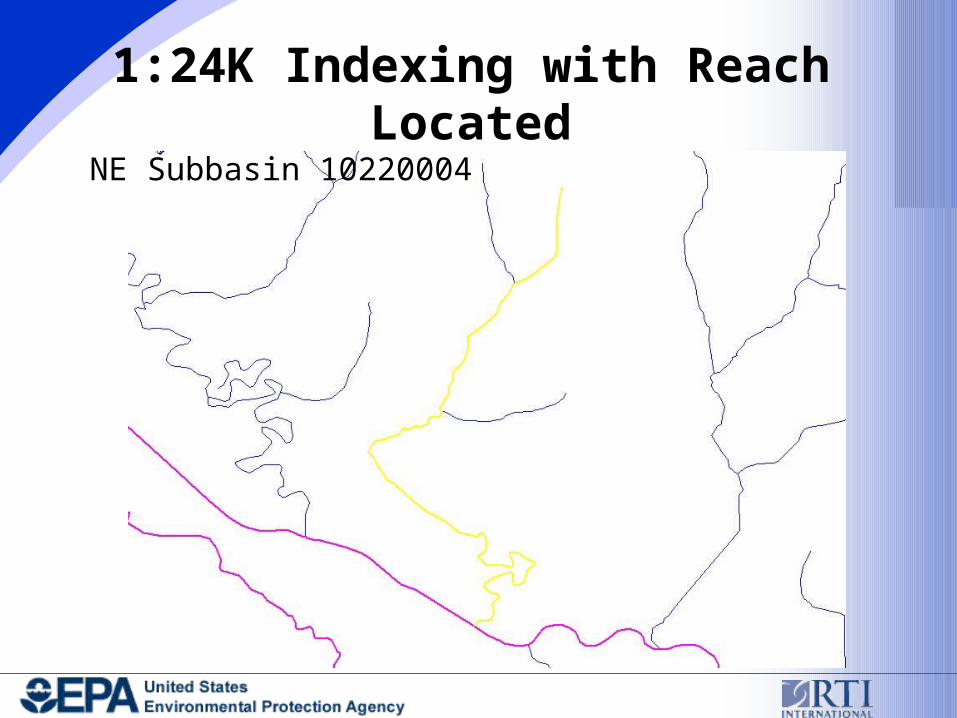
• Case Studies of 303(d), 305(b), and WQS Reach Indexing to 1:24K NHD

Overview

4

http://www.epa.gov/waters/enviromapper

Toxicology Research Support Services

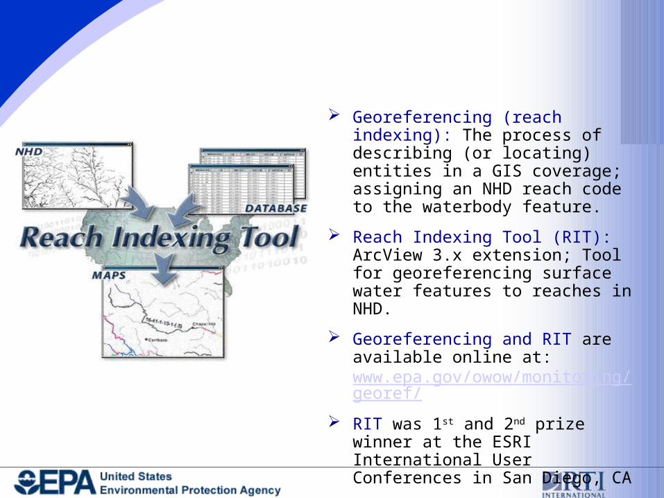
Indexing Tools and Resources

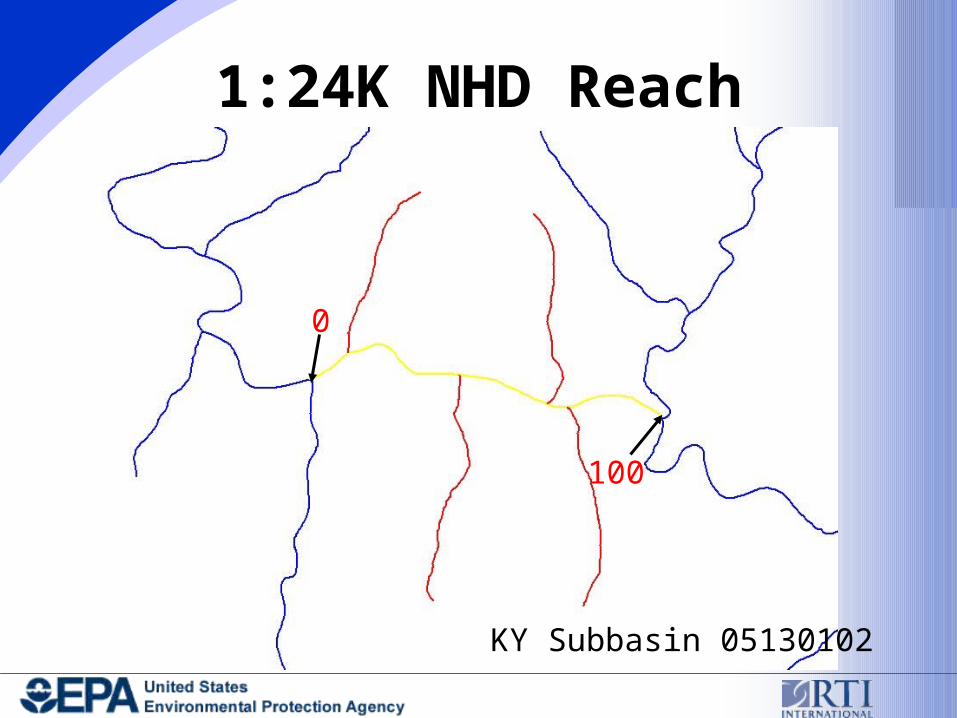
• National Hydrography Dataset (NHD)

• NHD Reach Indexing Tool (NHD-RIT)

• Automated Georeferencing Processes (e.g., for Adding General Use Waters)

Toxicology Research Support Services

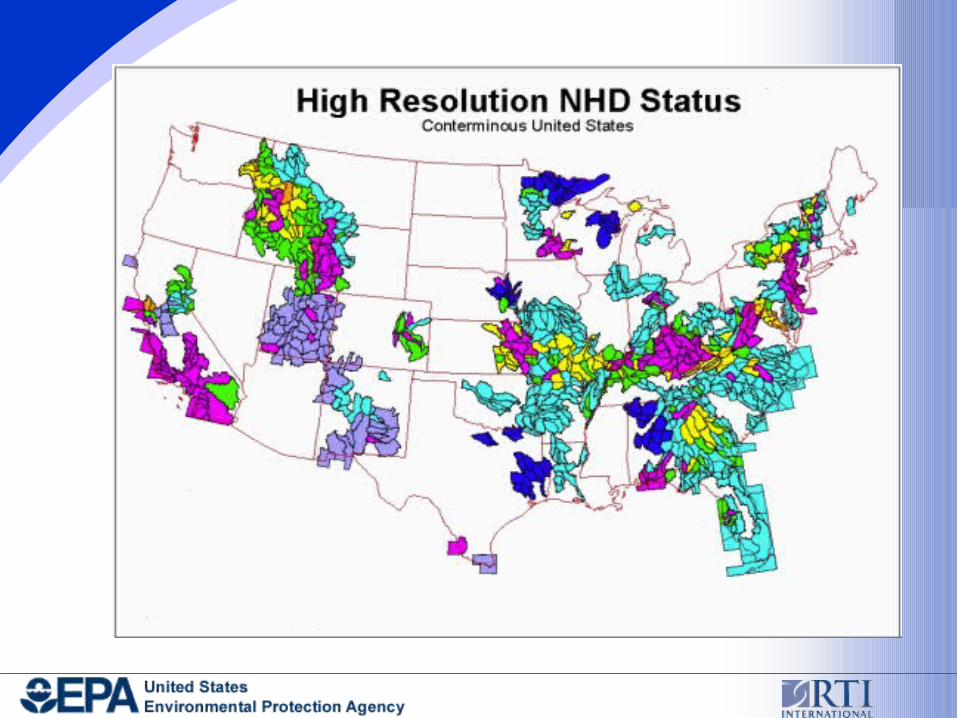
National Hydrography Dataset (NHD) Set of spatial data that contains

information about surface water features.

Surface water features are represented by "reaches," which are assigned unique identifiers

Contains 52 feature types including: streams, lakes, reservoirs, canals and dams.

Based upon the USGS Digital Line Graph (DLG) hydrography and the EPA Reach File Version 3 (RF3).

1:100,000-scale NHD (hi res IP)

NHD is available online at http://nhd.usgs.gov/

Toxicology Research Support Services Georeferencing (reach indexing): The

process of describing (or locating) entities in a GIS coverage; assigning an NHD reach code to the waterbody feature.

Reach Indexing Tool (RIT): ArcView 3.x extension; Tool for georeferencing surface water features to reaches in NHD.

Georeferencing and RIT are available online at: www.epa.gov/owow/monitoring/georef/

RIT was 1st and 2nd prize winner at the ESRI International User Conferences in San Diego, CA

Toxicology Research Support Services

EPA Program Database Link to GISDatabase

Event Table Indexed to NHD

NHD Coverage

GIS Map

MO1009MO1008

MO101010300102003685

Toxicology Research Support Services

Toxicology Research Support Services

20 Subbasins Analyzed from 18 States

Toxicology Research Support Services

KY Subbasin 05130102

Toxicology Research Support Services

1:100K NHD/1:24K NHD Comparison

KY Subbasin 05130102

Toxicology Research Support Services

1:100K NHD Reach

KY Subbasin 05130102

0

100

Toxicology Research Support Services

1:24K NHD Reach

KY Subbasin 05130102

0

100

Toxicology Research Support Services

1:100K

1,129

2,342

37.43

1:24K

3,482

1,279

16.92

Comparison of 1:100K and 1:24K NHD Subbasins: Linear Reaches

Average Number

Average Length (m)

Percent Named

Toxicology Research Support Services

1:100K

100

0.222

23.45

1:24K

1,291

0.026

2.54

Comparison of 1:100K and 1:24K NHD Subbasins: Waterbody Reaches

Average Number

Average Area (km2)

Percent Named

Toxicology Research Support ServicesNameChattahoochee River, GA

White River, VT

Green River, WY

Teagle Wash, CA

Mississippi River, MN

Change19%

2%

<1%

-9%

-14%

Change in Reach Length for Specific Rivers

Toxicology Research Support Services

303(d)

Georeferencing

Toxicology Research Support Services

NameCrooked Creek

Brush Creek

Wood Creek

Increase1%

2%

27%

Increase in 303(d) Reach Length for Kentucky Rivers: Subbasin 05130102

Toxicology Research Support Services

NameMonongahela River

Owl Creek

Laurel Run

Increase1%

3%

4%

Increase in 303(d) Reach Length for West Virginia Rivers: Subbasin 05020003

Toxicology Research Support Services

KY Subbasin 05130102

Toxicology Research Support Services

1:100K to 1:24K Shape Comparison

KY Subbasin 05130102

Toxicology Research Support Services

NameWood Creek Lake, KY

Deckers Creek Reservoirs, WV

Laurel Run Reservoirs, WV

Los Gatos Creek Reservoirs, CA

Coyote Creek Reservoirs, CA

Change-15%

-2%

-25%

5%

12%

Change in 303(d) Reach Areas for Lakes

Toxicology Research Support Services

305(b)

Georeferencing

Toxicology Research Support Services

WV Subbasin 05020003

Toxicology Research Support Services

Added 1:24K Lakes

WV Subbasin 05020003

Toxicology Research Support Services

Water Quality Standards

Georeferencing

Toxicology Research Support Services

NE Subbasin 10220004

Toxicology Research Support Services

1:100K Indexing with Point Event

NE Subbasin 10220004

Toxicology Research Support Services

1:24K Indexing with Reach Located

NE Subbasin 10220004

Toxicology Research Support Services

WV Subbasin 05020003

Toxicology Research Support Services

1:24K General Use Waters

WV Subbasin 05020003

WV Subbasin 05020003

Toxicology Research Support Services

Attribute

Total Reach Length

Total Waterbody Area

Increase

39%

53%

Increase in Total Reach Length and Area for KY Subbasin 05130102

Toxicology Research Support Services

Conclusions

• 1:24K NHD significantly increases the number of waterbodies that can be mapped

• Greater detail changes the shapes and lengths of NHD features

• Changes will impact mapping activities for all programs – tools will minimize impact

Toxicology Research Support Services

More Information & TrainingNHD web site:

http://nhd.usgs.gov/

NHD-RIT and Reach Indexing Web Site:www.epa.gov/owow/monitoring/georef/

EPA Watershed Assessment, Tracking & Environmental Results (WATERS)http://www.epa.gov/waters/

EPA Office of Water EnviroMapperhttp://www.epa.gov/waters/enviromapper


Recommended