100
US Army Corps of Engineers ® Kansas City District Draft Environmental Assessment for Chute Repairs and Modifications from 2019 Flood Damages May 2020
US Army Corps of Engineers ®
Kansas City District
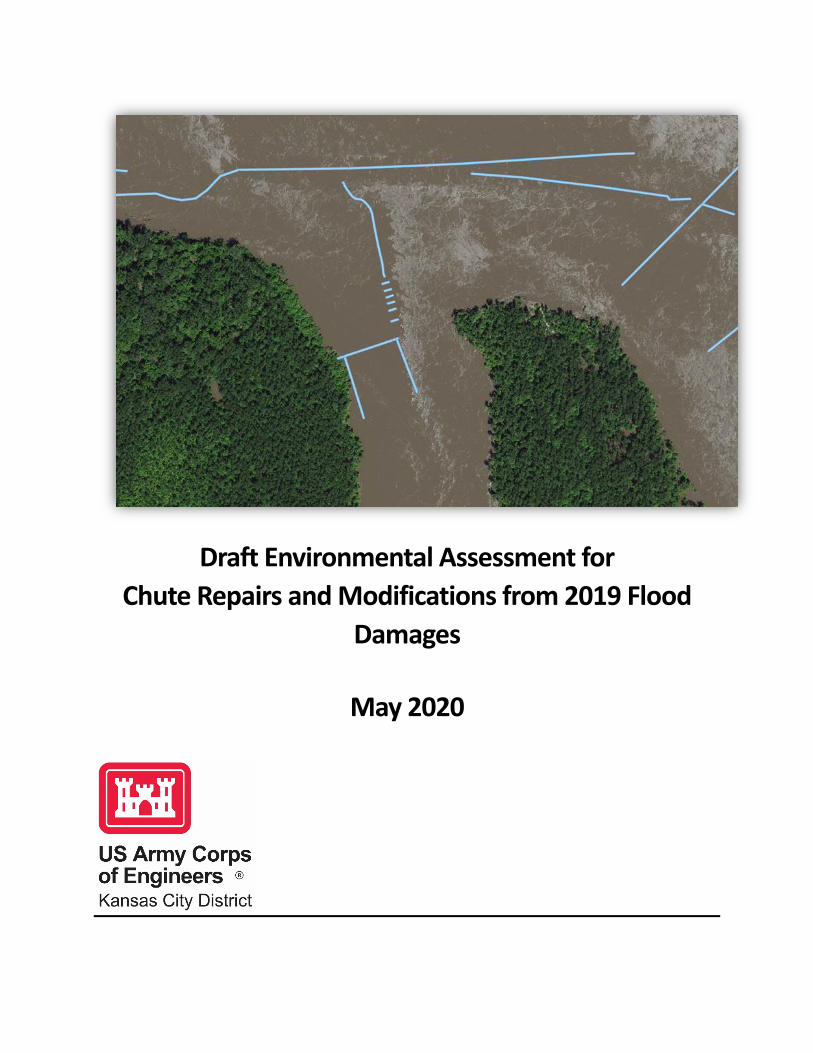
Draft Environmental Assessment for Chute Repairs and Modifications from 2019 Flood
Damages
May 2020

USACE Kansas City District Chute Repairs and Modifications EA
Page Intentionally Left Blank
ii
USACE Kansas City District Chute Repairs and Modifications EA
1.0 Table of Contents 1.0 Table of Contents................................................................................................................................... iii
2.0 List of Figures ......................................................................................................................................... iv
3.0 List of Tables ........................................................................................................................................... v
4.0 List of Appendices ................................................................................................................................... v
1.0 Introduction ............................................................................................................................................ 1
1.1. Missouri River Bank Stabilization and Navigation Project ................................................................. 1 1.2. BSNP Fish and Wildlife Mitigation Project ......................................................................................... 3 1.3. Endangered Species Act Compliance ................................................................................................. 4 1.4. Previous Related Reports................................................................................................................... 5
2.0 Purpose of and Need for the Proposed Action....................................................................................... 7
2.1. Purpose of the Proposed Action ........................................................................................................ 7 2.2. Need for the Proposed Action ........................................................................................................... 7
3.0 Proposed Action and Alternatives ........................................................................................................ 11
3.1. Proposed Action............................................................................................................................... 11 3.2. No Action Alternative....................................................................................................................... 23 3.3. Alternatives Considered but Dismissed ........................................................................................... 23
4.0 Affected Environment and Environmental Consequences ................................................................... 24
4.1. Impact Characterization................................................................................................................... 24 4.2. Resources Considered but Dismissed .............................................................................................. 24 4.3. Water Quality................................................................................................................................... 25 4.3.1. Affected Environment................................................................................................................... 25 4.3.2. Environmental Consequences....................................................................................................... 25 4.4. Fish and Wildlife Resources ............................................................................................................. 27 4.4.1. Affected Environment................................................................................................................... 27 4.4.2. Environmental Consequences....................................................................................................... 27 4.5. Terrestrial Resources ....................................................................................................................... 30 4.5.1. Affected Environment................................................................................................................... 30 4.5.2. Environmental Consequences....................................................................................................... 30 4.6. Threatened and Endangered Species .............................................................................................. 30 4.6.1. Affected Environment................................................................................................................... 30 4.6.2. Environmental Consequences....................................................................................................... 31 4.7. Cultural Resources ........................................................................................................................... 32 4.7.1. Affected Environment................................................................................................................... 32 4.7.2. Environmental Consequences....................................................................................................... 32 4.8. Recreation ........................................................................................................................................ 33 4.8.1. Affected Environment................................................................................................................... 33 4.8.2. Environmental Consequences....................................................................................................... 33
iii
USACE Kansas City District Chute Repairs and Modifications EA
4.9. Flood Risk ......................................................................................................................................... 33 4.9.1. Affected Environment................................................................................................................... 33 4.9.2. Environmental Consequences....................................................................................................... 33 4.10. Cumulative Impacts........................................................................................................................ 33 4.10.2. Past, Present, and Reasonably Foreseeable Future Actions....................................................... 34 4.10.3. Cumulative Impacts .................................................................................................................... 36 4.11. Climate Change Considerations ..................................................................................................... 36
5.0 Compliance with Environmental Laws.................................................................................................. 38
5.1. Archeological Resources Protection Act .......................................................................................... 38 5.2. Bald and Golden Eagle Protection Act ............................................................................................. 39 5.3. Clean Water Act ............................................................................................................................... 39 5.4. Endangered Species Act ................................................................................................................... 39 5.5. Fish and Wildlife Coordination Act .................................................................................................. 39 5.6. National Environmental Policy Act................................................................................................... 40 5.7. National Historic Preservation Act................................................................................................... 40
6.0 List of Preparers .................................................................................................................................... 41
7.0 Literature Cited ..................................................................................................................................... 42
2.0 List of Figures Figure 1-1. Typical Arrangement of BSNP Structures on the Missouri River................................................ 2
Figure 1-2. Typical Cross Section of the Missouri River Showing the BSNP Features that Create a Nine-feet-deep by 300-feet-wide Navigation Channel (Modified from USACE 1994) .......................................... 3
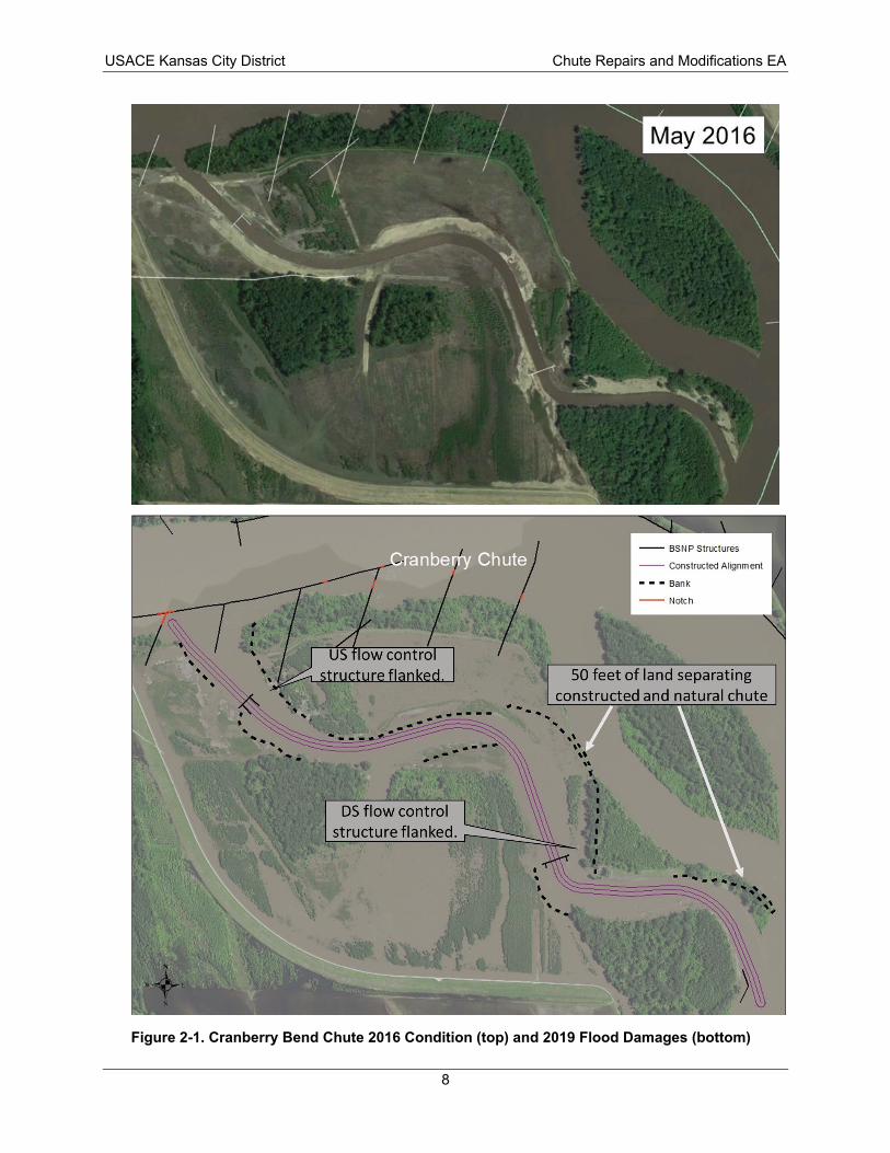
Figure 2-1. Cranberry Bend Chute 2016 Condition (top) and 2019 Flood Damages (bottom)..................... 8
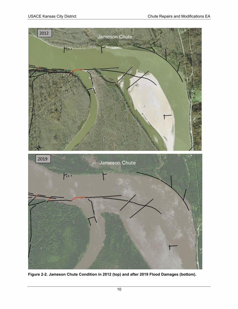
Figure 2-2. Jameson Chute Condition in 2012 (top) and after 2019 Flood Damages (bottom). ................ 10
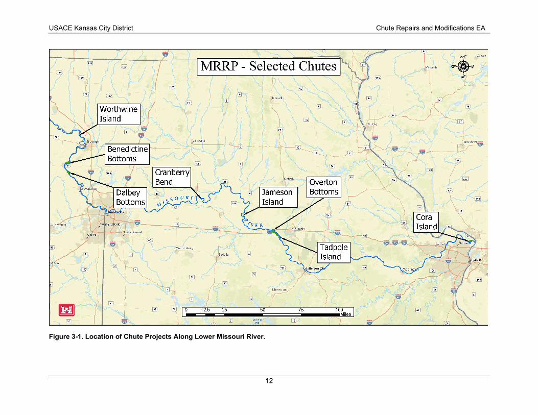
Figure 3-1. Location of Chute Projects Along Lower Missouri River........................................................... 12
Figure 3-2. Example of Repair to an Existing Flow Control Structure to Increase Elevation. ..................... 14
Figure 3-3. Example of Repair to a Flanked Flow Control Structure........................................................... 14
Figure 3-4. Initial Repair Design Concept for Cranberry Bend Chute. ........................................................ 16
Figure 3-5. Initial Repair Design Concept for Jameson Chute..................................................................... 17
Figure 3-6. Full Repair and Modification Design Concept for Cranberry Bend Chute. ............................... 18
Figure 3-7. Cora Chute Repair and Modification Concept. ......................................................................... 19
Figure 3-8. Tadpole Chute Repair and Modification Concept. ................................................................... 21
Figure 3-9. Overton North Chute Repair and Modification Concept.......................................................... 22
iv
29
USACE Kansas City District Chute Repairs and Modifications EA
3.0 List of Tables Table 3-1. Missouri River Recovery Program Chute Projects Requiring Repair and/or Modification. 11
Table 4-1. Median concentrations of common water quality collected from the Missouri River between the years 2010 and 2014. ............................................................................................................ 26
Table 4-2. Smallmouth Buffalo Habitat Suitability Index Model Variables and Data Inputs for Existing Conditions and Proposed Action. Table 4-3. Summary of Habitat Evaluation Results.............................................................................. 30
Table 4-4. Federally listed species that may occur in or near the project area................................... 31
Table 5-1. Compliance with Environmental Quality Statutes. ............................................................. 38
4.0 List of Appendices Appendix A Public Notice and Section 404(b)(1) Evaluation Appendix B USFWS Coordination Appendix C Cultural Resources Agency and Tribal Coordination (Placeholder)
v
USACE Kansas City District Chute Repairs and Modifications EA
Page Intentionally Left Blank
vi
USACE Kansas City District Chute Repairs and Modifications EA
Finding of No Significant Impact MRRP Chute Repairs and Modifications from 2019 Flood Damages
Environmental Assessment
Summary
The U.S. Army Corps of Engineers, Kansas City District (USACE), has conducted an environmental assessment (EA) in accordance with the National Environmental Policy Act of 1969 (NEPA), as amended. USACE assessed the effects of the proposed Missouri River Recovery Program (MRRP) side channel chute project (chutes) repairs and modifications. The EA is incorporated herein by reference.
The USACE Proposed Action is to repair and modify MRRP chutes to manage the amount of flow through the chute to maintain adequate flow in the navigation channel and maintain shallow water habitat, which by definition include[s] side channels, backwaters, depositional sandbars detached from the bank, and low-lying depositional areas adjacent to shorelines. Work is anticipated at eight MRRP chutes in the USACE Kansas City District area of responsibility. The amount of repair and modification varies by chute. The purpose of the Proposed Action is to repair and modify MRRP chutes to reduce the possibility of adversely affecting the authorized navigation channel and to provide more beneficial habitat in the chutes. The Proposed Action is needed because the 2019 floods resulted in sustained high flows on the Missouri River that caused wide-scale damage to both MRRP chutes and Missouri River Bank Stabilization and Navigation Project (BSNP) structures.
Restoring chutes and side channels was a primary means of creating shallow water habitat to achieve the pallid sturgeon (Scaphirhynchus albus) requirements of the U.S. Fish and Wildlife Service (USFWS) 2003 Amended Biological Opinion (BiOp). USACE consulted again with the USFWS as part of development of the Missouri River Recovery Management Plan (MRRMP). This culminated in a 2018 BiOp for the Operation of the Missouri River Mainstem Reservoir System, the Operation and Maintenance of the Bank Stabilization and Navigation Project, the Operation of Kansas River Reservoir System, and the Implementation of the Missouri River Recovery Management Plan. The 2018 BiOp supersedes the 2003 Amended BiOp. There is no longer a requirement for creation of shallow water habitat in the 2018 BiOp. However, the 2018 BiOp does stipulate the construction of interception rearing complexes (IRCs). Interception, food-producing, and foraging habitats for age-0 pallid sturgeon may be inter-related, as it is the combination of habitats that could result in retention and survival of young fish in supportive habitats. USACE committed to a rate and timeframe of IRC habitat construction, including the potential for refurbishing chutes into IRCs to contribute to achieving habitat targets. As a result, repair or modification of MRRP chutes must consider the implications for future refurbishment of chutes to serve as IRCs.
No Action Alternative
Under the No Action alternative, no repairs or modifications would be made at the MRRP chutes. USACE would not be able to select this alternative because the agency is Congressionally mandated to maintain the BSNP; however, it is included in the range of alternatives as a benchmark for comparison of impacts, consistent with the Council on Environmental Quality (CEQ) NEPA regulations.
Proposed Action
The Proposed Action includes repairs and modifications at eight MRRP chutes that would control flow into the chute and enhance habitat in the chute. It is anticipated that a phased approach would be required
ES-1
USACE Kansas City District Chute Repairs and Modifications EA
to complete the full repair and modification for each chute because of funding limitations. At certain chutes, initial modifications may be completed first to gain control of flow into the chute, with the full modifications completed later as funding becomes available or river conditions allow for more comprehensive inspections of the chutes to fully assess the extent of repairs required.
An example of a full modification at Cranberry Bend chute includes raising the revetment and dikes at the chute entrance to +7 feet above the construction reference plane (CRP), repairing both flanked flow control structures in the chute and adding bank protection where excessive erosion has occurred. The concept requires approximately 175,000 tons of rock. The magnitude of work at Cranberry Bend chute represents a high end of required rock tonnage.
It is anticipated that the following techniques would be used to achieve the intended repairs and modifications at MRRP chutes:
• Repair of degraded or damaged existing flow control structures.
• Extension of existing flow control structures to repair flanked areas and re-establish connection with bank.
• Modification of flow control structure elevations to manage flow through the chute.
• Addition of new flow control structures to manage flow or increase robustness of flow control. Typically, no more than two new flow control structures would be added to a chute to manage flow and characteristics within the chute. The number of new flow control structures would depend on the morphology and conditions at each chute. A new flow control structure would likely require approximately 10,000 to 20,000 tons of rock, which may vary based on site-specific conditions.
• Addition of new river training structures in the chute to manage flow, prevent excessive erosion, prevent avulsions, or protect existing flow control structures. If employed in a chute, this technique would likely require placing 3 to 6 new dikes requiring approximately 2,000 to 5,000 tons of rock per dike. Maximum heights of structures would be top of bank (i.e. generally +10 to +13 feet relative to the CRP). Quantities may vary depending on site-specific conditions.
• Addition of bank protection, including revetment, bank paving, and hardpoints, to prevent compromising or flanking of flow control structure, excessive widening, or channel avulsion.
• Modification of existing structures’ heights within the main channel, but near the entrance or exit of the chute to manage flow through the chute. Maximum heights of structures would be top of bank (i.e. generally +10 to +13 feet relative to CRP).
• Elimination or reduction of the size of notches in existing structures to manage the flow quantity and flow paths in and around chutes.
The initial phase of work that would be implemented under the Proposed Action includes repair and modification at Cranberry, Jameson, Cora, Tadpole, and Overton North chutes:
• Cranberry Chute – Raise the existing revetment and dikes at the chute entrance to +7 CRP and fill existing notches except for the notch in the downstream dike. Add five hardpoints near RM 282.9. This work is estimated to require approximately 31,000 tons of rock.
• Jameson Chute – Raise existing dike and revetment structures at the chute entrance to +10 CRP. Repair the existing flow control structure to as-built conditions. New bank armoring would be
ES-2
USACE Kansas City District Chute Repairs and Modifications EA
placed up and downstream of the flow control structure. This work is estimated to require approximately 40,000 tons of rock.
• Cora Chute –Extend the existing revetment at the chute entrance downstream to connect to the L-head structure at +5 CRP. The L-head would be repaired to +6 CRP and existing notches in that structure filled. The existing flow control structure invert (i.e. the lowest point in the structure cross section) would be raised to +3 CRP. The bank head and remainder of the existing flow control structure would be repaired to as-built conditions. Approximately 350 feet of new toe trench revetment would be added on the left bank upstream of the flow control structure. Approximately 400 feet of new bank paving would be installed from existing toe trench revetment to tie into the dike at the bank. This work is estimated to require approximately 37,000 tons of rock.
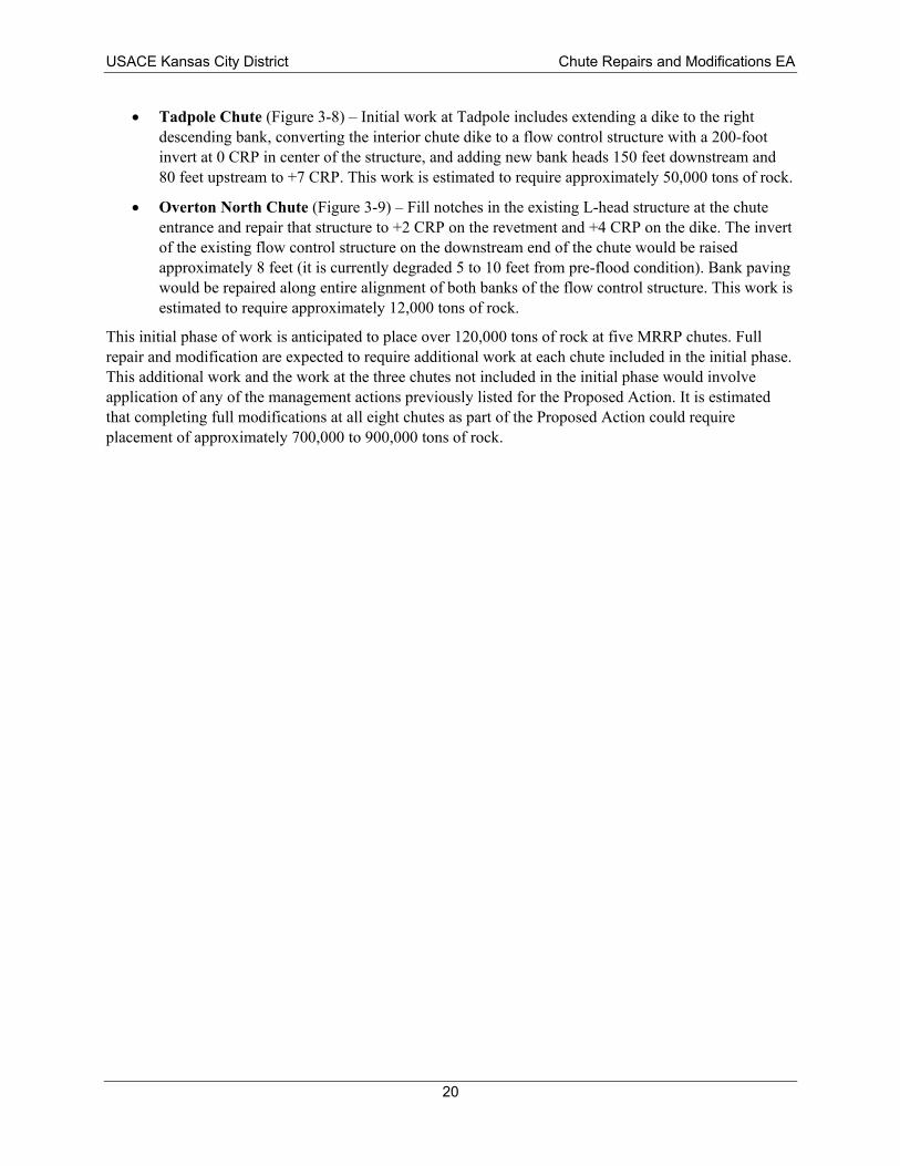
• Tadpole Chute – Initial work at Tadpole includes extending a dike to the right descending bank, converting the interior chute dike to a flow control structure with a 200-foot invert at 0 CRP in center of the structure, and adding new bank heads 150 feet downstream and 80 feet upstream to +7 CRP. This work is estimated to require approximately 50,000 tons of rock.
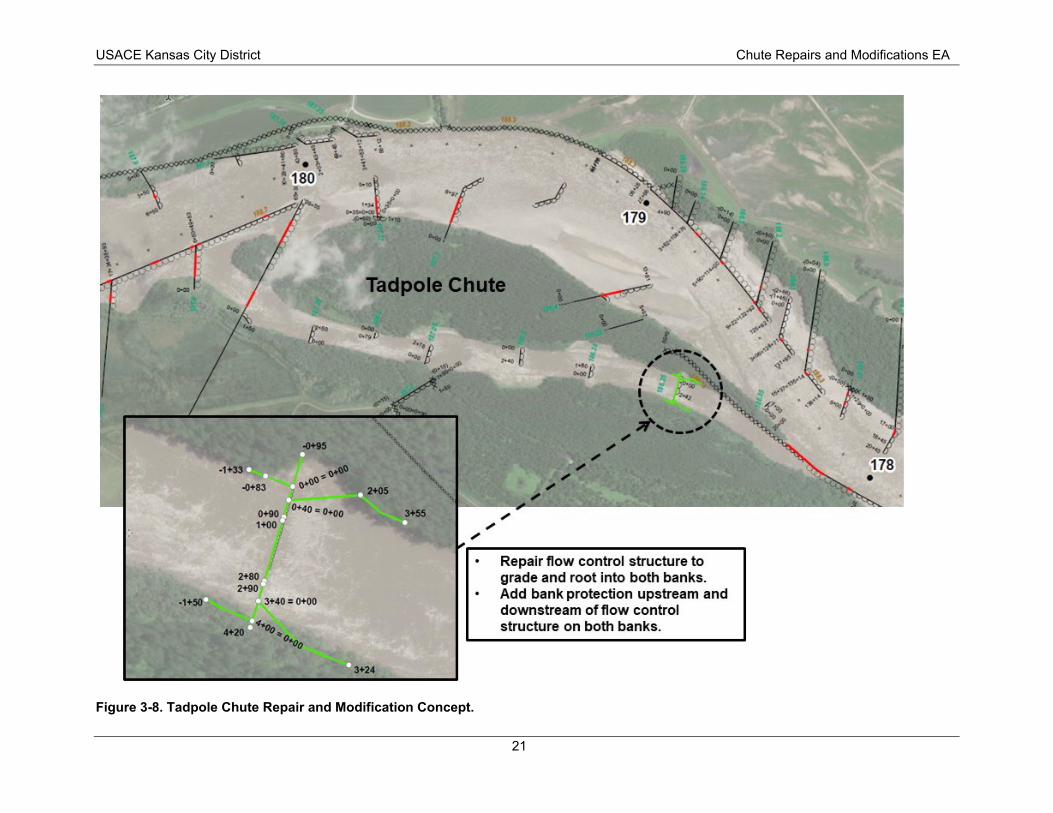
• Overton North Chute – Fill notches in the existing L-head structure at the chute entrance and repair that structure to +2 CRP on the revetment and +4 CRP on the dike. The invert of the existing flow control structure on the downstream end of the chute would be raised approximately 8 feet (it is currently degraded 5 to 10 feet from pre-flood condition). Bank paving would be repaired along entire alignment of both banks of the flow control structure. This work is estimated to require approximately 12,000 tons of rock.
This initial phase of work is anticipated to place over 120,000 tons of rock at five MRRP chutes. Full repair and modification are expected to require additional work at each chute included in the initial phase. This additional work and the work at the three chutes not included in the initial phase would involve application of any of the management actions previously listed for the Proposed Action. It is estimated that completing full modifications at all eight chutes as part of the Proposed Action could require placement of approximately 700,000 to 900,000 tons of rock.
Summary of Environmental Impacts
The No Action alternative and Proposed Action were evaluated in the EA. No or negligible impacts are anticipated to air quality, commercial sand and gravel dredging, environmental justice, invasive species, wetlands, and prime and unique farmland. Beneficial impacts to navigation are anticipated. Short-term localized adverse impacts to water quality would be anticipated due to construction activities. Fish and wildlife and terrestrial resources may experience short-term adverse impacts from disturbance during construction activities. Fish and wildlife are expected to see beneficial impacts from the changes in habitat within the chutes under either alternative. Minor adverse impacts to recreation would be expected from less frequent access via boat, kayak, or canoe into the chutes. Flood risk is not anticipated to change noticeably.
All practicable means to avoid and minimize adverse environmental effects have been incorporated into the Proposed Action. The Proposed Action was determined to “may affect, but not likely adversely affect” federally-listed threatened or endangered species and would not affect designated critical habitat, would have no impact to sites listed on or eligible for inclusion on the National Register of Historic Places, and would not significantly affect any wetlands or water of the U.S., nor any important wildlife habitat.
ES-3
USACE Kansas City District Chute Repairs and Modifications EA
Public Availability
A description of the Proposed Action was circulated to the public and resource agencies through a Public Notice, No. 2020-001-CW, dated May 12, 2020, with a 30-day comment period ending on June 11, 2020. This notice contained a project description, along with information on the USACE preliminary determination to prepare a FONSI and a draft Section 404(b)(1) Evaluation. The Draft EA, Draft FONSI, and Public Notice were provided for public/agency review through the Office of Public Affairs.
Conclusion
All applicable laws, executive orders, regulations, and local government plans were considered in the evaluation of the Proposed Action. It is my determination that the Proposed Action does not constitute a major federal action that would significantly affect the human environment; therefore, preparation of an Environmental Impact Statement is not required.
Date: ____________________ __________________________________________
William C. Hannan, Jr.
Colonel, Corps of Engineers
District Commander
ES-4
USACE Kansas City District Chute Repairs and Modifications EA
1.0 Introduction The 2019 floods resulted in sustained high flows on the Missouri River that caused wide-scale damage to both Missouri River Recovery Program (MRRP) side channel chute projects and Missouri River Bank Stabilization and Navigation Project (BSNP) structures. The scope of this Environmental Assessment (EA), prepared in compliance with the National Environmental Policy Act (NEPA), includes the repair and modification of MRRP side channel chute projects within the area of responsibility of the U.S. Army Corps of Engineers (USACE), Kansas City District. Side channel chutes have both downstream and upstream ends connected to the main river channel. They are narrower than the main river channel and bordered by the mainland, vegetated sandbars, sandbars, or islands.
The MRRP was established by USACE in 2005. It is the umbrella program that coordinates USACE efforts in the following:
• Endangered Species Act (ESA) compliance for the Operation of the Missouri River Main Stem Reservoir System, Operation and Maintenance of the BSNP, and Operation of the Kansas River Reservoir System;
• Acquiring and developing lands to mitigate for lost habitats as authorized in Section 601(a) of the Water Resources Development Act (WRDA) of 1986 and modified by Section 334(a) of WRDA 1999 (collectively known as the BSNP Fish and Wildlife Mitigation Project); and
• Implementation of WRDA 2007 including the Missouri River Recovery Implementation Committee and Section 3176, which allowed USACE to use recovery and mitigation funds in the upper basin states of Montana, Nebraska, North Dakota, and South Dakota.
USACE constructed MRRP side channel chutes for the dual purposes of (1) mitigating a lost habitat type under the authorities of the BSNP Fish and Wildlife Mitigation Project and (2) complying with the 2003 Amended Biological Opinion (BiOp) for the Operation of the Missouri River Main Stem Reservoir System, Operation and Maintenance of the BSNP, and Operation of the Kansas River Reservoir System that required restoring shallow water habitat to benefit the pallid sturgeon (Scaphirhynchus albus) based on best available science at the time. The shallow water habitat requirement of the 2003 Amended BiOp was subsequently superseded by the 2018 BiOp. All the MRRP chutes included in this EA are located on public land.
This chapter provides background on the BSNP, BSNP Fish and Wildlife Mitigation Project, and ESA compliance for the pallid sturgeon. Chapter 2 describes the purpose and need for the Proposed Action. Chapter 3 describes the Proposed Action and alternatives. Chapter 4 presents the resources affected by the Proposed Action and the environmental impacts.
1.1. Missouri River Bank Stabilization and Navigation Project Shortly after Lewis and Clark explored the Missouri River, the Federal Government started efforts to modify the Missouri River to support navigation. Starting as early as 1819, funds were appropriated by Congress to survey the river; remove river habitat features viewed as obstructive, such as snags, and to confine the river by locking its banks at specified locations. Beginning in 1912, Congress passed the first of several laws (Rivers and Harbors Acts of 1912, 1925, 1927, 1935, and 1945) to fund work by USACE to further improve the river for navigation. This work would later become known as the BSNP. The BSNP features authorized by these laws would further confine the natural river by providing for a comparably static, uniform depth, width, and length. From 1932 to 1973, USACE regularly dredged areas of the navigation channel that were prone to deposition.
1
DIKE
STANDARD REVETMENT
- 1/ BURIED DIKE
CONVEX DIKE UNDERWATER SILL
ROCK HARD POINTS L-HEAD REVETMENT
KICKER
CROSSING CONTROL STRUCTURE
STONE FILL REVETMENT
NOTCH
USACE Kansas City District Chute Repairs and Modifications EA
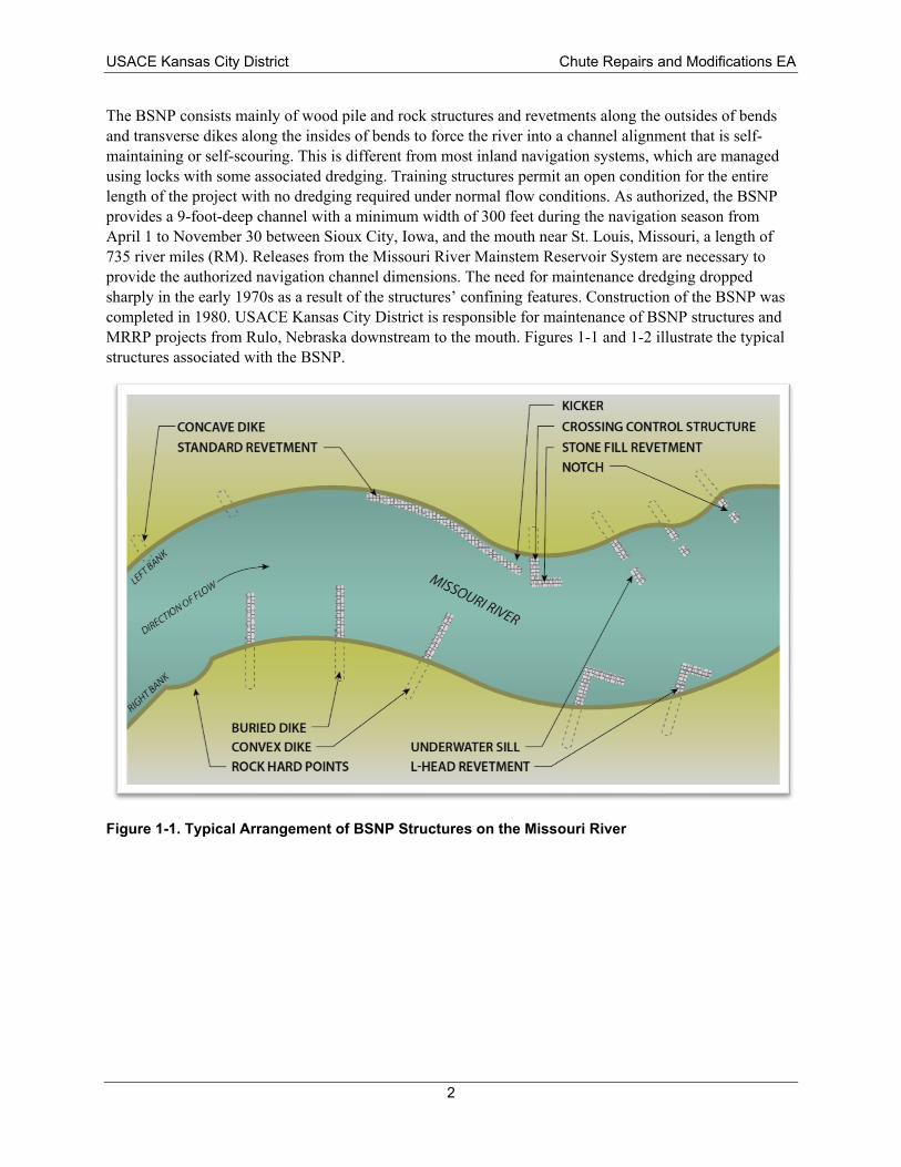
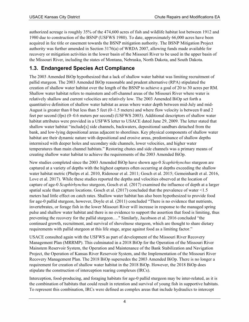
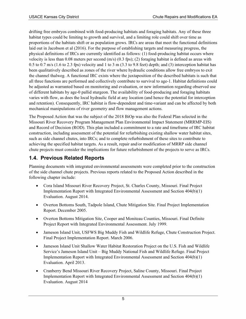
The BSNP consists mainly of wood pile and rock structures and revetments along the outsides of bends and transverse dikes along the insides of bends to force the river into a channel alignment that is self-maintaining or self-scouring. This is different from most inland navigation systems, which are managed using locks with some associated dredging. Training structures permit an open condition for the entire length of the project with no dredging required under normal flow conditions. As authorized, the BSNP provides a 9-foot-deep channel with a minimum width of 300 feet during the navigation season from April 1 to November 30 between Sioux City, Iowa, and the mouth near St. Louis, Missouri, a length of 735 river miles (RM). Releases from the Missouri River Mainstem Reservoir System are necessary to provide the authorized navigation channel dimensions. The need for maintenance dredging dropped sharply in the early 1970s as a result of the structures’ confining features. Construction of the BSNP was completed in 1980. USACE Kansas City District is responsible for maintenance of BSNP structures and MRRP projects from Rulo, Nebraska downstream to the mouth. Figures 1-1 and 1-2 illustrate the typical structures associated with the BSNP.
Figure 1-1. Typical Arrangement of BSNP Structures on the Missouri River
2
USACE Kansas City District Chute Repairs and Modifications EA
River Bank
Dike
Missouri River
Sill
Revetment
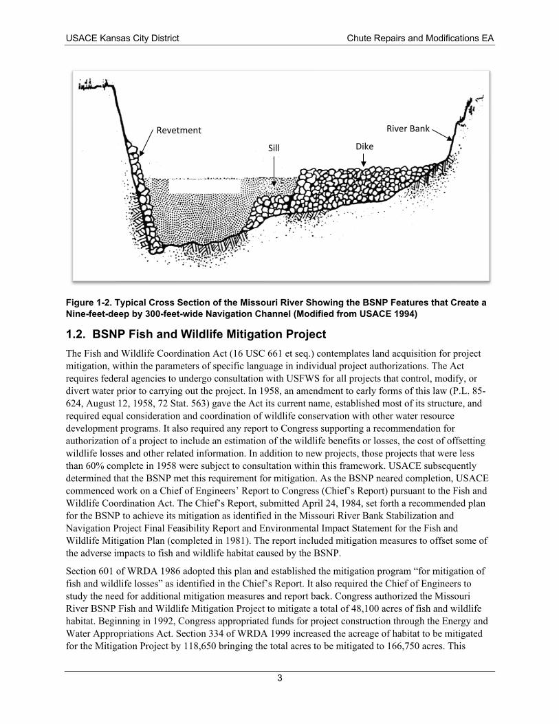
Figure 1-2. Typical Cross Section of the Missouri River Showing the BSNP Features that Create a Nine-feet-deep by 300-feet-wide Navigation Channel (Modified from USACE 1994)
1.2. BSNP Fish and Wildlife Mitigation Project The Fish and Wildlife Coordination Act (16 USC 661 et seq.) contemplates land acquisition for project mitigation, within the parameters of specific language in individual project authorizations. The Act requires federal agencies to undergo consultation with USFWS for all projects that control, modify, or divert water prior to carrying out the project. In 1958, an amendment to early forms of this law (P.L. 85-624, August 12, 1958, 72 Stat. 563) gave the Act its current name, established most of its structure, and required equal consideration and coordination of wildlife conservation with other water resource development programs. It also required any report to Congress supporting a recommendation for authorization of a project to include an estimation of the wildlife benefits or losses, the cost of offsetting wildlife losses and other related information. In addition to new projects, those projects that were less than 60% complete in 1958 were subject to consultation within this framework. USACE subsequently determined that the BSNP met this requirement for mitigation. As the BSNP neared completion, USACE commenced work on a Chief of Engineers’ Report to Congress (Chief’s Report) pursuant to the Fish and Wildlife Coordination Act. The Chief’s Report, submitted April 24, 1984, set forth a recommended plan for the BSNP to achieve its mitigation as identified in the Missouri River Bank Stabilization and Navigation Project Final Feasibility Report and Environmental Impact Statement for the Fish and Wildlife Mitigation Plan (completed in 1981). The report included mitigation measures to offset some of the adverse impacts to fish and wildlife habitat caused by the BSNP.
Section 601 of WRDA 1986 adopted this plan and established the mitigation program “for mitigation of fish and wildlife losses” as identified in the Chief’s Report. It also required the Chief of Engineers to study the need for additional mitigation measures and report back. Congress authorized the Missouri River BSNP Fish and Wildlife Mitigation Project to mitigate a total of 48,100 acres of fish and wildlife habitat. Beginning in 1992, Congress appropriated funds for project construction through the Energy and Water Appropriations Act. Section 334 of WRDA 1999 increased the acreage of habitat to be mitigated for the Mitigation Project by 118,650 bringing the total acres to be mitigated to 166,750 acres. This
3
USACE Kansas City District Chute Repairs and Modifications EA
authorized acreage is roughly 35% of the 474,600 acres of fish and wildlife habitat lost between 1912 and 1980 due to construction of the BSNP (USFWS 1980). To date, approximately 66,000 acres have been acquired in fee title or easement towards the BSNP mitigation authority. The BSNP Mitigation Project authority was further amended in Section 3176(a) of WRDA 2007, allowing funds made available for recovery or mitigation activities in the lower basin of the Missouri River to be used in the upper basin of the Missouri River, including the states of Montana, Nebraska, North Dakota, and South Dakota.
1.3. Endangered Species Act Compliance The 2003 Amended BiOp hypothesized that a lack of shallow water habitat was limiting recruitment of pallid sturgeon. The 2003 Amended BiOp reasonable and prudent alternative (RPA) stipulated the creation of shallow water habitat over the length of the BSNP to achieve a goal of 20 to 30 acres per RM. Shallow water habitat refers to mainstem and off-channel areas of the Missouri River where water is relatively shallow and current velocities are relatively low. The 2003 Amended BiOp set forth a quantitative definition of shallow water habitat as areas where water depth between mid-July and mid-August is greater than 0 but less than 5 feet (0–1.5 meters) and where flow velocity is between 0 and 2 feet per second (fps) (0–0.6 meters per second) (USFWS 2003). Additional descriptors of shallow water habitat attributes were provided in a USFWS letter to USACE dated June 29, 2009. The letter stated that shallow water habitat “include[s] side channels, backwaters, depositional sandbars detached from the bank, and low-lying depositional areas adjacent to shorelines. Key physical components of shallow water habitat are their dynamic nature with depositional and erosive areas, predominance of shallow depths intermixed with deeper holes and secondary side channels, lower velocities, and higher water temperatures than main channel habitats.” Restoring chutes and side channels was a primary means of creating shallow water habitat to achieve the requirements of the 2003 Amended BiOp.
New studies completed since the 2003 Amended BiOp have shown age-0 Scaphirhynchus sturgeon are captured at a variety of depths with the highest captures often occurring at depths exceeding the shallow water habitat metric (Phelps et al. 2010, Ridenour et al. 2011; Gosch et al. 2015; Gemeinhardt et al. 2016, Love et al. 2017). While these studies reported the depths and velocities observed at the location of capture of age-0 Scaphirhynchus sturgeon, Gosch et al. (2017) examined the influence of depth at a larger spatial scale than capture locations. Gosch et al. (2017) concluded that the prevalence of water <1.5 meters had little effect on catch rates. Shallow water habitat has also been hypothesized to provide food for age-0 pallid sturgeon, however, Doyle et al. (2011) concluded “There is no evidence that nutrients, invertebrates, or forage fish in the lower Missouri River will increase in response to the managed spring pulse and shallow water habitat and there is no evidence to support the assertion that food is limiting, thus preventing the recovery for the pallid sturgeon…." Similarly, Jacobson et al. 2016 concluded “the continued growth, recruitment, and survival of shovelnose sturgeon, which are thought to share dietary requirements with pallid sturgeon at this life stage, argue against food as a limiting factor.”
USACE consulted again with the USFWS as part of development of the Missouri River Recovery Management Plan (MRRMP). This culminated in a 2018 BiOp for the Operation of the Missouri River Mainstem Reservoir System, the Operation and Maintenance of the Bank Stabilization and Navigation Project, the Operation of Kansas River Reservoir System, and the Implementation of the Missouri River Recovery Management Plan. The 2018 BiOp supersedes the 2003 Amended BiOp. There is no longer a requirement for creation of shallow water habitat in the 2018 BiOp. However, the 2018 BiOp does stipulate the construction of interception rearing complexes (IRCs).
Interception, food-producing, and foraging habitats for age-0 pallid sturgeon may be inter-related, as it is the combination of habitats that could result in retention and survival of young fish in supportive habitats. To represent this combination, IRCs were defined as complex areas that include hydraulics to intercept
4
USACE Kansas City District Chute Repairs and Modifications EA
drifting free embryos combined with food-producing habitats and foraging habitats. Any of these three habitat types could be limiting to growth and survival, and a limiting role could shift over time as proportions of the habitats shift or as population grows. IRCs are areas that meet the functional definitions laid out in Jacobson et al (2016). For the purpose of establishing targets and measuring progress, the physical definitions of IRCs are currently identified as follows: (1) food-producing habitat occurs where velocity is less than 0.08 meters per second (m/s) (0.3 fps); (2) foraging habitat is defined as areas with 0.5 to 0.7 m/s (1.6 to 2.3 fps) velocity and 1 to 3 m (3.3 to 9.8 feet) depth; and (3) interception habitat has been qualitatively described as zones of the river where hydraulic conditions allow free embryos to exit the channel thalweg. A functional IRC exists where the juxtaposition of the described habitats is such that all three functions are performed and collectively contribute to survival to age-1. Habitat definitions could be adjusted as warranted based on monitoring and evaluation, or new information regarding observed use of different habitats by age-0 pallid sturgeon. The availability of food-producing and foraging habitats varies with flow, as does the local hydraulic field at any location (and hence the potential for interception and retention). Consequently, IRC habitat is flow-dependent and time-variant and can be affected by both mechanical manipulations of river geometry and flow management actions.
The Proposed Action that was the subject of the 2018 BiOp was also the Federal Plan selected in the Missouri River Recovery Program Management Plan Environmental Impact Statement (MRRMP-EIS) and Record of Decision (ROD). This plan included a commitment to a rate and timeframe of IRC habitat construction, including assessment of the potential for refurbishing existing shallow water habitat sites, such as side channel chutes, into IRCs; and to complete refurbishment of these sites to contribute to achieving the specified habitat targets. As a result, repair and/or modification of MRRP side channel chute projects must consider the implications for future refurbishment of the projects to serve as IRCs.
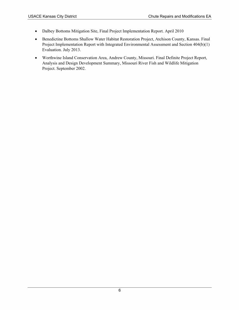
1.4. Previous Related Reports Planning documents with integrated environmental assessments were completed prior to the construction of the side channel chute projects. Previous reports related to the Proposed Action described in the following chapter include:
• Cora Island Missouri River Recovery Project, St. Charles County, Missouri. Final Project Implementation Report with Integrated Environmental Assessment and Section 404(b)(1) Evaluation. August 2014.
• Overton Bottoms South, Tadpole Island, Chute Mitigation Site. Final Project Implementation Report. December 2005.
• Overton Bottoms Mitigation Site, Cooper and Moniteau Counties, Missouri. Final Definite Project Report with Integrated Environmental Assessment. July 1999.
• Jameson Island Unit, USFWS Big Muddy Fish and Wildlife Refuge, Chute Construction Project. Final Project Implementation Report. March 2006.
• Jameson Island Unit Shallow Water Habitat Restoration Project on the U.S. Fish and Wildlife Service’s Jameson Island Unit – Big Muddy National Fish and Wildlife Refuge. Final Project Implementation Report with Integrated Environmental Assessment and Section 404(b)(1) Evaluation. April 2013.
• Cranberry Bend Missouri River Recovery Project, Saline County, Missouri. Final Project Implementation Report with Integrated Environmental Assessment and Section 404(b)(1) Evaluation. August 2014
5
USACE Kansas City District Chute Repairs and Modifications EA
• Dalbey Bottoms Mitigation Site, Final Project Implementation Report. April 2010
• Benedictine Bottoms Shallow Water Habitat Restoration Project, Atchison County, Kansas. Final Project Implementation Report with Integrated Environmental Assessment and Section 404(b)(1) Evaluation. July 2013.
• Worthwine Island Conservation Area, Andrew County, Missouri. Final Definite Project Report, Analysis and Design Development Summary, Missouri River Fish and Wildlife Mitigation Project. September 2002.
6
USACE Kansas City District Chute Repairs and Modifications EA
2.0 Purpose of and Need for the Proposed Action 2.1. Purpose of the Proposed Action The purpose of the Proposed Action is to repair and modify MRRP chutes to reduce the possibility of adversely affecting the authorized navigation channel and to provide more beneficial habitat in the chutes.
2.2. Need for the Proposed Action MRRP chute projects were designed in a manner that would not adversely affect the authorized purposes of other Missouri River projects, including flood control and navigation. Chute projects were designed and constructed to maintain sufficient flow in the navigation channel, and not result in deposition that would cause shoaling within the navigation channel. USACE routinely monitors the Missouri River navigation channel and coordinates these efforts with the U.S. Coast Guard and commercial navigators on the river. If navigation impediments are identified, USACE performs corrective actions as part of ongoing maintenance of the BSNP. Chutes typically include one or more flow control structures to limit degradation within the chute and maintain the proper flow between the chute and the main channel. Typically, it is desired that the chute captures less than 10% of total river volume flows when stages are at or below typical navigation stages; however, surveys conducted after the 2019 flood documented that at least three chutes are capturing over 10% of total river volume flows. Excessive flow through the chutes can create an imbalance in the sediment transport capacity in the main channel, potentially leading to shoaling that can impact navigation channel dimensions.
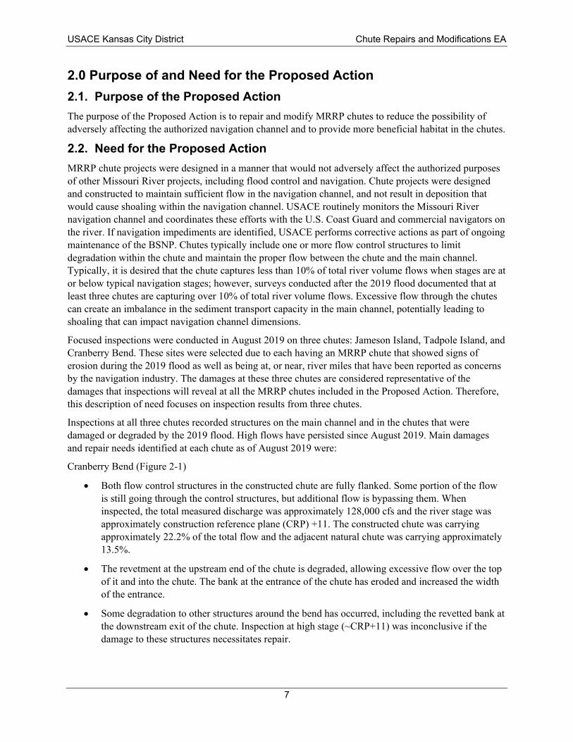
Focused inspections were conducted in August 2019 on three chutes: Jameson Island, Tadpole Island, and Cranberry Bend. These sites were selected due to each having an MRRP chute that showed signs of erosion during the 2019 flood as well as being at, or near, river miles that have been reported as concerns by the navigation industry. The damages at these three chutes are considered representative of the damages that inspections will reveal at all the MRRP chutes included in the Proposed Action. Therefore, this description of need focuses on inspection results from three chutes.
Inspections at all three chutes recorded structures on the main channel and in the chutes that were damaged or degraded by the 2019 flood. High flows have persisted since August 2019. Main damages and repair needs identified at each chute as of August 2019 were:
Cranberry Bend (Figure 2-1)
• Both flow control structures in the constructed chute are fully flanked. Some portion of the flow is still going through the control structures, but additional flow is bypassing them. When inspected, the total measured discharge was approximately 128,000 cfs and the river stage was approximately construction reference plane (CRP) +11. The constructed chute was carrying approximately 22.2% of the total flow and the adjacent natural chute was carrying approximately 13.5%.
• The revetment at the upstream end of the chute is degraded, allowing excessive flow over the top of it and into the chute. The bank at the entrance of the chute has eroded and increased the width of the entrance.
• Some degradation to other structures around the bend has occurred, including the revetted bank at the downstream exit of the chute. Inspection at high stage (~CRP+11) was inconclusive if the damage to these structures necessitates repair.
7
Constructed Alignment
- - - Bank
-- Notch
arating
--
USACE Kansas City District Chute Repairs and Modifications EA
Figure 2-1. Cranberry Bend Chute 2016 Condition (top) and 2019 Flood Damages (bottom)
8
USACE Kansas City District Chute Repairs and Modifications EA
• Bank erosion within the chute has resulted in the loss of part of the island separating the natural chute from the constructed chute. Further erosion could result in a connection between the two chutes, which was not desired by resource agencies during the initial planning and construction of this chute.
Jameson Island (Figure 2-2)
• The flow control structure is fully flanked. The bank protection upstream of the control structure is still largely intact and preventing some of the flow from bypassing the control structure, but at least some of the flow is going through the flanked area. When inspected, the total measured discharge was approximately 163,000 cfs and the river stage was approximately CRP+13. Approximately 12.5% of the total flow was being carried by the chute.
• The revetment at the entrance of the chute had a portion several hundred feet long that appeared to be degraded to the riverbed. Repair to this section is needed to control the flow entering the chute.
• Downstream portions of the same revetment are degraded and need to be repaired. This area is downstream of the chute entrance and thus does not impact the flow into the chute as much as the upstream damage. However, the downstream portion is critical for directing flows into the bend for the navigation channel instead of allowing the flow to migrate laterally across the inside bend sandbar on the riverward side of the island.
• The revetment at the downstream most exit of the chute is degraded.
Tadpole Island
• The flow control structure in the chute appears to be intact, rooted, and generally at the designed elevation. When inspected, the total measured discharge was approximately 174,000 cfs and the river stage was approximately CRP+13. Split flow measurement indicated that approximately 20% of the total flow was being carried by the chute.
• The revetment at the upstream entrance of the chute is degraded various amounts for several thousand feet. Because the control structure in the chute is still intact, the revetment repair is not as critical for controlling chute flows, but it is needed to help direct flow in the navigation channel. The entire length of revetment needing repair is located within the channel crossing, and a portion of the revetment is the crossing control structure.
• The dikes inside the chute appeared to be in relatively good shape with elevations at or near design. None of the dikes appeared to be fully flanked as the depths going around the dikes were around 5 feet; however, the banks near some dike roots have eroded and some water was observed passing between the dike and bank at high river stage (~CRP+13).
In addition to the need for repairs to ensure provision of the authorized navigation channel is not affected, the MRRP chutes were originally constructed with the desired intent to provide shallow water habitat. As stated in Section 1.3, USFWS considered shallow water habitat to be characterized by a “predominance of shallow depths intermixed with deeper holes and secondary side channels, lower velocities, and higher water temperatures than main channel habitats.” Physical monitoring of the chutes have indicated that the majority of them are faster and deeper than shallow water habitat. There is a need to modify the chutes to move them closer to meeting their intended habitat goals.
9
USACE Kansas City District Chute Repairs and Modifications EA
Figure 2-2. Jameson Chute Condition in 2012 (top) and after 2019 Flood Damages (bottom).
10
Table 3-1. Missouri River Recovery Program Chute Projects Requiring Repair and/or Modification.
Side Channel Chute Location (River Mile) Priority* Cora Island Chute 6.0 Moderate
Tadpole Island Chute 180.5 Moderate to High Overton North Chute 187.4 Moderate
Jameson Island Chute 214.3 Moderate to High Cranberry Bend Chute 282.7 High
Dalbey Chutes 418.0 Moderate Benedictine Bottoms Chute 425.6 Moderate
Worthwine Island Chute 459.0 Moderate
USACE Kansas City District Chute Repairs and Modifications EA
3.0 Proposed Action and Alternatives NEPA requires federal agencies to evaluate and consider a range of alternatives that address the purpose of and need for action. Alternatives under consideration must include a “No Action” alternative in accordance with Council on Environmental Quality (CEQ) regulations (40 CFR 1502.14). This environmental assessment evaluates the Proposed Action and the No Action. Due to the emergency nature of the Proposed Action, alternatives for accomplishing the necessary repairs are limited.
3.1. Proposed Action The USACE Proposed Action is to repair and modify MRRP side channel chute projects (chutes) to manage the amount of flow through the chute to maintain adequate flow in the navigation channel and maintain shallow water habitat in the chute. The amount of necessary repair and modification varies by chute; however, it is anticipated that some amount of work may be required at eight chutes within USACE Kansas City District’s area of responsibility (Table 3-1). The location of the chutes is shown in Figure 3-1. All chutes are located on public land.
*Prioritization may change pending future engineering inspections.
Types of management actions that would be implemented under the Proposed Action include:
• Repair of degraded or damaged existing flow control structures.
• Extension of existing flow control structures to repair flanked areas and re-establish connection with bank.
• Modification of flow control structure elevations to manage flow through the chute.
• Addition of new flow control structures to manage flow or increase robustness of flow control. Typically, no more than two new flow control structures would be added to a chute to manage flow and characteristics within the chute. The number of new flow control structures would depend on the morphology and conditions at each chute. A new flow control structure would likely require approximately 10,000 to 20,000 tons of rock, which may vary based on site-specific conditions.
• Addition of new river training structures in the chute to manage flow, prevent excessive erosion, prevent avulsions, or protect existing flow control structures. If employed in a chute, this technique would likely require placing 3 to 6 new dikes requiring approximately 2,000 to 5,000 tons of rock per dike. Maximum heights of structures would be top of bank (i.e. generally +10 to +13 feet relative to the CRP). Quantities may vary depending on site-specific conditions.
11
Worthwine Island
- Benedictine '--------' Bottoms
§l
i Dalbey
ottom
Cranberry Bend
1 MRRP - Selected Chutes r
ill
OSedalia
12.5 25
Kirksville 0
Moberly
01
m Jameson Island
Overton Bottoms
[ill
·~ -- -,......,_ __ o-le~ v -v -v.___,__--..:
d
o¥ Canton
'W♦f 0
<fl'.
[ill
Jacksonvil19 ---
l~ 0
l~
USACE Kansas City District Chute Repairs and Modifications EA
Figure 3-1. Location of Chute Projects Along Lower Missouri River.
12
USACE Kansas City District Chute Repairs and Modifications EA
• Addition of bank protection, including revetment, bank paving, and hardpoints, to prevent compromising or flanking of flow control structure, excessive widening, or channel avulsion.
• Modification of existing structures’ heights within the main channel, but near the entrance or exit of the chute to manage flow through the chute. Maximum heights of structures would be top of bank (i.e. generally +10 to +13 feet relative to CRP).
• Elimination or reduction of the size of notches in existing structures to manage the flow quantity and flow paths in and around chutes.
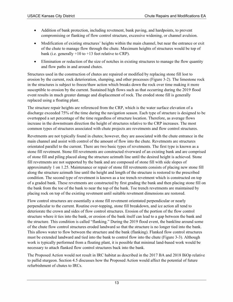
Structures used in the construction of chutes are repaired or modified by replacing stone fill lost to erosion by the current, rock deterioration, slumping, and other processes (Figure 3-2). The limestone rock in the structures is subject to freeze/thaw action which breaks down the rock over time making it more susceptible to erosion by the current. Sustained high flows such as that occurring during the 2019 flood event results in much greater damage and displacement of rock. The eroded stone fill is generally replaced using a floating plant.
The structure repair heights are referenced from the CRP, which is the water surface elevation of a discharge exceeded 75% of the time during the navigation season. Each type of structure is designed to be overtopped a set percentage of the time regardless of structure location. Therefore, as average flows increase in the downstream direction the height of structures relative to the CRP increases. The most common types of structures associated with chute projects are revetments and flow control structures.
Revetments are not typically found in chutes; however, they are associated with the chute entrance in the main channel and assist with control of the amount of flow into the chute. Revetments are structures orientated parallel to the current. There are two basic types of revetments. The first type is known as a stone fill revetment. Stone fill revetments are constructed riverward of an existing bank and are comprised of stone fill and piling placed along the structure azimuth line until the desired height is achieved. Stone fill revetments are not supported by the bank and are composed of stone fill with side slopes of approximately 1 on 1.25. Maintenance or repair of stone fill revetments consists of placing new stone fill along the structure azimuth line until the height and length of the structure is restored to the prescribed condition. The second type of revetment is known as a toe trench revetment which is constructed on top of a graded bank. These revetments are constructed by first grading the bank and then placing stone fill on the bank from the toe of the bank to near the top of the bank. Toe trench revetments are maintained by placing rock on top of the existing revetment until suitable revetment dimensions are restored.
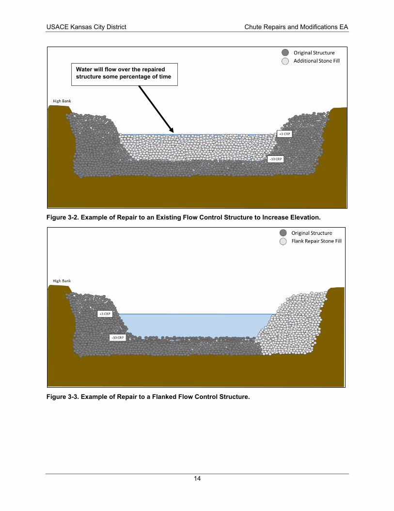
Flow control structures are essentially a stone fill revetment orientated perpendicular or nearly perpendicular to the current. Routine over-topping, stone fill breakdown, and ice action all tend to deteriorate the crown and sides of flow control structures. Erosion of the portion of the flow control structure where it ties into the bank, or erosion of the bank itself can lead to a gap between the bank and the structure. This condition is called “flanking.” During the 2019 flood event, the bankline around some of the chute flow control structures eroded landward so that the structure is no longer tied into the bank. This allows water to flow between the structure and the bank (flanking). Flanked flow control structures must be extended landward and tied into the bank to control flow into the chute (Figure 3-3). Although work is typically performed from a floating plant, it is possible that minimal land-based work would be necessary to attach flanked flow control structures back into the bank.
The Proposed Action would not result in IRC habitat as described in the 2017 BA and 2018 BiOp relative to pallid sturgeon. Section 4.5 discusses how the Proposed Action would affect the potential of future refurbishment of chutes to IRCs.
13
High Bank
• Original Structure
Q Additional Stone Fill
• Original Structure
Q Flank Repair Stone Fill
USACE Kansas City District Chute Repairs and Modifications EA
Water will flow over the repaired structure some percentage of time
Figure 3-2. Example of Repair to an Existing Flow Control Structure to Increase Elevation.
Figure 3-3. Example of Repair to a Flanked Flow Control Structure.
14
USACE Kansas City District Chute Repairs and Modifications EA
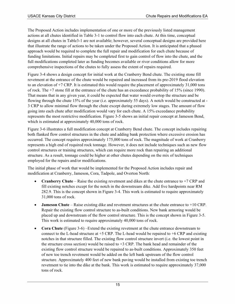
The Proposed Action includes implementation of one or more of the previously listed management actions at all chutes identified in Table 3-1 to control flow into each chute. At this time, conceptual designs at all chutes in Table3-1 are not available; however, several conceptual designs are provided here that illustrate the range of actions to be taken under the Proposed Action. It is anticipated that a phased approach would be required to complete the full repair and modification for each chute because of funding limitations. Initial repairs may be completed first to gain control of flow into the chute, and the full modifications completed later as funding becomes available or river conditions allow for more comprehensive inspections of the chutes to fully assess the extent of repairs required.
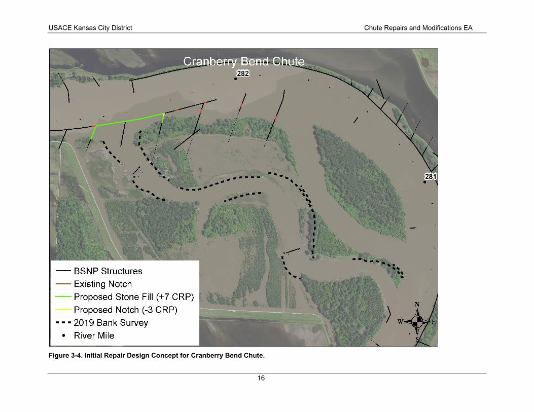
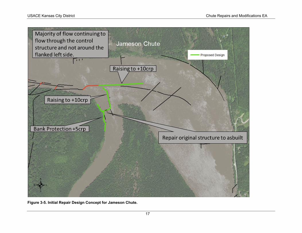
Figure 3-4 shows a design concept for initial work at the Cranberry Bend chute. The existing stone fill revetment at the entrance of the chute would be repaired and increased from its pre-2019 flood elevation to an elevation of +7 CRP. It is estimated this would require the placement of approximately 31,000 tons of rock. The +7 stone fill at the entrance of the chute has an exceedance probability of 15% (since 1990). That means that in any given year, it could be expected that water would overtop the structure and be flowing through the chute 15% of the year (i.e. approximately 55 days). A notch would be constructed at -3 CRP to allow minimal flow through the chute except during extremely low stages. The amount of flow going into each chute after modification would vary for each chute. A 15% exceedance probability represents the most restrictive modification. Figure 3-5 shows an initial repair concept at Jameson Bend, which is estimated at approximately 40,000 tons of rock.
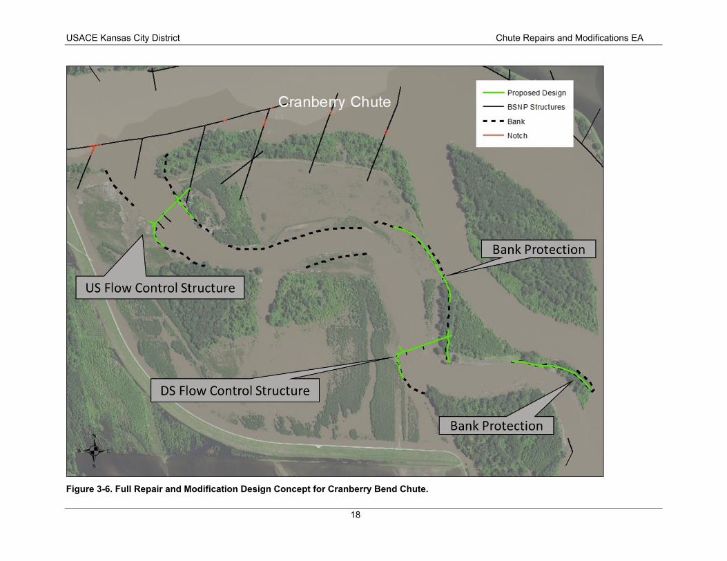
Figure 3-6 illustrates a full modification concept at Cranberry Bend chute. The concept includes repairing both flanked flow control structures in the chute and adding bank protection where excessive erosion has occurred. The concept requires approximately 175,000 tons of rock. The magnitude of work at Cranberry represents a high end of required rock tonnage. However, it does not include techniques such as new flow control structures or training structures, which can require more rock than repairing an additional structure. As a result, tonnage could be higher at other chutes depending on the mix of techniques employed for the repairs and/or modifications.
The initial phase of work that would be implemented for the Proposed Action includes repair and modification at Cranberry, Jameson, Cora, Tadpole, and Overton North:
• Cranberry Chute – Raise the existing revetment and dikes at the chute entrance to +7 CRP and fill existing notches except for the notch in the downstream dike. Add five hardpoints near RM 282.9. This is the concept shown in Figure 3-4. This work is estimated to require approximately 31,000 tons of rock.
• Jameson Chute – Raise existing dike and revetment structures at the chute entrance to +10 CRP. Repair the existing flow control structure to as-built conditions. New bank armoring would be placed up and downstream of the flow control structure. This is the concept shown in Figure 3-5. This work is estimated to require approximately 40,000 tons of rock.
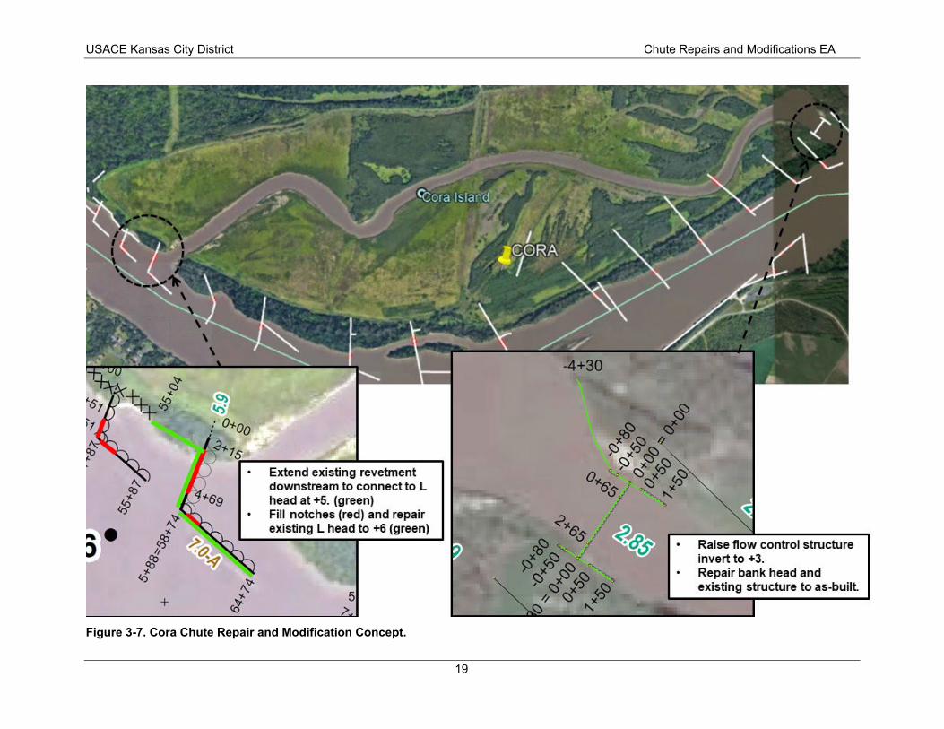
• Cora Chute (Figure 3-6) –Extend the existing revetment at the chute entrance downstream to connect to the L-head structure at +5 CRP. The L-head would be repaired to +6 CRP and existing notches in that structure filled. The existing flow control structure invert (i.e. the lowest point in the structure cross section) would be raised to +3 CRP. The bank head and remainder of the existing flow control structure would be repaired to as-built conditions. Approximately 350 feet of new toe trench revetment would be added on the left bank upstream of the flow control structure. Approximately 400 feet of new bank paving would be installed from existing toe trench revetment to tie into the dike at the bank. This work is estimated to require approximately 37,000 tons of rock.
15
- BSNP Structures
- Existing Notch
- Proposed Stone Fill ( + 7 CRP)
Proposed Notch (-3 CRP)
- - - 2019 Bank Survey • River Mile
USACE Kansas City District Chute Repairs and Modifications EA
Figure 3-4. Initial Repair Design Concept for Cranberry Bend Chute.
16
of flow continuing to flow through the control structure and not around the flanked left side.
I I I
to +lOcr
air original structure to
USACE Kansas City District Chute Repairs and Modifications EA
Figure 3-5. Initial Repair Design Concept for Jameson Chute.
17
Proposed Design
-- BSNP Structures
••• Bank
-- Notch
USACE Kansas City District Chute Repairs and Modifications EA
Figure 3-6. Full Repair and Modification Design Concept for Cranberry Bend Chute.
18
+
Extend existing revetment downstream to connect to L head at +5. (green) Fill notches (red) and repair existing L head to +6 (green)
• Raise flow control structure invert to +3.
• Repair bank head and existing structure to as-built.
USACE Kansas City District Chute Repairs and Modifications EA
Figure 3-7. Cora Chute Repair and Modification Concept.
19
USACE Kansas City District Chute Repairs and Modifications EA
• Tadpole Chute (Figure 3-8) – Initial work at Tadpole includes extending a dike to the right descending bank, converting the interior chute dike to a flow control structure with a 200-foot invert at 0 CRP in center of the structure, and adding new bank heads 150 feet downstream and 80 feet upstream to +7 CRP. This work is estimated to require approximately 50,000 tons of rock.
• Overton North Chute (Figure 3-9) – Fill notches in the existing L-head structure at the chute entrance and repair that structure to +2 CRP on the revetment and +4 CRP on the dike. The invert of the existing flow control structure on the downstream end of the chute would be raised approximately 8 feet (it is currently degraded 5 to 10 feet from pre-flood condition). Bank paving would be repaired along entire alignment of both banks of the flow control structure. This work is estimated to require approximately 12,000 tons of rock.
This initial phase of work is anticipated to place over 120,000 tons of rock at five MRRP chutes. Full repair and modification are expected to require additional work at each chute included in the initial phase. This additional work and the work at the three chutes not included in the initial phase would involve application of any of the management actions previously listed for the Proposed Action. It is estimated that completing full modifications at all eight chutes as part of the Proposed Action could require placement of approximately 700,000 to 900,000 tons of rock.
20
2+80 2+110
3+40= o+oo
• Repair flow control structure to grade and root into both banks.
• Add bank protection upstream and downstream of flow control structure on both banks.
USACE Kansas City District Chute Repairs and Modifications EA
Figure 3-8. Tadpole Chute Repair and Modification Concept.
21
• Fill in notches and repair deficient areas to grade in dike (+4 CRP) and revetment (+2 CRP) (green).
• Repair flow control structure to grade (+8 CRP)
Overton North Chute
Repair bank paving up and downstream of structure to grade on both banks (+6 CRP).
I I
I
, ,
4
USACE Kansas City District Chute Repairs and Modifications EA
Figure 3-9. Overton North Chute Repair and Modification Concept.
22
USACE Kansas City District Chute Repairs and Modifications EA
3.2. No Action Alternative Under the No Action alternative, no repairs or modifications would be made at the MRRP chutes. USACE would not be able to select this alternative because the agency is Congressionally mandated to maintain the BSNP; however, it is included in the range of alternatives as a benchmark for comparison of impacts, consistent with the CEQ NEPA regulations.
3.3. Alternatives Considered but Dismissed USACE considered whether chutes could be repaired to their prior designed condition, that is, repairing to lines and grades prior to the 2019 flood. However, the magnitude of geomorphic change precludes restoring the existing condition prior to the 2019 flood. Millions of cubic yards of material have been redistributed into, out of, and within the chutes, establishing entirely new bank lines and flow paths. Therefore, this alternative was not considered further.
23
USACE Kansas City District Chute Repairs and Modifications EA
4.0 Affected Environment and Environmental Consequences This chapter discusses aspects of the environment that may potentially be impacted by the No Action alternative and Proposed Action. It presents both the affected environment and environmental consequences, as required by NEPA. This chapter is organized by resource topic with the status of the affected environment and the impacts of each alternative described within each resource section. The affected environment sections provide a description of different aspects of the human environment that may be affected by the Proposed Action. The environmental consequences sections provide a description of the anticipated impacts. Consistent with CEQ Regulations 1502.15 and 1508.9, as well as CEQ 40 Questions 36A, this chapter focuses on the resource topics most relevant to the Proposed Action under evaluation. Resources that were considered but for which effects are either entirely beneficial or the adverse impacts are not as relevant to decision-making are described in Section 4.2.
4.1. Impact Characterization The potential impacts of the alternatives are described in this EA using the following terms:
• Beneficial: A positive change in the condition or appearance of the resource or a change that moves the resource toward a desired condition.
• Adverse: A change that moves the resource away from a desired condition or detracts from its appearance or condition.
• Direct: An effect on a resource by an action at the same place and time.
• Indirect: An effect from an action that occurs later or perhaps at a different place and often to a different resource but is still reasonably foreseeable.
• Short-term: impacts generally occur during construction or for a limited time thereafter, generally less than two years, by the end of which the resources recover their pre-construction conditions.
• Long-term: impacts last beyond the construction period, and the resources may not regain their preconstruction conditions for a longer period of time.
4.2. Resources Considered but Dismissed Air Quality – Air quality at a given location is described by the concentrations of various pollutants in the atmosphere. The quality of the air is measured against National Ambient Air Quality Standards (NAAQS) set by the EPA. Temporary increases in emissions that may occur during the construction period would not have potential to exceed NAAQS based on decades of experience implementing similar construction activities on the Missouri River. This resource topic was dismissed from further evaluation.
Commercial Sand and Gravel Dredging on the Lower Missouri River – Commercial sand and gravel dredging does not occur in MRRP chutes and such dredging is restricted ¼ mile upstream and downstream of the entrance and exit of chutes. The Proposed Action would not change any of the currently in place restrictions. As a result, no impacts to this resource topic are anticipated from the Proposed Action and it has been dismissed from further evaluation.
Environmental Justice – Environmental Justice promotes consideration of whether a Proposed Action would disproportionately affect low income and minority communities. Past NEPA reviews on construction of the MRRP chute projects have not identified Environmental Justice issues. In addition, there are no options to complete the Proposed Action in a location other than where the repairs are required. As a result, there is no potential for a disproportionate adverse effect on minorities, low-income
24
USACE Kansas City District Chute Repairs and Modifications EA
residents, or other environmental justice populations. This resource topic was dismissed from further evaluation.
Invasive Species – Invasive species have the potential to displace native plants and animals. In accordance with Executive Order 13122, federal agencies may not authorize, fund, or carry out actions that are likely to cause or promote the introduction or spread of invasive species. Invasive aquatic species that have the potential to be introduced into new water bodies as a result of contaminated construction equipment include zebra mussels, quagga mussels, New Zealand mudsnails, purple loosestrife, and Eurasian watermilfoil. Common invasive fish species on the lower Missouri River include the common carp, goldfish, grass carp, silver carp, bighead carp, and western mosquitofish. Transport of invasive species by the river is common. Natural erosion and deposition of material along the river can result in conditions that are susceptible to becoming established with invasive plants. Construction contractors are required to implement best management practices (BMPs) to limit the potential to spread invasive species. This would not vary by alternative; therefore, this topic is not evaluated further.
Navigation – the purpose of the Proposed Action is to reduce the possibility of adversely affecting the authorized navigation channel. Therefore, all impacts to navigation from the Proposed Action would be considered beneficial. As a result, this resource topic was dismissed from further evaluation.
Wetlands – The majority of the work will occur in open water. Although work on the streambank may occur to tie in flanked flow control structures, no wetland impacts are anticipated. This resource was dismissed from further evaluation.
Prime and Unique Farmland – There is no potential to affect prime and unique farmland because the Proposed Action would primarily affect open water areas. No agricultural lands would be converted to other uses. This resource was dismissed from further evaluation.
4.3. Water Quality 4.3.1. Affected Environment Past USACE water quality monitoring for the Missouri River has included long-term fixed station ambient monitoring at locations on the mainstem of the river, investigative monitoring, and special studies. Water quality parameters measured included total phosphorus, nitrate plus nitrite, ammonia, ortho-phosphorus, dissolved phosphorus, total Kjeldahl nitrogen, total suspended solids, suspended sediment concentration, total dissolved solids, total organic carbon, dissolved organic carbon, turbidity, chlorophyll A, total silica, and dissolved silica. Median concentrations of common water quality constituents are provided in Table 4-1. The Missouri River is listed on the Missouri 303(d) list of impaired waters for Escherichia coli.
4.3.2. Environmental Consequences No impacts to water quality would occur under the No Action alternative because no construction activities would occur under this scenario.
The Proposed Action may result in short-term adverse impacts to water quality during project construction. Construction activities would result in short-term disturbance to soils and riverbeds and banks. During construction, there would be small short-term adverse impacts to water quality from increased sediment loading to the river. Additionally, sediment disturbance could mobilize nutrients, organic material, anoxic sediments, and other pollutants including metals/metalloids associated with the sediment and would potentially increase loading of these pollutants into the river over the short-term.
25
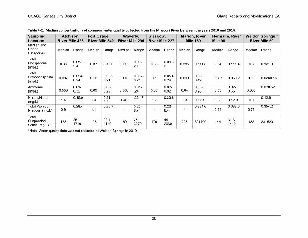
Table 4-2. Median concentrations of common water quality collected from the Missouri River between the years 2010 and 2014. Sampling
Location Atchison,
River Mile 423 Fort Osage,
River Mile 340 Waverly,
River Mile 294 Glasgow,
River Mile 227 Marion, River
Mile 160 Hermann, River
Mile 98 Weldon Springs,*
River Mile 50 Median and Range
Categories Median Range Median Range Median Range Median Range Median Range Median Range Median Range
Total Phosphorus
(mg/L) 0.33 0.05-
2.4 0.37 0.12.3 0.35 0.09-2.1 0.38 0.091-
2 0.385 0.111.8 0.34 0.111.4 0.3 0.121.9
Total Orthophosphate (mg/L)
0.087 0.024-0.24 0.12 0.053-
0.21 0.115 0.052-0.21 0.1 0.059-
0.24 0.099 0.056-0.49 0.087 0.050.2 0.09 0.0260.16
Ammonia (mg/L) 0.056
0.01-0.32 0.09
0.03-0.29 0.068
0.01-.24 0.05
0.02-0.92 0.04
0.03-0.28 0.35
0.02-0.65 0.033
0.020.52
Nitrate/Nitrite (mg/L) 1.4 0.15.0 1.4 0.21-
4.4 1.45 .224.7 1.2 0.23.8 1.3 0.17-4 0.98 0.12-3 0.9 0.12.9
Total Kjehldahl Nitrogen (mg/L) 0.9
0.28.4 1.1
0.26.7 1
0.25-6.7 1
0.22-6.4 1
0.334.6 0.89
0.383.6 0.78
0.354.2
Total Suspended Solids (mg/L)
128 25-4710 123 22.4-
4140 160 28-3070 176 44-
2660 203 321700 144 31.3-1410 132 231520
USACE Kansas City District Chute Repairs and Modifications EA
*Note: Water quality data was not collected at Weldon Springs in 2010.
26
USACE Kansas City District Chute Repairs and Modifications EA
This would result in negligible short-term adverse impacts from localized increases of nutrients and pollutants and potential increases in water temperatures and decreases in dissolved oxygen concentrations. A literature review on these types of effects from riprap stated that the impacts on water quality are typically minor (Fischenich 2003). The use of construction equipment could result in negligible short-term adverse impacts to water quality from accidental leaks and spills of pollutants (e.g., oil, gas, lubricants). Water-based equipment would have a greater potential of causing impacts compared to land-based equipment because it is in direct contact with the river water. These impacts would be minimized or eliminated by compliance with the various provisions of the Clean Water Act (CWA) and by using construction BMPs. A CWA Section 404(b)(1) evaluation was completed for the initial phase of the Proposed Action (Appendix A). The project is not anticipated to result in any exceedance of state water quality standards or additional impairment to the Missouri River. USACE will request a 401 Water Quality Certification from the appropriate state agency as details of the specific work is identified. Chapter 5 further discusses this approach to environmental compliance.
4.4. Fish and Wildlife Resources 4.4.1. Affected Environment Fish and wildlife species present within the study area are typical of those described in the MRRMP-EIS (USACE 2018), available online at https://www.nwo.usace.army.mil/MRRP/. Section 3.3.3 Wildlife and Section 3.3.4 Fisheries of that report are hereby incorporated by reference. The Missouri River Valley is an important nesting and feeding area within the Mississippi Flyway for many migratory birds and waterfowl species. Approximately one in every seven bird species in North America can be found along the lower Missouri River (Thogmartin 2009).
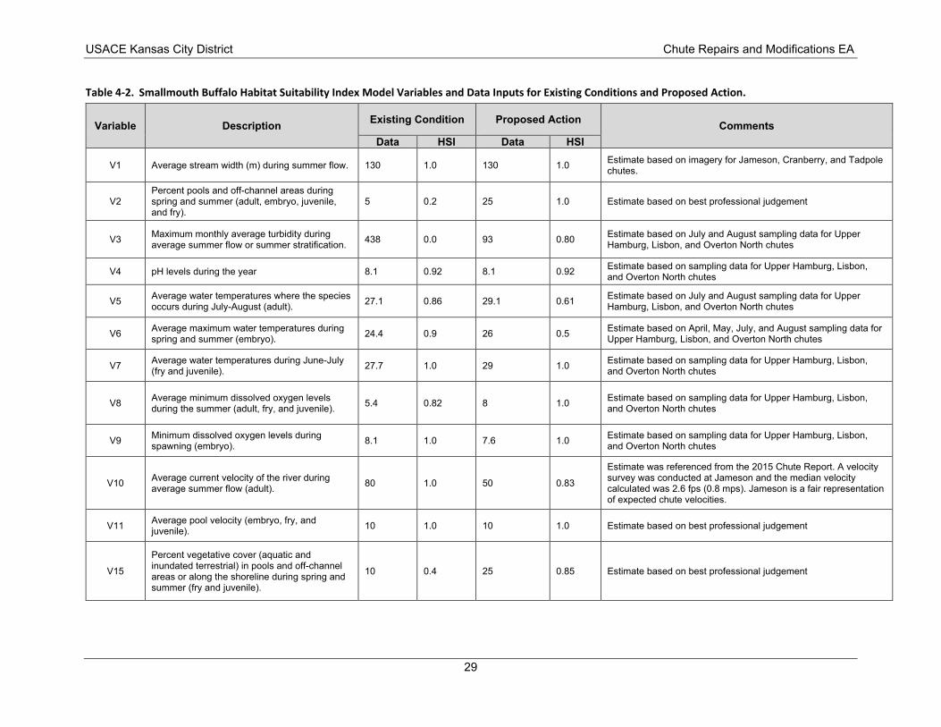
4.4.2. Environmental Consequences No impacts to fish and wildlife would occur under the No Action alternative because no construction activities would occur under this scenario. Modifications to MRRP chutes under the Proposed Action would have a direct long-term impact on habitat in each chute. The USFWS’s Habitat Evaluation Procedure (HEP) methodology was used to assess the quality and quantity of existing and future habitat in MRRP chutes. In general, HEP assigns Habitat Suitability Index (HSI) scores to model variables, which assess the quality or suitability of a habitat relative to a species ability to access food, secure shelter, and reproduce. HSI quality scores ranging from 0.0 to 1.0 are used with habitat acreages to obtain habitat units (HUs), which measured the overall value of a habitat type. Average annual habitat units (AAHUs) are calculated for each alternative and compared to the existing condition to determine if habitat lift or impairment results over a 50-year period of analysis. The evaluation was conducted for a single “typical” MRRP chute because the habitat changes within each chute are anticipated to be similar. Year 1 was considered the first year following completion of construction. It was assumed that the dominant habitat characteristics change immediately following construction and the limiting of flow into the chutes; therefore, HUs were assumed to be the same in each year over the 50-year period of analysis. Existing conditions and future conditions were informed by existing data, previous field investigations and best professional judgment depending on the variables in the HSI. The smallmouth buffalo (Ictiobus bubalus) HSI model was used to evaluate the change in habitat quality within MRRP chutes (Edwards and Twomey 1982). Smallmouth buffalo are commonly collected from the Missouri River and MRRP chutes and the habitat variables within the HSI model were directly relevant to anticipated habitat changes.
Table 4-2 summarizes the variables, data inputs, and HSI values by variable within the smallmouth buffalo HSI for the existing condition and with the Proposed Action. Table 4-3 summarizes the overall
27
USACE Kansas City District Chute Repairs and Modifications EA
HSI score, HUs, and AAHUs. The results of the evaluation indicate that the quality of habitat within each MRRP chute is anticipated to improve under the Proposed Action resulting in increased AAHUs over the 50-year period of analysis. This represents a long-term beneficial impact.
Minor short-term adverse impacts to fish and wildlife may result during project construction. There is potential that construction activities could affect fish and wildlife species in the project area through physical disturbance. Fish and wildlife may also experience direct and indirect adverse impacts from noise associated with construction activities. Maintenance on rock structures in the Missouri River, which cause similar temporary disturbance, is conducted as needed and has not shown any long-term impacts to fish and wildlife. Fish and wildlife are expected to move from areas of disturbance during project construction. At some chutes, fish passage may be restricted at a range of lower flows because of the raised height of structures at the entrance and exit. Fish access to chutes would be flow-dependent and vary between and within years.
28
USACE Kansas City District Chute Repairs and Modifications EA
Table 4-2. Smallmouth Buffalo Habitat Suitability Index Model Variables and Data Inputs for Existing Conditions and Proposed Action.
Variable Description Existing Condition Proposed Action Comments Data HSI Data HSI
V1 Average stream width (m) during summer flow. 130 1.0 130 1.0 Estimate based on imagery for Jameson, Cranberry, and Tadpole chutes.
V2 Percent pools and off-channel areas during spring and summer (adult, embryo, juvenile, and fry).
5 0.2 25 1.0 Estimate based on best professional judgement
V3 Maximum monthly average turbidity during average summer flow or summer stratification. 438 0.0 93 0.80 Estimate based on July and August sampling data for Upper
Hamburg, Lisbon, and Overton North chutes
V4 pH levels during the year 8.1 0.92 8.1 0.92 Estimate based on sampling data for Upper Hamburg, Lisbon, and Overton North chutes
V5 Average water temperatures where the species occurs during July-August (adult). 27.1 0.86 29.1 0.61 Estimate based on July and August sampling data for Upper
Hamburg, Lisbon, and Overton North chutes
V6 Average maximum water temperatures during spring and summer (embryo). 24.4 0.9 26 0.5 Estimate based on April, May, July, and August sampling data for
Upper Hamburg, Lisbon, and Overton North chutes
V7 Average water temperatures during June-July (fry and juvenile). 27.7 1.0 29 1.0 Estimate based on sampling data for Upper Hamburg, Lisbon,
and Overton North chutes
V8 Average minimum dissolved oxygen levels during the summer (adult, fry, and juvenile). 5.4 0.82 8 1.0 Estimate based on sampling data for Upper Hamburg, Lisbon,
and Overton North chutes
V9 Minimum dissolved oxygen levels during spawning (embryo). 8.1 1.0 7.6 1.0 Estimate based on sampling data for Upper Hamburg, Lisbon,
and Overton North chutes
V10 Average current velocity of the river during average summer flow (adult). 80 1.0 50 0.83
Estimate was referenced from the 2015 Chute Report. A velocity survey was conducted at Jameson and the median velocity calculated was 2.6 fps (0.8 mps). Jameson is a fair representation of expected chute velocities.
V11 Average pool velocity (embryo, fry, and juvenile). 10 1.0 10 1.0 Estimate based on best professional judgement
V15
Percent vegetative cover (aquatic and inundated terrestrial) in pools and off-channel areas or along the shoreline during spring and summer (fry and juvenile).
10 0.4 25 0.85 Estimate based on best professional judgement
29
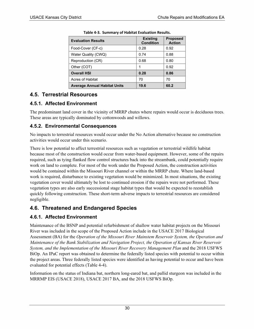
Evaluation Results Existing Condition
Proposed Action
Food-Cover (CF-c) 0.28 0.92 Water Quality (CWQ) 0.74 0.88
Reproduction (CR) 0.68 0.80 Other (COT) 1 0.92 Overall HSI 0.28 0.86
Acres of Habitat 70 70 Average Annual Habitat Units 19.6 60.2
USACE Kansas City District Chute Repairs and Modifications EA
Table 4-3. Summary of Habitat Evaluation Results.
4.5. Terrestrial Resources 4.5.1. Affected Environment The predominant land cover in the vicinity of MRRP chutes where repairs would occur is deciduous trees. These areas are typically dominated by cottonwoods and willows.
4.5.2. Environmental Consequences No impacts to terrestrial resources would occur under the No Action alternative because no construction activities would occur under this scenario.
There is low potential to affect terrestrial resources such as vegetation or terrestrial wildlife habitat because most of the construction would occur from water-based equipment. However, some of the repairs required, such as tying flanked flow control structures back into the streambank, could potentially require work on land to complete. For most of the work under the Proposed Action, the construction activities would be contained within the Missouri River channel or within the MRRP chute. Where land-based work is required, disturbance to existing vegetation would be minimized. In most situations, the existing vegetation cover would ultimately be lost to continued erosion if the repairs were not performed. These vegetation types are also early successional stage habitat types that would be expected to reestablish quickly following construction. These short-term adverse impacts to terrestrial resources are considered negligible.
4.6. Threatened and Endangered Species 4.6.1. Affected Environment Maintenance of the BSNP and potential refurbishment of shallow water habitat projects on the Missouri River was included in the scope of the Proposed Action include in the USACE 2017 Biological Assessment (BA) for the Operation of the Missouri River Mainstem Reservoir System, the Operation and Maintenance of the Bank Stabilization and Navigation Project, the Operation of Kansas River Reservoir System, and the Implementation of the Missouri River R ecovery Management Plan and the 2018 USFWS BiOp. An IPaC report was obtained to determine the federally listed species with potential to occur within the project areas. Three federally listed species were identified as having potential to occur and have been evaluated for potential effects (Table 4-4).
Information on the status of Indiana bat, northern long-eared bat, and pallid sturgeon was included in the MRRMP EIS (USACE 2018), USACE 2017 BA, and the 2018 USFWS BiOp.
30
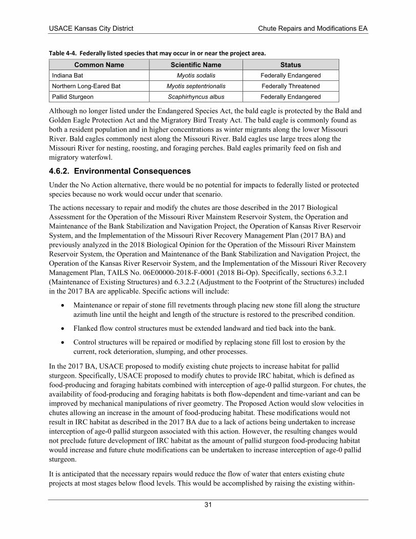
Common Name Scientific Name Status Indiana Bat Myotis sodalis Federally Endangered
Northern Long-Eared Bat Myotis septentrionalis Federally Threatened
Pallid Sturgeon Scaphirhyncus albus Federally Endangered
USACE Kansas City District Chute Repairs and Modifications EA
Table 4-4. Federally listed species that may occur in or near the project area.
Although no longer listed under the Endangered Species Act, the bald eagle is protected by the Bald and Golden Eagle Protection Act and the Migratory Bird Treaty Act. The bald eagle is commonly found as both a resident population and in higher concentrations as winter migrants along the lower Missouri River. Bald eagles commonly nest along the Missouri River. Bald eagles use large trees along the Missouri River for nesting, roosting, and foraging perches. Bald eagles primarily feed on fish and migratory waterfowl.
4.6.2. Environmental Consequences Under the No Action alternative, there would be no potential for impacts to federally listed or protected species because no work would occur under that scenario.
The actions necessary to repair and modify the chutes are those described in the 2017 Biological Assessment for the Operation of the Missouri River Mainstem Reservoir System, the Operation and Maintenance of the Bank Stabilization and Navigation Project, the Operation of Kansas River Reservoir System, and the Implementation of the Missouri River Recovery Management Plan (2017 BA) and previously analyzed in the 2018 Biological Opinion for the Operation of the Missouri River Mainstem Reservoir System, the Operation and Maintenance of the Bank Stabilization and Navigation Project, the Operation of the Kansas River Reservoir System, and the Implementation of the Missouri River Recovery Management Plan, TAILS No. 06E00000-2018-F-0001 (2018 Bi-Op). Specifically, sections 6.3.2.1 (Maintenance of Existing Structures) and 6.3.2.2 (Adjustment to the Footprint of the Structures) included in the 2017 BA are applicable. Specific actions will include:
• Maintenance or repair of stone fill revetments through placing new stone fill along the structure azimuth line until the height and length of the structure is restored to the prescribed condition.
• Flanked flow control structures must be extended landward and tied back into the bank.
• Control structures will be repaired or modified by replacing stone fill lost to erosion by the current, rock deterioration, slumping, and other processes.
In the 2017 BA, USACE proposed to modify existing chute projects to increase habitat for pallid sturgeon. Specifically, USACE proposed to modify chutes to provide IRC habitat, which is defined as food-producing and foraging habitats combined with interception of age-0 pallid sturgeon. For chutes, the availability of food-producing and foraging habitats is both flow-dependent and time-variant and can be improved by mechanical manipulations of river geometry. The Proposed Action would slow velocities in chutes allowing an increase in the amount of food-producing habitat. These modifications would not result in IRC habitat as described in the 2017 BA due to a lack of actions being undertaken to increase interception of age-0 pallid sturgeon associated with this action. However, the resulting changes would not preclude future development of IRC habitat as the amount of pallid sturgeon food-producing habitat would increase and future chute modifications can be undertaken to increase interception of age-0 pallid sturgeon.
It is anticipated that the necessary repairs would reduce the flow of water that enters existing chute projects at most stages below flood levels. This would be accomplished by raising the existing within-
31
USACE Kansas City District Chute Repairs and Modifications EA
chute control structures or increasing the height of existing revetments located near the entrance of chutes. Depending on the chute, it is anticipated that the frequency at which flows would overtop chute control structures (revetments and/or control structures) would be reduced from the 95th percentile exceedance up to the 15th percentile (approximately) exceedance. This change would result in lower water velocities within chutes a greater percentage of time. As such, we anticipate existing chutes would provide increased habitat diversity compared to the main channel and exhibit habitat characteristics often associated with off-channel backwater habitats (decreased velocities, increased water temperature, decreased turbidity, etc.) As stated in the 2017 BA, these actions may affect, but will not adversely affect the pallid sturgeon (see section 6.3.2), Indiana bat (section 6.4.1), and Northern Long-eared bat (6.5.1). The conservation measures will also be the same as those found in sections 6.3.7, 6.4.2, and 6.5.2.
The potential to affect bald eagles would occur primarily if nesting activity was occurring in the immediate vicinity of construction activities. Because work under the Proposed Action may occur in phases as funding becomes available, USACE would coordinate with USFWS as projects are initiating construction to identify the locations of any known bald eagle nests in the vicinity of project activities. Should bald eagles nesting be encountered, USACE would coordinate with the appropriate USFWS field office to determine measures to implement to avoid disturbance to bald eagles.
4.7. Cultural Resources 4.7.1. Affected Environment Prior to the initial construction of each MRRP chute project, a cultural resources review was performed as part of the project planning and environmental compliance process. These reviews included background research of the area to determine if any previously recorded cultural resources were present in the project areas. This research included review for sites listed on the National Register of Historic Places (NRHP), archeological and historic structure site location maps at the Kansas State Historic Preservation Office (SHPO) or Missouri SHPO, and shipwreck location maps in the USACE Kansas City District office. Although often shipwreck location maps identified the potential for a shipwreck to be in the vicinity of an MRRP chute project, no shipwrecks have ever been encountered during construction of the projects. In a few cases, magnetometer surveys were conducted along the chute alignment to determine if shipwrecks were present. Only at the Cora chute project area was an anomaly detected during a magnetometer survey. The chute aligned was realigned at that time to avoid the area of anomaly. In addition, all the MRRP chute project areas were comprised of a high percentage of accreted lands, indicating relatively recent aged soils. This indicated that it was unlikely any prehistoric archeological sites were present in the MRRP chute project areas. For all 8 chutes, the SHPO concurred with the USACE determination of "no historic properties affected". MRRP chute repairs and modifications would be contained within the areas previously evaluated for cultural resources; therefore, the prior determinations of "no historic properties affected" is also made for the current proposal and coordination with the Kansas and Missouri SHPOs is ongoing. Coordination with appropriate Tribes is also ongoing.
4.7.2. Environmental Consequences The No Action alternative would have no effect on any cultural resource in or adjacent to the project area.
Under the Proposed Action, no impacts to any cultural resources in or adjacent to the project areas are anticipated. If in the unlikely event that archeological materials are discovered during project construction, work in the area of discovery will cease and the discovery investigated by a qualified archeologist. The findings on the discovery would be coordinated with the appropriate SHPO and federally recognized Native American Tribes. Appendix C includes SHPO coordination letters.
32
USACE Kansas City District Chute Repairs and Modifications EA
4.8. Recreation 4.8.1. Affected Environment The Missouri River is used recreationally for fishing, boating, canoe/kayaking, and camping. No recreational access points, such as boat ramps or hiking trails are on the project sites.
4.8.2. Environmental Consequences The No Action alternative would have no impacts on recreation as no construction would occur.
The Proposed Action would have minor temporary adverse impacts on recreation from physical and noise disturbances during construction activities. There would be no long-term adverse impacts to the recreational experience due to changes in aesthetics. Access by boat, canoe, or kayak to MRRP chutes at either the upstream entrance or downstream exit would be restricted because the chute would not be flow-connected to the mainstem during most of the year. As chutes can be frequently accessed by hunters during the fall and winter, this is considered a long-term minor adverse impact.
4.9. Flood Risk 4.9.1. Affected Environment There is an extensive flood risk management system (i.e., levees and dams) along the Missouri River. According to Executive Order 11988, each agency shall provide leadership and shall take action to reduce the risk of flood loss, to minimize the impact of floods on human safety, health and welfare, and to restore and preserve the natural and beneficial values served by floodplains. USACE has a responsibility to evaluate the potential effects of any actions it may take in a floodplain, and to consider flood hazards in project planning.
4.9.2. Environmental Consequences The No Action alternative would have no change to existing flood risk because no projects would be constructed.
Under the Proposed Action, all the chute modifications would involve structures that are below flood stage and would still allow flood flows to pass through the chutes. Within the main channel, there might be slight increase of stage heights when stages are above CRP but below the tops of the structures as more flow is excluded from the chutes and directed to the main channel at those stages. However, once the structures are overtopped (before reaching flood stage) the chutes would begin passing flow again, and it is unlikely that there would be adverse changes in water surface at, or above, flood stage. As a result, no adverse impacts to flood risk are anticipated.
4.10. Cumulative Impacts The CEQ regulations for implementing NEPA require the assessment of cumulative impacts in the decision-making process. This section describes the methods for identification of cumulative actions and presents the results of the cumulative impact analysis. CEQ defines a cumulative impact as “the impact on the environment which results from the incremental impact of the action when added to other past, present, and reasonably foreseeable future actions regardless of what agency (Federal or non-Federal) or person undertakes such other actions” (40 CFR § 1508.7).
The cumulative action identification and analysis methods are based on the policy guidance and methodology originally developed by CEQ (1997) and an analysis of current case law. Cumulative impacts were determined by adding the impacts of the Proposed Action being considered with other past,
33
USACE Kansas City District Chute Repairs and Modifications EA
present, and reasonably foreseeable future actions. A process based on four primary steps was employed to assess the cumulative impacts of the Proposed Action.
Step 1: Identify Potentially Affected Resources
In this step, each resource affected by the Proposed Action is identified. Resources were not assessed for cumulative impacts if the analysis in Chapter 4 determined there would be no impact to that resource from the Proposed Action.
Step 2: Establish Boundaries (Geographic and Temporal)
In identifying past, present, and reasonably foreseeable actions to consider in the cumulative impact analysis, affected resource-specific spatial and temporal boundaries were identified. The spatial boundary is where impacts to the affected resource could occur from the Proposed Action and therefore where past, present, and reasonably foreseeable future actions could contribute to cumulative impacts to the affected resource. This boundary is defined by the affected resource and may be a different size than project area.
The temporal boundary describes how far into the past and forward into the future actions should be considered in the impact analysis. The temporal boundary is guided by CEQ guidance on considering past action and a rule of reason for identifying future actions.
For each resource topic, the geographic and temporal boundaries were identified. For all resource topics, the consideration of past actions is reflected in the existing condition. A default future temporal boundary of 50 years from the baseline condition was used as an initial timeframe; however, the impacts are based on their likelihood of occurring and whether they can be reasonably predicted.
Step 3: Identify the Cumulative Action Scenario
In this step, past, present, and reasonably foreseeable future actions to be included in the impact analysis for each specific affected resource were identified. These actions fall within the spatial and temporal boundaries established in Step 2.
Step 4: Analyze Cumulative Impacts
For each resource, the actions identified in Step 3 are analyzed in combination with the impacts of the Proposed Action being evaluated. This analysis describes the overall cumulative impact related to each resource and the contribution to this cumulative impact of each alternative being evaluated.
4.10.2. Past, Present, and Reasonably Foreseeable Future Actions This section includes cumulative action descriptions for past, present, and reasonably foreseeable future actions. These actions include:
Missouri River Reservoir System and Kansas River Reservoir System:
USACE operates the Missouri River Reservoir System (System) consisting of six dams and reservoirs with a capacity to store 72.4 million acre-feet of water, the largest reservoir system in North America. The System was authorized by the 1944 Flood Control Act. Combined, the System controls runoff from 279,480 square miles of the upper Missouri River basin. It contains 71% of the installed capacity in the basin’s Federal hydroelectric power system, provides almost all of the reservoir support for downstream flow on the Missouri River, and contributes greatly to flood risk reduction for over 2-million acres of land in the floodplain of the Missouri River (USACE 2006). The System is operated for eight congressionally authorized purposes: flood control, navigation, irrigation, hydropower, water supply, water quality, recreation, and fish and wildlife. USACE operates the System in accordance with the policies and
34
USACE Kansas City District Chute Repairs and Modifications EA
procedures prescribed in the Missouri River Mainstem Reservoir System Master Water Control Manual (Master Manual) (USACE 2006).
Clinton, Perry, Tuttle Creek, Milford, Waconda, Wilson, and Kanopolis are the primary downstream flood control dams in the Kansas River basin. Each is located on one of the major tributaries. Waconda is managed by the U.S. Bureau of Reclamation, and the other structures are USACE projects. The USACE projects are authorized for flood control, water supply, water quality, recreation, and fish and wildlife. Milford, Tuttle Creek, and Perry are also authorized to support navigation flows on the Missouri River. Harlan County, Waconda, and the other Bureau of Reclamation projects are authorized for irrigation. The Kansas River Reservoir System controls runoff from approximately 60,000 square miles of northern Kansas, southern Nebraska and northeastern Colorado (Sanders et al. 1993). Operation of the federal reservoirs on Kansas River tributaries has decreased the frequency of very high and very low flows while increasing the frequency of moderate flows. Construction and operation of the federal reservoirs on the Kansas River Reservoir System have trapped tributary sediment, precluding its introduction into the mainstem (USFWS 2000).
Bank Stabilization and Navigation Project and BSNP Fish and Wildlife Mitigation Project
The BSNP consists mainly of rockpile structures and revetments along the outsides of bends and transverse dikes along the insides of bends to force the river into a single active channel that is self-maintaining. The BSNP provides a 9-foot-deep channel with a minimum width of 300 feet during the navigation season from April 1 to November 30 between Sioux City, Iowa, and the mouth of the Missouri River near St. Charles, Missouri. The BSNP Fish and Wildlife Mitigation Project was described in Section 1.2.
Missouri River Recovery Management Plan and Environmental Impact Statement (MRRMP-EIS):
The purpose of the MRRMP-EIS was to develop a suite of actions that met USACE ESA responsibilities for the pallid sturgeon, piping plover, and interior least tern. The Federal Plan identified in the EIS included the IRC study. The IRC Study consists of the construction of 12 IRC projects in the lower Missouri River. Each IRC project would be paired with a control site as part of an experimental design to test the hypothesis that IRCs may contribute to the survival and recruitment to age-1 of pallid sturgeon. Eight preliminary sites for the IRC projects have been identified, although the list is subject to change.
Floodplain Agricultural Practices (Crop and Livestock Production):
This action includes the conversion of land from native habitat to crop production. Extensive acreage within the floodplain of the Missouri River and its tributaries, as well as the surrounding uplands, has been converted for crop production. This action also includes the use, alteration, or conversion of land in the floodplain of the Missouri River to grassland for pasturing animals.
Floodplain Development (Urban, Residential, Commercial, Industrial):
This action includes a wide range of development that converts natural lands to a wide range of urban, residential, commercial, and industrial uses.
Levee Construction (federal and private):
This action includes the placement, design, and management of structures intended to prevent or control floodplain inundation.
35
USACE Kansas City District Chute Repairs and Modifications EA
4.10.3. Cumulative Impacts Only resource categories that would result in at least minor impacts as a result of implementing the Proposed Action are considered for the cumulative impact assessment. The resource categories considered for cumulative impacts include water quality, fish and wildlife, terrestrial resources, and recreation.
Water Quality: Past and present impacts to water quality were primarily driven from construction of Mainstem Reservoir System and floodplain development. Closure of the six upstream dams that comprise the Mainstem System trapped sediment behind those dams. There have been long-term declines in suspended sediment loads on the lower Missouri River (Blevins 2006). Floodplain development also modified nutrient loading by the increase use of fertilizers on the floodplain. Past and present actions have had substantial impacts on water quality of the lower Missouri River. The Proposed Action results in short-term localized adverse impacts that would represent a negligible contribution to overall cumulative impacts to water quality.
Fish and Wildlife: In addition to MRRP, other large scale efforts to improve fish and wildlife habitat include the Big Muddy National Fish and Wildlife Refuge operated by USFWS, the Wetland Reserve Program operated by the NRCS, public and private land management programs of the MDC, habitat restoration and preservation activities of the MoDNR, and other efforts undertaken by individuals on private lands to benefit fish and wildlife resources. Although past actions such as the construction of the BSNP and floodplain development have had substantial impacts on fish and wildlife from the loss of habitat along the lower Missouri River, the short-term adverse impacts associated with the Proposed Action would represent a negligible contribution to these overall cumulative impacts.
Recreation: Past, present, and future construction projects, including those to maintain the Mainstem dams, roads, developed recreational areas, native fish and wildlife habitat areas, and the BSNP, can cause temporary localized adverse impacts to the quality and quantity of recreational visits as a result of construction-related noise, vibration, fugitive emissions, decreased visual aesthetics, and access limitations. However, many of these actions result in recreational benefits over the long-term by increasing access and providing a range of recreational opportunities available to a variety of users.
Continued management of recreation, wildlife, and natural areas by USFWS, NPS, and agencies that manage these resources at the state and local level generally benefit recreation along the river because they promote conservation and are focused on safeguarding and enhancing wildlife and recreational resources for current and future users. In addition, land easements and agricultural technical and financial programs administered by NRCS support restoring or maintaining natural habitats, with potential benefits to fish and wildlife and associated recreational opportunities. Variability in natural hydrologic conditions (precipitation and snowmelt, which include periods of drought and high runoff), and the “rules” governing Mainstem Reservoir System operation would continue to dominate the flows in the Missouri River into the future. As a result, the short-term minor adverse impacts to recreation associated with the Proposed Action would represent a negligible contribution to overall cumulative impacts.
4.11. Climate Change Considerations Although temporary emissions during construction would occur, the repairs and modifications, once constructed, do not generate greenhouse gas emissions and therefore do not contribute to climate change. Most references for the Missouri River basin agree that future climate trends will likely consist of increased temperatures and precipitation. Increased precipitation will result in higher streamflow, while increased temperatures will likely result in earlier spring snowmelt, decreased snowmelt season duration, and decreased peak snowmelt flows. Rainfall events will likely become even more sporadic for the entire
36
USACE Kansas City District Chute Repairs and Modifications EA
Missouri River basin. Large rain events will likely become more frequent and interspersed by longer relatively dry periods.
BSNP maintenance needs are evaluated annually and routine maintenance activities are an ongoing action. Increased variability in wet and dry conditions could make maintenance more challenging. An increase in large rain events could result in more frequent and severe damages to the BSNP and MRRP chutes; however, these potential climate changes impacts would not be expected to noticeably affect the resource impacts described in this chapter.
37
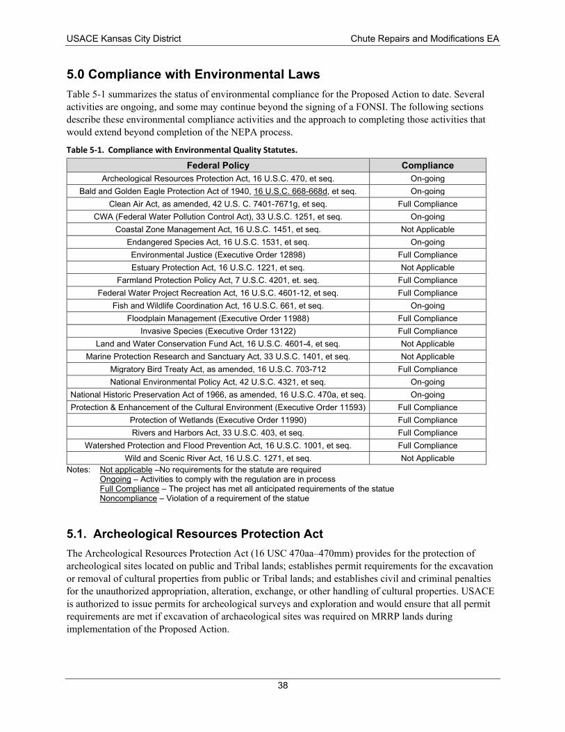
Federal Policy Compliance Archeological Resources Protection Act, 16 U.S.C. 470, et seq. On-going
Bald and Golden Eagle Protection Act of 1940, 16 U.S.C. 668-668d, et seq. On-going Clean Air Act, as amended, 42 U.S. C. 7401-7671g, et seq. Full Compliance
CWA (Federal Water Pollution Control Act), 33 U.S.C. 1251, et seq. On-going Coastal Zone Management Act, 16 U.S.C. 1451, et seq. Not Applicable
Endangered Species Act, 16 U.S.C. 1531, et seq. On-going Environmental Justice (Executive Order 12898) Full Compliance
Estuary Protection Act, 16 U.S.C. 1221, et seq. Not Applicable Farmland Protection Policy Act, 7 U.S.C. 4201, et. seq. Full Compliance
Federal Water Project Recreation Act, 16 U.S.C. 4601-12, et seq. Full Compliance Fish and Wildlife Coordination Act, 16 U.S.C. 661, et seq. On-going
Floodplain Management (Executive Order 11988) Full Compliance Invasive Species (Executive Order 13122) Full Compliance
Land and Water Conservation Fund Act, 16 U.S.C. 4601-4, et seq. Not Applicable Marine Protection Research and Sanctuary Act, 33 U.S.C. 1401, et seq. Not Applicable
Migratory Bird Treaty Act, as amended, 16 U.S.C. 703-712 Full Compliance National Environmental Policy Act, 42 U.S.C. 4321, et seq. On-going
National Historic Preservation Act of 1966, as amended, 16 U.S.C. 470a, et seq. On-going Protection & Enhancement of the Cultural Environment (Executive Order 11593) Full Compliance
Protection of Wetlands (Executive Order 11990) Full Compliance Rivers and Harbors Act, 33 U.S.C. 403, et seq. Full Compliance
Watershed Protection and Flood Prevention Act, 16 U.S.C. 1001, et seq. Full Compliance Wild and Scenic River Act, 16 U.S.C. 1271, et seq. Not Applicable
USACE Kansas City District Chute Repairs and Modifications EA
5.0 Compliance with Environmental Laws Table 5-1 summarizes the status of environmental compliance for the Proposed Action to date. Several activities are ongoing, and some may continue beyond the signing of a FONSI. The following sections describe these environmental compliance activities and the approach to completing those activities that would extend beyond completion of the NEPA process.
Table 5-1. Compliance with Environmental Quality Statutes.
Notes: Not applicable –No requirements for the statute are required Ongoing – Activities to comply with the regulation are in process Full Compliance – The project has met all anticipated requirements of the statue Noncompliance – Violation of a requirement of the statue
5.1. Archeological Resources Protection Act The Archeological Resources Protection Act (16 USC 470aa–470mm) provides for the protection of archeological sites located on public and Tribal lands; establishes permit requirements for the excavation or removal of cultural properties from public or Tribal lands; and establishes civil and criminal penalties for the unauthorized appropriation, alteration, exchange, or other handling of cultural properties. USACE is authorized to issue permits for archeological surveys and exploration and would ensure that all permit requirements are met if excavation of archaeological sites was required on MRRP lands during implementation of the Proposed Action.
38
USACE Kansas City District Chute Repairs and Modifications EA
5.2. Bald and Golden Eagle Protection Act The Bald and Golden Eagle Protection Act (16 USC §§ 668a–668d) prohibits the take, possession, or sale of bald and golden eagles, with limited exceptions for the scientific or exhibition purposes, for religious purposes of Indian Tribes, or for the protection of wildlife and agriculture or for preservation of the species. In 2009, USFWS created a permit program for non-purposeful take of eagles and their nests. This EA has analyzed the potential impacts of the Proposed Action and has determined that it is not likely to result in the take of bald or golden eagles. USACE would coordinate with USFWS and the appropriate state agencies to avoid incidental take of bald or golden eagles during the implementation of the chute repair projects. If a bald or golden eagle were to be found near or on a project site, the appropriate USFWS office would be contacted and USFWS National Bald Eagle Management Guidelines would be implemented in coordination with USFWS.
5.3. Clean Water Act The objective of the Clean Water Act (CWA) (33 USC 1251 et seq.), as amended, is to restore and maintain the chemical, physical, and biological integrity of the Nation’s waters. USACE regulates discharges of dredge or fill material into waters of the United States pursuant to Section 404 of the CWA. The selection of disposal sites for dredged or fill material is done in accordance with the Section 404(b)(1) guidelines, which were developed by the U.S. Environmental Protection Agency (EPA) (40 CFR Part 230). Section 401 of the CWA allows certain states or the EPA to grant or deny water quality certification for any activity that results in a discharge into waters of the United States and requires a federal permit or license. Certification requires a finding by the affected states or EPA that the activities permitted would comply with all water quality standards individually or cumulatively over the term of the permit. Section 401 water quality certifications would be obtained for site-specific management actions, as required, prior to construction. Section 402 of the CWA also established the National Pollutant Discharge Elimination System (NPDES) for permitting point-source discharges to waters of the United States.
A Section 404(b)(1) evaluation for the Proposed Action is included in Appendix A. Following a joint public notice and a 30-day public and agency review period, USACE will formally request a Section 401 water quality certification from the states of Missouri and Kansas. A NPDES permit applies to projects that would result in over 1 acre of land disturbance. Where required, USACE stipulates obtaining the NPDES permit to be the responsibility of the construction contractor.
5.4. Endangered Species Act The Endangered Species Act (ESA) (16 USC 1531 et seq.) established a program to promote the conservation and facilitate recovery of imperiled species and the habitats in which they are found. As such, ESA prohibits “take” of any species listed as threatened or endangered by the U.S. Fish and Wildlife Service (USFWS), where “take” is defined as to, “harass, harm, pursue, hunt, shoot, wound, kill, trap, capture, or collect,” any species listed under ESA. Section 7 of the ESA requires federal agencies to ensure that any actions authorized, funded, or carried out by the agency do not jeopardize the continued existence of a federally listed threatened or endangered species, or result in the destruction or adverse modification of the designated critical habitat of a federally listed species. ESA correspondence for the Proposed Action is provided in Appendix B.
5.5. Fish and Wildlife Coordination Act The Fish and Wildlife Coordination Act (FWCA) (16 USC 661 et seq.) requires federal agencies to coordinate with USFWS or the National Marine Fisheries Service and appropriate state wildlife agencies
39
USACE Kansas City District Chute Repairs and Modifications EA
to avoid or minimize adverse impacts of federal actions that propose to modify any stream or water body. Modification of a stream or water body includes impoundment, diversion, and deepening of channels. USACE has requested a planning aid letter from USFWS regarding their input on the Proposed Action and its impacts to fish and wildlife in accordance with FWCA. All recommendations received from USFWS will be considered and responded to prior to signing a FONSI. It is anticipated that coordination with USFWS would be ongoing as the designs for each chute are developed and refined.
5.6. National Environmental Policy Act USACE has prepared this draft EA in accordance with NEPA. A joint public notice will be issued by USACE and the Missouri Department of Natural Resources and the Kansas Department of Health and Environment announcing the availability of this draft EA and draft Section 404(b)(1) Evaluation for a 30-day public comment period. The public notice will be distributed as appropriate to notify the affected public of the availability of the draft EA. During the public comment period, the Public Notice and draft documents are available on the NWK Public Notice website at: http://www.nwk.usace.army.mil/Media/PublicNotices/PlanningPublicNotices.aspx. A copy of the Public Notice is included as Appendix A. All public and agency comments received during the public comment period and USACE responses will be included in the final EA. The NEPA process will conclude with either signing of a FONSI, the draft of which is found at the beginning of this document, or with a determination that and environmental impact statement is required.
5.7. National Historic Preservation Act Section 106 of the National Historic Preservation Act (NHPA) (54 USC 306108) requires federal agencies to evaluate the effects of federal undertakings on historical, archeological, and cultural resources. To do this, USACE must identify any district, site, building, structure, or object that is in or near the project area and is included in or eligible for inclusion in the National Register of Historic Places. USACE has coordinated with the Missouri and Kansas SHPOs and appropriate Native American Tribes as part of environmental compliance for the Proposed Action. All coordination is included in Appendix C.
40
USACE Kansas City District Chute Repairs and Modifications EA
6.0 List of Preparers
Name Education Years of Experience/Area of Expertise Responsibilities
Phil Alig BA Anthropology 7 years’ experience in archaeology (Missouri and Kansas)
Cultural Resources lead responsible for Section 106 compliance.
Todd Gemeinhardt B.S. Fisheries and Wildlife M.S. Fisheries and Wildlife
20 years of experience in fisheries management/fish ecology/aquatic habitat assessment and restoration
Lead for ESA consultation and evaluation of effects to federally listed species
Michael Gossenauer, PE B.S. Bioresource and Agricultural Engineering M.S. Civil Engineering
15 years hydraulic engineering and experience in Missouri River navigation support and habitat restoration
Engineering Technical Lead
Dane Morris B.S. Zoology M.S. Environmental Engineering
10 years engineering and project management experience in water resources and environmental restoration.
Project Manager
Drew Schrader
Hydraulic engineering and experience in Missouri River navigation support and habitat restoration
Engineering
Michael Snyder B.A. Biology M.S. Biological Sciences
20 years/NEPA compliance and natural resources planning
Primary author of EA, compilation of main report, and 404(b)(1) evaluation.
41
USACE Kansas City District Chute Repairs and Modifications EA
7.0 Literature Cited Blevins, D.W. 2006. The response of suspended sediment, turbidity, and velocity to historical alterations of the Missouri River: U.S. Geological Survey Circular 1301, 8 p.
CEQ. 1997. Considering Cumulative Effects under the National Environmental Policy Act. Executive Office of the President, Washington, D.C. pp. ix-x, 28-29 and 49-57.
DeLonay, A. J., R. B. Jacobson, D. M. Papoulias, M. L. Wildhaber, K. A. Chojnacki, E. K. Pherigo, C. L. Bergthold, and G. E. Mestl. 2010. Ecological requirements for pallid sturgeon reproduction and recruitment in the lower Missouri River—Annual report 2009: U.S. Geological Survey Open-File Report 2010–1215, 64 p.
DeLonay, A. J., R. B. Jacobson, D. M. Papoulias, M. L. Wildhaber, K. A. Chojnacki, E. K. Pherigo, J. D. Haas, and G. E. Mestl. 2012. Ecological requirements for pallid sturgeon reproduction and recruitment in the Lower Missouri River—Annual report 2010: U.S. Geological Survey Open-File Report 2012–1009, 51 p.
DeLonay, A. J., R. B. Jacobson, M. L. Annis, P. J. Braaten, K. A. Chojnacki, C. M. Elliott, D. B. Fuller, J. D. Haas, T. M. Haddix, B. J. McElroy, G. E. Mestl, D. M. Papoulias, J. C. Rhoten, and M. L. Wildhaber. 2014. Ecological requirements for pallid sturgeon reproduction and recruitment in the Missouri River: Annual report 2011. USGS Open File Report 2014–1106. 96 p.
Doyle, M., Murphy, D., Bartell, S., Farmer, A., Guy, C., Palmer, M., and Turner, R. 2011. Missouri River Recovery Program Independent Science Advisory Panel—Final Report on Spring Pulses and Adaptive Management. Prepared for the U.S. Institute for Environmental Conflict Resolution and Missouri River Recovery Implementation Committee, 11–STRI–1482.
Edwards, E.A., and K. Twomey. 1982. Habitat suitability index models: smallmouth buffalo. U.S. Department of the Interior, U.S. Fish and Wildlife Service. FWS/OBS-82/10.13. 28p.
Fischenich, J.C. 2003. Effects of riprap on riverine and riparian ecosystems. ERDC/EL TR-03-4, U.S. Army Engineer Research and Development Center, Vicksburg, MS.
Gosch, N.J.C., Miller, M.L., Gemeinhardt, T.R., Sampson, S.J., Bonneau, J.L. 2015. Age-0 Sturgeon Accessibility to Constructed and Modified Chutes in the Lower Missouri River. North American Journal of Fisheries Management. 35:1, 75-85.
Gosch, N. J. C., T. R. Gemeinhardt, W. W. Bouska, M. L. Miller, T. L. Brown, and J. L., Bonneau. (2017). Age-0 sturgeon and shallow water: A local-and reach-scale assessment. River Research and Application. DOI: 10.1002/rra.3195
Gemeinhardt, T. R., N. J. C. Gosch, D. M. Morris, M. L. Miller, T. L. Welker, and J. L. Bonneau. 2016. Is shallow water a suitable surrogate for assessing efforts to address pallid sturgeon population declines? River Research and Applications 32:734–743.
Jacobson, R. B., M. L. Annis, M. E Colvin, D. A. James, T. L. Welker, and M. J. Parsley. 2016. Missouri River Scaphirhynchus albus (pallid sturgeon) effects analysis—Integrative report 2016: U.S. Geological Survey Scientific Investigations Report 2016–5064, 154 p.
Love, S. A., Q. E. Phelps, S. J. Tripp, and D. P. Herzog. 2017. The importance of shallow-low velocity habitats to juvenile fish in the middle Mississippi River. River Research and Applications 33:321–327.
Phelps, Q. E., S. J. Tripp, J. E. Garvey, D. P. Herzog, D. E. Ostendorf, J. W. Ridings, J. W. Crites, and R. A. Hrabik. 2010. Habitat use during early life history infers recovery needs for shovelnose sturgeon and
42
USACE Kansas City District Chute Repairs and Modifications EA
pallid sturgeon in the middle Mississippi River. Transactions of the American Fisheries Society 139:1060-1068.
Ridenour, C. J., W. J. Doyle, and T. D. Hill. 2011. Habitats of age-0 sturgeon in the lower Missouri River. Transactions of the American Fisheries Society 140:1351-1358.
Sanders, R.M., D.G. Huggins, and F.B. Cross. 1993. The Kansas River system and its biota. Pages 295-326 in Restoration planning for the rivers of the Mississippi River ecosystem, L.W. Hesse, C.B. Stalnaker, N.G. Benson, and J.R. Zuboy, editors. U.S. Dept. of the Interior, National Biological Survey, Biological Report 19.
Thogmartin, W.E. 2009. Avian Assemblages in the Lower Missouri River Floodplain. Wetlands. The Society of Wetland Scientists. June 2009: Vol. 29, Issue 2 552-562.
USACE. 1994. Missouri River Navigation Project (Sioux City to the Mouth) Design Criteria. Missouri River Division, Omaha, Nebraska.
USACE. 2006. Missouri River mainstem reservoir system: master water control manual, Missouri River basin. Northwest Division.
USACE. 2018. Final Missouri River Recovery Management Plan and Environmental Impact Statement. Available at https://www.nwo.usace.army.mil/MRRP/
USFWS. 1980. Fish and Wildlife Coordination Act Report, Missouri River Bank Stabilization and Navigation Project. U.S. Fish and Wildlife Service, Division of Ecological Services, Kansas City, Missouri, 77 pp.
USFWS. 2000. USFWS 2000 biological opinion on the operation of the Missouri River main stem reservoir system, operation and maintenance of the Missouri River bank stabilization and navigation project, and operation of the Kansas River reservoir system. Denver, Colorado.
USFWS. 2003. Amendment to the 2000 Biological Opinion on the operation and maintenance of the Missouri River Main Stem Reservoir System, operation and maintenance of the Missouri River Bank Stabilization and Navigation Project, and operation of the Kansas River Reservoir System.
43
USACE Kansas City District Chute Repairs and Modifications EA
Appendix A Public Notice and Section 404(b)(1) Evaluation
44
______________________________________________________________________
PUBLIC NOTICE
Project No. 2020-001-CW US Army Corps of Engineers Issue Date: 2020-05-12 Kansas City District Expiration Date: 2020-06-11
INTRODUCTION: The U.S. Army Corps of Engineers, Kansas City District (USACE), has prepared a Draft Environmental Assessment (EA) and associated Finding of No Significant Impact (FONSI) in accordance with the National Environmental Policy Act (NEPA) of 1968, as amended, for the proposed repair and modification of Missouri River Recovery Program (MRRP) chutes for damages resulting from the 2019 flood. The Draft EA was prepared to assess and document potential effects to the human and natural environment of the project’s Proposed Action. The USACE has made a preliminary determination that the Proposed Action would not result in significant degradation to the environment and therefore supports preparation of a Draft FONSI. The Draft EA, FONSI, and supporting information are provided with issuance of this Public Notice on 12 May 2020 to initiate the 30-day public review and comment period.
This Public Notice and project related information are being provided to solicit public input on the proposed action. Any interested party is invited to submit to this office written facts or objections relative to the proposed project, both favorable and unfavorable in nature. All comments will be accepted and made part of the public record. Copies of all comments, including names and addresses of commenters, may be provided to applicants upon request. The USACE will consider all pertinent comments in preparing final documentation for completion of the NEPA process through signature of the FONSI by the USACE Kansas City District Commander.
CONTACT INFORMATION: Additional information about this application may be obtained by contacting Dane Morris, Project Manager, U.S Army Corps of Engineers, Kansas City District, ATTN: Project Management Section, Civil Works Program Branch, 601 East 12th Street, Kansas City, Missouri 64106; by email at [email protected]; or by phone at (816) 389-3476. Written comments will be accepted by mail and email. All mailed comments to this public notice should be directed to the above address.
PROJECT LOCATION The Proposed Action includes project at multiple locations along the lower Missouri River. Work is anticipated at eight chutes as identified in Table 1 and Figure 1.
AUTHORITY: USACE was authorized to construct and maintain the BSNP under the authorities of the Rivers and Harbors Acts of 1912, 1925, 1927, 1935, and 1945.
1
Table 1. Missouri River Recovery Program Chute Projects Requiring Repair and/or Modification.
Side Channel Chute Location (River Mile) Priority* Cora Island Chute 6.0 Moderate
Tadpole Island Chute 180.5 Moderate to High Overton North Chute 187.4 Moderate
Jameson Island Chute 214.3 Moderate to High Cranberry Bend Chute 282.7 High
Dalbey Chutes 418.0 Moderate Benedictine Bottoms Chute 425.6 Moderate
Worthwine Island Chute 459.0 Moderate *Prioritization may change pending future engineering inspections.
ACTIVITY: A detailed description of the Proposed Action, including illustrations, is described in Chapter 2 of the Draft Environmental Assessment. The Proposed Action includes extensive repairs and modifications at eight MRRP chutes to control flow into the chutes and enhance habitat in the chute. It is anticipated that a phased approach would be required to complete the full repair and modification for each chute because of funding limitations. An initial approach at certain chutes may be completed first to gain control of flow into the chute, and the full modifications completed later as funding becomes available or river conditions allow for more comprehensive inspections of the chutes to fully assess the extent of repairs required.
An example of a full modification concept at Cranberry Bend chute includes raising the revetment and dikes at the chute entrance to +7 construction reference plane (CRP), repairing both flanked flow control structures in the chute and adding bank protection where excessive erosion has occurred. The concept requires approximately 175,000 tons of rock. The magnitude of work at Cranberry Bend chute represents a high end of required rock tonnage.
It is anticipated that the following techniques would be used to achieve the intended repairs and modifications at MRRP chutes:
• Repair of degraded or damaged existing flow control structures. • Extension of existing flow control structures to repair flanked areas and re-establish
connection with bank. • Modification of flow control structure elevations to manage flow through the chute. • Addition of new flow control structures to manage flow or increase robustness of flow
control. Typically, no more than two new flow control structures would be added to a chute to manage flow and characteristics within the chute. The number of new flow control structures would depend on the morphology and conditions at each chute. A new flow control structure would likely require approximately 10,000 to 20,000 tons of rock, which may vary based on site-specific conditions.
• Addition of new river training structures in the chute to manage flow, prevent excessive erosion, prevent avulsions, or protect existing flow control structures. If employed in a chute, this technique would likely require placing 3 to 6 new dikes requiring approximately 2,000 to 5,000 tons of rock per dike. Maximum heights of structures would be top of bank (i.e. generally +10 to +13 feet relative to the CRP). Quantities may vary depending on site-specific conditions.
• Addition of bank protection, including revetment, bank paving, and hardpoints, to prevent compromising or flanking of flow control structure, excessive widening, or channel avulsion.
2
• Modification of existing structures’ heights within the main channel, but near the entrance or exit of the chute to manage flow through the chute. Maximum heights of structures would be top of bank (i.e. generally +10 to +13 feet relative to CRP).
• Elimination or reduction of the size of notches in existing structures to manage the flow quantity and flow paths in and around chutes.
The initial phase of work that would be implemented for the Proposed Action includes repair and modification at Cranberry, Jameson, Cora, Tadpole, and Overton North:
• Cranberry Chute – Raise the existing revetment and dikes at the chute entrance to +7 CRP and fill existing notches except for the notch in the downstream dike. Add five hardpoints near RM 282.9. This work is estimated to require approximately 31,000 tons of rock.
• Jameson Chute – Raise existing dike and revetment structures at the chute entrance to +10 CRP. Repair the existing flow control structure to as-built conditions. New bank armoring would be placed up and downstream of the flow control structure. This work is estimated to require approximately 40,000 tons of rock.
• Cora Chute –Extend the existing revetment at the chute entrance downstream to connect to the L-head structure at +5 CRP. The L-head would be repaired to +6 CRP and existing notches in that structure filled. The existing flow control structure invert (i.e. the lowest point in the structure cross section) would be raised to +3 CRP. The bank head and remainder of the existing flow control structure would be repaired to as-built conditions. Approximately 350 feet of new toe trench revetment would be added on the left bank upstream of the flow control structure. Approximately 400 feet of new bank paving would be installed from existing toe trench revetment to tie into the dike at the bank. This work is estimated to require approximately 37,000 tons of rock.
• Tadpole Chute – Initial work at Tadpole includes extending a dike to the right descending bank, converting the interior chute dike to a flow control structure with a 200-foot invert at 0 CRP in center of the structure, and adding new bank heads 150 feet downstream and 80 feet upstream to +7 CRP. This work is estimated to require approximately 50,000 tons of rock.
• Overton North Chute – Fill notches in the existing L-head structure at the chute entrance and repair that structure to +2 CRP on the revetment and +4 CRP on the dike. The invert of the existing flow control structure on the downstream end of the chute would be raised approximately 8 feet (it is currently degraded 5 to 10 feet from pre-flood condition). Bank paving would be repaired along entire alignment of both banks of the flow control structure. This work is estimated to require approximately 12,000 tons of rock.
This initial phase of work is anticipated to place over 120,000 tons of rock at five MRRP chutes. Full repair and modification are expected to require additional work at each chute included in the initial phase. This additional work and the work at the three chutes not included in the initial phase would involve application of any of the management actions previously listed for the Proposed Action. It is estimated that completing full modifications at all eight chutes as part of the Proposed Action could require placement of approximately 700,000 to 900,000 tons of rock.
AQUATIC HABITAT: The project features will take place within the side channel chutes on the Missouri River. As described in the Draft Environmental Assessment, the quality of aquatic habitat in the chutes is anticipated to improve as a result of the Proposed Action.
3
ENDANGERED SPECIES: USACE has determined that the Proposed Action would result in determinations of “may affect, but not likely to adversely affect” for the pallid sturgeon, Indiana bat, and northern long-eared bat. The proposed action is not anticipated to jeopardize the continued existence of species listed as endangered or threatened under the Endangered Species Act of 1973, as amended, or result in the destruction or adverse modification of critical habitat.
WATERS OF THE US: Construction activities with this project would occur in a jurisdictional water of the United States and require a Clean Water Act (CWA) Section 404 authorization and CWA Section 401 State Water Quality Certification (33 USC 1341). Section 404 of the Clean Water Act (CWA) requires authorization from the Secretary of the Army, acting through the Corps of Engineers, for the discharge of dredged or fill material into all waters of the United States. The USACE, through preparation of a Draft 404(b)(1) evaluation (40 CFR 230), has made a preliminary determination that the project as proposed would not be contrary to the public interest and is in compliance with Section 404(b)(1) guidelines. Certification, if issued, expresses the state's opinion that the discharge will not violate applicable water quality standards. Upon completion of the public review period, a public comment/response report will be provided to the relevant states for consideration in issuing a CWA Section 401 state water quality certification
CULTURAL RESOURCES: USACE will comply with the National Historic Preservation Act of 1966 and 36 CFR 800. An archeological background review of the proposed projects was conducted previously using MDNR Archeological Viewer (on-line); shipwreck location maps (Chittenden 1897 and Trail 1858-1965); Lewis and Clark camp site maps, and historic Missouri River channel location maps. The background review found no properties listed on the National Registry of Historic Places, archeological sites, shipwrecks, or Lewis and Clark campsites within the chute projects. Coordination with the Missouri and Kansas State Historic Preservation Officer (SHPO) is ongoing. In addition, USACE will take into consideration any information from affiliated Native American tribes or the public on any sites or traditional cultural properties that may be of concern.
FLOODPLAINS: This activity is being reviewed in accordance with Executive Order 11988, Floodplain Management, which discourages direct or indirect support of floodplain development whenever there is a practicable alternative. By its very nature, this project takes place within the floodplain. By this public notice, comments are requested from individuals and agencies that believe the described work will adversely impact the floodplain.
POTENTIAL IMPACTS: The decision to issue authorization will be based on an evaluation of the probable impact including the cumulative impacts of the proposed activity on the public interest. That decision will reflect the national concern for both protection and utilization of important resources. The benefits which reasonably may be expected to accrue from the proposal must be balanced against its reasonably foreseeable detriments. The Draft EA includes evaluation of temporary and direct effects of the Proposed Action on the human and natural environment, as well as potential cumulative impacts resulting from other reasonably foreseeable projects within the study areas. All relevant cumulative factors were considered including conservation, economics, aesthetics, general environmental concerns, wetlands, cultural values, fish and wildlife values, flood hazards, floodplain values, land use, navigation, shoreline erosion and accretion, recreation, water supply and conservation, water quality, energy needs, safety, food and fiber production, mineral needs and, in general, the needs and welfare of the people.
4
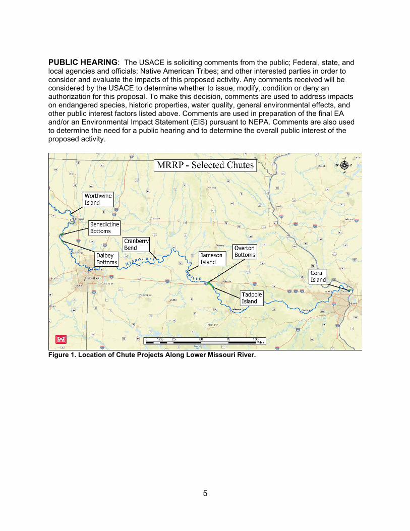
iJ
m
· ------.Jl!!.L.__ -,-,;}e<tsS>Jmrnit
0
0 TI\
[ill
'gJ.,...
0
[ill ~ 10
ijj
MRRP - Selected Chutes f oh' C..oo
:.a~ ~•· [ill
§ e,J
_.r,;i
III 9
ill -f,iJ_ fil fa} -
0
[ill
® " .. ,,
0 dpole • -• and
.....
[!I
[ill M,uouri
0
12.5 25 50 75 1~ rnes I
t.orud, h
(ill >o1
PUBLIC HEARING: The USACE is soliciting comments from the public; Federal, state, and local agencies and officials; Native American Tribes; and other interested parties in order to consider and evaluate the impacts of this proposed activity. Any comments received will be considered by the USACE to determine whether to issue, modify, condition or deny an authorization for this proposal. To make this decision, comments are used to address impacts on endangered species, historic properties, water quality, general environmental effects, and other public interest factors listed above. Comments are used in preparation of the final EA and/or an Environmental Impact Statement (EIS) pursuant to NEPA. Comments are also used to determine the need for a public hearing and to determine the overall public interest of the proposed activity.
Figure 1. Location of Chute Projects Along Lower Missouri River.
5
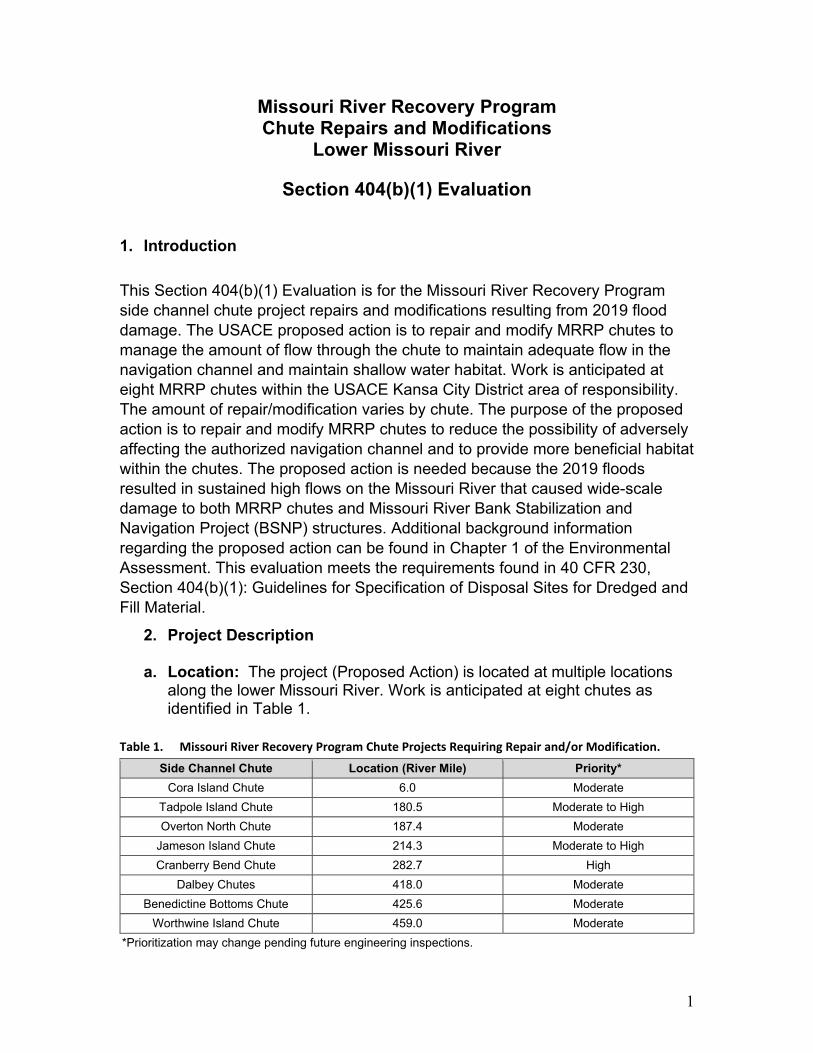
Missouri River Recovery Program Chute Repairs and Modifications
Lower Missouri River
Section 404(b)(1) Evaluation
1. Introduction
This Section 404(b)(1) Evaluation is for the Missouri River Recovery Program side channel chute project repairs and modifications resulting from 2019 flood damage. The USACE proposed action is to repair and modify MRRP chutes to manage the amount of flow through the chute to maintain adequate flow in the navigation channel and maintain shallow water habitat. Work is anticipated at eight MRRP chutes within the USACE Kansa City District area of responsibility. The amount of repair/modification varies by chute. The purpose of the proposed action is to repair and modify MRRP chutes to reduce the possibility of adversely affecting the authorized navigation channel and to provide more beneficial habitat within the chutes. The proposed action is needed because the 2019 floods resulted in sustained high flows on the Missouri River that caused wide-scale damage to both MRRP chutes and Missouri River Bank Stabilization and Navigation Project (BSNP) structures. Additional background information regarding the proposed action can be found in Chapter 1 of the Environmental Assessment. This evaluation meets the requirements found in 40 CFR 230, Section 404(b)(1): Guidelines for Specification of Disposal Sites for Dredged and Fill Material.
2. Project Description
a. Location: The project (Proposed Action) is located at multiple locations along the lower Missouri River. Work is anticipated at eight chutes as identified in Table 1.
Table 1. Missouri River Recovery Program Chute Projects Requiring Repair and/or Modification.
Side Channel Chute Location (River Mile) Priority* Cora Island Chute 6.0 Moderate
Tadpole Island Chute 180.5 Moderate to High Overton North Chute 187.4 Moderate
Jameson Island Chute 214.3 Moderate to High Cranberry Bend Chute 282.7 High
Dalbey Chutes 418.0 Moderate Benedictine Bottoms Chute 425.6 Moderate
Worthwine Island Chute 459.0 Moderate *Prioritization may change pending future engineering inspections.
1
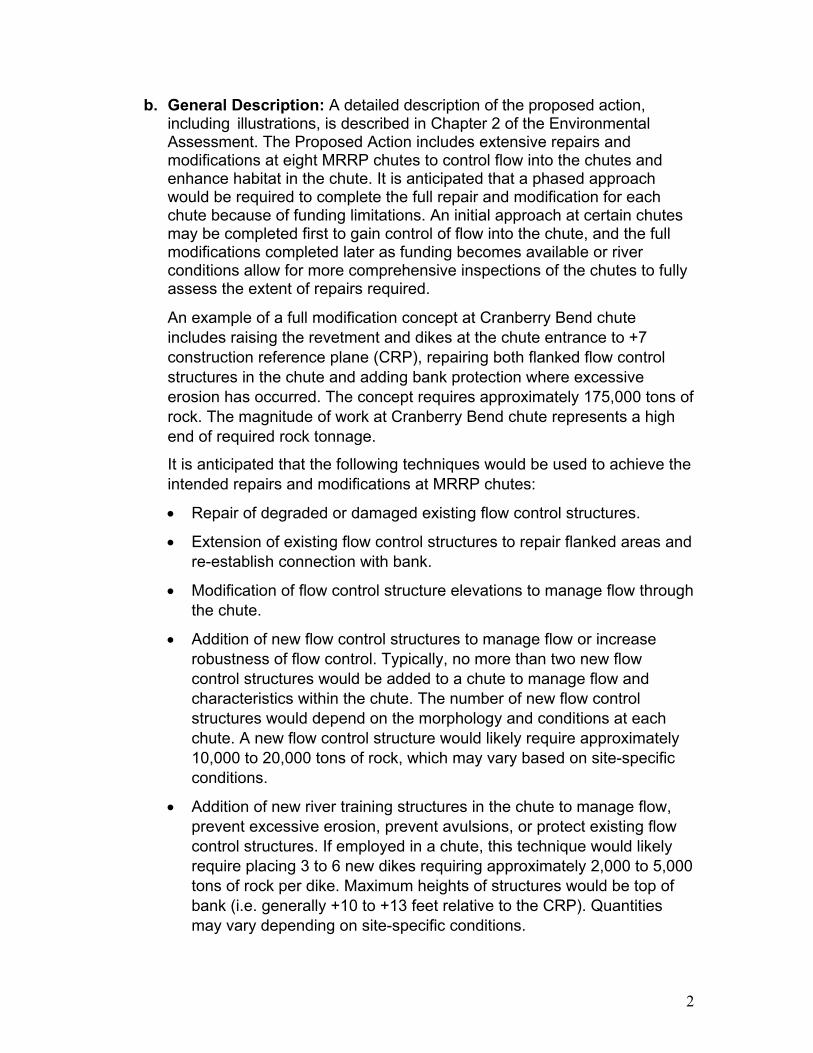
b. General Description: A detailed description of the proposed action, including illustrations, is described in Chapter 2 of the Environmental Assessment. The Proposed Action includes extensive repairs and modifications at eight MRRP chutes to control flow into the chutes and enhance habitat in the chute. It is anticipated that a phased approach would be required to complete the full repair and modification for each chute because of funding limitations. An initial approach at certain chutes may be completed first to gain control of flow into the chute, and the full modifications completed later as funding becomes available or river conditions allow for more comprehensive inspections of the chutes to fully assess the extent of repairs required.
An example of a full modification concept at Cranberry Bend chute includes raising the revetment and dikes at the chute entrance to +7 construction reference plane (CRP), repairing both flanked flow control structures in the chute and adding bank protection where excessive erosion has occurred. The concept requires approximately 175,000 tons of rock. The magnitude of work at Cranberry Bend chute represents a high end of required rock tonnage.
It is anticipated that the following techniques would be used to achieve the intended repairs and modifications at MRRP chutes:
• Repair of degraded or damaged existing flow control structures.
• Extension of existing flow control structures to repair flanked areas and re-establish connection with bank.
• Modification of flow control structure elevations to manage flow through the chute.
• Addition of new flow control structures to manage flow or increase robustness of flow control. Typically, no more than two new flow control structures would be added to a chute to manage flow and characteristics within the chute. The number of new flow control structures would depend on the morphology and conditions at each chute. A new flow control structure would likely require approximately 10,000 to 20,000 tons of rock, which may vary based on site-specific conditions.
• Addition of new river training structures in the chute to manage flow, prevent excessive erosion, prevent avulsions, or protect existing flow control structures. If employed in a chute, this technique would likely require placing 3 to 6 new dikes requiring approximately 2,000 to 5,000 tons of rock per dike. Maximum heights of structures would be top of bank (i.e. generally +10 to +13 feet relative to the CRP). Quantities may vary depending on site-specific conditions.
2
• Addition of bank protection, including revetment, bank paving, and hardpoints, to prevent compromising or flanking of flow control structure, excessive widening, or channel avulsion.
• Modification of existing structures’ heights within the main channel, but near the entrance or exit of the chute to manage flow through the chute. Maximum heights of structures would be top of bank (i.e. generally +10 to +13 feet relative to CRP).
• Elimination or reduction of the size of notches in existing structures to manage the flow quantity and flow paths in and around chutes.
The initial phase of work that would be implemented for the Proposed Action includes repair and modification at Cranberry, Jameson, Cora, Tadpole, and Overton North:
• Cranberry Chute – Raise the existing revetment and dikes at the chute entrance to +7 CRP and fill existing notches except for the notch in the downstream dike. Add five hardpoints near RM 282.9. This work is estimated to require approximately 31,000 tons of rock.
• Jameson Chute – Raise existing dike and revetment structures at the chute entrance to +10 CRP. Repair the existing flow control structure to as-built conditions. New bank armoring would be placed up and downstream of the flow control structure. This work is estimated to require approximately 40,000 tons of rock.
• Cora Chute –Extend the existing revetment at the chute entrance downstream to connect to the L-head structure at +5 CRP. The L-head would be repaired to +6 CRP and existing notches in that structure filled. The existing flow control structure invert (i.e. the lowest point in the structure cross section) would be raised to +3 CRP. The bank head and remainder of the existing flow control structure would be repaired to as-built conditions. Approximately 350 feet of new toe trench revetment would be added on the left bank upstream of the flow control structure. Approximately 400 feet of new bank paving would be installed from existing toe trench revetment to tie into the dike at the bank. This work is estimated to require approximately 37,000 tons of rock.
• Tadpole Chute – Initial work at Tadpole includes extending a dike to the right descending bank, converting the interior chute dike to a flow control structure with a 200-foot invert at 0 CRP in center of the structure, and adding new bank heads 150 feet downstream and 80 feet upstream to +7 CRP. This work is estimated to require approximately 50,000 tons of rock.
3
• Overton North Chute – Fill notches in the existing L-head structure at the chute entrance and repair that structure to +2 CRP on the revetment and +4 CRP on the dike. The invert of the existing flow control structure on the downstream end of the chute would be raised approximately 8 feet (it is currently degraded 5 to 10 feet from pre-flood condition). Bank paving would be repaired along entire alignment of both banks of the flow control structure. This work is estimated to require approximately 12,000 tons of rock.
This initial phase of work is anticipated to place over 120,000 tons of rock at five MRRP chutes. Full repair and modification are expected to require additional work at each chute included in the initial phase. This additional work and the work at the three chutes not included in the initial phase would involve application of any of the management actions previously listed for the Proposed Action. It is estimated that completing full modifications at all eight chutes as part of the Proposed Action could require placement of approximately 700,000 to 900,000 tons of rock.
c. Authority: USACE was authorized to construct and maintain the BSNP under the authorities of the Rivers and Harbors Acts of 1912, 1925, 1927, 1935, and 1945.
3. Review of Compliance (§ 230.10 a-d)
a. No practicable alternative to the Proposed Action would have a less adverse impact on the aquatic ecosystem while meeting the project objectives. The proposed action is anticipated to have overall beneficial impacts to the aquatic ecosystem within the MRRP chutes. Additional information on the impacts of various alternatives to waters of the U.S. can be found in Chapter 3 of the Environmental Assessment.
b. The Proposed Action would not violate any applicable state water quality standards, or applicable toxic effluent standard or prohibition under Section 307 of the Clean Water Act. USACE has determined that the Proposed Action would result in determinations of “may affect, but not likely to adversely affect” for the pallid sturgeon, Indiana bat, and northern long-eared bat. The proposed action is not anticipated to jeopardize the continued existence of species listed as endangered or threatened under the Endangered Species Act of 1973, as amended, or result in the destruction or adverse modification of critical habitat. Furthermore, the Proposed Action would not violate the requirements of any federally designated marine sanctuary.
c. The Proposed Action would not cause or contribute to significant degradation of waters of the United States. This includes any adverse
4
effects on human health, life stages of organisms’ dependent on the aquatic ecosystem, ecosystem diversity, productivity and stability, and recreational, aesthetic, and economic values.
d. Appropriate and practical steps have been taken to minimize potential adverse impacts on the aquatic ecosystem.
4. Technical Evaluation Factors (Subparts C-F)
a. Potential Impacts on Physical and Chemical Characteristics of the Aquatic Ecosystem (Subpart C)
1) Suspended particulates/turbidity: Based on experience from other similar projects, the proposed plan would result in localized minor, short-term impacts to suspended particulates and an increase in turbidity during project construction. The proposed action would not violate any general criteria of the Missouri Water Quality Standards, 10 CSR 20-7.037(3) (A)-(H).
2) Water: The project would not result in any long-term adverse impacts to water quality.
a) Salinity: Not applicable
b) Water Chemistry: Minor, short-term, and localized effects to water chemistry (see below) would primarily include an increase in turbidity due to construction activities.
c) Clarity: A minor short-term increase in turbidity would potentially occur during construction of the projects that could impact clarity. Even at the increased level the clarity would be within baseline conditions of the Missouri River and therefore not expected to adversely impact native species.
d) Color: A minor short-term change in color is possible due to the potential increased turbidity. Similar to Clarity above, any color change would be greatest during construction and would quickly become unnoticeable within a short distance downstream. Any changes in color would be expected to be within the range that is typically found where natural erosion occurs along the river or out of tributaries during high flow events and therefore not expected to adversely impact native species or result in adverse aesthetic impacts.
5
e) Odor: No impacts are anticipated
f) Taste: Not applicable
g) Dissolved Gas Levels: No changes to dissolved gas levels are anticipated.
h) Nutrients: Any alluvial sediments and associated nutrients that may be mobilized to construct the Proposed Action are materials deposited from river transport that are in temporary storage in the floodplain. Under natural conditions, the river would flood, rework, remove, and deposit these materials in a dynamic fashion. Any sediment and nutrients being remobilized are not a net addition to the system. This material, or its equivalent, would have been transported through the system by natural geomorphic processes in an unaltered river. This activity will not adversely affect life forms in the immediate project areas or in areas downstream.
i) Eutrophication: The Proposed Action would not result in any eutrophication to the Missouri River or other water bodies downstream. It has been documented by the National Research Council that other, larger scale, Missouri River Recovery Projects have not contributed to an increase in the areal extent of the Gulf of Mexico hypoxic zone.
3) Current patterns and water circulation: The purpose of the proposed action is to modify the flow of water from the mainstem Missouri River into the MRRP chutes. This would change the current patterns at these locations from the existing condition. These modifications are necessary to prevent adverse effects to the Congressionally authorized navigation channel. The proposed modifications would have the primary effect of reducing velocities within the chutes. It is anticipated that current patterns within the chutes would become more similar to that of a backwater following construction. However, the chutes would still be connected to the main channel during higher flows. See the evaluation documented in Chapter 4 of the Environmental Assessment, which determined this would result in a beneficial impact to habitat within the chutes.
4) Normal water fluctuations: There are no anticipated changes to normal water fluctuations that would result from the Proposed Action. There would not be any significant change to existing water
6
elevation on the Missouri River within the vicinity of the projects as a result of modifying the MRRP chutes.
5) Salinity Gradients: The Proposed Action would not impact any salinity gradients. The Missouri River is a freshwater system and this would not change as a result of the project.
b. Potential Impacts to the Biological Characteristics of the Aquatic Ecosystem (Subpart D)
1) Threatened and endangered species: This project “may affect but is not likely to adversely affect” pallid sturgeon, Indiana bat, and northern long-eared bat. See the discussion in Chapter 4 of the Environmental Assessment and consultation documents included in Appendix B for further information.
2) Fish, crustaceans, mollusks, and other aquatic organisms in the food web: The project would not result in significant adverse impacts to aquatic organisms. Minor, short-term impacts to the aquatic community may result from the smothering of immobile organisms, direct displacement of organisms, and an increase in turbidity, during project construction. The impacts may affect individual organisms in localized areas of the Missouri River, but would not have a significant impact on the overall population of any species within the river system. Long-term, there would be a positive impact to the aquatic ecosystem by creating more beneficial habitat conditions with varying depths and water velocities within the MRRP chutes. No significant adverse long-term impacts are anticipated.
3) Other wildlife: Wildlife associated with aquatic ecosystems includes resident and transient mammals, birds, reptiles, and amphibians. There would be minor, short-term impacts to these types of wildlife as a result of construction activities. No significant adverse long-term impacts are anticipated.
c. Potential Impacts on Special Aquatic Sites (Subpart E)
1) Sanctuaries and Refuges: The Cranberry, Jameson, Overton North, and Cora chutes are on lands that are part of the Big Muddy National Fish and Wildlife Refuge managed by the U.S. Fish and Wildlife Service. The proposed action would have a direct effect on habitat within the chute on these areas; however, as described in detail in Chapter 4 of the Environmental Assessment, these effects would be beneficial.
7
2) Wetlands: The Proposed Action would not result in any direct impacts to wetlands. The projects are located within the banks of the MRRP chutes.
3) Mud flats: No mud flats would be impacted by the Proposed Action.
4) Vegetated shallows: No vegetated shallows would be impacted by the Proposed Action. Because of the velocity in MRRP chutes, little to no rooted aquatic vegetation is located within the project areas.
5) Coral reefs: No coral reefs are found in the Missouri River.
6) Riffle and pool complexes: Because of the low gradient and sandy/silty nature of the Missouri River in the vicinity of the project sites, stable riffle and pool complexes do not typically exist.
d. Potential Effects on Human Use Characteristics (Subpart F):
1) Municipal and private water supplies: The project would not impact any municipal or private water supplies. The project is designed to provide service equal to or better than the previous configuration for commercial navigation on the Missouri River.
2) Recreational and commercial fisheries: The project would not affect the suitability of any recreational or commercial fisheries. The Proposed Action is expected to benefit aquatic organisms, including species targeted by recreational and commercial fisheries.
3) Water-related recreation: The project would not impair or destroy any resources which support recreation activities. There may be minor, short-term impacts to recreation during project construction due to restricted access. Long-term minor adverse impacts to recreation are anticipated from restricting access to the chutes by boat, kayak, or canoe during most of the year.
4) Aesthetics: The project may result in minimal impacts to the aesthetics of the areas as a result of project construction. This impact is expected to be beneficial.
5) Parks, national and historic monuments, national seashores, wilderness areas, research sites, and similar preserves: The Cranberry, Jameson, Overton North, and Cora chutes are on lands that are part of the Big Muddy National Fish and Wildlife Refuge managed by the U.S. Fish and Wildlife Service. The
8
proposed action would have a direct effect on habitat within the chute on these areas; however, as described in detail in Chapter 4 of the Environmental Assessment, these effects would be beneficial.
9
5. EVALUATION OF DREDGED OR FILL MATERIAL (Subpart G)
a. General evaluation of dredged or fill material: No dredging is proposed for this project.
7. ACTIONS TO MINIMIZE ADVERSE EFFECTS (SUBPART H)
Steps to minimize impacts would include non-structural BMPs such as keeping heavy construction equipment out of the waterway whenever possible, protecting construction materials from precipitation/flooding, having spill containment plans for construction equipment, and using materials that are free from contaminants.
8. FACTUAL DETERMINATIONS (§230.11)
A review of the information in items 4 thru 7 of this report indicates that there is minimal potential for long-term adverse environmental effects of the proposed fill. Additionally, there is not expected to be any adverse cumulative or long-term, secondary impacts as a result of the project.
9. FINDINGS (§230.12)
The proposed MRRP chute repairs and modifications for 2019 flood damages has been evaluated and determined to be in compliance with Clean Water Act Section 404(b)(1) guidelines, with the inclusion of appropriate and practical conditions to minimize pollution and adverse effects on the aquatic ecosystem.
10
Prepared by: _____________________________ _____________ Michael Snyder Date Environmental Resources Specialist Environmental Resources Section
Reviewed by: _____________________________ _____________ Mr. Jason Farmer Date Chief, Environmental Resources Section Planning Branch
Approved by: _____________________________ _____________ William C. Hannan, Jr. Date Colonel, Corps of Engineers District Commander
11
USACE Kansas City District Chute Repairs and Modifications EA
Appendix B U.S. Fish and Wildlife Service Coordination
45
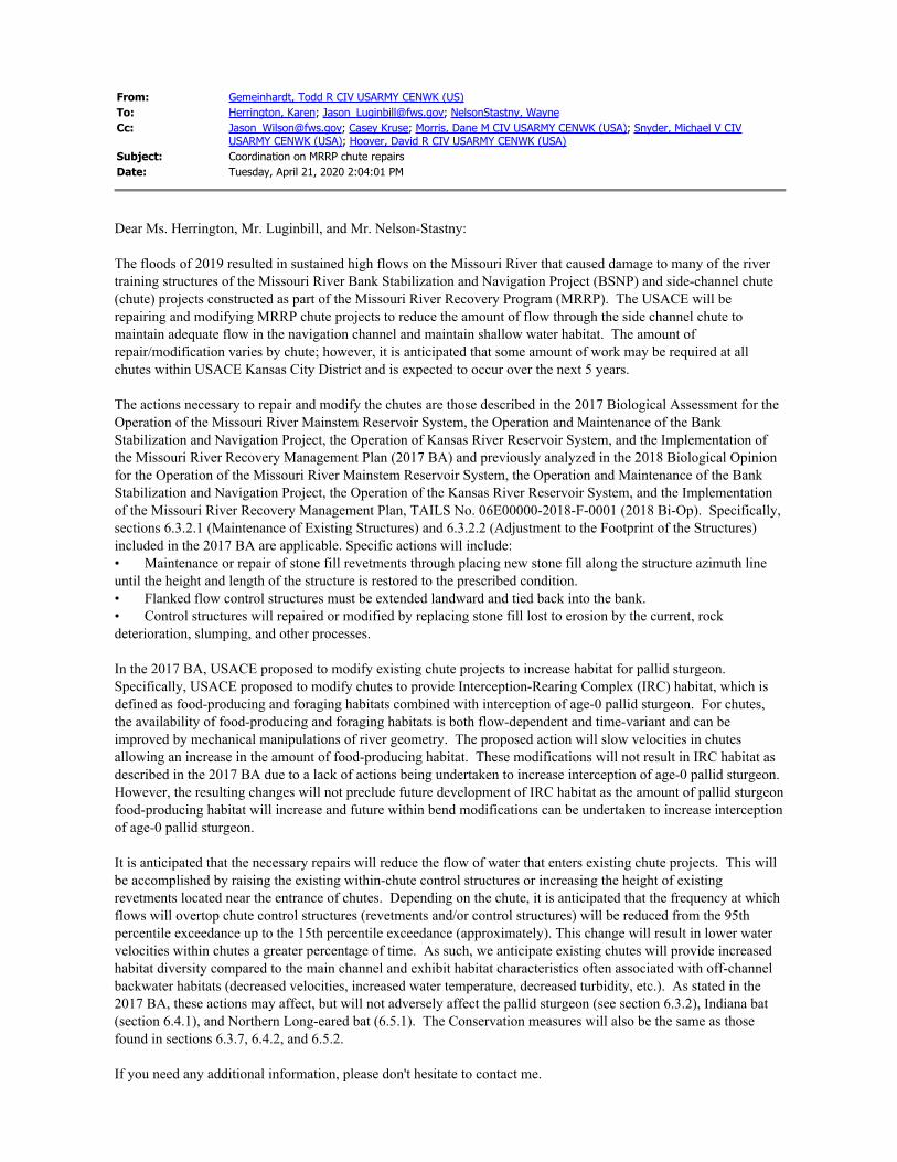
From: Gemeinhardt, Todd R CIV USARMY CENWK (US) To: Herrington, Karen; [email protected]; NelsonStastny, Wayne Cc: [email protected]; Casey Kruse; Morris, Dane M CIV USARMY CENWK (USA); Snyder, Michael V CIV
USARMY CENWK (USA); Hoover, David R CIV USARMY CENWK (USA) Subject: Coordination on MRRP chute repairs Date: Tuesday, April 21, 2020 2:04:01 PM
Dear Ms. Herrington, Mr. Luginbill, and Mr. Nelson-Stastny:
The floods of 2019 resulted in sustained high flows on the Missouri River that caused damage to many of the river training structures of the Missouri River Bank Stabilization and Navigation Project (BSNP) and side-channel chute (chute) projects constructed as part of the Missouri River Recovery Program (MRRP). The USACE will be repairing and modifying MRRP chute projects to reduce the amount of flow through the side channel chute to maintain adequate flow in the navigation channel and maintain shallow water habitat. The amount of repair/modification varies by chute; however, it is anticipated that some amount of work may be required at all chutes within USACE Kansas City District and is expected to occur over the next 5 years.
The actions necessary to repair and modify the chutes are those described in the 2017 Biological Assessment for the Operation of the Missouri River Mainstem Reservoir System, the Operation and Maintenance of the Bank Stabilization and Navigation Project, the Operation of Kansas River Reservoir System, and the Implementation of the Missouri River Recovery Management Plan (2017 BA) and previously analyzed in the 2018 Biological Opinion for the Operation of the Missouri River Mainstem Reservoir System, the Operation and Maintenance of the Bank Stabilization and Navigation Project, the Operation of the Kansas River Reservoir System, and the Implementation of the Missouri River Recovery Management Plan, TAILS No. 06E00000-2018-F-0001 (2018 Bi-Op). Specifically, sections 6.3.2.1 (Maintenance of Existing Structures) and 6.3.2.2 (Adjustment to the Footprint of the Structures) included in the 2017 BA are applicable. Specific actions will include: • Maintenance or repair of stone fill revetments through placing new stone fill along the structure azimuth line until the height and length of the structure is restored to the prescribed condition. • Flanked flow control structures must be extended landward and tied back into the bank. • Control structures will repaired or modified by replacing stone fill lost to erosion by the current, rock deterioration, slumping, and other processes.
In the 2017 BA, USACE proposed to modify existing chute projects to increase habitat for pallid sturgeon. Specifically, USACE proposed to modify chutes to provide Interception-Rearing Complex (IRC) habitat, which is defined as food-producing and foraging habitats combined with interception of age-0 pallid sturgeon. For chutes, the availability of food-producing and foraging habitats is both flow-dependent and time-variant and can be improved by mechanical manipulations of river geometry. The proposed action will slow velocities in chutes allowing an increase in the amount of food-producing habitat. These modifications will not result in IRC habitat as described in the 2017 BA due to a lack of actions being undertaken to increase interception of age-0 pallid sturgeon. However, the resulting changes will not preclude future development of IRC habitat as the amount of pallid sturgeon food-producing habitat will increase and future within bend modifications can be undertaken to increase interception of age-0 pallid sturgeon.
It is anticipated that the necessary repairs will reduce the flow of water that enters existing chute projects. This will be accomplished by raising the existing within-chute control structures or increasing the height of existing revetments located near the entrance of chutes. Depending on the chute, it is anticipated that the frequency at which flows will overtop chute control structures (revetments and/or control structures) will be reduced from the 95th percentile exceedance up to the 15th percentile exceedance (approximately). This change will result in lower water velocities within chutes a greater percentage of time. As such, we anticipate existing chutes will provide increased habitat diversity compared to the main channel and exhibit habitat characteristics often associated with off-channel backwater habitats (decreased velocities, increased water temperature, decreased turbidity, etc.). As stated in the 2017 BA, these actions may affect, but will not adversely affect the pallid sturgeon (see section 6.3.2), Indiana bat (section 6.4.1), and Northern Long-eared bat (6.5.1). The Conservation measures will also be the same as those found in sections 6.3.7, 6.4.2, and 6.5.2.
If you need any additional information, please don't hesitate to contact me.

Sincerely, Todd
Todd Gemeinhardt Habitat Assessment and Monitoring Program Manager US Army Corps of Engineers 601 E. 12th Street Kansas City, MO 64106 816-389-2268
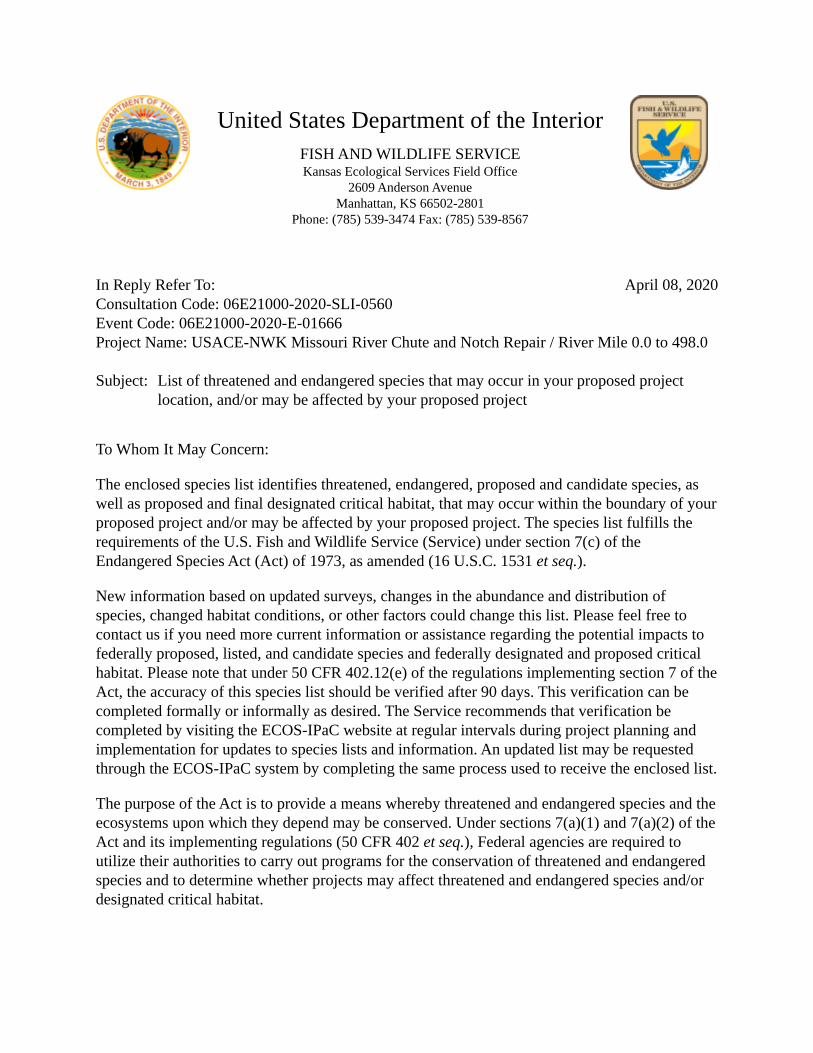
United States Department of the Interior FISH AND WILDLIFE SERVICE Kansas Ecological Services Field Office
2609 Anderson Avenue Manhattan, KS 66502-2801
Phone: (785) 539-3474 Fax: (785) 539-8567
In Reply Refer To: April 08, 2020 Consultation Code: 06E21000-2020-SLI-0560 Event Code: 06E21000-2020-E-01666 Project Name: USACE-NWK Missouri River Chute and Notch Repair / River Mile 0.0 to 498.0
Subject: List of threatened and endangered species that may occur in your proposed project location, and/or may be affected by your proposed project
To Whom It May Concern:
The enclosed species list identifies threatened, endangered, proposed and candidate species, as well as proposed and final designated critical habitat, that may occur within the boundary of your proposed project and/or may be affected by your proposed project. The species list fulfills the requirements of the U.S. Fish and Wildlife Service (Service) under section 7(c) of the Endangered Species Act (Act) of 1973, as amended (16 U.S.C. 1531 et seq.).
New information based on updated surveys, changes in the abundance and distribution of species, changed habitat conditions, or other factors could change this list. Please feel free to contact us if you need more current information or assistance regarding the potential impacts to federally proposed, listed, and candidate species and federally designated and proposed critical habitat. Please note that under 50 CFR 402.12(e) of the regulations implementing section 7 of the Act, the accuracy of this species list should be verified after 90 days. This verification can be completed formally or informally as desired. The Service recommends that verification be completed by visiting the ECOS-IPaC website at regular intervals during project planning and implementation for updates to species lists and information. An updated list may be requested through the ECOS-IPaC system by completing the same process used to receive the enclosed list.
The purpose of the Act is to provide a means whereby threatened and endangered species and the ecosystems upon which they depend may be conserved. Under sections 7(a)(1) and 7(a)(2) of the Act and its implementing regulations (50 CFR 402 et seq.), Federal agencies are required to utilize their authorities to carry out programs for the conservation of threatened and endangered species and to determine whether projects may affect threatened and endangered species and/or designated critical habitat.
2 04/08/2020 Event Code: 06E21000-2020-E-01666
A Biological Assessment is required for construction projects (or other undertakings having similar physical impacts) that are major Federal actions significantly affecting the quality of the human environment as defined in the National Environmental Policy Act (42 U.S.C. 4332(2) (c)). For projects other than major construction activities, the Service suggests that a biological evaluation similar to a Biological Assessment be prepared to determine whether the project may affect listed or proposed species and/or designated or proposed critical habitat. Recommended contents of a Biological Assessment are described at 50 CFR 402.12.
If a Federal agency determines, based on the Biological Assessment or biological evaluation, that listed species and/or designated critical habitat may be affected by the proposed project, the agency is required to consult with the Service pursuant to 50 CFR 402. In addition, the Service recommends that candidate species, proposed species and proposed critical habitat be addressed within the consultation. More information on the regulations and procedures for section 7 consultation, including the role of permit or license applicants, can be found in the "Endangered Species Consultation Handbook" at:
https://www.fws.gov/endangered/esa-library/pdf/esa_section7_handbook.pdf
Please be aware that bald and golden eagles are protected under the Bald and Golden Eagle Protection Act (16 U.S.C. 668 et seq.)(https://www.fws.gov/birds/management/managed-species/ eagle-management.php), and wind projects affecting these species may require development of an eagle conservation plan (https://www.fws.gov/migratorybirds/pdf/management/ eagleconservationplanguidance.pdf). Additionally, wind energy projects should follow the wind energy guidelines (https://www.fws.gov/ecological-services/energy-development/wind.html) for minimizing impacts to migratory birds and bats.
Guidance for minimizing impacts to migratory birds for projects including communications towers (e.g., cellular, digital television, radio, and emergency broadcast) can be found at: https:// www.fws.gov/birds/management/project-assessment-tools-and-guidance.php
We appreciate your concern for threatened and endangered species. The Service encourages Federal agencies to include conservation of threatened and endangered species into their project planning to further the purposes of the Act. Please include the Consultation Tracking Number in the header of this letter with any request for consultation or correspondence about your project that you submit to our office.
Attachment(s):
▪ Official Species List ▪ USFWS National Wildlife Refuges and Fish Hatcheries ▪ Migratory Birds ▪ Wetlands
1 04/08/2020 Event Code: 06E21000-2020-E-01666
Official Species List This list is provided pursuant to Section 7 of the Endangered Species Act, and fulfills the requirement for Federal agencies to "request of the Secretary of the Interior information whether any species which is listed or proposed to be listed may be present in the area of a proposed action".
This species list is provided by:
Kansas Ecological Services Field Office 2609 Anderson Avenue Manhattan, KS 66502-2801 (785) 539-3474
This project's location is within the jurisdiction of multiple offices. Expect additional species list documents from the following office, and expect that the species and critical habitats in each document reflect only those that fall in the office's jurisdiction:
Missouri Ecological Services Field Office 101 Park Deville Drive Suite A Columbia, MO 65203-0057 (573) 234-2132

2 04/08/2020 Event Code: 06E21000-2020-E-01666
Project Summary Consultation Code: 06E21000-2020-SLI-0560
Event Code: 06E21000-2020-E-01666
Project Name: USACE-NWK Missouri River Chute and Notch Repair / River Mile 0.0 to 498.0
Project Type: STREAM / WATERBODY / CANALS / LEVEES / DIKES
Project Description: Structure Notches During flood recovery repairs over the next 3-4 years, an estimated 40 to 100 notches will need to be reduced in size or completely filled due to loss of the original design function and corresponding loss of habitat, impacts to the navigation channel, or bank erosion along private property. Up to 20 of these notch modifications may be driven primarily by bank or channel concerns. Notches to be filled or reduced will likely be located throughout the nearly 500 miles of river within the Kansas City District’s area of operation. No more than two notches in any single river mile, or five notches on a single river bend, are anticipated to be filled or reduced. If 40-100 notches are filled, this represents approximately 2-4% of existing notches, 20 notches would represent less than 1% of existing notches. Concerns regarding navigation channel reliability and erosion of private property near notches will also be considered in assessing which notches will be reduced or closed. Notches near bank and channel concerns will be assessed for structure damage, impaired function, and relevance to reported concerns. When possible, these areas will be addressed through repair to original design criteria. If needed, modifications to notches to resolve bank and channel concerns will be designed to minimize impacts to adjacent habitat and maintain existing habitat as much as possible and may result in reduction of notch size or notch closure. Chutes The USACE proposed action is to repair and modify MRRP chute projects to reduce the amount of flow through the side channel chute to maintain adequate flow in the navigation channel and maintain shallow water habitat. The amount of repair/modification varies by chute; however, it is anticipated that some amount of work may be required at all chutes (Table 1) within USACE Kansas City District and is expected to occur over the next 5 years. Table 1. Missouri River Recovery Program Chute Projects Requiring Repair and/or Modification in the state of Missouri. Priority may change
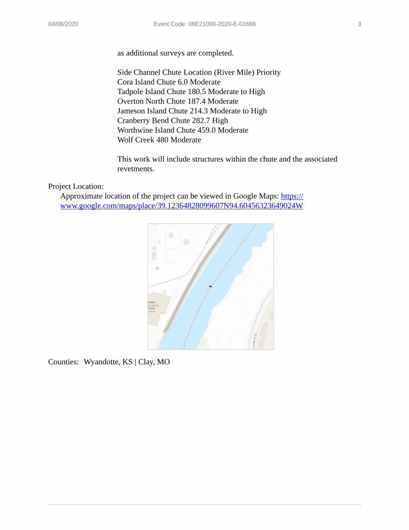
3 04/08/2020 Event Code: 06E21000-2020-E-01666
as additional surveys are completed. Side Channel Chute Location (River Mile) Priority Cora Island Chute 6.0 Moderate Tadpole Island Chute 180.5 Moderate to High Overton North Chute 187.4 Moderate Jameson Island Chute 214.3 Moderate to High Cranberry Bend Chute 282.7 High Worthwine Island Chute 459.0 Moderate Wolf Creek 480 Moderate This work will include structures within the chute and the associated revetments.
Project Location: Approximate location of the project can be viewed in Google Maps: https:// www.google.com/maps/place/39.12364828099607N94.60456323649024W
Counties: Wyandotte, KS | Clay, MO
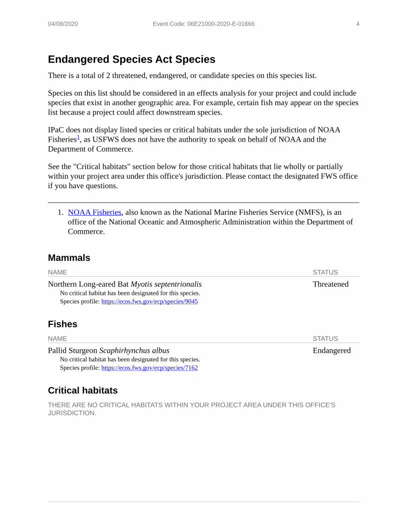
4 04/08/2020 Event Code: 06E21000-2020-E-01666
Endangered Species Act Species There is a total of 2 threatened, endangered, or candidate species on this species list.
Species on this list should be considered in an effects analysis for your project and could include species that exist in another geographic area. For example, certain fish may appear on the species list because a project could affect downstream species.
IPaC does not display listed species or critical habitats under the sole jurisdiction of NOAA1Fisheries , as USFWS does not have the authority to speak on behalf of NOAA and the
Department of Commerce.
See the "Critical habitats" section below for those critical habitats that lie wholly or partially within your project area under this office's jurisdiction. Please contact the designated FWS office if you have questions.
1. NOAA Fisheries, also known as the National Marine Fisheries Service (NMFS), is an office of the National Oceanic and Atmospheric Administration within the Department of Commerce.
Mammals NAME STATUS
Northern Long-eared Bat Myotis septentrionalis Threatened No critical habitat has been designated for this species. Species profile: https://ecos.fws.gov/ecp/species/9045
Fishes NAME STATUS
Pallid Sturgeon Scaphirhynchus albus Endangered No critical habitat has been designated for this species. Species profile: https://ecos.fws.gov/ecp/species/7162
Critical habitats THERE ARE NO CRITICAL HABITATS WITHIN YOUR PROJECT AREA UNDER THIS OFFICE'S JURISDICTION.
1 04/08/2020 Event Code: 06E21000-2020-E-01666
USFWS National Wildlife Refuge Lands And Fish Hatcheries Any activity proposed on lands managed by the National Wildlife Refuge system must undergo a 'Compatibility Determination' conducted by the Refuge. Please contact the individual Refuges to discuss any questions or concerns.
THERE ARE NO REFUGE LANDS OR FISH HATCHERIES WITHIN YOUR PROJECT AREA.
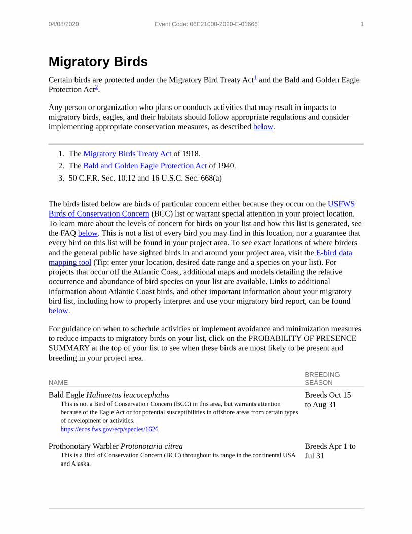
1 04/08/2020 Event Code: 06E21000-2020-E-01666
Migratory Birds Certain birds are protected under the Migratory Bird Treaty Act1 and the Bald and Golden EagleProtection Act 2.
Any person or organization who plans or conducts activities that may result in impacts to migratory birds, eagles, and their habitats should follow appropriate regulations and consider implementing appropriate conservation measures, as described below.
1. The Migratory Birds Treaty Act of 1918. 2. The Bald and Golden Eagle Protection Act of 1940. 3. 50 C.F.R. Sec. 10.12 and 16 U.S.C. Sec. 668(a)
The birds listed below are birds of particular concern either because they occur on the USFWS Birds of Conservation Concern (BCC) list or warrant special attention in your project location. To learn more about the levels of concern for birds on your list and how this list is generated, see the FAQ below. This is not a list of every bird you may find in this location, nor a guarantee that every bird on this list will be found in your project area. To see exact locations of where birders and the general public have sighted birds in and around your project area, visit the E-bird data mapping tool (Tip: enter your location, desired date range and a species on your list). For projects that occur off the Atlantic Coast, additional maps and models detailing the relative occurrence and abundance of bird species on your list are available. Links to additional information about Atlantic Coast birds, and other important information about your migratory bird list, including how to properly interpret and use your migratory bird report, can be found below.
For guidance on when to schedule activities or implement avoidance and minimization measures to reduce impacts to migratory birds on your list, click on the PROBABILITY OF PRESENCE SUMMARY at the top of your list to see when these birds are most likely to be present and breeding in your project area.
BREEDING NAME SEASON
Bald Eagle Haliaeetus leucocephalus Breeds Oct 15 This is not a Bird of Conservation Concern (BCC) in this area, but warrants attention to Aug 31 because of the Eagle Act or for potential susceptibilities in offshore areas from certain types of development or activities. https://ecos.fws.gov/ecp/species/1626
Prothonotary Warbler Protonotaria citrea Breeds Apr 1 to This is a Bird of Conservation Concern (BCC) throughout its range in the continental USA Jul 31 and Alaska.
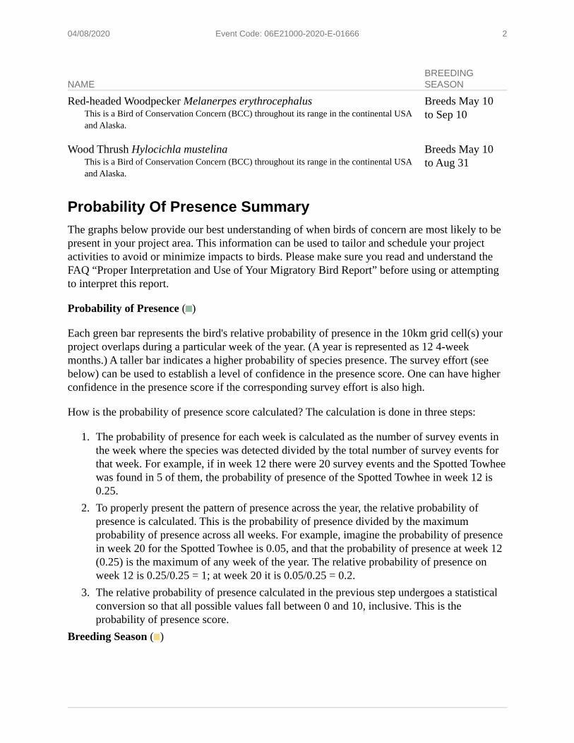
2 04/08/2020 Event Code: 06E21000-2020-E-01666
BREEDING NAME SEASON
Red-headed Woodpecker Melanerpes erythrocephalus Breeds May 10 This is a Bird of Conservation Concern (BCC) throughout its range in the continental USA to Sep 10 and Alaska.
Wood Thrush Hylocichla mustelina Breeds May 10 This is a Bird of Conservation Concern (BCC) throughout its range in the continental USA to Aug 31 and Alaska.
Probability Of Presence Summary The graphs below provide our best understanding of when birds of concern are most likely to be present in your project area. This information can be used to tailor and schedule your project activities to avoid or minimize impacts to birds. Please make sure you read and understand the FAQ “Proper Interpretation and Use of Your Migratory Bird Report” before using or attempting to interpret this report.
Probability of Presence ( ■ )
Each green bar represents the bird's relative probability of presence in the 10km grid cell(s) your project overlaps during a particular week of the year. (A year is represented as 12 4-week months.) A taller bar indicates a higher probability of species presence. The survey effort (see below) can be used to establish a level of confidence in the presence score. One can have higher confidence in the presence score if the corresponding survey effort is also high.
How is the probability of presence score calculated? The calculation is done in three steps:
1. The probability of presence for each week is calculated as the number of survey events in the week where the species was detected divided by the total number of survey events for that week. For example, if in week 12 there were 20 survey events and the Spotted Towhee was found in 5 of them, the probability of presence of the Spotted Towhee in week 12 is 0.25.
2. To properly present the pattern of presence across the year, the relative probability of presence is calculated. This is the probability of presence divided by the maximum probability of presence across all weeks. For example, imagine the probability of presence in week 20 for the Spotted Towhee is 0.05, and that the probability of presence at week 12 (0.25) is the maximum of any week of the year. The relative probability of presence on week 12 is 0.25/0.25 = 1; at week 20 it is 0.05/0.25 = 0.2.
3. The relative probability of presence calculated in the previous step undergoes a statistical conversion so that all possible values fall between 0 and 10, inclusive. This is the probability of presence score.
Breeding Season ( ■ )
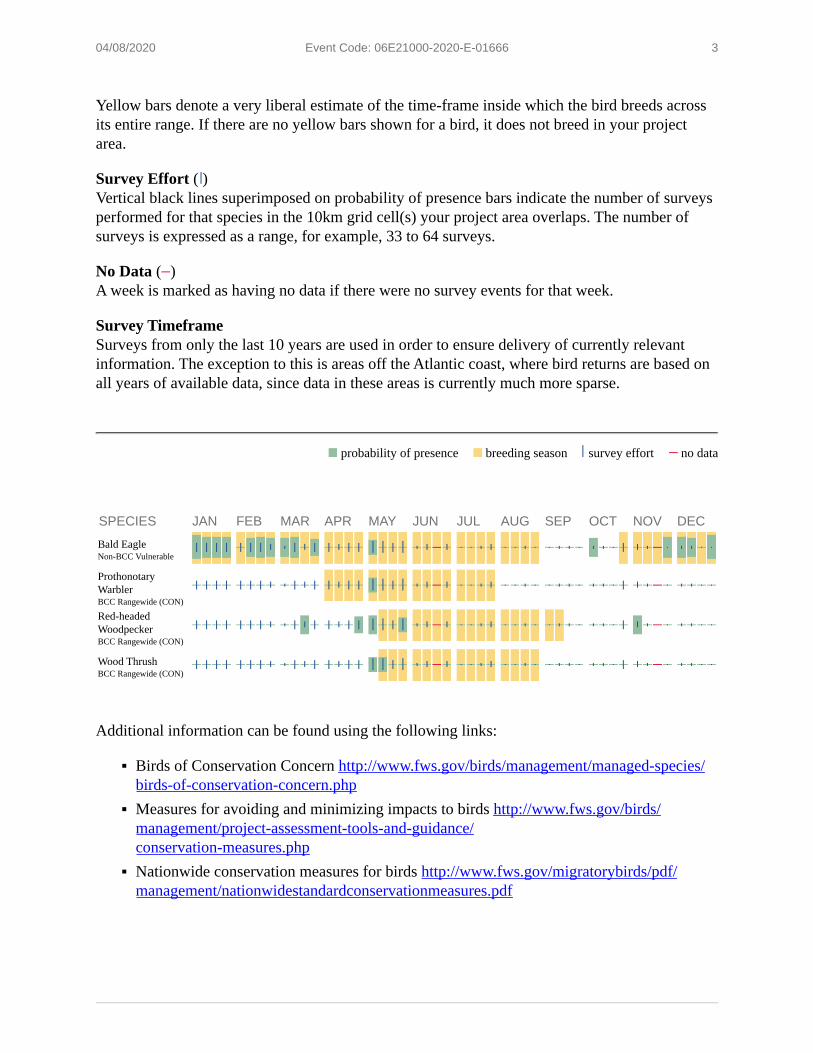
■ ■
++++++++ --++ - -
++++ ++++ ... + I + +++ I - - + I _, __ _ ..,_
- ++ - -
3 04/08/2020 Event Code: 06E21000-2020-E-01666
Yellow bars denote a very liberal estimate of the time-frame inside which the bird breeds across its entire range. If there are no yellow bars shown for a bird, it does not breed in your project area.
Survey Effort ( ) Vertical black lines superimposed on probability of presence bars indicate the number of surveys performed for that species in the 10km grid cell(s) your project area overlaps. The number of surveys is expressed as a range, for example, 33 to 64 surveys.
No Data ( ) A week is marked as having no data if there were no survey events for that week.
Survey Timeframe Surveys from only the last 10 years are used in order to ensure delivery of currently relevant information. The exception to this is areas off the Atlantic coast, where bird returns are based on all years of available data, since data in these areas is currently much more sparse.
probability of presence breeding season survey effort no data
SPECIES JAN FEB MAR APR MAY JUN JUL AUG SEP OCT NOV DEC
Bald Eagle Non-BCC Vulnerable
Prothonotary Warbler BCC Rangewide (CON)
Red-headed Woodpecker BCC Rangewide (CON)
Wood Thrush BCC Rangewide (CON)
Additional information can be found using the following links:
▪ Birds of Conservation Concern http://www.fws.gov/birds/management/managed-species/ birds-of-conservation-concern.php
▪ Measures for avoiding and minimizing impacts to birds http://www.fws.gov/birds/ management/project-assessment-tools-and-guidance/ conservation-measures.php
▪ Nationwide conservation measures for birds http://www.fws.gov/migratorybirds/pdf/ management/nationwidestandardconservationmeasures.pdf
4 04/08/2020 Event Code: 06E21000-2020-E-01666
Migratory Birds FAQ Tell me more about conservation measures I can implement to avoid or minimize impacts to migratory birds. Nationwide Conservation Measures describes measures that can help avoid and minimize impacts to all birds at any location year round. Implementation of these measures is particularly important when birds are most likely to occur in the project area. When birds may be breeding in the area, identifying the locations of any active nests and avoiding their destruction is a very helpful impact minimization measure. To see when birds are most likely to occur and be breeding in your project area, view the Probability of Presence Summary. Additional measures and/or permits may be advisable depending on the type of activity you are conducting and the type of infrastructure or bird species present on your project site.
What does IPaC use to generate the migratory birds potentially occurring in my specified location? The Migratory Bird Resource List is comprised of USFWS Birds of Conservation Concern (BCC) and other species that may warrant special attention in your project location.
The migratory bird list generated for your project is derived from data provided by the Avian Knowledge Network (AKN). The AKN data is based on a growing collection of survey, banding, and citizen science datasets and is queried and filtered to return a list of those birds reported as occurring in the 10km grid cell(s) which your project intersects, and that have been identified as warranting special attention because they are a BCC species in that area, an eagle (Eagle Act requirements may apply), or a species that has a particular vulnerability to offshore activities or development.
Again, the Migratory Bird Resource list includes only a subset of birds that may occur in your project area. It is not representative of all birds that may occur in your project area. To get a list of all birds potentially present in your project area, please visit the AKN Phenology Tool.
What does IPaC use to generate the probability of presence graphs for the migratory birds potentially occurring in my specified location? The probability of presence graphs associated with your migratory bird list are based on data provided by the Avian Knowledge Network (AKN). This data is derived from a growing collection of survey, banding, and citizen science datasets .
Probability of presence data is continuously being updated as new and better information becomes available. To learn more about how the probability of presence graphs are produced and how to interpret them, go the Probability of Presence Summary and then click on the "Tell me about these graphs" link.
How do I know if a bird is breeding, wintering, migrating or present year-round in my project area? To see what part of a particular bird's range your project area falls within (i.e. breeding, wintering, migrating or year-round), you may refer to the following resources: The Cornell Lab of Ornithology All About Birds Bird Guide, or (if you are unsuccessful in locating the bird of
5 04/08/2020 Event Code: 06E21000-2020-E-01666
interest there), the Cornell Lab of Ornithology Neotropical Birds guide. If a bird on your migratory bird species list has a breeding season associated with it, if that bird does occur in your project area, there may be nests present at some point within the timeframe specified. If "Breeds elsewhere" is indicated, then the bird likely does not breed in your project area.
What are the levels of concern for migratory birds? Migratory birds delivered through IPaC fall into the following distinct categories of concern:
1. "BCC Rangewide" birds are Birds of Conservation Concern (BCC) that are of concern throughout their range anywhere within the USA (including Hawaii, the Pacific Islands, Puerto Rico, and the Virgin Islands);
2. "BCC - BCR" birds are BCCs that are of concern only in particular Bird Conservation Regions (BCRs) in the continental USA; and
3. "Non-BCC - Vulnerable" birds are not BCC species in your project area, but appear on your list either because of the Eagle Act requirements (for eagles) or (for non-eagles) potential susceptibilities in offshore areas from certain types of development or activities (e.g. offshore energy development or longline fishing).
Although it is important to try to avoid and minimize impacts to all birds, efforts should be made, in particular, to avoid and minimize impacts to the birds on this list, especially eagles and BCC species of rangewide concern. For more information on conservation measures you can implement to help avoid and minimize migratory bird impacts and requirements for eagles, please see the FAQs for these topics.
Details about birds that are potentially affected by offshore projects For additional details about the relative occurrence and abundance of both individual bird species and groups of bird species within your project area off the Atlantic Coast, please visit the Northeast Ocean Data Portal. The Portal also offers data and information about other taxa besides birds that may be helpful to you in your project review. Alternately, you may download the bird model results files underlying the portal maps through the NOAA NCCOS Integrative Statistical Modeling and Predictive Mapping of Marine Bird Distributions and Abundance on the Atlantic Outer Continental Shelf project webpage.
Bird tracking data can also provide additional details about occurrence and habitat use throughout the year, including migration. Models relying on survey data may not include this information. For additional information on marine bird tracking data, see the Diving Bird Study and the nanotag studies or contact Caleb Spiegel or Pam Loring.
What if I have eagles on my list? If your project has the potential to disturb or kill eagles, you may need to obtain a permit to avoid violating the Eagle Act should such impacts occur.
Proper Interpretation and Use of Your Migratory Bird Report The migratory bird list generated is not a list of all birds in your project area, only a subset of birds of priority concern. To learn more about how your list is generated, and see options for identifying what other birds may be in your project area, please see the FAQ “What does IPaC
6 04/08/2020 Event Code: 06E21000-2020-E-01666
use to generate the migratory birds potentially occurring in my specified location”. Please be aware this report provides the “probability of presence” of birds within the 10 km grid cell(s) that overlap your project; not your exact project footprint. On the graphs provided, please also look carefully at the survey effort (indicated by the black vertical bar) and for the existence of the “no data” indicator (a red horizontal bar). A high survey effort is the key component. If the survey effort is high, then the probability of presence score can be viewed as more dependable. In contrast, a low survey effort bar or no data bar means a lack of data and, therefore, a lack of certainty about presence of the species. This list is not perfect; it is simply a starting point for identifying what birds of concern have the potential to be in your project area, when they might be there, and if they might be breeding (which means nests might be present). The list helps you know what to look for to confirm presence, and helps guide you in knowing when to implement conservation measures to avoid or minimize potential impacts from your project activities, should presence be confirmed. To learn more about conservation measures, visit the FAQ “Tell me about conservation measures I can implement to avoid or minimize impacts to migratory birds” at the bottom of your migratory bird trust resources page.
1 04/08/2020 Event Code: 06E21000-2020-E-01666
Wetlands Impacts to NWI wetlands and other aquatic habitats may be subject to regulation under Section 404 of the Clean Water Act, or other State/Federal statutes.
For more information please contact the Regulatory Program of the local U.S. Army Corps of Engineers District.
Please note that the NWI data being shown may be out of date. We are currently working to update our NWI data set. We recommend you verify these results with a site visit to determine the actual extent of wetlands on site.
RIVERINE ▪ Riverine
United States Department of the Interior FISH AND WILDLIFE SERVICE Missouri Ecological Services Field Office
101 Park Deville Drive Suite A
Columbia, MO 65203-0057 Phone: (573) 234-2132 Fax: (573) 234-2181
In Reply Refer To: April 08, 2020 Consultation Code: 03E14000-2020-SLI-1860 Event Code: 03E14000-2020-E-04694 Project Name: USACE-NWK Missouri River Chute and Notch Repair / River Mile 0.0 to 498.0
Subject: List of threatened and endangered species that may occur in your proposed project location, and/or may be affected by your proposed project
To Whom It May Concern:
This response has been generated by the Information, Planning, and Conservation (IPaC) system to provide information on natural resources that could be affected by your project. The U.S. Fish and Wildlife Service (Service) provides this response under the authority of the Endangered Species Act of 1973 (16 U.S.C. 1531-1543), the Bald and Golden Eagle Protection Act (16 U.S.C. 668-668d), the Migratory Bird Treaty Act (16 U.S.C. 703-712), and the Fish and Wildlife Coordination Act (16 U.S.C. 661 et seq.).
Threatened and Endangered Species
The enclosed species list identifies threatened, endangered, proposed and candidate species, as well as proposed and final designated critical habitat, that may occur within the boundary of your proposed project and may be affected by your proposed project. The species list fulfills the requirement for obtaining a Technical Assistance Letter from the U.S. Fish and Wildlife Service (Service) under section 7(c) of the Endangered Species Act (Act) of 1973, as amended (16 U.S.C. 1531 et seq.).
New information based on updated surveys, changes in the abundance and distribution of species, changed habitat conditions, or other factors could change this list. Note that under 50 CFR 402.12(e) of the regulations implementing section 7 of the Act, the accuracy of this species list should be verified after 90 days. The Service recommends that verification be completed by visiting the ECOS-IPaC website at regular intervals during project planning and implementation for updates to species lists and information. An updated list may be requested through the ECOS-IPaC system by completing the same process used to receive the enclosed list.
2 04/08/2020 Event Code: 03E14000-2020-E-04694
Consultation Technical Assistance
Refer to the Midwest Region S7 Technical Assistance website for step-by-step instructions for making species determinations and for specific guidance on the following types of projects: projects in developed areas, HUD, pipelines, buried utilities, telecommunications, and requests for a Conditional Letter of Map Revision (CLOMR) from FEMA.
Federally Listed Bat Species
Indiana bats, gray bats, and northern long-eared bats occur throughout Missouri and the information below may help in determining if your project may affect these species.
Gray bats - Gray bats roost in caves or mines year-round and use water features and forested riparian corridors for foraging and travel. If your project will impact caves, mines, associated riparian areas, or will involve tree removal around these features particularly within stream corridors, riparian areas, or associated upland woodlots gray bats could be affected.
Indiana and northern long-eared bats - These species hibernate in caves or mines only during the winter. In Missouri the hibernation season is considered to be November 1 to March 31. During the active season in Missouri (April 1 to October 31) they roost in forest and woodland habitats. Suitable summer habitat for Indiana bats and northern long-eared bats consists of a wide variety of forested/wooded habitats where they roost, forage, and travel and may also include some adjacent and interspersed non-forested habitats such as emergent wetlands and adjacent edges of agricultural fields, old fields and pastures. This includes forests and woodlots containing potential roosts (i.e., live trees and/or snags 5 inches diameter at breast height (dbh) for Indiana bat, and 3 inches dbh for northern long-eared bat, that have exfoliating bark, cracks, crevices, and/or hollows), as well as linear features such as fencerows, riparian forests, and other wooded corridors. These wooded areas may be dense or loose aggregates of trees with variable amounts of canopy closure. Tree species often include, but are not limited to, shellbark or shagbark hickory, white oak, cottonwood, and maple. Individual trees may be considered suitable habitat when they exhibit the characteristics of a potential roost tree and are located within 1,000 feet (305 meters) of other forested/wooded habitat. Northern long-eared bats have also been observed roosting in human-made structures, such as buildings, barns, bridges, and bat houses; therefore, these structures should also be considered potential summer habitat and evaluated for use by bats. If your project will impact caves or mines or will involve clearing forest or woodland habitat containing suitable roosting habitat, Indiana bats or northern long-eared bats could be affected.
Examples of unsuitable habitat include:
▪ Individual trees that are greater than 1,000 feet from forested or wooded areas; ▪ Trees found in highly-developed urban areas (e.g., street trees, downtown areas); ▪ A pure stand of less than 3-inch dbh trees that are not mixed with larger trees; and ▪ A stand of eastern red cedar shrubby vegetation with no potential roost trees.
3 04/08/2020 Event Code: 03E14000-2020-E-04694
Using the IPaC Official Species List to Make No Effect and May Affect Determinations for Listed Species
1. If IPaC returns a result of “There are no listed species found within the vicinity of the project,” then project proponents can conclude the proposed activities will have no effect on any federally listed species under Service jurisdiction. Concurrence from the Service is not required for No Effect determinations. No further consultation or coordination is required. Attach this letter to the dated IPaC species list report for your records. An example "No Effect" document also can be found on the S7 Technical Assistance website.
2. If IPaC returns one or more federally listed, proposed, or candidate species as potentially present in the action area of the proposed project other than bats (see #3 below) then project proponents can conclude the proposed activities may affect those species. For assistance in determining if suitable habitat for listed, candidate, or proposed species occurs within your project area or if species may be affected by project activities, you can obtain Life History Information for Listed and Candidate Species through the S7 Technical Assistance website.
3. If IPac returns a result that one or more federally listed bat species (Indiana bat, northern long-eared bat, or gray bat) are potentially present in the action area of the proposed project, project proponents can conclude the proposed activities may affect these bat species IF one or more of the following activities are proposed:
a. Clearing or disturbing suitable roosting habitat, as defined above, at any time of year; b. Any activity in or near the entrance to a cave or mine; c. Mining, deep excavation, or underground work within 0.25 miles of a cave or mine; d. Construction of one or more wind turbines; or e. Demolition or reconstruction of human-made structures that are known to be used by bats
based on observations of roosting bats, bats emerging at dusk, or guano deposits or stains. If none of the above activities are proposed, project proponents can conclude the proposed activities will have no effect on listed bat species. Concurrence from the Service is not required for No Effect determinations. No further consultation or coordination is required. Attach this letter to the dated IPaC species list report for your records. An example "No Effect" document also can be found on the S7 Technical Assistance website.
If any of the above activities are proposed in areas where one or more bat species may be present, project proponents can conclude the proposed activities may affect one or more bat species. We recommend coordinating with the Service as early as possible during project planning. If your project will involve removal of over 5 acres of suitable forest or woodland habitat, we recommend you complete a Summer Habitat Assessment prior to contacting our office to expedite the consultation process. The Summer Habitat Assessment Form is available in Appendix A of the most recent version of the Range-wide Indiana Bat Summer Survey Guidelines.
Other Trust Resources and Activities
4 04/08/2020 Event Code: 03E14000-2020-E-04694
Bald and Golden Eagles - Although the bald eagle has been removed from the endangered species list, this species and the golden eagle are protected by the Bald and Golden Eagle Act and the Migratory Bird Treaty Act. Should bald or golden eagles occur within or near the project area please contact our office for further coordination. For communication and wind energy projects, please refer to additional guidelines below.
Migratory Birds - The Migratory Bird Treaty Act (MBTA) prohibits the taking, killing, possession, transportation, and importation of migratory birds, their eggs, parts, and nests, except when specifically authorized by the Service. The Service has the responsibility under the MBTA to proactively prevent the mortality of migratory birds whenever possible and we encourage implementation of recommendations that minimize potential impacts to migratory birds. Such measures include clearing forested habitat outside the nesting season (generally March 1 to August 31) or conducting nest surveys prior to clearing to avoid injury to eggs or nestlings.
Communication Towers - Construction of new communications towers (including radio, television, cellular, and microwave) creates a potentially significant impact on migratory birds, especially some 350 species of night-migrating birds. However, the Service has developed voluntary guidelines for minimizing impacts.
Transmission Lines - Migratory birds, especially large species with long wingspans, heavy bodies, and poor maneuverability can also collide with power lines. In addition, mortality can occur when birds, particularly hawks, eagles, kites, falcons, and owls, attempt to perch on uninsulated or unguarded power poles. To minimize these risks, please refer to guidelines developed by the Avian Power Line Interaction Committee and the Service. Implementation of these measures is especially important along sections of lines adjacent to wetlands or other areas that support large numbers of raptors and migratory birds.
Wind Energy - To minimize impacts to migratory birds and bats, wind energy projects should follow the Service's Wind Energy Guidelines. In addition, please refer to the Service's Eagle Conservation Plan Guidance, which provides guidance for conserving bald and golden eagles in the course of siting, constructing, and operating wind energy facilities.
Next Steps
Should you determine that project activities may affect any federally listed species or trust resources described herein, please contact our office for further coordination. Letters with requests for consultation or correspondence about your project should include the Consultation Tracking Number in the header. Electronic submission is preferred.
If you have not already done so, please contact the Missouri Department of Conservation (Policy Coordination, P. O. Box 180, Jefferson City, MO 65102) for information concerning Missouri Natural Communities and Species of Conservation Concern.
We appreciate your concern for threatened and endangered species. Please feel free to contact our office with questions or for additional information.
5 04/08/2020 Event Code: 03E14000-2020-E-04694
Karen Herrington
Attachment(s):
▪ Official Species List ▪ USFWS National Wildlife Refuges and Fish Hatcheries ▪ Wetlands
1 04/08/2020 Event Code: 03E14000-2020-E-04694
Official Species List This list is provided pursuant to Section 7 of the Endangered Species Act, and fulfills the requirement for Federal agencies to "request of the Secretary of the Interior information whether any species which is listed or proposed to be listed may be present in the area of a proposed action".
This species list is provided by:
Missouri Ecological Services Field Office 101 Park Deville Drive Suite A Columbia, MO 65203-0057 (573) 234-2132
This project's location is within the jurisdiction of multiple offices. Expect additional species list documents from the following office, and expect that the species and critical habitats in each document reflect only those that fall in the office's jurisdiction:
Kansas Ecological Services Field Office 2609 Anderson Avenue Manhattan, KS 66502-2801 (785) 539-3474
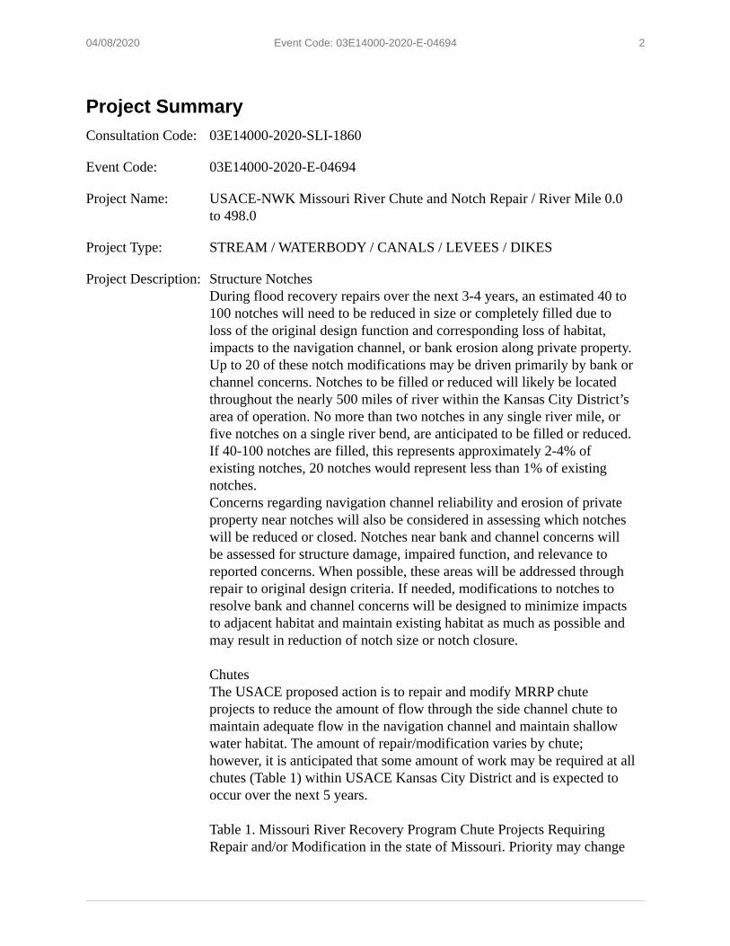
2 04/08/2020 Event Code: 03E14000-2020-E-04694
Project Summary Consultation Code: 03E14000-2020-SLI-1860
Event Code: 03E14000-2020-E-04694
Project Name: USACE-NWK Missouri River Chute and Notch Repair / River Mile 0.0 to 498.0
Project Type: STREAM / WATERBODY / CANALS / LEVEES / DIKES
Project Description: Structure Notches During flood recovery repairs over the next 3-4 years, an estimated 40 to 100 notches will need to be reduced in size or completely filled due to loss of the original design function and corresponding loss of habitat, impacts to the navigation channel, or bank erosion along private property. Up to 20 of these notch modifications may be driven primarily by bank or channel concerns. Notches to be filled or reduced will likely be located throughout the nearly 500 miles of river within the Kansas City District’s area of operation. No more than two notches in any single river mile, or five notches on a single river bend, are anticipated to be filled or reduced. If 40-100 notches are filled, this represents approximately 2-4% of existing notches, 20 notches would represent less than 1% of existing notches. Concerns regarding navigation channel reliability and erosion of private property near notches will also be considered in assessing which notches will be reduced or closed. Notches near bank and channel concerns will be assessed for structure damage, impaired function, and relevance to reported concerns. When possible, these areas will be addressed through repair to original design criteria. If needed, modifications to notches to resolve bank and channel concerns will be designed to minimize impacts to adjacent habitat and maintain existing habitat as much as possible and may result in reduction of notch size or notch closure.
Chutes The USACE proposed action is to repair and modify MRRP chute projects to reduce the amount of flow through the side channel chute to maintain adequate flow in the navigation channel and maintain shallow water habitat. The amount of repair/modification varies by chute; however, it is anticipated that some amount of work may be required at all chutes (Table 1) within USACE Kansas City District and is expected to occur over the next 5 years. Table 1. Missouri River Recovery Program Chute Projects Requiring Repair and/or Modification in the state of Missouri. Priority may change

3 04/08/2020 Event Code: 03E14000-2020-E-04694
as additional surveys are completed.
Side Channel Chute Location (River Mile) Priority Cora Island Chute 6.0 Moderate Tadpole Island Chute 180.5 Moderate to High Overton North Chute 187.4 Moderate Jameson Island Chute 214.3 Moderate to High Cranberry Bend Chute 282.7 High Worthwine Island Chute 459.0 Moderate Wolf Creek 480 Moderate
This work will include structures within the chute and the associated revetments.
Project Location: Approximate location of the project can be viewed in Google Maps: https:// www.google.com/maps/place/39.12364828099607N94.60456323649024W
Counties: Wyandotte, KS | Clay, MO

4 04/08/2020 Event Code: 03E14000-2020-E-04694
Endangered Species Act Species There is a total of 4 threatened, endangered, or candidate species on this species list.
Species on this list should be considered in an effects analysis for your project and could include species that exist in another geographic area. For example, certain fish may appear on the species list because a project could affect downstream species.
IPaC does not display listed species or critical habitats under the sole jurisdiction of NOAA Fisheries 1, as USFWS does not have the authority to speak on behalf of NOAA and the Department of Commerce.
See the "Critical habitats" section below for those critical habitats that lie wholly or partially within your project area under this office's jurisdiction. Please contact the designated FWS office if you have questions.
1. NOAA Fisheries, also known as the National Marine Fisheries Service (NMFS), is an office of the National Oceanic and Atmospheric Administration within the Department of Commerce.
Mammals NAME STATUS
Gray Bat Myotis grisescens Endangered No critical habitat has been designated for this species. Species profile: https://ecos.fws.gov/ecp/species/6329
Indiana Bat Myotis sodalis Endangered There is final critical habitat for this species. Y our location is outside the critical habitat. Species profile: https://ecos.fws.gov/ecp/species/5949
Northern Long-eared Bat Myotis septentrionalis Threatened No critical habitat has been designated for this species. Species profile: https://ecos.fws.gov/ecp/species/9045
Fishes NAME STATUS
Pallid Sturgeon Scaphirhynchus albus Endangered No critical habitat has been designated for this species. Species profile: https://ecos.fws.gov/ecp/species/7162

5 04/08/2020 Event Code: 03E14000-2020-E-04694
Critical habitats THERE ARE NO CRITICAL HABITATS WITHIN YOUR PROJECT AREA UNDER THIS OFFICE'S JURISDICTION.

1 04/08/2020 Event Code: 03E14000-2020-E-04694
USFWS National Wildlife Refuge Lands And Fish Hatcheries Any activity proposed on lands managed by the National Wildlife Refuge system must undergo a 'Compatibility Determination' conducted by the Refuge. Please contact the individual Refuges to discuss any questions or concerns.
THERE ARE NO REFUGE LANDS OR FISH HATCHERIES WITHIN YOUR PROJECT AREA.

1 04/08/2020 Event Code: 03E14000-2020-E-04694
Wetlands Impacts to NWI wetlands and other aquatic habitats may be subject to regulation under Section 404 of the Clean Water Act, or other State/Federal statutes.
For more information please contact the Regulatory Program of the local U.S. Army Corps of Engineers District.
Please note that the NWI data being shown may be out of date. We are currently working to update our NWI data set. We recommend you verify these results with a site visit to determine the actual extent of wetlands on site.
RIVERINE ▪ Riverine
USACE Kansas City District Chute Repairs and Modifications EA
Appendix C Cultural Resources Agency and Tribal Coordination
(Placeholder)
46


