0 Language: English Original: English AFRICAN DEVELOPMENT FUND PROJECT: MULTINATIONAL KENYA – TANZANIA POWERINTERCONNECTION PROJECT COUNTRY: REGIONAL (KENYA AND TANZANIA) ENVIRONMENTAL AND SOCIAL IMPACT ASSESSMENT SUMMARY JULY 2014 Appraisal Team Team Leader S. ASFAW Principal Power Engineer ONEC.2/EARC 8269 Team Members N. KULEMEKA Chief Socio-Economist ONEC.3/SARC 8452 C. AHOSSI Chief Regional Procurement Coordinator ORPF.1/EARC 8249 A.M.MOUSSA Financial Analyst ONEC.2 2867 E. NDINYA Senior Environmental Specialist ONEC3/SARC 8417 D. MUTUKU Principal Financial Management Officer ORPF.2/EARC 8252 S. ONEN Principal Legal Counsel GECL1/EARC 8239 E. CAROLINE Senior Investment Officer ONEC2/EARC 8233 S. MANDAGO Senior Energy Officer ONEC.2/TZFO 6459 G. KAIJAGE Principal Financial Management Officer ORPF2/TZFO 6456 H. Y BALOZI Procurement Officer, ETFO ORPF.1/ETFO 6465 P. OWUORI Senior National Procurement Officer ORPF.1/EARC 8240 Sector Manager E. NEGASH ONEC.2 3931 Sector Director A. RUGAMBA ONEC 2015 Regional Director G. NEGATU EARC 8232
Transcript
0
Language: English Original: English
AFRICAN DEVELOPMENT FUND
PROJECT: MULTINATIONAL KENYA – TANZANIA POWERINTERCONNECTION PROJECT
COUNTRY: REGIONAL (KENYA AND TANZANIA) ENVIRONMENTAL AND SOCIAL IMPACT ASSESSMENT SUMMARY
JULY 2014
Appraisal Team
Team Leader
S. ASFAW Principal Power Engineer ONEC.2/EARC 8269
Team Members
N. KULEMEKA Chief Socio-Economist ONEC.3/SARC 8452 C. AHOSSI Chief Regional
Procurement Coordinator ORPF.1/EARC 8249
A.M.MOUSSA Financial Analyst ONEC.2 2867
E. NDINYA Senior Environmental Specialist
ONEC3/SARC 8417
D. MUTUKU Principal Financial Management Officer
ORPF.2/EARC 8252
S. ONEN Principal Legal Counsel GECL1/EARC 8239 E. CAROLINE Senior Investment Officer ONEC2/EARC 8233
S. MANDAGO Senior Energy Officer ONEC.2/TZFO 6459
G. KAIJAGE Principal Financial Management Officer
ORPF2/TZFO 6456
H. Y BALOZI Procurement Officer, ETFO ORPF.1/ETFO 6465
P. OWUORI Senior National Procurement Officer
ORPF.1/EARC 8240
Sector Manager E. NEGASH ONEC.2 3931 Sector Director A. RUGAMBA ONEC 2015 Regional Director G. NEGATU EARC 8232
1
ENVIRONMENTAL AND SOCIAL IMPACT ASSESSMENT (ESIA)
SUMMARY
Project Name : Multinational: Kenya–Tanzania Power Interconnection Project Country : Kenya and Tanzania Project Number : P-Z1- FA0-052 1. Introduction The Governments of Kenya and Tanzania, under the auspices of the Nile Basin Initiative / Nile Equatorial Lakes Subsidiary Action Programme (NELSAP), have carried out a feasibility study and detailed design for a power line to interconnect the power grid systems of Kenya and Tanzania. The whole study consists of Feasibility Study, Environmental and Social Impact Assessment (ESIA), Resettlement Action Plan (RAP), Detailed Design and Tender Documents of the Kenya – Tanzania Power Interconnection. The Kenya-Tanzania interconnection project will involve the construction of a total of 507.5 km of 400Kv high voltage alternative current (HVAC) transmission line in double circuit from Isinya Substation in Kenya to Singida Substation in Tanzania. 93.1 km of the line is in Kenya and 414.5 km in Tanzania. The transfer capacity of the interconnector is designed for 2,400 MW. The associated substation works include: the extension of the existing Isinya (Kenya) and Iringa (Tanzania) substations to include 400 kV transformers, and the construction of a new 400kV substation in Arusha (Tanzania). This ESIA Summary has been prepared in accordance with AfDB’s Environmental and Social Assessment Procedures (ESAP), theproject is classified as Category 1 which calls for a full ESIA (Environmental and SocialImpact Assessment) to be carried out. In addition, over 200 persons will be involuntarilydisplaced in each country. The affected properties and number of households in Kenya are 158 and 790 project affected persons (PAPs) while in Tanzania 253 households and 1265 PAPs. A full Resettlement Action Plan (RAP) has been prepared and is included as an Annex 1 and 2. 2. Project Description and Justification The Kenyan Section of the corridor has a total length of about 93 Km. The corridor runs from Isinya Substation in a southerly direction, crosses a river and follows Road A104 (Athi-River Namanga Road) to the Border at Namanga. For technical reasons related to the network construction and operation, the line requires a right-of-way (ROW) varying from 70 m to 90 m. It is in the middle of this ROW, where all structures will have to be removed, that the line will be built. In Tanzania, between Namanga and Arusha, where the new 400 kV transmission line will run parallel to the existing 33 KV (Arusha - Oldonyo Sambu line). While from Arusha Sub-
2
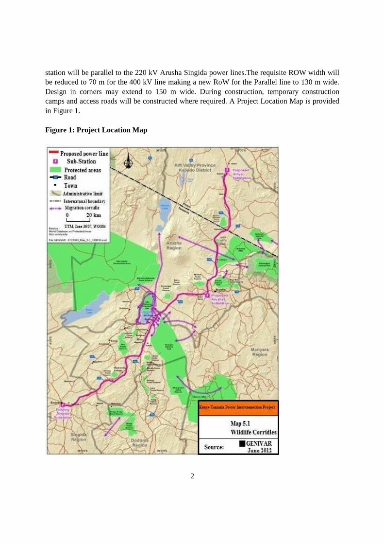
station will be parallel to the 220 kV Arusha Singida power lines.The requisite ROW width will be reduced to 70 m for the 400 kV line making a new RoW for the Parallel line to 130 m wide. Design in corners may extend to 150 m wide. During construction, temporary construction camps and access roads will be constructed where required. A Project Location Map is provided in Figure 1. Figure 1: Project Location Map
3
Capacity: The transmission capacity of Kenya, as of June 2008, consisted of 220 kV and 132 kV lines, and the distribution system comprised 66 kV, 40 kV, 33 kV and 11 kV lines. In Tanzania, the main backbone power transmission system comprises 220 kV, 132 kV and 66 kV transmission power lines. Considering the projected power transfers between Kenya and Tanzania, and the existing network layout and voltage levels, 400 kV proves to be the optimal voltage solution for this interconnection. This enables a maximum transfer of 1 250 MW. Number of Circuits: A double-circuit line gives increased transmission capacity and better reliability compared to a single-circuit line but requires about a 45% higher investment. Furthermore, a double-circuit line is more flexible in planning maintenance procedures in the line itself and with the substations as well. Phase Conductors: All Aluminium Alloy Conductor (AAAC) has beenused in Africa in countries where ice loads are not expected and where there is no firm commitment to any particular conductor type. Its usage is justified because of its strength, necessary for very long spans and very heavy loadings. Ground Wires: According to the electrical requirements, like earth fault currents, one steel wire with a cross section of 70 mmshould be sufficient. This wire type is also used as earthwire in both countries. The high reliability requirements of the line shall be considered when designing the protection against lightning. The average height of highest phase conductor from ground is about 50 m. Tower Types and Foundations: The line route of the interconnection line is mostly flat or slightly hilly, only short sections are slightly mountainous. The self-supported steel lattice towers with steel grillage foundations or concrete foundations are used in Kenya and Tanzania. Both of these foundations types are possible for the interconnection line. The foundations of tensions and terminal towers shall be of concrete. Clearing of Right-Of-Way: To observe the standards used by KETRACO and TANESCO, the ROW width is proposed to be set to a maximum of 60 m in Kenya and 90 m in Tanzania. When sensitive environmental components are present (forests, plantations), the ROW width may be reduced by 5 or 10 m. Nevertheless, vegetation with the potential to grow beyond 5 m at maturity will not be tolerated, including possible danger trees outside the ROW. The general objective of the project is to increase transit capacities and flexibility of operation of theKenya – Tanzania 400kv interconnection grids and to improve sustainable electricity supply in Kenya, Tanzania and the East Africa Power Pool (EAPP). The current rate of access of electricity is around 23% in Kenya and 14% in Tanzania. The interconnection project will enhance economic and social development in the region by improving quality and increasing energy availability. The project will provide a more sustainable energy supply for both countries
4
and will increase power supplies to areas with deficient electricity. The project will help in reducing the duration and frequency of power interruptions in both countries including Nairobi, Isinya, and Arusha, Manyara, Dodoma and Singida regions. It will also help in reducing power system and technical losses to meet the existing and increasing power demand in the whole area. 3. Policy, Legal and Administrative Framework Kenya The Environmental Management and Coordination Act (EMCA), 1999 provides for the establishment of a legal and institutional framework for the management of the environment and for matters connected therewith and incidental thereto. Just as in the new constitution, Part II of EMCA confers to every person the right to a clean and healthy environment and to its judicial enforcement. The new Constitution and EMCA therefore obligates the project’s Executing Agency and Contractor to work in a clean environment and not to contravene the right of any person within its zone of influence, to this entitlement. EMCA has provided for the development of several subsidiary legislations and guidelines which govern environmental management and are relevant to the project implementation. These include;
• The Environmental (Impact Assessment and Audit) Regulations, 2003 Legal Notice No. 101;
• The Environmental Management and Coordination (Waste Management) Regulations, 2006 Legal Notice No. 121;
• The Environmental Management and Coordination (Water Quality) Regulations, 2006 Legal Notice No. 120;
• The Environmental Management and Coordination (Noise and Excessive Vibration Pollution) (Control) Regulations, 2009 Legal Notice No. 61;
• The Environmental Management and Coordination (Conservation of Biological Diversity and Resources, Access to Genetic Resources and Benefit Sharing) Regulations, 2006 Legal Notice No. 160;
• The Environmental Management and Coordination (Fossil Fuel Emission Control) Regulations, 2006 Legal Notice No. 131;
• The Environmental Management and Coordination (Controlled Substances) Regulations, 2007 Legal Notice No. 73.
Kenya’s key environmental assessment and monitoring agencies include the following;
• The National Environment Council: The Council is responsible for policy formulation and directions for the purposes of developing the EMCA. The Council also sets national goals and, objectives, and determines policies, and priorities for the protection of the environment.
• The National Environment Management Authority (NEMA): NEMA is responsible for general supervision and, co-ordination of all matters relating to the environment and is the principal instrument of government in the implementation of all policies relating to
5
the environment. The authority is also responsible for monitoring compliance with all the NEMA regulations.
• The Standards and Enforcement Review Committee (SERC): NEMA through EMCA has established standards for the various environmental parameters that require management and these include the water quality standards, noise and vibration control standards, and the waste management standards, amongst other. SERC, through the Compliance and Enforcement Department of NEMA monitors the compliance level of the project to ensure environmental control standards are implemented. The committee also follows on complaints reported by the public.
• The Provincial and District/ County Environment Committees: These committees contribute to decentralization of activities undertaken by NEMA and thus enable local communities to have access to environmental management information. The committees also conduct quick site visits and review environment related reports of the projects and on occasions could attend site meetings.
The Occupational Safety and Health Act, 2007, is an Act of Parliament to provide for the safety, health and welfare of all workers and all persons lawfully present at workplaces, to provide for the establishment of the National Council for Occupational Safety and Health and for connected purposes. The Act applies to all workplaces and workers associated with it; whether temporary or permanent. The main aim of the Act is to safeguard the safety, health and welfare of workers and non-workers. It is thus recommended that all Sections of the Act related to this project, such as provision of protective clothing, clean water, and insurance cover are observed so as to protect all from work related injuries or other health hazards. There are sectoral legislation and regulations relating to various environmental aspects and that are relevant to the project that were reviewed, including international treaties and agreements that Kenya has ratified and these have been included in the ESIA Report. Tanzania The National Environment Policy (NEP, 1997) is the main policy document governing environmentalmanagement in the country. The policy addresses environmental issues as both natural and socialconcerns, and adopts the key principle of sustainable development. The Environmental Management (EMA) Act No 20, which was enacted in 2004, governsenvironmental management issues including EIA requirements in the country. The Actstipulates that any developer of a project to which EIA is required to be carried out by thelaw shall undertake at his own cost EIA before commencing the project. The Act alsodefines environmental management tools of general scope to facilitate consistent policingand enforcement.Tanzanian’s environmental assessment framework is also guided by the Environmental Impact Assessment and Audit Regulations, 2005. Tanzanian’s key environmental assessment and monitoring agencies include the following:
6
• Minister responsible for Environment (Vice President Office - VPO), The Minister is responsible for approval of the Environmental Impact Assessment
• National Environmental Management Council (NEMC). NEMC has the overall responsibility of undertaking enforcement, compliance, review and monitoring of Environmental Impact Assessment and in this regard facilitates public participation in environmental decision-making.
• Ministry of Lands, Housing and Human Settlements Development. The Ministry is responsible for population resettlement and compensation, land use planning, surveying and demarcating land/parcel/farms, and provision of land ownership and tenancy in both rural and urban areas. The Ministry has the Chief Government Valuer who is responsible among other things to ensure that prior to compensation of assets to any Project Affected Persons (PAPs).
• District Council (DC). The District Council’s Environmental Management Officer is responsible to promote environmental awareness in the district related to the protection of the environment and the conservation of natural resources.
• Village Development Committee (VDC). The VDC is responsible for the proper management in the village.
The Occupational Safety and Health Act, 2003, is an Act of Parliament to provide for the safety, health and welfare of all workers and all persons lawfully present at workplacesThis Act makes provisions for the safety, health and welfare of people at work. In addition, it provides for the protection of people against hazards to health and safety arising from a work environment. Relevant sections of the Act are Part IV Section 43 (1) - Safe means of access and safe working place ; Prevention of fire ; and Part V on health and welfare provisions, which includes supply of clean and safe sanitary convenience, washing facilities and first aid facility to the workers. National policies on environment, land, water and culture relevant to this projecthave been considered, as also various sectoral policies and legislation, international treaties and conventions on naturalresources that Tanzania has ratified. 4 Description of the Project Environment The proposed project covers Kajiado County in Kenya and three regions in Tanzania, namely; Arusha Region, Manyara Region and Singida Region. Climate: Kajiado County lies in the semi-arid and arid zone of Kenya. The temperature ranges between 10oC at Loitoktok, the eastern slopes of Mt Kilimanjaro and 34oC at Lake Magadi. The annual average temperature in the county is 25oC. Rainfall is bimodal and ranges from 500mm to 1250mm per annum.Arusha Region experiences temperature ranges between 13 and 30°C, with an average of about 21ºC and a lowland temperature average of 26ºC. Rainfall ranges from 250 mm to 1 200 mm per annum. It has distinct wet and dry seasons, and experiences an eastern prevailing wind from the Indian Ocean.
7
Manyara region experiences varying climatic conditions ranging from moderately wet to drier conditions further South. Temperatures are relatively low, between 10ºCand 21ºC. Rainfall ranges from 250 mm to 900 mm per annum. The region experiences distinct wet and dry seasons, with long dry seasons due to low rainfall received per year. Singida region has an arid climate with temperature ranging between 26ºC and 30ºC. The rain season starts in October and ends in May and the average annual rainfall is about 600 mm. Geology and Soils: Kajiado County comprises the Basement System rock formation which consists of various gneiss, schists, quartzite and crystalline limestone. The Soils in Kajiado County are red, sandy and often shallow soils. Soils of the Arusha and Manyara region are derived from underlying parent rocks and therefore almost all soils found in the area are basaltic in origin. Three main soil groupings are described: highlands soil type, short grass plains and southwest soil types.The highlands types of soils are derived from basaltic lavas giving a high fertility and porous nature to the soils. The short grass plain type of soils rich in clay content characterized the extensive plain, The soils in the South-West consist of vertisols derived from the calcareous tuff, usually 0.5 to 1 m thick, covered by a shallow layer of volcanic dust. The geology of the Singida region is composed of granite rocks.Rock outcrops of granitic nature can also be seen in the area and vegetation grows on a thin soil layer. The rock outcrops and this soil layer have caused the area to have only scattered bushes and limited number of well grown trees. Surface and Groundwater Sources: The Isinya – Namanga Way leave does not cross any permanent waterways but it crosses over numerous seasonal streams and a few dug out water pans used as water sources for animals during the rainy season. However, in dry season (December to March), the community rely on shallow wells and boreholes.Arusha region enjoys a good water supply from different spring and river sources. However, the dryer areas in the South, along the Namanga – Arusha Corridor, especially between angle points E11E at Namanga and E32, and far West are served by shallow wells and boreholes, and face considerable water shortage, particularly during the dry season. Manyara Region has rivers and small streams flowing from highlands such as Mbulu river, into Lake Manyara, which is one of the major freshwater streams feeding the soda lake. However, the region is one of the driest regions especially in the South where it borders the Singida region, experiencing semi-arid climatic condition. Singida region has few surface water bodies, including Singida and Kindai lakes. Vegetation: The predominant vegetation type in the project corridor in Kajiado County is open grassland dotted with dwarf shrubs and perennial herbs, wooded and grassed bushland, woodland
8
and woodland forest. In Arusha and Manyara Region, open woodland, degrading into open wooded grassland, characterizes large part of the region from the northern plain in Namanga, which borders Kenya, Tarangire National Park area, the Burunge Wildlife Management Area and further South. Open grasslands dominate in parts of the region, although they are interrupted by wooded to bushed grassland especially accelerated by human activities, such as cultivation and habitation. The characteristic vegetation of the central region of Singida is of “bush” or thicket type, which is widespread throughout the area wherever the natural plant cover has been altered by biotic factors.Most of the hill ranges, steep slopes and protected forest reserves are covered with large woody plants, which form good watershed protective covers. Ecological Stratification of the Transmission Line Corridor: Table 1: General Ecological Stratification of the Project Site Zone/area Type of vegetation RoW corridor Namanga Closed stunt acacia commiphora pass sparse less 10 Oldonyosambo Arusha Substation to Mti mmoja Magugu katesh to 30km before singida
farm land maize field, woodlots, commercial coffee farm, patches of open grassland Pad, maize ,sunflower peas with sorghum respectively
Wildlife: The expansive undisturbed bushland and woodland in the Kenya Section of the project area is sparsely populated. The Amboseli National Park which is home to several wildlife species is approximately 35Km south-east of the transmission line corridor but not fenced. As such it is common to find wild animals especially antelopes, zebras, gazelles, wildebeests and ostriches freely grazing. There are however, no wildlife or migratory birds corridors in the Isinya – Namanga Section of the Transmission line corridor. From Namanga, the transmission line route crosses three wildlife corridors and runs parallel or sharing dispersal areas with the fourth.These wildlife corridors are all located in Tanzania and are presented in Table 2 and 3.
9
Table 1: Wildlife Corridors
Wildlife Corridor Region Urgency1
Amboseli Kilimanjaro-Lake Natron
Kenya -Kilimanjaro, Arusha
Critical
Manyara Ranch-Lake Natron Manyara Moderate
Tarangire-Manyara (Kwakuchinja)
Manyara Critical
Notes: 1- Extreme = probably less than 2 years remaining; Critical = probably less than 5 years remaining; Moderate = less than 20 years remaining.Source: Jones et al. (2009)
Table 3: Name of the Corridor/ Crossing, target species, geo locations and season the corridor used by respective species Name corridor Width Length Target species
5 to 10 km 72km 4°41'4.92"S 35°12'37.30"E 4°31'35.20"S 35°16'46.78"E
Dry season
Source: World Elephant Centre 2013
Amboseli- Kilimanjaro-Lake Natron Corridor: The area West of Mount Kilimanjaro supports large numbers of elephants and other wildlife. It serves as an important wildlife corridor between three protected areas, Lake Natron, Kilimanjaro and Amboseli National Park. The selected power line crosses the migration corridor near Longido along road A104. As many as 600 elephants use this zone in the dry season. The area also provides important calving areas for zebras, wildebeests, Thomson’s gazelles (Gazella thomsonii), and Grant’s gazelles. Manyara Ranch-Lake Natron Corridor: This wildlife corridor starts at the northern end of Tarangire National Park (TNP) and crosses the selected corridor, and then passes through Manyara Ranch. Wildlife is present on the northeast boundary of Manyara Ranch and continues northwards of the plains, on the southern edge of Lake Natron. Much of the area is composed of open grassland interspersed with patches of bush land. Wildebeests and zebras movement from TNP to Lake Natron has been confirmed by radio collaring and tracking of individual animals.
10
The first stage of the corridor, between TNP and Manyara Ranch, is heavily used by elephants, wildebeests and zebras in addition to migration of giraffes, buffalos and elands. Tarangire-Manyara (Kwakuchinja) Corridor: The Tarangire-Manyara corridor lies between Lake Manyara and Tarangire National Park. The selected power line crosses this wildlife corridor. The vegetation is primarily savannah with pockets of woodlands along waterways. Elephants, bushbucks (Tragelaphus sp.), impalas and vervet monkeys (Cercopithecus aethiops), along with livestock, utilize the corridor throughout the year. Important Bird Areas (IBA’s) and wetlands: The list of Important Bird Areas (IBAs) and Wetlands found along the existing and proposed power lines and surrounding areas with respective type of birds and IUCN status of those birds are provided below. The area where the 400KV traverse is within the important avifauna ecological system where an estimate of up to one million flamingo migrates to Lake Natron situated in Enharareso Ward of Ngorongoro District in Arusha Region; where they lay eggs and breed successfully. The IBAs include: (i) Longido Game Controlled Area; (ii) Lake Singida; (iii) Lake Kindai; (iv) Lake Burungi. Population: The population in the project districts are: Kenya 687,312 persons while Tanzania, 1,569,762. Table 2: Population Data for Project Districts in 2012
District Name Population Kenya Kajiado 687312 Tanzania
Arusha 323198
Longido 123153
Monduli 158929
Babati 312,392
Hanang 275,990
Singida Municipal 150579
Singida Rural 225521
Total Population 1569762 Source: Tanzania National Census 2012 In Kenya, the study covers Kajiado County (formerly Kajiado District) while in Tanzania, the study covers three regions: Arusha, Manyara and Singida. The districts crossed by the transmission line corridor are Arumeru, Longido, Arusha, Monduli, Babati, Hanang, Singida Municipal and Singida Rural (Table 17 and Appendix 1). Within these districts, the project cuts
11
across 53 villages. The total population of the villages/sub-locations crossed by way-leave is estimated at 82 500 or 5% of the districts population. Table 5: List of Districts and Villages/Sub-Locations crossed by the Transmission Line District Villages/Sub-Locations Kenya
Singida Rural Kinyamwenda, Itaja Mughamo Singida Municipal
Singida, Misuna, Kisasida, Msikii, Mungu Mji
Institutions with Electricity: In Kenya, most areas close to the main road and the towns along the road are connected to electricity while areas further from the road are not connected. In Tanzania, electricity connections are available at the District headquarters, with Longido District obtaining electricity from Namanga-Kenya. At Singida, Manyara and Arusha, which are region headquarters, there are substations that receive and transmit electricity within various parts of the region. It was revealed that most of the villages that are close to the Districts headquarters are connected to the national grid, leaving those away without electricity.It was also revealed that most community services, such as schools, that are government owned are not connected to electricity. Table 7: Prevalence of Infrastructure with Electricity in the Communities
Infrastructure Prevalence within the communities (in %)
Health centre Dispensary 57 32 100 9 Hospital 14 3 100 3
12
Infrastructure Prevalence within the communities (in %)
Infrastructures with electricity (in %)
Total health centres 71 35 100 12 Market 100 26 56 0 Administrative building - 66 - 16
Religious site
Church 100 299 25 22 Mosque 43 92 92 17 Other religious site - 2 - 0 Total religious sites 143 393 33 39 Heritage or Cultural site/ cemetery
43 35
- 1
Machinery and production centre
Total machinery and production centre, Bricks making
100 195
15 90
5. Project Alternatives At the stage of the preliminary study, different corridors were compared except for the section from Isinya to Arusha for which the Terms of Reference focused on reviewing the line route proposed by BKS-Acres Consultants in 2002. A local optimization of this line route was however carried out during this detailed study, in collaboration with RSWI, in charge of the Detailed Design and Tender Documents. This final optimization has been made to avoid the most sensitive elements, such as relocation of schools, churches, cultural and ritual sites, sensitive ecosystems etc., and to minimize the need to construct new access tracks. Between Arusha (Kisongo substation) and Singida substations, three corridors (A-B-C) were compared. Following this comparison, Corridor B was chosen. The criteria used for the design and the selections of the least impact corridor were:
• Technical: topography, watercourses, soils, access, poorly drained and floodable sectors, airports, power line and road crossings, number of angles, etc.;
• Environmental: vegetation, protected areas, main watercourses, birds and mammals migratory corridors, fauna reproduction areas, etc.;
• Socioeconomic: number of villages affected, tourism infrastructure (lodges, etc.), permanent agriculture (coffee, fruits, etc.), livestock, tree plantations, military grounds, etc.
For technical and environmental reasons, Corridor B was preferred due to its direct route from the proposed Arusha substation to Singida substation. Also, for about 207 km of the 301 km between Arusha and Singida, the proposed corridor follows the existing 220 kV transmission line, which reduces environmental and social impacts. Corridor B is also the shortest alternative
13
with the fewest number of angle points and least amount of technical constraints and problematic zones, therefore costs associated with this option should be less. The following positive aspects were also identified during stakeholders meetings:-
• There are less potential cultural heritage sites in Corridor B than in the other corridors; • There are less farms and settlements in Corridor B than in Corridor A; • Even if there are a number of migratory corridors in Corridor B, especially between
Tarangire and Manyara Lake National Parks, it will have a minimal impact on this issue compared to Corridors A and C;
• Corridor B is already impacted by the presence of another transmission line, a maintenance road is already present and can be used for both lines, the width of the ROW for this new line is also minimised because it shares its space with the existing 220 kV line;
• Makuyuni, which is located at a little more than 1 km west of Corridor B, is an Export Processing Zone (EPZ) for the region as it is the main junction to Arusha, Babati, tourist circuits, Mwanza and Musoma. Additional power will thus represent an advantage for the development of this area.
6. Potential Impacts Positive impacts: Regional Integration: At the regional level, the Kenya transmission line will be interconnected at Isinya Sub-station from the North with Ethiopia and South Sudan via the Ethiopia-Kenya Inter-connector and the East African Power Pool (EAPP); while the Tanzania transmission line will be interconnected with South African Power Pool (SAPP) through Zambia on the Zambia – Tanzania backbone Interconnection. The Arusha Substation will have a hub check interconnection i.e. from the Dar es Salaam 400KV and the Isinya - Singida interconnection which will be connected from the Zambia-Tanzania back bone interconnection. Electricity Connections and Improved Local Socio-economy: The proposed project will enhance electricity connectivity, promote energy efficiency and facilitate the development of rural electrification projects that will increase electricity connectivity in the Eastern and Southern African countries. Higher electricity availability would in turn spur development of small industries, including tourism, and rural-based industries such as agro processing. During community consultation meetings, it was clear that demand for electricity was high. The communities were convinced that availability of electricity would stimulate economic activities, especially in trades such as metal welding, carpenters’ wood grooving machines, water pumping, motor-vehicle, mobile phone battery charging, etc., and also enable them to have lighting in households and schools as well as for watching television.
14
Employment Creation: The project is expected to generate employment to local communities in both countries at least in semi-skilled and unskilled jobs. Selection of workers shall give equal opportunity to both women and men. Furthermore, the contractors shall be expected to issue a code of conduct to employees to ensure that there are no tendencies by one gender group to intimidate and abuse the other. Construction camps shall be equipped with facilities specific to each gender group. Provision of Clean Energyat Lower Cost and Reduction of GHG Emissions: According to the Feasibility Study, Kenya would have to produce 2 320 MW of electricity mainly through coal fuel plants (52% or 1 200 MW) and geothermal sources (48% or 1 120 MW) to meet its power demand between 2014 to 2030 to partially achieve its Vision 2030 objectives to generate environmental friendly, cost effective and energy efficient sources of electricity. The construction and operation of the coal-fired plants would produce a large amount of greenhouse gas (coal produces 955 g of CO2 per kWh.Importing excess electricity produced in Tanzania can help reducing GHG emissions in Kenyaand is one of the ways Kenya will have access to the needed power for its development, as proposed in the Least Cost Power Development Plan (Republic of Kenya, 2011). Reduce Deforestation and influence Climate Change Mitigation Efforts: Firewood is the major source of energy in the project area. It provides over 90% of the energy requirements of most households for cooking and heating. The communities in the project area produce charcoal in the project districts from the woodlands for export to the other parts of Kenya and Tanzania. Therefore, improved access to electricity for both countries will reduce the use of firewood for cooking and heating, which represents a significant source of deforestation, contributing to climate change. In addition, access to electricity can reduce the use of private household generators and kerosene lamps, which also produce GHG emissions. Gender Empowerment: Local electrification would have a significant impact with regard to women’s work burden as pumped water and electricity would spare them the arduous daily responsibilities of collecting water and fire wood. The availability of electricity would also help girls’ school attendance due to reduction of house workload and eventually allowing them access to better jobs. It can be expected that women will receive better services from health centres given the availability of electricity, refrigeration for medicines and vaccines. Education and Health: Electricity would support overall investment in education and strengthen the on-going effort of capacity building to overcome critical constraints in the implementation of development programs. Essential to this effort would be power supply to health facilities for the installation of cold storage facilities for the safe transportation and storage of vaccines and other vital medications. Improved Agricultural Storage and Processing: If improved availability and reliability of power in the area results in a better access to electricity for communities and households, it can improve
15
storage and processing of agricultural products, thus increasing their market value or extending their selling period. Storage using refrigerators will preserve meat, milk products, fruits and vegetables which can be sold or consumed the following day. These improvements could result, on the long-term, in better prices for agricultural products and increased incomes for farmers. Negative Impacts: Impact on Forests and Woodland: There are 14 community forests that will be affected by the wayleave. They are located in Mogitu, Mara. Bagara, Kinyagigi, Mwada, Sigino, Kiongozi, Mawemairo, Mesenanijuu, Vilima vitatu, Kimokowa, Nandwa and Minjingu. The exact location and affected surface areas of these community forests are not currently available since they have not been delineated. Additional investigations will thus have to be conducted prior to construction activities to delineate these community forests. Land Take: It is estimated that a total of about 3 321 ha of land will be affected by the transmission line (when considering a corridor 90 m-wide and 114 km-long between the border and Arusha, a corridor 90 m-wide and 94 km-long between Arusha and the existing transmission line, and a corridor 70 m-wide and 207 km-long between the existing transmission line and Singida). Impacts on Terrestrial Animals: Vegetation clearance in the ROW and establishment of new access roads required for construction of the transmission line may lead to increased grazing and bush meat hunting. The presence of workers may also lead to increased hunting and poaching activities. In fact, although workers will be provided with adequate meals, they may be tempted to hunt during their spare time. Impacts on Avifauna: Bird strikes and mortality are also more important in areas with high bird densities, such as waterfowl breeding colonies or staging areas. Water areas constitute seasonal or short-time stopovers for migratory birds. These are especially important for species that pursue their flight towards the rainy forest. Cumulative Impacts: In the project area, a few projects are currently ongoing and some are planned. Among the most important projects underway is the Iringa – Shinyanga 400 kV transmission line, which will share some facilities with the proposed power interconnection project. The substation at Singida will be used for both projects. Cumulative impacts will be mainly felt at a social level. For instance, in some sections, the proposed Isinya –Singida power transmission line run within the same villages as Iringa –Shinyanga transmission line wayleave; the Isuna and Mungu-maji villages are already affected by the other transmission lines but will again be affected by the new proposed transmission line. The proposed power interconnection line also traverses an area where there is a road project that has just been completed from Singida to Babati and from Babati to Arusha, up to Namanga. Cumulative impacts emanating from these projects will affect, in part, the communities living along the proposed 400 kV transmission line
16
or those crossed by it. In Namanga, there is an international border construction project that will involved relocation of houses and business.The transmission line routing tried to limit as much as possible involuntary resettlement impacts. During implementation, the route will be further refined during tower spotting. The main impacts on the biophysical environment are the permanent loss of vegetation (trees, shrubs and planted woodlots) in the ROW and the permanent loss of small portions of wetlands required for the construction of towers. The biophysical impacts can be mitigated. Resettlement and Compensation: The transmission line will affect a number of houses, community structures, farms, crops, fences and trees. For example, there are 20 principal structures to be affected in Kenya and 253 structures in Tanzania. Othersignificant potential negative impacts are: (i) Displacement of houses, structures, public infrastructure, schools, etc. (loss of time, perturbation of daily life organization); (ii) Clearance of access roads and upgrading the 5km road to the Arusha substation (crop damage, loss of habitats, disturbance of wildlife); (iii) Clearance of line corridor between towers (crop damage, removal of trees and of some structures, loss of habitats, disturbance of wildlife); (iv) Earth-moving and tower construction (crop damage, removal of trees, siltation and contamination of surface water, loss of habitats, disturbance of wildlife); (v) Presence of migrant workers in rural areas (health concerns such as HIV/AIDS, social disturbances, overexploitation of local resources such as water, fire wood and other natural resources); (vi) Construction of work camps (crop damage, modification to water resources and properties, potential affects from inadequate waste management facilities, loss of habitats, disturbance of wildlife, etc.); (vii) Presence of new invasive habiting prey birds e.g. black kite (Milvus migrans); Pied crow(Corvus splendens)in towers invading domesticated chickens and disturbing women income generating activity due to loss of chicken to sale and earn petty cash. (viii) Risks for bird collision with the wires. 7.Mitigation / Enhancement Measures and Complimentary Initiatives Mitigation and Enhancement Measures: Tree Planting and Re-vegetation Program: To minimize the impacts on community forests and compensate for forest losses, a Tree Planting and re-vegetation program will be implemented in affected areas. Tree planting activities shall be included in the project either to replace those to be cut down in the transmission line corridor, but also as a means of reducing the visual intrusion (aesthetics) in selected degraded areas. TANESCO and KETRACO have reforestation programs which replaces every cut-down tree by two trees. This will be in collaboration with the forestry service/agency of the respective countries to ensure appropriate species are planted.This program should involve the local population as much as possible in close collaboration with the Tanzania and Kenya Forest Service. Local plant species should also be selected for re-vegetation purposes.
17
Rural Electrification: In Kenya the Project shall set aside USD 5 Million for Rural Electrification Authority (REA) to provide electricity to communities which will still have no electricity by the date of project implementation. The rural electrification program in Kenya has concentrated on primary and secondary schools across the country and this could already pave way for electrification of trading centres within the project area. In Tanzania the project shall aside USD10 million to provide electricity in the project area both on- and off-grid through Tanzania Rural Energy Agency (REA) which has the mandate for rural electrification. Implementation responsibility for rural electrification lies with TANESCO due to current available capacity. Protection of Terrestrial Animals: (i) Minimizing vegetation clearing, thereby limiting habitat destruction; (ii) Restoring ancillary sites as soon as they are not required anymore, such as borrow pits, camp sites, material storage piles; (iii) Monitoring of migration corridor used by large mammals, taking into account migratory patterns and preventing construction during identified specific periods; (iv) Prohibiting wildlife disturbance and poaching; (v) Prohibiting project workers from possess firearms, snares and other hunting equipment when on project sites. Protection of Avifauna: Although the number of bird collisions on the existing 220 kV line is not reported to be high and that most of the bird species identified in the project area are common and widely distributed in wetlands, there is need for precautionary measures to be taken by making the transmission line more visible. Proposed measures include installing reflectors on the ground wire at intervals along the line in specific areas such as wetlands, staging areas or in bird migration corridors. Also, in areas of high bird density, it is proposed to use specially-designed towers so that the conductors of the new line are at the same heights as those of the existing line it parallels. Monitoring of Elephant and Bird Migration: Given the sensitivity of the project areas especially in Tanzania where the project line shall intersect elephants corridors and can potentially affect important bird areas, the project has included an enhanced program of elephant and bird monitoring. This activity will be subcontracted to specialized and reputable service providers and will be co-ordinated by Tanzania Wildlife Research Institute (TAWIRI) and Tanzania National Parks Authority (TANAPA). Reduction of Wayleave/ ROW requirements: For technical reasons related to the network construction and operation, the line requires a ROW varying from 60-90 m in Kenya and Tanzania. It is in the middle of this ROW, from where all structures will have to be removed, that the line will be built. In Tanzania, the 220 kV line has a ROW that is 60 m wide. In the section of the new 400 kV line built from Namanga and thereafter in parallel to the existing 220 kV line between Arusha and Singida, the additional requisite wayleave width would be reduced to 70 m. In fact, the juxtaposition of the two ROWs will permit that the total width of the two ROWs be reduced to 130 m (60 m for the existing 220 kV line and 70m for the new 400 kV line) instead of 150 m (60 m for the existing 220 kV line and 90m for the new 400 kV line). The
18
adverse impacts of the project will be lessened by the fact that 69% of the transmission line route (207 out of 301 km) will be constructed close to the existing 220 kV line. Resettlement and Compensation: To mitigate impacts from involuntary displacement, Resettlement Action Plans for Kenya and Tanzania have been prepared and the summaries are included as Annex 1 and 2 of this Summary. Complimentary Initiatives : Prevention of Communicable Diseases: Sensitization programs shall be conducted by both KETRACO and TANESCO to bring in awareness, prevention and Voluntary Counselling and Training (VCT) for employees and communities living in the project areas. As part of the HIV/AIDS Campaign will be gender sensitization to inform communities of the importance of respecting each gender group and accepting that women can form part of the workforce. In both cases, specialized service providers shall be sub-contracted by either the utilities directly or by the contractors. Involvement of local institutions such as the AIDS Council/Commission, district entities and local NGOs and CBOs shall ensure relevance and sustainability. Contractor’s camps shall be fitted with mosquito gauze; and mosquito nets shall be provided to all workers to reduce the risk of catching malaria. Social Amenities: Provision of social amenities and infrastructure to communities shall be part of the project design for the Tanzania section. A school, a health clinic and an access road shall be provided at the substation site in Arusha. Water points shall also be provided along the route at pre-identified spots including places where the construction camps shall be established. In areas where the RAP has identified schools or health centres that need to be relocated, equal or better structures shall be constructed as part of the RAP. 8. Expected Residual Effects and Environmental Hazard Management
Environmental costs for this project shall comprise the compensations established under the RAP (Annex 1 and 2), plus a financial evaluation of non-compensated damages and disturbances bore by the receiving natural and socioeconomic systems. Compensations concern households and communities directly affected by the transmission line route and are estimated so far at a total amount of 10.77 MUSD. Non-compensated residual impacts are anticipated to variable extents (punctual to regional) and, although their value cannot be established at this stage, they are for the most part expected to be of minor magnitude. As for the project’s environmental benefits, these concern mainly the new employment and local business opportunities during the preconstruction and construction phases. The magnitude of these economic benefits for nearby communities is expected to be medium, although temporary.
19
9. ESMP Implementation and Monitoring Program Responsibility for monitoring of the ESMP belongs to the Executing Agencies i.e KETRACO in Kenya and TANESCO in Tanzania. In close collaboration with concerned ministerial authorities, agencies will undertake the creation of aProject Co-ordination Unit (PCU) that will facilitate the implementation of the multinational project. In each country, it is proposed that a Project Implementation Team (PIT) will be established. The Project will contract a supervising consulting firm to undertake the supervision of the construction works. Within the supervision consultant’s team, there will be provision of staffing for an Environmental Expert to supervise the implementation of the ESMP and a Social Expert to supervise the implementation of the RAP. The implementation of the ESMP will be the responsibility of the Contractor. Once contracted, the Contractor(s) will be expected to develop site specific Construction ESMPs and Site Health and Safety Plans (HASP). For the RAP implementation, the utilities / agencies will either recruit a firm or NGO. The estimated total cost of the ESMP is 7.3 M USD for Kenya and 39.98 M USD for Tanzania for the mitigation program for environmental and socio-economic impacts of the project, covering compensation for the loss of permanent and temporary assets and livelihood restoration (7 M USD for Kenya and 38 M USD for Tanzania) and an Environmental and Social Management Plan USD 353 850 in Kenya and USD 1.951M in Tanzania. USD 951000 has been allocated for annual monitoring. The ESMP Implementation Schedule is provided in Table 8.
20
Table8: ESMP Implementation Schedule
ACTIVITIES
TIMESCALE (years / months) Year 1 Year 2 Year 3
1 2 3 4 5 6 7 8 9 10
11
12
1 2 3 4 5 6 7 8 9 10
11
12
1 2 3 4 5 6 7 8 9 10
11
12
Preconstruction phase
Setting-up of PCU's Environmental Committee
Setting-up of PIT
Information and outreach to communities and PAPs
Delineation and pegging of ROW
Parcel Inquiry
Definition of compensation standards involving PCU and PIT
Construction phase
ROW clearance
Compensation payments to PAPs
Restoration of income generating assets
Supervision and monitoring of mitigation measures' implementation
Setting-up of CSRF
Operational and maintenance phase
ESMP performance assessment
Livelihood performance test
21
10. Public Consultations and Public Disclosure As part of the ESIA process, public participation and consultation was conducted with different stakeholders in order to share the proposed project details and obtain views with regard to the project. The aim was to spread project information and incorporate the views of project affected people, provide opportunities to avoid and resolve disputes and reconcile conflicting interests; enhance transparency and accountability in decision making and enable the Executing Agencies to incorporate the needs, preferences and values of affected parties into the project design. The key stakeholders included Local Government Authorities in Municipal, District Councils, Sector Ministries, Regional Authorities, NGOs, the Village communities close to and along the proposed transmission line route. Meetings were also held with the conservation stakeholders including the Wildlife Division of the Ministry of Natural Resources and Tourism, the Tanzania National Parks Authority (TANAPA), Tanzania Wildlife Research Institute (TAWIRI), Monduli District Game Officer, the Wildlife Conservation Society of Tanzania. Majority of government institutions and village communities along the transmission line, are positive with expressed broad support for the project development. The community was interested in knowing what benefits they are going to get during the construction of the project and operation phases. They suggested that social benefits like schools, dispensary, village office construction, income generating activities and electrification should be considered. Compensation should be prompt, transparent and adequate for those who will be affected by the project’s land acquisition. The wildlife conservation stakeholders lauded the project’s plans for mitigation and monitoring and recommended close collaboration and involvement during project implementation. They indicated that the monitoring results would support conservation planning and development of strategies to manage impacts of infrastructure on wildlife. The Environmental Management Act 2004 of the United Republic of Tanzania has provisions for public consultation and disclosure described in Section 89: Public Participation in Environmental Impact Assessment and Section 90: Public Hearing and Information Disclosure. On the Bank’s side, this summary shall be posted on the Bank’s website for a period of 120 days prior to presentation of the project to the Board.
11. Conclusion The Environmental and Social Impact Assessment has been undertaken for the proposed regional electricity interconnectionproject. The impacts on the biophysical environment will be felt during the construction phase of the project. These impacts are the permanent loss of vegetation in the ROW and the permanent loss of small portions of wetlands required for the construction of towers. Other impacts, such as dust emissions, noise, soil erosion, degradation of water quality, soil contamination by poor waste management or accidental spill of hydrocarbons, as well as
22
disturbance and displacement of wildlife, may occur during construction and maintenance works but will be very limited and of temporary nature. The main social impacts are the permanent loss of arable land due to the presence of access roads and tower bases, and the restriction of planting species without the potential to grow beyond 5 m at maturity in the ROW. Another significant impact will be the relocation of houses and some public or private infrastructure such as schools, mosques, churches, shops. In the case of wildlife corridor, electrical wire sag and fall may affect wildlife using the route through electrocution or collision for birds. In the cases of communal infrastructure, these will be relocated on another part of the same land, to an adjacent land plot or elsewhere as may be desired by the affected households. Many social measures have been proposed to minimize or compensate for adverse impacts and to maximize positive impacts. These measures namely include encouraging the practice of compatible agricultural activities within the transmission line ROW and planning maintenance work outside of the growing and grazing season. In the case of sagging specific design in specific areas used according to radio collaring studies, should be adhered and be part in contract agreement. The new transmission line will lead to regional integration between Kenya and Tanzania and further to connect to the South African Power Pool. A number of positive opportunities for project affected persons and communities shall be realised. These opportunities may be presented in the form of temporary employment during the construction phase, as well as through income generated by business opportunitiesthat will be created as a result of rural electrification.An Environmental and Social Management Plan (ESMP) has been developed to ensure that mitigation measures are effectively implemented during the construction and operational phases of the project. Monitoring plans are proposed for surface water quality, drinking water quality, air quality, noise levels, soil erosion, evolution of fauna and wetlands, bird strike mortalities, communities’ health, social and economic benefits for local communities. The ESMP also provides orientations on training and capacity building requirements for its successful implementation. The project is feasible for implementation provided the mitigation and monitoring measures are implemented.
23
ESIA Summary Annex 1 Summary of Resettlement Action Plan (RAP)- Kenya
Project Name: Kenya – Tanzania Power Interconnection Country: Kenya Project Number: P-Z1- FA0-052 1 Introduction
The Governments of Kenya and Tanzania, under the auspices of the Nile Basin Initiative / Nile Equatorial Lakes Subsidiary Action Programme (NELSAP), have carried out a feasibility study and detailed design for a power line to interconnect the power grid systems of Kenya and Tanzania. The whole study consists of Feasibility Study, Environmental and Social Impact Assessment (ESIA), Resettlement Action Plan (RAP), Detailed Design and Tender Documents of the Kenya – Tanzania Power Interconnection. The general objective of the project is to increase transit capacities and flexibility of operation of the grid and to improve sustainable electricity supply in Kenya, Tanzania and the East Africa Power Pool (EAPP). The interconnection project will enhance economic and social development in the region by improving quality and increasing energy availability. The project will provide a more sustainable energy supply for both countries and will increase power supplies to areas lacking electricity. The project will then help reducing the duration and frequency of power interruptions in both countries including Nairobi, Isinya, Arusha, Manyara, Dodoma and Singida regions. It will help reducing power system and technical losses to meet the existing and increasing power demand in the whole area.
This report summarizes the outcomes of the RAP for the line section in Kenya starting from Isinya substation to Namanga border with Tanzania. The project entails construction of a 93 km line in Kenya; and 414.5 km transmission line in Tanzania from Namanga border to Arusha (104 km) and Arusha to Singida (311 km). The substation at Isinya is being constructed under a separate project and all environmental and social due diligence have been performed under that project financed by the World Bank.
The summary covers the project description, project area and area of influence; potential impacts; organizational responsibilities and institutional framework; community participation; socio-economic studies; legal framework and conflict resolution and appeals mechanisms; eligibility; valuation and compensation entitlements; income and livelihood restoration strategies; implementation schedule; costs and budget; and monitoring and evaluation.
2 Project Description, Project Area and Area of Influence The project is to increase transit capacities and flexibility of operation of the grid and to improve a sustainable electricity supply in Kenya, Tanzania and the East Africa Power Pool (EAPP). Today, the rate of access of electricity is around 23% in Kenya and 14% in Tanzania. The interconnection project will enhance economic and social development in the region by improving quality and increasing energy availability.
24
The project line routing is within Kajiado county. The selection of the, route was based on satisfying the criteria which included technical, environmental, and socio-economic. The route, therefore, is as follows: from Isinya substation, the line goes south of the village of Isinya, crosses a river and follows Great North Road; then to the east of the village of Kajiado crossing Irrishta, Ngoile and Eserat rivers. The line then takes eastern side of road A104, east of Bisil and Enkosero until it reaches Namanga border. 3 Potential Impacts Undertaking of the project shall result in some negative impacts which shall originate from implementation of the following activities:
- Observation of the standards used by KETRACO of maintain a RoW of 60 m for the 400 kV line; - Observation of vegetation which doesn’t grow beyond 4.5 m at maturity; - Acquiring land for tower foundation; - Acquiring land for access roads; and - Acquiring land for the Arusha sub-station.
Overall, approximately 158 households shall be impacted upon in pne way or the other representing 790 persons. There are six categories of affected people that have been identified: . 20 owners of plots with houses in the wayleave (RoW); . 27 owners of plots with secondary structures in the wayleave; . 147 owners of plots with crops and/or trees in the wayleave; . An estimated 105 owners that have free-ranging animals in the wayleave . 2 churches within the wayleave; and . One livestock holding ground.
A certain number of households are affected by multiple impacts in form of a combination of the impacts itemized above. These include:
(a) 15 households having grazing fields and/or crops and/or trees and a house or secondary structures affected;
(b) Those with crops and grown trees taller than 4.5 meters; (c) Free ranging animals that will temporarily not have access to a part of the landduring
construction; (d) Loss of land and houses in which they are living; (e) Loss of other buildings and structures;
For those whose houses shall require relocation, the study found out that all of them have a space to relocate their structures within their premises or in the same village.
4 Organizational Responsibility and Institutional Framework
Responsibility for the implementation of this RAP lies with the electricity company, in this case KETRACO. The company will be responsible for setting-up the Project Implementation Unit
25
(PIU) or Project Coordination Unit (PCU) under a Coordinator. Other institutions will provide oversight to the works of the PCU, and these include: The District Commissioner (DC) Surveyor, Land office, Environmental Officer; local development NGO representatives; the Developer (KETRACO), representatives of Kajiado District Council, and an identified witness NGO. To enhance transparency it is also suggested that a witness NGO be retainedby the PCU to provide independent advice and report on RAP implementation and management focusing on consultation activities, compensation and resettlement related activities.
Responsibilities of the PCU Coordinator will be to: 1. Provide information on activities and consultation of the PAPs; 2. Maintain a census of the goods and a detailed evaluation of the compensations; 3. Management of compensation payments; 4. Monitoring the resettlement work; 5. Implementation of community approved projects financed through the CSRF; 6. Identification of the witness NGOs to be retained and facilitation of their involvement
it in the consultation activities, compensation and resettlement related activities; 7. Production of follow-up reports (see below) for the RAP implementation to appropriate government authorities, the promoter of the power network in each country and the contractor in charge of the line construction.
The Coordinator shall have on his team technical staff including accountants; surveyors, valuers, “option disclosure and agreement” officers; ad-hoc urban planner and architect (consultants), engineers / construction supervisors;compensation officers, database officers; agronomist / agro-foresters; social workers; community mobilization specialists/ sociologists; technicians or engineers on ad-hoc basis providing technical advices for projects.
5 Community Participation
During preparation of the ESIA and RAP, communities have been involved through consultations. Consultations were performed between January 2011 and March 2012 during the preliminary study at which stage national and regional consultative meetings, including meetings with stakeholders from ministries and governmental departments, NGOs, CBOs, as well as municipal and district councils participated. Over 15 meetings were organized during this period.
National and regional stakeholders included relevant ministries such as Ministry of Agriculture, Ministry of Tourism, Ministry of Environment and Natural Resources, and government agencies such as Kenya Wildlife Services (KWS), and the National Environment Management Authority (NEMA) as well as national and international NGOs running programmes in the project area such as GIZ Kenya, Africa Conservation Centre (ACC) and Maendeleo Ya Wanawake.
Local stakeholders were identified with the help of the local administration and authorities who helped in singling out persons, groups and organizations that needed to be consulted. All
26
stakeholders consulted were persons in the local leadership and NGOs/CBOs or groups that are running active projects/programmes in the project area as identified with the help of local leaders.
The purposes of the stakeholder meetings were to introduce the project to the relevant stakeholders and gather their feedback and opinion about the project as well as the raised issues of concern.At the national level, the stakeholders were contacted and briefed on the project, its objective and on the ESIA.
Community meetings were arranged with the help of the local leadership. These consultations were carried out at the District, Division and Community levels. At the district level, the Kajiado District Commissioner was informed in advance of the project objectives and method of consultation with landowners. Divisional Officers, in whose jurisdiction the proposed line traverses, were informed and they in turn informed the respective chiefs and provided the telephone contacts.
The chiefs were informed in advance and requested to organize a public meeting (baraza) with the residents of a particular area. The chiefs mobilized the community for the public meetings. A total of 7 meetings were conducted. The meetings were held in both English and Swahili.
Special meetings were held with Project Affected Persons (PAPs) including all persons whose land will be crossed by the proposed transmission line. The enumerators walked through the proposed wayleave andidentified the land and property owners. A face-to-face interview was then conducted with the head of household or another adult member of the household available at the time of the visit to fill the household questionnaire.
6 Integration with Host Communities
The project will not be displacing large and homogenous communities requiring to be resettled in different localities. This is mainly because the area is sparsely populated and that the project is linear in nature. The households that will be required to vacate the way leave will relocate within their own land – stepping back, and in some cases within the same villages. In these cases, there are no host communities that will be impacted upon.
7 Legal, Policy and Administrative Framework Administratively, the Ministry of Lands is the main institutional actor concerning population resettlement and compensation. The mandate of this Ministry is to formulate and implement land policy, undertake physical planning, register land transactions, undertake land surveys and mapping, land adjudication and settlement, land valuation and administration of state and trust land. Under the Kenya constitution, there are more institutions set up to deal with issues of land and settlement. These include: the National Land Commission (NLC); the National Land Trust Fund (NLTF); the District Land Boards (DLBs); and the Community Land Boards. The legal and regulatory framework provides the various legal aspects that must be adhered to at project
27
design, implementation and during operation, as well as later when it is decommissioned. The following are selected laws and regulations governing environmental and social issues of the project. Government Land Act (Cap 280):The Land Act makes provisions for regulating the leasing and other disposal of government land and other purposes. It vests the power and authority to make grants or dispositions of any estates, interests or rights in or over un-alienated government land by the president. Under section 87 compensation is payable for buildings or crops destroyed or damaged.
Registration of Titles Act (Cap 281):The Registration of Titles Act provides for the transfer of land by registration of titles. When land is intended to be transferred or any right of way or other easement is intended to be created or transferred, shall execute according to the Act.
Trust Land Act (Cap 288):The Act makes provision for Trust land which under Section 115 of the Constitution is vested in the county council within whose area of jurisdiction it is situated. Sections under this Act provide for setting apart Trust land for public purposes; full compensation be paid by the Government to any person who is prejudicially affected by the setting apart; gives mandate to the District Commissioner to assess the compensation to be awarded; provides for the right of and process of appeal; and provides that a way‐leave license may be granted.
Registered Land Act (Cap 300):This Act makes further provisions for the regulation of title to land and for the regulation of dealing in land so registered and for purposes connected therewith.
Physical Planning Act (Cap 286): The Act provides for the preparation and implementation of physical development plans and for connected purposes enacted by the Parliament of Kenya subject to a development permission granted by the local authority under section 33.
8 Grievance Redress Mechanism
During implementation of the project activities, it is possible that disputes/ disagreements between the project developer and the PAPs will occur especially in terms of compensation, boundaries, ownership of crops or land, etc. The practice of domestic and international arbitration in Kenya is conducted within the framework of the 1995 Arbitration Act and is interpreted as: “any arbitration whether or not administered by a permanent arbitral institution”. The Act follows the UNCITRAL and other internationally recognized entities and NEMA’s Department of Arbitration. However, the country doesn’t have a comprehensive resettlement legal and policy mechanism in the country laws, the requirements of the International Financing Agencies (World Bank and African Development Bank) safeguard policies on Involuntary Resettlement would provide the operational guidelines.
Grievance committees will be established at village level to deal with any disagreements between the PAPs and the project developer over the RAP. A grievance procedure will be
28
established for resolution of the disputes and complaints; and the following three-staged procedure to redress the grievances shall be followed:
Stage One: Grievance Committees: Procedures for grievances will be clearly explained during barazas. At the village levels, a series of customary avenues exist to deal with dispute resolutions. These avenues should be employed, when and where it is relevant as a “court of first appeal”. This will provide a first culturally and amicable grievance procedure that will facilitate formal and/or informal grievance resolution for grievances. The village level grievance committees shall have: a Traditional leader or head of the clan, a Secretary for women and children’s affairs, 2 representatives of the PAPs (1 female and 1 male), and One officer of the Survey, Identification & Valuation Team of the PCU. If the complaint cannot be resolved at the village level, the plaintiff should then be referred to the second stage.
Stage Two: District Resettlement Action Plan Committee: The District Resettlement Action Plan Committee (DRAPC) in which PAPs, affected communities (local leaders) and the PCU officer in charge of grievances will be represented. If the grievance cannot be resolved at the DRAPC level, should then be referred to the third stage.
Stage Three: Courts of Law: At this stage, PAPs that did not receive a satisfactory answer to their grievances in the first two stages, will be invited, as a last resort, to the legal system, and will be assisted by the PCU to access the appropriate courts of law. However, every effort shall be made to resolve grievances at the community level and avoid the lengthy and costly process through the law courts.
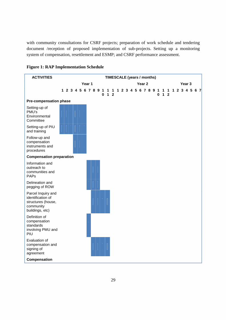
9 RAP Implementation Schedule
The RAP implementation schedule covers a period of twenty four months in order to include all planned activities, including implementation of the CSR. It is important that all structures to be rebuilt and payments for compensation are completed before project construction is commenced. This is to ensure that all possible barriers and encumbrances to the project implementation will have been dealt with ahead of time. The only RAP activities that are planned for a longer period (about 3 years) are the monitoring and evaluation activities which are scheduled to be done once a year after completion of major RAP activities.
The major activities in the implementation process include setting-up of PCU’s/PIU’s Environmental Committees; help forming up local RAP committees; setting-up training programs; follow-up and setting up compensation instruments and procedures. Information and outreach to communities and PAPs; delineation and pegging of ROWParcel Inquiry and identification of structures (house, community buildings, etc) Defining compensation standards involving PIUs; evaluation of compensation and signing of agreement. Reconstruction of households and community structure.Setting up Grievances Redress Committees, system of evaluation and resolution. Plans and programs of restoration of income generating assetsSupervision and monitoring of mitigation measures' implementation; setting up CSRF
29
with community consultations for CSRF projects; preparation of work schedule and tendering document /reception of proposed implementation of sub-projects.Setting up a monitoring system of compensation, resettlement and ESMP; and CSRF performance assessment.
Figure 1: RAP Implementation Schedule
ACTIVITIES TIMESCALE (years / months)
Year 1 Year 2 Year 3
1 2 3 4 5 6 7 8 9 10
11
12
1 2 3 4 5 6 7 8 9 10
11
12
1 2 3 4 5 6 7
Pre-compensation phase
Setting-up of PMU's Environmental Committee
Setting-up of PIU and training
Follow-up and compensation instruments and procedures
Compensation preparation
Information and outreach to communities and PAPs
Delineation and pegging of ROW
Parcel Inquiry and identification of structures (house, community buildings, etc)
Definition of compensation standards involving PMU and PIU
Evaluation of compensation and signing of agreement
Compensation
30
ACTIVITIES TIMESCALE (years / months)
Year 1 Year 2 Year 3
1 2 3 4 5 6 7 8 9 10
11
12
1 2 3 4 5 6 7 8 9 10
11
12
1 2 3 4 5 6 7
ROW clearance and line construction
Compensation payments to PAPs
Reconstruction of households and community structure
Grievances evaluation and resolution
Final payment after verification of reconstruction
Restoration of income generating assets
Supervision and monitoring of mitigation measures' implementation
Setting-up of CSRF
Community consultations for CSRF projects
Preparation of work schedule and tending document /reception of proposal
Implementation of projects
Monitoring
Monitoring of compensation, resettlement and ESMP
CSRF performance assessment
31
10 Valuation and Compensation for Losses
The Government of Kenya has guidelines to follow in establishing the compensation costs of land, houses, public infrastructure, crops/trees and other structures such as graves, toilets, plates wrack, etc. Persons affected by the project who will be eligible for compensation are those who were identified as being impacted upon at the cut-off date of 15th July 2013 for the entire line between Kenya and Tanzania; i.e. regardless of whether they have title deeds or not as long as they can prove with help of local leadership of their existence over the land and ownership of assets there-on. The Table 10.1, below summarizes the valuation of the entitlements for the affected persons.
Table 10.1: Compensation Rules
Asset Compensation under GoK
1 Land
Valuation based upon market value of unimproved land parcel plus a 15% disturbance allowance.
2 Permanent house
Valuation of each case based on the type of materials as well as house depreciation cost plus a 15% disturbance allowance.
3
Non-permanent house
Valuation based upon the official district approved compensation rates taking into account the type of materials, age and condition of the house plus a 15% disturbance allowance.
4 Other structures (graves, toilets, plate wrack etc.)
Valuation based upon the official district approved compensation rates taking into account the type of materials, age and condition of the structure plus a 15% disturbance allowance
5 Crops and trees
Valuation based upon the official district approved compensation and count of trees/crops on the affected land plot plus a 15% disturbance allowance
Affected Assets
Dwelling houses: There are potentially 31 houses belonging to 20 households that are likely to be affected. The temporary houses are built out of dried ground and cow dung applied to a lattice of branches and thatch roof; and at times with iron sheet roof. The semi-permanent houses are built
32
out of iron sheets or timber walls and have an iron sheet or thatched roof. The permanent houses are built out of concrete or burnt bricks and have a sheet /tile roofs (Table 10.2).
Public Infrastructure: Two public buildings are located in the wayleave and will be affected by the construction project. These are a churches and a church with a nursery school.
Table 10.2: Compensation for Houses to Relocate
Types of Structure
Temporary Semi-permanent Permanent Total (KSh.)
Average unit cost (Ksh)
Ksh. 500 per sq. ft Ksh. 1 500 per sq. ft Ksh. 3 000 per sq. ft
Among the housing and related assets to be lost are secondary structures which form part of the household facilities coming together with the house. These include cattle sheds, latrines, fences, kitchen/bathroom, etc.
Agricultural Land and Crops: The total area required by the project is estimated at 600 hectares (100 km X 60 m) which is the way-leave as per KETRACO standards. However, the land required for erecting pylons 5 980 m2 or 0,598 ha (230 pylons X 26 m2) which will be permanently lost. Some limited agricultural activities would continue to take place within the way but not for any trees or shrubs that mature at a height of 5 meters. While-as for crops, compensation will depend on whether people had time to harvest or not. Thus, compensations for crop losses will be calculated during the project implementation on the basis of their commercial value and by including the restoration cost of crops. Trees will be lost on a permanent basis and the compensation given to each tree will depend on its size.
Table 10.3: Compensation Costs for Loss of Annual Crops
Type No. of Households Total Area (m2) Rate (KShs.)/m2 Total cost (KShs.)
Total Cost (USD)
33
Maize 7 6173 41 432,960 4,811
Beans 6 16980 95 1,613,100 17,923
Garden Vegetables
6 6072 800 4,857,600 53,973
Millet 1 1012 100 101,200 1,124
Grand Estimated Total Cost 7,014,741 77,942
Table 10.4: Compensation Costs for Trees
Type of Tree No. of Trees Compensation Unit Costs (KSh.)
Total Cost (KSh.) Total Cost (USD)
Acacia and other dry areas species
133 366 490 65 349 340 726 104
Neem 8 700 5 600 62
Avocado 4 2 000 8 000 89
Mango 22 1 200 26 400 293
Eucalyptus 0 1 030 - -
Grevillea species 2 268 1 480 3 356 640 37 296
Orange 12 2 000 24 000 267
Guava 11 500 5 500 61
Lemon 22 1 000 22 000 244
Pawpaw 11 650 7 150 79
Ficus sycomorus 1 828 2 560 4 679 680 51 996
Fig tree 15 1 870 28 050 312
Others trees not in official compensation list
150 831 490 73 907 190 821 191
Total
147 419 550 1 637 995
34
Loss of Business Income: Some trading and businesses will be affected by the line construction. Taking into account the linear aspect of the project, trade shifting will be possible in areas located close to the original site. A cost equivalent to six months of turnover will be established as a basis of compensation.
11 Income and Livelihood Restoration Strategies
Considering that communities will be impacted negatively mainly through the displacement of community structures and through the effects on some of their community sites (forest, cemetery, etc.). While compensation and resettlement support will be provided to those losing personal and household assets, communal impacts shall be compensated through the Corporate Social Responsibility Fund (CSRF) which will be used to improve, as suggested by the community leaders, public buildings such as schools, health centers (clinics and dispensaries), and infrastructures (water supply, roads, and markets). Equitable distribution of the fund will be an important factor. Communities should receive their share according to the length of the wayleave within their community and the number of households affected. A calculation method for the distribution of the CSRF will be worked out with communities and local administration. Activities to be financed shall be demand driven through systematic consultations within beneficiary communities. The amount to be invested in this program is calculated as 1% of the direct RAP costs which is USD420,000. Different restoration packages will be required for each of the various categories of PAPs depending on the magnitude of the loss, their levels of vulnerability, their preferences associated to their family characteristics and other circumstances.
12 Environmental and Social Considerations
Environmental considerations were integrated in the design of the transmission line and taken into account in the technical feasibility study together with the ESIA that has been prepared. As detailed in the technical feasibility study, the transmission line is designed to comply with international standards regarding audible noise, electric and magnetic fields, corona, as well as interference with radio and television signal.
The technical feasibility study also discusses different alternatives related to tower design, span and foundations to minimize cost, ensure mechanical capacity of the towers, wire and other equipment; and minimize damage to property and displacements. Since the project is linear, except at the Arusha substation, there will be no specific location where the PAPs shall be moved to. All dislocations shall either be by way of stepping back in one yard, or those who will be integrated within existing villages. No environmental issues will arise, nor the notion of host communities.
13 RAP Implementation Cost
The RAP implementation budget is summarized in the Table 13.1, below. This includes all costs involved in the execution of all RAP activities highlighted in the implementation schedule and the total budget is estimated at Ksh 626 400 000 or USD 6 960 000.
35
Table 13.1 : RAP and CSRF Implementation and Monitoring Cost
Item Cost (Sh.) Cost (USD)
Resettlement Action Plan (RAP)
PIU formation and activities (3 years). This include costs for public information campaign (pamphlets, public announcement in newspaper, etc.) and compensations for local administrators
49 500 000 550 000
Detailed land and household evaluation 6 300 000 70 000
Permanent lost land compensation (pylons base), households and industrial land
403 650 4 485
Resettlement of principal structures (houses, shops, etc.) 26 754 480 297 272
Community buildings (church, schools, etc.) 1 878 300 20 870
Crops compensation 7 014 690 77 941
Trees compensation 147 419 550 1 637 995
Land compensation (average of 30% of cost of land. The estimated value of land in the ROW is 4M USD)*
108 000 000 1 200 000
Compensation sub-total 358 913 160 3 987 924
Contingencies 10% 35 891 316 398 792
Total RAP 394 804 476 4 386 716
Corporate Social Responsibility Fund (CSRF)
CSRF (1% of project cost) 37 800 000 420 000
Administration of CSRF (10%) 3 780 000 42 000
Total CSRF 41 580 000 462 000
Total RAP and CSRF 436 384 476 4 848 716
Inflation for 3 next year (12,8% average 2007-2012) Source Kenya Bureau of Statistics
190 015 560 2 111 284
36
Total of RAP and CSRF 626 400 000 6 960 000
14 Monitoring and Evaluation
Monitoring and evaluation includes: the establishment of socio-economic background data of the affected persons prior to actual land acquisition or physical relocation and regular monitoring of their situation for an extended period of time after land acquisition and relocation. In addition, qualitative and quantitative evaluations will be made to see whether the relocated persons and affected people achieve, at a minimum their pre-project standard of living as a result of the livelihood restoration programme.
The PCU will take full responsibility for conducting regular internal monitoring of the land acquisition, resettlement and compensation process and report to the authorities (KETRACO, Development Partners, Government officers and community leaders, etc.).
During the implementation of the RAP, monitoring will be undertaken at regular intervals. Post resettlement monitoring of the affected households shall also be undertaken relatively frequently during the construction period. Monitoring reports shall comply with; and outcome measures shall include the following:
− Number of households and individuals affected by project activities;
− Number of households and individuals economically displaced (crop, shops and activities affected, etc.) as a result of project activities;
− Number of households and individuals resettled by the project;
− Number of resettlement houses built;
− Number of resettlement houses taken possession of by resettlers;
− Grievances (open, closed);
− Amounts of compensation paid for each category of lost assets (structures, land, crops, others) and other benefits obtained by households and individuals;
− Affected PAPs and resettled households economic and livelihood situation;
− Community structures affected;
− Community structures rebuilt and used by community;
− Community plantation program (affected community forests); and
− CSRF approved projects and implementation status
37
ESIA Summary Annex 2 Summary of Resettlement Action Plan (RAP)- Tanzania
Project Name: Kenya – Tanzania Power Interconnection Country: Tanzania Project Number: P-Z1- FA0-052
1 INTRODUCTION
The Governments of Kenya and Tanzania, under the auspices of the Nile Basin Initiative / Nile Equatorial Lakes Subsidiary Action Programme (NELSAP), have carried out a feasibility study and detailed design for a power line to interconnect the power grid systems of Kenya and Tanzania. The whole study consists of Feasibility Study, Environmental and Social Impact Assessment (ESIA), Resettlement Action Plan (RAP), Detailed Design and Tender Documents of the Kenya – Tanzania Power Interconnection. The general objective of the project is to increase transit capacities and flexibility of operation of the grid and to improve sustainable electricity supply in Kenya, Tanzania and the East Africa Power Pool (EAPP). The interconnection project will enhance economic and social development in the region by improving quality and increasing energy availability. The project will provide a more sustainable energy supply for both countries and will increase power supplies to areas lacking electricity. The project will then help reducing the duration and frequency of power interruptions in both countries including Nairobi, Isinya, Arusha, Manyara, Dodoma and Singida regions. It will help reducing power system and technical losses to meet the existing and increasing power demand in the whole area.
This report summarizes the outcomes of the RAP for the line section in Tanzania starting from Namanga to Singida. The project entails construction of a 505 km transmission line from Namanga border to Arusha (204 km) and Arusha to Singida (301 km) with about 90 km in Kenya; and construction of two substations at Arusha and Singida both in Tanzania. The substation at Isinya is being constructed under a separate project and all environmental and social due diligence have been performed under that project financed by the World Bank.
The summary covers the project description, project area and area of influence; potential impacts; organizational responsibilities and institutional framework; community participation; socio-economic studies; legal framework and conflict resolution and appeals mechanisms; eligibility; valuation and compensation entitlements; income and livelihood restoration strategies; implementation schedule; costs and budget; and monitoring and evaluation.
2 PROJECT DESCRIPTION, PROJECT AREA AND AREA OF INFLUENCE
The line traverses three regions of Arusha, Manyara and Singida and cuts across 53 villages in 7 districts of Arumeru, Longido, Arusha, Monduli, Babati, Hanang, Singida Municipal and Singida Rural. It commences at Namanga border where it takes the southwest direction and follows road A104. The beginning of this section passes east of the city of Namanga, and then passes just to the north of the village of Kimokouwa. The line then takes a southern direction following the route of road A104 and loops around Longido National Forest
38
Reserve, with the corridor located about 2 km to the west of the village of Longido. Then it takes a southern direction to Arusha substation crossing the Xandasikirlit River bypassing the Loilenok Hills crossing an existing transmission line at less than 4 km west of Arusha airport the proposed Arusha substation at about 12 km west of Arusha city. Further down this section goes west crossing the Olemusa and Ardai Rivers, and the road going north to Monduli. The line also crosses an existing power line near the town of Duka Bovu. The line corridor passes east of Kwa Kuchinia, south of Minjingu; about 2 km east of Madwa and passes at less than 3 km west of Babati. The line then follows a western trajectory until Ndareda, and east of Endasak and approaches Katesh from south-east. The line corridor generally stays parallel to the existing 220 kV line sharing the same ROW and follows the route of road B143. The line proceeds to south of Endesh and north of Ngimu before its approach to Singida substation from a western direction. The existing Singida substation is located at the south end of the city.
3 POTENTIAL IMPACTS
Potential impacts of the project shall emanate from the clearance and acquisition of the ROW which shall range between 70 m and 90 m for a 400 kV line. Bush clearing shall implicate any trees and shrubs growing taller than 4.5m. The land take for installation of pylons over the 415 km stretch is estimated to be the equivalent of 3.042 ha. In addition the land required for the Arusha substation will be 16 ha. It is estimated that 253 households shall be greatly impacted representing 1265 persons. Out of these requirements, Four main categories of affected people have been identified:
− 253 owners of plots with houses and/or a secondary structure in the wayleave;
− 471 households having crops or cultivating small trees (banana, etc.) in the wayleave;
− 269 with at least one tree, growing higher than 4,5 meters, on the affected parcel;
− 326 owners having animals in the wayleave that are free-ranging, fenced or tethered.
A certain number of households are affected by multiple impacts:
− 155 households have grazing fields and/or crops and/or trees and a house or secondary structures affected;
− Households with crop and cultivated trees will be affected temporally by the construction and will lose their trees (if they grow higher than 4.5 meters). Some space under the pylons will be lost for cultivation or grazing;
− The free-ranging animals will not have access to a part of the land temporally during construction.
There are 23 community buildings affected along the ROW that need to be reconstructed. In the vast majority of cases, the communities have a piece of land on which it is possible to reconstruct them.
Some community sites are also affected and, in particular, community forests that need to be compensated for. A reforestation program is proposed to this effect (in line with the project ESIA report).
39
Different restoration packages will be required for each of the various categories of PAPs depending on the magnitude of the loss, their levels of vulnerability, their preferences associated to their family characteristics and other circumstances.
Most of the affected households have trees (natural and planted) and some crops that will be destroyed during the construction of the transmission line. In most cases cultivation of crop can be restored except for those trees that can grow higher than 5 meters. The impact is thus minimal and temporary provided that households have enough time to prepare, are duly compensated and receive as much as possible fringe benefits (work for the clearing of land restoration of compacted soil, ownership of wood cut on their plot, etc.).
For those households (253 cases) that have a house or secondary structures affected by the project, a large majority (74%) do not have land available to reconstruct them nearby. The potential impact for these households is more important. All necessary steps should be taken by TANESCO and the Project Coordination Unit (PCU) in charge of compensation and reconstruction follow-up, to buy suitable land for reconstruction, and ensure that enough time for reconstruction and proper compensation is attributed.
4 ORANIZATIONAL RESPONSIBILITIES /INSTITUIONAL FRAM EWORK
The overall responsibility for the implementation of this RAP lies with the electricity companies for whom the proposed power infrastructures will be built, in this case TANESCO. The company will thus be responsible for setting-up the Project Coordination Unit (PCU). The structure will take care of the implementation of the RAP, including the monitoring activities and implementation of the Corporate Social Responsibility Fund. The PCU will rely on a team of professionals and support staff who will execute implementation of the project. For implementation of the RAP, TANESCO may subcontract an independent agency, be it a firm or an NGO. However, at PCU, the following structure will be put in place to assist with RAP activities: secretarial support; survey, identification and valuation team; urban planner and architect; cash compensation staff (cashier, security, etc.); database officer; agronomist/agro-foresters; social workers; and community mobilization specialists to manage the CSRF (Corporate Social Responsibility Fund).A training program will be implemented as part of the PIU setting-up process to enhance awareness among key personnel involved with the supervision of compensation evaluation, procedures and implementation of others mitigation and compensation measures.
Tanzania does not have a single entity with the mandate to plan and provide resettlement and compensation help in cases where people are involuntarily displaced for development projects. Several parties will, therefore, be involved with the resettlement and/or compensation processes at different levels and times. At national level, TANESCO and Ministry of Lands and Human Settlement will have a role to play (within which is the Chief Government Valuer), and National Environment Management Council (NEMC), and at Regional and District levels are the District Councils, District Lands Officers, the Ward Councils and the Village Councils. TANESCO being the implementing agency for the project is therefore also the lead agency for implementing all resettlement and compensation activities. In so doing, TANESCO operational procedures will be linked closely to those prescribed by Lands Policy, the Lands Act of 1999 and AfDB Guidelines (2003).
While the overall responsibility lies with TANESCO, the execution of the RAP will be done in collaboration with the Social Services Committees which are chaired by the District Executive Officers. The District Social Services Committees are assisted by the Ward
40
Executive Committees; the Village Executive Committees and an independent NGO who have the responsibility for coordinating, management and monitoring of the practical day-to-day implementation of the resettlement activities, including the disbursement of compensation.
5. COMMUNITY PARTICIPATION
Public and stakeholder consultations have taken place both within the context of the ESIA and RAP preparation. These have been at national and local levels. The purposes of these meetings were to introduce the project to the relevant stakeholders and gather their feedback and opinion about the project. The stakeholders expressed their concerns about the project, which were duly recorded and incorporated into the project design. They also advised on the best way to approach the community members throughout the RAP process. Various stakeholders were met at national, regional and local levels. Most of the stakeholders consulted concur with the proposed development in view that the proposed power interconnection project will improve power supplies, stabilize the quality of the electricity and provide diverse source of power in the region. Some stakeholders also expressed their concerns regarding impacts on wildlife corridors and local biodiversity, impact on soil stability in erosion-prone areas.
Community meetings were organized with the help of the local leadership. These consultations were carried out at different levels. They informed the community about the upcoming activities of the project (household and community surveys). The chiefs mobilized the community for the public meetings. During these community meetings, the communities were informed of the project including: project background, objectives of the project, ongoing and expected activities of the RAP, purpose of the meeting, the need for cooperation from the community and expected compensation, how the compensation will be done, what qualifies for compensation and expected timetable for other activities Following the presentations, the community was given time to ask questions, seek clarifications, raise opinions and make comments. 55 community meetings were held in the villages included in the transmission line ROW. Preoccupations rose during these meetings mainly concerned. Local employment; Compensation; Scarcity of land; Community benefits; Impacts on infrastructure; and Land use. The community was assured that their concerns would be addressed accordingly.
With regard to potential PAPs, a face-to-face interview was conducted with the head of household or another adult member of the household available at the time of the visit to fill the household questionnaire. Socioeconomic information was collected about household members, livelihood, income and production, land ownership, livestock, crops, trees, as well as principal and secondary structures. Concerns rose about the wayleave and how the transmission line project could affect the households were also gathered. A control group was also formed of people that will not be affected by the project but who are living in the same area.
6. SOCIO-ECONOMIC SURVEY AND PROPERTY REGISTRATION
A household survey was carried out in order to assess the socioeconomic profile of the project area and affected households as well as to document the impacts of the project. To
41
accomplish this task, a detailed survey questionnaire was used which collected general information about the household members, livelihood, income and land ownership. The study also focused on the four main impacts of the projects which are: the different type of area or structures that could be affected; animal grazing; crops and trees; principal structures such as houses and shops; as well as secondary structures. The resettlement possibility (available land) has also been assessed in each case. The individual PAP preoccupations with the project was recorded. The area demographics show a population projection of 1,489,898 (based on 2002 census) with 82,500 or 5% being the population traversed by the way-leave. The districts that are located in Arusha and Manyara regions are dominated by the Maasaï ethnic group while in the Singida region the dominant ethnic group is Nyaturu. In a part of Manyara region, especially in Hanang District, the dominant ethnic group is Iraqw. Other parts of the project area are populated by multi-ethnic groups with varied semi-cultures, languages and religious beliefs. The people living in the project area subscribe to two main religious beliefs, Christians (61.3%) and Muslims (20,3%). The proportion with Traditional belief is 18.3%. For the majority of the people in the project area sources of income and occupations can dominantly be grouped in the following way: farming (51.2%), livestock keeping (24.5%), business (10.2%), and civil service (3.8%), works and crafts (2.2%), and hunting and fishing (0.6%). Regarding community services and structures, there are numerous social service facilities in communities where the proposed line route passes and these include: schools (primary, secondary and only one tertiary), health centres (dispensaries, hospitals), markets, administrative buildings, religious sites (churches and mosques), cemetery, machinery and production centres (grinding mills, sunflower ginnery). Most of these facilities are not connected to the national grid except for the machinery and production centres of which 46,2% are connected, mostly in urban areas or villages that are ward centres. Other community facilities that are connected are mainly secondary schools (36.8%), 100% for the colleges are connected and health centres (hospitals). The communities along the ROW can offer skilled and semi-skilled workforce and services. The most common trade is masons (builders) with 977 people within the communities, followed by truck drivers (680), carpenters (606), and painters (510). Other available workers include mechanics, electricians, welders, and heavy machine operators. The most common available services include: construction materials such as gravel, guest houses, mechanical services (dealers, repairs, etc.), transportation of goods or materials, canteens and restaurants, heavy machinery (crane, bulldozer, excavator, etc.) and gas and petroleum products. Socio-economic characteristics of the affected communities show that 87% of the households are headed by men and 13% by females. Of the female headed households, 57% are widowed. In the bigger picture 61% of the population earns less than a dollar a day. Approximately 10% of the population has never been to school with 84% having attended primary school, 4% secondary school and 1.2% having attended college or university education. Approximately 213 distinct households will have their principle structures affected
42
totalling 302. Of these 28.4% are permanent, 32.1% are semi-permanent and 39.4% are temporary structures. Most districts in the project area are agricultural growing maize, millet, beans, paddy, sunflower, and wheat. As for trees growing higher than 4.5 meters, sisal is the most common especially in the Singida region. Other trees include mango, avocado, pawpaw, guava Mvule, albizia coliaria, sycomore fig acacia, eucalyptus and acacia. These trees have a significant importance to the affected local communities as they are used for medicine, building materials, firewood, establishing beehives, and shelter. In the Longido District and parts of Monduli district, the project is located in areas that are mostly used as grazing. Cattle are the most prevalent animals that the impacted households have and that use the wayleave for grazing. Chickens are mainly used for household consumption and in a few cases as a source of income for the household. About 12% of households in Arusha and Babati sectors have an average of 600 cattle each. Other animals include goats, pigs, sheep and donkey that are kept on a small scale.
7 INSTITUTIONAL AND LEGAL FRAMEWORK
The institutional actor for population resettlement and compensation is the Ministry of Lands, Housing and Human Settlements Development. This Ministry is mainly responsible for land use planning, surveying and demarcating land/parcel/farms, and provision of land ownership and tenancy in both rural and urban areas. Within the Ministry, there is a Chief Government Valuer who is responsible among other things to ensure that prior to compensation of assets to any Project Affected Persons (PAPs), valuation reports are prepared according to the Land Act of 1999.
Policies and laws that are related to resettlement social issues include:
− National Land Policy, 1995 (revised in 1997): The main objective of the Policy is to address the various and ever-changing land use needs. The Policy aims “to promote and ensure a secure land tenure system, to encourage the optimal use of land resources and to facilitate broad-based social and economic development without endangering the ecological balance of the environment.
− Land Acquisition and Resettlement Policy: There is no Resettlement Policy in Tanzania. The resettlement process at TANESCO is guided by the Land Regulations of 2001. The draft National Resettlement Policy Framework which was prepared in 2003 based on the World Bank’s OP 4.12 on Involuntary Resettlement.
- Land Act, 1999: This Act lays down fundamental principles for occupying and using the land. Among them is the principle that any land user shall ensure that land is used productively and that any such use complies with the principles of sustainable development. Tanzanian land falls under three categories, namely: Reserved Land which is land set aside for wildlife, forests, marine parks, etc.; Village Land which includes all land inside the boundaries of registered villages; and General Land which is land neither reserved land nor village land and is therefore managed by the Commissioner.
- Village Land Act No. 5 of 1999: This Act governs all matters related to land tenure under the Village Councils in accordance with the principles of a trustee with the villagers being the beneficiaries.
43
− The Land Regulation (2001): The Land Regulation provides guidance on the issue of compensation in all forms.
- The Land Disputes Courts Act No. 2 of 2002. The Act stipulates that every dispute or complaint concerning land shall be instituted in the Court having jurisdiction to determine land dispute in the given area (Section 3) at all levels ( The Village Land Council; The Ward Tribunal; District Land and Housing Tribunal; The High Court (Land Division); and The Court of Appeal of Tanzania).
8 GRIEVANCE REDRESS MECHANISM
All PAPs and impacted communities will be informed about the grievances procedure and their rights at the implementation stage of the RAP. The Project Coordination Unit shall designate an officer in charge of grievances who will make every effort to resolve grievances at the community level. Recourse to the legal system should be considered as a last resort. If the issue is not resolved, the grievances will be taken through a three steps grievances redress mechanism proposed to ensure proper care of PAP’s compensation and other possible sources of dissatisfaction. This three step mechanism has been design so that it is simple, administered as far as possible at the local level, to facilitate access, flexibility and openness to various proofs, taking into account that most of the PAPs have minimal awareness of the grievances procedures.
(i) Stage One: Village Level: A series of customary avenues exist to deal with dispute resolutions. These avenues should be employed, when and where it is relevant as a “court of first appeal” in an amicable grievance procedure that will facilitate formal and/or informal grievance resolution. If the complaint cannot be resolved at the village level, then it gets referred to the second stage;
(ii) Stage Two: Ward Executive Officer: Grievances that could not be resolved at the first stage will be submitted to the second stage: the District Resettlement Action Plan Committee (DRAPC) in which PAPs, affected communities (local leaders) and the Project officer in charge of grievances will be represented. This committee should be presided by the Ward Executive Officer. If again the grievance is not resolved, then it goes to the third stage;
(iii) Stage Three: District Executive Director: At this stage, a PAP that did not receive a satisfactory answer to the grievance in the first two stages, will be invited to submit the case to the District Executive Director for conciliation. If the PAP is still not satisfied it will be directed, by the Project officer, to High Court of Tanzania, the ultimate level for a decision according to the Land Act (section 156).
9 Eligibility and Entitlement Matrix All persons who were currently residing or owning property and assets within the wayleave at the time the census was carried out (July 2013) are legible for compensation, Table 9.1 below. Economic and social considerations have been taken into account in determining the requirements for compensation. Under the present policy, only displaced population having formal legal rights to land or assets and those who can prove entitlement under the country’s
44
customary laws are considered and will be fully compensated for loss of land or other assets. However, a third category of displaced persons who have no recognizable legal right or claim to the land they are occupying in the project area will be entitled to resettlement assistance in lieu of compensation for land. Land, housing, and infrastructure will be provided to the adversely affected population, including, religious and linguistic minorities, and pastoralists who may have usufruct rights to the land or other resources taken for the project.
45
Table 9.1 Entitlement Matrix Type of Loss/Impact/ Eligible
TANESCO discusses with respective entity responsible and preferred cash compensation at replacement cost.
Shifting of common resources such as water supply lines, telecommunication lines.
Utility agency who owns the facility
As Above
1. All (cash or in-kind) payment for the structure at replacement cost
2. Payment of Transition Settlement allowances: a) Restoration of access to community resources b) other expenses for resettlement – disturbance allowances
1 Government valuer (agency) 2. TANESCO (authority)
TANESCO discusses with respective entity responsible and preferred cash compensation at replacement cost
Loss of business (Temporary) (in case the commercial
Affected business owners with registration /without
Cash assistance for six months of turnover.
According to laws and regulations loss of business is to be
1 Government valuer (agency) 2. TANESCO (authority)
47
structure is affected partially or temporary, and being rebuilt on the site)
registration (regardless of ownership of land)
paid after submission of Audited Accounts
Loss of business (permanent)
Affected business owners with registration
Cash payment not exceeding the average annual net profit of three years.
According to laws and regulations loss of business is to be paid after submission of Audited Accounts
1. Government valuer (agency) 2. TANESCO (authority)
Affected business owners without registration (regardless of ownership of land)
Cash assistance for six months of turnover.
According to laws and regulations loss of business is to be paid after submission of Audited Accounts
1. Government valuer (agency) 2. TANESCO (authority)
Loss of Income of Employees or Hired Labourers
People losing wage employment
Allowance equivalent to 3 months basic salary. According to land laws and regulations we don’t have this type of compensation /payment. They will be paid as per other country laws and regulations related to employee and labour benefits.
1. Government valuer (agency) 2. TANESCO (authority)
Loss of crops
Person who cultivates crops (regardless of the ownership of land)
Paid cash compensation for the affected crops according to the percentage of growth and set rates and disturbance allowances.
If own land paid land rate as per market valuer
1. Government valuer (agency) 2. TANESCO (authority)
Loss of agricultural/ industrial land
Person who owns agricultural/industrial land
Paid market valuer of land
Paid cash compensation for the affected crops according to the percentage of growth and set rates and disturbance allowances
Administrative costs incurred during registration taxes if they have land title
1. Government valuer (agency) 2. TANESCO (authority)
Loss of trees
Titled owner of land Paid market valuer of land
Paid cash compensation for the affected trees according to the percentage of growth and set rates and disturbance allowances
Administrative costs incurred during registration taxes if they have land title
1. Government valuer (agency) 2. TANESCO (authority)
Loss of community forests
Socially recognized owner of land
1. Provision of compensation for loss of interest in the land and for other losses
1. Government valuer (agency)
TANESCO through Local government
48
2. Provision of new land at market valuer
3. Payment of forest according to growth rates 4. Payment of reforestation allowances
2. TANESCO (authority)
will provide funds for reforestation activities.
Loss of / Impact on Livelihood (permanent)
Household having permanent effect on livelihood (small business owners, self-employed )
If requested by household, TANESCO will assist in obtaining professional assistance and advice to set up a business at commercially viable location. Livelihood Restoration Assistance - To be paid as per laws and regulations
1. Government valuer (agency) 2. TANESCO (authority)
Loss of / Impact on Livelihood (temporary)
Household having temporary effect on livelihood (small business owners, self-employed women, etc.)
If requested by household, TANESCO will assist in obtaining professional assistance for required needs. Livelihood Restoration Assistance – To be paid as per laws and regulations
1. Government valuer (agency) 2. TANESCO (authority)
Impact on Vulnerable People
Households having vulnerable APs (poor, elderly APs, female-headed households, Chronically ill and disabled)
If requested by household, TANESCO will assist in obtaining professional assistance for required needs. To be paid as per laws and regulations
1. Government valuer (agency) 2. TANESCO (authority) 3. Government of Tanzania through TANESCO (agency) will provide funds
TANESCO normally consider other assistance like supervising the construction of the house or finding a land.
Any unanticipated adverse impact due to project intervention
Any unanticipated consequence of the project will be documented and mitigated based on the spirit of the principles agreed upon in this RAP
The project shall apply Government of Tanzania valuation criteria and where it differs from international standards such as those prescribed by the AfDB’s policy as well as the World Bank, the international standards shall prevail. The guidelines to be followed in establishing the compensation costs of land, houses, public infrastructure, crops/trees and other structures such as graves, toilets, plate racks, etc. are summarised in the table below. 10 VALUATION OF AND CPOMPENSATION FOR LOSSES
Asset Compensation under the GOT International Standards
Land Valuation based upon market value of unimproved land parcel plus a disturbance allowance based on commercial bank interest rates at that particular time.
PAPs will be given an option of having in kind compensation for land.
49
Permanent house
Valuation of each case based on the type of materials as well as house deprecation cost, transport for 12 tonnes at a distance of 20km and renting allowances for 36 months plus a disturbance allowance based on commercial bank interest rates at that particular time.
Structure can be completed at full replacement cost.
Traditional house
Valuation of each case based on the type of materials as well as house deprecation cost, transport for 12 tonnes at a distance of 20kms and renting allowances for 36 months plus a disturbance allowance based on commercial bank interest rates at that particular time.
Full replacement cost.
Other structures (graves, toilets, plate wrack, etc.)
Valuation based upon the official district approved compensation rates taking into account the type of materials, age and condition of the structure plus a disturbance allowance based on commercial bank interest rates at that particular time.
Replacement costs with additional facilitation for cultural rituals and relocation assistance.
Crops and trees Valuation based upon the official district or Ministry of agriculture approved compensation and count of trees/crops on the affected land plot plus a 5% disturbance allowance.
For perennial crops a transition period for culture should be taken into account. This period may be more than one year for some crops. For trees a compensation rate should be convened for their permanent loss.
For annual crops there is no specific provision. The goal is income restoration.
50
11 COSTS AND BUDGET
The schedule covers a period of twenty four months in order to include all planned activities, including implementation of the CSRF (Corporate Social Responsibility Fund) also referred to as Income and Livelihood Restoration Strategy. The total cost of implementing the RAP and CSRF is estimated at USD 39,980,379.09.
12 INCOME AND LIVELIHOOD RESTORATION STRATEGIES
Considering that communities will be impacted negatively mainly through the displacement of community structures and through the effects on some of their community sites (forest, cemetery, etc.). While compensation and resettlement support will be provided to those losing personal and household assets, communal impacts shall be compensated through the Corporate Social Responsibility Fund (CSRF) which will be used to improve, as suggested by the community leaders, public buildings such as schools, health centers (clinics and dispensaries), and infrastructures (water supply, roads, and markets). Equitable distribution of the fund will be an important factor. Communities should receive their share according to the length of the wayleave within their community and the number of households affected. A calculation method for the distribution of the CSRF will be worked out with communities and local administration. Activities to be financed shall be demand driven through systematic consultations within beneficiary communities. The amount to be invested in this program is calculated as 1% of the direct RAP costs which is USD1.7 million. Different restoration packages will be required for each of the various categories of PAPs depending on the magnitude of the loss, their levels of vulnerability, their preferences associated to their family characteristics and other circumstances.
13 ENVIRONMENTAL AND SOCIAL CONSIDERATIONS
Environmental considerations were integrated in the design of the transmission line and taken into account in the technical feasibility study together with the ESIA that has been prepared. As detailed in the technical feasibility study, the transmission line is designed to comply with international standards regarding audible noise, electric and magnetic fields, corona, as well as interference with radio and television signal.
The technical feasibility study also discusses different alternatives related to tower design, span and foundations to minimize cost, ensure mechanical capacity of the towers, wire and other equipment; and minimize damage to property and displacements. Since the project is linear, except at the Arusha substation, there will be no specific location where the PAPs shall be moved to. All dislocations shall either be by way of stepping back in one yard, or those who will be integrated within existing villages. No environmental issues will arise, nor the notion of host communities.
51
14 RAP IMPLEMENTATION SCHEDULE
Figure 1 RAP Implementation and Follow-Up Schedule
Follow-up and compensation instruments and procedures
Compensation preparation
Information and outreach to communities and PAPs
Delineation and pegging of ROW
Parcel Inquiry and identification of structures (house, community buildings, etc)
Definition of compensation standards involving PMU and PIU
Evaluation of compensation and signing of agreement
Compensation
ROW clearance and line construction
Compensation payments to PAPs
Reconstruction of households and community structure
Grievances evaluation and resolution
Final payment after verification of reconstruction
Restoration of income generating assets
Supervision and monitoring of mitigation measures' implementation
Setting-up of CSRF
Community consultations for CSRF projects
Preparation of work schedule and tending document /reception of proposal
Implementation of projects
Monitoring
Monitoring of compensation, resettlement and ESMP
CSRF performance assessment
52
15 MONITORING, REVIEWS, AND EVALUATION
Monitoring and evaluation includes: the establishment of socio-economic background data of the affected persons prior to actual land acquisition or physical relocation and regular monitoring of their situation for an extended period of time after land acquisition and relocation. In addition, qualitative and quantitative evaluations will be made to see whether the relocated persons and affected people achieve, at a minimum their pre-project standard of living as a result of the livelihood restoration programme.
The PCU will take full responsibility for conducting regular internal monitoring of the land acquisition, resettlement and compensation process and report to the authorities (TANESCO, Development Partners, Government officers and community leaders, etc.).
During the implementation of the RAP, monitoring will be undertaken at regular intervals. Post resettlement monitoring of the affected households shall also be undertaken relatively frequently during the construction period. Monitoring reports shall comply with; and outcome measures shall include the following:
− Number of households and individuals affected by project activities;
− Number of households and individuals economically displaced (crop, shops and activities affected, etc.) as a result of project activities;
− Number of households and individuals resettled by the project;
− Number of resettlement houses built;
− Number of resettlement houses taken possession of by resettlers;
− Grievances (open, closed);
− Amounts of compensation paid for each category of lost assets (structures, land, crops, others) and other benefits obtained by households and individuals;
− Affected PAPs and resettled households economic and livelihood situation;
− Community structures affected;
− Community structures rebuilt and used by community;
− Community plantation program (affected community forests); and
− CSRF approved projects and implementation status