MULTIPLE USE OF SPACE:CURRENT PRACTICE OF REGISTRATIONAND DEVELOPMENT OF A 3D CADASTRE
JANTIEN E. STOTER & Hendrik D.Ploeger
Department of GeodesyFaculty of Civil Engineering and GeosciencesDelft University of TechnologyThe Netherlands
ABSTRACTA cadastral registration system provides insight in rights and limited rights related to (2D)parcels. In case of multiple use of space, the 2D parcel has shown its limitations. Toillustrate this we describe two cases in this paper. At our Department a research is carriedout in collaboration with the Netherlands’ Kadaster to study the 3D issue of cadastralregistration in a fundamental way. During this research a prototype of a 3D cadastre isbeing developed, in which rights established on 2D parcels can be represented in 3D (3Dright-objects). We give a description of this prototype and demonstrate that theintroduction of 3D right-objects improves the insight in the vertical component of rightsconsiderably by applying this concept to the described cases. Future research will focuson defining the 3D right-objects more precisely in 2D and 3D (geometrically as well astopologically) and on the registration of 3D physical objects (objects as they occur in thereal world). The last will require more drastic adjustments in the current cadastralregistration system.
INTRODUCTION
The traditional cadastre is based on a division of land in 2D parcels. Ownership rights andlimited real rights on land are registered on these parcels. The question can be raised if this“flat world” is satisfactory. After all, it cannot be denied that the dimensions of real rights onland are not only fixed in 2D, by the boundaries of the parcel. These rights have also a spatialcomponent in the third dimension, in height and depth. The right of ownership reaches fromthe middle of the earth up to the sky, according to the Latin maxim: ‘cujus est solum ejus estusque ad coelum et ad inferos’.So why is the cadastre flat? The answer must be that in far most cases the representation of a3D legal reality in a flat 2D cadastre is sufficient. There is no need to add the third dimensionto this kind of geo-information. The spatial component is not important as far as only oneperson (or group of persons) is entitled to the parcel. This is also the case in the situation thatthe owner has established a limited real right (ius in re aliena) on his land, like usufruct. Theowner is restricted in the use and enjoyment of his property by the existence of this limitedright. The holder of the limited right may claim control of the land in so far as it is necessaryfor the effective exercise of his right. As a general rule he has the right to hold and use all of
the land during the time the right is granted. The owner of the land is left with the dominiumnudum, a restricted ownership until the moment he will regain the full ownership byextinction of the limited right (Kleyn and Borraine, 1992).
However, in particular cases, it is not so obvious that a cadastre should be flat. These we call“complex situations”. Cases of multiple use of space: one parcel is used by several people -full owners and/or holders of limited real rights - each holding a right on the parcel, each rightlimited in the third (and second) dimension. For example: a building is divided in severalapartments, and they belong to different owners. Or the owner of a railway line grantssomeone the right to erect an office block 10 meters above the tracks. Other examples ofmultiple use of space are tunnels, pipelines, cables and underground extraction of minerals.Can a 2D cadastre really cope with these situations?
Registration of ownership in complex situations
According to the Articles 20 and 21 of Book 5 of the Dutch Civil Code (1992) the right ofownership of land reaches from the middle of the earth up to the sky. Also ownership of landcomprises the buildings and works forming a permanent part of the land. Horizontal divisionof ownerships rights is possible by establishing rights and limited rights on surface parcels,such as a right of superficies or apartment ownership (Nieper and Ploeger, 1999; Stoter,2000).
In cases of multiple use of space the Netherlands’ Kadaster registers the ownership andlimited rights just on the flat, 2D parcels. As we will demonstrate, this kind of registration haslimitations to give a clear representation of the 3D component of the concerning rights.
In 2000 the Department of Geodesy of the Delft University of Technology started a researchto study the needs and possibilities of the registration of multiple use of space in a 3Dcadastre. This research is carried out in collaboration with the Netherlands’ Kadaster.As part of this research we investigated four cases from practice, of which we will presenttwo in this paper:- “Den Haag Centraal”: a building complex in the city centre of The Hague;- a small apartment complex.
We start with a short overview of the current registration practice in the Netherlands. Thisbackground knowledge is needed to understand the two cases. For each of these cases weexamine first the actual registration of the property rights. How does the Netherlands’Kadaster deal with multiple use of space at this moment? Next we discuss the need of aregistration in 3D. What problems rise with the representation of the legal situation in 2D ineach of the cases?During the research a concept of a 3D cadastre has been developed, as well as prototypeimplementations. We give a description of these implementations and then we will apply theprototype implementations to the cases. In our conclusion we examine if the developedconcept and the proposed implementations offer improvements for the problems mentioned.
Registration by the Netherlands’ Kadaster The Netherlands’ Kadaster bears the responsibility for the cadastral registration in theNetherlands: the registration of the parcel boundaries and the registration of the legal status ofthe parcels. This system consists of (Lemmen et al, 1998):- a 2D geo-DBMS for maintaining the geometry and topology of parcels (and buildings for
reference purposes) called LKI (Landmeetkundig Kartografisch Informatiesysteem,‘Information system for Surveying and Mapping’)
- an administrative DBMS for legal and other administrative data related to parcels calledAKR (Automatisering Kadastrale Registratie, ‘Automated Cadastral Registration’)
The Kadaster also maintains the Public Registers (Openbare registers): a registration ofnotarial deeds creating or transferring real rights to land. These deeds are registered andarchived in chronological order. The cadastral registration system makes the information inthe deeds referring to individual parcels accessible.
CASES
We will now describe two cases to show how complex situations are registered within thecurrent cadastral registration system.
Case 1: Den Haag Centraal
“Den Haag Centraal” is a building complex in the city centre of The Hague. It is acombination of a multi-floor public transport interchange (bus/tram station and railwaystation), an office centre and shops (see figure 1). All parts of this complex are owned bydifferent companies. This is achieved by dividing the high building (office and railwaystation) in apartments rights, and the establishment of a right of superficies for the bus/tramstation.The use of apartment rights will be discussed in more detail in the second case. Here we takea closer look at the right of superficies (opstalrecht). A right of superficies is a limited realright that entitles its holder to build and have a building (or an other type of construction) in,on or above the land owned by another. As a limited real right it restricts the landowner in hisuse: he has to tolerate the existence of the building. On the other hand, the holder of the rightof superficies is the full owner of the erected building. In the case of Den Haag Centraal, theholder of the right of superficies is entitled to build the tram and bus station on top of therailway platforms.
Figure 1: Den Haag Centraal. Combination of a business centre, a railway station anda bus/tram station.
The cadastral map of this complex is shown in figure 2. The bus/tram station on top of therailway platform is erected on parcel ‘13295’, the business center is on top of the railwaystation on parcel ‘12131’.
Figure 2: The cadastral map of ‘Den Haag Centraal’.
According to the cadastral DBMS, the right of the concerning parcels are as follows:
PARCEL KIND_OF_RIGHT RIGHT_OWNER------- ------------- ------------12131 VE VERENIGING VAN EIGENAREN STICHTHAGE TE ’S-GRAVENHAGE
--(divided into two apartments: 12205A0001 and 12205A0002)12205A0002 VE STICHTHAGE TRUST B.V. GEV. TE'S-GRAVENHAGE12205A0001 VE NS VASTGOED BV13288 VE NS VASTGOED BV13289 VE NS VASTGOED BV13290 VE NS VASTGOED BV13291 EVOS NS VASTGOED BV13291 OS Gemeente Den Haag13292 EVOS NS VASTGOED BV13292 OS Gemeente Den Haag13293 EVOS NS VASTGOED BV13293 OS Gemeente Den Haag13294 EVOS NS VASTGOED BV13294 OS Gemeente Den Haag13295 EVOS NS Railinfratrust BV13295 OS Gemeente Den Haag
VE = full right of ownershipOS = right of superficiesEVOS = right of ownership, restricted by a right of superficies
Analyzing these data, it is clear which persons have a right on the concerning parcels. So, forinstance for the parcel 13295 it shows that “NS Railinfratrust BV” is owner of the land (withthe railway platforms), and that the municipality of The Hague (in Dutch: gemeente DenHaag) is holder of the right of superficies (tram/bus station). However, neither these data northe cadastral map give insight how on every single parcel the rights are divided in the verticaldimension. Even there is no indication in the cadastre that the municipality is the full ownerof the bus/tram station. A study in the Public Registers did not reveal much more information.Except for parcel 12131 (divided in apartment rights), the concerning deeds do not contain aspatial description or a (clear) drawing to clarify the division in ownerships rights on everyparcel.
Case 2: Apartment complex
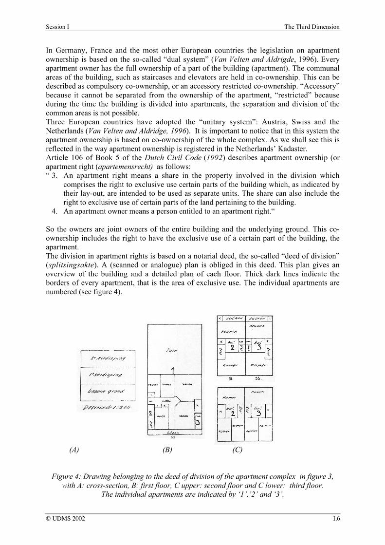
A typical form of multiple use of space, known in Dutch law since 1953, is apartmentownership (condominium ownership).For this case, we used a ‘simple’ apartment complex, consisting of one ground parcel andthree apartments. One apartment is located on the ground floor, and the two other apartmentsare located on the second and third floor, next to each other, with an entrance on groundlevel(see figure 3).
Figure 3: Example of an apartment complex (left) and an overview of the whole street (right).
In Germany, France and the most other European countries the legislation on apartmentownership is based on the so-called “dual system” (Van Velten and Aldrigde, 1996). Everyapartment owner has the full ownership of a part of the building (apartment). The communalareas of the building, such as staircases and elevators are held in co-ownership. This can bedescribed as compulsory co-ownership, or an accessory restricted co-ownership. “Accessory”because it cannot be separated from the ownership of the apartment, “restricted” becauseduring the time the building is divided into apartments, the separation and division of thecommon areas is not possible.Three European countries have adopted the “unitary system”: Austria, Swiss and theNetherlands (Van Velten and Aldridge, 1996). It is important to notice that in this system theapartment ownership is based on co-ownership of the whole complex. As we shall see this isreflected in the way apartment ownership is registered in the Netherlands’ Kadaster.Article 106 of Book 5 of the Dutch Civil Code (1992) describes apartment ownership (orapartment right (apartemensrecht) as follows:“ 3. An apartment right means a share in the property involved in the division which
comprises the right to exclusive use certain parts of the building which, as indicated bytheir lay-out, are intended to be used as separate units. The share can also include theright to exclusive use of certain parts of the land pertaining to the building.
4. An apartment owner means a person entitled to an apartment right.“
So the owners are joint owners of the entire building and the underlying ground. This co-ownership includes the right to have the exclusive use of a certain part of the building, theapartment.The division in apartment rights is based on a notarial deed, the so-called “deed of division”(splitsingsakte). A (scanned or analogue) plan is obliged in this deed. This plan gives anoverview of the building and a detailed plan of each floor. Thick dark lines indicate theborders of every apartment, that is the area of exclusive use. The individual apartments arenumbered (see figure 4).
(A) (B) (C)
Figure 4: Drawing belonging to the deed of division of the apartment complex in figure 3,with A: cross-section, B: first floor, C upper: second floor and C lower: third floor.
The individual apartments are indicated by ‘1’,’2’ and ‘3’.
The rights on the parcel and the apartments according to the cadastral registration system areas follows:
PARCEL KIND_OF_RIGHT RIGHT_OWNER----- -------------- ---------------------- --------------------5238 G0 VE VERENIGING VAN EIGENAREN HOORNBEEKSTRAAT 51,55, DELFT 6408 A3 VE BALLERING6408 A2 VE JANSSEN6408 A1 VE STOTER
VE = full right of ownership
At a first glance it seems that there are four owners, the “vereniging van eigenaren”(association of owners) and the holders of each of the three apartments. But this conclusion isnot correct. The parcel 5238 G0 refers to the ground parcel. This parcel, with the apartmentcomplex erected on it, is co-owned by all the holders of apartments rights. In practise theKadaster names the “vereniging van eigenaren” (the association of owners) as owner. From alegal point of view this is not correct. The complex is co-owned by all the apartment owners,not by the association. In Dutch law this association of co-owners is merely a legal bodyentrusted with the day-to-day administration and management of the complex. All the co-owners of the complex are members of this association.Apart from the (co-owned) ground parcel, we find the individual apartments, each indicatedby a unique number (6408 A1, 6408 A2, 6408 A3). The suffix A shows that this numberrefers to an apartment right. The last digit is the same as the apartment number in the deed ofdivision.Most important is to realize that the individual apartments, the areas of exclusive use, cannotbe found on the cadastral map (see figure 5). The Public Registers have to be queried to findthe plan of division. Another disadvantage of this way of registration is that the plans in thenotarial deed are drawn in a local coordinate system (in 2D layers). When coordinates weredefined in the national reference system they could be combined with the cadastral map orother geo-data (e.g. topographic data). However, the addition of 3D information on theindividual apartments in the cadastral system itself would especially enhance insight.
Figure 5: The cadastral map of the apartment complex in figure 3.The concerning parcel is indicated. The front of the building is indicated with an arrow.
Note that the parcel is larger than the footprint of the building.
These two cases illustrate the main problem that arises with 3D situations in urban areas in thecurrent cadastral registration: that spatial information in the vertical dimension is unavailable.The Public Registers need to be consulted to get insight in the actual 3D situation in the caseof apartment rights. For other cases (e.g. horizontal division of ownership by establishing aright of superficies) adding plans to deeds is voluntary, so consulting the Public Registersdoes not necessary yield significantly more information.
DESCRIPTION OF A PROTOTYPE OF A 3D CADASTRE
Before we came to a feasible approach for a 3D cadastre for the medium-term feature westarted with the concepts of three possible alternative solutions (Stoter et al., 2002):- Full 3D cadastre, in which 3D parcels and hence 3D rights are supported;- Hybrid solution, which means preservation of the 2D cadastre and the registration of the
situation in 3D within the 2D cadastral registration when this is required from a legalpoint of view;
- 2D classical registration with references, which means preservation of the 2D cadastrewith external references to representations of 3D situations (which is current practice).
In Stoter et al. (2002) we concluded that a hybrid approach for a 3D cadastre offers the bestpossibilities to meet the complications sketched above, both from a legal and technical pointof view.The hybrid approach consists of a registration of the 3D situation in addition to the existing2D parcel registration. This concept of a 3D cadastre is translated into prototypeimplementations in the geo-DBMS. For the implementation we use Oracle Spatial 9i. Theprototype has been implemented in two ways: using spatial data types and using a topologicalmodel. For technical details of the implementation see (Stoter and Van Oosterom, 2002).
For the registration of 2D parcels and 3D situations in one system, we start with a relativesimple solution: an extension of the current cadastral registration system, which implies theregistration of rights concerning 3D situations in 3D. This implementation is seen as a tool toget insight in the 3D aspect of rights (‘visualization of rights in 3D’): it is not an exactrepresentation on which conclusions with juridical consequences can be drawn.
The registration of 3D right-objects
A 3D right-object is a 3D representation of a right that is established on a 2D parcel andconcerns a 3D situation, for example a right of superficies that is limited in the thirddimension. The boundary of this 3D representation starts with the parcel boundary and isextended into 3D by means of defining the upper and lower limits. When more detail isrequired, e.g. in case only a part of a parcel deals with a complex situation, a new (2D) parcelboundary needs to be generated.The 3D right-objects that are maintained are associated with a registered right and contain areference to the whole spatial object (physical objects). Spatial and non-spatial characteristicsof these physical objects might also be maintained in the DBMS. All 3D right-objectsbelonging to one 3D physical object can be derived, because they all refer to the same 3Dphysical object. The registration of a 3D physical object consists of several rights belongingto this particular 3D physical object (right of superficies, condominium right etc). In this waya physical object, e.g. a tunnel, is subdivided into parts according to the ground parcels.
It can be queried which parcels contain a right or limited right related to a specific 3Dphysical object. To identify this, a record with at least the identification (the id) of this 3Dphysical object has to be present within the system. This query cannot be performed in thecurrent cadastral system, as there are no physical objects available. Neither can the 3D extentof a right be queried at the moment (to what height or depth extends the right of superficies?).A 3D right-object associated with a right on a parcel is only registered, when this is juridicallyrequired. That is in the case a limited real right is established. In other cases it is voluntary.For that reason it is possible that the 3D physical object is not completely known in thecadastral registration system. This can be illustrated by the example of a railway tunnel. Thistunnel is built in the underground of six parcels. The owner of the tunnel (the company “T”) isalso the owner of two of these parcels. The other four parcels are owned by respectively A, B,C and D. For each of these parcels a right of superficies is established. In this case the 3Dphysical object is registered for four surface parcels. Not necessarily for the two parcelsowned by T. Therefore the uniformity of the registrations of 3D physical objects and withthis insight in the 3D situation can run a risk.
The registration of 3D physical objects
A more advanced solution would also include the registering of 3D physical objects apartfrom (in addition to) 2D parcels. However, this solution requires considerable adjustments ofthe current cadastral registration system, technically as well as juridically. A registration of3D physical objects needs to be organised and maintained and this registration could becomea cadastral task. For the implementation of this registration a finite list of objects that need tobe registered has to be made. It has to be decided whether this list can include ‘empty space’objects or not. For this it is interesting to look to similar international experiences: ‘air spaceparcels’ are known in British Columbia (Gerremo and Hansson, 1998) while ‘constructionproperties’ in Norway (Onsrud, 2001) and ‘3D property units’ in Sweden (Julstad andEricsson, 2001) have to consist of actually built constructions. The last two will get legalforce in the coming years. When 3D physical objects (as they are defined on the finite list) arerealised, they have to be registered. To make the registration indisputable, a law is needed tomake the registration compulsory. From a technical point of view 3D physical objects aremore difficult to maintain since the geometry of physical objects is more complex than thegeometry of 3D right-objects (generating data, implementing data structures and spatialanalyses are more complex).When 3D physical objects are maintained, a 3D physical object can be queried (spatially andadministratively) as a whole (e.g. which parcels are intersecting with (the projection of) a 3Dphysical object?; which rights are established on these parcels; who are the right-owners?).
Prototype implementation
In this research we are looking for a feasible solution in the medium-term future. Thereforewe first focus on the registration of rights in 3D (3D right-objects). Figure 6 depicts theneeded extension of the current cadastral data model in UML (Warmer and Kleppe, 1998).To describe the rights concerning complex situations in 3D we introduce a table (3D right-table) that contains for every parcel the different height-levels of ownership (z-list). The z-listcontains n z-values corresponding to n-1 consecutive ranges associated with the parcel.Redundancy is avoided since only the z-levels are stored in addition to the currently storeddata (boundary of parcels). This information is sufficient to generate the representation of 3Dright-objects based on the geometry of parcel boundaries. The 3D right-objects are identifiedby unique numbers that are based on the concerning parcel number.
Holders of a 3D right-object can be obtained by the right to which the 3D right-object isassociated (e.g. a right of superficies). The right-owner of this right (subject) is the holder ofthe 3D right-object. For this moment the height-levels are invariant for every 3D right-object,which means that the upper and lower boundaries of 3D right-objects are defined byhorizontal planes.
Figure 6: UML class diagram for the cadastral data model including the registration of 3Dright-objects: An object is a parcel or a condominium right and a subject is a person who has
a right on an object.
PROTOTYPE APPLIED TO CASES
Case “Den Haag Centraal”
For the building complex “Den Haag Centraal” the 3D right-table looks as follows:
For every parcel a z-list is stored, that defines the upper and lower limits of rights establishedon the parcel. For example, the vertical extents of the rights on the parcel that contains thetram and bus station and the railway platform (parcel ‘13295’), are as follows:- railway platform (owned by “NS Vastgoed”): 0 to 6 m- tram/bus station (right of superficies, holder Municipality of Den Haag): 6m to 12 m.
While in this case the notarial deed gives no information about the boundaries of theestablished right of superficies in the third dimension, the levels were obtained by measuringthe building ourselves.The legal status of the space above and under the building complex is not explicitlyregistered. However according to the legal rule the owner of the parcel is owner of the spaceunder the complex and the subject who has a right of superficies on the parcel is owner of thespace above the construction. In this case the limits of the 3D right-objects are related to theconstruction as built. If the limits of the rights are defined in the deeds these can be used toconstruct the 3D right-objects. In that case it can happen that the visualization of the 3D right-objects is different than the actual built construction (e.g. when a right of superficies exceedsthe actual construction).The visualization of the generated 3D right-objects is shown in figure 7.
Figure 7: Visualization of 3D right-objects that were generated in the DBMS(“Den Haag Centraal”).
This visualization gives a clear insight of the various rights in the building complex. Not onlyit gives an indication of the spatial component of the property rights on each of the concernedparcels, it also shows the relation between the rights established on adjacent parcels. The 3Dmap of Den Haag Centraal clearly shows that the Municipality of Den Haag is not onlyholding the right of superficies on parcel 13295 (the big parcel in the center, with the railwayplatforms on ground level), but also of the parcels 13291, 13292, 13293 and 13294. At aglance one can see that the Municipality is owner of the bus/tram station on the second floor,with the adjacent entrances at left and right hand side of the railway station. This is a greatadvantage compared to the traditional 2D cadastral map.However it must be noticed that the 3D map only shows the 3D right-objects and not thephysical object (in this case the whole complex) itself. The physical object is only used todetermine and visualize the vertical limits of the right of the landowner and the limited realrights. Also it is important to notice that it is possible that a part of the structure is notvisualized because it is in full ownership with the owner of the land. In the previous section
we illustrated this by the example of a railway tunnel. In figure 7 this is the case with parcel12677: the small parcel just in front of the railway platforms and bus station. In fact therailway platforms are also erected on this parcel. However this part of the complex is notvisualized because “NS Railinfratrust BV” holds it in full ownership. Generally speaking,every part of a complex that is erected on a parcel that is in full ownership will not be shownon the 3D map.
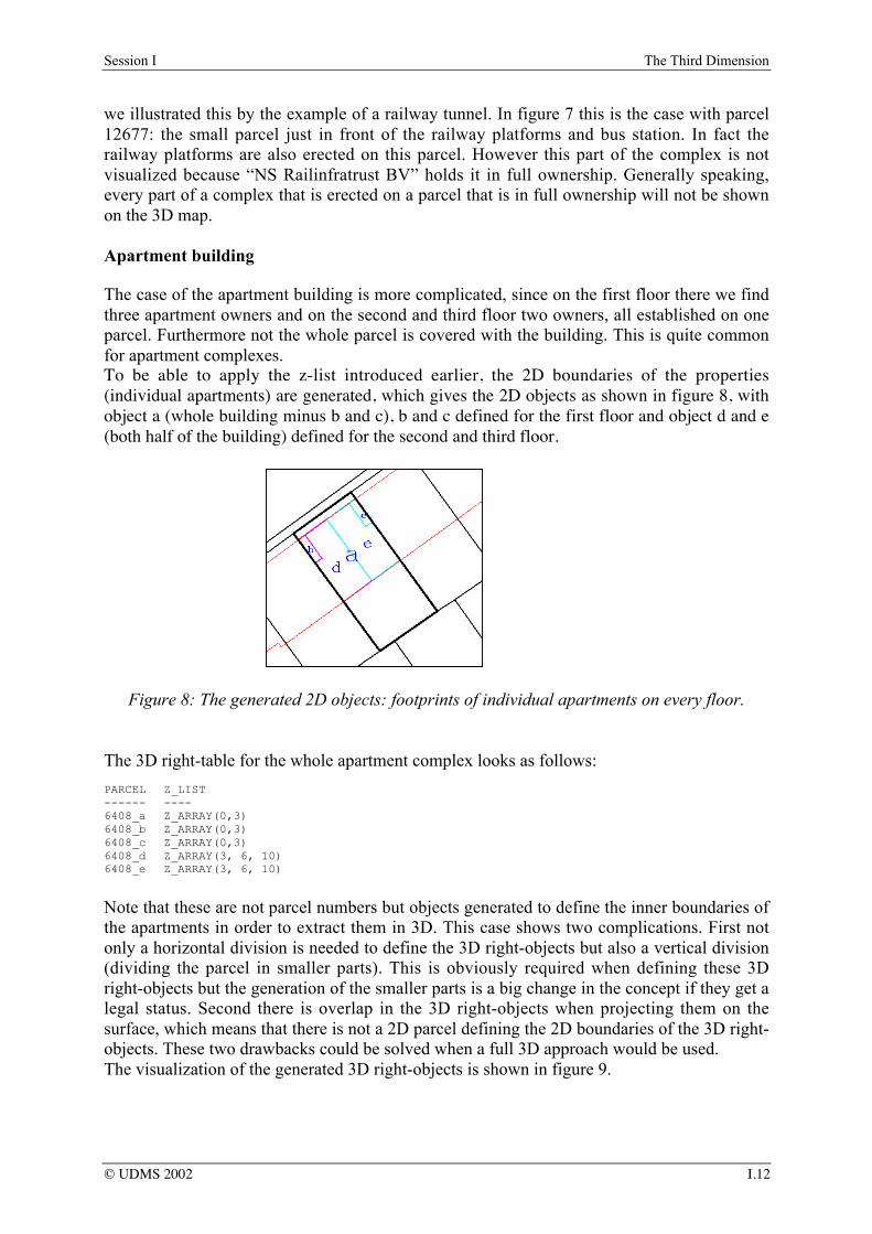
Apartment building
The case of the apartment building is more complicated, since on the first floor there we findthree apartment owners and on the second and third floor two owners, all established on oneparcel. Furthermore not the whole parcel is covered with the building. This is quite commonfor apartment complexes.To be able to apply the z-list introduced earlier, the 2D boundaries of the properties(individual apartments) are generated, which gives the 2D objects as shown in figure 8, withobject a (whole building minus b and c), b and c defined for the first floor and object d and e(both half of the building) defined for the second and third floor.
Figure 8: The generated 2D objects: footprints of individual apartments on every floor.
The 3D right-table for the whole apartment complex looks as follows:
Note that these are not parcel numbers but objects generated to define the inner boundaries ofthe apartments in order to extract them in 3D. This case shows two complications. First notonly a horizontal division is needed to define the 3D right-objects but also a vertical division(dividing the parcel in smaller parts). This is obviously required when defining these 3Dright-objects but the generation of the smaller parts is a big change in the concept if they get alegal status. Second there is overlap in the 3D right-objects when projecting them on thesurface, which means that there is not a 2D parcel defining the 2D boundaries of the 3D right-objects. These two drawbacks could be solved when a full 3D approach would be used.The visualization of the generated 3D right-objects is shown in figure 9.
Figure 9: Visualization of 3D right-objects (apartment rights) that were generated in theDBMS (left all apartments in the street and right the apartment complex of the case study
which is the second complex from right).
CONCLUSION
The objective of every cadastral registration system is to give insight in rights on land. In thispaper we analyzed two cases of multiple use of space: a building complex and a smallapartment complex. We found that the use of 2D parcels as the only basis for registration hasimportant limitations. The main problem is that the cadastral registration system cannotreflect the vertical component of ownership rights and real limited rights concerning complexsituations.In our research to find a solution we introduced 3D right-objects. These 3D representations ofrights improve insight in spatially complex situation considerably, as was illustrated byapplying this solution to the described cases. The 3D right-object starts with the 2D parcelboundary on which the right is established. This is extended into 3D by means of definingupper and lower limits of the right. This approach yielded some complications in case of theapartment complex, which have to be studied further.In conclusion, inserting 3D right-objects on the cadastral map gives an overview of thehorizontal division of ownership, which is a significant enhancement of the current system.Incorporation of 3D right-objects in the cadastral registration system provides information onthe vertical component of rights without having to consult the Public Registers. Furthermore,since references are maintained to the whole spatial object, all parcels can be found that areintersecting with one particular physical object (e.g. a tunnel). On the other hand, a drawbackof the proposed prototype is that such objects above or below several 2D parcels have to besubdivided in as many 3D right-objects as there are parcels on the surface.Based on the experiences in the case studies, the concept of a 3D cadastre as well as theprototype implementations will be improved to come to an optimal solution. Future researchwill also focus on spatially defining 3D right-objects more precisely (topologically andgeometrically), as well as on the study if the approach of 3D right-objects suffices or a moreadvanced solution is required: the registration of 3D physical objects (as they occur inreality). This will require more drastic changes in the current cadastral registration system.
ACKNOWLEDGEMENTSWe would like to thank the Netherlands’ Kadaster for their support and for using their data during thisresearch. We are grateful to Oracle and Bentley for using their software and for their support. Finallywe would like to thank professor Peter van Oosterom and Elfriede M. Fendel for their review onearlier versions of this paper and for their suggestions for improvements
REFERENCESCivil Code (Burgerlijk Wetboek) (1992): Boek 5: Zakelijke Rechten, 1992. (In Dutch)Gerremo J. and J. Hannson (1998): Ownership and real property in British Colombia: a legal study,
MSc thesis (nr. 48), Royal Institute of Technology, Stockholm, Department of Real Estate andConstruction Management, Division of Real Estate Planning and Land Law.
Julstad, B. and A. Ericsson (2001): property formation and three-dimensional property units inSweden, Proceedings of the international workshop on 3D-Cadastres - registration of propertiesin strata, pp.173-190, Delft, November 28-30, FIG, Frederiksberg, Denmark. ISBN 87-90907-15-9.
Kleyn, D.G. and A. Borraine (1992): The Law of Property, 3rd edition, Butterworths, Durban, 1992.ISBN 0-409-05314-7.
Lemmen, C.H.J., E.P. Oosterbroek and P.M.J. van Oosterom (1998): New spatial data managementdevelopments in the Netherlands Cadastre, FIG XXI International Congress, Brighton UK,Commission 3, Land Information Systems, pp. 398-409, 19-25 July 1998.
Nieper, F and H.D. Ploeger (1999): Sachenrecht in Europa, Niederlande (Christian von Bar, ed.),Universitätsverlag Rash, Osnabrück 1999. ISBN 3-934005-31-4.
Onsrud, H. (2001): Making laws for 3D cadastre in Norway. Proceedings of the internationalworkshop on 3D-Cadastres - registration of properties in strata, pp.191-199, Delft, November28-30, FIG, Frederiksberg, Denmark. ISBN 87-90907-15-9.
Oosterom, P.J.M. van and C.H.J. Lemmen (2001): Spatial data management on a very large cadastraldatabase, Computers, Environments and Urban Systems (CEUS), volume 25, number 4-5, pp.509-528.
Oosterom,. P.J.M. van, J.E. Stoter, S. Zlatanova, W.C. Quak (2002): The balance between Geometryand Topology, Spatial Data Handling 2002 Symposium, Ottowa, Canada, 9-12 July 2002.
Stoter, J.E. (2000): Needs, possibilities and constraints to develop a 3D cadastral registration system,UDMS 2000, Delft, the Netherlands, 11-15 September 2000.
Stoter, J.E., M.A. Salzmann, P.J.M. van Oosterom and P. van der Molen (2002): Towards a 3DCadastre, FIG XXII/ACSM-ASPRS, 19 – 26 April, 2002, Washington, USA.
Stoter, J.E., and P.J.M. van Oosterom (2002): 3D data modelling in a geo-DBMS, GIScience 2002,Boulder, Colorado, 25-28 September, 2002, USA.
Snijders, H.J. and E.B. Rank-Berenschot (2001): Goederenrecht, 3rd edition, Kluwer, Deventer 2001.ISBN 90-268-3446-2. (in Dutch).
Van Velten, A.A. and T.M. Aldridge (1996): Copropriété and commonhold, Apartment ownership inthe European Union, Union Internationale du Notariat Latin, Amsterdam 1996.
J. Warmer and A. Kleppe (1998) The Object Constraint Language: Precise Modeling with UML,Addison-Wesley, 1998.
CV OF THE AUTHORSJantien Stoter (MSc) graduated in Physical Geography in 1994. She started her career as a GISspecialist/consultant, with the District Water Board of Amsterdam and Surroundings (1995-1997).From 1997 till 1999 she worked as a GIS specialist/consultant at the Engineering Office Holland RailConsult. Since 1999 she is an assistant professor in GIS applications, section GIS technology,Department of Geodesy, Delft University of Technology. Also doing a PhD on 3D cadastres. In thisresearch the needs, possibilities, and constraints are studied for 3D cadastral registrations. Theemphasis of the research is the implementation of the facility to incorporate 3D real estate objects(geo-objects) in the current 2D geo-DBMS of the Netherlands’ Kadaster.Dr. Hendrik Ploeger studied Dutch Law at Leiden University and Notary Law at the Free Universityof Amsterdam. In 1997 he finished his thesis on the subject of the horizontal division of ownership(Horizontale splitsing van eigendom, Leiden 1997). At the E.M. Meijers-Institute of Legal Studies hedid research on the rights of land owners and the building of drilled tunnels (publication:Civielrechtelijke aspecten van de aanleg van boortunnels, Kluwer 1997). From 1997 until 2001 he wasassistant professor in Civil and Notary Law, Department of Civil Law, Leiden University. He is nowassistant-professor at the Delft University of Technology, Department of Geodesy, section Geo-information and Land Development
CO-ORDINATESJ.E. Stoter and H.D. PloegerDepartment of GeodesyFaculty of Civil Engineering and GeosciencesDelft University of TechnologyP.O. Box 50302600 GA DelftThe NetherlandsTel. +31-15-2788136/2782557Fax +31-15-2782745E-mail [email protected]