56
Muswellbrook Coal Continuation Project Biodiversity Assessment Prepared for Muswellbrook Coal Company Limited | 22 April 2016

Muswellbrook Coal Continuation Project
Biodiversity Assessment
Prepared for Muswellbrook Coal Company Limited | 22 April 2016


Muswellbrook Coal Continuation Project
Biodiversity Assessment
Prepared for Muswellbrook Coal Company Limited | 22 April 2016
Ground Floor, Suite 01, 20 Chandos StreetSt Leonards, NSW, 2065
T +61 2 9493 9500F +61 2 9493 9599
www.emmconsulting.com.au

Muswellbrook Coal Continuation Project
Draft Report
Report J16011RP1 | Prepared for Muswellbrook Coal Company Limited | 22 April 2016
Prepared by Dilys Zhang Approved by Katie Whiting
Position Ecologist Position Associate, Ecology Services Manager
Signature Signature
Date 22 April 2016 Date 22 April 2016
This report has been prepared in accordance with the brief provided by the client and has relied upon the information collected at the time and under the conditions specified in the report. All findings, conclusions or recommendations contained in the report are based on the aforementioned circumstances. The report is for the use of the client and no responsibility will be taken for its use by other parties. The client may, at its discretion, use the report to inform regulators and the public.
© Reproduction of this report for educational or other non‐commercial purposes is authorised without prior written permission from EMM provided the source is fully acknowledged. Reproduction of this report for resale or other commercial purposes is prohibited without EMM’s prior written permission.
Document Control
Version Date Prepared by Reviewed by
1 15/3/16 Dilys Zhang Katie Whiting
2 1/4/16 Dilys Zhang Katie Whiting Nicole Armit
3 22/04/16 Dilys Zhang Kate Cox
T +61 (0)2 9493 9500 | F +61 (0)2 9493 9599
Ground Floor | Suite 01 | 20 Chandos Street | St Leonards | New South Wales | 2065 | Australia
www.emmconsulting.com.au

J16011RP1 i
Table of contents
Chapter 1 Introduction 1 1.1 Overview 1 1.2 Scope and objectives 2
Chapter 2 Legislative requirements 3 2.1 Overview 3 2.2 Environmental Planning and Assessment Act 1979 3 2.3 Threatened Species Conservation Act 1995 4 2.4 National Parks and Wildlife Act 1974 4 2.5 Noxious Weeds Act 1993 4 2.6 Fisheries Management Act 1994 4 2.7 Environment Protection and Biodiversity Conservation Act 1999 5
2.7.1 Matters of national environmental significance 5
Chapter 3 Methods 7 3.1 Introduction 7 3.2 Desktop assessment 7
Chapter 4 Existing environment 9 4.1 Description of the study area 9 4.2 Vegetation communities 9
4.2.1 Threatened flora 10 4.3 Fauna 11
4.3.1 Fauna habitat 11 4.3.2 Threatened fauna 11 4.3.3 Migratory fauna 12
4.4 Aquatic environment 12 4.5 Critical habitat 12
Chapter 5 Potential impacts 13 5.1 Vegetation communities 13 5.2 Fauna 13
5.2.1 Threatened and migratory fauna 13 5.3 Aquatic environment 14
Chapter 6 Safeguards and recommendations 15
Chapter 7 Conclusions 17
References 19
J16011RP1 ii
Appendices
A Likelihood of occurrence of listed species B Assessment of significance
Tables
A.1 Likelihood of occurrence include one or more of the following criteria A.1 A.2 Threatened species previously recorded or predicted to occur in the locality A.2
Figures
1 Study area location 8

J16011RP1 1
1 Introduction
1.1 Overview
Muswellbrook coal mine (MCM) is an open cut coal mine operated by Muswellbrook Coal Company Limited (MCC). MCM is located, 3 kilometres (km) north‐east of the township of Muswellbrook, in the Muswellbrook local government area (LGA) in New South Wales (NSW).
MCC has a long history of mining in the Muswellbrook area, with underground operations commencing at MCM in 1907 and open cut operations commencing in 1944. Underground operations ceased in the late 1990s; however open cut mining continues. MCC has development consent from Muswellbrook Shire Council (MSC) to mine within the No. 1 Open Cut Extension Area (Open Cut 1) (Development Consent No. DA 205/2002, as modified), with operations to be complete by 2020.
Additional coal resources have been identified within a previously rehabilitated area adjacent to Open Cut 1. While this area is within the development consent boundary, a modification to the existing development consent is required to modify the conceptual mine plan to allow mining of these additional resources, as well as extending the approved mine life and modifying the conceptual final landform (the modification).
The modification would maximise the recovery of coal resources within ML 1562, ML 1304 and CCL 713 and would enable the recovery of approximately 4.2 million tonnes (Mt) of additional coal resources.
In summary the modification involves:
• extension of open cut mining operations in Open Cut 1;
• extension of the mine life, with operations to cease by the end of 2025;
• changes to the conceptual final landform within the modification area; and
• overburden emplacement in both Open Cut 1 and Open Cut 2, so as to achieve the conceptual final landform.
As the modification involves mining of a previously disturbed area that was used as an overburden dump, there would be no direct impact to previously undisturbed land.
No changes are proposed to the currently approved maximum production rate of 2 Mtpa, mining methods, coal processing, blasting methods, water management, waste management and handling, coal transport, access to site, employee numbers, hazardous substances and dangerous goods management.
MSC requires the submission of a Statement of Environmental Effects (SEE) to support the application for modification of the existing consent (DA 205/2002) (the proposed modification) under section 96 (2) of the Environmental Planning and Assessment Act 1979 (EP&A Act).

J16011RP1 2
1.2 Scope and objectives
The biodiversity assessment:
• assesses biodiversity values and likely biodiversity impacts of the modification;
• considers the provisions of Section 5A(1) of the EP&A Act in determining the likelihood of the modification having a significant impact on threatened species, populations of ecological communities or their habitats listed under the NSW Threatened Species Conservation Act 1995 (TSC Act), NSW Fisheries Management Act 1994 (FM Act) and the Commonwealth Environment Protection and Biodiversity Conservation Act (EPBC Act); and
• considers impacts on aquatic biodiversity and assesses any impacts in accordance with the Policy and Guidelines for Fish Habitat Conservation and Management (Fisheries NSW, 2013).
J16011RP1 3
2 Legislative requirements
2.1 Overview
Legislation and planning policies relevant to the protection of biodiversity or their habitats and this biodiversity assessment are provided below. These statutory instruments provide conditions, matters for consideration, and requirements to seek authorisation (licences and approvals) to undertake various actions and activities. The list of State and Commonwealth legislation applicable to this assessment are:
• EP&A Act;
• TSC Act;
• NSW National Parks and Wildlife Act 1974 (NPW Act);
• NSW Noxious Weeds Act 1993 (NW Act);
• FM Act; and
• EPBC Act.
2.2 Environmental Planning and Assessment Act 1979
Under Section 96 (2) of the EP&A Act, a consent authority may modify the existing consent if:
a) it is satisfied that the development to which the consent as modified relates is substantially the same development as the development for which consent was originally granted and before that consent as originally granted was modified (if at all);
b) it has consulted with the relevant Minister, public authority or approval body (within the meaning of Division 5) in respect of a condition imposed as a requirement of a concurrence to the consent or in accordance with the general terms of an approval proposed to be granted by the approval body and that Minister, authority or body has not, within 21 days after being consulted, objected to the modification of that consent; and
c) it has notified the application in accordance with:
i) the regulations, if the regulations so require; or
ii) a development control plan, if the consent authority is a council that has made a development control plan that requires the notification or advertising of applications for modification of a development consent (applicable to this assessment); and
d) it has considered any submissions made concerning the proposed modification within the period prescribed by the regulations or provided by the development control plan, as the case may be.
J16011RP1 4
The assessment must address whether the activity is likely to significantly impact threatened biodiversity. In order to make this decision, a determining authority must consider the impact of an activity on:
• threatened species, populations and ecological communities, and their habitats (listed under the TSC Act) and whether there is likely to be a significant impact on these;
• critical habitat (listed under the TSC Act); and
• any other protected fauna or protected native plants within the meaning of the NPW Act.
Section 5A of the EP&A Act outlines the seven factors that must be taken into account when deciding whether a project will likely to have a significant impact on threatened species, populations or communities or their habitats (also known as the 7‐part test). This ecology report assesses the likelihood that threatened biodiversity will occur and be impacted by the proposed modification.
2.3 Threatened Species Conservation Act 1995
The TSC Act requires that any vulnerable, endangered or critically endangered species, population or ecological community associated with a proposed development are identified. It also requires that acceptable recovery and management strategies are implemented, if a project is likely to have a significant impact. This ecology report considers the likelihood that threatened biodiversity will be significantly impacted.
2.4 National Parks and Wildlife Act 1974
The NPW Act is administered by NSW Office of Environment and Heritage (OEH) and contains provisions that relate to the protection of native terrestrial fauna, flora and endangered ecological communities. Under the NPW Act, it is an offence to harm threatened species; buy, sell or possess threatened species; damage critical habitat; or damage the habitat of a threatened species without approval under the Act. Under Section 171 of the Act, the Director‐General may authorise the harming of threatened and protected flora and fauna species and habitats. It is a defence to prosecution under the Act if the offence is necessary for carrying out a project that has received development consent under the EP&A Act, such as the proposed modification is seeking.
2.5 Noxious Weeds Act 1993
The NW Act defines the roles of government, councils, private landholders and public authorities in the management of noxious weeds. The NW Act sets up categorisation and control actions for noxious weeds and imposes penalties for various offences. All private landowners, occupiers, public authorities and councils are required to control noxious weeds on their land under Part 3, Division 1 of the NW Act.
2.6 Fisheries Management Act 1994
The provisions of the FM Act relating to the development approval process operate similarly to the TSC Act. The FM Act identifies threatened aquatic species, populations and ecological communities and requires an identical test of significance. This report assessed the likelihood that threatened aquatic biodiversity would occur or be impacted by the proposed modification.
J16011RP1 5
2.7 Environment Protection and Biodiversity Conservation Act 1999
2.7.1 Matters of national environmental significance
The EPBC Act protects nationally and internationally important flora, fauna, ecological communities and heritage places, which are defined in the EPBC Act as matters of national environmental significance (NES). Matters of NES relevant to biodiversity are:
• wetlands of international importance;
• nationally threatened species and ecological communities;
• migratory species; and
• Commonwealth marine areas.
The significance of impacts is determined in accordance with the Significant impact guidelines 1.1 – Matters of National Environmental Significance (Department of the Environment (DoE), 2013).
Where an action is likely to have a significant impact on a matter of NES, the action is referred to the Commonwealth Environment Minister. The referral process involves a decision on whether or not the action is a ‘controlled action’. When an action is declared to be a controlled action, approval from the Minister is required.
If a significant impact to matters of NES is likely from the proposed modification, a decision to refer the matter will be made by MCC.
This report considers the likelihood that nationally threatened species and ecological communities would occur or be impacted by the proposed modification.

J16011RP1 6
“his page has been intentionally left blank”

J16011RP1 7
3 Methods
3.1 Introduction
The study area covers the majority of the partially rehabilitated area between Open Cut 1 and Open Cut 2, within the modification area. The biodiversity study area is illustrated in Figure 1. The biodiversity study area excludes the open pit to the north of the proposed modification boundary (Open Cut 2). This pit has not undergone rehabilitation and has no biodiversity values (see Figure 1).
An EMM Consulting Pty Limited (EMM) Ecologist undertook a desktop assessment to determine existing biodiversity values within the study area and the potential impacts from the proposed modification. This assessment is based on the results of the 2015 Rehabilitation Monitoring Report (EcoLogical Australia 2016).
3.2 Desktop assessment
A desktop assessment was undertaken to identify biodiversity values of the study area. The following was completed for the desktop assessment:
• a search of the BioNet Atlas of NSW Wildlife (a 10 km radius from the study area) for previous threatened species records (OEH, 2015a);
• a search of the Commonwealth DoE Protected Matters Search Tool (PMST) (a 10 km radius from the study area) for Matters of NES, including threatened species records (DoE, 2015a);
• a review of profiles for NSW and Commonwealth listed threatened biodiversity (Royal Botanic Gardens and Domain Trust (RBGDT), 2015; DoE, 2015b; OEH, 2015b);
• vegetation mapping and community descriptions from Greater Hunter Native Vegetation Mapping (OEH, 2012) were consulted as a guide to identifying potential plant community types (PCTs) (ie , an unambiguous, master community‐level native vegetation classification which identifies a collection of plant species unique to vegetation type) present within the study area; and
• 2015 Rehabilitation Monitoring Report (EcoLogical Australia, 2016) prepared for MCC was reviewed to determine the existing environment within the study area.

Mine access road (private)
Product stockpiles
Coal processing plant
Mine infrastructure area
Open cut 2
Open cut 1
Open cut 1 rehabilitation
Eastern out-of-pitemplacement
Open cut 2rehabilitation
SANDY CREEK ROAD
¯
Source: EMM (2015); LPI (2015)
\\10.0.0
.200\e
mgam
m\Jobs
\2016\
J16011
- Musw
ellbroo
k Coal
Contin
ued Op
eration
s Proje
ct\GIS\
02_Ma
ps\E0
01_Stu
dyArea
_20160
421_04
.mxd 2
2/04/2
016
0 250 500
m
GDA 1994 MGA Zone 56
Biodiversity assessment study area
Figure 1Muswellbrook Coal Continued Operations Project
Biodiversity Assessment
KEYRoadWaterwayDevelopment consentboundaryModification areaBiodiversity study area

J16011RP1 9
4 Existing environment
4.1 Description of the study area
The study area is in the MSC local government area (LGA) and the Hunter drainage catchment. The natural landscape of the area is classed as the Central Hunter Foothills characterised by undulating lowlands, rounded to steep hills with rock outcrop on ridges on Permian lithic sandstone, conglomerate, shale and coal. The elevation is generally 40‐300 m with a local relief of 30‐120 m (Mitchell, 2002).
Land uses surrounding the mine include agricultural activities, light industrial land uses and residential areas. Agricultural activities are located on properties surrounding MCM and primarily include grazing of beef cattle. Light industrial land uses include Muswellbrook Quarry to the north‐west, St. Heliers correctional centre to the north‐west and Muswellbrook waste management facility to the south. Muswellbrook township is to the west, with other notable rural‐residential areas along Sandy Creek Road to the north, Woodlands Ridge Estate to the south and along Muscle Creek Road to the south‐east.
Other significant features surrounding MCM include the Main Northern Rail Line and the New England Highway, which run to the west through Muswellbrook township and to the south towards Singleton. Numerous other mining operations and power‐generating facilities exist between Muswellbrook and Singleton.
The top soil levels in the study area are reported as mostly low‐moderate with limited erosion due to vegetation cover throughout much of the area (EcoLogical Australia, 2016). The Soils Assessment (EMM, 2016) for the modification identified the land and soil capability (LCS) as Class 6, which is low capability land.
Rehabilitation is undertaken at MCC in accordance with the Mining Operations Plan (MOP) (MCC, 2015), which outlines the regulatory requirements and rehabilitation objectives for rehabilitation. The strategy for rehabilitation with respect to restoring biodiversity comprises:
• the spread of a 10 cm topsoil in areas where the final vegetation will be native vegetation;
• weed control on shaped areas and areas with topsoil (if required) prior to spreading ameliorants and seeding activities;
• coordination of feral animal control, erosion controls, fertilisation, reseeding in failed areas and access track maintenance; and
• annual rehabilitation monitoring.
The final land use in rehabilitated areas is aimed at approximately 50% of pasture and 50% of native trees (woodland). The location of plantings is aimed at restoring connectivity between the remnant vegetation between Bells Mountain and Skelletar Ridge (MCC, 2015).
4.2 Vegetation communities
Prior to mining‐related disturbance, historical mapping classed the vegetation of the study area as non‐native (OEH, 2012). However, revegetation of the study area over the last five to ten years has allowed a number of native species to colonise the study area.
J16011RP1 10
The forested areas are mostly comprised of a canopy of Spotted Gum (Corymbia maculata) and Sugar Gum (Eucalyptus cladocalyx). These species are not endemic to the area or representative of local vegetation communities. The canopy cover is estimated at 34% as compared with 75% in remnant woodland areas. The shallow topsoil profile of the study area has led to stunted canopy growth, hence a lower canopy cover (EcoLogical Australia, 2016).
The midstorey is dominated by Golden Wreath Wattle (Acacia saligna) while the groundcover is mostly exotic. There is negligible shrub cover across the study area. The pasture areas are mostly colonised by exotic grasses and forbs including Rhodes Grass (Chloris gayana), Kikuyu (Pennisetum clandestinum), Red Natal Grass (Melinis repens), Fireweed (Senecio madagascariensis), Centaurium tenuiflorum, Barrel Medic (Medicago truncatula), Haresfoot Clover (Trifolium arvense), Hop Clover (Trifolium campestre) and White Clover (Trifolium repens) (EcoLogical Australia, 2016).
A number of threatened ecological communities (TECs) are mapped in areas adjacent to the study area, including:
• Central Hunter Grey Box‐Ironbark Woodland in the New South Wales North Coast and Sydney Basin Bioregions listed as an endangered ecological community (EEC) under the TSC Act and Central Hunter Valley Eucalypt Forest and Woodland listed as a critically endangered ecological community (CEEC) under the EPBC Act (PCT ID 1691);
• White Box Yellow Box Blakely’s Red Gum Woodland listed as an EEC under the TSC Act and White Box‐Yellow Box‐Blakely's Red Gum Grassy Woodland and Derived Native Grassland listed as a CEEC under the EPBC Act (PCT ID 1606 and 1608);
• Central Hunter Ironbark‐Spotted Gum‐Grey Box Forest in the New South Wales North Coast and Sydney Basin Bioregions listed as an EEC under the TSC Act and Central Hunter Valley Eucalypt Forest and Woodland listed as a critically endangered ecological community (CEEC) under the EPBC Act (PCT ID 1604); and
• Lower Hunter Valley Dry Rainforest in the Sydney Basin and NSW North Coast Bioregions listed as a vulnerable ecological community (VEC) under the TSC Act (PCT ID 1543).
Due to the high degree of disturbance, absence of representative species and low native flora diversity and complexity, the vegetation in the study area does not fit the description of any native PCTs. The species composition and low condition of the vegetation within the study area does not meet any of the listing descriptions or condition thresholds of TECs.
4.2.1 Threatened flora
Twelve threatened flora species are recorded within 10 km of the study area (locality) or are predicted to occur within the locality. An assessment of the likelihood of threatened flora to occur in the study area was undertaken, and is provided in Appendix A.
No threatened flora species are likely to occur within the study area. The vegetation within the study area has not been well established and is at an early stage of rehabilitation. Overstorey growth appears stunted and vegetated areas have little to no native midstorey or groundcover resulting in a lack of structural complexity. The study area also lacks any associated species or preferable habitat features that threatened flora recorded in the locality require. Accordingly, no further assessment has been undertaken for threatened flora species.
J16011RP1 11
4.3 Fauna
Fauna monitoring for the 2015 Rehabilitation Monitoring Report (EcoLogical Australia, 2016) identified a limited number of common, native bird and mammal species that utilise the study area. These include:
• Red‐necked Wallaby (Macropus rufogriseus);
• Eastern Grey Kangaroo (Macropus giganteus); and
• Australian Raven (Corvus coronoides).
Monitoring in adjacent rehabilitation areas within the mining lease boundary also found the presence of other native and exotic fauna including the Echidna (Tachyglossus aculeatus), Australian Magpie (Gymnorhina tibicen), White‐winged Chough (Corcorax melanorhamphos) and the introduced Hare (Lepus europaeus) (EcoLogical Australia, 2016).
Native bird and mammal diversity was similar in rehabilitated woodland and adjacent remnant woodland areas. However, reptiles and microchiropteran bats (microbats) preferred remnant woodland as they did not appear to utilise rehabilitated areas. Exotic species diversity in remnant woodland were also found to be approximately double that of rehabilitated areas (EcoLogical Australia, 2016).
4.3.1 Fauna habitat
Native fauna habitat in the study area is limited due to the early stage of rehabilitation. Plantings in the study area have occurred over the last five to ten years and therefore have not had sufficient time to develop important shelter habitats for fauna including tree hollows and fallen logs. Insectivorous passerines have potential to forage in the canopy and midstorey within the study area. However, it is evident that better foraging, roosting and nesting habitat exist in adjacent remnant woodland where the overstorey and midstorey cover are denser and in better condition.
The pasture areas are dominated by introduced plant species which provide little value to native fauna species, and provide more suitable habitat for introduced species including the Hare. The presence of Hares may provide hunting opportunities for native birds of prey. However, with the lack of large trees or stags in the area, nesting habitat is not available and better condition, preferred habitat is in adjacent, remnant areas.
4.3.2 Threatened fauna
Thirty‐nine threatened fauna species have been recorded or are predicted to occur within 10 km of the study area. Of these 39, 19 were birds, 18 were mammals and one amphibian and reptile. An assessment of the likelihood of threatened fauna to occur in the study area was undertaken, and is provided in Appendix A.
The Speckled Warbler (Chthonicola sagittatus) was recorded in a rehabilitation site to the east of the study area (Block A). The vegetation condition in Block A was of higher quality than the study area with more native species in the overstorey, the presence of a shrubby midstorey and native groundcover in some sections (EcoLogical Australia, 2016). Relatively undisturbed remnant vegetation is required for the species to persist in the area and the sightings are likely to be foraging individuals from adjacent remnant woodland. The species has a low potential to periodically forage in the study area and due to unsuitable habitat and no records in the study area, and therefore, no further assessment has been undertaken (see Appendix A).

J16011RP1 12
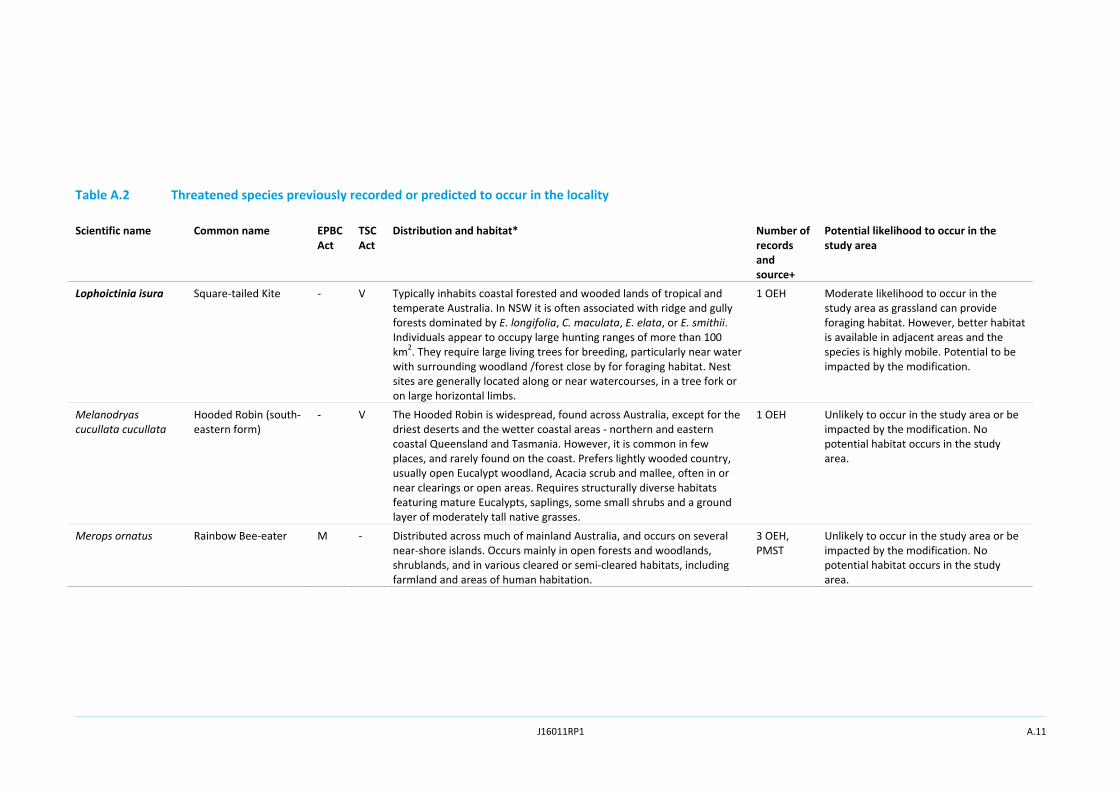
Bird of prey species including the Spotted Harrier (Circus assimilis), Little Eagle (Hieraaetus morphnoides) and the Square‐tailed Kite (Lophoictinia isura) may utilise the open grassland to forage as potential prey (the Hare) is present in the study area. However, there are limited records of their occurrence and no large trees or stags in the study area for roosting or nesting. The study area is not deemed as preferred habitat and better condition habitat is available in remnant vegetation in the greater area. Their occurrence in the study area is likely to be moderate and a combined assessment of significance has been carried out for these three species (see Appendix A and B).
4.3.3 Migratory fauna
Twelve migratory bird species are recorded within or are predicted to occur within the locality. An assessment of the likelihood of migratory fauna to occur in the study area was undertaken, and is provided in Appendix A.
There are no migratory fauna that have a moderate to high likelihood to occur in the study area due to the lack of preferred habitat (see Appendix A). Some species may fly over but are unlikely to utilise the study area as habitat. The study area is not considered important habitat for any migratory species, and therefore no further assessment has been undertaken.
4.4 Aquatic environment
There is a void to the north of the study area (Open Cut 2), which is filled with water and has not undergone rehabilitation. This is not considered to have any ecological values or provide habitat to threatened aquatic species. No threatened aquatic species have been recorded or are predicted to occur in the locality.
4.5 Critical habitat
Critical habitat is an area of land that is critical to the survival of particular threatened species, populations and ecological communities. These areas are registered under the TSC Act after extensive consultation with the Scientific Committee in the Register of Critical Habitat kept by the NSW OEH. The study area is not considered critical habitat and the proposed modification will not impact on registered critical habitat.

J16011RP1 13
5 Potential impacts
5.1 Vegetation communities
The biodiversity assessment has conservatively assumed that the entire study area will be cleared/disturbed by the modification. As such, the assessment has considered the removal of all rehabilitated woodland and pasture within the study area (Figure 1), although only an estimated 45.2 ha is expected to be disturbed.
As stated in Section 4.2, vegetation in the study area does not meet any native PCT definitions. Clearing will remove native canopy species that are stunted in growth and not endemic to the area or representative of local vegetation communities. Shrub cover in the proposed modification area is negligible, hence only midstorey species to be removed will be some areas of Golden Wreath Wattles. The clearing will also remove grasses and forbs from pasture areas.
Following completion of mining, the modification area will be progressively rehabilitated in accordance with the MOP and development consent. The final land use will comprise a mixture of pasture and native woodland.
5.2 Fauna
The proposed modification will remove potential foraging habitat for a number of common native birds and mammals. However, no significant habitat features (hollow‐bearing tree and large woody debris are recorded within the study area). The study area is adjacent to better condition remnant woodland with more suitable habitat for native fauna. The proposed modification will not impact on significant or high condition fauna habitat.
Clearing of vegetation for the proposed modification may cause direct injury or mortality to native fauna foraging in the study area. Native fauna identified during clearing would be encouraged to relocate to areas outside the impact area.
5.2.1 Threatened and migratory fauna
No important habitat currently utilised by threatened or migratory fauna will be impacted by the proposed modification. Most threatened and migratory fauna are unlikely or have a low likelihood to occur in the study area.
The clearing of pasture may remove potential foraging habitat for three threatened bird of prey species in the area. These include the:
• Spotted Harrier;
• Little Eagle; and
• Square‐tailed Kite.
An assessment of significance is provided at Appendix B for these raptor species, in accordance with Section 5a of the EP&A Act. The assessment concluded that the proposed modification will not have a significant impact on these species. The proposed modification will not impact any important habitat for migratory fauna.

J16011RP1 14
5.3 Aquatic environment
Erosion and sedimentation from the proposed modification may be transported through the ephemeral drainage network in the study area to larger waterways nearby. All dirty water within the study area that is affected by mining would be captured by the site water management system. Erosion and sediment controls are described in the Surface Water Assessment prepared for the proposed modification by SLR Consulting Australia Pty Ltd (SLR 2016).

J16011RP1 15
6 Safeguards and recommendations
The activities under the proposed modification will be conducted in accordance with the MOP and MCC’s relevant management plans. Vegetation clearing, weed management, erosion and sediment controls, before and during mining operations are guided by MCC’s existing suite of management plans and MOP. A rehabilitation plan including a full list of native flora species from analogous sites for the rehabilitation of the study area, management and monitoring of rehabilitation sites are also detailed in the MOP.
The following safeguards are recommended for the proposed modification to avoid, minimise and mitigate potential impacts to biodiversity:
• the relevant management plans will be updated to reflect the changes to operations as a result of the proposed modification;
• the boundaries of vegetation clearing will be clearly marked so that areas outside the modification area are not impacted and the adjacent remnant woodland and rehabilitation areas remain intact;
• debris and stockpiles must also remain within the boundaries of the proposed modification;
• any native fauna encountered during the works will be encouraged to relocate to remnant woodland a safe distance from the study area; and
• erosion and sediment controls are implemented prior to the commencement of clearing.

J16011RP1 16
“This page has been intentionally left blank”

J16011RP1 17
7 Conclusions
The vegetation of the study area is at an early stage of rehabilitation, and is therefore in low condition. Fauna habitat is limited in the study area, and no significant habitat features are present.
The proposed modification will remove an estimated 45.2 ha of low condition, rehabilitated woodland and pasture. Three threatened raptor species have potential to forage in the open pasture within the study area. However, due to the lack of breeding or roosting habitats in the study area, better condition habitat in adjacent areas in the locality and the large home ranges of these species, the proposed modification is unlikely to significantly impact these species.
While the modification will disturb an area of partially completed rehabilitation, the modification area will be progressively rehabilitated following mining in accordance with the MOP and development consent.
Accordingly, the proposed modification is not likely to significantly impact on biodiversity within the study area.

J16011RP1 18
“This page has been intentionally left blank”

J16011RP1 19
References
DoE 2013, Matters of National Environmental Significance: Significant Impact Guidelines 1.1, Commonwealth of Australia, Canberra.
DoE 2015a, Protected Matters Search Tool. 2015a, viewed March 2016, http://www.environment.gov.au/epbc/protected‐matters‐search‐tool.
DoE 2015b, Species Profile and Threats Database, viewed March 2016, http://www.environment.gov.au/cgi‐bin/sprat/public/sprat.pl.
EcoLogical Australia 2016, 2015 Rehbailitation Monitoring Reporting, MCC.
EMM Consulting 2016, Soils Assessment: Muswellbrook Coal Continuation Project. Prepared for Muswellbrook Coal Company Limited.
Fisheries NSW 2013. Policy and guidelines for fish habitat conservation and management. Wollongbar, Department of Primary Industries (DPI), NSW.
MCC 2015, Muswellbrook Coal Company Open Cut Operations: Mining Operations Plan.
Mitchell, P 2002, Descriptions for NSW (Mitchell) Landscapes, Version 2, DECC (Department of Environment and Climate Change).
OEH 2012, Greater Hunter Native Vegetation Mapping.
OEH 2015a, NSW BioNet: Atlas of NSW Wildlife. 2015a, viewed March 2016, http://www.bionet.nsw.gov.au/.
OEH 2015, Threatened Species Profile Search, viewed March 2016, http://www.environment.nsw.gov.au/threatenedSpeciesApp/.
RBGDT 2015, PlantNET ‐ The Plant Information Network System of the Royal Botanic Gardens and Domain Trust, viewed March 2016, http://plantnet.rbgsyd.nsw.gov.au/.
SLR 2016, Muswellbrook Coal Continuation Project – Surface Water Assessment. Prepared for Muswellbrook Coal Company Limited.

J16011RP1 20
“This page has been intentionally left blank”
J16011RP1
Appendix A
Likelihood of occurrence of listed species

J16011RP1
“This page has been intentionally left blank”

J16011RP1 A.1
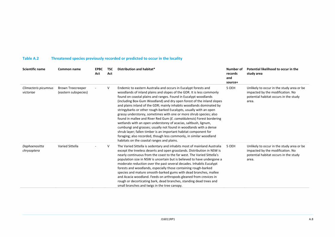
The following assessment identifies the list of threatened flora and fauna species recorded from a 10 km radius of the study area (locality) and compares the preferred habitat of these species with the habitats identified in the study area to make an assessment of the likelihood of the species being present in the study area (ie subject species). The criteria used in the assessment are detailed in Table A.1. Assessments of significance are only completed for species determined to have a moderate or high likelihood of occurrence.
Table A.1 Likelihood of occurrence include one or more of the following criteria
Likelihood of occurrence
Criteria
Unlikely Species highly restricted to certain geographical areas not within the proposal footprint Species that have specific habitat requirements are not present in the study area
Low Species that fit into one or more of the following criteria: Have not been recorded previously in the study area/surrounds and for which the study area is beyond the current distribution range Use specific habitats or resources not present in the study area Are a non‐cryptic perennial flora species that were specifically targeted by surveys and not recorded
Moderate Species that fit one or more of the following criteria: Have infrequently been recorded previously in the study area/surrounds Use specific habitats or resources present in the study area but in a poor or modified condition Are unlikely to maintain sedentary populations, however may seasonally use resources within the study area opportunistically or during migration Are cryptic flowering flora species that were not seasonally targeted by surveys and that have not been recorded
High Species that fit one or more of the following criteria: Have frequently been recorded previously in the study area/surrounds Use habitat types or resources that are present in the study area that are abundance and/or in good condition within the study area Are known or likely to maintain resident populations surrounding the study area Are known or likely to visit the site during regular seasonal movements or migration

J16011RP1 A.2
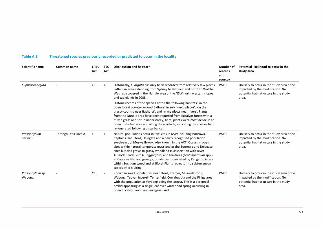
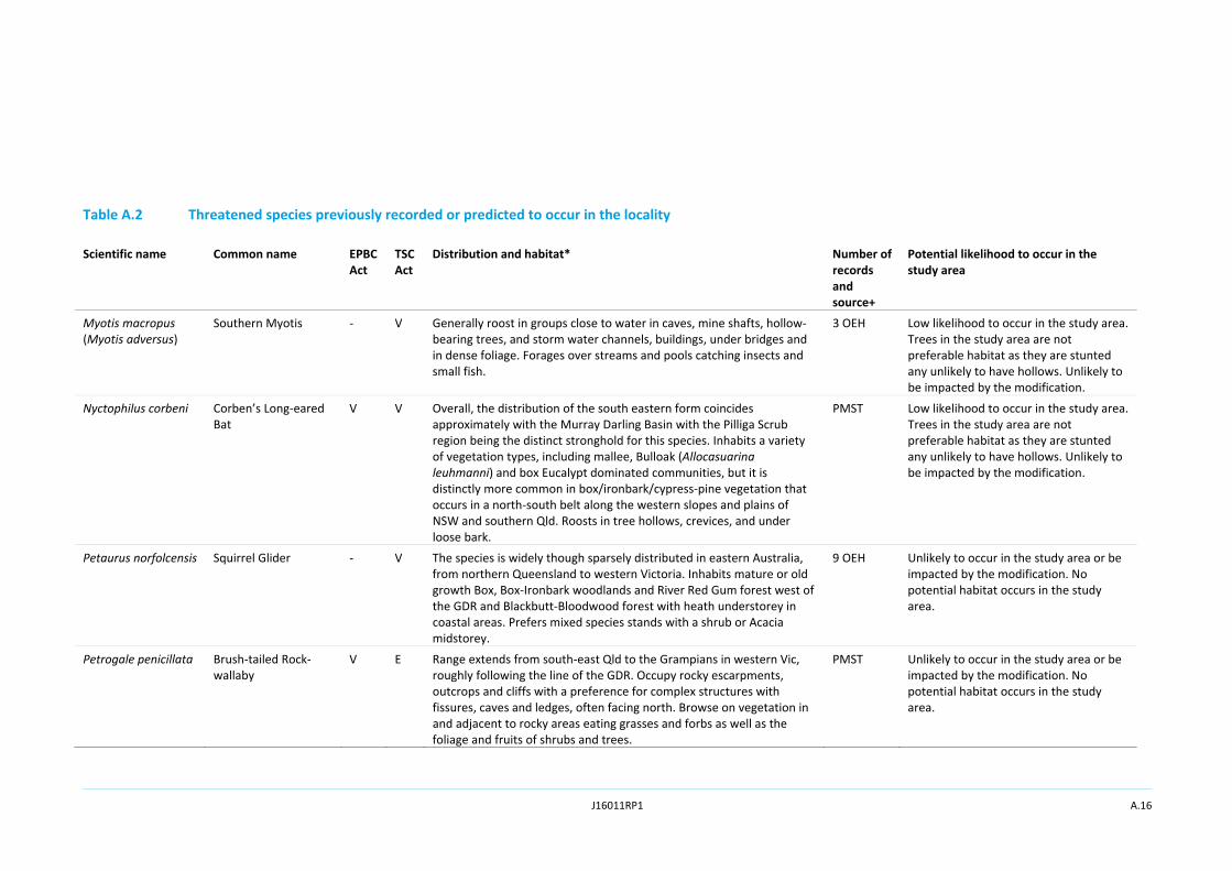
Table A.2 Threatened species previously recorded or predicted to occur in the locality
Scientific name Common name EPBC Act
TSC Act
Distribution and habitat* Number of records and source+
Potential likelihood to occur in the study area
Plants
Acacia pendula (endangered population)
Acacia pendula population in the Hunter Catchment
‐ EP The species occurs on the western slopes, western plains and far western plains of New South Wales (NSW), and south into Victoria (Vic) and north into Queensland (Qld). Within the Hunter catchment the species typically occurs on heavy soils, sometimes on the margins of small floodplains, but also in more undulating locations.
28 OEH Unlikely to occur in the study area or be impacted by the modification. No potential habitat occurs in the study area.
Cymbidium canaliculatum (endangered population)
Cymbidium canaliculatum population in the Hunter Catchment
‐ EP Scattered distribution across northern and eastern Australia, extending from Hunter River in NSW to Cape York and across northern Northern Territory (NT) and Qld to the Kimberley region in Western Australia (WA). Typically grows in the hollows, fissures, trunks and forks of trees in dry sclerophyll forest or woodland, where its host trees typically occur on Permian sediments of the Hunter Valley floor.
3 OEH Unlikely to occur in the study area or be impacted by the modification. No potential habitat occurs in the study area.
Diuris tricolor (endangered population)
Pine Donkey Orchid population in the Muswellbrook LGA
‐ EP The population of D. tricolor in the Muswellbrook local government area (LGA), in the upper Hunter Valley, comprises a number of occurrences, ranging from a few scattered individuals to a few thousand plants. The area of occupancy of the population is less than 50 km2. Therefore, the geographic distribution of the population is estimated to be highly restricted. The population of D. tricolor in the Muswellbrook LGA is at the eastern limit of the geographic range of the species and all other populations of the species are located west of the Great Dividing Range (GDR). The distance of the Muswellbrook LGA population to the nearest population of the species to the west is about 100 km. Therefore the population in the Muswellbrook LGA is disjunct and at the limit of its geographic range. Found in sclerophyll woodland and derived grassland on flats or small rises, on a range of substrates including sandy or loamy soils.
304 OEH Unlikely to occur in the study area or be impacted by the modification. No potential habitat occurs in the study area and the closest records are approximately seven kilometres south‐west of the study area.

J16011RP1 A.3
Table A.2 Threatened species previously recorded or predicted to occur in the locality
Scientific name Common name EPBC Act
TSC Act
Distribution and habitat* Number of records and source+
Potential likelihood to occur in the study area
Eucalyptus camaldulensis (endangered population)
Eucalyptus camaldulensis population in the Hunter Catchment
‐ EP This endangered population is located in the Wingecarribee LGA. Three sub‐populations, comprising less than 100 plants in total, are located in Berrima, Medway and Sutton Forest. Grows in the lowest parts of the landscape. Grows on alluvial soils, on cold, poorly‐drained flats and hollows adjacent to creeks and small rivers. Often grows with other cold‐adapted eucalypts, such as Snow Gum or White Sallee (Eucalyptus pauciflora), Manna or Ribbon Gum (E. viminalis), Candlebark (E. rubida), Black Sallee (E. stellulata) and Swamp Gum (E. ovata). Black Gum usually occurs in an open woodland formation with a grassy groundlayer dominated either by River Tussock (Poa labillardierei) or Kangaroo Grass (Themeda australis), but with few shrubs.
149 OEH Unlikely to occur in the study area or be impacted by the modification. No potential habitat occurs in the study area and the closest records are approximately 4.5 km south‐west of the study area.
Eucalyptus glaucina Slaty Red Gum V V Found only on the north coast of NSW and in separate districts: near Casino where it can be locally common, and farther south, from Taree to Broke, west of Maitland. Grows in grassy woodland and dry eucalypt forest. Grows on deep, moderately fertile and well‐watered soils.
PMST Unlikely to occur in the study area or be impacted by the modification. No potential habitat occurs in the study area.
Eucalyptus nicholii Narrow‐leaved Black Peppermint
V V This species is sparsely distributed but widespread on the New England Tablelands from Nundle to north of Tenterfield, being most common in central portions of its range. Found largely on private property and roadsides, and occasionally conservation reserves. Planted as urban trees, windbreaks and corridors. Typically grows in dry grassy woodland, on shallow soils of slopes and ridges. Found primarily on infertile soils derived from granite or meta‐sedimentary rock.
1 OEH Unlikely to occur in the study area or be impacted by the modification. No potential habitat occurs in the study area.
J16011RP1 A.4
Table A.2 Threatened species previously recorded or predicted to occur in the locality
Scientific name Common name EPBC Act
TSC Act
Distribution and habitat* Number of records and source+
Potential likelihood to occur in the study area
Euphrasia arguta ‐ CE CE Historically, E. arguta has only been recorded from relatively few places within an area extending from Sydney to Bathurst and north to Walcha. Was rediscovered in the Nundle area of the NSW north western slopes and tablelands in 2008. Historic records of the species noted the following habitats: 'in the open forest country around Bathurst in sub humid places', 'on the grassy country near Bathurst', and 'in meadows near rivers'. Plants from the Nundle area have been reported from Eucalypt forest with a mixed grass and shrub understorey; here, plants were most dense in an open disturbed area and along the roadside, indicating the species had regenerated following disturbance.
PMST Unlikely to occur in the study area or be impacted by the modification. No potential habitat occurs in the study area.
Prasophyllum petilum
Tarengo Leek Orchid E E Natural populations occur in five sites in NSW including Boorowa, Captains Flat, Ilford, Delegate and a newly recognised population south‐east of Muswellbrook. Also known in the ACT. Occurs in open sites within natural temperate grassland at the Boorowa and Delegate sites but also grows in grassy woodland in association with River Tussock, Black Gum (E. aggregata) and tea‐trees (Leptospermum spp.) at Captains Flat and grassy groundcover dominated by Kangaroo Grass within Box‐gum woodland at Ilford. Plants retreats into subterranean tubers after fruiting.
PMST Unlikely to occur in the study area or be impacted by the modification. No potential habitat occurs in the study area.
Prasophyllum sp. Wybong
‐ CE ‐ Known in small populations near Ilford, Premer, Muswellbrook, Wybong, Yeoval, Inverell, Tenterfield, Currabubula and the Pilliga area with the population at Wybong being the largest. This is a perennial orchid appearing as a single leaf over winter and spring occurring in open Eucalypt woodland and grassland.
PMST Unlikely to occur in the study area or be impacted by the modification. No potential habitat occurs in the study area.

J16011RP1 A.5
Table A.2 Threatened species previously recorded or predicted to occur in the locality
Scientific name Common name EPBC Act
TSC Act
Distribution and habitat* Number of records and source+
Potential likelihood to occur in the study area
Pterostylis gibbosa Illawarra Greenhood E E Known from a small number of populations in the Hunter region (Milbrodale), the Illawarra region (Albion Park and Yallah) and the Shoalhaven region (near Nowra). It is apparently extinct in western Sydney which is the area where it was first collected (1803). All known populations grow in open forest or woodland, on flat or gently sloping land with poor drainage. In the Hunter region, the species grows in open woodland dominated by Narrow‐leaved Ironbark (E. crebra), Forest Red Gum (E. tereticornis) and Black Cypress Pine (Callitris endlicheri).
PMST Unlikely to occur in the study area or be impacted by the modification. No potential habitat occurs in the study area.
Thesium australe Austral Toadflax V V Found in very small populations scattered across eastern NSW, along the coast, and from the Northern to Southern Tablelands. It is also found in Tasmania (Tas) and Qld and in eastern Asia. Occurs in grassland on coastal headlands or grassland and grassy woodland away from the coast. Often found in association with Kangaroo Grass.
PMST Unlikely to occur in the study area or be impacted by the modification. No potential habitat occurs in the study area.
Tylophora linearis ‐ E V Mostly known to occur in the central western region. Grows in dry scrub and open forest of E. fibrosa, E. sideroxylon, E. albens, C. endlicheri, C. glaucophylla and Allocasuarina luehmannii. Also grows in association with Acacia hakeoides, A. lineata, Melaleuca uncinata, Myoporum spp. and Casuarina spp. Flowers in spring and fruiting 2‐3 months later.
PMST Unlikely to occur in the study area or be impacted by the modification. No potential habitat occurs in the study area.

J16011RP1 A.6
Table A.2 Threatened species previously recorded or predicted to occur in the locality
Scientific name Common name EPBC Act
TSC Act
Distribution and habitat* Number of records and source+
Potential likelihood to occur in the study area
Birds
Anseranas semipalmata
Magpie Goose ‐ V Mainly found in shallow wetlands (less than one meter deep) with dense growth of rushes or sedges. Equally at home in aquatic or terrestrial habitats; often seen walking and grazing on land; feeds on grasses, bulbs and rhizomes. Activities are centred on wetlands, mainly those on floodplains of rivers and large shallow wetlands formed by run‐off; breeding can occur in both summer and winter dominated rainfall areas and is strongly influenced by water level; most breeding now occurs in monsoonal areas; nests are formed in trees over deep water; breeding is unlikely in south‐eastern NSW.
1 OEH Unlikely to occur in the study area or be impacted by the modification. No potential habitat occurs in the study area.
Anthochaera Phrygia (Xanthomyza phrygia)
Regent Honeyeater CE CE Temperate woodlands and open forests of the inland slopes of south‐east Australia. The species inhabits dry open forest and woodland, particularly Box‐Ironbark woodland, and riparian forests of River Sheoak. Regent Honeyeaters usually nest in horizontal branches or forks in tall mature eucalypts and Sheoaks.
PMST Unlikely to occur in the study area or be impacted by the modification. No potential habitat occurs in the study area.
Apus pacificus Fork‐tailed Swift M ‐ Recorded in all regions of NSW. The Fork‐tailed Swift is almost exclusively aerial, flying from less than one meter to at least 300 m above ground and probably much higher.
PMST Low likelihood of occurrence in the study area but is almost exclusively aerial. Unlikely to be impacted by the modification.

J16011RP1 A.7
Table A.2 Threatened species previously recorded or predicted to occur in the locality
Scientific name Common name EPBC Act
TSC Act
Distribution and habitat* Number of records and source+
Potential likelihood to occur in the study area
Ardea alba (Ardea modesta)
Great Egret M ‐ Widespread in Australia. Reported in a wide range of wetland habitats (for example inland and coastal, freshwater and saline, permanent and ephemeral, open and vegetated, large and small, natural and artificial).
PMST Unlikely to occur in the study area or be impacted by the modification. No potential habitat occurs in the study area.
Ardea ibis Cattle Egret M ‐ Widespread and common according to migration movements and breeding localities surveys. Occurs in tropical and temperate grasslands, wooded lands and terrestrial wetlands.
4 OEH Low likelihood to occur in the study area as there is no preferred habitat and the species is highly mobile. Unlikely to be impacted by the modification.
Botaurus poiciloptilus
Australasian Bittern E E Occurs from south‐east Queensland to south‐east South Australia, Tasmania and the south‐west of Western Australia. Occurs in terrestrial freshwater wetlands and, rarely, estuarine habitats.
PMST Unlikely to occur in the study area or be impacted by the modification. No potential habitat occurs in the study area.
Chthonicola sagittata (Pyrrholaemus sagittatus)
Speckled Warbler ‐ V The Speckled Warbler lives in a wide range of Eucalyptus dominated communities that have a grassy understorey, often on rocky ridges or in gullies. Typical habitat would include scattered native tussock grasses, a sparse shrub layer, some eucalypt re‐growth and an open canopy. Large, relatively undisturbed remnants are required for the species to persist in an area.
13 OEH Low likelihood to occur in the study area as there is no preferred habitat and the species is highly mobile. Unlikely to be impacted by the modification.
Circus assimilis Spotted Harrier ‐ V The Spotted Harrier occurs throughout the Australian mainland, except in densely forested or wooded habitats of the coast, escarpment and ranges, and rarely in Tasmania. Individuals disperse widely in NSW and comprise a single population. Occurs in grassy open woodland including Acacia and mallee remnants, inland riparian woodland, grassland and shrub steppe. It is found most commonly in native grassland, but also occurs in agricultural land, foraging over open habitats including edges of inland wetlands.
1 OEH Moderate likelihood to occur in the study area as grassland can provide foraging habitat. However, better habitat is available in adjacent areas and the species is highly mobile. Potential to be impacted by the modification.
J16011RP1 A.8
Table A.2 Threatened species previously recorded or predicted to occur in the locality
Scientific name Common name EPBC Act
TSC Act
Distribution and habitat* Number of records and source+
Potential likelihood to occur in the study area
Climacteris picumnus victoriae
Brown Treecreeper (eastern subspecies)
‐ V Endemic to eastern Australia and occurs in Eucalypt forests and woodlands of inland plains and slopes of the GDR. It is less commonly found on coastal plains and ranges. Found in Eucalypt woodlands (including Box‐Gum Woodland) and dry open forest of the inland slopes and plains inland of the GDR; mainly inhabits woodlands dominated by stringybarks or other rough‐barked Eucalypts, usually with an open grassy understorey, sometimes with one or more shrub species; also found in mallee and River Red Gum (E. camaldulensis) Forest bordering wetlands with an open understorey of acacias, saltbush, lignum, cumbungi and grasses; usually not found in woodlands with a dense shrub layer; fallen timber is an important habitat component for foraging; also recorded, though less commonly, in similar woodland habitats on the coastal ranges and plains.
5 OEH Unlikely to occur in the study area or be impacted by the modification. No potential habitat occurs in the study area.
Daphoenositta chrysoptera
Varied Sittella ‐ V The Varied Sittella is sedentary and inhabits most of mainland Australia except the treeless deserts and open grasslands. Distribution in NSW is nearly continuous from the coast to the far west. The Varied Sittella's population size in NSW is uncertain but is believed to have undergone a moderate reduction over the past several decades. Inhabits Eucalypt forests and woodlands, especially those containing rough‐barked species and mature smooth‐barked gums with dead branches, mallee and Acacia woodland. Feeds on arthropods gleaned from crevices in rough or decorticating bark, dead branches, standing dead trees and small branches and twigs in the tree canopy.
5 OEH Unlikely to occur in the study area or be impacted by the modification. No potential habitat occurs in the study area.

J16011RP1 A.9
Table A.2 Threatened species previously recorded or predicted to occur in the locality
Scientific name Common name EPBC Act
TSC Act
Distribution and habitat* Number of records and source+
Potential likelihood to occur in the study area
Ephippiorhynchus asiaticus
Black‐necked Stork ‐ E In Australia, Black‐necked Storks are widespread in coastal and subcoastal northern and eastern Australia, as far south as central NSW (although vagrants may occur further south or inland, well away from breeding areas). In NSW, the species becomes increasingly uncommon south of the Clarence Valley, and rarely occurs south of Sydney. Since 1995, breeding has been recorded as far south as Buladelah. Floodplain wetlands (swamps, billabongs, watercourses and dams) of the major coastal rivers are the key habitat in NSW for the Black‐necked Stork. Secondary habitat includes minor floodplains, coastal sandplain wetlands and estuaries. Storks usually forage in water 5‐30 cm deep for vertebrate and invertebrate prey. Eels regularly contribute the greatest biomass to their diet, but they feed on a wide variety of animals, including other fish, frogs and invertebrates (such as beetles, grasshoppers, crickets and crayfish). Black‐necked Storks build large nests high in tall trees close to water. Trees usually provide clear observation of the surroundings and are at low elevation (reflecting the floodplain habitat).
1 OEH Unlikely to occur in the study area or be impacted by the modification. No potential habitat occurs in the study area.
Gallinago hardwickii Latham's Snipe M ‐ Recorded along the east coast of Australia from Cape York Peninsula through to south‐eastern South Australia. Occurs in permanent and ephemeral wetlands up to 2000 m above sea‐level.
PMST Unlikely to occur in the study area or be impacted by the modification. No potential habitat occurs in the study area.
Glossopsitta pusilla Little Lorikeet ‐ V Forages primarily in the canopy of open Eucalyptus forest and woodland, yet also finds food in apples (Angophora sp.), paperbarks (Melaleuca sp.) and other tree species. Riparian habitats are particularly used, due to higher soil fertility and hence greater productivity. Isolated flowering trees in open country (eg paddocks, roadside remnants) and urban trees also help sustain viable populations of the species.
9 OEH Unlikely to occur in the study area or be impacted by the modification. No potential habitat occurs in the study area.

J16011RP1 A.10
Table A.2 Threatened species previously recorded or predicted to occur in the locality
Scientific name Common name EPBC Act
TSC Act
Distribution and habitat* Number of records and source+
Potential likelihood to occur in the study area
Grantiella picta Painted Honeyeater V V The Painted Honeyeater is nomadic and occurs at low densities throughout its range. The greatest concentrations of the species and almost all breeding occur on the inland slopes of the GDR in NSW, Vic and southern Qld. During the winter it is more likely to be found in the north of its distribution. Inhabits Boree, Brigalow and Box‐Gum Woodlands and Box‐Ironbark Forests. A specialist feeder on the fruits of mistletoes growing on woodland Eucalypts and Acacias. Prefers mistletoes of the genus Amyema.
PMST Unlikely to occur in the study area or be impacted by the modification. No potential habitat occurs in the study area.
Hieraaetus morphnoides
Little Eagle ‐ V The Little Eagle is found throughout the Australian mainland excepting the most densely forested parts of the Dividing Range escarpment. It occurs as a single population throughout NSW. Occupies open Eucalypt forest, woodland or open woodland. Sheoak or Acacia woodlands and riparian woodlands of interior NSW are also used.
2 OEH Moderate likelihood to occur in the study area as grassland can provide foraging habitat. However, better habitat is available in adjacent areas and the species is highly mobile. Potential to be impacted by the modification.
Hirundapus caudacutus
White‐throated Needletail
M ‐ Widespread in eastern and south‐eastern Australia. Almost exclusively aerial, from heights of less than one meter up to more than 1000 m above the ground. They also commonly occur over heathland but less often over treeless areas, such as grassland or swamps.
2 OEH, PMST
Unlikely to occur in the study area or be impacted by the modification. No potential habitat occurs in the study area.
Lathamus discolor Swift Parrot E E On the mainland they occur in areas where Eucalypts are flowering profusely or where there are abundant lerp (from sap‐sucking bugs) infestations. Favoured feed trees include winter flowering species such as Swamp Mahogany (E. robusta), Spotted Gum (Corymbia maculata), Red Bloodwood (C. Gummifera), Red Ironbark (E. sideroxylon), and White Box (E. albens).
4 OEH, PMST
Low likelihood to occur in the study area when flowering. However, vegetation in the study area is stunted and the species is highly mobile. Unlikely to be impacted by the modification.
J16011RP1 A.11
Table A.2 Threatened species previously recorded or predicted to occur in the locality
Scientific name Common name EPBC Act
TSC Act
Distribution and habitat* Number of records and source+
Potential likelihood to occur in the study area
Lophoictinia isura Square‐tailed Kite ‐ V Typically inhabits coastal forested and wooded lands of tropical and temperate Australia. In NSW it is often associated with ridge and gully forests dominated by E. longifolia, C. maculata, E. elata, or E. smithii. Individuals appear to occupy large hunting ranges of more than 100 km2. They require large living trees for breeding, particularly near water with surrounding woodland /forest close by for foraging habitat. Nest sites are generally located along or near watercourses, in a tree fork or on large horizontal limbs.
1 OEH Moderate likelihood to occur in the study area as grassland can provide foraging habitat. However, better habitat is available in adjacent areas and the species is highly mobile. Potential to be impacted by the modification.
Melanodryas cucullata cucullata
Hooded Robin (south‐eastern form)
‐ V The Hooded Robin is widespread, found across Australia, except for the driest deserts and the wetter coastal areas ‐ northern and eastern coastal Queensland and Tasmania. However, it is common in few places, and rarely found on the coast. Prefers lightly wooded country, usually open Eucalypt woodland, Acacia scrub and mallee, often in or near clearings or open areas. Requires structurally diverse habitats featuring mature Eucalypts, saplings, some small shrubs and a ground layer of moderately tall native grasses.
1 OEH Unlikely to occur in the study area or be impacted by the modification. No potential habitat occurs in the study area.
Merops ornatus Rainbow Bee‐eater M ‐ Distributed across much of mainland Australia, and occurs on several near‐shore islands. Occurs mainly in open forests and woodlands, shrublands, and in various cleared or semi‐cleared habitats, including farmland and areas of human habitation.
3 OEH, PMST
Unlikely to occur in the study area or be impacted by the modification. No potential habitat occurs in the study area.
J16011RP1 A.12
Table A.2 Threatened species previously recorded or predicted to occur in the locality
Scientific name Common name EPBC Act
TSC Act
Distribution and habitat* Number of records and source+
Potential likelihood to occur in the study area
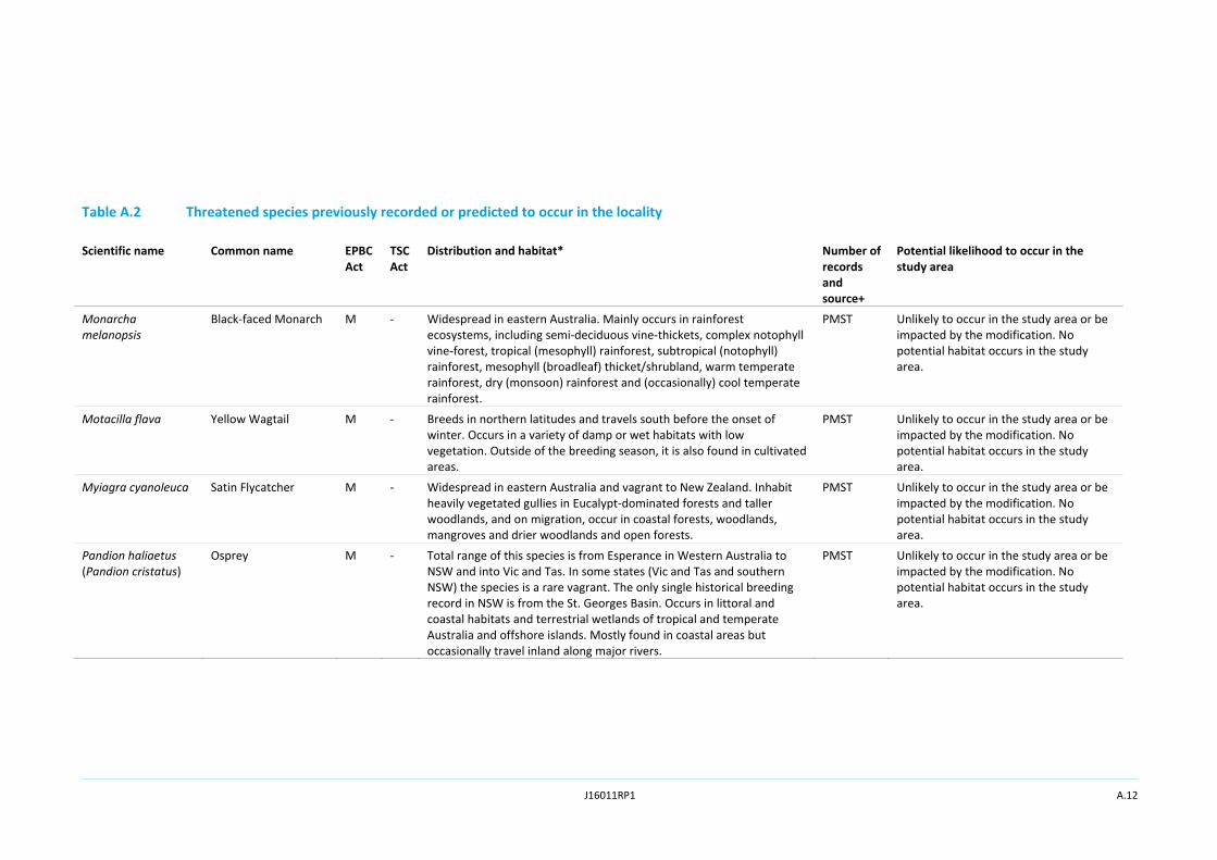
Monarcha melanopsis
Black‐faced Monarch M ‐ Widespread in eastern Australia. Mainly occurs in rainforest ecosystems, including semi‐deciduous vine‐thickets, complex notophyll vine‐forest, tropical (mesophyll) rainforest, subtropical (notophyll) rainforest, mesophyll (broadleaf) thicket/shrubland, warm temperate rainforest, dry (monsoon) rainforest and (occasionally) cool temperate rainforest.
PMST Unlikely to occur in the study area or be impacted by the modification. No potential habitat occurs in the study area.
Motacilla flava Yellow Wagtail M ‐ Breeds in northern latitudes and travels south before the onset of winter. Occurs in a variety of damp or wet habitats with low vegetation. Outside of the breeding season, it is also found in cultivated areas.
PMST Unlikely to occur in the study area or be impacted by the modification. No potential habitat occurs in the study area.
Myiagra cyanoleuca Satin Flycatcher M ‐ Widespread in eastern Australia and vagrant to New Zealand. Inhabit heavily vegetated gullies in Eucalypt‐dominated forests and taller woodlands, and on migration, occur in coastal forests, woodlands, mangroves and drier woodlands and open forests.
PMST Unlikely to occur in the study area or be impacted by the modification. No potential habitat occurs in the study area.
Pandion haliaetus (Pandion cristatus)
Osprey M ‐ Total range of this species is from Esperance in Western Australia to NSW and into Vic and Tas. In some states (Vic and Tas and southern NSW) the species is a rare vagrant. The only single historical breeding record in NSW is from the St. Georges Basin. Occurs in littoral and coastal habitats and terrestrial wetlands of tropical and temperate Australia and offshore islands. Mostly found in coastal areas but occasionally travel inland along major rivers.
PMST Unlikely to occur in the study area or be impacted by the modification. No potential habitat occurs in the study area.

J16011RP1 A.13
Table A.2 Threatened species previously recorded or predicted to occur in the locality
Scientific name Common name EPBC Act
TSC Act
Distribution and habitat* Number of records and source+
Potential likelihood to occur in the study area
Petroica phoenicea Flame Robin ‐ V The Flame Robin is endemic to south eastern Australia, and ranges from near the Qld border to south‐east South Australia (SA) and also in Tas. In NSW, it breeds in upland areas and in winter, many birds move to the inland slopes and plains. It is likely that there are two separate populations in NSW, one in the Northern Tablelands, and another ranging from the Central to Southern Tablelands. Breeds in upland tall moist Eucalypt forests and woodlands, often on ridges and slopes. Prefers clearings or areas with open understoreys. The groundlayer of the breeding habitat is dominated by native grasses and the shrub layer may be either sparse or dense. Occasionally occurs in temperate rainforest, and also in herbfields, heathlands, shrublands and sedgelands at high altitudes.
1 OEH Unlikely to occur in the study area or be impacted by the modification. No potential habitat occurs in the study area.
Pomatostomus temporalis temporalis
Grey‐crowned Babbler
‐ V In NSW, the eastern sub‐species occurs on the western slopes of the GDR, and on the western plains reaching as far as Louth and Balranald. It also occurs in woodlands in the Hunter Valley and in several locations on the north coast of NSW. It may be extinct in the southern, central and New England tablelands. Inhabits open Box‐Gum Woodlands on the slopes, and Box‐Cypress‐pine and open Box Woodlands on alluvial plains.
10 OEH Unlikely to occur in the study area or be impacted by the modification. No potential habitat occurs in the study area.
Rhipidura rufifrons Rufous Fantail M ‐ Occurs in coastal and near coastal districts of northern and eastern Australia. In east and south‐east Australia, the Rufous Fantail mainly inhabits wet sclerophyll forests, often in gullies dominated by Eucalypts such as Tallow‐wood (E. microcorys), Mountain Grey Gum (E. cypellocarpa), Narrow‐leaved Peppermint (E. radiata), Mountain Ash (E. regnans), Alpine Ash (E. delegatensis), Blackbutt (E. pilularis) or Red Mahogany (E. resinifera); usually with a dense shrubby understorey often including ferns.
PMST Unlikely to occur in the study area or be impacted by the modification. No potential habitat occurs in the study area.

J16011RP1 A.14
Table A.2 Threatened species previously recorded or predicted to occur in the locality
Scientific name Common name EPBC Act
TSC Act
Distribution and habitat* Number of records and source+
Potential likelihood to occur in the study area
Rostratula australis Australian Painted Snipe
E E Most records are from the south east, particularly the Murray Darling Basin, with scattered records across northern Australia and historical records from around the Perth region in WA. Prefers fringes of swamps, dams and nearby marshy areas where there is a cover of grasses, lignum, low scrub or open timber. Nests on the ground amongst tall vegetation, such as grasses, tussocks or reeds.
PMST Unlikely to occur in the study area or be impacted by the modification. No potential habitat occurs in the study area.
Stagonopleura guttata
Diamond Firetail ‐ V Found in grassy Eucalypt woodlands, including Box‐Gum Woodlands and Snow Gum (E. pauciflora) Woodlands. Also occurs in open forest, mallee, Natural Temperate Grassland, and in secondary grassland derived from other communities. Often found in riparian areas (rivers and creeks), and sometimes in lightly wooded farmland.
2 OEH Unlikely to occur in the study area or be impacted by the modification. No potential habitat occurs in the study area.
Tringa nebularia Common Greenshank M ‐ The Common Greenshank does not breed in Australia, however, the species occurs in all types of wetlands and has the widest distribution of any shorebird in Australia.
PMST Unlikely to occur in the study area or be impacted by the modification. No potential habitat occurs in the study area.
Tyto tenebricosa Sooty Owl
‐ V Occupies the easternmost one‐eighth of NSW, occurring on the coast, coastal escarpment and eastern tablelands. Territories are occupied permanently. Occurs in rainforest, including dry rainforest, subtropical and warm temperate rainforest, as well as moist Eucalypt forests.
1 OEH Unlikely to occur in the study area or be impacted by the modification. No potential habitat occurs in the study area.
Mammals
Chalinolobus dwyeri Large‐eared Pied Bat V V Forages over a broad range of open forest and woodland habitats, this species is a cave roosting bat which favours sandstone escarpment habitats for roosting, in the form of shallow overhangs, crevices and caves.
1 OEH, PMST
Unlikely to occur in the study area or be impacted by the modification. No potential habitat occurs in the study area.
J16011RP1 A.15
Table A.2 Threatened species previously recorded or predicted to occur in the locality
Scientific name Common name EPBC Act
TSC Act
Distribution and habitat* Number of records and source+
Potential likelihood to occur in the study area
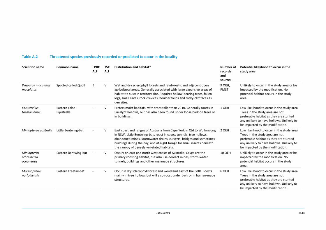
Dasyurus maculatus maculatus
Spotted‐tailed Quoll E V Wet and dry sclerophyll forests and rainforests, and adjacent open agricultural areas. Generally associated with large expansive areas of habitat to sustain territory size. Requires hollow‐bearing trees, fallen logs, small caves, rock crevices, boulder fields and rocky‐cliff faces as den sites.
9 OEH, PMST
Unlikely to occur in the study area or be impacted by the modification. No potential habitat occurs in the study area.
Falsistrellus tasmaniensis
Eastern False Pipistrelle
‐ V Prefers moist habitats, with trees taller than 20 m. Generally roosts in Eucalypt hollows, but has also been found under loose bark on trees or in buildings.
1 OEH Low likelihood to occur in the study area. Trees in the study area are not preferable habitat as they are stunted any unlikely to have hollows. Unlikely to be impacted by the modification.
Miniopterus australis Little Bentwing‐bat ‐ V East coast and ranges of Australia from Cape York in Qld to Wollongong in NSW. Little Bentwing‐bats roost in caves, tunnels, tree hollows, abandoned mines, stormwater drains, culverts, bridges and sometimes buildings during the day, and at night forage for small insects beneath the canopy of densely vegetated habitats.
2 OEH Low likelihood to occur in the study area. Trees in the study area are not preferable habitat as they are stunted any unlikely to have hollows. Unlikely to be impacted by the modification.
Miniopterus schreibersii oceanensis
Eastern Bentwing‐bat ‐ V Occurs on east and north west coasts of Australia. Caves are the primary roosting habitat, but also use derelict mines, storm‐water tunnels, buildings and other manmade structures.
10 OEH Unlikely to occur in the study area or be impacted by the modification. No potential habitat occurs in the study area.
Mormopterus norfolkensis
Eastern Freetail‐bat ‐ V Occur in dry sclerophyll forest and woodland east of the GDR. Roosts mainly in tree hollows but will also roost under bark or in human‐made structures.
6 OEH Low likelihood to occur in the study area. Trees in the study area are not preferable habitat as they are stunted any unlikely to have hollows. Unlikely to be impacted by the modification.
J16011RP1 A.16
Table A.2 Threatened species previously recorded or predicted to occur in the locality
Scientific name Common name EPBC Act
TSC Act
Distribution and habitat* Number of records and source+
Potential likelihood to occur in the study area
Myotis macropus (Myotis adversus)
Southern Myotis ‐ V Generally roost in groups close to water in caves, mine shafts, hollow‐bearing trees, and storm water channels, buildings, under bridges and in dense foliage. Forages over streams and pools catching insects and small fish.
3 OEH Low likelihood to occur in the study area. Trees in the study area are not preferable habitat as they are stunted any unlikely to have hollows. Unlikely to be impacted by the modification.
Nyctophilus corbeni Corben’s Long‐eared Bat
V
V Overall, the distribution of the south eastern form coincides approximately with the Murray Darling Basin with the Pilliga Scrub region being the distinct stronghold for this species. Inhabits a variety of vegetation types, including mallee, Bulloak (Allocasuarina leuhmanni) and box Eucalypt dominated communities, but it is distinctly more common in box/ironbark/cypress‐pine vegetation that occurs in a north‐south belt along the western slopes and plains of NSW and southern Qld. Roosts in tree hollows, crevices, and under loose bark.
PMST Low likelihood to occur in the study area. Trees in the study area are not preferable habitat as they are stunted any unlikely to have hollows. Unlikely to be impacted by the modification.
Petaurus norfolcensis Squirrel Glider ‐ V The species is widely though sparsely distributed in eastern Australia, from northern Queensland to western Victoria. Inhabits mature or old growth Box, Box‐Ironbark woodlands and River Red Gum forest west of the GDR and Blackbutt‐Bloodwood forest with heath understorey in coastal areas. Prefers mixed species stands with a shrub or Acacia midstorey.
9 OEH Unlikely to occur in the study area or be impacted by the modification. No potential habitat occurs in the study area.
Petrogale penicillata Brush‐tailed Rock‐wallaby
V E Range extends from south‐east Qld to the Grampians in western Vic, roughly following the line of the GDR. Occupy rocky escarpments, outcrops and cliffs with a preference for complex structures with fissures, caves and ledges, often facing north. Browse on vegetation in and adjacent to rocky areas eating grasses and forbs as well as the foliage and fruits of shrubs and trees.
PMST Unlikely to occur in the study area or be impacted by the modification. No potential habitat occurs in the study area.
J16011RP1 A.17
Table A.2 Threatened species previously recorded or predicted to occur in the locality
Scientific name Common name EPBC Act
TSC Act
Distribution and habitat* Number of records and source+
Potential likelihood to occur in the study area
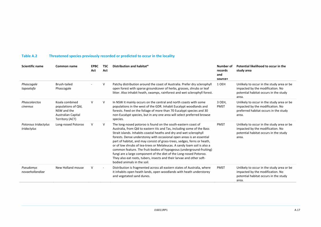
Phascogale tapoatafa
Brush‐tailed Phascogale
‐
V Patchy distribution around the coast of Australia. Prefer dry sclerophyll open forest with sparse groundcover of herbs, grasses, shrubs or leaf litter. Also inhabit heath, swamps, rainforest and wet sclerophyll forest.
1 OEH Unlikely to occur in the study area or be impacted by the modification. No potential habitat occurs in the study area.
Phascolarctos cinereus
Koala combined populations of Qld, NSW and the Australian Capital Territory (ACT)
V V In NSW it mainly occurs on the central and north coasts with some populations in the west of the GDR. Inhabit Eucalypt woodlands and forests. Feed on the foliage of more than 70 Eucalypt species and 30 non‐Eucalypt species, but in any one area will select preferred browse species.
3 OEH, PMST
Unlikely to occur in the study area or be impacted by the modification. No preferred habitat occurs in the study area.
Potorous tridactylus tridactylus
Long‐nosed Potoroo V V The long‐nosed potoroo is found on the south‐eastern coast of Australia, from Qld to eastern Vic and Tas, including some of the Bass Strait islands. Inhabits coastal heaths and dry and wet sclerophyll forests. Dense understorey with occasional open areas is an essential part of habitat, and may consist of grass‐trees, sedges, ferns or heath, or of low shrubs of tea‐trees or Melaleucas. A sandy loam soil is also a common feature. The fruit‐bodies of hypogeous (underground‐fruiting) fungi are a large component of the diet of the Long‐nosed Potoroo. They also eat roots, tubers, insects and their larvae and other soft‐bodied animals in the soil.
PMST Unlikely to occur in the study area or be impacted by the modification. No potential habitat occurs in the study area.
Pseudomys novaehollandiae
New Holland mouse V ‐ Distribution is fragmented across all eastern states of Australia, where it inhabits open heath lands, open woodlands with heath understorey and vegetated sand dunes.
PMST Unlikely to occur in the study area or be impacted by the modification. No potential habitat occurs in the study area.
J16011RP1 A.18
Table A.2 Threatened species previously recorded or predicted to occur in the locality
Scientific name Common name EPBC Act
TSC Act
Distribution and habitat* Number of records and source+
Potential likelihood to occur in the study area
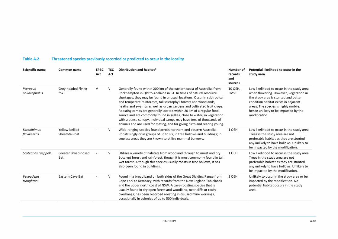
Pteropus poliocephalus
Grey‐headed Flying‐fox
V V Generally found within 200 km of the eastern coast of Australia, from Rockhampton in Qld to Adelaide in SA. In times of natural resource shortages, they may be found in unusual locations. Occur in subtropical and temperate rainforests, tall sclerophyll forests and woodlands, heaths and swamps as well as urban gardens and cultivated fruit crops. Roosting camps are generally located within 20 km of a regular food source and are commonly found in gullies, close to water, in vegetation with a dense canopy. Individual camps may have tens of thousands of animals and are used for mating, and for giving birth and rearing young.
10 OEH, PMST
Low likelihood to occur in the study area when flowering. However, vegetation in the study area is stunted and better condition habitat exists in adjacent areas. The species is highly mobile, hence unlikely to be impacted by the modification.
Saccolaimus flaviventris
Yellow‐bellied Sheathtail‐bat
‐ V Wide‐ranging species found across northern and eastern Australia. Roosts singly or in groups of up to six, in tree hollows and buildings; in treeless areas they are known to utilise mammal burrows.
1 OEH Low likelihood to occur in the study area. Trees in the study area are not preferable habitat as they are stunted any unlikely to have hollows. Unlikely to be impacted by the modification.
Scoteanax rueppellii Greater Broad‐nosed Bat
‐ V Utilises a variety of habitats from woodland through to moist and dry Eucalypt forest and rainforest, though it is most commonly found in tall wet forest. Although this species usually roosts in tree hollows, it has also been found in buildings.
1 OEH Low likelihood to occur in the study area. Trees in the study area are not preferable habitat as they are stunted any unlikely to have hollows. Unlikely to be impacted by the modification.
Vespadelus troughtoni
Eastern Cave Bat ‐ V Found in a broad band on both sides of the Great Dividing Range from Cape York to Kempsey, with records from the New England Tablelands and the upper north coast of NSW. A cave‐roosting species that is usually found in dry open forest and woodland, near cliffs or rocky overhangs; has been recorded roosting in disused mine workings, occasionally in colonies of up to 500 individuals.
2 OEH Unlikely to occur in the study area or be impacted by the modification. No potential habitat occurs in the study area.
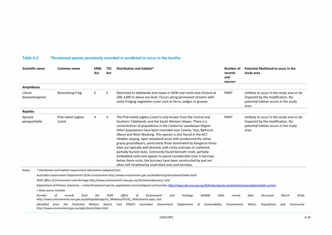
J16011RP1 A.19
Table A.2 Threatened species previously recorded or predicted to occur in the locality
Scientific name Common name EPBC Act
TSC Act
Distribution and habitat* Number of records and source+
Potential likelihood to occur in the study area
Amphibians
Litoria booroolongensis
Booroolong Frog E E Restricted to tablelands and slopes in NSW and north‐east Victoria at 200–1300 m above sea level. Occurs along permanent streams with some fringing vegetation cover such as ferns, sedges or grasses.
PMST Unlikely to occur in the study area or be impacted by the modification. No potential habitat occurs in the study area.
Reptiles
Aprasia parapulchella
Pink‐tailed Legless Lizard
V V The Pink‐tailed Legless Lizard is only known from the Central and Southern Tablelands, and the South Western Slopes. There is a concentration of populations in the Canberra/ ueanbeyan Region. Other populations have been recorded near Cooma, Yass, Bathurst, Albury and West Wyalong. This species is also found in the ACT. Inhabits sloping, open woodland areas with predominantly native grassy groundlayers, particularly those dominated by Kangaroo Grass. Sites are typically well‐drained, with rocky outcrops or scattered, partially‐buried rocks. Commonly found beneath small, partially‐embedded rocks and appear to spend considerable time in burrows below these rocks; the burrows have been constructed by and are often still inhabited by small black ants and termites.
PMST Unlikely to occur in the study area or be impacted by the modification. No potential habitat occurs in the study area.
Notes: * Distribution and habitat requirement information adapted from:
Australian Government Department of the Environment http://www.environment.gov.au/biodiversity/threatened/index.html
NSW Office of Environment and Heritage http://www.environment.nsw.gov.au/threatenedspecies/; and
Department of Primary Industries – Listed threatened species, populations and ecological communities http://www.dpi.nsw.gov.au/fisheries/species‐protection/conservation/what‐current
+ Data source includes
Number of records from the NSW Office of Environment and Heritage Wildlife Atlas record data (Accessed March 2016) http://www.environment.nsw.gov.au/atlaspublicapp/UI_Modules/ATLAS_/AtlasSearch.aspx; and
Identified from the Protected Matters Search Tool (PMST) Australian Government Department of Sustainability, Environment, Water, Populations and Community http://www.environment.gov.au/epbc/pmst/index.html
J16011RP1 A.20
Key:
EP = endangered population
CE = critically endangered
E = endangered
V = vulnerable
M = migratory

J16011RP1
Appendix B
Assessment of significance

J16011RP1
“This page has been intentionally left blank”
J16011RP1 B.1
Significance assessments have been conducted by Dilys Zhang (BSc Hons.), an ecologist for EMM, for threatened species that were identified as having a moderate or high potential to occur in the study area due to the presence of nearby records and/or the presence of suitable habitat. These species are listed in Appendix A. The significance assessments have been completed on the basis of all rehabilitation within the study area shown in Figure 1 being disturbed, although actual disturbance is estimated to be approximately 45.2 ha.
The proposed modification will be assessed under Section 96 (2) of the EP&A Act. Under the EP&A Act, a ‘7‐part test’ is undertaken to assess the likelihood of significant impact upon threatened species, populations or ecological communities listed under the TSC Act. The document Threatened Species Assessment Guidelines: the Assessment of Significance (Department of Environment and Climate Change (DECC), 2007) outlines a set of guidelines to help applicants/proponents of a development or activity with interpreting and applying the factors of assessment in the 7‐part test. The guidance provided by DECC (2007) has been used here in preparing this 7‐part test.
No threatened species listed under the EPBC Act were considered to have a moderate to high likelihood of occurrence in the study area. Species with similar life histories and habitat requirements (eg raptors) have been assessed in groups.
Threatened raptors including the Spotted Harrier (Circus assimilis), Little Eagle (Hieraaetus morphnoides) and the Square‐tailed Kite (Lophoictinia isura) have been previously recorded in the locality in areas including Muswellbrook and Aberdeen. These species have large home ranges and may utilise the habitats, particularly open pasture areas within the study area for foraging. Prey species such as Hares are common. The study area is considered unlikely to provide suitable nesting or roosting habitat for these species. Considering the high mobility of these species and foraging behaviour it is likely that the study area is utilised intermittently for foraging purposes by the local populations of these species.
The factors to be considered when determining whether an action, development or activity is likely to significantly affect threatened species or their habitats are outlined below:
1. In the case of a threatened species, whether the action proposed is likely to have an adverse effect on the life cycle of the species such that a viable local population of the species is likely to be placed at risk of extinction.
These raptor species occupy large hunting ranges. The proposed modification will remove a small portion (approximately 45.2 ha) of low condition foraging habitat. No breeding or roosting habitats exist in the study area. This impact is considered minor and not expected to place local populations at risk of extinction. Importantly, no breeding habitat will be affected by the work.
2. In the case of an Endangered population, whether the action proposed is likely to have an adverse effect on the life cycle of the species that constitutes the Endangered population such that a viable local population of the species is likely to be placed at risk of extinction.
Not applicable.
3. In the case of an Endangered ecological community or Critically Endangered ecological community, whether the action proposed:
e) is likely to have an adverse effect on the extent of the ecological community such that its local occurrence is likely to be placed at risk of extinction; or
J16011RP1 B.2
f) is likely to substantially and adversely modify the composition of the ecological community such that its local occurrence is likely to be placed at risk of extinction.
Not applicable.
2. In relation to the habitat of a threatened species, population or ecological community:
a) the extent to which habitat is likely to be removed or modified as a result of the action proposed;
b) whether an area of habitat is likely to become fragmented or isolated from other areas of habitat as a result of the proposed action; and
c) the importance of the habitat to be removed, modified, fragmented or isolated to the long‐term survival of the species, population or ecological community in the locality.
The proposed works will require the removal of 45.2 ha of exotic vegetation. These areas may provide suitable foraging habitat for these raptors.
Importantly, the proposed modification will not result in fragmentation of habitat for these raptors. These species are highly mobile and occupy large home ranges that include areas of pasture. These species will freely fly long distances over open areas to move between nesting sites and foraging sites. The proposed modification will not affect the movement of raptors across the landscape.
The proposed modification will remove a small amount of potential foraging habitat for these raptor species. The foraging habitat to be removed is small, isolated and part of a larger forging range. The habitat to be impacted by the project is not considered important to the long‐term survival of these raptors in the area. The higher quality habitat in adjacent remnant vegetation will remain intact and extensive areas of foraging habitat will remain within the locality.
3. Whether the action proposed is likely to have an adverse effect on critical habitat (either directly or indirectly).
There is no critical habitat present in the study area. Critical habitat refers only to those areas of land listed in the Register of Critical Habitat kept by the NSW OEH. This question is not applicable, as no critical habitat has been listed for these raptors.
4. Whether the action proposed is consistent with the objectives or actions of a recovery plan or threat abatement plan.
There is no recovery plan for these species. However, the NSW OEH has identified the following activities to help recover these raptors in NSW:
• retain and protect known and potential nesting and foraging habitat, particular along waterways;
• encourage land owners to avoid using pindone to control rabbits;
• buffer habitat areas from the impact of other activities;
• rehabilitate known and potential habitat;
• protect known habitat from fires of a frequency greater than that recommended for the retention of biodiversity; and

J16011RP1 B.3
• report suspected illegal bird shooting and egg collecting to OEH.
The recovery actions listed above, and those identified in the Saving Our Species program, that have been identified by the NSW OEH to help recover these raptors are largely not applicable to the project as they are actions for the NSW OEH to complete and focus on priority conservation lands which are outside of the study area. The project will not interfere with the recovery of these raptors.
5. Whether the action proposed constitutes or is part of a key threatening process (KTP) or is likely to result in the operation of, or increase the impact of, a key threatening process.
No listed KTP will be triggered by the proposed modification as the potential foraging habitat to be impacted is exotic pasture. Hence, the proposed modification is unlikely to impact on these raptors through the operation of, or increase the impact of any KTPs.
B.1 Conclusion
There are extensive areas of potential foraging habitat for these species throughout the broader locality. The study area is not considered high quality habitat for these species and removal of vegetation in the area will not fragment or isolate potential habitats. There is an abundance of preferred habitat in adjacent remnant vegetation, hence the proposed works are not considered likely to affect these species at the local level. The works are unlikely to affect the feeding, breeding or gestation of the local occurrence of these raptors.

J16011RP1 B.4
“This page has been intentionally left blank”


