Nepal Lamabagar Valley Assessment - 3 June 2015 h f ! o ( ! ! ! ! ! ! ! ! ! ! ! ! ! ! ! ! ! ! ! ! ! ! ! ! ! ! ! ! ! ! ! ! ! ! ! ! ! ! ! ! ! ! ! ! ! ! ! ! f ! f ! f ! f ! f ! f ! f ! f ! f Tam b a Ko s i K h a r e K h o l a T a m b a K o s i S i e r i K h o l a T a m b a K o s i T a m b a K o s i R o l w a l i n g K o s i R o n g s h a r C h u Khare Max Heli: AS350 Bigu Max Heli: ? Lamabagar Max Heli: Mi-8 Simigaun Max Heli: ? CHINA Bigu Simigaun Phedi Tangapol Dobhan Syalu Keore Sinduki Devithan Gyalwasin Buthu Thangchhemu Melungthali Kulkute Thadi Thopsang Lumnang Samling Tansinam Syakhu Chhetchhet Rikhu Nagara Pharedandagaun Thangthikharka Khartal Milke Thauthau Lamobagar Rayobattar Banspani Nangara Gongar Deulang Khartal Thasing Simigaon Koyang Jobalu Lapchegaun Pachete Lomnang Gosesa Kartun Alumpu Purano Jagat Jagat WORANG Compos: DIRT Area: 2,845 SQM Elev: 1,200 M / 3,937 FT Slope: 3,40% CHILANKHU Compos: DIRT Area: 1,694 SQM Elev: 2,354 M / 7,723 FT Slope: 7,00% CHILANGKHA Compos: GRASS/DIRT Area: 3,887 SQM Elev: 1,963 M / 6,440 FT LAMABAGAR SY POST (PRIMARY) Compos: GRASS Area: 7,283 SQM Elev: 2,398 M / 7,868 FT Slope: 16,00% LAMABAGAR SY POST (ALTERNATE) Compos: DIRT Area: 4,451 SQM Elev: 2,859 M / 9,380 FT Slope: 30,00% 09 10 11 12 13 14 15 16 17 18 19 20 21 22 23 24 25 26 27 28 29 30 31 32 33 34 35 36 37 77 77 78 78 79 79 80 80 81 81 82 82 83 83 84 84 85 85 86 86 87 87 88 88 89 89 90 90 91 91 92 92 93 93 94 94 95 95 96 96 97 97 98 98 99 99 00 00 01 01 02 02 03 03 04 04 05 05 06 06 07 07 08 08 09 09 10 10 11 11 12 12 13 13 14 14 15 15 16 16 4 09 000m. E 4 09 000m. E 4 10 4 10 11 11 12 12 13 13 14 14 15 15 16 16 17 17 18 18 19 19 4 20 4 20 21 21 22 22 23 23 24 24 25 25 26 26 27 27 28 28 29 29 4 30 4 30 31 31 32 32 33 33 34 34 35 35 36 36 4 37 000m. E 4 37 000m. E 30 77 000m. N 30 77 000m. N 78 78 79 79 30 80 30 80 81 81 82 82 83 83 84 84 85 85 86 86 87 87 88 88 89 89 30 90 30 90 91 91 92 92 93 93 94 94 95 95 96 96 97 97 98 98 99 99 31 00 31 00 01 01 02 02 03 03 04 04 05 05 06 06 07 07 08 08 09 09 31 10 31 10 11 11 12 12 13 13 14 14 15 15 31 16 000m. N 31 16 000m. N Date Created: 05 June 2015 Contact: [email protected]Website: www.logcluster.org Prepared by: LogCluster Map Reference: NPL_OP_DolakhaNorthAssessment_A0P ! \ INDIA NEPAL CHINA Kathmandu ¯ ! ( ! ! o ( Helicopters L.Z. ! f ! f ! f TRAIL OPEN TRAIL CLOSED ROAD OPEN (ONLY WALKING) ONLY WALKING SOON: 4X4
Transcript
N e p a l Lamabagar Valley Assessment - 3 June 2015hf
!o(
!
!
!
!
!
!
!
!
!
!
!
!
!
!
!
!
!
!
!
!
!
!
!
!
!
!
!
!
!
!
!
!
!
!
!
!
!
!
!
!
!
!
!
!
!
!
!
!
!
!
!
!
!
!
!
!
!
!
!
!f
!f
!f
!f
!f
!f
!f
!f
!f
!f
!f
T a m b aK
os i
K h a r e K h o l a
T a mb
aK
os
i
S i e r i K h o l a
Ta
mb a
Ko
si
T a
m
ba
Ko
s i
R o l w a l i n g K o s i
R o n g s h a r C h u
D o l a k h a
KhareMax Heli:AS350
BiguMaxHeli: ?
LamabagarMax Heli:Mi-8
SimigaunMax
Heli: ?
W orang
Alam b u
Bigu
Bulung
Lad uk
Chilangkha
Gaurishankar
Khare
Khop achagu
Lam ab agar
M arb u
4400
2800
5200
3000
2200
5400
5600
2800
5600
5400
5400
3600
4400
3600
2600
3000
2400
5600
5800
4400
6000
5200
4800
4200
3000
2200
5800
2400
3000 24
00
5600
3600
2600
5000
6600
2400
6400
2400
1800
3000
3800
5600
2400
2800
3200
3400
2600
3200
2800
5400
4200
2800
2600
1800
2800
4800
3200
2800
6800
6200
6000
5800
5600
5400
5200
5000
60005600
5400
5200
5000
4600
4400
5400
4600
4400
58005600
5400
5200
5000
46004400
4200
2200
4200
400038003600
5000
4800
4600
4400
5800
5400
5800
58005600
4800
5200
3400
3200
2200
2000
2800
3600
3200
2400
2200
5200
5800
4800
4600
4400
3000
2800
2600
4800
4000
3600
3800
3600
3200
4200
3000
2800
4600
4800
5000
4800
42003800
4800
3400
3600
40005400
5000
5400
4800
4600
4400
4600
5000
5000
4400
4000
3800
4200
2400
2600
2800
3000
3200
3000
26002400
4600
5000
5000
3400
12001400
16001800
5200
4800
5800
6800
3400
5600
5400
48004600
4600
4200
50004800
4600
4800
36003400
2800
3600
3200
2400
3000
2600
22002000
5600
5400
5600
5200
4600
5400
5000
4400
4400
2600
2800
2400
2600
4000
3800
2400
3200
5400
54005200
2800
3600
3000
3000
2600
2800
C H I N A
Bigu
Simigaun
Phedi
TangapolDobhan
Syalu
Keore
Sinduki
Devithan
Gyalwasin
Loting
Buthu
Thangchhemu
Melungthali
Kulkute
Thadi
Thopsang
Lumnang
Samling
Tansinam
Bhotechyangu
Syakhu
Kolepa
Changu
Chhetchhet
Rikhu
Nagara
Pharedandagaun
Sangwa
Thangthikharka
Khartal
DandagharBulukpa
Pheldar
Milke
Thauthau
Lamobagar
Rayobattar
Banspani
Nangara
Gongar
Deulang
Khartal
Thasing
Simigaon
Koyang
Jobalu
Lapchegaun
Pachete
Lomnang
Amatol
Gosesa
Kartun
Alumpu
Pegugaun
PuranoJagat
Jagat
WORANGCompos: DIRTArea: 2,845 SQMElev: 1,200 M / 3,937 FTSlope: 3,40%
CHILANKHUCompos: DIRT
Area: 1,694 SQMElev: 2,354 M / 7,723 FT
Slope: 7,00%
CHILANGKHACompos: GRASS/DIRTArea: 3,887 SQMElev: 1,963 M / 6,440 FTSlope: 7,50%
LAMABAGAR SY POST (PRIMARY)Compos: GRASSArea: 7,283 SQMElev: 2,398 M / 7,868 FTSlope: 16,00%
Date Created: 05 June 2015Contact: [email protected]: www.logcluster.org
The b ound arie s and nam e s and the d e signations use d on this m apd o not im p ly official e nd orse m e nt or ac c e p tanc e b y the U nite dNations.
Transve rse M e rcator Proje ctionW orld Ge od e tic Syste m 1984 Datum (W GS 84)U TM Zone 45R / 100k M GRS Grid Zone U L1000m M GRS GridEle vation in m e te rs ab ove se a le ve l100m c ontour inte rval
¯!( Town! V illage
!o( Airp ortHe li. GPS track
Helicopters L.Z.!f U NHAS!f U SM C!f NPL M ilitary
HighwayPrim ary roadSe c ond ary roadLocal roadTrail
Inte rnat. Bound .District b ound aryV DC b ound aryW ate rway
IDP Cam p sBuild ingBuilt-up Are aV e ge tationW ate r
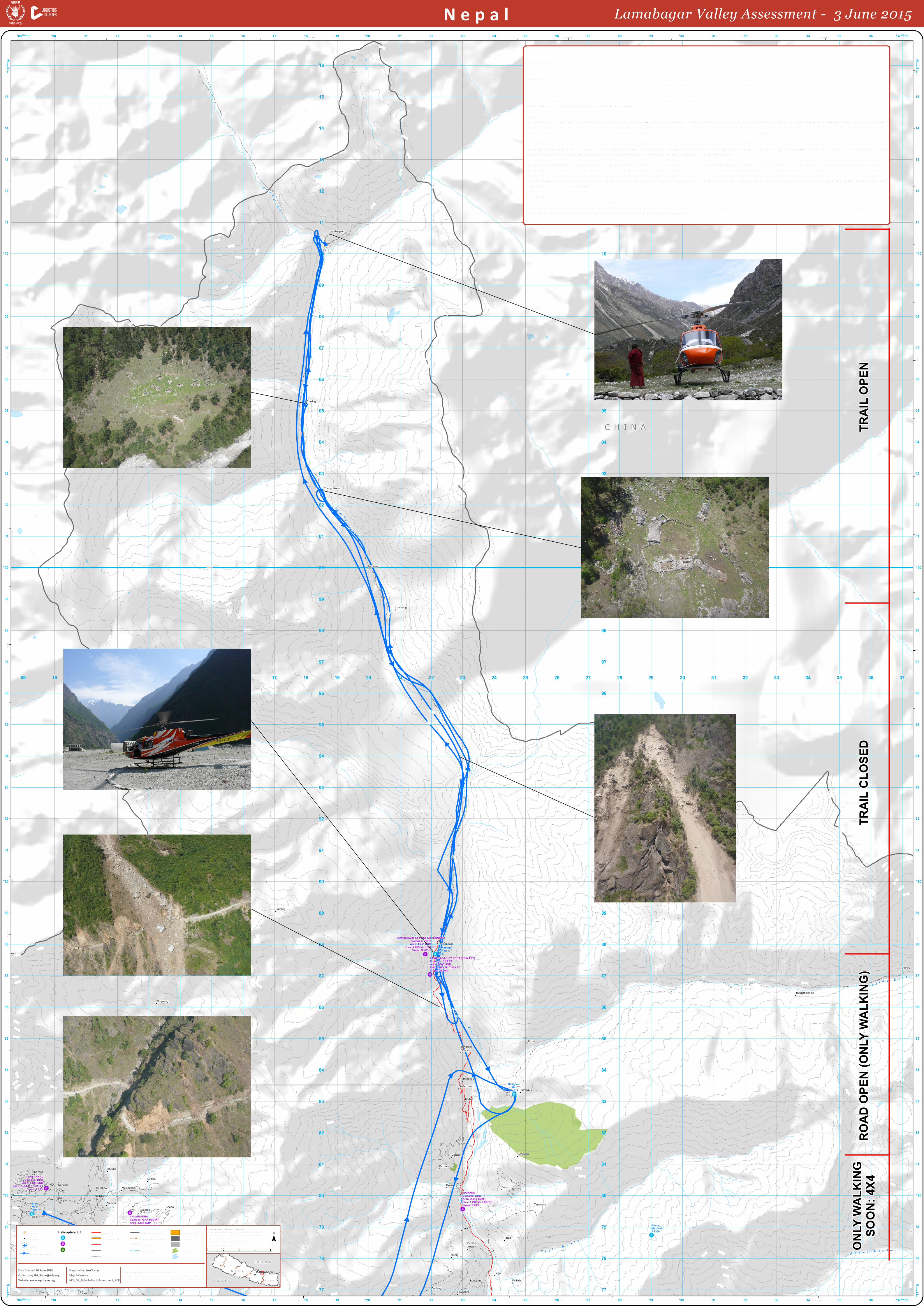
Asse ssm e nt M ission Re p ort – Dolakha (Lam ab agar – Lom nang – Lap c he gaun) 3 June 2015Partic ip ants:Ne p al M ountaine e ring Assoc iation (NM A), Chautara Re gional Logistics Cluste r Coord inator, Logistics Cluste r GIS Offic e r and the Logistics Offic e r in Kathm and u.Ob je ctive :To asse ss trail cond itions for the NM A trail re hab ilitation p roje ct in Northe rn Dolakha toward s Lap c he gaun via Lonm ang.Background :Following trail asse ssm e nt m issions, the Le tte r of Agre e m e nt (LOA) b e twe e n W FP and the NM A for trail re hab ilitation and food d istrib ution from Lam ab agar via Lom nang toLap c he gaun, in the Dolakha District, has b e e n signe d .Trail Asse ssm e nt:Lam ab agar – Chhe c he t – Gogar: The tail asse ssm e nt starte d in Lam ab agar. The focal p oint for the NM A in Lam ab agar ad vise d that the trail re hab ilitation from Lam ab agar viaChhe c he t to Gogar had b e e n c om p le te d . The trail is now p assab le b y foot. Food d istrib ution in Lam ab agar and Chhe c he t, inc lud ing house hold s along the trail to Gogar, wasalso com p le te d . Gogar is curre ntly only ac c e ssib le b y foot b ut it m ay b e soon ac c e ssib le b y 4x4 from the south, onc e the road is cle are d .Lam ab agar – Lom nang – Lap c he gaun: The trail from Lam ab agar to Lom nang was b ad ly d am age d b y land slid e s and falling roc ks could b e se e n d uring asse ssm e nt m issions.The b rid ge that le ad s the trail across the rive r was also b roke n. This trail is curre ntly not p assab le b y foot. Pilots asse sse d the p ossib ility of land ings p ad s in se ve ral p lac e s b utcould not id e ntify a safe p lac e whe re M i8 he licop te rs could land , d ue to land e xp osure to falling roc ks.The AS350 he lic op te r could not land in Lap c he gaun with four p asse nge rs, d ue to high altitud e (ab out 3,000 m e tre s). Te am s had to re turn to Lam ab agar and d rop off twop asse nge rs and d o a se c ond rotation. In Lom nang village rs inform e d asse ssm e nt te am s that the trail le ad ing up to the village had b e e n c le are d . It took se ve n d ays and 13p e op le to cle ar the trail. On ave rage it take s 6-7 hours b y foot to walk from Lap c he gaun to Lam nang. The total num b e r of house hold s b e twe e n the se two village s am ounts to35. The village rs ad vise d the y had not re c e ive d any food d ue to the re m ote ne ss of the ir location. Pilots asse sse d that M i8 he lic op te rs are not suitab le for cargo airlifts and thatsling d rop s m ay b e a p ossib ility.Conc lusion:The trail b e twe e n Lom nang and Lap c he gaun is curre ntly not p assab le . Trail re hab ilitation cannot b e carrie d out b e fore the start of the m onsoon se ason, as the trail runsb e twe e n two ste e p m ountain slop e s and it is e stim ate d that it m ay take m any m onths for it to b e re p aire d . Airlift to Lap c he gaun is not p ossib le b e cause of the the high altitud e ,and also in Lom nang b e cause of falling roc ks and lack of a p rop e r land ing p ad s.


![Link Farmer[countryside] to Customer[downtown]. Downtown Valley F F F F F F F F.](https://static.documents.pub/doc/80x56/56649f385503460f94c55132/link-farmercountryside-to-customerdowntown-downtown-valley-f-f-f-f-f-f.jpg)

![aP ‘ ’ K $˙ " " % Kb ˚˛ W K S& $ d1c K% & _ ˘ e K ˆ O Q Y1X K S ]Y1h ˚g $ f ˘&" f ˘J " f ˘˙ S&$ f ˘ " S &E ˘ & ... E ˘ " S & ˝( % TO˘ M˝ < ( ˚ c ...](https://static.documents.pub/doc/80x56/5e4b5c3c74f6f36c66676b02/ap-a-a-k-kb-w-k-s-d1c-k-e-k-o.jpg)