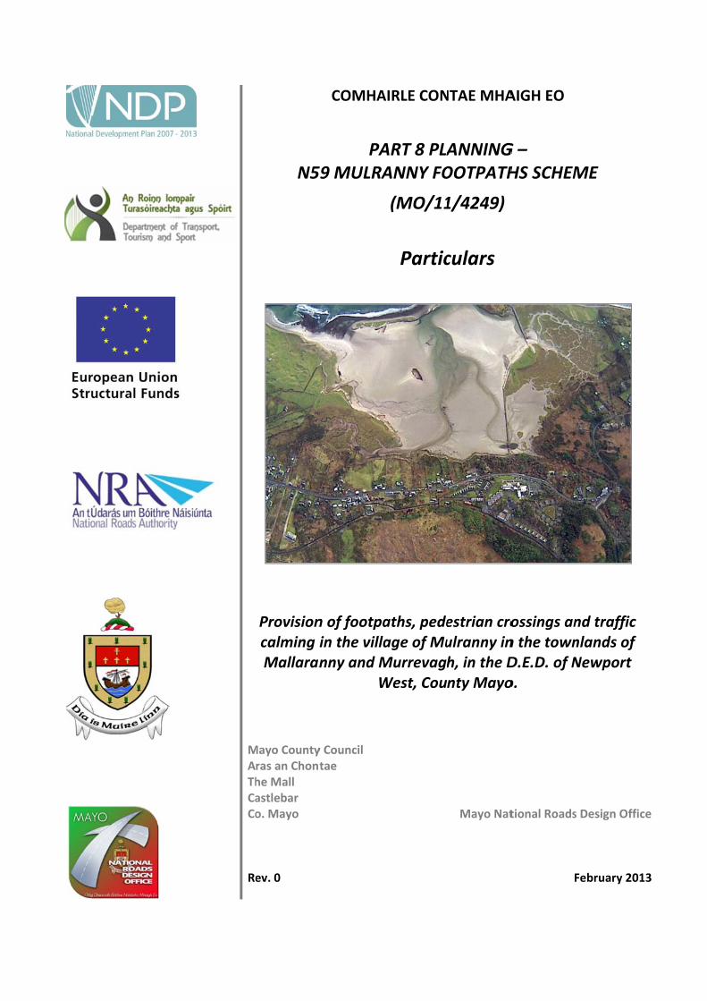
M A Th Ca Co Re N5 Provision calming i Mallaran Mayo County ras an Chont he Mall astlebar o. Mayo ev. 0 COMHA PA 59 MULRA n of footpa in the villa nny and M W y Council tae AIRLE CON ART 8 PLA ANNY FO (MO/11 Partic aths, pede age of Mu Murrevagh West, Cou NTAE MHA ANNING OOTPATH 1/4249) culars estrian cro ulranny in h, in the D nty Mayo Mayo Nat AIGH EO G – HS SCHEM ossings an n the town D.E.D. of N o. tional Roads F ME nd traffic nlands of Newport s Design Offi February 20 ce 13
Transcript
MAThCaCo Re
N5
Provisioncalming iMallaran
Mayo Countyras an Chonthe Mall astlebar o. Mayo
ev. 0
COMHA
PA59 MULRA
n of footpain the villanny and M
W
y Council tae
AIRLE CON
ART 8 PLAANNY FO
(MO/11
Partic
aths, pedeage of MuMurrevaghWest, Cou
NTAE MHA
ANNINGOOTPATH
1/4249)
culars
estrian croulranny inh, in the Dnty Mayo
Mayo Nat
AIGH EO
G – HS SCHEM
ossings ann the townD.E.D. of No.
tional Roads
F
ME
nd traffic nlands of Newport
s Design Offi
February 20
ce
13
Mayo National Roads Design Office N59 Mulranny Footpaths Mayo County Council Part 8
1.1 PROPOSED DEVELOPMENT ............................................................................................................................................. 3
1.2 BENEFITS OF THE PROPOSED DEVELOPMENT ................................................................................................................. 3
Creation of Employment & Accessibility / Tourism .......................................................................................................... 3
Public Transport ............................................................................................................................................................... 4
1.3 PLANNING AND DEVELOPMENT REGULATIONS .............................................................................................................. 4
2 DESCRIPTION OF SCHEME .............................................................................................................................................. 5
2.4 GREAT WESTERN GREENWAY / CYCLEWAYS ................................................................................................................... 5
2.9 PUBLIC UTILITIES ............................................................................................................................................................. 6
2.12 IMPACTS ON THE ENVIRONMENT ................................................................................................................................. 7
Human Beings .................................................................................................................................................................. 7
Soils, Geology and Hydrogeology: .................................................................................................................................... 8
Water / Hydrology............................................................................................................................................................ 8
Air & Climate .................................................................................................................................................................... 9
Noise and Vibration .......................................................................................................................................................... 9
Archaeology, Architecture and Cultural Heritage .......................................................................................................... 10
3 LAND ACQUISITION AND ACCOMMODATION WORKS .................................................................................................. 11
APPENDIX A .................................................................................................................................................................... 12
Notice of Proposed Development (Newspaper & Site) ....................................................................................................... 12
APPENDIX B ..................................................................................................................................................................... 15
Bodies Notified in accordance with Section 82 of the Planning and Development Regulations ........................................ 15
APPENDIX C ..................................................................................................................................................................... 17
Mayo National Roads Design Office N59 Mulranny Footpaths Mayo County Council Part 8
2
Mayo National Roads Design Office N59 Mulranny Footpaths Mayo County Council Part 8
3
N59 MULRANNY FOOTPATHS
PART 8 PARTICULARS
1 INTRODUCTION
1.1 PROPOSED DEVELOPMENT
This document relates to the proposed improvements of the N59 road in Mulranny village. The scheme is progressing through planning and design in conjunction with the National Roads Authority (NRA).
The proposed development will consist of the following: ‐
Provision of footpaths for a distance of approximately 890m;
Provision of a promenade/amenity area 170m long;
Provision of car and bus parking;
Enhancements to the existing Great Western Greenway by the provision of an access with improved gradient into the village;
Improvement of one sideroad junction;
Provision of a zebra crossing and six uncontrolled pedestrian crossings;
Provision of a traffic calming scheme and cycleways at the east end of the village;
Associated earthworks, drainage, landscaping and diversion of services and ancillary works.
The proposed scheme is in the townlands of Mallaranny and Murrevagh in the D.E.D. of Newport West, County Mayo.
More details of the scheme are shown in the Part 8 Plans.
1.2 BENEFITS OF THE PROPOSED DEVELOPMENT
Creation of Employment & Accessibility / Tourism
The N59 National Secondary Route in Co. Mayo is approximately 139km long and serves as the main access route for tourists visiting Westport, Newport, Mulranny, Achill Island and north to Belmullet, Erris and the Céide Fields in North Mayo. It serves the Gaeltacht areas of Acaill (Achill) and Iorrais (Erris).
Westport, Newport, Mulranny, Achill and the surrounding area of Mayo is a major attraction for visitors to Ireland. In 2011, the number of visitors to Mayo was approximately 267,000 (Fáilte Ireland). These figures emphasise the region’s importance as a visitor destination in Ireland.
This road project will provide an improved transport link to this region and will enhance economic growth and employment, particularly in the area of tourism.
Road Safety
This section of National Secondary Road is deficient in terms of horizontal alignment, vertical alignment and cross‐section, and there is a proliferation of junctions and private accesses causing traffic hazards.
Mayo National Roads Design Office N59 Mulranny Footpaths Mayo County Council Part 8
4
The narrow cross‐section of the existing N59 route through the village also makes it unsuitable for Non‐Motorised Users (pedestrians and cyclists).
There have been a number of incidents involving vehicular traffic and pedestrians in the village of Mulranny. Some of these accidents were due to the absence of a footpath, necessitating pedestrians to walk on the carriageway.
There have been 12 reported accidents in the village of Mulranny between 2006 and the end of 2011. 4 of these were serious injury accidents, 5 of these were minor injury accidents and 3 were recorded as Material Damage.
There was a near fatal accident in 2011 when a child who was walking along the edge of the carriageway was knocked down and seriously injured.
The provision of a consistent alignment will reduce driver confusion and error. These measures will have a beneficial effect on road safety. As part of the scheme, footpaths and pedestrian crossings will be provided and, in conjunction with the Great Western Greenway, improved access to the greenway, which will have a positive effect on both the quality and safety of the road for Non‐Motorised Users.
Public Transport
Improvement of the N59 will improve road‐based public transport between Achill, Newport and Westport.
1.3 PLANNING AND DEVELOPMENT REGULATIONS
In accordance with the Planning and Development Acts 2000‐2006, Planning and Development Regulations 2001 as amended by Planning and Development Regulations 2006‐2011, Mayo County Council is making available for inspection to members of the public, documentation and drawings describing the proposed works. The following drawings should be read in conjunction with this document:
Drawing Number Title
NRD/MO 11 4249/308/Loc Site Location Map;
NRD/MO 11 4249/308/0 Site Layout Map;
NRD/MO 11 4249/308/1‐5 Plans Layouts 1‐5;
NRD/MO 11 4249/308/6 Greenway Link Plan & Longitudinal Section.
A copy of the Newspaper and Site Notices for the proposed development as required by the above Regulations is included in Appendix A.
Appendix B consists of the list of relevant bodies to which notice of the proposed development, including the Plans & Particulars, have been sent as required by the above Regulations.
Mayo National Roads Design Office N59 Mulranny Footpaths Mayo County Council Part 8
5
2 DESCRIPTION OF SCHEME
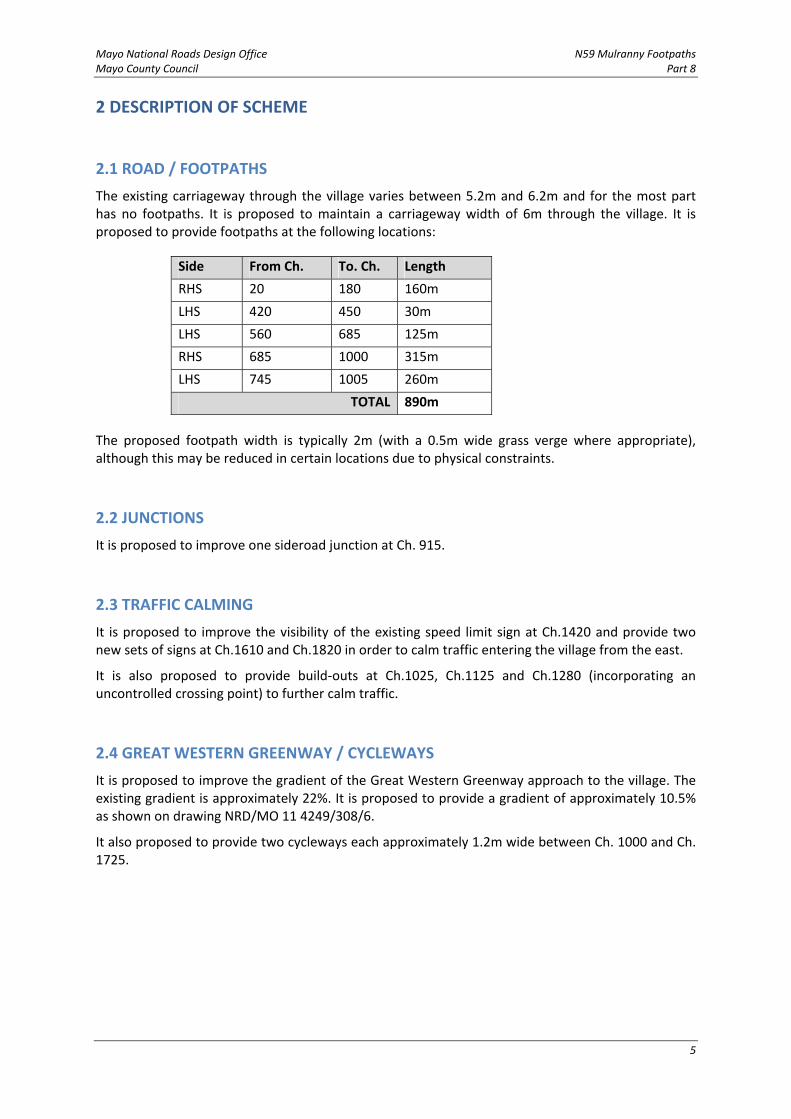
2.1 ROAD / FOOTPATHS
The existing carriageway through the village varies between 5.2m and 6.2m and for the most part has no footpaths. It is proposed to maintain a carriageway width of 6m through the village. It is proposed to provide footpaths at the following locations:
Side From Ch. To. Ch. Length
RHS 20 180 160m
LHS 420 450 30m
LHS 560 685 125m
RHS 685 1000 315m
LHS 745 1005 260m
TOTAL 890m
The proposed footpath width is typically 2m (with a 0.5m wide grass verge where appropriate), although this may be reduced in certain locations due to physical constraints.
2.2 JUNCTIONS
It is proposed to improve one sideroad junction at Ch. 915.
2.3 TRAFFIC CALMING
It is proposed to improve the visibility of the existing speed limit sign at Ch.1420 and provide two new sets of signs at Ch.1610 and Ch.1820 in order to calm traffic entering the village from the east.
It is also proposed to provide build‐outs at Ch.1025, Ch.1125 and Ch.1280 (incorporating an uncontrolled crossing point) to further calm traffic.
2.4 GREAT WESTERN GREENWAY / CYCLEWAYS
It is proposed to improve the gradient of the Great Western Greenway approach to the village. The existing gradient is approximately 22%. It is proposed to provide a gradient of approximately 10.5% as shown on drawing NRD/MO 11 4249/308/6.
It also proposed to provide two cycleways each approximately 1.2m wide between Ch. 1000 and Ch. 1725.
Mayo National Roads Design Office N59 Mulranny Footpaths Mayo County Council Part 8
6
2.5 PEDESTRIAN CROSSINGS
It is proposed to provide pedestrian crossings at the following locations:
Ch. Type
170 Uncontrolled crossing
580 Uncontrolled crossing
685 Uncontrolled crossing
790 Uncontrolled crossing
905 Zebra crossing
980 Uncontrolled crossing
1280 Uncontrolled crossing (incorporated with build‐out)
2.6 RETAINING WALLS
Retaining walls will be required at the following locations:
Side From Ch. To. Ch. Length
LHS 580 600 20m
LHS 640 685 45m
RHS 790 820 30m
LHS 825 910 85m
RHS 870 960 90m
TOTAL 270m
2.7 DRAINAGE
Existing roadside drainage will be maintained. Gulleys provided along the kerbs of the new footpaths will be channeled into the existing drains on the south side of the N59.
2.8 LANDSCAPING & VISUAL
Landscaping will be carried out taking account of the existing vegetation so that the scheme can be carefully integrated into the receiving environment. Native species will be used.
2.9 PUBLIC UTILITIES
Local utility diversions and alterations will be made as necessary to facilitate the new proposed improvement. These include water, telecommunications and electricity services.
2.10 PARKING
It is proposed to provide car and bus parking at the locations indicated on the drawings.
Mayo National Roads Design Office N59 Mulranny Footpaths Mayo County Council Part 8
7
2.11 TRAFFIC MANAGEMENT
Traffic management will be required along the length of the scheme during construction.
2.12 IMPACTS ON THE ENVIRONMENT
Human Beings
During the construction phase the increased development activity associated with the project should prove to have positive benefits to the local economy.
All along its route, the location of the proposed development is used by pedestrians and cyclists, in particular people using the adjacent Great Western Greenway, which attracts many tourists to the area. Traffic management plans during the construction phase should ensure safety of the vulnerable road users and continued usage during construction. Long term, with the improved interaction between the Greenway and the village core, the use of both will be enhanced.
The N59 is identified as one of the most important tourist routes in the State. The proposed development has the potential to positively impact on tourism in Mulranny and the wider region with safer traffic movements and pedestrian/cyclist movement. This will result in a more pleasant and safer environment in the village and will allow the area to develop to its true potential.
During the construction phase there may be some minor short term negative impacts along the N59 transport corridor as a result of potential traffic delays.
Local community, tourist and business facilities are located within Mulranny. It is considered that there will be a positive increase in the use of these facilities arising from the proposed development. The proposed development has the potential to improve safety and access to these facilities.
Community severance may be described as being the separation of residents from facilities and services used within their community, caused by new or improved roads or changes in access and/or traffic flows. As the proposed works primarily involve an online at‐grade provision and improvement of pedestrian /cyclist facilities along the N59, there is minimal scope for affecting existing severance, as the project will provide improved safety for pedestrians, cyclists and vehicles accessing these community facilities and services.
Ecology
There are five Natura 2000 sites situated within 15km of the proposed development, including Clew Bay Complex cSAC (Site Code 001482), Owenduff/Nephin Complex cSAC (Site Code 000534) and SPA (004098), Lough Gall Bog cSAC (Site Code 000522), and Corraun Plateau cSAC (Site Code 000485).
There are a further four proposed Natural Heritage Areas (pNHAs) within 15km of the proposed development, including Clew Bay pNHA (Site Code 0001482), Owenduff/Nephin Complex pNHA (Site Code 000534), Lough Gall Bog pNHA (Site Code 000522), and Corraun Plateau pNHA (Site Code 000485),
The designated sites which may be impacted by the proposed works include, Clew Bay Complex cSAC/pNHA, Owenduff/Nephin Complex cSAC/SPA/pNHA and Corraun Plateau cSAC/pNHA. The proposed development does not traverse any habitats listed under Annex I of the EU Habitats Directive within the Clew Bay cSAC, Owenduff/Nephin Complex cSAC/SPA/pNHA and Corraun Plateau cSAC/pNHA, which would be listed as qualifying interests of the designated site. The proposed development crosses a number of watercourses which flow into Clew Bay and drain the Owenduff/Nephin Complex. There is potential for aquatic species to be disturbed either through deterioration in water quality or a disruption of hydrological processes as a result of construction
Mayo National Roads Design Office N59 Mulranny Footpaths Mayo County Council Part 8
8
operations. Construction activities may cause some disruption to the protected bird species found in Owenduff/Nephin Complex SPA.
The proposed development is an online provision and improvement of pedestrian /cyclist facilities along the N59. The majority of the impacts that are likely to have an impact on the environment are associated with the construction stage. These construction stage impacts are temporary in nature, of short duration, will not recur once construction has been completed and the effects will be reversible over time.
The exception to this is mainly loss of roadside vegetation where the existing road cross‐section is widened. This will be minimal and consist of removal of hedgerows and agricultural grassland. In this case the duration is permanent and is not reversible.
Where any vegetation clearance is required this shall be done outside the bird nesting season – March 1st to August 31st.
In areas of vegetation clearance, where there is the presence of non‐native invasive plant species, in particular Japanese Knotweed (Fallopia japonica), Himalayan Balsam (Impatiens glandulifera) and Giant Rhubarb (Gunnera tinctoria), care will be taken in the excavation and movement of material in these areas to prevent the spread of invasive species. The NRA’s Guidelines on the Management of Noxious Weeds and Non‐Native Invasive Plant Species on National Roads will be followed in these instances. Roadside habitat loss can be compensated for through creative and ecologically sensitive landscaping.
The proposed development will be developed in accordance with the NRA and other relevant environmental guidelines and specific environmental avoidance and mitigation measures will be implemented.
Soils, Geology and Hydrogeology:
The geology and hydrogeology along the N59 in this area is mainly a poor aquifer associated with the Anaffrin Formation, described as Psammitic schists and quartzites. The groundwater vulnerability is considered extreme. Impacts both constructional and operational to the geology and hydrogeology will be minor to imperceptible and do not require any specific mitigation.
There will be a permanent but imperceptible negative impact due to the need to import material to fill sections of the proposed development and to excavate material.
Water / Hydrology
The proposed N59 Mulranny Footpaths area is within the Murrevagh River catchment. The Murrevagh River is classed at ‘Good’ status in the Clew Bay Water Management Unit Action Plan (March 2012). Along the proposed development there are two watercourse channel crossings with a number of potential road drainage outfall locations. All of these watercourses discharge to the Clew Bay SAC complex. The drainage system will be designed to protect the water quality of the receiving waters from operational impacts associated with routine road runoff and accidental spillages.
The design of the drainage system for the project recognizes that the scheme is a low volume route, and is an online upgrade of an existing road carriageway/cross‐section. It is considered that the design should seek to be as simple and as low maintenance as possible and reflect broadly the existing drainage regime in the area, while still seeking to protect any vulnerable and/or important receiving watercourses.
It is proposed that a concrete channel / kerb and gully drainage system is the most desirable solution for the scheme.
Mayo National Roads Design Office N59 Mulranny Footpaths Mayo County Council Part 8
9
The majority of the catchment areas associated with this study comprise Soil Type 5 (Very High Runoff) with areas of Soil Type 4 (High Runoff) on the lower slopes of the Nephins. These characteristics give rise to high rates of runoff and large flood flows in the watercourses intercepted by the road.
The principal hydrological impact of the scheme will be associated with sediment runoff generated by construction works near watercourses and the handling of unsuitable material, its removal, transport and recovery. Appropriate sediment control measures during the construction phase will be required to minimise impact to receiving watercourses and ensure imperceptible impact to the downstream Clew Bay SAC. The operational impact on surface water quality due to the proposed development as a whole is expected to be slightly positive through improved road runoff drainage and treatment.
Air & Climate
Due to the fact that the proposed development will not generate extra vehicular traffic volumes or significantly divert vehicular traffic, it is predicted that at a local level the proposed development will have no significant impact on air quality. At a regional level, the proposed development will not result in a detrimental impact on background air quality. Levels of vehicular traffic‐derived air pollutants in the locality will not exceed the ambient air quality standards either with or without the proposed development in place. As part of the mitigation strategy, a dust minimisation plan will be incorporated into the Environmental Operating Plan formulated for the construction phase of the project in accordance with industry guidelines.
Noise and Vibration
The existing background noise levels are typical of a semi‐urban area influenced by a rural/semi‐urban national road. Due to the fact that the proposed development will not generate extra vehicular traffic volumes or divert vehicular traffic, it is predicted that the proposed development will have no significant impact on background noise levels in the area. Mitigation measures such as acoustic barriers or low noise road surfacing are not necessary. The proposed development is not expected to give rise to vibration that is either significantly intrusive or capable of giving rise to structural or cosmetic damage.
Construction may lead to temporary adverse noise impacts at nearby residences. Subject to good working practice during the construction phase and non‐exceedence of any noise limits stipulated in industry guidelines, construction noise impacts will be kept to a minimum. There is the potential for vibration impacts during construction at properties close to the works. However, contract documents will specify that the Contractor will be obliged to undertake specific abatement measures and to comply with industry guideline vibration limits.
Landscape & Visual Assessment
Generally the landscape either side of the proposed development is either rural or residential/commercial, rising to the north and includes mature roadside planting. The visual envelope i.e. where the site and any activities associated with the site during construction and operation will be visible without mitigation measures in place, is narrow and within 100m either side of the proposed development. From the preliminary visual assessment carried out, no significant visual impacts will result.
The proposed development is described in the Landscape Appraisal of County Mayo (CAAS Ltd., 2008) within the Landscape Character Zone Area E: North Mayo Mountain Moorland. The Appraisal notes that the N59 is a designated scenic route from Bangor to east of Rosturk. The project is fully within this designated scenic route.
Mayo National Roads Design Office N59 Mulranny Footpaths Mayo County Council Part 8
10
Impacts on the landscape and its associated character will result from the removal of mature vegetation along the project required from the creation of the widened road cross‐section. Mitigation including providing areas suitable for planting, reinstatement of hedgerow and road edge planting plus sensitive treatment to finishes to the promenade area will reduce impacts on the landscape.
Archaeology, Architecture and Cultural Heritage
The proposed development will not impact on any national monuments, recorded archaeological monuments or any other known archaeological sites.
The potential for previously unidentified or subsurface archaeological remains within the development area is deemed very low to negligible. Nevertheless, a programme of archaeological fieldwalking shall be carried out by a suitably qualified archaeologist. If archaeological remains are identified an archaeological mitigation strategy will be implemented in agreement with the relevant statutory bodies. This may include test trenching that, if required, shall be carried out by a suitably qualified archaeologist under licence from the National Monuments Service and the National Museum of Ireland.
The proposed development will not have any direct or significant impacts on any Recorded Protected Structures. Two Recorded Protected Structures ‘The Great Southern Hotel’ (ID:0121) and ‘St. Mary’s RC Church’ (ID:0122) are located adjacent to the scheme but will not be impacted on negatively by the proposed development.
One structure included in the Mayo Thatch survey is located within the study area but will not be impacted on. Also it should be noted that the Great Western Railway (Now the greenway cycle path) and associated features, run parallel and adjacent to the study area but will not be impacted on by the development.
Environmental Impact Assessment Screening
An Environmental Impact Assessment Screening was carried out on the N59 Mulranny Footpaths Project and it determined that the proposed development would not be likely to have significant effects on the environment and that the project does not require an Environmental Impact Assessment. The determination on the Environmental Impact Assessment Screening is included in Appendix C.
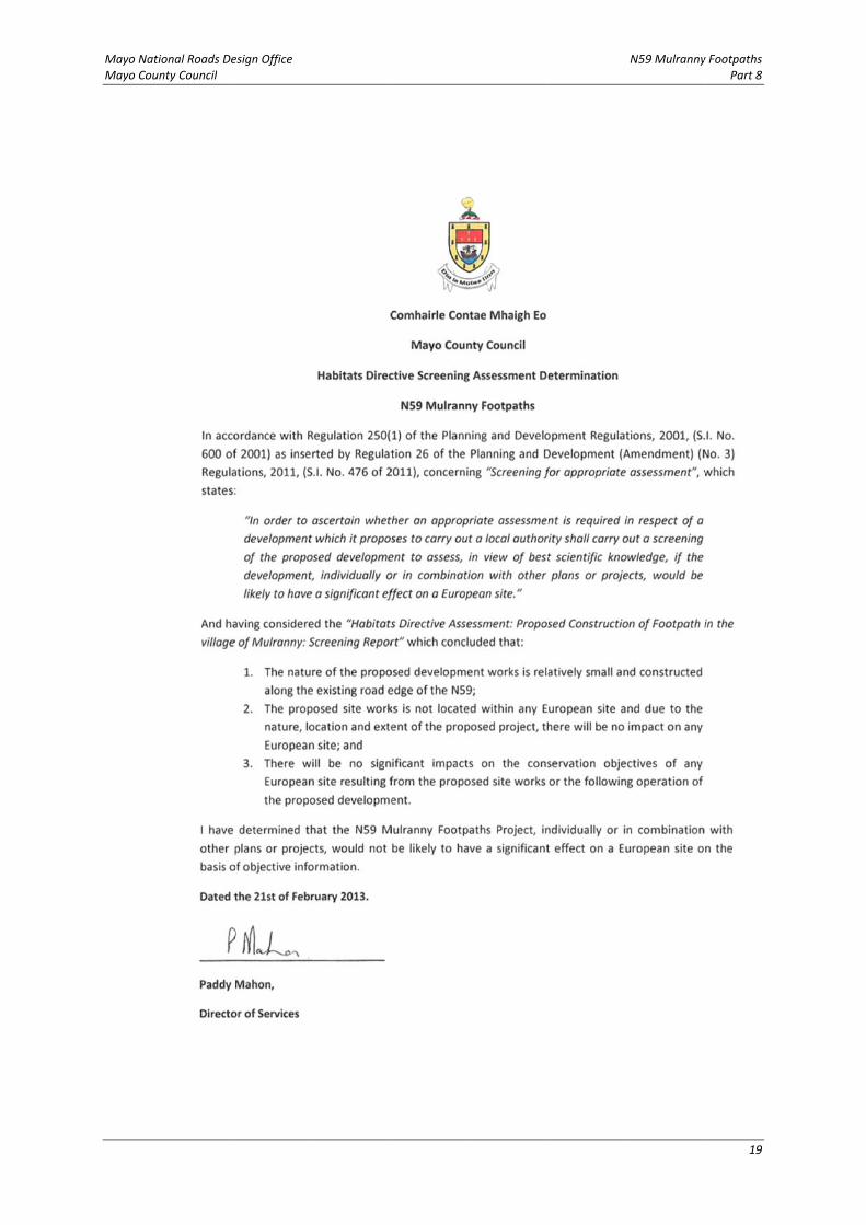
Habitats Directive Assessment Screening
In addition and due to the location of a number of European sites (Natura 2000 sites) in the vicinity of the proposed development a Habitats Directive Assessment Screening was carried out on the proposed development. The screening determined that the N59 Mulranny Footpaths Project, individually or in combination with other plans or projects, would not be likely to have a significant effect on a European site on the basis of objective information. This determination indicates that a Stage 2 Appropriate Assessment is not required for the proposed development. A copy of the determination is included in Appendix C.
Overall
The impacts of all aspects of the project have been addressed. It is evident that there will not be significant effects on the receiving environment or on effected designated sites, if all precautionary measures are implemented.
Mayo National Roads Design Office N59 Mulranny Footpaths Mayo County Council Part 8
11
3 LAND ACQUISITION AND ACCOMMODATION WORKS
Land acquisition will be required in order to construct this proposed improvement of the N59. The preliminary design has focused on the development of the proposed project to permit Land Acquisition procedures to be undertaken.
The alignment is online and as a result the impact on properties will be limited to landtake only along the external boundary with the national road. Likely impacts are expected to include impacts on the curtilage of properties, impacts to property boundaries and entrances, impacts on services including water, utilities and to a more limited extent, direct impacts on properties.
Accommodation works will be required along the length of the scheme, and will be designed in consultation with the landowners.
Mayo National Roads Design Office N59 Mulranny Footpaths Mayo County Council Part 8
12
APPENDIX A
Notice of Proposed Development (Newspaper & Site)
Mayo National Roads Design Office N59 Mulranny Footpaths Mayo County Council Part 8
13
Comhairle Contae Mhaigh Eo
Mayo County Council
Part 8 of the Planning and Development Regulations 2001
Planning and Development Regulations 2001 to 2011
N59 Mulranny Footpaths Scheme
Provision of footpaths, pedestrian crossings and traffic calming in the village of Mulranny in the townlands of Mallaranny and Murrevagh, in the D.E.D. of Newport West, County Mayo.
In accordance with Articles 80 and 81 of the Planning and Development Regulations 2001, as amended by the Planning & Development Regulations 2006 ‐ 2012, notice is hereby given that Mayo County Council proposes to carry out development, as described below, in the above‐named townlands in the D.E.D. of Newport West, County Mayo:
Provision of footpaths for a distance of approximately 890m;
Provision of a promenade/amenity area 170m long;
Provision of car and bus parking;
Enhancements to the existing Great Western Greenway by the provision of an access with improved gradient into the village;
Improvement of one sideroad junction;
Provision of a zebra crossing and six uncontrolled pedestrian crossings;
Provision of a traffic calming scheme and cycleways at the east end of the village;
Associated earthworks, drainage, landscaping and diversion of services and ancillary works.
An Environmental Impact Assessment Screening process was carried out for the project, and Mayo County Council has determined that the scheme would not have a significant effect on the environment, and that an Environmental Impact Assessment is not required.
A Habitats Directive Assessment Screening process was carried out for the project, and Mayo County Council has determined that the scheme, individually or in combination with other plans or projects, would not be likely to have a significant effect on a European site.
Plans and particulars of the proposed development, and the Environmental Impact Assessment Screening and Habitats Directive Assessment Screening determinations will be available for inspection between the hours of 9.30am to 1.00pm and 2.00pm to 4.30 pm on Mondays to Fridays (bank holidays excluded) from Tuesday 26th February 2013 to Tuesday 9th April 2013 at the following locations:
Mulranny Post Office, Mulranny, Co. Mayo;
The offices of Mayo County Council, Church Road, Belmullet, Co. Mayo
The offices of Mayo County Council, Civic Offices, Altamount Street, Westport, Co. Mayo;
Mayo National Roads Design Office N59 Mulranny Footpaths Mayo County Council Part 8
14
The offices of Mayo County Council, National Roads Design Office, Glenpark House, The Mall, Castlebar, Co. Mayo;
and will be available for purchase at a fee not exceeding the reasonable cost of making a copy at:
The offices of Mayo County Council, National Roads Design Office, Glenpark House, The Mall, Castlebar, Co. Mayo;
until 9th April 2013.
Submissions or observations with respect to the proposed development dealing with the proper planning and sustainable development of the area in which the development will be situated may be made in writing to the undersigned before 4 p.m. on Tuesday 23rd April 2013.
Dated this 26th day of February, 2013.
J. Condon, County Secretary, Mayo County Council, Aras an Chontae, The Mall, Castlebar, Co. Mayo.
Mayo National Roads Design Office N59 Mulranny Footpaths Mayo County Council Part 8
15
APPENDIX B
Bodies Notified in accordance with Section 82 of the Planning and Development Regulations
Mayo National Roads Design Office N59 Mulranny Footpaths Mayo County Council Part 8
16
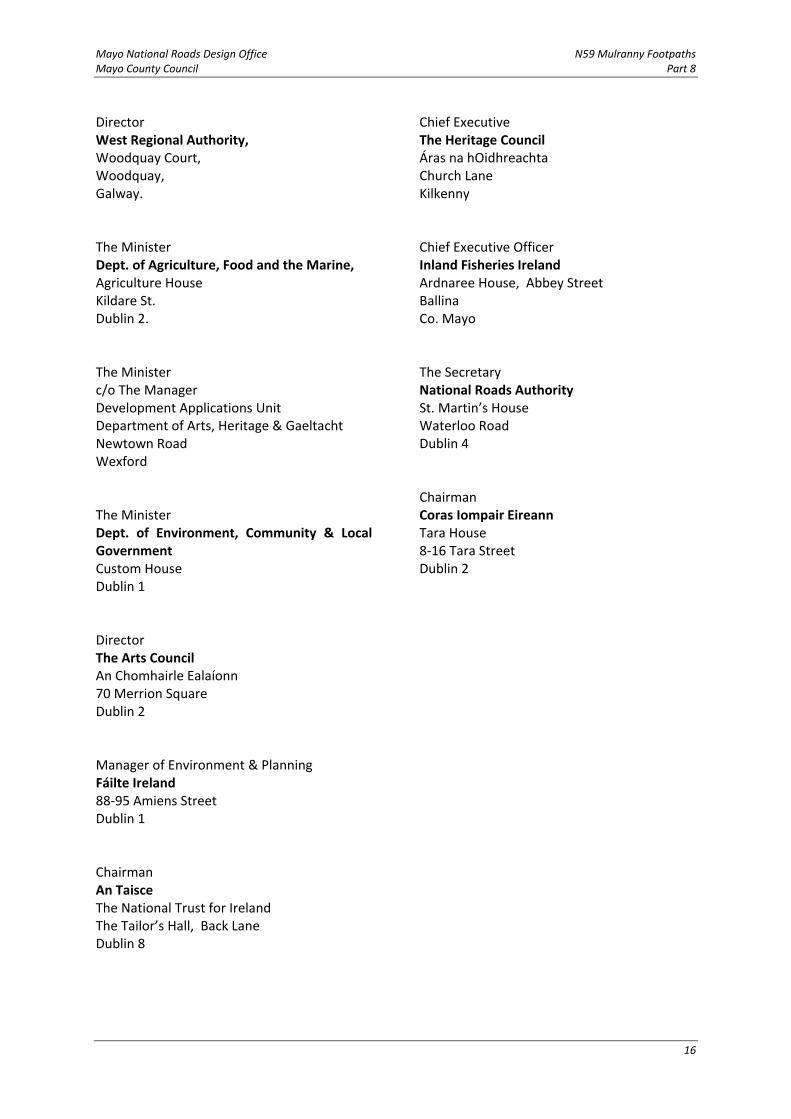
Director West Regional Authority, Woodquay Court, Woodquay, Galway. The Minister Dept. of Agriculture, Food and the Marine, Agriculture House Kildare St. Dublin 2. The Minister c/o The Manager Development Applications Unit Department of Arts, Heritage & Gaeltacht Newtown Road Wexford The Minister Dept. of Environment, Community & Local Government Custom House Dublin 1 Director The Arts Council An Chomhairle Ealaíonn 70 Merrion Square Dublin 2 Manager of Environment & Planning Fáilte Ireland 88‐95 Amiens Street Dublin 1 Chairman An Taisce The National Trust for Ireland The Tailor’s Hall, Back Lane Dublin 8
Chief Executive The Heritage Council Áras na hOidhreachta Church Lane Kilkenny Chief Executive Officer Inland Fisheries Ireland Ardnaree House, Abbey Street Ballina Co. Mayo The Secretary National Roads Authority St. Martin’s House Waterloo Road Dublin 4 Chairman Coras Iompair Eireann Tara House 8‐16 Tara Street Dublin 2
Mayo National Roads Design Office N59 Mulranny Footpaths Mayo County Council Part 8