49
N81 Tullow Footbridges & Associated Works Appropriate Assessment Screening Report Carlow County Council 10 April 2018
N81 Tullow Footbridges & Associated Works Appropriate Assessment Screening Report Carlow County Council
10 April 2018
N81 Tullow Footbridges & Associated Works Appropriate Assessment Screening Report
Atkins Appropriate Assessment Screening Report | Version 1.0 | 10 April 2018 | 5153094 ii
Notice
This document and its contents have been prepared and are intended solely for Carlow County Council’s information and use in relation to N81 Tullow Footbridges and Associated Works project.
Atkins Ireland assumes no responsibility to any other party in respect of or arising out of or in connection with this document and/or its contents.
This document has 43 pages including the cover.
Document history
Job number: 5153094 Document ref: 5153094 DG36
Revision Purpose description Originated Checked Reviewed Authorised Date
Rev 1.0 Appropriate Assessment POD POD NS MJ 10/04/18
Client signoff
Client Carlow County Council
Project N81 Tullow Footbridges & Associated Works
Document title Appropriate Assessment Screening Report
Job no. 5153094
Copy no. 1.0
Document reference
5153094DG36
N81 Tullow Footbridges & Associated Works Appropriate Assessment Screening Report
Atkins Appropriate Assessment Screening Report | Version 1.0 | 10 April 2018 | 5153094 iii
Table of contents
Chapter Pages
1. Introduction 1 Background to the commission 1 Description of the Proposed Works 2 General Description of the Project Location 4
2. The Appropriate Assessment Process 9 The Stages in Appropriate Assessment 9 Objectives of Appropriate Assessment 10
3. Methods 11 Desk Study 11 Screening Process 11 Statement of Authority 13
4. Appropriate Assessment Screening 14 Identification of Natura 2000 Sites 14 Brief Description of Natura 2000 Sites 14 Conservation Objectives for the Natura 2000 sites 18 Features of Interest and Potential Threats to the Natura 2000 Sites 20 Likelihood of Potential Impacts on Natura 2000 Sites 23 Identification of potential impacts on Natura 2000 sites 23 Cumulative impacts 29 Likelihood of Significant Effects on Natura 2000 Sites 30 Consideration of Findings 30
5. Findings of No Significant Impacts 31
6. References 35
Appendices 37
Appendix A. Site Synopsis – Slaney River Valley SAC 38
N81 Tullow Footbridges & Associated Works Appropriate Assessment Screening Report
Atkins Appropriate Assessment Screening Report | Version 1.0 | 10 April 2018 | 5153094 iv
List of Tables
Table 5.1 Natura 2000 sites features of interest and NPWS identified threats.
Table 5.2 Potential for Impacts on Features of Interest of Slaney River Valley SAC (000781).
List of Figure
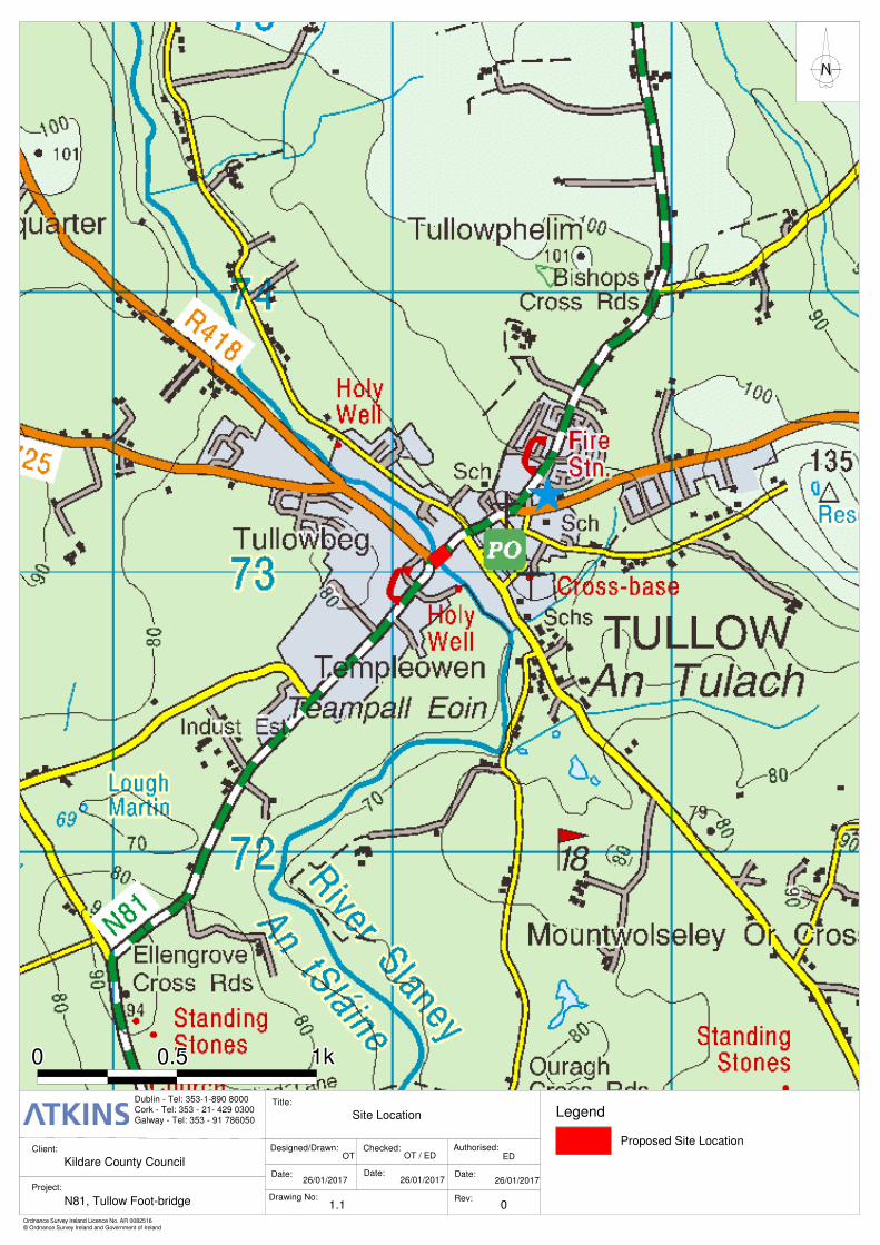
Figure 1.1 Site Location.
Figure 5.1 Natura 2000 Sites.
List of Plates
Plate 1.1 N81 Slaney Bridge (downstream).
Plate 1.2 View of left hand bank (upstream).
Plate 1.3 View of left hand bank (downstream).
Plate 1.4 View of right hand bank (upstream).
Plate 1.5 View of right hand bank (downstream).
N81 Tullow Footbridges & Associated Works Appropriate Assessment Screening Report
Atkins Appropriate Assessment Screening Report | Version 1.0 | 10 April 2018 | 5153094 1
1. Introduction 1.1. Atkins was commissioned by Carlow County Council (CCC) to examine a number
of design options for footbridges adjacent to the existing N81 Slaney Bridge in Tullow, Co Carlow. The commission also includes design of a lighting system; the redesign of the junction of the N81 and R725 to improve turning movements for HGV vehicles turning northbound on the N81 from the R725.
1.2. Atkins ecology team has been tasked with preparation of the Appropriate Assessment Screening Report for the project.
Background to the commission
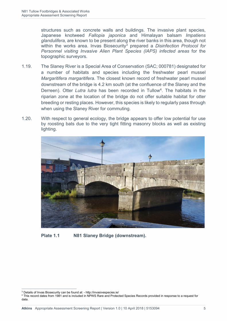
1.3. The existing Slaney Bridge in Tullow is a four span masonry arch over the River Slaney, built circa 1855. The overall length of the bridge between abutments, is approximately 33.9 m. The overall width of the structure is 10.26 m.
1.4. It has been identified that both vehicular and pedestrian traffic safety is compromised during large HGV movements from the R725 northbound onto Slaney Bridge. During these movements, large HGV traffic is forced across into the opposing lane of the N81, in addition to mounting the nearside western footpath in order to complete the turning movement. With the aforementioned in mind it is considered that the existing 1.4 m pedestrian footpaths are inadequate and new footbridges on both sides of the structure are required. Various potential solutions were examined to alleviate existing conflicts in the traffic turning movements while facilitating the safe passage of pedestrians on the bridge. To facilitate safe pedestrian movement all options would require the construction of new footbridges on both sides of the existing bridge.
1.5. The protected status of Slaney Bridge required careful consideration of its interface with the proposed works. In consultation with conservation architects it was determined that the proposed works to the existing bridge would be kept to a minimum. Thomas Traynor Street between Hawkin’s Lane and Abbey Street would be widened by removing a section of the existing footpath and the two way traffic would be moved to the newly constructed southern kerb line to maximize the available space for traffic to carry out its required turning movements over Slaney Bridge.
1.6. Therefore, the aim of the proposed project is to alleviate vehicular congestion and provide safe pedestrian access across the N81. The proposed project does not aim to increase traffic volumes in the vicinity of the R418/ N81 junction and the Slaney Bridge.
1.7. Three options for the footbridges have been considered; these are as follows: -
Option 1 consists of precast concrete bridges comprising pre-stressed slabs spanning between existing piers cutwaters and supported on in-situ concrete pad foundations incorporated into the cutwater and river walls. This option would include granite masonry cladding to the proposed footbridges facia to match the granite masonry façade of the existing bridge.
N81 Tullow Footbridges & Associated Works Appropriate Assessment Screening Report
Atkins Appropriate Assessment Screening Report | Version 1.0 | 10 April 2018 | 5153094 2
Option 2 consists of steel bridge decks with steel box sections spanning between the existing cutwaters and supported on circular steel sections at the cutwaters and on concrete pads on the river walls. The supports on the cutwaters are splayed outwardly (longitudinally) to minimise the deck span and therefore minimise the deck depth (this option is presented in the design drawings listed in paragraph 1.8).
Option 3 is similar to Option 2 and comprises a steel bridge deck spanning between the existing cutwaters with simple vertical supports at the cutwaters. This option minimises steelwork fabrication, but requires deeper steel box sections.
1.8. All the above options include provisions for carrying multiple services under the footbridges.
1.9. The preferred design solution is Option 2; a full set of design drawings is included with the Part 8 planning application package. Key design drawings are listed below: -
5153094-HTR-DR-8101 Site Location Map / Plan
5153094-HTR-DR-8105 Proposed Bridge Site Layout Plan
5153094-HTR-DR-8107 Existing & Proposed Bridge Elevations (Sheet 1 of 2)
5153094-HTR-DR-8108 Existing & Proposed Bridge Elevations (Sheet 2 of 2)
5153094-HTR-DR-8109 Proposed Footbridges Typical Cross Sections
5153094-HTR-DR-8111 Photomontages of Proposed Footbridges
5153094-HTR-DR-8112 - 8114 Proposed Lighting Design (Sheets 1-3)
Description of the Proposed Works
1.10. The proposed footbridges will be 2m wide and their vertical profile will, in so far as is possible, follow that of the existing masonry bridge. The footbridges will be constructed of profiled aluminium decking on a painted structural steel frame. The steel frame would span between the existing bridge pier cutwaters and the river walls. The footbridges will be anchored to the existing bridge at the piers. The new footbridge structures will be located on both sides of the existing masonry road bridge.
1.11. The archaeological and architectural heritage importance of the existing bridge (NIAH ref. no. 10400325) has been assessed as part of the design process and to support the application for Part 8 planning permission.
1.12. The junction of the N81 and R725 Thomas Traynor Street is currently geometrically inadequate to accommodate two way movements of HGV’s. This results in HGV’s frequently carrying out unsafe turning maneouvres while turning north onto N81 Slaney Bridge from R725 Thomas Traynor Street. The proposal to
N81 Tullow Footbridges & Associated Works Appropriate Assessment Screening Report
Atkins Appropriate Assessment Screening Report | Version 1.0 | 10 April 2018 | 5153094 3
provide footbridges and associated works will require the provision of appropriate signage, road markings and minor works to guide HGV traffic approaching the bridge along R725 Thomas Traynor Street and on to Slaney Bridge.
1.13. Site works associated with the design process included topographical surveys (completed in November & December 2016) and geotechnical and structural investigations (completed in August 2017). These works are required to inform the final design of the footbridges. The topographical surveys were carried out on foot and did not require any intrusive works on the river banks or within the river channel.
1.14. There shall be no large machinery, such as excavators or diggers, working in-stream at any time during the construction of the footbridges. Scaffolding will be required around the pier cutwaters to facilitate the installation of the footbridges and their supports on the cutwaters and river walls. The scaffolding will be manually erected by construction workers. The scaffolding will be placed on the existing concrete apron which extends underneath the bridge on both sides. The concrete apron extends 1.5-3.0m beyond the extent of the cutwaters and therefore provide sufficient room for access and erection of the scaffolding. The scaffolding will be 1.0 m wide and will not impact on the river bed as it will be wholly contained within the concrete apron. Thus, there shall be no in-stream works within the natural riverbed of the River Slaney.
1.15. Construction of the footbridges will be carried out from the scaffolding, existing bridge deck and from the river walls at either end of the bridge. As the steel bridge sections will be prefabricated the construction works required to put them in place will be limited to the construction of pad supports for the footbridges on the cutwaters and river walls. The footbridges will then be fixed in place on the cutwaters/river walls and tied to the existing piers for stability. This will require coring a small hole through the existing bridge parapets/piers at each cutwater to facilitate the installation of stainless steel tie rods/anchors.
1.16. The expected construction period for the works is 36 weeks and, for associated instream works, would span the IFI open season from July to September inclusive.
1.17. The Contractor will be required to work to published (standard) environmental best practice methods during the works; this would include for example the implementation of appropriate pollution prevention measures such as the use of spill kits; safe storage of material; maintaining vehicles in good working order etc. to protect the River Slaney during the works.
a. The appointed contractor will be required to prepare a method statement for each element of the construction works. The method statement should refer to appropriate guidance such as the CIRIA publications ‘Environmental good practice on site guide (C741D)’, Control of water pollution from construction sites. Guidance for consultants and contractors (C532D)’, Inland Fisheries Ireland Guidelines on Protection of Fisheries During Construction Works In and Adjacent to Waters 2016 and the site specific Disinfection Protocol for Personnel visiting Invasive Alien Plant
N81 Tullow Footbridges & Associated Works Appropriate Assessment Screening Report
Atkins Appropriate Assessment Screening Report | Version 1.0 | 10 April 2018 | 5153094 4
Species (IAPS) infected areas prepared by Invas Biosecurity1 , which was prepared for the topographic surveys.
b. The contractor will identify and name a project manager / site manager / site foreman in the method statement. The site manager / site foreman will supervise all activities on the construction site and ensure compliance with measures, such as maintenance of a protective buffer zone, to protect the receiving environment. The site manager / site foreman will be responsible for ensuring all site workers are informed of the approach to good working practice on site and any additional measures they may wish to employ to protect the receiving environment.
c. The site compound for the proposed works will be set back from the River Slaney at a suitable location to be decided by the appointed contractor in consultation with Carlow County Council.
d. Materials will be stored away from the river in the designated site compound for the construction site and there will be no storage of construction materials on or near the banks of the River Slaney.
e. Waste materials will be placed in a designated skip within the site compound. All waste generated on site will be disposed of appropriately at a licensed waste facility.
f. The construction machinery required on site will be limited, however all refuelling of machines will be carried out in a designated area in the site compound and will be supervised by a designated person. Drip trays/plant nappies will be used as standard under machines when refuelling is taking place.
g. Any spills of fuel, hydraulic oils or lubricants will be contained immediately. Contaminated material will be removed from the site and disposed of correctly. Spill kits will be present on site in case of such an incident and the site staff will be trained in their use.
h. Concrete required for the works will be delivered to the site ready mixed. The ready-mix delivery lorry will then return to the site compound to wash out the container and chute in a designated concrete washout area.
i. Any further measures deemed necessary to protect the receiving environment will be put in place during works associated with installation of the footbridges, according to CIRIA best practice guidelines.
General Description of the Project Location
1.18. The N81 Slaney Bridge in Tullow, Co. Carlow crosses over the main channel of the Slaney River and is located (centred) at Ordnance Survey Ireland Grid Reference (OSIGR) S 85144 73058. The river channel is approximately 30 m wide at the bridge location. The riparian habitat in this area does not conform to any Annex 1 habitats2 and is largely artificial in nature i.e. consists of manmade
1 Details of Invas Biosecurity can be found at: - http://invasivespecies.ie/. 2 Habitat types whose conservation requires the designation of Special Areas of Conservation.
N81 Tullow Footbridges & Associated Works Appropriate Assessment Screening Report
Atkins Appropriate Assessment Screening Report | Version 1.0 | 10 April 2018 | 5153094 5
structures such as concrete walls and buildings. The invasive plant species, Japanese knotweed Fallopia japonica and Himalayan balsam Impatiens glandulifera, are known to be present along the river banks in this area, though not within the works area. Invas Biosecurity3 prepared a Disinfection Protocol for Personnel visiting Invasive Alien Plant Species (IAPS) infected areas for the topographic surveyors.
1.19. The Slaney River is a Special Area of Conservation (SAC; 000781) designated for
a number of habitats and species including the freshwater pearl mussel
Margaritifera margaritifera. The closest known record of freshwater pearl mussel
downstream of the bridge is 4.2 km south (at the confluence of the Slaney and the
Derreen). Otter Lutra lutra has been recorded in Tullow4. The habitats in the
riparian zone at the location of the bridge do not offer suitable habitat for otter
breeding or resting places. However, this species is likely to regularly pass through
when using the Slaney River for commuting.
1.20. With respect to general ecology, the bridge appears to offer low potential for use by roosting bats due to the very tight fitting masonry blocks as well as existing lighting.
Plate 1.1 N81 Slaney Bridge (downstream).
3 Details of Invas Biosecurity can be found at: - http://invasivespecies.ie/ 4 This record dates from 1981 and is included in NPWS Rare and Protected Species Records provided in response to a request for data.
N81 Tullow Footbridges & Associated Works Appropriate Assessment Screening Report
Atkins Appropriate Assessment Screening Report | Version 1.0 | 10 April 2018 | 5153094 6
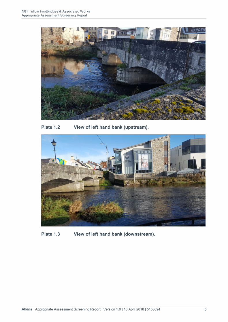
Plate 1.2 View of left hand bank (upstream).
Plate 1.3 View of left hand bank (downstream).
N81 Tullow Footbridges & Associated Works Appropriate Assessment Screening Report
Atkins Appropriate Assessment Screening Report | Version 1.0 | 10 April 2018 | 5153094 7
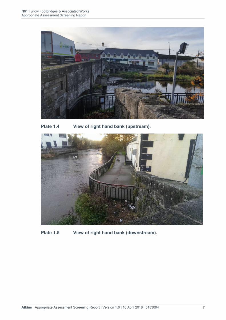
Plate 1.4 View of right hand bank (upstream).
Plate 1.5 View of right hand bank (downstream).
Legend
Proposed Site Location
0000000000000000000000000000000000000000000000000 1k1k1k1k1k1k1k1k1k1k1k1k1k1k1k1k1k1k1k1k1k1k1k1k1k1k1k1k1k1k1k1k1k1k1k1k1k1k1k1k1k1k1k1k1k1k1k1k1k0.50.50.50.50.50.50.50.50.50.50.50.50.50.50.50.50.50.50.50.50.50.50.50.50.50.50.50.50.50.50.50.50.50.50.50.50.50.50.50.50.50.50.50.50.50.50.50.50.5
Ordnance Survey Ireland Licence No. AR 0082516© Ordnance Survey Ireland and Government of Ireland
Client:
Project:
Title:
Designed/Drawn: Checked: Authorised:
Date: Date: Date:
Drawing No: Rev:
EDOT OT / ED
26/01/201726/01/2017 26/01/2017
0
Dublin - Tel: 353-1-890 8000Cork - Tel: 353 - 21- 429 0300Galway - Tel: 353 - 91 786050
Kildare County Council
N81, Tullow Foot-bridge
Site Location
1.1
N81 Tullow Footbridges & Associated Works Appropriate Assessment Screening Report
Atkins Appropriate Assessment Screening Report | Version 1.0 | 10 April 2018 | 5153094 9
2. The Appropriate Assessment Process 2.1. The Habitats Directive (Council Directive 92/43/EEC on the Conservation of
Natural Habitats and of Wild Fauna and Flora) forms the basis for the designation of Special Areas of Conservation (SACs). Similarly, Special Protection Areas (SPAs) are legislated for under the Birds Directive (Council Directive 2009/147/EEC on the Conservation of Wild Birds). The Habitats and Birds Directives transposed into Irish law by the EC (Birds and Natural Habitats) Regulations 2011 (Statutory Instrument No. 477/2011). Collectively, SACs and SPAs are referred to as the Natura 2000 network. In general terms, they are considered to be of exceptional importance in terms of rare, endangered or vulnerable habitats and species within the European Community.
2.2. Under Article 6(3) of the Habitats Directive an Appropriate Assessment must be undertaken for any plan or project that is likely to have a significant effect on the conservation objectives of a Natura 2000 site. An Appropriate Assessment is an evaluation of the potential impacts of a plan or project on the conservation objectives of a Natura 2000 site, and the development, where necessary, of mitigation or avoidance measures to preclude negative effects.
2.3. Article 6, paragraph 3 of the EC Habitats Directive 92/43/EEC (“the Habitats Directive”) states that:-
“Any plan or project not directly connected with or necessary to the management of the site but likely to have a significant effect thereon, either individually or in combination with other plans or projects, shall be subject to appropriate assessment of its implications for the site in view of the site's conservation objectives. In the light of the conclusions of the assessment of the implications for the site and subject to the provisions of paragraph 4, the competent national authorities shall agree to the plan or project only after having ascertained that it will not adversely affect the integrity of the site concerned and, if appropriate, after having obtained the opinion of the general public”.
The Stages in Appropriate Assessment
2.4. There are up to 4 stages in the Appropriate Assessment process as outlined in the European Commission Guidance document (EC, 2001). The following is a brief summary of these stages (each of which is dependent on the outcome of the previous).
Stage 1 - Screening: This stage examines the likely effects of a plan or project either alone or in combination with other projects upon a Natura 2000 Site and considers whether it can be objectively concluded that these effects will not be significant.
Stage 2 - Appropriate Assessment: In this stage, the impact of the plan or project on the integrity of a Natura 2000 site is considered with respect to the conservation objectives of the site and to its structure and function.
N81 Tullow Footbridges & Associated Works Appropriate Assessment Screening Report
Atkins Appropriate Assessment Screening Report | Version 1.0 | 10 April 2018 | 5153094 10
Stage 3 - Assessment of Alternative Solutions: Should the Appropriate Assessment determine that adverse impacts are likely upon a Natura 2000 site, this stage examines alternative ways of implementing the plan or project that, where possible, avoid these adverse impacts.
Stage 4 - Assessment where no alternative solutions exist and where adverse impacts remain: Where imperative reasons of overriding public interest (IROPI) exist, an assessment to consider whether compensatory measures will or will not effectively offset the damage to the Natura 2000 site will be necessary.
Objectives of Appropriate Assessment
2.5. The Habitats Directive promotes a hierarchy of avoidance, mitigation and compensatory measures to be addressed in the AA process5 as follows: -
1. Firstly, a plan / project should aim to avoid any negative impacts on Natura 2000 sites by identifying possible impacts early and designing the project / plan to avoid such impacts.
2. Secondly, mitigation measures should be applied during the AA process to the point where no adverse impacts on the site(s) remain.
3. Thirdly a plan / project may have to undergo an assessment of alternative solutions. Under this stage of the assessment, compensatory measures are required for any remaining adverse effects, but they are permitted only if (a) there are no alternative solutions and (b) the plan / project is required for imperative reasons of overriding public interest (the ‘IROPI test’). European case law highlights that consideration must be given to alternatives outside the plan / project boundary area in carrying out the IROPI test.
5 The AA process as outlined is based on Scott Wilson and Levett-Therivel, (2006) Appropriate Assessment of Plans. Scott Wilson, Levett-Therivel Sustainability Consultants, Treweek Environmental Consultants and Land Use Consultants.
N81 Tullow Footbridges & Associated Works Appropriate Assessment Screening Report
Atkins Appropriate Assessment Screening Report | Version 1.0 | 10 April 2018 | 5153094 11
3. Methods 3.1. The approach taken in preparing this document is broadly based on standard
methods and best practice guidance, as listed in the references in Section 6. In the preparation of this Appropriate Assessment screening report regard has been given to the: -
Council Directive 92/43/EEC of 21 May 1992 on the conservation of natural habitats and of wild flora and fauna (Habitats Directive).
Statutory Instrument No. 477/2011 — European Communities (Birds and Natural Habitats) Regulations 2011.
3.2. The aim of this screening report is to provide supporting information to assist the competent authority, in this case Carlow County Council, to carry out an appropriate assessment screening in respect of the proposed design and construction of pedestrian footways / boardwalks.
Desk Study
3.3. A desk study was carried out to collate information available on Natura 2000 sites in the vicinity of the proposed works on Slaney Bridge. The location of the proposed development and the surrounding area was viewed using Google Earth, Google maps6 and Bing maps7. Carlow County Council website was accessed for information on other plans and projects that may act in combination with the proposed works at Slaney Bridge.
3.4. The National Parks and Wildlife Service (NPWS) and National Biodiversity Data Centre (NBDC) online databases were consulted concerning Natura 2000 sites in the vicinity of the proposed development. A data request was also submitted to NPWS on 18th January 2017 and a response was received on the 26th January 2017. The photos of the location of Slaney Bridge, taken during engineering site visits, were also reviewed during the desk study.
Screening Process
3.5. The AA screening process is as follows: -
Identify Natura 2000 sites, within the potential zone of influence of the proposed development.
Identify the features of interest of the Natura 2000 sites and review their conservation objectives.
Review whether there is potential for the features of interest to be affected by the proposed works based on information such as the vulnerabilities of the Natura 2000 site, proximity to the development and the nature and scale of the works associated with the proposed development.
6 https://www.google.ie/maps
7 http://www.bing.com/maps/

N81 Tullow Footbridges & Associated Works Appropriate Assessment Screening Report
Atkins Appropriate Assessment Screening Report | Version 1.0 | 10 April 2018 | 5153094 12
Consider the likelihood of potential impacts occurring based on the information collated and professional judgement.
Consider the likelihood of cumulative impacts arising from the proposed development in-combination with other plans and projects.
Identify the likelihood of significant effects on Natura 2000 sites occurring as a result of the proposed works.
N81 Tullow Footbridges & Associated Works Appropriate Assessment Screening Report
Atkins Appropriate Assessment Screening Report | Version 1.0 | 10 April 2018 | 5153094 13
Statement of Authority
3.6. The appropriate assessment screening report was prepared by Elaine Dromey MCIEEM. Dr. Paul O’Donoghue MCIEEM CEnv also input to the report and carried out the technical review.
3.7. Elaine Dromey has worked in ecological consultancy since 2000 in both the UK and Ireland. She holds a BSc in Earth Science from University College Cork and an MSc in Vegetation Survey and Assessment from the University of Reading, UK. She is a full member of the Chartered Institute of Ecology and Environmental Management. Elaine has worked as a senior ecologist and the project lead on a number of projects requiring the preparation of Appropriate Assessment reports. Elaine has prepared AA screening reports and Natura Impact Statements (NIS) for a range of different projects and plans including large wind farms, single turbine developments, power lines, quarry developments, anaerobic digesters, industrial development and single small developments. Elaine has also prepared and input to the preparation of AA screening reports and Natura Impact Reports (NIR) for County Development Plans (CDP), Sustainable Energy Action Plans (SEAP) and Masterplans. Elaine prepared this AA screening report.
3.8. Paul O’Donoghue has a BSc (Zoology), MSc (Behavioural Ecology) and a PhD in avian ecology and genetics. His is a chartered member of the Society for the Environment (CEnv) and a full member of the Chartered Institute of Ecology and Environmental Management (MCIEEM). Paul is a Principal Ecologist based in Atkins office in Cork; with over 16 years’ experience in ecology; including extensive experience in the preparation of Habitat Directive Assessments / Natura Impact Statements (i.e. Appropriate Assessment under Article 6(3) of the EU Habitats Directive).

N81 Tullow Footbridges & Associated Works Appropriate Assessment Screening Report
Atkins Appropriate Assessment Screening Report | Version 1.0 | 10 April 2018 | 5153094 14
4. Appropriate Assessment Screening 4.1. A distance of 15 km is currently recommended in the case of plans, as a potential
zone of influence, and this distance is derived from Irish and UK guidance (Scott Wilson et al., 2006). For projects, the distance could be much less than 15km, and in some cases less than 100m, but National Parks and Wildlife Service guidance (DoEHLG, 2009) advises that this must be evaluated on a case-by-case basis with reference to the nature, size and location of the project, the sensitivities of the ecological receptors, and the potential for in-combination effects8.
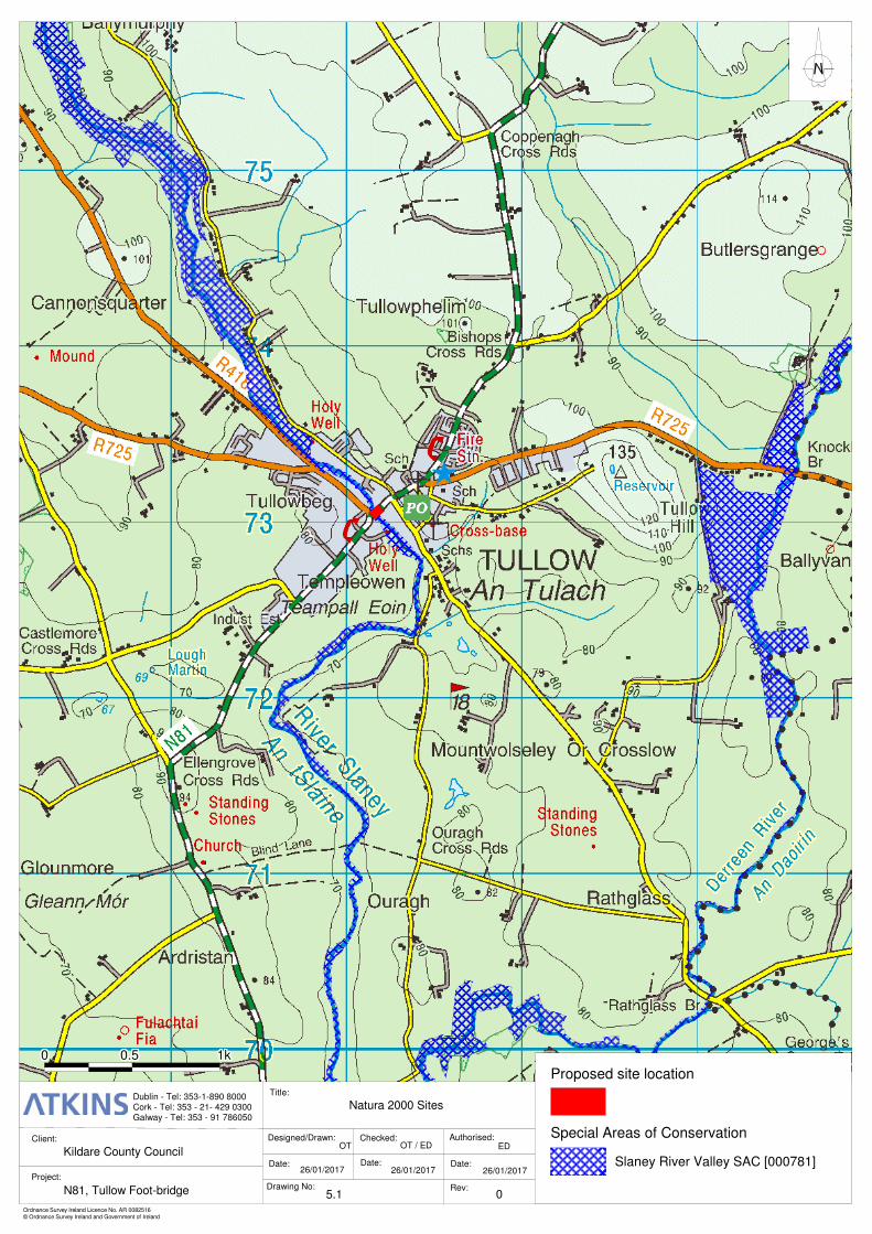
Identification of Natura 2000 Sites
4.2. The existing N81 Slaney Bridge crosses over the Slaney River SAC and this Natura 2000 site is clearly within the potential zone of influence of the project.
4.3. The next closest Natura 2000 site is the River Barrow and River Nore SAC (002162) approximately 15 km to the west of Tullow. This Natura 2000 site is not within the potential zone of influence of the project given the localised nature of the project and associated work; the distance between Slaney Bridge and the SAC and the location of the project in a different river catchment.
4.4. The Blackstairs Mountains SAC (000770) is approximately 17 km south of Slaney Bridge (measured in a straight line) and given the localised nature of the project is sufficiently distant to be considered outside the potential zone of influence.
4.5. The potential zone of influence of the project is therefore limited to the immediate area of the bridge and downstream within the Slaney River Valley SAC. All other Natura 2000 sites can be excluded for the potential zone of influence of the project due to localised nature of the project, location of the project within different river catchments and the distance between the project and the Natura 2000 sites.
Brief Description of Natura 2000 Sites
4.6. A description of Slaney River Valley SAC (000781), taken from the supporting information available on the NPWS website9 is provided below.
“This site comprises the freshwater stretches of the River Slaney as far as the Wicklow Mountains; a number of tributaries, the larger of which include the Bann, Boro, Glasha, Clody, Derry, Derreen, Douglas and Carrigower Rivers; the estuary at Ferrycarrig; and Wexford Harbour. The site flows through the Counties of Wicklow, Wexford and Carlow. Towns along the site but not within it include Baltinglass, Hacketstown, Tinahely, Tullow, Bunclody, Camolin, Enniscorthy and Wexford.
Floating river vegetation is found along much of the freshwater stretches within the site. Good examples of wet woodland are found associated with Macmine
8 DoEHLG, 2009. (2009). Appropriate Assessment of Plans and Projects in Ireland. Guidance for Planning Authorities. Department of Environment, Heritage and Local Government, Dublin, Ireland. 9 Taken from the supporting information such as the site synopsis and Natura 2000 Data Forms available for each Natura 2000 site at http://www.npws.ie/protectedsites
N81 Tullow Footbridges & Associated Works Appropriate Assessment Screening Report
Atkins Appropriate Assessment Screening Report | Version 1.0 | 10 April 2018 | 5153094 15
marshes, along the banks of the Slaney and its tributaries, and within reedswamps. Old oak woodlands are best represented at Tomnafinnoge, though patches are present throughout the site. Below Enniscorthy there are several areas of woodland with a mixed canopy of oak, Beech, Sycamore (Acer pseudoplatanus), Ash and generally a good diverse ground flora. Near the mouth of the river at Ferrycarrig is a steep south facing slope covered with oak woodland. North of Bunclody, the river valley still has a number of dry woodlands though these have mostly been managed by the estates, with the introduction of Beech and occasional conifers
At the southern end of the site, the Red Data Book species Yellow Archangel (Lamiastrum galeobdolon) occurs. Three more Red Data Book species have also been recorded from the site: Blue Fleabane (Erigeron acer), Basil Thyme (Acinos arvensis), and Small Cudweed (Logfia minima). Basil Thyme and Small Cudweed are protected under the Flora (Protection) Order, 2015. A nationally rare species, Summer Snowflake (Leucojum aestivum), is also found within the site.
The site is considered to contain a very good example of the extreme upper reaches of an estuary. Tidal reedbeds with wet woodland are present in places. The reedswamp is extensive around Macmine, where the river widens and there are islands with swamp and marsh vegetation. Further south of Macmine are expanses of intertidal mudflats and sandflats and shingle shore often fringed with a narrow band of saltmarsh and brackish vegetation. Narrow shingle beaches up to 10 m wide occur in places along the river banks and are exposed at low tide.
The salt marsh at Castlebridge is dominated by Mediterranean salt meadows. The marsh is perched on ground that is bisected by a number of channels which extend a considerable distance inland. The site is notable for the presence of Borrer’s Saltmarsh-grass (Puccinnellia fasciculata), which is found along the cattle tracks of the marsh. Another notable feature is the transition from saltmarsh to brackish marsh communities, which is quite extensive and diverse. The marsh is generally in good condition. A significant area of Atlantic salt meadows also occurs at Castlebridge.
Wexford Harbour is an extensive, shallow estuary which dries out considerably at low tide exposing large expanses of mudflats and sandflats. Within these habitats four biological community complexes have been recorded: estuarine muds dominated by polychaetes and crustaceans community complex; sand dominated by polychaetes community complex; mixed sediment community complex; and fine sand with Spiophanes bombyx community complex.
The site supports populations of several species listed on Annex II of the E.U. Habitats Directive, including Sea Lamprey, River Lamprey and Brook Lamprey, Otter, Salmon, small numbers of Freshwater Pearl Mussel, and in the tidal stretches, Twaite Shad. A survey of the Derreen River in 1995 estimated the population of Freshwater Pearl Mussel at about 3,000 individuals.
The Slaney is primarily a spring salmon fishery and is regarded as one of the top rivers in Ireland for early spring fishing. The upper Slaney and tributary headwaters are very important for spawning. The site supports regionally

N81 Tullow Footbridges & Associated Works Appropriate Assessment Screening Report
Atkins Appropriate Assessment Screening Report | Version 1.0 | 10 April 2018 | 5153094 16
significant numbers of Common Seal. This Annex II species occurs year-round in Wexford Harbour where several sandbanks are used for breeding, moulting and resting activity. The site is of high ornithological importance also, with internationally important populations of Mute Swan (300), Light-bellied Brent Goose (200), Bar-tailed Godwit (1,843) and Black-tailed Godwit (350) occurring – all figures are average peaks for the five winters, 1995/96-99/2000. There are at least a further 18 species of wintering waterfowl which occur in numbers of national importance.”
1k1k1k1k1k1k1k1k1k1k1k1k1k1k1k1k1k1k1k1k1k1k1k1k1k1k1k1k1k1k1k1k1k1k1k1k1k1k1k1k1k1k1k1k1k1k1k1k1k0.50.50.50.50.50.50.50.50.50.50.50.50.50.50.50.50.50.50.50.50.50.50.50.50.50.50.50.50.50.50.50.50.50.50.50.50.50.50.50.50.50.50.50.50.50.50.50.50.50000000000000000000000000000000000000000000000000
Ordnance Survey Ireland Licence No. AR 0082516© Ordnance Survey Ireland and Government of Ireland
Client:
Project:
Title:
Designed/Drawn: Checked: Authorised:
Date: Date: Date:
Drawing No: Rev:
EDOT OT / ED
26/01/201726/01/2017 26/01/2017
0
Dublin - Tel: 353-1-890 8000Cork - Tel: 353 - 21- 429 0300Galway - Tel: 353 - 91 786050
Kildare County Council
N81, Tullow Foot-bridge
Natura 2000 Sites
5.1
Special Areas of Conservation
Proposed site location
Slaney River Valley SAC [000781]
N81 Tullow Footbridges & Associated Works Appropriate Assessment Screening Report
Atkins Appropriate Assessment Screening Report | Version 1.0 | 10 April 2018 | 5153094 18
Conservation Objectives for the Natura 2000 sites
4.7. The Habitats Directive defines when the conservation status of the listed habitats and species is considered as favourable. The definitions it uses for this are specific to the Directive. In summary, they require that the range and areas of the listed habitats, and the range and population of the listed species, should be at least maintained at their status at the time of designation. Site‐specific conservation objectives aim to define favourable conservation conditions for a particular habitat or species at that site.
4.8. Article (1) of the Habitats Directive (92/43/EEC) describes favourable conservation status for habitats and species as follows.
4.9. Favourable conservation status of a habitat is achieved when: -
Its natural range, and area it covers within that range, are stable or increasing, and
The specific structure and functions which are necessary for its long‐term maintenance exist and are likely to continue to exist for the foreseeable future, and
The conservation status of its typical species is favourable.
4.10. The favourable conservation status of a species is achieved when: -
Population dynamics data on the species concerned indicate that it is maintaining itself on a long term basis as a viable component of its natural habitats, and
The natural range of the species is neither being reduced nor is likely to be reduced for the foreseeable future, and
There is, and will probably continue to be, a sufficiently large habitat to maintain its populations on a long‐term basis.
4.11. The conservation objectives in full for Slaney River Valley SAC can be found at https://www.npws.ie/sites/default/files/protected-sites/conservation_objectives/CO000781.pdf. These were reviewed and considered when preparing this AA screening report and can be broadly summarised as follows: -
The status of the freshwater pearl mussel (Margaritifera margaritifera) as a qualifying Annex II species for the Slaney River Valley SAC is currently under review. The outcome of this review will determine whether a site‐specific conservation objective is set for this species͘.
To restore the favourable conservation condition of Sea lamprey in the Slaney River Valley SAC, which is defined by a specific list of attributes and targets:
To restore the favourable conservation condition of Brook lamprey in the Slaney River Valley SAC, which is defined by a specific list of attributes and targets.
N81 Tullow Footbridges & Associated Works Appropriate Assessment Screening Report
Atkins Appropriate Assessment Screening Report | Version 1.0 | 10 April 2018 | 5153094 19
To restore the favourable conservation condition of River lamprey in the Slaney River Valley SAC, which is defined by a specific list of attributes and targets.
To restore the favourable conservation condition of Twaite shad in the Slaney River Valley SAC, which is defined by a specific list of attributes and targets.
To restore the favourable conservation condition of Salmon in the Slaney River Valley SAC, which is defined by a specific list of attributes and targets.
To maintain the favourable conservation condition of Estuaries in the Slaney River Valley SAC, which is defined by a specific list of attributes and targets.
To maintain the favourable conservation condition of Mudflats and sandflats not covered by seawater at low tide in the Slaney River Valley SAC, which is defined by a specific list of attributes and targets.
To restore the favourable conservation condition of Otter in the Slaney River Valley SAC, which is defined by a specific list of attributes and targets.
To maintain the favourable conservation condition of Harbour Seal in the Slaney River Valley SAC, which is defined by the following list of attributes and targets.
To maintain the favourable conservation condition of Water courses of plain to montane levels with the Ranunculion fluitantis and Callitricho‐Batrachion vegetation in the Slaney River Valley SAC, which is defined by a specific list of attributes and targets.
To restore the favourable conservation condition of old sessile oakwoods with Ilex and Blechnum in the Slaney River Valley SAC, which is defined by a specific list of attributes and targets.
To restore the favourable conservation condition of Alluvial forests with Alnus glutinosa and Fraxinus excelsior (Alno‐Padion) in the Slaney River Valley SAC, which is defined by a specific list of attributes and targets.
N81 Tullow Footbridges & Associated Works Appropriate Assessment Screening Report
Atkins Appropriate Assessment Screening Report | Version 1.0 | 10 April 2018 | 5153094 20
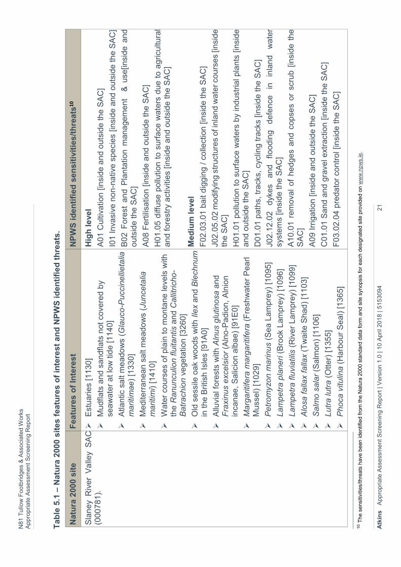
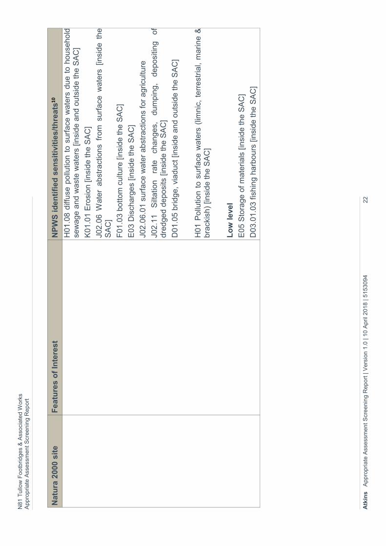
Features of Interest and Potential Threats to the Natura 2000 Sites
4.12. The Features of Interest and potential threats, as identified by NPWS, for Slaney River Valley SAC (000781), are given in Table 5.1 below. This information was obtained from the NPWS website (last accessed on 27th January 2017). Most of the threats identified by NPWS relate to damaging land uses, changes in land use, leisure activities or loss of suitable habitat to support the features of interest of the Natura 2000 sites.
4.13. The site synopsis for Slaney River Valley SAC (000781) describes the land use and management within the site as follows: -
“Agriculture is the main land use. Arable crops are important. Improved grassland and silage account for much of the remainder. The spreading of slurry and fertiliser poses a threat to the water quality of this salmonid river and to the populations of E.U. Habitats Directive Annex II animal species within it. Run-off is undoubtedly occurring, as some of the fields slope steeply directly to the river bank. In addition, cattle have access to the river bank in places. Fishing is a main tourist attraction along stretches of the Slaney and its tributaries, and there are a number of Angler Associations, some with a number of boats. Fishing stands and styles have been erected in places. Both commercial and leisure fishing takes place. There are some gravel pits along the river below Bunclody and many of these are active. There is large landfill site adjacent to the river close to Hacketstown and at Killurin. Boating, bait-digging and fishing occur in parts of Wexford Harbour. Waste water outflows, runoff from intensive agricultural enterprises, a meat factory at Clohamon, a landfill site adjacent to the river, and further industrial development upstream in Enniscorthy and in other towns could all have potential adverse impacts on the water quality unless they are carefully managed. The spread of exotic species is reducing the quality of the woodlands.”
N81
Tullo
w F
ootb
rid
ges
& A
ssocia
ted W
ork
s A
pp
rop
riate
Ass
ess
ment
Scr
een
ing R
ep
ort
Atk
ins
A
pp
rop
ria
te A
ssess
men
t S
cre
enin
g R
eport
| V
ers
ion 1
.0 | 1
0 A
pril 2
018 | 5
153094
21
Tab
le 5
.1 –
Natu
ra 2
000
sit
es
featu
res
of
inte
rest
an
d N
PW
S id
en
tifi
ed
th
rea
ts.
Natu
ra 2
000
sit
e
Fea
ture
s o
f In
tere
st
NP
WS
id
en
tifi
ed
sen
sit
ivit
ies
/th
rea
ts10
Sla
ney
Riv
er
Va
lley
SA
C
(000
781
).
Est
uaries
[1130
]
Mudfla
ts a
nd s
andflats
not
cove
red
by
sea
wa
ter
at lo
w tid
e [114
0]
Atla
ntic
salt
me
ado
ws
(Gla
uco
-Pu
ccin
elli
eta
lia
maritim
ae
) [1
330
]
Medite
rran
ean
salt
meado
ws
(Jun
ceta
lia
maritim
i) [14
10
]
Wate
r co
urs
es
of pla
in to
mon
tane le
vels
with
th
e R
anu
ncu
lion
flu
itantis
an
d C
alli
tric
ho
-B
atr
ach
ion
vegeta
tion [32
60]
Old
sess
ile o
ak
woo
ds
with
Ile
x a
nd B
lech
num
in
the B
ritis
h I
sles
[91A
0]
Allu
via
l fore
sts
with
Aln
us
glu
tino
sa a
nd
Fra
xinu
s e
xcels
ior
(Aln
o-P
adio
n, A
lnio
n
inca
nae,
Salic
ion
alb
ae)
[91E
0]
Marg
aritif
era
marg
aritif
era
(F
resh
wate
r P
ea
rl
Muss
el) [1
029]
Pe
trom
yzo
n m
arinu
s (
Sea
Lam
pre
y) [10
95]
La
mpe
tra p
lane
ri (
Bro
ok
Lam
pre
y) [10
96]
La
mpe
tra f
luvi
atilis
(R
iver
Lam
pre
y) [10
99]
Alo
sa falla
x fa
llax
(Tw
aite
Shad
) [1
103]
Sa
lmo s
ala
r (S
alm
on)
[11
06]
Lu
tra lu
tra
(O
tter)
[1
355]
Ph
oca
vitu
lina (
Harb
our
Se
al) [1365]
Hig
h le
vel
A0
1 C
ulti
vation [in
side a
nd o
uts
ide the
SA
C]
I01 Inva
sive
no
n-n
ativ
e s
pe
cies
[insi
de a
nd
outs
ide
th
e S
AC
]
B0
2 F
ore
st a
nd
Pla
nta
tion
mana
gem
ent
& u
se[in
side a
nd
ou
tsid
e t
he S
AC
]
A0
8 F
ert
ilisa
tion
[in
side a
nd o
uts
ide the S
AC
]
H01
.05
diff
use
pollu
tion t
o s
urf
ace
wate
rs d
ue t
o a
gricu
ltura
l an
d fore
stry
act
iviti
es
[insi
de
an
d o
uts
ide
the
SA
C]
Me
diu
m le
vel
F02
.03.0
1 b
ait
dig
gin
g /
co
llect
ion [
insi
de the S
AC
]
J02
.05.0
2 m
odifyi
ng s
truct
ure
s of i
nla
nd w
ate
r co
urs
es
[insi
de
the S
AC
]
H01
.01
pollu
tion t
o s
urf
ace
wate
rs b
y in
dust
rial pla
nts
[in
side
an
d o
uts
ide the
SA
C]
D01
.01
path
s, tra
cks,
cyc
ling tra
cks
[insi
de
the S
AC
]
J02
.12.0
2
dyk
es
and
floodin
g
defe
nce
in
in
land
wate
r sy
ste
ms
[insi
de the S
AC
]
A1
0.0
1 r
em
ova
l of
hedges
an
d c
opse
s or
scru
b [
insi
de t
he
SA
C]
A0
9 I
rrig
ation
[in
sid
e a
nd o
uts
ide the S
AC
]
C01
.01
Sand
and g
rave
l ext
ract
ion [
insi
de
the S
AC
]
F0
3.0
2.0
4 p
reda
tor
contr
ol [
insi
de t
he S
AC
]
10 T
he
se
nsi
tiviti
es/
thre
ats
have
be
en
ide
ntif
ied f
rom
th
e N
atu
ra 2
00
0 s
tan
dard
da
ta fo
rm a
nd
site
syn
op
sis
for
ea
ch d
esi
gn
ate
d s
ite p
rovi
de
d o
n w
ww
.np
ws.ie.
N81
Tullo
w F
ootb
rid
ges
& A
ssocia
ted W
ork
s A
pp
rop
riate
Ass
ess
ment
Scr
een
ing R
ep
ort
Atk
ins
A
pp
rop
ria
te A
ssess
men
t S
cre
enin
g R
eport
| V
ers
ion 1
.0 | 1
0 A
pril 2
018 | 5
153094
22
Natu
ra 2
000
sit
e
Fea
ture
s o
f In
tere
st
NP
WS
id
en
tifi
ed
sen
sit
ivit
ies
/th
rea
ts10
H01
.08
diff
use
pollu
tion t
o s
urf
ace
wate
rs d
ue t
o h
ou
seho
ld
sew
age a
nd
wast
e w
ate
rs [in
side
and o
uts
ide th
e S
AC
]
K0
1.0
1 E
rosi
on
[in
sid
e th
e S
AC
]
J02
.06 W
ate
r ab
stra
ctio
ns
from
surf
ace
wate
rs [
insi
de t
he
SA
C]
F01
.03
bott
om
cultu
re [in
sid
e the
SA
C]
E0
3 D
isch
arg
es
[insi
de th
e S
AC
]
J02
.06.0
1 s
urf
ace
wate
r ab
stra
ctio
ns
for
agricu
lture
J02
.11
Silt
ation
rate
ch
anges,
dum
pin
g,
depo
sitin
g
of
dre
dged
de
posi
ts [
insi
de
the
SA
C]
D01
.05
bridge,
viad
uct
[in
side
an
d o
uts
ide
the S
AC
]
H01
Po
llution t
o s
urf
ace
wate
rs (
limn
ic,
terr
est
rial,
marine &
bra
ckis
h)
[insi
de the S
AC
]
Lo
w level
E0
5 S
tora
ge o
f m
ate
rials
[in
side th
e S
AC
]
D03
.01
.03 f
ishin
g h
arb
ou
rs [in
side t
he S
AC
]
N81 Tullow Footbridges & Associated Works Appropriate Assessment Screening Report
Atkins Appropriate Assessment Screening Report | Version 1.0 | 10 April 2018 | 5153094 23
Likelihood of Potential Impacts on Natura 2000 Sites
4.14. The available information on Slaney River Valley SAC was reviewed to establish whether or not the proposed works at Slaney Bridge are likely to have a significant effect on the conservation objectives of the SAC. The likelihood of impacts on the features of interest of the Slaney River Valley SAC identified in this report is based on information collated from the desk study, site photographs from engineering site visits and other available existing information.
4.15. The likelihood of impacts occurring are established in light of the type and scale of the proposed development, the location of the proposed development with respect to Natura 2000 sites and the features of interest and conservation objectives of the Natura 2000 sites.
4.16. This screening report is prepared following the Cause – Pathway – Effect model11.
The potential impacts are summarised into the following categories for screening purposes.
Direct impacts refer to habitat loss or fragmentation arising from land-take requirements for development or agricultural purposes. Direct impacts can be as a result of a change in land use or management, such as the removal of agricultural practices that prevent scrub encroachment. In the case of bridge works, likely direct impacts due to construction works could include loss and fragmentation of habitat.
Indirect and secondary impacts do not have a straight-line route between cause and effect. It is potentially more challenging to ensure that all the possible indirect impacts of the plan/project – in combination with other plans and projects - have been established. These can arise, for example, when a development alters the hydrology of a catchment area, which in turn affects the movement of groundwater to a site and the qualifying interests that rely on the maintenance of water levels. Deterioration in water quality can occur as an indirect consequence of development, which in turn changes the aquatic environment and reduces its capacity to support certain plants and animals. The introduction of invasive species can also be defined as an indirect impact. Disturbance to fauna can arise directly through the loss of habitat (e.g. displacement of roosting bats) or indirectly through noise, vibration and increased activity associated with construction and operation.
Identification of potential impacts on Natura 2000 sites
4.17. The project involves the design and construction of pedestrian footways / boardwalks adjacent to the existing N81 Slaney Bridge. The proposed pedestrian footways / boardwalks are located above the Slaney River Valley SAC (000781). The proposed works will not give rise to any of the threats identified in Table 5.1 above (design drawings are shown in Appendix B).
11 The approach is broadly based on information contained in Cooper, L. M. (2004), Guidelines for Cumulative Effects Assessment in SEA of Plans, EPMG Occasional Paper 04/LMC/CEA, Imperial College London.
N81 Tullow Footbridges & Associated Works Appropriate Assessment Screening Report
Atkins Appropriate Assessment Screening Report | Version 1.0 | 10 April 2018 | 5153094 24
4.18. During the construction phase of the proposed project, the potential impacts posed to the River Slaney SAC are via land and air pathways and surface water pathways. The proposed project poses a potential impact via land and air pathways in the form of direct disturbance to the riverbed and riparian corridor. This may impact upon designated species of the SAC as a result of habitat loss through degradation of the river substrate, direct mortalities or displacement of species. However, given the design measures of the proposed project outlined in paragraphs 1.14 and 1.15, which detail that there shall be no in-stream works within the natural riverbed of the River Slaney, impacts via land and air pathways are not anticipated as a result.
4.19. Potential sources of impact such as silt laden runoff, hydrocarbon spillages and cement or other building materials entering the River Slaney via surface water pathways have the potential to affect the water quality of the River Slaney and in turn may indirectly affect surface water dependent species of the SAC. The implementation of best practice construction methods are an intrinsic part of the proposed project and were considered as an underlying element of the project during the design process. These best practice measures shall be included in contract documents and in the contractor’s method statements. Thus, impacts via surface water pathways are not anticipated during the construction phase of the project.
4.20. There is no potential for impact on the Slaney River Valley SAC arising from the proposed project once construction is complete and the footways / boardwalks are in place. Table 5.2 presents an overview of the potential for impacts on the features of interest of the SAC.
Direct impacts
4.21. There will be no direct impacts on features of interest of the Slaney River Valley
SAC as the site investigations and construction of the footways / boardwalks will
not result in the loss or fragmentation of any habitats listed as features of interest
of the Slaney River Valley SAC. There will be no barrier to passage of fauna, such
as fish and otter, listed as features of interest of the Natura 2000 site. As noted in
paragraph 1.13, a single core was bored in the riverbed close to the slip way and
three into the bridge structure; however the scale and duration of works would not
affect the Slaney River Valley SAC.
Indirect impacts
4.22. The bridge currently has limited public lighting in place. The proposed redesign of
public lighting at the bridge is illustrated on design drawing 5153094-HTR-DR-
8013 included in Appendix B. Otter are increasingly being recorded in urban areas
with associated public lighting (e.g. Cork City; Sleeman and Moore, 2005;
Kilkenny, pers obs, etc.). It is therefore not anticipated that the redesign of lighting
will result in indirect effects on features of interest of the Slaney River Valley SAC
such as otter.
N81 Tullow Footbridges & Associated Works Appropriate Assessment Screening Report
Atkins Appropriate Assessment Screening Report | Version 1.0 | 10 April 2018 | 5153094 25
4.23. The construction works at the bridge have the potential to locally disturb otter,
which may result in some temporary displacement of the species from the area.
The site investigation works are anticipated to last 1 -2 weeks and the construction
of the footways / walkways are anticipated to be completed within 6 months. While
some of the site investigation works will be carried out at night the majority of work
will be during the daytime. As otter are considered to be primarily a nocturnal
species (NRA, 2009) the majority of the work will not result in any disturbance.
The bridge itself does not offer suitable sites for otter to holt or shelter. Passage
of otter upstream / downstream will not be impeded by the proposed works. The
potential for impact on otter is therefore extremely low.
4.24. There is no potential for impact on other features of interest of the Slaney River
Valley SAC as detailed in Table 5.2 below.
N81 Tullow Footbridges & Associated Works Appropriate Assessment Screening Report
Atkins Appropriate Assessment Screening Report | Version 1.0 | 10 April 2018 | 5153094 26
Table 4.2 – Potential for Impacts on Features of Interest of Slaney River Valley SAC (000781).
Features of Interest Potential for impacts
Habitats
Estuaries [1130] There is no potential for impact on this habitat as it is not present at the location of Slaney Bridge. This habitat is only present within the coastal stretches of the SAC.
Mudflats and sandflats not covered by seawater at low tide [1140]
There is no potential for impact on this habitat as it is not present at the location of Slaney Bridge. This habitat is only present within the coastal stretches of the SAC.
Atlantic salt meadows (Glauco-Puccinellietalia maritimae) [1330]
There is no potential for impact on this habitat as it is not present at the location of Slaney Bridge. This habitat is only present within the coastal stretches of the SAC.
Mediterranean salt meadows (Juncetalia maritimi) [1410]
There is no potential for impact on this habitat as it is not present at the location of Slaney Bridge. This habitat is only present within the coastal stretches of the SAC.
Water courses of plain to montane levels with the Ranunculion fluitantis and Callitricho-Batrachion vegetation [3260]
This habitat is not present at the location of Slaney Bridge and as the works will be contained to the immediate area of the bridge there is no potential for impact on this habitat downstream.
Old sessile oak woods with Ilex and Blechnum in the British Isles [91A0]
This habitat is not present at the location of Slaney Bridge and there is no potential for impact further downstream due to the localised nature of the project.
Alluvial forests with Alnus glutinosa and Fraxinus excelsior (Alno-Padion, Alnion incanae, Salicion albae) [91E0]
This habitat is not present at the location of Slaney Bridge and there is no potential for impact further downstream due to the localised nature of the project.
Species
Margaritifera margaritifera (Freshwater Pearl Mussel) [1029]
The closest known population of this species is approximately 4.2 km downstream. Given the localised nature of the project and that there shall be no in-stream works within the natural riverbed of the River Slaney, the conservation objectives of this species are unlikely to be negatively impacted by the proposed works.
N81 Tullow Footbridges & Associated Works Appropriate Assessment Screening Report
Atkins Appropriate Assessment Screening Report | Version 1.0 | 10 April 2018 | 5153094 27
Features of Interest Potential for impacts
The appointed contractor will, however, be required to adhere to on-site best practice and prevent escapement of silt laden waters from the works area to the river generally (note in particular; IFI, 201612).
Strict adherence to biosecurity measures will also be required.
Petromyzon marinus (Sea Lamprey) [1095]
Lampetra planeri (Brook Lamprey) [1096]
Lampetra fluviatilis (River Lamprey) [1099]
Given the localised nature of the project and that there shall be no in-stream works within the natural riverbed of the River Slaney, it is unlikely that the conservation objectives of these species would be negatively impacted by the proposed works.
The appointed contractor will, however, be required to adhere to on-site best practice and prevent escapement of silt laden waters from the works area to the river generally (note in particular; IFI, 2016).
Strict adherence to biosecurity measures will also be required.
Alosa fallax fallax (Twaite Shad) [1103]
Salmo salar (Salmon) [1106]
Given the localised nature of the project and that there shall be no in-stream works within the natural riverbed of the River Slaney, it is unlikely that the conservation objectives of these species would be negatively impacted by the proposed works.
The appointed contractor will, however, be required to adhere to on-site best practice and prevent escapement of silt laden waters from the works area to the river generally (note in particular; IFI, 2016).
Strict adherence to biosecurity measures will also be required.
Lutra lutra (Otter) [1355] The habitat at the location of the bridge is not suitable to support otter breeding or resting places.
Otter is likely to use the Slaney River at this point primarily for commuting and / or feeding.
The bridge currently has limited public lighting in place. The proposed redesign of public lighting at the bridge is illustrated on design drawing
12 Inland Fisheries Ireland, IFI (2016). Guidelines on protection of fisheries during construction works in and adjacent to waters.
N81 Tullow Footbridges & Associated Works Appropriate Assessment Screening Report
Atkins Appropriate Assessment Screening Report | Version 1.0 | 10 April 2018 | 5153094 28
Features of Interest Potential for impacts
5153094-HTR-DR-8013 included in Appendix B. Otter are increasingly being recorded in urban areas with associated public lighting (e.g. Cork City; Sleeman and Moore, 2005; Kilkenny, pers obs, etc.). It is therefore not anticipated that the redesign of lighting will result in indirect effects on features of interest of the Slaney River Valley SAC such as otter.
The proposed project does not aim to increase traffic volumes in the vicinity of the R418/ N81 junction and the Slaney Bridge. Therefore, disturbance impacts to otter during the operation of the project are not anticipated.
Phoca vitulina (Harbour Seal) [1365]
This species does not occur at Slaney Bridge as it is a marine species found year-round in Wexford Harbour. There is no potential for impact on this species as it located at least 60 km to the south of Tullow.
N81 Tullow Footbridges & Associated Works Appropriate Assessment Screening Report
Atkins Appropriate Assessment Screening Report | Version 1.0 | 10 April 2018 | 5153094 29
Cumulative impacts
4.25. While there is some potential for localised day time disturbance to otter using the River Slaney, it is considered that it would not result in a significant effect on the otter population of Slaney River Valley SAC (000781) as a result of the proposed site investigations and construction of the footbridges.
4.26. The following plans and projects were reviewed when considering in-combination effects: -
Carlow County Development Plan 2015 – 2021.
Tullow Draft Local Area Plan 2016-2022.
Planning applications within the last 5 years in the immediate vicinity of Slaney Bridge.
4.27. There are no objectives within either the Carlow County Development Plan or the Tullow Local Area Plan that could act in-combination with the proposed site investigations and construction works to give rise to effects on otter.
4.28. There are no planning applications within the immediate vicinity of Slaney Bridge in the last five years. Planning applications within the wider Tullow town area have been largely been for new dwellings, extension to new dwellings, change of use of buildings and retention applications for dwellings or extension to dwellings. The planning applications reviewed are not considered likely to give rise to impacts that could act in-combination with the potential impacts of the proposed site investigations and construction works to give rise to effects on otter. In-combination effects are therefore not considered likely to occur.
N81 Tullow Footbridges & Associated Works Appropriate Assessment Screening Report
Atkins Appropriate Assessment Screening Report | Version 1.0 | 10 April 2018 | 5153094 30
Likelihood of Significant Effects on Natura 2000 Sites
4.30. The proposed project has the potential to locally disturb otter, which may result in some temporary day time displacement of the species from the area. However, such temporary and localised impacts within an urban area are not likely to impact on the conservation status of the otter population within the Slaney River Valley SAC. No other direct or indirect impacts on habitats or species for which the Slaney River Valley SAC has been designated are predicted, due to the implementation of project design measures and best practice methods.
4.31. It is considered that any potential for impact on otter is slight and that there is no likelihood of significant effects on this Natura 2000 site either alone or in-combination with other plans and projects.
Consideration of Findings
4.32. This screening report for Appropriate Assessment, based on the best available scientific information, shows that the proposed project, including site investigations and construction works, poses no likely significant risk of effects on Slaney River Valley SAC (000781).
4.33. It is considered that the proposed project does not require progression to the second stage of Appropriate Assessment.
4.34. Based on this conclusion, we submit that the competent authority can determine that an appropriate assessment is not required, as it can be excluded on the basis of objective scientific information, that the proposed project, individually or in combination with other plans or projects, will not have a significant effect on any European sites in light of their conservation objectives.
N81 Tullow Footbridges & Associated Works Appropriate Assessment Screening Report
Atkins Appropriate Assessment Screening Report | Version 1.0 | 10 April 2018 | 5153094 31
5. Findings of No Significant Impacts
1. Description of the project or plan
Location Tullow, Co. Carlow
Distance from designated site
Bridge over the River Slaney, which is within the
Slaney River Valley SAC (002162)
The next nearest Natura 2000 site is the Blackstairs Mountains SAC (000770), which is located ca. 17km south of Slaney Bridge. This is considered outside the zone of potential impact and is screened out from further consideration.
Name and location of Natura site(s)
Slaney River Valley SAC (002162) (see Figure 2.1)
Brief description of the project or plan
See paragraphs 1.6 – 1.17 (& Plates 1.1-1.5); see also Design Drawings in Appendix B.
Is the project or plan directly connected with or necessary to the site management for nature conservation?
No
Are there other projects or plans that together with the project or plan being assessed could affect the site?
The following plans and projects were reviewed
when considering in-combination effects: -
Carlow County Development Plan, 2015 – 2021.
Tullow Draft Local Area Plan, 2016-2022.
Planning applications within the last 5 years in
the immediate vicinity of Slaney Bridge.
There are no objectives within either the Carlow
County Development Plan or the Tullow Local Area
Plan that could act in-combination with the proposed
site investigations and construction works to give
rise to effects on otter.
There are no planning applications within the immediate vicinity of Slaney Bridge in the last five years. Planning applications within the wider Tullow town area have been largely been for new dwellings, extension to new dwellings, change of use of buildings and retention applications for dwellings or extension to dwellings. The planning applications reviewed are not considered likely to give rise to impacts that could act in-combination with the potential impacts of the proposed site investigations and construction works to give rise to effects on
N81 Tullow Footbridges & Associated Works Appropriate Assessment Screening Report
Atkins Appropriate Assessment Screening Report | Version 1.0 | 10 April 2018 | 5153094 32
1. Description of the project or plan
otter. In-combination effects are therefore not considered likely to occur.
1. Brief Description of the Natura 2000 site.
Name Slaney River Valley SAC (002162) (see Figure 2.1)
Site Designation status SAC
Qualifying Interests Estuaries [1130]
Mudflats and sandflats not covered by
seawater at low tide [1140]
Atlantic salt meadows (Glauco-Puccinellietalia
maritimae) [1330]
Mediterranean salt meadows (Juncetalia
maritimi) [1410]
Water courses of plain to montane levels with
the Ranunculion fluitantis and Callitricho-
Batrachion vegetation [3260]
Old sessile oak woods with Ilex and Blechnum
in the British Isles [91A0]
Alluvial forests with Alnus glutinosa and
Fraxinus excelsior (Alno-Padion, Alnion
incanae, Salicion albae) [91E0]
Margaritifera margaritifera (Freshwater Pearl
Mussel) [1029]
Petromyzon marinus (Sea Lamprey) [1095]
Lampetra planeri (Brook Lamprey) [1096]
Lampetra fluviatilis (River Lamprey) [1099]
Alosa fallax fallax (Twaite Shad) [1103]
Salmo salar (Salmon) [1106]
Lutra lutra (Otter) [1355]
Phoca vitulina (Harbour Seal) [1365]
Unit Size 6020.48 ha (56.12% marine area)
N81 Tullow Footbridges & Associated Works Appropriate Assessment Screening Report
Atkins Appropriate Assessment Screening Report | Version 1.0 | 10 April 2018 | 5153094 33
2. Data collected to carry out the assessment.
Who carried out the assessment
Sources of data Level of assessment completed
Where can the full results of the assessments be accessed and viewed?
The AA screening report was prepared by Atkins Ecology Cork to inform the AA screening carried out by the competent authority.
Desktop assessment and literature review; including data and published material from National Parks and Wildlife Service; as well as records hosted by National Biodiversity Data Centre (www.nbdc.ie).
Site information including photographs from the project engineers; consultation with project engineers.
NPWS data request; received on 26th January 2017.
Carlow County Council Website.
Screening ATKINS, Unit 2B, 2200 Cork Airport Business Park, Cork
3. Assessment of significance of effects.
Describe how the project (either alone or in combination with other plans or projects) is likely to affect the Natura 2000 site.
The project has the potential to impact otter through disturbance during the site investigations and construction works. The disturbance could cause temporary displacement of the species.
Explain why the effects are not considered significant
The site investigations and construction works at the bridge have the potential to locally disturb otter, which may result in some temporary displacement of the species from the area. However, such temporary and localised impacts within an urban area are not likely to impact on the conservation status of the otter population within the Slaney River Valley SAC. No other direct or indirect impacts on habitats or species for which the Slaney River Valley SAC has been
N81 Tullow Footbridges & Associated Works Appropriate Assessment Screening Report
Atkins Appropriate Assessment Screening Report | Version 1.0 | 10 April 2018 | 5153094 34
designated are predicted, given the implementation of project design measures and best practice methods.
List the Agencies consulted
Formal consultation with NPWS via the Development Applications Unit (Department of Arts, Heritage & the Gaeltacht) has not been undertaken at this time. The Stage 1 AA Screening will, however, be circulated to statutory consultee’s as part of the Application for Part 8 planning (i.e. under section 82(3) of the Planning Act.
Response to Consultation n/a
N81 Tullow Footbridges & Associated Works Appropriate Assessment Screening Report
Atkins Appropriate Assessment Screening Report | Version 1.0 | 10 April 2018 | 5153094 35
6. References
Cooper, L. M. (2004). Guidelines for Cumulative Effects Assessment in SEA of Plans, EPMG Occasional Paper 04/LMC/CEA, Imperial College London.
DoEHLG (2009). Appropriate Assessment of Plans and Projects in Ireland: Guidance for Planning Authorities. National Parks and Wildlife Service, Department of the Environment, Heritage and Local Government. Dublin.
CIRIA (2015). Environmental good practice on site guide (fourth edition). Published by CIRIA, Griffin Court, 15 Long Lane, London, EC1A 9PN, UK
European Commission (2001). Assessment of Plans and Projects significantly affecting Natura 2000 Sites: Methodological guidance on the provisions of Article 6(3) and (4) of the Habitats Directive 92/43/EEC.
European Commission (2000). Managing Natura 2000 Sites: The Provisions of Article 6 of the ‘Habitats Directive’ 92/43/EEC.
European Union Habitats Directive, (1992). Council Directives 92/43/EEC of 21 May 1992 on the conservation of natural habitats and of wild fauna and flora.
Inland Fisheries Ireland (2016). Guidelines on protection of fisheries during construction works in and adjacent to waters. Published by Inland Fisheries Ireland, 3044 Lake Drive, Citywest Business Campus, Dublin, D24 Y265.
NPWS (2015). Site synopsis for Slaney River Valley SAC 000781. Department of Arts, Heritage and the Gaeltacht.
NPWS (2011) Conservation Objectives: Slaney River Valley SAC 000781. Version 1.0. National Parks and Wildlife Service, Department of Arts, Heritage and the Gaeltacht.
NPWS (2015). Natura 2000 standard data form for Slaney River Valley SAC 000781. Department of Arts, Heritage and the Gaeltacht.
National Roads Authority (2009). Ecological Surveying Techniques for Protected Flora and Fauna during the Planning of National Road Schemes.
Reid, N., Hayden, B., Lundy, M.G., Pietravalle, S., McDonald, R.A. & Montgomery, W.I. (2013) National Otter Survey of Ireland 2010/12. Irish Wildlife Manuals No. 76. National Parks and Wildlife Service, Department of Arts, Heritage and the Gaeltacht, Dublin, Ireland.
Scott Wilson and Levett-Therivel, (2006). Appropriate Assessment of Plans. Scott Wilson, Levett-Therivel Sustainability Consultants, Treweek Environmental Consultants and Land Use Consultants.
N81 Tullow Footbridges & Associated Works Appropriate Assessment Screening Report
Atkins Appropriate Assessment Screening Report | Version 1.0 | 10 April 2018 | 5153094 36
Sleeman, P. and Moore, P.G. (2005). Otters Lutra lutra in Cork City. Ir. Nat. J. 28(2): 73-79.
Websites
www.npws.ie (last accessed 24th January 2017)
http://maps.biodiversityireland.ie/#/Map (Last accessed 30th January 2017)
http://www.carlow.ie/planning-enquiry (Last accessed 30th January 2017)

Appendices
N81 Tullow Footbridges & Associated Works Appropriate Assessment Screening Report
Atkins Appropriate Assessment Screening Report | Version 1.0 | 10 April 2018 | 5153094 38
Appendix A. Site Synopsis – Slaney River Valley SAC
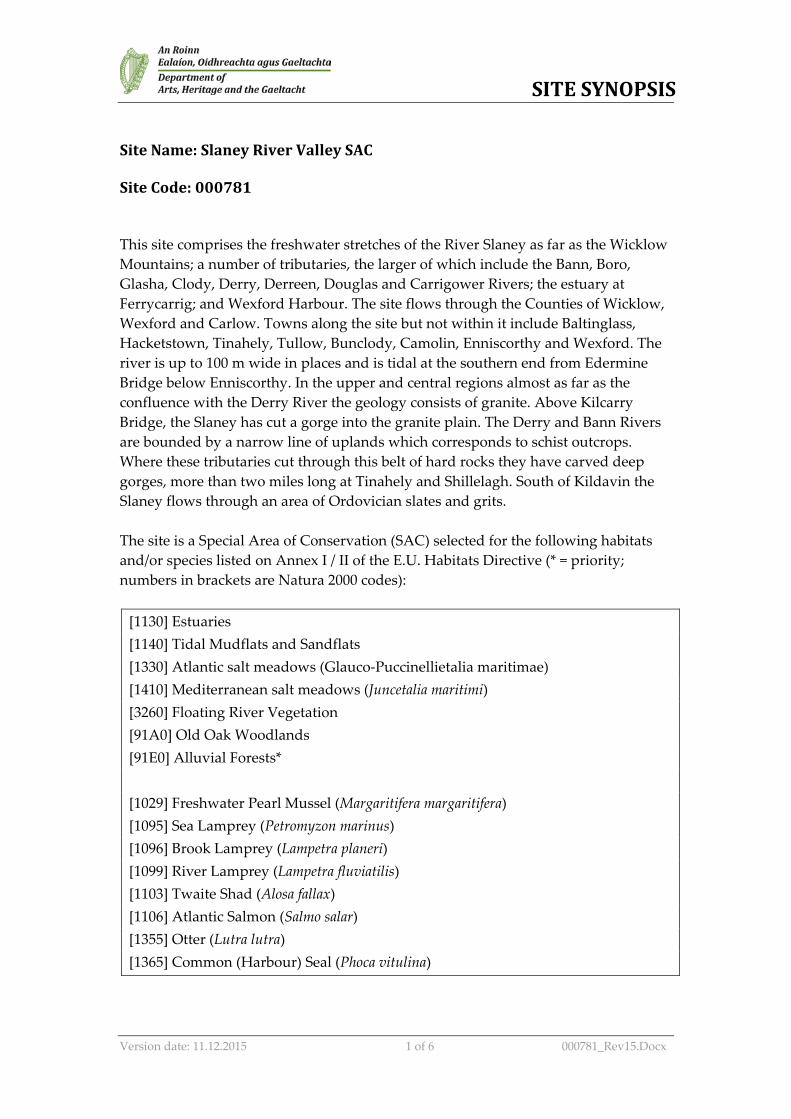
SITE SYNOPSIS
Version date: 11.12.2015 1 of 6 000781_Rev15.Docx
Site Name: Slaney River Valley SAC Site Code: 000781 This site comprises the freshwater stretches of the River Slaney as far as the Wicklow Mountains; a number of tributaries, the larger of which include the Bann, Boro, Glasha, Clody, Derry, Derreen, Douglas and Carrigower Rivers; the estuary at Ferrycarrig; and Wexford Harbour. The site flows through the Counties of Wicklow, Wexford and Carlow. Towns along the site but not within it include Baltinglass, Hacketstown, Tinahely, Tullow, Bunclody, Camolin, Enniscorthy and Wexford. The river is up to 100 m wide in places and is tidal at the southern end from Edermine Bridge below Enniscorthy. In the upper and central regions almost as far as the confluence with the Derry River the geology consists of granite. Above Kilcarry Bridge, the Slaney has cut a gorge into the granite plain. The Derry and Bann Rivers are bounded by a narrow line of uplands which corresponds to schist outcrops. Where these tributaries cut through this belt of hard rocks they have carved deep gorges, more than two miles long at Tinahely and Shillelagh. South of Kildavin the Slaney flows through an area of Ordovician slates and grits. The site is a Special Area of Conservation (SAC) selected for the following habitats and/or species listed on Annex I / II of the E.U. Habitats Directive (* = priority; numbers in brackets are Natura 2000 codes):
[1130] Estuaries [1140] Tidal Mudflats and Sandflats [1330] Atlantic salt meadows (Glauco-Puccinellietalia maritimae) [1410] Mediterranean salt meadows (Juncetalia maritimi) [3260] Floating River Vegetation [91A0] Old Oak Woodlands [91E0] Alluvial Forests* [1029] Freshwater Pearl Mussel (Margaritifera margaritifera) [1095] Sea Lamprey (Petromyzon marinus) [1096] Brook Lamprey (Lampetra planeri) [1099] River Lamprey (Lampetra fluviatilis) [1103] Twaite Shad (Alosa fallax) [1106] Atlantic Salmon (Salmo salar) [1355] Otter (Lutra lutra) [1365] Common (Harbour) Seal (Phoca vitulina)
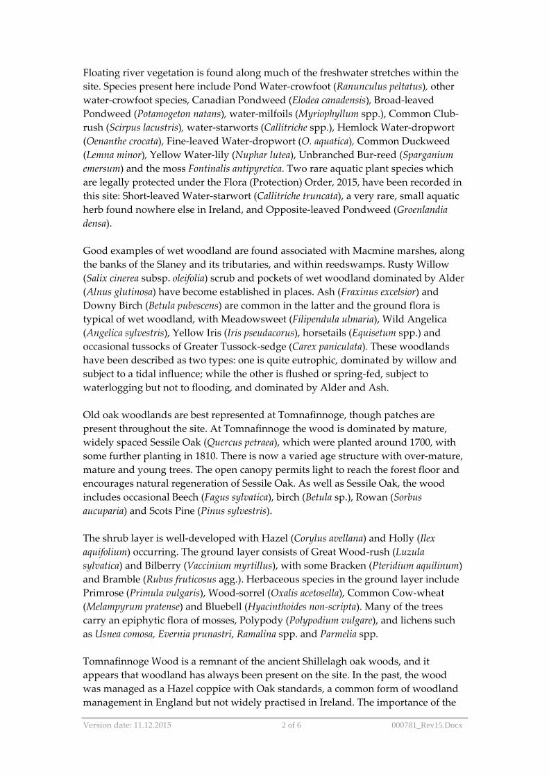
Version date: 11.12.2015 2 of 6 000781_Rev15.Docx
Floating river vegetation is found along much of the freshwater stretches within the site. Species present here include Pond Water-crowfoot (Ranunculus peltatus), other water-crowfoot species, Canadian Pondweed (Elodea canadensis), Broad-leaved Pondweed (Potamogeton natans), water-milfoils (Myriophyllum spp.), Common Club-rush (Scirpus lacustris), water-starworts (Callitriche spp.), Hemlock Water-dropwort (Oenanthe crocata), Fine-leaved Water-dropwort (O. aquatica), Common Duckweed (Lemna minor), Yellow Water-lily (Nuphar lutea), Unbranched Bur-reed (Sparganium emersum) and the moss Fontinalis antipyretica. Two rare aquatic plant species which are legally protected under the Flora (Protection) Order, 2015, have been recorded in this site: Short-leaved Water-starwort (Callitriche truncata), a very rare, small aquatic herb found nowhere else in Ireland, and Opposite-leaved Pondweed (Groenlandia densa). Good examples of wet woodland are found associated with Macmine marshes, along the banks of the Slaney and its tributaries, and within reedswamps. Rusty Willow (Salix cinerea subsp. oleifolia) scrub and pockets of wet woodland dominated by Alder (Alnus glutinosa) have become established in places. Ash (Fraxinus excelsior) and Downy Birch (Betula pubescens) are common in the latter and the ground flora is typical of wet woodland, with Meadowsweet (Filipendula ulmaria), Wild Angelica (Angelica sylvestris), Yellow Iris (Iris pseudacorus), horsetails (Equisetum spp.) and occasional tussocks of Greater Tussock-sedge (Carex paniculata). These woodlands have been described as two types: one is quite eutrophic, dominated by willow and subject to a tidal influence; while the other is flushed or spring-fed, subject to waterlogging but not to flooding, and dominated by Alder and Ash. Old oak woodlands are best represented at Tomnafinnoge, though patches are present throughout the site. At Tomnafinnoge the wood is dominated by mature, widely spaced Sessile Oak (Quercus petraea), which were planted around 1700, with some further planting in 1810. There is now a varied age structure with over-mature, mature and young trees. The open canopy permits light to reach the forest floor and encourages natural regeneration of Sessile Oak. As well as Sessile Oak, the wood includes occasional Beech (Fagus sylvatica), birch (Betula sp.), Rowan (Sorbus aucuparia) and Scots Pine (Pinus sylvestris). The shrub layer is well-developed with Hazel (Corylus avellana) and Holly (Ilex aquifolium) occurring. The ground layer consists of Great Wood-rush (Luzula sylvatica) and Bilberry (Vaccinium myrtillus), with some Bracken (Pteridium aquilinum) and Bramble (Rubus fruticosus agg.). Herbaceous species in the ground layer include Primrose (Primula vulgaris), Wood-sorrel (Oxalis acetosella), Common Cow-wheat (Melampyrum pratense) and Bluebell (Hyacinthoides non-scripta). Many of the trees carry an epiphytic flora of mosses, Polypody (Polypodium vulgare), and lichens such as Usnea comosa, Evernia prunastri, Ramalina spp. and Parmelia spp. Tomnafinnoge Wood is a remnant of the ancient Shillelagh oak woods, and it appears that woodland has always been present on the site. In the past, the wood was managed as a Hazel coppice with Oak standards, a common form of woodland management in England but not widely practised in Ireland. The importance of the
Version date: 11.12.2015 3 of 6 000781_Rev15.Docx
woodland lies in the size of the trees, their capacity to regenerate, their genetic continuity with ancient woodland and their historic interest. The nearest comparable stands are at Abbeyleix, Co. Laois and Portlaw, Co. Waterford. Below Enniscorthy there are several areas of woodland with a mixed canopy of oak, Beech, Sycamore (Acer pseudoplatanus), Ash and generally a good diverse ground flora. Near the mouth of the river at Ferrycarrig is a steep south facing slope covered with oak woodland. Holly and Hazel are the main species in the shrub layer and a species-rich ground flora typical of this type of oak woodland has abundant ferns (Dryopteris filix-mas, Polystichum setiferum and Phyllitis scolopendrium) and mosses (Thuidium tamariscinum, Mnium hornum and Eurynchium praelongum). North of Bunclody, the river valley still has a number of dry woodlands though these have mostly been managed by the estates, with the introduction of Beech and occasional conifers. The steeper sides are covered in a thick scrub from which taller trees protrude. At the southern end of the site, the Red Data Book species Yellow Archangel (Lamiastrum galeobdolon) occurs. Three more Red Data Book species have also been recorded from the site: Blue Fleabane (Erigeron acer), Basil Thyme (Acinos arvensis), and Small Cudweed (Logfia minima). Basil Thyme and Small Cudweed are protected under the Flora (Protection) Order, 2015. A nationally rare species, Summer Snowflake (Leucojum aestivum), is also found within the site. Mixed woodlands occur at Carrickduff and Coolaphuca in Bunclody. Oak trees, which make up the greater part of the canopy, were originally planted and at the present time are not regenerating actively. In time, if permitted, the woodland will probably become dominated by Beech. A fair number of Yew (Taxus baccata) trees have also reached a large size and these, together with Holly, give to the site some of the appearance of a south-western oak wood. The site is considered to contain a very good example of the extreme upper reaches of an estuary. Tidal reedbeds with wet woodland are present in places. The fringing reed communities support Sea Club-rush (Scirpus maritimus), Grey Club-rush (S. tabernaemontani) and abundant Common Reed (Phragmites australis). Other species occurring are Bulrush (Typha latifolia), Reed Canary-grass (Phalaris arundinacea) and Branched Bur-reed (Sparganium erectum). The reedswamp is extensive around Macmine, where the river widens and there are islands with swamp and marsh vegetation. Further south of Macmine are expanses of intertidal mudflats and sandflats and shingle shore often fringed with a narrow band of saltmarsh and brackish vegetation. Narrow shingle beaches up to 10 m wide occur in places along the river banks and are exposed at low tide. Upslope the shingle is sometimes colonised by Saltmarsh Rush (Juncus gerardii), Townsend’s Cord-grass (Spartina townsendii), Common Saltmarsh-grass (Puccinellia maritima), Sea Aster (Aster tripolium), Hemlock Water-dropwort and the non-native and invasive Himalayan Balsam (Impatiens glandulifera).
Version date: 11.12.2015 4 of 6 000781_Rev15.Docx
The salt marsh at Castlebridge is dominated by Mediterranean salt meadows. The main community is characterized by the presence of Sea Rush (Juncus maritimus). Red Fescue (Festuca rubra) and Creeping Bent-grass (Agrostis stolonifera) are both abundant within this vegetation type. Other species present include Autumn Hawkbit (Leontodon autumnalis), Sea Milkwort (Glaux maritima), Silverweed (Potentilla anserina), Long-bracted Sedge (Carex extensa), Parsley Water-dropwort (Oenanthe lachenalii), Curled Dock (Rumex crispus), Sea Arrowgrass (Trigolchin maritima), Smooth Sow-thistle (Sonchus oleraceus), Sea Plantain (Plantago maritima), Wild Celery (Apium graveolens), Spear-leaved Orache (Atriplex prostrata), White Clover (Trifolium repens), Sea Aster and Saltmarsh Rush. These species vary in cover values and Salt marsh Rush may occasionally be dominant. Species such as Hard-grass (Parapholis strigosa) and Common Saltmarsh-grass are found along some of the tracks, while Common Saltmarsh-grass is also more common around the mouths of the creeks and along some of the drainage channels. The marsh is perched on ground that is bisected by a number of channels which extend a considerable distance inland. The site is notable for the presence of Borrer’s Saltmarsh-grass (Puccinnellia fasciculata), which is found along the cattle tracks of the marsh. Another notable feature is the transition from saltmarsh to brackish marsh communities, which is quite extensive and diverse. The marsh is generally in good condition. A significant area of Atlantic salt meadows also occurs at Castlebridge. This habitat is characterised by the presence of grassy upper saltmarsh vegetation communities dominated by Red Fescue and/or Creeping Bent-grass. Other species present include Saltmarsh Rush, Sea Milkwort (Glaux maritima), Sea Aster, Sea Arrowgrass (Triglochin maritimum), Sea Plantain, Common Scurvygrass (Cochlearia officinalis), and Curled Dock (Rumex crispus). Sea Rush may be present in this habitat and has cover values between 0-10%. Wexford Harbour is an extensive, shallow estuary which dries out considerably at low tide exposing large expanses of mudflats and sandflats. Within these habitats four biological community complexes have been recorded: estuarine muds dominated by polychaetes and crustaceans community complex; sand dominated by polychaetes community complex; mixed sediment community complex; and fine sand with Spiophanes bombyx community complex. The harbour is largely sheltered by the Raven Point to the north and Rosslare Point in the south. Other habitats present within the site include species-rich marsh in which sedges such as Carex disticha, Carex riparia and Carex vesicaria are common. Among the other species found in this habitat are Yellow Iris, Water Mint (Mentha aquatica), Purple Loosestrife (Lythrum salicaria) and Soft Rush (Juncus effusus). Extensive marshes occur to the west of Castlebridge associated with the tidal areas of the River Sow. The site supports populations of several species listed on Annex II of the E.U. Habitats Directive, including Sea Lamprey, River Lamprey and Brook Lamprey, Otter, Salmon, small numbers of Freshwater Pearl Mussel, and in the tidal stretches,
Version date: 11.12.2015 5 of 6 000781_Rev15.Docx
Twaite Shad. A survey of the Derreen River in 1995 estimated the population of Freshwater Pearl Mussel at about 3,000 individuals. This is a significant population, especially in the context of eastern Ireland. The Slaney is primarily a spring salmon fishery and is regarded as one of the top rivers in Ireland for early spring fishing. The upper Slaney and tributary headwaters are very important for spawning. The site supports regionally significant numbers of Common Seal. This Annex II species occurs year-round in Wexford Harbour where several sandbanks are used for breeding, moulting and resting activity. At least 27 Common Seal regularly occur within the site. The site is of high ornithological importance also, with internationally important populations of Mute Swan (300), Light-bellied Brent Goose (200), Bar-tailed Godwit (1,843) and Black-tailed Godwit (350) occurring – all figures are average peaks for the five winters, 1995/96-99/2000. There are at least a further 18 species of wintering waterfowl which occur in numbers of national importance, i.e. Great-crested Grebe (123), Cormorant (443), Shelduck (903), Teal (800), Scaup (416), Goldeneye (151), Red-breasted Merganser (226), Oystercatcher (1,800), Golden Plover (3,000), Grey Plover (1,412), Lapwing (5,000), Knot (566), Sanderling (262), Dunlin (3,037), Curlew (1,300), Redshank (535), Black-headed Gull (6,136) and Lesser Black-backed Gull (1,036). Several of the above populations represent substantial proportions of the national totals, especially Shelduck (6.1%), Scaup (5.9%), Red-breasted Merganser (5.6%), Grey Plover (18.8%, the top site in the country) and Black-headed Gull (6.1%). A nesting colony of Little Egret has recently become established within the site (12+ pairs in 2003) and birds are present in the area throughout the year. The sheltered estuarine habitat to the west of Wexford Bridge is the favoured location. Another very localised breeding species, Reed Warbler, is well established within the swamp vegetation along the River Slaney and on the South Slob (estimated as at least 10 pairs). The River Slaney supports typical riparian species, including Dipper and Kingfisher. The site supports many of the mammal species occurring in Ireland. Those which are listed in the Irish Red Data Book include Pine Marten, Badger, Irish Hare and Daubenton’s Bat. Common Frog (Rana temporaria), another Red Data Book species, also occurs within the site. Agriculture is the main land use. Arable crops are important. Improved grassland and silage account for much of the remainder. The spreading of slurry and fertiliser poses a threat to the water quality of this salmonid river and to the populations of E.U. Habitats Directive Annex II animal species within it. Run-off is undoubtedly occurring, as some of the fields slope steeply directly to the river bank. In addition, cattle have access to the river bank in places. Fishing is a main tourist attraction along stretches of the Slaney and its tributaries, and there are a number of Angler Associations, some with a number of boats. Fishing stands and styles have been erected in places. Both commercial and leisure fishing takes place. There are some gravel pits along the river below Bunclody and many of these are active. There is a
Version date: 11.12.2015 6 of 6 000781_Rev15.Docx
large landfill site adjacent to the river close to Hacketstown and at Killurin. Boating, bait-digging and fishing occur in parts of Wexford Harbour. Waste water outflows, runoff from intensive agricultural enterprises, a meat factory at Clohamon, a landfill site adjacent to the river, and further industrial development upstream in Enniscorthy and in other towns could all have potential adverse impacts on the water quality unless they are carefully managed. The spread of exotic species is reducing the quality of the woodlands. The site supports populations of several species listed on Annex II of the E.U. Habitats Directive, and habitats listed on Annex I of this Directive, as well as important numbers of wintering wildfowl including some species listed on Annex I of the E.U. Birds Directive. The presence of wet and broadleaved woodlands increases the overall habitat diversity and the occurrence of a number of Red Data Book plant and animal species adds further importance to the site. Overall it is of considerable conservation significance.

© Atkins Ltd except where stated otherwise. The Atkins logo, ‘Carbon Critical Design’ and the strapline ‘Plan Design Enable’ are trademarks of Atkins Ltd.
Atkins Unit 2B 2200 Cork Airport Business Park Cork
[email protected] +353 (0)21 429 0300


