58


NAME OF SURVEY ....................................................................2
BOUNDARIES OF SURVEY AREA .........................................................2
NUMBER OF PROPERTIES SURVEYED .....................................................3
NUMBER OF SQUARE MILES SURVEYED ...................................................3
SURVEYORS .........................................................................3
BEGINNING AND ENDING DATES OF SURVEY ..............................................3
OBJECTIVES OF SURVEY ..............................................................3
PROJECT METHODOLOGY AND PRODUCTS OF SURVEY ........................................3
NARRATIVE HISTORY OF THE SURVEY AREA ..............................................5
Introduction ...................................................................5
Settlement and Early History; The Antebellum Period ............................6
The Civil War ..................................................................9
Reconstruction, 1868-1877 .....................................................10
Growth and Optimism, 1880 to 1925 .............................................11
The Great Slump, 1925 to 1935 .................................................14
A New Boom, 1936 to 1945 ......................................................15
Architects and Builders Known to Have Worked in the Survey Area ...............18
EVALUATION OF SURVEY DATA ........................................................20
Properties that are listed in the National Register of Historic Places ........20
Architectural Analysis ........................................................21
Properties that are eligible for listing in the National Register .............37
RECOMMENDATIONS ..................................................................39
DATA GAPS ........................................................................42
BIBLIOGRAPHY .....................................................................43
COMPILED INVENTORY OF SITES ......................................................45
1

NAME OF SURVEY City of Georgetown Cultural Resources Survey BOUNDARIES OF SURVEY AREA The survey area includes the National Register City of Georgetown Historic District, bounded on the west by Wood Street, on the north by Church Street/Highway 17, on the east by Meeting Street, and on the south by the Sampit River. It also includes an area east of the Historic District, bounded by Meeting Street, Church Street, the Sampit River, and the Black River on the east. A windshield reconnaissance survey was carried out in the area west of the Historic District, bounded by Wood Street on the east, Front Street on the south, North Fraser Street on the west, and Church Street on the north. Five additional properties were intensively surveyed: Antipedo Baptist Cemetery and the Georgetown Armory, both at the north side of Church Street, adjacent to the National Register Historic District; Bethesda Missionary Baptist Church (Wood Street), also adjacent to the Historic District; Elmwood Cemetery; and the Howard School Community Building.
MAP SHOWING BOUNDARIES OF SURVEY AREA
2

NUMBER OF PROPERTIES SURVEYED 333 site forms were filled out for properties that were intensively surveyed. Of these, 289 are within the Historic District, four of which have previously been listed in the National Register. In the area east of the Historic District are 39 survey sites. Five site cards represent the scattered sites mentioned above. Reconnaissance survey between Wood and North Fraser Streets found 35 sites that would be eligible for intensive survey. Of these, one (Bethesda Missionary Baptist Church, 225 Wood Street, Site #389) was surveyed intensively; and one (Winyah Indigo School) is listed in the National Register of Historic Places. NUMBER OF SQUARE MILES SURVEYED Intensive survey: about 290 acres. Reconnaissance survey: about 60 acres. SURVEYORS Sarah Fick, Historic Preservation Consultants, Inc. Rachel Campo, Chicora Foundation, Inc. BEGINNING AND ENDING DATES OF SURVEY Work began with the initial planning meeting, July 23, 1999. The project was completed July 24, 2000. OBJECTIVES OF SURVEY The Georgetown County Historical Society (Society) and the SC Department of Archives and History, State Historic Preservation Office (SHPO) shared several goals for the survey. A primary goal was to establish comprehen-sive information about the individual properties that contribute to the City of Georgetown Historic District and those in the area adjacent to the District that are at least 50 years old and retain physical integrity. An associated goal was to determine whether the boundaries of the National Register District or the locally zoned historic district should be redrawn; and whether the dates of the period of significance for the district should be redefined. The Society’s objective is to improve the information on which the City Planning Department and Architectural Review Board base their decision-making, and to encourage sensitive rehabilitation within and adjacent to the district. The SHPO’s objective is to obtain the infor-mation necessary for carrying out its responsibilities in administering state and federal preservation programs. The second objective of the project was to develop recommendations for future programs or projects that will further enhance both agencies’ abilities to carry out their mission to preserve the built environment of the City of Georgetown and Georgetown County. In studying the boundaries of the National Register Historic District, the consultants found three properties adjacent to the district that should be evaluated by SHPO for their potential eligibility for listing in the Register. Because the district does not include the entire City of Georgetown, the study goal was expanded to determine the likelihood of additional National Register-eligible properties existing outside the district. PROJECT METHODOLOGY AND PRODUCTS OF SURVEY The project was carried out in accordance with the standards of the SHPO and National Park Service as outlined in the “South Carolina Statewide
3

Survey of Historic Places: Survey Manual”; National Register Bulletin 24 (Guidelines for Local Surveys: A Basis for Preservation Planning). Every road or street in the survey area was walked or driven and each survey-eligible resource was recorded according to the Survey Manual: a site number was assigned, a data form was completed, black-and-white photograph taken, and the site number entered on data form, photograph sheet, and survey map. Survey-eligible resources are defined as buildings, struc-tures, sites, objects, and landscapes that are at least 50 years old (for purposes of this project, those that were first constructed before 1950 met the age requirement) and retain their essential physical integrity. Some properties were surveyed that have lost their physical integrity, but which are historically significant within the context of Georgetown’s history. Historic research sufficient to establish a context for extant historic resources was an integral part of the project. Georgetown’s history has been well-documented through publications of the Georgetown County Historical Society and others, so the general narrative could be based on solid secondary sources. Additional general research included scanning newspaper articles (Georgetown newspapers are not indexed) for references to construction trends during selected periods of time, mostly in the twentieth century. Because the antebellum buildings in the district have been researched as thoroughly as feasible given the lack of courthouse records, the important focus for individual sites was to establish construction dates for post-1865 buildings. This was accomplished by comparing photos and present site locations to Sanborn Maps published for Georgetown in 1888, 1899, 1908, 1913, and 1924. Products of the survey include this report and site forms with photographs, provided in duplicate to SHPO and the Society. One copy of the forms and photos will be housed with the Planning Office of the City of Georgetown, and a photocopied set will be provided to the Georgetown County Public Library and stored with the local history collection. A map with street names and addresses, showing boundaries of the survey area and site numbers within property lines, was also provided in duplicate. A separate map, cross-hatched to indicate survey-eligible resources, was provided for the area of reconnaissance survey. A printed list of all survey sites is included with this report, and a separate computerized inventory of sites was provided to SHPO in a database format (Microsoft Access 97). Black-and-white negatives will be stored in the SHPO, a division of the South Carolina Department of Archives and History. To facilitate presentations regarding the survey and further studies of Georgetown’s built environment, color slides showing representative streetscapes and properties in the survey area were provided to the Society and SHPO.
4
NARRATIVE HISTORY OF THE SURVEY AREA
Introduction Georgetown lies on the north bank of the Sampit River at the head of Winyah Bay, twelve miles above the Atlantic Ocean. This location made Georgetown an important port for the region above the Santee River, but commercial shipping opportunities here, like those of Port Royal (Beaufort), were historically overshadowed by the larger import-export trade at Charleston. Also like Port Royal, Georgetown did not enter the Railroad Age until the late nineteenth century. The town’s mercantile and institutional interests prospered with the wealth of its surrounding rice plantations during the antebellum period, but Charleston was the more important social center. Georgetown County planters’ most opulent town houses of the antebellum era were built in Charleston, not Georgetown. The national building boom of the 1880s demanded as much lumber and shingles as the region could provide. Georgetown’s harbor, supplemented by rail service beginning in 1883, shipped enormous quantities of lumber. Unlike rice, raw timber was not shipped to Charleston for processing and export, so this new economy, which lasted until after the turn of the century, brought independent prosperity. Many of the substantial dwellings and commercial buildings of the historic district (and in surrounding neighborhoods to the north and west) date from this period. The first quarter of the twentieth century was one of economic turbulence. The last of the commercial rice and turpentine producers ceased operations or moved out of the area, truck farming failed to meet promoters’ hopes, and lumber markets proved unstable. There was a post-war boom in lumber and cotton demand in the early 1920s, then the general economic slump caught up with Georgetown. A decade of poverty was eased by New Deal construction projects, then substantially cured by the coming of International Paper Company’s kraft mill. Mill employment was boosted during World War II, and brought Georgetown into the 1950s as a stable, if small, city. Except the Greenwich Plantation lands at the southeast side of town, opened for residential development in the late 1930s, historic Georgetown was hemmed in by water and industry. Only toward the interior could sub-divisions, highways and shopping centers be sited. The historic district was thus buffered from the impact of adjacent modern construction that affects many small cities. The hundred year old trees planted along most streets enhanced appreciation of the original grid plan, which is therefore largely intact, and a long-standing veneration for Georgetown’s earliest buildings has also served to protect their later historic neighbors.
5

Settlement and Early History; The Antebellum Period Well before the town was established, the area that became Georgetown was visited by white traders from the colony at Charleston. They used Native American trails, creeks and rivers, and began to establish trading posts and permanent residences. The earliest land grants, to John Perrie in 1705, encompassed the site of the present city. By 1721 there were enough permanent white settlers to establish Prince George, Winyah, as a parish of the Church of England.1 Perrie’s grants were acquired by William Screven, whose son Elisha recognized an opportunity and had surveyor William Swinton lay out a town on 174 acres, where Screven began to sell lots in 1729. The next year, Royal Governor Johnson declared that a planned town and port of entry were needed to serve the many people settling on “Wyneau” River. With George-town already laid out, its growth was assured.2 Georgetown’s original grid included 200 building lots, a common of 100 acres, lots for Protestant churches (Anglican, Presbyterian, Baptist) with cemeteries, and lots for school, court, prison, market place, and military post. Screven intended the town to develop quickly: lot purchasers were required to build a brick or framed house at least 22’ X 16’, with brick chimneys, within 18 months. In 1737, eighty-eight new lots were made on the common (a 130-acre tract beyond the grid was designated as a replacement common), expanding the town from today’s St. James Street to Cleland Street, between Church and Front streets.3 With the requirement that houses be built right away, many of Georgetown’s first dwellings were erected as rental or speculative housing. A list made in 1737 details owners of 234 lots in Georgetown, not all of whom established residence. Lot owners included Anthony White, who held fourteen lots, William Waties and Meredith Hughes each with eight, and William Swinton and George Pawley, seven lots apiece. William Allston, an early member of the rice planting family, owned four lots, as did tavern keeper/ vintner Thomas Bolem. Daniel LaRoche & Co., Daniel LaRoche and Thomas LaRoche had eight lots altogether. Charlestonians Nicholas Trott (chief justice of the colony) and Othniel Beale each owned four lots.4 As resident merchants, shipowners and professionals prospered, they, like their peers in Charleston or Beaufort, tended to join the planter class by putting their profits into land and slaves. Rice was the first staple crop on the farms and plantations around Georgetown, but during the 1740s it was supplanted by indigo. British subsidies and a strong market made indigo production immensely lucrative, and it became the crop of choice. When planters organized a beneficial/social club in town, they named it the Winyah Indigo Society, and paid their dues in indigo. The society was
1 A Guide to Georgetown Historic District, Georgetown, South Carolina (Georgetown:
The Georgetown County Historical Society, 1995), p. 5. 2 George C. Rogers, Jr., The History of Georgetown County, South Carolina (1970, rep.
ed. Spartanburg: The Reprint Company, 1990), pp. 28-30. 3 Guide to Georgetown Historic District, p. 5. Henry A. M. Smith, “Georgetown - The
Original Plan and the Earliest Settlers” pp. 85-101 in SCHGM IX, No. 2 (April 1908).
4 Smith, “Georgetown.” Rogers, pp. 35-36.
6

supporting a free school for white children by the mid-1750s.5 Indigo was Georgetown’s primary export crop until the American Revolution, after which market changes (principally the loss of British subsidies) combined with new technology to return rice to the fore. There is little information about the earliest era of construction, but Prince George, Winyah, Church (300 Broad Street, Site #24), built in the 1740s, and several substantial dwellings attest to the wealth and architectural sophistication of Georgetown’s first residents. Robert Stewart built a masonry house at 1019 Front Street (Site #75) ca. 1750; physician Charles Fyffe built 15 Cannon Street (Site #260) ca. 1765; and Mary Man of Mansfield Plantation had an ample town house constructed at 528 Front Street (Site #323) ca. 1775. Planters, shipbuilders, and “mechanics” (building contractors) all relied upon the labor of slaves, and much of the skilled craftsmanship evident in these buildings was provided by bondsmen. The American Revolution was marked in Georgetown by British occupation from July 1780 to May 1781. British sailors are said to have destroyed some forty buildings and houses in 1781.6 Few of them would have been replaced immediately, but by about 1785 societal and economic recovery began to encourage new construction. In early 1788 a traveler noted that about 150 houses had been built since the war.7 Although the Anglican Church had been disestablished, South Carolina’s local government remained organized on parish lines. Georgetown, home of Prince George, Winyah, Parish, retained its role as a district, eventually county, seat. The town was enlarged, with ninety-one new lots drawn east of St. James Street, an area called Brown Town.8
After the American Revolution, tidal-field rice growing became dominant on Georgetown County plantations. New lands were diked as a small group of planters consolidated earlier tracts into enormous plantations where they created an aristocracy based on wealth and family. By 1840 Georgetown District produced nearly half the national yield of rice. The production of their slaves allowed successful whites to build fine country seats and settle themselves in handsome town residences. The rice planters formed country clubs - Hot and Hot Fish Club, the Planters Club - for companionship, feasting and celebrations, while the Indigo Society, their town club, remained an important institution. In 1857 rice planters’ money built the Winyah Indigo Society Hall at 501 Prince Street (Site #126). Despite its setting at the mouth of South Carolina’s premier rice-growing rivers, antebellum Georgetown saw little traffic from the crop. The Georgetown Steam Rice Mill purchased by Benjamin King in 1838 succeeded for a time, but upriver planters preferred to ship directly from their own docks to Charleston for milling and export, and import plantation and household goods through Charleston factors. Their prosperity, and George-town’s position as the seat of government and justice, brought some new dwelling houses, institutions and mercantile businesses. Notable public
5 Guide to Georgetown Historic District, pp. 5, 34-35. 6 Ibid, p. 6. 7 Rogers, Georgetown County, pp. 166-167. 8 Smith, “Georgetown.” John Hardwick, Surveyor, “A Plan of Georgetown and its
Common, also of the Lots adjoining George Town...” (1798, early 20th century tracing by L. H. Siau.)
7

buildings were constructed or remodeled during the decades of the 1820s-1840s, including the County Courthouse on Screven Street (Site #136), Prince George, Winyah, Church (300 Broad Street, Site #24); and Market Hall on Front Street at the foot of Screven Street (Site #12). The small-town marketplace, however, limited commercial development to several blocks along Front Street and nearby sections of Screven, Broad, Orange and King. In 1825 Robert Mills estimated that the number of houses in Georgetown exceeded 300,9 but by this time, planters’ families were beginning to abandon town. They educated their children with tutors, then sent them to school in Charleston or further away. Entire households spent the summer at the seashore, in pineland villages, the mountains, or the High Hills at Stateburg, or left the region entirely.10 Charleston’s role as the Low-country’s social and commercial capital drew planters to that city, and many of them, including Joshua J. Ward, William Bull Pringle, William Alston, R. F. W. Allston, made their principal residence there. A number of planters had town houses in both places, while some resided only in Georgetown.11 These rice planters were among the richest people in the nation, but few flaunted their wealth in Georgetown construction. As early as 1790 the houses they occupied in Charleston were more opulent, a trend that continued with the construction of ever-grander dwellings there until the Civil War. Among the leading planters with residences in Georgetown was Daniel Tucker of Litchfield and Retreat, who remodeled Robert Stewart’s house at 1019 Front Street (Site #75) after his 1787 purchase. Benjamin Allston Sr. of the Waccamaw River rice planting family later bought the house, which was near his daughter Martha Pyatt’s dwelling at 630 Highmarket Street (Site #153). Francis Withers too kept a town house in Charleston though he owned houses at 513 Prince Street (Site #127) and 202 Cannon Street (Site #205), which he may have occupied himself. William H. Trapier, who planted on the Black River and owned the house at 1024 Front Street (Site #236), also maintained a residence in Charleston. Planters’ ownership of town property extended to investment property, as with the Charlotte Allston House (422 Prince Street, Site #207) and Cleland House (405 Front Street, Site #265), owned in succession by John Withers Jr., Francis Withers, Joseph Blythe, and R. F. W. Allston, all antebellum rice planters.12 The period was also marked by Stephen W. Rouquie’s enlargement of his dry goods and hardware store at 633 Front Street (Kaminski Building, Site #99) in 1860. The shift of commerce and planters’ residences away from Georgetown is evident in census figures: the population declined from 2,000 in 1820 to 1,500 in 1840. There was then slow growth from 1,628 (604 white, 1,024 black) in 1850 to 1,720 (786 white, 923 black) in 1860.13 Unlike rice planters, lumber producers relied upon Georgetown Harbor to serve their markets in the northern United States and the Caribbean. Beginning in the 1830s there were steam mills in Georgetown and at the opposite side of the Sampit River, and in 1855 David Risley, a former Philadelphian, established the Palmetto Mill.14 Sawmilling and turpentine production began to dominate the town. During the 1840s, as lumbermen depleted northern forests, turpentine makers moved into South Carolina. This new era of naval stores activity reached Georgetown County in the 1850s, with small operations set up along many rivers and streams. By 1860 numerous turpentine distillers, "farmers," and laborers lived in Georgetown. There were ten turpentine factories in
9 Mills, Statistics, p. 559. 10 Rogers, Georgetown County, pp. 304-310, 312-318. 11 Guide to Georgetown Historic District, pp. 24-26. 12 Ibid. 13 State Board of Agriculture of South Carolina, South Carolina. Resources and
Population, Institutions, and Industries (1883, rep. ed. Spartanburg: The Reprint Company, 1972), pp. 686-687. Rogers, p. 253.
14 Rogers, Georgetown County, pp. 318-323.
8

Prince George Winyah Parish, but their economic profile was fairly low compared to lumber. Some relied heavily on slave labor, in the tapping operations if not in the distillery. In 1860 Elisha Perkins of Georgetown employed his eighty-two slaves as turpentine "getters," and the firm of Perkins, Carraway and Perkins had about 180 slaves, nearly all of them men aged 17-40, who were "turpentine collectors."15 The Civil War With the onset of war, President Lincoln proclaimed a blockade of all South Carolina ports on April 19, 1861. As the war progressed, the Confederates did not mount much defense along the coast. Union warships and steamers traveled fairly freely up the Santee and Waccamaw Rivers during 1862. Plantation rice and food crops suffered as white families and their slaves moved to safer ground inland, but Georgetown was not invaded and the city and surrounds were intact if decrepit. After Georgetown surrendered to Admiral John A. Dahlgren on February 23, 1865, the Union Army occupied the town but did not destroy its buildings or landscape.16 After the war ended, changes in social, commercial and agricultural life reflected the emancipation of African-Americans. Most rice plantation owners wanted to continue the crop, and were willing to try a free labor system. Some reached agreements with their former slaves and began culti-vation in the spring of 1865, but many freedmen abandoned the plantations for urban opportunities in Georgetown or Charleston. The population of the City of Georgetown, in fact, increased from 1,720 in 1860 to 2,080 in 1870. The growth was entirely due to African-Americans moving into the city: while the white population declined, the black population swelled by almost 50%, from 923 to 1,397. The proportion of African-Americans increased from a slight majority in 1860 to two-thirds in 1870.17
15 Melissa J. Wyndham, "The 1860 Census of Georgetown County, South Carolina"
(typescript, nd, Georgetown County Public Library). Seventh Census (1850), Industrial Schedules. Eighth Census (1860), Industrial and Slave Schedules.
16 Rogers, pp. 399-404, 417-419. 17 Ibid, p. 468.
9

Reconstruction, 1868-1877 From 1868 until 1877, the period of Reconstruction, blacks controlled Georgetown political life. The population of the city expanded during the 1870s, and as before most of the increase was African-American. By 1880 there were 2,557 residents: 746 white, 1,811 black.18 After 1877, whites generally regained power but blacks retained a number of public offices in Georgetown until after 1900.19 Success in government, trades and commerce enabled some of them to purchase or build residences side-by-side with and as equally impressive as the houses of prominent whites (Rainey House, 909 Prince Street, Site #25; Bowley House, 231 King Street, Site #292). At the same time, African-Americans held to the new churches they had organized during the 1860s when they left the galleries of white churches. The independent church became an important benevolent and social institution in black community life. Despite three successive crop failures from 1865-1867, individual rice planters continued the attempt for years. One by one, forced by debt and the deterioration of dikes and dams, they reduced their cultivated acreage. As production of rice dwindled, revived lumber shipping brought increased maritime activity. During the last half of the 1860s, lumber and shingles made up the great majority of the value of goods exported from Georgetown. By 1870 Palmetto Mill, the only such company in town to survive the Civil War, had an active competitor. The two mills received rafts of logs floated down into Winyah Bay, and shipped sawn or planed wood on schooners. There were also four coopers (seventeen employees), two large turpentine distilleries, owned by Congdon & Hazard and Arthur Morgan, and several other tar and turpentine producers. By 1880 a great many residents of the City of Georgetown were employed in the turpentine industry. The naval stores industries then began to migrate to Georgia and Florida as forests were depleted by lumbering. The advent of steel ships reduced demand for naval stores, but the primacy of coastal shipping at Georgetown sustained a market into the twentieth century.20 Few of these operations were managed by pre-war rice planters, many of whom continued to struggle with their ancestral crop, settled in Charleston, or left the region. Some antebellum merchants, including Heiman Kaminski and Joseph Sampson, avoided debt pitfalls and even profited from loans to others. The last effort of the old guard was the Georgetown Rice Milling Company, a locally owned firm established in 1879 to pound rough rice into the finished product, to be exported without stopping to benefit Charleston businesses. For a few years the mill was supplied by upriver plantations and prospered.21
18 Rogers, Georgetown County, p. 468. 19 Ibid, pp. 437-438, 463-464, 474-482. 20 Ibid, pp. 431-436, 441-445. Ronald E. Bridwell, “Gem of the Atlantic Seaboard.”
Part II of “That We Should Have a Port,” A History of the Port of Georgetown, South Carolina (Georgetown: Ronald E. Bridwell, 1991), pp. 10-12, 17, 21. Ninth Census (1870) and Tenth Census (1880), Industrial Schedules. Dorothy T. Teel, The 1880 Census of Georgetown County, South Carolina (Hemingway: 3 Rivers Historical Society, 1985).
21 Bridwell, p. 21. Rogers, pp. 454-456, 465-466.
10

Growth and Optimism, 1880 to 1925 In the early 1880s, despite the rice planters’ continuing difficulties, Georgetown stirred with optimism. In 1882 work began on the roadbed of the Georgetown and Lanes Railroad. From the freight and passenger depot on South Fraser Street west of town, the line ran inland some thirty-six miles to connect with the Northeastern Railroad, a north-south main line, at Lanes in Williamsburg County. The locomotive was demonstrated in April 1883, and soon the railroad was open. A spur linking the depot to new wharves along the Sampit River promised to connect Georgetown Harbor with the interior.22 Lumber companies rafted great harvests of logs to waterside mills and exported board lumber and shingles by ship or rail. Even with the railroad underway, the inadequate depth and treacherous sandbars in Winyah Bay/ Georgetown Harbor hampered exports. During the 1880s, while Georgetown lobbied the federal government to fund stone jetties that would maintain a permanent deep channel into the harbor, there were waterway improvements throughout the region. Federal money through Rivers and Harbors appro-priations cleared the Wateree, Congaree, Santee, Waccamaw and Pee Dee rivers; cut a canal to connect the Santee with Winyah Bay; and dredged the Sampit bar to improve access to city wharves. Water traffic grew, with lumber, rice and cotton going out and goods and fertilizer coming in, more so after 1888 when the Clyde Steamship Line brought regular weekly service to New York. In 1890 the federal government responded to the increased trade and funded two jetties to keep the channel clear. The project was completed in 1904.23 Commercial optimism did not bring a sudden population increase. Georgetown grew only slowly from 2,557 to 2,895 inhabitants during the 1880s.24 In 1883 the mile-square city had fourteen miles of streets, surfaced with stone, brick or wood. There were three boarding-houses; five churches (three white, two black); two public schools (white and black) and a number of private schools. Important employers were three saw mills, a shingle mill, and the rice-pounding mill.25 An 1888 chronicler found Georgetown rising “on a flood tide of prosperity to a position it should have occupied years ago.” Shipments of lumber and shingles had declined between 1883 and 1886, the effect of unstable businesses or transportation difficulties, but the supply was still plentiful. Although buildings and streets had a run-down appearance, rail-way wharves were piled with lumber, the Georgetown Rice Milling Company (on the waterfront between Cleland and Wood streets) was pouring out steam and smoke, and the Palmetto Lumber Company mill (Front Street, between St. James and Meeting) was installing electric lights to allow night shifts.26 The two decades between 1890 and 1910 was the period of most rapid change in Georgetown. This era saw the end of two industries, rice and turpentine.
22 Bridwell, “Gem of the Atlantic,” pp. 22-23. 23 Ibid, pp. 23-28. Rogers, Georgetown County, pp. 466-467. 24 Bridwell, p. 48. 25 State Board of Agriculture, South Carolina, p. 686. 26 (Charleston) News and Courier, 12/13/1888, 12/14/1888. Bridwell, p. 31.
11

The hurricane of 1893, the worst since 1854, destroyed pine trees and turpentine stills, and dealt the final blow to rice planters. While urban buildings and businesses were rebuilt again and again, planters could not afford constant repairs to banks and canals, and naval stores producers could not replace trees. The storm of 1904 felled hundreds of pines, and although the Atlantic Coast Lumber Company produced at least some turpen-tine as late as 1915, the industry was effectively dead by 1911.27 Despite the problems of the agricultural and forestry industries, both white and black entrepreneurs prospered with trade and employment opportunities in turn-of-the-century Georgetown. In 1896 several Front Street businesspeople were black: grocer Primus Smalls, cook Sarah Moultrie, barbers W. E. Dennison, J. W. Washington and Ladson Wineglass, shoemaker L. A. Coit. J. A. Jackson was the proprietor of a feed and livery store on Broad Street. Despite the apparently integrated nature of this commerce, other aspects of life became increasingly segregated. A public hospital was built for whites, while nurse Florence Williams began a hospital for African-Americans in her home. As the business of undertaking became professionalized, separate mortuaries were established to serve each race.28 The Winyah Indigo Society turned over responsibility for white education to the Georgetown School District in 1887. There was a separate school, the “Georgetown Colored Academy,” which was replaced by a larger frame building, Howard Graded School, in 1908 (Mt. Olive Baptist Church, 1029 Duke Street, Site #226, is on its site). The brick Winyah School for whites was also built in 1908.29 An important wage-payer was the Gardner and Lacy Lumber Company, organized by midwestern lumber executives in 1891. They added a planing mill to their sawmill, supplied by a company-owned electric plant, and by 1899 were employing more than 225 men. In 1895, Philadelphian Jacob Savage moved his Black River Saw Mills downriver and took up the old Georgetown Lumber and Furniture Manufacturing Company site. He soon bought part of adjacent Serenity Plantation on the Sampit River, and moved his entire plant of sawmill, planing mill, and drying kilns to that tract.30 Some enterprises failed, such as an English venture to saw and ship kindling wood from the lightwood stumps that board lumber firms discarded. Their plant on Winyah Bay was purchased in 1897 by local merchant Marks Moses, whose Yellow Pine Lumber Company produced flooring, ceiling boards, and mouldings primarily for local consumption. The Winyah Lumber Company was organized in 1898 by P. J. Doyle and G. A. Doyle. They purchased the Palmetto Mill and installed a modern bandsaw. In 1899 W. H. Tilghman
27 News and Courier, 9/12/1893. Bridwell, p. 44. A View of Our Past. The Morgan
Photographic Collection depicting Georgetown, South Carolina ca. 1890-1915 (Georgetown: The Georgetown County Library System, 1993), pp. 12, 86.
28 Miss Mary M. Bonds, Mrs. Evelyn Washington Nesbitt, Mrs. Zelda Jackson Woodson, compilers, “Afro-American Georgetown, S. C. Heritage, 1670-1960,” nd, vertical files, Georgetown County Library.
29 Georgetown Times, 6/16/1986. Community Times “Black History Edition” 2/19-2/35/1998. Sanborn Company Insurance Maps, 1894, 1899. “Winyah Indigo School,” National Register nomination (Columbia: SHPO, 1998).
30 Bridwell, “Gem of the Atlantic,” pp. 30-31.
12

bought land just outside town, adjacent to Serenity Plantation. Owners of a large mill in Virginia, Tilghman and his sons joined their competitors in migrating south to new forests. In 1900 they had a double band saw in operation, and plans underway for a planing mill.31
The lumber company that had the greatest impact on Georgetown was the Atlantic Coast Lumber Company, which purchased Savage’s lumber mill and additional land on the former Serenity Plantation and began operation in 1899. Headquartered in Norfolk with offices in New York, Philadelphia and Georgetown, this company brought together lumbering interests from Michigan, New York, and Norfolk to buy tracts of land across eastern South Carolina. On their Sampit River site they constructed a saw mill, planing mill, wharves, and ancillary buildings including houses for operatives and managers, hotel, store, foundry, offices, and an electric power plant. By 1903 there were four saw mills running. The company remained a prominent part of Georgetown’s economy for three decades.32 William Doyle Morgan’s service as intendant and then mayor of Georgetown from 1891-1906 coincided with the city’s greatest period of development. The population increased from 2,895 to 4,138 by 1900 and 5,530 in 1910.33 During Morgan’s tenure the face of Georgetown changed dramatically. Physical changes included the new schools, a new federal office building at 1001 Front Street (Site #77) completed in 1906, oak and elm trees to replace those that lined Georgetown’s streets until the hurricane of 1893,34 concrete sidewalks in much of the business area, electric street lights, and new streets in the West End. Morgan was active in securing appro-priations for deepening Georgetown Harbor, and encouraged lumber businesses to move to the area.35 Private development, residential and commercial, was an important aspect of the Morgan years. Reflecting population growth and the ready availability of lumber and millwork, dozens of wood-framed and wood-sided houses were built in Georgetown between 1890 and 1910. Newcomers or newly prosperous residents built substantial houses and modest cottages for themselves. There was also investment construction, such as the rental dwellings built for Herman Schenck at 519 Highmarket Street, 226 Queen and 232 Queen Street (Sites #146, 148, and 187). Of 333 properties surveyed for this project, 116 were originally built between ca. 1890 and ca. 1910. Ninety-three of 256 single-family residences and eighteen of forty-eight commercial structures date to this era. In 1907 the Georgetown Chamber of Commerce provided facts and figures about the city, reporting the population as 6,000 (an exaggeration), with 2,500 in its suburbs. Supported by growing port and rail commerce, there were four building and loan associations; good banking facilities; a land association “offering city lots on easy terms”; several sawmill plants including “the largest... in this country”; machine shops and foundries; bottling works; an ice factory; a boat oar factory; handsome churches of
31 Bridwell, “Gem of the Atlantic,” pp. 31-32. 32 Ibid, pp. 32, 50. 33 Ibid, p. 48. 34 News and Courier, 12/13/1888, 9/12/1893. 35 View of Our Past, pp. 6-13.
13

several denominations; a “modernly” equipped hospital; shad and sturgeon fisheries; fine electric lights; broad macadamized streets; large wholesale grocery and provision and feed stores; good retail stores, filled with well-kept and complete stocks of merchandise; and “good, live, progressive and liberal business men, who will welcome the capitalist, tourist, homeseeker, manufacturer, mechanic, farmer and all good citizens.”36
Some visitors were not such good citizens. In 1910, 583 vessels arrived at Georgetown, with more than 13,000 men in their crews. The presence of sailors in port had a negative effect on the quality of life in some commercial areas, patronizing taverns and prostitutes (6 houses on Screven and Church streets in 1910),37 but they did add cash to the economy. From a high point in 1905, commercial and business activity leveled off. Export trade tonnage and value declined from 1906 to 1925 as railroads supplanted river traffic. The jetty work was done, and federal employees and their wages moved away.38 Population fluctuated from 5,530 in 1910 to 4,579 in 1920 and back up to 5,082 in 1930.39
Lumber remained the most important product and export. After near-total destruction by fire in 1913, a new ACL plant was completed the next year. The rebuilding program included dozens of employee houses in the West End. On the 56-acre site, a modern steel and concrete plant comprised four sawmills, a planing mill, turpentine still, machine shop and other support shops, a power plant, and the alcohol plant operated by the DuPont Powder Company adjacent to the mill. Begun in 1909, the plant converted sawdust into alcohol until its closure in 1922.40 The low population in 1920 may have resulted from World War I. During the war, both the Clyde Line and the Baltimore and Carolina Steamship Company dropped Georgetown as a regular stop. Added to wartime economic pressures, steamships were losing the competition with rail for lumber freight, which itself was stagnant during the war. Rail competition for agricultural produce also had an impact. By 1920 most Pee Dee cotton and tobacco was transported by rail, little of it reaching Georgetown for shipment.41 The Great Slump, 1925 to 1935 With the end of the war, international demand for lumber and cotton products soared. South Carolina cotton planters and timbermen had five or more years of heady success. The height of the postwar boom came in 1923, then for several years Georgetown seems to have been unaware of the coming collapse. The statewide agricultural depression and national economic depression of the 1920s and 1930s brought financial problems, unemployment and hunger, but some commercial and residential construction continued.
36 Handbook of South Carolina, 1908, p. 568. 37 Bridwell, “Gem of the Atlantic,” p. 57. 38 Ibid, pp. 48-50. 39 Ibid, p. 48. 40 Ibid, pp. 50-51. Dennis T. Lawson, “Atlantic Coast Lumber Corporation,”
(Georgetown: The Rice Museum, 1975). 41 Bridwell, pp. 52-53.
14

South Carolina’s era of school and highway improvements in the 1920s came to Georgetown County in the form of a large addition to Winyah High School, and bridges over the Pee Dee, Black, Sampit, and Santee rivers. The general depression was also eased by the acquisition of many nearby plantations as winter hunting preserves for wealthy outsiders. The cash wages and purchasing power they brought to the county spread into the city, and during the 1920s the Kaminski House (1003 Front Street, Site #76) became a hunter’s winter residence. Winter colonists and highway and waterway tourists supported merchants, guesthouses and hotels. In 1927 Georgetown was “an excellent shopping town” with two banks and several building and loan associations; three wholesale grocery houses, a wholesale hardware house distributing over a wide territory; six lumber plants, ice factory, soft drink plants and fisheries.42 The stores of N. Sayed and M. Kintar were improved with new brick facades in 1927. Commercial construction was still active in mid-1929. On the north side of Front Street between Orange and King, new brick facades were applied to “a line of shacks” (see 920 Front Street, Site #241, and 922-926 Front Street, Site #240). Elsewhere on Front, the former Candy Kitchen was remodeled, and brick fronts were put on Ford’s Store, Assey’s Store, and Dantzler’s Drug Store. The Serve-U confectionery store was enlarged, and the Standard Oil Station was improved.43 Yet by 1929 all the city’s banks had failed. Sawmills were idle. Winyah Lumber Company did not rebuild after a destructive fire. With farming “dead” and industry a dim hope, the Times expressed feeble optimism that tourism might prove the backbone of a new economy. Georgetown hit bottom in 1932 when the ACL mill closed, throwing about 2,000 out of work.44
Some cash continued to come into the area with winter sportsmen, and the employment and construction programs of the New Deal proved a lifeline. There were federally-funded improvements to the harbor jetties in 1933, and the Atlantic Intracoastal Waterway was completed between 1936-37. These navigation improvements led Standard Oil Company to buy the Winyah Lumber site as a storage tank facility, but the inland waterway was generally overshadowed by World War II and the highway age that succeeded it. Although the waterway did not significantly increase trade, recreational boaters became a familiar sight on Front Street. Automobile travelers also found their way to stores and guesthouses after the Public Works Administration (PWA) bridged the Waccamaw River in 1935 to complete the Atlantic Coastal Highway from Myrtle Beach to Charleston.45 Federal construction spending was a critical component of the economy during the 1930s. Between 1935 and 1939 the Works Progress Administration (WPA) worked on roads in Georgetown County, paving Prince, Cannon, and other city streets and constructing oak-lined East Bay Street, and built twelve public buildings. These projects included the Naval Reserve building on Front Street (gone), National Guard Armory (800 Church Street, Site #391), a new Winyah high school (burned 1981) beside the 1908/1924 building (National Register), and the new Howard School complex in the West End (1623 Gilbert Street, Site #392).46 A New Boom, 1936 to 1945 Public spending kept Georgetown alive until the revitalization of the Atlantic Coast Lumber site provided an economic cure. With new methods of
42 Department of Agriculture, Commerce and Industries, and Clemson College, South
Carolina. A Handbook (Columbia: 1927), pp. 269-272. 43 Georgetown Times, 5/31/1929, 6/21/1929, 8/9/1929. 44 News and Courier, 2/8/1942. Bridwell, “Gem of the Atlantic,” p. 53. Rogers,
Georgetown County, p. 503. 45 Bridwell, pp. 49, 55, 59. Georgetown Times, 6/25/1933. 46 News and Courier, 4/25/1937, 7/10/1939, 5/5/1940. Georgetown Times, 4/1/1938,
7/8/1938.
15

making paper from lumber pulp, companies like International Paper were searching for sites with access to pine forests, fresh water, and shipping. The Sampit River just outside city limits was suitable, and with the use of the ACL’s former Black River water plant, state tax breaks, and the urging of Seaboard Air Line Railway to its potential new customer, International Paper committed to build a kraft paper mill. Eight hundred men were employed in its construction; the permanent work force was expected to be 1,200 in the mill and 1,000 in forests throughout the region. The mill made its first paper in June 1937, and in 1939 the American Cyanamid Company built a chemical plant nearby.47
The paper mill was an enormous project, and it was accompanied by other construction to accommodate people moving into the area. Karnes Court Apartments (712 Duke Street, Site #160) and a hotel-store building at 811-819 Front Street (Site #83) were both constructed in 1937, while houses and commercial buildings went up all over town. Stores were rebuilt, with C. L. Ford and Company (711-713 Front Street, Site #94) and Ringle’s Department Store (715-717 Front Street, Site #93) redone in a “modernistic” style. The Palace Theater (724 Front, now gone), a motion picture house, opened in 1936, and the rival Peerless (gone) opened at 702 Front within a few years.48 By 1939, more than 200 houses had been built, about half of them inside the city limits. New subdivisions such as Boulevard, Bayview, Willowbank, and Greenwich Plantation were filling up.49 Georgetown’s population grew by 10% during the 1930s, to 5,579 in 1940, and at about the same rate during the 1940s.50 In 1942, a time when materials were already being rationed, International Paper established a new plant to make shipping containers for the armed forces, accelerating an acute housing shortage. In early 1946 an 85-bedroom floating hotel, formerly Naval personnel housing known as the Monitor, was moved to Georgetown from Beaufort at the urging of International Paper.51 The company remains a principal employer, having expanded in 1946 and again in 1961. Its presence stimulates continuing maintenance of a deep channel through Winyah Bay, and since 1959 the State Ports Authority has operated a terminal adjacent to International Paper Company’s wharf. These terminals and those of the Hess Corporation and Georgetown Steel Corporation (built in 1969 on 40 acres of the ACL tract) support a modern industrial economy.52 As Georgetown grew from about 6,000 inhabitants in 1950 to over 12,000 in 1960, it expanded in areas outside the historic district. The district has been affected by some modern construction, but there are still double lots, and population density has probably been reduced as outbuildings are demolished and upstairs apartments returned to single-family space. Except the ongoing replacement of historic fabric with new, and the conversion of deteriorating buildings and open areas to parking spaces, the use and size of buildings in the district has been largely unaffected by the city’s growth.
47 Bridwell, “Gem of the Atlantic,” pp. 58, 62. 48 Rogers, Georgetown County, pp. 501-502. News and Courier, 4/25/1937. Georgetown
Times, 1/28/1938. Georgetown City Directory, 1941. 49 Clerk of Court’s Office, “Greenwich Plantation,” Plat Book E, p. 67 (1930); A3, p.
1A-3 (1937). “Willowbank Subdivision,” Plat Book E, p. 78 (1939). News and Courier, 7/10/1939.
50 Bridwell, p. 48. Rogers, p. 510. 51 Rogers, p. 503. News and Courier, 6/6/1946. 52 Bridwell, “Gem of the Atlantic,” pp. 57-64.
16

17

Architects and Builders Known to Have Worked in the Survey Area
Architects
Bellonby, Leonard A., for Standard Improvement Company of Charlotte, 1914: two Baptist Churches1
Hamby, Arthur W., and Thomas C. Hamby (Hamby and Hamby), 1907: Courthouse Annex; residences for Herman Schenck and L. S. Ehrich. 1909: residences for O. P. Bourke and Joseph Kaminski2
Hamby, Arthur W., 1911 Georgetown Fire Station (gone)3
Harmon, G. Thomas, 1948 annex to County Courthouse (Site #136)
Harper, Walter D., 1948 Howard School, Kaminski Street4
Hazard, Arthur I., of Augusta and Georgetown, 1938: Winyah High School (burned 1981)5; Cut-Rate Drugs (Walgreen), 722 Front Street (gone)6
Hyer, David B., of Charleston, 1924 Winyah High School (listed in National Register as part of Winyah Indigo School nomination)
Lafaye and Lafaye, of Columbia, 1949 Duncan Memorial Methodist Chapel and Educational Building, 825 Highmarket Street (Site #281.01)
Mills, Robert, 1824 Georgetown County Courthouse, Screven Street (Site #136)
Sompayrac, Edwin D., of Columbia, 1912 enlargement of 528 Front Street (Site #323)
Taylor, James Knox, of Washington DC (supervising architect of the US Department of the Treasury), US Post Office and Customs House, 1001 Front Street (Site #77)
Wilson, Charles Coker, of Columbia (Wilson, Sompayrac and Urquhart), 1908 Winyah Graded School (listed in National Register as part of Winyah Indigo School nomination); 1902 Bank of Georgetown (gone)7; 1905 West End Methodist Church, South Kaminski Street at Taylor Road; 1905 Kaminski Hardware Store, 901-903 Front Street (Site #80)
1 John E. Wells and Robert E. Dalton, South Carolina Architects, 1885-1935 (Richmond
VA: New South Architectural Press, 1992), pp. 11-12. 2 Ibid, pp. 59-62. 3 Ibid, p. 61. 4 Ibid, pp. 63-64. 5 Georgetown Times, 11/10/1981. 6 Ibid, 4/29/1938. 7 Ibid, 7/10/1952.
18

Builders
Cain, John J., of Columbia, 1908 Winyah Graded School (listed in National Register as part of Winyah Indigo School nomination)
Cheves-Oliver Construction Company of Charleston, 1924 Winyah High School (listed in National Register as part of Winyah Indigo School nomination)
Clark, Thomas, 1938 Howard School Community Building, 1623 Gilbert Street (Site #392)
Dawson Engineers of Charleston, 1948 annex to County Courthouse (Site #136)
Dunmore, Samson, ca. 1905 Bethel AME Parsonage, 417 Broad Street (#159); ca. 1910 MacDonald Hotel, Prince and Dozier Street (outside district; demolished after fire, 1999)8
Southern Builders of Florence and Myrtle Beach, 1938 Cut Rate Drugs (Walgreen) building, 722 Front Street (gone)9
8 Bonds et. al. , “Afro-American Heritage.” 9 Georgetown Times, 4/29/1938.
19

EVALUATION OF SURVEY DATA Properties that are listed in the National Register of Historic Places The City of Georgetown Historic District, bounded by Sampit River, U.S. 17, Meeting Street and Wood Street, was listed in the National Register on October 14, 1971. Three properties within the boundaries of the district have been individually listed:
Old Market Building/Georgetown County Rice Museum, Front Street, listed 12/3/69. Prince George Winyah Church (Episcopal) and Cemetery (Sites #24.00 and 24.01), Broad Street, listed 5/6/71. Joseph H. Rainey House (Site #25), 909 Prince Street, listed 4/20/84. Winyah Indigo School, 1200 Highmarket Street, one block east of the district, listed 11/3/88.
20

Architectural Analysis The City of Georgetown Historic District is bounded by Georgetown Harbor, Wood Street, Church Street, and Meeting Street. It closely follows the eighteenth century town, the boundaries of which were a block to the west at either side, from Cleland Street to St. James Street. This project was intended to inventory the Historic District and areas to the southeast (Browntown and Greenwich Plantation lands). The survey did not include the West End, an area of late-nineteenth and early-twentieth century development, or neighborhoods north of Church Street (mid-1930s and later). Because the various parts of Georgetown developed during different periods, one cannot assume an understanding of areas outside the survey area from findings about the properties within it. Likewise, a count of extant buildings is not a precise tool for understanding eras of construction. Unless they are of particular histor-ical significance, early properties that have been heavily altered within the past fifty years are not included in an historic sites survey. Building stock in Georgetown has been reduced by removal for replacement as well as by fire and hurricane. Research into early property histories is complicated by the fact that most of Georgetown County’s land records were lost during the Civil War. Georgetown experienced severe hurricanes in 1804, 1806, and 1813. The dangerous storm of 1822 swept through town and, based on recorded damage to most public buildings,1 there was surely destruction and rebuilding of houses, stores and wharves. Fire in 1841 destroyed a large part of the Front Street commercial district. Replacement construction included Market Hall (637 Front Street, Site #12), the Kaminski Building (633 Front Street, Site #99) and the row to its east at 625-631 Front Street (Sites #100-103). The hurricanes of 1871 and 1874 had little impact on the town or its buildings, but the 1885 storm brought high waves and flood waters. The famous storm of August 1893 was the worst of the series it ushered in (1894, 1898, 1899). Stores, houses, warehouses, and lumber mills were inundated; tin roofs were ripped or torn off buildings, shutters and window sashes smashed. The clock and tower of Market Hall were damaged, and fences and trees were blown down all over town.2 A second storm in 1893 flooded stores and houses again, and must have set back damage repairs. The following decade repeated the pattern, with the fierce storm of 1904 causing more destruction than those that followed in 1906, 1910, and 1911 (although this last series did end the vestiges of rice planting in Georgetown County).3 The early twentieth century city was further damaged in 1902 by a fire that consumed the west side of Screven Street between Front and Prince. The inventory of survey sites shows that just over half (173 of 333) were constructed between ca. 1870 and ca. 1920. Georgetown’s greatest period of prosperity before the 1940s corresponds to the period when most replacement construction was needed. This accounts for the visual dominance of late-nineteenth and early-twentieth century architecture in the district.
1 Rogers, Georgetown County, p. 226. 2 News and Courier, 9/12/1893. 3 Bridwell, “Gem of the Atlantic,” pp. 17, 43-44, 56.
21

Materials Buildings are classified according to use, material, and style. Most of those included in this survey (251 of the 327 survey sites that are buildings) were historically built as residences. Lumber has been readily available to Georgetown builders since the earliest settlement. Wood-frame construction with weatherboard siding (or beaded weatherboard, clapboard, shiplap) is most common on residences, with some various specialty claddings, such as shingles or flushboard, seen on many turn-of-the-century buildings. The preference for wood construction remained strong until the mid-1930s, with brick veneer becoming a popular exterior material during the twentieth century in a trend that reached its height with the building boom of the 1940s. Robert Mills visited Georgetown in the early 1820s, and commented that “most of the houses are built of wood (the district abounding with the finest and most durable cypress and pine) yet excellent clay for making brick is plenty.”4 Brick was common in foundation piers, chimneys, some institutional buildings such as Prince George Winyah Church (Site #24), and commercial construction. The only early masonry residence in Georgetown is the Robert Stewart House (1019 Front Street, Site #75). The source of brick for these buildings is not documented. Some masons must have used brick made in the area. In 1883, brick was manufactured “in any quantity called for on Port’s Creek, eight miles from the town.”5 Ports Creek, a tributary of the Sampit, flows along Waterfield and Bonny Neck plantations, part of the holdings of antebellum rice planter Francis Withers. His father James (d. 1756), a “bricklayer” from Charleston, was the first of the family to settle on the Sampit, and may have selected a tract with good clay. The Ports Creek operation of the 1880s could have been connected to the Withers family of a century earlier. Building materials other than wood and brick came from outside the area. There is no stone construction, although limestone, cast-stone, and granite were occasionally used as accents (806 Front Street, Site #245). Only one building, the Brickman House at 116 St. James Street (Site #218), was constructed of the ornamental concrete block that was briefly popular during the early twentieth century. There may have been some tabby construction in or around Georgetown, but none has been documented in the survey area.
4 Robert Mills, Statistics of South Carolina (1826, rep. ed. Spartanburg: The
Reprint Co., 1972), p. 571. 5 State Board of Agriculture, South Carolina, p. 687.
22

Residential Design As in any other city, Georgetown’s buildings do not adhere perfectly to patternbook examples of architectural style, and there are overlaps among various styles. Some buildings are designed in a regional vernacular, such as the shotgun house (311 Cannon Street, Site #255), raised cottage (132 St. James Street, Site #121), or I-house (926 Prince Street, Site #299); others, like the Charleston single house (1024 Front Street, Site #236), are more specific to the Lowcountry. During the eighteenth and early nineteenth centuries, educated owners often planned their own houses, providing a design to a builder. It was also common to indicate a neighboring house as a model for the contractor and his skilled craftsmen, who were often slaves. In this way, particular architectural styles or features became established in certain areas: the T-shaped Beaufort house, the Charleston single house, the paired front doors of the upper Berkeley County plantation house, or the “rain porch” of South Carolina’s Pee Dee region. The dominant early architectural tradi-tion in Georgetown is known as the Georgetown single house. Example of a Georgetown Single House, 630 Highmarket Street (Site #153)
Considered a Colonial style, the Georgetown single house is a relatively simple one-and-a-half or two-story house set on a modestly raised foundation, having a lateral hipped roof and dormers, some (315 Screven and 331 Screven Street, Sites #165 and #161) with a distinct bell cast at the eaves. The front elevation almost always faces southeast or southwest toward the water, with one narrow end along the street and a one- or two-
23

tier porch across the main facade. Two chimneys are set to the rear, serving fireplaces in two principal rooms at each floor. The Georgetown Single House is very similar to its Charleston cousin, and the types are less different in their plan or mass than in setting. While high walls are used in Charleston to separate the house from the street and its neighbors, in Georgetown a lawn typically extends from the front of the house to the street. This open lot plan has been interrupted in several cases by a later building placed only a few feet from the front porch, as at 421 Prince Street (Site #124) and 107 Cannon Street (Site #259), and also the similarly-set cottage at 212 St. James Street known as the Mary Gilbert House (Site #216). Survey data challenge attributions about the original dates of Georgetown houses, but because of the lack of records the questions cannot be answered here. Of twenty-one dwellings that are believed to be pre-Revolutionary (ca. 1740-ca. 1780) and have not been altered beyond recognition, eleven are Georgetown single houses or close variants. Of only fifteen extant houses thought to have been built during the period ca. 1785-ca. 1830, five are in the Georgetown single house style. Just six residences in the historic district, one of them a variant of the single house, are said to date to ca. 1835-1860. Although few buildings may have been constructed during this period when planters were abandoning Georgetown, the inventory suggests a tendency to assume a very early date when faced with the indigenous architectural pattern. This is not certain, however. Obviously, houses that survived for gener-ations were those that were comfortably situated and well-built, whether as principal dwellings or rental property. For example, in early 1888 many smaller houses were observed to be decaying, but these “ruins are not the most ancient of the city. The old family residences... were evidently built to outlast the centuries, and although they are old looking, they are well preserved. The ruined houses are those of more modern enterprise, the property of those, who, losing faith in the future of Georgetown... left their homes to decay and neglect.”6
Few residences associated with the non-wealthy segments of society remain anywhere, and Georgetown is no exception. Urban slaves were housed in domestic outbuildings, often above stables and kitchen houses, or over stores; some were allowed to live “out” on separate property. Under a law passed in 1823, a tax of up to $100 per annum could be levied on land inside town inhabited by a slave or free person of color unless it was within an enclosure upon which a white person resided.7 How long or how rigorously this was enforced may be debatable, but it would have discouraged independent black quarters. Residences that existed were inexpensively built and probably crowded on small lots held for rental income by whites or free blacks. Shanties for slaves and hired labor working on the waterfront and in the lumber industry were likely erected on nearby commercial property.
6 News and Courier, 12/13/1888. 7 Rogers, Georgetown County, p. 212.
24

After the Revolution, the Federal or Adamesque style, characterized by delicate lines, slender vertical members, and rounded or octagonal rooms, was an important architectural movement, but it left little representation in Georgetown. The best example is the substantial renovation of the Robert Stewart House at 1019 Front Street (Site #75), remodeled ca. 1818 with a large one-story addition having elliptical ends. As the Greek Revival style became popular, it affected the local single house mainly through high-style porches (202 Cannon Street, Site #205), while the classic temple form was the pattern for public buildings (County Courthouse, Site #136). The gable-fronted rectangular pattern did not yet extend to residential construction in the city, although Annandale Plantation House in Georgetown County (built 1833, listed in the National Register) is a good example of the Greek Revival. Owners of single houses often enlarged their one-story piazzas around one or both sides of the building, even over the public right-of-way. These porch extensions were then taken down as sidewalks were improved. By 1888 the “old style of house with piazzas that were intended originally to cover as much of the pavement as possible” was a type that “has not been followed in the few houses that have been erected since the war.”8 This comment, that few houses were constructed between 1865 and 1888, is confirmed by survey data: only nine residences built from ca. 1870 to ca. 1885 were surveyed. During this period, a few variants of the single house were built (see 334 Orange Street and 332 Screven Street, Sites #232 and 162). Less massive than earlier single houses, their architectural influence was as much the I-house as the Georgetown tradition, but unlike the I-house they have rear-set chimneys. With the economic recovery of the 1880s, new residential construction began. Fifty-four survey sites are houses built between ca. 1885 and ca. 1900. Architectural tastes expanded to include Queen Anne, Italianate, and Stick-influence. Local mills and skilled builders provided mass-produced structural components, a variety of window designs, and ornament of sawn or turned wood to be used on large and complex houses with irregular floor plans, intersecting rooflines, and canted or “cutaway” bays. The dwellings that typify this era of construction in the historic district are wood frame, mostly two-story. About 1885 a plan called front-gable and wing appeared in the L-shaped residence at 727 Prince Street (Site #117). This house type remained important through the 1920s. The geometric pattern of the front-gable and wing proved compatible with the Queen Anne style that became popular about 1890 (see 111 Broad Street, Site #115; 918 Highmarket Street, Site #312).
8 News and Courier, 12/13/1888.
25

Front-gable and wing pattern, ca. 1895, 407 Front Street (Site #266)
1897 Queen Anne-detailed Front-gable and Wing, 1004 Highmarket Street (Site #293)
26

The hallmark of Georgetown construction continued to be spaciousness, as with the irregularly L-shaped residence at 327 Front Street (Site #264), or the Queen Anne-influenced lateral house at 426 Front Street (Site #330). The Italianate style, another trend of the late 1800s, was expressed in massed rectangles of two or more stories (620 and 722 Prince Street, Sites #198 and 195) with elaborate wood ornamentation at the low-pitched rooflines and at window and door openings. Queen Anne tastes not only resulted in complex house plans, but also affected the exterior detailing of simpler patterns such as the row across from Masonic Hall (617-625 Prince Street, Sites #133-135), and the Gothic-revival influenced 315 Front Street (Site #263). By about 1900, as the Queen Anne influence was waning, the straightforward rectangle of the gable-front house, a national-folk style, was seen in Georgetown. This simply-detailed residence type has its gable end to the street and a (usually one-story) porch across the facade (see 422 Front Street, Site #330; 922 Prince Street, Site 300).
Ca. 1900 Gable-Front House, 214 Cannon Street (Site #337)
27

The gable-front house could be varied slightly in plan or detail (see 208 Cannon Street, Site #335, or 255 King Street, Site #291) without losing ease of siting or construction, and became an important architectural type. Two-story rectangular houses with a wide facade under a lateral roof are less common, and may feature elements of revival styles. Some, like the William D. Morgan House at 732 Prince Street (Site #196), may appear as enlarged and ornamented versions of the earlier Georgetown single house. Two-story houses are predominant among the surviving turn-of-the century dwellings in Georgetown, but some shotgun cottages (see 311 and 315 Cannon Street, Sites #255 and 254) also remain from this era. The shotgun, like the larger front-gable house, was a national style that became especially prevalent in the South. These compact dwellings proved a popular and economical housing solution for the many African-Americans who were moving into Georgetown and other cities. As with other small or inexpensively-built structures, shotgun cottages were typically replaced as circumstances permitted, and few survive in comparison with larger houses. Ca. 1900 Shotgun House, 311 Cannon Street (Site #255)
There are forty-six dwellings in the inventory that were built between ca. 1905-ca. 1910. Among them are gable-front houses, and also the first of the American Foursquares, a house type with low-pitched hipped roof and dormer and a full-facade porch (see 902 Highmarket Street, Site #278. The gable-front houses from this period are lighter and somewhat more vertical than the Foursquare. A typical example is 226 Queen Street (Site #187), one of the houses built for investor/developer Herman Schenck.
28

These simplified plans did not immediately displace the variations of pattern and surface so important to Victorian construction. Irregular massing and decorative woodwork remained popular, as with the Bethel AME Parsonage at 417 Broad Street (Site #159). The Queen Anne influence is clear in L-shaped front-gable and wing houses such as 231 Broad Street (Site #106) and 811 Prince Street (Site #120) as well as in the complex plan of 232 Queen Street (Site #148). Late-Victorian Style, Ca. 1905, 232 Queen Street (Site #148)
Few small dwellings in the survey area remain from the period ca. 1895-ca. 1910. As with the rows of over two dozen small houses that lined Howard Street at least from 1908-1924, the simplest residences have mostly been replaced or substantially altered, but the Dan Oliver House (222 Meeting Street, Site #361) and a shotgun house (210 King Street, Site #339) remain. There are several other small folk houses, built ca. 1915-1920, with pyramidal roof, a nearly square plan, and one corner recessed as a simple porch (see 12 St. James Street, Site #222). Thirty-two houses in the historic district were built between ca. 1915 and ca. 1920. The larger dwellings, such as the gable-front house at 212 Wood Street (Site #224) were generally simpler in plan and decoration than Victorian architecture. There is a modestly geometric front-gable and wing (623 Duke Street, Site #181), but the Foursquare (see 117 Cannon Street, Site #258) was a more important model than the vertical gable-front of earlier years. The most significant house type, however, was the bungalow.
29

About one-third of the ca. 1915-ca. 1920 dwellings that were surveyed show the impact of the bungalow, a new style of small house that combined economy, functional interior space, low-pitched roof with wide eaves, substantial porch, and an emphasis on structural elements such as exposed rafters and beams. Although there was little use of strongly Craftsman-style elements in Georgetown’s bungalows, the type is well-expressed in 721 Prince Street (Site #118) or 308 Front Street (Site #333), both of which, like nearly all the bungalows in the historic district, have a lateral or side-gabled roof. Ca. 1915 Bungalow Style, 308 Front Street (Site #333)
The post-World War I depression had reached Georgetown in earnest by 1925. Reflecting the pinched economy, only twenty-one houses included in the survey were built during the decade ca. 1925-ca. 1935. Very few are substantial; most are small, generally one-story buildings with a bungalow influence (see 419 Cannon Street, Site #252). The best example of a Craftsman-influenced bungalow (1019 Prince Street, Site #295) also dates to this period. Revival styles influenced the design of 118 Queen Street (Site #191), with its jerkinhead roof and small windows referring to English cottages, and the larger Spanish-colonial revival dwelling at 518 Prince Street (Site #202).
30

“Minimal Traditional”9 is a label given to a new small-house plan with severely limited ornamental detail that developed in the mid-1930s. This simple style was favored for developer-built subdivisions such as Willowbank (north of Church Street, outside the survey area). A few examples are also found in the survey area. Ca. 1938 Minimal-Traditional Style, 211 Front Street (Site #398)
During Georgetown’s boom from ca. 1936 to ca. 1945, new and replacement buildings went up in scattered sites throughout the historic district, and the Greenwich Plantation section of the survey area was subdivided for new construction. In these parts of the city, most new residences were contracted individually, and often added elements of various revival styles to a simple Minimal-Traditional “box.” Several cottages in the historic district, such as 418 Highmarket Street (Site #140) and 326 Duke Street (Site #169) feature the Tudor Revival influence in their arrangements of gables, chimneys, and large windows. A similar borrowing is evident at 416 Highmarket (Site #139) with a steeply-pitched gabled roof and Colonial Revival-influenced symmetrical facade. While these cottages follow the precepts of the Minimal-Traditional style in scale and plan, their revival detailing lends interest to the small rectangular form. A variety of cottages and larger Colonial Revival-influenced residences began to dot the southeast side of the city. Brick veneer construction became widespread. The 1940s transition to the modern ranch is seen in one-story houses that sprawl out rather than up, a style that was more suited to new subdivisions than to the regular grid of the early city.
9 McAlester, Field Guide to American Houses, pp. 476-478.
31

The survey includes forty-five residences built between ca. 1936 and ca. 1943. The majority are small cottages, but houses were also being built on a larger scale, such as the lateral gable two-story residences with Colonial Revival features at 223 Smith and 226 Smith Street (Sites #367 and 368). Colonial Revival-influenced Lateral Gable House, 15 East Bay Street (Site #352)
By the end of World War II, most lots in the historic district had been built upon. Of fifteen residences constructed between ca. 1945 and ca. 1950, seven are in the historic district and eight are east of Meeting Street. Their architectural influences are a mix of folk-style massed-plan cottages, late Colonial Revival, and the new ranch design which was beginning to dominate American domestic architecture. From 1950 until the mid-1980s, these American house types were the most popular styles in Georgetown as new subdivisions and developments were laid out. Since the 1980s, along with a reaction against the ranch-style houses of suburbia, there is a new appreciation for wood or artificial “wood-look” construction. New houses are being built that directly imitate historic urban construction, or take design elements from twentieth century beach or golf-resort houses. While the brick ranch houses of the 1940s and 1950s are part of the historic twentieth century continuum, this latest residential style represents a definite break with the past.
32

Commercial Design Forty-nine survey sites in the Georgetown Historic District were originally constructed as commercial buildings. Because of the importance of water shipment in early Georgetown, nearly all these properties stand along Front Street, the focus of business activity, with eight sites located on adjacent blocks of Cannon, King, Screven, and St. James streets. These buildings range from the simple wood-frame warehouses on lower Cannon and St. James streets (Sites #261 and 223) to the Georgian Revival-style Federal Building at 1001 Front Street (Site #77), but most (thirty-seven) originally housed stores or wholesale operations. There are also two banks, two office buildings, two theatres, two combination hotel/retail buildings, and the Old Market (Town Hall). The Old Market Building at 637 Front Street (Site #12) and five surviving store buildings to its east were built soon after the fire of 1841. The stores were all two stories in height (the Kaminski Building at 633 Front Street, Site #99 was enlarged ca. 1860), of brick masonry construction, with an open plan on the ground floor and storage, office, or even residential uses above. The original storefront designs have been lost, and the facades of at least two of the buildings (625 Front Street, Site #103, and 629 Front Street, Site #101) were remodeled during the late nineteenth century. Even with these changes, this small row retains a consistency of size and plan that is unusual on Front Street. The years since the Civil War have been marked by two great periods of prosperity in Georgetown, ca. 1885-ca. 1915 and ca. 1936-ca. 1950. There was also a brief post-World War I resurgence in the 1920s. Buildings from these eras remain side-by-side in the commercial district, providing Front Street with an exuberant mix of architectural styles. Even with the variety of exterior materials and ornamental detail, the commercial buildings have important characteristics in common. Rectangular buildings of masonry construction have storefronts at ground level and regularly-spaced sash windows in the upper floors of two- and three-story buildings (except the hotel/stores of the mid-1930s, which have metal casement windows). Gabled, hipped, or monopitched roofs are low-pitched or nearly flat, usually concealed by front and side parapet walls. Facades are evenly aligned, and side walls typically abut the adjoining property, some being common or party walls. Storefronts of wood or iron and glass historically featured oversized plate-glass display windows, often with transoms, and transoms over the entries, which were usually recessed at the center bay. These storefront elements have been replaced in the majority of cases by a variety of mid- to late-twentieth century treatments. Seventeen commercial buildings on Front Street remain from the two decades ca. 1880-1899. One, a warehouse (913-917 Front Street, Site #78), is a one-story building. The others, built as single or double stores, are all two-story in height except 723 Front Street (Site #90). Although six of these properties have lost nearly all their historic century material and detail, their early appearance has been documented photographically.10 Store buildings constructed during Georgetown’s late-nineteenth century boom are generally larger, in width and in height, than the remaining antebellum commercial properties. There are several double buildings, such
10 A View of Our Past, pp. 28-49.
33

as 642 Front Street (Site #249), 701-703 Front Street (Site #98), and 707 Front Street (Site #96). The most striking visual quality of the streetscape was the pressed-metal ornamentation of many upper facades, which featured stepped, gabled, or flat parapets above projecting cornices supported by brackets or pilasters.11 These elements were imported by a local contractor or supply house, most of them being made by Geo. L. Mesker & Co. of Evansville, Indiana. Although many of these pressed-metal embellishments have been removed, good examples remain at 723 Front Street (Site #90), 801 Front Street (Site #88), and 803 Front Street (Site #87). Pressed-metal facade on masonry building, 803 Front Street (Site #87)
Twelve survey sites are commercial buildings erected between ca. 1900 and ca. 1920. They include the Spanish Colonial-revival influenced Peoples Bank (732-740 Front Street, Site #246) and the Georgian revival-styled Customs House (1001 Front Street, Site #77). More typically, though, buildings are substantial rectangles whose facades are ornamented with cornices, parapets and window surrounds in several materials (stucco, pressed metal, granite or cast-stone) but whose side and rear walls are plain red brick (see 806 Front Street, Site #245, 901 Front Street, Site #80, and 117 Screven Street, Site #270). There was very little construction along Front Street between about 1910 and 1920. After World War I, with the return to normalcy and even some prosperity came a new architectural type, the one-story commercial range built in masonry. Lots with a wide street frontage were developed as a series of shops, uniform in size and connected by party-walls. Each shop has a separate storefront, usually oversized windows flanking a center
11 A View of Our Past, pp. 34-35.
34
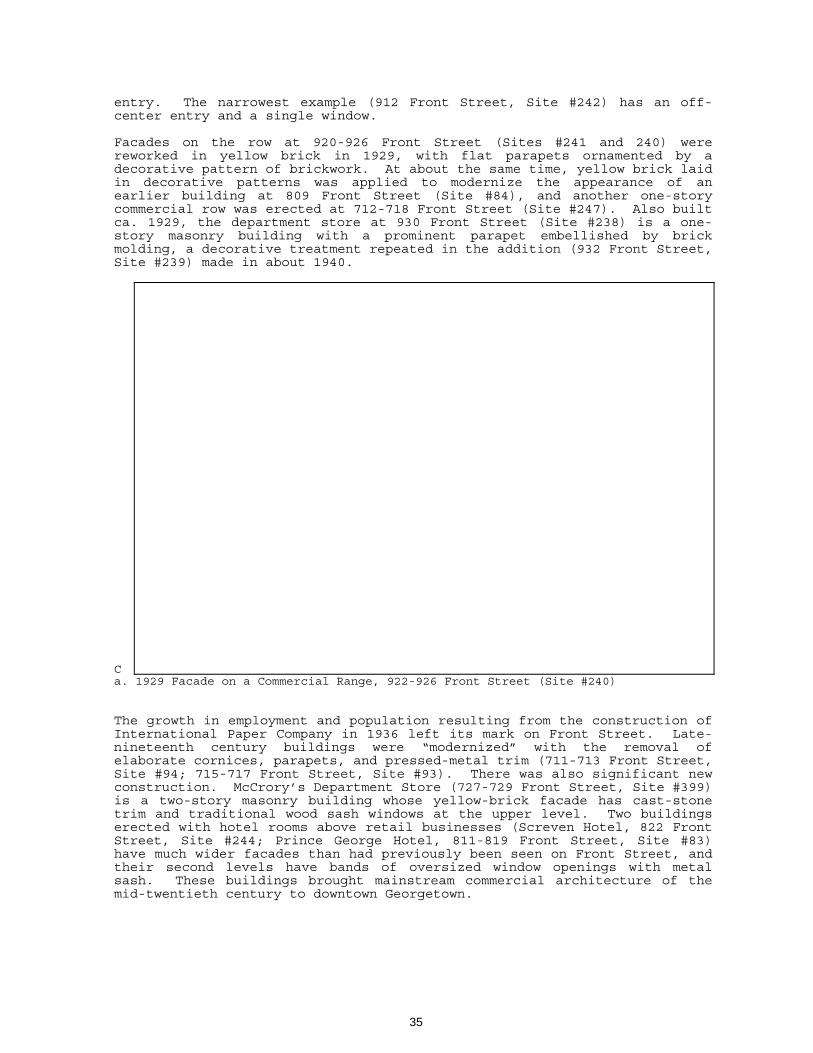
entry. The narrowest example (912 Front Street, Site #242) has an off-center entry and a single window. Facades on the row at 920-926 Front Street (Sites #241 and 240) were reworked in yellow brick in 1929, with flat parapets ornamented by a decorative pattern of brickwork. At about the same time, yellow brick laid in decorative patterns was applied to modernize the appearance of an earlier building at 809 Front Street (Site #84), and another one-story commercial row was erected at 712-718 Front Street (Site #247). Also built ca. 1929, the department store at 930 Front Street (Site #238) is a one-story masonry building with a prominent parapet embellished by brick molding, a decorative treatment repeated in the addition (932 Front Street, Site #239) made in about 1940. Ca. 1929 Facade on a Commercial Range, 922-926 Front Street (Site #240)
The growth in employment and population resulting from the construction of International Paper Company in 1936 left its mark on Front Street. Late-nineteenth century buildings were “modernized” with the removal of elaborate cornices, parapets, and pressed-metal trim (711-713 Front Street, Site #94; 715-717 Front Street, Site #93). There was also significant new construction. McCrory’s Department Store (727-729 Front Street, Site #399) is a two-story masonry building whose yellow-brick facade has cast-stone trim and traditional wood sash windows at the upper level. Two buildings erected with hotel rooms above retail businesses (Screven Hotel, 822 Front Street, Site #244; Prince George Hotel, 811-819 Front Street, Site #83) have much wider facades than had previously been seen on Front Street, and their second levels have bands of oversized window openings with metal sash. These buildings brought mainstream commercial architecture of the mid-twentieth century to downtown Georgetown.
35

Alterations This survey included buildings that were first constructed before 1950, and that retain whose historic scale, mass, or detail have not been substantially altered or replaced within the past fifty years. Some changes, such as the mid-century rear additions to the Morgan House at 732 Prince Street (Site #196), do not jeopardize the essential integrity of the primary elevations, and substantial alterations that took place before 1950 have themselves become a part of a building’s historical record (for example, the mansard roof on the Georgetown single house at 417 Prince Street, Site #123; the complete reworking of Masonic Hall, 632 Prince Street, Site #197). The most common alterations to residences in the survey area have been side or rear additions, replacement windows, replacement exterior siding, and remodeled porches. A popular mid-twentieth century alteration (429 Prince Street, Site #125; 131 Orange Street, Site #275) was to replace one-story or two-tiered porches with a full-height portico supported by monumental columns. Because of their original architectural or historical interest, these and a few other properties, such as the Oliver House (914 Prince Street, Site #303) or B. W. Cannon’s Store (805 Prince Street, Site #86), were surveyed when alterations are so extensive that they do not contribute to the historic district.
36

Properties that are eligible for listing in the National Register
37

38

RECOMMENDATIONS Preservation of Georgetown’s sense of history has been a component of civic life for decades. A 1907 observer found that “the flavor of colonial life, culture and tradition, mingled with the snap and vim of twentieth century progress, exists in Georgetown.”1 The local commitment to preserving the built environment can be strengthened through continuing research, education, and government/agency activities. The survey of historic properties, including evaluations of National Register eligibility, should continue. The Georgetown Historic District includes the original 200 lots laid out in 1729, and some of the 88 adjacent lots laid out in 1737. The blocks between Wood and Cleland Street are within the early plan, but have not been included in the National Register District or the local historic district. This area should be surveyed and district boundaries redrawn to include the appropriate blocks or properties. The boundaries of the locally-designated historic district should be revised, at least extended to include the blocks between Wood and North Fraser Streets. The survey area that is east of Meeting Street does not appear to be an eligible National Register district, but there are aspects of the neighborhood that deserve protection: streetscapes and trees, lot size and density, and the general low-rise nature of its residential construction. An overlay district should be incorporated into the City Zoning Ordinance that will protect the visual qualities of this area while allowing compatible new construction that complies with current building codes. As survey is carried out in other neighborhoods, the West End and Willowbank for example, it may become desirable to develop additional overlay districts and guidelines. In addition to expanding the boundaries of the Georgetown Historic District, the National Register nomination for the City of Georgetown Historic District should be amended so that the period of significance reflects the extant historic properties. Revisions to the National Register Historic District and individual National Register nominations should be prepared in accordance with the SHPO Determinations of Eligibility. An historic sites survey, at least at the reconnaissance level, should be conducted in the entire city. Besides the Howard School/Georgetown High School complex, the West End retains several properties of special interest to the African-American community as well as a number of early-twentieth century dwellings constructed for the Atlantic Coast Lumber Company. Several subdivisions were developed somewhat later, during the boom decade that began in 1936. A windshield survey of Willowbank Subdivision found that it retains its original street plan nearly intact, and substantial architectural integrity. Willowbank and contemporary developments should be evaluated in sufficient depth for the Historical Society and City Planning Department to begin discussing priorities for preserving the historic built environment of the twentieth century.
1 Handbook of South Carolina, 1908, p. 568.
39

A handbook of design guidelines2 is in use by the City of Georgetown Architectural Review Board. These guidelines contain valuable insights into the general architectural characteristics of the district - street plan, typical building placement, size, mass and construction materials - and suggestions for reinforcing the district’s sense of time and place when considering new construction. In considering rehabilitation guidelines, however, the handbook places most emphasis on early or high-style structures, remarking that “the slow growth that has characterized the Town from early times does much to explain why there are not more historic buildings and why there are not more detailed and elaborate designs.”3 In fact, the majority of buildings within the district are historic, and most of them retain substantial architectural integrity. New design guidelines need to be developed that respect Georgetown’s particular history and architectural legacy, including small buildings and twentieth century construction. The commercial district along Front Street is a fragile resource that may be jeopardized by remodeling as much as by vacancy and low-rent use. The City should develop building-by-building design guidelines specifically for the historic properties, ranging in date from the 1840s to the 1940s, that characterize this particular commercial area. Sensitive rehabilitation in Georgetown will respect the late-nineteenth and early twentieth-century design of the original construction without attempts to create either an earlier appearance or incompatible modernity. Georgetown’s street trees, mostly oaks, are an important component of the National Register Historic District and several other neighborhoods. They must be protected, maintained by qualified arborists, and replaced in kind when necessary. Along with preserving individual buildings, the eighteenth century grid plan, and generations of street trees, the Society and Planning Department must develop programs that will protect the sense of place of the district. This will include planning for traffic and tourism management, especially parking and guided or driving tours. The issue of financial return and control must be raised before Georgetown becomes a drive-through spot for coach tours. Most controls on appearance and usage must be implemented and enforced at the local level. There are also state and federal incentives for preservation, and the possibility of local incentives. A Federal program, administered through the National Park Service and SHPO, provides for significant income tax credits in support of sensitive rehabilitation of income-producing historic properties. There is also a provision for tax-deductible charitable contributions based on the donation of a conservation easement to protect historic properties, whether or not they are income-producing. The easement program depends upon the participation of a non-profit organization engaged in historic preservation. Such an organization can qualify to accept and monitor preservation easements.
2 Wright and Associates, “Architectural Review Board Guidelines, Georgetown, South
Carolina,” (Charleston: Wright and Associates, nd, ca. 1985). 3 Ibid, p. 8.
40

Although the Federal Investment Tax Credit program allows incentives only for income-producing properties, there is the possibility of local tax relief under the provisions of South Carolina’s “Bailey Bill.” Other incentive programs, such as the Historic Homeownership Program being considered by Congress, may provide further incentives. The Historical Society and Planning Department should each charge a staff or volunteer member with becoming familiar with the range of financial incentive programs and proposals, and make information available to property owners, architects, and developers interested in Georgetown’s historic buildings. Accurate evaluations of historic buildings depend upon an understanding of the local context, both the circumstances that influenced construction and the individuals who planned it. A comprehensive study of Georgetown’s builders would provide valuable insight into the resources available to the people who commissioned the city’s structures. Many slave craftsmen and itinerant builders will remain anonymous, but there is material to be found about twentieth century architects and contractors. Within the African-American community, they include master carpenter Renty Tucker, master builder Mackie Ford, and others such as Nathan Brown, Sam Bonds, and Sam Hudson of Brandon Construction. The role of white developers like Herman Schenck in the construction of their investment properties should also be explored. Except for the questions about builders, a great deal of information is readily available about Georgetown’s historic buildings and their occupants. Less is known about the city’s cemeteries, historic resources that reveal significant aspects of town planning and can also provide information about the past through their layouts, plantings, and monument types. A comprehensive guide to gravestone inscriptions in Georgetown’s historically white cemeteries is available, but the cemeteries of the city, white and black, deserve additional attention. The history of the potters’ field shown on LeGrand Walker’s 1885 map should be explored. This site has been developed, but it should not be forgotten. Other burial grounds, such as Bethesda Baptist Cemetery on Black River Road; St. Stephen AME Cemetery and Church of God Cemetery at the foot of Gilbert Street; and the old Myrtle Grove Cemetery said to be on the International Paper Company site, should be visited and mapped. To help assure their future protection, boundaries, ownership and responsible parties should be clarified. These steps are the minimum that should be taken for cemeteries within the city. Other activities could include research into the history of the land upon which they were established; organizational affiliations of the cemeteries’ users; the people who were buried in them; and studies of layout, plantings, and tombstone types. Finally, the Georgetown County Historical Society should be commended for the work it has done in promoting awareness and appreciation of our history as it is reflected in the City of Georgetown Historic District. The Society’s future activities, and cooperative ventures with organizations such as the Committee for African-American History Observances, the Georgetown County Public Library, the Rice Museum, and the South Carolina Department of Archives and History, must acknowledge the solid groundwork that has been provided through the publications and programs of the Society.
41

DATA GAPS There were no known or suspected historic properties in the survey area that were inaccessible for intensive survey. Gaps in the historic research due to the losses of Georgetown County’s records or neglect in some areas of record-keeping are discussed in the narrative that is part of this report. Suggestions for further research are included as recommendations.
42

BIBLIOGRAPHY
Bonds, Miss Mary M., Mrs. Evelyn Washington Nesbitt, Mrs. Zelda Jackson Woodson, compilers, “Afro-American Georgetown, S. C. Heritage, 1670-1960,” n. d., vertical files, Georgetown County Library.
Bridwell, Ronald E. “Gem of the Atlantic Seaboard.” Part II of “That We Should Have a Port,” A History of the Port of Georgetown, South Carolina. Georgetown: Ronald E. Bridwell, 1991.
Bryan, John M., ed. Robert Mills, Architect. Washington DC: American Institute of Architects Press, 1989.
Clark, Clifford Edward, Jr. The American Family Home, 1800-1960. Chapel Hill: University of North Carolina Press, 1986.
Committee for African-American History Observances, “Gullah Roots. A Tour of African-American Georgetown.” n.d.
_______. “Living Legends Calendar: Men of Action Edition,” 1990
_______. Vertical files, Georgetown County Library.
Community Times “Black History Edition” 2/19-2/35/1998.
Department of Agriculture, Commerce and Industries, and Clemson College. South Carolina. A Handbook. Columbia: 1927.
Georgetown County, South Carolina, Tombstone Inscriptions. Georgetown: The Georgetown County Historical Society and the Georgetown Committee of the National Society of Colonial Dames of America in the State of South Carolina, 1980.
Georgetown County Clerk of Court’s Office. Plat and Deed Books.
Georgetown City Directory. 1941.
“Georgetown. The Gem of the Atlantic Seaboard.” Georgetown: Chamber of Commerce, ca. 1925.
The Georgetown Times.
Gowans, Alan. The Comfortable House: North American Suburban Architecture 1890-1930. Cambridge MA: MIT Press, 1986.
A Guide to the City of Georgetown Historic District. The Rice Museum, 1974, 1980, revised edition 1995 Georgetown County Historical Society.
Hardwick, John. A Plan of George Town and its Common also of the Lots adjoining George Town laid out by Charles Brown, Esq. and Dr. Joseph Blyth... 1798, traced by L. H. Siau. N.d., n.p., Georgetown County Historical Society.
Lane, Mills. Architecture of the Old South: South Carolina. Savannah: The Beehive Press, 1984.
Lawson, Dennis T. “Atlantic Coast Lumber Corporation,” Georgetown: The Rice Museum, 1975.
McAlester, Virginia, and Lee McAlester. A Field Guide to American Houses. New York: Alfred A. Knopf, 1984.
43

Mills, Robert. Statistics of South Carolina. 1826, rep. ed. Spartanburg: The Reprint Co., 1972
South Carolina Historical and Genealogical Magazine/South Carolina Historical Magazine.
National Archives Microfilm Publications. United States Census, Georgetown District/County. Industrial Schedules, Seventh Census, 1850.
_____________. Industrial and Slave Schedules, Eighth Census, 1860.
_____________. Industrial Schedules, Ninth Census, 1870.
_____________. Industrial Schedules, Tenth Census, 1880.
National Register Property Files, City of Georgetown. State Historic Preservation Office, SC Department of Archives and History.
(Charleston) News and Courier.
Ravenel, Beatrice St. J. Architects of Charleston. Charleston: Carolina Art Association, 1945, rev. ed. 1964.
Rogers, George C. Jr. The History of Georgetown County, South Carolina. Columbia: USC Press, 1970; rep. Spartanburg: The Reprint Company, Publishers, 1990.
Sanborn Company Insurance Maps.
Smith, Henry A. M. “Georgetown - The Original Plan and the Earliest Settlers” pp. 85-101 in SCHGM IX, No. 2 (April 1908).
South Carolina State Gazetteer and Business Directory for 1890-91. N. p., ca. 1890.
South Carolina State Gazetteer and Business Directory. Period 1905-1910. N. p., ca. 1905.
State Board of Agriculture of South Carolina. South Carolina. Resources and Population, Institutions, and Industries. Charleston, 1883. Rep. ed. Spartanburg: The Reprint Company, 1972.
State Department of Agriculture, Commerce and Immigration. Handbook of South Carolina. Resources, Institutions and Industries of the State. 2nd ed. Columbia: The State Company, 1908.
Teel, Dorothy T. The 1880 Census of Georgetown County, South Carolina. Hemingway: 3 Rivers Historical Society, 1985.
A View of Our Past. The Morgan Photographic Collection depicting Georgetown, South Carolina ca. 1890-1915. Georgetown: The Georgetown County Library System, 1993.
Walker, LeGrand G., “Georgetown, South Carolina. Compiled from Plans, Wm. Greene & Chas. W. Forster.” Georgetown: Clerk of Council, 1885.
Wells, John E., and Robert E. Dalton. South Carolina Architects, 1885-1935. Richmond VA: New South Architectural Press, 1992.
Wright and Associates, “Architectural Review Board Guidelines, Georgetown, South Carolina.” Charleston: Wright and Associates, n. d., ca. 1985.
Wyndham, Melissa J. "The 1860 Census of Georgetown County, South Carolina." Typescript, nd, Georgetown County Public Library.
44

COMPILED INVENTORY OF SITES The inventory of sites serves both as an index to the site forms, and as a database of information about each survey property. It is organized by street address, and includes the survey site number, assessor’s tax parcel number, property type and date, and historic name where appropriate. Property type abbreviations used in this inventory:
APT apartment building CEM cemetery COM commercial property DUP duplex residence EDU educational institution GOV government/public building REL religious property SFR single family residence MISC other: includes Winyah Indigo Society Hall, Masonic Lodge, and the “Garden Center” on Church Street
The inventory for the City of Georgetown Cultural Resources Survey also provides information about properties within the Georgetown Historic District. Where “district” is shown as GHD, the status of the property - Contributing, Non-contributing, or individually listed in the National Register of Historic Places - is indicated as C, NC, or NR. The designation E in the status column indicates survey properties outside the Historic District which were evaluated as Eligible for listing in the National Register. The Georgetown Historic District was officially listed in the National Register with a period of significance from 1729 to 1931. Only those contributing properties built prior to 1932 are officially listed in the Register. The period of significance for the district is eligible for expansion to include the period from 1932 to 1950; therefore properties included in the inventory that are marked with “C” status but were built between 1932 and 1950 are marked with an asterisk (*). These properties will be officially listed in the National Register only when the district nomination has been revised to reflect an expanded period of significance.
45


