84
NARIVA SWAMP RESTORATION INITIATIVE -TRINIDAD AND TOBAGO- by Montserrat Carbonell Dawn Browne Gerard Alleng Bobby Massey 2007

NARIVA SWAMP RESTORATION INITIATIVE -TRINIDAD AND TOBAGO-
by
Montserrat Carbonell Dawn Browne Gerard Alleng Bobby Massey
2007

DUCKS UNLIMITED, Inc. Memphis, TN /USA
www.ducks.org

NARIVA SWAMP RESTORATION INITIATIVE
TRINIDAD AND TOBAGO
by Montserrat Carbonell
Gerard Alleng Dawn Browne Bobby Massey
August 2007

Printed by: Ducks Unlimited, Inc., Memphis, TN, U.S.A. Prepared with financial assistance of Ducks Unlimited, Inc., USDA Forest Service and US Fish and Wildlife Service
Copyright: The organizations responsible for this publication have waived copyright. ISBN: 1 932052 13 5 Suggested Citation: Carbonell, M., G. Alleng, D. Browne, and B. Massey. 2007. Nariva Swamp Restoration Initiative, Trinidad and Tobago. Ducks Unlimited, Inc., Memphis, TN, USA. Available from: Ducks Unlimited, Inc., One Waterfowl Way, Memphis, TN, 38120-2351, U.S.A. http://www.ducks.org/lac/homepage The presentation of material in this book and the geographical designation employed do not imply the expression of any opinion whatsoever on the part of Ducks Unlimited, Inc. concerning the legal status of any country, area, or territory, or concerning the delimitation of its boundaries or frontiers. The information contained in this book and accompanying maps are unsuited for, and shall not be used for any regulatory purpose of action, nor shall the report or accompanying maps be the basis for any determination relating to impact assessment or mitigation. 2007

“…for a radical, rather than superficial solution… a management strategy is required that recognizes the fundamental ecological character of this important natural area… No resource use of this area, or management system designed for the area, can be sustainable unless it takes account of water. Consequently, the future protection and rational utilization of Nariva Swamp must be based on a better understanding of the hydrology.”
P. Bacon (1996)


ACKNOWLEDGEMENTS The Nariva Swamp Restoration Initiative was developed thanks to the many colleagues both in Trinidad and Tobago and in the USA who over eight years have generously provided and shared information, bibliography, unpublished reports, field notes, and personal experience. We are sure this list is far from complete and we would like to apologize up front for having omitted anyone. First and foremost, we would like to thank the Hon. Penelope Beckles, Minister of Public Utilities and the Environment for her support and patience. A very special thanks goes to our “boss”, Nadra Nathai-Gyan. She kept us busy all along but shared her deep knowledge of Nariva, her professionalism, her passion for conservation and love for her country. Her enthusiasm was contagious and kept us going even in the most difficult moments, but we must thank her also for going out of her way every time we visited Trinidad, making our trips very productive and efficient, and for providing more information that we could digest. To our colleagues in the Forestry Division, Kenny Singh, Roopnarine Singh, David Boodoo, Steven Poon, Motilal Lal, and Sham Ramsubage (Shortman), for being an integral part of the project and sharing Nariva with us, discussing draft documents and result, and for everything they do during their daily jobs to ensure Nariva doesn’t die! To our dear friends Ashook Maharaj and Dhaniram Ramlal, made sure we did not miss any appointment. Whether in town or in the field, they drove us safely everywhere and taught us many things about their culture. And to Sandra Marajh and Lisa Philip for helping us in so many ways, making sure we had everything we needed and ensuring everything went smoothly. Many thanks to all. We are particularly grateful to the many inhabitants of the communities of Biche, Kernahan-Cocal and Plum Mitan, in particular to all the members of the Nariva Environmental Trust and volunteer fire fighters (in alphabetical order): Kalian Deonanan, Kenrick Harris, Randy Jagdeo, Shobha Jonas, Sitram Jury, Teeluck Khemraj, Totaram Khemraj, Yodha Khemraj, Aneil Lal, Anurudh Lal, Anthony Pitt, Audho Ramadhar, Ashley Ramoutar, Eddy Rampersad, Irvin Rampersad, Sham Ramsubage, Kirk Sampath, Visham Sieunarine, Kushulal Sooknanan, Ramesh Zoongie , who in spite of their busy schedules tending to their gardens and families were always available to give us a hand while doing field work. We owe a warm thank you Mrs. Jonas in Kernahan and Mrs. Deonanan in Plum Mitan, who treated us like family and provided the meals while we were guests in their communities. We also would like to thank Suresh Sookbir for an excellent job geo-referencing, classifying, and digitizing and Jacob Opadeyi of UWI for the GIS work. Robyn Cross and Ken Ogeer, of the EMA were extremely helpful ensuring the topographic surveys were carried out the way we had requested. Special thanks go to John Agard, EMA’s Chairman of the Board, for his wise advise so many times, his support and guidance in navigating the sometimes difficult institutional labyrinth. To all the members of the National Wetlands Committee, past and present, for listening to our presentations of draft after draft, to our requests and suggestions, and for contributing with information and guidance as to what was most useful for them when planning for the conservation of Nariva. Special thanks to Ronald Bryce and Frankie Balkissoon of the MALMR for sharing some old

maps, reports and data that had until then been impossible to obtain, and Narine “Guptie” Lutchmedial of the Manatee Trust for helping to get the fire fighting materials to the volunteer fire patrol members. We are also grateful for the information provided by Water and Sewerage Authority, Water Resources Agency, Urban and Regional (Town and Country) Planning Division (Ministry of Planning and Development), and the Draughting Office of the Forestry Division, in particular Barbara Scoobie. Many thanks to our colleagues in Ducks Unlimited who provided assistance during various stages of the project. Steve Adair helped with the initial restoration work plan. Dick Kempka was involved at the beginning and was instrumental in getting the change detection analysis to a good start. Nancy Thompson and Yongtao Luo always helped with a big smile with the database, the mapping application and the multiple maps versions. Shane Hanna did the many drafts of the complicated drawings necessary for the topographic surveys and for the engineering plans. A special thanks to Ken Kriese for his help with ensuring the fire management materials reached Trinidad, and with the final editing of the report. Jyoti Karki of the Center for Energy and Environmental Policy (University of Delaware) worked hard on the hydrological analysis, thanks. We hope that this baptism to issues facing Caribbean wetlands will be a milestone for you in your own conservation efforts and career path. Thanks to the USFWS Neotropical Migratory Bird Conservation Act for providing financial support for several aspects of this project, and to an Anonymous Donor for providing support over the life of the Latin America and Caribbean Program. Two special people deserve more than a simple thank you. They have taught us how to never give up, keep fighting for something one believes in, and never let Nature down. They have been criticized, and even virtually and literally slapped on the face, but they continue to fight for Nariva, just like they have for the past 20+ years. Molly Gaskin and Karilyn Shephard - thanks for being such special people. Finally, a very special thanks goes to our partners in the USDA Forest Service: Val Mezainis, Jack Capp, Carol Lively, George Custer, Will Ebaugh, David Farnsworth, Michelle Zeedee, Dana Roth, Billy Terry, Andrea von de Rohe, and Ronna Simon for their help in many ways than one. The financial support was crucial, but so was the technical expertise they contributed to this project. Their presence and encouragement throughout the project were instrumental to achieving many good things.

We dedicate this effort on Nariva and its ensuring legacy to one person who is no longer with us but whose scientific research and commitment to wetlands in the Caribbean provided us with a solid foundation to build on for our work in Nariva. Peter Robin Bacon left us in 2003 but as a testament to his legacy, his research on Nariva in 1979 remains the most comprehensive study of the area and has been extensively utilized and cited. The region lost a significant asset with his passing but it is hoped that this work in Nariva will inspire many others with his type of passion and zeal for wetlands conservation.
Prof. Peter R. Bacon - 1997


CONTENTS
A BRIEF HISTORY OF CONSERVATION EFFORTS IN NARIVA ...............................1 RESEARCH AND ECOLOGICAL STUDIES.........................................................................1 COMMUNITIES AND FARMING .......................................................................................3 AGRICULTURE AND AQUACULTURE DEVELOPMENT PROJECTS........................................4 OIL EXPLORATION ......................................................................................................5 FIRE THREATS............................................................................................................6 THE ROLE OF NGOS ..................................................................................................6 PROTECTION AND CONSERVATION MEASURES..............................................................8 THE RAMSAR CONVENTION ON WETLANDS...................................................................9 MANAGEMENT PLAN AND ENVIRONMENTAL IMPACT STUDY ............................................9 RESTORATION PLANS .................................................................................................9 CARBON SEQUESTRATION AND FUTURE PLANS FOR NARIVA ........................................10
THE NARIVA SWAMP RESTORATION INITIATIVE...................................................11 ANALYSIS OF HISTORICAL LANDSCAPE CHANGES IN NARIVA ...........................................13
INTRODUCTION .........................................................................................................13 SOURCES OF INFORMATION.......................................................................................13 RESULTS .................................................................................................................19
ANALYSIS OF THE HYDROLOGY OF NARIVA ....................................................................34 INTRODUCTION .........................................................................................................34 SOURCES OF INFORMATION .......................................................................................35 RESULTS .................................................................................................................35
RECOMMENDATIONS FOR RESTORATION OF NARIVA........................................43 HYDROLOGICAL REHABILITATION ..................................................................................46
BUSH-BUSH .............................................................................................................47 KERNAHAN...............................................................................................................47 GENERAL SURVEY GUIDELINES FOR NARIVA SWAMP .....................................................54
FIRE MANAGEMENT .....................................................................................................58 LITERATURE...............................................................................................................63


A BRIEF HISTORY OF CONSERVATION EFFORTS IN NARIVA Nariva has the most varied vegetation of all wetlands in Trinidad and Tobago, with distinct zones of swamp forest, palm swamp, herbaceous swamp and mangrove woodlands (James, 1992). It is especially important for the large numbers of waterfowl, including migratory species, and it is the major wetland in Trinidad which still sustains anaconda (Eunectes murinus), the blue and golden macaw (Ara ararauna) after a reintroduction program, and manatee (Trichechus manatus) - the latter under threat due to habitat destruction illegal hunting for its meat. Traditional methods are used to fish cascadura (Hoplosternum littorale), a species whose whole life history is tied to the ecology of Nariva, to which it is confined, and black conch (Pomacea urceus), which are consumed by local communities and offered for sale on a small scale to the wider community.
Anaconda (Eunectes murinus)
Due to its uniqueness, Nariva has attracted scientific research, socio-economic and agricultural projects, conservation projects, and several “development” plans. It is an area where conventional development and conservation concerns have crossed paths and have resulted in conflict. RESEARCH AND ECOLOGICAL STUDIES Early scientific work in the Nariva Swamp area was carried out around the 1950s, by the then Trinidad Regional Virus Laboratory (TRVL) - now Caribbean Epidemiological Centre (CAREC) – which was especially interested in research on arboviruses. The scientific expedition was involved in bird surveys and banding efforts, bat and other small mammal projects, and amphibian and reptile surveys.
Nariva Swamp Restoration Initiative page 1

TRVL Field Station on Bush-Bush (http://www.carec.org/about/history.html) Research has also been carried out on species that are used and/or consumed by the local population (Price 1955, Bacon 1970, LaCroix 1971. These include studies on: the palmiste palm (Roystonea oleracea); moriche palm (Mauritia setigera); mangroves; fish such as the cascadura (Hoplosternum littorale), the guabine (Hoplias malabaricus) and the yarrow (Hoplerythrinus unitaeniatus); the blue crab (Cardisoma guanhumi) and callaloo crab (Ucides cordatus); the mangrove oyster (Crassostrea rhizophorae); and the conch (Pomacea urceus). In the late 1970s, after realising the ecological and socio-economic importance of the Nariva Swamp, the Ministry of Agriculture, Land and Marine Resources (MALMR), responsible for the conservation of natural resources in the country at that time, requested the University of the West Indies (UWI) to carry out a study of the area. The report prepared by the UWI (Bacon et al, 1979) included physical and ecological aspects, as well as the possible environmental effects of reclamation of the Nariva Swamp. The authors clearly indicated that their report lacked a soil study and insect population and epidemiology surveys - which were meant to be carried out by other institutions. The study could also have been greatly improved by consideration of economic and social aspects. Nevertheless, the report still remains the most comprehensive study of Nariva from the perspective of its natural resources. Other studies have included those on manatee (Khan, J 1996) and on palm swamp forest (Bonadie, W.A. & Bacon, P.R. 1999, 2000), and the economic evaluation of its resources (Pemberton, C & Fridie, M. 2000; Pemberton, C. 2005)
page 2 Nariva Swamp Restoration Initiative

COMMUNITIES AND FARMING A small portion of the northern area of Nariva has been occupied by local people, growing vegetables and rice, and harvesting fish and molluscs, since the 1940s (Pritchard, 1997). The first development was to the north, between the Nariva Swamp and the foothill of Brigand Hill and Mt. Harris. In the 1960s, small developments also became established in the southern portion of Nariva, and along the Manzanilla-Mayaro coastal road. These activities did not have a negative influence in the Nariva ecosystem because of their small scale and the methods used by the farmers (mostly without machinery or use of agrochemicals). At present there are two communities, Plum Mitan (600 inhabitants) and Kernahan (400 inhabitants), directly benefiting from the natural resources of Nariva. Additionally there is a small, non-permanent community, Cocal (50 inhabitants), that benefits from Nariva during part of the year. The community of Biche (2000 inhabitants) is further away and benefits less directly from the natural resources of Nariva.
Nariva farmers, Forestry Division and Ducks Unlimited partners Until the mid 1990s, the communities in Nariva viewed the Government as only being interested in the conservation of wildlife and unconcerned about their welfare. For years, international missions and delegations travelled to Nariva, but had never sufficiently consulted the communities that relied
Nariva Swamp Restoration Initiative page 3
on Nariva’s resources or considered their needs. However, in the mid 1990s, the Trinidad and Tobago authorities changed their approach and started to integrate the communities surrounding Nariva and include them in the decision making process. As a result, the attitude and actions of the communities also began to change. Volunteer fire-fighting groups were trained and established in each community of Nariva by the Government of Trinidad and Tobago, and a small but growing local NGO, comprised entirely of community members, was formed. The mission of this group, which became the Nariva Environmental Trust in 2003, is to “look after the preservation of Nariva Swamp and its resources.” The government has continued to engage the communities and has hired local members for various part-time jobs, such as filling canals dug by the evicted illegal farmers, building an observation tower and interpretation centre, developing a tree nursery, supporting the reintroduction of the blue and gold macaw, and patrolling the protected area. Several community members have also become tour guides, while continuing to benefit from the fish, conch, crab and other wildlife. AGRICULTURE AND AQUACULTURE DEVELOPMENT PROJECTS In the 1950s, a legal agriculture project, the Plum Mitan Rice Scheme (Sector A), was developed. It started as a request by several farmers in the 1930s (Agristudio, 1991). Approximately 500ha of wetland and forest were converted into agricultural plots and a series of drainage and irrigation canals were constructed. The objective was to accommodate small land holdings for the inhabitants of Plum Mitan. In the 1960s the Navet Dam was built upstream to divert water from the Navet River to the expanding developments in the area around San Fernando on the west coast. This significantly reduced the flow of water into the Nariva system. Since the 1950s, several studies have been carried out to determine the potential of the marsh for agricultural development, and some incorporated suggestions for aquaculture projects. These included various initiatives funded by international agencies including FAO (1957, 1985), OTCA (1967, 1970), and NEDECO (1983). Unfortunately, all of them omitted the physical and ecological aspects of the Nariva Swamp, an evaluation of the possible negative effects of this development on the environment, as well as the socio-economic impact and/or benefits they might bring to the local communities. Furthermore, none of the studies involved consultation with the local communities. Bacon et al (1979) warned against the consequences of the FAO (1957) and OTCA (1970) proposals, and together with other scientific information, however scant and preliminary, helped the government withhold its decision to approve the execution of any reclamation scheme. According to Agristudio (1991), in 1990 the Institute of Marine Affairs advised the Ministry of the Environment and National Service to study the extent of habitat destruction in Nariva; stop further expansion of rice cultivation; restrict hunting and fishing activities; and give higher priority to aquaculture projects over agriculture ones. The report also considered plans to develop other rice schemes, as follows:
page 4 Nariva Swamp Restoration Initiative

− Bois Neuf Scheme, or Sector B, immediately south of Sector A. This plan included: o 1200ha of agricultural plots; o the construction of the Plum Mitan Reservoir in the corner where the Jagruma River
was converted into the Jagruma cut; o the construction of the Bois Neuf Reservoir to hold water transported by the
Jagruma River upstream from Sector A (the forest and vegetation were cleared and became known as “The Bowl”); and
o two canals (Main Canal and Navet Cut) to transport the water accumulated north of Bois Neuf by the Bois Neuf, the Navet River and others.
− Petit Poole Scheme, north of Petit Poole, with 100ha of agricultural plots.
− Cocal-Kernahan Scheme, south of the Nariva Swamp, with 700ha of agricultural plots, which
has been developed. Additional modifications took place from 1987 - 1996. Illegal rice farmers began squatting in the area south of Sector A, which was to become the Bois Neuf Scheme, or Sector B. They occupied over 1500ha of land, where they cleared the forest, dug canals, burned the vegetation on a regular basis, and extensively used agrochemicals as well as heavy machinery. These illegal farmers were not part of the local communities but came from outside the area, which contributed to distrust by local communities of people from outside Nariva, and furthered hindered efforts by the Government in implementing conservation and sustainable-use plans in Nariva. The illegal rice farmers were finally evicted in 1996 by the government. However, because Trinidad and Tobago lacks legislation that requires those responsible for environmental damage to pay mitigation or restoration costs, the government has had to assume responsibility for funding efforts to reverse the damages done to the Nariva Swamp. OIL EXPLORATION Trinidad's oil- and gas-driven economy has doubled in 7 years and quadrupled in 20 (McKenzie Funk 2005), and the industry has had interests in the Nariva area as there is potential for oil and gas deposits under it. Nariva has been exposed to seismic surveys for a number of years conducted for the Government of TT through PETROTRIN. In 2002, a new threat arose when Talisman (Trinidad) Petroleum Ltd. discovered an apparent oil deposit below Nariva. While some manner of exploration still seemed likely, the Environmental Management Authority stood up, denying Talisman the clearance to use underground explosives for seismic testing. In 2004, Talisman submitted a request, including an environmental impact study, for oil and gas exploration and exploitation in and around Nariva. Permission was granted to explore up to 18 wells outside the Nariva Swamp Protected Area boundaries, three wells on the boundaries, and to carry out horizontal exploration under it -work has already started.
Nariva Swamp Restoration Initiative page 5

FIRE THREATS Starting in 1997, after some initial funding was secured, several training workshops were organised by the Forestry Division, including some with the support and participation of the Ramsar Convention Secretariat, Ducks Unlimited and USDA Forest Service. Fire fighting materials and equipment, and training in the use of GPS units, was also provided. By 2005, over 35 local community members were actively participating in the prevention, management and suppression of fires in Nariva.
1995 fires throughout Nariva Swamp and surrounding forest THE ROLE OF NGOS The role of the NGOs, mainly that of the Pointe-a-Pierre Wildfowl Trust, in securing time on local television and radio stations, publishing numerous newspaper articles, alerting the international conservation community, organizing street demonstrations and meetings of experts, providing technical and scientific information to the authorities, and much more, has been crucial in helping to save Nariva. A professionally made video, 'Nariva Must Not Die' by Pearl & Dean (Caribbean) Ltd., was aired several times on national television in 1994 which showed the rich fauna and flora of Nariva and its importance to livelihood of the local communities. This was sponsored by Angostura Bitters, Thomas Peake Hardware Store, Guardian Life Wildlife Trust, the Southern Basin Consortium, West Indian Tobacco Company Ltd., ESSO Standard Oil and AMOCO Trinidad Oil Company. It was also shown by the Trinidad and Tobago delegation at the 5th Conference of the Contracting Parties to the Ramsar Convention on Wetlands, in Kushiro, Japan, in 1993.
page 6 Nariva Swamp Restoration Initiative
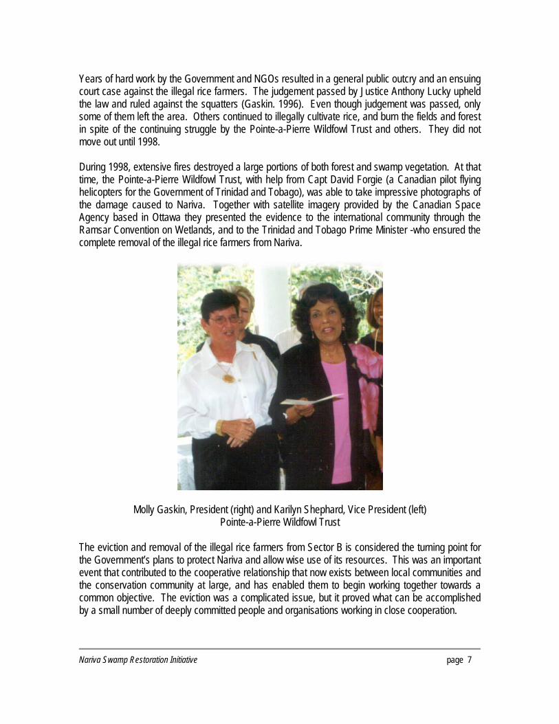
Years of hard work by the Government and NGOs resulted in a general public outcry and an ensuing court case against the illegal rice farmers. The judgement passed by Justice Anthony Lucky upheld the law and ruled against the squatters (Gaskin. 1996). Even though judgement was passed, only some of them left the area. Others continued to illegally cultivate rice, and burn the fields and forest in spite of the continuing struggle by the Pointe-a-Pierre Wildfowl Trust and others. They did not move out until 1998. During 1998, extensive fires destroyed a large portions of both forest and swamp vegetation. At that time, the Pointe-a-Pierre Wildfowl Trust, with help from Capt David Forgie (a Canadian pilot flying helicopters for the Government of Trinidad and Tobago), was able to take impressive photographs of the damage caused to Nariva. Together with satellite imagery provided by the Canadian Space Agency based in Ottawa they presented the evidence to the international community through the Ramsar Convention on Wetlands, and to the Trinidad and Tobago Prime Minister -who ensured the complete removal of the illegal rice farmers from Nariva.
Molly Gaskin, President (right) and Karilyn Shephard, Vice President (left) Pointe-a-Pierre Wildfowl Trust
The eviction and removal of the illegal rice farmers from Sector B is considered the turning point for the Government’s plans to protect Nariva and allow wise use of its resources. This was an important event that contributed to the cooperative relationship that now exists between local communities and the conservation community at large, and has enabled them to begin working together towards a common objective. The eviction was a complicated issue, but it proved what can be accomplished by a small number of deeply committed people and organisations working in close cooperation.
Nariva Swamp Restoration Initiative page 7

PROTECTION AND CONSERVATION MEASURES Trinidad and Tobago has a well-established system of forest reserves, game sanctuaries and prohibited areas, with the first wildlife sanctuary being created as early as 1928 (Bacchus and Vorran, 1990). A forest reserve ordinance was established in 1950, which made provision for the establishment of forest reserves, but the legislation was basically concerned with the sale of timber and is limited in its protection of the forest environment. Unfortunately there are no legally defined national parks in Trinidad and Tobago as draft legislation for the creation of these management categories has been proposed but has not been enacted. However, the administrative responsibility for the conservation of wetlands that contains forest reserves fall under the jurisdiction of the Forest Division, Ministry of Public Utilities and the Environment. The national policy on wetlands was approved in 2001 and advises the Forestry Division on wetland conservation issues. The policy is supposed to provide a framework for the management of wetlands within the country but the legal framework only provides limited protection to the system, as there is no specific legislation that covers the management or regulation of wetlands. The Bush-Bush Wildlife Sanctuary was established in 1968 under the Conservation of Wildlife Act, and declared a Prohibited Area in 1989. The Nariva Windbelt Forest Reserve to the west of Nariva was declared under the Forests Act in 1954, giving the Forestry Division the authority to manage it. The Nariva Swamp was declared a Prohibited Area (6,234ha) in 1992, and proposed as a National Park in 1998 under an approved World Bank project to designate several protected areas in the country. This project was discontinued after two years, in 2000. However, it was not until in 2006 when Nariva became an Environmental Sensitive Area under the Environmental Management Act (EMA) of Trinidad and Tobago that the area can be said to have become adequately protected. The Act prescribes the limitations of land use within environmentally sensitive areas, including Nariva, and specifies the type and intensity of activities that are required to sustain or enhance the natural resources within these areas. In addition to these items of national legislation, the Government of Trinidad and Tobago is party to a number of international conventions that if upheld should provide tools (legal and technical) to adequately protect the Nariva Swamp. These international conventions include the Ramsar Convention on Wetlands (signed in 1993); the Convention on Biodiversity (ratified in 1996), Convention on Climate Change (ratified in 1994), the Kyoto Protocol (signed in 1999, ratified in 2005)., the Convention on International Trade in Endangered Species of Flora and Fauna (CITES, signed in 1984); and the Protocol for Specially Protected Areas and Wildlife (SPAW, signed in 2000), which focuses on the establishment of legally protected areas and national parks, particularly for the protection of wildlife. Additionally, the manatee was declared an Environmentally Sensitive Species in 2005 under the Environmental Management Act. The designation gives manatee special protection and includes specific limitations on use of or activities required to adequately protect it.
page 8 Nariva Swamp Restoration Initiative

THE RAMSAR CONVENTION ON WETLANDS While the process leading to the final eviction of the illegal rice farmers was taking place, the Government of Trinidad and Tobago had already realised it would have to shoulder the responsibility for finding the way to restore Nariva’s original functions, values and benefits. To this aim the government took a series of very important steps. The first was in 1993 when Trinidad and Tobago became a Contracting Party to the Convention of Wetlands of International Importance (Ramsar, Iran, 1971) and designated the Nariva Swamp as its first wetland of international importance. This led to a series of additional measures that continue to improve the biological, social, and economical situation in and around Nariva. A few months after Nariva was designated a Ramsar site, the Government requested its inclusion in the Montreux Record, and the application of the Ramsar Advisory Mission. These were accepted in view of the changes taking place in the ecological character of this Ramsar site, and considered a serious commitment on the part of the Government to come to terms with a multiple use approach for the conservation of Nariva. The recommendations in the Ramsar Advisory Mission report (Ramsar Convention Bureau, 1995) added to the initiatives already underway for the conservation and wise use of the Nariva Swamp, and were used as a framework in which the many factors affecting the management and conservation of the site might be addressed within an international context. MANAGEMENT PLAN AND ENVIRONMENTAL IMPACT STUDY Arising out of the Ramsar Advisory Mission was a series of recommendations, including the development of a management plan and the undertaking of an environmental impact assessment of the most heavily impacted areas. These were completed in 1999 by the Institute of Marine Affairs at the request of the MALMR and provided the guidelines and recommendations the Government needed to carry out its work, step by step, with a technical and scientific basis. RESTORATION PLANS One of the recommendations of the management plan was to restore the hydrology of the swamp and develop a fire fighting and fire prevention program. In 1997, the Government begun filling in the channels created by the large rice farmers and started its fire training program with the local communities. However, the Government was also aware that in order to restore Nariva to its original condition, a more complex and detailed approach was required if it was to succeed in the long term. In 1999 it began to develop the Nariva Swamp Restoration Initiative with the objective of restoring the landscape and the ecological character of Nariva. As there was limited expertise on wetland restoration in Trinidad, the Government invited Ducks Unlimited, Inc. (DU) and the USDA Forest Service (USFS) to be part of a team that, together with national experts, would prepare a restoration work plan. The aim of the restoration work plan was to guide the implementation of some of the recommendations of the management plan that the EIA had undertaken a couple of years before,
Nariva Swamp Restoration Initiative page 9
and to focus on the restoration of the hydrology, aquatic vegetation and forests of the wetland, and the establishment of a fire-fighting program for the area. It soon became evident that there was no adequate information to establish a baseline for comparison, and guidelines for the restoration plans. After careful consideration it was determined that before any extensive restoration work could be adequately undertaken, a historical analysis of the land use and land cover changes using geographic information systems (GIS) and remote sensing (RS) technology was needed. Once the baseline was determined, a restoration scenario was developed based on ecological, socio-economic and managerial considerations. Thanks to the support of the USDA Forest Service and the US Fish and Wildlife Service, a final report was submitted to the Government of Trinidad and Tobago in late 2005 that constituted the basis for the present report. CARBON SEQUESTRATION AND FUTURE PLANS FOR NARIVA The opportunity to develop a Carbon sequestration project to help fund the reforestation work necessary in Nariva, occurred in 2004. Contact was made with the World Bank BioCarbon Fund and DU submitted a project idea note (PIN) on behalf of the Government of Trinidad and Tobago for their consideration. After initial negotiations with DU, and pre-approval of the project, the Environmental Management Authority (EMA) took on the responsibility on behalf of the Government. In 2007, a contract was signed between the Government of Trinidad and Tobago and the World Bank to develop a project design document (PDD) for submission to the Clean Development Mechanism (CDM) Executive Board. The development of the PDD involves the undertaking of a hydrological study and preparation of a water management plan, together with a reforestation plan for the area. The PDD is expected to be submitted to the CDM Executive Board in 2008. The Carbon sequestration component of the restoration project represents a significant opportunity for Trinidad and Tobago and the Caribbean region. The financing of an afforestation/reforestation (A/R) project through the sale of Carbon credits under the CDM of the Kyoto Protocol is the first of its kind in the country and the region, incorporating at the same time biodiversity and social components, as well as wetland restoration (in many cases not considered Carbon sinks). It is expected that the approach, the methodology, techniques and other lessons learnt from the implementation of this type of project will foster the growth of similar A/R CDM projects in the Caribbean and Latin America. This will be particularly useful as there are only a few CDM financed projects to date in the region because many countries have not tapped into the benefits of this financial mechanism for conservation purposes. It is anticipated that the Nariva project will be the prototype for future A/R CDM projects.
page 10 Nariva Swamp Restoration Initiative

THE NARIVA SWAMP RESTORATION INITIATIVE
Wetland restoration has been regarded as a priority mainly by developed countries, with limited efforts being undertaken in less developed countries. In the Neotropical Region, very little has been done, and most of these efforts have failed to address the situation in an integral and comprehensive way by not using the existing information and available technology to their advantage. Trinidad and Tobago on the other hand, has used the many financial mechanisms and guidance provided by the Ramsar Convention on Wetlands to help with the restoration work in Nariva. Some of these initiatives include the formulation of a national wetlands policy, revision of laws and institutional structure, involvement of local communities, promotion of communication, education and public awareness, development of environmental impact assessments and management plans, monitoring of the ecological character of wetlands, and more. Trinidad and Tobago’s legislation does not include provisions to make those who cause damages to the environment pay for the restoration or mitigation of the impacts. Therefore, even though the large farmers were evicted in 1996, the Government had to shoulder the responsibility of finding a way to restore the original functions, values, and benefits Nariva provided before it was so heavily modified. In 1999, Ducks Unlimited, Inc. (DU) and the USDA Forest Service (USFS) hosted a workshop on the use of Geographical Information Systems (GIS) and remote sensing (RS) for wetland management and restoration during the Ramsar Convention on Wetlands’ 7th Conference of the Contracting Parties in Costa Rica. The workshop provided many examples in North America where both organizations had developed successful wetland management and restoration projects, and the delegates of Trinidad and Tobago realized this methodology could also be applied to Nariva. Thus, the Government of Trinidad and Tobago approached DU and the USFS, and invited them to visit the country and meet with national experts to discuss the possibility of developing a restoration initiative for the Nariva Swamp Ramsar Site. After several visits, a work plan was developed that would implement of some of the recommendations proposed in the management plan and environmental impact assessment produced by the Institute of Marine Affairs (IMA). The work plan concentrated on the reforestation of areas that had been cleared, and the rehabilitation of the wetland’s hydrology, taking into account the role that fires have played in the destruction of the site in the past, and their use as a positive tool in the future. As there was no information available at the landscape level, and the Government wanted a realistic scenario for the restoration of Nariva, an analysis of the historical changes that had taken place at the landscape level was the initial step. This was followed by an analysis of the hydrology, and topographic surveys that guided the engineering recommendations and suggestions that would assist in the rehabilitation of the marsh.
Nariva Swamp Restoration Initiative page 11
In addition, a fire prevention and management plan was also prepared, training workshops in Trinidad were carried out, several fire-fighters from Trinidad trained in the USA, and materials and

equipment were purchased and given to members of the volunteer fire fighting brigades in the communities around Nariva. All the work was carried out by DU, USFS and experts from Trinidad and Tobago, but many members of the Forestry Division and MALMR staff, local communities, NGOs, UWI, EMA, , and the National Wetlands Committee (NWC) played a very active role throughout the process. They provided information, suggestions, their direct knowledge of Nariva, and most importantly, their support and encouragement to continue working in spite of the many difficulties that the project went through. The results of this project are considered public domain and can be shared among cooperators and stakeholders. To this end, a database was generated to house the information collected and generated throughout the project, and a mapping application has been developed to serve the information on-line. The database is currently hosted and managed by DU (www.ducks.org/lac/nariva), however all of the information has already been transferred to the EMA in Trinidad and Tobago, which will soon manage the mapping application and most of the data sets contained in the database through its own web site.
The Nariva River
page 12 Nariva Swamp Restoration Initiative

ANALYSIS OF HISTORICAL LANDSCAPE CHANGES IN NARIVA INTRODUCTION The objective of the change detection analysis was to determine the historical changes that had occurred at the landscape level and to analyze them as far back in time as possible. A GIS work plan was developed to guide the project team which worked on the historical change analysis. This provided the methods and standards that had to be followed in order to ensure that all the data resulting from the analysis could be assembled into a database. An inventory was made of the existing spatial data pertaining to the Nariva Swamp and new data was developed based on a needs assessment for historical change detection. The initial focus of the analysis was directed primarily at the Nariva Swamp protected area and Ramsar site (Figure 1). Ideally, if funding had become available and time would have allowed for it, the analysis would have been expanded to cover the entire catchment. However, existing GIS data for the catchment area was compiled when available and stored in the database. A review was undertaken of the spatial and attributes data pertaining to the Nariva Swamp, as well as the institutional capabilities of local agencies/organizations working with GIS. The following is a list of the organizations in Trinidad and Tobago that were approached for data based on their GIS capabilities and spatial data resources:
- Department of Surveying and Land Information, University of the West Indies (UWI), St. Augustine
- Forestry Division, Ministry of Public Utilities and the Environment - Land and Water Development Division, Ministry of Agriculture, Land and Marine Resources
(MALMR) - Land and Surveys Division, MALMR - Urban and Regional (Town and Country) Planning Division, Ministry of Planning and
Development - Water Resources Agency (WARA), Ministry of Public Utilities and the Environment
SOURCES OF INFORMATION Aerial Photographs Coverage of the Nariva Swamp by aerial photographs provided an adequate perspective of the historical changes within the area. The earliest photographs used were those of a 1942 series and the latest from a 1998 national survey (Table 1). Most decades were represented by coverage, with the exception being the period of the 1970s and the 1980s (Figures 4, 6, 8, 10).
Nariva Swamp Restoration Initiative page 13
The aerial photographs provided by the various organizations were in hard copy format with the exception of those at the Department of Surveying and Land Information, UWI. Once scanned, the photographs were geo-referenced, mosaicked and histogram-matched

Figure 1. Location of Trinidad and Tobago and the Nariva Swamp
page 14 Nariva Swamp Restoration Initiative

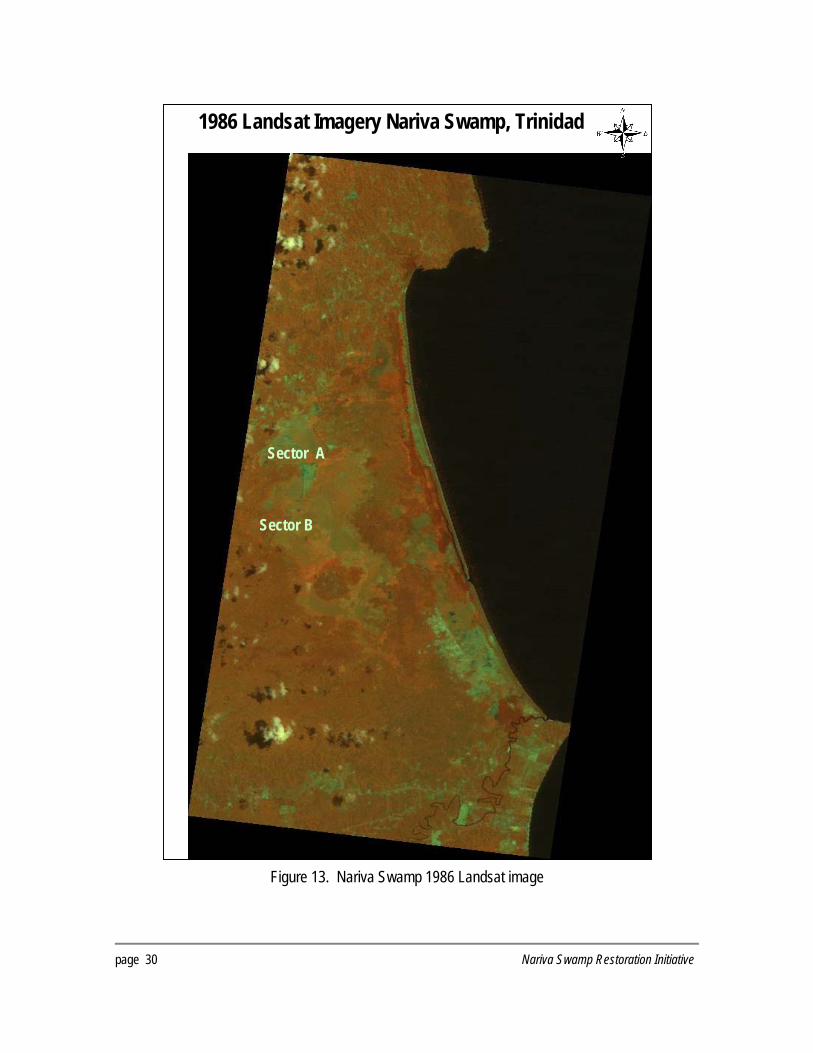
Satellite Imagery There was limited satellite data for the area (Table 1) available in Trinidad. Since aerial photography for 1970s and 1980s was not available, Landsat images (28.5 m resolution) for the years 1986 and 1987 were used in a limited way (Figures 13, 14) because they had limited spatial resolution. As it was necessary to provide greater spatial detail for the change detection analysis, IKONOS satellite imagery was acquired from Space Imaging (Figure 12). Image processing enhancements and classification of the IKONOS image was completed using PCI Geomatica Prime (includes Ortho Engine) software and used in conjunction with the aerial photographs for the land cover delineation and change analysis exercise. Topographic maps and other data sets Topographic map sheets of the area were available in hard copy format from the Land and Surveys Division of the Ministry of Housing and Settlements (Table 1). They were published in 1977 at a scale of 1:25,000. A more recent map series, based on a 1998 aerial survey is expected to be published soon. These maps may be available in various scales in paper and digital format. Nevertheless, the IMA had digitized the 1977 map sheets as part of the EIA (IMA, 1998) and Management Plan (IMA, 1999). In addition, the mapping section of the Forestry Division had historical land use and vegetation maps of the area, prepared in 1980. They were in hard copy format and had to be digitized as new data layers. Other data layers used in the change analysis were available from the various organizations including:
- Political boundaries – county limits - Infrastructure – e.g. villages, roads - Land use – e.g. agriculture - Surface and sub-surface geology - Watersheds boundaries - Hydrology
Hydrology data The hydrology data was obtained from the Land and Water Development Division, the engineering branch of the MALMR. This data was used in conjunction with the topographic maps for the area. Digital stream coverage for each decade was generated from the aerial photography, satellite imagery and topographic maps in order to establish the hydrological transitions of Nariva and the availability of water for the restoration. Boundary data The Water Resources Agency, part of the Water and Sewage Authority provided a copy of their version of the Nariva Swamp boundary and the EMA provided the proposed delineation of the Environmentally Sensitive Area (ESA) of Nariva (Figure 2).
Nariva Swamp Restoration Initiative page 15

Table 1. Topographic maps, aerial photo and satellite imagery inventory for the Nariva Swamp project
Data Type / Description
Data Source
Date of Data Capture
Data Scale / Resolution
Scanning Resolution
Projection Datum Area of Coverage
Topographic Map Sheets (34, 35, 36, 44, 45, 46, 54, 55, 56)
Lands and Surveys Division
1-D.O.S. 1977 Ed. Based on 1969 Air Photos
1:25,000 200 dpi UTM, Zone 20 P Naparima Datum
Nariva Catchment
Aerial Photograph 1942
Lands and Surveys Division
March 1942 1:50,000 300 dpi UTM, Zone 20 P Naparima Datum
Nariva Catchment
Aerial Photograph 1958
Wildlife Section
February 1958
1, 12,500 400 dpi UTM, Zone 20 P Naparima Datum
Nariva Swamp
Aerial Photograph 1969
Lands and Surveys Division
March 1969 300 dpi UTM, Zone 20 P Naparima Datum
Nariva Catchment
Aerial Photograph 1980
Lands and Surveys Division
1:10,000 400 dpi UTM, Zone 20 P Naparima Datum
Nariva Swamp (partial)
Aerial Photograph 1994
Wildlife Section
March 1994 1:25,000 300 dpi UTM, Zone 20 P Naparima Datum
Nariva Catchment
Ortho-photos 1994
Lands and Surveys Division
March 1994 1:25,000 300 dpi UTM, Zone 20 P Naparima Datum
Nariva Swamp
Aerial Photograph 1998
Land Settlement Agency
1:12,500 300 dpi UTM, Zone 20 P Naparima Datum
Nariva Swamp
Landsat 5 TM 1986
IMA May 1986 28.5m N/A UTM, Zone 20 P Naparima Datum
Nariva Swamp
Landsat 4 TM 1987
UWI November 1987
28.5m N/A UTM, Zone 20 P Naparima Datum
Nariva Catchment
Landsat 5 TM Landsat 5 TM
UWI May 1991 January 29 2001
28.5m N/A UTM, Zone 20 P Naparima Datum
Nariva Catchment
IKONOS 2003 Ducks Unlimited
January 2003 April 2003
4.0m 4.0 m
N/A UTM, Zone 20 P Naparima Datum
Nariva Swamp
page 16 Nariva Swamp Restoration Initiative
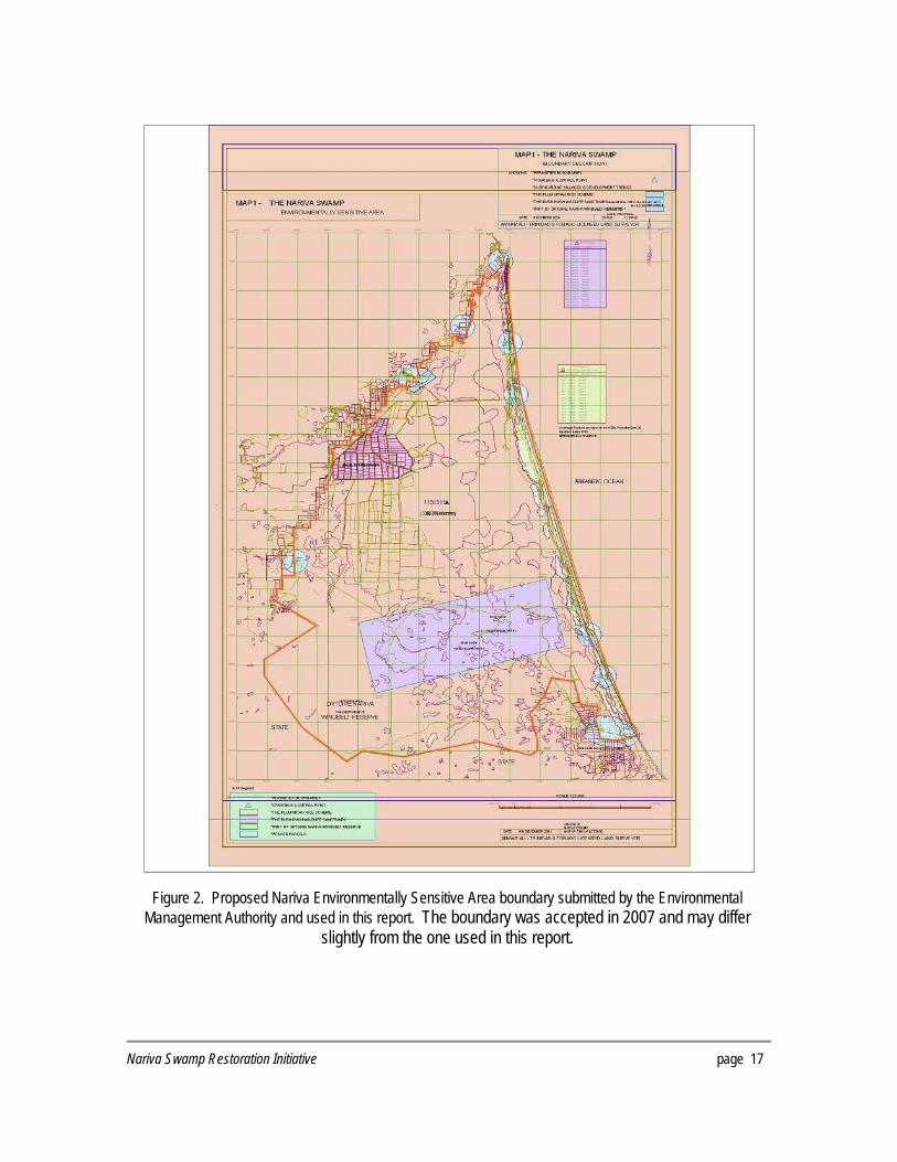
Figure 2. Proposed Nariva Environmentally Sensitive Area boundary submitted by the Environmental
Management Authority and used in this report. The boundary was accepted in 2007 and may differ slightly from the one used in this report.
Nariva Swamp Restoration Initiative page 17

Standards and metadata A key part of the project was to maintain data standards, including an adequate level of metadata. To ensure compliance with international standards, a metadata database was compiled according to ‘Federal Geographic Data Committee Level I’ standards. An initial phase of the program was implemented with the creation of a database for the digital map data available from the various agencies consulted. This database was reviewed and upgraded as the new data set layers were created during the analysis. GIS analysis and change detection The historical landscape changes were assessed based on a comparison of aerial photography, vegetation and hydrological information from 1942, 1958, 1969, 1980 (partial), and 1994 (Table 1, Figures 4, 6, 8, 10). However there was limited use of the 1980 aerial photographs because of the insufficient coverage of the area in the dataset. It was also not possible to use the Landsat imagery (Figures 13, 14) for the vegetation classification because of its limited spatial resolution but the IKONOS imagery (2003, Figure 12) was used to establish a present-day baseline inventory of land cover, land use, hydrology and roads. Digital topographic maps were compiled and mosaicked for the entire catchment and were used for geo-referencing all imagery. A topographic analysis, including development of digital streams coverage and other hydrological information, was undertaken. The following projection standard was decided on for use in the creation of the Nariva Swamp GIS database:
Projection - UTM Zone 20 Datum - UTM Naparima Datum Spheroid - UTM Naparima Datum
Vegetation/Landcover Delineation The delineation of vegetation classes and change detection was completed with the assistance of a wetlands ecologist and Forestry Division officers who had detailed knowledge of Nariva. The vegetation classes were selected based on a combination of factors including imagery resolution/scale and the objective of creating a historical perspective of relatively large-scale changes in vegetation communities. A pixel based classification of the IKONOS 2003 imagery was performed and designated with the same classes that were applied to the aerial photographs. Some areas over Sector B were obscured with cloud and required post-classification cleaning or interpolation. The land cover classes that were identified for Nariva Swamp are as follows:
Open Water Upland Forest Coconut Clear Cut Forest Marsh Swamp Forest Agriculture Settlement
The Marsh and Swamp Forest are both plant communities in the Swamp that occupy different areas and should be identified in a more detailed classification when is required by the restoration and monitoring work. The Swamp Forest category includes swampwood, palm forest and mangrove. Table 2 provides summaries of the historic area extents of the vegetation or land-use classes.
page 18 Nariva Swamp Restoration Initiative

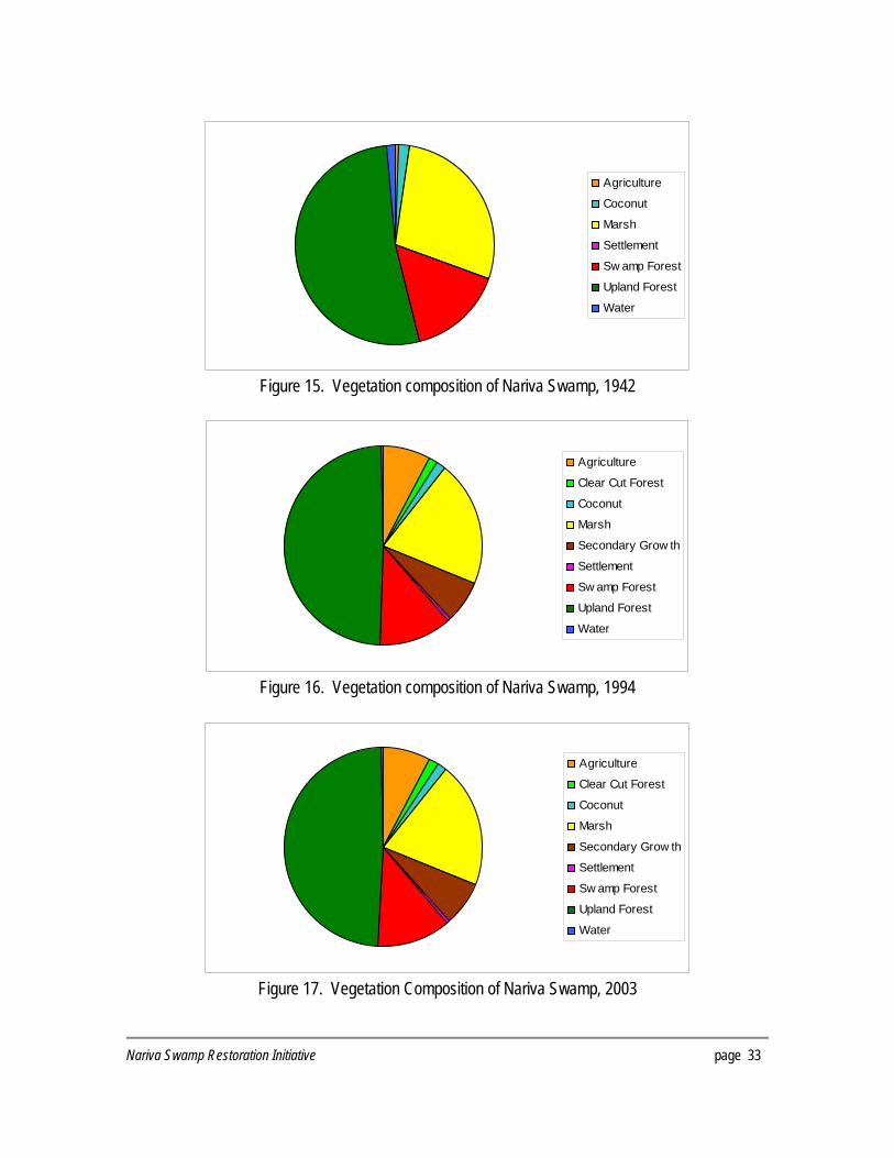
RESULTS Change Detection In 1942, the first decade of aerial photography acquired for the study (Figures 3-4), Nariva’s hydrological regime was very different from today. The Navet Dam did not yet exist, farming in Sector A and Sector B had not yet begun and the ecosystem was a mosaic of marsh, mangrove, forest and open water. In 1958, the major notable change was the decrease in open water areas in the south of Nariva and around Bush-Bush (Figures 5-6). An expansion of agriculture in what is now known as Sector A had begun to encroach on the marsh. By 1969, the Navet Dam had been built, roads had been constructed and the Petit Poole canal created (Figures 7-8). Agriculture had expanded significantly around Kernahan in the south and illegal rice farmers were moving into Sector B. Open water areas were scarce and the swamp forest distribution had shifted. Evidence of clear cutting in the upland forest around Kernahan was also apparent. Imagery was not available for the 1970s so a clear picture of the composition of Nariva was not possible for this decade. By the 1980s, the illegal rice farmers continued to move into Sector B and subsequently the hydrology of the marsh continued to be altered (Figure 13). Progression of swamp forest in the eastern part of the marsh was apparent and can be attributed to the lack of fresh water. In 1994, the swamp forest continued to expand on the east but was completely removed along the western edges of Sector B (Figures 9-10). By 1996, the Government of Trinidad and Tobago had evicted the illegal rice farmers in Sector B and passive regeneration had begun. However, the hydrology remained altered with many canals and levees still in place. In 2003 the legal agricultural plots in Sector A (Figure 11-12) had undergone a transition from rice to other types of farming (watermelon, green peppers, among others) and the canals had been rehabilitated and pumps updated with new equipment. In addition, recent satellite data from January 2007 did not show any major man-made changes within the protected area (Figure 14). With a detailed understanding of the composition of Nariva in the early 1940’s and the present day settlements, legal agriculture, hydrology and road infrastructure, inferences can be made with respect to the feasibility of restoration and rehabilitation. Figures 15-17 are a comparison of the vegetation composition between 1942, 1994 and 2003.
Nariva Swamp Restoration Initiative page 19

Figure 3 Nariva Swamp 1942 vegetation delineation
page 20 Nariva Swamp Restoration Initiative

Figure 4. Nariva Swamp 1942 aerial photography mosaic
Nariva Swamp Restoration Initiative page 21

Figure 5. Nariva Swamp 1958 vegetation delineation
page 22 Nariva Swamp Restoration Initiative

Figure 6. Nariva Swamp 1958 aerial photography mosaic
Nariva Swamp Restoration Initiative page 23
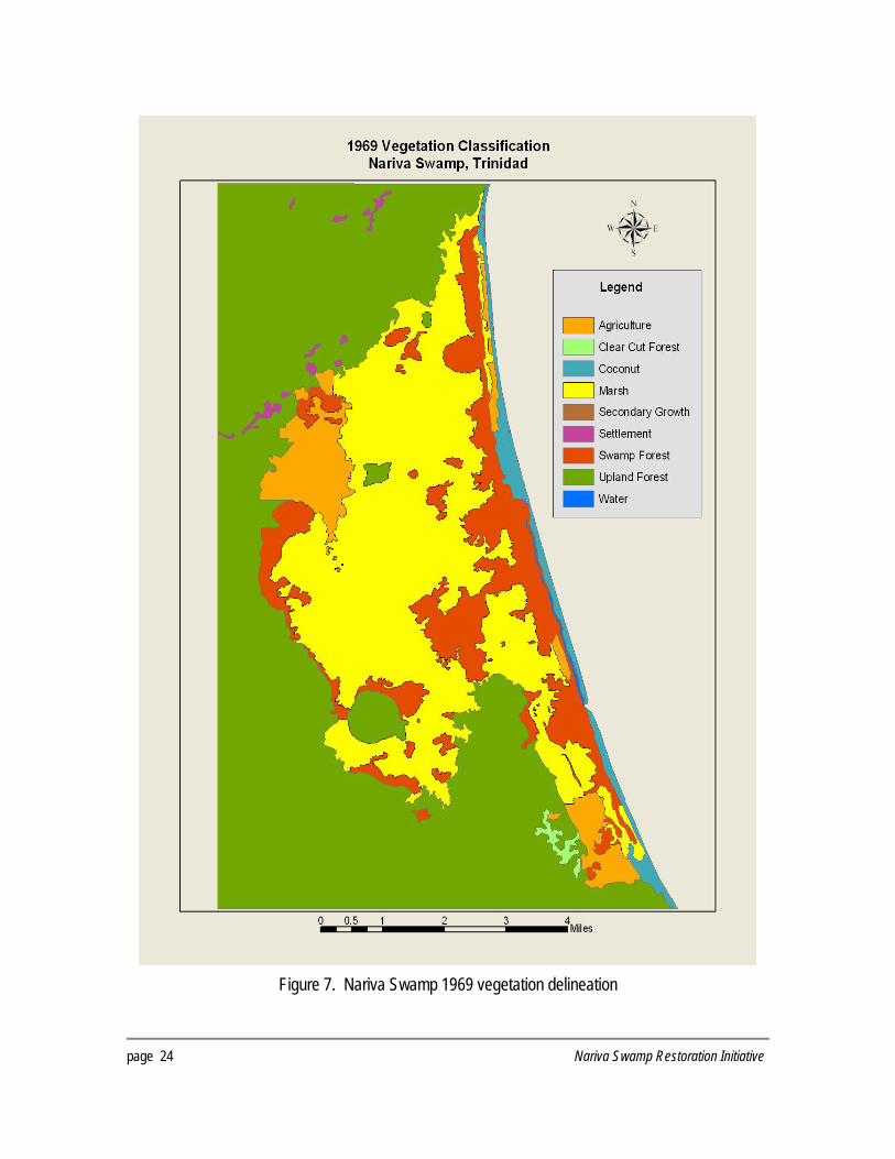
Figure 7. Nariva Swamp 1969 vegetation delineation
page 24 Nariva Swamp Restoration Initiative

Figure 8. Nariva Swamp 1969 aerial photography mosaic
Nariva Swamp Restoration Initiative page 25

Figure 9. Nariva Swamp 1994 vegetation delineation
page 26 Nariva Swamp Restoration Initiative

Figure 10. Nariva Swamp 1994 aerial photography mosaic
Nariva Swamp Restoration Initiative page 27
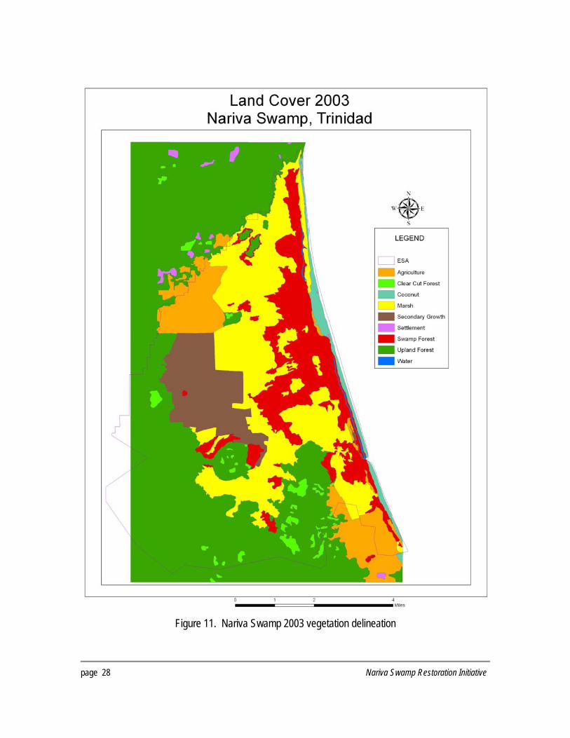
Figure 11. Nariva Swamp 2003 vegetation delineation
page 28 Nariva Swamp Restoration Initiative

Sector A
Sector B
Figure 12. Nariva Swamp 2003 IKONOS satellite imagery
Nariva Swamp Restoration Initiative page 29
page 30 Nariva Swamp Restoration Initiative
1986 Landsat Imagery Nariva Swamp, Trinidad
Sector A
Sector B
Figure 13. Nariva Swamp 1986 Landsat image

Nariva Swamp Restoration Initiative page 31
2007 IKONOS Imagery Nariva Swamp, Trinidad
Sector B Sector B
Sector A
Figure 14. Nariva Swamp2007 IKONOS image

% o
f to
tal h
a
8%
2%
2%
20%
7%
1%
12%
49%
0%
100%
2003
hect
ares
1226
237
253
3166
1110
82
1885
7677
22
1556
8
% o
f to
tal h
a
8%
1%
2%
21%
7%
1%
12%
49%
0%
100%
1994
hect
ares
1216
210
253
3230
1036
82
1895
7699
22
1564
4
% o
f to
tal h
a
5%
0%
2%
29%
-- 0%
12%
52%
0%
100%
1969
hect
ares
762 49
326
4488
-- 63
1858
8148
20
1571
4
% o
f to
tal h
a
2%
-- 2%
30%
0%
0%
14%
52%
0%
100%
1958
hect
ares
259 -- 237
4708
23
27
2245
8187
19
1570
4
% o
f to
tal h
a
1%
-- 2%
28%
-- 0%
15%
52%
1%
100%
1942
hect
ares
101 -- 281
4414
-- 7 2433
8236
232
1570
3
Table
2. P
relim
inary
area
summ
aries
for e
ach v
egeta
tion o
r land
use c
lass
Summ
aries
wer
e calc
ulated
using
the s
ame a
rea f
or ea
ch ye
ar
Clas
s
Agric
ultur
e
Clea
r Cut
Fore
st
Coco
nut
Marsh
Seco
ndar
y Gro
wth
Settle
ment
Swam
p For
est
Uplan
d For
est
Wate
r
Tota
l
page 32 Nariva Swamp Restoration Initiative
Agriculture
Coconut
Marsh
Settlement
Sw amp Forest
Upland Forest
Water
Figure 15. Vegetation composition of Nariva Swamp, 1942
Agriculture
Clear Cut Forest
Coconut
Marsh
Secondary Grow th
Settlement
Sw amp Forest
Upland Forest
Water
Figure 16. Vegetation composition of Nariva Swamp, 1994
Agriculture
Clear Cut Forest
Coconut
Marsh
Secondary Grow th
Settlement
Sw amp Forest
Upland Forest
Water
Figure 17. Vegetation Composition of Nariva Swamp, 2003
Nariva Swamp Restoration Initiative page 33

ANALYSIS OF THE HYDROLOGY OF NARIVA INTRODUCTION The Nariva system is a low-lying coastal wetland situated in a topographic depression running the length of Cocos Bay along the east coast of Trinidad. It occupies the lower reaches of a series of rivers flowing from the eastern flank of the Central Range towards the Atlantic Ocean. The water catchment covers an area of approximately 461km2 with the Nariva River being the main outlet for the watershed. The river is a tidal lagoon formed by the semi-enclosure of the Cocal sand bar, with the main area of discharge located at the southern end of the sand bar. There may also be some water seepage across the bar. Rainfall estimates for the area from 1969-1996 indicate that the western section of the wetland receives approximately 1528-3437mm/year with an overall mean of 2619mm, compared to the eastern section which, based on estimates from 1973-1996, receives a smaller amount of rainfall, 1420-2558mm/year with an overall mean of 1949mm (Draft Technical report for the Nariva Management Plan: Surface water Hydrology of Nariva Swamp).
0.0
50.0
100.0
150.0
200.0
250.0
300.0
350.0
400.0
450.0
JAN FEB MAR APR MAY JUN JUL AUG SEP OCT NOV DEC
Navet Ortoire Marper Farm
Aver
age A
nnua
l Rain
fall (m
m)
Figure 18. Average annual rainfall of three different stations from 1996-2005
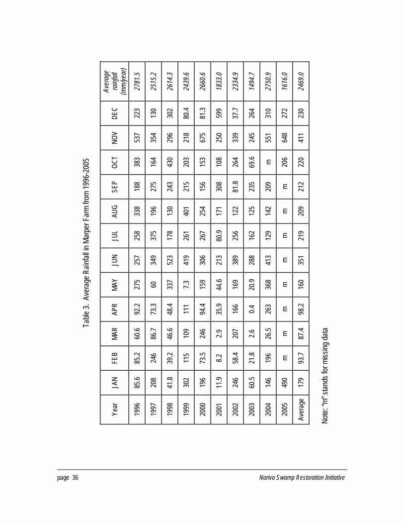
However, recent rainfall data from the Water Resource Agency (Figure 18) shows that over the last ten years (1996-2005), there has not been much of a difference in overall mean annual precipitation between the western and eastern regions of Nariva, as observed in the previous database (1969-1996) where the average rainfall for the western and eastern regions was 2469mm/year and 2382.2mm/year respectively. Data for the Navet Dam also indicates that it receives rainfall in the range of 1574-2689.5mm/year with an overall mean of 2442.1mm/year (See Tables 3-5 for details).
page 34 Nariva Swamp Restoration Initiative
Estimated evaporation loss from the area is 1636.8mm/year compared to 1496.3mm/year from evapo-transpiration. SOURCES OF INFORMATION The data on the hydrology of the Nariva system comes from a variety of sources. Rainfall data and stream flow for the area are available from the Water Resources Agency, which monitors water resources in the area from three primary recording stations – Navet, Ortorie and Marper Farm. Additional hydrological information has come from the studies by NEDECO (1981; 1983a & b), Agristudio (1991) and the work undertaken by the Institute of Marine Affairs for the environmental impact assessment and management plan. RESULTS The hydrology of Nariva Swamp is primarily determined by three factors:
− Freshwater inflow from inlets along its western boundary − Retention capacity and fluctuations in the water level in the swamp basin − Outflow/inflow of water through the Nariva River
Fresh Water Inflow Figure 19 shows the various streams and watercourses of the system. The wetland receives freshwater inflow from a series of rivers and their tributaries that drain the eastern side of the Central Range and flow into the western boundary of the system. In the northwestern sector of the wetland, water enters from the Petite Poole, Cuche, and Canque Rivers, and flow into the Petite Poole Cut. The Huila River and other small seasonal streams enter the Petite Poole Cut from the north. From the Petite Poole Cut, water flows into the northern end of the Nariva River. Rivers in the western sector of the wetland are the Jagruma, the Bois Neuf, and their tributaries. The outflow of the Jagruma River has been diverted into the Jagruma Cut which spreads east and south into the marsh. However there is uncertainty concerning the topology of these rivers. Water flow along the southern boundary of the wetland is influenced by the Guatacare River, which also receives water from the Ecclesville River. Water from the southern portion of the Nariva Swamp discharges through Boat Line, which eventually flows into the Nariva River (IMA, 1999f). The most southerly of the water channels affecting the hydrology of the wetland is the Cascadura River, which drains the Kernahan area. However, the exact location of its drainage route is unknown. Some studies state that during wet season, ground water also feeds water in the swamp. However, insufficient data exist in the distribution of aquifers and aquitards in catchment area to understand the importance of groundwater in providing freshwater to the wetland. Nevertheless two possible scenarios have been proposed regarding the movement of the water table based on the depth of the groundwater. Under the first scenario, the wetland is characterized as a surface and groundwater
Nariva Swamp Restoration Initiative page 35
Aver
age
rainf
all
(mm
/year
)
2781
.5
2515
.2
2614
.3
2439
.6
2660
.6
1833
.0
2334
.9
1494
.7
2750
.9
1616
.0
2469
.0
DEC
223
130
302
80.4
81.3
599
37.7
264
310
272
230
NOV
537
354
296
218
675
250
339
245
551
648
411
OCT
383
164
430
203
153
108
264
69.6 m 206
220
SEP
188
275
243
215
156
308
81.8
235
209 m 212
AUG
338
196
130
401
254
171
122
125
142 m 209
JUL
258
375
178
261
267
80.9
256
162
129 m 219
JUN
257
349
523
419
306
213
389
288
413 m 351
MAY
275 60
337
7.3
159
44.6
169
20.9
368 m 160
APR
92.2
73.3
48.4
111
94.4
35.9
166
0.4
263 m 98.2
MAR
60.6
86.7
46.6
109
246
2.9
207
2.6
26.5 m 87.4
FEB
85.2
246
39.2
115
73.5 8.2
58.4
21.8
196 m 93.7
JAN
85.6
208
41.8
302
196
11.9
246
60.5
146
490
179
Table
3. A
vera
ge R
ainfal
l in M
arpe
r Far
m fro
m 19
96-2
005
Year
1996
1997
1998
1999
2000
2001
2002
2003
2004
2005
Aver
age
Note:
“m” s
tands
for m
issing
data
page 36 Nariva Swamp Restoration Initiative

Aver
age
rainf
all
(mm
/year
)
2667
.1
2284
.5
2698
.5
2917
.1
2400
.1
1721
.1
2334
.7
1742
.0
2451
.3
517.
1
2382
.2
DEC
214 52
319
417
77.2
371
67.6
386
276 m 242
NOV
365
401
375
465
695
105
331
258
227 m 358
OCT
304
210
364
290
253
104
122
88.5
290 m 225
SEP
393
199
263
174
133
295
226
157
228 m 230
AUG
171
260
157
381
281
183
163
283
219 m 233
JUL
241
325
328
182
263
189
233
249
231 m 249
JUN
394
186
371
295
214
213
285
180
158 m 255
MAY
340
143
267
24.6
114
25.6
211
55.6
258 m 160
APR
47.1
45.2
83.8
150
143
35.9
90.4
31.9
323
13.7
96.5
MAR
54.2
12.9
75.5
41.9
31.6 1.3
147 8 60
m 48.1
FEB
79.1
213
39.1
139
39.4
146
49.5
30.9 60
m 88.4
JAN
64.4
240
55.8
359
156 52
410 14
121
503
197
Table
4. A
vera
ge R
ainfal
l in O
rtoire
Esta
te fr
om 19
96-2
005
Year
1996
1997
1998
1999
2000
2001
2002
2003
2004
2005
Aver
age
Note:
“m” s
tands
for m
issing
data
Nariva Swamp Restoration Initiative page 37

Aver
age
rainf
all
(mm
/year
)
2582
.3
2542
.4
2689
.5
2410
.1
2312
.8
1574
.0
2447
.8
0 0 0
2442
.1
DEC
157
87.4
328
250
167
244
93.7 m m m 190
NOV
388
309
383
319
605
109
368 m m m 354
OCT
166
162
203
260
419
86.7
207 m m m 215
SEP
290
354
342
281
307
285
156 m m m 288
AUG
273
241
301
295
265
188
176 m m m 248
JUL
226
362
347
178
263
220
305 m m m 271
JUN
504
372
345
367
289
203
304 m m m 341
MAY
330
114
256
11.4 m 47.8
195 m m m 159
APR
39
46.5
44.7
118 m 47.8
195 m m m 81.9
MAR
66.5 55
23
81.7 m 2.1
149 m m m 62.9
FEB
104
243
58.3
31.9 m 89.5
30.6 m m m 92.7
JAN 40
199
59.7
218 m 51.2
268 m m m 139
Table
5. A
vera
ge R
ainfal
l in N
avet
Dam
from
1996
-200
5
Year
1996
1997
1998
1999
2000
2001
2002
2003
2004
2005
Aver
age
Note:
“m” s
tands
for m
issing
data
page 38 Nariva Swamp Restoration Initiative
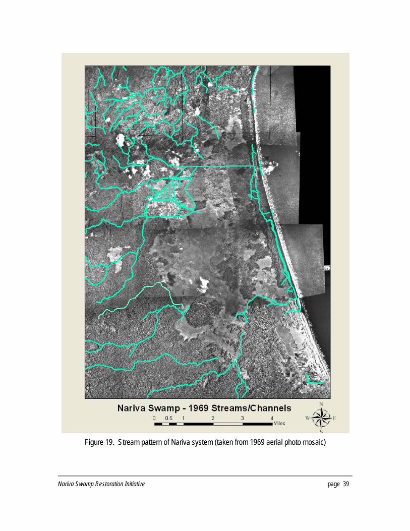
Figure 19. Stream pattern of Nariva system (taken from 1969 aerial photo mosaic)
Nariva Swamp Restoration Initiative page 39

discharge system. During the wet season, the swamp is fed by surface and groundwater because the water table is at or intersects the ground surface; during the dry season, the water table declines to a minimum depth of 1.37m below ground surface. In the second scenario, the wetland is defined as a surface water (perched) system, where the system is fed by surface water only during both the wet and dry seasons because the water table is located significantly below the ground surface; groundwater does not affect the system (IMA, 1998c). Retention capacity and fluctuations in the water level in the swamp basin There is uncertainty regarding the flow rates in the main water channels of the wetland as they are not gauged. As a result, there is limited understanding of the length of time that water is retained in the system. Table 6 shows the estimates of annual flow rates based on a study by Agristudio (1992). Table 6. Mean discharges for selected rivers flowing into the Nariva Swamp (after Agristudio, 1992)
Petit Poole Cuche Canque Jagruma m3/s m3 m3/s m3 m3/s m3 m3/s m3
0.293 924600 0.75 236400 0.517 163149 1.115 351655 Spot measurements taken from the Petit Poole cut in 1997 and 1998, ranged from 0.03-3.22m3/s in the wet season, and 0.01-0.03m3/s in the dry season. During the same period, flow rates in the Jagruma Cut ranged from 2.47-26.41m3/s (wet season) and 0.00-0.49m3/s (dry season) (IMA, 1999f). Limited data is available for other water channels in the swamp including Bush-Bush Canal (0.01- 0.14m3/s in the dry season) and Cascadura River where there was negligible flow during the wet season and no measurable flow during the dry season. Flow rates have not been measured for other rivers especially in the northwestern sector of the swamp. Further, there have not been any projections as to the retention time of the water flowing through the wetland. Outflow of Nariva River from the Swamp Outflow of water from the wetland is primarily through the Nariva River and peak water outflow is achieved during the wet season. However there is a very wide fluctuation for spot measurements of flow rates recorded during this period, ranging from 2.10-33.84m3/s. In the dry season, flow rates were 3.0-3.5m3/s, although a peak flow of 16.00m3/s was recorded due to tidal inflow into the wetland. This indicates that during the dry season, peak flow is reversed with the net water movement being from the sea into the wetland. Alterations to the hydrology of Nariva Swamp There have been both direct and indirect alterations to the hydrology of the Nariva Swamp as a result of external and internal impacts. Water flow into the system has been significantly altered with the establishment of the Navet reservoir in the upper reaches of the watershed. The reservoir was created in 1962 and extended in 1966 and 1976 (WASA, 2006). Its present capacity is 18,200,000 cubic meters of water, which has been retained from the Navet River, one of the main rivers
page 40 Nariva Swamp Restoration Initiative

supplying water to the southwestern section of the wetland. The retention of water from the Navet River would have reduced flow rates in rivers such as Bois Neuf River, which has become equivalent to the overflow discharge from the Navet Dam (IMA, 1999h). Major modifications to the hydrology have also taken place within the swamp and are primarily the result of agricultural encroachment. The creation of the Block A drainage system took place as early as 1940, where a topographic map of the area shows the beginning of the Petit Poole Cut. The purpose of this drainage canal, together with the Jagruma Cut, was to divert water away from the Block A in order to facilitate small-scale agriculture. The Block B area was the result of the illegal encroachment of large-scale rice farmers into the central section of the wetland. The farmers divided up the area into a network of interconnected channels and roads that could be utilized for irrigation and drainage of rice paddies and to provide access to the site. A channel 2m deep was also dug to connect the Bois Neuf River to the main storage channel in Block B. A second channel was excavated to connect the Bush-Bush boat line to Block B to transport harvested rice out of swamp, especially during dry seasons. It was postulated that these widespread alterations, particularly the alteration to the Bush-Bush Boatline, changed the hydrodynamics of the system, resulting in greater saltwater intrusion into the area from the Atlantic Ocean (Bacon, 1998). In 2005 the MALMR initiated a drainage control program for Block A, which consisted of: the dredging and possible widening of the Petit Poole Cut, the Jagruma Cut and Main Line; the building of a sluice gate at the eastern end of the Jagruma Cut so as to create a reservoir for irrigation to Block A and; clearing and maintenance of irrigation canals in Sector A. It is unclear what will be the impacts of this scheme on the hydrology of the wetland.
Nariva Swamp Restoration Initiative page 41

This page left blank intentionally
page 42 Nariva Swamp Restoration Initiative

RECOMMENDATIONS FOR RESTORATION OF NARIVA Habitat restoration or rehabilitation can be achieved through a combination of active and passive restoration techniques. Passive restoration requires the modification or halting of activities that are causing degradation or preventing recovery, and allows nature to take care of itself. Active restoration requires human intervention to speed up ecosystem recovery, but can be financially costly over large scales. However, carefully planned active restoration over a short period of time gives nature the initial assistance to help it evolve towards the desired results. Active restoration also helps to speed up carbon sequestration, generating carbon credits that can be sold on the international market, thereby offsetting the costs of restoration. The hydrological and landscape restoration scenario (Figure 20) contemplates a land cover baseline similar to the conditions in the early 1970s. The criteria followed for choosing the period as a baseline were:
− The restoration work should aim at a realistic scenario considering that the amount of water entering Nariva at present has been the same since the completion of the Navet Dam in the late 1960s and the agriculture scheme known as Sector A; and
− The restoration work should not negatively impact the current settlements and established legal agricultural areas.
While the suggested restoration goals reflect the early 1970s ecosystem composition, it was realized that the vegetation communities at that time had not yet reached a new distribution in response to the altered hydrological conditions and water levels imposed by the Navet Dam and Sector A. Because aerial photography or detailed maps from the 1970s were not available, it was not possible to obtain detailed vegetation composition data to provide accurate information about the landscape of Nariva in the 1970s, after the hydrology was altered by the dam and Sector A and before the illegal rice farmers modified “Sector B.” The recommended restoration scenario is based on the analysis of six decades of information that provide a characterization of the evolution of the vegetation under the different disturbance conditions. A monitoring plan will gauge the progress of the hydrological and vegetative restoration in the context of an adaptive management plan. In order to achieve a landscape that can be sustained with the water available at present, taking into account the existing needs of local communities and their farming water requirements, it will be necessary:
− to continue working with the MALMR to design and implement a water management plan for the area which may include modifications to the hydrologic structures built by the MALMR outside the limits of Sector A and Kernahan and increase the efficient and effective use of
Nariva Swamp Restoration Initiative page 43
water in Sector A and Kernahan in the dry season and ensure the rehabilitation measures outside the designated agricultural areas do not impact the farmers negatively;
− to consider modifying the existing hydrologic structures for the Boat Line canal; − to reforest areas deforested illegally, as well as other areas suitable for reforestation once
the hydrological system has been rehabilitated; − to develop and implement a comprehensive fire protection plan and to continue to improve
the response to fires in order to prevent further damage; and − to monitor these activities to evaluate on a regular basis the results and implement
modifications as necessary. In order to develop detailed engineering plans for the above hydrological objectives, it was necessary to carry out topographic surveys (see below). As a result of the hydrological and landscape changes resulting from human activities, it is difficult to predict the new hydrological model. A hydrological plan based on accurate and complete topographic measurements is required before any soil or vegetation management activities are implemented.
page 44 Nariva Swamp Restoration Initiative

Figure 20. Nariva Swamp Restoration Scenario (Reforestation = 872.22ha)
Nariva Swamp Restoration Initiative page 45

HYDROLOGICAL REHABILITATION The various factors that affect Nariva’s hydrology have to be considered in making the final determination regarding what level of rehabilitation to undertake. Issues such as manatee habitat, irrigation water, and saltwater intrusion must be included in the decisions regarding rehabilitation of the hydrology of the system. The GIS historical change detection analysis helped in making a decision based on what the swamp looked like historically and the level of rehabilitation that can feasibly be accomplished. However, additional information was needed with regard to the current situation with the hydrology, particularly due to the considerable alterations that have taken place. The EMA in Trinidad has hired as a consultant to develop a Water Resources Plan for the Nariva Swamp restoration as part of a carbon sequestration project between the Government of Trinidad and Tobago and World Bank. This plan is anticipated to be completed in 2008. It is also anticipated that the results of this plan will provide a better understanding of the hydrology of Nariva Swamp and the hydrological alterations needed to meet the 1970s ecosystem restoration goal. Prior to the selection of a consultant to develop the Water Restoration Plan, the EMA, together with DU and the Forestry Division, selected the surveying firm L & S Surveying Ltd to gather data for the possible location of a structure at the outlet of Bush-Bush, or Boatline Canal, and to determine if flooding of the Kernahan area could be reduced. The evaluation of the survey data was undertaken and recommended options are summarized below. An analysis of these changes has been performed with the desired restoration being a return of the vegetation patterns similar to that of the 1970s baseline. It will be necessary to install components to the existing hydrology that will permit the manipulation of water levels within Nariva Swamp. These components should be constructed to allow for the greatest degree of flexibility of operation, and to not adversely impact existing infrastructure. For this reason the tilting weir gate water control structure is recommended to manipulate the outlet flows from the swamp. Since the water levels in the swamp will be manipulated to allow for longer periods of inundation or for deeper depths of water within the swamp in order to achieve the 1970s ecosystem restoration goal, drainage from Kernahan will adversely be affected. Therefore, it is recommended that an alternate drainage system be constructed for Kernahan that is independent of the gated structures that will control water in Nariva Swamp. There are still other areas of the swamp to be surveyed, primarily the northern section of the system. These surveys were not possible due to lack of time (surveying in the area can only be done during the dry season), lack of sufficient funding, and limited expertise available to conduct surveys in wetland areas. Nevertheless, if these factors can be overcome, surveys should be undertaken of the northern sections of the swamp, in particular Sector B, areas east of Sector B to the Nariva River, Petite Poole, and areas north of Petite Poole. General guidelines for undertaking these surveys are provided in the section following the survey results below.
page 46 Nariva Swamp Restoration Initiative

BUSH-BUSH Plans for restoration of Nariva Swamp will require some type of structure at the outlets of Bush-Bush that can allow for the manipulation of water levels within Nariva Swamp. The data provided by L & S Surveying, Limited shows that there are two existing culverts under Manzanilla-Mayaro Road that allow water to exit Nariva Swamp. These will require the installation of water control structures so that water levels in Nariva Swamp can be held longer or at different depths to influence the vegetation restoration of Nariva Swamp. It is recommended that a dike and a tilting weir gate structure be installed upstream of these culverts. Figures 21 and 22 show the suggested layout of the dikes and the structure locations. For the main outlet of Bush-Bush or Boatline Canal, the dike should be constructed around the existing house and the existing culvert under Manzanilla-Mayaro Road so that the dike does not affect drainage from the house. The layouts shown will allow the installation of water control structures at the outlets of Nariva Swamp without any alteration to the existing culverts or disturbance to the road. These structures then can be used to manipulate the water regime of Nariva Swamp. A tilting Weir gate similar to the one shown in Figure 23 is recommended for this application. The size and number of the gates would be determined based upon the data provided in the Water Restoration Plan, but should be sufficient to pass flows without overtopping the new dikes. It is likely that riprap stones would need to be placed downstream of the gates to prevent future erosion of the river banks and to dissipate the velocity after the water comes over the gates. The tilting weir gate is an extremely easy gate to manipulate water levels. A simple turn of a handwheel will raise or lower the gate elevation to control water depths upstream. Once water reaches the desired level it will spill over the top of the gate and continue downstream. KERNAHAN Kernahan experiences flooding and standing water because any drainage from Kernahan must flow into Bush-Bush and exit via the structures under Manzanilla-Mayaro Road. Since the proposed gated outlet structures to be installed at the outlets to Bush-Bush will result in water being held longer in Nariva Swamp or increased depths of water within Nariva Swamp, the installation of these structures will also act to impede drainage from Kernahan. Therefore, an alternate drainage for Kernahan is also needed. In Figure 24 the current drainage of Kernahan is via four 0.61m pipes shown as Pipes A and one 1.2m pipe shown as Pipe B. This water makes it way into Nariva Swamp and exits via the culverts under Manzanilla-Mayaro Road. The elevations of Pipes A are around 0.2-0.25m. The elevation of Pipe B is around 0.95m. However, surveys of the ditches below these culverts show them to be around 0.7m, which will prevent anything below elevation 0.7m from draining. Based upon the survey data provided by L & S Surveying Limited, it appears that a new canal can be constructed from Pipe C at the corner of Kernahan to the outlet bridge under Manzanilla-Mayaro
Nariva Swamp Restoration Initiative page 47
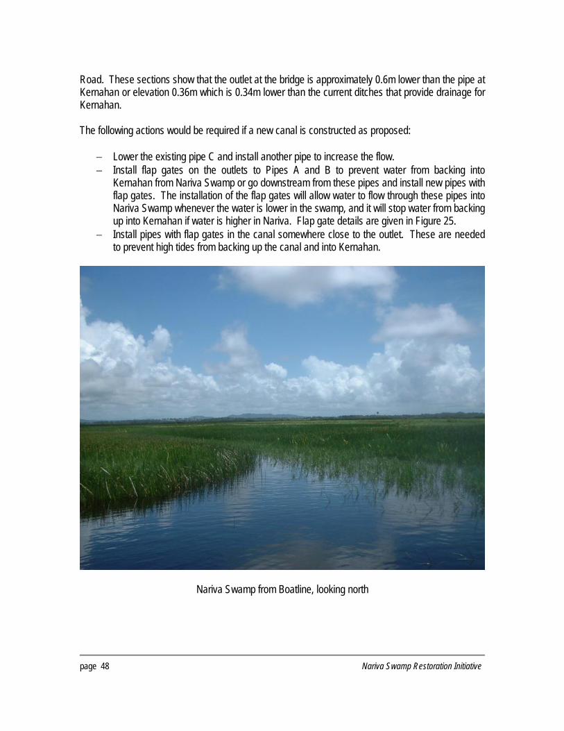
Road. These sections show that the outlet at the bridge is approximately 0.6m lower than the pipe at Kernahan or elevation 0.36m which is 0.34m lower than the current ditches that provide drainage for Kernahan. The following actions would be required if a new canal is constructed as proposed:
− Lower the existing pipe C and install another pipe to increase the flow. − Install flap gates on the outlets to Pipes A and B to prevent water from backing into
Kernahan from Nariva Swamp or go downstream from these pipes and install new pipes with flap gates. The installation of the flap gates will allow water to flow through these pipes into Nariva Swamp whenever the water is lower in the swamp, and it will stop water from backing up into Kernahan if water is higher in Nariva. Flap gate details are given in Figure 25.
− Install pipes with flap gates in the canal somewhere close to the outlet. These are needed to prevent high tides from backing up the canal and into Kernahan.
Nariva Swamp from Boatline, looking north
page 48 Nariva Swamp Restoration Initiative

Figure 21. Suggested layout of dikes and structures at Boatline Canal
Nariva Swamp Restoration Initiative page 49
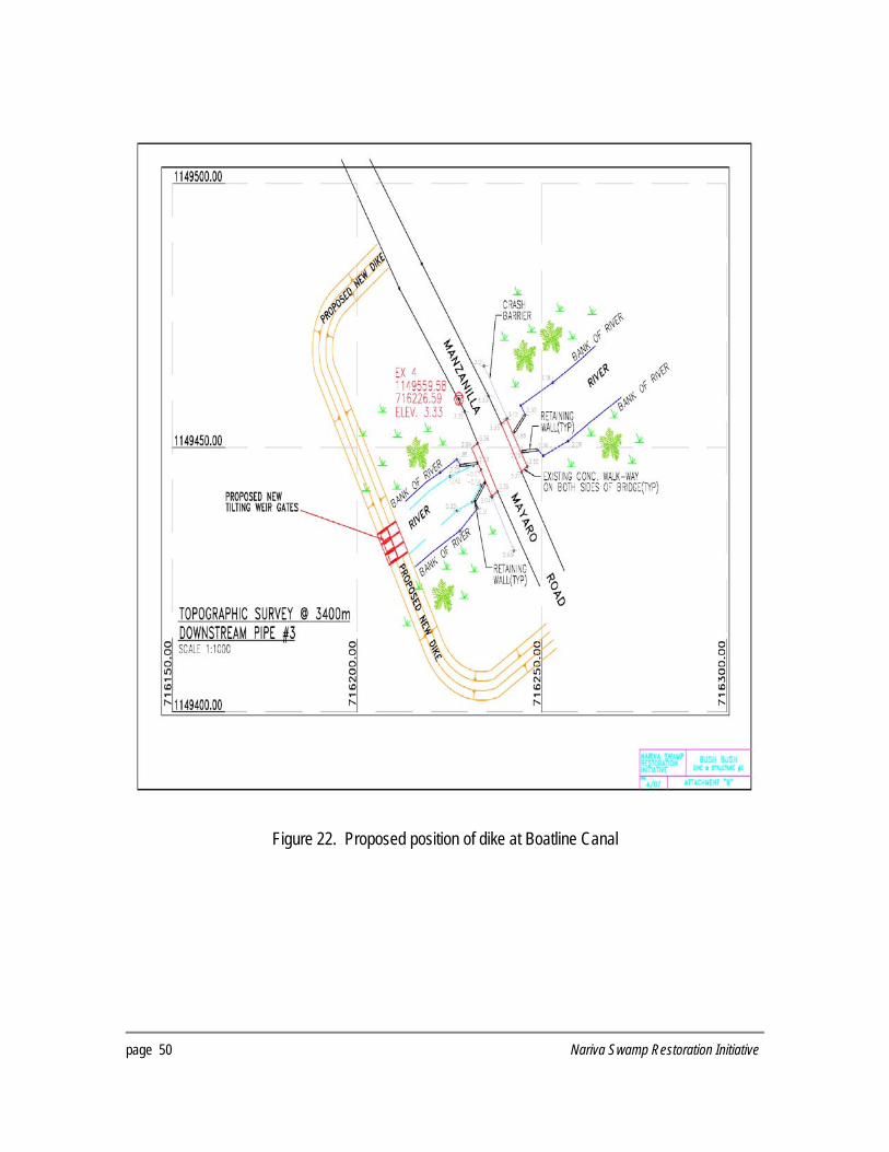
Figure 22. Proposed position of dike at Boatline Canal
page 50 Nariva Swamp Restoration Initiative
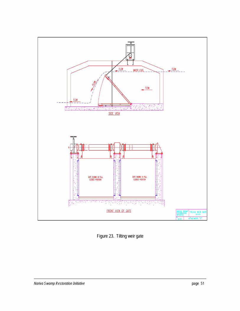
Figure 23. Tilting weir gate
Nariva Swamp Restoration Initiative page 51

Figure 24. Proposed drainage alterations for Kernahan
page 52 Nariva Swamp Restoration Initiative

Figure 25. Details of flap gate
Nariva Swamp Restoration Initiative page 53
GENERAL SURVEY GUIDELINES FOR NARIVA SWAMP The hydrological rehabilitation suggestions presented in the previous chapter are preliminary, and based on several field visits by engineers, hydrologists, ecologists, foresters and members of the local communities. Other key areas for detailed topographic surveys have been identified and prioritized and will provide the information necessary to confirm the initial recommendations for water control structures and canal management or indicate a need for re-assessment. These areas include Sector B and the marsh area south of the Petit Poole canal towards Sector B (Figure 26). In this section we present the guidelines used for the topographic surveys of Bush-Bush and Kernahan that could be used in the new areas to be surveyed in the future. General Guidelines The field notes comprise the original record of the survey and shall be legible, self-explanatory, clean, clear and complete, and shall be recorded in a manner that will admit only one interpretation, and that the correct one. There shall be no erasures on note sheets. All erroneously recorded data shall be crossed out and the correct entry made directly above. Sketches shall be made that show all survey control points at their approximate locations in relation to the area being surveyed. If survey was preformed with total station or GPS equipment all original and adjusted electronic files shall be submitted in their native format along with an ASCII comma delimited file and accompanied by field notes. The survey will be tied to an existing established and accepted horizontal and vertical datum unless otherwise specified. Vertical Control When a Mean Sea Level (MSL) elevation is required and it shall be run from the nearest government or other established benchmark available that is accepted by the surveying community as reliable. Such level runs shall be closed upon itself or another equally reliable benchmark. If MSL is not required, an assumed elevation shall be used. All assumed elevations must be determined by using a spot elevation as shown on a published quadrangle. All assumed elevations must be marked as such in the field book. When a level circuit is run from an accepted benchmark to the site, permanent bench -marks shall be placed at maximum intervals of 1.6km. A minimum of two permanent benchmarks shall be placed at each site. Any vertical control may also be used as a horizontal control as described under section 3.0.
page 54 Nariva Swamp Restoration Initiative

Figure 26. Location of five transects for MSL elevations – approximately 25,000m
Nariva Swamp Restoration Initiative page 55

All vertical control points must be a durable ferromagnetic monument and must be at least 45cm in length and at least 13mm in sectional dimension. A cap shall be driven on top and clearly marked with your company’s name or identification number. A steel fence post shall be driven alongside to mark and protect the monument. All vertical control points shall be thoroughly described in the notes. Care shall be given to the location of these points to enhance their chance of survival. T.B.M.'s (Temporary Benchmarks) may be set at random at convenient points around the site. All T.B.M.'s shall be described thoroughly in the field notes. Do not use spikes in power poles or telephone poles as T.B.M.'s. All level circuits shall be looped and shall not exceed +/- 12mm/km error. All benchmarks and/or turning points shall be described in the field notes. Horizontal Control A minimum of two (2) permanent horizontal control points shall be placed at each site. Any horizontal control point may also be used as a vertical control point as described under section 2.0. All horizontal control points must be a durable ferromagnetic monument and must be at least 45cm in length and at least 13mm in sectional dimension. A cap shall be driven on top and clearly marked with your company’s name or identification number. A steel fence post shall be driven alongside to mark and protect the monument. All horizontal control points shall be thoroughly described in the notes. Care shall be given to the location of these points to enhance their chance of survival. Topographic Features The following are a list of pertinent topographic features that should be located and noted on the survey. – All buildings, fences and fence corners, topographic features, cultural features, creeks, ditches,
swamps, tree lines, shelter belts in site area shall be tied to the survey. – All found property corners, in or adjacent to site area shall be tied to the survey and shown on
the drawing. – Roads
The location of all roads in or adjacent to site area shall be located and shown on the drawings with the following information:
• Type of road surface • Name or designation of road if available
page 56 Nariva Swamp Restoration Initiative
– Pipelines The location of all pipelines, whether above the surface or buried in site area shall be shown on the drawings with the following information:
• Owner of pipeline • Size of pipeline (if available) • Whether surface or buried • Depth of pipe (if available) • Material being transported (if available)
− Power and Telephone Lines
The location of all overhead or buried power, telephone, telegraph lines or cables in site area shall be shown on the drawings with the following information:
• All poles, posts and cable markers • Guy wires • Type of line • Depth of line (if available) • Owner of line (if available)
− Culverts
The location, size, and invert elevations of all box culverts, CMP's, RCP's, steel pipe in site area shall be noted in the survey. Any culverts in general surrounding area that might have an effect on project shall also be shown.
Survey Notes All maps, original notes, sketches, electronic data files, etc., that pertain to site should be submitted. Also any information and data sheets referencing the location, and recovery data about published monuments used to bring control to site should be considered a part of the survey notes.
Nariva Swamp Restoration Initiative page 57

FIRE MANAGEMENT Fires are not a natural event in this part of Trinidad, and farmers have set fires to their fields every year under the wrong impression that by doing so they are fertilising the soil and eliminating unwanted weeds. Unfortunately, they are actually putting Nariva under threat by destroying the rich communities of micro-organisms that help break down vegetation matter and keep soils viable. The illegal rice farmers, however, caused the greatest damage to the marsh and forest in Nariva by burning their fields yearly to eliminate the deep organic soil and reach the clay soils underneath, where rice could be planted. With no fire control experience and unpredictable winds in this part of the island, fires often escaped from the fields and burned the surrounding forest. Fires are also used by poachers to clear the undergrowth inside the forest and facilitate access to waterholes where they hunt mostly mammals that come to drink in the dry season, and the fish that are trapped in them. These fires were particularly bad in 1998 when the extreme dryness of some areas was exacerbated by an intense dry season (nationwide) and high winds, which made the area conducive to fires. More than 3,000 acres were destroyed by bush fires (http://www.ramsar.org/forum/forum_trinidad_nariva_fires.htm). Personnel had to be brought in from other parts of the country, but the presence of well-trained community personnel who could respond quickly to fires was required to deal with this threat. Aware of the hazard that fire posed to their fields and homes, the local communities welcomed the Government’s plan to develop brigades of fire patrol volunteers. Currently there are 35 volunteer fire patrol members living in the three communities surrounding Nariva, but additional fire patrol personnel are needed. Further training in fire tactics and fire safety to develop a comprehensive fire response plan is also necessary. In addition, the fire patrol members trained in the Nariva area could be utilized for fires elsewhere in the country. The Ramsar Project: Forest Fire Protection Plan for Nariva Swamp issued by the Forestry Division in 1999 outlines the main elements necessary for effective and adequate fire management in Nariva. To assure continued success, the Government of Trinidad and Tobago in cooperation with outside assistance should reinforce several items. These include: fire training for local fire responders, site assessment of fire problems, overall fire response planning, and community outreach of fire and environmental education. These arrangements are under review and a Fire Protection Plans for Nariva is being drafted. Fire Training Fire exclusion is necessary during the first 5 to 10 years to assure the success of reforestation efforts. The following recommended actions will improve the ability of the Government and local communities to protect and restore the habitat of the Nariva. Honorary Fire Guardians
page 58 Nariva Swamp Restoration Initiative
Appoint all honorary fire patrol members from the Nariva community as Honorary Fire Guardians - this is described in Chapter 6302 of the Agricultural Fire Act, 2nd paragraph. The appointment to

honorary fire guardian protects the fire program team in the case of violent behaviour from other persons, and provides medical coverage in the event of injury while carrying out their duties. Fire Assessment and Plan In conjunction with the USFS, Trinidad conservation officials will develop a fire danger rating and warning system and a comprehensive fire plan for Nariva. This will include: − A written fuel assessment with predicted fire behaviour. The fire danger rating system will require the direct input from the Trinidad conservation officials. − A comprehensive written fire plan to include prevention response, fire detecting procedures, use of fire towers, telecommunication systems, dispatch procedures, establishment and maintenance of traces, damage assessment, reporting and rehabilitation. While the Fire Assessment and Fire Plan have not yet been put in writing, one fire tower has already been built (in the south end of Nariva outside the village of Kernahan) and there are plans to build another in Sandhill to cover the north and centre of Nariva. Several fire traces have already been established and others are planned in the near future (Figure 27). Fire Traces Clear “fire traces” along streams and construct “fire” water reservoirs in strategic locations as soon as possible using local manpower to accomplish the work. In exchange for a fishing fee, fishermen could have access to areas clear of vegetation and close to water bodies. This will help prevent fishermen from setting fires to clear fishing spots. The fire plan must address regular maintenance of fire traces and reservoirs. Prescribed Burning Using fire properly on adjoining agricultural land to clear fields is essential to preventing habitat loss in Nariva. Trained personnel will assist and train farmers on how to safely use prescribed burning, and to avoid improper burning during dry periods. Fire Suppression Equipment Equipment is necessary in order to fight fires more adequately and provide suitable protection for the volunteers. The following are examples of items needed, but a full inventory should be made periodically to ensure the equipment requirements are met. Some equipment has already been provided, but more will be necessary as additional fire patrol members join the existing teams.
– Backpack pumps – Portable pump with 100 gallon/min cap and hose – Safety clothing such as shoes, masks, gloves, hats, trousers and shirts – Communications equipment such as cellular phones and radios
Transportation Getting to the fire promptly and safely is essential. Two permanent vehicles allocated to fire fighting are necessary, one at the Biche / Plum Mitan area and one at Kernahan / Cocal area. Preferably
Nariva Swamp Restoration Initiative page 59

these should be 4WD pick-up trucks capable of towing the portable pump. At the same time, the possibility of acquiring ATVs should be investigated. Fishing permits Permits for fishing will be issued to local fisherman at no charge for subsistence. Consideration should be given to having “outsiders” and recreational fishing persons pay for permits. Even so, issue of permits should be carefully monitored and regulated to prevent over harvesting and other unsustainable practices, such as the use of fish traps. Arrangements have been made for officers at the Field Station at Kernahan to issue permit for entry into the prohibited area. This will assure better compliance with fishing and fire regulations. Community Outreach Investigations show that all fires are due to some human activity and are therefore potentially preventable. Access to most parts of the Nariva Swamp is difficult and therefore access to fires and fire suppression are time consuming and difficult. For this reason, emphasis shall be placed on fire prevention through outreach and awareness programs. As the most important stakeholders in this ecosystem, the communities around Nariva must play an integral role in the design and implementation of such initiatives. Extension strategies shall also be utilized to guide and assist farmers in safe and proper burning.
page 60 Nariva Swamp Restoration Initiative

Figure 27. Existing and proposed improvements for fire management in Nariva
Nariva Swamp Restoration Initiative page 61

This page left blank intentionally
page 62 Nariva Swamp Restoration Initiative

LITERATURE AGRISTUDIO.1991. Feasibility study for the rehabilitation of the Plum Mitan rice scheme. AGRISTUDIO srl, Firenze, Italy. Ahmad, N. 1977. Nariva Swamp development project - Proposal for soil studies. Unpublished Report. Faculty of Agriculture, University of the West Indies, Trinidad and Tobago. Aitken, T.H.G. 1968. Arbovirus studies in Bush-Bush Forest, Trinidad, W.I. September 1957- December 1962. III. Entomologic Studies. American Journal of Tropical Medicine & Hygiene. 17: 253-268 Aitken, T.H.G. 1973. Bush-Bush Forest and Nariva Swamp. Journal of Trinidad Field Naturalists' Club, 1: 1-6. Aitken, T.H.G. 1973. Arthropods collected in the Bush-Bush Forest Nature Reserve by personnel of the Trinidad Regional Virus Laboratory. Journal of Trinidad Field Naturalists' Club, 13-18. Aitken, T.H.G. 1973. Bush-Bush amphibians and reptiles. Journal of Trinidad Field Naturalists' Club, 19-21. Aitken, T.H.G. 1975. A review of the bloodsucking midges of Trinidad and Tobago, West Indies (Diptera: Ceratopogonidae). Journal of Entomology. 44(2); 101-144... Alleng, G.P. 1994. Advanced application of remote sensing with specific reference to Caribbean coastal environments. Final Report to the Caribbean Development Bank, St. Michael's Barbados. . Alleng, G.P. 1996. The integration of remote sensing imagery with GPS data, for the purpose of improving the demarcation of boundaries within the Nariva Swamp, Trinidad and Tobago. Final Report to the Pan-American Health Organization (PAHO). Alleng, G.P. 1997. Coastal wetlands in Trinidad and Tobago: Status and trends. Research Report. Institute of Marine Affairs, Trinidad and Tobago. Alleng, G.P. 1997. Use of remote sensing to monitor and assess the environmental conditions of the Nariva wetland. Pp. 21-27. In Proceedings of Nariva Swamp Seminar. Caribbean Forest Conservation Association. Bacchus, C.F. and Vorran, G.M.C. (1990) The role of forestry in biological diversity conservation in Trinidad and Tobago. Unpublished document. 21 pp. Bacon, P.R. 1979a. Studies on the biological resources of Nariva Swamp, Trinidad. Vol. I & II. Occasional Papers No. 4. Zoology Department, University of the West Indies, St. Augustine, Trinidad. Bacon, P.R. 1979b. Notes on some freshwater molluscs from Nariva Swamp. Journal of Trinidad Field Naturalists' Club, 14-15. Bacon, P.R. 1988. Freshwater foodchains of Caribbean wetlands. Acta Cientifica, 2:74-93.
Nariva Swamp Restoration Initiative page 63

Bacon, P.R. 1996. Water management for sustainable development in the Nariva Swamp. Pp. 10-18. Nariva Swamp Seminar. Caribbean Forest Conservation Association. Bacon, P., 1998. Preliminary statement on the encroachment of saline water in eastern Nariva Swamp. Unpublished report. Bacon, P.R., Lugo, A.E. 1990. Ecology and management of swamp forests in the Guianas and Caribbean region. Pp. 213-248. In Forested Wetlands: Ecosystems of the World. Volume 15. Elsevier Publishers, Amsterdam, The Netherlands. Baranowski, R.M. 1979. Biology, host specificity and description of the immature stages of Lipostemmata major Ashlock and L. humeralis Berg. (Hemiptera: Lygaeidae).The Florida Entomologist, 62: 383-389. Beard, J.S. 1946. The natural vegetation of Trinidad. Oxford Forestry Memoirs, No. 21. Bonadie, W.A. 1998. The ecology of Roystonea oleracea palm swamp forest in the Nariva Swamp (Trinidad). Wetlands, Vol. 18(2): 249-255. Bonadie, W.A. 1999. The structure and ecology of Mauritia setigera palm swamp forest in Nariva Swamp, Trinidad. Tropical Ecology, Vol. 40(2): 199-206. Bonadie, W. A. & Bacon, P.R. 1999 The structure and ecology of Mauritia setigera palm swamp forest in Nariva swamp, Trinidad. Tropical Ecology 40 (2): 199-206. Bonadie, W.A. and Bacon, P. R. 2000. Year-round utilization of fragmented palm swamp forest by Red-bellied macaws (Ara manilata) and Orange-winged parrots (Amazona amazonica) in the Nariva Swamp (Trinidad). Biological Conservation 95:1-5. Boeseman, M. 1960. The freshwater fishes of the island of Trinidad. Studies of the Fauna of Curacao and other Caribbean Islands, 48: 73-153. Brooks, R.L. 1935. Forests and forestry in Trinidad and Tobago. A statement prepared for the British Empire Forestry Conference, South Africa. Government Printer, Port of Spain, Trinidad. Brown, C.B. 1970. Land capability survey of Trinidad and Tobago No. 4. - Central - Soil survey. Caribbean Printers, Trinidad. Bryce, R. 2000. Preliminary investigation of some water quality and quantity parameters for water in the coastal area of the swamp. Report Submitted to the National Wetlands Committee. Land and Water Development Division, Ministry of Agriculture, Lands and Marine Resources. Collens, J.H. 1982. The Trinidad manatee. Journal of Trinidad Field Naturalists' Club, 1: 136-170. Cullen, M.J. 1969. The biology of giant water bugs (Hemiptera: Belostomatidae) in Trinidad. Proceedings of the Royal Entomological Society, London (A). 44 (7-9): 123-136. Downes, W.G. 1968. Arbovirus studies in Bush-Bush forest Trinidad, W.I. September 1959 - December 1964. I. Description of the study area. American Journal of Tropical Medicine and Hygiene, 17: 224-236. Downie, R., Downie, R. 1996. The effects of the encroachment of rice cultivation within Nariva Swamp. Pp. 13-21. Report of the University of Glasgow Exploration Society, Trinidad 1996.
page 64 Nariva Swamp Restoration Initiative

Ducks Unlimited. 1999. Nariva Initiative - Terms of Reference and Work Plan. Unpublished report to the Forestry Division, TT. Duguid, A., Downie, R. 1996. A comparison between fish communities in Nariva Swamp and adjacent rice paddies. Pp. 22-27. Report of the University of Glasgow Exploration Society, Trinidad. Everard, C.O.R. 1973. Ecology of the rodents, Proechymis guyanensis trinitatis and Oryzomys captito velutinus on Trinidad. Journal of Mammalogy. 54(4): 875-886. Food and Agricultural Organization (FAO) 1957. The reclamation of the Caroni, Oropuche and Nariva areas. Report No. 636. Food and Agricultural Organization of the United Nations. Food and Agricultural Organization (FAO) 1985. Aquaculture potential in the Nariva Swamp, Trinidad, West Indies. Report of a FAO Mission Conducted 3-29 March 1985. Food and Agricultural Organization of the United Nations. ffrench, R.P. 1973. A guide to the birds of Trinidad and Tobago. Livingstone Publishing Company. ffrench, R.P. 1977. Some interesting bird records from Trinidad and Tobago. Journal of Trinidad Field Naturalists' Club, 2 (6): 28-31 & 34-35. Funk, M. 2005. Treasure island. Audubon 107 (2) Gaskin, M. 1996. Rationale for the protection of the Nariva Wetland (Swamp). “Nariva Swamp Seminar”, Caribbean Forest Conservation Association, Port-of-Spain, Trinidad and Tobago). Herklots, G.A.C. 1961. The birds of Trinidad and Tobago. Collins. Institute of Marine Affairs. 1997. Progress report for environmental impact assessment of the Nariva Swamp (Biche Bois Neuf area). Document Prepared for the Ministry of Agriculture, Lands and Marine Resources. Institute of Marine Affairs, Trinidad and Tobago. Institute of Marine Affairs. 1998a. Environmental impact assessment of the Nariva Swamp (Biche Bois Neuf area) - 2nd Progress report.Document Prepared for the Ministry of Agriculture, Lands and Marine Resources. Institute of Marine Affairs, Trinidad and Tobago. Institute of Marine Affairs. 1998b. Legislative control - Technical report for the formulation plan of the Nariva Swamp. Document Prepared for the Ministry of Agriculture, Lands and Marine Resources. Institute of Marine Affairs, Trinidad and Tobago. Institute of Marine Affairs. 1998c. Final report for environmental impact assessment of the Nariva Swamp (Biche Bois Neuf area). Document Prepared for the Ministry of Agriculture, Lands and Marine Resources. Institute of Marine Affairs, Trinidad and Tobago. Institute of Marine Affairs. 1999a. Draft technical report for the Nariva Swamp Management Plan: Aquatic fauna. Document Prepared for the Ministry of Agriculture, Lands and Marine Resources. Institute of Marine Affairs, Trinidad and Tobago. Institute of Marine Affairs. 1999b. Aquatic fauna - Technical report for the formulation plan of Nariva Swamp. Document Prepared for the Ministry of Agriculture, Lands and Marine Resources. Institute of Marine Affairs, Trinidad and Tobago.
Nariva Swamp Restoration Initiative page 65

Institute of Marine Affairs. 1999c. Draft technical report for the Nariva Swamp Management Plan: Economic aspects. Document Prepared for the Ministry of Agriculture, Lands and Marine Resources. Institute of Marine Affairs, Trinidad and Tobago. Institute of Marine Affairs.1999d. Draft technical report for the Nariva Swamp Management Plan: Wetlands ecology. Document Prepared for the Ministry of Agriculture, Lands and Marine Resources. Institute of Marine Affairs, Trinidad and Tobago. Institute of Marine Affairs. 1999e. Draft technical report for the Nariva Swamp Management Plan: Geology. Document Prepared for the Ministry of Agriculture, Lands and Marine Resources. Institute of Marine Affairs, Trinidad and Tobago. Institute of Marine Affairs. 1999f. Draft technical report for the Nariva Swamp Management Plan: Surface water hydrology of Nariva Swamp.Document Prepared for the Ministry of Agriculture, Lands and Marine Resources .Institute of Marine Affairs, Trinidad and Tobago. Institute of Marine Affairs. 1999g. Draft technical report for the Nariva Swamp Management Plan: Machinery and roads. Document Prepared for the Ministry of Agriculture, Lands and Marine Resources .Institute of Marine Affairs, Trinidad and Tobago. Institute of Marine Affairs. 1999h. Final report - The formulation of the Nariva Swamp Management Plan. Document Prepared for the Ministry of Agriculture, Lands and Marine Resources. Institute of Marine Affairs, Trinidad and Tobago. Institutional Consultants (International) Ltd. 1980. Forest Resource Inventory and Management Section: Inventory of the Indigenous forest of Trinidad and Tobago. Vol. I - XI. Document Prepared for the Government of Trinidad and Tobago. James, C., Lugo, A.E. 1992. Wetlands management in Trinidad and Tobago. Pp. 74-107. In Wetlands Management in the Caribbean and the Role of Forestry and Wetlands in the Economy. Institute of Tropical Forestry and the Caribbean National Forest. USDA Forest Service, Rio Piedras, Puerto Rico. James, C. &. Scott, D.A. 1986. Trinidad and Tobago.Pp. 256-265. In A Directory of Neotropical Wetlands. IUCN Cambridge and IWRB Slimbridge, UK. James, K. 1994. Analysis of the potential of Bush-Bush Wildlife Sanctuary, Nariva Swamp, Trinidad, for the development of ecotourism. Unpublished Undergraduate Thesis. Zoology Department, University of the West Indies, St. Augustine, Trinidad. Jonkers, A.H. 1968. Arbovirus studies in Bush-Bush forest, Trinidad, W.I. Sept. 1959 - Dec. 1964. V. Virus isolations. American Journal of Tropical Medicine and Hygiene, 17: 276-284. Jonkers, A.H. 1968. Arbovirus studies in Bush-Bush forest, Trinidad, W.I. Sept. 1959 - Dec. 1964. VI. Rodent-associated viruses: Isolations and further studies. American Journal of Tropical Medicine and Hygiene, 17: 285-298. Kacal, A.S. 1992. Recommendations for three national parks in Trinidad and Tobago. AOK Associates, Trinidad. Kairi Consultants Limited. 1998. National parks and watershed management project - Watershed areas: Development of watershed management plans and related studies. Final report.
page 66 Nariva Swamp Restoration Initiative

Kalloo, M.B. 1975. A list of plants from Bush-Bush forest and the Boat Line of the Nariva Swamp.Mimeographed Report. The National Herbarium, University of the West Indies, St. Augustine, Trinidad. Keeler, A.G. and Pemberton, C. 1996. Nariva Swamp: An exercise in environmental economics. Notes of a seminar presented at the University of the West Indies, St. Augustine, on Nov. 20, 1996. University of the West Indies, St. Augustine, Trinidad. Kenny, J.S. 1969. The amphibia of Trinidad. Studies of the Fauna of Curacao and other Caribbean Islands, 29: 1-78. Khan, J. 1997. Distribution, status and conservation efforts of the West Indian manatee in Nariva Swamp.Pp. 39-42. In Nariva Swamp Seminar. Caribbean Forest Conservation Association. Kugler, H. 1959. Geological map of Trinidad. Petroleum Association of Trinidad, Basel Switzerland. Lum Kong, A. 1986. Aspects of the biology of the river conch, Pomacea urceus (Muller 1774). Unpublished M.Phil. Research Thesis.Zoology Department, University of the West Indies, St. Augustine, Trinidad. Lum Kong, A. 1988. Biology of the river conch Pomacea urceus (Muller, 1774). UWI Biospectrum 1:43-44. Mahy, M. 1997. Feasibility of co-managing a wetland of international importance: The case of the Nariva Swamp, Trinidad. Master of Environmental Studies Dissertation. Dalhousie University, Nova Scotia, Canada. Marshall, R.C. 1934. Physiography and vegetation of Trinidad and Tobago. Oxford Forestry Memoire. 17: 1-56. Marshall, R.C. 1939. Silviculture of the trees of Trinidad and Tobago. Oxford University Press, London, Great Britain. Ministry of Agriculture. 1976. Report of enumeration survey carried out in the Nariva Windbelt Reserve and also recommendations for rehabilitation. Forest Division Files 15.6.76. Ministry of Agriculture, Lands and Marine Resources, Government of Trinidad and Tobago. Ministry of Agriculture. 1977. Inspection of the Nariva Windbelt Reserve - Union Village for the prospective regeneration of teak. MMS Report. Ministry of Agriculture, Lands and Marine Resources, Government of Trinidad and Tobago. Ministry of Planning and Development. 1973. Land capability studies, Phase II Report No. 6. Agriculture in counties Nariva, Mayaro. Ministry of Planning and Development, Government of Trinidad and Tobago. Ministry of Planning and Development. 1973. Land capability studies. Phase II Trinidad and Tobago. Report No.7 Agriculture in counties St. Andrew St. David. Ministry of Planning and Development, Government of Trinidad and Tobago. Nathai-Gyan, N. & Boodoo, D. 2002. Trinidad and Tobago Manatee Recovery Plan. Manatee Conservation Trust. Trinidad and Tobago.
Nariva Swamp Restoration Initiative page 67
Neil, B. 2002. Notes on the ecology of the south American water snake Helicops angulatus (Squamata: Colubridae) in Nariva Sawamp, Trinidad. Caribbean Journal of Science, Vol. 38(1-2): 129-132. NEDECO. 1981. A summary and review of previous studies of the Nariva Swamp. Ministry of Agriculture, Lands and Fisheries, Port of Spain, Trinidad and Tobago. NEDECO. 1983a. Phase I - Investigations of the development of the Nariva Swamp. Vol I - Main report . Ministry of Agriculture, Lands and Fisheries, Port of Spain, Trinidad and Tobago. NEDECO. 1983b. Phase I - Investigations of the development of the Nariva Swamp. Vol II - Annexes A and B. Ministry of Agriculture, Lands and Fisheries, Port of Spain, Trinidad and Tobago. Neville, M. 1972. The population structure of Red Howler Monkeys (Alouatta seniculus) in Trinidad and Venezuela. Folia Primatologica. 17(1-2): 56-86. Neville, M. 1976. The population and conservation of Howler Monkeys in Venezuela and Trinidad. Pp 101-109. In Neotropical Primates, Field Studies and Conservation. Proceedings of a Symposium on Distribution and Abundance of Neotropical Primates. National Academy of Sciences, Washington, DC. Nottebohm, F. 1969. The parrots of Bush-Bush. Animal Kingdom, 72(1): 18-23. Overseas Technical Cooperation Agency (OCTA) 1967. Agricultural development project for the Nariva Swamp in Trinidad and Tobago - Reconnaissance report. Overseas Technical Cooperation Agency, Government of Japan. Overseas Technical Cooperation Agency (OCTA) 1970. Agricultural development project for the Nariva Swamp in Trinidad and Tobago - Feasibility report. Overseas Technical Cooperation Agency, Government of Japan. Paul, A. 1981. A review of the geology and hydrocarbon potential of the Nariva Swamp area, South Trinidad. Internal report. Ministry of Energy and Energy-based Industries, Government of Trinidad and Tobago. Pemberton, C. 2005. Ecotourism as a means of conserving wetlands. Journal of Agriculture and Applied Economics. August 2005. Pemberton, C. and Fridie, M. 2000. Fishing versus farming in a fresh water swamp in Trinidad in the Caribbean. International Institute of Foisheries Economics and Trade (IIFET) 2000 Conference: Microbehavior and Macroresults. Oregon State University, July 10-14, Corvallis, Orgeon, USA. http://oregonstate.edu/dept/iifet/2000/papers/pemberton.pdf Planning Associates. 1980. A review of the hydrologic analysis performed in support of the Manzanilla-Mayaro bridge project. Planning Associates. Price, J.L. 1955. A survey of the freshwater fishes of the island of Trinidad. Journal of the Agriculture Society of Trinidad and Tobago, Society Paper No. 863. Quesnel, V.C. 1969. Report to the faculty on the plan of the Japanese mission for the development of the Nariva Swamp for agriculture. Faculty Paper. D20/454/69. Faculty of Agriculture, University of the West Indies, Trinidad and Tobago.
page 68 Nariva Swamp Restoration Initiative
Quesnel, V.C. 1969. The Nariva Swamp reclamation project. Second report to the faculty. Mimeograph Report. Faculty of Agriculture, University of the West Indies, Trinidad and Tobago. Ramcharan, E.K. 1979. Ecological observations on Bois Neuf. Journal of Trinidad Field Naturalists' Club, 30-31. Ramcharan, E.K. 1980. Floral history of the Nariva Swamp. Ph.D. Thesis. Department of Biological Sciences, University of the West Indies, Trinidad and Tobago. Ramcharan, E.K. 1982. Inventory of the living resources of coastal wetlands in Trinidad and Tobago. Institute of Marine Affairs, Trinidad and Tobago. Ramcharan, E.K. 1988. The status and distribution of wetland dependent birds in Trinidad. Journal of Trinidad Field Naturalists' Club 1987-1988. 36-46. Ramsar Convention Bureau. 1996. Ramsar Convention Monitoring Procedure - Final Report - Nariva Swamp, Trinidad and Tobago. Ramsar Convention, Gland, Switzerland. Robinson, P.1988. Aquatic invertebrates of the Nariva Swamp. Unpublished Undergraduate Research Report. Zoology Department, University of the West Indies, St. Augustine, Trinidad. Singh, T.B. 1978. The biology of the cascadura, Hoplosternum littorale with reference to its reproductive biology and population dynamics.Unpublished Ph.D. Thesis. Zoology Department, University of the West Indies, St. Augustine, Trinidad. Sletto, B. 1998. The changing political economy of the Nariva Swamp, Trinidad. Unpublished Graduate Research Report. Department of Geography, University of Kansas. Smith, R. 1979. Occurrence of the rare checkerbelly snake, Miphlophis cervinus, in the Nariva Swamp, Trinidad. Journal of Trinidad Field Naturalists' Club, 11. Suter, H.H. 1960. The general and economic geology of Trinidad and Tobago, B.W.I. H.M. Stationery Office, London. Thelen, K.D. 1980. Plan for a system of national parks and other protected areas in Trinidad and Tobago. Forestry Division, Ministry of Agriculture, Lands and Fisheries. Tikasingh, E.S. 1972. Bush-Bush Wildlife Sanctuary. Pp. 67-71. In The Wildlife Sanctuaries of Trinidad and Tobago. Ministry of Agriculture, Lands and Fisheries. Port of Spain, Trinidad. Tikasingh, E.S. 1973. Rainfall-temperature-humidity relationships in the Bush-Bush forest, Trinidad. Journal of Trinidad Field Naturalists' Club, 7-12. Trinidad Regional Virus Laboratory. 1963. Checklist of birds of Bush-Bush forest and Nariva Swamp, corrected to 1st April, 1963. Mimeographed Report. Trinidad Regional Virus Laboratory, Port of Spain, Trinidad and Tobago. Wahab, A.S. 1997. Stakeholders' perceptions of natural resource conflict - the case of the Nariva wetland, Trinidad and Tobago. Unpublished Graduate Research Thesis. Graduate School of the Faculty of Life and Environmental Sciences, Shimane University, Japan. Water and Sewerage Authority. 1990. Explanatory notes, hydrogeological Maps of Trinidad and Tobago. Water and Sewerage Authority, Trinidad and Tobago.
Nariva Swamp Restoration Initiative page 69

Water Resources Agency. 1989. Hydrogeological map of Trinidad and Tobago. Water Resources Agency, Trinidad and Tobago. Wildlife Section 1993. Historical perspectives on habitat destruction in the Nariva Swamp, Trinidad. Wildlife Section Issues Paper. Forestry Division, Ministry of Agriculture, Land and Marine Resources. Worth, C.B. 1973. Checklist of the birds of Bush-Bush forest. Journal of Trinidad Field Naturalists' Club, 22-28. Worth, C.B. 1968. Arbovirus studies in Bush-Bush forest, Trinidad, W.I. Sept.1959 - Dec. 1964. IV. Vertebrate populations. American Journal of Tropical Medicine and Hygiene, 17: 269-275. Worth, C.B. 1973. Bush-Bush mammals. Journal of Trinidad Field Naturalists' Club, 29-33.
page 70 Nariva Swamp Restoration Initiative


DUCKS UNLIMITED, Inc. Memphis, TN /USA
www.ducks.org


