30
Nassau County Governor’s Office of Storm Recovery Nelson & Pope MARCH 2017 B AY P ARK /V ILLAGE OF E AST R OCKAWAY D RAINAGE I MPROVEMENTS
Nassau CountyGovernor’s Office of Storm Recovery
Nelson & Pope
MARCH 2017
BAY PARK/VILLAGE OF EAST ROCKAWAYDRAINAGE IMPROVEMENTS
PROJECT BACKGROUND AND OBJECTIVE
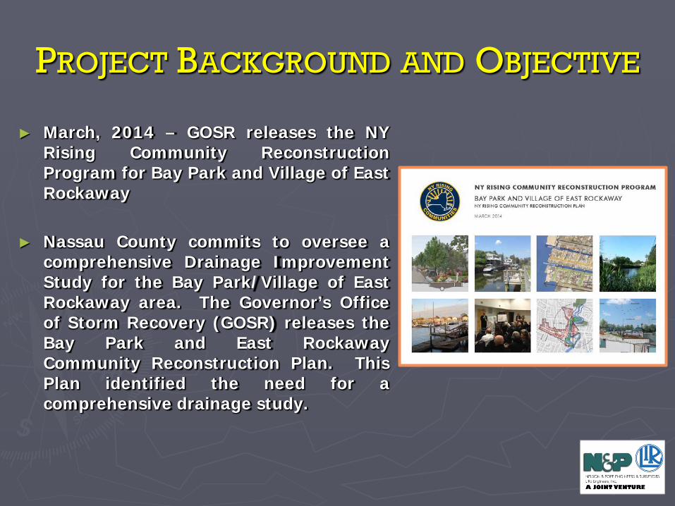
► March, 2014 – GOSR releases the NYRising Community ReconstructionProgram for Bay Park and Village of EastRockaway
► Nassau County commits to oversee acomprehensive Drainage ImprovementStudy for the Bay Park/Village of EastRockaway area. The Governor’s Officeof Storm Recovery (GOSR) releases theBay Park and East RockawayCommunity Reconstruction Plan. ThisPlan identified the need for acomprehensive drainage study.
PROJECT IMPLEMENTATION
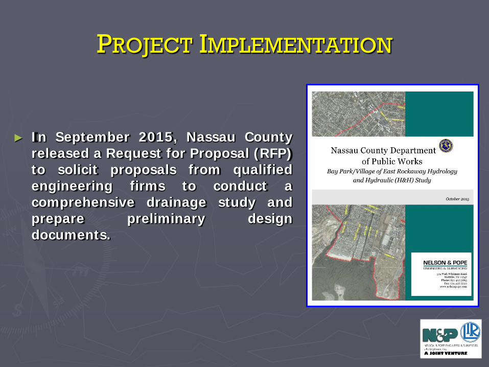
► In September 2015, Nassau Countyreleased a Request for Proposal (RFP)to solicit proposals from qualifiedengineering firms to conduct acomprehensive drainage study andprepare preliminary designdocuments.
PROJECT IMPLEMENTATION
Nassau County’s Department of Public Works to provide ProjectOversight
The Project Team consists of:► Nelson & Pope, Engineers & Surveyors► The LiRo Group► Gayron de Bruin Land Surveying & Engineering (W/DBE)► Hirani Engineering & Land Surveying (M/DBE)► VJ Associates (M/DBE)
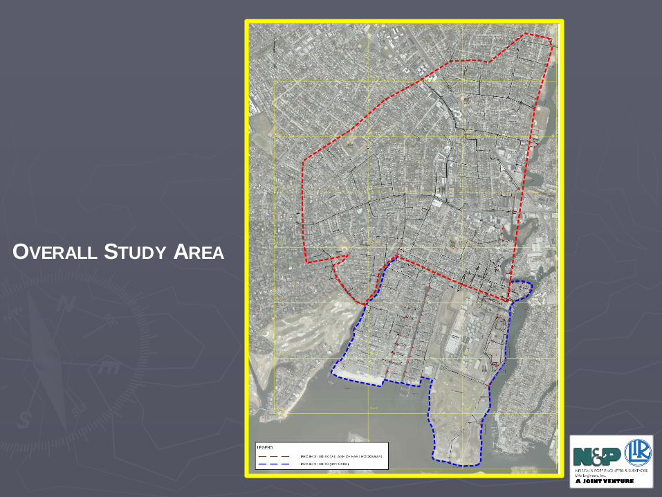
OVERALL STUDY AREA
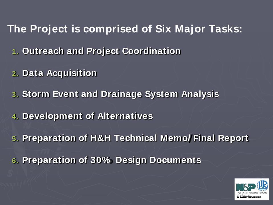
1. Outreach and Project Coordination
2. Data Acquisition
3. Storm Event and Drainage System Analysis
4. Development of Alternatives
5. Preparation of H&H Technical Memo/Final Report
6. Preparation of 30% Design Documents
The Project is comprised of Six Major Tasks:
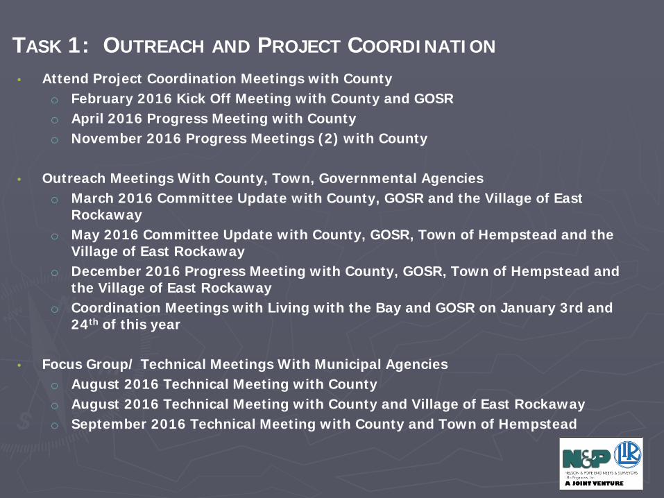
• Attend Project Coordination Meetings with Countyo February 2016 Kick Off Meeting with County and GOSRo April 2016 Progress Meeting with Countyo November 2016 Progress Meetings (2) with County
• Outreach Meetings With County, Town, Governmental Agencieso March 2016 Committee Update with County, GOSR and the Village of East
Rockawayo May 2016 Committee Update with County, GOSR, Town of Hempstead and the
Village of East Rockawayo December 2016 Progress Meeting with County, GOSR, Town of Hempstead and
the Village of East Rockawayo Coordination Meetings with Living with the Bay and GOSR on January 3rd and
24th of this year
• Focus Group/ Technical Meetings With Municipal Agencieso August 2016 Technical Meeting with Countyo August 2016 Technical Meeting with County and Village of East Rockawayo September 2016 Technical Meeting with County and Town of Hempstead
TASK 1: OUTREACH AND PROJECT COORDINATION
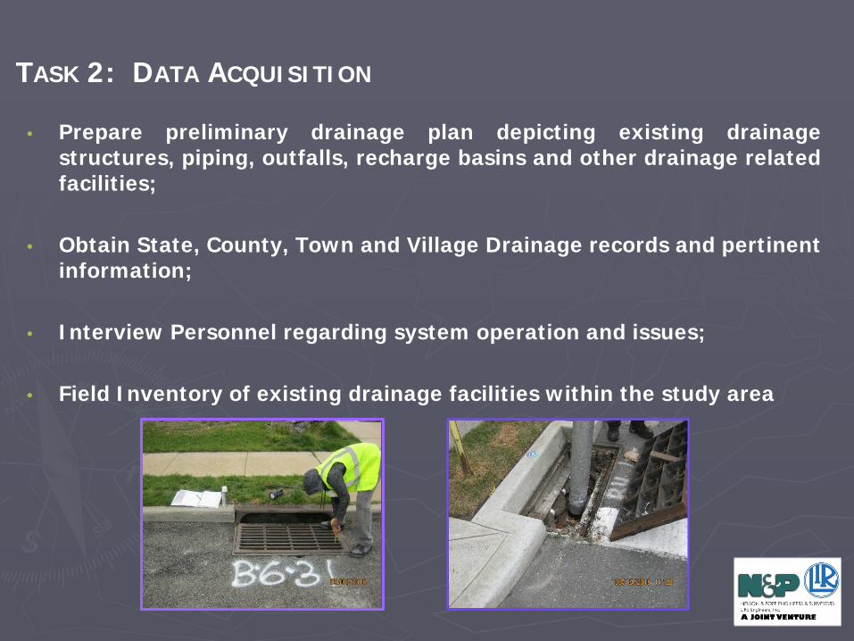
• Prepare preliminary drainage plan depicting existing drainagestructures, piping, outfalls, recharge basins and other drainage relatedfacilities;
• Obtain State, County, Town and Village Drainage records and pertinentinformation;
• Interview Personnel regarding system operation and issues;
• Field Inventory of existing drainage facilities within the study area
TASK 2: DATA ACQUISITION
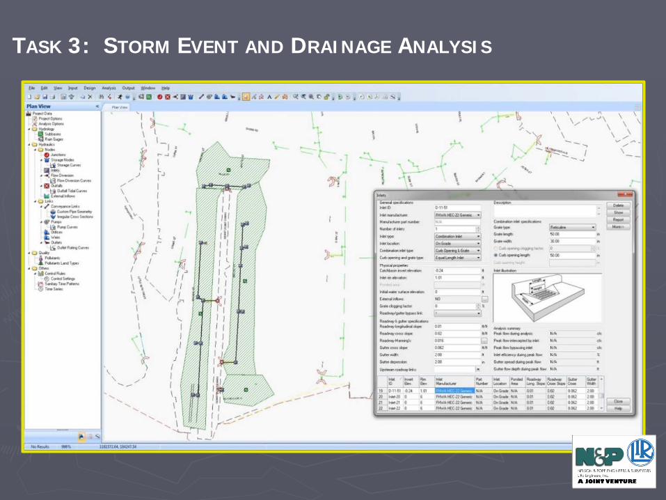
TASK 3: STORM EVENT AND DRAINAGE ANALYSIS
• Identify the overall drainage tributary area
• Hydrology Method Used: SCD TR-55
• Perform analyses of the existing drainage system for 3 Storm Events:• 1-Year Storm (2.84”, 24-hour period);• 10-Year Storm (5.05”, 24-hour period)• 100-Year Storm (8.92”, 24-hour period)
• Assumed Tidal Event used for Analysis:• Highest Annual Tide Cycle for Sandy Hook, NJ
(information received from NCDPW) • Assumed Coincidental Rainfall and Tidal Events
TASK 3: STORM EVENT AND DRAINAGE ANALYSIS
TASK 3: STORM EVENT AND DRAINAGE ANALYSIS
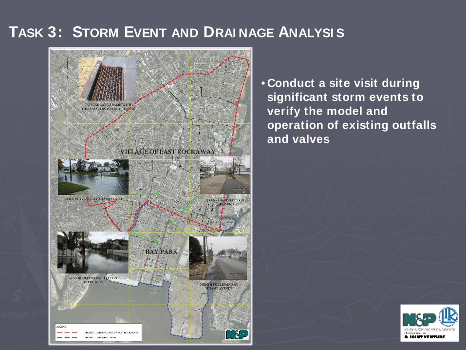
• Conduct a site visit during significant storm events to verify the model and operation of existing outfalls and valves
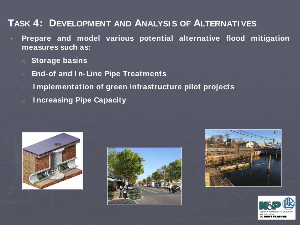
• Prepare and model various potential alternative flood mitigationmeasures such as:o Storage basinso End-of and In-Line Pipe Treatmentso Implementation of green infrastructure pilot projectso Increasing Pipe Capacity
TASK 4: DEVELOPMENT AND ANALYSIS OF ALTERNATIVES
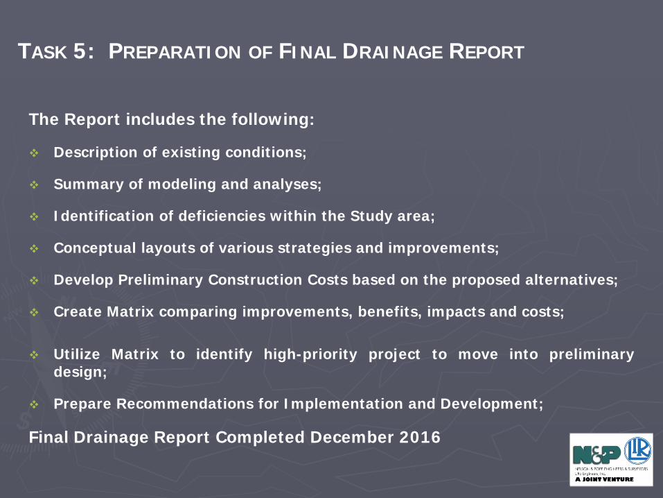
The Report includes the following:
Description of existing conditions;
Summary of modeling and analyses;
Identification of deficiencies within the Study area;
Conceptual layouts of various strategies and improvements;
Develop Preliminary Construction Costs based on the proposed alternatives;
Create Matrix comparing improvements, benefits, impacts and costs;
Utilize Matrix to identify high-priority project to move into preliminarydesign;
Prepare Recommendations for Implementation and Development;
Final Drainage Report Completed December 2016
TASK 5: PREPARATION OF FINAL DRAINAGE REPORT
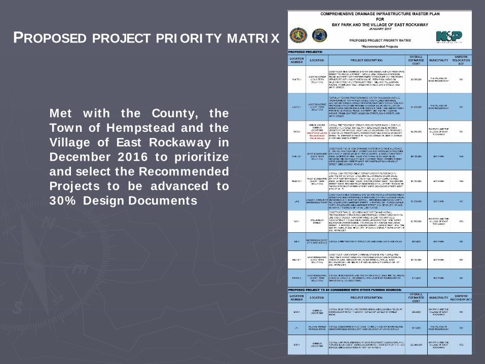
Met with the County, theTown of Hempstead and theVillage of East Rockaway inDecember 2016 to prioritizeand select the RecommendedProjects to be advanced to30% Design Documents
PROPOSED PROJECT PRIORITY MATRIX
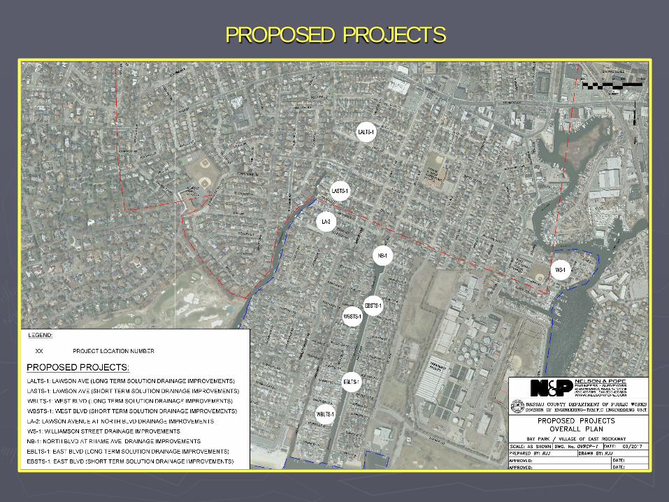
PROPOSED PROJECTS
Selected Projects:o Lawson Avenue Long Term Solutiono Multiple Check Valves Installation on Lawrence Street and North
Boulevard; North Boulevard at Rhame Avenue; West Boulevard; and EastBoulevard
30% Plans, Specifications and Estimates for the selected projects arebeing developed and will be given to Nassau County upon completion(expected April 2017). To be further developed into ConstructionDocuments under succeeding RFP
TASK 6: PREPARATION OF 30% DESIGN DOCUMENTS
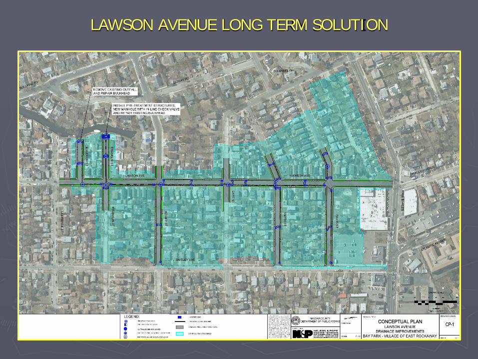
LAWSON AVENUE LONG TERM SOLUTION
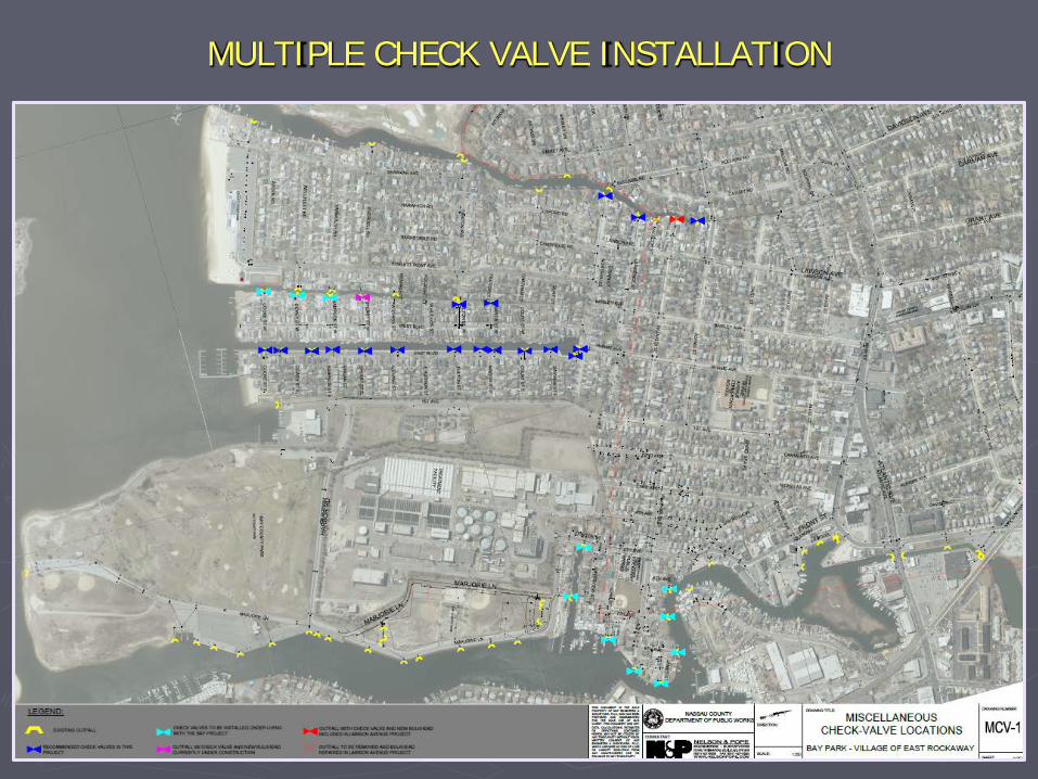
MULTIPLE CHECK VALVE INSTALLATION
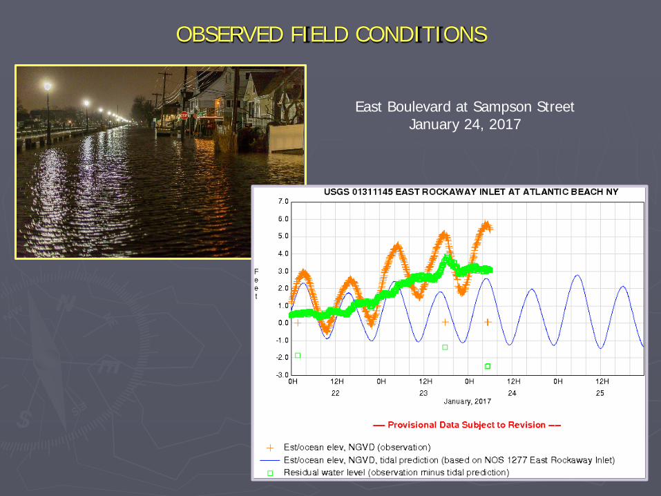
OBSERVED FIELD CONDITIONS
East Boulevard at Sampson StreetJanuary 24, 2017
Reviewed and gathered Record Plans from State, County, Town and Village
Prepared Overall Study Aerial depicting all Record Plan Drainage Structuresas well as GIS Information
Completed Drainage Field Inventory
Analysis of the Existing Drainage Systems Completed
Developed Solutions, Alternatives and Recommended Projects
Final Drainage Report Completed December 2016
Selected Projects to be progressed to 30% Preliminary Plans
Commenced work on 30% Preliminary Plans for Selected Projects
TASKS COMPLETED TO DATE:
NEXT STEPS: Continue Development of 30% Preliminary Plans and Estimate for Selected
Projects (expected completion April 2017).
Provide Nassau County with Completed 30% Preliminary Plans,Specifications & Estimate for Selected Projects
QUESTIONS & ANSWERS
THIS PROJECT WAS FUNDED BY AND CONCEIVED THROUGH THE
NY RISING COMMUNITY RECONSTRUCTION PROGRAM OF THE
GOVERNOR’S OFFICE OF STORM RECOVERY. FOR MORE INFORMATION CONTACT SEAN SALLIE, PLANNING
DIVISION, NASSAU COUNTY DEPARTMENT OF PUBLIC WORKS, 1194 PROSPECT AVENUE, WESTBURY, NY 11590.
EMAIL: [email protected]
Addendum (slides inserted after 3/30/17 public meeting)
• The previous slides, presented on 3/30/17, summarize the study process, findings and selected projects (within available CDBG-DR funding allocation).
• The New York Rising Bay Park/Village of EastRockaway Community Reconstruction Plan(March, 2014) recommended the preparation ofa study and several specific drainageimprovement projects.
• Excerpts from the Community Reconstruction Plan,pertaining to drainage recommendations, are calledout in the following slides.
89Section IV: Implementation – Project Profiles
NY Rising Community Reconstruction Plan
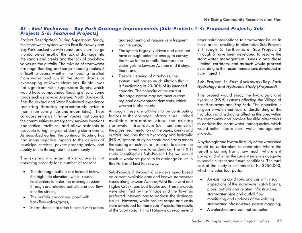
B1 - East Rockaway - Bay Park Drainage Improvements [Sub-Projects 1-4: Proposed Projects, Sub-Projects 5-6: Featured Projects] Project Description: During Superstorm Sandy, the stormwater system within East Rockaway and Bay Park backed up with runoff and storm surge inundation as result of the lack of drainage into the canals and creeks and the lack of back-flow valves on the outfalls. The mixture of stormwater drainage flooding and surge flooding makes it difficult to assess whether the flooding resulted from water back up in the storm drains or overtopping of lower elevations. Rainfall was not significant with Superstorm Sandy, which would have compounded flooding effects. Some roads such as Lawson Avenue, North Boulevard, East Boulevard and West Boulevard experience recurring flooding approximately twice a month (on spring tide and moon tides). These corridors serve as “lifeline” routes that connect the communities to emergency services locations and critical facilities, and allow residents to evacuate to higher ground during storm events. As described earlier, the continual flooding has had many negative impacts to the delivery of municipal services, private property, safety, and quality of life throughout the community.
The existing drainage infrastructure is not operating properly for a number of reasons:
• The drainage outfalls are located belowthe high tide elevation, which causestidal waters to enter the drainage systemthrough unprotected outfalls and overflowinto the streets;
• The outfalls are not equipped withbackflow valves/gates;
• Storm drains are often blocked with debris
and sediment and require very frequent maintenance;
• The system is gravity driven and does nothave enough potential energy to conveythe flows to the outfalls, therefore thewater gets to Lawson Avenue and it staysthere; and,
• Despite cleaning of manholes, thesystem itself has so much siltation that itis functioning at 20-30% of its intendedcapacity. The capacity of the currentdrainage system may not meet currentregional development demands, whichwarrant further study.
Although these are all likely to be contributing factors to the drainage infrastructure, limited available information about the existing stormwater infrastructure (i.e. maintenance of the pipes, sedimentation of the pipes, creeks and outfalls) requires that a hydrology and hydraulic (H & H) systems study be conducted first to assess the existing infrastructure – in order to determine the best interventions to undertake. The H & H study, identified as Sub-Project 1 below, would result in workable plans to fix drainage issues in Bay Park and East Rockaway.
Sub-Projects 2 through 6 are developed based on current available data and known stormwater issues along Lawson Avenue, West Boulevard and Higbie Creek, and East Boulevard. These projects were identified by the Village and the Town as preferred interventions to address the drainage issues. However, while project scope and costs were developed for these Sub-Projects, the results of the Sub-Project 1 H & H Study may recommend
other solutions/options to stormwater issues in these areas, resulting in alternative Sub-Projects 2 through 6. Furthermore, Sub-Projects 2 through 6 have been developed to resolve the stormwater management issues along these ‘lifeline’ corridors, and as such would proceed according to the recommendations developed in Sub-Project 1.
Sub-Project 1: East Rockaway/Bay Park Hydrology and Hydraulic Study (Proposed)
This project would study the hydrologic and hydraulic (H&H) systems affecting the Village of East Rockaway and Bay Park. The objective is to gain a watershed-level understanding of the hydrology and hydraulics affecting this area within the community and provide feasible alternatives to address the storm water inadequacies, which would better inform storm water management projects.
A hydrologic and hydraulic study of the watershed would be undertaken to determine where the runoff is coming from, how much, where is it going, and whether the current system is adequate to handle current and future conditions. The total cost of the study is estimated to be $250,000, which includes four parts:
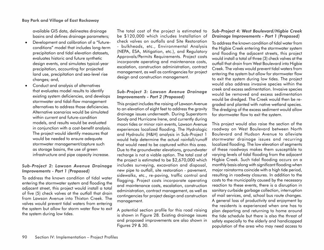
• An existing conditions analysis with visualinspections of the stormwater catch basins,pipes, outfalls and related infrastructure,stormwater pipe and outfall flowmonitoring and updates of the existingstormwater infrastructure system mapping;
• A watershed analysis that compiles
90 Section IV: Implementation – Project Profiles
Bay Park and Village of East Rockaway
available GIS data, delineates drainage basins and defines drainage parameters;
• Development and calibration of a “future-conditions” model that includes long-term precipitation and tidal elevation datasets, evaluates historic and future synthetic design events, and simulates typical-year precipitation, accounting for projected land use, precipitation and sea-level rise changes; and,
• Conduct and analysis of alternatives that evaluates model results to identify existing system deficiencies, and develops stormwater and tidal-flow management alternatives to address those deficiencies. Alternative scenarios would be simulated within current and future-condition models, and results would be evaluated in conjunction with a cost-benefit analysis. The project would identify measures that would be needed to ensure adequate stormwater management/capture such as storage basins, the use of green infrastructure and pipe capacity increase.
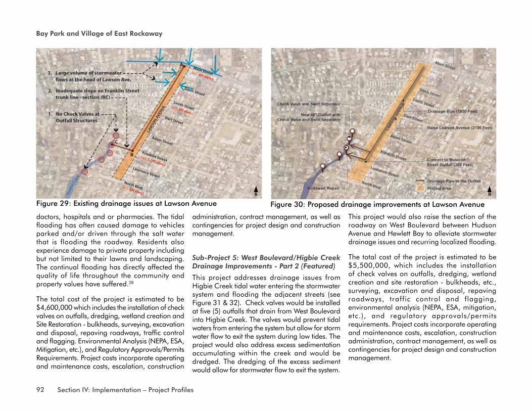
Sub-Project 2: Lawson Avenue Drainage Improvements - Part 1 (Proposed)
To address the known condition of tidal water entering the stormwater system and flooding the adjacent street, this project would install a total of five (5) check valves at the outfall that drain from Lawson Avenue into Thixton Creek. The valves would prevent tidal waters from entering the system but allow for storm water flow to exit the system during low tides.
The total cost of the project is estimated to be $120,000 which includes Installation of check valves on outfalls and Site Restoration - bulkheads, etc., Environmental Analysis (NEPA, ESA, Mitigation, etc.), and Regulatory Approvals/Permits Requirements. Project costs incorporate operating and maintenance costs, escalation, construction administration, contract management, as well as contingencies for project design and construction management.
Sub-Project 3: Lawson Avenue Drainage Improvements - Part 2 (Proposed)
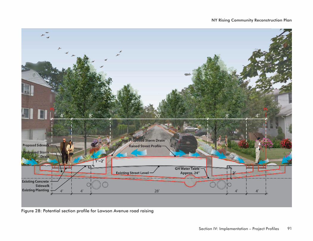
This project includes the raising of Lawson Avenue to an elevation of eight feet to address the gravity drainage issues underneath. During Superstorm Sandy and Hurricane Irene, and currently during moon tides or minor rain events, Lawson Avenue experiences localized flooding. The Hydrologic and Hydraulic (H&H) analysis in Sub-Project 1 would help determine the actual rainfall/runoff that would need to be captured within this area. Due to the groundwater elevations, groundwater recharge is not a viable option. The total cost of the project is estimated to be $2,670,000 which includes surveying, excavation and disposal, new pipe to outfall, site restoration - pavement, sidewalks, etc., re-paving, traffic control and flagging. Project costs incorporate operating and maintenance costs, escalation, construction administration, contract management, as well as contingencies for project design and construction management.
A potential section profile for this road raising is shown in Figure 28. Existing drainage issues and proposed improvements are also shown in Figures 29 & 30.
Sub-Project 4: West Boulevard/Higbie Creek Drainage Improvements - Part 1 (Proposed)
To address the known condition of tidal water from the Higbie Creek entering the stormwater system and flooding the adjacent streets, this project would install a total of three (3) check valves at the outfall that drain from West Boulevard into Higbie Creek. The valves would prevent tidal waters from entering the system but allow for stormwater flow to exit the system during low tides. The project would also address invasive species within the creek and excess sedimentation. Invasive species would be removed and excess sedimentation would be dredged. The Creek would then be re-graded and planted with native wetland species. The dredging of the excess sediment would allow for stormwater flow to exit the system.
This project would also raise the section of the roadway on West Boulevard between North Boulevard and Hudson Avenue to alleviate stormwater drainage issues and recurring localized flooding. The low elevation of segments of these roadways makes them susceptible to varying levels of tidal flooding from the adjacent Higbie Creek. Such tidal flooding occurs on a monthly basis along with significant flooding when major rainstorms coincide with a high tide period, resulting in roadway closures. In addition to the costs to the municipality caused by the necessary reaction to these events, there is a disruption in sanitary curbside garbage collection, interruption of mail services, and, school bus route changes. A general loss of productivity and enjoyment by the residents is experienced when one has to plan departing and returning to home around the tide schedule but there is also the threat of safety especially to the elderly and handicapped population of the area who may need access to
91Section IV: Implementation – Project Profiles
NY Rising Community Reconstruction Plan
Figure 28: Potential section profile for Lawson Avenue road raising
92 Section IV: Implementation – Project Profiles
Bay Park and Village of East Rockaway
doctors, hospitals and or pharmacies. The tidal flooding has often caused damage to vehicles parked and/or driven through the salt water that is flooding the roadway. Residents also experience damage to private property including but not limited to their lawns and landscaping. The continual flooding has directly affected the quality of life throughout the community and property values have suffered.28
The total cost of the project is estimated to be $4,600,000 which includes the installation of check valves on outfalls, dredging, wetland creation and Site Restoration - bulkheads, surveying, excavation and disposal, repaving roadways, traffic control and flagging. Environmental Analysis (NEPA, ESA, Mitigation, etc.), and Regulatory Approvals/Permits Requirements. Project costs incorporate operating and maintenance costs, escalation, construction
administration, contract management, as well as contingencies for project design and construction management.
Sub-Project 5: West Boulevard/Higbie Creek Drainage Improvements - Part 2 (Featured)
This project addresses drainage issues from Higbie Creek tidal water entering the stormwater system and flooding the adjacent streets (see Figure 31 & 32). Check valves would be installed at five (5) outfalls that drain from West Boulevard into Higbie Creek. The valves would prevent tidal waters from entering the system but allow for storm water flow to exit the system during low tides. The project would also address excess sedimentation accumulating within the creek and would be dredged. The dredging of the excess sediment would allow for stormwater flow to exit the system.
This project would also raise the section of the roadway on West Boulevard between Hudson Avenue and Hewlett Bay to alleviate stormwater drainage issues and recurring localized flooding.
The total cost of the project is estimated to be $5,500,000, which includes the installation of check valves on outfalls, dredging, wetland creation and site restoration - bulkheads, etc., surveying, excavation and disposal, repaving roadways, traffic control and flagging, environmental analysis (NEPA, ESA, mitigation, etc.), and regulatory approvals/permits requirements. Project costs incorporate operating and maintenance costs, escalation, construction administration, contract management, as well as contingencies for project design and construction management.
Figure 29: Existing drainage issues at Lawson avenue Figure 30: proposed drainage improvements at Lawson avenueNNNN
93Section IV: Implementation – Project Profiles
NY Rising Community Reconstruction Plan
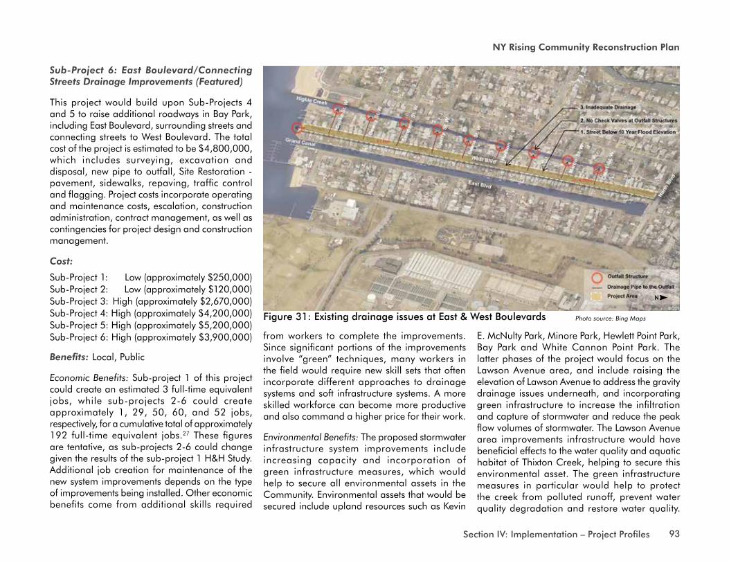
Sub-Project 6: East Boulevard/Connecting Streets Drainage Improvements (Featured)
This project would build upon Sub-Projects 4 and 5 to raise additional roadways in Bay Park, including East Boulevard, surrounding streets and connecting streets to West Boulevard. The total cost of the project is estimated to be $4,800,000, which includes surveying, excavation and disposal, new pipe to outfall, Site Restoration - pavement, sidewalks, repaving, traffic control and flagging. Project costs incorporate operating and maintenance costs, escalation, construction administration, contract management, as well as contingencies for project design and construction management.
Cost:
Sub-Project 1: Low (approximately $250,000)Sub-Project 2: Low (approximately $120,000)Sub-Project 3: High (approximately $2,670,000)Sub-Project 4: High (approximately $4,200,000)Sub-Project 5: High (approximately $5,200,000)Sub-Project 6: High (approximately $3,900,000)
Benefits: Local, Public
Economic Benefits: Sub-project 1 of this project could create an estimated 3 full-time equivalent jobs, while sub-projects 2-6 could create approximately 1, 29, 50, 60, and 52 jobs, respectively, for a cumulative total of approximately 192 full-time equivalent jobs.27 These figures are tentative, as sub-projects 2-6 could change given the results of the sub-project 1 H&H Study. Additional job creation for maintenance of the new system improvements depends on the type of improvements being installed. Other economic benefits come from additional skills required
Figure 31: Existing drainage issues at East & west boulevards Photo source: Bing Maps
from workers to complete the improvements. Since significant portions of the improvements involve “green” techniques, many workers in the field would require new skill sets that often incorporate different approaches to drainage systems and soft infrastructure systems. A more skilled workforce can become more productive and also command a higher price for their work.
Environmental Benefits: The proposed stormwater infrastructure system improvements include increasing capacity and incorporation of green infrastructure measures, which would help to secure all environmental assets in the Community. Environmental assets that would be secured include upland resources such as Kevin
E. McNulty Park, Minore Park, Hewlett Point Park, Bay Park and White Cannon Point Park. The latter phases of the project would focus on the Lawson Avenue area, and include raising the elevation of Lawson Avenue to address the gravity drainage issues underneath, and incorporating green infrastructure to increase the infiltration and capture of stormwater and reduce the peak flow volumes of stormwater. The Lawson Avenue area improvements infrastructure would have beneficial effects to the water quality and aquatic habitat of Thixton Creek, helping to secure this environmental asset. The green infrastructure measures in particular would help to protect the creek from polluted runoff, prevent water quality degradation and restore water quality.
NN
94 Section IV: Implementation – Project Profiles
Bay Park and Village of East Rockaway
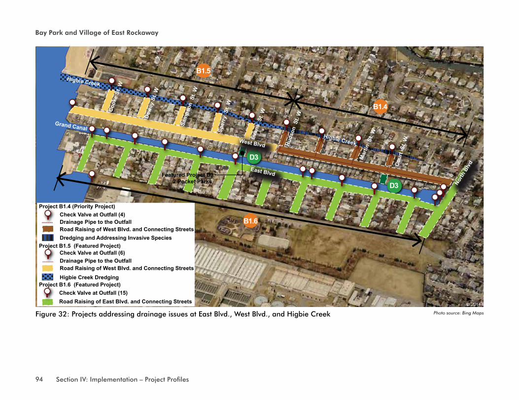
B1.4
B1.5
B1.6
D3
D3
Featured Project D32 Pocket Parks
Higbie CreekWest Blvd
East Blvd
North
Blv
d
Cook
e St
. W
Dew
ey S
t. W
Sam
pson
St.
W
Sper
ry S
t. W
Evan
s S
t. W
Huds
on S
t. W
Mar
tin S
t. W
Cour
t St
. W
Grand Canal
Higbie Creek
Drainage Pipe to the OutfallRoad Raising of West Blvd. and Connecting StreetsDredging and Addressing Invasive Species
Higbie Creek Dredging
Road Raising of East Blvd. and Connecting Streets
Check Valve at Outfall (4)Project B1.4 (Priority Project)
Project B1.5 (Featured Project)
Drainage Pipe to the OutfallCheck Valve at Outfall (6)
Check Valve at Outfall (15)
Road Raising of West Blvd. and Connecting Streets
Project B1.6 (Featured Project)
Figure 32: projects addressing drainage issues at East blvd., west blvd., and Higbie creek Photo source: Bing Maps
N
95Section IV: Implementation – Project Profiles
NY Rising Community Reconstruction Plan
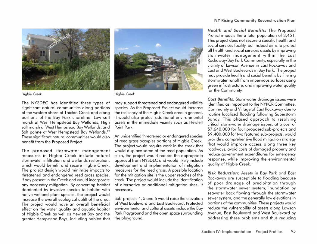
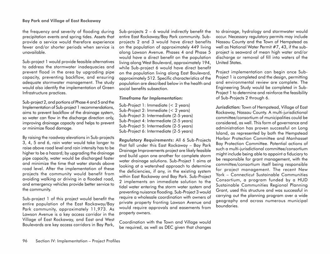
The NYSDEC has identified three types of significant natural communities along portions of the western shore of Thixton Creek and along portions of the Bay Park shoreline: Low salt marsh at West Hempstead Bay Wetlands, High salt marsh at West Hempstead Bay Wetlands, and Salt panne at West Hempstead Bay Wetlands.29 These significant natural communities would also benefit from the Proposed Project.
The proposed stormwater management measures in Higbie Creek include natural stormwater infiltration and wetlands restoration, which would benefit and secure Higbie Creek. The project design would minimize impacts to threatened and endangered reed grass species, if any present in the Creek and would incorporate any necessary mitigation. By converting habitat dominated by invasive species to habitat with native wetland plant species, the project would increase the overall ecological uplift of the area. The project would have an overall beneficial effect on the water quality and aquatic habitat of Higbie Creek as well as Hewlett Bay and the greater Hempstead Bays, including habitat that
may support threatened and endangered wildlife species. As the Proposed Project would increase the resiliency of the Higbie Creek area in general, it would also protect additional environmental assets in the immediate vicinity such as Hewlett Point Park.
An unidentified threatened or endangered species of reed grass occupies portions of Higbie Creek. The project would require work in the creek that would displace some of the reed population. As such, the project would require the appropriate approval from NYSDEC and would likely include development and implementation of mitigation measures for the reed grass. A possible location for the mitigation site is the upper reaches of the creek. The project would include the identification of alternative or additional mitigation sites, if necessary.
Sub-projects 4, 5 and 6 would raise the elevation of West Boulevard and East Boulevard. Protected environmental and cultural assets include the Bay Park Playground and the open space surrounding the playground.
Health and Social Benefits: The Proposed Project impacts the a total population of 3,451. This project does not secure a specific health and social services facility, but instead aims to protect all health and social services assets by improving stormwater management within the East Rockaway/Bay Park Community, especially in the vicinity of Lawson Avenue in East Rockaway and East and West Boulevards in Bay Park. The project may provide health and social benefits by filtering stormwater runoff from impervious surfaces using green infrastructure, and improving water quality for the Community.
Cost Benefits: Stormwater drainage issues were identified as important to the NYRCR Committee, Community and Village of East Rockaway due to routine localized flooding following Superstorm Sandy. This phased approach to resolving critical stormwater drainage issues, at a cost of $7,640,000 for four proposed sub-projects and $9,400,000 for two featured sub-projects, would provide a comprehensive flood mitigation strategy that would improve access along three key roadways, avoid costs of damaged property and reduce government expenditures for emergency response, while improving the environmental quality of Higbie Creek.
Risk Reduction: Assets in Bay Park and East Rockaway are susceptible to flooding because of poor drainage of precipitation through the stormwater sewer system, inundation by seawater back flowing through the stormwater sewer system, and the generally low elevations in portions of the communities. These projects would reduce the vulnerability of assets along Lawson Avenue, East Boulevard and West Boulevard by addressing these problems and thus reducing
Higbie Creek Higbie Creek
96 Section IV: Implementation – Project Profiles
Bay Park and Village of East Rockaway
the frequency and severity of flooding during precipitation events and spring tides. Assets that provide a service would therefore experience fewer and/or shorter periods when service is unavailable.
Sub-project 1 would provide feasible alternatives to address the stormwater inadequacies and prevent flood in the area by upgrading pipe capacity, preventing backflow, and ensuring adequate stormwater management. The study would also identify the implementation of Green Infrastructure practices.
Sub-project 2, and portions of Phase 4 and 5 and the Implementation of Sub-project 1 recommendations, aims to prevent backflow of the drainage system, so water can flow in the discharge direction only, improving drainage capacity and helps to prevent or minimize flood damage.
By raising the roadway elevations in Sub-projects 3, 4, 5 and 6, rain water would take longer to raise above road level and rain intensity has to be higher to be a hazard; by upgrading the drainage pipe capacity, water would be discharged faster and minimize the time that water stands above road level. After the implementation of these projects the community would benefit from avoiding walking or driving in a flooded road, and emergency vehicles provide better service to the community.
Sub-project 1 of this project would benefit the entire population of the East Rockaway/Bay Park community, approximately 11,973. As Lawson Avenue is a key access corridor in the Village of East Rockaway, and East and West Boulevards are key access corridors in Bay Park,
Sub-projects 2 – 6 would indirectly benefit the entire East Rockaway/Bay Park community. Sub-projects 2 and 3 would have direct benefits on the population of approximately 449 living along Lawson Avenue. Phases 4 and Phase 5 would have a direct benefit on the population living along West Boulevard, approximately 194, while Sub-project 6 would have direct benefit on the population living along East Boulevard, approximately 512. Specific characteristics of the population are described below in the health and social benefits subsection.
Timeframe for Implementation:
Sub-Project 1: Immediate (< 2 years)Sub-Project 2: Immediate (< 2 years)Sub-Project 3: Intermediate (2-5 years)Sub-Project 4: Intermediate (2-5 years)Sub-Project 5: Intermediate (2-5 years)Sub-Project 6: Intermediate (2-5 years)
Regulatory Requirements: All 6 Sub-Projects that fall under this East Rockaway – Bay Park Drainage Improvements project are likely feasible and build upon one another for complete storm water drainage solutions. Sub-Project 1 aims at looking at a watershed approach to determine the deficiencies, if any, in the existing system within East Rockaway and Bay Park. Sub-Project 2 implements an immediate solution to the tidal water entering the storm water system and preventing nuisance flooding. Sub-Project 3 would require a wholesale coordination with owners of private property fronting Lawson Avenue and would require approvals and easements from property owners.
Coordination with the Town and Village would be required, as well as DEC given that changes
to drainage, hydrology and stormwater would occur. Necessary regulatory permits may include Nassau County and the Town of Hempstead as well as National Water Permit #7, 43, if the sub-project is seaward of mean high water and/or discharge or removal of fill into waters of the United States.
Project implementation can begin once Sub-Project 1 is completed and the design, permitting and environmental review are complete. The Engineering Study would be completed in Sub-Project 1 to determine and reinforce the feasibility of Sub-Projects 2 through 6.
Jurisdiction: Town of Hempstead, Village of East Rockaway, Nassau County. A multi-jurisdictional committee/consortium of municipalities could be considered, as well. This form of governance and administration has proven successful on Long Island, as represented by both the Hempstead Harbor Protection Committee and Manhasset Bay Protection Committee. Potential actions of such a multi-jurisdictional committee/consortium might include being able to appoint a fiduciary to be responsible for grant management, with the committee/consortium itself being responsible for project management. The recent New York – Connecticut Sustainable Communities Consortium, a program funded by a HUD Sustainable Communities Regional Planning Grant, used this structure and was successful in carrying out the planning program over a wide geography and across numerous municipal boundaries.


