6
A DIGITAL TECH LEADER SERVING THE FRENCH TERRITORIES NATIONAL INSTITUTE OF GEOGRAPHIC AND FOREST INFORMATION

DEVELOPING COLLABORATIVE WORK
A DIGITAL TECH LEADERSERVING THE FRENCHTERRITORIES
NATIONAL INSTITUTEOF GEOGRAPHICAND FORESTINFORMATION
IGN1 is the official reference for geographic and forest information in France, certified to be neutral and interoperable. The institute is constantly developing new reference databases, products and geoservices, to meet the country's growing and changing needs for map data and geographic information.
A LEADING OPERATORSERVING PUBLIC POLICY
As a powerful public institute providing digital technology to describe the French territory, IGN helps define, evaluate and implement public policies in various fields and has particular expertise on forest issues.
MAIN ACTIVITIES
4million monthly visitsto Géoportail
GÉOPORTAIL - THE PEOPLE'S PORTAL TO FRANCEBuilt with openness and data sharing in mind, Géoportail facilitates access to official geographic information. The portal is constantly enhanced with data and provides access to numerous themes and information layers of interest to the general public.geoportail.gouv.fr
1L’IGN is a public administrative establishment placed under the joint authority of the Ministers in charge of the environment, energy and the sea, and agriculture, agribusiness and forestry.
Numerical modelling, development of monitoring tools (floods, earthquake zones, landslides), etc.
Risk prevention
National forest inventory, publication of sustainable forest management indicators, development of the nature and landscape information system, studies on forest availability, monitoring and evaluation of sea levels and changes in the coastline, etc.
Forest, environment and agriculture
Development of analysis services, monitoring of consumption of natural, forest and agricultural areas, city asset and infrastructure mapping, development of data and service infrastructure for managing road travel, etc.
Land-use planning, urban planning and urban management
Programming and processing of satellite and aerial images, annual coverage of the entire French territory (SPOT 6 and 7 satellites), stereoscopic observation of key areas, etc.
Defence, security and space
Mont Saint-Michel, digital terrain model - ©IGN
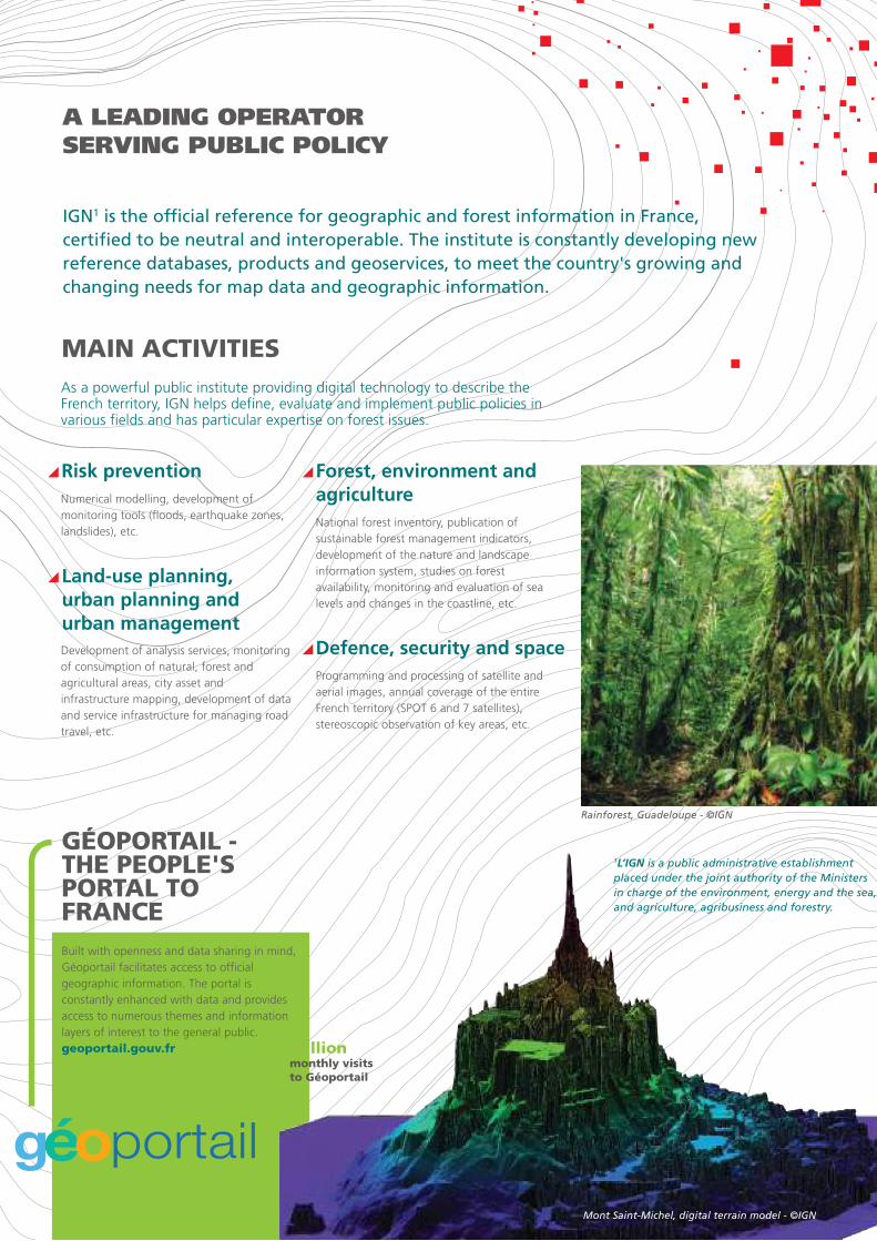
Rainforest, Guadeloupe - ©IGN

IGN's five inter-regional agencies work in collaboration with the local authorities. Through regional programming committees, the goal is to build an annual programme that meets local needs by identifying synergies and pooling production efforts, while ensuring national consistency with the Institute's strategy.
A PARTNER SERVINGFRENCH TERRITORIES
Large scale land use (OCS GE) for monitoring urbanization and other land development
Produced in partnership with state and local authorities, the OCS GE database provides consistent information on land use to track urbanization and consumption of spaces, control development and preserve biodiversity, etc.
High-resolutionorthoimages toreadjust networks
In partnership with local authorities and state services, IGN produces orthophotographic coverage with a ground pixel resolution of 15 to 20 cm. This makes it possible to readjust networks and develop planning documents, track consumption and protection of spaces and assess light pollution.
The production of certain products or services is funded through partnerships that allocate contributions between IGN and local authorities. These take various forms: co-production, grants andtechnical assistance from IGN.
THE PARTNERSHIP APPROACHIN THE FRENCH TERRITORIES
1L’IGN is a public administrative establishment placed under the joint authority of the Ministers in charge of the environment, energy and the sea, and agriculture, agribusiness and forestry.
EXAMPLESOF LOCALPARTNERSHIPSAND USES
The National Address Database is the result of a
unique partnership between IGN, the Groupe
La Poste, local authorities, municipalities, the fire
and rescue services, the association OpenStreetMap
France and the Etalab mission. This database, whose
purpose is to reference the location of all 25 million
addresses in France, can be added to by citizens,
institutions and businesses. It is based on an open
system that is continually updated and accessible.
National Address Database:a successful collaboration
FO
CUS ON

GEOSERVICES FOR ANALYSINGAND UNDERSTANDING CHANGESIN FRENCH TERRITORIES
Some examples of Geoservices developed by IGN to facilitatethe use of spatial data.
A portal to delve into the past and compare the development of French territories over time.
RemonterLeTemps.ign.fr
In just a few clicks, users can geocode a list of mailing addresses, display them on a map and share the results with others.
MesAdresses.ign.fr
Easily make a personalized online interactive map.
MaCarte.ign.fr
Host and distribute localized information with a high level of performance.
MonGéoportail.ign.fr
Online management tool that allows municipalities and public agencies to help improve the National Address Database.
Guichet-adresse.ign.fr
National platform co-produced by IGN and the Ministry of Housing and Sustainable Habitat, which aims to facilitate access to urban planning documents and utility easements, both for professionals and the general public.
Géoportail for urban planning
Several IGN projects were selected under theInvestments for the Future Programme.The objective of these mapping tools is to simplify the online administrative procedures set up by the government.
PROJECTS TO MODERNIZEPUBLIC ACTION
A GEODATABASEON ESTABLISHMENTSOPEN TO THE PUBLIC
With this project, IGN provides tools and web services that people can use collaboratively to list all establishmentsopen to the public in France and add relevant data (hours, reports, disabled accessibility, etc.).erp.ign.fr
API CARTO: FOR SIMPLIFIED ONLINE ADMINISTRATIVE PROCEDURES
This software component offers processing and calculation web services that can be used by public agencies to easily retrieve geolocatable information requested in administrative procedures. The aim is threefold: make the procedures more reliable, simpler and faster.apicarto.ign.fr
Vitiplantation: an illustration of how
API Carto simplifies things
API Carto is used to develop and create Vitiplantation, an administrative
e-service that allows wine growers to file their vine planting and replanting
applications. With the capabilities of the API Carto, wine growers now just
have to trace the outlines of their field as part of the process. The system
automatically calculates the size and retrieves the reference data required
in the application, in particular the protected designation of origin.
Vitiplantation was created in partnership with France Agrimer.
FOCU
S ON
©Ph
oto
Men
et/I
GN

AN INNOVATION LEADER FORTHE DIGITAL ECONOMY
The GéocubeMeasure and monitor ground movements
Géocube is a standalone, ultra-compact, high precision GPS receiver that can detect the slightest ground movement.Installed alone or as part of a network, it can
The IGN Lightweight Camera for risk prevention
Designed by IGN's optical and micro-computer laboratory LOEMI, the IGN Lightweight Camera is very high resolution and allows 3D modelling from images. On board drones, aircraft, vehicles or other vectors, this camera offers the ability to
iTownsNavigate the city in 3D
iTowns is an immersive and fluid way of navigating around the city. The data collected by IGN vehicles equipped with cameras - that travel and digitize the public space - offer many practical applications for towns. ign.fr/institut/innovation/itowns
Innovation is a core strategy of IGN through its five research laboratories, its school, its project accelerator, its forestry expertsand the services provided by IGN Conseil, IGN Espace and the specialized geodetic levelling work.
A SUPPORT SYSTEMFOR START-UPS
This website helps connect individuals and
professionals to promote access to
photovoltaics. IGNfab supported this project
by developing a feature that gives website
users an instant, accurate assessment of the
solar potential of their rooftops based on the
data and algorithms of the institute.
This web platform facilitates contacts between
forest industry operators and the millions of
small inactive forest owners. IGNfab supported
this project by developing a feature that
identifies forest resources and accesses.
InSunWeTrust OpenForêt
fabIGNfab helps SMEs develop innovative products and services using the description of the territory and geolocation in different sectors. IGNfab supports selected projects by providing its expertise, free preferential access to its data and a dedicated 200-sqm workspace.ignfab.ign.fr
IGN has a school of excellence in the field of geomatics: ENSG, the National School of Geographical Sciences, which trains future talents involved in the production and use of geographic information.ensg.eu
acquire images for erecting structures (dams, bridges, levees), surveying geophysical objects (landslides, cliffs) and 3D modelling of underground spaces that are difficult to access (tunnels, sewers). Delair-Tech, winner of Season 2 of IGNfab, is going to industrialise and include IGN Lightweight Cameras in their drones.
The Géocube
IGN Lightweight Camera
A SCHOOLFORGEOMATICSENGINEERING
THREE RESEARCH RESULTS
monitor seismic zones,coastal landslides and glaciermelt. The Géocube is beingindustrialized by thecompany Kylia.
Arc de Triomphe, laser survey - Stéréopolis ©IGN

IGN CONSTANTLY ADAPTSTO NEW SOCIETAL DEMANDS
For several years now, IGN has been engaged in a process of opening up data and providing free software. To maintain the quality of its data, IGN has set up a special price policy. Today, the institute supports the French government's policy on Open Data and digital technology.
IGN has migrated all of its historical collaboration tools into a single interface: the Collaborative Space. This platform provides an opportunity for IGN partners to:
IGN PROMOTES OPEN DATA
DEVELOPING COLLABORATIVE WORK 2009: all IGN public data were made free for schools and research labs
2011: the large-scale reference database (RGE®) was made free for non-industrial and non-commercial public service missions
From 2011 to present: IGN regularly makes new data sets under Etalab open license accessible to everyone on www.data.gouv.fr (Contours...Iris®, GEOFLA®, BD ALTI®, maps, scanned aerial images, raw forest inventory data, territorial coherence schemes, etc.)
Key dates for open data
National Institute of Geographic andForest Information73 avenue de Paris 94160 - Saint-Mandé - France+33 (0)1 43 98 80 00
ign.frgeoportail.gouv.fr
report changes or anomalies (street name change, new building) in the Institute's databases through an information reporting system,
extract IGN reference vectors (land use, address) based on geographical criteria (region, department) and/or semantic criteria,
host and manage their data using dedicated tools as part of a commercial service.
Espacecollaboratif.ign.fr
©IG
N/D
IRC
OM
/201
6/R
éf.4
8


