Form No. 10-300 , \Q-' &&>• UNITED STATES DEPARTMENT OF THE INTERIOR NATIONAL PARK SERVICE NATIONAL REGISTER OF HISTORIC PLACES INVENTORY -- NOMINATION FORM SEE INSTRUCTIONS IN HOWTO COMPLETE NATIONAL REGISTER FORMS ___________TYPE ALL ENTRIES - COMPLETE APPLICABLE SECTIONS______ I NAME HISTORIC Charlotte Amalie Historic District AND/OR COMMON STREET & NUMBER _NOT FOR PUBLICATION CITY. TOWN CONGRESSIONAL DISTRICT Charlotte Amalie _ STATE Vircrin Islands .VICINITY OF CODE 78 1 COUNTY £+- rPl-»/-Ymae HCLASSIFI CATION CATEGORY -^DISTRICT _ BUILDING(S) —STRUCTURE —SITE —OBJECT OWNERSHIP —PUBLIC —PRIVATE ^.BOTH PUBLIC ACQUISITION _IN PROCESS —BEING CONSIDERED STATUS ^.OCCUPIED ^.UNOCCUPIED —WORK IN PROGRESS ACCESSIBLE —YES: RESTRICTED ^-YES. UNRESTRICTED _NO CODE n0an PRESENT USE _ AGRICULTURE ^COMMERCIAL ^.EDUCATIONAL —ENTERTAINMENT —GOVERNMENT —INDUSTRIAL ^.MILITARY _?MUSEUM —PARK ^PRIVATE RESIDENCE J^RELIGIOUS —SCIENTIFIC .^TRANSPORTATION —OTHER: Multiple Ownership STREET & NUMBER CITY, TOWN STATE VICINITY OF LOCATION OF LEGAL DESCRIPTION Recorder of Deeds COURTHOUSE. REGISTRY OF DEEDS,ETC. STREET & NUMBER CITY, TOWN ,..,.18; Kongens Gade Charlotte Amalie, St. Thomas STATE U.S. Vi-rm'n QQ801 El REPRESENTATION IN EXISTING SURVEYS TITLE DATE Select properties within the district have been surveyed by HABS x —FEDERAL —STATE —COUNTY —LOCAL DEPOSITORY FOR SURVEY RECORDS National Park Service and Library of Concjress CITY. TOWN Washington STATE D.C.
Transcript
Form No. 10-300 , \Q-' &&>•
UNITED STATES DEPARTMENT OF THE INTERIOR NATIONAL PARK SERVICE
NATIONAL REGISTER OF HISTORIC PLACES INVENTORY -- NOMINATION FORM
SEE INSTRUCTIONS IN HOWTO COMPLETE NATIONAL REGISTER FORMS ___________TYPE ALL ENTRIES - COMPLETE APPLICABLE SECTIONS______
I NAMEHISTORIC
Charlotte Amalie Historic DistrictAND/OR COMMON
STREET & NUMBER
_NOT FOR PUBLICATIONCITY. TOWN CONGRESSIONAL DISTRICT
Charlotte Amalie _STATE
Vircrin Islands
.VICINITY OFCODE
78
1COUNTY
£+- rPl-»/-Ymae
HCLASSIFI CATIONCATEGORY
-^DISTRICT_ BUILDING(S)
—STRUCTURE
—SITE
—OBJECT
OWNERSHIP—PUBLIC
—PRIVATE
^.BOTH
PUBLIC ACQUISITION_IN PROCESS
—BEING CONSIDERED
STATUS^.OCCUPIED
^.UNOCCUPIED
—WORK IN PROGRESS
ACCESSIBLE—YES: RESTRICTED
^-YES. UNRESTRICTED
_NO
CODE
n0an
PRESENT USE_ AGRICULTURE
^COMMERCIAL
^.EDUCATIONAL
—ENTERTAINMENT
—GOVERNMENT
—INDUSTRIAL
^.MILITARY
_?MUSEUM
—PARK
^PRIVATE RESIDENCE
J^RELIGIOUS
—SCIENTIFIC
.^TRANSPORTATION
—OTHER:
Multiple OwnershipSTREET & NUMBER
CITY, TOWN STATE
VICINITY OF
LOCATION OF LEGAL DESCRIPTION
Recorder of DeedsCOURTHOUSE. REGISTRY OF DEEDS,ETC.
STREET & NUMBER
CITY, TOWN,..,.18; Kongens Gade
Charlotte Amalie, St. ThomasSTATE
U.S. Vi-rm'n QQ801
El REPRESENTATION IN EXISTING SURVEYSTITLE
DATESelect properties within the district have been surveyed by HABS
x—FEDERAL —STATE —COUNTY —LOCAL
DEPOSITORY FORSURVEY RECORDS National Park Service and Library of ConcjressCITY. TOWN
WashingtonSTATE
D.C.
DESCRIPTION
CONDITION CHECK ONE CHECK ONE
X_EXCELLENT ^DETERIORATED ^.UNALTERED ^ORIGINAL SITE
X_GOOD XRUINS ^ALTERED _MOVED DATE_______
X_FAIR __UNEXPOSED
DESCRIBE THE PRESENT AND ORIGINAL (IF KNOWN) PHYSICAL APPEARANCE
The Charlotte Amalie Historic District lies at the head of the St. Thomas Harbor, in the center of the southern shoreline of the capitol of the United States Virgin Islands. The predominantly flat area of the district that extends along the waterfront gives way to gently rolling topography to the north and finally is marked by two large hills at the third points, Denmark Hill to the west and Government Hill to the east.
Settlement of the area that is now Charlotte Amalie began with the construction of Fort Christian C1666 (a national historic site). Begun by a previous group of Danish settlers east of the harbor, the building was completed sometime before 1680 by members of the Danish West Indian and Guinea Company. Standing alone, the fort housed all the administra tive, trading and religious functions of the new colony, as most of the initial settlers were engaged in establishing farms in the outlying areas. By 1681 permission had been granted for the construction of four houses west of the Fort, the actual beginnings of the town. In 1688 additional lots on the east lands northeast of the Fort were parcelled out, followed in 1692 by the granting of lots along the waterfront below the row of the four earlier houses to planters for warehouses and wharves. By 1698 forty-seven houses had been constructed in Charlotte Amalie. Pere Labat, visiting St. Thomas in 1707 writes:
"At fifty or sixty paces from the Fort there is a town which takes the form of the Bay, and constitutes the port. This town consists of only one long street, which terminates at the factory or offices of the company. This is a large and handsome edifice, containing many apartments and commodious magazines for merchandise, and for the security of the Negroes, in which this company carries on a trade with the Spaniards. To the right of the factory are two small streets filled with French refugees. The houses of the town, which formerly were nothing but huts, are now built of brick, almost all of one story, but very well arranged."*
The town continued to prosper and grow during the beginning of the 1800 Ct,,, and by 1716 there were 82 houses. New warehouses were con structed between the main street (Dronningens Gade) and the area north of this street was opened for development by the construction of parallel streets or paths. Two gridiron planned residential areas were laid out in 1764-65, "Savanne", in the valley west of Denmark (Berg) Hill, and "New Town" or "East Savanne", east of Government Hill and northeast of the Fort. The lagoon areas along the waterfront directly east of the Fort were designed in 1781-1782 but this area was very slow to develop.
Changes to the physical character of Charlotte Amalie were dictated by disaster rather than plan. On November 22, 1804, fire destroyed 634
Labat, Jean Baptiste, Voyage Aux Isles de 1 "Amerique, vol ii. tst. Paris, 1722. English Version translated by John Eaden, New York 1920
SIGNIFICANCE
PERIOD—PREHISTORIC
—1400-1499
—1500-1599
X_1600-1699
X_1 700-1 799
?_1800-1899
X_1900-
AREAS OF SIGNIFICANCE -- CHECK AND JUSTIFY BELOW_ ARCHEOLOGY-PREHISTORIC
_ ARCHEOLOGY-HISTORIC
_ AGRICULTURE
^ARCHITECTURE y
^.COMMERCE V
—COMMUNICATIONS
—COMMUNITY PLANNING
—CONSERVATION
—ECONOMICS
—EDUCATION
—ENGINEERING .
—LANDSCAPE ARCHITECTURE
—LAW
—LITERATURE
—MILITARY
—MUSIC
^EXPLORATION/SETTLEMENT ,- —PHILOSOPHY
—INDUSTRY ,.
—INVENTION
XpOLITICS/GOVERNMENT
^RELIGION
—SCIENCE
_SCULPTURE
—SOCIAL/HUMANITARIAN
—THEATER
.^TRANSPORTATION
—OTHER (SPECIFY)
SPECIFIC DATES BUILDER/ARCHITECT
STATEMENT OF SIGNIFICANCE
Exploration And Settlement
While the town of Charlotte Amalie was not plotted until 1681, nine years after the first permanent Danish settlement, the history of St. Thomas is synonomous with the development and settlement of the present capitol of the United States Virgin Islands. St. Thomas, along with the other Virgin Islands, was discovered by Columbus in 1493 while on his second voyage to the new world. In 1657 Dutch colonists settled on St. Thomas, but soon left the island for the more promising New Amsterdam, leaving behind little traces of their occupation. A second attempt at colonizing St. Thomas, this time by the Danes who first arrived in December of 1665 also failed, but the seeds of a settlement were planted at the head of St. Thomas Harbor, with the beginning of the construction of Fort Christian.
The first permanent settlement of St. Thomas took place in 1672, with the arrival of the Danish West India Company. Plantations were immediately parcelled out for agricultural uses, but the still uncompleted Fort remained as the only structure at the harbor. By 1674 the Company had changed its name to the Danish West India and Guinea Company and St. Thomas rapidly became one the leading slave trading centers in the West Indies. This initial prosperity as a port prompted the governor to grant permission for the construction of four houses, with tavern licenses, along the harbor west of the Fort. The immediate success of these taverns with the traders led to the settlement being derisively called "Tap Hus" (Beer Hall), a name which continued in use until 1691, when the settlement was offically declared a town and named Charlotte Amalie in honor of the Queen of Denmark, wife of King Christian V.
Because of the limited means available to the Danish West India and Guinea Company, and the inability to fully capitalize on the lucrative slave trade, Denmark entered into a treaty with the Duchy of Brandenburg in 1685 to permit the Brandenburg American Company to set up a slave trading post on St. Thomas. The Company constructed a large warehouse at what was then the western edge of the settlement. While the treaty lapsed in 1695, the Germans were allowed to remain and contributed to the future development of St. Thomas.
The first census of the island, taken in 1688, identified 37 persons living in the town, all in a single row of houses stretching west of the Fort. During this same decade, with the tacit approval of two governors, the Brothers Nicolaj and Adolph Esmit, St. Thomas and especially the settlement at the harbor became a safe refuge for pirates, who openly disposed of their prizes in town and often took up residence
QMAJOR BIBLIOGRAPHICAL REFERENCESKnox, John P. A Historical Account of St. Thomas, W.I. New York: Charles Scribner, 1852.Larsen, Jens, Virgin Island Story. Philadelphia: Fortress Press 1950 Royal Academy of Fine Arts. Three Towns. Copenhagen: Tutein & Koch, 1964Gosner, Pamela. Historic Architecture of the U.S. Virgin Islands. Durham ,North Carolina: Moore Publishing Co. 1971.
HJjGEOGRAPHICAL DATAACREAGE OF NOMINATED PROPERTY 165.28
UTM REFERENCES
A| , 1 1 1 , LJ.ZONE EASTING
, | 1 • I » LNORTHING
18°20acres 18°20
18°20 18°21, , ) B!
'26 '26 '51 '00
. 1ZONE
"N. "N. "N. "N. "N.
LL
Lat. Lat. Lat. Lat. Lat.
, 1 ,EASTING
b4 w bb 64°55 64°56 64°56 64°55
-i-J L
1 3U '30 '23 '23 ! 52 , 1
11 w. 11 W. 11 W. "W. 11 W.
, 1
Long Long Long Long Long< i i
•
*
NORTHINGcl . I 1 I , I i . I I , I . I . . I Dl . I I I . I..,,. ] I I I , I ,VERBAL BOUNDARY DESCRIPTION
The boundary of the Charlotte Amalie Historic District begins at the projection of the southern property line of 40 aab Bjerge Gade to Veterans Drive, and the mean high water mark at the shore of Charlotte Amalie Harbor, thence east to Bjerge Gade continuning east along the southern property line of 40 aa Taarneberg, thence north along the eastern property line of 4 aa Taarneberg, thence west along the southern
LIST ALL STATES AND COUNTIES FOR PROPERTIES OVERLAPPING STATE OR COUNTY BOUNDARIES
STATE CODE COUNTY CODE
STATE CODE COUNTY CODE
FORM PREPARED BYNAME/TITLE
Russell Wright Virgin Islands HistoricORGANIZATION
Virgin IslandsSTREET & NUMBER
P.O. Box 2606
Plannina
CITY OR TOWN
Charlotte Amalie, St.
OfficeDATE
Mav 70. 1Q7fiTELEPHONE
(80<n 774-17™
Thomas. V.T. 00STATE
801
STATE HISTORIC PRESERVATION OFFICER CERTIFICATIONTHE EVALUATED SIGNIFICANCE OF THIS PROPERTY WITHIN THE STATE IS;
NATIONAL _X_ STATE LOCAL
As the designated State Historic Preservation Officer for the National Historic Preservation Act of 1966 (Public Law 89-665), I hereby nominate this property for inclusion in the National Register and certify that it has been evaluated according to the criteria and procedures set forth by the National Park Service. ,-
STATE HISTORIC PRESERVATION OFFICER SIGNATURE
TITLE Direc-faor of Planning- May 1976
.^^^^%|^^^&?P^;E:!^T^At"-flEO!'§T6R;.«:•:; *::; '. • : i v r r: ;• :- • v :• :: r: :••:•••'•••••"••.-•: : . .;••••-- Wfii:Aiy.iv:Hisf<),fiJfc::^R^sifty;ATi.ON::
DATE
GPO 892-453
Form No. 1f)-300a (Aev. 10-74)
UNITED STATES DEPARTMENTOE THE INTERIOR NATIONAL PARK SERVICE
NATIONAL REGISTER OF HISTORIC PLACES INVENTORY -- NOMINATION FORM
FOR NFS USE ONtY
RECEIVED ; :;
DATE ENTERED
CONTINUATION SHEET ITEM NUMBER 6 PAGE thirteen
U.S. Virgin Islands Inventory of Historic Places
May 1976 x__ State
Virgin Islands Planning Office
Charlotte Amalie U.S.V.I.
Form No. 10-300a (Rev. 10-74)
UNITED STATES DEPARTMENT OF THH INTERIORNATIONAL PARK SERVICE
RECEIVED
NATIONAL REGISTER OF HISTORIC PLACESDATE ENTEREDINVENTORY -- NOMINATION FORM
FORNPSUSEONIY
CONTINUATION SHEET_________________ITEM NUMBER 7_____PAGE one_____________________
of 910 taxable buildings in the heart of town, including the Roman Catholic Church, the Dutch Reformed Church and the Jewish Synagogue. 1806 saw two fires, which consumed 172 buildings, followed by the diastrous fire of 1825, which consumed over 1000 buildings in the west ern end of the town, including the lower portion of the Savanne. The areas around the Frederic Lutheran Church were destroyed by fire in 1826, and a fire in 1831 destroyed 550 buildings in the Commandant Gade area.
Before 1800 most of the warehouses and residences in town were of frame construction, built extremely close together on narrow alleys. The fires of 1804-1832 brought about a series of restrictive building codes which greatly affects the visual character of the town, a character which remains to this day. The earliest codes called for the widening of streets or the construction of additional ones, in an attempt to lessen density, and also called for the voluntary use of masonry for new construction, especially in the warehouse areas. A number of such "fire - proofs" were built after the 1804 and 1806 fires, but it was not until the fire of 1831 that such construction was made mandatory. The building code in 1832 banned frame construction in the commercial area and required fire proof roofs, usually of tile or brick, later changed to corrugated metal to better withstand hurricanes. These code requirements, along with the knowledge that the hip roof permitted the use of attic space while afford ing reasonable protection from tropical storms, dictated the form which all construction along the two block wide commercial-warehousing section of the town, from the head of Dronningens Gade (at the Grand Hotel) to the Roman Catholic Church on Kronprindsens Gade two blocks west of the Market Square.
By 1836 there were 60 "fire-proof" warehouses, as well as many new masonry residences, but the small frame houses of the free-colored remained in many areas of the town, especially in Savanne and New Town, with the only changes in these being sheet metal roofs replacing the traditional wood shingles. By this time the town plan had evolved to essentially what it is today, with only minor expansion taking place at the east and west edges and new residential areas being developed in the valleys between the two hills. Density of the open residential areas, however, was affected as many of the freed slaves immediately moved into town after Emancipation in 1848. The Savanne, originally laid out for settlement by the free-colored almost 100 years previous, and the east ern portion of New Town in particular, were re-subdivided into smaller lots, with the resulting overcrowding that exists today.
There were few changes or additions to the town during the latter part of the 19th century and the first half of the 20th century, due to loss of trade and the decline of St. Thomas as a Port. The increase in tourism immediately after WWII however, brought many changes to Charlotte
Form No. 10-300a (Rev. 10-74)
UNITED STATES DEPARTMENT OE THE INTERIOR NATIONAL PARK SERVICE
NATIONAL REGISTER OF HISTORIC PLACES INVENTORY -- NOMINATION FORM DATE ENTERED
COIMTi ISIUAHON SHEET__________________ITEM NUMBER 7______PAGE two______________________
Amalie, when many of the former warehouses were converted into gift and speciality stores to accommodate the growing number of visitors to the islands. For the most part, the reuse of these buildings has been accomplished in a manner sympathetic to the original architectural character and integrity of the structure. Unfortunately, this program of adaptive use, the sub-service to the tourist trade, and increasing traffic problems led to the destruction of the wooden warehouses along the harbor, for new buildings and parking, and the construction in 1953-54 of the four lane waterfront Veterans Drive, and the concrete dock space.
The Charlotte Amalie Historic District today can be divided into four visual and land use districts; 1) The commercial areas, from the Fort to the Windward Hotel, with Main Street as its spine; 2) The high density residential areas west of Denmark Hill, including Savanne; 3) Denmark Hill to the valley east of Government Hill; and 4) The New Town or East Savanne part of Kings Quarter, east and northeast of the Fort.
The commercial area is almost exclusively retail or office uses in a two block deep band centered on Dronnengens Gade and Kronprindsens Gade, with mixed residential uses occurring at either end and along the lower faces of the hills which form the northern edge of this area. Building heights are predominately one (on the Harbor side of Main Street) and two stories, with only a small number of three story structures present. The area is of masonry construction (because of the codes) usually stucco over brick or rubble walls and building conditions and maintenance is very high. The converted early warehouse buildings and early residences are of great distinction and typical of West Indian architecture, with hip roofs (now of corrugated metal), arcaded first floors with semi circular headed openings extending to the sidewalk, heavy wood shutters hung on massive and often decorative wrought iron strap hinges, and in some cases, well designed cast or wrought iron overhanging verandas at the upper level of the converted residences. Building density is ex tremely high, with both sides of the Main Street consisting of solid rows of structures.
The residential area west of Denmark Hill is nestled at one side of the hill and spills over onto a flat plain above the western end of the commercial area. This area, which includes the Savanne laid out in a grid plan in 1764-65, is predominantly single family residential in use, with some commercial uses occurring along its eastern boundary, and con venience retail uses scattered throughout the area. Buildings in the Savanne area are almost exclusively one-story, of frame construction with some later masonry structures interspersed, and are low, shingled cottage types with hip roofs. Conditions vary from good (newer buildings) to dilapidated, and density, especially with the resub-division of lots in the 1850's is exceptionaly high. Of slightly less density are the residential areas to the east and south of the Savanne area, where most of
Form No. 10-300a (Rev. 10-74)
UNITED STATES DEPARTiMENT OF THE INTERIOR NATIONAL PARK SERVICE
NATIONAL REGISTER OF HISTORIC PLACES INVENTORY - NOMINATION FORM
FORNPSUSEONtY
DATEENTI8ED
COIVm NUATION SHEET__________________ITEM NUMBER 7______PAGE three____________________
the construction is two-story, masonry, with both flat and hip roofs occurring.
Much of the development of the slopes of Denmark and Government Hills and the valley in between is of relatively recent date, with the obvious exception of Catherineberg (Denmark Hill) and Bluebeard's Tower (Skytsborg). The newer residential buildings are two stories in height, masonry con struction with the traditional hip roof and are set on large, often spacious lots. The older structures, some of which are three stories, continued the hip roof tradition and offer one of the most important ensembles in the district. Building conditions are good, and the area is virtually all residential in use.
The final visual area includes the part of town laid off in 1764-75 east of Government Hill as New Town or East Savanne, and the area due east of the Fort in what is now Kings Quarter. This latter area, centered along isforre Gade is mixed commercial/office and residential in use and is the site of the new Federal Building, nearing completion. Most of the structures, many of which are of high architectural significance, are two stories with hip roofs, stucco over brick or rubble stone, and are sited along the front building line. Building coverage along the street facades is extremely high, but density is reduced by spacious rear yards and courts. Building conditions are generally excellent.
New Town is predominantly residential with convenience commercial uses dotted throughout. Building heights are almost evenly divided between one and two stories (one story being the earlier structures) with masonry the predominant method of construction. While almost all of the buildings are placed at the front property line, density is medium because of side and rear yards. Building conditions are good to fair.
The edges of the Charlotte Amalie Historic District are defined by the steep slope of Bluebeard's Hill to the east, the hospital and stadium complex and a change in the visual character of the residential structures in the eastern part of the northern edge, the ridge lines on Government Hill and Denmark Hill in the central portion of the north edge, and the grid plan of the Savanne, which completes this boundary. A change in architectural character, density and period of construction defines the western limit of the District. The southern boundary is St. Thomas Harbor.
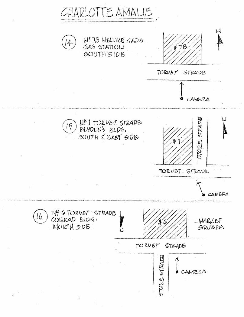
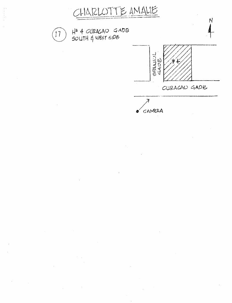
Pivotal buildings and spaces in the Charlotte Amalie Historic District keyed to the accompanying map and photographs, include:
1. Fort Christian, the earliest known building in the town. Thought to have been begun in 1666 and completed in 1680, the brick and rubble fort was seriously altered in 1874, when the watch tower was removed, and the present day Gothic Revival north facade, with the crenelated clock tower was added. (A National Historic Site).
Form No. 10-300a (Rev. 10-74)
UNITED STATES DEPARTMENT OF THE INTERIOR FOR NPS DSC ONLY NATIONAL PARK SERVICE
RECEIVED
NATIONAL REGISTER OF HISTORIC PLACES INVENTORY -- NOMINATION FORM
JUL 1 i
CONTINUATION SHEET_________________ITEM NUMBER 7_____PAGE four_________________
2. Legislative Building, 1874. Constructed as a barracks for the Danish Police, this is now the home of the Virgin Islands Senate. The long, two story, arcaded Italian Rennaisance structure also served as a U.S. Marine Corps Barracks from 1917-1930, and a public school until 1957.
3. Emancipation Park. Named in comemoration of the July 3, 1848 emancipation of the slaves by Governor Peter von Scholten, the park is the site of many of St. Thomas 1 official ceremonies, is well landscaped and maintained and includes a bandstand.
4. Commercial Hotel and Coffee House (now Grand Hotel), 44 Norre Gade. This Greek Revival structure, no longer in use as a hotel, was built in 1839-40 occupying an entire city block at the eastern terminus of Dronningens Gade, the main street. Originally three stories in height, the top story was lost sometime after 1896, presumably because of damage caused by a hurricane. The entire first floor is arcaded, with the three entrances on the north, south and west sides framed by engaged columns, and the corners accented by huge bulbous engaged columns. The second floor of the south facade, facing Emancipation Park, is an excellent arcaded open loggia.
5. Jacob H.S. Lind House (now Benthania,Frederick Lutheran Church Parish Hall). This one time residence, built between 1806 and 1827, has been used as a Post Office, an old peoples1 home and a school as well as the Parish Hall. Two stories in height and of masonry construction (brick and rubble, stuccoed) with the characteristic hip roof, the house is of a U shape plan with the east and west wings provided with exterior free standing brick stairways.
6. Frederick Lutheran Church, 1826. The present day free standing Gothic R^-ival one and one-half story building with projecting central entrance pavillion with round arched door and bell tower, all set on an elevated base reached by a wide set of stairs, replaces two earlier churches on this site (1750 and 1789). The rubble walls are faced with buff colored brick laid in English bond, the gable ends are stepped.
7. Old Unity Lodge |1908, 5 Norre Gade. This two-story masonry former residence is one of the most important examples of early 19th century neo-classic villas in St. Thomas. Set back from the street and surrounded by a high masonry wall with sturdy entrance gate, the main facade (upper) of the hip roofed structure is composed of alternating triangular and segmental headed window and door openings, some of which are secured with heavy panelled wood shutters.
8. Moravian Memorial Church, 1882. A large two store edifice constructed of local blue-bitch stone with rusticated sandstone quoins and a heavy overhanging cornice. The hip roof is accented by a light, frame bell tower and cupola, over the large arcaded center entrance with fan
Form No. 10-300a (Rev. 10-74)
UNITED STATES DEPARTMENT OF THH INTERIOR NATIONAL PARK SERVICE
NATIONAL REGISTER OF HISTORIC PLACES INVENTORY -- NOMINATION FORM
FOR NFS USE QNIY
RECEIVED -.:w..^
DATE ENTERED
CONTI NUAT1ON SHEET ITEM NUMBER PAGE five
light. Flanking windows in the upper story are framed with rusticated stone and triangular pediments, while flanking doors on the first story have flat post and lintel openings,
9. Government House, 21-22 Kongens Gade. This three-story masonry, free standing hip roofed structure with an exceptional cast iron two- story veranda, was constructed in 1865-1867 to replace an early building used.for the same function built in 1819. Neo-classic in design, the brick walls, now stuccoed, are decorated with exposed brick belt course and quoins and a heavy dentilled brick cornice.
10. Quarters 'B 32 and 33 Kongens Gade. This Greek revival two-story hip roofed structure of masonry and frame construction was originally constructed as a residence in 1816. Built on the slope on Government Hill, the upper frame story is entered through a recessed gabled archway support ed by two Ionic pilasters. The remainder of this facade is divided into four bays by engaged pilaster strips with molded bases. Wall sheathing is vertical siding. The interior is noted for its large mahogony stair leading to the traditional "Welcoming Arms" stair case at the lower landing.
11. A. Lavalette House, 30-A Kongens Gade. Now the Hotel 1829, this two-story stucco over rubble masonry structure with brick linings at all wall openings and at the corners was originally built as a residence about 1831. The original part of the complex, U-shaped in plan, has a low parapet wall hiding a low pitched shed roof. A molded brick cornice defines the second floor ceiling height and the central portion of the front facade has a two- story balcony supported by square brick pilasters with molded capitals and bands.
12. Skytsborg (Blackbeard's Castle) 1678. A round five story conical tower constructed of rubble masonry by the Danes to serve as a watch tower overlooking the harbor,
13. St. Thomas Reformed Church (formerly the Dutch Reformed Church). The excellent example of Greek Revival residential building was constructed in 1846. The large triangular pedimented two story front facade is supported by four large Doric columns. The walls are stuccoed over masonry with the three bay front facade scored to imitate dressed and coursed stone. The door openings are framed with pilasters and full entablatures/ the win dows with' a flat frame with crossettes.
14. Synagogue of Beracha Veshalom Vegemiluth Hasidim, Krystal Gade 16A & B. This free standing one-story synagogue of cut stone and brick, built in 1833, has a three bay front facade with a hip roof behind a low but heavily corniced parapet wall. The front pointed arcade door is sheltered by a corner entrance way supported by a pair of Doric columns, from which the plaster has been removed to expose the brick. The doors in the north (rear) and south (front) walls are flanked by single large windows provided with wood shutters.
Form No. 10-300a (Rev. 10-74)
UNITED STATES DEPARTMENT OF THE INTERIOR NATIONAL PARK SERVICE
NATIONAL REGISTER OF HISTORIC PLACES INVENTORY -- NOMINATION FORM
RECEIVED
CONTINUATION SHEET ITEM NUMBER 7 PAGE six
15. Villa Santana, 2 Bjerge Gade. This rambling one-story residence of masonry and wood construction was built c. 1860 by the Mexican revolutionist Antonio Lopez de Santa Anna while spending part of his exile in St. Thomas, 1858-1869.
16. Denmark Hill (Catherineberg) c 1830. This large imposing two- story masonry residence was built in the Greek Revival style by Hans Henrik Berg, later to become Governor of the Danish West Indies in 1862. U-shaped in plan, the house is approached by a double flanking staircase leading to a portico supported by four free standing and two engaged doric columns. A low parapet now surrounds the shallow pitched roof and is de corated with lozenge and rectangular panels in the frieze and by interesting scroll design pinnacles at the corners.
17. The Market Place. The space, now used as a produce market and provided with an extremely interesting iron marker shed is the site of the notorious slave market, one of the busiest 18th markets in the West Indies.
18. Kronprindsen Gade 87. A one-story brick warehouse with a high para pet wall. The walls are articulated by engaged pilasters with capitals cre ating four by two bays.The corners have pilasters and % columns. There is a molded cornice. All round headed openings are trimmed with limestone blocks,
19. The Savanne. The area was laid out in the gridiron plan during 1764-1765 and lots were sold off to accommodate the free-colored of St. Thomas. These original lots were further sub-divided c 1848 after Emancipation, when many of the newly freed slaves moved into town from the outlying estates and plantations. Most of the remaining earlier houses are one-story shingled frame cottages with hip roofs. This is an important area in presenting the social, economic and architectural history of the Historic District.
20. "East Savanne" or "New Town". This residential area was laid out at the same time as the Savanne and has many of the same characteristics, including rows of simple workers cottages along the grid street plan.
Other pivotal structures include Crown House (once the house of the Vice Governor Peter von Scholten), the Continental Shop, once used as the Danish Custom House, the Lange Building, now the Enid M. Baa Library, the Pissarro birthplace and residence (now Tropicana, Inc.), the Church of All Saints, and the Virgin Islands Bank. Also of great significance are the many long flights of steps ascending the various hills in the town.
Federally owned property in the District are the U.S. Post Office, The U.S. District Court, and the New Federal Building.
The National Register Historic District includes all of the Charlotte Amalie National Historic Site and all of the Charlotte Amalie Historic and Architectural Control District.
Form No. 10-300a (Rev. 10-74)
UNITED STATES DEPARTMENT OF THH INTERIORNATIONAL PARK SERVICE
RECEIVED
NATIONAL REGISTER OF HISTORIC PLACESDATE ENTEREDINVENTORY » NOMINATION FORM
FOR NPS USE ONLY
CONTINUATION SHEET__________________ITEM NUMBER 8 PAGE
in the nearby hills. Piracy continued to divert legitimate trade from St. Thomas until 1700, and Charlotte Amalie was home to such as Jean Hamlin, George Bond, Bartholomew Sharp, 'Tempest 1 Robers and Captain Kidd.
By 1754 Charlotte Amalie had recovered and grown into an important, and prosperous trading center. The merchants, chafing under the yoke of the Danish West India and Guinea Company, which was severly in debt and mismanaged, persuaded King Frederick V to buy out the interest of the Company and return the island to Sovereign rule. While this action resulted in an immediate decrease in commerce and trade the loss was only temporary as St. Thomas was declared a free port in 1764 and redeclared in 1766. This action by the king, coupled with Denmark's posture of neutrality during the various European wars of the mid and late 18th century contributed to the remarkable growth and development of St. Thomas. By 1799 the population of Charlotte Amalie had increased to 7000 and the town took its position as one of, if not the most important, trading centers in all of the West Indies. This increase in population had forced the town to expand beyond its original east and west edges and most importantly to the north, where two new residential subdivisions were laid out, Savanne west of Denmark Hill, and New Town, now Kings Quarter, northeast of the Fort.
Prosperity continued until April 1, 1801, when, after Denmark had forfeited its neutrality by siding with Paul I of Russia, St. Thomas was occupied by the English. Restored to Denmark in February of 1802 after only ten months of occupation, Charlotte Amalie began to re capture its lost trade and commerce, to a point where "Wealth new continued to pour into St. Thomas, and with it luxury and vice pre- # vailed to an alarming extent in the community. Judgements followed," These "judgements" took the form of a series of devasting fires; first in 1804 when 634 of the 910 taxable buildings in Charlotte Amalie were destroyed; then two fires in 1806 which destroyed 172 buildings. The town was immediately rebuilt, just in time to be surrendered again to the English, on December 22, 1807, the result of Denmark's alliance with Napoleon. With 1500 British troops quartered in the town, and all trade restricted to English Houses, commerce in Charlotte Amalie came
Knox, Rev. John P., A Historical Account of St. Thomas, W.I., New York, Charles Scribner, 1852, Page 92.
Form No. 10-300a (Rev. 10-74)
UNITED STATES DEPARTMENT OF THH INTERIOR NATIONAL PARK SERVICE
NATIONAL REGISTER OF HISTORIC PLACES INVENTORY -- NOMINATION FORM
FOR NFS USE ONIY
COIMT1 NUAT1ON SHEET_________________ITEM NUMBER 8 PAGE eight_________________
to a virtual standstill. This state continued until April 1815 when peace was restored and England returned the Danish West Indian Islands to Denmark in exchange for the island of Heligoland.
Prosperity again returned to Charlotte Aamlie, and the town was well on its way to recapturing its leading role as a trading center, when in 1825 tragedy struck again. First to hit the town was a hurricane, followed by an earthquake, and finally a fire which consumed 1000 buildings in Charlotte Amalie. Two other fires were to strike the town, the first in 1826, causing the loss of the rebuilt Lutheran Church^among other buildings^ and a second in 1831 which claimed 55$ structures.
By 1850, trading and commerce had reached its zenith in Charlotte Amalie, but the change to steam power for the ocean going vessels gradually reduced the importance of the town as a stop-over point. By 1870, despite attempts to develop the town as a major coal ing station for the steamships, Charlotte Amalie had fallen on bad times. The town briefly served as a base for Confederate blockade runners during the Civil War, but the final blow to the economy of Charlotte Amalie occurred with the St. Croix labor riots in 1878. Un rest caused the closing of virtually all of the major shipping companies in St. Thomas, and the commercial importance of Charlotte Amalie was a thing of the past. The Danish West Indies were purchased by the United States in 1917, primarily to prevent their use as a submarine base by Germany, and the islands continued under the administration of the U.S. Navy until 1930, with little or no improve ment to the economy or commerce.
Charlotte Amalie today is well into the process of recovering its past significance as a trading center, steadily building on the tourist trade which discovered the U.S. Virgin Islands shortly after World War II.
Architectural SignificanceWith few exceptions, most of the buildings in the Charlotte
Amalie Historic District were constructed after the series of devastating fires, 1804-1832. In the built-up commercial area, extend ing two blocks in from the harbor, from the Grand Hotel to the Roman Catholic Church, structures built after the fires were made to conform to a series of restrictive building and fire codes. For all practical purposes, the architecture of the Historic District dates from the beginning of the nineteenth century. Important exceptions to this are Fort Christian, begun prior to 1672 and completed by 1680 (A National Historic Site), Skytsborg Tower on Government Hill, 1678, and Crown House, a three-story hip roofed structure built prior to 1750 which was used as the residence of Peter Von Scholten when he
Form No. 10-300a (Rev. 10-74)
UNITED STATES DEPARTMENT OE THE INTERIOR NATIONAL PARK SERVICE
NATIONAL REGISTER OF HISTORIC PLACES INVENTORY « NOMINATION FORM
CONTI NUATiOiSI SHEET__________________ITEM NUMBER g PAGEnine_____________________
was first the Harbor Master of St. Thomas and later the Vice Governor of the Danish West Indies. Von Scholten lived in this typical West- Indian cottage until 1822 when as Governor he moved to Christiansted on St. Croix, the then capital. The Market Square, which predates the fires of the 1800's, is another exception of great significance, as it is the site of one of the busiest slave markets of the 18th century (the present market shed was constructed in the late 19th century).
Important examples of structures dating from the early "Fire proof" period (1804-1825) are the large three-story masonry Lange Residence, c 1800, now the Enid M. Baa Library, recorded as the first fireproof building in the town, the Jacob H.S. Lind House (now Bethania), 1806-1827; the Penecke Building (1805-1806) a two-story hipped roof office and warehouse which withstood the 1806 fire; and the A.H. Riise warehouse, now a gift shop.
Gothic revival is represented by the 1826 Frederick Lutheran Church, rebuilt using the fire damaged remains of an earlier church constructed in 1793. The Greek revival is also well represented in the Charlotte Amalie Historic District, with the two-story residence of Governor Hans Henrik Berg, called Catharineberge, on Denmark Hill; Quarters 'B', originally built as a residence in 1816; the Grand Hotel 1839-1840, now altered; and the St. Thomas Reformed Church, formerly the Dutch Reformed Church, rebuilt in 1846 after two disastrous fires. Also of this period are the Lavalette House (now the Hotel 1829 cited by the Historic American Buildings Survey as "one of the best sur viving examples of the larger early 19th century urban residences on St. Thomas;" and the Classically inspired "Old Unity Lodge", built as a residence prior to 1833.
Beracha Veshalom Vegemiluth, 1833, the third synagogue to be built on the site, is an example ofSpanish-koorish influence, while the Villa Santana,a c. 1860 one-story residence built and lived in from 1858 to 1869 by the Mexican Revolutionist and hero Antonio Lopez de Santa Anna is an excellent example of a small Spanish villa adapted to the climate of St. Thomas. Government House, 1865-67 is an excellent example of mid 19th c. neo-classic revival, while the offices of the Hamburg American Shipping Lines now the U.S. District Court Building, completed in 1913 represents 20th century design made compatible to the existing character of the town.
The Architecture extant in the Charlotte Amalie Historic District, including numerous accessory structures and lesser residences, especially in the residential section known as 'The Savanne 1 , spans three centuries and is of great significance in understanding the development of this important town.
Art Significance——————The Charlotte Amalie Historic District includes the birthplace,
Form No. 10-300a (Rev. 10-74)
UNITED STATES DEPARTMENT OF THE INTERIOR NATIONAL PARK SERVICE
NATIONAL REGISTER OF HISTORIC PLACES INVENTORY -- NOMINATION FORM
CONTINUATION SHEET ITEM NUMBER 8 PAGE
Dronningen Gade 2 and one time residence (1847-1852) of Camille Pissaro (1831-1903). Also, the U.S. Post Office at the eastern end of Dronningens Gade (Main Street) contains two exceptional wall murals of the works progress administration artists' projects, painted by Steven Dohanos, and excellent mid 19th c. paintings of Biblical scenes by Ilderhonsus are hung in Sts. Peter and Paul Catholic Church, Kronprindsens Gade.
Form No. 10-300a (Hev. 10-74)
UNITED STATES DEPARTMENT OE THE INTERIORNATIONAL PARK SERVICE
RECEIVED
NATIONAL REGISTER OF HISTORIC PLACESINVENTORY -- NOMINATION FORM
FORNPSUSEON1Y
DATE ENTERED
CONTINUATION SHEET ITEM NUMBER 1Q PAGE Eleven _____
property line of 40cc Taarneberg, thence north along the western pro perty line of 40cc Taarneberg, thence east along the northern property line of 40cc Taarneberg, thence north along the western property line of 40cc Taarneberg, thence west along the northern property line of 40c Taarneberg to a point that intersects with the western property line of 24D Norre Gade, thence north along 24D Norre Gade thence west along the southern property line 24C Norre Gade, thence north along the eastern property line of la, 2, 3 and 4 Bjerge Gade, thence east along the southern property line of 24ba and 24bc Taarneberg, thence north along the eastern property line of 24bc and 24b Taarneberg, thence across Norre Gade to the southwestern corner of 1 Frederickberg Gade, thence east along the southern property line of 1 Frederickberg, thence north along the eastern property line of 1 Frederickberg, thence east along the southern property line of la Kongens Gade, thence north along the eastern property line of la Kongens Gade to Dronningens Gade across to the southern property line of 73a Dronningens Gade, thence west along Dronningens Gade' to 65 a Dronningens Gade, thence north along the west ern property line of 65a, thence east along the northern property line of 65a, 65b, 66, 67 and 67aa Dronningens Gade, thence north along the eastern property line of 9d and 8b Prindsens Gade across Prindsens Gade to the southern property line of 9 and 10 Hospital line, thence south, along the same thence north along the western property line of 9 and 10 Hospital line, thence west along the southern side of Hospital line to the intersection of Lille Taarn Gade, thence north across Hospital line and along the eastern property line of 100 Hospital Ground, thence south along the western property line of 100 Hospital Ground, thence west along the northern property line of 37 Dronningens Gade to Store Taarn Gad.e, thence south along the western side of Store Taarns Gade, thence west along the southern property line of 13ba and 13b Kommandant Gade, thence north along the Louisenhoj Road to 10 Adele Gade, thence west along the northern property line of 10 Adele Gade, thence north along the western property line of 8G Lytons Fancy, thence west along the northern property line of 8L, 8E, 8D, 8B and 8A Lytons Fancy, thence south along the western property line of 8A Lytons Fancy, thence south along the southern side of the road continuing south along the western property line of 16F Lytons Fancy across the gut to the northern most corner of 16a Palm Straede thence west along the northern property line of 16a Palm Straede across Palm Straede and continuing along the southern line of 16HA, 16HC, and 16H to Catharineberg Road, thence north along the western side of Catharineberg Road thence west along the southern property line of 101, 108 Agnes Fancy continuing across the road thence south along the eastern property line of 1A Catherineberq Road, thence west along the southern propertyline of 1A CatherinebersT Road, thence south along eastern property line
Form No. 1f)-300a (Aev. 10-74)
UNITED STATES DEPARTMENT OE THE INTERIOR NATIONAL PARK SERVICE
NATIONAL REGISTER OF HISTORIC PLACES MII „ n 107C INVENTORY ~ NOMINATION FORM \MIMmm ———
CONTINUATION SHEET ITEM NUMBER ]_Q PAGE Twelve
thence west along 11 and lla Nordsidevej across Northsidevej continuing along the northern side of Tamarind Gade to Vester Gade continuing west along the northern property line of 35 Vester Gade across the gut along the northern property line of 1A and 1BBA Silke Gade to Pile Gade, thence south along the eastern property line of 2AA Silke Gade, thence west along the northern property line of 2cc, 2a, 3a Silke Gade 8b and 8c Jode Gade 2a and Ib Gaase Gade 7b and 8b Silke Gade, thence south along the western property line of 8b and 8a Silke Gade to Silke Gade, thence west along the northern property line of 9Q Gamble Northsidevej, thence east along the southern property line of 9Q Gamble Northsidevej thence south along the eastern property line of 9S Gamble Northsidevej to Smal Strade, thence east along the northern property line of 6bb and 6bba Borger Gade, thence east along the northern property line of 6d Borger Gade/\ Gamble Gade, thence west along the southern side of Gamble Gade, thence south along the western property line of 11B Borger Gade, thence east along the southern side of Regjerings Gade, thence south along the eastern property line of 12aa Borger Gade continuing south along the western property line of 13 Borger Gade to Jasmin Gade, thence west along the southern side of Jasmin Gade to Gamble Nordsideven thence south along the western side of Gamble Nordsideven to Prindsesse Gade, thence west along the northern side of Prindsesse Gade to NY. Nordsideven continuing along the northern property line of 3 Nye Nordsidevej, thence south along the western property line of 3 and 2B Nye Nordsidevej continuing south along the western property line of 37 Kronprindsen Gade to Kronprindsens Gade, thence east along the northern side of Kronprindsens Gade to Nye Tvaer Gade, thence south along the western side of Nye Tvaer Gade to Veterans Drive and Water Front, continuing 200 feet into the water thence east to the point of beginning