National Science Foundation Engineering Research Center Faculty Cyrus Shahabi (DB) Craig Knoblock (AI) Ulrich Neumann (CG) Ram Nevatia (CV) Staff Farnoush Banaei-Kashani Luciano Nocera GeoDec: Enabling Geospatial Decision Making University of Southern California Los Angeles, CA 900890781 [email protected]http://infolab.usc.edu PhD Students Ugur Demiryurek Jeff Khoshgozaran Songhua Xing Undergrad Student Fernando Arreola
Transcript
National Science Foundation Engineering Research Center
National Science Foundation Engineering Research Center
GeoDec Mission!
Vision (What?): • Rapidly and accurately building an information-rich and realistic
geospatial space (e.g., a city) with temporal dimension, supporting visualization, querying and data analysis capabilities
• Challenges (How?):– Realistic rendering
– Accurate information fusion
– Interactive query and access
– Scalable infrastructure
– Efficient in time-to-build
Applications (Why?):• City planners• Emergency response and first responders • Military intelligence • Simulation & training • Computer games• Real-estate• News broadcast
National Science Foundation Engineering Research Center
GeoDec Data Sources
National Science Foundation Engineering Research Center
Outline
• Underlying Technologies– Building 3D Models– Static and Dynamic Textures– Geospatial Data Fusion– Effective Presentation and Querying
• Current Status and Future plan
National Science Foundation Engineering Research Center
Outline
• Underlying Technologies– Building 3D Models– Static and Dynamic Textures– Geospatial Data Fusion – Effective Presentation and Querying
• Current Status and Future plan
National Science Foundation Engineering Research Center
3D Building Modeling Overview(Nevatia et. al)
National Science Foundation Engineering Research Center
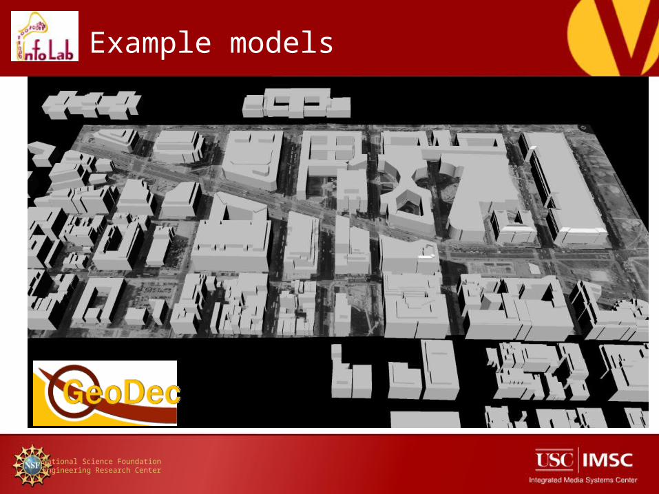
Large Site Modeling Example (USC Campus)
• 256 building components modeled in about two hours
3D models with texture rendered in VRML
3D building models rendered in VRML
National Science Foundation Engineering Research Center
Example models
National Science Foundation Engineering Research Center
Outline
• Underlying Technologies– Building 3D Models– Static and Dynamic Textures– Geospatial Data Fusion– Effective Presentation and Querying
• Current Status and Future plan
National Science Foundation Engineering Research Center
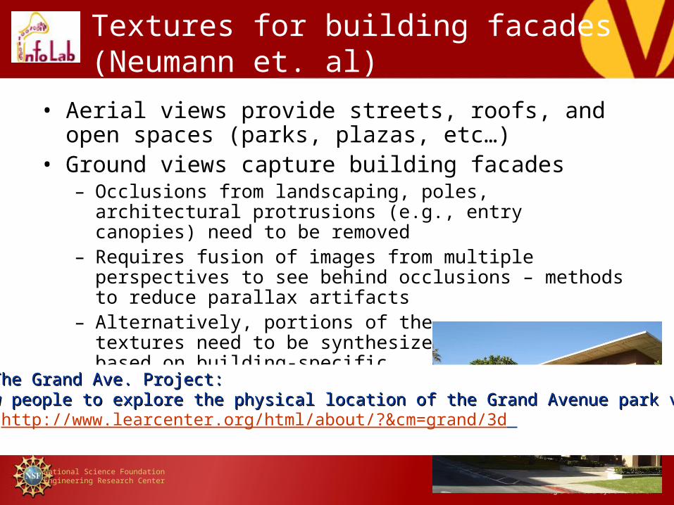
Textures for building facades(Neumann et. al)
• Aerial views provide streets, roofs, and open spaces (parks, plazas, etc…)
• Ground views capture building facades– Occlusions from landscaping, poles, architectural protrusions
(e.g., entry canopies) need to be removed– Requires fusion of images from multiple perspectives to see
behind occlusions – methods to reduce parallax artifacts– Alternatively, portions of the
textures need to be synthesized based on building-specific texture patterns
App1-The Grand Ave. Project:App1-The Grand Ave. Project:““Allow people to explore the physical location of the Grand Avenue park virtually.”Allow people to explore the physical location of the Grand Avenue park virtually.”See: See: http://www.learcenter.org/html/about/?&cm=grand/3d
National Science Foundation Engineering Research Center
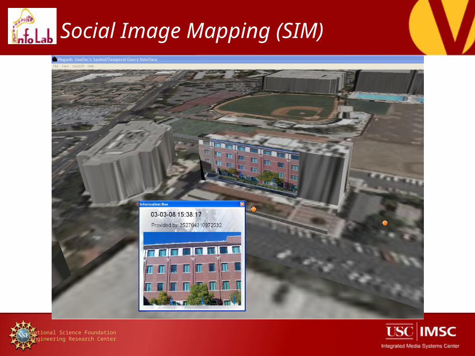
Social Image Mapping (SIM)
• Improving time-to-build• Collaboration with NSF’s STC at UCLA: CENS: Center for Embedded Networked Sensing
National Science Foundation Engineering Research Center
Social Image Mapping (SIM)
National Science Foundation Engineering Research Center
Social Image Mapping (SIM)
National Science Foundation Engineering Research Center
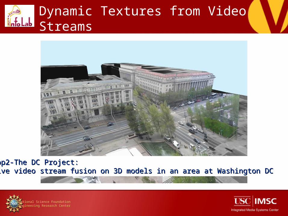
Dynamic Textures from Video Streams
App2-The DC Project:App2-The DC Project:Five video stream fusion on 3D models in an area at Washington DC Five video stream fusion on 3D models in an area at Washington DC
National Science Foundation Engineering Research Center
Outline
• Underlying Technologies– Building 3D Models– Static and Dynamic Textures– Geospatial Data Fusion– Effective Presentation and Querying
• Current Status and Future plan
National Science Foundation Engineering Research Center
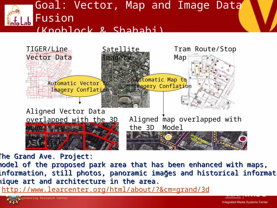
TIGER/Line Vector Data
Satellite Imagery Tram Route/Stop Map
Automatic Vector to Imagery Conflation
Automatic Map to Imagery Conflation
Aligned Vector Data overlapped with the 3D model Aligned map overlapped with the 3D
Model
Goal: Vector, Map and Image Data Fusion(Knoblock & Shahabi)
App3-The Grand Ave. Project:App3-The Grand Ave. Project:““3-D model of the proposed park area that has been enhanced with maps, 3-D model of the proposed park area that has been enhanced with maps, road information, still photos, panoramic images and historical information about road information, still photos, panoramic images and historical information about the unique art and architecture in the area.”the unique art and architecture in the area.”See: See: http://www.learcenter.org/html/about/?&cm=grand/3d
National Science Foundation Engineering Research Center
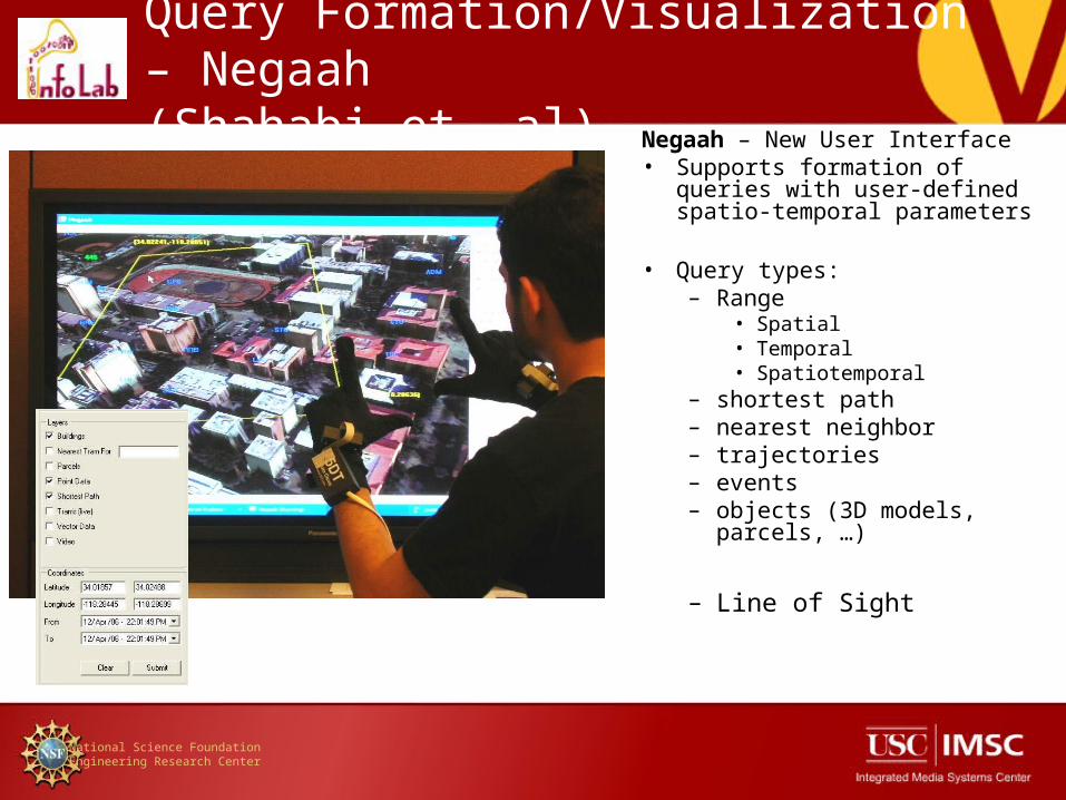
Demo:
Sponsors: • NSF
– IMSC– ITR– PECASE
• Google• Annenberg• Microsoft • Chevron
App4-The USC's App4-The USC's 125th Anniversary125th Anniversary::Adding moving objects and glove interfaceAdding moving objects and glove interface
National Science Foundation Engineering Research Center
Outline
• Underlying Technologies– Building 3D Models– Static and Dynamic Textures– Geospatial Data Fusion– Effective Presentation and Querying
• Current Status and future plan
National Science Foundation Engineering Research Center
National Science Foundation Engineering Research Center
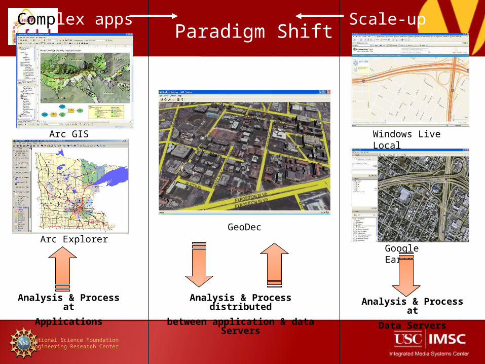
Analysis & Process at
Applications
Arc GIS
Arc Explorer
Windows Live Local
Google Earth
GeoDec
Paradigm Shift
Analysis & Process at
Data Servers
Analysis & Process distributed
between application & data Servers
Complex apps Scale-up
National Science Foundation Engineering Research Center
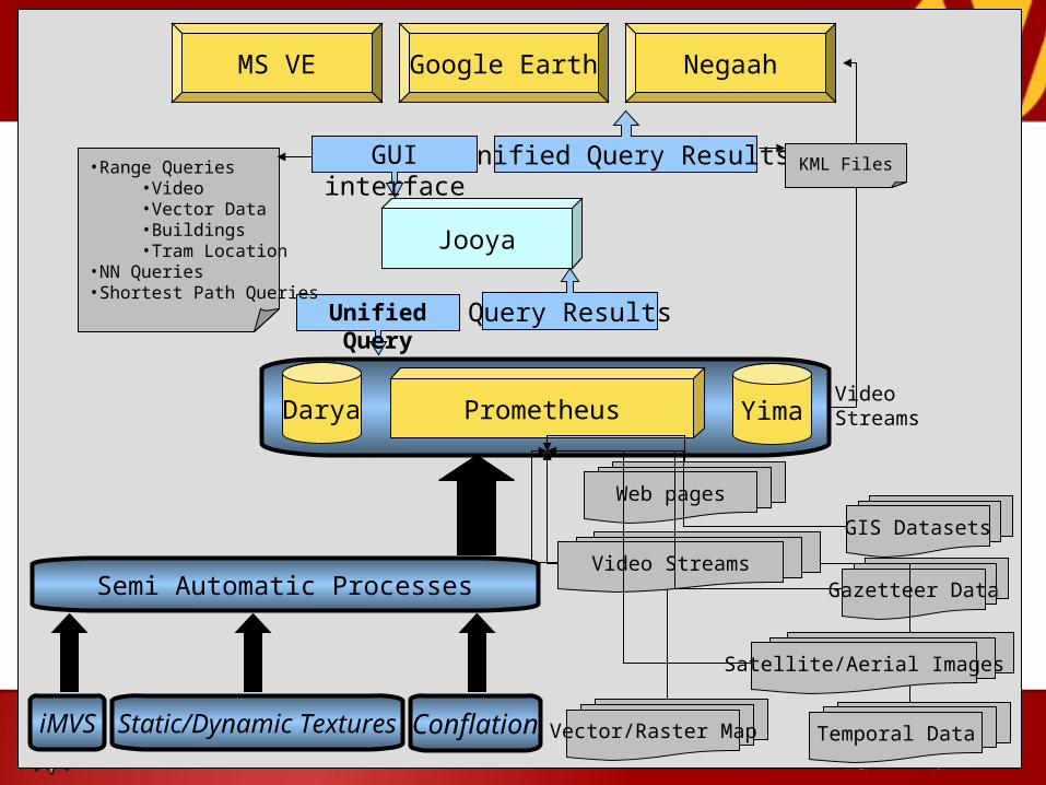
So What’s unique about GeoDec?
• Not a visualization GUI with data access features added in an ad-hoc manner as an after thought!– Three tier architecture with distribution of code where it belongs– All objects are tagged and indexed spatially and temporally– Access at different tiers: GUI, Web-services, database
• Time dimension• Extended querying capabilities• We have the source code!
– Go wild! Your ideas will not be hindered by the restricted API!
National Science Foundation Engineering Research Center
Outline
• Underlying Technologies– Building 3D Models– Static and Dynamic Textures– Geospatial Data Fusion– Effective Presentation and Querying
• Current Status and future plan
National Science Foundation Engineering Research Center
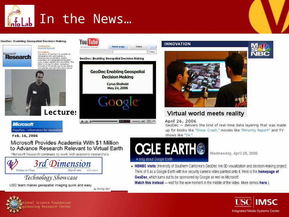
In the News…
Lectures
National Science Foundation Engineering Research Center
Where we’re going?
• Up to now, the focus was on:– Modeling and visualization– Acquisition, storage, integration of real datasets– Implementing the software architecture– Developing generic query types– Some “toy” applications: DC, USC campus, downtown LA
• What’s next:– GeoDec+: Challenges of
• Real applications, multidisciplinary collaboration(e.g., NSF CDI pre-proposal: pollution in Megacities w/ Keck School of
Medicine, Env. & Civil Eng, Earth Science; School of Architecture)• Dynamic datasets: climate data, pollutant data, transportation data,
…
National Science Foundation Engineering Research Center
GeoDec+: Vision
• Marrying– Information richness of GIS systems– Interaction flexibility of computer games & simulations
• Challenge: Query and access of real-world large spatio-temporal data as if they are synthetically generated data– Index 3d data (e.g., surface data) for querying and not
just rendering
National Science Foundation Engineering Research Center