38
National Spatial Data Infrastructure Future Directions Strategic Planning Initiative FGDC Agency Metadata Profiles Summary Report September 12, 2005 DRAFT Submitted by:
National Spatial Data Infrastructure
Future Directions Strategic Planning Initiative
FGDC Agency Metadata ProfilesSummary Report September 12, 2005 DRAFT
Submitted by:Future Directions – Metadata Publishing Action Team
NSDI Future Directions DRAFT September 12, 2005
Table of Contents:
pageSummary
Purpose...................................................................................1Methods and Response...........................................................1Results....................................................................................1Recommendations...................................................................3
Responding Agencies..................................................................4Metadata Collection Websites......................................................6Metadata Staff..............................................................................11Metadata Requirements...............................................................15Metadata Resources....................................................................18Metadata Utility............................................................................20Metadata Challenges, Opportunities and Successes..................22
Metadata Agency Profile Summary i
NSDI Future Directions DRAFT September 12, 2005
Summary
PurposeThe NSDI Future Direction’s Metadata Publishing Action Team identified the need to baseline metadata implementation activities within their Action Plan (http://fgdc.gov/FutureDirections/action_plans/act_plans.html). The purpose of the metadata baseline was to:
identify existing metadata resources that can be utilized or adopted by Federal agenciesidentify needed metadata resources for development by FGDC and FGDC Coordination Group agenciesassist agencies in assessing and developing their own metadata programssupport the Office of Management and Budget A-16 compliance assessment.
Methods and ResponseA Metadata Agency Profile document was developed and presented to the Federal Geographic Data Committee (FGDC) Coordination Group in February 2005. Each Federal member of the FGDC Coordination Group was asked to compile a single agency metadata profile that characterized geospatial metadata resources within all programs of the agency and to return the completed profile by March of 2005.
21 of the 30 (70%) Federal members of the FGDC Coordination Group completed and returned the document. One agency responded that the Profile was not applicable because they did not create geospatial data. A complete list of participation is provided on pages 4-5.
The Metadata Publishing Action Team recommends that the information documented within the individual profiles be returned to the agencies for update as part of their annual FGDC reporting.
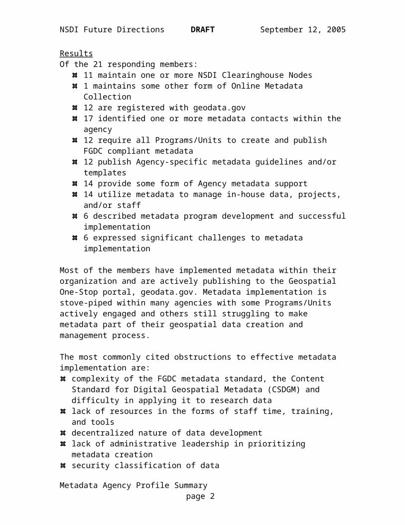
ResultsOf the 21 responding members:
11 maintain one or more NSDI Clearinghouse Nodes1 maintains some other form of Online Metadata Collection12 are registered with geodata.gov17 identified one or more metadata contacts within the agency12 require all Programs/Units to create and publish FGDC compliant metadata12 publish Agency-specific metadata guidelines and/or templates14 provide some form of Agency metadata support14 utilize metadata to manage in-house data, projects, and/or staff6 described metadata program development and successful implementation6 expressed significant challenges to metadata implementation
Metadata Agency Profile Summary page 1
NSDI Future Directions DRAFT September 12, 2005
Most of the members have implemented metadata within their organization and are actively publishing to the Geospatial One-Stop portal, geodata.gov. Metadata implementation is stove-piped within many agencies with some Programs/Units actively engaged and others still struggling to make metadata part of their geospatial data creation and management process.
The most commonly cited obstructions to effective metadata implementation are:complexity of the FGDC metadata standard, the Content Standard for Digital Geospatial Metadata (CSDGM) and difficulty in applying it to research datalack of resources in the forms of staff time, training, and toolsdecentralized nature of data developmentlack of administrative leadership in prioritizing metadata creationsecurity classification of data
Several Agencies have developed programs and resources that can serve as an example to others. Most notably these include:
Bureau of Land Management (BLM)metadata supporttraining program
Census Bureau (Census)automation of metadata production via development of metadata profiles for various data typesmetadata working grouptraining program
Department of Defense – Business Domain (DOD_BD)metadata working groupadministrative leadership
National Aeronautics and Space Administration (NASA)metadata authoring tool developmentfocus on user needs
US Geological Survey (USGS)tool developmentmetadata supportmetadata training programpartnerships (National Biological Information Infrastructure - NBII)
A significant number of previously unrecognized Federal metadata contacts were identified.
Metadata Agency Profile Summary page 2
NSDI Future Directions DRAFT September 12, 2005
RecommendationsThe Metadata Publishing Action Team makes the following recommendations:
Each Agency should identify an Agency-wide Metadata Coordinator responsible for:
creating and directing an interagency metadata working groupdirecting interagency inquiries for assistance and trainingreporting on Agency metadata implementationparticipating in the FGDC Metadata Working Groupdistributing metadata-related updates and information to Agency personnel
FGDC should provide increased metadata support to Federal agencies in the form of:
Metadata Trainingestablish a standardized metadata training curriculumtrain and organize a cadre of Agency metadata trainers
Metadata Guidance and Supportestablish a metadata guidance publications seriesredesign the website at http://fgdc.gov/metadata
Metadata CoordinationHold regular meetings of the metadata working groupdevelop a web map that identifies metadata experts by geography, expertise, discipline, and other attributesestablish an email list of Agency metadata staff. provide timely information regarding ISO status and activities via the metadata website and email list.
Metadata Agency Profile Summary page 3

NSDI Future Directions DRAFT September 12, 2005
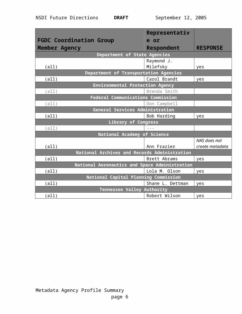
Responding Agencies
FGDC Coordination GroupMember Agency
Representative or Respondent RESPONSE
Department of Agriculture AgenciesNatural Resources Conservation Service Christine ClarkeU.S. Forest Service Betsy Kanalley yesFarm Service Agency Lori Ulhorn yes
Department of Commerce AgenciesCensus Bureau Randy Fusaro yesNational Oceanic and Atmospheric Administration Mike Moeller yes
Department of Defense AgenciesBusiness Domain Randall Turner yes
National Geospatial-Intelligence AgencyLee WarrenCharles Roswell yes
U.S. Army Corps of Engineers Nancy BlylerDepartment of Education
(all) Tai A. Phan yesDepartment of Energy Agencies
(all) David Morehouse yesDepartment of Health and Human Services Agencies
(all) Chuck Croner yesDepartment of Homeland Security Agencies
(all) Leslie Weiner-LeandroDepartment of Housing and Urban Development Agencies
(all) Robert Renner yesDepartment of the Interior Agencies
Bureau of Land Management James Horan yesMinerals Management Service ----National Park Service ----U.S. Fish & Wildlife Service Barb White yesU.S. Geological Survey Anne Frondorf yes
Department of Justice Agencies(all) ----
Department of State Agencies(all) Raymond J. Milefsky yes
Department of Transportation Agencies(all) Carol Brandt yes
Metadata Agency Profile Summary page 4

NSDI Future Directions DRAFT September 12, 2005
FGDC Coordination GroupMember Agency
Representative or Respondent RESPONSE
Environmental Protection Agency(all) Brenda Smith
Federal Communications Commission(all) Don Campbell
General Services Administration(all) Bob Harding yes
Library of Congress(all) ---
National Academy of Science
(all) Ann FrazierNAS does not create metadata
National Archives and Records Administration(all) Brett Abrams yes
National Aeronautics and Space Administration(all) Lola M. Olson yes
National Capital Planning Commission(all) Shane L. Dettman yes
Tennessee Valley Authority(all) Robert Wilson yes
Metadata Agency Profile Summary page 5

NSDI Future Directions DRAFT September 12, 2005
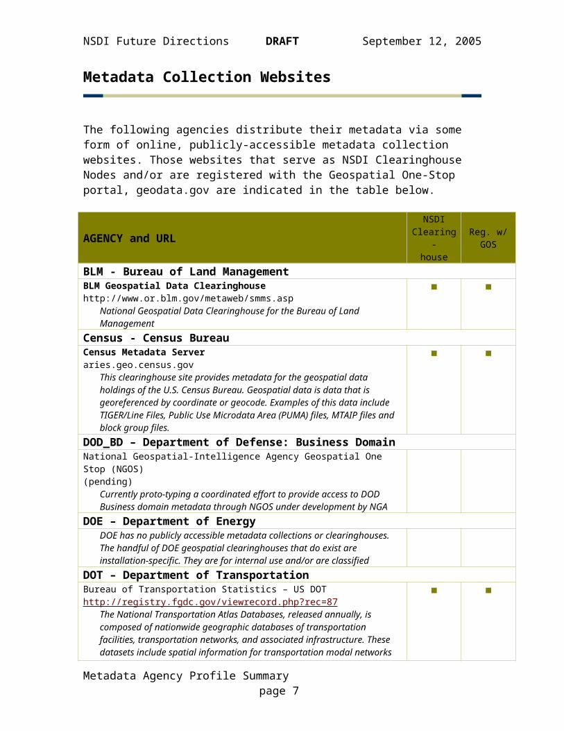
Metadata Collection Websites
The following agencies distribute their metadata via some form of online, publicly-accessible metadata collection websites. Those websites that serve as NSDI Clearinghouse Nodes and/or are registered with the Geospatial One-Stop portal, geodata.gov are indicated in the table below.
AGENCY and URLNSDI
Clearing-house
Reg. w/GOS
BLM - Bureau of Land ManagementBLM Geospatial Data Clearinghousehttp://www.or.blm.gov/metaweb/smms.asp
National Geospatial Data Clearinghouse for the Bureau of Land Management
■ ■
Census - Census BureauCensus Metadata Serveraries.geo.census.gov
This clearinghouse site provides metadata for the geospatial data holdings of the U.S. Census Bureau. Geospatial data is data that is georeferenced by coordinate or geocode. Examples of this data include TIGER/Line Files, Public Use Microdata Area (PUMA) files, MTAIP files and block group files.
■ ■
DOD_BD – Department of Defense: Business DomainNational Geospatial-Intelligence Agency Geospatial One Stop (NGOS)(pending)
Currently proto-typing a coordinated effort to provide access to DOD Business domain metadata through NGOS under development by NGA
DOE – Department of EnergyDOE has no publicly accessible metadata collections or clearinghouses. The handful of DOE geospatial clearinghouses that do exist are installation-specific. They are for internal use and/or are classified
DOT – Department of TransportationBureau of Transportation Statistics – US DOThttp://registry.fgdc.gov/viewrecord.php?rec=87
The National Transportation Atlas Databases, released annually, is composed of nationwide geographic databases of transportation facilities, transportation networks, and associated infrastructure. These datasets include spatial information for transportation modal networks and intermodal terminals, as well as the related attribute information for these features
National Pipeline Mapping Systemhttp://www.npms.rspa.dot.gov
U.S. DOT, Pipeline and Hazardous Materials Safety Administration, Office of Pipeline Safety clearinghouse for hazardous liquid and natural gas transmission pipeline data.
■ ■
■
Metadata Agency Profile Summary page 6
NSDI Future Directions DRAFT September 12, 2005
AGENCY and URLNSDI
Clearing-house
Reg. w/GOS
ED – Department of EducationNCES School District Demographicshttp://nces.ed.gov/surveys/sdds
U.S. Clearing house for school district economic, social, and demographics data
■ ■
FSA – Farm Service AgencyNAIPwww.apfo.usda.gov
National Aerial Imagery Program
■
GSA – General Services Administration noneHHS – Department of Health and Human ServicesHealth Resources and Services Administration (HRSA), HRSA Geospatial Data Warehouse (HGDW)http://datawarehouse.hrsa.gov/metadataexplorer
The Health Resources and Services Administration (HRSA) Geospatial Data Warehouse and its associated applications provide HRSA and its customers with access to a broad range of information about HRSA programs, related health resources, and demographic data useful for planning and policy purposes. The HRSA Geospatial Data Warehouse contains data about grants, scholarship and loan programs, designation of underserved areas, and service demonstration programs and integrates these with data acquired from external sources. For a comprehensive list, refer to the list of data sources under the Help Resources link on the web site. The Warehouse is the central source for access to information on HRSA activities
Interactive Atlas of Reproductive Healthwww.cdc.gov/reproductivehealth/gisatlas
The Interactive Atlas of Reproductive Health is a web-based interactive geographic information system (GIS) dedicated to reproductive health issues such as infant mortality, fertility, and low birth weight
Heart Disease and Stroke Maps (online map dbase – no metadata)http://www.cdc.gov/cvh/maps/index.htm
Maps as well as downloadable reports with detailed descriptions of data and other information are available for viewing online at the website. We respond to requests for electronic copies of maps or data (or metadata) that come through the website “contact us” links and address them on a case-by-case basis..
■ ■
■
HUD – Department of Housing and Urban Development noneNARA – National Archives and Records Administration none
Metadata Agency Profile Summary page 7
NSDI Future Directions DRAFT September 12, 2005
AGENCY and URLNSDI
Clearing-house
Reg. w/GOS
NASA – National Aeronautics and Space AdministrationGlobal Change Master Directoryhttp://gcmd.nasa.gov
NASA Earth science data set collections including collections from EOSDIS
CEOS International Directory Networkhttp://idn.ceos.org
Earth science descriptions from CEOS International Directory Network member nodes
■
■
■
■
NCPC – National Capital Planning Commission noneNGA – National Geospatial Intelligence Agency
NGOS will expose metadata for NGA and DoD domestic holdings which are unclassified and not managed by MoA with USGS. Note: NGA’s primary mission is foreign and the volume of metadata not already exposed is limited
NOAA – National Oceanic and Atmospheric AdministrationNOAA Cooperative Data (COOP) Nodehttp://www.esdim.noaa.gov/
…includes data set descriptions related to climatology, meteorology, ecology, pollution, geology, oceanography, remote sensing, and Earth-observation satellites…
NOAA Environmental Satellite, Data and Information Services (SAT) Nodehttp://www.esdim.noaa.gov/
…This Node of the NOAA Environmental Services Data Directory contains descriptions of selected satellite data sets and ice cover data sets held in NESDIS Satellite Offices…
NOAA NMFS Southeast Fisheries Science Center Nodehttp://www.sefsc.noaa.gov/
…include descriptions regarding movements and biology of marine fish species in the Atlantic Ocean, Gulf of Mexico, and the Caribbean Sea, summarized landed quantity by year, month, state, species and value, and biological data including age, reproductive, prey, and genetic data. The data is confidential but may be available upon request…
NOAA AVHRR Data over Canadahttp://ceocat.ccrs.nrcan.gc.ca/
…Coverage is 100% of Canada. 1 km and 4 km NOAA AVHRR imagery are also processed on the CCRS GeoComp System to produce geocoded and composite products...
NOAA Central Library Historical Data Sets (LISD) Nodehttp://www.lib.noaa.gov/
…The NOAA Central Library contains a collection of over 10,000 historical climatic and meteorological records from countries around the world…
NOAA Coastal Services Centerhttp://www.csc.noaa.gov/
…Descriptions of data, information and products for the US Coastal States and territories including the Great Lakes. Types of data include GIS and in situ…
■
■
■
■
■
■
■
■
■
Metadata Agency Profile Summary page 8

NSDI Future Directions DRAFT September 12, 2005
AGENCY and URLNSDI
Clearing-house
Reg. w/GOS
NOAA National Climatic Data Center (NCDC) Nodehttp://www.esdim.noaa.gov/
…Data sources include descriptions related to climatology, meteorology, ecology, pollution, geology, oceanography, and remote sensing satellites…
NOAA National Marine Fisheries Service (NMFS) Nodehttp://www.nmfs.gov/
…support domestic and international fisheries management operations, fisheries development, trade and industry assistance activities, enforcement, protected species and habitat conservation operations, and the scientific and technical aspects of NOAAs marine fisheries program…
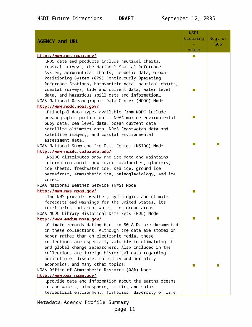
NOAA National Ocean Service (NOS) Nodehttp://www.nos.noaa.gov/
…NOS data and products include nautical charts, coastal surveys, the National Spatial Reference System, aeronautical charts, geodetic data, Global Positioning System (GPS) Continuously Operating Reference Stations, bathymetric data, nautical charts, coastal surveys, tide and current data, water level data, and hazardous spill data and information…
NOAA National Oceanographic Data Center (NODC) Nodehttp://www.nodc.noaa.gov/
…Principal data types available from NODC include oceanographic profile data, NOAA marine environmental buoy data, sea level data, ocean current data, satellite altimeter data, NOAA Coastwatch data and satellite imagery, and coastal environmental assessment data…
NOAA National Snow and Ice Data Center (NSIDC) Nodehttp://www-nsidc.colorado.edu/
…NSIDC distributes snow and ice data and maintains information about snow cover, avalanches, glaciers, ice sheets, freshwater ice, sea ice, ground ice, permafrost, atmospheric ice, paleoglaciology, and ice cores…
NOAA National Weather Service (NWS) Nodehttp://www.nws.noaa.gov/
…The NWS provides weather, hydrologic, and climate forecasts and warnings for the United States, its territories, adjacent waters and ocean areas…
NOAA NCDC Library Historical Data Sets (FDL) Nodehttp://www.esdim.noaa.gov/
…Climate records dating back to 50 A.D. are documented in these collections. Although the data are stored on paper rather than on electronic media, these collections are especially valuable to climatologists and global change researchers. Also included in the collections are foreign historical data regarding agriculture, disease, morbidity and mortality, economics, and many other topics…
NOAA Office of Atmospheric Research (OAR) Nodehttp://www.oar.noaa.gov/
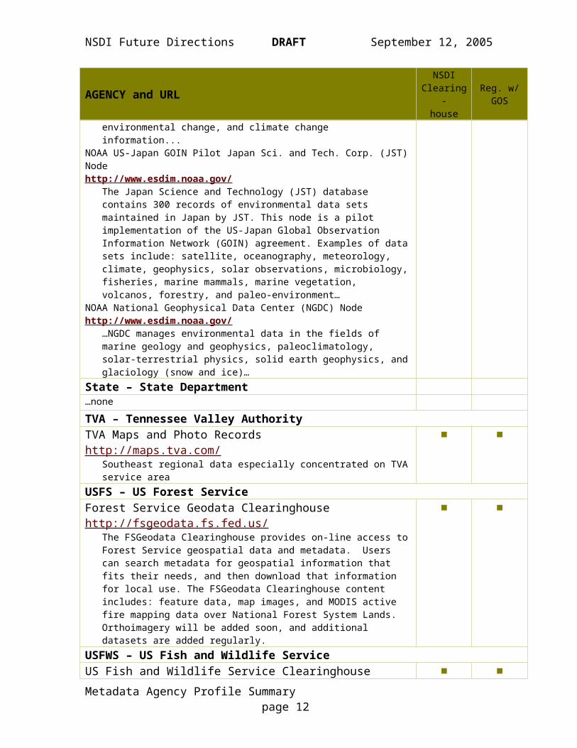
…provide data and information about the earths oceans, inland waters, atmosphere, arctic, and solar terrestrial environment, fisheries, diversity of life, environmental change, and climate change information...
NOAA US-Japan GOIN Pilot Japan Sci. and Tech. Corp. (JST) Nodehttp://www.esdim.noaa.gov/
The Japan Science and Technology (JST) database contains 300 records of environmental data sets maintained in Japan by JST. This node is a pilot implementation of the US-Japan Global Observation Information Network (GOIN) agreement. Examples of data sets include: satellite,
■
■
■
■
■
■
■
■
■
■
■
■
■
■
Metadata Agency Profile Summary page 9

NSDI Future Directions DRAFT September 12, 2005
AGENCY and URLNSDI
Clearing-house
Reg. w/GOS
oceanography, meteorology, climate, geophysics, solar observations, microbiology, fisheries, marine mammals, marine vegetation, volcanos, forestry, and paleo-environment…
NOAA National Geophysical Data Center (NGDC) Nodehttp://www.esdim.noaa.gov/
…NGDC manages environmental data in the fields of marine geology and geophysics, paleoclimatology, solar-terrestrial physics, solid earth geophysics, and glaciology (snow and ice)…
■ ■
State – State Department…none
TVA – Tennessee Valley AuthorityTVA Maps and Photo Recordshttp://maps.tva.com/
Southeast regional data especially concentrated on TVA service area
■ ■
USFS – US Forest ServiceForest Service Geodata Clearinghousehttp://fsgeodata.fs.fed.us/
The FSGeodata Clearinghouse provides on-line access to Forest Service geospatial data and metadata. Users can search metadata for geospatial information that fits their needs, and then download that information for local use. The FSGeodata Clearinghouse content includes: feature data, map images, and MODIS active fire mapping data over National Forest System Lands. Orthoimagery will be added soon, and additional datasets are added regularly.
■ ■
USFWS – US Fish and Wildlife ServiceUS Fish and Wildlife Service Clearinghousehttp://www.fws.gov/data/datafws.html
National wildlife refuge boundariesNational Wetlands Inventoryhttp://wetlandsfws.er.usgs.gov/
National Wetlands Inventory (NWI) Wetlands Digital Data
■ ■
USGS – US Geological SurveyDigital Elevation Geospatial Datahttp://geography.usgs.gov/nsdi
various national-level digital geospatial elevation data setsNational Digital Orthophoto Programhttp://geography.usgs.gov/nsdi
National digital orthoimagery data setUSGS Geoscience Data Cataloghttp://geo-nsdi.er.usgs.gov/
A catalog of earth science data produced by the U.S. Geological SurveyNational Biological Information Infrastructurehttp://www.nbii.gov
Includes metadata descriptions of biological databases and information products developed and maintained by USGS scientists, as well as data and information developed and maintained by other NBII participants, including federal, state, and local government agencies; private sector organizations; and other partners around the nation and the world.
■
■
■
■
■
■
■
■
Metadata Agency Profile Summary page 10

NSDI Future Directions DRAFT September 12, 2005
AGENCY and URLNSDI
Clearing-house
Reg. w/GOS
Geographic Names Information System (GNIS)http://geonames.usgs.gov
The Geographic Names Information System (GNIS), developed by the USGS in cooperation with the U.S. Board on Geographic Names (BGN), contains information for almost 2 million physical and cultural geographic features in the United States and its territories
USGS Water Resources Discipline Node of the National Spatial Data Infrastructurehttp://water.usgs.gov/maps.html
Contains more than 360 thematic GIS datasets pertaining to water.
■
■
■
■
Metadata Agency Profile Summary page 11
NSDI Future Directions DRAFT September 12, 2005
Metadata Staff
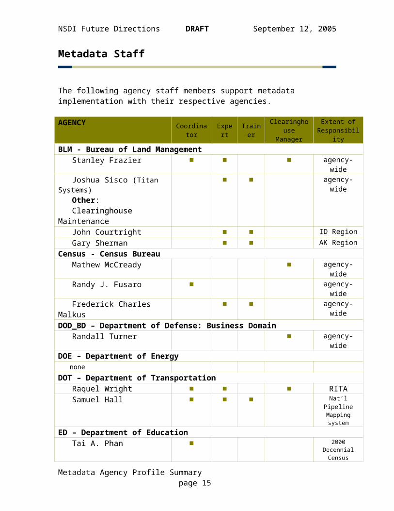
The following agency staff members support metadata implementation with their respective agencies.
AGENCY Coordinator Expert Trainer ClearinghouseManager
Extent ofResponsibility
BLM - Bureau of Land Management Stanley Frazier ■ ■ ■ agency-wide Joshua Sisco (Titan Systems) Other: Clearinghouse Maintenance
■ ■ agency-wide
John Courtright ■ ■ ID Region Gary Sherman ■ ■ AK RegionCensus - Census Bureau Mathew McCready ■ agency-wide Randy J. Fusaro ■ agency-wide Frederick Charles Malkus ■ ■ agency-wideDOD_BD – Department of Defense: Business Domain Randall Turner ■ agency-wideDOE – Department of Energy noneDOT – Department of Transportation Raquel Wright ■ ■ ■ RITA Samuel Hall ■ ■ ■ Nat’l Pipeline
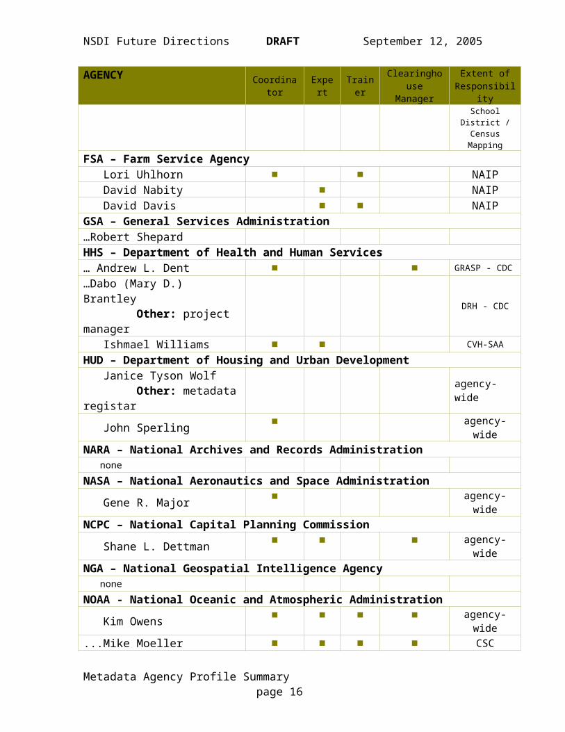
Mapping systemED – Department of Education Tai A. Phan ■ 2000 Decennial
Census School District / Census
MappingFSA – Farm Service Agency Lori Uhlhorn ■ ■ NAIP David Nabity ■ NAIP David Davis ■ ■ NAIPGSA – General Services Administration…Robert ShepardHHS – Department of Health and Human Services… Andrew L. Dent ■ ■ GRASP - CDC…Dabo (Mary D.) Brantley Other: project manager
DRH - CDC
Ishmael Williams ■ ■ CVH-SAA
Metadata Agency Profile Summary page 12
NSDI Future Directions DRAFT September 12, 2005
AGENCY Coordinator Expert Trainer ClearinghouseManager
Extent ofResponsibility
HUD – Department of Housing and Urban Development Janice Tyson Wolf Other: metadata registar agency-wide
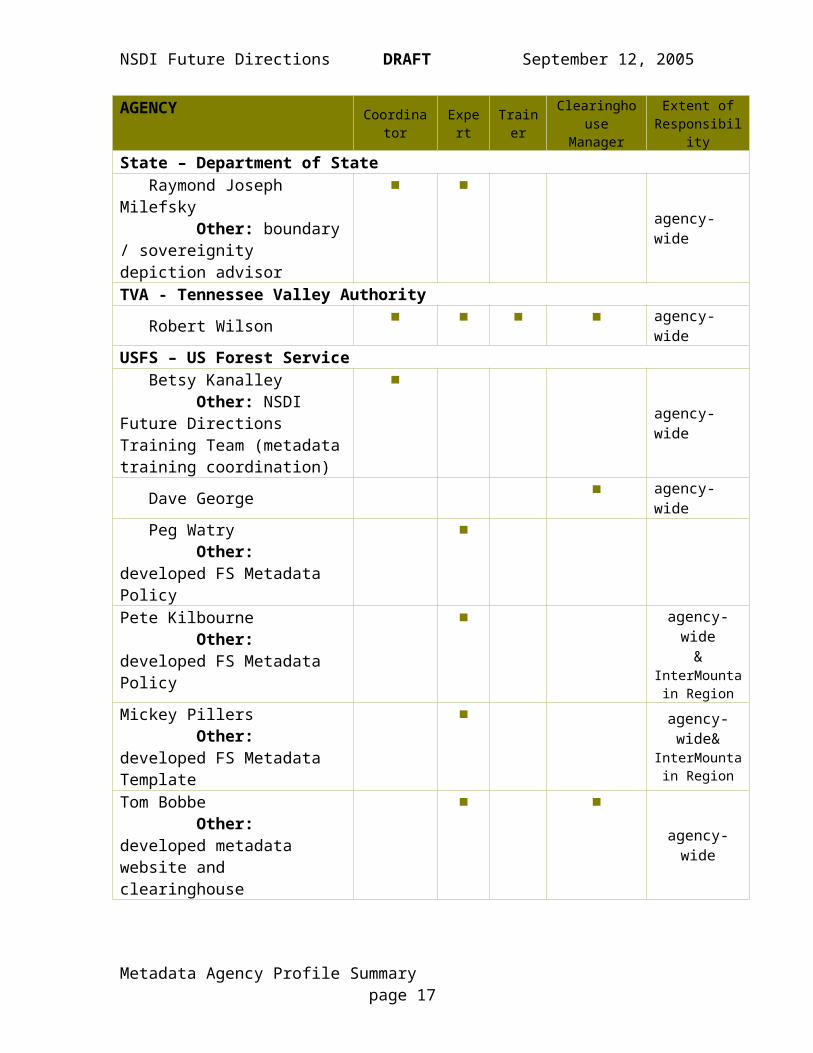
John Sperling ■ agency-wideNARA – National Archives and Records Administration noneNASA – National Aeronautics and Space Administration Gene R. Major ■ agency-wideNCPC – National Capital Planning Commission Shane L. Dettman ■ ■ ■ agency-wideNGA – National Geospatial Intelligence Agency noneNOAA - National Oceanic and Atmospheric Administration Kim Owens ■ ■ ■ ■ agency-wide...Mike Moeller ■ ■ ■ ■ CSCState – Department of State Raymond Joseph Milefsky Other: boundary / sovereignity depiction advisor
■ ■agency-wide
TVA - Tennessee Valley Authority Robert Wilson ■ ■ ■ ■ agency-wideUSFS – US Forest Service Betsy Kanalley Other: NSDI Future Directions Training Team (metadata training coordination)
■
agency-wide
Dave George ■ agency-wide Peg Watry Other: developed FS Metadata Policy
■
Pete Kilbourne Other: developed FS Metadata Policy
■ agency-wide&
InterMountain Region
Mickey Pillers Other: developed FS Metadata Template
■ agency-wide&
InterMountain Region
Tom Bobbe Other: developed metadata website and clearinghouse
■ ■
agency-wide
Metadata Agency Profile Summary page 13

NSDI Future Directions DRAFT September 12, 2005
AGENCY Coordinator Expert Trainer ClearinghouseManager
Extent ofResponsibility
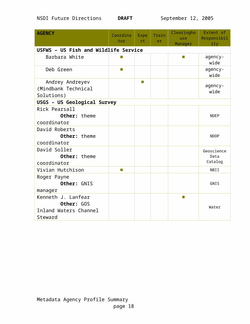
USFWS – US Fish and Wildlife Service Barbara White ■ ■ agency-wide Deb Green ■ agency-wide Andrey Andreyev (Mindbank Technical Solutions)
■ agency-wide
USGS – US Geological SurveyRick Pearsall Other: theme coordinator
NDEP
David Roberts Other: theme coordinator
NDOP
David Soller Other: theme coordinator
Geoscience Data Catalog
Vivian Hutchison ■ NBIIRoger Payne Other: GNIS manager
GNIS
Kenneth J. Lanfear Other: GOS Inland Waters Channel Steward
■Water
Metadata Agency Profile Summary page 14

NSDI Future Directions DRAFT September 12, 2005
Metadata Requirements
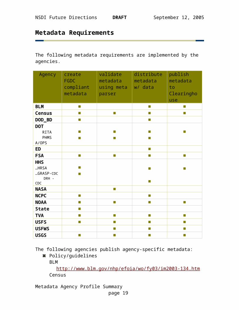
The following metadata requirements are implemented by the agencies.
Agency create FGDC compliant metadata
validate metadata using meta parser
distribute metadata w/ data
publish metadata to Clearinghouse
BLM ■ ■ ■Census ■ ■ ■ ■DOD_BD ■ ■DOT RITA PHMS A/OPS
■■
■■
■■
■
ED ■FSA ■ ■ ■ ■HHS…HRSA…GRASP-CDC DRH - CDC
■■
■
■
■
NASA ■NCPC ■ ■NOAA ■ ■ ■ ■State ■TVA ■ ■ ■ ■USFS ■ ■ ■ ■USFWS ■ ■ ■USGS ■ ■ ■ ■
The following agencies publish agency-specific metadata:Policy/guidelinesBLM
http://www.blm.gov/nhp/efoia/wo/fy03/im2003-134.htmCensus
Intranet onlyDOD_BD
http://www.dod.mil/brac/docs/ivtqap.v1-1.pdfHHS
(no URL provided)NASA
DIF Writer’s Guide: http://gcmd.nasa.gov/User/difguide/difman.htmlNOAA
http://www.csc.noaa.gov/metadata/howtometa.html
Metadata Agency Profile Summary page 15
NSDI Future Directions DRAFT September 12, 2005
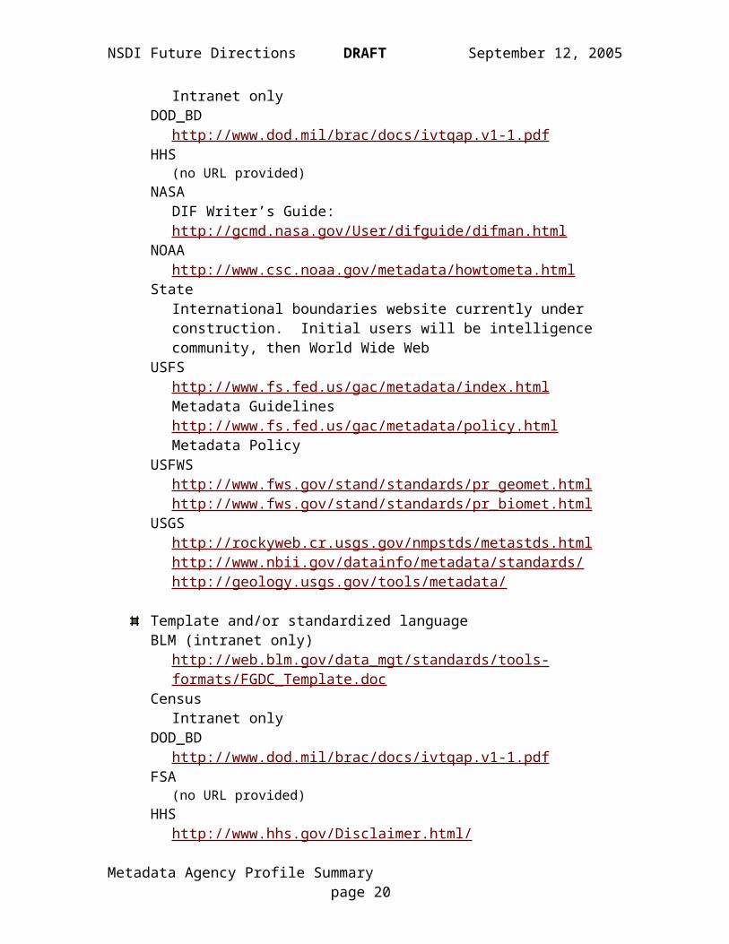
StateInternational boundaries website currently under construction. Initial users will be intelligence community, then World Wide Web
USFShttp://www.fs.fed.us/gac/metadata/index.html Metadata Guidelineshttp://www.fs.fed.us/gac/metadata/policy.html Metadata Policy
USFWShttp://www.fws.gov/stand/standards/pr_geomet.htmlhttp://www.fws.gov/stand/standards/pr_biomet.html
USGShttp://rockyweb.cr.usgs.gov/nmpstds/metastds.htmlhttp://www.nbii.gov/datainfo/metadata/standards/http://geology.usgs.gov/tools/metadata/
Template and/or standardized languageBLM (intranet only)
http://web.blm.gov/data_mgt/standards/tools-formats/FGDC_Template.doc
CensusIntranet only
DOD_BDhttp://www.dod.mil/brac/docs/ivtqap.v1-1.pdf
FSA(no URL provided)
HHShttp://www.hhs.gov/Disclaimer.html/
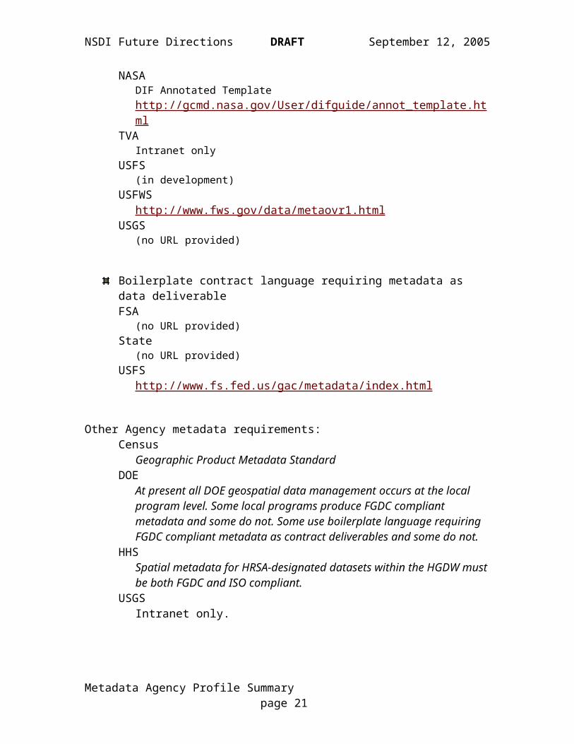
NASADIF Annotated Template http://gcmd.nasa.gov/User/difguide/annot_template.html
TVAIntranet only
USFS(in development)
USFWShttp://www.fws.gov/data/metaovr1.html
USGS(no URL provided)
Boilerplate contract language requiring metadata as data deliverableFSA
(no URL provided)State
(no URL provided)USFS
http://www.fs.fed.us/gac/metadata/index.html
Metadata Agency Profile Summary page 16
NSDI Future Directions DRAFT September 12, 2005
Other Agency metadata requirements:Census
Geographic Product Metadata StandardDOE
At present all DOE geospatial data management occurs at the local program level. Some local programs produce FGDC compliant metadata and some do not. Some use boilerplate language requiring FGDC compliant metadata as contract deliverables and some do not.
HHSSpatial metadata for HRSA-designated datasets within the HGDW must be both FGDC and ISO compliant.
USGSIntranet only.
Metadata Agency Profile Summary page 17
NSDI Future Directions DRAFT September 12, 2005
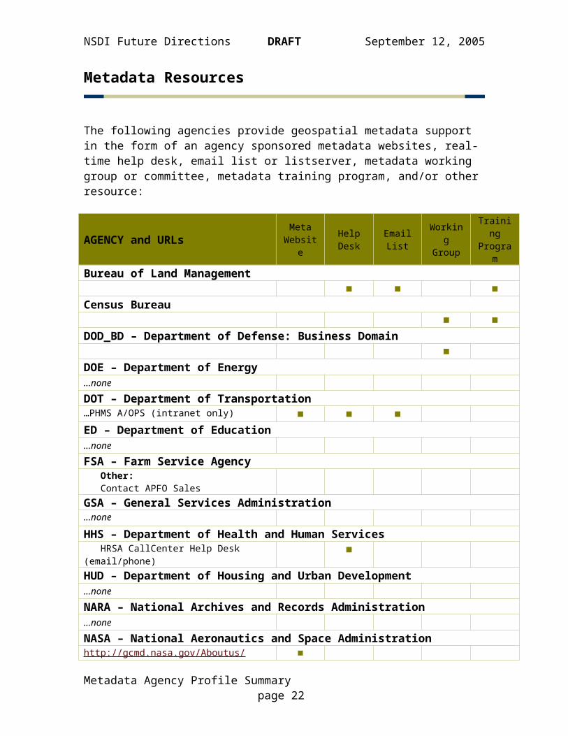
Metadata Resources
The following agencies provide geospatial metadata support in the form of an agency sponsored metadata websites, real-time help desk, email list or listserver, metadata working group or committee, metadata training program, and/or other resource:
AGENCY and URLs Meta Website
Help Desk
Email List
Working Group
Training Program
Bureau of Land Management■ ■ ■
Census Bureau■ ■
DOD_BD – Department of Defense: Business Domain■
DOE – Department of Energy…noneDOT – Department of Transportation…PHMS A/OPS (intranet only) ■ ■ ■ED – Department of Education…noneFSA – Farm Service Agency Other: Contact APFO SalesGSA – General Services Administration…noneHHS – Department of Health and Human Services HRSA CallCenter Help Desk (email/phone) ■HUD – Department of Housing and Urban Development…noneNARA – National Archives and Records Administration…noneNASA – National Aeronautics and Space Administrationhttp://gcmd.nasa.gov/Aboutus/standards/http://gcmd.nasa.gov/User/authoring.htmlhttp://gcmd.nasa.gov/MailComments/index.htmlCEOS/IDN Interoperability listserv:http://gcmd.gsfc.nasa.gov/pipermail/interop/CEOS/International Directory Network (IDN) - http://idn.ceos.org/ Other: DIF crosswalk to other meta standards http://gcmd.nasa.gov/Aboutus/standards/
■■
■
■
■
■
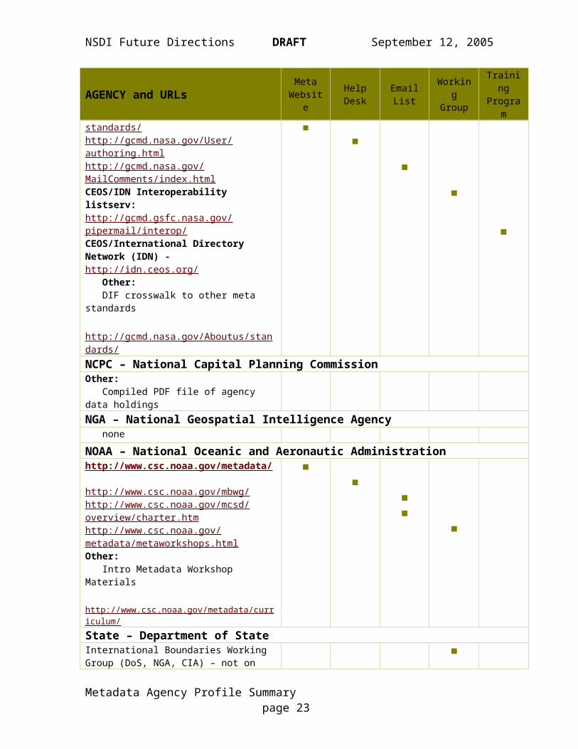
NCPC – National Capital Planning CommissionOther: Compiled PDF file of agency data holdings
Metadata Agency Profile Summary page 18
NSDI Future Directions DRAFT September 12, 2005
AGENCY and URLs Meta Website
Help Desk
Email List
Working Group
Training Program
NGA – National Geospatial Intelligence Agency none
NOAA – National Oceanic and Aeronautic Administrationhttp://www.csc.noaa.gov/metadata/
http://www.csc.noaa.gov/mbwg/http://www.csc.noaa.gov/mcsd/overview/charter.htmhttp://www.csc.noaa.gov/metadata/metaworkshops.htmlOther: Intro Metadata Workshop Materials http://www.csc.noaa.gov/metadata/curriculum/
■■
■■
■
State – Department of StateInternational Boundaries Working Group (DoS, NGA, CIA) – not on line, meet informally
■
TVA – Tennessee Valley Authority…(no URL provided) ■ ■ ■USFS – US Forest Servicehttp://www.fs.fed.us/gac/metadata/index.htmlFS Geospatial Advisory Committee, Geo Data Standards Focus TeamFS National Geospatial Training Center w/FGDC
■
■■
USFWS – US Fish and Wildlife Service http://www.fws.gov/data/fwsmeta.html…http://www.fws.gov/data/meta.html Other: Contractor metadata support position
■ ■
USGS – US Geological Surveyhttp://rockyweb.cr.usgs.gov/nmpstds/metastds.htmlhttp://www.nbii.gov/datainfo/metadata/standards/http://geology.usgs.gov/tools/metadata/
■■■
■■
Metadata Agency Profile Summary page 19
NSDI Future Directions DRAFT September 12, 2005
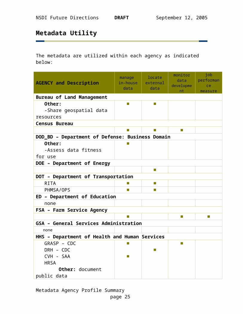
Metadata Utility
The metadata are utilized within each agency as indicated below:
AGENCY and Descriptionmanage in-house
data
locate external
data
monitor data development
job performance
measureBureau of Land Management Other: -Share geospatial data resources
■ ■
Census Bureau■ ■ ■
DOD_BD – Department of Defense: Business Domain Other: -Assess data fitness for use
■
DOE – Department of Energy■
DOT – Department of Transportation RITA ■ ■ PHMSA/OPS ■ ■ED – Department of Education noneFSA – Farm Service Agency
■ ■ ■GSA – General Services Administration noneHHS – Department of Health and Human Services GRASP – CDC DRH – CDC CVH - SAA HRSA Other: document public data
■
■■
■
HUD – Department of Housing and Urban Development■
NARA – National Archives and Records Administration noneNASA – National Aeronautics and Space Administration
■NCPC – National Capital Planning Commission
■NGA – National Geospatial Intelligence Agency none
Metadata Agency Profile Summary page 20
NSDI Future Directions DRAFT September 12, 2005
AGENCY and Descriptionmanage in-house
data
locate external
data
monitor data development
job performance
measureNOAA – National Oceanic and Atmospheric Administration
■ ■ ■State – Department of State
■ ■ ■TVA – Tennessee Valley Authority
■ ■ ■USFS – US Forest Service Other: The Forest Service is currently working to develop Performance Accountablity Standards for collecting and maintaining standard geospatial data, which includes FGDC Compliant metadata
■ ■ ■
USFWS – US Fish and Wildlife Service■ ■ ■
USGS – US Geological Survey■ ■ ■ ■
Metadata Agency Profile Summary page 21
NSDI Future Directions DRAFT September 12, 2005
Metadata Challenges, Opportunities, and Successes
BLM - Bureau of Land ManagementBLM recognizes the need for the development of agency/state specific thesaurus and keywords to better facilitate the search for data. The Bureau continues to train both spatial and tabular data users in the collection and posting of their metadata.
Census - Census BureauThe Census Bureau’s Geography Division is developing an automated geospatial metadata production process. The first step of this process, designing a metadata profile for varying types of geospatial products (i.e. vector files, atlases, printed maps) was completed in late 2004. This profile documents for each type of geospatial product the required metadata elements that must be included to meet FGDC Metadata Standards.
DOD_BD – Dept of Defense – Business DivisionThe DoD recognized the value installation maps could serve as a geospatial complement to strategic basing decisions. In response to requirements established by legislation to conduct another round of base realignment and closure (BRAC), the DoD Infrastructure Executive Council tasked the DoD Services with delivering the Installation Visualization Tool, or IVT, in the first Base Realignment and Closure (BRAC) 2005 policy memo in spring 2003. Given the aggressive timeframe to collect and compile the required geospatial data across 300+ defense installations for IVT, a strategy was established to collect "best-available" geospatial data and then document the accuracy, completeness, and overall fitness-of-use in the associated metadata.
Services collaboratively defined what metadata would be collected (given the FGDC minimum metadata requirements) and then built robust metadata collection guidance based on the FGDC CSDGM. The metadata was made available to BRAC decision-makers via the IVT, thereby ensuring high confidence decisions based on installation geospatial data. Approximately 60,000 metadata items were collected and validated for 8 geospatial data layers across 300+ DoD installations in less than 7 months. The DoD Inspector General and audit community was integrally involved with and endorsed the DoD IVT metadata framework development - based on the FGDC CSDGM - and participated in metadata QA/QC activities.
When Senior DoD leaders saw the rapid progress and unprecedented visualization capabilities afforded by the IVT, it was apparent the scope of the effort could be expanded beyond the BRAC mission. As such, the DoD business domain is currently establishing policy, guidance, advocacy, and enterprise architectures to ensure the Services continue to collect FGDC-
Metadata Agency Profile Summary page 22
NSDI Future Directions DRAFT September 12, 2005
compliant metadata for their business domain geospatial data holdings and publish these metadata to the NSDI as part of an overall Defense Installation Spatial Data Infrastructure (DISDI). The DoD business domain is currently partnering with the National Geospatial Intelligence Agency (NGA) to establish a single DoD node on the the NSDI to publish DoD-wide (business and other domains) geospatial data and metadata
DOE – Department of EnergyAt present DOE's geospatial activities are not centrally managed. They are conducted by a wide variety of entities in support of mission-related programs, all geospatial management is at the local program level, and the geospatial work is almost always done by contractors rather than DOE staff.
DOT – Department of TransportationThe ESRI tool provides allows a user to generate multiple file types of FGDC compliant metadata. The ESRI tool provides allows a user to generate multiple file types of FGDC compliant metadata.
ED – Department of EducationCensus Bureau is an agency to collect, process, and deliver school district boundary files. All of NCES SDDS meta data are the same as Census TIGER and Census Decennial data.
FSA – Farm Services AdministrationFully automated, on demand fully compliant FGDC metadata.
GSA – General Services AdministrationCurrently, GSA is not utilizing metadata. There is no business requirement supporting the extensive capture, use or maintenance of geospatial data.
HHS – Health and Human ServicesHRSAManaging the metadata for the HGDW is extremely time-consuming. This is not only because of the inherent repetitiveness, but also because there is no good tool for managing definitions of common elements that appear in both spatial and non-spatial tables, or across multiple spatial datasets. HRSA publishes metadata on over 2,400 distinct data elements, many of which appear in multiple tables. Ensuring that every instance of a given data element has the correct definition, domain information, process history, and business rules applied. The difficulty is compounded by the complexity of the FGDC metadata structure.
Metadata Agency Profile Summary page 23
NSDI Future Directions DRAFT September 12, 2005
GRASPThe GRASP Metadata collection effort is a three-part process (that we are currently beginning with a new position devoted to metadata development):
1. Develop and maintain metadata.2. Develop and maintain intranet explorer.3. Develop and maintain internet metadata explorer (used to share
uniquely-developed geospatial data)
DRH – CDCThe RH Atlas conforms to the minimum requirements for spatial metadata, and most of it is not in the FGDC format. The concept of spatial metadata is still pretty foreign in our group, since we mainly use other people’s data. Developing spatial metadata using the FGDC format is a monumental process for most work groups. It is both confusing and time consuming. The format is not specific to health data and includes many elements that mean little to most health data managers. XML and other electronic processors tend to fail often, adding a frustration component to the task. Therefore, most of the agencies that I know of who produce spatial metadata have people that specialize in just doing metadata. We don’t have that luxury.
CVH - SAAA challenge in using Geospatial Metadata Standards has been creating useful metadata that captures the important dimensions of our work that should be described for a user (source data, age/race/region samples, data processing, age adjustments, outcome measure methods, mapping methods, limitations, constraints, possible errors, etc.). Most standard metadata models place much greater emphasis on the geographic parameters of the data – the actual shapes - (accuracy, precision, scale, etc.). Such a focus is unwarranted in our data because they are joined to common, public access shape files (ie. County or Census shapes) that carry metadata from their sponsor agencies.
HUD – Department of Housing and Urban DevelopmentWe are serving metadata with all data products served through our ArcIMS web mapping service at http://hud.esri.com and downloadable data at http://www.huduser.org/datasets/gis.html. These data sets also have been registered at www.geographynetwork.com and are currently being registered at www.geodata.gov.
NASA – National Aeronautics and Space AdministrationChallengesThe Global Change Master Directory has met numerous challenges associated with its metadata implementation. The first challenge was in developing a metadata format that allowed users to properly describe and identify scientific data sets of use. This widely-used and international metadata format subsequently influenced the development of other
Metadata Agency Profile Summary page 24

NSDI Future Directions DRAFT September 12, 2005
standards, such as the ISO 19115 Geographic Information/Geomatics metadata standard. Therefore, very few changes were needed to comply with the ISO standard when it took effect in 2004.Another challenge was properly encouraging data set providers to write and update metadata. These tasks were facilitated through the offering of a robust metadata authoring tool that interfaces with the database and thus allows one to select existing information, such as data center provider, without having to re-enter the information. This tool significantly reduces the metadata burden on the user. This same tool can also be used to update metadata records and can be accessed while viewing a metadata record from the GCMD interface - at the most opportune time for an author or other knowledgeable person to recognize and make additions or corrections to the record (such as a change in personnel, data location, or other fields). All of the metadata information viewed in a record is automatically and dynamically captured into the tool so the metadata burden on the author is again further reduced. These changes are quality controlled to assure that records are not changed inaccurately.
OpportunitiesBy capitalizing on the basic software architecture and design created for organizing and querying data sets, the project was able to quickly adapt its infrastructure to offer a directory of Earth science software, tools, and services metadata. This activity also provided an opportunity to link Earth science related services and tools with corresponding data sets (for example, linking metadata describing a model with the model data from that model).
New opportunities have arisen in easing the search and retrieval ofGIS data sets and the direct linkage to web mapping services to process the information.
SuccessesSuccesses have arisen from listening to users, observing user statistics, performing usability testing, and subsequently acting on those observations. The GCMD serves a broad and diverse population from university and other educational communities to international users. Users can easily locate the data and services they desire through a comprehensive controlled vocabulary, a free-text search, a geospatial search, or through a combination of these (controlled keywords and geospatial elements are contained within the metadata). They can also refine their queries, as they drill down to their desired data sets or Earth science services. In many cases, a direct link to access data and/or services is available. The bottom line success is GCMD's ease of use and its multitude of users (the directory receives close to 5 million hits per month).
Another success, which was recognized as crucial to search and retrieval of information in the early years of the project, was the building of a hierarchical
Metadata Agency Profile Summary page 25
NSDI Future Directions DRAFT September 12, 2005
keyword list for Earth science topics for the data search, as well as a free-text search. The importance of these two options provides added value for the user by offering the user a combined search using both keywords and free-text.
NCPC – National Capital Planning CommissionStaffing and lack of prioritization makes it very hard to compile a complete geospatial data set accompanied by accurate (FGDC compliant) metadata.
NGANGA has significant challenges to overcome in order to share domestic metadata.1. NGA’s primary mission is to support Department of Defense and
Intelligence Community organizations and is primarily foreign.2. Of the domestic data collected and used by NGA much is exposed
through United States Geological Survey (USGS) according to Memoranda of Agreement which designate USGS as the executive manager.
3. Any domestic metadata exposed by NGA must be releasable at the unclassified level, be free of any contractual liens or restrictions and be certified for release through NGA policy procedures.
That said NGA is developing a NGA Geospatial One Stop (NGOS) in order to expose NGA metadata and potentially DoD metadata for use by the larger geospatial community. The implementation of NGOS is currently undergoing requirements review and accreditation challenges within NGA and is projected to operate as a prototype/proof of concept capability by the middle of May 2005.
State – Department of StateWe are making adequate progress inventorying and describing the 325 land and 400+ maritime boundaries of the world. NGA is digitizing these boundaries for us and we are providing textual descriptions of each boundaries primary segments.
TVA – Tennessee Valley AuthorityTVA is using metadata to drive our e-commerce site where we distribute geospatial data to the public. (see maps.tva.com).
USFS – US Forest ServiceThe US Forest Service has established metadata policy and technical guidelines to direct the preparation and maintenance of metadata for agency GIS data. The US Forest Service has also established new guidelines for feature level metadata. The policy and guidelines are available on the web (http://www.fs.fed.us/gac/metadata/index.html). Metadata training is a new emphasis area for US Forest Service metadata implementation.
Metadata Agency Profile Summary page 26

NSDI Future Directions DRAFT September 12, 2005
USFWS – US Fish and Wildlife ServiceIn April 2003, the USFWS Division of Information Resources and Technology Management (IRTM) and USGS National Biological Information Infrastructure (NBII) established a Memorandum of Understanding (MOU) to produce, and make available, metadata files for USFWS data sets that are compliant with the FGDC standards.
As of March 10, 2005, a total of 523 metadata records have been published on the USFWS Node of the NBII and NSDI Clearinghouse sites; another 200+ records are in progress. This could not have been accomplished without assistance and support from the USGS NBII Program personnel: Vivian Hutchison, USGS, Seattle, WA; Diane Schneider and Terry Giles, USGS Fort Collins Science Center, and Chris Lindsley, Oak Ridge National Laboratory.
USGS – US Geological SurveySee the USGS input to the FY 2004 NSDI Annual Spatial Data Report for additional information.
Metadata Agency Profile Summary page 27


