129

National Strategy and Action Plan for Sustainable Management
of Peatlands
FINAL DRAFT (AUGUST 2006)
NATIONAL WORKING GROUP ON PEATLAND MANAGEMEN

NATIONAL STRATEGY AND ACTION PLAN FOR SUSTAINABLE MANAGEMENT OF PEATLANDS
© Departemen Dalam Negeri, 2006 Writing Team: A. Patrons
1. H. Syamsul Arief Rivai Dirjen Bina Bangda, Depdagri Advisor 2. Dra. Masnellyarti Hilman, M.Sc. Deputi Bidang Peningkatan Konservasi Advisor SDA dan Pengendalian Kerusakan Lingkungan, KLH 3. Ir. M. Arman Mallolongan, MM Dirjen PHKA, Departemen Kehutanan Advisor 4. DR. Ichwanuddin Mawardi Sahmen PPN Bidang Percepatan Advisor Pembangunan Kawasan Timur Indonesia dan Kawasan Tertinggal
B. Working Group 1. Prof. DR. Tjahya Supriatna, SU Ditjen Bina Bangda, Depdagri Coordinator 2. DR. Agus Prabowo Bappenas Member 3. Drs. Bambang Jasminto, M.Sc. Dit. Anggaran IIDitjen APK, Depkeu Member 4. Ir. Antung Deddy Radiansyah Kementrian Lingkungan Hidup Member 5. Ir. Bambang Sukmananto, M.Sc. Ditjen PHKA, Dephut Member 6. Drs. Dibjo Sartono Wetlands International – IP Member 7. Ir. Listya Kusumawardani, M.Sc. Ditjen BPK, Dephut Member 8. Ir. Warsito Sw, Dipl. HE. Ditjen Sumber Daya Air, Dep. PU Member 9. Ir. Tangkas Pandjaitan, M.Agr.Sc. Ditjen Pengelolaan Lahan dan Air, Deptan Member 10. Ir. Diah Indrajati, M. Sc. Ditjen Bina Bangda, Depdagri Member 11. Bambang Supartanto, ME. Balitbang PU Member 12. DR. Ir. Budi Triadi, Dipl. HE. Balitbang PU Member 13. DR. Ir. Didi A. Suriadikarta, M.Sc. Balitbang Pertanian Member 14. Drs. M. Fakhrudin, M.Si. Pusat Penelitian Limnologi – LIPI Member 15. DR. Sabaruddin W., M.Sc. P3TL- BPPT Member 16. Ir. Nyoto santoso, M.Sc. Yayasan Mangrove Indonesia Member 17. Drs. Wahyunto, M.Sc. Balai Besar Litbang Sumberdaya Lahan Member Pertanian 18. DR. Ir. Istomo, M.Sc. Fakultas Kehutanan IPB Member
C. Working Group Secretariat 1. Ir. Diah Indrajati, M. Sc. Ditjen Bina Bangda, Depdagri Chairman 2. Ir. I Nyoman N. Suryadiputra Wetlands International – IP Deputy Chairman 3. Dra. Heni Agustina, M.Sc. Kementrian Lingkungan Hidup Member 4. Drs. Barkah Sulistiadi Ditjen Bina Bangda, Depdagri Member 5. Ir. Wahyu Rudianto Ditjen PHKA, Dephut. Member
D. Editors
1. Dandun Sutaryo Wetlands International – IP 2. I Nyoman N. Suryadiputra Wetlands International – IP
Translated under ausAID financial support (August 2007)

National Strategy and Action Plan for Sustainable Management of Peatlands iii
Preface
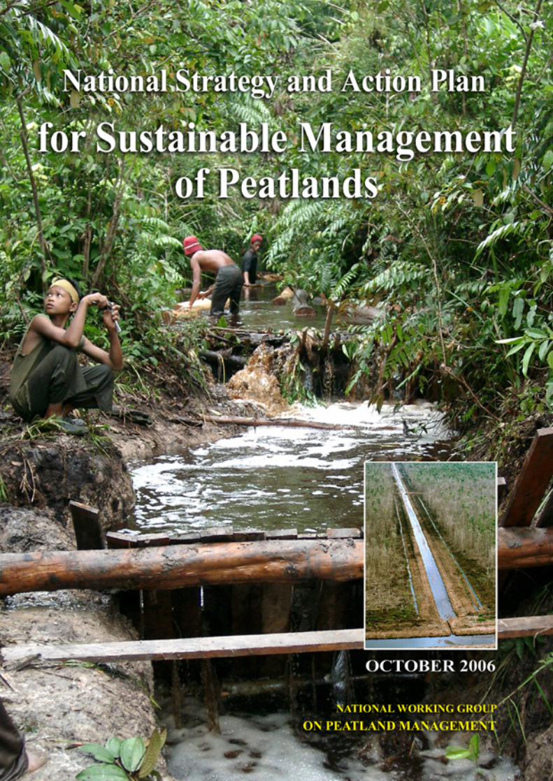
Indonesia, possessing around 20 million hectares of peatlands, is the country with the world’s largest area of tropical peatlands. Peatlands are of vital significance because they are a system of life support, a source of water and food, they protect a wealth of biodiversity, and they function as a control on global climate. In view of their important roles and functions as one form of wetland, peatlands must be managed in an appropriate and integrated manner. As the community’s need for land increases, peatlands tend to be evaluated from an economic point of view compared against their ecological functions and value. This can lead to a conflict of interests not just between sectors but also between regions and even between the various interests of different parties. Moreover, peatland management that leans towards economic values will tend to be biased towards the owners of capital, marginalising the community’s rights and ignoring the ecological functions of peatlands. Although peatlands are included within the framework of the National Wetlands Management Strategy (Strategi Pengelolaan Lahan Basah Nasional, (KLH, 2004)), in view of the large potential and specific factors possessed by Indonesia’s peatlands, it is considered necessary to draw up a special strategy framework for their management. This national strategy document has the title Strategi dan Rencana Tindak Nasional Pengelolaan Lahan Gambut Berkelanjutan (National Strategy and Action Plan for Sustainable Management of Peatlands (NSAPSMP)). It is expected to become an ‘umbrella’ manual for the effective and synergic management of peatlands by all stakeholders, at both central and regional level. Although this NSAPSMP document is an umbrella for the issuing of peatland management strategies in the regions, it is accommodative in character as, in practice, it can be developed to suit the specific characteristics and priorities of each region in line with the demands of decentralisation and autonomy, provided that ecological functions and values are given as much consideration as economic values and that the community’s interests are the main target. The National Working Group on Peatland Management who have written this NSAPSMP are fully aware that this document is far from perfect, and we welcome all criticisms or suggestions from readers; these can be made to us either orally or in writing. May we also take this opportunity to thank all those who have directly or indirectly helped in and supported the writing of this document. Jakarta, August 2006 National Working Group on Peatland Management

iv National Strategy and Action Plan for Sustainable Management of Peatlands
Table of Contents
Preface ...................................................................................................................... iii
Glossary of Terms and Abbreviations.............................................................................. vii
1. Introduction...............................................................................................................1
2. Peatlands in Indonesia .............................................................................................6 2.1 Definitions and Characteristics of Peat ....................................................................... 6 2.2 Distribution and Extent of Peatlands in Indonesia....................................................... 8 2.3 Values and Uses of Peatlands in Indonesia.............................................................. 11 2.4 Policies and Institutions related to Peatland management ......................................... 16 2.5 Problems and Threats ............................................................................................... 32 2.6 The need for a peatland management strategy ........................................................ 42 2.7 Regional Cooperation................................................................................................ 43
3. National Strategy and Action Plan for Sustainable Management of Peatlands (NSAPSMP) ...........................................................................................................44 3.1 Basic principles.......................................................................................................... 44 3.2 Challenges for Sustainable Peatland Management in Indonesia.............................. 44 3.3 Rationale for a National Strategy .............................................................................. 45 3.4 Goals of the National Strategy................................................................................... 46 3.5 General Objectives .................................................................................................... 47 3.6 Operational Objectives .............................................................................................. 47 3.7. Action Plan................................................................................................................. 49
4. Implementation Mechanisms..................................................................................57 4.1 National/Central Implementation Mechanisms.......................................................... 57 4.2 Regional (local) Implementation Mechanism ............................................................ 60 4.3 Funding Mechanism .................................................................................................. 62
4.3.1 Domestic sources of funding................................................................... 62 4.3.2 Foreign aid and cooperation .................................................................... 63 4.3.3 Alternative sources of funding ................................................................ 63
4.4 Monitoring and Evaluation Mechanism ..................................................................... 64 4.4.1 Principles of monitoring and evaluation................................................. 64 4.4.2 Mechanisms and Procedures .................................................................. 65
National Strategy and Action Plan for Sustainable Management of Peatlands v
ANNEXES
Annex 1. Extent and Distribution of Peatlands in Sumatera in 2002......................... 67
Annex 2. Extent and Distribution of Peatlands in Kalimantan in 2002 ...................... 70
Annex 3. Important values and uses of peatlands .................................................... 72
Annex 3. Important values and uses of peatlands .................................................... 73
Annex 4. Policies related to the management of Land and Forest fire in Indonesia ................................................................................................... 75
Annex 5. Names and addresses of institutions/agencies at Central / National level related (directly or indirectly) to peatland management..................... 76
Annex 6. Names and addresses of agencies in areas related (directly or indirectly) to peatland management * ........................................................ 77
Annex 7. Regional Cooperation ................................................................................ 83
Annex 8. List of publications related to peatland issues ........................................... 88
Annex 9. List of regions possessing peatland potential and their spatial planning status........................................................................................... 96
Annex 10. Copies of documents ................................................................................. 99
Annex 11. Declaration / Statements related to peat management............................ 106
TABLES Table 1. Estimated age of peatland at several locations in Kalimantan ........................................ 6
Table 2. Estimated extent and distribution of peatlands in Indonesia according to several sources ................................................................................................................ 9
Table 3. UPT Transmigration settlements developed on peatlands ............................................ 14
Table 4. Fish species found in blackwater (peat) rivers, swamps and lakes in and around Sungai Puning, Kab Barito Selatan ................................................................... 15
Table 5. Actions by government agencies and Regional Governments related to management of peat lands and forest in Indonesia ....................................................... 26
Table 6. Production Volume and Economic Benefit from the Direct Use of Forest Products from Peatlands in Blok Perian in 2000. ........................................................... 42
Table 7. Focal areas and operational objectives for peatland management in Indonesia ....................................................................................................................... 48
Table 8. Action Plan ..................................................................................................................... 50

vi National Strategy and Action Plan for Sustainable Management of Peatlands
PICTURES Figure 1. Cross section of peat dome ............................................................................................. 8
Figure 2. Species of trees growing in peatlands (Photo: Iwan Tri Cahyo W./Dok. WI-IP) ............. 8
Figure 3. Vegetables grown on peatland in Central Kalimantan and Jambi ................................. 13
Figure 4. Flooding in peatland village desa Sungai Aur, Jambi. One factor that must be considered in programs to develop agricultural land on peat ....................................... 39
Figure 5. Water management in plantations on peatlands growing pinang in Desa Mendahara Hulu, Jambi (left) and oranges in Desa Basarang, Central Kalimantan (right). How long will these last? Remember, peatlands are prone to subsidence ................................................................................................................ 40
Figure 6. Diagram showing the proposed work mechanism for the implementation of the national peatland management strategy at central level ............................................... 58
Figure 7. Flow chart of the monitoring and evaluation process .................................................... 66
BOXES BOX 1 Canal blocking in South Sumatera & Central Kalimantan ............................................... 11
BOX 2 Using blocked ditches/channels for aquaculture ............................................................. 16
BOX 3 Succession trends in burnt peatland (Wibisono et al., 2005) ........................................... 33
BOX 4 Training on Fire Fighting in Desa Sungai Aur (Sri Najiyati et al., 2005) .......................... 34
BOX 5 The fate of illegal loggers in peat swamps in South Sumatera ....................................... 36
BOX 6 Experience of rehabilitating burnt forest in Berbak National Park, Jambi (Wibisono et.al 2005) ....................................................................................................... 37
BOX 7 Comparative study by peatland farmers from Central Kalimantan to Jambi and South Sumatra and vice versa ......................................................................................... 38
BOX 8 Small Grant Funds Sumatera ........................................................................................... 39

National Strategy and Action Plan for Sustainable Management of Peatlands vii
Glossary of Terms and Abbreviations
Alluvial : An area where sand or clay or similar materials are gradually sedimented by running water.
AMDAL : Environmental Impact Assessment (Analisis Mengenai Dampak Lingkungan)
AMMH : ASEAN Ministerial Meeting on Haze
APBD : Regional Budget (Anggaran Pendapatan dan Belanja Daerah)
APBN : National Budget (Anggaran Pendapatan dan Belanja Negara)
APMI : ASEAN Peatland Management Initiative
APMS : ASEAN Peatland Management Strategy
ASCC : ASEAN Socio-Cultural Community
ASEAN : Association of South East Asian Nations
ASOEN-HTTF : ASEAN Senior Officials on the Environment - Haze Technical Task Force
Bakornas PBP : National Coordination Agency for Disaster Management and Refugees (Badan Koordinasi Nasional Penanggulangan Bencana dan Penanganan Pengungsi)
Balitbang : Research and Development Agency (Badan Pelitian dan Pengembangan)
BAPPEDA : Regional Development Planning Agency (Badan Perencanaan Pembangunan Daerah)
BAPPENAS : National Development Planning Agency (Badan Perencanaan Pembangunan Nasional)
Base Saturation (BS) : The percentage of base cations in a soil complex. Base saturation is closely related to soil pH. If the pH is high, the base saturation will also be high, and similarly if soil pH is low the base saturation will be low also
Beje : A long rectangular fishpond, commonly dug in the middle of peatswamp forests or peatlands by the rural people in Central Kalimantan. The ‘beje’ ponds are usually not far from a river and are positioned behind the dwellings
Biodiversity : All variations within and among living species and the ecological whole in which they live. Biodiversity has three levels: ecosystem, species and genetic. Biodiversity is described from the total number of different species, different combinations of species, and different combinations of genes in each species.

viii National Strategy and Action Plan for Sustainable Management of Peatlands
BMG : Meteorology and Geophysics Office (Badan Meteorogi dan Geofisika)
BPPT : Agency for the Assessment and Application of Technology (Badan Pengkajian dan Penerapan Teknologi)
Bulk Density : The weight of a volume of undisturbed peat soil expressed in units of gr/cc or kg/m3. Values range between 0.10-0.40 gr/cc, depending on the peat’s level of maturity
Canal blocking : Construction of dams to block canals, ditches and channels
CBD : Convention on Biological Diversity.
CCFPI : Climate Change Forests and Peatlands in Indonesia, is a forestry project which is closely related to the issue of climate change, where the forest plays an important role in carbon sequestration. This project is implemented by WI-IP together with Wildlife Habitat Canada (WHC) and funded by grants from the Canadian Goverment (CIDA, Canadian International Development Agency) through the Canada Climate Change Development Fund for a period of four years (August 2001 – September 2005), then extended to December 2006. Activities under this Project involve the participation of community and government in the conservation and rehabilitation of peatlands and peat forests in Indonesia. This Project was specifically designed to support the United Nations Framework Convention on Climate Change (UNFCCC) for Canada and Indonesia.
CC-GAP : Coordinating Committee on Global Action on Peatlands
CDM : Clean Development Mechanism
CEC : Cation Exchange Capacity. The capacity to absorb cations dissolved in soil per weight unit of soil
Cellulose : A polymer (long chain) of carbohydrate molecules produced by a plant. Cellulose is the material from which cell walls are composed, usually in the form of fibres, that form the largest part of plant mass.
CIDA : Canadian International Development Agency
CITES : Convention on International Trade in Endangered Species of Wild flora and fauna
Classification of grain size and rheological characteristics : Used to determine the properties of soil composition. Soil grain size greater than 2.0 millimicrons (loamy skeletal, sandy skeletal) and rheological properties showing shape deformation and flow that forms cohesive force and soil grain cohesion
COP : Convention for the Parties
National Strategy and Action Plan for Sustainable Management of Peatlands ix
Decomposition : The breaking down of organic material by living creatures (mainly bacteria and moulds) in the environment, that produces inorganic compounds or simpler organic compounds.
Deptan : Ministry for Agriculture (Departemen Pertanian)
Ditjen. Bina Bangda : Directorate General for Regional Development, Ministry of Home Affairs (Direktoral Jenderal Bina Pembangunan Daerah, Departemen Dalam Negeri)
Ditjen PHKA : Directorate General for Forest Protection and Nature Conservation, Ministry for Forestry (Direktorat Jenderal Perlindungan Hutan dan Konservasi Alam, Departemen Kehutanan)
Endemic : Limted in its distribution to only one specific site or area
Fire Break : A piece of land used to separate, stop, and control the spread of land/forest fire. Fire breaks can be natural, such as river chasms and empty land; or they may be man-made, such as roads, reservoirs, ditches and belts that have been cleared of litter and trees
Floodplain : A plain or basin near a river that experiences flooding/ inundation during the rainy season or at high tide, for example the flood plains in South Sumatera.
GEC : Global Environmental Center, a NGO based in Kuala Lumpur Malaysia
GEF-UNEP : Global Environment Facility -- United Nations Environmental Programme
GHG : Green House Gases: certain gases in the atmosphere that can obstruct/prevent the escape of infrared radiation from the earth, with the result that the average temperature of the earth’s surface is getting warmer. This resembles the trapping of infrared radiation inside a greenhouse, thus raising the temperature. The Kyoto Protocol lists six types of GHG whose emissions must be regulated/reduced: carbon dioxide (CO2), nitrous oxide (N2O), methane (CH4), sulphur hexafluoride (SF6), perfluorocarbon (PFC), and hydrofluorocarbon (HFC).
Giga : 109 (1,000,000,000) E.g. 1 Giga ton = 1,000,000,000 ton
HPH : Forestry Licence (Hak Pengusahaan Hutan)
HRGMK : The peatswamp forest of Merang-Kepahiyang (Hutan Rawa Gambut Merang – Kepahiyang) in Kabupaten Musi Banyuasin, South Sumatera
HTI : Industrial Forest (Hutan Tanaman Industri)
HTTF : The Haze Technical Task Force
Hydrology : The science of the properties and behaviour of water in the atmosphere, on the earth’s surface and underground

x National Strategy and Action Plan for Sustainable Management of Peatlands
Illegal logging : The illegal extraction of forest timber that disadvantages the nation and tends to ignore environmental regulations
Irreversible : Unable to be restored to its natural/original condition
Irreversible desiccation : A physical property of peat, which after becoming dry is no longer able to absorb water even if inundated
IUCN : International Union for Conservation of Nature and Natural Resources
Keppres : Presidential decree (Keputusan Presiden)
Kpts : Decree/decision (Keputusan)
LAPAN : National Institute for Aeronautics (Lembaga Penerbangan dan Antariksa Nasional )
LIPI : Indonesian Institute of Sciences (Lembaga Ilmu Pengetahuan Indonesia)
LREP : Land Resources Evaluation and Planning Project
LSAPSMP : Local Strategy and Action Plan for Sustainable Management of Peatlands
LSM : Non-governmental organisation (Lembaga Swadaya Masyarakat)
Lignin : A chemical compound that forms the biggest component of wood and forms part of the cell walls. The mass of lignin can reach 1/3 of the entire dry weight of wood. This compund is the second most abundant compound on earth after cellulose.
Mendagri : Minister for Home Affairs (Menteri Dalam Negeri)
MenHut : Minister for Forestry (Menteri Kehutanan)
Men LH : Minister for the Environment (Menteri Lingkungan Hidup)
NGO : Non-governmental Organisation. A non-profit organisation managed outside the political structure with the purpose of achieving a particular social aim.
NSAPSMP : National Strategy and Action Plan for Sustainable Management of Peatlands
Organosol / histosol : Soil that contains enormous quantities of organic materials from partially decomposed plant matter. This soil is formed because the low oxygen content of inundated land slows down the decomposition of organic materials. The term ‘histosol’ derives from the word Histos meaning ‘network’. ‘Histosol’ can therefore be taken to mean ‘soil constructed from a network’. The term ‘organosol’ indicates soil with a very high content of organic materials. Organosol and Histosol are terms used in soil classification, usually to denote soil commonly known as peat.
National Strategy and Action Plan for Sustainable Management of Peatlands xi
Parit : Ditch, a small channel (width 0.5 – 3 m; depth 0.6 – 1.5 m length up to 13 km), made in peatland, usually dug by individuals or groups to transport logs and/or other forest products
Peat : (organosol or histosol) soil formed from the accumulation over a long period of time of organic matter such as the remains of plants. Peat soil is generally waterlogged or flooded all year long unless drained. Several experts have defined ‘peat’ in different ways:
• According to Driessen, 1978: peat is soil containing more than 65% organic material (dry weight) and having a peat depth greater than 0.5 m.
• According to “Soil Taxonomy”: peat is soil comprised of organic materials with a thickness exceeding 40cm or 60cm, depending on the bulk density and level of decomposition of the organic matter
Peat dome : The central part of peatland, which rises like a dome. This part is usually less fertile because its nutrients come only from rainwater.
PEMDA : Regional Government (Pemerintah Daerah)
PERDA : Regional Regulation (Peraturan Daerah)
PERPRES : Presidential Regulation (Peraturan Presiden) – previously termed Presidential Decree (Keppres= Keputusan Presiden)
PINSE : Yayasan Pinang Sebatang, a local NGO in Jambi
PLG : Proyek Lahan Gambut – the one million hectare peatland project developed in Central Kalimantan in 1995 during the era of President Suharto. The project was officially terminated in 1999 during the term of President Habibi because it was considered to be a failure.
POKJA PLGB : Working Group on Sustainable Peatland Management (Kelompok Kerja Pengelolaan Lahan Gambut Secara Berkelanjutan)
Porosity : A grade that indicates the number of pores in a medium (soil, gravel or stone) through which water or air can pass.
PP : Government Regulation (Peraturan Pemerintah)
PU : Public Works (Pekerjaan Umum)
PUS-DALKARHUTNAS : National Forest Fire Control Centre (Pusat Pengendalian Kebakaran Hutan Nasional)
Puslitanak : Soil and Agroclimate Research Centre (Pusat Penelitian Tanah dan Agroklimat)
xii National Strategy and Action Plan for Sustainable Management of Peatlands
Pyrite : A soil layer containing more than 0.75% iron sulphide (FeS2). If marine soil (also shallow coastal peat soil) containing pyrite is reclaimed (e.g. by opening drainage channels so that the water level falls and the pyrite environment is exposed to an aerobic atmosphere) the pyrite will be oxidized to produce sulphuric acid with the result that the soil reacts by becoming highly acidic and highly dangerous to plants and organism in its waters
Ramsar : An international convention on wetlands. Indonesia ratified this convention in 1992
Red data book : A list of species threatened with extinction.
Reservoir : A body of water (usually constructed) capable of storing large quantities of water
RHAP : Regional Haze Action Plan
RLKT : Land Rehabilitation and Soil Conservation (Rehabilitasi Lahan dan Konservasi Tanah)
RTRWP : Provincial Spatial Planning (Rencana Tata Ruang Wilayah Propinsi)
SK : Decree/decision (Surat Keputusan)
Soil buffer capacity : The force exerted by the soil on a force that is exerted on top of it. The value of this force is required primarily when building irrigation constructions such as dams, water gates, or when establishing plantations.
SRFA : Sub-Regional Firefighting Arrangement
SRTDPLGB : Strategi dan Rencana Tindak Daerah Pengelolaan Lahan Gambut Berkelanjutan (see LSAPSMP)
SRTNPLGB : Strategi dan Rencana Tindak Nasional Pengelolaan Lahan Gambut Berkelanjutan (see NSAPSMP)
Subsidence : In a geological, technical or mapping survey context, subsidence is defined as the downward movement or collapse of a surface (usually the earth’s surface) relative to a certain datum – usually sealevel. The opposite of subsidence is uplift, which raises up the surface. In the context of peatlands, subsidence means the collapse of the peat’s surface, usually as a result of over-drainage or damage to its hydrology and vegetation, oxidation of the peat.
Tabat/tebat : (from the Dayak language) This is a barrier or dam constructed across a drainage channel/ditch in order to reduce the drainage of water and prevent the peat from drying out in the dry season
TNI AU : Indonesian Air Force (Tentara Nasional Indonesia – Angkatan Udara)
National Strategy and Action Plan for Sustainable Management of Peatlands xiii
THR : Grand Forest Park (Taman Hutan Raya)
TN : National Park (Taman Nasional)
UNEP : United Nations Environmental Programme
UNFCCC : United Nations Framework Convention on Climate Change
UU : Law (Undang Undang)
UNDP : United Nations Development Programme
WB : World Bank
WBH : Yayasan Wahana Bumi Hijau, a local NGO in Palembang, South Sumatera
WHC : Wildlife Habitat Canada, a NGO in Canada
WI-IP : Wetlands International-Indonesia Programme, an international non-profit organisation active in the field of wetlands conservation
WWF-Indonesia : World Wide Fund for Nature Indonesia
Yakomsu : Yayasan Komunitas Sungai, a local NGO in Kabupaten Barito Selatan, Central Kalimantan


National Strategy and Action Plan for Sustainable Management of Peatlands 1
1. Introduction
Background to the creation of the National Strategy and Action Plan for Sustainable Management of Peatlands
Peatlands have an extremely important role to play in the lives of the humans and other creatures that live on and around them. Peatlands do not only function as a direct life support system (for example, as a source of freshwater fish, a habitat for a diversity of living creatures) but also have a variety of ecological functions like flood control and global climate control. Peatland areas are difficult to restore once they are damaged. Therefore, to preserve the ecological ecosystem of peatlands it is necessary to manage them wisely, paying proper attention to ecological equilibrium, for the interests of current and future generations. As a part of wetlands, peatlands have in fact been mentioned in the National Wetlands Management Strategy (Strategi Pengelolaan Lahan Basah Nasional). Nevertheless, in view of their specific characteristics and the vast extent of Indonesia’s peatlands (approximately 20 million Ha or 50% of the world’s total tropical peatlands), it is deemed necessary to develop a management strategy specifically for peatlands. The development of the National Strategy and Action Plan for Sustainable Management of Peatlands is also the result of a number of other considerations, including the following:
In order to maintain the functions and benefits of the peatland natural resource, there needs to be a balance between its conservation and sustainable use. This can be achieved based on identification of existing potentials and problems, using an approach that balances the needs for conservation against those of utilisation.
The management of natural resources, including peatlands, cannot be carried out by a single party alone, but requires the efforts and cooperation of a number of parties, such as government, NGOs, institutes of higher education, the private sector, and the community. This requires cooperation to achieve optimal, sustainable use of this natural resource.
Implementing decentralisation at local level requires the assignment of strict, clear management functions, as well as open, continuous communication among stakeholders. For this, a guide is needed which is national in character but which can be described in different regions and adapted to the local conditions.
A number of meetings related to peatlands, at both national and international level, have also prompted the development of this National Strategy and Action Plan for Sustainable Management of Peatlands. Some of these meetings and their recommendations are as follows.
The international symposium on tropical peatlands (Annex 11a) entitled "Peatlands for People” held in Jakarta, 22 -23 August 2001 produced the Jakarta Statement On The Importance Of Tropical Peatlands. This urged all parties to pay greater attention to “the conservation of peatland biodiversity and carbon stores as well as sustainable use of peatlands, particularly peat swamp forests.” The statement also encouraged all sectors to invest in efforts directed towards the conservation and restoration of tropical peatlands while at the same time promoting their wise, sustainable use.

2 National Strategy and Action Plan for Sustainable Management of Peatlands
The workshop on the wise use and sustainable management of peatlands Pemanfaatan Bijaksana serta Praktek-praktek Pengelolaan Lahan Gambut yang Berkelanjutan held in Bogor on 13 – 14 October 2003 (Annex 11b), resulted in a statement urging the government, non-government organisations, private sector and communities to work together to protect, rehabilitate and sustainably manage peatlands for the benefit of present and future generations and for the global environment.
The Riau Declaration (Annex 11c) produced by the international Workshop on Vulnerability of Carbon Pools in Tropical Peatlands” held 23-26 January 2006 in Pekanbaru underlined, among other things, the need to “strengthen policies and institutional arrangements for peatland management and strictly enforce policies and rules for the management and conservation of peatlands”.
During 9-11 April 2003, the Seminar on Wise Use and Sustainable Management of Peatlands was held in Narathiwat, Thailand (Annex 11d). This examined 2 main topics: the rehabilitation and management of peatlands, and the sustainable use of peatlands and community participation. The seminar produced a number of recommendations contained in the Narathiwat Statement on Wise Use and Sustainable Management of Peatlands. This welcomed the establishment of the ASEAN Peatland Management Initiative in March 2003 and the Ramsar Convention Guidelines on Global Action on Peatland. The Seminar also stated that it was important to “urgently stop the loss and degradation of peatlands in SE Asia and promote their sustainable management”. The main points of the action plan recommended by the Narathiwat Statement which urged prompt adoption of the NSAPSMP include: (a) “Establish national inter-agency working groups to develop strategies for peatland protection and sustainable use” (b) “Formulate or update national policies and strategies or action plans for conservation and wise use of peatlands” (c) “Develop overall management plans for each peatland area to include forest, water and fire management as well as community participation and utilization of resources”.
Besides being discussed in a number of national and international level meetings, peatlands have also received attention in several international conventions since the beginning of the present millennium. Such international conventions include: the Convention on Biological Diversity (CBD), the United Nations Framework on Climate Change (UNFCCC) and the Ramsar Convention. In fact, the last of these addressed the issue of peatlands back in 1996 during Ramsar Convention COP 6 in Brisbane, Australia.
The Convention on Biological Diversity (CBD) through its resolution on Biological Diversity and Climate Change encouraged actions to mitigate the degradation and promote the restoration of peatlands as carbon stores and/or to maintain their capacity to absorb carbon. In addition, CBD also supported the studies of peatland biodiversity and climate change carried out by international NGOs (Wetlands International and Global Environment Center). This convention also pointed out the need to combine peatland issues into a work programme on inland water biodiversity.
The United Nations Framework on Climate Change (UNFCCC) appears to give limited attention to the value of peatlands as a carbon store, even though there has been an obvious increase in carbon emissions into the atmosphere as a result of the recent peatland fires and degradation. It is predicted that this situation will soon change with the increase in knowledge/awareness of peatland issues by various international conventions, member countries and even by the Intergovernmental panel of the UNFCCC.
National Strategy and Action Plan for Sustainable Management of Peatlands 3
The Ramsar Convention has acknowledged the need to pay more attention to the conservation and wise use of peatlands and their role in controlling climate change. In 2002, this convention formed a Coordinating Committee to monitor developments in the implementation of Manuals on Global Action on peatlands (CC-GAP, Coordinating Committee on Global Action on Peatlands), and to produce an Action plan as a further step, and to identify action priorities within the framework of promoting the wise use of peatlands.
The Action plan developed by CC-GAP is an important step forwards for the global agenda in promoting the wise use of peatlands. It provides direction/guidance on many conventions and their member countries, related to the peatland issues arising and the main priorities for action.
The following are Ramsar Convention resolutions related to peatlands:
Article 1 of the Ramsar Convention specifically states that peatlands are included within the connotation of the definition of wetlands. This means that peatlands will always form part of the term ‘wetlands’ wherever it appears within the Convention.
Recommendation 6.1 (1996, COP 6) on “peatland conservation” urges stakeholders to inventorise peatlands, develop guidelines for the management of peatlands at regional level, recommend that the Guidelines for the Wise Use of Wetlands published by the Ramsar Convention be fully applied to peatlands, that international mechanisms for coordination and cooperation on peatland conservation initiatives be expanded, and encourage research into the functions of peat and their restoration.
Recommendation 7.1 (1999, COP 7) on “the wise use of peatlands” presents a “Global Action Plan for the management and wise use of peatlands”
Resolution VIII.3 (2002, COP 8) tells relevant countries to minimise the degradation of peatlands and to promote the restoration of degraded peatlands which are of important value as carbon stores.
Resolution VIII.17 (2002 COP 8) adopted the “Guidelines for Global Action on Peatlands” and established the CC-GAP.
The development of a National Strategy and Action Plan for Sustainable Management of Peatlands (NSAPSMP) for Indonesia became urgent due to the pressing need from the local, national, regional and even international communities for wise use and sustainable management of peatlands. The routine incidence of forest and peatland fires together with the associated haze, resulting from the unwise management and use of forests and peatlands, have caused great economic, environmental and health losses for the people of Indonesia (particularly in Sumatra and Kalimantan) and neighbouring countries, and could bring about global climate change. The peatland management strategy for Indonesia has been developed with reference to the framework of the ASEAN Peatland Management Initiative (APMI) and the ASEAN Agreement on Transboundary Haze Pollution contained in the ASEAN Peatland Management Strategy (APMS). It refers also to the stipulations contained in the Ramsar Convention, the Convention on Biological Diversity and the National Wetlands Management Strategy. The regional meeting behind the development of the NSAPSMP was the ASEAN Ministerial Meeting on Haze in Kuala Lumpur on 11 June 2002. During this meeting, it was decided to pay greater attention to the issue of peatland management and addressing the problem of fire and associated haze. It was also agreed to develop an initiative that would be used to encourage sustainable peatland management in the ASEAN region through joint actions and improved cooperation to support and maintain the local communities’ livelihoods, reduce the risk of fire and haze, and make a meaningful contribution to the management of the global environment.

4 National Strategy and Action Plan for Sustainable Management of Peatlands
The development of a regional strategy, the ASEAN Peatland Management Strategy (APMS), was one item in the work plan of the APMI (2003 – 2005) adopted at the ASOEN-HTTF meeting in the Philippines, 28 February 2003. Besides agreeing on the strategy framework, the meeting also decided that each member country should prepare information and a country paper for discussion at the APMI regional workshop in October 2003 in Bogor, Indonesia. The First Regional Workshop on the APMI, on 16-17 October 2003 in Bogor, collectively agreed to prepare an ASEAN Peatland Management Strategy (APMS). This regional strategy would be based on information collected from each country attending the meeting and other appropriate materials. A variety of inputs were subsequently collected and synergised into a draft regional strategy document (APMS) prepared by the ASEAN Secretariat with technical support from the Global Environment Centre and Wetlands International, during the period December 2003 to June 2004. As several countries had been unable to attend the regional workshop, this document still required their inputs as well as further polishing. Finally, on 15 November 2005, at the 22nd Meeting of the ASEAN Senior Officials on the Environment Haze Technical Task Force (ASOEN-HTTF) in Bandar Seri Begawan, Brunei Darussalam, the “Strategy and Action Plan for Sustainable Management of Peatlands in ASEAN Member Countries” (APMS) with a duration of 15 years: 2006 – 2020, was officially accepted by the ASEAN member countries. Characteristics and Systematization of the National Strategy and Action Plan for Sustainable Management of Peatlands
This NSAPSMP is the master plan for: peatland conservation, peatland utilisation, and the control and handling (rehabilitation) of peatland degradation. This master plan will be the basis for drawing up peatland management programmes that will be further described in the action plan of each relevant Central agency. As peatland conditions vary from place to place, the order of priorities/needs in peatland management will be determined to suit local requirements. The NSAPSMP is divided into two parts. The first part provides background information on peatlands in Indonesia, including information on definitions, distribution, area, status, utilisation, policies and institutions involved in peatland management, issues and problems that arise, needs and general recommendations for each level of government: provincial, district (kabupaten), municipal. The second part contains information on the development of the strategy itself, including its background, formulation, reasons/justification for the need for such a strategy at national level, detailed and general objectives accompanied by details of actions, and an initial framework for implementing the strategy. The strategy focuses primarily upon the following four objectives:
Raise awareness and knowledge concerning peatlands
Address peatland degradation
Promote the wise, sustainable management of peatlands
Enhance and promote collective cooperation among the District (Kabupaten)/Municipal/ Provincial [and regional] levels of government, related to peatland management.
National Strategy and Action Plan for Sustainable Management of Peatlands 5
The operational objectives of this national strategy (NSAPSMP) are designed to describe the objectives above along general lines only, for use as a guide by District/Municipal and Provincial Governments when drawing up a more detailed Peatland Management Action Plan at District/Municipal or Provincial level, which is adapted to the prevailing local conditions. Considering that it is increasingly important to have a network or cooperation among district/provincial [even regional and international] levels in order to address the issues of peatland fires and haze, conservation and sustainable management, and enhanced capacity for peatland management and research, this strategy is expected to play an important role as a form of formal cooperation among District, Municipal and Provincial governments [and even the Regional ASEAN level], through the exchange of technology and expertise as well as technical assistance to overcome the various problems of peatlands in each area. This NSAPSMP document has been drawn up by a Working Group/Team with members from a range of relevant technical agencies at Central Government, and also through consultations with representatives from District/Municipal and Provincial Governments of areas possessing peatlands (Annexes 5 and 6). It is therefore hoped that the document can be described and incorporated into a more detailed and realistic action plan in the regions, and in its application can be adapted to the conditions prevailing in each particular District/Municipality/Province.
6 National Strategy and Action Plan for Sustainable Management of Peatlands
2. Peatlands in Indonesia
This section defines peatlands and provides information on their distribution, extent, values and uses, and on relevant policies and institutions, problems and threats, management and cooperation among District, Municipal and Provincial levels in the management of peatlands in Indonesia. The information given here was obtained from a number of written sources supplied by technical agencies, research institutes, universities, NGOs and other competent sources in the area of peatland studies. 2.1 Definitions and Characteristics of Peat
Peatlands constitute a wetland ecosystem formed from the accumulation of organic matter on the forest floor, originating from the debris of the vegetation above it over a very long period of time (thousands of years). This occurs because the rate of decomposition is slow compared to the rate at which the organic matter accumulates on the wet/inundated forest floor. Peatland is organosol or histosol soil that is always saturated with water or inundated throughout the year, unless it is drained. Different experts have defined peat in different ways. Two of the definitions commonly used are:
Peat is soil containing more than 65% organic material (dry weight) and having a peat depth greater than 0.5 m (Driessen, 1978)
Peat is soil comprised of organic materials with a thickness exceeding 40cm or 60 cm, depending on the bulk density and level of decomposition of the organic matter (Soil Taxonomy).
The formation of peat in many coastal areas of Indonesia is thought to have begun during the last glacial age, about 3,000 – 5,000 years ago. The formation process for deep peat is even older, starting around 10,000 years ago (Brady 1997 in Daniel Murdiyarso et al, 2004). Table 1 below shows the age of peatlands at several locations in Kalimantan.
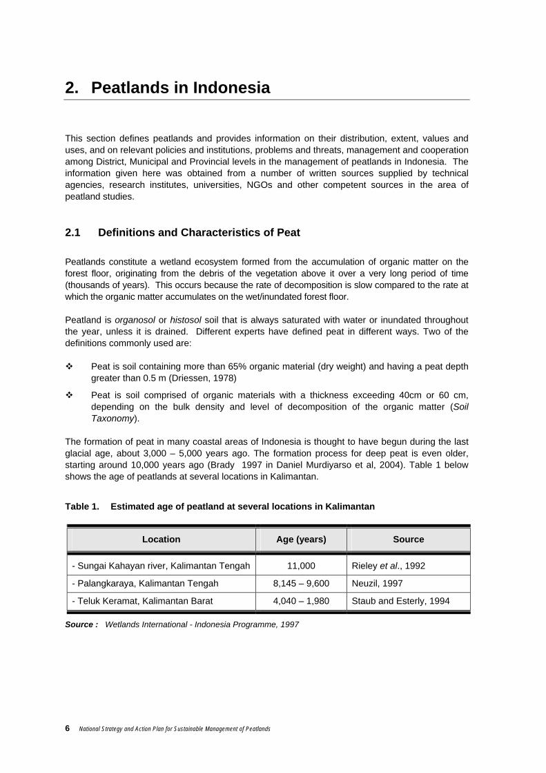
Table 1. Estimated age of peatland at several locations in Kalimantan
Location Age (years) Source
- Sungai Kahayan river, Kalimantan Tengah 11,000 Rieley et al., 1992
- Palangkaraya, Kalimantan Tengah 8,145 – 9,600 Neuzil, 1997
- Teluk Keramat, Kalimantan Barat 4,040 – 1,980 Staub and Esterly, 1994
Source : Wetlands International - Indonesia Programme, 1997

National Strategy and Action Plan for Sustainable Management of Peatlands 7
Like other tropical peat, Indonesia’s peat was formed by the accumulation of tropical vegetation residue rich in Lignin and Cellulose (Andriesse, 1988). Due to the slow process of decomposition, heaps of twigs, branches and roots of large plants are often found preserved in the peat, with their structure still relatively clear to see. As a wetland ecosystem, peat possesses unique characteristics compared to other ecosystems. These can be seen from its chemical and physical properties. Chemically, its fertility varies but is generally low. This is signalled by the peat soil’s acidity (low pH), low availability of macro (K, Ca, Mg, P) and micro (Cu, Zn, Mn, and Bo) nutrients, the presence of toxic organic acids, and high Cation Exchange Capacity (CEC) but low Base Saturation (BS) . The physical properties of peat, which are unique and need to be properly understood, include maturity, colour, bulk density, porosity, irreversible desiccation, subsidence, and high combustibility. As regards maturity, peat has a variable level of maturity because of the differences in the materials, environmental conditions and time involved in its formation. Mature peat (sapric type) tends to be finer and more fertile. Conversely, immature peat (fibric type) contains a lot of coarse fibre and is less fertile. Peat also varies in colour. Although the original materials were grey, brown or red, after decomposition dark coloured compounds appear (Nurhayati et al, 1986) with the result that the peat (also peat water) is generally brown to black in colour. Colour is one indicator of the peat’s maturity. The more mature the peat, the darker its colour. Fibric is brown, haemic is dark brown, and sapric is black (Darmawijaya, 1990). When wet, the peat is usually darker. Peat has a much lower bulk density than alluvial soil. The more mature the peat, the higher its bulk density. Besides this, peat has a low soil buffer capacity because its large pores result in lightweight soil with low cohesion. Total pores for fibric/haemic materials is 86-91 % (volume) and for haemic/sapric 88-92 %, or around 90 % volume on average (Suhardjo and Dreissen, 1977). As a result, trees that grow on it easily fall over. The low soil buffer capacity is a problem in constructing irrigation channels, roads, housing, plantations and rice-fields. Peat also possesses rapid horizontal hydraulic conductivity which accelerates the leaching of nutrients into drainage channels. Conversely, its vertical water-conduction capacity (upwards) is extremely slow, with the result that the surface layer of the peat often dries out, even though the layer below is wet. This also impedes the supply of water to the layer where roots are growing. Besides this, peat is also characterised by irreversible desiccation. This means that it will be very difficult for peat that has experienced extreme drought to absorb water again. Following drainage or reclamation, peat will gradually subside. This is caused by the maturing process of the peat and the lack of water. The length and speed of this subsidence depends on the depth of the peat. The thicker the peat, the quicker it will happen and the longer it will continue for. On average, the rate of subsidence is 0.3-0.8 cm/month lasting over a period of 3-7 years following drainage and working of the soil.

8 National Strategy and Action Plan for Sustainable Management of Peatlands
Peatlands tend to be easily combustible due to their high content of organic materials, irreversible desiccation, high porosity, and low vertical hydraulic conductivity. Peatland fires are extremely difficult to put out because they can travel underground. Embers thought to have been extinguished lie beneath the surface and, unbeknown, continue to spread the fire to surrounding areas. Embers in deep peat can usually be extinguished only by heavy rainfall. For this reason, peat fires must be prevented by not burning peatlands, not irresponsibly discarding even the tiniest spark of fire such as cigarette stubs, especially during the dry season, and keeping peat soil moist by not constructing excessive drainage. 2.2 Distribution and Extent of Peatlands in Indonesia
Indonesia’s peatlands are distributed in swampland, that is land situated at the transition between terrestrial and aquatic ecosystems. For all, or most, of the year, this land is continuously waterlogged or inundated. Peat occupies basins, depressions and the lowest parts of valleys, and its distribution ranges from lowland plains to highland plateaux. In Indonesia, most peatlands are found in lowland swamp plains along the coast. The extent of these peatlands is vast, usually occupying depressions between large rivers near the estuaries, where the rise and fall of the groundwater is influenced by the daily ocean tides. The peat dome and plain usually stretch across a wide basin between large rivers, extending upstream from the coastal plain (see Figure 1).
Figure 1. Cross section of peat dome
Indonesia is the country with the world’s fourth largest area of peatlands (Euroconsult, 1984), with about 20 million ha, after Canada (170 million ha), the former Soviet Union (150 million ha), and the USA (40 million ha). However, different reports (see Table 1) give widely different figures for the extent of Indonesia’s peatlands, ranging from 13.5 million to 26.5 million ha (average 20 million ha). If we take 20 million ha as an estimate, this means that around 50% of the world’s tropical peatlands (totalling approximately 40 million ha) are in Indonesia. Note that data on the extent of Indonesia’s peatlands has not been standardised and therefore the range 13.5 – 26.5 million ha is still used.
Distance
D
epth
Mineral Soil
Peat/organic soil River River Peat dome
National Strategy and Action Plan for Sustainable Management of Peatlands 9
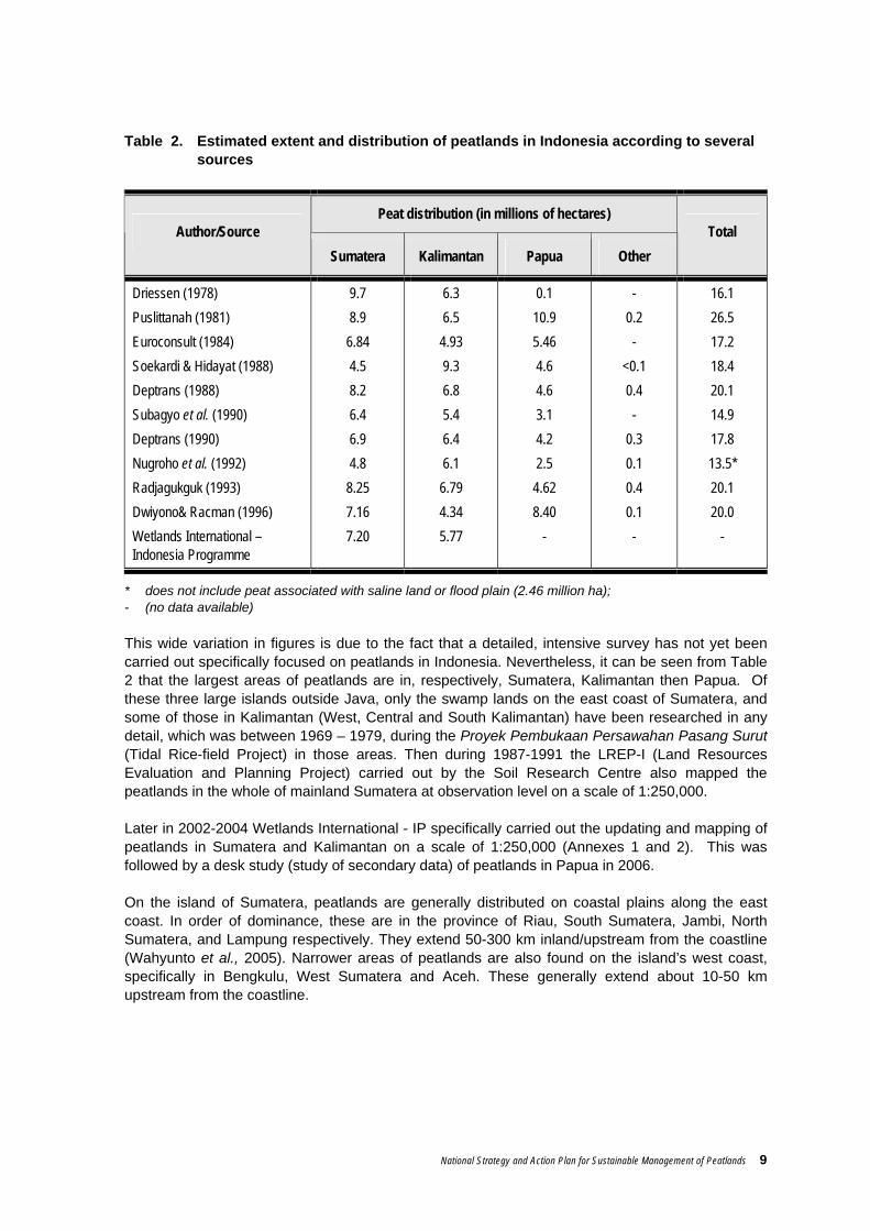
Table 2. Estimated extent and distribution of peatlands in Indonesia according to several sources
Peat distribution (in millions of hectares) Author/Source
Sumatera Kalimantan Papua Other Total
Driessen (1978) Puslittanah (1981) Euroconsult (1984) Soekardi & Hidayat (1988) Deptrans (1988) Subagyo et al. (1990) Deptrans (1990) Nugroho et al. (1992) Radjagukguk (1993) Dwiyono& Racman (1996) Wetlands International – Indonesia Programme
9.7 8.9 6.84 4.5 8.2 6.4 6.9 4.8 8.25 7.16 7.20
6.3 6.5 4.93 9.3 6.8 5.4 6.4 6.1 6.79 4.34 5.77
0.1 10.9 5.46 4.6 4.6 3.1 4.2 2.5 4.62 8.40
-
- 0.2 -
<0.1 0.4 -
0.3 0.1 0.4 0.1 -
16.1 26.5 17.2 18.4 20.1 14.9 17.8 13.5* 20.1 20.0
-
* does not include peat associated with saline land or flood plain (2.46 million ha); - (no data available) This wide variation in figures is due to the fact that a detailed, intensive survey has not yet been carried out specifically focused on peatlands in Indonesia. Nevertheless, it can be seen from Table 2 that the largest areas of peatlands are in, respectively, Sumatera, Kalimantan then Papua. Of these three large islands outside Java, only the swamp lands on the east coast of Sumatera, and some of those in Kalimantan (West, Central and South Kalimantan) have been researched in any detail, which was between 1969 – 1979, during the Proyek Pembukaan Persawahan Pasang Surut (Tidal Rice-field Project) in those areas. Then during 1987-1991 the LREP-I (Land Resources Evaluation and Planning Project) carried out by the Soil Research Centre also mapped the peatlands in the whole of mainland Sumatera at observation level on a scale of 1:250,000. Later in 2002-2004 Wetlands International - IP specifically carried out the updating and mapping of peatlands in Sumatera and Kalimantan on a scale of 1:250,000 (Annexes 1 and 2). This was followed by a desk study (study of secondary data) of peatlands in Papua in 2006. On the island of Sumatera, peatlands are generally distributed on coastal plains along the east coast. In order of dominance, these are in the province of Riau, South Sumatera, Jambi, North Sumatera, and Lampung respectively. They extend 50-300 km inland/upstream from the coastline (Wahyunto et al., 2005). Narrower areas of peatlands are also found on the island’s west coast, specifically in Bengkulu, West Sumatera and Aceh. These generally extend about 10-50 km upstream from the coastline.

10 National Strategy and Action Plan for Sustainable Management of Peatlands
The extent of the peatlands (including very shallow peat or peaty mineral soil) in each province of Sumatera, starting with the largest area, is as follows: i) Riau 4.044 million ha (56.1 % of total peatland area) ii) South Sumatera 1.484 million ha (20.6 %) iii) Jambi 0.717 million ha ( 9.95 %) iv) North Sumatera 0.325 million ha ( 4.5 %) v) Nanggroe Aceh D. 0.274 million ha ( 3.8 %) vi) West Sumatera 0.210 million ha ( 2.9 %) vii) Lampung 0.088 million ha ( 1.2 %) viii) Bengkulu 0.063 million ha ( 0.88 %) According to the thickness of the peat layer, in 2002 the composition of peatlands in Sumatera was as follows : i) Very shallow peat (< 50 cm) 0.682 million ha ( 9.5 %); ii) Shallow peat (50 – 100 cm) 1.241 million ha (17.2 %); iii) Moderate (100 – 200 cm) 2.327 million ha (32.3 % iv) Deep peat (200 – 400 cm) 1.246 million ha (17.3 %). v) Very deep peat (> 400 cm – 800 cm) 1.705 million ha (23.7 %); On the island of Kalimantan, the peatlands (total area 5,769,246 Ha) are generally distributed on the lowland plains of Central Kalimantan (3,010,640 ha), followed by West Kalimantan (1,729,980 Ha), East Kalimantan (696,997 Ha) and South Kalimantan (331,629 Ha). These extend up to 50 km inland/upstream from the coastline (Wahyunto et al., 2005). Narrower areas of peatlands are also found on the plateau in the western part of Kalimantan, particularly in the region of Danau Sentarum, Kapuas Hulu, Propinsi Kalimantan Barat. The extent of the peatlands (including very shallow peat or peaty mineral soil) in each province of Kalimantan, starting with the largest area, is as follows: i) Central Kalimantan 3.011 million ha (52.2 % dari luas total lahan gambut) ii) West Kalimantan 1.730 million ha (30.0 %). iii) East Kalimantan 0.697 million ha (12.1 %). iv) South Kalimantan 0.332 million ha ( 5.7 %). According to the thickness of the peat layer, in 2003, the composition of peatlands in Kalimantan was as follows : i) Very shallow peat ( < 50 cm) 0.190 million ha ( 3.3 %). ii) Shallow peat (50 – 100cm) 1.741 million ha (30.2 %); iii) Moderate (100- 200 cm) 1.391 million ha (24.1 %); iv) Deep peat (200 – 400 cm) 1.105 million ha (19.1 %). v) Very deep peat (400 – 800 cm) 1.065 million ha (18.5 %); vi) Extremely deep peat (> 800 cm-14m) 0.278 million ha (4.8%) For other places, such as Papua, Sulawesi and Halmahera, no detailed, comprehensive field study of the extent and distribution of peatlands has yet been carried out. Details of peatland distribution on the islands of Kalimantan and Sumatera can be seen in Annexes 1 and 2.
National Strategy and Action Plan for Sustainable Management of Peatlands 11
2.3 Values and Uses of Peatlands in Indonesia
People began to talk a lot about peat ten years ago when the world started to realise that this natural resource did not just function as a hydrological regulator, a habitat for the conservation of biodiversity, a cultivation site and an energy source, but also played an even more significant role in the control of global climate change because of its capacity to sequester and store the world’s carbon reserves. 1. Hydrological Regulator Peat is highly porous and therefore able to soak up huge quantities of water. When saturated, sapiric, haematic and fibric peat respectively can contain water amounting to as much as 450%, 450 – 850%, and more than 850% of the peat’s dry weight or up to 90% of its volume. Because of this, peat possesses the capacity to function as a large freshwater reservoir, to the extent that it can prevent flooding in the wet season and release water during the dry season, and prevent intrusion of salt water inland. The peat’s function as a hydrological regulator can be disturbed if it experiences excessive drainage conditions, because this material is characterised by irreversible desiccation, high porosity, and low vertical conductivity. Peat that has dried out to the point of irreversibility will be extremely lightweight and thus easily washed away by rainwater, its structure falls apart like layers of litter, it burns easily, is very poor at reabsorbing water, and is difficult to replant. BOX 1
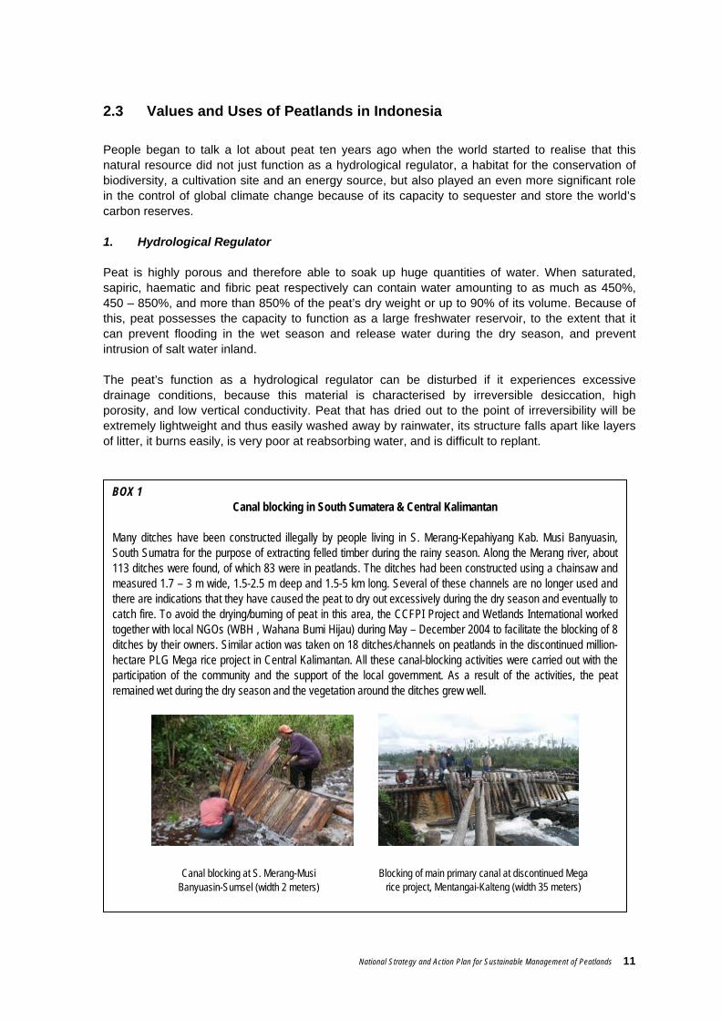
Canal blocking in South Sumatera & Central Kalimantan
Many ditches have been constructed illegally by people living in S. Merang-Kepahiyang Kab. Musi Banyuasin, South Sumatra for the purpose of extracting felled timber during the rainy season. Along the Merang river, about 113 ditches were found, of which 83 were in peatlands. The ditches had been constructed using a chainsaw and measured 1.7 – 3 m wide, 1.5-2.5 m deep and 1.5-5 km long. Several of these channels are no longer used and there are indications that they have caused the peat to dry out excessively during the dry season and eventually to catch fire. To avoid the drying/burning of peat in this area, the CCFPI Project and Wetlands International worked together with local NGOs (WBH , Wahana Bumi Hijau) during May – December 2004 to facilitate the blocking of 8 ditches by their owners. Similar action was taken on 18 ditches/channels on peatlands in the discontinued million-hectare PLG Mega rice project in Central Kalimantan. All these canal-blocking activities were carried out with the participation of the community and the support of the local government. As a result of the activities, the peat remained wet during the dry season and the vegetation around the ditches grew well.
Canal blocking at S. Merang-Musi Banyuasin-Sumsel (width 2 meters)
Blocking of main primary canal at discontinued Mega rice project, Mentangai-Kalteng (width 35 meters)
12 National Strategy and Action Plan for Sustainable Management of Peatlands
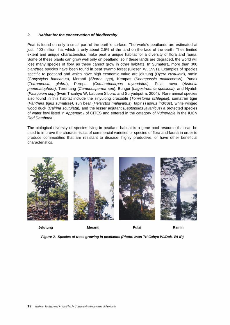
2. Habitat for the conservation of biodiversity Peat is found on only a small part of the earth’s surface. The world’s peatlands are estimated at just 400 million ha, which is only about 2.5% of the land on the face of the earth. Their limited extent and unique characteristics make peat a unique habitat for a diversity of flora and fauna. Some of these plants can grow well only on peatland, so if these lands are degraded, the world will lose many species of flora as these cannot grow in other habitats. In Sumatera, more than 300 plant/tree species have been found in peat swamp forest (Giesen W, 1991). Examples of species specific to peatland and which have high economic value are jelutung (Dyera custulata), ramin (Gonystylus bancanus), Meranti (Shorea spp), Kempas (Koompassia malaccensis), Punak (Tetramerista glabra), Perepat (Combretocarpus royundatus), Pulai rawa (Alstonia pneumatophora), Terentang (Campnosperma spp), Bungur (Lagestroemia spesiosa), and Nyatoh (Palaquium spp) (Iwan Tricahyo W, Labueni Siboro, and Suryadiputra, 2004). Rare animal species also found in this habitat include the sinyulong crocodile (Tomistoma schlegelii), sumatran tiger (Panthera tigris sumatrae), sun bear (Helarctos malayanus), tapir (Tapirus indicus), white winged wood duck (Cairina scutulata), and the lesser adjutant (Leptoptilos javanicus) a protected species of water fowl listed in Appendix I of CITES and entered in the category of Vulnerable in the IUCN Red Databook . The biological diversity of species living in peatland habitat is a gene pool resource that can be used to improve the characteristics of commercial varieties or species of flora and fauna in order to produce commodities that are resistant to disease, highly productive, or have other beneficial characteristics.
Jelutung Meranti Pulai Ramin
Figure 2. Species of trees growing in peatlands (Photo: Iwan Tri Cahyo W./Dok. WI-IP)

National Strategy and Action Plan for Sustainable Management of Peatlands 13
3. Global climate safeguard
Climate change is a global phenomenon signalled by changes in temperature and rainfall patterns. The biggest contributor to climate change is the increasing concentrations of ‘greenhouse’ gases in the atmosphere, such as carbon dioxide (CO2), methane (CH4), and nitrous oxide (N2O) whose concentrations continue to increase (Daniel Murdiyarso and Suryadiputra, 2004). These gases absorb long wave radiation, which is hot and will cause the earth’s temperature to rise as the quantity of such gases in the atmosphere increases.
A global increase in air temperature will change the world’s climate pattern, altering rainfall distribution, wind direction and wind speeds. All this will impact directly on Earth’s various life forms, such as the development of diseases in animals, humans and plants; changes in plant productivity; drought, flooding, and so on.
Peat has a very big Carbon (C) content. According to calculations by Matby and Immirizi (1993) in Daniel Murdiyarso and Suryadiputra (2004), the world’s peat contains 329-525 Gt or 35% of the world’s total C. The peat in Indonesia stores 46 GT (note: 1 GT = 109 ton) or 8-14% of the carbon present in the world’s peat. Thus, peat plays a significant role as a safeguard on global climate. If this peat burns or is degraded, it emits gases (mainly CO2, N2O, and CH4) to the atmosphere ready to cause global climate change. If this happens, we must be prepared to suffer the consequences. 4. Cultivation
The use of peatlands for the cultivation of plants (including oil palm plantations or HTI), livestock and fish has long been familiar to farmers and businesses in Indonesia. Small-scale traditional farming in peatlands was begun hundreds of years ago by the Dayak, Bugis, Banjar, and Melayu peoples. They selected sites wisely, chose well-tested commodities, and farmed on a scale that nature could support.
As the demand for agricultural commodities rose due to increasing economic and population growth, there was a rapid expansion in land for agriculture. Sadly, this expansion often paid little or no attention to the soil buffer capacity and characteristics of peatland. Poor planning was accompanied by the use of unsuitable land, inadequate implementation of the principles of land conservation, and the use of technology that tended to be less than appropriate. The result was widespread damage, and repeated failure of agriculture and plantations developed on peatlands. Conversely, however, the use of peatlands for agriculture and orchards on a limited scale, paying due attention to the principles of conservation and employing appropriate technologies, has proven to be productive and prosper the farmer.
Figure 3. Vegetables grown on peatland in Central Kalimantan and Jambi
Long Beans Pumpkin Leeks
14 National Strategy and Action Plan for Sustainable Management of Peatlands
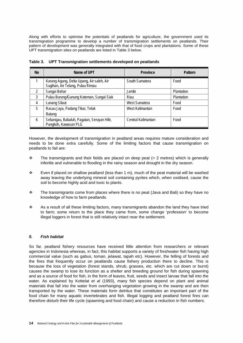
Along with efforts to optimise the potentials of peatlands for agriculture, the government used its transmigration programme to develop a number of transmigration settlements on peatlands. Their pattern of development was generally integrated with that of food crops and plantations. Some of these UPT transmigration sites on peatlands are listed in Table 3 below.
Table 3. UPT Transmigration settlements developed on peatlands
No Name of UPT Province Pattern
1 Karang Agung, Delta Upang, Air saleh, Air Sugihan, Air Telang, Pulau Rimau
South Sumatera Food
2 Sungai Bahar Jambi Plantation 3 Pulau Burung/Gunung Kateman, Sungai Siak Riau Plantation 4 Lunang Silaut West Sumatera Food 5 Rasau Jaya, Padang Tikar, Teluk
Batang West Kalimantan Food
6 Sebangau, Babaluh, Pagatan, Seruyan Hilir, Pangkoh, Kawasan PLG
Central Kalimantan Food
However, the development of transmigration in peatland areas requires mature consideration and needs to be done extra carefully. Some of the limiting factors that cause transmigration on peatlands to fail are:
The transmigrants and their fields are placed on deep peat (> 2 metres) which is generally infertile and vulnerable to flooding in the rainy season and drought in the dry season.
Even if placed on shallow peatland (less than 1 m), much of the peat material will be washed away leaving the underlying mineral soil containing pyrites which, when oxidised, cause the soil to become highly acid and toxic to plants.
The transmigrants come from places where there is no peat (Java and Bali) so they have no knowledge of how to farm peatlands.
As a result of all these limiting factors, many transmigrants abandon the land they have tried to farm; some return to the place they came from, some change ‘profession’ to become illegal loggers in forest that is still relatively intact near the settlement.
5. Fish habitat So far, peatland fishery resources have received little attention from researchers or relevant agencies in Indonesia whereas, in fact, this habitat supports a variety of freshwater fish having high commercial value (such as gabus, toman, jelawat, tapah etc). However, the felling of forests and the fires that frequently occur on peatlands cause fishery production there to decline. This is because the loss of vegetation (forest stands, shrub, grasses, etc. which are cut down or burnt) causes the swamp to lose its function as a shelter and breeding ground for fish during spawning and as a source of food for fish, in the form of leaves, fruit, seeds and insect larvae that fall into the water. As explained by Kottelat et al (1993), many fish species depend on plant and animal materials that fall into the water from overhanging vegetation growing in the swamp and are then transported by the water. These materials form detritus that constitutes an important part of the food chain for many aquatic invertebrates and fish. Illegal logging and peatland forest fires can therefore disturb their life cycle (spawning and food chain) and cause a reduction in fish numbers.

National Strategy and Action Plan for Sustainable Management of Peatlands 15
Table 4. Fish species found in blackwater (peat) rivers, swamps and lakes in and around Sungai Puning, Kab Barito Selatan
No Local Name Found in No Local Name Found in
GABUS SALUANG 1 Kihung R, L, B 21 Saluang Barik R,L, B 2 Miau R, B 22 S Sapapirang R,L 3 Peyang R 23 S Janah R,L 4 Tahuman R, L, B 24 S Bambayung R,L 25 S Batang R,L BAUNG 26 S Juar R,L 5 Baung Kopa R 27 S Tengak R,L 6 Baung Langkai R, L 28 Tangkalasa * 7 Baung Gurai R, L 29 Kalabau R,L, B 8 Baung Bangku R, L 30 Tatumbuk Baner R,L, B 9 Baung Karangkam R, L 31 Janjulung R,L, B 32 Papuyu R,L, B PATIN 33 Kakapar R,L, B
10 Lawang R 34 Pentet/Lele R,L, B 11 Riyu R 35 Puhing R,L 12 Patin Sabun R 36 Sangguringan R,L 37 Junu/Butia R,L LAIS 38 Pipih R
13 L Banto R, L 39 Barbus R,L 14 L Bamban R 40 Darah manginang R,L 15 L Celeng R,L 41 Jajela R,L 16 L Nipis R, L 42 Pahi/pari R LAINNYA 43 Patan R,L
17 Tapah R,L, 44 Jalawat R,L 18 Biawan R,L, B 45 Jalawat batu R,L 19 Sasapat R,L, B 46 Belut/lindung L 20 Kalui /Tambakang R 47 Karandang *
Key: 1) R = River (blackwater); L = Lake/swamp (blackwater); B = Blocked ditches/channels 2) * = very rarely found, almost extinct 3) The information above was obtained from interviews with fishermen in the village Dusun Muara Puning
(Sdr Yulius, 2002; pak Amat 2004; pak Husniayansyah 2004), Kabupaten Barito Selatan.

16 National Strategy and Action Plan for Sustainable Management of Peatlands
In addition to the five values/uses described above, peatlands also possess other values and uses as detailed in Annex 3.
2.4 Policies and Institutions related to Peatland management
Policies
There has, so far, been little development of policies specifically (directly) governing the management of peatlands in Indonesia. Nevertheless, several policies related to the management of peatland forest fire have been published in the form of laws (Undang-undang), Government regulations (Peraturan Pemerintah), Presidential decrees (Kepres/Perpres), Ministerial decrees (Surat Keputusan Menteri), Director Generals’ decrees (Surat Keputusan Direktur Jenderal), Local regulations (Peraturan Daerah), and the decrees of Governors(Surat Keputusan Gubernur), Regents (Bupati), and Mayors (Walikota).
BOX 2
Using blocked ditches/channels for aquaculture
In Desa Muara Puning (in Kabupaten Barito Selatan-Kalteng), the ditches/channels in the peatland (3 – 11 km long) were usually rented out by the owners to illegal loggers to transport timber. After illegal logging ceased (because the timber resource had run out), these ditches were abandoned by their owners. Subseqently, WI-IP together with the local NGO Yakomsu (Yayasan Komunitas Sungai = river communiy foundation) and the local community took this opportunity to block the ditches/channels in order to prevent the peatland from losing water, drying out and potentially catching fire in the dry season. In fact, the blocking not only caused the water level in the channels to rise thus creating long ponds (similar to the “Beje” ponds generally dug by Dayak communities), but also functioned as fire breaks. Moreover, these ponds were also able to trap fish. The quantity of fish thus caught (mainly betok, gabus, sepat and lele) at the end of the rainy season was reported to reach 100 kg for each 500 m section of the blocked channels (1.2 m wide and about 1 m deep) and even amounted to 2 ton for a 3 km long section.
Left and centre: pictures of blocked ditch, and
right: example of fish caught at the end of the rainy season (Photo: I.N.N. Suryadiputra, 2004)
National Strategy and Action Plan for Sustainable Management of Peatlands 17
The following are some of the policies that relate directly or indirectly to peat issues: 1. Laws (Undang Undang)
a. UU No.5 year 1990 Regulation concerning the conservation of natural resources and their ecosystems -- Konservasi Sumber Daya Alam Hayati dan Ekosistemnya (Lembaran Negara tahun 1990 Nomor 49, Tambahan Lembaran Negara Nomor 3419). Contains basic regulations for the conservation of natural resources, covering the protection of life support systems, preservation of plant and animal species biodiversity and their ecosystems, sustainable use of natural resources and their ecosystems, and community participation in conservation activity.
b. UU No 12 year 1992 concerning plantations Perkebunan: emphasizes that plantation systems must be based on sustainable use and prevent environmental degradation and pollution
c. UU No. 24 year 1992 concerning spatial planning Penataan Ruang (Lembar Negara RI tahun 1992 Nomor 115, Tambahan Lembaran Negara RI Nomor 3501): peatland management must be based on spatial planning. According to the book of peat distribution in Sumatra and Kalimantan (Wahyunto et al., 2004), peatlands in Sumatra and Kalimantan are distributed across 76 districts (Kabupaten) and municipalities (kota). This figure may change in line with regional developments. Based on data from Dirjen Bina Bangda, as per January 2005, of these 76 districts/municipalities, 27 are recorded as possessing regional regulations on spatial planning (Perda Tata Ruang). As only 36% of regions possess Perda Tata Ruang, increased effort needs to be made to encourage the regions to include peatland management promptly into their spatial planning.
d. Undang-undang No.5 year 1994 This law makes the United Nations Convention on Biological Diversity part of the policy governing biodiversity in Indonesia. This convention contains 42 articles concerning general efforts for the conservation and sustainable utilisation of biological diversity, raising the community’s level of concern, technological developments, and funding.
e. Undang-undang No.6 year 1994 This law is on the government’s ratification of the UN Convention on Climate Change. This convention consists of 26 articles, covering the aims, convention principles, stakeholders’ obligations, convention participants, convention procedures. Land and forest fire is strongly related to this convention, considering that fires release tons of the carbon stored in vegetation, peat etc.

18 National Strategy and Action Plan for Sustainable Management of Peatlands
f. Undang-undang No.23 year 1997 This law on management of the environment Pengelolaan Lingkungan Hidup (Lembaran Negara RI tahun 1997 Nomor 68, Tambahan Lembaran Negara RI nomor 3839) consists of 52 articles concerning terms related to environmental management; principles, aims and goals of environmental management in Indonesia; the community’s rights and obligations in managing the environment; provisions on environmental planning and conservation; enquiry, resolution of conflicts and sanctions for infringement of the environmental management regulations.
g. Undang-undang No.41 year 1999 Law on forestry Kehutanan as amended by government regulation Peraturan Pemerintah Pengganti Undang-undang Nomor 1 tahun 2004 tentang Perubahan atas UU Nomor 41/1999 tentang Kehutanan (Lembar Negara RI tahun 2004 Nomor 29, Tambahan Lembaran Negara Nomor 4374).
As stated in the section menimbang, UU no 41 1999 states that law Undang-undang No 5 year 1967 on Ketentuan-ketentuan Pokok Kehutanan (Lembaran Negara Tahun 1967 Nomor 8) is no longer in line with the principle of forest administration and authority, and the demands of changing circumstances, so needs to be replaced. The new law consists of 17 chapters, 84 articles. Important points in this law include :
• In chapter V, it is explained that rehabilitation, forest protection and nature conservation are all part of forest management in Indonesia.
• The fourth part of chapter V regulates on types of rehabilitation activity, location, implementation methods and the implementers of rehabilitation activities.
• The fifth part of chapter V regulates on provisions for forest protection and nature conservation, where forest fire prevention is part of forest protection.
• Article 48 paragraph 1 explains that the government regulates all aspects of forest protection, both within and outside the forest area
• Responsibility for fires is regulated in article 49 with the provision that the holders of forest management rights or licences are responsible for the occurrence of forest fire in their work territory.
• Forest protection efforts (including fire) are carried out with the involvement of the community (article 48 paragraph 5)
• Basically, everybody is prohibited from burning forest and from discarding objects that could cause fire (article 50 paragraph 3d,l)
• Criminal sanctions for violators of the regulations are given in article 78 paragraphs 3,4 and 11. Persons intentionally setting fire to forest face a maximum prison sentence of 15 years and a maximum fine of 5 billion rupiah and may also be subject to additional criminal charges. If done unintentionally (due to negligence), the punishment is a maximum 5 years in prison and a maximum fine of 1.5 billion rupiah. A person who discards an object that then causes a fire faces up to 3 years in prison and a maximum 1 billion rupiah fine.
h. UU No. 4 Year 2001
Concerns deterioration of environmental quality, the treatment of pollution related to land and forest fire. This regulation also determines the authority and responsibilities of central and regional governments and of other stakeholders as regards fire management in their region.
National Strategy and Action Plan for Sustainable Management of Peatlands 19
i. UU No. 7 Year 2004 Tentang Sumber Daya Air
This law on Water Resources emphasizes the need for amendment to law UU No 11 of 1974 on water Pengairan which was considered no longer relevant. This law regulates the rights to water, through regulations on the right to obtain and use water for various needs, including business. Water use rights do not confer ownership of the water, but are restricted to the right to obtain and use or do business with a quantity (quota) of water in accordance with the allocation determined by the government to the users, both those requiring a licence and those who do not.
This law protects the interests of the economically weak members of the community by applying the water resource management principle of harmony among social, environmental and economic interests. This law also stipulates that the Government or Regional Government guarantees the allocation of water to fulfil primary daily requirements for the individual and also for farming, while still paying attention to the condition of the water supply in the area of the river concerned and maintaining order.
The principle adhered to in this law with regard to water resources management is that water is a single resource extending from the river source all the way down to the estuary in a single water resource management pattern, unaffected by the administrative boundaries through which it passes. The water resource management plan is a master plan for water resources conservation and utilisation, and control of water damage, prepared in a coordinated manner and based on the river area.
j. UU No. 17/2004 concerning Ratification of the Kyoto Protocol One implication of Indonesia’s ratification of the Kyoto Protocol is that it opens the possibility for investment in Indonesia within the framework of meeting greenhouse gas emission reduction targets by industrial nations via the Kyoto Protocol mechanism. Sectors that can reduce emissions include energy, industry, transportation, forestry, agriculture and domestic waste.
k. UU No. 18 Year 2004 concerning food crop farming Perkebunan pangan which stipulates that every stakeholder is prohibited from using fire to clear/prepare land because this will cause pollution and degradation of environmental quality.
l. UU No. 32 Year 2004 concerning Regional Government Pemerintahan Daerah (Lembaran Negara RI tahun 2004 No 125, Tambahan Lembaran Negara No 4437). The main provisions in this law are that what is meant by Regional Government “Pemerintah Daerah” is: 1) government of a provincial region comprising the provincial government (pemerintah daerah provinsi) and the provincial house of representatives (DPRD); and 2) government of a district (kabupaten) or municipality comprising the district/municipal government (pemerintah daerah kabupaten/kota) and the district/municipal house of representatives (DPRD kabupaten/kota). Obligations which come under the jurisdiction of regional government are matters on a regional (provincial/district/municipal) scale which cover: a) planning and control of development; b) spatial planning, use and supervision; c) maintenance of public law and order; d) provision of public facilities and infrastructures; e) health management; f) provision of education and allocation of potential human resources; g) management of social problems; h) services in the field of labour/employment; i) facilitating the development of cooperatives, small and medium scale businesses; j) environmental control; k) land services; l) demographic services and civil registry; m) public administration services; n) investment administration services; o) the provision of other

20 National Strategy and Action Plan for Sustainable Management of Peatlands
basic services that can not be carried out by the district/municipality; and other obligations mandated by law. Optional matters for provincial government cover government matters that exist and have the potential to improve public welfare according to the conditions, special characteristics, and potentials of the area concerned.
m. UU No. 33 Year 2004 concerning Balance of Finance between Central and Regional Governments Perimbangan Keuangan antara Pemerintah Pusat dan Pemerintah Daerah (Lembaran Negara RI tahun 2004 No 126, Tambahan Lembaran Negara No 4438). The Perimbangan Keuangan antara Pemerintah Pusat dan Daerah is a system of government funding in the framework of a unified nation, which covers the allocation of finance between Central and Regional Government and equality/evenness among regions in a manner that is proportional, democratic, fair and transparent, taking into consideration each region’s potentials, conditions and needs, in line with the obligations and division of authority and also procedures for operating that authority, including financial management and supervision. Sources of funding for the implementation of decentralisation consist of the locally generated regional income (pendapatan asli daerah), balancing funds (dana perimbangan), regional borrowing (pinjaman daerah), and other official receipts. The sources of locally generated regional income (pendapatan asli daerah) are regional financial sources derived from within the particular region concerned and consist of regional taxes, regional levies (retribusi daerah), income from the management of separate regional wealth, and other official forms of locally generated income. The balancing fund is a source of funding that comes from the regional component of the land and property tax (Pajak Bumi dan Bangunan), duty on land and property certification (Bea Perolehan Hak atas Tanah dan Bangunan), and receipts from natural resources, as well as general allocation funds (dana alokasi umum) and specific allocation funds (dana alokasi khusus). The balancing fund cannot be separated one part from another, considering that the purpose of each type of source is to supplement and complete the others.
2. Government Regulations
a. When the law UU No 7 year 2004 concerning water resources Sumber Daya Air was passed, the regulations pertaining to water management had to be adapted. While awaiting the process leading to the publication of the new Regulations, all the regulations related to water resources were declared to be still valid insofar as they did not contradict law UU No. 7 year 2004. These regulations include:
• Government Regulation on water management procedures Peraturan
Pemerintah No. 22/1982 tentang Tata Pengelolaan Air The main points of regulations in this law relate to: a) determining a plan of priorities for the use of water and/or water sources; b) determining an order of priorities for the use of water and/or water sources within plans for the protection, development and use of these water sources; c) regulating the use of water and/or water sources; d) regulating methods for the disposal of waste water and other waste materials; and e) regulating the construction of irrigation and other constructions at the water source.

National Strategy and Action Plan for Sustainable Management of Peatlands 21
• Government Regulation on swamps Peraturan Pemerintah No. 27/1991 tentang Rawa. This law contains the stipulation that swamps come under the jurisdiction of the State, in this case exerted by the Government, which then bestows the implementation of its jurisdiction over swamps to the Minister responsible for water supply/irrigation. In exerting this jurisdiction, the Minister is given authority and responsibility for the management of swamps.
Swamp management covers the protection, sustainable preservation, and enhancement of the swamps’ functions and uses, carried out through the stages of planning, development, exploitation and care, and control. The Minister may subsequently relegate the authority and responsibility for swamp management to the Regional Government. Parts of the stages in enhancing swamp functions and uses may be carried out by legal entities (badan hukum), social institutions, and/or individuals after obtaining permission from the Minister.
Swamp reclamation is under the authority of the Minister responsible for water supply/irrigation, who may subsequently bestow this authority on the Regional Government. In order to give the community the opportunity to play a participatory role in National development, in certain matters stipulated by the Minister, legal entities, social institutions and/or individuals may carry out swamp reclamation after obtaining permission from the Minister.
• Government Regulation on Rivers Peraturan Pemerintah No. 35/1991 tentang Sungai.
This law contains a definition of rivers and related matters. In the context of this law, a river is defined as: places and basins together with a network of water courses, from the spring to the estuary, limited on the right and left and along the whole length of its course by a demarcation line. River catchment is defined as: a unified water management area resulting from the development of one or more water courses. The river bank is the land on both sides along the whole of the river bed measured from the edge to the inner foot of the embankment. The river boundary line is the outer demarcation line of river protection.
Definition a) river boundary; b) regulation of the area between two river boundaries which is defined as a river utilisation zone and water jurisdiction zone, and c) regulation of former rivers is determined by the Minister.
The above laws also stipulate that it is prohibited to alter a river catchment, except with the permission of the authorised Official. Other prohibited activities are the throwing of solid and/or liquid waste objects/material into or nearby a river which could be considered likely to give rise to pollution or degrade water quality, such that it would endanger and/or cause detriment to other uses of the water and environment. Taking and utilising river water for uses other than basic daily needs is also prohibited, except where permission has first been obtained from the authorised official.

22 National Strategy and Action Plan for Sustainable Management of Peatlands
b. Government Regulation Peraturan Pemerintah No. 4 Year 2001 concerning control of environmental damage and/or pollution related to land or forest fire. This covers efforts for prevention, management and recovery, and monitoring of environmental damage and/or pollution related to land or forest fire, responsibilities and authority of central and regional governments, and every business operative in controlling environmental damage and/or pollution, granting of regional authority to form land and forest fire organisations, regulation of the obligations of individuals, groups and business operatives as regards the incidence of land/forest fire, and criminal sanctions for violators.
3. Presidential Decrees KEPPRES / PERPRES
a. Presidential decree No 32 Year 1990 concerning the management of protected areas. This contains the stipulation that peat with a depth exceeding 3 metres is categorised as a protected area. Any activity whatsoever in such areas must be reassessed to investigate its effect on the environment.
b. Presidential Decree 48 Year 1991 concerning Ratification of the Ramsar Convention (a convention on wetlands first conceived in the town of Ramsar, Iran, in 1971)
With this presidential decree on ratification of the Ramsar Convention, the Government of Indonesia is obligated to carry out the provisions in the convention. The main principles and materials stipulated in the convention are:
Main Principles:
• Each member must determine at least one wetland within its territory to be entered into the list of International Wetlands, based on the following considerations: its ecology, botany, zoology, limnology and hydrology, and the wetland must be of importance to water fowl ;
• Entering a wetland onto the list is not allowed to affect the member’s exclusive sovereign rights to the territory where that wetland exists
• The member has international responsibility for conservation, management and wise use of the stocks of migratory waterfowl
Main Material:
• Actions that must be taken by the nation to inventorize the wetlands in their country
• Planning and conservation of wetlands • Management of increase to waterfowl populations in wetlands • Research and the exchange of data and information, and completion of a list
of wetlands of international interest.
4. Other a. Decree of the Minister for the Environment No. 5 Year 2001 concerning Environmental
Impact Assessment (AMDAL) guidelines for the development of wetlands: an environmental impact assessment must be performed prior to development in peatland areas
A list of policies related to the management of land and forest fire can be seen in Annex 4.

National Strategy and Action Plan for Sustainable Management of Peatlands 23
Institutions Because of the wide range of activities involved in peatland management, many institutions will be involved in their implementation. This requires effective inter-institutional cooperation and co-ordination which, it is hoped, will reduce the incidence of slow, convoluted planning and implementation of activities, and duplication of activity. It is also hoped that effective institutional coordination will be able to reduce top-down planning, which tends not to have a positive effect at community level. Inter-institutional cooperation. The current institutional framework, both at central and regional level, must be able to work together to increase commitment to the sustainable development of peatlands. Each institution must develop participation in peatland management through an approach which includes community empowerment, decentralization, and the development of management systems. Inter-institutional cooperation in peatland management will develop and grow through cooperation which is synergic and mutually strengthening, continuing to give autonomy to work units in the management of their own sector/field. Inter-institutional cooperation is expected to encourage the division of each institution’s roles so as to avoid duplication of programmes or inter-institutional conflict over roles. Spatial planning approach. Basic to the development of policies and actions for peatland management is the spatial planning approach. Article 1 of the Law on Spatial Planning (UU Tata Ruang pasal 1) emphasises that what is meant by spatial planning is the process of spatial planning, spatial use and the control of spatial use. This law also stipulates the existence of protected areas (kawasan lindung) and cultivation areas (kawasan budidaya). In this context, the basic meaning of the term Wilayah is defined as a space which forms a geographical unit together with every element related to it, the boundary and system of which are determined based on the administrative and/or functional aspect. The term Kawasan is defined as a ‘wilayah’ whose primary function is protection or cultivation. As a consequence of these definitions, the management of a wilayah is in the hands of several institutions. Ecosystem based approach. Referring to the definitions above, peatlands must be understood to be a ‘wilayah’ the boundary of whose system is determined by its functional aspect. With this functional boundary, an ecosystem based approach to peatland management must be the main approach. For example, the designation of a peatland area with a depth of >3m as a protected area (kawasan lindung) does not mean that peat less than 3 metres deep can be exploited without considering the unity of the peatland as a single, unified ecosystem. In view of the three considerations described above, inter-institutional cooperation in peatland management is extremely important. Governmental and non-governmental agencies related to the management of peat lands and forest in Indonesia include the following : 1. Forestry Sector, i.e.: Ministry of Forestry
a. Stipulation of criteria for the determination and alteration of land function in the framework of spatial planning for forestry.
b. Stipulation of guidelines for the management and protection of forestry natural resources.
c. Stipulation of criteria and standards for the inventory, consolidation and land-use of forest areas (kawasan hutan), nature reserves (kawasan suaka alam), nature conservation areas (kawasan pelestarian alam) and hunting parks.
d. Stipulation of criteria and standards for the formation of forest management areas (wilayah pengelolaan hutan), nature reserves, nature conservation areas and hunting parks.
24 National Strategy and Action Plan for Sustainable Management of Peatlands
e. Stipulation of criteria and standards for granting licences for utilisation of forest areas, utilisation and harvesting of forest products, utilisation of environmental services, ecotourism businesses, hunting park businesses, hunting, captive breeding of flora and fauna, and conservation institutions.
f. Stipulation of criteria and standards for forest management, including plans for the management, utilisation, care, rehabilitation, reclamation, recovery, supervision and control of forest areas.
g. Stipulation of criteria and standards for the conservation of natural resources and their ecosystems, including protection, preservation and sustainable use in forestry.
h. Designation of forest areas, alteration to their status and function.
2. Agricultural Sector, i.e. : Ministry of Agriculture a. Preparation, formulation and implementation of policies on land and water
management; production facilities, seed production, and cultivation. b. The compilation of standards, norms, guidelines, criteria and procedures on land and
water management; production facilities, seed production, and cultivation. c. Provision of technical guidance and evaluation on land and water management;
production facilities, seed production, and cultivation. 3. Ministry of Manpower and Transmigration
a. Formulates policies on extending the field of employment and improving the quality of human resources.
b. Supports the development of kawasan areas through the Transmigration Programme. c. Works to bring about improvement in the quality of housing, the competencies of human
resources, community participation, and inter-regional cooperation related to the transmigration programme.
d. Provides guidance to transmigration sites so that they develop to become centres of economic growth.
4. Ministry of Public Works
a. Meet the region’s needs for public works infrastructures related to water resources, including support for food security through development of the swamp reclamation network, and to secure the centres of production and settlement from the dangers of water damage.
b. Make operational the national, provincial and district/municipal spatial planning (RTRW) plans in the form of more detailed work plans complete with indications of the strategic programme.
5. Environmental Sector, i.e. : Minister of State for the Environment a. Formulation of government policies on environmental management; b. Coordination and enhanced integration in the creation of plans and programmes,
monitoring, analysis, and evaluation regarding environmental management; c. Stipulation of guidelines for the management and protection of natural resources in the
context of environmental conservation; d. Stipulation of guidelines for the control of natural resources and the conservation of
environmental functions

National Strategy and Action Plan for Sustainable Management of Peatlands 25
6. Ministry of Home Affairs a. Guidance and supervision of the application of regional autonomy, covering the
provision of manuals, guidance, training, direction, and supervision. b. Regulation of criteria and facilitation of the management of regional income
(pendapatan asli daerah) and other sources of funding. c. Repressive supervision of regional government policies in the form of regional
regulations and/or decrees by the head of the region after coordination with the relevant agency.
7. Development Planning, i.e. BAPPENAS
a. Coordinate the planning and implementation of national development programmes and support coordination among the agents/actors of development.
b. Endeavour to create integration, synchronisation, and synergy among development programmes, whether between different regions, places/spaces, times and government functions, and between the Centre and the regions;
c. Coordination, facilitation and implementation of the search for sources of funding, both domestic and foreign, and the allocation of funds for development, together with the relevant agencies.
d. Endeavour to guarantee relevance and consistency among planning, budgeting, implementation, and supervision;
e. Endeavour to achieve the efficient, effective, fair, and sustainable use of resources. 8. Disaster Management Sector, i.e.: Bakornas PBP
a. Formulate policies for disaster management and provide guidelines or direction and coordinate disaster management policies for the stages preceding, during and following disaster in an integrated manner;
b. Provide criteria and direction for policy guidelines in efforts to cope with disaster, including preventive, repressive, and rehabilitative measures, covering prevention, suppression, rescue, rehabilitation and reconstruction.
9. Other institutions, i.e.: BMG, LAPAN, BPPT
These agencies provide basic information and perform specific research/studies, the results of which will subsequently be used in peatland management.
A more detailed list of names and addresses of the various technical agencies relevant to peatland management, either directly or indirectly, is given in Annex 5 for those at central/national level, and Annex 6 for those at regional level. A summary of the various peatland management actions performed by stakeholders in Indonesia is given in Table 5.
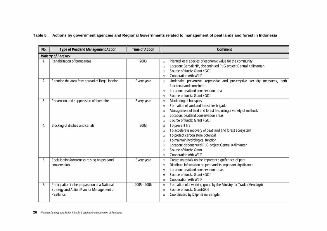
26 National Strategy and Action Plan for Sustainable Management of Peatlands
Table 5. Actions by government agencies and Regional Governments related to management of peat lands and forest in Indonesia
No. Type of Peatland Management Action Time of Action Comment Ministry of Forestry
1. Rehabilitation of burnt areas 2003 o Planted local species of economic value for the community o Location: Berbak NP, discontinued PLG project Central Kalimantan o Source of funds: Grant / GOI o Cooperation with WI-IP
2. Securing the area from spread of illegal logging Every year o Undertake preventive, repressive and pre-emptive security measures, both functional and combined
o Location: peatland conservation area o Source of funds: Grant / GOI
3. Prevention and suppression of forest fire Every year o Monitoring of hot spots o Formation of land and forest fire brigade o Management of land and forest fire, using a variety of methods o Location: peatland conservation areas o Source of funds: Grant / GOI
4. Blocking of ditches and canals 2003 o To prevent fire o To accelerate recovery of peat land and forest ecosystem o To protect carbon store potential o To maintain hydrological function o Location: discontinued PLG project Central Kalimantan o Source of funds: Grant o Cooperation with WI-IP
5. Socialisation/awareness raising on peatland conservation
Every year o Create materials on the important significance of peat o Distribute information on peat and its important significance o Location: peatland conservation areas o Source of funds: Grant / GOI o Cooperation with WI-IP
6. Participation in the preparation of a National Strategy and Action Plan for Management of Peatlands
2005 - 2006 o Formation of a working group by the Ministry for Trade (Mendagri) o Source of funds: Grant/GOI o Coordinated by Ditjen Bina Bangda

National Strategy and Action Plan for Sustainable Management of Peatlands 27
No. Type of Peatland Management Action Time of Action Comment 7. Mapping of Peatland Areas 2003 o Peat potential based on its depth and distribution
o Location: Sumatera, Kalimantan o Source of funds: Grant/GOI o Cooperation with WI-IP
8. Data collection on peat conservation areas 2005 o Compiled data on conservation areas throughout Indonesia possessing peat type ecosystems
o Source of funds: Grant Ministry of Public Works
1 Hydraulic and hydrometric survey in support of the tidal rice-field project (P4S)
1979/1980 o Location: Sumatera Kalimantan and Irian Jaya o Source of funds: GOI
2 Research and development of water management system and water regulation constructions/buildings
1996/1997 o Location: South Kalimantan o Source of funds: GOI
3 Assessment of the impact of constructing primary canals in deep peat land
1997 / 1998 o Location: Central Kalimantan o Source of funds: GOI
4 Study of the water management system during clearing of peatland ‘packet A’ for PLG project Central Kalimantan
1997 / 1998 o Location: Central Kalimantan / Kuala Kapuas o Source of funds: GOI
5 Construction of prototype lock gates in tidal swamp areas
1998 / 1999 o Location: South Kalimantan / Barito Kuala o Source of funds: GOI
6 Circulation system and leaching for the treatment of acidity
1999 / 2000 o Location: South and Central Kalimantan o Source of funds: GOI
7 Study of the division of tidal swamp water resource management area as regards agricultural cultivation
2001 o Location: South Sumatera o Source of funds: GOI
8 Study of the management pattern and policy for the development of drainage irrigation
2001 o Location: Jambi o Source of funds: GOI
9 Study and development of swamp water management system
2002 o Location: South Sumatera and South Kalimantan o Source of funds: GOI
10 Study of micro water management patterns with regard to the tidal ricefield scheme
2002 o Location: Jambi o Source of funds: GOI
11 Tidal irrigation on the East coast of Sumatera 2003 o Location: Jambi, South Sumatera, Riau o Source of funds: GOI
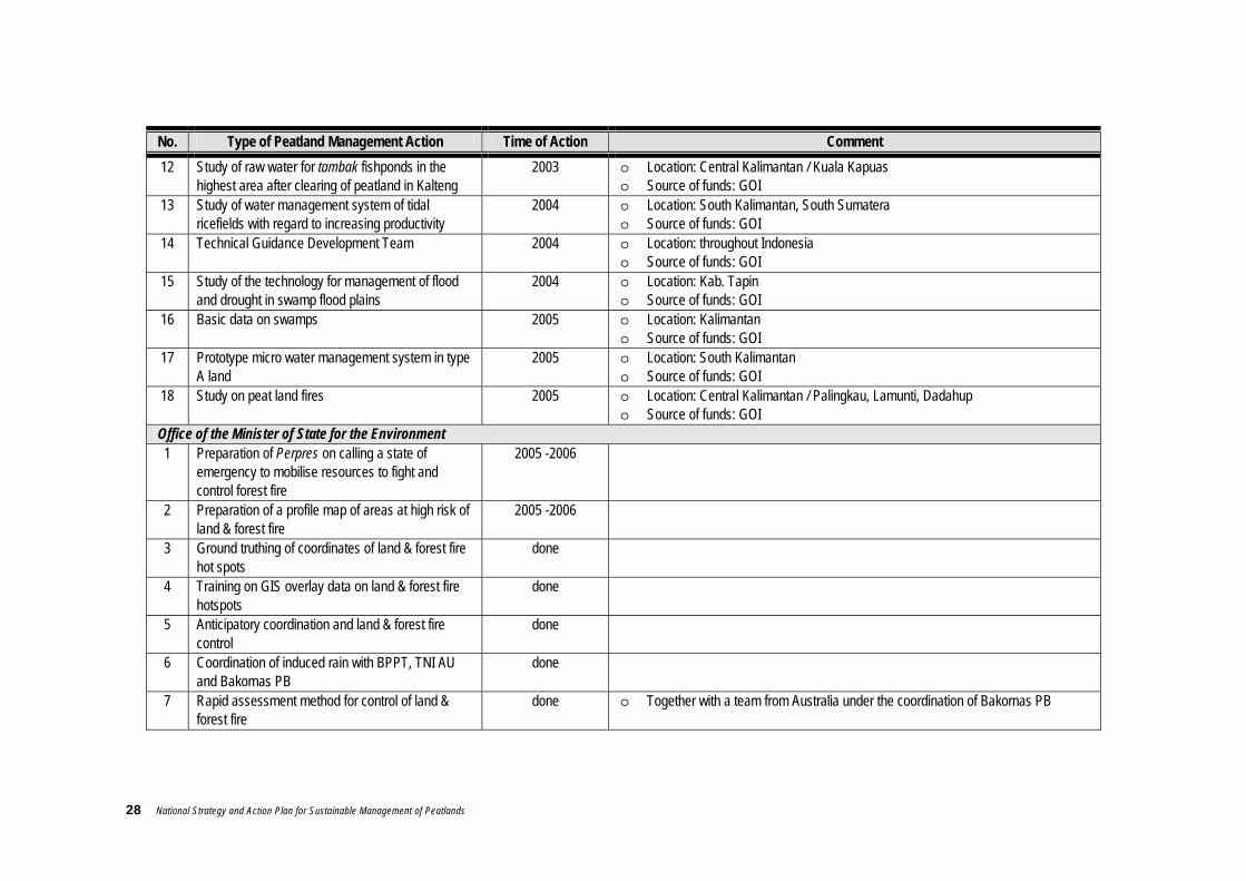
28 National Strategy and Action Plan for Sustainable Management of Peatlands
No. Type of Peatland Management Action Time of Action Comment 12 Study of raw water for tambak fishponds in the
highest area after clearing of peatland in Kalteng 2003 o Location: Central Kalimantan / Kuala Kapuas
o Source of funds: GOI 13 Study of water management system of tidal
ricefields with regard to increasing productivity 2004 o Location: South Kalimantan, South Sumatera
o Source of funds: GOI 14 Technical Guidance Development Team 2004 o Location: throughout Indonesia
o Source of funds: GOI 15 Study of the technology for management of flood
and drought in swamp flood plains 2004 o Location: Kab. Tapin
o Source of funds: GOI 16 Basic data on swamps 2005 o Location: Kalimantan
o Source of funds: GOI 17 Prototype micro water management system in type
A land 2005 o Location: South Kalimantan
o Source of funds: GOI 18 Study on peat land fires 2005 o Location: Central Kalimantan / Palingkau, Lamunti, Dadahup
o Source of funds: GOI Office of the Minister of State for the Environment 1 Preparation of Perpres on calling a state of
emergency to mobilise resources to fight and control forest fire
2005 -2006
2 Preparation of a profile map of areas at high risk of land & forest fire
2005 -2006
3 Ground truthing of coordinates of land & forest fire hot spots
done
4 Training on GIS overlay data on land & forest fire hotspots
done
5 Anticipatory coordination and land & forest fire control
done
6 Coordination of induced rain with BPPT, TNI AU and Bakornas PB
done
7 Rapid assessment method for control of land & forest fire
done o Together with a team from Australia under the coordination of Bakornas PB
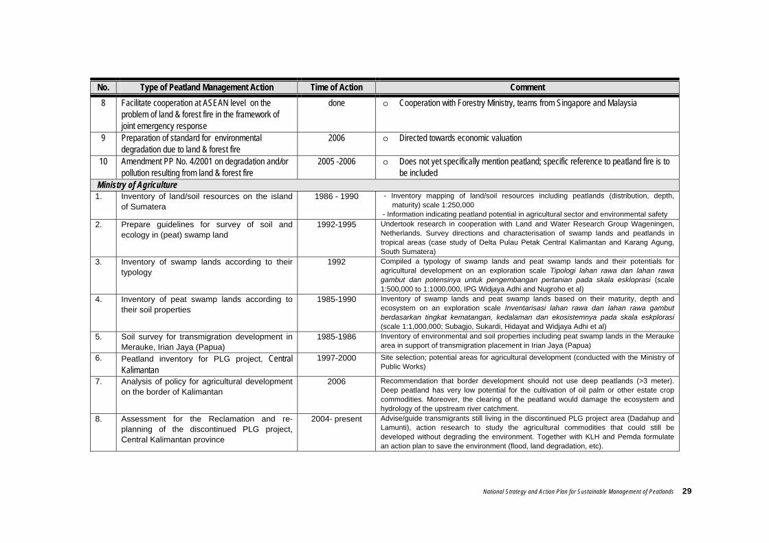
National Strategy and Action Plan for Sustainable Management of Peatlands 29
No. Type of Peatland Management Action Time of Action Comment 8 Facilitate cooperation at ASEAN level on the
problem of land & forest fire in the framework of joint emergency response
done o Cooperation with Forestry Ministry, teams from Singapore and Malaysia
9 Preparation of standard for environmental degradation due to land & forest fire
2006 o Directed towards economic valuation
10 Amendment PP No. 4/2001 on degradation and/or pollution resulting from land & forest fire
2005 -2006 o Does not yet specifically mention peatland; specific reference to peatland fire is to be included
Ministry of Agriculture 1. Inventory of land/soil resources on the island
of Sumatera 1986 - 1990 - Inventory mapping of land/soil resources including peatlands (distribution, depth,
maturity) scale 1:250,000 - Information indicating peatland potential in agricultural sector and environmental safety
2. Prepare guidelines for survey of soil and ecology in (peat) swamp land
1992-1995 Undertook research in cooperation with Land and Water Research Group Wageningen, Netherlands. Survey directions and characterisation of swamp lands and peatlands in tropical areas (case study of Delta Pulau Petak Central Kalimantan and Karang Agung, South Sumatera)
3. Inventory of swamp lands according to their typology
1992 Compiled a typology of swamp lands and peat swamp lands and their potentials for agricultural development on an exploration scale Tipologi lahan rawa dan lahan rawa gambut dan potensinya untuk pengembangan pertanian pada skala eskloprasi (scale 1:500,000 to 1:1000,000, IPG Widjaya Adhi and Nugroho et al)
4. Inventory of peat swamp lands according to their soil properties
1985-1990 Inventory of swamp lands and peat swamp lands based on their maturity, depth and ecosystem on an exploration scale Inventarisasi lahan rawa dan lahan rawa gambut berdasarkan tingkat kematangan, kedalaman dan ekosistemnya pada skala eskplorasi (scale 1:1,000,000; Subagjo, Sukardi, Hidayat and Widjaya Adhi et al)
5. Soil survey for transmigration development in Merauke, Irian Jaya (Papua)
1985-1986 Inventory of environmental and soil properties including peat swamp lands in the Merauke area in support of transmigration placement in Irian Jaya (Papua)
6. Peatland inventory for PLG project, Central Kalimantan
1997-2000 Site selection; potential areas for agricultural development (conducted with the Ministry of Public Works)
7. Analysis of policy for agricultural development on the border of Kalimantan
2006 Recommendation that border development should not use deep peatlands (>3 meter). Deep peatland has very low potential for the cultivation of oil palm or other estate crop commodities. Moreover, the clearing of the peatland would damage the ecosystem and hydrology of the upstream river catchment.
8. Assessment for the Reclamation and re-planning of the discontinued PLG project, Central Kalimantan province
2004- present Advise/guide transmigrants still living in the discontinued PLG project area (Dadahup and Lamunti), action research to study the agricultural commodities that could still be developed without degrading the environment. Together with KLH and Pemda formulate an action plan to save the environment (flood, land degradation, etc).

30 National Strategy and Action Plan for Sustainable Management of Peatlands
No. Type of Peatland Management Action Time of Action Comment 9. Assessment of the sustainable development of
the usaha tani farm system in swamp lands (including peat swamp)
1984 to 2000 Assess and formulate an usaha tani system in swamp and peat swamp areas (together with Dep.PU, KLH, University). It was recommended that shallow peat areas (<1m) be used for food crops and rice, 1-2m thick peatland could be used for plantations (oil palm, coconut, rubber), while deep peat (>3 metres) should be forested. The usaha tani system and commodities that could be grown here were demonstrated to the farmers, instructors and relevant Agencies.
10 Assessment and development of agricultural machinery in swamp land
1984 to present Together with Ministry of Public Works, agricultural machinery suitable for the ecosystem in swamp and peat swamp lands (ranging from soil working equipment to harvesters) has been assembled, constructed, and distributed
11. Inventory, classification and assessment of the typology conditions of peatlands based on the soil properties affecting the production of agricultural crops.
1985- Resulted in a classification of peat swamp lands and typology of peat swamp lands directed towards land use for agriculture. Shallow peat (50-<100 cm thick) : wet ricefields, dry land; Medium thickness peat (100- <200 cm): coconut, oil palm preceded by food and horticultural crops; Deep peat (200-300 cm) : plantations; Very deep peat (>300 cm): to be forested and become a preservation area, rainfall reservoir.
12. Assess land management technology to achieve successful farming in swamp lands, including peat swamp land
1984 –2000 Produced a handbook on technology for the management of (peat) swamp land, covering: water management, landscaping, soil processing, amelioration and fertilisation, planting patterns and cultivation technology, pest control, and mechanisation.
13. Inventory of peat swamp lands that had become dormant in Basarang - Central Kalimantan and South Sumatera
1994 - 1996 Information was obtained on the distribution of dormant/degraded land and the condition of peatland that had become degraded, and the species of vegetation usually growing in the area (dominated by rushes, shrubs and ferns, and no longer productive)
14. Assessment of methods of rehabilitating dormant land in peat swamp lands
1994 - 1999 3 approaches to rehabilitation can be followed: (1) action without change, i.e. leaving the land as it is, (2) action that does not cause drastic change, such as applying a sawah system using special rehabilitation techniques, and (3) action that intentionally brings about a drastic change. The Ministry of Agriculture Cq Puslibangtanah has studied the second approach but the results were not encouraging
15. Undertake fertilisation trials to determine the type(s) and doses of fertiliser best suited to agriculture in swamp land
1985 - 1999 Carried out in cooperation with Puslitbangtanah, Puslibang Tanaman Pangan, Dinas Pertanian Tanaman Pangan Tingkat II, the dose and specific type of fertiliser were identified for several agricultural commodities
16 Training for farmers and agricultural instructors on agricultural development in swamp lands
1995 Training was given in Karang Agung Ulu, Sumatera Selatan during 26 –30 June 1995. Material comprised : pyrites, peat, drainage, peatland problems and their solutions
17. Inventory and securing of gene pool in peat swamp land in South Kalimantan
1990- present Carried out by Balai Penelitian Pertanian Lahan Rawa: an inventory was made and several agricultural plant species were found that grow only in swamp land habitat, such as red durian, mango, pineapple rice.
18. Prepare spatial planning for the development of agricultural areas in Kalimantan
1994 Recommendations were made for national agricultural development including peat swamp land. In this context, it was recommended to the provincial government and to BAPPENAS that peat swamp > 300 cm should continue to be maintained as conservation forest / rain catchment area.
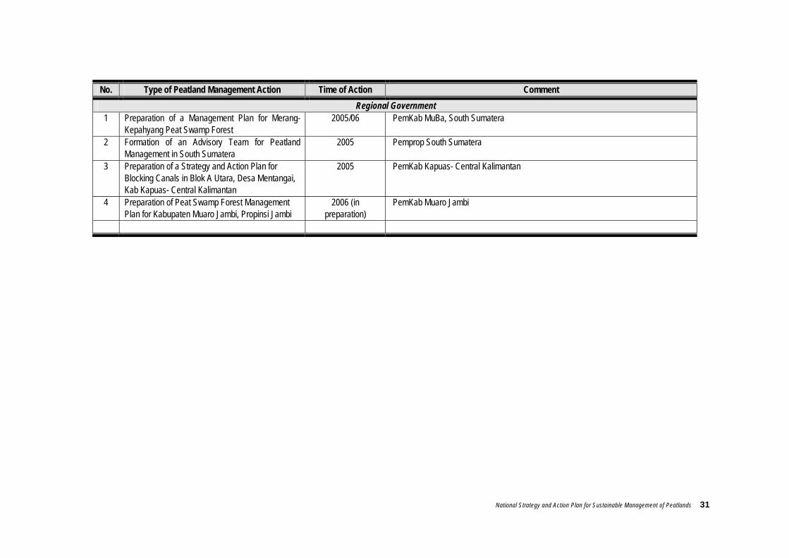
National Strategy and Action Plan for Sustainable Management of Peatlands 31
No. Type of Peatland Management Action Time of Action Comment Regional Government
1 Preparation of a Management Plan for Merang-Kepahyang Peat Swamp Forest
2005/06 PemKab MuBa, South Sumatera
2 Formation of an Advisory Team for Peatland Management in South Sumatera
2005 Pemprop South Sumatera
3 Preparation of a Strategy and Action Plan for Blocking Canals in Blok A Utara, Desa Mentangai, Kab Kapuas- Central Kalimantan
2005 PemKab Kapuas- Central Kalimantan
4 Preparation of Peat Swamp Forest Management Plan for Kabupaten Muaro Jambi, Propinsi Jambi
2006 (in preparation)
PemKab Muaro Jambi
32 National Strategy and Action Plan for Sustainable Management of Peatlands
2.5 Problems and Threats
Peatlands form a single ecosystem that should be managed based on the boundaries of that ecosystem, even if they cross over administrative boundaries or jurisdictions of particular agencies. In practice, management based on ecosystem boundaries becomes more difficult if there is not an institution that coordinates and takes full responsibility. It is admitted that so far there is no institution at either central or regional level that has the responsibility and full authority to carry out or to coordinate the management of peatlands. Basically, there are many stakeholders with an interest in peatlands. However, there is not yet an adequate mechanism for trans-sectoral coordination. The lack of a special institution, together with poor communication and coordination among agencies in Regional Government or between Regional and Central governments, make peatland management prone to conflict. In some places, these weaknesses have even threatened the conservation of natural resources. Peatland management requires policies that firmly bind every stakeholder and every actor. Peatland management requires an institution that is strong in many aspects, including territorial jurisdiction and responsibility, organisational ability, institutional capacity, and funding. A problem of equal importance is the low level of community participation in the preparation of peatland management policy. This makes the implementation of several policies contradictory, prone to conflict and difficult to carry out. This problem is further complicated by the institutional weaknesses and the weaknesses in the content of the regulations/laws and policies themselves, thus making them difficult to enforce. Another factor that strongly influences the effectiveness of law/policy enforcement is the general public’s understanding and awareness of the law and their willingness to obey it. The community’s low level of participation in preparing the peatland management plan also makes the activities and programmes one-sided and insufficiently sensitive to the local culture. It frequently happens that neither the peatland management plan nor its implementation are adapted to local conditions. Respect for and utilisation of traditional wisdom, which should form the basis for peatland management at local level, are still relatively low or even ignored. In more detail, the current problems in peatland management are:
Limited data and distribution of information on peatlands. Accurate data and information on the condition and status of peatlands in Indonesia are still limited and what there is is distributed among only a few urban districts and relevant agencies which are tackling peat issues.
Degradation of water management system. The degradation of peatland hydrology is frequently brought about by uncontrolled human activities, such as the construction of ditches and canals, logging, land burning, etc. Of these activities, the construction of open ditches and canals in peatlands (without maintaining a certain level of water in the ditch), whether for the transportation of timber (legal or illegal) from the forest or for the irrigation of fields and plantations, is thought to cause water to drain away from the peat so that it becomes dry and easy to burn in the dry season. Such conditions have been proven to be the case in several peatlands in Central Kalimantan and Sumatera where the areas around the ditches and canals have caught fire.
Another effect of the digging of ditches is that the excavated materials (litter, mud and peat bulk) enter the rivers, and this can change the river’s morphology and the quality of its water. If this continues, it is feared that it will have a negative impact on the aquatic biota.

National Strategy and Action Plan for Sustainable Management of Peatlands 33
BOX 3
Succession trends in burnt peatland (Wibisono et al., 2005)
Forest fire is one of the main causes of degradation to tropical forest in Indonesia. In1997/98 around 2,124,000 ha of Indonesia’s peat swamp forest was recorded to have burnt (Tacconi, 2003). There are also many cases of multiple fire, where the same site has caught fire time and time again. Most of the fires occurring in peat forest are serious because of the properties of the peat itself, which consists of decayed organic litter, and the vegetation growing there, which are potential fuels. The heaps of rotted organic matter that make up the peat layer can burn and lead to ground fire, i.e. fire below ground, while the even surface of the peat facilitates the spread of fire from tree to tree or through the tree canopy when the fire is on the surface. As a result, in peatlands, fire frequently occurs simultaneously below and above the ground, thus impacting on the environment and aggravating the loss of biodiversity. After fire, vegetation above the peat’s surface is lost and the peatsoil layer is diminished, forming depressions which turn into lakes in the rainy season. These pools form a medium for seed distribution because of the vegetation that appears following fire. However, only a few particular species are able to withstand these inundated conditions, such as Pandanus helicopus and Thoracostachyum bancanum. The illustrations below illustrate one hypothesis for succession that could occur on peatlands following fire in Berbak National Park, Jambi (Giesen, 2003).
Undisturbed peat swamp forest is characterised by an intact layer of peat and a variety of trees and shrubs on the surface, although herbs are limited
Fire in peat swamp forest causes the peat layer to become thinner. This type of habitat is dominated by hardy species such as Combretocarpus rotundatus, palms, growth from surviving roots, herbs or pioneers and other perennials
Repeated fires cause the loss of primary peat species and the increase of pioneer or secondary species. If the fire results in the loss of extensive areas of the peat layer, then depressions will form as temporary lakes (containing water only in the rainy season) and under such conditions only Pandanus helicopus and Thoracostachyum bancanum will appear.
34 National Strategy and Action Plan for Sustainable Management of Peatlands
Mining Mining products are an important source of the nation’s foreign exchange. Mines are scattered across many sites, including forest and peatland areas. A struggle between many interests, for example between the forestry and mining sectors, especially open mining, often occurs. In fact, however, for reasons of investment, job creation and economic growth, the forestry function is frequently sacrificed or ignored in favour of obtaining the minerals. The long term result of this is the degradation of the peat ecosystem and the loss of the social and economic values and uses and the environmental services that the peat ecosystem had previously provided. Recently, due to the increasing price of fossil fuels, private enterprises have even started to extract peat, treating it as a mining product, a source of energy for their industries. If this is allowed to continue, an even worse environmental disaster is likely, because peat is not just some inanimate material like coal, but a medium for the growth of the life on it.
Peat/Forest fire and its consequences for air pollution (due to smoke/haze) Peat land and forest fires happen almost every year in Indonesia, particularly in the dry season. They usually occur in areas belonging to the community, plantations, HPH, HTI, and even in protected areas. Some fires are started by people using fire to clear land. This is still considered to be the cheapest most practical method, to the extent that several estate companies and HTI continue to use fire, saying it is more economical, even though it is forbidden by law. According to available facts, almost all forest fires in Indonesia are caused by human activities (whether or not intentionally) and there is no evidence so far of any fires having started naturally. They are unaware of the impact of their actions: not only that it is difficult to extinguish fires on peatland because the fire travels underground often occurring in remote inaccessible places and because equipment and technology are limited, but also that the fires cause air pollution.
BOX 4 Training on Fire Fighting in Desa Sungai Aur (Sri Najiyati et al., 2005)
In Desa Sungai Aur, near Berbak National Park, Jambi, the local NGO, PINSE, facilitated by funds from WI-IP, gave training to community groups on methods for fighting fire on peatand. As a follow-up to this, and to show their concern over the fire disasters that often occurred in this village, they formed a fire brigade in Desa Sungai Aur. The members of this brigade were coached by instructors from PINSE and it is hoped that they will be able to mobilise the community to fight fires in their own village and also be available to help as fire fighters from time to time as necessary to prevent and extinguish fires in Berbak National Park. Similar brigades were also formed by PINSE in Desa Pematang Raman and Sungai Rambut, Jambi.
In order to enhance fire-fighting skills and preparedness, PINSE and Berbak NP (with funding from CCFPI-WIIP and other donors) subsequently held a joint meeting in March 2005 in Desa Sungai Aur. The basic aim of this activity, which was given the title “Berkumpul, Bergerak, Bersama” (B3) [Gather, Move, Together], was to unite and synergise the potentials of every group member in an effort to mitigate or suppress land and forest fire in the National Park in line with each stakeholder’s abilities and authority. In addition, it was hoped that this activity would enhance the members’ capabilities and skills in contolling and managing land and forest fire. Activities performed during the meeting included explanation and application of fire-fighting techniques by a government team of fire-fighting instructors, discussion among group members, and games intended to strengthen relationships and to enhance the members’ capabilities regarding the suppression of land and forest fires. Nine fire-fighting teams from 3 villages (Desa Sungai Aur, Pematang Raman and Sungai Rambut) took part, along with representatives from 14 villages in the Berbak NP buffer zone, and representatives from oil palm plantations in the vicinity.

National Strategy and Action Plan for Sustainable Management of Peatlands 35
Illegal logging There is a lack of adequate government supervision of forestry concession holders whose licences (HPH) have expired but who have not returned the land they managed, with the result that the land’s status becomes unclear as to who is responsible for managing it. This open land/forest is then exploited by local inhabitants who extract forest products such as timber, using the canals to transport it. Such exploitation has proven to be unsustainable; forests that have been logged are simply left to deteriorate and turn into unproductive fern swamps and grass swamps.
Box 4 (continued)
Fire Brigades from 3 villages (Pematang Raman, Sungai Aur and Sungai Rambut) practising, so as to be ready to deal with land and forest fires in Berbak NP expected during the coming dry season July – September 2007. Document PINSE, 2005

36 National Strategy and Action Plan for Sustainable Management of Peatlands
BOX 5
The fate of illegal loggers in peat swamps in South Sumatera
The peat swamp forest of Sungai Merang-Kepahyang, Kabupaten Musi Banyuasin – South Sumatera, has a peat depth that varies between 1-10 m. Prior to 2000, illegal logging did not seem to be an issue in this area. However, when an onslaught of around 2000 people from Kecamatan Selapan (Kabupaten Kayu Agung, South Sumatera) “invaded” Sungai Merang and Sungai Kepayang to log timber, the inhabitants of three villages in the river catchment followed suit and began to cut down trees in the peat swamp on either side of the river. People from Selapan do not settle.They live on the sides of rivers and in the forest to log the timber, only returning home to Selapan when the dry season comes. They usually log during the rainy season so it will be easy to pull the logs out of the forest along the canals in the peat or the river. If any of them do log during the dry season, they do not usually move the logs out from the forest until the rainy season. While they are in the forest, they face serious threats like attack by tigers or being struck by falling trees. When they pull the logs along the river, they are likely to be stopped by corrupt officials (‘oknum’) lying in wait to demand illegal tolls/bribes. Within the forest, they cook their own meals (rice, oil and foodstuffs are usually supplied on credit by the ‘cukong’ racketeers at double the price in the market), which risks starting forest fires. And all that, ironically, is the illegal logger’s fate: to be mauled by tigers, squashed by falling trees, ripped off by corrupt officials, and overcharged by racketeers. What little money they have left to take home to their wife and children is no more than Rp 10,000 per day. (note: at that time 1 USD = Rp 8,750) Illegal loggers usually work in groups of 8-10 members. To work in the forest for 90 days (3 months), they need to take about 5 drums of diesel oil and food supplies provided by the racketeers). They produce around 135–300 m3 of timber for wages amounting to about Rp 50,000/m3 or a maximum of Rp 15 million for the whole 3 months work. In other words, each individual logger receives about Rp 1.5 million for 3 months work or Rp 500,000 per month. This is gross, because they have to pay for the food supplied by the racketeer. If each logger is charged around Rp 200,000 per month for the food he needs (Rp 600,000 for 90 days), then all he has left to take home for his beloved family is only Rp 300,000 or Rp 10,000/person/day. With logs fetching an average price of Rp 150,000/m3 in South Sumtera, the total value of illegal timber stands at 300 m3 x Rp 150,000 = Rp 45,000,000. Just think, how much profit do the racketeers make? And how much goes into the pockets of corrupt officials ? So, from an activity so detrimental to the environment, the logger’s income is extremely small. To address the problem of illegal logging in Indonesia (particularly Kalimantan and Sumatra), can the government create alternative jobs (that pay at least Rp 10,000/person/day) for these loggers? If not, are we simply going to leave our brothers to continue logging, despite the World Bank’s prediction that Sumtera’s forests will have disappeared in 2005 and Kalimantan’s in 2010? (Condensed from observation by INN Suryadiputra in 2003, WKLB Volume 11 No. 1, 2003)

National Strategy and Action Plan for Sustainable Management of Peatlands 37
Degradation of habitat and biodiversity The very existence of peat swamp forests, with their diverse species of vegetation that function as habitat for a diversity of wildlife, is currently threatened by the increasing amount of peatland being cleared, both through logging and conversion to agriculture, plantations and housing.
BOX 6
Experience of rehabilitating burnt forest in Berbak National Park, Jambi (Wibisono et.al 2005)
Rehabilitation of burnt areas of Berbak National Park was carried out by Wetlands International Indonesia Programme in cooperation with Berbak NP, fishing communities and PT.Putra Duta Indah Wood (PIW). This activity was funded by CIDA through the Climate Change Forest and Peatlands in Indonesia (CCFPI) project. A total of 20 thousand artificial mounds with a width/length of 50-100 cm and height 30-50 cm were completed during the dry season (September 2003). Of the 20 thousand seedlings prepared, 14 thousand were planted during the rainy season (October 2003). The seedlings planted were all local species, i.e.: Ramin Gonystylus bancanus, Rengas tembaga Mellanorhoea walichii, Meranti Shorea pauciflora, Perepat Combretocarpus rotundatus, Jambu-jambuan Eugenia spp., Jelutung Dyera lowii, and Pulai Alstonia pneumatophora. These seedlings were prepared in the nurseries of PT.PIW about 29-33 km from the planting site.
Monitoring was conducted in mid-February 2004, when indundation of the planting site had reached a depth of 50cm. According to a rough estimate, 65- 85% of the seedlings survived. A further check was made on 10-11 April 2004, when inundation had reached 120 cm. Under these conditions, the percentage surviving had fallen drastically to 10%. The species able to survive such inundation conditions were Gonystylus bancanus, Shorea pauciflora, Eugenia spp., and Alstonia pneumatophora. Lessons learnt from this activity 1. Not all sites are suitable for rehabilitation. Sites highly prone to inundation (particularly very deep or long-
lasting inundation) should be avoided as the probability of success is extremely low. 2. The difficulty in knowing how the climate is changing makes it difficult to anticipate the patterns of flooding. 3. Nurseries should not be too far from the planting site. Apart from the risk of damage to the seedlings during
transportation, the cost of transporting them over long distances is very expensive. 4. Even at sites with normal conditions, inundation is always high. The creation of mounds greatly helps to
protect the seedlings from excessive inundation, but the function of these mounds will be lost if flooding is extreme.
5. Experience and information about peatland rehabilitation are very limited, which is a constraining factor in rehabilitation activities. For this reason, a variety of research and experiments should be carried out.
Preparing mounds Making a hole in the top of the mound
Burnt peat forest in Berbak National Park, Jambi

38 National Strategy and Action Plan for Sustainable Management of Peatlands
Insufficient Government guidance to the community on the wise management of
peatlands So far, community management of peatlands has lacked adequate technical guidance from relevant agencies. The community’s use of fire to clear the land, coupled with excessive drainage, have degraded the peatlands. From the start, there is often poor awareness of technical constraints such as low soil fertility, subsidence due to drainage, etc. Then, the resulting failures cause the farmers to abandon these degraded lands.
BOX 7
Comparative study by peatland farmers from Central Kalimantan to Jambi and South Sumatra and vice versa
A comparative study for a number of peatland farmers from Central Kalimantan to Jambi and South Sumatera (and vice versa) was held by WI-IP in 2004 through the CCFPI project. The purpose of this activity was for the peatland farmers from different parts of the country to see directly and learn from the environmentally friendly peatland management practices in the area they visited and then apply them in practice on their return home. The activity involved about 50 peatland farmers and their companions, from both islands. In addition to field visits, they were also given classroom “lectures” to raise their awareness of the uniqueness and vulnerability of the peatlands on which they lived and worked, and therefore of the need to have a deep understanding of them in order to manage them properly.
The pictures below show some of the activities participants carried out during the field visits. These included visits to the lands of farmers who had successfully developed an environmentally friendly cultivation system, such as the “tumpang sari” intercropping of trees and food crops in peatland, making “bokasi” compost, organic farming, and water management in peatland through blocking the canals. In addition, the participants had the opportunity to visit peatlands that had been badly degraded as a result of excessive drying and fire. At the end of the activity, a number of selected participants were given working capital to develop environmentally friendly agricultural practices in their own village.

National Strategy and Action Plan for Sustainable Management of Peatlands 39
Lack of specific policies regulating peatlands There is currently a lack of policies or regulations that specifically govern sustainable management of peatlands. Peatland management is usually just one component in regulations that address matters of a more general nature.
There is as yet no institution that has the authority or responsibility to manage peatlands Many problems have arisen due mainly to the degradation of peatswamp land (e.g. in Riau province) caused by a variety of interests, primarily related to enhancing economic growth, with the result that the exploitation of natural resources has not taken into account the level of conservation nor sustainability. This has happened because inadequate attention has been paid to the importance of peatlands in supporting sustainable development, and because no institution has been given the authority to manage and protect the peatlands in Indonesia.
Figure 4. Flooding in peatland village desa Sungai Aur, Jambi. One factor that must be considered in programs to develop agricultural land on peat
(Source of photo: Indra Arinal, 2004)
BOX 8
Small Grant Funds Sumatera
Wetland International – Indonesia Programme through the CCFPI (Climate Change, Forest and Peatland Indonesia) project funded by CIDA (Canadian International Development Agency) during 2002-2004, gave a number of Small Grant Funds to community groups for peatland conservation activities. After passing through several stages (Socialisation, submission of proposals, administrative selection and field verification) the winners of the small grants were decided upon. These included a community group from Desa Jebus village (Kelompok Tani Suka Maju) consisting of 16 families. Desa Jebus is situated in Kecamatan Kumpe Hilir Kabupaten Muaro Jambi, and is one of the villages in the buffer zone of Berbak National Park. Most of the people there live from farming and marine fishing. However, their farmland is unprofitable, suffering from flooding in the rainy season and drought in the dry season. They needed to find an alternative, more appropriate source of income. The community group who received the small grant chose to develop free range chicken farming and, in return for the funds from CCFPI, they planted and cared for a number of trees on the peatlands opposite their village and also played an active role in combatting fire hazard in the peatlands near their village.

40 National Strategy and Action Plan for Sustainable Management of Peatlands
There are plenty of technical problems associated with the development of peatlands for plantations, agriculture and fishery. Some of the main ones are:
Limited knowledge regarding peatland management One of the main obstacles to peatland management in this region is the limited amount of knowledge about peatland functions and management. Except for a few examples, the components and functions of peatlands are still poorly understood or quantified compared with other ecosystems. The information currently available is insufficient to assess what effect the development of tropical peatlands will have. Moreover, the complexity of the peatland system is still poorly understood, and there is a failure to comprehend how important its natural functions are.
Figure 5. Water management in plantations on peatlands growing pinang in Desa Mendahara Hulu, Jambi (left) and oranges in Desa Basarang, Central Kalimantan (right). How long will
these last? Remember, peatlands are prone to subsidence.
Conflicting and overlapping policies Indonesia’s peatlands are sorely affected by a variety of conflicting and overlapping policies. One example is the discontinued one million hectare Mega rice PLG project in Kalimantan where the peatlands were dried out for agriculture, even though these wetlands had little agricultural value and in fact were much more valuable for the ecological functions they had performed when still in their natural state. In addition, even though several areas of peatland are protected by law, there is still the problem of poor law enforcement.
Issues of definition Another obstacle to peatland management in Indonesia is the lack of a clear, commonly accepted definition and classification of peatlands. This leads to problems in classifying peatlands for land use purposes, and difficulty in developing common management guidelines.

National Strategy and Action Plan for Sustainable Management of Peatlands 41
Lack of understanding In many cases, the guidance given to farmers and agricultural agencies has not been oriented towards the needs of the farmers; this is especially important as peatland farmers face needs and constraints that are different from those faced by farmers in non-peat lands. For this reason, the success of the comprehensive rural development approach which involves the participation of the rural community from the beginning of the decision making process, will be used as a reference for peatland development.
Constraints of infrastructure and facilities At several peatland development sites, the macro water management system constructed by the government has usually failed to take into consideration the topography and height of the land, with the result that the farmers are unable to utilise the tidal dynamics which are characteristic of this type of land. If the condition of the macro water management system can be restored, then the provision of production facilities and infrastructures, and the empowerment of peatland farmers, can be carried out well.
Lack of information on prioritized products The development of an area should always involve an evaluation of whether or not that area is suited to producing prioritized commodities of a certain type. Peatlands have many characteristics which make them unsuitable for the production of agricultural commodities. .
Pests There are currently many areas of peatland that are lying fallow because the farmers are not yet able to use them. These fallow lands can become breeding grounds for pests such as rats and pigs which will in turn destroy all the plants in the area; moreover, fallow land is one cause of fire spreading because the owner does not care about it. So far, no serious effort has been made to deal with this problem.
Transmigration programme The relocation of transmigrant farmers to peatlands has not been based on the farmers’ own background experience/knowledge of peatlands. These transmigration programmes have therefore failed; some of the transmigrants then left and some resorted to illegal logging in the peatlands.
Constraints resulting from the land’s biophysical characteristics The biophysical characteristics of peatlands make them difficult to use for the development of agriculture or infrastructures. These characteristics include : • Subsidence when drained • Irreversible desiccation when dried excessively • Easily combustible • Low pH • Deficient in macro nutrients: P and K • Deficient in micro nutrients: Zn, Cu and B
Lack of information on the overall value of the peatland ecosystem
So far, the evaluation of peatlands has been centred only on the timber growing there. A fully comprehensive evaluation, incorporating the social, economic and cultural values, biodiversity and environmental services that peatlands can provide, has not yet been made; as a result, their current exploitation (primarily to extract timber) tends to ignore other values. The results of a detailed assessment of the economic value of peatlands in Blok Perian East Kalimantan undertaken by W-IP in 2000 (Table 6) shows that in fact the value of these peatlands lay not in their trees but in their fish (Wibowo, et al. 2000).

42 National Strategy and Action Plan for Sustainable Management of Peatlands
Table 6. Production Volume and Economic Benefit from the Direct Use of Forest Products from Peatlands in Blok Perian in 2000.
No. Type of Forest Product Production Volume Annual Economic Benefit (Rp)
Contribution to Total Benefit (%)
1 Construction timber 2,843.30 m3 852,991,200 10.49 2 Firewood 439,799 bundles 1,011,538,648 12.45 3 All purpose wood 754 lengths 565,740 0.007 4 Wooden shingles 51,534 packs 386,507,430 4.76 5 Bamboo 14,569 lengths 4,370,669 0.05 6 Rattan 164,273 lengths 62,423,719 0.77 7 Damar 222.91 kg 144,893 0.002 8 Medicinal plants 10,345 plants/species 14,896,829 0.18 9 Deer 168 82,484,465 1.02 10 Pigs 71 5,313,600 0.07 11 Anteaters (Trenggiling) 1 37,786 0.00 12 Burung Tiung 1 94,464 0.001 13 Burung Murai Batu 41 614,016 0.008 14 Burung Telisak 1 2,390 0.00 15 Burung Punai 301 452,049 0.006 16 Fish 2,852,851.56 kg 5,705,703,120 70.20
Total 8,128,141,017 100
2.6 The need for a peatland management strategy
There are many similarities in the peatland management problems faced by the district, municipal and provincial governments of those areas in Indonesia that possess peatlands. Problems that frequently arise are fire, drainage, inappropriate management practices, livelihood options, sustainability issues, etc. There is also a similarity in their need for awareness raising, education and information exchange, for capacity building and training, for prevention and suppression of fire, for the wise use, rehabilitation and inventory of peatlands, for research and demonstration projects.
To overcome these problems, the following need to be done:
Improve knowledge of the peatland ecosystem. This includes increasing awareness & capacities of stakeholders through : (a) education, (b) sharing information and making it available, (c) training and workshops, (d) improving peatland management by the local community groups – for example, through sustainable economic activities for the community, (e) resolving the issues regarding the definition of ‘peat’ (f) developing various management and restoration options; (g) research, monitoring and evaluation..
Resolve the various conflicts of interest within and between local inhabitants, industry and government.

National Strategy and Action Plan for Sustainable Management of Peatlands 43
Correct and/or nurture the creation of better policies and institutional frameworks. These should include efforts to improve the resolution of conflicts among stakeholders regarding the exploitation of peatland and its resources and to improve law enforcement.
In view of these similarities, a general reference manual is required to resolve the problems and meet the needs. For this purpose, the “National Strategy and Action Plan for Sustainable Management of Peatlands” is urgently needed, so it can become the reference manual for the development of management at both national and regional levels.
2.7 Regional Cooperation
The issues related to peatlands are not limited to local and national level, but are also on the agenda at both regional and international level. ASEAN regional cooperation related to the preparation of this national strategy and action plan includes the following :
ASEAN Vision 2020. This medium-term action plan and meetings of ASEAN Environment Ministers have guided ASEAN cooperation on the environment
ASEAN Concord II (Bali Concord II). ASEAN leaders promised by the year 2020 to have
achieved an ASEAN community founded upon three pillars: the “ASEAN Security Community”, “ASEAN Economic Community” and “ASEAN Socio-Cultural Community”
The Haze Technical Task Force (HTTF), established in 1995, is a subsidiary body of the
ASEAN Senior Officials on the Environment (ASOEN). HTTF is chaired by Indonesia and consists of senior officials from the ten ASEAN member countries. It focuses on fire management efforts (including/especially peatland fires) in specific areas.
Regional Haze Action Plan (RHAP). This was endorsed by the ASEAN Environment
Ministers in December 1997 during a period of fires and transboundary smoke haze pollution. Under the overall RHAP framework, strategic activities are directed towards strengthening the region’s capacity and capability to address the problem of transboundary smoke haze pollution.
ASEAN Agreement on Transboundary Haze Pollution signed by the ASEAN member
countries on 10 June 2002 in Kuala Lumpur, Malaysia. This Agreement contains provisions on monitoring, assessment and prevention, technical cooperation and scientific research, mechanisms for coordination, lines of communication, and simplified immigration and customs procedures for disaster relief.
ASEAN Peatland Management Initiative – APMI. The concept for this was developed
through discussion with various ASEAN agencies during 1999 – 2003. ASEAN regional cooperation related to the development of peatland management and strategy can be seen in Annex 7.
44 National Strategy and Action Plan for Sustainable Management of Peatlands
3. National Strategy and Action Plan for Sustainable Management of Peatlands (NSAPSMP)
3.1 Basic principles
Everyone concerned with peatland management should share the same way of looking at peatlands, so as to minimise the possibility of strategies and activities going off in different directions. In looking at peatland potentials, the following two views should form the basis of understanding:
Peatlands naturally follow a certain physiographical form irrespective of any administrative territorial borders. In their management, peatlands must be seen as a single intact ecosystem with the peat dome as its centre.
Peat is a growth medium. As such, it possesses certain physical and chemical properties which together with other environmental factors have resulted in a unique ecosystem with a unique biodiversity. All treatment of peat as anything other than as a growth medium is highly likely to lead to a negative environmental impact that far exceeds the benefit obtained.
To facilitate understanding of the following chapters, some basic definitions/meanings will be given here. The terms defined are : peatland management, integrated peatland management, wise management of peatlands and sustainable management of peatlands.
Peatland management covers all aspects of management: conservation, utilisation, and the control of peatland degradation, and also covers one integrative and intact management unit of the peatland ecosystem that comprises the entire process of planning, implementation, monitoring and evaluation.
Integrated peatland management is management that involves all interests and stakeholders, from all sectors and all administrative areas.
Wise management of peatlands is management that pays attention to the equilibrium of the ecosystem and environmental carrying capacity.
Sustainable management of peatlands is the management of peatland resources that is directed not only towards the interests of current generations but also the interests of future generations.
3.2 Challenges for Sustainable Peatland Management in Indonesia
As already mentioned, Indonesia possesses approximately 20 million hectares of peatland, comprising 50% of global tropical peatlands. These peatlands have significant importance for socio-economic development and they support the local community’s livelihoods. Moreover, if managed well, paying attention to their natural characteristics, peatlands are capable of providing a

National Strategy and Action Plan for Sustainable Management of Peatlands 45
range of environmental services both for people and also for the other creatures living on and around them. These include their role in mitigating the impact of global climate change through their capacity to sequester and store huge quantities of carbon, their role as hydrological regulators, as habitat for unique biodiversity, as suppliers of food (freshwater fish and other natural products), timber, non-timber products (e.g. rattan and honey) and so on. However, these roles are frequently ignored as a result of non-integrated and conflicting policies. Indonesia’s peat lands and forests are currently under increasing pressure, mainly from forest exploitation as well as from intensive and extensive clearing of land for the needs of industry (e.g. HTI), and to increase food production (e.g. oil palm plantations). Directly or indirectly, all these activities end in the degradation of the peatland ecosystem. This degradation occurs as a result of the use of fire to clear land, and the construction of ditches/channels for drainage and for transporting forest and non-forest products thus allowing the peat water to drain away leaving the peat dry and easily combustible or prone to subsidence. During the last 10 years, peatland conversion to oil palm and pulp wood plantations, unsustainable logging and large-scale agriculture are estimated to have degraded around 6 million ha of peatland. Visions of turning peat into an energy source also require care and thorough assessment. ‘Mining’ peat for fuel will reduce its volume. This will certainly diminish the peat’s value as regards the physical characteristics related directly or indirectly to its volume, such as its capacity for holding water, and that will diminish its flood control function. 3.3 Rationale for a National Strategy
So far, a variety of peatland management activities have been carried out in Indonesia by certain agencies, with a poor level of understanding of conservation issues. For example, deep peatland has been cleared for agriculture and housing, with no attention paid to conservation of water or land, despite presidential decree No 32/1990 stipulating that this type of land must be protected. This demonstrates lack of coordination between agencies active in the development sector with those in the peatland conservation sector. Cooperation has been forthcoming on some matters, but this has been limited. For example, initial measures resulting from the formation of the Land and Forest Fire Control Post and others have, so far, focused only on steps to address the problems of fire and smoke haze, but have not yet included the need for a long-term strategy for measures that should be carried out in other sectors (agriculture, plantations, etc.) which routinely cause fire and degradation of peatlands. There are similarities in the problems occurring at many places in Indonesia’s peatland sites, like land and forest fire, over-drainage, illegal logging, and unwise management practices. For this reason, this national strategy has been developed to provide a general, basic framework for overcoming common problems in peatlands, for stakeholders in the districts and municipalities throughout Indonesia that possess peatlands. Thus, actors in different areas can share their experiences in carrying out the action programmes for sustainable management of peatlands. In this way, duplication of effort and unnecessary actions can be avoided, thereby saving energy and money. In this instance, central government will not only act as a collective body in developing this strategy, but will also monitor, integrate and facilitate the funding and implementation of the action plan for peatland management by regional governments.
46 National Strategy and Action Plan for Sustainable Management of Peatlands
Essentially, peatland management is expected to fulfil a range of demands and developments. This is illustrated by fulfilment of the following management principles:
Principle of Conservation, meaning that peatland resources are utilised sustainably in a way that preserves their functions.
Principle of Balances, meaning the balance between the social, environmental and economic functions.
Principle of Public Benefit, meaning that the peatland resource is managed so as to provide maximum benefit for the public interest, effectively and efficiently.
Principle of Integration and Harmony, meaning that the peatland resource is managed in an integrated manner so as to achieve harmony among the different interests and also paying attention to the natural dynamic characteristics of peatland.
Principle of Justice, meaning that the peatland resource is managed fairly, for all levels of the local community, such that every citizen really has the same opportunity to play a role and enjoy the results.
Principle of Independence, meaning that the management of a peatland resource pays attention to the capabilities and strengths of local resources.
Principle of Transparency and Accountability, meaning that the management of peatland resources is open and can be accounted for.
3.4 Goals of the National Strategy
The goal of this national strategy is to promote sustainable management of peatlands in Indonesia through the collective actions of the various stakeholders, and to spur cooperation to support and sustain local livelihoods, reduce the risk of fire and associated haze, and contribute to global environmental management. This national strategy is an “umbrella” that provides a general framework for Government and stakeholders at district/municipal/provincial level who have a responsibility or commitment to sustainable peatland management, its wise use, fire prevention and land rehabilitation. This strategy has been developed with reference to the principles of regional cooperation contained in the Declaration of ASEAN Concord II (Bali Concord II). It will also contribute to the development of the ASEAN Socio-Cultural Community (ASCC), intended to strengthen cooperation in addressing regional problems including matters related to environmental degradation and transboundary pollution. In addition, the strategy is expected to contribute towards implementation of the ASEAN Agreement on Transboundary Haze Pollution and the ASEAN Regional Haze Action Plan. This national strategy is also a master plan for coordinated, ecosystem-based peatland management that covers: peatland conservation, peatland utilisation, and control of peatland degradation. It forms a basis for the description of a peatland resource management programme, further delineated in the action plans of each relevant agency. Because of the diverse potentials of peatland resources and the differing levels of need for land and the potentials contained within it, the order of priorities for peatland management is determined according to the local needs.

National Strategy and Action Plan for Sustainable Management of Peatlands 47
3.5 General Objectives
The National Strategy and Action Plan for Sustainable Management of Peatlands (NSAPSMP) has four general objectives, which are based on the general objectives agreed upon by ASEAN (APMS) but do not stray from the needs relevant to Indonesia. These general objectives are: General Objective 1. Enhance awareness and capacity on peatlands: To stimulate
awareness and understanding of peatland issues and to build capacity on the wise use and sustainable management of peatlands in Indonesia.
General Objective 2. Address the destruction and degradation of peatlands: To reduce the
rate and amount of destruction and degradation of peatlands, to enhance the prevention, control and monitoring of the destruction/degradation of peatlands, including the consequences of such damage, through collective efforts among local areas or cooperation at national and/or regional level.
General Objective 3. Promote sustainable management of peatlands: To promote integrated
management of peatlands for a variety of sectors, including forestry, water, agriculture, plantations, local community livelihoods, and rehabilitation of degraded peat swamps forest and peatlands.
General Objective 4. Promote cooperation among Kabupaten districts, municipalities,
provinces, and even regional cooperation: To promote and enhance cooperation through information exchange, research and partnerships in the implementation of activities and development of available resources.
3.6 Operational Objectives
Each of the general objectives above will be delivered in the form of operational objectives, grouped into 12 focal areas.

48 National Strategy and Action Plan for Sustainable Management of Peatlands
Table 7. Focal areas and operational objectives for peatland management in Indonesia
Focal Areas Operational Objectives 1.1. Determine the extent and status of peatlands throughout Indonesia (including issues of definition) 1.2. Assess problems and constraints faced in peatland management 1.3. Monitor and evaluate peatland status and management to ascertain current and future dynamics 1 Inventory, Assessment and Research
1.4. Undertake priority research activities to obtain information concerning techniques for sustainable peatland management 2.1. Enhance public awareness on the importance of peatland, its vulnerability to fire and the threat to health of haze, through implementation of a
comprehensive plan 2 Awareness and Capacity Building 2.2. Build institutional capacity on the management of peatlands
3 Information Sharing 3.1. Enhance information management and promote sharing of information on peatlands
4 Policies and Legislation 4.1. Develop and strengthen policies and legislation related to protection of peatlands and mitigation of peat fire
5 Prevention, Control and Monitoring of Degradation and Fire
5.1. Mitigate and minimize peatland degradation and fire
6 Conservation of Peatland Diversity 6.1. Promote conservation of peatlands with high biodiversity value (High Conservation Value Forest) 7.1. Promote multi-agency involvement in peatland management 7.2. Promote integrated water resources and peatland management using a basin-wide approach and avoiding fragmentation, for each
development sector (forestry, agriculture and plantations, etc) 7.3. Promote integrated management of peatland forest
7 Integrated peatland management
7.4. Promote integration of peatland management with community empowerment in the development of livelihoods
8 Creation and Promotion of Demonstration plots (Demplot) for Peatland Management
8.1 Promote the application of best management practices for peatlands
9.1. Develop appropriate techniques for the rehabilitation of degraded peatlands 9 Restoration and Rehabilitation 9.2. Rehabilitate peatlands that have been degraded by fire, drainage, or other causes
10.1. Protect and improve function of peatlands for carbon sequestration and storage, and adaptation to climate change 10 Peatland and Climate Change 10.2. Support process of peatland adaptation to global climate change 11.1. Promote exchange of expertise/experience in addressing peatland management issues 11.2. Strengthen Centres for the Study and Management of Peatlands (Pusat Studi & Pengelolaan Lahan Gambut) at district, provincial and
national levels 11 Cooperation among different areas (District, Province, National)
11.3. Increase contribution to the implementation of agreements and regional cooperation mechanisms 12 Financing 12.1 Increase financial resources required to implement programmes and achieve the target of the strategy

National Strategy and Action Plan for Sustainable Management of Peatlands 49
3.7. Action Plan
From Table 7 above, each operational objective is delineated in more detail into the form of an action plan. In addition to a list of actions, the action plan table also contains information on the stakeholders who will implement or support the actions, the level of priority and time scale for each action, and indicates the source or mechanism through which the action is expected to be funded. (see Table 8) Action As this is basically a general guide, the action points given in the action plan table are general in character. Before they can be applied in practice, they need to be delineated as actions appropriate to the local conditions. Considering that some of these action points are currently being (or have already been) carried out by several relevant agencies (see Annexes 5 and 6), repetition/duplication should be avoided as far as possible in order to economise on funding and labour. If an action does need to be repeated, it should refer to what has already been done so as to achieve optimal, useful results. Responsible agencies The information shown in this column is intended to enhance coordination in the action’s implementation. If an action is implemented by more than one agency, the implementation should be coordinated by the most relevant agency with the support of the others. In order to avoid confusion or overlapping during implementation, each actor is expected to inform the coordinator and other relevant agencies prior to starting field activity. Coordination meetings chaired by the leadership from the relevant coordinating agency and attended by all the stakeholders concerned, will greatly help to avoid such overlapping. Priority and time scale The three priority levels (Very important/V, Important/I and Ordinary/O) assigned in Table 8 are not rigid and can be adapted to the specific conditions, needs and interests of each particular area concerned. Three time scale categories are proposed: short term (S), medium term (M) and long term (L). It is expected that actions will be completed in 5 years (short term), 5–10 years (medium term), or 10–25 years (long term). The validity of this National Strategy and Action Plan for Sustainable Management of Peatlands is scheduled to last at least 15 years (2006 – 2021). The NSAPSMP document and its implementation will be evaluated every 5 years by the National Working Group on Peatland Management on the basis of inputs and considerations from other stakeholders with an interest in peatlands management.

National Strategy and Action Plan for Sustainable Management of Peatlands 50
Table 8. Action Plan
Operational Objectives Action
Responsible Agencies (+ Partner/
Working Group)
Time scale (S/M/P) 1/5/10 years
Priority V:Very important
I: Important O: Ordinary
Funding *)1
1.1.1 Harmonize definition and classification of peatlands (e.g. type, depth, vegetation, water regime, extent)
BPPT Puslitanak *)2
S V APBN 1.1: Determine the extent and status of peatlands throughout Indonesia (including issues of definition)
1.1.2 Determine and update the extent and status of peatlands throughout Indonesia through comprehensive national inventories (including status of protection, degradation and land use)
Puslitanak and Bakosurtanal
M V APBN
1.2. Assess problems and constraints faced in peatland management
1.2.1 Identify problems, constraints and opportunities faced in peatland management to obtain potential of best peatland management option/model
LH & Dephut M V APBN
1.3.1 Develop a guideline for monitoring & evaluation of ecological change in peatland areas
BPPT LIPI
M O APBN 1.3: Monitor and evaluate peatland status and management to ascertain current and future dynamics
1.3.2 Undertake regular monitoring & evaluation of peatland areas, including peatland water quality and physico-chemical conditions, hydrology and biology.
Dephut & LIPI P O APBN
1.4.1 Undertake integrated research on peatland ecosystems, including physico-chemical water quality, hydrology, biology and socio-economic values for the purposes of sustainable peatland conservation and use.
LIPI & PT P I APBN
1.4.2 Undertake R&D to enhance existing or develop new uses for peatland products and resources insofar as this does not degrade the peatland ecosystem
BPPT and LIPI P O APBN
1.4: Undertake priority research activities to obtain information concerning techniques for sustainable peatland management 1.4.3 Undertake research into traditional peatland management
practices and knowledge that form part of the local wisdom, so as to promote community empowerment and alternative, sustainable livelihoods.
BPPT and LIPI P O APBN
1. Inventory, Assessment and
Research
1.4.4 Undertake research on silviculture techniques for indigenous peatland species, especially prioritized species, potentials and prospects for cultivation as part of the sustainable rehabilitation and reforestation of peatlands
Dephut & Deptan M I APBN
*)1 Information under ’funding’ is indicative only *)2 Inventory, Assessment and Research activities can involve universities as partners S = short (1 yr); M = Medium (5 yr); P = long (10 yr)

National Strategy and Action Plan for Sustainable Management of Peatlands 51
Operational Objectives Action
Responsible Agencies (+ Partner/
Working Group)
Time scale (S/M/P) 1/5/10 years
Priority V:Very important
I: Important O: Ordinary
Funding *)1
2.1.1 Develop and implement a communication strategy for peatland management, including use of video, TV, media, schools, extension services, workshops, information exchange programmes and networks such as mailing lists
KOMINFO & Depdagri
P I APBN
2.1.2 Prepare extension materials to enhance the community’s understanding of peatland values, threats, impacts and management options
LH & Dephut M I APBN
2.1: Enhance public awareness on the importance of peatland, its vulnerability to fire and the threat to health of haze, through implementation of a comprehensive plan 2.1.3 Develop appropriate awareness materials and activities for the
general public (of all ages, educational levels, including pre-school environmental education) and relevant government agencies, both central and regional, to enhance their understanding of peatland values, threats, impacts and sustainable management options, and to undertake socialization, enhance comprehension and make recommendations to agencies concerned with policy making (executive and legislative) related to peatland management at both central and regional levels
Depdagri & LH & Dephut
M I APBN
2.2.1 Support and enhance human resources and strengthen institutional capacity related to sustainable peatland management
Depdagri and LH M M APBN
2.2.2 Develop a core group of relevant experts and associations to conduct assessments, evaluations and recommendations for other stakeholders who will be undertaking actions related to peatland management/use.
Depdagri and LH P V APBN
2. Awareness and Capacity
Building
2.2: Build institutional capacity on the management of peatlands
2.2.3 Enhance coordination among stakeholders related to peatland management through networks or working groups
Depdagri, LH & Bappenas
M I APBN
3.1.1 Establish or strengthen existing information systems (e.g. Database) or clearing houses to manage and make available information related to peatlands
Peatland Working Group Secretariat
P I APBN
3. Information Sharing
3.1: Enhance information management and promote sharing of information on peatlands
3.1.2 Enhance national capacity for information sharing on peatland management among agencies at both central and regional/local level
Dep-Kominfo P I APBN

52 National Strategy and Action Plan for Sustainable Management of Peatlands
Operational Objectives Action
Responsible Agencies (+ Partner/
Working Group)
Time scale (S/M/P) 1/5/10 years
Priority V:Very important
I: Important O: Ordinary
Funding *)1
4.1.1 Formulate or update policies and strategies relating to peatland conservation and cultivation, including facilitation of integrated land use planning and management for peatlands, through a thorough planning process that involves relevant stakeholders at national, provincial and district levels.
Relevant sectors + Working Group
S I APBN
4.1.2 Formulate criteria and indicators of sustainable peatland development (determine standards for peatland management, e.g.: subsidence threshold, water quality, peat water level, etc.)
Sektor teknis + Working Group
S I APBN
4.1.3 Develop regulations prohibiting the extraction of peat as a source of energy
LH 4. Policies and Legislation
4.1: Develop and strengthen policies and legislation related to protection of peatlands and mitigation of peat fire
4.1.4 Enhance and strengthen law enforcement (including customary ‘adat’ law) on the protection and wise management of peatlands, illegal logging and harvesting of peatforest products, the chain of illegal trade at local, national and regional levels, including the mechanism for addressing the international trafficking of forest products
Depdagri and Dephut
S I APBN/APBD
5.1.1 Identify peatlands with high risk of degradation and fire (intensity of human activity, water level, peat water content, climatic conditions, drainage) and develop and promote preventive measures
LH & Dephut & Deptan
M I APBN/APBD
5.1.2 Develop an early warning system for fire hazard (based on weather conditions, human activity and hot spots) in peatland areas with high fire risk
BPPT & LH M I APBN/APBD
5.1.3 Develop and promote systems and techniques (modern and traditional) for managing groundwater levels in peatlands so that the peat remains wet and difficult to burn (includes prevention of overdrainage and subsidence). For example, the long ‘beje’ ponds in the peatlands in Kalteng help keep peat moist.
Working Group Secretariat
M I APBN/APBD
5. Prevention, Control and
Monitoring of Degradation and
Fire
5.1: Mitigate and minimize peatland degradation and fire
5.1.4 Enhance capacity of and coordination among agencies involved in peatland fire prevention and control, including the smallest
Kantor Menko Kesra & Dephut
S I APBN/APBD
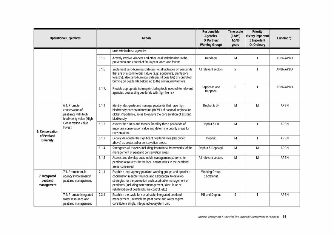
National Strategy and Action Plan for Sustainable Management of Peatlands 53
Operational Objectives Action
Responsible Agencies (+ Partner/
Working Group)
Time scale (S/M/P) 1/5/10 years
Priority V:Very important
I: Important O: Ordinary
Funding *)1
units within these agencies
5.1.5 Actively involve villagers and other local stakeholders in the prevention and control of fire in peat lands and forests
Depdagri M I APBN/APBD
5.1.6 Implement zero-burning strategies for all activities on peatlands that are of a commercial nature (e.g.: agriculture, plantations, forestry); also zero-burning strategies (if possible) or controlled burning on peatlands belonging to the community/farmers
All relevant sectors S I APBN/APBD
5.1.7. Provide appropriate training (including tools needed) to relevant agencies possessing peatlands with high fire risk
Bappenas and Bappeda
P I APBN/APBD
6.1.1 Identify, designate and manage peatlands that have high biodiversity conservation value (HCVF) of national, regional or global importance, so as to ensure the conservation of existing biodiversity
Dephut & LH M M APBN
6.1.2 Assess the status and threats faced by these peatlands of important conservation value and determine priority areas for conservation.
Dephut & LH M I APBN
6.1.3 Legally designate the significant peatland sites (described above) as protected or conservation areas.
Dephut M I APBN
6.1.4 Strengthen all aspects including ‘institutional frameworks’ of the management of peatland conservation areas
Dephut & Depdagri M M APBN
6. Conservation of Peatland
Diversity
6.1: Promote conservation of peatlands with high biodiversity value (High Conservation Value Forest)
6.1.5 Assess and develop sustainable management patterns for peatland resources for the local communities in the peatland areas conserved
All relevant sectors M M APBN
7.1. Promote multi-agency involvement in peatland management
7.1.1 Establish inter-agency peatland working groups and appoint a coordinator in each Province and Kabupaten, to develop strategies for the protection and sustainable management of peatlands (including water management, silviculture or rehabilitation of peatlands, fire control, etc.)
Working Group Secretariat
7. Integrated
peatland management
7.2: Promote integrated water resources and peatland management
7.2.1 Establish the basis for sustainable, integrated peatland management , in which the peat dome and water regime constitute a single, integrated ecosystem unit.
PU and Dephut S I APBN
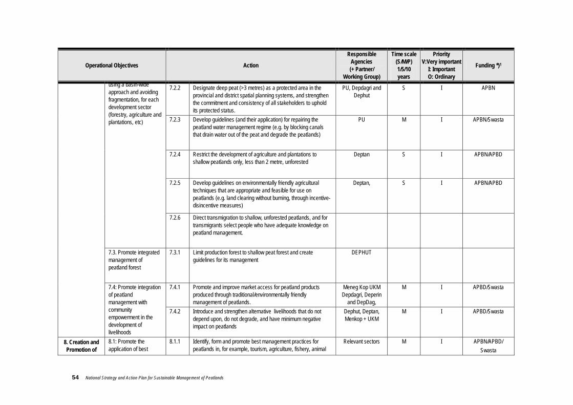
54 National Strategy and Action Plan for Sustainable Management of Peatlands
Operational Objectives Action
Responsible Agencies (+ Partner/
Working Group)
Time scale (S/M/P) 1/5/10 years
Priority V:Very important
I: Important O: Ordinary
Funding *)1
7.2.2 Designate deep peat (>3 metres) as a protected area in the provincial and district spatial planning systems, and strengthen the commitment and consistency of all stakeholders to uphold its protected status.
PU, Depdagri and Dephut
S I APBN
7.2.3 Develop guidelines (and their application) for repairing the peatland water management regime (e.g. by blocking canals that drain water out of the peat and degrade the peatlands)
PU M I APBN/Swasta
7.2.4 Restrict the development of agriculture and plantations to shallow peatlands only, less than 2 metre, unforested
Deptan S I APBN/APBD
7.2.5 Develop guidelines on environmentally friendly agricultural techniques that are appropriate and feasible for use on peatlands (e.g. land clearing without burning, through incentive-disincentive measures)
Deptan, S I APBN/APBD
using a basin-wide approach and avoiding fragmentation, for each development sector (forestry, agriculture and plantations, etc)
7.2.6 Direct transmigration to shallow, unforested peatlands, and for transmigrants select people who have adequate knowledge on peatland management.
7.3. Promote integrated management of peatland forest
7.3.1 Limit production forest to shallow peat forest and create guidelines for its management
DEPHUT
7.4.1 Promote and improve market access for peatland products produced through traditional/environmentally friendly management of peatlands.
Meneg Kop UKM Depdagri, Deperin
and DepDag,
M I APBD/Swasta 7.4: Promote integration of peatland management with community empowerment in the development of livelihoods
7.4.2 Introduce and strengthen alternative livelihoods that do not depend upon, do not degrade, and have minimum negative impact on peatlands
Dephut, Deptan, Menkop + UKM
M I APBD/Swasta
8. Creation and Promotion of
8.1: Promote the application of best
8.1.1 Identify, form and promote best management practices for peatlands in, for example, tourism, agriculture, fishery, animal
Relevant sectors M I APBN/APBD/ Swasta

National Strategy and Action Plan for Sustainable Management of Peatlands 55
Operational Objectives Action
Responsible Agencies (+ Partner/
Working Group)
Time scale (S/M/P) 1/5/10 years
Priority V:Very important
I: Important O: Ordinary
Funding *)1
Demonstration plots (Demplot)
for Peatland Management
management practices for peatlands
husbandry, forestry, plantations and other sectors, through research and development
9.1.1 Develop and widely promote proper guidelines and manuals on peatland restoration and rehabilitation based on local knowledge, national experience and R&D findings
Dephut, LIPI, LH, Deptan,
S I APBN/APBD/
Swasta
9.1.2 Establish pilot projects to test new techniques in peatland rehabilitation
Dephut , LIPI, LH, Deptan,
S I APBN/APBD/
Swasta
9.1: Develop appropriate techniques for the rehabilitation of degraded peatlands
9.1.3 Conduct specific technical training programmes on the restoration and rehabilitation of peatlands
Dephut, LIPI, LH, Deptan,
S I APBN/APBD/
Swasta 9. Restoration
and Rehabilitation 9.2: Rehabilitate
peatlands that have been degraded by fire, drainage, or other causes
9.2.1 Prepare and implement peatland restoration and rehabilitation programmes
Working Group Secretariat
S I APBN/APBD/
Swasta
10.1.1 Quantify the above and below ground carbon content in peatlands in each province or kabupaten and its role in mitigating climate change
Puslitanak , M I APBN/Swasta 10.1. Protect and improve function of peatlands for carbon sequestration and storage, and adaptation to climate change
10.1.2 Integrate peatland issues (fire, drought, changes to water quality, etc) into a national plan on climate change
Working Group Secretariat
M M APBN/Swasta 10. Peatland and Climate Change
10.2. Support process of peatland adaptation to global climate change
10.2.1 Assess the impact of climate change on peatland ecosystem in Indonesia
LIPI, BPPT,
11.1.1 Develop national and regional collaborative research projects and other activities involving experts at national, regional and international levels
LH, Depdagri, Dephut, Setkab,
Deplu
M I APBN/Swasta
11. Cooperation among different areas (District, Province, National)
11.1: Promote exchange of expertise/experience in addressing peatland management issues 11.1.2 Strengthen the Peatland Management network in Indonesia by
including all experts on peatland in this area and at ASEAN level
LH, Depdagri, Dephut, Setkab,
Deplu
M M APBN/Swasta

56 National Strategy and Action Plan for Sustainable Management of Peatlands
Operational Objectives Action
Responsible Agencies (+ Partner/
Working Group)
Time scale (S/M/P) 1/5/10 years
Priority V:Very important
I: Important O: Ordinary
Funding *)1
11.2: Strengthen Centres for the Study and Management of Peatlands (Pusat Studi & Pengelolaan Lahan Gambut) at district, provincial and national levels
11.2.1 Identify centres for the study and management of peatlands at Kabupaten, Provincial and National levels, and develop opportunities for cooperation with similar study centres at Regional (ASEAN) level
Working Group Secretariat
S I APBN
11.3: Increase contribution to the implementation of agreements and regional cooperation mechanisms
11.3.1 Incorporate peatland issues into ASEAN and other international frameworks related to, for example, forest fire, biodiversity, conservation of water resources, etc.
Relevant sectors M M Swasta
12.1.1 Develop a financing strategy for implementation of the National Peatland Strategy (including financing for environmental services provided by peatlands for the global interest)
Depkeu & Bappenas
S I APBN/Swasta
12.1.2 Undertake a feasibility study to explore use of polluter-pay and user-pay schemes, tax incentives or other options to generate sustained resources to support the implementation of the strategy
Depkeu Bapenas, Dephut, LH,
Deptan,
S I APBN/Swasta
12.1.3 Develop specific budgets and proposals for funding of activities under this strategy, by central government, and grants from international sources (not loans)
Relevant sectors M M APBN/Swasta 12. Financing
12.1. Increase financial resources required to implement programmes and achieve the target of the strategy
12.1.4 Establish appropriate funding mechanisms to channel payments to local governments or community groups, to support the rehabilitation and sustainable management of peatlands (e.g. through micro credit funding)
Depdagri, Depkeu, Bapenas, Dephut,
Deptan,
S I APBN/Swasta
National Strategy and Action Plan for Sustainable Management of Peatlands 57
4. Implementation Mechanisms
The NSAPSMP is an ‘umbrella’ document that is national in scope and is a reference for peatland management. Under laws UU No. 32 /2004 and PP 25/ 2000, each region may adapt or develop local strategies according to local conditions. The efforts and adaptations made in the regions should not stray from the main goal and general objectives stated in this NSAPSMP. It is expected that the NSAPSMP will be developed in each kabupaten district or at least in each province that possesses peatlands. 4.1 National/Central Implementation Mechanisms
At central government level, the peatlands mechanism will be operated through cooperation among relevant central agencies. As there is not as yet a specific agency to act as coordinator for peatland management, this function will “temporarily” be facilitated by the Working Group on peatlands with members from a number of relevant agencies. The decree of the minister for home affairs concerning the Working Group on Sustainable Management of Peatlands, Surat Keputusan Menteri Dalam Negeri (No.520.01/Kep/Bangda/2006 dated 30 January 2006) tentang Perubahan keputusan Menteri Dalam Negeri Nomor: 520-218/Kep/Bangda/2005 tentang Kelompok Kerja (POKJA) Pengelolaan Lahan Gambut Secara Berkelanjutan (abbreviated to Pokja Pengelolaan Lahan Gambut Nasional or National Working Group on Peatland Management) stipulates the following provisions:
1. The Working Group on Sustainable Management of Peatlands is established with membership as stated in the appendix to the decree (see Annex 10 b.)
2. The Working Group on Sustainable Management of Peatlands is an inter-agency work team to prepare and formulate policy on the sustainable management and use of peatlands.
3. To optimise the Working Group’s activity, the Directorate General for Regional Development (under the Ministry of Home Affairs) is the coordinating agency that will bridge the interests of agencies at central and regional levels related to peatlands management.
4. The Working Group’s duty will be to establish a National Strategy and Action Plan for the management and use of peatlands at national level.
5. A Working Group Secretariat is established to facilitate the Working Group’s day to day work and draw up its work schedule.
6. Each member of the Working Group is obligated to report every update in the National Strategy and Action Plan to his/her own leadership.

58 National Strategy and Action Plan for Sustainable Management of Peatlands
7. A draft of updates to the National Strategy and Action Plan must be presented regularly to the relevant stakeholders in coordination meetings to be coordinated by the Directorate General for Regional Development.
8. The final result of the Working Group is to be reported to the Minister for Home Affairs for coordination with other relevant Ministers as national policy.
9. This decree shall be valid from the date of issue, with the provision that should it be found to contain any errors these will be corrected in line with the current regulations.
From the points above it is clear that the NSAPSMP is an official document produced by cooperation among relevant Central Government agencies. As the policies it contains are general in nature, it is necessary for each Region to describe these in more detail in accordance with local needs and conditions. An outline of the work mechanism of the Working Group on Peatland Management and the tasks of each of its components can be seen in the diagram below :
Note: The working group is chaired by the Direktur Fasilitasi Penataan Ruang dan Lingkungan Hidup, Ditjen Bangda Depdagri.
Figure 6. Diagram showing the proposed work mechanism for the implementation of the national peatland management strategy at central level.
Working Group on Peatland Management Peat experts, technical staff /agencies from relevant
government departments, Research Institutes, NGOs and the private sector
Advisory Team officials from relevant departments at Director General
level
Other supporters Secretariat of working group
Facilitation to regions

National Strategy and Action Plan for Sustainable Management of Peatlands 59
Advisory Team Ministerial decree SK-Mendagri No 520.01/Kep/Bangda/2006, states that the advisory team should comprise 4 senior representatives from relevant agencies. These are: Dirjen Bina Bangda-Depdagri (Directorate General for Regional Development), Deputi Bidang Peningkatan Konservasi SDA dan Pengendalian Kerusakan Lingkungan-KLH (Deputy for Increased Conservation of Natural Resources and Control of Environmental Degradation from the Minister for the Environment), Dirjen PHKA-Dephut (Directorate General PHKA from the Forestry Ministry), and Sahmen PPN Bidang Percepatan Pembangunan Kawasan Timur Indonesia dan Kawasan Tertinggal. The Advisory Team’s duties are:
1. To provide the Working Group on Peatland Management with technical and non-technical direction and input related to peatland management in Indonesia
2. To hold meetings and invite Working Group members to discuss peatland management issues
3. Provide the Chairperson/Coordinator of the Working Group with direction and inputs concerning strategy for developing and implementing the NSAPSMP and its socialisation in the regions
4. Provide direction to Regional Governments on the implementation/development of the national strategy for sustainable management of peatlands
Working Group Ministerial decree SK Mendagri No 520.01/Kep/Bangda/2006 (dated 30 January 2006), stipulates that the membership of the National Working Group on Peatland Management shall comprise 18 persons from 12 relevant agencies (government, academic and NGOs) with relevant expertise in peatland management.
The membership may be permanent or ad hoc, depending on the conditions and needs.
The tasks of the Working Group are:
1. Assess and develop technical papers on sustainable peatland management, including the National Strategy and Action Plan for the Sustainable Management of Peatlands (NSAPSMP) and Guidelines for Monitoring and Evaluation.
2. Socialise the NSAPSMP produced by the Working Group to relevant agencies, policy makers and other stakeholders, including the private sector, at both Central and Regional level.
3. Act as a source of information on the development of a local strategy and action plan (LSAPSMP) in the regions (Province/ Kabupaten / Municipality) of Indonesia that possess peatlands. [note: LSAPSMP = Local Strategy and Action Plan for the Sustainable Management of Peatlands]
4. Oversee implementation of trans-provincial peatland management programmes.
5. Review the NSAPSMP every 5 years.
6. Report to the Advisory Team on peatland management in the regions.
7. Make scientific judgements to policy makers on development plans on peatlands that are anticipated to have far-reaching environmental and social impacts, regarding both conservation and commercial aims.

60 National Strategy and Action Plan for Sustainable Management of Peatlands
8. Provide information, direction and recommendations to Amdal (environmental impact assessment) teams who will assess the environmental impact of proposed development on peatland.
9. Coordinate with other agencies, especially committees and convention focal points, in the context of peatland management
Working Group Secretariat The Secretariat is formed in the agency the Working Group Chairman comes from, in this case the Ditjen Bina Bangda-Depdagri. The members of the secretariat may be representatives from other agencies outside Ditjen Bina Bangda-Depdagri (see the details in the SK Mendagri ministerial decree above) appointed by the Chairman. The tasks of the secretariat are:
1. Plan schedules and agenda for Working Group member meetings
2. Facilitate meetings of Working Group members and produce reports on the meetings’ outcomes
3. Gather inputs from Working Group members relevant to the development of the NSAPSMP
4. Facilitate production and implementation of the work plan, including monitoring and evaluation.
5. Facilitate the formation of working groups on peatland management at local levels (Province / Kabupaten / Municipality) and the development of the Local Strategy and Action Plan for the Sustainable Management of Peatlands (LSAPSMP) at each local level.
6. Facilitate funding for the implementation of the LSAPSMPs from the national budget (APBN) and/or untied grants from other sources
Other supporters Other supports could be NGOs, community groups or individuals who care about the existence of peatlands and the problems faced in Indonesia. Tasks are not specified for these supporters but their inputs can be requested or submitted through communication with the Working Group secretariat. 4.2 Regional (local) Implementation Mechanism
The agency considered necessary/appropriate to undertake the NSAPSMP at regional level is the Government of the Kabupaten/Municipality/Province. This will be according to the location and extent of peatlands in each region, but must always refer to the law on spatial planning UU No. 24/1992 mengenai Tata Ruang, as follows:
District (Kabupaten) / Municipality (Kota) level. If the peatland is present only in a certain district or municipality, then the district/municipality concerned is obliged to develop a Local Strategy and Action Plan for the Sustainable Management of Peatlands (LSAPSMP) at their level.
National Strategy and Action Plan for Sustainable Management of Peatlands 61
Provincial level. If the peatlands extend widely and their boundaries overlap the administrative boundaries of several kabupaten districts, it is recommended that the LSAPSMP be developed by the provincial government with due regard to the existing administrative and ecological boundaries (e.g. watershed).
If a trans-province peatland management programme is needed, this can be planned and
implemented through a mechanism overseen by Central Government Cq the Working Group Team In the preparation of the LSAPSMP, whether at provincial, district or municipal level, the Regional Government is obligated to hold consultations with a range of stakeholders and other relevant agencies. It is also recommended that a representative of the National Working Group also attend as a facilitator, in order to ensure that the LSAPSMP has the same direction and aims. In order to equip the local working group, a team from the National Working Group will give training in the management and use of peatlands to the regional government apparatus, regional house of representatives (DPRD) and the private sector coordinated by the National Working Group (as regulated by ministerial decree SK Mendagri No 520. 01 / Kep/ bangda/ 2006 dated 30 January 2006.) This will be done centrally and regionally). Peatland management strategy in the province or district/municipality is governed by Regional Regulations. Changes to peatland function and use must refer to the regional spatial planning plan Rencana Umum Tata Ruang Daerah (RUTRD). Programmes implementing the peatland management strategy can be produced as a specific policy or integrated into the regional development programme. To optimise the use of peatlands in the regions, if necessary a work unit can be set up, which can be structural or ad hoc, to coordinate trans-sectoral management of peatlands. Similar institutions can also be set up for Trans-Regional coordination, to handle management of an area that extends across more than one administrative jurisdiction. Time scale for implementation of LSAPSMP This is the same as for the NSAPSMP, its implementation expected to continue for least 15 years with a review every 5 years. During the subsequent period, extensions, revisions and modifications will be made with consideration to local conditions and interests. Working Group institutions at regional (local) level Determination of the mechanisms and regional working group institutions is delegated to the regional government, as appropriate to the technical capabilities, funding and peatland conditions in the region concerned. Organisation of regional working group institutions will be facilitated by a team from the National Working Group.

62 National Strategy and Action Plan for Sustainable Management of Peatlands
4.3 Funding Mechanism
When the NSAPSMP (STRNPLGB) has been produced, it will be disseminated and socialised at both central and regional (local) levels. When the document has been socialised to all relevant parties, it is expected that the programmes drawn up by the various agencies will be synchronous with the points of the action plan. Thus each agency will be able to budget for activities appropriate to the programmes. In other words, the budget for implementation of the points in the action plan will be the responsibility of each implementing agency/institution. In the case of joint programmes, the agencies can work together to obtain funds. The funding mechanism will be developed in such a way that it functions as a predictable source of funds that can be mobilised to implement the strategy. The mechanism could constitute a pool of financial resources, based on a scheme that can be managed jointly. Under the umbrella of the strategy, the mechanism and options for generating continuous funding to implement the strategy will be continuously sought and developed. 4.3.1 Domestic sources of funding
Funding is needed to support implementation of the national peatland management strategy. The main source of funds can come from central government’s national budget (APBN) and/or the regional government’s budget (APBD). It is therefore recommended that peatland management strategy be integrated with sectoral development programmes at central and regional level, so as to obtain funding allocated for those activities. Funds from the national/regional budgets (APBN / APBD) are an instrument to stimulate and accelerate action by all stakeholders. For implementation of the strategy at regional (provincial/district/municipal) level funded from the regional budget (APBD), the Region is given authority to: use, mobilise and manage their own financial resources supported by balancing funds between Centre and Region. Authority to optimise their own Regional financial resources is exerted through increasing the capacity of the locally generated Regional Income (PAD), while financial balancing is performed through the allocation of the Balancing Fund (Dana Perimbangan). As the Balancing Funds (Production Sharing (Bagi Hasil) and General Allocation Fund (Dana Alokasi Umum)) are in the form of block grants, the Regions have the freedom to use them as best suits their needs and priorities. Similarly, allocation of the locally generated Regional Income is also the prerogative of the Region. For implementation of the strategy at Central level, funding will be taken from the national budget (APBN) for each sector or from other sources of untied funding. Another potential source of funding is the reforestation fund (dana reboisasi) in the forestry sector. As this fund must be used only for forest management, another strategy is needed to allow it to be used for managing peatlands outside the forest areas.
National Strategy and Action Plan for Sustainable Management of Peatlands 63
4.3.2 Foreign aid and cooperation
Mobilisation of funds from outside the government’s budget is badly needed; potential sources are foreign aid and cooperation. Every party who uses or derives benefit from natural resources must contribute towards the sustainable use of those resources. Within the framework of ASEAN cooperation, member countries are expected to allocate sufficient funds to support the implementation of the strategy at national level and for regional cooperation. Synchronisation between APMS implementation and national peatland management strategy will help to secure funding for the implementation of this strategy. Indonesia’s peat lands and forests have enormous potential as suppliers of oxygen to the atmosphere and stabilisers of global climate. These benefits are felt not only at local level but on a regional and even global scale. It is therefore hoped that the central government can increase cooperation with other countries, both within the ASEAN region and beyond. In this way, these countries can contribute further to saving the peatlands and peatforests from degradation, in return for the benefits they have received. Contributions from dialogue partners, whether national, regional or with other donor institutions, are a potential source of funding for the implementation of the strategy. The Central Government is expected to encourage and facilitate meetings with donor institutions and other supporters in order to mobilise foreign sources of funding. Proposals for funding of activities related to peatland management need to be developed and submitted to potential donors and supporters, in order to boost financial resources to fund the implementation of the strategy. As regards international cooperation and donor institutions, it must be underlined that the type of aid used for implementation of the strategy is grant not loan (not even soft loans). In this way, implementing this strategy will not become a burden to the budget in the future.
4.3.3 Alternative sources of funding Other potential sources of funding are the private sector or public collection. These funds can be gathered from fees charged for every use of peatland (note: care must be taken by central/regional government to prevent the granting of licences for peatland uses that are not environmentally friendly and do not adhere to the use designated in the spatial planning). An incentive-disincentive mechanism can be developed to support continued funding for the management of protected peatlands. Regulations stipulating the method and size of incentives/disincentives can be issued by the appropriate management authority at Regional or Central level.

64 National Strategy and Action Plan for Sustainable Management of Peatlands
4.4 Monitoring and Evaluation Mechanism
4.4.1 Principles of monitoring and evaluation
To achieve full benefit from the monitoring and evaluation, there must be a clear purpose, and implementation in the field must be well prepared. Monitoring and evaluation must be based on honesty, motivation, and a strong desire on the part of the monitors, so that the results show the true situation in the field and can be used to improve performance. The principles for monitoring and evaluation are as follow. a. Objective and professional
Monitoring and evaluation must have a clear purpose and be performed in a professional manner based on analysis of complete, accurate data so that it results in an objective assessment and appropriate input concerning the implementation of the policy.
b. Transparency Monitoring and evaluation must be performed in an open manner and reported widely through a range of media so that the community can easily access the information and findings.
c. Participatory Monitoring and evaluation must involve the actors of peatland management, both actively and interactively.
d. Accountability The results of the monitoring and evaluation must be subject to accountability, both internal and external.
e. Punctual Monitoring and evaluation must adhere to the time schedule.
f. Continuity Monitoring and evaluation must be performed on a continuous basis so that they can be used as feedback to improve the policy.
g. Based on performance indicators Monitoring and evaluation must be based on criteria or performance indicators of input, process, output, use and impact.
Based on the above principles, the National Working Group team is expected to produce Monitoring and Evaluation Guidelines containing all the points described above. The guidelines should also contain a baseline against which subsequent results can be compared. Where possible, the guidelines will also contain an activity assessment form . In addition to producing the guidelines, in order to strengthen the local working groups, the National Working Group will provide direction for the monitoring and evaluation at regional level, by giving training to the regional working groups. The overall process of monitoring and evaluation of the implementation of the NSAPSMP and LSAPSMP can be seen in the flowchart in Figure 7.

National Strategy and Action Plan for Sustainable Management of Peatlands 65
4.4.2 Mechanisms and Procedures
Data Collection Data and information to be collected include ecological indicators and the socio-economic conditions of communities living in the vicinity of the peatlands. Data and information required for monitoring and evaluation include the collection of: (1) routine reports by the ministry/institute implementing the policy and programme; (2) results of research and participatory assessments performed by universities, NGOs and research institutes; (3) news reports; and (4) community group reports. Reporting The findings of the monitoring and evaluation will be reported in order to describe objectively the actual condition of peatland management and policy performance. Reports from different agencies will need to be processed and consolidated so as to be comprehensive and complete. Consolidation of these reports will be undertaken by the Working Group. Monitoring and evaluation reports from NGOs, the mass media, academic institutions and research institutes will also be consolidated. The Working Group team will then combine the findings from both consolidations of monitoring and evaluation reports (conducted by government and non-government) to produce a monitoring and evaluation report that describes the changes in the ecological conditions and the socio-economic conditions of the communities living on or near peatlands. The findings of the monitoring and evaluation of the implementation of the NSAPSMP will be presented in a simple, comprehensive report that is easy to understand and easily accessible to the general public. It will be accompanied by policy recommendations in response to the current peatland management conditions, which will be reported to the relevant agencies and disseminated to the public. Dissemination The public will have the right to the findings of the monitoring and evaluation and should be able to access them openly, quickly and easily. For this reason, the findings will need to be disseminated to decision makers, mass media and the general public through a range of information channels such as print, electronic and other media that are easy for the public to access. Frequency of Monitoring and Evaluation Monitoring and evaluation will be performed once a year or according to the time scale of the programme being evaluated. Once every 5 years, the monitoring and evaluation findings will be compiled and used to assess and review the implementation of the NSAPSMP. Funding for Monitoring and Evaluation The cost of monitoring and evaluating the implementation of the action plan is part of the implementation costs component of the NSAPSMP/LSAPSMP. Thus every implementation of the action plan is already allocated guaranteed funds for evaluation. The public and non-government institutions can carry out their own independent monitoring and evaluation of every programme, using their own financial resources. Support for the cost of reporting and disseminating the findings will be sought from the national and regional budgets (APBN and APBD) and other sources of untied funding.
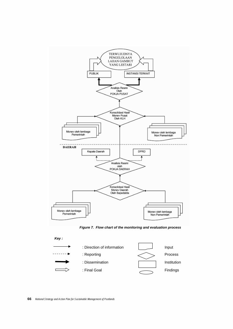
66 National Strategy and Action Plan for Sustainable Management of Peatlands
Figure 7. Flow chart of the monitoring and evaluation process
Key :
: Direction of information Input
: Reporting Process
: Dissemination Institution
: Final Goal Findings

National Strategy and Action Plan for Sustainable Management of Peatlands 67
Annexes
Annex 1. Extent and Distribution of Peatlands in Sumatera in 2002
Peat Area of Peatlands in each Province (Hectares) Total
No Depth Peat Type Riau Sumsel Jambi Sumut Aceh Sumbar Lampung Bengkulu Hectares %
1 - Hemists - 6,474 - - - - - 946 7,420 2 - Hemists/Saprists 45,711 49,459 64,238 2,024 - 6,727 - 13,177 181,336 3 - Hemists/mineral 28,095 46,955 86,394 36,133 2,219 72,233 60,426 16,738 349,193 4 - Saprists - 56,148 - - - - - - 56,148 5
Very shallow (Peaty Mineral Soil) - Saprists/Hemists 11,754 - - 5,892 34,331 13,142 - - 65,119
6 - Saprists/mineral - - 3,093 - 1,720 - 18,884 23,697 Subtotal : 85,560 159,036 153,725 44,049 38,270 92,102 60,426 49,745 682,913 9.48 % 12.5 23.3 22.5 6.5 5.6 13.5 8.8 7.3 100.0
7 Shallow - Fibrists/Saprists 4,070 - - - - - - - 4,070 8 - Hemists - 11,987 - - - - - - 11,987 9 - Hemists/Saprists 442,508 61,907 116,566 - - 1,699 - 3,851 626,531 10 - Hemists/mineral 54,218 224,069 10,888 26,966 1,792 17,120 6,734 616 342,403 11 - Saprists - 6,367 - 10,006 - - - - 16,373 12 - Saprists/Hemists 39,766 - 427 3,437 14,242 10,490 - - 68,362 13 - Saprists/mineral 32,876 8,994 - 122,780 3,738 - - 3,625 172,013 Subtotal : 573,438 313,324 127,881 163,189 19,772 29,309 6,734 8,092 1,241,739 17.24 % 46.2 25.2 10.3 13.1 1.6 2.4 0.5 0.7 100.0
14 Moderate - Hemists - 67,950 - - - - - - 67,950 15 - Hemists/Saprists 668,935 271,625 86,988 - 11,983 17,157 - - 1,056,688 16 - Hemists/mineral 3,322 563,122 16,045 14,733 26,061 - 20,407 1,575 645,265

68 National Strategy and Action Plan for Sustainable Management of Peatlands
Peat Area of Peatlands in each Province (Hectares) Total
No Depth Peat Type Riau Sumsel Jambi Sumut Aceh Sumbar Lampung Bengkulu Hectares %
17 - Saprists 26,652 1,855 - 31,399 - - - - 59,906 18 - Saprists/Hemists 173,942 - 2,413 14,588 105,565 7,682 - - 304,190 19 -Saprists/mineral 79,206 77,471 - 34,950 1,143 - - 800 193,570 Subtotal : 952,057 982,023 105,446 95,670 144,752 24,839 20,407 2,375 2,327,569 32.31 % 40.9 42.2 4.5 4.1 6.2 1.1 0.9 0.1 100.0
20 Deep - Hemists - - - 2,201 - - - - 2,201 21 - Hemists/Saprists 328,656 22,631 258,974 3,274 24,614 5,925 - 2,431 646,505 22 - Saprists 1,314 - - 16,912 - - - - 18,226 23 - Saprists/Hemists 497,476 - 19,590 - 46,643 9,135 - - 572,844 24 - Saprists/mineral - 6,648 - - - - - - 6,648 Subtotal : 827,446 29,279 278,564 22,387 71,247 15,060 - 2,431 1,246,424 17.30 % 66.4 2.3 22.3 1.8 5.7 1.2 - 0.2 100.0
25 - Hemists/Saprists 635,228 - 36,287 - - 48,924 - 409 720,848 26
Very deep - Hemists/mineral - - 14,936 - - - - - 14,936
27 - Saprists/Hemists 969,872 - - - - - - - 969,872 Subtotal : 1,605,100 - 51,223 - - 48,924 - 409 1,705,656 23.68 % 94.1 - 3.0 - - 2.9 - 0.0 100.0
Total (Ha) 4,043,601 1,483,662 716,839 325,295 274,051 210,234 87,567 63,052 7,204,301
% 56.13 20.59 9.95 4.52 3.80 2.92 1.22 0.88 100.00 100.0

National Strategy and Action Plan for Sustainable Management of Peatlands 69
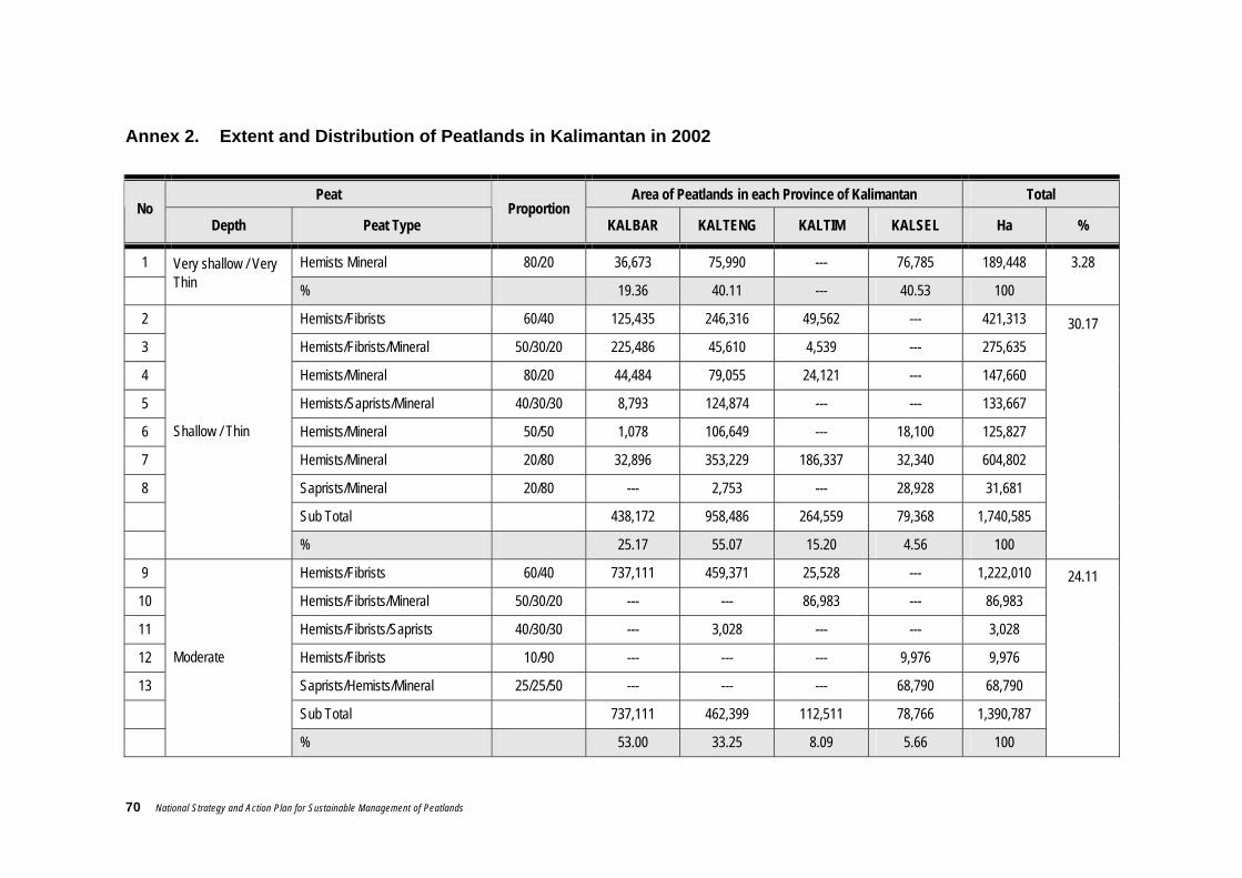
70 National Strategy and Action Plan for Sustainable Management of Peatlands
Annex 2. Extent and Distribution of Peatlands in Kalimantan in 2002
Peat Area of Peatlands in each Province of Kalimantan Total No
Depth Peat Type Proportion
KALBAR KALTENG KALTIM KALSEL Ha %
1 Hemists Mineral 80/20 36,673 75,990 --- 76,785 189,448
Very shallow / Very Thin % 19.36 40.11 --- 40.53 100
3.28
2 Hemists/Fibrists 60/40 125,435 246,316 49,562 --- 421,313
3 Hemists/Fibrists/Mineral 50/30/20 225,486 45,610 4,539 --- 275,635
4 Hemists/Mineral 80/20 44,484 79,055 24,121 --- 147,660
5 Hemists/Saprists/Mineral 40/30/30 8,793 124,874 --- --- 133,667
6 Hemists/Mineral 50/50 1,078 106,649 --- 18,100 125,827
7 Hemists/Mineral 20/80 32,896 353,229 186,337 32,340 604,802
8 Saprists/Mineral 20/80 --- 2,753 --- 28,928 31,681
Sub Total 438,172 958,486 264,559 79,368 1,740,585
Shallow / Thin
% 25.17 55.07 15.20 4.56 100
30.17
9 Hemists/Fibrists 60/40 737,111 459,371 25,528 --- 1,222,010
10 Hemists/Fibrists/Mineral 50/30/20 --- --- 86,983 --- 86,983
11 Hemists/Fibrists/Saprists 40/30/30 --- 3,028 --- --- 3,028
12 Hemists/Fibrists 10/90 --- --- --- 9,976 9,976
13 Saprists/Hemists/Mineral 25/25/50 --- --- --- 68,790 68,790
Sub Total 737,111 462,399 112,511 78,766 1,390,787
Moderate
% 53.00 33.25 8.09 5.66 100
24.11

National Strategy and Action Plan for Sustainable Management of Peatlands 71
Peat Area of Peatlands in each Province of Kalimantan Total No
Depth Peat Type Proportion
KALBAR KALTENG KALTIM KALSEL Ha %
14 Hemists/Fibrists 60/40 213,705 574,978 128,561 32,669 949,913
15 Hemists/Fibrists/Mineral 50/30/20 --- --- 91,142 --- 91,142
16 Saprists/Hemists/Mineral 30/30/40 --- --- --- 64,041 64,041
Sub Total 213,705 574,978 219,703 96,710 1,105,096
Deep / Thick
% 19.34 52.03 19.88 8.75 100
19.15
17 Hemists/Fibrists 60/40 304,319 661,093 100,224 --- 1,065,636
Very Deep / Very Thick % 28.56 62.04 9.41 --- 100
18.47
18 Hemists/Fibrists 60/40 --- 277,694 --- --- 277,694
Extremely Deep / Extremely Thick % --- 100.00 --- --- 100
4.81
Total 1,729,980 3,010,640 696,997 331,629 5,769,246
% 29.99 52.18 12.08 5.75 100
100

72 National Strategy and Action Plan for Sustainable Management of Peatlands

National Strategy and Action Plan for Sustainable Management of Peatlands 73
Annex 3. Important values and uses of peatlands
Category Description
Direct Uses
Fishery Peatland waters form a habitat for a diversity of specific/ freshwater fish species including several of commercial value such as: Gabus Chana sp., Lele Clarias sp., Betok Anabas testudineus, Sepat Trichogaster sp., and Tambakan Helostoma sp. . Peatland fishery is a potential source of income for the local community
Transportation As in other wetlands, the rivers that flow through the peatlands provide the main transport route for the people in the vicinity
Forest resources Although the area of peatswamp forests is rapidly shrinking, a variety of timber and non-timber forest products have long been utilised and contributed to the economy of the local community. Commercial timber species with high economic value include: Ramin (Gonystylus bancanus), Jelutung (Dyera costulata), and Meranti (Shorea spp.). The declining quality and quantity of peatswamp forest resources make it urgent to help the local communities to find alternative livelihoods.
Hydrological Regulation
Regulation of flooding and water flow
Peatlands function as a catchment area for water which is plentiful during flooding and then release it during the dry season
Prevent intrusion of saltwater
Peatlands can provide a source of water for agricultural activities while at the same time preventing intrusion by saltwater.
Source of water supplies In rural areas, peatlands might be the only source of freshwater for everyday use and agricultural irrigation.
Biodiversity
Source of gene pool Peatlands are an important source of gene pool for a diversity of indigenous species, especially in peatlands that form a transition between or combination of freshwater swamp forest and mangrove forest.
Plant habitat Hundreds of plant species have been recorded in Indonesia’s peatlands, several of which have important, high economic value
Wildlife habitat Peatlands provide habitat for a diversity of wildlife, including rare and endemic species. These include the Senyulong crocodile, Sumatran elephant, Sumatran tiger, Siamang, Orang Utan and several species of Rangkong hornbills
Climatic stability
Carbon sequestration Healthy peatswamp forest can actively accumulate carbon, thereby subsequently reducing the influence of greenhouse gases.

74 National Strategy and Action Plan for Sustainable Management of Peatlands
Category Description
Carbon store Peatlands can store carbon in huge quantities. The degradation of peatland by fire and peat desiccation will also emit carbon in huge quantities. The fires in Indonesia during 1997 are estimated to have released 0.81 – 2.57 Gigaton of carbon into the atmosphere. This amount is equivalent to 13 – 40% of the average annual global carbon emissions from the combustion of fossil fuels.
Climate regulation The presence of peat forest and the enormous quantities of fresh water contained in the peat will influence climate on a micro scale. In addition, peat forest and vegetation can act as wind breaks and to reduce temperatures. Forested lowland plains also appear to invite more rain when compared against barren land.
Research and education The uniqueness of the functions and attributes of peatlands makes an interesting subject for research in a number of disciplines and can also be used as a vehicle for education.
Socio-cultural values For certain communities, peat swamp forest is a special, unique place that plays an important role in their lives.

National Strategy and Action Plan for Sustainable Management of Peatlands 75
Annex 4. Policies related to the management of Land and Forest fire in Indonesia
No Regulation Type Regulation Number Contents
1 UU No.5 Tahun 1967 Ketentuan-ketentuan pokok kehutanan 2 UU No.5 Tahun 1990 Konservasi sumberdaya alam hayati dan ekosistemnya
3 UU No.5 Tahun 1994 Ratifikasi dari konvensi PBB mengenai keanekaragaman hayati
4 UU No.6 Tahun 1994 Ratifikasi dari konvensi PBB mengenai perubahan iklim 5 UU No.23 Tahun 1997 Pengelolaan Lingkungan Hidup 6
Laws Undang-undang
UU No.41 Tahun 1999 Pokok-pokok Kehutanan (pengganti UU No.5 Tahun 1967) 7 PP No.28 Tahun 1985 Perlindungan Hutan
8
Government Regulations Peraturan Pemerintah
PP No.4 Tahun 2001 Pengendalian kerusakan dan atau pencemaran lingkungan hidup yang berkaitan dengan kebakaran hutan dan atau lahan
9 No. 195/Kpts-II/1986 Petunjuk tentang Usaha Pencegahan dan Pemadaman Kebakaran Hutan
10 No. 523/Kpts-II/1993 Pedoman Perlindungan di Areal Pengusahaan Hutan
11 No 188/Kpts-II/1995 Pembentukan Pusat Pengendalian Kebakaran Hutan nasional (PUS-DALKARHUTNAS)
12 No. 260/Kpts-II/1995 Petunjuk Tentang Usaha Pencegahan dan Pemadaman Kebakaran
13 No. 365/Kpts-II/1997 Maskot Nasional untuk pengendalian kebakaran hutan 14
Decrees of the Minister for Forestry Surat Keputusan Menteri Kehutanan
No. 97/Kpts-II/1998 Prosedur Penanganan Kebakaran Hutan
15 No. KEP-18/MENLH/3/1995 Pembentukan Badan Koordinasi Nasional Kebakaran Lahan
16
Decrees of the Minister for the Environment Surat Keputusan Menteri Lingkungan Hidup
No. KEP-40/MENLH/09/97 Pembentukan Tim Koordinasi Nasional Pengendalian Kebakaran Hutan dan Lahan
17
Decree of Minister for Home Affairs Surat Keputusan Menteri Dalam Negeri
No.364.152.233-255
Pengesahan Peraturan Daerah Propinsi Tingkat I Jawa Tengah Nomor 6 Tahun 1991 tentang Usaha Pencegahan dan Pemadaman Kebakaran Hutan di Propinsi Daerah Tingkat I Jawa Tengah
18 No.243/Kpts/DJ-VI/1994 Petunjuk Teknis Pencegahan dan Penanggulangan Kebakaram Hutan di Areal Pengusahaan Hutan dan Areal Penggunaan lainnya.
19 No. 244/Kpts/DJ-VI/1994 Petunjuk Teknis Pemadaman Kebakaran Hutan
20 No. 245/Kpts/DJ-VI/1994
Prosedur Tetap Pemakaian Peralatan Pemadaman Kebakaran Hutan
21 No. 246/Kpts/DJ-VI/1994 Petunjuk Pembuatan dan Pemasangan Rambu-rambu Kebakaran
22 No. 247/Kpts-DJ-VI/1994 Petunjuk Standarisasi Sarana Pencegahan dan Penanggulangan Kebakaran Hutan
23
Decrees of Director General for Forest Protection and Nature Conservation Surat Keputusan Direktur Jenderal Perlindungan Hutan dan Pelestarian Alam (PHPA) No. 248/Kpts/DJ-VI/1994 Prosedur tetap Pencegahan dan Penanggulangan
Kebakaran Hutan

76 National Strategy and Action Plan for Sustainable Management of Peatlands
Annex 5. Names and addresses of institutions/agencies at Central / National level related (directly or indirectly) to peatland management
No Name of Institution Address
1 Departemen Dalam Negeri Jl. Merdeka Utara No. 7 Jakarta 10110 Telepon (021) 345-0058, 384-2222 Fax : (021) 383-1193
2 Departemen Pertanian. Jl. Harsono RM. No. 3 Ragunan , Pasar Minggu Jakarta 12550 Telepon : (021) 780-4056 Fax : (021) 780-4237
3 Departemen Kehutanan Gedung Manggal Wanabakti, Jl. Jend. Gatot Subroto, Jakarta Telepon : (021) 573-1820 Fax : (021) 570-0226
4 Departemen Pekerjaan Umum Jl. Patimura No. 20, Kebayoran Baru, Jakarta Telepon : (021) 724-7564, 739-7758 Fax : (021) 726-0855
5 Departemen Tenaga kerja dan Transmigrasi
Jl. Jend. Gatot Subroto Kav. 51 Jakarta 12950 Telp. : (021) 522-9285, 798-9924 Fax : (021) 797-4488
6 Departemen Energi dan Sumberdaya Mineral
Jl. Merdeka Selatan 18 Jakarta 10110 Telepon : (021) 380-4242, 381-3233 Fax : (021) 384-7461
7 Kementerian Lingkungan Hidup B Building, 2nd Floor, Jl. DI. Panjaitan, Kav. 24 Kebon Nanas, Jakarta 13410 Telepon : (021) 858-0103 Fax : (021) 858-0101
8 Kementerian Perencanaan Pembangunan Nasional.
Jl. Taman Suropati No. 2, Jakarta Telepon : (021) 334-811, 3190-6288 Fax : (021) 314-5374
9 Badan Perencanaan Pembangunan Nasional (BAPPENAS).
Jl. Taman Suropati 2, Jakarta Telepon : (021) 390-5650, 336-207 Fax : (021) 334-779
10 Badan Koordinasi Survei dan Pemetaan Nasional (BAKOSURTANAL)
Jl. Raya Jakarta-Bogor Km. 46, Cibinong 16911 Telepon : (021) 875-2062, 875-7422 Fax : (021) 875-2064, 875-3067
11 Badan Pengkajian dan Penerapan Teknologi (BPPT).
Jl. M.H. Thamrin No. 8, Jakarta 10340 Telepon : (021) 316-2222 Fax : (021) 390-4537
12 Lembaga Penerbangan dan Antariksa Nasional (LAPAN).
Jl. Pemuda, Persil No. 1, Rawamangun, Jakarta 13220 Telepon : (021) 489-2802 Fax : (021) 489-4815
13 Puslitbang Sumber Daya Air Jalan Ir. H. Juanda 193 Bandung 40135 14 Pusat Penelitian dan Pengembangan
Tanaman Pangan Jalan Merdeka No. 207 Bogor, 16111 Telp. 62-251-334 089 ; 311 432 Fax. 62-251-312-755
15 Pusat Penelitian dan Pengembangan tanah dan agroklimat
Jl. Ir. H. Juanda No. 98 Bogor, 16123 Tel.: 0251 323012, 311256
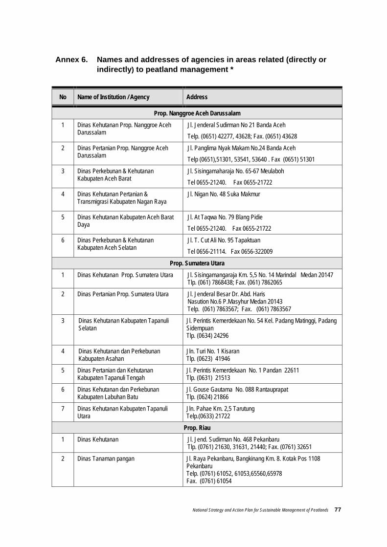
National Strategy and Action Plan for Sustainable Management of Peatlands 77
Annex 6. Names and addresses of agencies in areas related (directly or indirectly) to peatland management *
No Name of Institution / Agency Address
Prop. Nanggroe Aceh Darussalam
1 Dinas Kehutanan Prop. Nanggroe Aceh Darussalam
Jl. Jenderal Sudirman No 21 Banda Aceh
Telp. (0651) 42277, 43628; Fax. (0651) 43628
2 Dinas Pertanian Prop. Nanggroe Aceh Darussalam
Jl. Panglima Nyak Makam No.24 Banda Aceh
Telp (0651),51301, 53541, 53640 . Fax (0651) 51301
3 Dinas Perkebunan & Kehutanan Kabupaten Aceh Barat
Jl. Sisingamaharaja No. 65-67 Meulaboh
Tel 0655-21240. Fax 0655-21722
4 Dinas Kehutanan Pertanian & Transmigrasi Kabupaten Nagan Raya
Jl. Nigan No. 48 Suka Makmur
5 Dinas Kehutanan Kabupaten Aceh Barat Daya
Jl. At Taqwa No. 79 Blang Pidie
Tel 0655-21240. Fax 0655-21722
6 Dinas Perkebunan & Kehutanan Kabupaten Aceh Selatan
Jl. T. Cut Ali No. 95 Tapaktuan
Tel 0656-21114. Fax 0656-322009
Prop. Sumatera Utara
1 Dinas Kehutanan Prop. Sumatera Utara Jl. Sisingamangaraja Km. 5,5 No. 14 Marindal Medan 20147 Tlp. (061) 7868438; Fax. (061) 7862065
2 Dinas Pertanian Prop. Sumatera Utara
Jl. Jenderal Besar Dr. Abd. Haris Nasution No.6 P.Masyhur Medan 20143 Telp. (061) 7863567; Fax. (061) 7863567
3 Dinas Kehutanan Kabupaten Tapanuli Selatan
Jl. Perintis Kemerdekaan No. 54 Kel. Padang Matinggi, Padang Sidempuan Tlp. (0634) 24296
4 Dinas Kehutanan dan Perkebunan Kabupaten Asahan
Jln. Turi No. 1 Kisaran Tlp. (0623) 41946
5 Dinas Pertanian dan Kehutanan Kabupaten Tapanuli Tengah
Jl. Perintis Kemerdekaan No. 1 Pandan 22611 Tlp. (0631) 21513
6 Dinas Kehutanan dan Perkebunan Kabupaten Labuhan Batu
Jl. Gouse Gautama No. 088 Rantauprapat Tlp. (0624) 21866
7 Dinas Kehutanan Kabupaten Tapanuli Utara
Jln. Pahae Km. 2,5 Tarutung Telp.(0633) 21722
Prop. Riau
1 Dinas Kehutanan Jl. Jend. Sudirman No. 468 Pekanbaru Tlp. (0761) 21630, 31631, 21440; Fax. (0761) 32651
2 Dinas Tanaman pangan Jl. Raya Pekanbaru, Bangkinang Km. 8. Kotak Pos 1108 Pekanbaru Telp. (0761) 61052, 61053,65560,65978 Fax. (0761) 61054

78 National Strategy and Action Plan for Sustainable Management of Peatlands
No Name of Institution / Agency Address
3 Dinas Kehutanan Kabupaten Bengkalis Jl. Jend. Sudirman No. 024, Bengkalis 28712. Tlp. (0766) 21016, 23845; Fax. (0766) 21014
4 Dinas Kehutanan Kabupaten Rokan Hulu Jl. Diponegoro Km. 1 Pasir Pengarayan Tlp. (0762) 91452
Prop. Sumatera Barat
1 Dinas Kehutanan Prop. Sumatera Barat Jl. Khatib Sulaiman No. 46 - Padang Tlp. (0751) 53343, 51535; Fax. (0751) 59511
2 Dinas Pertanian Tanaman Pangan & Perkebunan, Prop. Sumatera Barat
Jl. Jenderal Sudirman No.51 Kotak Pos 112, Padang Telp (0751) 54505; Fax (0751) 31553,22114
3 Dinas Kehutanan dan Perkebunan Kabupaten Padang Pariaman
Jl. Imam Bonjol No. 30 Pariaman Tlp. (0751) 92985
4 Dinas Kehutanan dan Perkebunan Kabupaten Pasaman
Jl. Prof. Hazairin No. 1 Pasaman Tlp. (0753) 20129
5 Dinas Kehutanan dan Perkebunan Kabupaten Pesisir Selatan
Jl. Mohamad Hatta - Painan Tlp. (0756) 21441
6 Dinas Pertanian, Perkebunan dan Kehutanan Kabupaten Lubuk Basung Agam
Jl. Koto Padang Baru Lubuk Basung Tlp. (0752) 76316
7 Dinas Pertanian dan Kehutanan Kota Padang
Jl. S. Parman Lolong - Padang Tlp. (0759) 54174
Prop. Jambi
1 Dinas Kehutanan Prop. Jambi Jl. Arif Rahman Hakim No. 10 Telanaipura Jambi 36124 Tlp. (0741) 62609, 62295; Fax. (0741) 61545
2 Dinas Pertanian Tanaman Pangan Prop. Jambi
Jl. R.M. Noer Atmadibrata Jambi (36122) Telp (0741) 62404, Fax (0741) 62829
3 Dinas Kehutanan dan Konservasi Tanah Kabupaten Kerinci
Jl. Prof. Dr. Sri Sudewi Mashoen Syofwan, SH No. 99 Sungai Penuh Tlp. (0748) 323816; Fax. (0748) 323815
4 Dinas Kehutanan Kabupaten Sorolangun Jl. Jend Sudirman No. 27 Sorolangun Tlp/Fax (0745) 91312
Prop. Sumatera Selatan
1 Dinas Kehutanan Prop. Sumatera Selatan
Jl. Kol. H. Burlian Punti Kayu Km. 6,5 PO Box. 340, Palembang Tlp. (0711) 410739, 411476; Fax. (0711) 411479
2 Dinas Pertanian Prop. Sumatera Selatan
Jl. Kapten P. Tendean No. 1058 Palembang 30129 Telp (0711)353122,364881; Fax (0711) 350741
3 Dinas Kehutanan dan Perkebunan Kabupaten Muara Enim
Jl. Jend. Bambang Oetoyo No. 32 Muara Enim Tlp. (0734) 421125
4 Dinas Kehutanan dan Perkebunan Kabupaten Musi Banyuasin
Jl. Kol. Wahid Udin No. 254 Sekayu Tlp. (0714) 321202

National Strategy and Action Plan for Sustainable Management of Peatlands 79
No Name of Institution / Agency Address
5 Dinas Kehutanan Kabupaten Musi Rawas Jl. Pembangunan, Taba Pingin, Lubuk Linggau 31626 Tlp. (0733) 451142
6 Dinas Kehutanan Kabupaten Ogan Komering Ilir
Jl. Letnan Darna Jambi No. 5 Kayu Agung Tlp. (0712) 321059, 321755
Prop. Bangka Belitung
1 Dinas Kehutanan dan Pertanian Jl. Mentok No. 205 Pangkalpinang 33134 Tlp. (0717) 438850; Fax. (0717) 438850
2 Dinas Kehutanan dan Perkebunan Kabupaten Bangka
Jl. Diponegoro No. 15, Sungai Liat, Kab. Bangka Tlp. (0717) 92447
3 Dinas Pertanian dan Kehutanan Kabupaten Belitung
Jl. A. Yani No. 90 Tanjungpandan, Belitung Tlp. (0719) 23831
Provinsi Bengkulu
1 Dinas Kehutanan
Jl. Pembangunan Simpang Harapan Bengkulu Tlp. (0736) 20091; Fax. (0736) 22856
2 Dinas Pertanian dan Ketahanan Pangan
Jl. Pembangunan pd Harapan Bengkulu 38225 Telp (0736) 21410, 21721, 23236,23237 Fax (0736) 21017,23236
3 Dinas Kehutanan Kabupaten Bengkulu Utara
Jl. Ir. Soekarno 174 Argamakmur Tlp. (0737) 521367
4 Dinas Kehutanan Kabupaten Bengkulu Selatan
Jl. Raya Padang Panjang, Manna, Bengkulu Selatan Tlp. (0739) 21294
5 Dinas Kehutanan dan Perkebunan Kabupaten Rejang Lebong
Jl. S. Sukowati No. 60 Curup, Rejang Lebong Tlp/Fax. (0732) 21424
Prop. Lampung
1 Dinas Kehutanan Jl. H. Zainal Abidin Pagar Alam Rajabasa, Bandar Lampung 35144 Tlp. (0721) 703177, 788841; Fax. (0721) 705058
2 Dinas Pertanian dan Ketahan Pangan Jl. Hj. Zainal Abidin Pagaralam No.1 Rajabasa, Bandar Lampung 35144 Telp (0721) 704700Fax (0721) 703775
3 Dinas Perkebunan dan Kehutanan Kabupaten Tulang Bawang
Jl. Cemara Komplek Perkantoran Pemda Kab. Tulang Bawang, Menggala Tlp. (0726) 21163; Fax. (0726) 21642
4 Dinas Perkebunan dan Kehutanan Kabupaten Lampung Timur
Jl. Kol Hasan Basri Sukadana Lampung Timur
5 Dinas kehutanan dan Perkebunan Kabupaten Way Kanan
Jl. Trans Sumatera Km. 191, Bumi Ratu, Blambangan Umpu, Kab. Way Kanan Tlp. (0828) 722163
Prov. Kalimantan Barat
1 Dinas Kehutanan Jl. Sultan Abdurahman No. 137 Pontianak 78116 Tlp. (0561) 734029; Fax. (0561) 733789
2
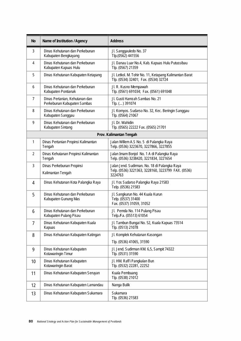
80 National Strategy and Action Plan for Sustainable Management of Peatlands
No Name of Institution / Agency Address
3 Dinas Kehutanan dan Perkebunan Kabupaten Bengkayang
Jl. Sanggauledo No. 37 Tlp.(0562) 441556
4 Dinas Kehutanan dan Perkebunan Kabupaten Kapuas Hulu
Jl. Danau Luar No.4, Kab. Kapuas Hulu Putussibau Tlp. (0567) 21359
5 Dinas Kehutanan Kabupaten Ketapang Jl. Letkol. M. Tohir No. 11, Ketapang Kalimantan Barat Tlp. (0534) 32401; Fax. (0534) 32724
6 Dinas Kehutanan dan Perkebunan Kabupaten Pontianak
Jl. R. Kusno Mempawah Tlp. (0561) 691034; Fax. (0561) 691048
7 Dinas Pertanian, Kehutanan dan Perkebunan Kabupaten Sambas
Jl. Gusti Hamzah Sambas No. 21 Tlp. (…) 391074
8 Dinas Kehutanan dan Perkebunan Kabupaten Sanggau
Jl. Kornyos. Sudarso No. 32, Kec. Beringin Sanggau Tlp. (0564) 21067
9 Dinas Kehutanan dan Perkebunan Kabupaten Sintang
Jl. Dr. Wahidin Tlp. (0565) 22222 Fax. (0565) 21701
Prov. Kalimantan Tengah
1 Dinas Pertanian Propinsi Kalimantan Tengah
Jalan Willem A.S No. 5 di Palangka Raya Telp. (0536) 3223670, 3227866, 3227855
2 Dinas Kehutanan Propinsi Kalimantan Tengah
Jalan Imam Bonjol No. 1 A di Palangka Raya Telp. (0536) 3238420, 3221834, 3221654
3 Dinas Perkebunan Propinsi
Kalimantan Tengah
Jalan Jend. Sudirman. No. 18 di Palangka Raya Telp. (0536) 3221363, 3228160, 3223799 FAX. (0536) 3224763
4 Dinas Kehutanan Kota Palangka Raya Jl. Yos Sudarso Palangka Raya 21583 Telp. (0536) 21583
5 Dinas Kehutanan dan Perkebunan Kabupaten Gunung Mas
Jl. Sangkurun No. 44 Kuala Kurun Telp. (0537) 31400 Fax. (0537) 31059, 31052
6 Dinas Kehutanan dan Perkebunan Kabupaten Pulang Pisau
Jl. Pemda No. 114 Pulang Pisau Telp./Fa. (05513) 61054
7 Dinas Kehutanan Kabupaten Kuala Kapuas
Jl. Tambun Bungai No. 52, Kuala Kapuas 73514 Tlp. (0513) 21078
8 Dinas Kehutanan Kabupaten Katingan Jl. Komplek Kehutanan Kasongan
Tlp. (0536) 41065, 31590 9 Dinas Kehutanan Kabupaten
Kotawaringin Timur Jl. Jend. Sudirman KM. 6,5, Sampit 74322 Tlp. (0531) 31590
10 Dinas Kehutanan Kabupaten Kotawaringin Barat
Jl. HM. Rafi’i Pangkalan Bun Tlp. (0532) 22281, 22252
11 Dinas Kehutanan Kabupaten Seruyan Kuala Pembuang Tlp. (0538) 21012
12 Dinas Kehutanan Kabupaten Lamandau Nanga Bulik
13 Dinas Kehutanan Kabupaten Sukamara Sukamara Tlp. (0536) 21583

National Strategy and Action Plan for Sustainable Management of Peatlands 81
No Name of Institution / Agency Address
14 Dinas Kehutanan Kabupaten Barito Utara
Jl. Yetro Sinseng No. 17 Muara Teweh Tlp. (0519) 21220, 21713, 21203
15 Dinas Kehutanan dan Perkebunan Kabupaten Murung Raya
Jl. A. Yani No. 08 Puruk Cahu Tlp. (0528) 31009
16 Dinas Kehutanan Kabupaten Barito Selatan
Jl. Panglima Batur No. 12 Buntok Tlp. (0525) 22323, 21025, 21129
17 Dinas Perkebunan dan Kehutanan Kabupaten Barito Timur
Jl. Negara Km. 02 Tamiang Layang Tlp. (0526) 91520
Prov. Kalimantan Timur
1 Dinas Kehutanan Prop. Kalimantan Timur Jl. Kesuma Bangsa, Samarinda 75123 Tlp. (0541) 741963, 741803, 741807; Fax. (0541) 736003
2 Dinas Pertanian Tanaman Pangan Propinsi kalimantan Timur
Jl. Basuki Rahmat, Samarinda Tel : (0541) 742484,741676; Fax : (0541) 743867,271048
Prov. Kalimantan Selatan
1 Dinas Pertanian Propinsi Kalimantan Selatan
Jl.Jenderal Sudirman No.5Banjarbaru Telp.4773557- 4772473
2 Dinas Perkebunan Propinsi Kalimantan Selatan
Jl.Jend.A.Yani No.29 Banjarbaru Telp.4772536 – 4772847
3 Dinas Kehutanan Propinsi Kalimantan Selatan
Jl.Jend.A.Yani Timur No.14 Banjarbaru Telp.4772234 -4774914
4 Dinas Pertanian dan Kehutanan Kota Banjarbaru
Jl. Jend. Ahmad Yani Timur 14 Banjarbaru Telp. (0511) 777534, 772234 Fax; (0511) 772234
5 Dinas Kehutanan Kabupaten Banjar Jl. Barintik No. 24, Martapura 70814 Tlp. (0511) 721932
6 Dinas Kehutanan Kabupaten Tanah Laut
Jl. A. Syairani – Palaihari 70814 Tlp. (0512) 21256 , Fax. (0512) 21256
7 Dinas Kehutanan, Perkebunan dan Lingkungan Hidup Kabupaten Tanah Bumbu
Jl. 7 Februari No. 27 Pagatan Telp. (0518) 38120
8 Dinas Kehutanan Kabupaten Kota Baru
Jl. Diponegoro Kotabaru Tlp./Fax. (0518) 21227
9 Dinas Kehutanan dan Perkebunan Kabupaten Tapin
Jl. Jend Sudirman No. 59 Rantau 70111 Tlp. (0517) 31492
10 Dinas Kehutanan dan Perkebunan Kabupaten Hulu Sungai Selatan
Jl. Singakarsa No. 38 Kandangan Tlp. (0517) 21283 Fax. (0517) 24525 Email: [email protected]
11 Dinas Kehutanan dan Perkebunan Kabupaten Hulu Sungai Tengah
Jl. Perintis Kemerdekaan Rt.2 , Betali Raya, Barabai, 71351 Tlp./Fax. (0517) 24525

82 National Strategy and Action Plan for Sustainable Management of Peatlands
No Name of Institution / Agency Address
12 Dinas Lingkungan Hidup, Kehutanan dan Perkebunan Kabupaten Hulu Sungai Utara
Jl. Bihman Villa No. 3 Amuntai 71416, Kab. Hulu Sungai Utara Tlp./Fax. (0527) 61287
13 Dinas Kehutanan Kabupaten Tabalong Jl. Pangeran HM. Noor, Tanjung 71571 Tlp/Fax. (0526) 22222
14 Dinas Kehutanan dan Perkebunan Kabupaten Barito Kuala
Jl. Jend. Sudirman No. 74 Marabahan-70513 Telp. (o511) 799053
15 Dinas Pertanian, Kehutanan dan Lingkungan Hidup Kabupaten Balangan
Jl. Jend. A. Yani Km. 3,5 Paringin 711462
Propinsi Papua
1 Dinas Tanaman Pangan Dan Hortikultura Ktr. Dinas-Dinas Otonom Gdg. B. Lt. 3 Jl. Raya Kotaraja Telp. (0967) 583158, 585501
2 Dinas Kehutanan Jln. Tanjung Ria Jayapura 99117 Papua Telepon : (0967) 541522, 541222; Fax.: (0967) 541041
3 Dinas Kehutanan Kabupaten Jayapura
Jl. Raya Abepura – Megapura, Skyline – Jayapura Tel : ( 0967) 582931
4 Dinas Kehutanan Kabupaten Jayawijaya
Jl. Diponegoro No. 29, Wamena Po Box 292 Jayawijaya Tel : ( 0969) 31537
5 Dinas Kehutanan Kabupaten Merauke Jl. A. Yani No. 08, Merauke Tel/Fax : ( 0971) 321796
6 Dinas Kehutanan Kabupaten Mimika Jl. Yos Sudarso No.10 Sempang, Timika Tel : ( 0901) 321397
7 Dinas Kehutanan Kabupaten Sorong Jl. Pramuka No.31 Remu, Sorong Tel : ( 0951) 321216, 321218, 323071
*) The names of kabupaten listed in this table do not entirely reflect the names of new kabupaten resulting from growth

National Strategy and Action Plan for Sustainable Management of Peatlands 83
Annex 7. Regional Cooperation
1. ASEAN Vision 2020
Kerjasama ASEAN dibidang lingkungan dipandu oleh ASEAN Vision 2020, rencana aksi jangka menengah, dan pertemuan para Menteri Lingkungan ASEAN. ASEAN Vision 2020 secara khusus mengajak untuk mewujudkan “… ASEAN yang bersih dan hijau dengan mekanisme yang telah terbangun untuk pembangunan yang berkelanjutan guna meyakinkan perlindungan lingkungan di wilayah ini, keberlanjutan sumber daya alam, dan kualitas yang tinggi dari masyarakatnya…”
2. Bali Concord II Selama pertemuan tingkat tinggi ASEAN ke-9, Oktober 2003, para pemimpin Negara-negara Anggota ASEAN berjanji untuk pada tahun 2020 mencapai masyarakat ASEAN yang berlandaskan kepada tiga pilar, yaitu “Masyarakat Keamanan ASEAN”, “Masyarakat Ekonomi ASEAN” dan “Masyarakat Sosial – Budaya ASEAN” sebagaimana yang kemudian tercantum dalam dekalarasi ASEAN Concord II (Bali Concord II). The ASEAN Socio-cultural Community (ASCC) dimasukan dalam ASEAN Vision 2020, dimana ASEAN akan diikat bersama dalam suatu kemitraan sebagai suatu masyarakat yang saling hirau sesamanya. Melalui ASCC, kerjasama dibidang sosial dan populasi pedesaan akan diperkuat, dan peran serta aktif seluruh sektor masyarakat, termasuk wanita, pemuda dan kelompok masyarakat akan ditingkatkan. ASCC juga akan meningkatkan kerjasama dalam menyentuh masalah yang terkait dengan pertumbuhan penduduk, pendidikan, lapangan kerja, pencegahan penyakit berbahaya, seperti HIV/AIDS dan SARS, kerusakan lingkungan dan polusi lintas batas.
3. Gusus tugas teknis asap kabut & persetujuan penanganan kebakaran untuk Sumatera dan Kalimantan Gugus Tugas Teknis Kabut Asap - The Haze Technical Task Force (HTTF) merupakan institusi dari ASEAN Senior Officials on the Environment (ASOEN). Institusi ini dibentuk pada tahun 1995. HTTF diketuai oleh Indonesia dan beranggotakan pejabat senior dari sepuluh Negara-negara Anggota ASEAN. Menyadari adanya kebutuhan untuk memfokuskan upaya-upaya pengelolaan kebakaran di wilayah tertentu, pada bulan April 1998 HTTF mendirikan dua kelompok kerja untuk sub-wilayah Sumatera dan Kalimantan, yaitu Kelompok Kerja Persetujuan penanganan kebakaran sub-regional untuk Sumatera - Working Group on Subregional Firefighting Arrangement for Sumatra (SRFA-Sumatra) dan Kelompok Kerja Persetujuan penanganan kebakaran sub-regional untuk Kalimantan - Working Group on Subregional Firefighting Arrangement for Borneo (SRFA-Borneo). Pada saat yang bersamaan HTTF juga membentuk dua kelompok kerja tambahan yang memfokuskan pada urusan penegakan peraturan dan administrasi hukum (the SRFA Legal Group on Law and Enforcement), dan kondisi iklim dan meteorologis (the Subregional Climate Review Meeting). Sebuah kelompok ad hoc, yaitu Simulation Organising Committee (SOC) untuk SRFA Fire and Haze Disaster Simulation Exercise juga telah didirikan pada bulan Agustus 2002 untuk mengembangkan prosedur operasi standar untuk SRFA dan mempersiapkan rincian untuk latihan simulasi SRFA.

84 National Strategy and Action Plan for Sustainable Management of Peatlands
4. ASEAN Regional Haze Action Plan Rencana aksi kabut asap regional - Regional Haze Action Plan (RHAP) didukung oleh para Menteri Lingkungan ASEAN pada bulan Desember 1997 selama periode terjadinya kebakaran dan polusi kabut asap lintas batas. Dibawah kerangka kerja keseluruhan dari RHAP, kegiatan strategis diarahkan pada penguatan kapasitas wilayah dan kemampuannya untuk menyentuh masalah polusi kabut asap lintas batas. Terdapat tiga tujuan utama dari RHAP, yaitu (i) mencegah kebakaran hutan dan lahan melalui kebijakan yang lebih baik dan ditegakan pelaksanaannya, (ii) membuat mekanisme operasional untuk memantau kebakaran hutan dan lahan, dan (iii) memperkuat kemampuan mengatasi kebakaran hutan dan lahan. RHAP dengan demikian memiliki tiga komponen utama, yaitu pencegahan, mitigasi dan pemantauan. Beberapa negara telah mengajukan berbagai aktifitas yang terkait dengan komponen-komponen tersebut. Malaysia mengambil peran pimpinan untuk kegiatan pencegahan, Indonesia dalam mitigasi dan Singapura dalam kegiatan pemantauan. Negara-negara Anggota ASEAN juga melakukan aksi di negara masing-masing yang berhubungan dengan ketiga komponen RHAP tersebut. Pelaksanaan RHAP pada tingkat sub-wilayah dan wilayah akan membantu berbagai upaya yang dilaksanakan pada tingkat nasional.
5. ASEAN Agreement on Transboundary Haze Pollution ASEAN Agreement on Transboundary Haze Pollution ditandatangani oleh Negara-negara Anggota ASEAN pada tanggal 10 Juni 2002 di Kuala Lumpur, Malaysia. Perjanjian ini berisi penekanan pada kegiatan pemantauan, pengkajian dan pencegahan, kerjasama teknis dan penelitian ilmiah, mekanisme untuk kerjasama, garis komunikasi, dan menyederhanakan prosedur imigrasi dan bea & cukai untuk mengatasi bencana. Perjanjian tersebut juga memberikan dukungan untuk pembentukan Pusat koordinasi ASEAN untuk penanganan polusi kabut asap lintas batas - ASEAN Coordinating Centre for Transboundary Haze Pollution Control. Perjanjian tersebut mulai berlaku sejak 25 November 2003, menyusul dimasukannya instrumen keenam dari ratifikasi oleh Pemerintah Kerajaan Thailand pada tanggal 26 September 2003. Perjanjian tersebut akan mulai berlaku enam puluh hari sejak pemasukan instrumen keenam dari ratifikasi tersebut. Brunei Darussalam, Malaysia, Myanmar, Singapura dan Viet Nam telah terlebih dahulu memasukan instrumennya untuk ratifikasi/persetujuan. Pertemuan persiapan untuk pertemuan pertama dari Negara peserta Konferensi (CoP) ASEAN Agreement on Transboundary Haze Pollution dilaksanakan pada tanggal 28-30 April 2004 di Kuala Lumpur, Malaysia. Pertemuan tersebut mendiskusikan persiapan untuk pertemuan pertama CoP, dan menyetujui untuk merekomendasikan hal-hal berikut dalam CoP: aturan prosedur untuk pertemuan CoP; peraturan keuangan dari ASEAN Transboundary Haze Pollution Control Fund; struktur awal dari ASEAN Coordinating Centre (ACC) for Transboundary Haze Pollution Control; dan perjanjian untuk pengelolaan dan tuan rumah dari ACC. Tanggal dan tempat pertemuan pertama CoP akan didiskusikan pada pertemuan pejabat senior ASEAN untuk lingkungan yang akan datang, direncanakan diadakan di Laos pada bulan Agustus 2004.
National Strategy and Action Plan for Sustainable Management of Peatlands 85
6. Inisiatif Pengelolaan Lahan gambut ASEAN - ASEAN Peatland Management Initiative – APMI Konsep APMI telah dikembangkan melalui diskusi dengan berbagai institusi pada tahun 1999 – 2001. Draft konsep telah dipresentasikan pada pertemuan 13th ASEAN Senior Officials for Environment Haze Technical Task Force (HTTF) dan 7th ASEAN Ministerial Meeting on Haze (AMMH) pada tanggal 5 – 6 Juli 1999. Pertemuan AMMH pada tanggal 11 Juni 2002 di Kuala Lumpur memutuskan untuk memberikan fokus pada pengelolaan lahan gambut dan kebakaran serta kabut asap yang menyertainya. Pertemuan ini juga membentuk pakta regional baru (ASEAN Agreement on Transboundary Haze) yang akan bertindak sebagai kerangka kerja untuk kerjasama dalam menyentuh masalah kebakaran hutan dan lahan. Pertemuan 19th ASOEN Haze Technical Task Force (HTTF) dan 9th ASEAN Ministerial Meeting on Haze (AMMH) pada tanggal 10 - 11 Juni 2002 mendiskusikan berbagai isu terkait dengan pencegahan dan pengendalian kebakaran di lahan gambut, dan meminta pimpinan HTTF untuk mengembangkan inisiatif ini dengan Sekretariat ASEAN dan Global Environment Centre. APMI telah didiskusikan dan dikembangkan lebih lanjut melalui konsultasi, lembar isian dan berbagai pertemuan regional serta telah disetujui pada tanggal 28 Februari 2003 pada pertemuan HTTF di Manila, Filipina, bersamaan dengan rencana kerja untuk 2003 – 2005. Pada bulan Februari 2003 di Seam Reap, Kamboja, AMMH juga menggarisbawahi inisiatif yang telah disetujui tersebut.
i. Sasaran akhir dan tujuan
Sasaran akhir dari APMI adalah untuk mempromosikan pengelolaan lahan gambut yang berkelanjutan di wilayah ASEAN melalui aksi kolektif dan meningkatkan kerjasama untuk mendukung dan mempertahankan mata penghidupan masyarakat lokal, mengurangi resiko kebakaran dan kabut asap serta memberikan sumbangan terhadap pengelolaan lingkungan global
Tujuannya adalah:
• Untuk meningkatkan pengertian dan membangun kapasitas pengelolaan lahan gambut di wilayah ASEAN
• Mengurangi insiden kebakaran lahan gambut dan kabut asap yang menyertainya
• Untuk mendukung kegiatan pelaksanaan pada tingkat lokal dan nasional mengenai pengelolaan lahan gambut dan pencegahan kebakaran
• Untuk mengembangkan mekanisme strategi dan kerjasama regional dalam mempromosikan pengelolaan lahan gambut yang berkelanjutan

86 National Strategy and Action Plan for Sustainable Management of Peatlands
ii. Berbagai isu kunci Sebuah “pengkajian kebutuhan dan sumbangan” telah dilaksanakan melalui penyebaran daftar isian yang disebarkan oleh Sekretariat ASEAN kepada focal point masing-masing negara, institusi lain dan para pakar. Tanggapan diterima dari enam focal point ASEAN serta dari institusi dan para pakar. Urutan isu kunci yang berpengaruh terhadap lahan gambut adalah sebagai berikut:
1. Kebakaran (81%)
2. Kehilangan keanekaragaman hayati (81%)
3. Drainase/pengelolaan air (71%)
4. Pembalakan berlebih (48%)
5. Kesulitan reforestasi (48%) 6. Kurangnya kerjasama antar instansi (48%) Inisiatif ini ditujukan untuk mengembangkan kerangka kerja yang akan memasukan rencana kerja yang melingkupi berbagai kepentingan dengan cara terpadu dan menyentuh isu-isu berikut:
• Pengembangan kapasitas
• Konservasi keanekaragaman biologis dan perlindungan lokasi kunci
• Pengaruh yang ditimbulkan oleh pengembangan lahan yang tidak memadai
• Pencegahan kebakaran hutan rawa gambut
• Rehabilitasi hutan rawa gambut
• Restorasi ekologi lahan gambut
• Pengelolaan hutan berkelanjutan
• Pemanfaatan sosial-ekonomi lahan gambut
• Peran lahan gambut dalam pengelolaan sumber daya air
• Perlindungan fungsi penangkapan dan penyimpanan karbon.
iii. Kegiatan Rencana kerja APMI termasuk berbagai kegiatan berikut:
iv. Mekanisme pelaksanaan APMI dirancang sebagai inisiatif jangka panjang ASEAN untuk dilaksanakan dengan menggunakan mekanisme yang ada di ASEAN.

National Strategy and Action Plan for Sustainable Management of Peatlands 87
Gugus Tugas Teknis Kabut Asap - The Haze Technical Task Force
Focal point HTTF akan memberikan arahan dan panduan kebijakan terhadap inisiatif tersebut serta memfasilitasi berbagai kegiatan pada tingkat nasional. Focal point HTTF dapat saja menunjuk institusi lain yang sesuai untuk membantu berbagai kegiatan spesifik pada tingkat nasional. Sekretariat ASEAN - The ASEAN Secretariat
Sekretariat ASEAN mendukung koordinasi formal diantara negara-negara peserta dan memfasilitasi kegiatan dan pertemuan utama di wilayah ini. Global Environment Centre (GEC) dan institusi lain dapat memberikan dukungan teknis dan operasional APMI dan membantu memperoleh sumber daya untuk mendukung berbagai kegiatan tersebut. Negara-negara Anggota ASEAN
Para negara anggota dapat mendukung APMI melalui: Mengidentifikasi berbagai institusi yang akan terlibat Menyediakan informasi dan pengalaman dalam pengelolaan lahan gambut Memfasilitasi kegiatan APMI Menyediakan para pakar nasional untuk mendukung kegiatan regional Untuk negara-negara yang memiliki luasan lahan gambut yang signifikan, mendirikan
setidaknya satu lokasi proyek percontohan untuk menguji pendekatan-pendekatan baru terhadap pengelolaan lahan gambut
Memberikan dukungan teknis atau finansial untuk berbagai kegiatan nasional atau regional sesuai dengan kemampuan masing-masing.
Mitra
Mitra APMI termasuk berbagai organisai atau proyek yang sedang berjalan dan melaksanakan berbagai kegiatan yang terkait dengan pengelolaan lahan gambut berkelanjutan di wilayah ASEAN. Para mitra dapat memberikan sumbangan dalam bentuk:
Mendukung dalam pelaksanaan komponen APMI yang sesuai Tukar menukar pengalaman dan aktifitas Mengundang keikutsertaan negara dan institusi di wilayah ASEAN dalam kegiatan mereka Memberikan dukungan lainnya
Pendukung
Pendukung termasuk penyandang dana, institusi penelitian atau pendidikan atau media massa. Mereka dapat mendukung dalam bentuk:
Menyediakan dana Memberikan panduan teknis Mempromosikan inisiatif Dukungan lain

88 National Strategy and Action Plan for Sustainable Management of Peatlands
Annex 8. List of publications related to peatland issues
No. Title Year of Publication Comment
Books containing basic information 1. Peta/atlas Luas Sebaran Lahan Gambut dan Kandungan
Karbon di Pulau Sumatera Buku 1, Edisi Pertama 2004 Wetlands International –
Indonesia Programme 2. Peta/atlas Luas Sebaran Lahan Gambut dan Kandungan
Karbon di Pulau Kalimantan, Buku 1, Edisi Pertama 2004 Wetlands International –
Indonesia Programme 3 Sebaran Lahan Gambut dan Kandungan Karbon di
Sumatera dan Kalimantan, Buku 2, Edisi Pertama 2004 Wetlands International –
Indonesia Programme 4 Strategi Nasional dan Rencana Aksi Pengelolaan Lahan
Basah Indonesia 2004 Kantor Menteri Negara
Lingkungan Hidup Handbooks or operational manuals
1 Panduan Penyekatan Parit dan Saluran di Lahan Gambut Bersama Masyarakat
2005 Wetlands International – Indonesia Programme
2 Panduan Pengendalian kebakaran hutan dan lahan gambut
2005 Wetlands International – Indonesia Programme
3 Panduan Rehabilitasi dan Teknik Silvikultur di Lahan Gambut
2005 Wetlands International – Indonesia Programme
4 Panduan Pengelolaan Lahan Gambut untuk Pertanian Berkelanjutan
2005 Wetlands International – Indonesia Programme
5 Pemberdayaan Masyarakat di Lahan Gambut 2005 Wetlands International – Indonesia Programme
6 Petunjuk Lapangan Pendugaan Cadangan Karbon pada Lahan Gambut
2004 Wetlands International – Indonesia Programme
7 Pedoman Penggunaan untuk Anggota Peat-Portal (http://www.indo-peat.net)
2004 Wetlands International – Indonesia Programme
Practical information packets (brochures/ flyers) 1 Teknik Penyiapan Lahan untuk Budidaya Pertanian di
Lahan Gambut dengan Sistem Surjan 2004 Wetlands International –
Indonesia Programme 2 Teknik Pembuatan Kompos untuk Meningkatkan
Produktivitas Tanah di Lahan Gambut 2004 Wetlands International –
Indonesia Programme 3 Sistem Pengelolaan Air di Lahan Gambut untuk
Mendukung Budidaya Pertanian 2004 Wetlands International –
Indonesia Programme 4 Mengenal Perilaku Lahan Gambut 2004 Wetlands International –
Indonesia Programme 5 Mengenal Tipe Lahan Rawa Gambut 2004 Wetlands International –
Indonesia Programme 6 Memilih dan Menata Lahan Rawa Gambut 2004 Wetlands International –
Indonesia Programme 7 Tata Air untuk Pertanian di Lahan Rawa Gambut 2004 Wetlands International –
Indonesia Programme 8 Kiat Budidaya Palawija di Lahan Gambut 2004 Wetlands International –
Indonesia Programme 9 Kebakaran Hutan dan Lahan 2004 Wetlands International –
Indonesia Programme 10 Strategi Pencegahan Kebakaran Hutan dan Lahan 2004 Wetlands International –
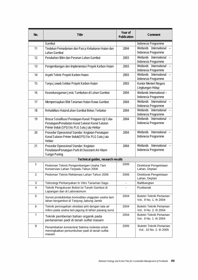
National Strategy and Action Plan for Sustainable Management of Peatlands 89
No. Title Year of Publication Comment
Gambut Indonesia Programme 11 Tindakan Pemadaman dan Pasca Kebakaran Hutan dan
Lahan Gambut 2004 Wetlands International –
Indonesia Programme 12 Perubahan Iklim dan Peranan Lahan Gambut 2003 Wetlands International –
Indonesia Programme 13 Pengembangan dan Implementasi Proyek Karbon Hutan 2003 Wetlands International –
Indonesia Programme 14 Aspek Teknis Proyek Karbon Hutan 2003 Wetlands International –
Indonesia Programme 15 Tanya Jawab Sekitar Proyek Karbon Hutan 2003 Kantor Menteri Negara
Lingkungan Hidup 16 Keanekaragaman Jenis Tumbuhan di Lahan Gambut 2004 Wetlands International –
Indonesia Programme 17 Mempersiapkan Bbit Tanaman Hutan Rawa Gambut 2004 Wetlands International –
Indonesia Programme 18 Rehabilitasi Hutan/Lahan Gambut Bekas Terbakar 2004 Wetlands International –
Indonesia Programme 19 Brosur Sosiallisasi Penutupan Kanal: Program Uji Coba
Penutupan/Penabatan Kanal Saluran Kanal Saluran Primer Induk (SPI) Eks PLG Satu Juta Hektar
2004 Wetlands International – Indonesia Programme
20 Prosedur Operasional Standar: Kegiatan Penutupan Kanal Saluran Primer Induk(SPI) Eks PLG Satu Juta Hektar
2004 Wetlands International – Indonesia Programme
21 Prosedur Operasional Standar: Kegiatan Penabatan/Penutupan Parit di Ekosistem Air Hitam Sungai Puning
2004 Wetlands International – Indonesia Programme
Technical guides, research results 1 Pedoman Teknis Pengembangan Usaha Tani
Konservasi Lahan Terpadu Tahun 2006 2006 Direktorat Pengelolaan
Lahan, Deptan
2 Pedoman Teknis Reklamasi Lahan Tahun 2006 2006 Direktorat Pengelolaan Lahan, Deptan
3 Teknologi Perbanyakan In Vitro Tanaman Sagu - Balitbangtan 4 Teknik Pengukuran Bobot Isi Tanah Gambut di
Lapangan dan di Laboratorium - Puslitanak
5 Survei produktivitas komoditas unggulan usaha tani lahan bergambut di Tanjung Jabung Jambi
2004 Buletin Teknik Pertanian Vol.. 9 No. 1. th 2004
6 Teknik pencegahan oksidasi pirit dengan tata air mikro pada usaha tani jagung di lahan pasang surut
2004 Buletin Teknik Pertanian Vol.. 9 No. 2. th 2004
7 Teknik pemberian bahan organik pada pertanaman padi di tanah sulfat masam
2004 Buletin Teknik Pertanian Vol.. 9 No. 1. th 2004
8 Penambahan konsentrat Salvina molesta untuk meningkatkan pertumbuhan padi di tanah sulfat masam
2005 Buletin Teknik Pertanian Vol.. 10 No. 2. th 2005
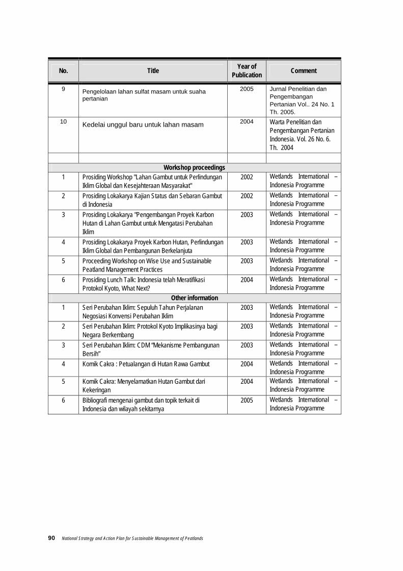
90 National Strategy and Action Plan for Sustainable Management of Peatlands
No. Title Year of Publication Comment
9 Pengelolaan lahan sulfat masam untuk suaha pertanian
2005 Jurnal Penelitian dan Pengembangan Pertanian Vol.. 24 No. 1 Th. 2005.
10 Kedelai unggul baru untuk lahan masam 2004 Warta Penelitian dan Pengembangan Pertanian Indonesia. Vol. 26 No. 6. Th. 2004
Workshop proceedings
1 Prosiding Workshop "Lahan Gambut untuk Perlindungan Iklim Global dan Kesejahteraan Masyarakat"
2002 Wetlands International – Indonesia Programme
2 Prosiding Lokakarya Kajian Status dan Sebaran Gambut di Indonesia
2002 Wetlands International – Indonesia Programme
3 Prosiding Lokakarya "Pengembangan Proyek Karbon Hutan di Lahan Gambut untuk Mengatasi Perubahan Iklim
2003 Wetlands International – Indonesia Programme
4 Prosiding Lokakarya Proyek Karbon Hutan, Perlindungan Iklim Global dan Pembangunan Berkelanjuta
2003 Wetlands International – Indonesia Programme
5 Proceeding Workshop on Wise Use and Sustainable Peatland Management Practices
2003 Wetlands International – Indonesia Programme
6 Prosiding Lunch Talk: Indonesia telah Meratifikasi Protokol Kyoto, What Next?
2004 Wetlands International – Indonesia Programme
Other information 1 Seri Perubahan Iklim: Sepuluh Tahun Perjalanan
Negosiasi Konvensi Perubahan Iklim 2003 Wetlands International –
Indonesia Programme 2 Seri Perubahan Iklim: Protokol Kyoto Implikasinya bagi
Negara Berkembang 2003 Wetlands International –
Indonesia Programme 3 Seri Perubahan Iklim: CDM “Mekanisme Pembangunan
Bersih” 2003 Wetlands International –
Indonesia Programme 4 Komik Cakra : Petualangan di Hutan Rawa Gambut 2004 Wetlands International –
Indonesia Programme 5 Komik Cakra: Menyelamatkan Hutan Gambut dari
Kekeringan 2004 Wetlands International –
Indonesia Programme 6 Bibliografi mengenai gambut dan topik terkait di
Indonesia dan wilayah sekitarnya 2005 Wetlands International –
Indonesia Programme
National Strategy and Action Plan for Sustainable Management of Peatlands 91
Other publications related to peatland issues
Abdullah, T.S. 1997. Tanah Gambut. Genesis, Klasifikasi, Karakteristik, Penggunaan, kendala dan Penyebarannya di indonesia. Jurusan Ilmu Tansh Fakultas Pertanian IPB. Bogor.
Adinugroho, W.C., Suryadiputra I N.N., E. Siboro and B. Hero. 2005. Panduan Pengendalian Kebakaran Hutan dan Lahan Gambut. Wetlands International – Indonesia Programme (WI-IP) dan Wildlife Habitat Canada (WHC).
Alue Dohong, 2003. Pemanfaatan Lahan Gambut untuk Kegiatan Pertanian Holtikuktura: Belajar dari Pengalaman Petani Desa Kalampangan, Kalimantan Tengah. Warta Konservasi Lahan basah Vol 11 no.2 April 2003. Wetlands International Indonesia Programme
Anderson, I. P. & M.R. Bowen. 2000. Fire zones and the threats of wetlands of Sumatra, Indonesia. Forest Fire Prevention and Control Project. Departemen Kehutanan, Kantor Wilayah Propinsi Sumatera selatan dan European Union.
Anderson, J.A.R. 1976. Observation on the ecology of five peat swamps in Sumatra and Kalimantan. Soil Res. Inst. Bogor Bull. 3: 45-55.
Ardjakusumah S., Nur’ani, E. Sumantri. 2002. Teknik Penyiapan Pada Lahan Gambut Bongkor Untuk Tanaman Holtikultura. Pusat Penelitian Tanah dan Agroklimat – Bogor.
Bambang Setiadi. 1993. Pemanfaatan Gambut Untuk Pertanian dan Transmigrasi. Tim Studi Pemanfatan Gambut Kedeputian Bidang Pengembangan Kekayaan Alam-BPP Teknologi, Jakarta
Bappenas - ADB. 1999. Causes, extent, impact and costs of 1997/1998 Fire and Dorught. National Development Planning Agency (Bappenas) and Asian Development Bank, Jakarta.
Bappenas – Kementerian Perencanaan Pembangunan Nasional 2002 (?). Rencana Rehabilitasi Kawasan Eks Pengembangan Lahan Gambut Kalimantan Tengah
CCFPI, Climate Change, Forests and Peatlands in Indonesia. 2005. Pengelolaan lahan gambut berkelanjutan. Seri prosiding 07. Bogor. Ditjen Bina Bangda, Wetlands International-Indonesia Programme dan Wildlife Habitat Canada.
CCFPI, WI-IP, WHC. 2003. Penutupan Kanal/Parit (Canal/Ditch Blocking) di Lahan Gambut: Buku Panduan. CCFPI, WI-IP, WHC. Bogor
CCFPI. 2003. Sebaran Gambut di Indonesia. Seri Prosiding 02. Wetlands International – Indonesia Programme dan Wildlife Habitat Canada. Bogor.
Departemen Kehutanan. 2002. Statistik Kehutanan Indonesia 2000/2001. Biro Perencanaan Departemen Kehutanan. Jakarta.
Departemen Pemukiman dan Prasarana Wilayah. 2003. Data Sumber Daya Air Indonesia. hppt://sda.kimpraswil.go.id
Departemen Pertambangan dan Energi. 1999. Buku Tahunan Pertambangan dan Energi 1999. Departemen Pertambangan dan Energi, Jakarta.
92 National Strategy and Action Plan for Sustainable Management of Peatlands
Dodent, D.L. 1986. Acid Sulphate soil: a baseline for research and development. ILRI pubilactions 39. ILRI, Wageningen. The Netherlands.
Driessen P.M. dan Permadhy Sudewo. 1975. Sebuah Tinjauan Tentang Tanaman-Tanaman dan Kinerja Tanaman Di Lahan Gambut Dataran Rendah Kawasan Asia Tenggara. Lembaga Penelitian Tanah, Bogor (terjemaahan).
Driessen, P. and H. Suhardjo. 1978. On the defective grain formation of sawah rice on peat. Soil Research Bulletin. ATA, SRI Bogor.
Driessen, PM. 1978. Peats soils in Soil and Rice. Los Banos. Philipinnes. The International Rice Research Institute (IRRI). hlm 763-779.
Funakawa, S., K. Yonebayashi, J.F. Shoon and E.C.O. Khun. 1995. Nutritional environment of tropical peat soils in view of soil solution composition. In: Environmental rehabilitation of tropical peat land: sustainable land use and soil ecosystem in peat land. Yonebayashi, K. L.C. Pang Eds.. Kyoto.
Gavin, D.G. & D.R. Peart. 1997. Spatial structure and regeneration of Tetramerista glabra in peat swamp rain forest in Indonesian Borneo. Plant Ecology Vol. 131 No. 2 pp: 223 – 231.
Giesen W, 1991. Berbak Wildlife Reserve, in Iwan Tricahyo W, Labueni Siboro, and INN Suryadiputra, 2004, Keanekaragaman Jenis Tumbuhan di Hutan Rawa Gambut, Kerjasama Wetlands Internasional, CCFPI, dan Wildlife Habitat Canada.
Hardjowigeno, S. 1989. Sifat-sifat dan potensi tanah gambut Sumatera untuk pengembangan pertanian. Hal. 15-42. Dalam Muis Lubis, A. et al. (ed.). Prosiding Seminar Tanah Gambut untuk Perluasan Pertanian. Fak. Pertanian, Universitas Islam Sumatera Utara, Medan 27 November 1989.
Hardjowigeno, S., and Abdullah. 1987. Suitability of peat soils of Sumatra for agricultural development. International Peat Society. Symposium on Tropical Peat and Peatland for Development. Yogyakarta, 9-14 Februari 1987.
Harry Heriawan Saleh, Baslian K. Yosa, Teti Herawati, Sri Najiyati, Anharudin, Rofiq Ahmad, 1997. Studi Pengerahan dan Penempatan Transmigrasi APPDT Menunjang Program PLG Satu Juta Hektar. Kerjasama Pusat Penelitian dan Pengembangan Transmigrasi dengan Direktorat Jenderal Pengerahan dan Penempatan Transmigrasi, Jakarta.
I Nyoman N. Suryadiputra, 2003. Nasib Penebang Liar di Rawa Gambut Sumatera Selatan. Warta Konservasi Lahan Basah Volume 11 No 1 januari 2003. Wetlands Internasional.
I Nyoman N. Suryadiputra, Alue Dohong, Roh S. Waspodo, Lili Muslihat, Irwansyah Reza Lubis, Ferry Hasudungan, Iwan T.C. Wibisono. December 2005. Panduan Penyekatan Parit dan Saluran di Lahan Gambut Bersama Masyarakat. Wetlands International Indonesia Programme & Wildlife Habitat canada
Inu G. Ismail dan I.W. Swastika. 1994. Pemanfaatan Abu Gergaji Kayu untuk Meningkatkan Pendapatan Petani Di Lahan Gambut. Makalah Seminar Hasil-hasil Penelitian Usahatani dan Pengembangan Tanaman Pangan. Pusat Penelitian Tanah dan Agroklimat. Bogor.

National Strategy and Action Plan for Sustainable Management of Peatlands 93
Inubushi, K. A. Hadi, M. Okazaki, & K. Yonebayashi. 1998. Effect on converting wetlands forest to sagopalm plantations on methane flux and carbon dynamics in tropical peat soil. Hydrological Processes 12: 2072 – 2080.
Jabatan Pengairan dan Saliran, Sarawak. 2001. Water Management Guidelines for Agricultural Development in Lowland Peat Swamps of Sarawak. PS Konsultant in Association with LAWOO (The Wageningen Land and Water Research Group). Research into Drainage and Water Management Guidelines for Agricultural Development in Coastal Peat Swamps of Sarawak, Phase 1. Final Report, May 2001.
Jaya, A. 2001. Carbon storage in tropical peatlands. Tropical Peatlands 1: 11 – 15.
Kottelat M, SN Kartikasari, AJ Whitten, S Wirjoatmojo. 1993. Ikan air tawar Indonesia bagian barat dan Sulawesi. Jakarta. Periplus Editions. 293 hlm.
Lili Muslihat. 2004. Teknik Penyiapan Lahan Untuk Budidaya Pertanian Di Lahan Gambut dengan Sistim Surjan, Leaflet Seri Pengelolaan Hutan dan Lahan Gambut Kerjasama antara Wetlands International Programme, Bogor.
Lim, E.T., B. Ahmad, T.L. Tie, H.S. Kueh, and F.S. Jong. 1991. Utilization of tropical peats for the cultivation of sagopalm (Metroxylon spp). p. 361-366. In Aminuddin, B.Y. (ed.). Tropical Peat. Proceed. of the Intern. Symp. on Tropical Peatland, Kuching, Sarawak, Malaysia, 6-10 May 1991.
Ministry of The Environment. 1996. The National Strategy and Action Plan for the Management of Indonesia Wetlands / Strategi Nasional dan Program Aksi Pengelolaan Lahan Basah (SNPLB). Ministry of Environment. Bogor.
Muhammad Noor. 2000. Pertanian Lahan Gambut : Potensi dan Kendala.. Kanisius, Yogyakarta.
Murdiyarso D., Upik Rosalina, Kurniatun Hairiah, Lili Muslihat, I.N.N Suryadiputra dan Adi Jaya. 2004. Petunjuk Lapangan Pendugaan cadangan Karbon pada lahan Gambut. Kerjasama antara Wetlands International, Wildlife Habitat Canada , Habitat Funnique Canada, dan Ditjen PHKA.
Murdiyarso, D. dan INN Suryadiputra. 2004. Paket informasi praktis: Perubahan iklim dan peranan lahan gambut. Bogor. Proyek Climate Change, Forests and Peatlands in Indonesia. Wetlands International-Indonesia Programme dan Wildlife Habitat Canada. hlm 3.
Noble, R. 2003. Peat substitute makes mushroom production more ecofriendly. Mushroom Journal, No. 638 pp: 20-21.
Page, S.E. & J.O. Rieley. 1998. Tropical peatlands: a review of their natural resource functions, with particular reference to southeast asia. Intl. Peat Jornal, 8: 95 – 106.
Polak, B. 1952. Occurrence and fertility of tropical peat soils in Indonesia. Contrib. Gen. Agric. Res. Sta. No. 104 Bogor.
Pusat Penelitian Tanah dan Agroklimat. 1986 – 1990. Buku Keterangan Peta Satuan Lahan dan Tanah Seluruh Sumatera (42 Lembar), Skala 1 : 250.000. Proyek Perencanaan dan Evaluasi Sumber Daya Lahan. Pusat Penelitian Tanah dan Agroklimat. Badan Penelitian dan Pengembangan Pertanian
94 National Strategy and Action Plan for Sustainable Management of Peatlands
Pusat Penelitian Tanah. 1988. Buku Penuntun Lapangan untuk survei Tanah Tinjau Pulau Sumatera Proyek Perencanaan dan Evaluasi Sumberdaya Lahan (LREP).
Radjagukguk B., dan Bambang Setiadi. 1989. Strategi pemanfaatan gambut di Indonesia. Hal. 1-13. Dalam Muis Lubis, A. et al. (ed.). Prosiding Seminar Tanah Gambut untuk Perluasan Pertanian. Fak. Pertanian, Universitas Islam Sumatera Utara, Medan.
Radjagukguk, B. 2000. Perubahan sifat fisik dan kimia tranah gambut akibat reklamasi lahan gambut untuk pertanian (Changes in the physical and chemical properties of peat soil with peatland reclamation for agriculture in Indonesia). Journal Ilmu tanah dan Lingkungan (Journal of soil science and the environment) 2(1): 1 – 15.
Sabiham, S. H. Furukawa. 1986. A Study of floral composition of peat soil in the lower Batanghari River Basin of jambi, Sumatra. Southeast Asian Studies 24(2):113 - 132.
Safford, L. & E. Maltby (EDITORS), 1998. Guidelines for integrated planning and management of tropical lowland peatlands, with special reference to Southeast Asia.IUCN Commision on Ecosystem management, Tropical Peatland Expert Group. IUCN, Gland Switzerland and Cambridge, UK.
Siwono Yudohusodo. 1994. Tantangan dan Peluang Transmigrasi pada Lahan Gambut di Kawasan Pasang Surut. Makalah Pengarahan pada Seminar Nasional 25 tahun Pemanfaatan dan Pengembangan Kawasan Pasang Surut. Jakarta, 14 Desember 1994.
Sri Najiyati, 1994-1996. Studi Verifikasi dan Pengembangan Lahan Gambut di Karang Agung Tengah, Puslitbang Transmigrasi, Jakarta.
Sri Najiyati, Agus Asmana dan I Nyoman N. Suryadiputra, 2005. Pemberdayaan Masyarakat di Lahan Gambut. Proyek Climate Change, Forests and Peatlands in Indonesia. Wetlands International – Indonesia Programme dan Wildlife Habitat Canada, Bogor.
Subagjo H. 2002. Penyebaran dan potensi tanah gambut di Indonesia untuk pengembangan pertanian. Bogor. Pusat Penelitian Tanah dan Agroklimat.
Subagjo, H., dan IPG Widjaya Adhi. 1998. Peluang dan kendala penggunaan lahan rawa untuk pengembangan pertanian di Indonesia. Kasus Sumatera Selatan dan Kalimantan Tengah. Hal. 13-50. Dalam U. Kurnia et al. (ed.) Prosiding Pertemuan Pembahasan dan Komunikasi Hasil Penelitian Tanah dan Agroklimat. Makalah Utama. Bogor, 10-12 Februari 1998. Puslit. Tanah dan Agroklimat, Bogor.
Subagyo, H. 1997. Potensi pengembangan dan tata ruang lahan rawa untuk pertanian. Hal. 17-55. Dalam Prosiding Simposium Nasional dan Kongres VI PERAGI. Makalah Utama. Jakarta, 25-27 Juni 1996.
Subagyo, H. 1998. Karakteristik bio-fisik lokasi pengembangan Sistim Usaha Pertanian Pasang Surut, Sumatera Selatan. Pusat Penelitian Tanah dan Agroklimat, Bogor (Tidak dipublikasi).
Subagyo, H., M. Sudjadi, E. Suryatna, and J. Dai. 1990. Wet Soils of Indonesia. p. 248-259. In Kimble, J.M. 1992 (ed.). Proceed. of the VIIIth International Soils Coralation Meeting (VIII ISFORM): Characterization, Classification, and Utilization of Wet Soils. USDA- Soil Conservation Service, National Soil Survey Centre, Lincoln, NE.

National Strategy and Action Plan for Sustainable Management of Peatlands 95
Subiksa, I G. M., dan A. Syarifuddin Karama. 1996. Sistem surjan di lahan rawa. Puslittanak, mimeograph, 8 hal.
Suhardjo, H., and Widjaya-Adhi, I P.G. 1976. Chemical characteristics of the upper 30 cm of peat soils from Riau. Soil Research Institute, Bulletin 3: 74-92.
Wahyunto, S. Ritung dan H. Subagjo. 2003. Peta Sebaran Gambut dan Kandungan Karbon Pulau Sumatera/ Map of Peat Distributions and Carbon Contents of Sumatera Island (Buku 2). Wetlands International-Canadian International Development Agency (CIDA) – Wildlife Habitat Canada. Bogor.
Wahyunto, S. Ritung dan H. Subagjo. 2003. Peta Sebaran Gambut dan Kandungan Karbon Pulau Kalimantan/ Map of Peat Distributions and Carbon Contents of Kalimantan (Buku 2). Wetlands International-Canadian International Development Agency (CIDA) – Wildlife Habitat Canada. Bogor.
Wahyunto, S. Ritung dan H. Subagjo. 2005. Sebaran Gambut dan Kandungan Karbon Pulau Sumatera/ Peat Distributions and Carbon Contents of Sumatera Island (Buku 1). Wetlands International-Canadian International Development Agency (CIDA) – Wildlife Habitat Canada. Bogor.
Wibisono, I.T.C. , Labueni Siboro, dan INN Suryadiputra, 2004. Keanekaragaman Jenis Tumbuhan Di Hutan Rawa Gambut, Leaflet Seri Pengelolaan Hutan dan Lahan Gambut. Kerjasama antara Wetlands International, Wildlife Habitat Canada dan Ditjen PHKA.
Wibisono, I.T.C., Labueni S dan I N.N. Suryadiputra. 2005. Panduan Rehabilitasi dan Teknik Silvikultur di Lahan Gambut. Kerjasama antara Wetlands International, Wildlife Habitat Canada dan Ditjen PHKA.
Wibisono, I.T.C., Labueni S dan I N.N. Suryadiputra., 2004. Rehabilitasi Hutan/Lahan Rawa Gambut Bekas Terbakar, Leaflet Seri Pengelolaan Hutan dan Lahan Gambut. Kerjasama antara Wetlands International, Wildlife Habitat Canada , Habitat Funnique Canada, dan Ditjen PHKA.
Wibowo, P., I N. N. Suryadiputra, Herry, N. and (et. al). 2000. Laporan Survei: Studi Lahan Basah Bagian Hutan Perian, Kalimantan Timur, PT. ITCI Kartika Utama dan Wetlands Internasional – Asia Pasific Indonesia Programme.
Widjaya Adhi, I P.G. 1988. Physical and chemical characteristics of peat soil of Indonesia. IARD Journal 10 (3): 59-64.
Widjaya-Adhi, I P.G., dan M. Sudjadi. 1988. Sebaran dan potensi pengembangan lahan gambut untuk pertanian di Indonesia. Kongres I Himpunan Gambut Indonesia dan Seminar Nasional Gambut I. Univ. Gadjah Mada.

96 National Strategy and Action Plan for Sustainable Management of Peatlands
Annex 9. List of regions possessing peatland potential and their spatial planning status
No Region Extent of Peatland (Ha) No / Th Perda Tata Ruang
Propinsi NAD a Kabupaten Aceh Selatan 168, 634 No. 2 Th 1994 b Kabupaten Aceh Barat 105, 417 No. 5 Th 1994
Propinsi Sumatera Utara a Kabupaten Labuhan Batu 191, 931 No. 6 Th. 1997 b Kabupaten Tapanuli Selatan 85, 468 No 16/KPTS/1998 c Kabupaten Asahan 24, 116 No. 3 Th. 1995 d Kabupaten Tapanuli Tengah 16, 795 No. 7 Th. 1997 (perlu revisi karena pemekaran) e Kabupaten Tapanuli Utara 6, 986 No. 21 Th. 2001
Propinsi Sumatera Barat a Kabupaten Pesisir Selatan 94, 893 b Kabupaten Pasaman 82, 427 c Kabupaten Agam 17, 229 d Kabupaten Padang Pariaman 11, 487 e Kota Padang 4, 198
Propinsi Riau a Kabupaten Inderagiri Hilirl 982, 526 b Kabupaten Bengkalis 856, 386 No. 19 Th. 2004 c Kabupaten Pelelawan 679, 731 No. 23 Th. 2001 d Kabupaten Siak 503, 669 No. 1 Th 2002 e Kabupaten Rokan Hllir 453, 874 No. 27 Th. 2002 f Kabupaten Inderagiri Hulu 222, 396 g Kabupaten Dumai 159, 596 h Kabupaten Kampar 119, 775 i Kabupaten Rokan Hulu 50, 481 j Kota Pekanbaru 5, 231
Propinsi Kepulauan Riau a Kabupaten Karimun 8, 264 b Kabupaten Kep. Riau 1, 672
Propinsi Jambi a Kabupaten tanjabtim 266, 304 b Kabupaten Batanghari 257, 506 No. 6/ 1993 c Kabupaten Tanjabbar 142, 255 d Kabupaten Sarolangun 41, 283
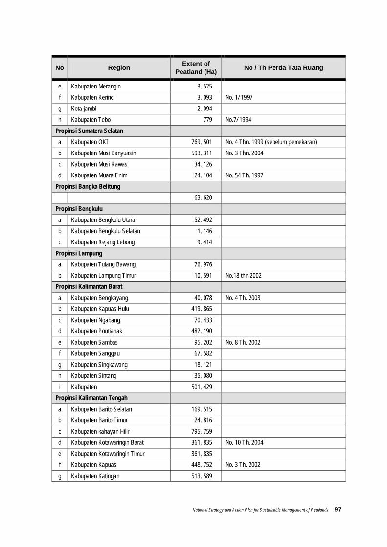
National Strategy and Action Plan for Sustainable Management of Peatlands 97
No Region Extent of Peatland (Ha) No / Th Perda Tata Ruang
e Kabupaten Merangin 3, 525 f Kabupaten Kerinci 3, 093 No. 1/ 1997 g Kota jambi 2, 094 h Kabupaten Tebo 779 No.7/ 1994
Propinsi Sumatera Selatan a Kabupaten OKI 769, 501 No. 4 Thn. 1999 (sebelum pemekaran) b Kabupaten Musi Banyuasin 593, 311 No. 3 Thn. 2004 c Kabupaten Musi Rawas 34, 126 d Kabupaten Muara Enim 24, 104 No. 54 Th. 1997
Propinsi Bangka Belitung 63, 620
Propinsi Bengkulu a Kabupaten Bengkulu Utara 52, 492 b Kabupaten Bengkulu Selatan 1, 146 c Kabupaten Rejang Lebong 9, 414
Propinsi Lampung a Kabupaten Tulang Bawang 76, 976 b Kabupaten Lampung Timur 10, 591 No.18 thn 2002
Propinsi Kalimantan Barat a Kabupaten Bengkayang 40, 078 No. 4 Th. 2003 b Kabupaten Kapuas Hulu 419, 865 c Kabupaten Ngabang 70, 433 d Kabupaten Pontianak 482, 190 e Kabupaten Sambas 95, 202 No. 8 Th. 2002 f Kabupaten Sanggau 67, 582 g Kabupaten Singkawang 18, 121 h Kabupaten Sintang 35, 080 i Kabupaten 501, 429
Propinsi Kalimantan Tengah a Kabupaten Barito Selatan 169, 515 b Kabupaten Barito Timur 24, 816 c Kabupaten kahayan Hilir 795, 759 d Kabupaten Kotawaringin Barat 361, 835 No. 10 Th. 2004 e Kabupaten Kotawaringin Timur 361, 835 f Kabupaten Kapuas 448, 752 No. 3 Th. 2002 g Kabupaten Katingan 513, 589

98 National Strategy and Action Plan for Sustainable Management of Peatlands
No Region Extent of Peatland (Ha) No / Th Perda Tata Ruang
h Kabupaten Seruyan 333, 156 i Kabupaten Sukamara 96, 119
Propinsi Kalimantan Timur a Kabupaten Berau 21, 694 No. 3 Th. 2004 b Kabupaten Bulungan 51, 346 No. 5 Th. 2003 c Kabupaten Kutai dan Kota Samarinda 278, 971 d Kabupaten Kutai Barat 62, 265 e Kabupaten Malinau 6, 579 f Kabupaten Kutai Timur 66, 950 g Kabupaten Nunukan 193, 162 h Kabupaten Pasir dan Kota Balikpapan 10, 030 Kab. Pasir : No. 6 Th. 1999
Propinsi Kalimantan Selatan a Kota Banjar Baru 42, 780 b Kabupaten Barito Kuala 40, 858 No. 9 Th. 2003 c Kabupaten Hulu Sungai Selatan 74, 972 No. 1 Th. 2004 d Kabupaten Hulu Sungai Tengah 16, 855 e Kabupaten Hulu Sungai Utara 34, 760 f Kabupaten Tapin 112, 782 g Kabupaten Tabalong 8, 337 h Kabupaten Tanah Laut 285

National Strategy and Action Plan for Sustainable Management of Peatlands 99
Annex 10. Copies of documents
a. Surat Keputusan Menteri Dalam Negeri No. 520.01/Kep/Bangda/2006 tentang Pembentukan Pokja Pengelolaan Lahan Gambut secara Berkelanjutan

100 National Strategy and Action Plan for Sustainable Management of Peatlands

National Strategy and Action Plan for Sustainable Management of Peatlands 101

102 National Strategy and Action Plan for Sustainable Management of Peatlands
b. Lampiran SK Mendagri No. 520.01/Kep/Bangda/2006

National Strategy and Action Plan for Sustainable Management of Peatlands 103
c. Surat Menteri Dalam Negeri tentang Pembentukan Pokja Pengelolaan Lahan Gambut Provinsi Riau.

104 National Strategy and Action Plan for Sustainable Management of Peatlands
d. Surat Dirjen Bina Bangda tentang Pemaparan Pengalaman Pengelolaan Lahan Gambut.
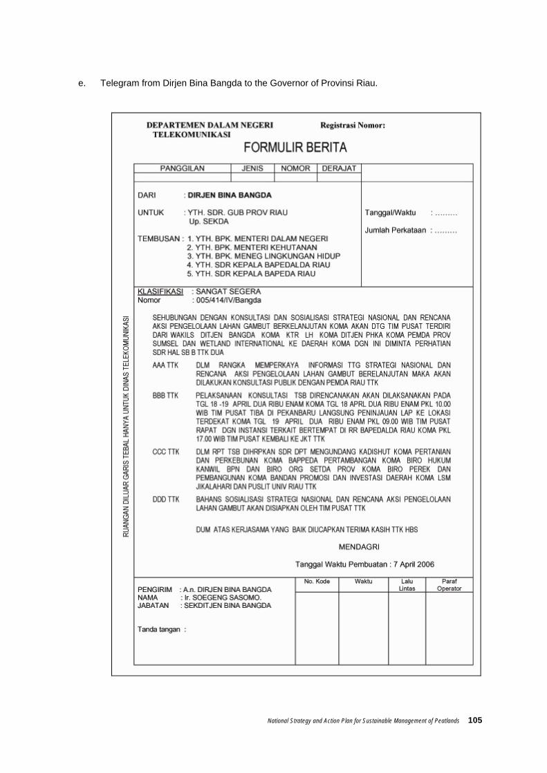
National Strategy and Action Plan for Sustainable Management of Peatlands 105
e. Telegram from Dirjen Bina Bangda to the Governor of Provinsi Riau.

106 National Strategy and Action Plan for Sustainable Management of Peatlands
Annex 11. Declaration / Statements related to peat management
e. Jakarta Statement JAKARTA STATEMENT
ON THE IMPORTANCE OF TROPICAL PEATLANDS
The importance of peatlands to national economies and the environment was highlighted August 22-23, 2001 at the International Symposium on Tropical Peatlands, entitled "Peatlands for People", which was attended by over 200 peatland scientists and managers from Indonesia and 10 other nations. Opening statements by the Indonesian Ministers of Research and Technology, Forestry, and Environment outlined their Government’s strong commitment to the sustainable use of Indonesia’s peatland resources through sound science and wise use. The Ministers welcomed the opportunities generated by this symposium and emphasized the willingness of the Indonesian Government to lead new initiatives with partner agencies in all sectors of peatland management. This symposium was timely and encouraged new initiatives for all tropical peatlands.
A wealth of new research and practical approaches to management of tropical peatland was reported at this Symposium, information that will assist people and governments throughout Southeast Asia and other tropical regions in their understanding and valuing of peatland resources. The results of the Symposium will include a published proceedings and establishment of an international network of tropical peatland science expertise in cooperation with groups such as the Indonesian Peat Association and International Peat Society. The conclusions of the Symposium provide a challenge for planners and decision-makers who now must recognize the limitations in use of tropical peatland resources.
The Symposium:
NOTED that this is a time of new beginnings in Indonesia with the meeting closely following the inauguration of a new national Government;
WELCOMED that countries such as Indonesia now have a broad spectrum of peatland and forest management expertise with many young and enthusiastic researchers and scientists eager to ensure the wise use of peatland resources;
IDENTIFIED regional cooperation on peatland issues as a priority;
WELCOMED the interest of international organizations and other governments in the region supporting new efforts for the mitigation of impacts of past management decisions affecting tropical peatlands, and calling for urgent action to prevent future peat swamp forest fires;
IDENTIFIED the importance of tropical peatlands to global biodiversity, forestry and climate change issues and their critical role in carbon cycling and deposition;
ACKNOWLEDGED that peatland fires have been a major environmental problem in Southeast Asia in recent years, and again this year, resulting in serious regional atmospheric haze effects on people and the environment;
RECOGNIZED that peatland fires have been promoted largely by land use change and logging practices, particularly in Kalimantan and Sumatra;
URGED the Indonesian Government to uphold its commitment to prevent further development on peatland with peat over three metres in thickness;

National Strategy and Action Plan for Sustainable Management of Peatlands 107
WELCOMED the role of national and provincial governments as well as local communities in charting a new course for tropical peatlands;
URGED that greater attention be focused on the conservation of peatland biodiversity and carbon stores as well as sustainable use of peatlands, particularly peat swamp forests;
ENCOURAGED STRONGLY investment by international governments and the private sector in the conservation and restoration of tropical peatlands while also PROMOTING wise use and rural sustainable development of these ecosystems;
EMPHASIZED the need for new partnerships, capacity building and application of appropriate technology as key elements of such investment;
DETERMINED that the need for new financial resources to support these peatland initiatives is pressing and vital especially to enable local government authorities to undertake their new devolved responsibilities.
Endorsed by the participants at the International Symposium on Tropical Peatlands, at Jakarta, Indonesia on August 23, 2001.
f. Pernyataan Bogor / Bogor Statement
The Bogor Statement on Wise Use and Sustainable Peatlands Management Practices
The Wise Use and Sustainable Peatlands Management Practices workshop was held in Bogor, Indonesia, on 13-14th October 2003 and was jointly organized by Wetlands International – Indonesia Programme, Wildlife Habitat Canada and the Global Environment Center and funded by Canadian International Development Assistance Agency (CIDA) through the Climate Change, Forests and Peatlands in Indonesia project (CCFPI). The workshop was attended by over 100 national and international participants from governmental and non-governmental organisations, research institutions and the private sector. Participants were drawn from the conservation, agricultural, forestry and plantation sectors. The major issues reviewed included national and international experience and best practices in peatland management, peatland fire prevention and control and post fire rehabilitation and water management.
The workshop noted that peatland ecosystems play a significant role in flood control, water storage and supply; carbon storage/sequestration and greenhouse gas/climate regulation; biodiversity conservation; socio-economic development and livelihoods. Furthermore it noted that peatlands are fragile and vulnerable to degradation.
The workshop expressed concern about the significant loss and degradation of peatland ecosystems in SE Asia and the negative impacts of this on local communities, as well as the regional and global environments. Conversion, drainage and over-exploitation of peatlands were recognised as the root causes of fires which have destroyed or degraded over two million ha of peatlands in the region in recent years, as well as leading to significant emissions of greenhouse gases and smoke.

108 National Strategy and Action Plan for Sustainable Management of Peatlands
The workshop welcomed the recent adoption by the ASEAN countries of the ASEAN Peatland Management Initiative and encouraged rapid progress in developing and implementing national plans for peatland management.
The meeting recognized the need to
• Develop and implement integrated land use plans for peatlands based on ecosystem and hydrological functions and using a basin management approach, while drawing on local knowledge and wisdom.
• Focus on the fundamental importance of maintaining or restoring the natural water regime of peatlands as the basis of measures for protection, sustainable use and rehabilitation of peatlands.
• Stop the further drainage and conversion (for agriculture, plantation, forestry and other uses) of deep peat, peat domes, undisturbed peatlands as well as other areas of conservation importance; future plantation, agriculture or development activities in peatlands should thus be focused in areas which have already been cleared or degraded.
• Take urgent measures to protect remaining intact or important peatlands.
• Require that all users of peatlands, including forestry, agriculture and plantations, apply sustainable management practices.
• Prevent peatland fires by addressing the root causes of fires such as drainage or inappropriate land use and also strengthen capacity at the local level to respond to fires.
• Support and empower local communities to protect and sustainably use peatland resources to contribute to their livelihood and environmental security.
• Facilitate the free and open sharing of information, experiences and lessons learned in order to support cooperative and effective peat management.
The Workshop strongly URGED
Governmental and non-governmental organizations, the private sector and communities to work together to protect, rehabilitate and sustainably manage peatland areas for current and future generations and the global environment.
PROPOSED ACTIONS
The Workshop further called for the following actions to be undertaken.
Regional
• Encourage the active implementation of the ASEAN Peatland Management Initiative.
• Enhance regional information sharing on peatland extent, status and management and develop handbooks for best management practices.

National Strategy and Action Plan for Sustainable Management of Peatlands 109
National
• Formulate or update national policies and strategies or action plans for conservation and wise use of peatlands.
• Undertake or revise national inventories of peatlands and zone them for protection, rehabilitation and other uses. Establish networks of pilot project sites to test and demonstrate sustainable peatland management options.
Working Group Recommendations
Fire Management in Peatland Areas
• Maintaining or restoring natural water tables in peatlands is the key to fire prevention.
• Strengthen the coordination among agencies involved in peatland fire prevention and control, including establishment of peat fire prevention units in agencies responsible for forestry and agriculture.
• Actively involve villagers in fire prevention and fighting.
• Adopt zero burning strategies for all commercial agriculture.
• Improve law enforcement as well as monitoring and predicting of fire risk.
Rehabilitation of Peatlands
• Each country with degraded peatlands is encouraged to develop a programme for peatland rehabilitation.
• Degraded peatlands should be identified and classified according to the rehabilitation options.
• Proper guidelines or manuals should be developed based on regional experience and promoted widely.
• Pilot projects to test techniques should be established.
• The first measures at the site should relate to restoration of the water table (such as blocking of drains) and prevention of conditions which may lead to the lowering of the water table or initiation of fires.
• Restoration should be undertaken with appropriate indigenous species.

110 National Strategy and Action Plan for Sustainable Management of Peatlands
Agriculture in peatland areas
• Indigenous knowledge and modern methodologies, such as techniques for prevention of subsidence and over-drainage, low impact land clearing and agricultural practices should be documented and promoted in existing peatland agricultural areas.
• Affordable and appropriate options for land clearing should be developed and provided to communities living in peatland areas.
• Promote haze-free agriculture through incentive and disincentive measures.
Water Management in Peatland Areas
• Treat each peat dome as a hydrological unit for management and integrate the management of peatlands with the management of relevant river basins.
• Blocking of drainage and logging canals in peatland areas is an important strategy to restore natural water levels and ecosystem values as well as to prevent fires and stop the sedimentation of adjacent waterways.
• Control the drainage of peatlands and restore and maintain water tables both within and in buffer zones around peatlands .
Participants requested the organizers of the meeting to widely disseminate the statement and to coordinate follow-up activities.
g. Riau Declaration
RIAU DECLARATION ON PEATLANDS AND CLIMATE CHANGE 26th January 2006
The workshop on Vulnerability of Carbon pools in Tropical Peatlands was held in Pekanbaru, Riau Sumatra from 23-26 January 2006. It was attended by 61 participants from 10 countries. It was organised by the Global Carbon Project (GCP), the Global Environment Centre (GEC) and the Centre for International Forestry Research (CIFOR). It reviewed the extent of and carbon store in tropical peatlands, land use change and fire, greenhouse gas (GHG) emissions, future climate scenarios and management options. A field visit to the Kampar Peninsular to assess current peatland plantation management practices was facilitated by Riau Andalan Pulp and Paper (RAPP). The workshop was supported by The Asia Pacific Network for Global Change, the Wetlands International-GEC project on Integrated Management of Peatlands for Biodiversity and Climate Change (funded by UNEP-GEF), and the Wetlands International Climate Change Forests and Peatlands in Indonesia project (funded by CIDA through WHC).
National Strategy and Action Plan for Sustainable Management of Peatlands 111
The workshop noted that peat is one of the world’s most important carbon stores (storing about 30% of global soil carbon) and tropical peatlands are an extremely important component – storing 30% of peatland carbon. The most extensive tropical peatlands are in SE Asia and cover about 30 million ha of which over 20 million are in Indonesia and 4 million in Riau province. Tropical peatlands play an extremely important global role for carbon storage and climate moderation as well as providing a range of other benefits such as biodiversity, water management, and livelihood support to local communities. The fundamental component of peatlands is water. As water level decreases in peatlands so does capacity for sequestering and storing carbon. Current management practices in peatlands combined with climate change and variability are having a major negative impact on peatlands. In the past 10 years about 3 million ha of peatland in SE Asia have been burnt releasing up to 3-5 billion tonnes of carbon. In additions, the drainage of peat for oil palm and timber and pulpwood plantations as well as other agriculture and unsustainable logging is estimated to --- --- have affected more than 6 million ha and released an additional 2 billion tonnes of carbon over the same period. Thus the emission of carbon dioxide from peatlands in SE Asia represents one of the largest single sources of GHG emissions globally and is equivalent of 10% of the average annual fossil fuel emission over the same period. This is accelerating global climate change. It is recognized that unsustainable practices in management of peatlands in SE Asia is the main cause of peat fire transboundary smoke haze in SE Asia which causes massive health, social, economic and environmental impacts. Subsequent El Niño events will increase likelihood of drought and associated fires will have a major negative impact on peatlands carbon stores and people in the SE Asia region. The next El Niño event is predicted within four years. The predicted changes to climate over the next 50 years as a result of increasing GHG emissions, including hotter temperatures and changes in rainfall patterns combined with land use change and deforestation, will lead to increased degradation of peatlands, increased emissions of GHGs and further acceleration of climate change. The workshop proposed the following target : All stakeholders (including government, non-government, research, private sector and local communities) should urgently work in partnership to prevent peatland fires and degradation. In addition, promote rehabilitation and sustainable use of peatlands in SE Asia to provide multiple benefits to the people in the region and safeguard the global environment. The workshop recommended relevant stakeholders to: Regional and global actions
• Expedite the implementation of the ASEAN Peatland Management Strategy and associated National Action Plans. These should be complemented by plans at the provincial and local level in regions with extensive peatlands.

112 National Strategy and Action Plan for Sustainable Management of Peatlands
• Strengthen policies and institutional arrangements for peatland management and strictly enforce policies and rules for the management and conservation of peatlands.
• Stop the further conversion and/or drainage of deep peat and peat domes and maintain and restore the hydrology of peatland systems to prevent fires, minimize GHG emissions, and maintain ecological services.
• Improve current forestry, agriculture and plantations management practices to ensure that they contribute to the sustainability of peatlands.
• Promote international cooperative studies to assess the role of peatlands in mitigating climate change and the potential future impacts of climate change and land use on the peatland carbon pool.
• Undertake an assessment of the vulnerability of peatlands to climate change and extreme events. Effectively disseminate the knowledge generated by the scientific community for use by decision makers and to support the assessment processes and later develop adaptation strategies to guide peatland managers, in particular plantation operators.
• Strengthen activities for monitoring changes in the status of tropical peatlands to guide wise management.
Riau Province
• Establish a Riau Peatland Management Partnership to bring together key stakeholders to work together to maintain and rehabilitate peatlands and promote sustainable use.
• Develop through a multistakeholder process, a masterplan for the future conservation and sustainable development of the Kampar Peninsular given its importance as one of the largest and currently relatively intact tropical peatlands in the world.
• Develop integrated management plans for each peatland to maintain the provision of ecosystem functions and services including carbon storage and water supply – as most major peatland ecosystems function as one hydrological unit but are administered by two or more District (Kabupaten) administrations and are managed by a range of agencies.
• Incorporate peatlands as a key part of integrated river basin management since peatlands in Riau form the largest stores of freshwater in the province and play a key role in regulating river flow and preventing saline intrusion and that peatland degradation will jeopardize future water supply.
• Support community based initiatives for protection and sustainable use of peatlands in Riau as an incentive to maintain peatlands and associated ecosystem services.

National Strategy and Action Plan for Sustainable Management of Peatlands 113
h. Narathiwat Statement NARATHIWAT STATEMENT ON
WISE USE AND SUSTAINABLE MANAGEMENT OF PEATLANDS The Seminar on Wise Use and Sustainable Management of Peatlands was held in Narathiwat, Thailand from 9-11 April 2003. The workshop was jointly organized by Wetlands International, Global Environment Centre, Royal Forest Department, the National Park, Wildlife and Plant Conservation Department, and the Royal Phikulthong Development and Study Centre, with support from the ASEAN Regional Centre for Biodiversity Conservation, the Climate Change, Forestry and Peatland in Indonesia Project, the Global Peatland Initiative, and the Canada Fund. It was well attended by technical experts and representatives from government, non-government research and international organisations in South East Asia. The workshop was officially opened by the Governor of Narathiwat Province - Thira Rojannapornphun. The Seminar examined two main topics – peatland management and rehabilitation; and sustainable use and community participation. Detailed presentations were made on 9 April on a broad range of issues ranging from fire prevention and control, water management, rehabilitation, biodiversity, community involvement and livelihood development. A field assessment of peatland research, management and utilisation in Narathiwat Province was made on 10 April. Two working groups on 11 April reviewed in detail issues related to management and rehabilitation; sustainable use and community participation as well as the ASEAN Peatland Management Initiative, and prepared a broad range of recommendations which were reviewed by the overall Seminar. The Seminar welcomed the establishment of the ASEAN Peatland Management Initiative in March 2003 as well as the Ramsar Convention Guidelines on Global Action on Peatland. The Workshop noted with concern the rapid loss and degradation of peat swamp forest in SE Asia and recognised that peatlands are fragile ecosystems vulnerable to fire, and impacted heavily by uncontrolled drainage. The Seminar noted that Southeast Asia has more than 60% of the world’s tropical peatlands which play a significant role in flood control, water storage and supply; climate regulation; biodiversity conservation; socio-economic development and livelihood. The meeting congratulated the Royal Thai government and local agencies for the work undertaken for the sustainable management of the peatlands in the Province of Narathiwat and encouraged recognition of this work in the region through the documentation, promotion and development of international linkages.
GOAL The Seminar URGED all stakeholders to work together in achieving the following goal:
Urgently stop the loss and degradation of peatlands in SE Asia and promote their sustainable management
PROPOSED ACTIONS The Workshop further called for the following actions to be undertaken.

114 National Strategy and Action Plan for Sustainable Management of Peatlands
Regional • Encourage the active implementation of the ASEAN Peatland Management
Initiative • Strengthen cooperation between all stakeholders in Southeast Asia on wise use
and sustainable management of peatland resources • Collate, translate and disseminate information, case studies and lessons learned
on peatland management and develop handbooks on best management practices
• Develop and implement a communication strategy for peatland management including use of video, TV, media, schools, extension services, workshops etc. information exchange programmes, and networks such as SEA Peat Network
• Establish multi-country technical working groups to work on issues of common concern such as peatland water management or rehabilitation options
• Enhance regional information sharing on peatland extent, status and management.
• Develop and promote national or regional “centers of excellence” for peatland management and enhance linkage and cooperation between them.
National • Establish national inter-agency working groups to develop strategies for peatland
protection and sustainable use • Formulate or update national policies and strategies or action plans for
conservation and wise use of peatlands • Undertake or revise national inventories of peatlands and zone them for
protection, rehabilitation and other uses • Identify and protect key peatlands important for biodiversity, carbon storage,
hydrological functions and socio-economic value to local communities. • Establish or enhance existing funding mechanisms and explore use of user- pay
schemes or tax incentives to support peatland research and sustainable management.
Management and Rehabilitation • Develop overall management plans for each peatland area to include forest,
water and fire management as well as community participation and utilization of resources.
• Develop and promote appropriate models for rehabilitation and sustainable management of peatlands
• Control the drainage of peatlands and restore and maintain water tables both within and in buffer zones around peatlands
• Promote the integrated management of peatlands using a basin-wide approach. • Establish pilot projects and demonstration sites to test and promote approaches
to sustainable management Sustainable Use and Community Participation • Introduce and strengthen alternative livelihoods to minimize impacts on peatlands • Local communities and other stakeholders should be involved in decision making
on the use of peatlands. • Develop guidance and Promote use of cost/benefit analysis, EIA as well as Social
impact assessment to minimise negative impacts of development activities on peatlands.
The organizers of the meeting were requested to widely disseminate the statement and to coordinate follow-up activities.


