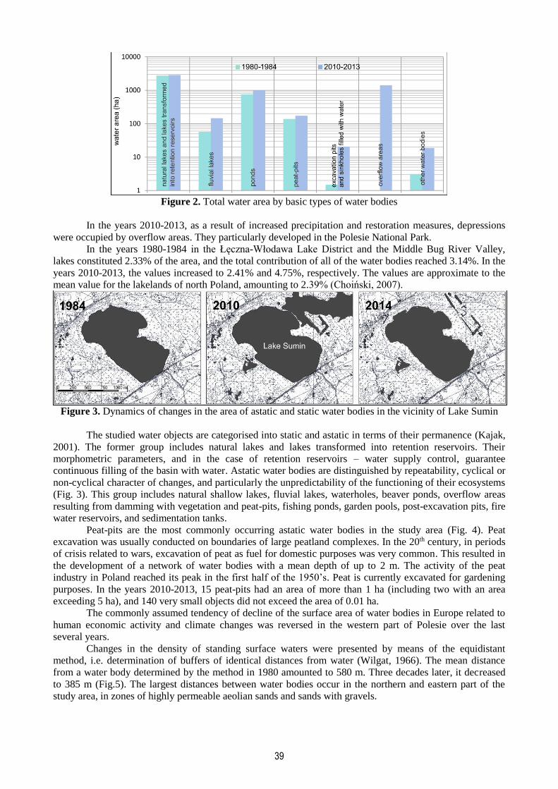
36
NATURAL AND ANTHROPOGENIC CHANGES OF STANDING WATER BODIES IN WEST POLESIE (EAST POLAND)
Katarzyna Mięsiak-Wójcik, Marek Turczyński, Joanna Sposób
Maria Curie-Skłodowska University in Lublin (Poland), Faculty of Earth Sciences and Spatial Management, Department of Hydrology
Al. Kraśnicka 2 cd/114, 20-718 Lublin, Poland, +48 815376876 [email protected], [email protected], [email protected]
Abstract
The article presents changes in the surface area of standing waters in West Polesie, East Poland. The study was based on the analysis of the content of archival topographic maps of Poland at a scale of 1:10,000, presenting the situation from the early 1980’s, and ortophotomaps and satellite scenes from the years 2010-2014. The objective of the analysis was the determination of the direction of the transformations, as well as the presentation of results conflicting with the opinion commonly adopted in Europe on the proceeding decline of the surface area of water bodies. The number of objects and their surface area evidently increased over the last three decades. This resulted from the co-occurrence of natural factors and human activities, both destructive, and those aiming at the restoration of the Old Glacial hydrogenic areas unique at the European scale. Keywords: water bodies, climate fluctuations, hydrographic cartography
1. INTRODUCTION
The Łęczna-Włodawa Lake District and the Middle Bug River Valley are subregions of West
Polesie, constituting the westernmost fragment of a large European region of Polesie. Both of the subregions
are included in the western part of the West Polesie Transboundary Biosphere Reserve.
The environmental attractiveness of West Polesie has encouraged researchers from a number of
fields to perform intensive environmental studies. They have been documenting transformations of biotic and
abiotic elements of the region for more than a century. The first of the papers concerned peatlands and the
accompanying lakes (Kulczyński, 1939, 1940), and a thorough study of several tens of lakes of the Łęczna-
Włodawa Lake District (Wilgat 1954). A number of monographs and papers have appeared so far, with
content related to standing surface waters, constituting the primary element of hydrogenic landscapes
(Chmielewski&Chmielewski, 2008; 2010; Chmielewski&Piasecki, 2010; Harasimiuk et al., 1998;
Kowalewski, 2012; Osowiec, 2011; Radwan et al., 2002; Michalczyk et al., 2003).
The study area occupies 1,181 km2. Water bodies together with the surrounding peatlands are the
most important elements of Old Glacial hydrogenic landscapes. The system of standing surface waters is
dominated by lakes with a small area, but varied depths. The area of standing waters also includes that of
retention reservoirs in the western and central part of the Łęczna-Włodawa Lake District (Dawidek et al.
2004; Mięsiak et al., 2005), complexes of fishing ponds established on the weakly permeable soils of the
northern and western part of the area, and peat-pits, pools and small ponds, excavation pits, and sinkholes
developed as a result of exploitation of aggregates and hard coal (Chmiel et al., 2002; Michalczyk&Zarębski,
1995; Michalczyk et al., 2007; Pęczuła et al., 2014). The area is distinguished by the occurrence of numerous
small water bodies of varied origin, particularly anthropogenic.
The first research paper concerning the identification of small water bodies with an area of less than
1 ha in the West Polesie Transboundary Biosphere Reserve was published in 2013 (Sender et al., 2013). It
identified approximately 3,000 such objects with varied origin, area, and character of their immediate
surroundings.
Along with climate changes, large areas originally occupied by lakes were transformed into
peatlands. The area of the Łęczna-Włodawa Lake District has been subjected to measures aimed at draining
excess water and obtaining land for agricultural activity for more than 200 years (Wilgat et al. 1997; Mięsiak
et al., 2005, Sposób & Turczyński, 2009). In the second half of the 20th century, the western and central part
of the Łęczna-Włodawa Lake District was incorporated into the largest in Poland melioration system of the
Wieprz-Krzna Canal (Janiec, 1993; Michalczyk, 1994). In the 1980’s, hard coal mines were established at
the south-western boundary of the region.
2nd International Conference - Water resources and wetlands. 11-13 September, 2014 Tulcea (Romania); Available online at http://www.limnology.ro/water2014/proceedings.html Editors: Petre Gâştescu ; Włodzimierz Marszelewski ; Petre Bretcan; ISSN: 2285-7923; Pages: 36-43; Open access under CC BY-NC-ND license ;
37
2. METHODS
The objective of the study was the analysis of changes in the surface area of standing waters
performed in two temporal aspects with different degree of humidity. The situation from the years 1980-
1984 was analysed based on topographic maps at a scale of 1:10,000. For the years 2010-2013,
ortophotomaps and satellite scenes were applied. The water bodies were digitalised in the GIS environment.
Areas with identical distance from shores of the water bodies were identified. The areas of the buffers
between equidistants were used for the determination of the density of water bodies (Wilgat, 1966). Changes
in the water surface area were also presented in basic fields with an area of 1 ha. The field verification of
selected objects was performed in July and August 2013.
Precipitation is the primary factor guaranteeing the permanent character of a water body. The
determination of the distribution of precipitation in the study period and the period preceding the analysis is
the basic requirement permitting drawing accurate conclusions. The mean annual precipitation in the study
area in the years 1955-2013 amounted to 550 mm. The period included 36 dry years (Fig. 1) and 26 years
with precipitation exceeding the mean value. The lowest precipitation, below 75% of the mean value, was
recorded five times, in 1959, 1961, 1969, 1977, and 1982. High precipitation, exceeding 125% of the mean
total, occurred eight times, in 1966, 1974, 1980, 1997, 2000, 2001, 2009, and 2010. A long sequence of dry
years, from 1981 to 1991, resulted in drying out of a number of small water bodies. Excess precipitation in
the years 2005-2010, and particularly the very high precipitation of two consecutive years 2009 and 2010,
resulted in filling them with water again. The first of the periods mentioned above is documented by
topographic maps issued in 1984. The second one is documented by satellite photographs commonly
available on geoportal.pl, and by high-resolution scenes of Google Earth.
Figure 1. Annual precipitation recorded in the Łęczna-Włodawa Lake District in the years 1955-2013
(precipitation station in Garbatówka)
3. RESULTS AND DISCUSSION
The study area, located outside of the range of the last glaciation, is distinguished by small surface
areas of particular water bodies. The terrestrialisation processes, slower than in the northern part of Poland
and Europe, resulting from the evolution of lakes towards peatlands and gyttja bogs, caused the
transformation of large water areas into smaller water bodies. Their number today exceeds 4,000 (Table 1).
The mean area per water body in the years 1980-1984 amounted to 1.43 ha, and three decades later 1.33 ha.
The area criterion for lakes adopted in Poland is 1 ha. Smaller water bodies are called ponds (Choiński,
2007). Small water bodies are also recognised as “ponds” in foreign literature (Downing et al., 2006; Rouen,
2001). According to the Pond Conservation Group (1993), small water bodies are objects with an area of less
than 2 ha, maintaining water surface for at least 4 months in a year.
In the early 1980’s, the study area included 2,427 such small water bodies. Three decades later, their
number increased to 3,968. They were dominated by peat-pits and small ponds (Table 2). The number of
small ponds has been dynamically increasing since the 1990’s.
38
Table 1. Water bodies of the Łęczna-Włodawa District
Type of water body
1980-1984 2010-2013
Number of objects
Area (ha)
Contribution of water area of a
given type in the group of water
bodies
Number of objects
Area (ha)
Contribution of water area of a
given type in the group of water
bodies
lakes and lakes transformed into retention reservoirs 60 2,754.30 74.3 651) 2,852.00 50.8
fluvial lakes 308 56.98 1.5 362 145.99 2.6
ponds 271 752.30 20.3 1,258 985.70 17.6
peat-pits 1,880 139.20 3.8 1,830 172.30 3.1
excavation pits and sinkholes filled with water 20 1.50 0.04 43 20.90 0.4
overflow areas 353 1,414.20 25.2
other water bodies 51 3.14 0.1 295 18.91 0.3
total 2,588 3,707.42 100.0 4,206 5,610.01 100.0
1) The increased number of lakes in the period 2010-2013 results from filling several fragments of the gyttja bog in place of the former Lake Laskie
No considerable changes in the surface area of lakes have been observed over the last three decades
(Fig. 2). They are the most stable among all of the studied types of water bodies. Limnic systems the most
prone to transformations are located in the south-western part of the Lake District. They are affected by the
activity of hard coal mines. Deformations of sinking ground result in changes in the direction of surface and
underground water runoff.
Table 2. Areas of limnic objects in the years 1980-1984 and 2010-2013
Type of water body
Area (ha)
Documentation from the years
Mean value
<0.
01
0.01
– 0
.1
0.1
- 1
1 -
5
5 -
10
10 -
50
50 -
100
100
- 50
0
500
- 10
00
min max
Number of objects
lakes and lakes transformed into retention reservoirs
1980-1984 45.90 0 0 4 9 8 22 10 7 0 0.576 458.20
2010-2013 43.88 4 3 3 8 8 20 12 7 0 0.00142 478.47
fluvial lakes 1980-1984 0.185 26 195 75 10 1 0 0 0 0 0.00511 9.014
2010-2013 0.403 9 160 161 27 4 1 0 0 0 0.00282 11.81
ponds 1980-1984 2.558 12 105 69 47 17 21 1 0 0 0.00609 51.94
2010-2013 0.783 29 825 321 45 14 21 2 1 0 0.00400 104.55
peat-pits 1980-1984 0.074 111 1,434 325 7 0 1 0 0 0 0.00441 14.19
2010-2013 0.094 140 1,322 353 13 2 0 0 0 0 0.00088 6.50
excavation pits and sinkholes filled with water
1980-1984 0.067 2 15 3 0 0 0 0 0 0 0.00668 0.42
2010-2013 0.486 9 23 8 2 0 1 0 0 0 0.00180 14.65
overflow areas 1980-1984 * * * * * * * * * * * *
2010-2013 4.006 30 152 122 28 11 8 0 1 1 0.00161 783.17
other water bodies 1980-1984 0.061 7 38 6 0 0 0 0 0 0 0.00435 0.64
2010-2013 0.064 11 241 42 1 0 0 0 0 0 0.00364 1.84
total 1980-1984 158 1,787 482 73 26 44 11 7 0
total 2010-2013 232 2,726 1,010 124 39 51 14 9 1
* not marked in topographic maps
39
Figure 2. Total water area by basic types of water bodies
In the years 2010-2013, as a result of increased precipitation and restoration measures, depressions
were occupied by overflow areas. They particularly developed in the Polesie National Park.
In the years 1980-1984 in the Łęczna-Włodawa Lake District and the Middle Bug River Valley,
lakes constituted 2.33% of the area, and the total contribution of all of the water bodies reached 3.14%. In the
years 2010-2013, the values increased to 2.41% and 4.75%, respectively. The values are approximate to the
mean value for the lakelands of north Poland, amounting to 2.39% (Choiński, 2007).
Figure 3. Dynamics of changes in the area of astatic and static water bodies in the vicinity of Lake Sumin
The studied water objects are categorised into static and astatic in terms of their permanence (Kajak,
2001). The former group includes natural lakes and lakes transformed into retention reservoirs. Their
morphometric parameters, and in the case of retention reservoirs – water supply control, guarantee
continuous filling of the basin with water. Astatic water bodies are distinguished by repeatability, cyclical or
non-cyclical character of changes, and particularly the unpredictability of the functioning of their ecosystems
(Fig. 3). This group includes natural shallow lakes, fluvial lakes, waterholes, beaver ponds, overflow areas
resulting from damming with vegetation and peat-pits, fishing ponds, garden pools, post-excavation pits, fire
water reservoirs, and sedimentation tanks.
Peat-pits are the most commonly occurring astatic water bodies in the study area (Fig. 4). Peat
excavation was usually conducted on boundaries of large peatland complexes. In the 20th century, in periods
of crisis related to wars, excavation of peat as fuel for domestic purposes was very common. This resulted in
the development of a network of water bodies with a mean depth of up to 2 m. The activity of the peat
industry in Poland reached its peak in the first half of the 1950’s. Peat is currently excavated for gardening
purposes. In the years 2010-2013, 15 peat-pits had an area of more than 1 ha (including two with an area
exceeding 5 ha), and 140 very small objects did not exceed the area of 0.01 ha.
The commonly assumed tendency of decline of the surface area of water bodies in Europe related to
human economic activity and climate changes was reversed in the western part of Polesie over the last
several years.
Changes in the density of standing surface waters were presented by means of the equidistant
method, i.e. determination of buffers of identical distances from water (Wilgat, 1966). The mean distance
from a water body determined by the method in 1980 amounted to 580 m. Three decades later, it decreased
to 385 m (Fig.5). The largest distances between water bodies occur in the northern and eastern part of the
study area, in zones of highly permeable aeolian sands and sands with gravels.
40
Figure 4. Increase in the area of peat-pits as a consequence of currently intensified peat excavation at the
boundaries of the Krowie Bagno peatland
The synthesis of the spatial variability of changes in areas occupied by water bodies was prepared by
means of quantitative analysis in a matrix with fields of 1 ha. The analysis result was presented in a diagram
(Fig. 6) and spatial cartographic image (Fig. 7).
Figure 5. Zones of distances from water bodies – equidistant map
41
Figure 6. Number of basic fields in classes of contribution of standing surface waters
The difference map (Fig. 7) presents three areas (A, B, and C) with a considerable increase in the
surface area of standing water bodies. Water bodies in the Polesie National Park (A, B) developed as a
consequence of restoration works involving damming water runoff from originally closed-drainage areas
incorporated into the melioration system in the 20th century. In area C, water bodies developed as a result of
the destructive activity of man. Some of them are flooded depressions resulting from mining land
deformations. Others are currently developed peat-pits.
Figure 7. Difference map of the surface area of standing waters of the Łęczna-Włodawa Lake District and
Middle Bug River Valley in the years 1980-84 and 2010-2013
A – peatlands in the southern part of the Polesie National Park subject to restoration measures, B – meadows
and ponds in the northern part of the Polesie National Park subject to restoration measures, C – zone affected
by the activity of hard coal mines
Water bodies, particularly small, play a considerable role in the preservation of biodiversity in West
Polesie (Chmielewski&Piasecki, 2010). The objects have become a habitat and place of reproduction of
valuable endangered animals. In the scope of the Programme of protection and restitution of European pond
turtle (Emys orbicularis) in Poland, a number of small water bodies have been established in the eastern part
of the study area for the purpose of reintroduction of the species. Moreover, the water bodies have become a
suitable ecosystem for swamp minnow (Eupallasella percnurus). Both of the species are under strict species
protection in Poland, and they are included in the IUCN Red List of Threatened Species.
42
4. CONCLUSIONS
The determination of the rate and direction of transformations of water resources accumulated in
natural and artificial surface water bodies must be preceded by the analysis of the conditions of precipitation.
Lack of information on precipitation preceding the terms of hydrological analysis frequently results in
unjustified conclusions. Such a procedure will permit the identification of natural and anthropogenic factors
determining the functioning of water bodies.
In the early 1980’s, 2,588 water bodies (static and astatic) were recorded in the study area, occupying
a total area of 37.1 km2. After the first decade of the 21st century, the study area included 4,206 objects with
a total area of 56.1 km2. The increase in the number of standing surface water objects has natural and
anthropogenic causes. A natural factor raising water resources is increased precipitation and its specific
distribution in time. Over the recent years, many natural depressions were occupied by overflow areas
resulting from restoration measures, particularly in the Polesie National Park (Pikunas&Kobielas, 2007). The
growing population of Eurasian beaver (Castor fiber) largely contributes to their development. The Middle
Bug River Valley with approximately 300 fluvial lakes is a hydrological area unique at the European scale.
Its water resources are subject to continuous natural changes.
The excavation of hard coal by the caving method results in land deformations in the south-western
part of West Polesie. Water accumulating in sinkholes develops dynamically changing anthropogenic water
bodies.
REFERENCES Chmiel, S., Michalczyk, Z., Turczyński, M. 2002, Hydrological changes of waters in reservoirs formed as a
result of mining deformations, Limnological Review, 2, 57-62.
Chmielewski, T. J. & Chmielewski, Sz. 2008, The influence of changes in landscape ecological structure on
biodiversity (The West Polesie Biosphere Reserve) in Kędziora, A. (edit.) Papers on Global Change,
IGBP Warsaw, 15, 121 – 140.
Chmielewski, T. J. & Chmielewski, Sz. 2010, Procesy zanikania ekosystemów jeziornych i torfowiskowych
w rejonie Poleskiego Parku Narodowego od II połowy XX w. oraz perspektywy ich ochrony [The
processes of decay of lake and peatland ecosystems in the area of Polesie National Park since the second
half of 20th century and perspectives of their protection], Problemy Ekologii Krajobrazu, 26, 121-134 [in
Polish].
Chmielewski, T. J. & Piasecki, D. (edit.) 2010, The Future of Hydrogenic Landscapes in European
Biosphere Reserves, University of Life Sciences in Lublin, Polesie National Park, Polish Academy of
Sciences - Branch in Lublin, National UNESCO-MaB Committee of Poland, Lublin, 438p.
Choiński, A., 2007, Limnologia fizyczna Polski [Physical limnology of Poland], Wyd. UAM, Poznań, 548p.
Dawidek, J., Sobolewski, W., Turczyński, M. 2004, Transformations of catchment-areas of lakes converted
into storage reservoirs in the Wieprz–Krzna Canal system. Limnological Review, 4, 67-74.
Downing, J. A., Prairie, Y. T., Cole, J. J., Duarte, C. M., Tranvik, L. J., Striegl, R. G., McDowell, W. H.,
Kortelainen, P., Caraco, N. F., Melack, J. M., Middelburg, J. J. 2006, The global abundance and size
distribution of lakes, ponds, and impoundments, Limnology and Oceanography, 51: 2388–2397.
Harasimiuk M., Michalczyk Z., Turczyński M. (edit.) 1998, Jeziora łęczyńsko-włodawskie. Monografia
przyrodnicza. [The Łęczna-Włodawa lakes. Environmental monograph], Biblioteka Monitoringu
Środowiska, UMCS, PIOŚ, Lublin, 176p. [in Polish].
Janiec, B. 1993, Przyrodnicza ocena wpływu Kanału Wieprz –Krzna na jakość hydrosfery Pojezierza
Łęczyńsko –Włodawskiego [Natural evaluation of Wieprz-Krzna Canal influence on the hydrosphere
quality of Łęczna Włodawa Lake District, Gospodarka Wodna, 2, 36-42 [in Polish].
Kajak, Z. 2001, Hydrobiologia: limnologia. Ekosystemy wód śródlądowych [Hydrobiology: Limnology.
Ecosystems of inland waters], Wyd. Nauk. PWN, Warszawa, 355p. [in Polish].
Kowalewski, G. 2012, Over 200 years of drainage practices and lake level drawdown in the Uściwierskie
Lowering (Łęczna-Włodawa Lakeland). Limnological Review, 12: 4, 179-190.
Kulczyński, S. 1939, Torfowiska Polesia t. I [Peatlands of Polesie, volume I], Uniwersytet Jagielloński,
Kraków [in Polish].
Kulczyński, S. 1940, Torfowiska Polesia t. II [Peatlands of Polesie, volume II], Uniwersytet Jagielloński,
Kraków [in Polish].
43
Michalczyk, Z. 1994, Zmiany sieci hydrograficznej w rejonie oddziaływania kanału Wieprz-Krzna [Changes
of hydrographical network in the influence area of Wieprz-Krzna Canal] in Środowisko przyrodnicze w
strefie oddziaływania kanału Wieprz-Krzna [Natural environment in the influence area of Wieprz-Krzna
Canal], Akademia Rolnicza, Lublin, 43-46.
Michalczyk Z. & Zarębski K. 1995, Wymiana wód podziemnych w południowo-zachodniej części
Pojezierza Łęczyńsko-Włodawskiego w rejonie KWK "Bogdanka" [Ground water interchange in the
south-western part of the Łęczna-Włodawa Lake region in the Bogdanka Coalmine], 119-126 in
Conference Procedings 7th Workshop Present problems of hydrogeology, 7, part 2, Kraków-Krynica [in
Polish].
Michalczyk Z., Chmiel S., Turczyński M. 2003, Stosunki wodne w obszarze funkcjonalnym Poleskiego
Parku Narodowego [Water conditions in the functional area of Polesie National Park], Acta Agrophys.
Rozpr. Monogr. 91, 26-67 [in Polish].
Michalczyk, Z., Chmiel, S., Chmielewski, J., Turczyński, M. 2007, Hydrologiczne konsekwencje
eksploatacji złoża węgla kamiennego w rejonie Bogdanki (LZW) [Hydrological consequences of coal
mining in the area of Bogdanka (Lublin Coalfield)], Biuletyn Państwowego Instytutu Geologicznego, 422,
113–126 [in Polish].
Mięsiak, K., Szwajgier, W. & Turczyński, M. 2005, Environmental transformations in Lake Lejno catchment
basin. Limnological Review, 5, 175-182.
Osowiec, M. 2011, Strukturalno-funkcjonalna klasyfikacja krajobrazów hydrogenicznych na przykładzie
Polesia Lubelskiego [Structural and functional classification of hydrogenic landscapes on the examples of
Lublin Polesie], Prace i Studia Geograficzne, 46, 155-168 [in Polish].
Pęczuła, W., Szczurowska, A. & Poniewozik, M. 2014, Phytoplankton Community in Early Stages of
Reservoir Development--a Case Study from the Newly Formed, Colored, and Episodic Lake of Mining-
Subsidence Genesis, Polish Journal of Environmental Studies, 23: 2, 585-591.
Pikunas, K.& Kobielas, M. 2007, Ochrona aktywna ekosystemów wodno-torfowiskowych w Poleskim Parku
Narodowym [Active protection of water-peatland ecosystems in Polesie National Park] in Michalczyk, Z.
(edit.) Obieg wody w środowisku naturalnym i przekształconym [Water circulation in natural and
changed environment, Wyd. UMCS, Lublin, 436-444 [in Polish].
Pond Conservation Group 1993, A future for Britain’s ponds: An agenda for action. Pond Conservation
Group, Oxford.
Radwan, S., Mieczan, T., Płaska, W., Sender, J., Wojciechowska, W., Jaszczenko, P. 2002, Ekosystemy
wodne Polesia – stan aktualny i kierunki zmian [Water ecosystems of Polesie – actual state and directions
of changes] in Radwan, S., Gliński, J., Geodecki, M., Rozmus, M. (edit.) Środowisko przyrodnicze
Polesia – stan aktualny i zmiany [Natural environment of Polesie - actual state and changes], Acta
Agrophysica, 66, 89-120 [in Polish].
Rouen K., 2001, Use of the terms ‘ponds’ and ‘pools’, Freshwater Forum, 17, 4.
Sender, J., Kułak, A., Maślanko, W. 2013, Różnorodność drobnych zbiorników wodnych w wybranych
parkach krajobrazowych położonych w Rezerwacie Biosfery „Polesie Zachodnie” [Diversity of small
water reservoirs in selected landscape parks within the Biosphere Reserve Western Polesie] in
Functioning, endangeres and protection of small water reservoirs, Polish Scientific Conference, 26-27
September 2013, Janów Lubelski - Lublin Poland, 79 [in Polish].
Sposób, J. & Turczyński, M. 2009. Przekształcenia obszarów bezodpływowych w zlewnie o wymuszonym
obiegu wody–Pojezierze Łęczyńsko-Włodawskie [Transformation of undrained areas into catchments of
imposed water circulation–Łęczyńsko-Włodawskie Lake District] in Bogdanowicz, R. & Fac-Beneda, J.
(edit.) Zasoby i ochrona wód. Obieg wody i materii w zlewniach rzecznych [Water resources and
protection. water and matter cycling in river catchments). Gdańsk, FRUG, 111-121 [in Polish].
Wilgat T. 1954, Jeziora Łęczyńsko-Włodawskie [The Łęczna-Włodawa lakes], Ann. UMCS, B: 8, 37-122 [in
Polish].
Wilgat, T. 1966, Odległość od wody jako wskaźnik gęstości sieci wodnej [Distance from water as index of
water network density], Przegl. Geogr., 38: 3, 371 – 380 [in Polish].
Wilgat, T., Janiec, B., Michalczyk, Z., Turczyński, M. 1997, Hydrological consequences of human action in
the Łęczna-Włodawa Lake Region, Geogr. Pol., 68, 117-147.