Natural England Research Report NERR029 Current marine and coastal issues for North East Kent: proceedings of the third North East Kent Coastal Conference 9 November 2006 www.naturalengland.org.uk
Transcript
Natural England Research Report NERR029
Current marine and coastal issues for North East Kent: proceedings of the third North East Kent Coastal Conference 9 November 2006
Current marine and coastal issues for North East Kent: proceedings of
the third North East Kent Coastal Conference 9 November 2006
Tony Child1 and Ian Tittley2
1Thanet Coast Project 2Natural History Museum
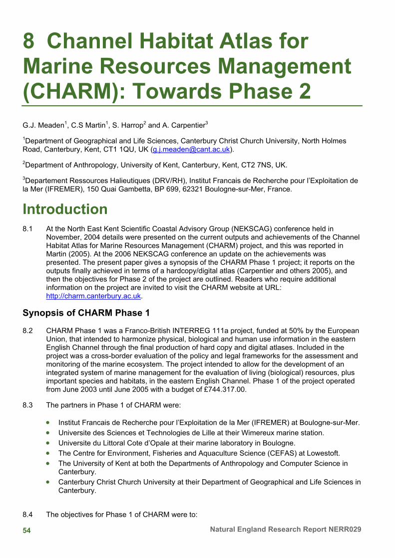
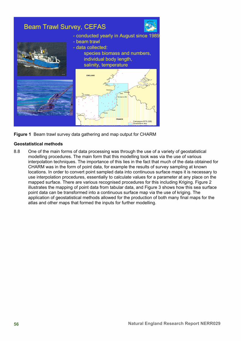
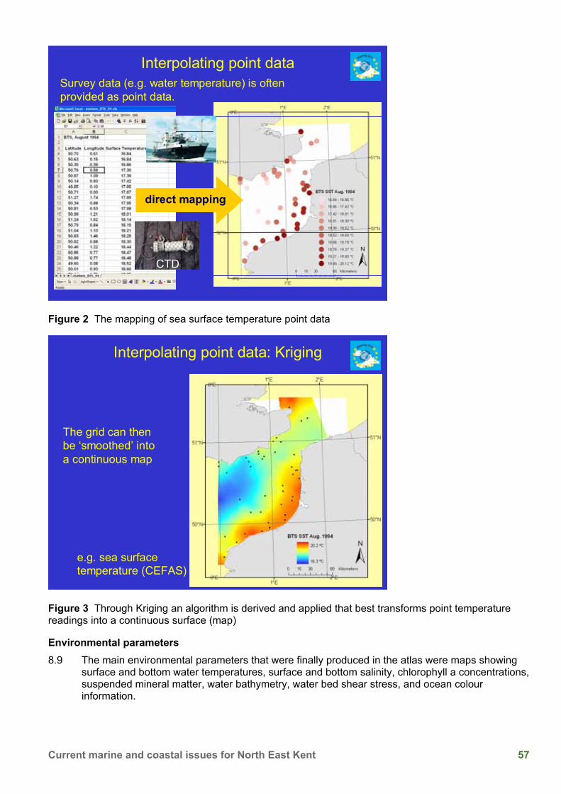
Published on 19 December 2008
The views in this report are those of the authors and do not necessarily represent those of Natural England. You may reproduce as many individual copies of this report
as you like, provided such copies stipulate that copyright remains with Natural England, 1 East Parade, Sheffield, S1 2ET
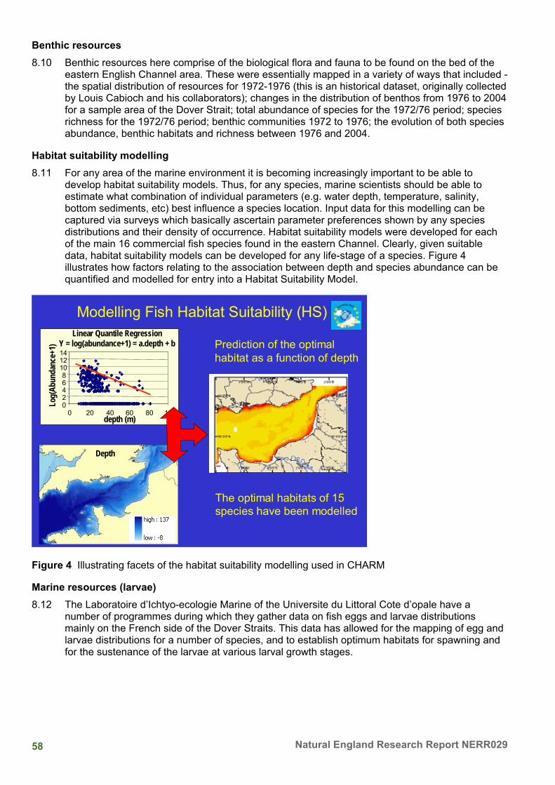
i Current marine and coastal issues for North East Kent
Project details This report is the summary of the coastal research covered within a conference linked to the area covered by the North East Kent European marine sites and the North East Kent Scientific Coastal Advisory Group, supported by Natural England.
A summary of the findings covered by this report, as well as Natural England's views on this research, can be found within Natural England Research Information Note RIN029 – Current marine and coastal issues for North East Kent: proceedings of the third North East Kent Coastal Conference 9 November 2006.
This report should be cited as:
Child, T.F, & Tittley, I. 2008. Current marine and coastal issues for North East Kent: proceedings of the third North East Kent Coastal Research Conference 9 November 2006. Natural England Research Reports, Number 029.
Project manager Ingrid Chudleigh Natural England The Countryside Management Centre Coldharbour Farm Wye Ashford Kent TN25 5DB [email protected]
Contractor Tony Child Thanet Coast Project Thanet District Council Cecil Street Margate CT9 1XZ www.thanetcoast.org.uk Ian Tittley Department of Botany Natural History Museum Cromwell Road London SW7 5BD www.nhm.ac.uk
Acknowledgments The authors would like to acknowledge the help and assistance from the North East Kent Scientific Coastal Advisory Group (NEKSCAG) members, Thanet District Council and support from Natural England for this Research Conference.
iii Current marine and coastal issues for North East Kent
Introduction This volume contains the proceedings of the third North East Kent Coastal Conference held in the Winter Gardens, Margate on 9 November 2006. The coastal conference is now a well-established biennial forum that attracts speakers and participants representing a wide range of stakeholder interests in the North East Kent European Marine Sites area. A particular aim of the series of conferences has been to facilitate communication and exchange of information between coastal researchers from academia, statutory agencies, local authorities, consultancies and NGOs active in North East Kent. The conference also presents an opportunity to communicate science results and address issues of interest and concern to a wider audience especially the general public, local businesses and leisure activity groups with a stakeholder interest in the North East Kent European Marine Sites. In all these respects the series of conferences has been most successful.
Coastal research work in the North East Kent European Marine Sites is now supported by an electronic library (a metadata collation) of literature references for the area that has been completed since the last conference in 2005. This was a topic for research identified at a previous conference and is now accessible to anyone interested via the Kent and Medway Biological Records centre web site. Also, since the last conference, a monitoring study in the Thanet SAC has confirmed a favourably maintained status for intertidal features. The papers published here bring the reader up to date with the results of coastal research around the Thanet coast.
The conference dealt with current marine and coastal issues for northeast Kent and covered three main themes: (i) ongoing research, (ii) the use of coastal resources, and (iii) managing coastal resources. The presentation sessions were complemented by four participatory workshops dealing with topical, often controversial, issues: (i) implications of collecting from the foreshore, (ii) the establishment of a highly protected marine area, (iii) the Thanet Coast Project’s future remit, and (iv) an assessment of the impact of human activities. These are reported in the Appendix; their style and content varies according to the facilitator and the information provided by the workshop group.
The revised Management Plan 2007-12 for the North East Kent Marine Sites launched in April 2007 has identified topics for future research as has the North East Kent Coastal Science Advisory Group (NEKSCAG) and will include issues such as unlicensed mollusc gathering, and the spread of non-native species around the coast of North East Kent. We also look forward to feedback of information from the Thanet Coastal Warden Scheme now successfully up and running.
Finally, we would like to thank all the participants for contributing to a successful day, to Natural England for making the day possible and this Conference Proceedings, and to Thanet District Council for their hospitality and use of the Winter Gardens in Margate.
Tony Child & Ian Tittley
Editors on behalf of North East Kent Scientific Coastal Advisory Group (NEKSCAG).
iv Natural England Research Report NERR029
Opening Remarks Cllr Roger Latchford OBE
Deputy Leader, Thanet District Council
Here in North East Kent, the sea and coast is integral to defining our local community and its history. It is something we are still proud of today and Thanet, for instance, has not only the longest continuous stretch of chalk coastline in the country, but also achieved the most ‘blue flags’ and ‘seaside awards’ for its seaside beaches!
This is an important year for the Marine environment. With the Government’s proposed Marine Bill consultation this summer we all look forward to seeing some progress towards the better management of our seas that have for too long been out of sight and out of people’s minds.
And last week the Stern Report (Nicholas Stern, is the Government's chief economist) has highlighted the huge task and costs required to help avoid the worst effects of climate change that will effect us all - but it stresses, that we need to start taking action now because our coastline in North East Kent is particularly vulnerable to both coastal flooding and to marine erosion.
That's why I’m really pleased to see that the North East Kent Scientific Coastal Advisory Group (NEKSCAG) - a group representing the natural sciences from government agencies to non-governmental bodies and specialists interests - are helping to lead the way in discussing issues and promoting research for things that we can do at a local level in North East Kent.
Following previous conferences in 2002 and 2004, this is the third biennial research conference that has been held by NEKSCAG. English Nature, now Natural England, has kindly sponsored these, as well the writing up of each of the presentations as the Conference Proceedings. We thank them sincerely for this.
I wholeheartedly endorse the work of the Group as it is so important that we identify and encourage appropriate research into coastal and marine issues, so that we are able to make ‘informed decisions’ about the way that we manage the coast and our marine environment in the future.
This research is also an important part of the Management Scheme for the international nature conservation designations that cover this area known as the North East Kent European marine sites. It is important that we can share the findings of the work that is taking place here, and I look forward to hearing the presentations that have been lined up for today.
I also want to take the opportunity to thank all the people involved with promoting the natural environment of the North East Kent coast that is particularly visible in the work undertaken by the Thanet Coast Project and supported by various organisations and individuals.
v Current marine and coastal issues for North East Kent
Cllr Roger Latchford OBE, Deputy Leader, Thanet District Council
Research around our coast
(Chair: Jackie Trigwell)
10.15 - 10.35 Thanet Coast Special Area of Conservation: - intertidal monitoring and condition status
Ian Tittley, Natural History Museum, London
P. Chimonides, Natural History Museum, London
C. J. Spurrier, Natural History Museum, London
B. Chapman, Kent Wildlife Trust, Maidstone
10.35 - 10.55 Filter feeding crustaceans in the Kentish Stour estuary
Phil Buckley, Ecology Research Group, Canterbury Christ Church University
10.55 - 11.15 Life on the edge - the invertebrate fauna of Kent's soft cliffs
Andrew Whitehouse, Buglife, The Invertebrate Conservation Trust
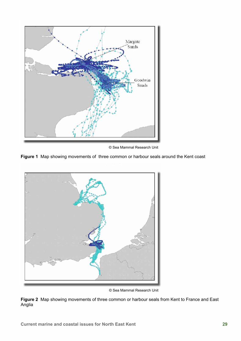
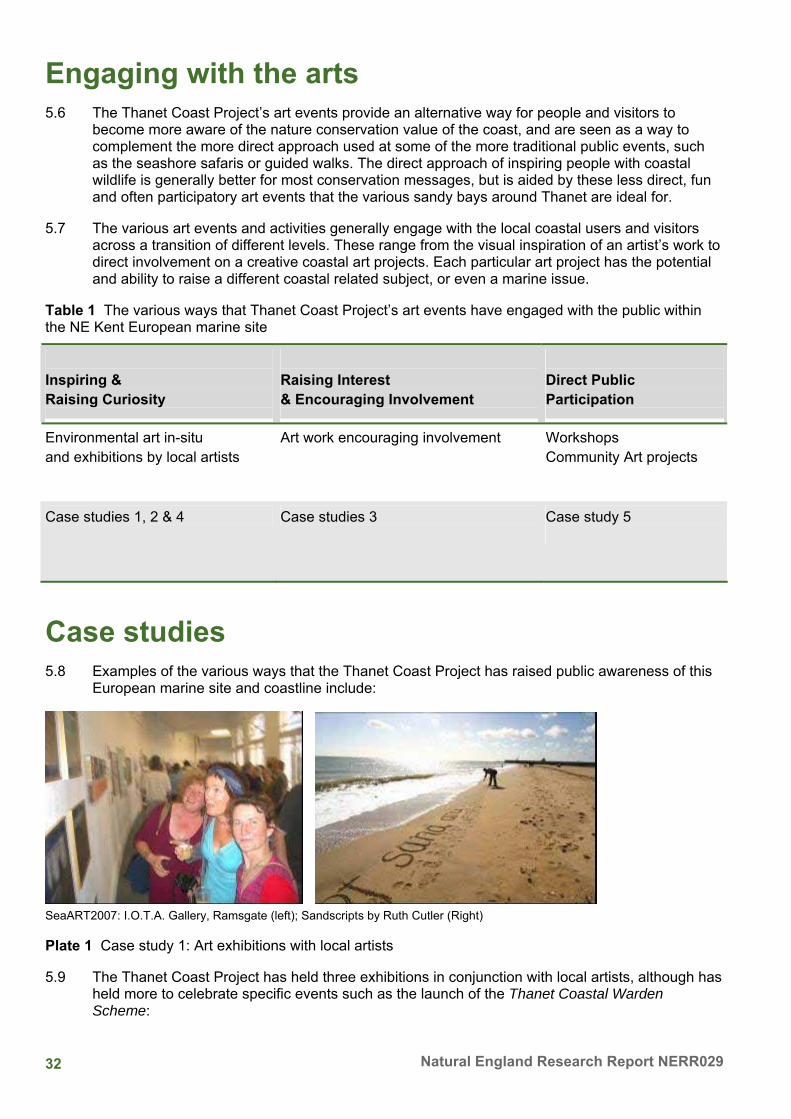
11.15 - 11.35 'Beyond the Sandbanks' - An introduction to the use of satellite telemetry to monitor the movements of Harbour seals (Phoca vitulina) around the Kent coastline
Brett Lewis, Lewis Ecology
11.35 - 11.55 Refreshment break
Using coastal resources
(Chair: Geoff Meaden)
11.55 - 12.15 Art for Nature’s sake
Tony Child, Thanet Coast Project
12.15 - 12.35 The small business of searching and dredging for cockles in the Thames Estuary; is it sustainable?
Stephen Hickman, Business School, University of Greenwich
12.35 - 12.55 Riding the waves of PWC management: - partnership working in Kent
Liz Holliday, Kent Coastal Network, Kent County Council
vi Natural England Research Report NERR029
12.55 - 13.40 Lunch break
Managing coastal resources
(Chair: Ian Tittley)
13.40 - 14.00 A channel habitat atlas for marine resource management
Geoff Meaden, Canterbury Christ Church University
14.00 - 14.20 North Kent Shoreline Management Plan
Mark Smith, Environment Agency
14.20 - 14.40 Collecting and managing Kent marine survey data
Bryony Chapman & Lee Manning, Kent Wildlife Trust, Maidstone
14.40 - 15.00 Local fisheries management and changes in the marine environment
Joss Wiggins, Kent and Essex Sea Fisheries Committee
15.00 - 15.15 Refreshment break
Workshop sessions
15.15 - 15.20 Introduction
Geoff Meaden, Christchurch Canterbury University
15.20 - 16.05 A. Implications of collecting from the foreshore
Facilitator, Ingrid Chudleigh, Natural England
B. A Highly Protected Marine Area
Facilitator, Naomi Biggs, Thanet Coast Project
C. Agreeing the Thanet Coast Project’s future work remit
Facilitator, Bryony Chapman, Kent Wildlife Trust
D. Impact analysis - activity against coastal zone
Facilitator, Geoff Meaden, Christchurch Canterbury University
16.05 - 16.20 Feedback from workshop sessions
16.20 - 16.30 Closing remarks
Geoff Meaden, Christchurch Canterbury University
16.30 Close of conference
vii Current marine and coastal issues for North East Kent
Attendance List Table i Attendance List
Name Organisation
Debbie Barlett Ecologist & Rural Development Consultant
Naomi Biggs Thanet Coast Project
Philip Bolton Wildthing Wildlife Consultants
Fred Booth Kent Marine Group/Kent Wildlife Trust
Jonathan Bramley Bramley Associates
Angela Brennan University of Greenwich
Philip Buckley Canterbury Christ Church University
Stephanie Buell Kent and Medway Biological Records Centre
Bryony Chapman Kent Wildlife Trust
Tony Child Thanet Coast Project
Jim Chimonides Natural History Museum
Ingrid Chudleigh Natural England
Clare Dove Thanet Coastal Warden
Ludo Dupuis Canterbury Christ Church University
Richard Evans Warwick Energy
Elizabeth Furkert University of Greenwich
George Ganda Environment Agency
Clive Gilbert SAIL Partnership
Janet Glynn Thanet Coastal Warden
James Francis Goodrum University of Greenwich
Tom Hawkins Canterbury City Council
Keith Henson Natural England
Stephen Hickman University of Greenwich
Liz Holliday Kent Coastal Network
Mike Humber Thanet District Council
Ian Humpheryes Environment Agency
Fiona Idriss Thanet Coastal volunteer
Table continued…
viii Natural England Research Report NERR029
Name Organisation
Roger Latchford Thanet District Council
Brett Lewis Lewis Ecology
Sheila MacDonald Interested individual
Sarah Maloney Canterbury City Council
Lee Manning Kent Wildlife Trust
Christine Marsh Dover Harbour Broad
Willie McKnight Thanet Coastal Warden
Geoff Meaden Canterbury Christ Church University
Diana Pound Dialogue Matters
Angus Radford District Inspector of Fisheries
Claudie Sculley Natural England
Robin Shrubsole Thanet Coastal Warden
Andrew Small Kent Police
Mark Smith Environmental Agency
Ian Tittley Natural History Museum
Jackie Trigwell Canterbury Christ Church University
Paul Vertigen Warwick Energy
Shirley Weller Thanet Coastal Warden
Andrew Whitehouse Buglife - The Invertebrate Conservation Trust
Joss Wiggins Kent & Essex Sea Fisheries Committee
Jacqui Williams Thanet RSPCA
Will Wright Kent & Essex Sea Fisheries Committee
ix Current marine and coastal issues for North East Kent
Contents 1 Thanet Coast SAC monitoring 2005 and 2006 1
Introduction 1 1997 and 2001 surveys 1 2001 survey 2 2005 survey 3 Re-mapping biotopes 2005 4 Biotope mapping 2006 - a different approach 4 Discussion 8 Summary and Conclusions 8 Acknowledgements 9 References 9
2 Filter feeding Crustaceans in the Stour Estuary, Kent, UK 11 Introduction 11 Changes in corophiid abundance in the Stour estuary between 1996 and 2003 12
Changes in the native invertebrate fauna of the Stour Estuary before the invasion 14 Changes in water physico-chemistry before the invasion 15 Changes in nationwide distribution of C. curvispinum 1985-2003 16 Possible impacts of the C. curvispinum invasion on the native fauna 17 Possible impacts of C. curvispinum on the physico-chemistry of the Stour 18
Summary 19 Acknowledgements 19 References 19
3 The Invertebrate Fauna of Kent’s Soft Cliffs 20 Introduction 20 What is a soft cliff? 20 Why are soft rock cliffs so important for invertebrates? 21 Kent’s soft cliff sites 22 Management 23 Conclusions 24 Acknowledgements 24 References 24
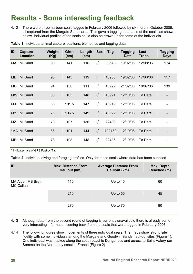
4 'Beyond the Sandbanks' An introduction to the use of satellite telemetry to monitor the movements of Harbour seals (Phoca vitulina) around the Kent coastline 26
Introduction 26 How many seals are there in Kent? 26 What don’t we know? 27 Collating new data 27
x Natural England Research Report NERR029
Summary of survey methods 27 Results - Some interesting feedback 28 Conclusion 30 References 30
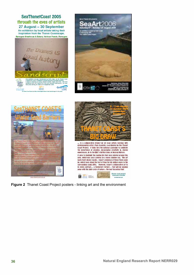
5 Art for Nature’s sake! 31 Introduction 31 Awareness raising and the arts connection 31 Engaging with the arts 32 Case studies 32 Sea the difference? 35 Future prospects 35
6 The small business of searching and dredging for cockles in the Thames Estuary: An ethnographic study 37
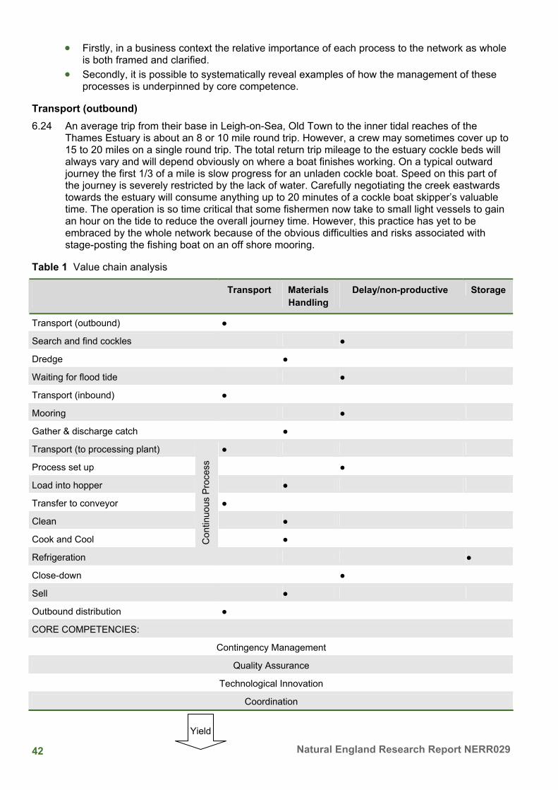
Introduction 37 Methodology 38 Cumulative findings from a single-location, coastal zone field study of a search and dredge shellfish operations based at Leigh-on Sea, Essex, England 39 Location 40 The operating zone 40 Innovation-orientated and contingency minded 41 Value chain analysis 41 Core competence: Technological Innovation 46 Relevance of findings to ICZM 47 Conclusion 47 References 47
7 Riding the Wave of Personal Water Craft Management - Partnership Working in Kent 49 Introduction to the Kent Coastal Network and its Working Groups 49 The Personal Water Craft Working Group 49 Key areas of PWC management 50 Achievements of the PWC Working Group 50 Benefits of Partnership Working 53 Further information 53
8 Channel Habitat Atlas for Marine Resources Management (CHARM): Towards Phase 2 54 Introduction 54 Final Achievements of CHARM Phase 1 55 Objectives for CHARM Phase 2 59 References 61
9 Medway and Swale, Isle of Grain to South Foreland Shoreline Management Plans 62 Introduction 62 Why do we need a Shoreline Management Plan? 62
xi Current marine and coastal issues for North East Kent
The Changing Coastline 62 Climate Change and Sea Level Rise 62
What does this mean? 63 How has the Plan been developed and how were interested parties represented? 63
Democratic Input 64 Technical Assessment 64
What will the Shoreline Management Plan Do and What happens next? 64 Reviewing/ Feeding back on the Plan 65
10 Collection and Management of Volunteer Marine Survey Data 66 Introduction 66 Seasearch 66 Shoresearch 68 Data Handling and GIS 72 Use of Marine Data at Kent and Medway Biological Records Centre 73 Acknowledgements 73 References and further information 74
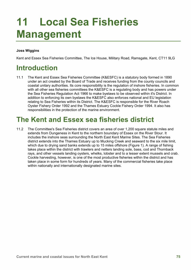
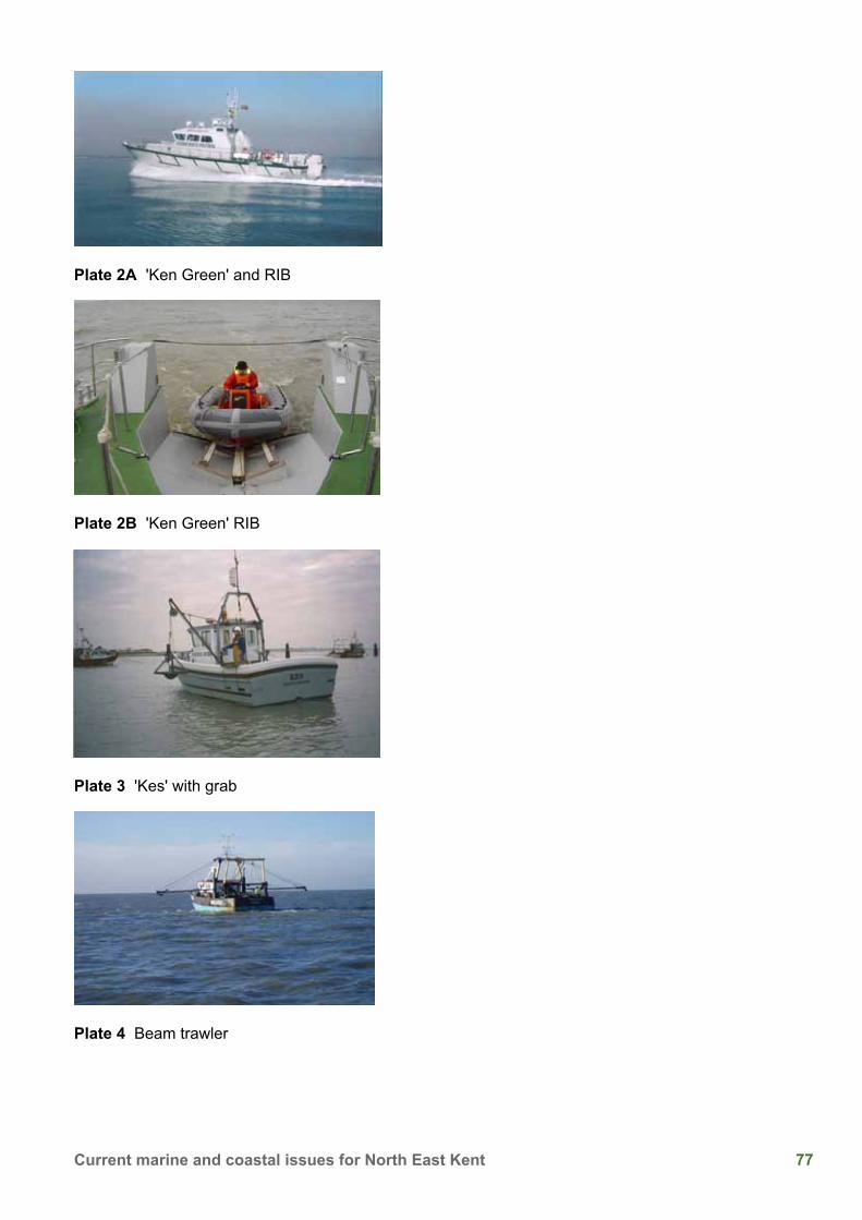
11 Local Sea Fisheries Management 75 Introduction 75 The Kent and Essex sea fisheries district 75 Enforcement 76 Commercial fishing methods 78 Thames cockle fishing 78
xii Natural England Research Report NERR029
Appendices Appendix 1: Conference Workshops 84
Workshop A: Implications of collecting from the foreshore 85 Facilitator - Ingrid Chudleigh 85
Workshop D: Impact of Human Activities on Different Marine Zones/Ecosystems 91 Facilitator - Geoff Meaden 91
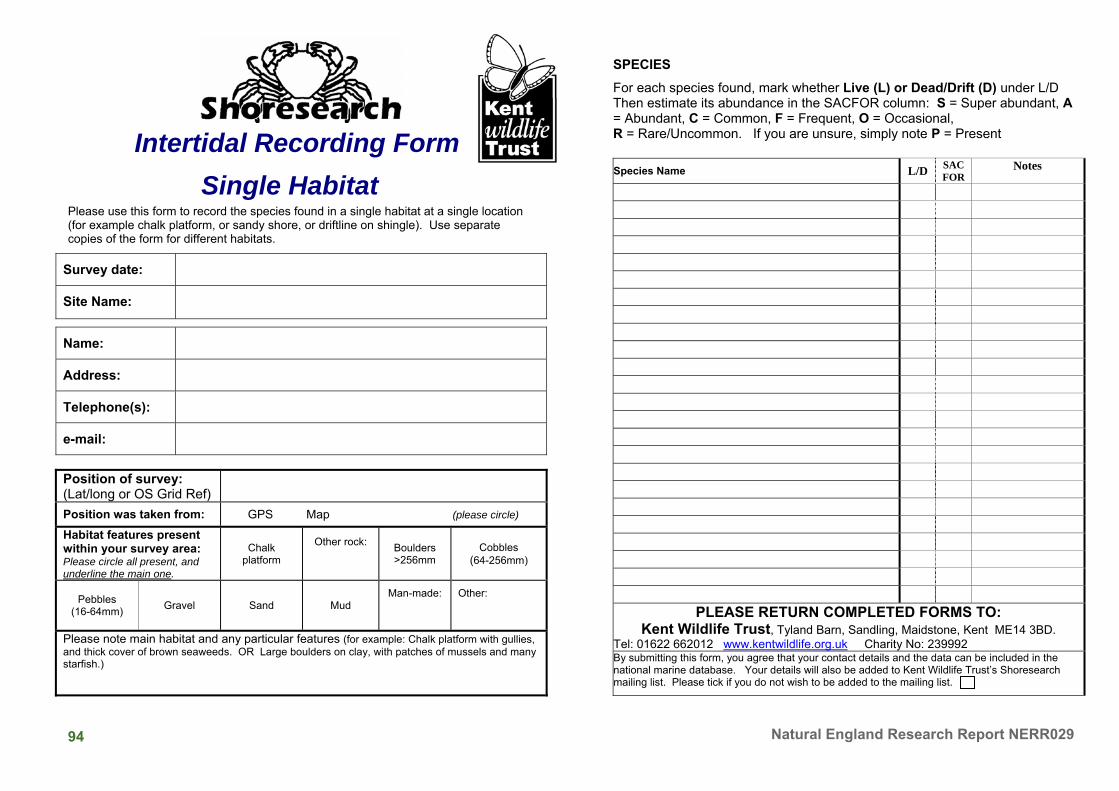
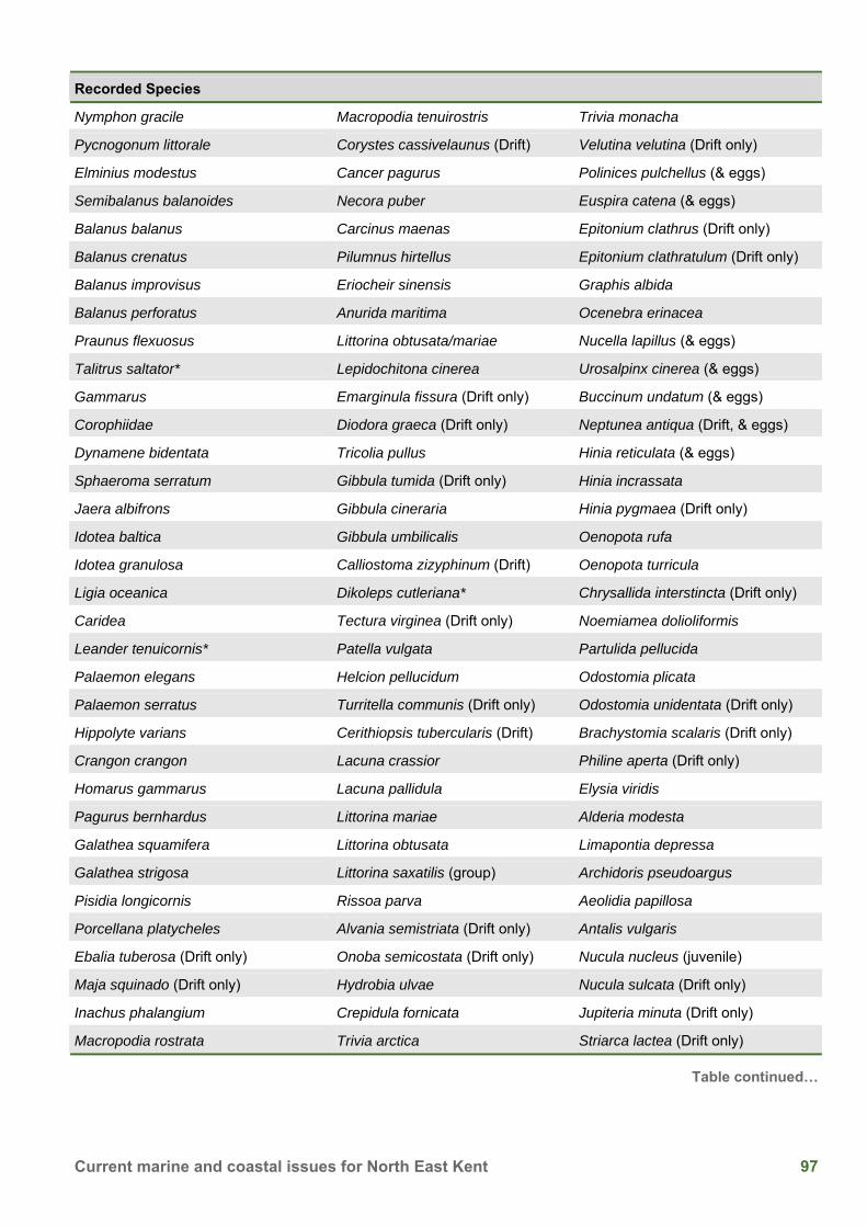
Appendix 2: Intertidal Recording Form Single Habitat 93 Appendix 3: Shoresearch - Intertidal Recording Form 95 Appendix 4: List of species recorded within the North East Kent European Marine Sites on Shoresearch Surveys, 2003 - 2006 (in taxonomic order) 96 Appendix 5: List of Kent ShoresearchSurvey Sites between 2004 and 2006 100 Appendix 6: The Conference images 108
xiii Current marine and coastal issues for North East Kent
List of tables Table i Attendance List vii 1 Thanet Coast SAC monitoring 2005 and 2006: Table 1 Comparison of spatial abundance of the main biotope features, 1997, 2005, 2006 (% rounded up or down to whole number) 7 2 Filter feeding Crustaceans in the Stour Estuary, Kent, UK: Table 1 Densities of the three different species from the Stour, and from other water bodies worldwide 13 4 'Beyond the Sandbanks' An introduction to the use of satellite telemetry to monitor the movements of Harbour seals (Phoca vitulina) around the Kent coastline: Table 1 Individual animal capture locations, biometrics and tagging data 28 Table 2 Individual diving and foraging profiles. Only for those seals where data has been supplied 28 5 Art for Nature’s sake!: Table 1 The various ways that Thanet Coast Project’s art events have engaged with the public within the NE Kent European marine site 32 6 The small business of searching and dredging for cockles in the Thames Estuary: An ethnographic study: Table 1 Value chain analysis 42 Appendix 1: Table A Impact of Human Activities on Different Marine Zones/Ecosystems 92 Appendix 4: Table B List of species recorded within the North East Kent European Marine Sites on Shoresearch Surveys, 2003 - 2006 96 Appendix 5: Table C List of Kent ShoresearchSurvey Sites between 2004 and 2006 100
xiv Natural England Research Report NERR029
List of figures 1 Thanet Coast SAC monitoring 2005 and 2006: Figure 1 Locations of importance for monitoring in the Thanet Coast SAC [from Tittley and others 1998] 2 Figure 2 ACE quadrat monitoring sites at Dumpton Gap [from Tittley and others 1997, 2001] 3 Figure 3 Biotopes mapped at Fulsam Rock [from Tittley and others 2006] 4 Figure 4 Biotopes mapped at Dumpton Gap [from Tittley and others 2006] 6 Figure 5 Surveyed grid points and 23 biotope features recorded at Dumpton Gap overlain on 2005 biotope map; the number of points recorded for each biotope feature is given in parentheses 6 Figure 6 Survey grid points and 13 biotope features recorded at Dumpton Gap overlain on 2005 biotope map; the number of points recorded for each biotope feature is in parentheses 7 Figure 7 Information sheet used for grid mapping biotopes at Dumpton Gap, May 2006 10 2 Filter feeding Crustaceans in the Stour Estuary, Kent, UK: Figure 1 A sketch map of the river Stour (after Buckley and others 2004) 11 Figure 2 The three corophiids species found in the Kentish Stour Estuary; a) C. curvispinum, b) C. multisetosum, c) C. volutator 12 Figure 3 Changes in the abundance of corophiids in the Stour estuary 13 Figure 4 Multi-dimensional scaling plot showing the similarity of native invertebrate community in samples in the years preceding the invasion 14 Figure 5 Simpson’s index for samples of invertebrates taken from the upper five sites 14 Figure 6 Average daily flow of the Stour at Horton, just above Canterbury (data collected by the Environment Agency) 15 Figure 7 Five day biochemical oxygen demand at sites 10-6 before the C.curvispinum invasion 15 Figure 8 Number of water bodies where C. curvispinum was found in Great Britain (data collected by the Environment Agency) 16 Figure 9 Simpson’s index of samples taken from sites 10-6 before, during and after the invasion 17 Figure 11 A model of suspended solids discharging into Pegwell Bay from the Kentish Stour 18 Figure 12 Algal mats present on Pegwell Bay in the summer of 2003. The river channel can be seen towards the bottom of the picture, and Ramsgate can be seen in the top right corner (photograph courtesy of Philip Rogers) 18 3 The Invertebrate Fauna of Kent’s Soft Cliffs: Figure 1 The distribution of coastal soft cliff in the UK (from Howe 2003) 21 4 'Beyond the Sandbanks' An introduction to the use of satellite telemetry to monitor the movements of Harbour seals (Phoca vitulina) around the Kent coastline: Figure 1 Map showing movements of three common or harbour seals around the Kent coast 29 Figure 2 Map showing movements of three common or harbour seals from Kent to France and East Anglia 29 5 Art for Nature’s sake!: Figure 1 Raising public awareness through environmental art 31 Figure 2 Thanet Coast Project posters - linking art and the environment 36 7 Riding the Wave of Personal Water Craft Management - Partnership Working in Kent:
xv Current marine and coastal issues for North East Kent
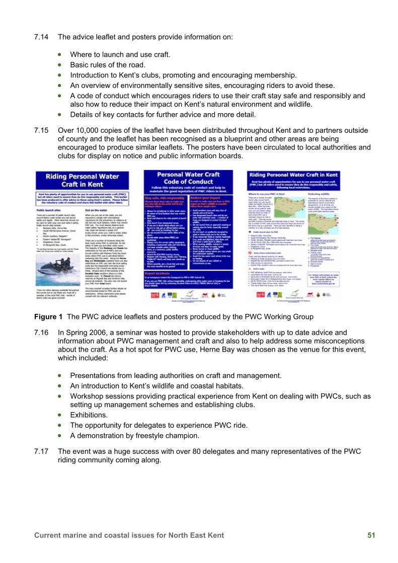
Figure 1 The PWC advice leaflets and posters produced by the PWC Working Group 51 8 Channel Habitat Atlas for Marine Resources Management (CHARM): Towards Phase 2: Figure 1 Beam trawl survey data gathering and map output for CHARM 56 Figure 2 The mapping of sea surface temperature point data 57 Figure 3 Through Kriging an algorithm is derived and applied that best transforms point temperature readings into a continuous surface (map) 57 Figure 4 Illustrating facets of the habitat suitability modelling used in CHARM 58 Figure 5 Sample pages from the CHARM atlas showing facets of fish distributions 59 Figure 6 Marine area covered by Phase 2 of the CHARM project 60 10 Collection and Management of Volunteer Marine Survey Data: Figure 1 Location of Kent Seasearch survey dives between 2003 and 2006 68 Figure 2 Location of Kent Shoresearch surveys around the whole Kent coast between 2004 and 2006 71 Figure 3 Location of Kent Shoresearch surveys undertaken around the Thanet coast between 2004 and 2006 71 Figure 4 Distribution of the common starfish Asterias rubens around Kent, as recorded to date in Seasearch and Shoresearch surveys 72 11 Local Sea Fisheries Management: Figure 1 The Kent and Essex sea fisheries district 76 Figure 2 Cockle harvesting areas 79 Figure 3 Adult Cockle Population on Main Beds 1988 - 2006 80 Figure 4 Cockle spat on Maplin and Foulness Sands1990-2006 80 Figure 5 Information Sheet - Fish Stock Conservation (minimum fish sizes) 82 Figure 6 Information Sheet - Mesh Sizes (fixed gear) 83
xvi Natural England Research Report NERR029
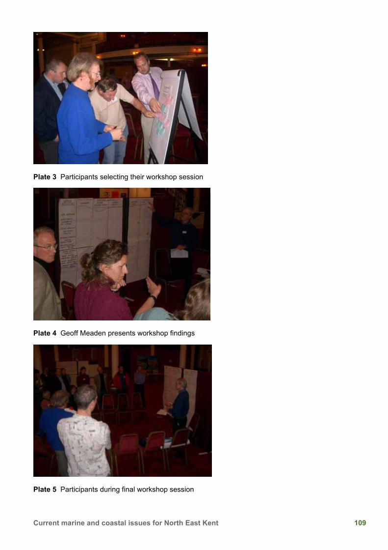
List of plates 1 Thanet Coast SAC monitoring 2005 and 2006: Plate 1 Shoresearch volunteers mapping biotopes at Dumpton Gap 5 4 'Beyond the Sandbanks' An introduction to the use of satellite telemetry to monitor the movements of Harbour seals (Phoca vitulina) around the Kent coastline: Plate 1 Harbour and Grey Seals 30 5 Art for Nature’s sake!: Plate 1 Case study 1: Art exhibitions with local artists 32 Plate 2 Case study 2: Environmental art commissions 33 Plate 3 Case study 3: Workshops - BeachART for children 33 Plate 4 Case Study 4: Winter Sand Barriers 34 Plate 5 Case Study 5: Thanet Coast’s Big Draw - community art projects 34 7 Riding the Wave of Personal Water Craft Management - Partnership Working in Kent: Plate 1 Delegates at the seminar, enjoying a ride on a PWC and attending one of the presentations 52 Plate 2 Members of Operation Excalibur 52 11 Local Sea Fisheries Management: Plate 1 Checking fishing net mesh size 76 Plate 2A 'Ken Green' and RIB 77 Plate 2B 'Ken Green' RIB 77 Plate 3 'Kes' with grab 77 Plate 4 Beam trawler 77 Plate 5 Cockle suction dredging 78 Plate 6 Cockle catch 78 Plate 7 Dredge tracks in heavily fished area 81 Plate 8 Cockle re-laying 81 Appendix 6: Plate 1 Ian Tittley presenting ‘Thanet Coast SAC monitoring 2005 and 2006’ 108 Plate 2 Cllr Roger Latchford OBE with Jackie Trigwell and Geoff Meaden (Chair) of the North East Kent Scientific Coastal Advisory Group 108 Plate 3 Participants selecting their workshop session 109 Plate 4 Geoff Meaden presents workshop findings 109 Plate 5 Participants during final workshop session 109
1 Current marine and coastal issues for North East Kent
1 Thanet Coast SAC monitoring 2005 and 2006 Ian Tittley, P.J.Chimonides and C.J.H. Spurrier
Departments of Botany and Zoology, Natural History Museum, London SW7 5BD
Bryony Chapman
Kent Wildlife Trust, Tyland Barn, Maidstone, Kent ME14 3BD
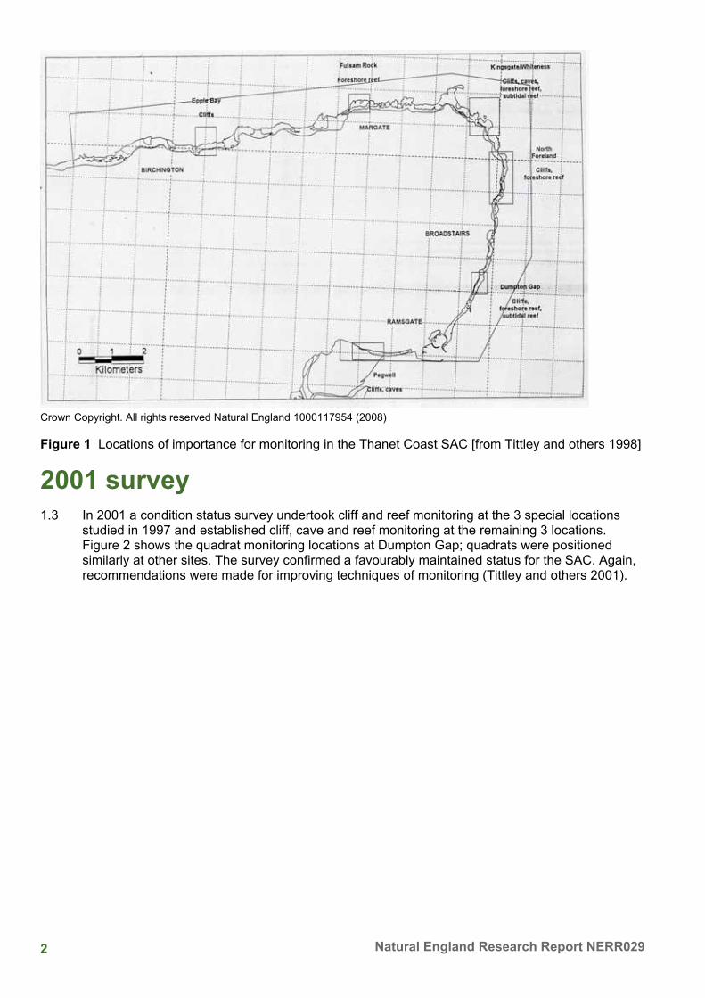
Introduction 1.1 The Thanet Coast SAC (Special Area of Conservation, EU Habitats Directive) was designated in
1995 because it held (i) the longest length of coastal chalk in the UK; (ii) chalk sea-caves and associated communities; (iii) chalk reef biotopes, especially those associated with rock-boring invertebrates (Anon. 1995; Tittley and others 1999). Thanet also has a long history of marine studies (Tittley 2004). A requirement for management is that biotope features are regularly monitored to assess the status of their condition.
1997 and 2001 surveys 1.2 In 1997 English Nature commissioned a detailed baseline survey of chalk cave, cliff, intertidal and
subtidal reef biotopes in the Thanet Coast SAC (Tittley and others 1998). This survey recognised and mapped 25 intertidal biotopes and identified six locations of special importance for detailed monitoring (Epple Bay, Fulsam Rock, White Ness, North Foreland, Dumpton Gap and Pegwell, Figure 1). These were mostly sites where the coast remained in a natural state with unspoilt cliffs and caves adjacent to lengths of intertidal chalk reef. The survey undertook monitoring of cliff cave and reef communities at three of these locations. The cliff and cave algal communities were monitored along line transects while reef communities were monitored using quadrats and the ACE method (Hiscock 1998). The 1997 survey recorded well-established populations of the non-native brown alga Sargassum muticum and blanketing growths of green algae over chalk reef communities notably at Fulsam Rock. Recommendations were made for improving the monitoring techniques.
2 Natural England Research Report NERR029
Crown Copyright. All rights reserved Natural England 1000117954 (2008)
Figure 1 Locations of importance for monitoring in the Thanet Coast SAC [from Tittley and others 1998]
2001 survey 1.3 In 2001 a condition status survey undertook cliff and reef monitoring at the 3 special locations
studied in 1997 and established cliff, cave and reef monitoring at the remaining 3 locations. Figure 2 shows the quadrat monitoring locations at Dumpton Gap; quadrats were positioned similarly at other sites. The survey confirmed a favourably maintained status for the SAC. Again, recommendations were made for improving techniques of monitoring (Tittley and others 2001).
3 Current marine and coastal issues for North East Kent
Crown Copyright. All rights reserved Natural England 1000117954 (2008)
Figure 2 ACE quadrat monitoring sites at Dumpton Gap [from Tittley and others 1997, 2001]
2005 survey 1.4 In 2005, a second condition status survey was undertaken (Tittley and others 2006). Cave and
cliff transect, and reef quadrat monitoring was carried out at the six special locations. In addition, intertidal chalk reef biotopes of these sites were re-mapped (see below). The studies showed the communities in these habitats were largely stable in species dominance and composition. The survey also showed that non-native species were becoming more common and widespread in the SAC. Japweed (Sargassum muticum) formed a distinct biotope in pools and lagoons as measurable and mappable amounts at Fulsam Rock. The Pacific Oyster (Crasostrea gigas) was detected throughout the SAC and in amounts sufficient at Epple Bay to form a biotope. The barnacle Chthamalus stellatus occurred sporadically throughout the SAC as did the ascidian Styela clava and the mollusc Crepidula fornicata. Two other non-native seaweeds that occur in Ramsgate Harbour (Grateloupia turturu, Undaria pinnatifida) were not found on chalk reefs. Overall, the condition status survey of 2005 concluded that there was a generally favourable condition of biotopes in content and extent save for the spread of non-native species. A few interesting and unusual species were detected. It was recommended that quadrat monitoring on chalk reef be replicated to facilitate statistical analysis of data.
4 Natural England Research Report NERR029
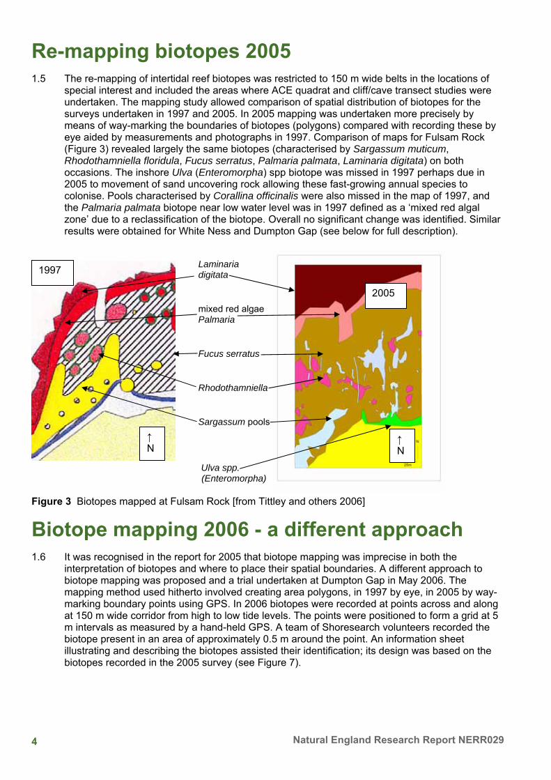
Re-mapping biotopes 2005 1.5 The re-mapping of intertidal reef biotopes was restricted to 150 m wide belts in the locations of
special interest and included the areas where ACE quadrat and cliff/cave transect studies were undertaken. The mapping study allowed comparison of spatial distribution of biotopes for the surveys undertaken in 1997 and 2005. In 2005 mapping was undertaken more precisely by means of way-marking the boundaries of biotopes (polygons) compared with recording these by eye aided by measurements and photographs in 1997. Comparison of maps for Fulsam Rock (Figure 3) revealed largely the same biotopes (characterised by Sargassum muticum, Rhodothamniella floridula, Fucus serratus, Palmaria palmata, Laminaria digitata) on both occasions. The inshore Ulva (Enteromorpha) spp biotope was missed in 1997 perhaps due in 2005 to movement of sand uncovering rock allowing these fast-growing annual species to colonise. Pools characterised by Corallina officinalis were also missed in the map of 1997, and the Palmaria palmata biotope near low water level was in 1997 defined as a ‘mixed red algal zone’ due to a reclassification of the biotope. Overall no significant change was identified. Similar results were obtained for White Ness and Dumpton Gap (see below for full description).
Laminaria digitata
mixed red algae Palmaria Fucus serratus Rhodothamniella Sargassum pools Ulva spp. (Enteromorpha) Figure 3 Biotopes mapped at Fulsam Rock [from Tittley and others 2006]
Biotope mapping 2006 - a different approach 1.6 It was recognised in the report for 2005 that biotope mapping was imprecise in both the
interpretation of biotopes and where to place their spatial boundaries. A different approach to biotope mapping was proposed and a trial undertaken at Dumpton Gap in May 2006. The mapping method used hitherto involved creating area polygons, in 1997 by eye, in 2005 by way-marking boundary points using GPS. In 2006 biotopes were recorded at points across and along at 150 m wide corridor from high to low tide levels. The points were positioned to form a grid at 5 m intervals as measured by a hand-held GPS. A team of Shoresearch volunteers recorded the biotope present in an area of approximately 0.5 m around the point. An information sheet illustrating and describing the biotopes assisted their identification; its design was based on the biotopes recorded in the 2005 survey (see Figure 7).
2005
↑N
1997
↑ N
5 Current marine and coastal issues for North East Kent
Plate 1 Shoresearch volunteers mapping biotopes at Dumpton Gap
1.7 A comparison of the biotope maps for 1997 and 2005 revealed an inshore band of Ulva (Enteromorpha) spp. in both surveys; in 2005 an area of Fucus vesiculosus, not noted in 1997, was recorded adjacent to the Ulva biotope. In 1997 a wide zone of F. serratus with Osmundea pinnatifida was recorded occurring extensively over the foreshore while in 2005 an extensive canopy of F. serratus was mapped within which were patches of Rhodothamniella floridula. At lower shore levels in 1997 the principal biotope was characterised by an assemblage of mixed red algae that in 2005 was interpreted as a biotope characterised by Palmaria palmata. Both maps showed a biotope characterised by Laminaria digitata at low water level and below.
1.8 The positions of the points at which biotopes were recorded in May 2006 are shown in Figure 5 and these are overlain on the biotope map produced in the 2005 survey but which may require minor realignment. The 2006 study initially identified 23 biotope features many of which were mixtures of biotopes; these are listed in Figure 5 using common English names - see Figure 7 for clarification. The most common feature was Fucus serratus recorded at 204 points out of a total of 915. The next most common biotope features recorded by the survey grid were Ulva (Enteromorpha) spp. at 142 points and sand at 140 points. At a lower level of abundance was a mixture of Ulva (Enteromorpha) spp. and F. serratus recorded at 80 points. A mixture of F. serratus and Palmaria palmata was recorded at 40 points, F. serratus and Osmundea pinnatifida at 40 points and P. palmata at 38 points. Other features less often recorded were F. vesiculosus in pure stands at only 19 points but mixed with Ulva (Enteromorpha) spp. at a further 27 points and with F. serratus at another 10 points. The hummock-forming Rhodothamniella floridula occurred at only 13 points but mixed with F. serratus at a further 22 points, and rock pools with Corallina officinalis at 29 points. Overlying the biotopes recorded from the grid in 2006 on the polygon map made in 2005 showed a reasonable concordance of features.
6 Natural England Research Report NERR029
Ulva (Enteromorpha) spp. Ulva (Enteromorpha) spp. Fucus serratus/ Fucus serratus Osmundea pinnatifida Fucus vesiculosus Mixed red algae Rhodothamniella floridula Laminaria digitata Corallina pools Laminaria digitata Figure 4 Biotopes mapped at Dumpton Gap [from Tittley and others 2006]
Figure 5 Surveyed grid points and 23 biotope features recorded at Dumpton Gap overlain on 2005 biotope map; the number of points recorded for each biotope feature is given in parentheses
1.9 From a review of data sheets and digital images made at various recording points, the 23 biotope features were revised and reduced to 13, to reflect the 11 features mapped in 2005. The 13 biotopes recorded on the grid points are overlain in Figure 6 on the biotope map of 2005. The most common biotope was that characterised by a canopy of Fucus serratus at 289 points; the next most common was the Ulva (Enteromorpha) spp. biotope recorded at 142 points; sand occurred at 140 points and Palmaria palmata at 102 points A canopy of F. vesiculosus was recorded at 46 points and mixed with F. serratus at a further 10 points. A mixture of Osmundea pinnatifida turf and F. serratus occurred at 43 points while Rhodothamniella floridula hummocks occurred at 35 points. Rock pools characterised by Corallina officinalis were recorded at 29 points.
↑ N
1997 2005
↑ N
↑ N
7 Current marine and coastal issues for North East Kent
Figure 6 Survey grid points and 13 biotope features recorded at Dumpton Gap overlain on 2005 biotope map; the number of points recorded for each biotope feature is in parentheses
1.10 Table 1 compares the spatial abundances of biotope features recorded on the three occasions. The second and third columns for 1997 and 2005 give the areas of biotopes recorded and these expressed as percent of the total area of biotopes excluding bare rock and sand. For 2006 percent abundance is expressed as (i) a proportion of the 915 points recorded, (ii) a proportion of 720 points that exclude rock and sand features.
Table 1 Comparison of spatial abundance of the main biotope features, 1997, 2005, 2006 (% rounded up or down to whole number)
Discussion 1.11 Comparison of cover values of biotopes at Dumpton Gap in Table 1 questions the accuracy of
recording the spatial extents of biotopes on the seashore. This is important for comparison of data in time series monitoring. A broad similarity in extent of the principal biotope features in the 3 mapping surveys is suggested in Figures 5, 6 and Table 1. There are disparities that reflect (i) differences in definition and identification of the biotope features (ii) lesser precision in both definition and assessing special extent with the mapping of biotopes by eye in 1997, (iii) greater precision in the grid mapping of May 2006 (iv) differences in cover due to changes in vegetation. For example in 1997 a Fucus serratus and Osmundea pinnatifida mixed biotope was mapped extensively at Dumpton Gap while in autumn 2005 this was interpreted as a Fucus serratus biotope. In 2006 both the F. serratus and the F. serratus - O. pinnatifida biotopes were recorded but the latter relatively uncommonly. From the maps it could be concluded that at Dumpton Gap there has been a change in biotope structure with a mixed F. serratus - O. pinnatifida biotope giving way to a pure stand of F. serratus; this is probably unlikely and the difference may reflect recorder variance. The Ulva (Enteromorpha) biotope was either under-recorded in 2005 compared with 1997 and 2006 or perhaps had decreased due to deposition of sand. The extent of Rhodothamniella flordidula was perhaps over-estimated in 2005 compared with 2006. ‘Mixed red algae’ (= Palmaria) biotope was probably over-estimated in area in 1997 as was the mix of F. vesiculosus and F. serratus in 2005. F vesiculosus was probably under-estimated in 1997 and 2005 compared with 2006. The grid survey was more precise in recording the relatively uncommon and restricted rock pool biotope characterised by Corallina officinalis which was missed in the polygon map of 1997 probably because the MNCR biotope survey method recommends noting, not mapping, biotopes of less than 5 m2. The disadvantage of grid mapping is that it was labour intensive; 12 volunteers were employed in a half tide cycle to complete the task in 2006 compared with two ecologists for the polygon survey of 2005. Overall, the assessment of cover from the 2006 survey was probably more accurate, since, as mentioned previously, defining biotope boundaries in the field is an imprecise art.
1.12 The broad similarity of the maps of 1997, 2005 and 2006 for Dumpton Gap suggest relative short-term stability of the intertidal communities (biotopes) although some local variations in cover with time is suggested in Table 1. This contrasts with the maps for Botany Bay in Thanet made in the late 1960s and in 1997 (Tittley 2005) that show significant changes in the medium-term with, for example, the canopy of Fucus serratus (biotope) replaced by a bed of Mytilus edulis (biotope).
1.13 The identification of biotopes is not straightforward not least because their definitions in the MNCR Classification have been revised on several occasions with, for example, the ‘mixed red algal’ biotope (considered to be an important feature in the Thanet Coast SAC) now being a component of another biotope. In the field even when guided by an information sheet illustrating 11 biotopes at Dumpton Gap the recording of individual biotopes was made difficult by their often patchy and overlapping nature. The grid mapping method encouraged recording of the mixed nature of the biotopes present at many of the points, rather than taking the general view of the dominant biotope in the vicinity. The resulting list of different combinations of biotopes required interpretation by ecologists with specialist knowledge of the area to achieve results that could be compared with previous surveys.
Summary and Conclusions • The condition surveys of 2001 and 2005 compared with the baseline study of 1997 reported a
favourably maintained status of the biotope features of the Thanet Coast SAC. • Detailed biotope mapping at the six locations of special importance in the SAC in 2005
revealed no major changes in the spatial extent of biotopes. Differences were due to changes in the national classification of biotopes.
• Differences in the maps of 2005 compared with 1997 resulted from the more accurate method of defining polygons by way-marking their boundaries using GPS. The recognition of such boundaries was not straightforward and required the skills of experienced field ecologists.
9 Current marine and coastal issues for North East Kent
• The larger number of biotopes identified by semi-skilled volunteers is a more accurate reflection of the overlapping and mixed nature of biotopes at Dumpton Gap. The final smaller number biotopes involved to certain extent ‘pidgeon-holing’ species-assemblage data into the national biotope classification.
• The grid of biotope records 5 m apart produced maps of spatial distribution of biotopes broadly comparable with those obtained by defining polygons and overall a more accurate result in assessing abundances of biotopes.
• Biotopes of limited area missed in the polygon surveys were recorded in the grid survey. • The grid survey at Dumpton Gap used 12 volunteers in a single tidal cycle with work
inevitably slowed by time spent on training; however, this survey could be achieved more speedily with fewer experienced operatives.
• Objectively obtained identification of the biotopes at Dumpton Gap could be obtained from quantitative data on species occurrence in defined quadrats and subjecting such data to numerical analysis.
Acknowledgements 1.14 We are extremely grateful to the Kent Shoresearch volunteers without whose considerable help
the pilot grid mapping in 2006 could not have been undertaken. The team comprised David Baxter, Fred Booth, Jon Bramley, Tony Child, Elaine Cramp, Susan Holton, Willie McKnight, Noreen Musikant, Yvonne Sharp, Robin Shrubsole, Jean Stewart, Dave Townsend.
References ANON. 1995. Reasons for recommendation as a possible Special Area of Conservation. Peterborough, English Nature.
HISCOCK, K. 1998. In situ surveys of intertidal biotopes using abundance scales and check lists at exact locations (ACE surveys). In: K. HISCOCK (ed.) Biological monitoring of marine Special Areas of Conservation: a handbook of methods for detecting change. Part 2. Procedural guidelines. Peterborough: JNCC.
TITTLEY, I. 2004. The Thanet coast: a site with an exceptional history of marine study. In: I. TITTLEY & S. PECKHAM, eds. Proceedings of the North East Kent Coastal Research Workshop 22 October 2002. English Nature Research Reports, 570, 13-25. TITTLEY, I. 2005. The marine algal flora of Thanet - stability or change? In: P. ROGERS, ed. ‘Making Connections’: Proceedings of the second North East Kent Coastal Conference, 11 November 2004. English Nature Research Reports, 630, 80-95.
TITTLEY, I., GILLILAND, P., & POUND, D. 1999. The marine flora of the Thanet coast marine SAC: a conservation management perspective. In: G.W. SCOTT & I. TITTLEY, eds. Changes in the marine flora of the North Sea, pp. 65-74. Scarborough: Centre for Environmental Research into Coastal Issues.
TITTLEY, I., SPURRIER, C.J.H., & CHIMONIDES, P.J. 2002. Thanet intertidal survey: assessment of favourable condition of reef and sea cave features in the Thanet Coast cSAC. English Nature Research Reports, 568, 1-82.
TITTLEY, I., SPURRIER, C.J.H., CHIMONIDES, P.J., & CHAPMAN, B. 2006. Thanet Coast Special Area of Conservation: 2005 intertidal monitoring. English Nature Research Reports, 700, 1-109. TITTLEY, I., SPURRIER, C.J.H., CHIMONIDES, P.J., GEORGE, J.D., MOORE, J.A., EVANS, N.J., & MUIR, A.I., 1998. Survey of chalk cave, cliff, intertidal and subtidal reef biotopes in the Thanet coast SAC. English Nature Research Reports, 325, 1-90.
10 Natural England Research Report NERR029
Figure 7 Information sheet used for grid mapping biotopes at Dumpton Gap, May 2006
Characterising Species Common Names
Biotope Codes for trial mapping
Bare Rock Rock Bare Sand Sand
Enteromorpha sp.
Gut weed Ent
Fucus vesiculosus
Bladder wrack
Bladder
Fucus serratus
Saw wrack
Saw
Rhodothamniella floridula
Red Sand Collector
Rho
Palmaria palmata
Dulse Dulse
Corallina officinalis
Corallina Pool
Cor
Laminaria digitata
Kelp Kelp
11 Current marine and coastal issues for North East Kent
2 Filter feeding Crustaceans in the Stour Estuary, Kent, UK Phil Buckley and Georges Dussart
Canterbury Christ Church University, Kent, U.K.
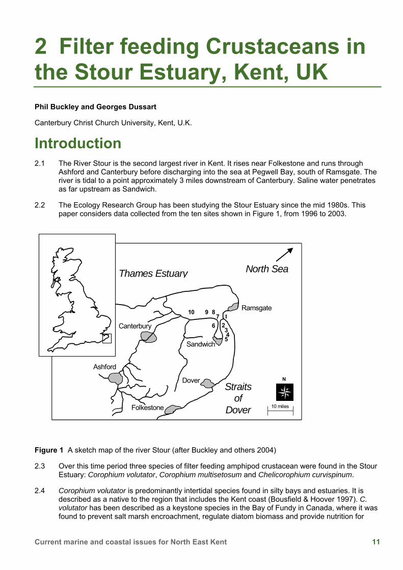
Introduction 2.1 The River Stour is the second largest river in Kent. It rises near Folkestone and runs through
Ashford and Canterbury before discharging into the sea at Pegwell Bay, south of Ramsgate. The river is tidal to a point approximately 3 miles downstream of Canterbury. Saline water penetrates as far upstream as Sandwich.
2.2 The Ecology Research Group has been studying the Stour Estuary since the mid 1980s. This paper considers data collected from the ten sites shown in Figure 1, from 1996 to 2003.
Figure 1 A sketch map of the river Stour (after Buckley and others 2004)
2.3 Over this time period three species of filter feeding amphipod crustacean were found in the Stour Estuary: Corophium volutator, Corophium multisetosum and Chelicorophium curvispinum.
2.4 Corophium volutator is predominantly intertidal species found in silty bays and estuaries. It is described as a native to the region that includes the Kent coast (Bousfield & Hoover 1997). C. volutator has been described as a keystone species in the Bay of Fundy in Canada, where it was found to prevent salt marsh encroachment, regulate diatom biomass and provide nutrition for
N
10 miles
Dover
Folkestone
Ramsgate
Sandwich
North Sea Thames Estuary
Straitsof
Dover
Ashford
10 9 87
6
5 43
21
Canterbury
12 Natural England Research Report NERR029
large flocks of shore birds (Percy 1999). In the Kentish Stour Estuary, C. volutator was found between site 1 and site 5.
2.5 C. multisetosum is a brackish water specialist and is also a native to the region (Bousfield & Hoover 1997). This species was first identified in 1952, and previous to this date was probably identified as C. volutator. In the Stour Estuary, C. multisetosum appeared occasionally at site 5 and occasionally at site 6. Independent surveying found a healthy population between these two sample sites.
2.6 C. curvispinum is a predominantly freshwater species. It lives in tubes which it generally attaches to hard substratum. C. curvispinum was originally described from estuaries discharging into the northern Caspian sea at the end of the nineteenth century. Since this time it has invaded waterways throughout Western Europe (Jazdzewski 1980). In the Dutch Lower River Rhine C. curvispinum was first found in 1987 attached to stones. Over the next five years the population density increased from an initial 2 individuals per square metre to an average of 200 000 individuals per square metre, and a maximum of 750 000 individuals per square metre (van den Brink et al. 1993). In the Stour Estuary C. curvispinum was found from site 10 to site 6.
a) b) c) Figure 2 The three corophiids species found in the Kentish Stour Estuary; a) C. curvispinum, b) C. multisetosum, c) C. volutator
Changes in corophiid abundance in the Stour estuary between 1996 and 2003 2.7 Surveys conducted in 1996 and 1997 found only C. volutator present in the estuary. Furthermore
it was found in small numbers, at sites 1 to 5. In September 1998 the numbers of C. volutator found in samples increased tenfold. Also during the September 1998 survey, C. curvispinum was found in the estuary for the first time (Figure 3).
2.8 The number of corophiids of both species increased over the subsequent two surveys. In September 1999 there was a representative of the family Corophiidae present at each of the ten sites, including the previously unrecorded C. multisetosum (Figure 3).
2.9 After September 1999 the population of C. curvispinum went into decline. During the March 2002 survey C. curvispinum was not found in the estuary. The population size of C. volutator appeared to remain relatively constant after 1999.
13 Current marine and coastal issues for North East Kent
1
10
100
1000
10000
Jun-
96S
ep-9
6M
ar-9
7Ju
n-97
Sep
-97
Mar
-98
Jun-
98S
ep-9
8M
ar-9
9Ju
n-99
Sep
-99
Mar
-00
Jun-
00S
ep-0
0M
ar-0
1Ju
n-01
Sep
-01
Mar
-02
Jun-
02S
ep-0
2M
ar-0
3Ju
n-03
Sep
-03
Date
Num
ber o
f cor
ophi
ids
foun
d in
the
entir
e su
rvey
C. curvispinum
C. multisetosum
C. volutator
Figure 3 Changes in the abundance of corophiids in the Stour estuary
2.10 At the height of the incursion of the Corophiidae into the Stour estuary the density of each the three species was not as high as some other rivers (Table 1). For C. curvispinum the reason it did not reach its optimum density could be due to the relative lack of hard substratum in the river channel for it to anchor its tubes. For C. multisetosum the Stour estuary is near the northern limit of its range. The numbers of C. volutator in the Stour are consistent with number found in the Ythan estuary in Scotland (Lawrie & Raffaelli 2000).
Table 1 Densities of the three different species from the Stour, and from other water bodies worldwide
Species Density in the Stour (individuals/m2)
Density in other waterbodies (individuals/m2)
C. curvispinum 22 400 (Plucks Gutter) 750 000 (Lower Rhine, the Netherlands) (Rajagopal and others 1999)
C. multisetosum 755 (Sandwich Marina) 523 000 (Ria de Aveiro, Portugal) (Cunha, Moreira & Sorbe 2000)
C. volutator 26 000 (Shell Ness) Over 60 000 (Bay of Fundy, Canada) (Percy and others 1999)
2.11 Most of our research has been carried out on C. curvispinum therefore the majority of the rest of
the paper focuses on the part of the estuary (sites 10-6) where C. curvispinum was found.
14 Natural England Research Report NERR029
Changes in the native invertebrate fauna of the Stour Estuary before the invasion
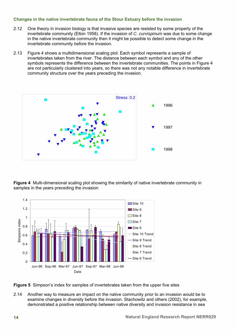
2.12 One theory in invasion biology is that invasive species are resisted by some property of the invertebrate community (Elton 1958). If the invasion of C. curvispinum was due to some change in the native invertebrate community then it might be possible to detect some change in the invertebrate community before the invasion.
2.13 Figure 4 shows a multidimensional scaling plot. Each symbol represents a sample of invertebrates taken from the river. The distance between each symbol and any of the other symbols represents the difference between the invertebrate communities. The points in Figure 4 are not particularly clustered into years, so there was not any notable difference in invertebrate community structure over the years preceding the invasion.
1996
1997
1998
Stress: 0.2
Figure 4 Multi-dimensional scaling plot showing the similarity of native invertebrate community in samples in the years preceding the invasion
Figure 5 Simpson’s index for samples of invertebrates taken from the upper five sites
2.14 Another way to measure an impact on the native community prior to an invasion would be to examine changes in diversity before the invasion. Stachowitz and others (2002), for example, demonstrated a positive relationship between native diversity and invasion resistance in sea
15 Current marine and coastal issues for North East Kent
squirt communities. Figure 5 shows the Simpson’s diversity of sites 10-6 during surveys carried out before the invasion. There was no particular drop in diversity over the period of the invasion, in fact the trend line for diversity at site 10 is almost horizontal, indicating no particular upward or downward trend in diversity before the invasion.
Changes in water physico-chemistry before the invasion
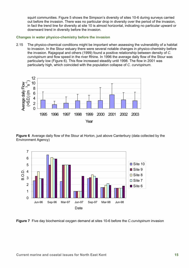
2.15 The physico-chemical conditions might be important when assessing the vulnerability of a habitat to invasion. In the Stour estuary there were several notable changes in physico-chemistry before the invasion. Rajagopal and others (1999) found a positive relationship between density of C. curvispinum and flow speed in the river Rhine. In 1996 the average daily flow of the Stour was particularly low (Figure 6). This flow increased steadily until 1998. The flow in 2001 was particularly high, which coincided with the population collapse of C. curvispinum.
02468
1012
1995 1996 1997 1998 1999 2000 2001 2002 2003
Year
Aver
age
daily
Flow
(+
S.D.
) (m
3 s-1)
Figure 6 Average daily flow of the Stour at Horton, just above Canterbury (data collected by the Environment Agency)
0
1
2
3
4
5
6
7
Jun-96 Sep-96 Mar-97 Jun-97 Sep-97 Mar-98 Jun-98
Date
B.O
.D.
Site 10Site 9Site 8Site 7Site 6
Figure 7 Five day biochemical oxygen demand at sites 10-6 before the C.curvispinum invasion
16 Natural England Research Report NERR029
Changes in nationwide distribution of C. curvispinum 1985-2003
2.16 The Stour might always have been a suitable habitat for C. curvispinum. Therefore the invasion could be caused by an increased opportunity for the animal to invade. To examine this possibility national data for the distribution of C. curvispinum was obtained from the Environment Agency.
Figure 8 Number of water bodies where C. curvispinum was found in Great Britain (data collected by the Environment Agency)
2.17 The number of waterbodies in which C. curvispinum was found fluctuated between 1985 and 1992 (Figure 8). During this time most of the water bodies occupied by C. curvispinum were canals in central England. After 1992 the number of water bodies occupied by C. curvispinum increased steadily, reaching a peak of 41 water bodies in 1996. In 1996 C. curvispinum was also found for the first time in the river Thames. The discovery of the Stour invasion in 1998 coincided with a national decline in the distribution of C. curvispinum (Figure 8).
2.18 Preliminary experiments have indicated that the most likely route for invasion of the Stour by C. curvispinum was by a boat being transported overland from a water body that had already been colonised by C. curvispinum.
2.19 An invasion can affect an ecosystem in a number of ways. The native fauna can in some instances be impacted (e.g. Dick and others 2002). In other cases the physico-chemical properties of the habitat can be modified by the invading organism, for example, in the great lakes the filter feeding bivalve Dreissena polymorpha was found to significantly decrease the turbidity of the water by filtering suspended particulates and algae out of the water column (Rayl 1999).
17 Current marine and coastal issues for North East Kent
Possible impacts of the C. curvispinum invasion on the native fauna
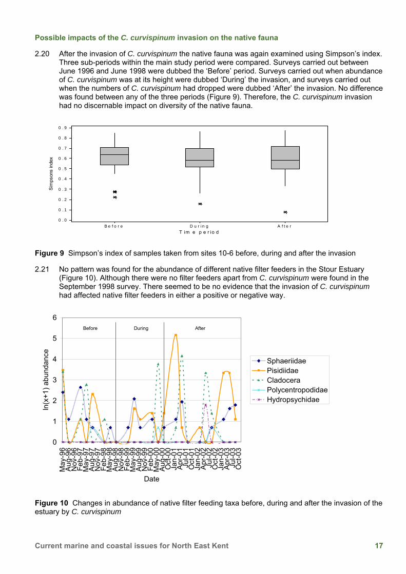
2.20 After the invasion of C. curvispinum the native fauna was again examined using Simpson’s index. Three sub-periods within the main study period were compared. Surveys carried out between June 1996 and June 1998 were dubbed the ‘Before’ period. Surveys carried out when abundance of C. curvispinum was at its height were dubbed ‘During’ the invasion, and surveys carried out when the numbers of C. curvispinum had dropped were dubbed ‘After’ the invasion. No difference was found between any of the three periods (Figure 9). Therefore, the C. curvispinum invasion had no discernable impact on diversity of the native fauna.
T im e p e r io d
Sim
pson
s in
dex
A f t e rD u r i n gB e f o r e
0 . 9
0 . 8
0 . 7
0 . 6
0 . 5
0 . 4
0 . 3
0 . 2
0 . 1
0 . 0
Figure 9 Simpson’s index of samples taken from sites 10-6 before, during and after the invasion
2.21 No pattern was found for the abundance of different native filter feeders in the Stour Estuary (Figure 10). Although there were no filter feeders apart from C. curvispinum were found in the September 1998 survey. There seemed to be no evidence that the invasion of C. curvispinum had affected native filter feeders in either a positive or negative way.
Figure 10 Changes in abundance of native filter feeding taxa before, during and after the invasion of the estuary by C. curvispinum
18 Natural England Research Report NERR029
Possible impacts of C. curvispinum on the physico-chemistry of the Stour
2.22 Filter feeders can reduce the amount of suspended particulates in the water column (Rayl 1999). Figure 11 shows a simple model estimating the annual weight of suspended solids that were discharged into Pegwell Bay between 1996 and 2003. This model was constructed by multiplying the average daily flow of the Stour (Figure 6) with the annual average concentration of suspended solids recorded at site 2. The model indicates that suspended solids in the Stour Estuary have dropped in the years following the invasion of the three species of filter feeding corophiids.
2.23 There have been several changes in the physico-chemistry of the bay itself. There were small algal blooms on the Bay in 1999, 2000, 2002 and 2004 (Philip Rogers, personal communication). In 2003 there was a major bloom of green algae in the Bay (Figure 12).
Figure 11 A model of suspended solids discharging into Pegwell Bay from the Kentish Stour
Figure 12 Algal mats present on Pegwell Bay in the summer of 2003. The river channel can be seen towards the bottom of the picture, and Ramsgate can be seen in the top right corner (photograph courtesy of Philip Rogers)
19 Current marine and coastal issues for North East Kent
Summary 2.24 The invasion of the Kentish Stour Estuary by filter feeding crustaceans is noteworthy because it
involved three closely related species expanding their ranges in the Estuary at approximately the same time. At sites 10-6 there no evidence was found to indicate any weakening of native invertebrate community before the invasion. There were several changes in the physico-chemical properties of the Estuary prior to the invasion, including an increase in average daily flow, and a decrease in biochemical oxygen demand.
2.25 There was no evidence that the invasion of C. curvispinum had any impact on the native invertebrate community. There was evidence of a decrease in suspended solids in the Estuary after the invasion.
Acknowledgements 2.26 Thank you to Dr Jackie Trigwell, for originally identified these species from the Estuary, and for
her expertise. The work was funded by Pfizer Limited, who also took micrographs of the animals. The Environment Agency provided data and helpful advice. Philip Rogers gave technical advice and provided the aerial photos of Pegwell Bay.
References BUCKLEY, P.L., DUSSART, G.B.J. and TRIGWELL, J.A. 2004. Invasion and expansion of Corophiidae (Amphipoda) in the Stour Estuary (Kent, U.K.). Crustaceana, 77 (4), 425-433.
BOUSFIELD, E.L. & HOOVER, P.M.1997. The amphipod superfamily Corophoidea on the pacific coast of North America. Part V. Family Corophiidae: Corophiinae, new subfamily. Systematics and distributional ecology. Amphipacifica, 2(3), 67-139.
CUNHA, M.R., MOREIRA, M.H. & SORBE, J.C. 2000. The amphipod Corophium multisetosum (Corophiidae) in Ria de Aveiro (NW Portugal). II. Abundance, biomass and production. Marine Biology, 137, 651-660.
DICK, T.A., PLATVOET, D. & KELLY, D.W. 2002. Predatory impact of the freshwater invader Dikerogammarus villosus (Crustacea: Amphipoda). Canadian Journal of Fisheries and Aquatic Science, 59, 1078-1084.
ELTON, C.S. 1958. The ecology of invasions. Chicago: University of Chicago Press.
JADZEWSKI, K. 1980. Range extensions of some Gammaridean species in European inland waterways caused by human activity. Crustaceana. Suppl. 6, 84-107.
LAWRIE, S.M., RAFFAELLI, D.G. & EMES, C.H. 2000. Small scale patterns in the distribution of the amphipod Corophium volutator on the Ythan estuary, Aberdeenshire, Scotland. Sarsia, 85, 321-327.
RAJAGOPAL, S., VAN DER VELDE, G., PAFFEN, B.G.P., VAN DEN BRINK, F.W.B. & BI J DE VAATE, A. 1999. Life history and reproductive biology of the invasive amphipod Corophium curvispinum (Crustacea:Amphipoda) in the Lower Rhine. Archive für Hydrobiologie, 3(144), 305-325.
RAYL, A.J.S. 1999. Bioinvaders proliferate in US waterways. Scientist, 13(16), 6-25.
VAN DEN BRIN, F.W.B., VAN DER VELDE, G. & BIJ DE VAATE, A. 1993. Ecological aspects, explosive range extension and impact of a mass invader, Corophium curvispinum Sars, 1895 (Crustacea:Amphipoda), in the Lower Rhine (The Netherlands), Oecologia, 93, 224-232.
PERCY, J.A. 1999. Keystone Corophium: master of the mudflats! [online] available at URL: www.bofep.org/corophiu.htm [Accessed November 2008].
3 The Invertebrate Fauna of Kent’s Soft Cliffs Andrew Whitehouse
Buglife - The Invertebrate Conservation Trust
Introduction 3.1 Coastal soft rock cliffs and slopes are a habitat that, in the past, has been largely neglected. They
are widely recognised for their geomorphological interest, many are notified as geological Sites of Special Scientific Interest. However, much less well known is their importance for supporting rich invertebrate assemblages and as a refuge for rare species. A recent review (Howe 2003) lists 28 species found only on soft rock cliffs in the UK (Table 1), of these, 22 are Red Data Book species. Well-represented groups are the Hymenoptera (bees, wasps and ants), Coleoptera (beetles), and Diptera (flies). Alongside these invertebrate species restricted to soft cliffs, an earlier report (Howe 2002) identifies 20 invertebrate species with strong affinities to coastal soft cliff (the majority of the UK populations, or the strongest populations occurring on such sites), and a further 56 species associated with coastal soft cliff for at least part of their UK range.
3.2 There are many reasons why these habitats should be of such importance to insects and other invertebrates. The key features are the historical continuity of bare ground, the maintenance of early successional pioneer plant communities, hydrological features such as freshwater seepages, and physical aspects such as temperature.
3.3 Coastal soft cliffs and slopes are amongst the most natural habitats in the UK, on many sites active human intervention or management is not required to maintain the habitat and species diversity. However, due to a lack of recognition for their nature conservation interest much of the UK resource has been altered or lost behind coastal protection schemes, or degraded through inappropriate management of cliffs and slopes and their immediate surroundings.
What is a soft cliff? 3.4 Soft rock cliffs are formed of relatively easily eroded material, contrasting with much more
resistant ‘hard’ rocks. This softer ‘rock’ is often poorly consolidated or poorly cemented material such as glacial till, friable sands, head deposits, or weakly consolidated clays and shales. The cliffs are subject to frequent slumping and land slippage caused by rain, tidal action, storms, and percolating groundwater. The continued erosion of the cliff and movement of material provides a constant renewal or rejuvenation of bare ground, early successional habitats and pioneer plant communities. For the purposes of Buglife’s work we have not included soft chalk as ‘soft cliff’, although it can experience relatively high rates of erosion.
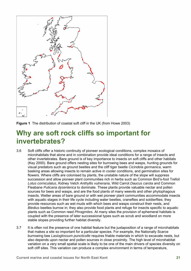
3.5 The UK coastal soft cliff resource is concentrated in England and Wales with an estimated 256 km and 100 km of unprotected soft cliff respectively (Figure 1).
21 Current marine and coastal issues for North East Kent
Figure 1 The distribution of coastal soft cliff in the UK (from Howe 2003)
Why are soft rock cliffs so important for invertebrates? 3.6 Soft cliffs offer a historic continuity of pioneer ecological conditions, complex mosaics of
microhabitats that alone and in combination provide ideal conditions for a range of insects and other invertebrates. Bare ground is of key importance to insects on soft cliffs and other habitats (Key 2000). Bare ground offers nesting sites for burrowing bees and wasps, hunting grounds for visual predators such as ground beetles and the cliff tiger beetle Cicindela germanica, warm basking areas allowing insects to remain active in cooler conditions, and germination sites for flowers. Where cliffs are colonised by plants, the unstable nature of the slope will suppress succession and allow pioneer plant communities rich in herbs such as Common Bird’s-foot Trefoil Lotus corniculatus, Kidney Vetch Anthyllis vulneraria, Wild Carrot Daucus carota and Common Fleabane Pulicaria dysenterica to dominate. These plants provide valuable nectar and pollen sources for bees and wasps, and are the food plants of many weevils and other phytophagous insects. Wetter areas of bare ground or with wet pioneer plant communities accommodate insects with aquatic stages in their life cycle including water beetles, craneflies and soldierflies; they provide resources such as wet muds with which bees and wasps construct their nests, and Bledius beetles burrow in; they also provide food plants and refuge for insects specific to aquatic plants such as Common reed Phragmites. At many sites the provision of ephemeral habitats is coupled with the presence of later successional types such as scrub and woodland on more stable slopes providing further habitat diversity.
3.7 It is often not the presence of one habitat feature but the juxtaposition of a range of microhabitats that makes a site so important for a particular species. For example, the Nationally Scarce burrowing bee Lasioglossum puncticolle requires friable materials in which to excavate nests, but also depends upon nectar and pollen sources in close proximity. The high level of microhabitat variation on a very small spatial scale is likely to be one of the main drivers of species diversity on soft cliff sites. This variation can produce a complex environment in terms of temperature,
22 Natural England Research Report NERR029
exposure, vegetation type and structure, stability, substrate compaction, water, and radiation. Radiation is another factor that drives the insect species diversity on soft cliff sites as many of the habitat specialists are thermophillic. The most important sites in the UK have a south facing aspect (Whitehouse in prep) and feature species at the northern edge of their range in Europe.
3.8 The apparent concentration of insect biodiversity at soft cliff localities can be partly attributed to the loss of open habitats in the wider countryside through agricultural intensification. The capacity of soft cliffs to offer a continuity of such habitats with such predictability is increasingly rare in the. Soft cliffs offer refuges for once more widespread species such as the Brown-banded carder bee Bombus humilis, Long-horned mining bee Eucera longicornis and Chalk carpet moth Scotopteryx bipunctaria.
3.9 In addition to invertebrates, unprotected soft cliffs are also of interest for several plants, lichens (Gilbert 2003), nesting sites for sand martins, and the abundance of invertebrates provides a source of prey for birds, small mammals, and bats (Parsons 2001).
Kent’s soft cliff sites 3.10 With an estimated 9.3km of unprotected soft cliffs (Pye & French 1993) the Kent coast has a
significant proportion of the UK resource. As the rest of the UK, the soft cliffs of Kent support a great diversity of invertebrate species, particularly those that are south facing.
3.11 As part of a national project Buglife have been collating data on the invertebrate faunas of soft cliff sites in Kent. We have also been working in partnership with the Kent Field Club and the Kent and Medway Biological Records Centre (KMBRC) to survey a number of soft cliff sites in Kent over the 2006 field season.
3.12 The northern end of the Isle of Sheppey features impressive clay cliffs that vary in height from 8 to 52 m. These are fairly dynamic landslip systems, estimates put the erosion rate at just under 1 m per year (South East Coastal Group 2006). This constant geological activity means that we have a historical continuity of bare ground on the site, plus the maintenance of nectar-rich flowering grasslands. Our surveys have recorded a number of rare and scarce insects from Sheppey’s soft cliffs including the mining bee Lasioglossum puncticolle, and the Shrill Carder bumblebee Bombus sylvarum, both of which are Nationally Scarce. Highlights at Warden Point include the Nationally Scarce cuckoo wasp Nysson trimaculatus and the plant Tetragonolobus maritimus or ‘Dragon’s Teeth’. There are records of the long-horned mining bee Eucera longicornis from the Sheppey cliffs, although this species has not been here recorded for over 20 years.
3.13 The cliffs at Reculver consist of soft sandstones and clay, unfortunately large sections of the cliff here have been damaged by sea defences, artificial drainage and regrading. However, where they have been allowed to function naturally they still support interesting wildlife. Reculver cliffs are perhaps better known for supporting one of the largest Sand Martin colonies in Kent, however the nesting aggregations of solitary bees and wasps are equally impressive.
3.14 Within the Reculver cliff complex Bishopstone Glen is of particular note. In contrast to the rather exposed, north-facing cliffs faces of the open coast, the Glen offers sheltered faces, some of which are actually south facing and thus experience higher temperatures. The faces with a more southerly aspect tend to feature concentrations of aculeate burrows. Along with some of the best bee and wasp real estate on the coast, the Glen also features flower rich vegetation that provides ideal foraging areas for these insects. At Bishopstone Glen supports populations of a number of Nationally Scarce hymenoptera including the Digger wasps Alysson lunicornis and Ectemnius ruficornis, Mining bees Anthophora quadrimaculata and Dasypoda hirtipes, Cuckoo bees Nomada fucata and Sphecodes rubicundis, and the Large Velvet ant Mutilla europaea. We have also recorded the Red Data Book Bee Wolf Philanthus triangulum.
23 Current marine and coastal issues for North East Kent
3.15 Pegwell Bay features short sections of soft clay cliff to the north end of the bay. These vertical soft cliffs represent one of the most important UK sites for the rare Four-banded Weevil wasp Cerceris quadricincta (RDB1). The mining bee Andrena spectabilis has also been recorded here.
3.16 It is clear that the soft cliffs of Kent are of regional and national importance for their invertebrate populations. Our combined data for Kent sites gives a total of 7 species identified as having an affinity for the soft cliff habitat (Howe 2002). Further surveys of these interesting sites will undoubtedly reveal more.
Management 3.17 Kent’s coastal soft cliffs are clearly important for their invertebrate faunas, but how do we manage
these sites?
3.18 In basic terms the management recommendations for soft cliff sites are that there should be none. These are dynamic habitats that are maintained by natural processes of erosion. Sites are damaged, degraded or destroyed when human activities directly or indirectly disrupt natural coastal processes.
3.19 The invertebrate interest of a soft cliff is intrinsically linked with the rate of erosion. Too little erosion and the vegetation closes up eventually becoming scrub or even woodland. Too fast a rate and there is no chance for an interesting fauna to colonise. A significant proportion of the UK coastal soft cliff resource has been destroyed through the development of sea defences. Many of the sites that have been lost or damaged were of national and international ecological importance. The temporary cessation of cliff erosion also reduces sediment supply to the coastal system with impacts further a field on other habitats of high conservation value such as beaches, salt marsh and sand dunes. It has been estimated that sediment inputs may have declined as much as 50% over the last 100 years due to cliff protection works (UK Biodiversity group 1999); this has lead to accelerated erosion and sediment starvation of many sites down-drift from protected sites.
3.20 As coastal management policy changes towards a more flexible and integrated management of dynamic coastal processes, a more sensitive approach to the management of eroding soft coasts is emerging. The Shoreline Management Plan (SMP) review process is in now full swing and we are starting to see a shift in policy towards sustainable management of our coasts. Whilst political pressures to defend economic and social assets against coastal erosion remain, environmental considerations are now being given more weight when conflicts of interests arise. This can only improve with a greater recognition of the ecological importance of soft cliffs and invertebrate surveys such as those outlined in this paper can be fed directly into the SMP process.
3.21 Insensitive cliff top management is another major threat to soft cliff ecology. Agricultural improvement of coastal grasslands and conversion to arable on the cliff top can have significant impacts on the ecology of the cliff slope. The impact of tourism should also be considered; car parks, caravan sites and golf courses have replaced unimproved cliff top grasslands in many locations. Appropriately managed cliff tops can provide a range of resources, from acting as a source of plant material for the eroding cliff face; providing forage for bees, wasps and others; and providing ecological linkages between sites. Where favourable cliff top habitats are lost vulnerable species are confined to the cliff slope, in a form of ‘coastal squeeze’. Plus, ecological links are lost and the sites become fragmented. Disruption or removal of the supply of seeds and other plant material from the cliff top can alter the botanical composition of slope communities.
3.22 For much of England’s soft cliff sites unimproved cliff top grassland has been reduced to a thin strip along the top of the cliff, often incorporating public footpaths. In some areas, particularly on the softer rocks of the east coast of England, arable land may reach right to the cliff edge, especially where erosion rates are high. For example, the Holderness coast that has been retreating at an annual average rate of 1.8m since 1852 (Lee 1995) has virtually no semi-natural cliff top vegetation. Of course, it is not just a negative impact on cliffs and slopes, but much of the remaining cliff top grassland is also of high ecological value in its own right.
24 Natural England Research Report NERR029
3.23 It is likely that positive changes to the management of cliff top habitats will be critical to future sustainable management of our soft cliff resource for insects and other invertebrates. Where coastal protection works have reduced the size of areas of soft cliffs and isolated fragments of habitat sensitively managed cliff top habitat could improve the connectivity of sites and be crucial to the survival of many species. Connectivity of suitable habitat is likely to be key to the conservation of invertebrates that exhibit metapopulation dynamics.
3.24 Restoration of unimproved coastal grasslands could enhance many sites significantly. This could be achieved through the creation of buffer zones flexible enough to move inland with the retreating cliff to avoid coastal squeeze, thus maintaining the area of cliff top habitat. Effective targeting of agri-environment schemes will be crucial to achieving this.
3.25 A good example in Kent is the cliff top grassland at Reculver, managed by Canterbury City Council and Kent Wildlife Trust. This herb-rich grassland provides essential resources for bees and wasps nesting on the cliff face and is a major source of food for the resident sand martins.
Conclusions 3.26 In summary, our 2006 surveys have shown that there are more species to be discovered on
Kent’s soft cliffs. Hopefully the survey work will continue and we will build upon our dataset. Further work will be necessary to ensure that these habitats are appropriately managed in the future, with particular emphasis on the SMP process and cliff top management. It is hoped that the information produced by this project will enable those involved in the future management of our coast to make better-informed decisions to protect and enhance this precious habitat. The national Buglife report on the Sustainable Management of Soft Rock Cliffs and their Invertebrate Biodiversity will be published in early summer 2007.
Acknowledgements 3.27 Thank you to our partners in Kent - the Kent Field Club and the KMBRC; and Esmée Fairbairn
Foundation for funding the national Buglife soft cliffs project. I would also like to thank those who have participated in survey work or contributed data to the project, in particular John Badmin, Lawrence Clemons and BWARS.
References GILBERT, O.L. 2003. The lichen flora of unprotected soft sea cliffs and slopes. The Lichenologist, 35(3), 245-254.
HOWE, M. 2002. A review of the coastal soft cliff resource in Wales, with particular reference to its importance for invertebrates. CCW Natural Science Report. 02/5/1. Countryside Council for Wales, Bangor.
HOWE, M. 2003. Coastal soft cliffs and their importance for invertebrates. British Wildlife, 14(5), 323-331.
KEY, R. 2000. Bare ground and the conservation of invertebrates. British Wildlife, 11, 183-191.
LEE, E.M. 1995. Coastal cliff recession in Great Britain: the significance for sustainable coastal management. In: M.G. HEALY & J.P. DOODY (eds) Directions in European Coastal Management, 185-194. Samara Publishing.
NATIONAL TRUST 2005. Shifting Shores - living with a changing coastline. National Trust, London.
PARSONS, S.M., GEORGE, B.P. & GEORGE, E.L. 2001. Barbastelle Bats at Paston Great Barn 1998-2000. Transactions of the Norfolk & Norwich Naturalists' Society, 34, 307-317.
PYE, K. & FRENCH, P.W. 1993. Targets for coastal habitat re-creation. English Nature Science. 13. English Nature, Peterborough.
25 Current marine and coastal issues for North East Kent
SOUTH EAST COASTAL GROUP. 2006. Isle of Grain to South Foreland Shoreline Management Plan Review.
UK BIODIVERSITY GROUP. 1999. Maritime Cliffs and Slopes. In: Maritime species and habitats. Tranche 2 Action Plans. Volume V, 99-104. English Nature, Peterborough.
WHITEHOUSE A.T. (in prep.). The Sustainable Management of Coastal Soft Cliffs and their Invertebrate Biodiversity. Buglife - The Invertebrate Conservation Trust.
26 Natural England Research Report NERR029
4 'Beyond the Sandbanks' An introduction to the use of satellite telemetry to monitor the movements of Harbour seals (Phoca vitulina) around the Kent coastline Brett Lewis
Lewis Ecology, 41 Churchill Avenue, Beltinge, Herne Bay, Kent, CT6 6SG. E-mail [email protected]
Sea Mammal Research Unit
School of Biology, Gatty Marine Laboratory, St Andrews, Fife, Scotland, KY16 8LB.
Introduction 4.1 This presentation covers preliminary work carried out by the Sea Mammal Research Unit and
Brett Lewis to establish movements and foraging profiles of harbour seals (Phoca vitulina), fitted with satellite telemetry devices, within Thames Estuary area.
How many seals are there in Kent? 4.2 In order to put the Kent seal population into context we must first look at the national distribution.
The UK has approximately 40% of the Harbour Seal population in the world - at about 40,000; and nearly half of the Grey Seal population at 110,000 (Anderson, 1990). The Kent seal populations have been relatively unrecorded, and it has only been in recent years that Bramley and Lewis (2004) have shown counts of up to 140 animals including both common and grey seals.
4.3 According to Thompson et al. (1997), these early observations represent between 5070% of the population present at low tide, haul-out sites. However, these preliminary surveys did not take into account seal haul-out sites in riverine estuaries such as the River Stour, nor the sandbanks that were inaccessible during those surveys. Therefore, based on additional reports a further 30 animals were added to earlier counts to give a total seal count of 170 - and an estimated population of between 238 and 340 seals.
4.4 These seal counts include surveys of established haul-out sites - from West Barrow, North Knob and Knock John, Shingles and Shingles Patch, Pan Sand and Ridge to Margate Sand, The Last, Margate Hook and North Sand, Kellet Gut Bank, Central Goodwin and South Calliper. However, more recent surveys have found smaller numbers of seals in the estuaries - such as Stangate (3) and Sharford Creek (1) in the Medway, Peg Fleet (1) and Horse Sands (7) in the Swale.
27 Current marine and coastal issues for North East Kent
What don’t we know? 4.5 There is still very little information known about Kent seal population. For instance - where do
they forage; how long are they at sea; for how long do they haul out, how deep do they dive, how long are they underwater…. and so on? All this information is important if we are to help the Kent seal population to survive and thrive with increasing human pressures within our coastal waters. In particularly, this includes the new, offshore wind farm developments off of the Thanet Coast and the world’s largest - London Array - within the Thames Estuary and southern North Sea.
Collating new data 4.6 The Sea Mammal Research Unit (SMRU) was contracted to collate information regarding seals
around the Kent coast. The SMRU is one of the foremost research institutions carrying out research on marine mammals in the world, and represents a formidable concentration of expertise in the field of marine mammal research and, more generally, in marine ecology. The mission of the SMRU is to carry out fundamental research into the biology of upper trophic level predators in the oceans and through this, to provide support to the Natural Environment Research Council so that it can carry out its statutory duty to advise Government in the UK about the management of seal populations.
4.7 The research involved a process of capture and release of seals with satellite tagging. There have been two types of data loggers used to monitor seal behaviour in the Thames estuary - the 9000x Satellite Relay Data Logger (SRDL), and the GPS (Fastloc) GSM Relay Data Logger.
4.8 Satellite Relay Data Loggers are used to record data for wet/dry periods, pressure, swim speed and temperatures every 4 seconds. They are used for detailing individual dives (maximum depth, profile, time at depth, etc) and haul-out records along with temperature profiles and synoptic summary records. This system is limited however due to the Argos data channel which does not allow all records to be transmitted. SMRU therefore use a pseudo-random method to schedule the transmission of an unbiased sample of the stored records.
4.9 GPS (Fastloc) GSM Relay Data Logger is for species that come near shore, within GMS coverage, the entire set of data records stored within the memory are relayed via the GSM mobile phone system. Visits ashore may be infrequent and up to a year of data can be stored on board the tag, and data may be downloaded if the tag is retrieved. GSM data-relay offers very high data bandwidth and is over one hundred times more efficient than Argos - all for the cost of a couple of hours phone calls!
Summary of survey methods 4.10 Capture of seals was undertaken using a combination of high powered water craft and a 150m
seine net stretched in front of a haul out site. Animals were then transferred from the seine net to individual hoop nets. The captured seals are then sedated. This provides opportunity to record specific biometrics including sex, weight, length and girth etc. Skin and blubber samples were also taken for DNA and biochemical analysis.
4.11 Each captured seal received a flipper tag with an individual number for future identification. The seal’s pelage was then cleaned and prepared to enable placement of the satellite telemetry tag. Once the tag had been placed the animal was then monitored until recovery. All procedures are regulated under a Home Office Licence, which are issued for each specific project undertaken by the Sea Mammal Research Unit.
28 Natural England Research Report NERR029
Results - Some interesting feedback 4.12 There were three harbour seals tagged in February 2006 followed by six more in October 2006,
all captured from the Margate Sands area. This gave a tagging data table of the seal’s as shown below. Individual profiles of the seals could also be drawn up for some of the individuals.
Table 1 Individual animal capture locations, biometrics and tagging data
ID Capture Location
Weight (Kg)
Girth (cm)
Length (cm)
Sex Tag Tagging Date
Last Trans.
Tagging Days
MA M. Sand 90 141 116 ♂ 38578 19/02/06 12/08/06 174
MC M. Sand 94 150 111 ♂ 48929 21/02/06 10/07/06 139
MW M. Sand 68 103 148 ♂ 48921 12/10/06 To Date -
MX M. Sand 68 101.5 147 ♂ 48919 12/10/06 To Date -
MY M. Sand 75 106.5 149 ♂ 48922 12/10/06 To Date -
MZ M. Sand 73 107 136 ♂ 22489 12/10/06 To Date -
*MA M. Sand 66 101 144 ♂ 702159 12/10/06 To Date -
MB M. Sand 78 108 148 ♂ 22486 12/10/06 To Date -
* Indicates use of GPS Fastloc Tag
Table 2 Individual diving and foraging profiles. Only for those seals where data has been supplied
ID Max. Distance From Haulout (km)
Average Distance From Haulout (km)
Max. Depth Reached (m)
110 Up to 40 60
210 Up to 50 45
MA Aiden MB Brett MC Callan
270 Up to 70 90
4.13 Although data from the second round of tagging is currently unavailable there is already some
very interesting information coming back from the seals that were tagged in February 2006.
4.14 The following figures show movements of three individual seals. The maps show strong site fidelity with some individuals among the Margate and Goodwin Sands haul-out sites (Figure 1). One individual was tracked along the south coast to Dungeness and across to Saint-Valery-sur-Somme on the Normandy coast in France (Figure 2).
29 Current marine and coastal issues for North East Kent
Figure 2 Map showing movements of three common or harbour seals from Kent to France and East Anglia
30 Natural England Research Report NERR029
4.15 Even longer distances were recorded including excursions to East Anglia along the Norfolk coast to the Wash, Lincolnshire and further north well into the North Sea.
4.16 There is still some error in track coding data and this is shown by tracks that are displayed across land. However, continuing work on refining this data is currently being undertaken at the research centre in Scotland. It is hoped that new information will be shown at the Kent Coastal Conference in 2008.
Conclusion 4.17 These early records have provided a small insight into the foraging behaviour of Harbour seals in
the Thames estuary area. The use of satellite telemetry has shown the seals to roam over vast areas of the south-east coastline and interacting with colonies on the European continent. The early research on these colonies may have significant implications for wider research into the path and spread of pathogens as well as stress factors affecting seals at haul out sites in relation to offshore development.
4.18 It is hoped that clarification of data from the second sample of tagged seals will strengthen data from earlier studies and help better understand the ecology of this local population.
References ANDERSON, S. 1990. Seals. London; Whittet Books.
BRAMLEY, J., LEWIS. B. 2004. Pilot survey of seal haul-out sites off of the north Kent coast. Proceedings of the second North Kent Coastal Conference. English Nature Report 630.
THOMPSON, P.M., et al. 1997. Estimating harbour seal abundance and status in an estuarine habitat in north-east Scotland. Journal of Applied Ecology, 34, 43-52.
31 Current marine and coastal issues for North East Kent
Introduction 5.1 The Thanet Coast Project was set up in July 2001 to take forward many of the wildlife related
actions mentioned within the North East Kent European marine sites Management Scheme (2001-6) that were not being dealt with by other organisations.
5.2 A part of the remit of the Thanet Coast Project is to raise awareness of the marine and bird life of the coast, to work with local people to help safeguard the coast, and to promote wildlife related events - including making links to the arts and ‘coastscape’.
5.3 Originally it was anticipated that there would be three project staff - project, education and arts officers - however subsequent funding would only allow for one Project Officer joined by an Education Officer in 2004. Nevertheless, the Project sought small amounts of funding to commission and work with local artists to help raise awareness of marine life and the coast in North East Kent.
Awareness raising and the arts connection 5.4 As the Thanet Coast Project has developed, it has widened the various methods of raising
awareness of the nature conservation importance of the coast - from newsletters, displays, interpretation, presentations and direct community action. Although direct volunteer involvement is a crucial part of engaging with local people, the series of public wildlife-related events remains the main way of raising local people and visitor interest in the coast.
5.5 The first links with the arts were by trail and error, with the commissioning of environmental artists at some of the public events programme - from Ruth Cutler’s Salvage Art after a ‘Low Tide Day Beach Clean’, Paul Goodrick’s Sand Art at a Marine Week ‘Seashore Safari’ (rockpooling for the family) to links with creative children art workshops in 2002-3.
Figure 1 Raising public awareness through environmental art
32 Natural England Research Report NERR029
Engaging with the arts 5.6 The Thanet Coast Project’s art events provide an alternative way for people and visitors to
become more aware of the nature conservation value of the coast, and are seen as a way to complement the more direct approach used at some of the more traditional public events, such as the seashore safaris or guided walks. The direct approach of inspiring people with coastal wildlife is generally better for most conservation messages, but is aided by these less direct, fun and often participatory art events that the various sandy bays around Thanet are ideal for.
5.7 The various art events and activities generally engage with the local coastal users and visitors across a transition of different levels. These range from the visual inspiration of an artist’s work to direct involvement on a creative coastal art projects. Each particular art project has the potential and ability to raise a different coastal related subject, or even a marine issue.
Table 1 The various ways that Thanet Coast Project’s art events have engaged with the public within the NE Kent European marine site
Inspiring & Raising Curiosity
Raising Interest & Encouraging Involvement
Direct Public Participation
Environmental art in-situ and exhibitions by local artists
Art work encouraging involvement
Workshops Community Art projects
Case studies 1, 2 & 4 Case studies 3 Case study 5
Case studies 5.8 Examples of the various ways that the Thanet Coast Project has raised public awareness of this
European marine site and coastline include:
SeaART2007: I.O.T.A. Gallery, Ramsgate (left); Sandscripts by Ruth Cutler (Right)
Plate 1 Case study 1: Art exhibitions with local artists
5.9 The Thanet Coast Project has held three exhibitions in conjunction with local artists, although has held more to celebrate specific events such as the launch of the Thanet Coastal Warden Scheme:
33 Current marine and coastal issues for North East Kent
• In 2004, ‘Life’s A Beach’ brought to together a dozen artists to exhibit their works for a month in the Ramsgate Brewhouse, and was launched with the screening of marine images and short films.
• The summer exhibition ‘SeaThanetCoast 2005 - through the eyes of artists’ ran at the same venue to celebrate Marine Week throughout August - which was accompanied by the projection of images. It was accompanied by the Project’s first ‘Artist in Residence’ commission, as Ruth Cutler’s ‘Sandscripts’ left a series of well known coastal sayings scribed onto the Ramsgate’s Main Sands throughout August, that could be viewed from the cliffs.
• The SeaART2006 exhibition was the largest to date. It linked up with Isle of Thanet Arts Limited and took place within the I.O.T.A. Gallery in August to celebrate the start of Marine Week. The exhibition involved over 30 local artists, and was accompanied by nautical flag-making workshops. Over 400 people attended the launch and the exhibition was viewed by over 700 people over the 10 days.
Cuttlefish, by Matt Searles (left); Plaice by Angela Molloy (right)
Plate 2 Case study 2: Environmental art commissions
5.10 There has been a series of environmental art commissions from 2003 to 2006. These commissions have been to individual artists to produce work on the sandy beaches usually at the same time that the Seashore Safaris were taking place.
5.11 The idea is to inspire curiosity and interest in the work, which is based upon a marine creature. These commissions ranged from creatures - including crabs, brittlestars, starfish and cuttlefish - to kelp, eels, plaice and mermaid’s purses - the eggcase of skate and rays. This was particularly useful for raising awareness of life usually hidden by the tide by creating a more visible manifestation. Two artists that dominated the environmental art commissions were both local art tutors - Angela Molloy and Matt Searles.
Art Monkeys at Ramsgate Main Sands (left) and large crab at Minnis Bay, Birchington (right)
Plate 3 Case study 3: Workshops - BeachART for children
34 Natural England Research Report NERR029
5.12 Some of the environmental art commissions inspired people to participate, and in 2005-6 the Project commissioned ‘Art Monkeys’, a branch of I.O.T.A., to lead on children participatory events on the beach - through BeachART sessions or to complement the Seashore Safaris.
5.13 Various projects ranged from helping children create their own marine inspired image within a larger ‘starfish’ template, to helping complete one larger art work. These were particularly suitable for the main bays where wildlife associated with the reef were further away from the leisure usually associated with these main beaches.
Pipefish by Paul Goodrich (left); Seahorses by Angela Molloy and Katie Welsford (right)
Plate 4 Case Study 4: Winter Sand Barriers
5.14 Another environmental art commission with a functional purpose has been the Winter Sand Barriers. The local authority uses JCBs, in October-November each year, to build up the sand banks to protect the facilities and chalets from the winter storms and wind-blown sand at the back of the main bays. In this case, the artist influences the design of these sand banks to add marine-themed interest. Paul Goodrick created three giant pipefish in 2004, and Angela Molloy and Katie Welsford created two seahorses in 2005. Whilst the detailed features of the design can disappear within the first day of two, the shape of the design can last all winter. This adds interest to the bay throughout the traditionally very quiet winter period, and also attracts people onto the beach to use the creation as a temporary giant winter adventure playground.
Tide Winder (left) and Line of Fish (right)
Plate 5 Case Study 5: Thanet Coast’s Big Draw - community art projects
5.15 The various Big Draw projects have been aimed at participatory events on a large scale. The idea has been to tie in with National Big Draw to encourage public drawing - in this case as light relief on the template of sand. Environmental artist Paul Goodrick has led these projects in 2004, 2005 and 2006, in conjunction with the Thanet Coast Project:
• In 2004, twenty artists were invited to create large ‘Fossils’ to reflect the illusive ammonites from the ancient chalk cliffs. All created at low tide within Louisa Bay.
35 Current marine and coastal issues for North East Kent
• The ‘Tide Winder’ in 2005, was the first major community participatory project, where 80 people helped create this image based upon the scalloped edges of a shell. It was probably the largest sand sculpture within the country at over one quarter of a mile as it wound its way across the whole of Broadstair’s Viking Bay, dividing the land from the sea.
• The ‘Line of Fish’ in 2006, was a creative migration of fish from one side of the bay towards the other and helped to raise awareness of the plight of sustainable fisheries in a fun way. Over 140 people participated - leaving an impressive shoal!
Sea the difference? 5.16 In summary, art can be used to build links between the environment and local community, and
can support the work of local artists.
5.17 The Thanet Coast Project’s various art initiatives build upon making these links between the coastal and marine environment with both the local community and visitors. The environment in the North East Kent coast is the largest public open space in the area and has internationally important designations for its nature conservation as a European marine site. The Project’s extensive events programme mainly uses a ‘hands-on’ approach ‘on-site’, based upon the wildlife around the coast. This often provides a more memorable experience than less-direct approaches. However, sometimes a less-direct approach with the arts at an event can appeal to people, and provides complementary added-interest and value to provide a more memorable experience.
5.18 Some of the main benefits of working with local environmental artists include:
• The added value and variety to the events programme, where the arts have the ability to raise curiosity; interest and sometimes concern in the natural environment. Community art projects can also engage with local people and stimulate creativity.
• Helping ‘reveal’ marine wildlife that is often hidden or out of view of the public, in a fun and enjoyable way.
• Site specific events tailored to suit bays and beaches - so that even the main beaches, which have more sand and people than wildlife, can be targeted to reach new audiences.
• Partnership work, where art can also help on collaborative projects between organisations on national campaigns such as the ‘Big Draw’ or ‘Marine Week.
• Supporting local art giving local artists and artist networks the chance to show their talent.
Future prospects 5.19 During the review of the North East Kent European marine sites Management Scheme
throughout 2006, the future management of the coast has been looked at in more detail. One of the main new actions to be emerge from the proposed action Plan for 2007-12 is the possibility of setting up a new ‘Thanet Coastal Arts’ project of some form to build upon the art related achievements to date.
5.20 However, a survey of the feedback from the Thanet Coast newsletter showed that the direct approach of on-site educational events received most public support, with the arts taking a close secondary role. This may reflect the fact that art plays a complementary role in most Thanet coast events rather than becoming the main focus of the event. Locally it may also reflect that the arts have already received much attention and funding through the current Turner Contemporary proposals for a regional art gallery. In addition to this feedback, there is another chance to clarify the work of the Thanet Coast Project and its links to the arts, which will be held at one of the afternoon workshop sessions.
36 Natural England Research Report NERR029
Figure 2 Thanet Coast Project posters - linking art and the environment
37 Current marine and coastal issues for North East Kent
6 The small business of searching and dredging for cockles in the Thames Estuary: An ethnographic study Stephen P Hickman
University of Greenwich Business school
Introduction 6.1 The cockle industry centred on the Thames Estuary is believed to be the largest in the UK.
Dredging for cockles, a practice restricted under licence to the lower estuary is a relatively modern development. There are currently 14 cockle fishing licenses in the Thames. Nine of these shallow draft vessels are based at Leigh-on-sea in Essex while four operate from Whitstable and Queenborough in Kent. A further vessel also operates from Mersea in Essex. All of these vessels are officially classified as suction dredgers that have been either specially adapted or specially built for Cockle fishing. A relatively recent innovation for the Leigh boats has been the use of a solids handling pump system. This new system, which also incorporates a sieve-like mechanism works along much the same lines as before; sifting through the sand, separating the cockles which are pumped onto the boat, but is less aggressive and damages fewer cockles. This is a more efficient method of dredging that also contributes to improved product yield has been established as the best method for gathering cockles within the Leigh network. The cockle fishermen face a common set of constraints related directly to their location. This situation has come to highlight the indirect interactions between the resident businesses within their operating environment. Each micro-business regularly employs between four and six people, inclusive in most cases of the owner operator.
6.2 All the cockle fishermen/processors operate specialized dredging boats and each boat’s “skipper” can process his catch through a bespoke designed, owner-operated processing plant, independent of his fellow cocklers. Speed and yield count for everything in this environment (delay decreases financial return!) and therefore the distinctive capability (Slack & Lewis 2002) of the cockle fishermen to integrate logistics processes upstream of the processing plant, and innovate through process-technology is shown to be strategically important. Noticeably though, in what has become a very capital intensive operating environment the objectives of speed or yield are never compromised for quality. To better describe the activities performed within this network an adapted value chain analysis approach is used. The analysis aims to distinguish between the main processes that each of the businesses need to perform to maximize cockle yield, and a unique set of core competencies that strategically underpin the whole network.
6.3 In relation to the physical processes revealed through the value chain analysis, evidence that exemplifies the presence, within the network being studied of strategic concepts such as; integration, collaboration and technological innovation are revealed as the primary source of sustainability for each of these micro-businesses when they function as part of a cultural knowledge (Spradley 1980) network.
38 Natural England Research Report NERR029
Note to the reader 6.4 The cockle is usually white or cream in colour with an almost circular ribbed, hinged shell.
Cockles are eaten by birds, fish and man. They live in dense beds in many coastal estuaries and some of these beds around the UK hold millions of these tasty molluscs. Wild cockles are gathered either by handpicking them from along the shoreline (the tragic Morecambe Bay episode) or, as in this instance dredging estuary beds using specialised coastal fishing boats. Commercial dredging for cockles on the scale reported here is believed to be unique to Europe.
Methodology 6.5 In an effort to get close to and learn about this collection of local micro-businesses the researcher
adopted an ethnographic approach. The industry and group selected for this study, a Thames Estuary based cluster of cockle fishermen, proved to be a near-to-perfect setting because of the close physical.
6.6 proximity of the single field study location to the researcher’s home base. This facilitated the researcher’s ongoing participation in a local (to the researcher) industry setting. This in turn permitted the researcher to experience first hand, a somewhat complex “cultural entity” (Bryman & Bell 2003) functioning as both a contributor to the local economy and a small player in the £1.9 billion UK seafood market (Parker 2006). The research, which began in March 2005 has already spanned a full fishing season cycle, during which time the businesses being scrutinised have conducted the full range of their ordinary seasonal routines (processes).
6.7 As with many ethnographic studies, the strategic intent of the researcher from the outset of this work was to fully engage with those under study to generate data. This form of participant observation (Hammersley 2004) placed the researcher at the very heart of the research process, yet on the very periphery of the activities and situation described. For the purpose of collecting data a participative strategy can be most effective as it allows the researcher to notice, understand and explain what people are doing in a chosen setting through participating directly in what they are doing (Brewer 2002). Participant observation however was not the only data collection method employed here. Correspondingly many writers on this topic (e.g. Bryman & Bell 2003) expound the idea that ethnographic research is about much more than just data collection, and incorporates both method and methodology. Consistent with this view, Brewer (2002) citing Burges (1982:15) also explains that researchers conducting real-life case studies of this nature will tend to use multiple methods that are often unstructured, flexible and open-ended. Multiple methods are certainly a feature of this particular field study where no less than five methods are combined together; in-depth (informal) interviews and systematic observations (Emerson 1995), post-fieldwork email discussions with key informants and value chain analysis (Porter 1985), and photography.
6.8 The value chain analysis in this instance served as a form of ethnographic coding (Hammersley 2004). Whereby, as the analysis of the field notes progressed some noticeable themes began to emerge around the value chain model. Photography was increasingly used as a descriptive and analytical medium for this research, producing a multidimensional effect. On occasion the photographs served as a form of informant feedback. The photographs were well received and brought the researcher an increased level of confidence with the study group. This was not intentional. The degree to which such photographic narrative is employed in operations or logistics management research is not generally apparent in the Operations Management literature. A multiple method approach was used in an attempt to holistically capture (in the form of the written-up field notes) the reality of seasonal, daily work routines and any evidence of interaction between the businesses. The accumulated data was then systematically analysed and chronologically presented in the form of a reliable and an honest and insightful ethnography.
6.9 As stated, the quite usual ethnographic feature of this fieldwork was the prevalence of participant observation. In the mind of the researcher it is accurate to use the term participant observation because the cockle fishermen became accustomed to the presence of the researcher and his style (Emerson 1995), observing and writing-up notes as the primary method of collecting data.
39 Current marine and coastal issues for North East Kent
Specifically the research technique was to become involved in watching from a distance, close-up observation and, talking with informants and operatives in order to discover how the type of operations and logistics activities being undertaken could best be interpreted to represent what was important to this micro-business network. The concept of a network of resident micro-businesses (literally seen to be indirectly interacting in the same operating zone) is founded on a notional form of supply network relationships. This is characterised by Cagliano and others (2005) as enterprises working and collaborating together over an extended period of time.
6.10 The group being observed included all key stakeholders working in the immediate operating area. During the height of the fishing season (July-August) up to twenty personnel were being watched from a distance, while operatives observed close-up during this period rarely numbered more than six at any one time. Informants (eight) and key informants (two) were informally interviewed at mutually convenient (to the researcher and interviewee) times. Informants and Key Informants were interviewed before during and after the study. The researcher used email to correspond with key informants only. Key informants email responses helped direct and guide the researchers future questions and observations.
6.11 The knowledge acquired in the field about how, why and in which sequence the cockle fishermen of Leigh-on-Sea conducted their ordinary operation routines was then used to analytically and objectively write-up a case study, interpreting findings from a strategic operations perspective using an adapted value chain analysis framework.
6.12 The process of reflecting upon and writing up the accumulated notes was undertaken before the researcher completely withdrew from the field location. Working concurrently in these the two modes of observing and writing enabled the researcher to clarify certain technical detail with members of the study group. The formalized research findings were shared with key informants before the ethnography was finalised in an effort to ensure a credible descriptive research outcome uncontaminated by bias (Hammersley 2004).
Cumulative findings from a single-location, coastal zone field study of a search and dredge shellfish operations based at Leigh-on Sea, Essex, England 6.13 Cockling, for which Leigh-on-Sea is now best known, has occupied the fishermen of Leigh, since
the late 1800s. The local network of micro-businesses who land and process cockles at Leigh is well established, highly productive and complex incorporating many interrelated processes and practices. Pressure on Leigh’s cocklers to comply with stringent food hygiene and safety legislation in order to sustain consumer confidence has necessitated implementing a total quality management approach. The issue of food safety was ignited by past episodes of Diarrhetic Shellfish Poisoning (DSP). Over recent years the Thames cockle fishery has been subjected to periodic closures of cockle production beds due to public health fears over DSP. During summer 2001, positive DSP results were detected in cockles from several harvesting areas around the coast of England and Wales, including the Thames Estuary. Although positive results for DSP were recorded there has not been a single proven case of DSP poisoning resulting from the consumption of wild harvested cockles dredged from the Thames (URL: www.thamesweb.com).
6.14 These matters together with the ongoing restrictions on the Total Catches Allowable (TCA), designed to annually restrict harvesting to no more than one third of the stock in any one year, (thus providing a growing opportunity for immature cockle spat) plus the need to maximise cockle yield has resulted in the implementation of some highly innovative process improvements. The fisherman long ago swapped their baskets for excavators (mechanical grabbers) and although the legacy of basket measurements still remains, (one ‘leigh’ basket has a volume of six gallons)
ongoing technology integration has enabled extensive mechanisation to all but eliminate the human element from the processing of the cockles after unloading.
6.15 The Shellfish Association of Great Britain believes the overall UK harvest of Cockles is worth £20m (URL: www.shellfish.org). The fact that between 1991 and 2001 an average of 8230 tonnes per year (live weight) of cockle was landed at Leigh-on-Sea in Essex, and the fact that over 90% of cockle product from Leigh is now exported highlights the strategic importance of the Leigh network to both the local economy and the UK Shellfish industry. Integrating logistics with the fishing, unloading and processing activities is critically important to achieving the maximum yield from each cockle catch.
Location 6.16 A clustering of independent but inter-dependent cockle fishermen, with their boats, their plant,
equipment, workshops and processing factories in one locality, along a single stretch of a heavily silted creek on the Thames is more a legacy of constraint than a rationalised location decision. The problem of operating out of a tidal silted creek is a message repeated by all the Leigh cocklers although attention to this issue only just edges ahead of their claim that the local council is inclined to respect the industry more for its tourist attraction value ahead of recognising the seriousness of their contribution to local competitiveness and employment. The operating zone is in a flood vulnerable area. Flood risk however, from either slow rising water or damage caused by the velocity of waves appears not to be properly understood or recognised by the majority of the business occupants. Some of the measures taken by this particular community of micro-businesses to mitigate against the fact that the location is less than ideal, combined with their effective management of an operating zone that covers no more than the size of a football pitch, yet houses no less than eight processing factories, seven moorings, maintenance workshops, and a retail outlet, are all features that make this a fascinating study of coastal-zone business operations.
The operating zone 6.17 It is their very legacy and their enviable heritage that characterises these unique, dynamic and
highly effective example of cooperative yet competitive businesses in action. Outwardly, the cockle fishermen portray a stance of friendly rivalry, but beneath the surface there is much evidence to suggest that cooperation underpins most of what they do. The necessary indirect interactions between the resident “shed crews” who operate the processing plants that creates this mood of cooperation can be explored in more detail by considering how these operations come together (around the tide) within a single operating zone.
6.18 The one thing the cockle fishermen cannot control - the tide, dictates their every operation. Each of these independent businesses needs to operate the same process at full or near to full capacity at the very same time of day, most usually on the same days of the week. So, while the proprietors of these micro-businesses are of an independent status their businesses function in a most highly inter-dependent manner. Collectively they must utilise this communal beach area without impairing each adjacent businesses’ productivity. There is no overall governance of the beach zone as such, which implies that “best” utilisation depends very much on cooperative and coherent decision making. Indeed, it is doubtful whether all the related activities that comprise the cockle fishermen’s inbound logistics inside this zone could be so efficiently and effectively executed without a high level of cooperation. This is easier to observe than report, but the integrated movement of people and vehicles and plant, as most readers will appreciate does not just happen it is a consequence of careful, strategic attention to the layout of an operating zone, and attentive management of logistics and communications within that zone. However, management in this instance does not always necessitate governance, for although speed is of the essence the unwritten rule is that outgoing vessels in Leigh creek always have priority.
41 Current marine and coastal issues for North East Kent
6.19 The layout of the coastal zone at Leigh on Sea has gradually changed and evolved to meet the needs of the operatives. One feature of this change is the small jetties along the beach that now slightly intrude the creek and are progressively submerged at high tide.
Innovation-orientated and contingency minded 6.20 As an industry cockle fishing has had to endure more than its fair share of legislation: The
Thames Estuary Fishing Regulation Order 1994, and the New European Shellfish legislation alone have restricted the number of total catches allowable (TCA), and necessitated the complete redesign of processing methods respectively. The cockle fishermen’s response has been a resourceful one. They have met these challenges head on by concurrently investing in technology and adopting an all-round contingency approach to managing their operation. The innovative use of technology (in the broadest sense) has resulted in the extensive automation of the cockle washing, cooking and cooling process. The practice of routine vessel inspection, whilst awaiting a flood tide on the cockle beds provides a good illustration of the fishermen’s contingent approach. This opportunistic use of the cockle beds as a virtual dry dock, for such work as inspecting the propeller (the creek is full of rubbish which can cause damage or become entangled e.g. rope, rag, fishing line, polythene bags etc.) helps to minimise unproductive down time, and avoids costly breakdowns of fishing boats and auxiliary equipment. The cockle fishermen, like many other fishermen today operate only in a fixed weekly-quota season. For this reason a contingency approach is obviously not just sensible but absolutely essential to achieving trouble-free operations. Throughout the season Leigh’s cockle fishermen will work at the beginning of the week then, if they suffer breakdowns or bad weather it still allows them time to recover. However, if a fisherman does not manage to accommodate his allotted trips into his weekly schedule before midday on a Friday then he has essentially lost a portion of his allowable fixed-weekly catch. The fishermen are therefore compelled to follow a routine program of total preventative fishing boat maintenance and adopt rigid and rigorous close down procedures for the processing plants at the end of each shift. In this way the operation is less susceptible to abortive trips and lost processing capacity.
Value chain analysis 6.21 Looking at all of the activities that permit the fishermen to source, land and process their catch
instantly and efficiently and to further discuss the cooperative mood that their network has retained requires highlighting the overall operation. One way to do this is to diagram the operation using value chain analysis, which can be used to divorce what a company does from how it does it. Essentially it is a form of high-level process analysis of how the activities (ordinary but primary routines) in a business, or an industry interrelate and contribute to adding value (Porter 1985).
6.22 Using value chain analysis (Table 1) it is possible to identify the major activities that make up the overall operation. For the purposes of this analysis the value chain framework is adapted to identify the macro business processes of transport, materials handling and storage that can then be decomposed into 17 second-level processes. Five of these 17 second-level processes are aggregated as delay/non-productive time. The diagram also signifies how the complete operation, at every level is underpinned by some intrinsic characteristics that facilitate the integration of these processes. For the purpose of this report these intrinsic characteristics are termed core competencies, which in turn are defined as a combined proficiency of practice and know-how that the Leigh network have learnt to pay particular attention to.
6.23 The Leigh businesses exemplify a network that is instinctively competent in the areas of: contingency management, quality assurance, technological innovation, and coordination. A series of interviews and systematic observations has revealed the extent to which these competencies make it possible for this network to implement successive improvements and overcome operating difficulties. Discussing each of the above areas in turn it is possible to achieve two things:
42 Natural England Research Report NERR029
• Firstly, in a business context the relative importance of each process to the network as whole is both framed and clarified.
• Secondly, it is possible to systematically reveal examples of how the management of these processes is underpinned by core competence.
Transport (outbound) 6.24 An average trip from their base in Leigh-on-Sea, Old Town to the inner tidal reaches of the
Thames Estuary is about an 8 or 10 mile round trip. However, a crew may sometimes cover up to 15 to 20 miles on a single round trip. The total return trip mileage to the estuary cockle beds will always vary and will depend obviously on where a boat finishes working. On a typical outward journey the first 1/3 of a mile is slow progress for an unladen cockle boat. Speed on this part of the journey is severely restricted by the lack of water. Carefully negotiating the creek eastwards towards the estuary will consume anything up to 20 minutes of a cockle boat skipper’s valuable time. The operation is so time critical that some fishermen now take to small light vessels to gain an hour on the tide to reduce the overall journey time. However, this practice has yet to be embraced by the whole network because of the obvious difficulties and risks associated with stage-posting the fishing boat on an off shore mooring.
Table 1 Value chain analysis
Transport Materials Handling
Delay/non-productive
Storage
Transport (outbound) ●
Search and find cockles ●
Dredge ●
Waiting for flood tide ●
Transport (inbound) ●
Mooring ●
Gather & discharge catch ●
Transport (to processing plant) ●
Process set up ●
Load into hopper ●
Transfer to conveyor ●
Clean ●
Cook and Cool Con
tinuo
us P
roce
ss
●
Refrigeration ●
Close-down ●
Sell ●
Outbound distribution ●
CORE COMPETENCIES:
Contingency Management
Quality Assurance
Technological Innovation
Coordination
Yield
43 Current marine and coastal issues for North East Kent
Fishing (Search, find and dredge) 6.25 The history of Leigh on Sea, and specifically the fishermen who characterised Old Leigh is well
documented (Brine 1992) while library records indicate that shellfish, especially oysters have been gathered locally since pre-Roman Times. Amongst the earliest specially designed fishing boats to operate in the Thames were the Bawleys. These were about 35 feet in length with a 12 foot beam and drawing up to 5 to 6ft of water. During the 1900s some of these sailing boats were fitted with low powered engines typically between 25 and 44 horsepower. The Old Leigh Bawleys had a deeper draught than the modern-day cockle boat, although they probably had the same origins and looked very similar. Cockle boats typically drew 2 to 3 foot of water. George Dell (who first dredged for Cockles in the Thames some 35 years ago) the owner of FA Emery Fish Merchants, operates one of the larger Cockle boats in the current Leigh-on-Sea fleet. George’s boat 'Sophie Jayne' is most regularly skippered by his son Steve Dell. Sophie Jayne is not untypical of vessels in the Thames fleet, although she is as big as is legally allowed and has the maximum power permitted. She is 46 ft long (overall, not registered) with a 16 ft beam and draws just over 3 ft of water. She has 300 horsepower and a carrying capacity of 1320 baskets of raw cockles. This equates to roughly 30 tonnes. It is an approximate weight because a load of cockles varies with the time of year it is caught as does the yield (the fishermen explain that it seems to be acknowledged by the authorities that approximately 45 Leigh baskets weighs 1 tonne).
6.26 Technology on board these short-sea vessels has become increasingly relevant in recent years. For example, in addition to radar, VHF radio (but more likely mobile telephone), chart plotters, and sunlight-viewable displays, to reduce searching time skippers now use Global Positioning Systems (GPS) to locate the most dense and accessible cockle beds.
Waiting for flood tide 6.27 Waiting for the inbound tide after fishing is a key cause of downtime to the fishermen ahead of
their return journey. Skippers will consistently do what ever they can to minimize this, but, as described earlier, even though this time is used for conducting routine inspections the wait can still be anything up to 4 hours before moving off the cockle beds. As Steve Dell explains putting this time to productive use is not easy. “The time between stopping work and getting to the mooring is typically 6 hours plus; 3 hours ebb to 3 hours flood. This time is usually spent doing routine maintenance. Although this is not only an opportunity to check dredge equipment, and check hydraulic fluid levels, when the tide is gone it is possible to walk the cockle grounds”. Steve Dell once more: “Walking the ground enables you to look for places where the cockles are bigger, thicker, in deeper water etc. Also the Sands, occupy a Ministry of Defence firing range site and as such are covered in debris, spent shells, shrapnel, old targets many of which can damage not only the dredge but also the boat, in the right circumstances. It's nice to know where the big lumps are!”
Transport inbound 6.28 For the inbound journey the Skippers objective, laden with his daily quota of 500 baskets of raw
cockles (measured by the authorities as 13.5 cubic meters) is to make for Leigh-on-Sea beach in the shortest possible time. Inbound transit is very much speed-focused so as to attain the highest yield from the freshest cockles. Vessels will achieve an average speed of eight knots on the return journey on an incoming tide. During the return journey the skipper will maintain regular contact with the onshore “shed crew” by using a mobile telephone. Sharing information about his progress, or lack of it will facilitate the just-in-time (JIT) readiness of the machinery needed to unload the cockles and the timely set up of the processing plant by the shed crews. The dilemma for the shore-based operatives is to not have started the plant to run too early which would be wasteful of resource and impair cost efficiencies. But equally, it is not at all acceptable to cause the skipper to consume his own time maneuvering the excavators and/or tipper trailers into position on arrival at the mooring, or to cause disruptions or stoppages because the processing plant is not as it should be to satisfactorily process the catch.
44 Natural England Research Report NERR029
Mooring 6.29 A skipper will always turnaround a boat in the creek before mooring, so as not to impede the next
incoming tide’s sailing. But this is the only acceptable delay that is permitted as the time between landing and cooking each catch is crucial, particularly in summer. Being situated in Leigh is in actual fact more of a hindrance, as Steve Dell explains: “Leigh creek is tidal and the lack of water for long periods means delay in processing. It also restricts our working times. The location of the cockle industry in Leigh is purely because it has always been there. If anyone were to start from scratch Leigh, as it is today would be the last place to work from!”
6.30 In times past all boats would moor directly behind their processing plants, but as a consequence of the creek silting up some fishermen, have been forced to re-site their moorings further along the beach where there is deeper water.
Gather and discharge catch 6.31 There are essentially two accepted best practices for unloading cockles on Leigh beach. Both of
the current methods of unloading have evolved to suit the individual situations of the Cockle fishermen. All the while a skipper is able to moor close to the rear of his factory the more likely he is to use an excavator to grab the loose cockles from the boats hold and discharge a full grab into a front shovel loader. With this method the raw cockles only need to be handled once. However, as mentioned already the silting up of the creek and the need to moor further along the beach has resulted in an increase use of tipper trailers. Mooring away from the factory causes crews to unload their entire catch into one trailer (again using excavators to grab the loose cockles) and make one single, longer trip along beach to the factory where the cockles are either tipped directly into the hopper or unloaded onto a conveyor belt. The conveyor immediately and continuously feeds the first part of the cleaning process.
Transport to processing plant 6.32 Despite the need to re-site some of the moorings further away from the factories the operating
zone remains highly optimised. The beach zone has to accommodate multiple short journey vehicle movements, most of which are no greater in distance than 15 to 30 metres. Short round-trip movements from the discharging vessels to the processing plants across this space will typically involve multi-skilled shed crew operatives coming to grips with plant and equipment such as loaders, or manoeuvring tractors pulling tipper trailers into position to feed their individual processing plant. Some light truck movements also have to be tolerated, as do the occasional movements (both on the beach and in the creek itself!) of the purpose built track-type dredging vehicle. This vehicle is used and maintained collectively by the fishermen for localised dredging. When observing unloading activities in the beach zone it becomes instantly noticeable that the cockle fishermen run a well-orchestrated, highly optimised off-road logistics operation on the beach at Leigh. As stated already, this is not because of any operating space governance. There is no central transport controller or watchful manager efficiently directing operatives who constantly need to crisscross each other’s paths all along this shoreline. Neither is there an imposition of mandatory signage or obstructions to direct vehicle manoeuvres. These businesses operate in unison by achieving a high level of cooperation, and coherence during peak conditions. In the writer’s experience, it is certainly unusual to organise coherent plant and vehicle movements on this level without prohibitive signage or directives. The plant and trailers that work within the beach zone are owned by the fishermen/processors who, because they are often unloading their catch at the same time all need their own machines.
Load into hopper and Transfer to conveyor 6.33 Each factory hopper will hold an entire catch. The cockles are always fed into the plant via a
conveyor belt, either from a hopper or tipper trailer as mentioned already. When the freshly gathered cockles are loaded into the hopper they will remain tightly closed as they fall through to the belt conveyor feeding directly into the cleaning process. Cockles must be cooked whilst still alive or the meat does not separate from the shell. Cockles that remain closed during cooking will not return any yield and are discarded with the shell. On a hot day loss of yield from a catch can be as high as 25%.
45 Current marine and coastal issues for North East Kent
Continuous processing - Cleaning 6.34 The first stage of preparing the cockles for cooking involves mechanically shaking the raw
cockles through a rotating screen or cage to remove surface mud or sand. The raw cockles then fall into a tank of boiling water. Nothing is left to chance, and the physical segregation of the raw cockles during the first stage of cleaning before the cockles enter the factory’s “high-care” area for cooking, successive cleanings and ultimately cooling of the finished product demonstrates diligent quality control and assurance measures. The bespoke designed machinery imbedded with computing technology is highly specified and has completely eliminated the need for human intervention in the high-care area operation. To run this whole process from start to finish takes about four hours per catch. The plant set up time for each catch is about two hours. The implementation of computer-integrated processing technology as a means of automating and quality controlling the process is probably the single most contributory factor to the survival of the Leigh network. That same technology and processing capability is now helping to sustain these businesses independence. (This is discussed in more detail later).
Continuous processing - Cook and Cool 6.35 The cockles travel through a boiling tank on a metal conveyor submerged in water at a minimum
temperature of 94° C. The cockles must be no more than four inches thick on the conveyor so that the heat penetrates to the centre of the load. The cockle depth is regulated by means of a fixed sized opening at the start of the conveyor. The cockle meat has to be held at 94° C for a predetermined (computer controlled and monitored) time in order to kill all bacteria. The conveyor is geared to be at a constant speed and is not adjustable! The temperature of the water is monitored by means of several temperature probes that are connected to electronic controllers and also monitored by a computer.
6.36 After about 4.5 meters the boiling water drains off and the cockles are again agitated in another metal cage before falling to a lower level trough of ice cold water. This is one of several transfers into clean fresh water that facilitates cooling and continuous washing through the high-care area. By this time the cockle meat is detached from the shell and the shells have been discarded. Any shells still remaining by this stage will sink to the bottom of the trough and are later recovered from the trough as waste. The cockle meat then continues to “float” the length of a further ice cold water trough on another metal conveyor. Finally a crew operative intervenes in the process (for the first time) at the final stage to collect and immediately seal the cockles into plastic containers as they fall from the end of the final conveyor.
Refrigeration 6.37 The cockles are highly perishable and therefore need continuing refrigeration during processing
and whilst being stored and transported. Each factory has its own integral refrigeration units for storing the cockles in readiness for customer collection.
Close-down 6.38 To meet the demands of maintaining high standard of hygiene the factory floors and equipment
must withstand regular and rigorous cleaning. After processing every catch the whole of the high-care factory area including each piece of machinery is cleaned thoroughly by the shed crew. This is obviously critical to prevent contamination of the cooked cockle meat. The effectiveness of the cleaning is monitored by local Environmental Health Officers who will take regular swabs and water samples. To complete the close down procedure will take, on average two crew operatives one hour.
Sell 6.39 Calculating the precise yield of cockle is fraught with difficulties. Some fishermen/processors like
to sell by weight and others by volume. Both options have their pros and cons. Weight is easy to measure accurately but is dependant on water content. Volume is easy also but the cockles settle and compress over time. Customers are predominantly wholesale buyers as the retail market in Leigh itself is tiny and somewhat inconsequential. There are apparently no Leigh branded cockles ironically. In fact most branded cockles sold in supermarkets and fishmongers will proclaim
46 Natural England Research Report NERR029
“Product of Holland/Spain/Boston etc" when they really originate from Leigh. Over 90% of landed cockle processed by the Leigh network is for export. The final measure of the sold cockles will vary and will be in gallons or kilograms.
6.40 In recent years the cockle fishermen have been affected by some fierce competition from the large, international shellfish companies who increasingly try to tempt the fishermen to sell their raw cockles at prices that tend to be very good. The largest buyer of raw cockles in recent years has been International Shellfish, a Dutch company; another is Conservas Dani of Spain. Both of these competitors, through their subsidiaries have opportunities to achieve economies of scale that the Leigh network could never aspire to. If all the Leigh businesses sold their raw cockles to the large processors and closed their factories, the larger wholesale buyers would ultimately be able to dictate the price they pay as all cockles must be processed. This scenario is clear to the cockle fishermen. Despite their good productivity, their overheads of running their factories cut their profits. Indeed, undoubtedly they would be better off financially by closing their factories and selling their cockles raw, but such a strategy is wholly untenable in the long term. The legacy of vertically integrating fishing, logistics, and processing, for the immediate future anyway may just provide these businesses with the possibility to continue to earn returns on their investment and continue to process using their own factories.
Outbound distribution 6.41 Some wholesaler customers will collect cooked cockles from the Leigh factories with the benefit
of transport costs paid by the customer. The cockles are "sold" as soon as they are on the truck. The driver has to sign a collection slip for them.
Core competence: Technological Innovation 6.42 The specific core competency of technological inovation is singled out next to demonstrate how
the identification of the most critical, within-the-network priority shaped the formulation and implementation of a strategy aligned to the dominant objectives of speed, quality and yield.
6.43 Technology has not only revolutionized the search and dredge operation, it has also impacted shellfish processing in a major way. Around 16 years ago all of the businesses in the Leigh network were actually forced to rebuild their processing plants. For the cockle fishermen the stark reality of needing to modernise processes or go out of business necessitated investing capital in new equipment. This was not a decision that could be left to another time. Thus began an ambitious programme of heavy investment to upgrade each factory. Those earlier, long term investment decisions have since allowed the cockle fisherman to keep control of finished seafood production which has thereby helped sustain their independence against the dominance of large-scale shellfish process operators. Steve Dell emphasises this point: “the independence we get from processing means we have the choice to sell wholesale or retail and find our own customers”.
6.44 Each of the processing factories at Leigh has been designed and built to control the risk of product contamination to avoid overcooking and to comply with all relevant legislation. This was accomplished through the innovative detailed redesign of each of the factory layouts, including the segregated high-care area and the installation of some highly specialised, (bespoke designed) materials-processing machinery. Progressive integration of computer-based monitoring and control functionality with the materials processing machinery has shaped a processing system that can today average an impressive cycle time (Slack 2004) of seven minutes. Recounting the choices faced by the Leigh fishermen back in the 1980s illustrates how, with careful reconfiguration of processes and attention to the critical business performance needs (in this case yield, speed and quality) the implementation of appropriate processing technology can help reduce cost, increase throughput times and quality assure your product offering.
6.45 A determination to retain control of the processing operation now provides the fishermen with a crucial advantage. As a consequence of some quite pioneering integration of superior processing technology into their respective factories the Leigh network is now capable of achieving a product
47 Current marine and coastal issues for North East Kent
yield considerably and consistently better than their larger competitors. The Cockle fishermen remark about feeing aggrieved that, in contrast to their long term commitment and investment it seems an ill-assorted local government anomaly to afford them only short term lease options on their processing factories relative to the length of business lease agreements more usually offered to commercial businesses in the vicinity is unsurprising.
Relevance of findings to ICZM 6.46 At a conceptual level there are three ideas discussed in this study that warrant further research
with regard to ICZM: synergistic value, self-governance (based on confidence) and, cooperation or collaborative working. This is because the concept of businesses cooperating, in a self-governing, confident manner to attain inter-dependent synergistic value is a notion that may just help with the quest of formulating and implementing an ICZM strategy. Accepting that, contextually ICZM does most probably always hold a more complex coastal zone scenario than the field location in this study with, for example multiple actors (stakeholders) sharing a greater polarisation of issues and objectives, the applicability of an ICZM plan embedded with an inter-dependent and collaborative component is, nonetheless still a highly relevant consideration. The relevance is significant because tactically fine-tuning relational arrangements and structures (De Wit & Meyer 2004) in this way so as to manoeuvre and induce cultures to absorb ICZM ahead of implementation may help with the cause of successfully implementing ICZM.
Conclusion 6.47 This short case illustrates how each of the second level business processes that need to be
performed by these micro-businesses contributes to an integrated operation. The distinction between the primary activities, or as they are classified here the macro logistics processes of; transport, materials handling and Ssorage critical to fulfilling customers orders, and the core competencies of contingency management, quality assurance, technology management and coordination that critically underpin these processes is also visible. Episodes of each of these are evidenced all through the ethnography whilst special coverage is afforded, what has been interpreted by the researcher to be this particular networks most critical core competence of technological innovation. In addition, observations about the study groups apparent (but covert) collaborative nature are recounted to illustrate the benefit to these independent businesses of sharing best practice routines and know how in order to collectively realise inter-dependent synergistic value and achieve network sustainability. By reflecting a sense of what is relevant and important to the network being observed, developing this description into a single location field study and then applying management concepts to reframe field notes the researcher has attempted to develop an objective diagnostic interpretation of insider accounts. As such this approach has permitted the representation of situational-observational perspectives (Emmerson 1995) to be aggregated at a conceptual and strategic level. As a final point, certain intrinsic characteristics indicated in this ethnography provided an opportunity to consider the practicable relevance of the findings to the strategic matter of implementing ICZM.
References BANKS, M., & MORPHY, J. 1997. Visual Anthropology, Yale University Press.
BREWER, J. 2002. Ethnography, Open University Press.
BRIDE, H. 1992. Old Leigh. Museum Handbook No.12, Southend Museums Service.
BRYMAN, A. & BELL, E. 2003. Business Research Methods, Oxford University Press.
BURGES, R. 1984. In the Field, Routledge.
CAGLIANO, R., and others. 2005. Collaborative improvement in the extended manufacturing enterprise: lessons from an action research process. Production Planning & Control The Management of Operations, Vol.16, No.4, pp. 344-355.
48 Natural England Research Report NERR029
DE WIT, B. & MEYER, R. 2004. Strategy process, content, context, Thompson.
EMERSON, R., FRETZ, R., and SHAW, L. 1995. Writing Ethnographic Fieldnotes, Chicago.
HAMMERSLEY, M., and ATKINSON, P. 2004. Ethnography: Principles in Practice, Second Edition, Routledge.
JANKOWICZ, A. 2005. Business Research Projects, Thompson.
PARKER, M. 2006. Aquaculturetoday2006, Conference Proceedings.
PORTER, M. 1985. Competitive Advantage: Creating and Sustaining Superior Performance, Free Press.
SLACK, N. 2004. Operations Management, Fourth Edition, Prentice Hall.
SPRADLEY, J. 1980. Participant Observation, Wadsworth Thomson Learning.
Electronic Sources Information on cockles [online] available from URL: www.thamesweb.com [Accessed November 2008].
Shellfish catch statistics [online] available from URL: www.shellfish.org [Accessed December 2008].
49 Current marine and coastal issues for North East Kent
7 Riding the Wave of Personal Water Craft Management - Partnership Working in Kent Elizabeth Holliday
Kent Coastal Officer, Kent County Council
Introduction to the Kent Coastal Network and its Working Groups 7.1 The Kent Coastal Network was established in late spring 2004. The main aims of the Network are
to improve communication and increase awareness of the activities taking place along Kent’s coast. This helps to reduce duplication of effort and enables members to identify opportunities for working together and to also identify where experience and knowledge lies and hence where advice and learning can be sought. In addition the Network also aims to facilitate working in partnership and to provide a platform for discussion of common issues. The membership of the Network has grown steadily and to date the Network has attracted over 125 members, representing over 80 different organisations.
7.2 The Network represents many different stakeholders and therefore can act as a facilitator in getting people together to discuss common issues. These form the Network working groups. Such working groups provide an opportunity to not only discuss the issue but share and learn from the wealth of experience and knowledge within the Network. Working groups are set up to address an issue common to the coastline of Kent, with the aim of identifying ways to improve the situation by working in partnership.
7.3 The first Network working group was held in October 2004 to look at the management of Personal Water Craft, which had previously been identified as an issue by members.
The Personal Water Craft Working Group 7.4 Personal Water Craft (PWC) management is an issue facing many coastal managers around the
coast of Kent, with particular hot spots in Whitstable and Herne Bay, the Thanet coast and throughout the Medway and Swale. In recent years PWC activity has also increased in Dover, which has resulted in many public complaints. The PWC Working Group was therefore established to bring together all relevant stakeholders to discuss this pertinent issue.
7.5 The first meeting was held in October 2004 with the aim of providing a platform for the sharing of experience and knowledge and the discussion of effective PWC management. A further aim of the Group was to identify actions to be taken forward in partnership to address the management of PWCs in Kent. Since 2004 meetings have been held every year and a variety of actions taken forward.
50 Natural England Research Report NERR029
7.6 The meetings, attended by all major stakeholders, offer a valuable opportunity to discuss the management of PWCs in a fully integrated and holistic way. Stakeholder groups represented include:
• local authorities • regulators and safety authorities • coastal partnerships • environmental bodies • ports • PWC riders • yachting and recreation clubs.
7.7 The wide representation means that contacts have been established that might not have been otherwise and the different sectors are able to hear the concerns of others, helping to address any previously held misconceptions.
Key areas of PWC management 7.8 The Working Group has identified a number of key areas to PWC management that form the
basis of the group’s activities.
7.9 Whilst controlled launch sites and management schemes are generally effective they are also expensive to run and therefore self regulating controls should be introduced in the first instance. As a result clubs have an important role to play, encouraging responsible use of craft through peer pressure and education. Ensuring riders are well informed of restrictions and controls is an important part of PWC management and every attempt should be made in ensuring the relevant information is available, such as maintaining information at launch sites. However this information provision is made difficult by vandalism of signs. In some instances formal control may be appropriate.
7.10 Whenever addressing the management of PWCs, it is important to remember that the majority of problems are caused by a limited number of individuals, unregulated by management schemes or clubs.
Achievements of the PWC Working Group 7.11 Key achievements of the group have included:
• The availability of better information in a one-stop shop. • Raised awareness of the sport and responsible riding. • Increased and new partnership working on local issues. • Increasing recognition throughout UK of progress being made in county on PWC
management and the wealth of practical experience and knowledge within the group.
7.12 These achievements are looked at in more detail below.
Awareness raising, information provision, education and training 7.13 The working group have produced an advice leaflet and set of posters designed to provide a one-
stop-shop for information on using a PWC responsibly and correctly off the coast of Kent. Both were developed in collaboration with all key stakeholders and importantly, in the case of the code of conduct, with the PWC riders themselves.
51 Current marine and coastal issues for North East Kent
7.14 The advice leaflet and posters provide information on:
• Where to launch and use craft. • Basic rules of the road. • Introduction to Kent’s clubs, promoting and encouraging membership. • An overview of environmentally sensitive sites, encouraging riders to avoid these. • A code of conduct which encourages riders to use their craft stay safe and responsibly and
also how to reduce their impact on Kent’s natural environment and wildlife. • Details of key contacts for further advice and more detail.
7.15 Over 10,000 copies of the leaflet have been distributed throughout Kent and to partners outside of county and the leaflet has been recognised as a blueprint and other areas are being encouraged to produce similar leaflets. The posters have been circulated to local authorities and clubs for display on notice and public information boards.
Figure 1 The PWC advice leaflets and posters produced by the PWC Working Group
7.16 In Spring 2006, a seminar was hosted to provide stakeholders with up to date advice and information about PWC management and craft and also to help address some misconceptions about the craft. As a hot spot for PWC use, Herne Bay was chosen as the venue for this event, which included:
• Presentations from leading authorities on craft and management. • An introduction to Kent’s wildlife and coastal habitats. • Workshop sessions providing practical experience from Kent on dealing with PWCs, such as
setting up management schemes and establishing clubs. • Exhibitions. • The opportunity for delegates to experience PWC ride. • A demonstration by freestyle champion.
7.17 The event was a huge success with over 80 delegates and many representatives of the PWC riding community coming along.
52 Natural England Research Report NERR029
Plate 1 Delegates at the seminar, enjoying a ride on a PWC and attending one of the presentations
7.18 To assist members of the group, and others from the county or indeed further afield, who need advice or assistance in PWC management, a contact directory of key local and national contacts has been produced by the group. This is increasingly being requested by people outside of Kent demonstrating the respect the working group is earning for itself. There is already written advice out there on PWC management so the group has also catalogued this in an education and information directory.
Partnership action 7.19 The group has also facilitated a number of actions being taken forward by members of the group.
These include Operation Excalibur (Fleet), a partnership led operation, promoting coastal community safety to PWC riders. The group has supported the development of a PWC management scheme in Medway and the establishment of a new club and launch at Minster. Members of the group also provide advice and support to others in their work and offer specialist input when it comes to issues relating to PWC use - for example the group is assisting with the review of the Medway Ports Bylaws.
Plate 2 Members of Operation Excalibur
7.20 The group has also led to the establishment of new partnerships, such as the affiliation of JAWS with the Medway Yachting Association. This affiliation has led to a better understanding and co-operation between what were traditionally two rivals sectors of the water recreation community.
53 Current marine and coastal issues for North East Kent
Future actions for the PWC Working Group 7.21 The PWC working group is keen to build on its successes and take forward further actions over
the next few years. These can be broken down into seven key areas:
1) Better identification of PWCs - including trialling a voluntary identification scheme off Herne Bay and Whitstable; encouraging greater uptake of identification in clubs; and the development of a database of registered craft.
2) Building on the working group - widening the scope of the group to include other water user groups.
3) Furthering efforts on education and training and raising awareness - including the development of a scheme to target non-compliant riders; encouraging greater take up of training; repeating the PWC seminar; and organising topic briefings.
4) Development of clubs in Kent - this will focus largely on taking forward the establishment of a PWC club at Minster. In addition the group will look at increasing club membership and improving communication between established PWC clubs.
5) Monitoring environmental impacts - this area of work will establish a study assessing the potential impact of water craft on the Medway and Swale's sensitive habitats and species.
6) Improving provisions for PWCs - providing assistance in the review and revision of the Medway Ports River Bylaws 1991 and the development of PWC launch at Minster.
7) Improving the powers for management of PWCs in Kent - this will be taken forward by Kent Police with support from members. Work will look at the use of fixed penalty notices and accreditation for issuing and will lobby for legislation for nuisance marine craft and the application of rules of the road to all craft.
Benefits of Partnership Working 7.22 In conclusion, the experiences from the PWC Working Group have shown the clear benefits of
working in partnership. The Group has brought together different stakeholder groups, enabling experience and knowledge to be shared and new contacts to be established. By looking at the issues and conflicts from every stakeholder angle, a better understanding of each other’s issues has been arrived at, which has helped address any misconceptions. The Group has also assisted in identifying further opportunities for partnership working.
Further information 7.23 For further information and the PWC working group reports and outputs see:
• First PWC Working Group report (2004) - URL: www.coastalkent.net/news.php?id=19. • PWC Working Group Progress report (2005) - URL: www.coastalkent.net/news.php?id=110. • PWC Advice leaflet (2006) - URL: www.coastalkent.net/news.php?id=158. • PWC poster (2006) - URL: www.coastalkent.net/news.php?id=159. • PWC Spring seminar presentations (2006) - URL: www.coastalkent.net/news.php?id=194. • PWC Working Group Progress report (2006) - available from Network website shortly
(February 2007).
7.24 Alternatively contact the Kent Coastal Officer on [email protected] or 01622 221487. For more information on the Kent Coastal Network see URL: www.coastalkent.net.
8 Channel Habitat Atlas for Marine Resources Management (CHARM): Towards Phase 2 G.J. Meaden1, C.S Martin1, S. Harrop2 and A. Carpentier3
1Department of Geographical and Life Sciences, Canterbury Christ Church University, North Holmes Road, Canterbury, Kent, CT1 1QU, UK ([email protected]).
2Department of Anthropology, University of Kent, Canterbury, Kent, CT2 7NS, UK.
3Departement Ressources Halieutiques (DRV/RH), Institut Francais de Recherche pour l’Exploitation de la Mer (IFREMER), 150 Quai Gambetta, BP 699, 62321 Boulogne-sur-Mer, France.
Introduction 8.1 At the North East Kent Scientific Coastal Advisory Group (NEKSCAG) conference held in
November, 2004 details were presented on the current outputs and achievements of the Channel Habitat Atlas for Marine Resources Management (CHARM) project, and this was reported in Martin (2005). At the 2006 NEKSCAG conference an update on the achievements was presented. The present paper gives a synopsis of the CHARM Phase 1 project; it reports on the outputs finally achieved in terms of a hardcopy/digital atlas (Carpentier and others 2005), and then the objectives for Phase 2 of the project are outlined. Readers who require additional information on the project are invited to visit the CHARM website at URL: http://charm.canterbury.ac.uk.
Synopsis of CHARM Phase 1 8.2 CHARM Phase 1 was a Franco-British INTERREG 111a project, funded at 50% by the European
Union, that intended to harmonize physical, biological and human use information in the eastern English Channel through the final production of hard copy and digital atlases. Included in the project was a cross-border evaluation of the policy and legal frameworks for the assessment and monitoring of the marine ecosystem. The project intended to allow for the development of an integrated system of marine management for the evaluation of living (biological) resources, plus important species and habitats, in the eastern English Channel. Phase 1 of the project operated from June 2003 until June 2005 with a budget of £744.317.00.
8.3 The partners in Phase 1 of CHARM were:
• Institut Francais de Recherche pour l’Exploitation de la Mer (IFREMER) at Boulogne-sur-Mer. • Universite des Sciences et Technologies de Lille at their Wimereux marine station. • Universite du Littoral Cote d’Opale at their marine laboratory in Boulogne. • The Centre for Environment, Fisheries and Aquaculture Science (CEFAS) at Lowestoft. • The University of Kent at both the Departments of Anthropology and Computer Science in
Canterbury. • Canterbury Christ Church University at their Department of Geographical and Life Sciences in
55 Current marine and coastal issues for North East Kent
• Evaluate the available data. • Standardize French and British data across all data sets. • Identify the key marine species living in the general Dover Strait area. • Develop geo-referenced map layers of marine environmental features and of the spatial
distribution of marine living resources. • Develop statistical models of marine living resource habitats. • Review national, EU and international legislation and policy relevant to marine resource use. • Produce an electronic and hard copy Marine Atlas of the Eastern English Channel.
8.5 Most of the objectives were achieved through via the production of the CHARM atlas and this was the major project output. This output was aimed at supplying information to environment agencies, conservation bodies, fisheries managers, aggregate extraction companies, scientists and also the general public. If these outputs, in the form of the completed atlas, were deemed to be successful by the EU project funding body, then there would be the go-ahead for a CHARM Phase 2. The project has been successful and objectives for Phase 2 are described in Section 8.15 below.
Final Achievements of CHARM Phase 1 8.6 The achievements and outputs from Phase 1 of the project can best be briefly reviewed under a
number of thematic headings.
Atlas datasets 8.7 A wide variety of data was acquired from an array of sources. These comprised mainly of
government agencies, specific marine establishments, university research teams, fishery landing statistics, secondary map sources and satellite imagery. The format of data varied though most of it was in tabular or mapping format. Figure 1 provides insights into beam trawl data as captured and supplied by CEFAS. All data needed to cover the eastern English Channel area of interest and for plotting purposes had to be geo-referenced. The data also needed to be structured so that it was accessible to ArcView GIS, and adjusted so that scales and mapping projection were standardised. Once these procedures had been performed then data could either be used directly in the atlas (in map or graphical formats) or it could act as inputs to further geo-processing.
56 Natural England Research Report NERR029
- conducted yearly in August since 1989- beam trawl- data collected:
species biomass and numbers, individual body length,salinity, temperature
Beam Trawl Survey, CEFAS
#
#
#
#
#
#
#
##
#####
# #
#
#
#
##
###
##
#
##
##
##
#
##
# #
#
#
##
##
##
#
#
### ##
#
#
#
# #
##
# # ##
##
## # #
##
#
##
# #
#
#
# #
##
##
#
#
##
#
#
#
##
#
#
##
####
#
Calais
Dieppe
Fécamp
Cherbourg
Dunkerque
Folkestone
Boulogne-sur-Mer
Zonecharm.shp# Campagne BTS (GB)
ENGLAND
FRANCE
Figure 1 Beam trawl survey data gathering and map output for CHARM
Geostatistical methods 8.8 One of the main forms of data processing was through the use of a variety of geostatistical
modelling procedures. The main form that this modelling took was via the use of various interpolation techniques. The importance of this lies in the fact that much of the data obtained for CHARM was in the form of point data, for example the results of survey sampling at known locations. In order to convert point sampled data into continuous surface maps it is necessary to use interpolation procedures, essentially to calculate values for a parameter at any place on the mapped surface. There are various recognised procedures for this including Kriging. Figure 2 illustrates the mapping of point data from tabular data, and Figure 3 shows how this sea surface point data can be transformed into a continuous surface map via the use of kriging. The application of geostatistical methods allowed for the production of both many final maps for the atlas and other maps that formed the inputs for further modelling.
57 Current marine and coastal issues for North East Kent
Interpolating point dataSurvey data (e.g. water temperature) is often provided as point data.
direct mapping
CTD
Figure 2 The mapping of sea surface temperature point data
The grid can thenbe ‘smoothed’ into a continuous map
e.g. sea surface temperature (CEFAS)
Interpolating point data: Kriging
Figure 3 Through Kriging an algorithm is derived and applied that best transforms point temperature readings into a continuous surface (map)
Environmental parameters 8.9 The main environmental parameters that were finally produced in the atlas were maps showing
surface and bottom water temperatures, surface and bottom salinity, chlorophyll a concentrations, suspended mineral matter, water bathymetry, water bed shear stress, and ocean colour information.
58 Natural England Research Report NERR029
Benthic resources 8.10 Benthic resources here comprise of the biological flora and fauna to be found on the bed of the
eastern English Channel area. These were essentially mapped in a variety of ways that included - the spatial distribution of resources for 1972-1976 (this is an historical dataset, originally collected by Louis Cabioch and his collaborators); changes in the distribution of benthos from 1976 to 2004 for a sample area of the Dover Strait; total abundance of species for the 1972/76 period; species richness for the 1972/76 period; benthic communities 1972 to 1976; the evolution of both species abundance, benthic habitats and richness between 1976 and 2004.
Habitat suitability modelling 8.11 For any area of the marine environment it is becoming increasingly important to be able to
develop habitat suitability models. Thus, for any species, marine scientists should be able to estimate what combination of individual parameters (e.g. water depth, temperature, salinity, bottom sediments, etc) best influence a species location. Input data for this modelling can be captured via surveys which basically ascertain parameter preferences shown by any species distributions and their density of occurrence. Habitat suitability models were developed for each of the main 16 commercial fish species found in the eastern Channel. Clearly, given suitable data, habitat suitability models can be developed for any life-stage of a species. Figure 4 illustrates how factors relating to the association between depth and species abundance can be quantified and modelled for entry into a Habitat Suitability Model.
Linear Quantile Regression Y = log(abundance+1) = a.depth + b
02468
101214
0 20 40 60 80 100depth (m)
Log(
Abun
danc
e+1)
Depth
Prediction of the optimal habitat as a function of depth
The optimal habitats of 15 species have been modelled
Modelling Fish Habitat Suitability (HS)
Figure 4 Illustrating facets of the habitat suitability modelling used in CHARM
Marine resources (larvae) 8.12 The Laboratoire d’Ichtyo-ecologie Marine of the Universite du Littoral Cote d’opale have a
number of programmes during which they gather data on fish eggs and larvae distributions mainly on the French side of the Dover Straits. This data has allowed for the mapping of egg and larvae distributions for a number of species, and to establish optimum habitats for spawning and for the sustenance of the larvae at various larval growth stages.
59 Current marine and coastal issues for North East Kent
Marine resources (adult and juveniles) 8.13 Far more data is available to map distributions of fish species at post-larval (juvenile and adult)
ages. Phase 1 of the project has concentrated on mapping distributions for 16 commercial species in various ways. Thus habitat suitability for adults has been established, as well as actual species distributions. The latter has been mapped as time series mapping for the period 1989 to 2004 in the month of the main survey (July, August and October), and from this mapping a mean spatial distribution has been calculated. Figure 5 gives examples of atlas pages showing time series spatial distributions, mean spatial distribution and habitat suitability for common sole (Solea solea) in October. Fisheries log-book returns have been used to map the distribution of catches in the study area though unfortunately these can only be mapped at a coarse resolution.
Juvenile/adult fishSpatial distribution
(time series)Mean spatial distribution
and habitat suitability
Figure 5 Sample pages from the CHARM atlas showing facets of fish distributions
Atlas summary 8.14 The finished atlas (available electronically on the project’s web site) contains more than 200
pages of information on marine resources in the eastern English Channel. As can be seen in Figure 5 mapped information is accompanied by detailed textual descriptions plus additional graphical and photographic illustrations. Textual information is given in French and English. The main limitations of material in the atlas derive from the fact that marine surveys are very expensive and thus cannot be conducted with great frequency. This means that data are often only available for short time sequences, or only for particular seasons or months, or from specific surveys.
Objectives for CHARM Phase 2 8.15 Phase 2 of the CHARM project commenced in September 2006 and it runs for exactly two years.
It has virtually the same working team as for Phase 1 but it has a larger budget of £1,305,316.00. The CHARM geographic area will be expanded to cover the area shown in Figure 6. This phase of the project is intended to take the earlier work very much further forward along a variety of thematic areas as outlined in the bulleted list below:
• Benthic, habitat and fish distribution maps will be updated, more species will be included and information will be mapped for the expanded geographic area. This work will be led by IFREMER but with contributions from most of the partners.
60 Natural England Research Report NERR029
• The Department of Anthropology at the University of Kent will be collecting ‘fishers perceptual and intention data’ that should allow for information relating to personal preferences to be recorded and mapped, and to be used as inputs to ecosystems and conservation modelling. This should complement data and records secured by more traditional management means.
• There will be a bilingual comparison of French and UK policies in the context of marine resource management, and this will be undertaken by the Durrell Institute for Conservation Ecology (DICE) at the University of Kent.
• Attempts will be made to model the complete marine ecosystems functions in the eastern English Channel via the use of the respective mass-balance food web and habitat Ecopath and Ecospace models. This modelling will inform a range of management scenarios as driven by inputs from various stakeholders. IFREMER and CEFAS scientists will take the lead roles.
• Using the MARXAN spatial planning software at DICE, important sites will be identified for marine conservation in this part of the Channel. Essentially this will ensure that the conservation of biodiversity can be married to economic exploitation in a framework of sustainability and legality.
• Given the complexity of resource exploitation and management in this busy marine area, a draft management strategy will be developed, and this will be reviewed by stakeholders at targeted workshops.
• All the mappable project outputs will be delivered via an interactive web-based GIS. Clearly this will allow any interested parties to access information on CHARM outputs and to query the atlas data in order to answer individual questions for areas of specific interest. The CHARM website (URL: http://charm.canterbury.ac.uk) will be maintained at Canterbury Christ Church University.
• Information gleaned through the work on CHARM will be delivered through a series of workshops, conference presentation, papers in peer-reviewed and non-technical publications, and a major final report.
Figure 6 Marine area covered by Phase 2 of the CHARM project
8.16 Achievement of the above project outputs will allow for the biological resources of this part of the
Channel to be better managed within a cross-border framework. Exploitation levels of biological
61 Current marine and coastal issues for North East Kent
resources can be much better estimated and target indicators can be drawn up that both warn when exploitation levels are too high and that can be used as actual future targets to aim for in order to maintain marine systems equilibrium. This becomes a crucial exercise at a time when most marine natural resources are being exploited at unsustainable levels. The information supplied should aid in better decision-making and the possibilities for flexible management will be enhanced within a clearer legal framework. It is further hoped that the lessons learned through CHARM will be exportable to other critical marine areas.
References CARPENTIER, A. and others. 2005. Eastern Channel Habitat Atlas for Marine Resource Management. Version 2.0. INTERREG IIIA. 225 pp.
MARTIN, C.S. CARPENTIER, A., COPPIN, F., DAUVIN, J.-C., DESROY, N., DEWARUMEZ J.-M., EASTWOOD, P.D., ERNANDE, B., HARROP, S., KEMP, Z., KOUBBI, P., LEFÈBVRE, A., LEMOINE, M., MEADEN, G.J., VAZ, S. & WALKEY, M. 2005. Eastern Channel Habitat Atlas for Marine Resource Management (CHARM Project) English Nature Research Reports, 630, 57-64.
62 Natural England Research Report NERR029
9 Medway and Swale, Isle of Grain to South Foreland Shoreline Management Plans Mark Smith
Introduction 9.1 The South East Coastal Group have been developing two Shoreline Management plans that
cover the area of the North and East Kent Coast between the Isle of Grain in the North-west and South Foreland in the East, including the Medway Estuary and the Swale up to Allington Lock in Maidstone.
Why do we need a Shoreline Management Plan? The Changing Coastline
9.2 The coastline is constantly changing. Waves and tides naturally erode some areas of the coastline and deposit eroded material at others. The amount of change depends on how hard or soft the coastal geology is and how aggressive the coastal storms can be.
9.3 These changes have usually taken place over long historical periods and this can be seen where settlements have been lost through erosion or where former coastal villages are now landlocked because of coastal deposition Another influence on the evolution of the coastline has been human intervention throughout the ages, particularly in attempts to arrest the effect of erosion or flooding. In many cases this has taken place without an appreciation of the effect these works could have on other locations up and down the coast. Whilst these changes continue, social, economic and environmental pressures are increasing in coastal areas. People enjoy living by and visiting the coast, as such, the pressure for more housing is ever present. As international trade increases, so does the demand for port space and associated coastal-based industry. Such development places stress on natural coastal habitats that are often unique and of national and international importance.5
Climate Change and Sea Level Rise
9.4 Much of the present shoreline of the English Channel has been shaped by sea level rise following the last ice age. Approximately c.10,000 years ago flooding of the English Channel commenced as sea levels rose. At that time the channel was only a river but, within 2000 years, the entire English Channel was completely and constantly flooded. For the last 8000 years, sea level rise has continued but at a much slower pace.
63 Current marine and coastal issues for North East Kent
9.5 However, recent studies show that we are now entering a period of accelerated sea level rise caused by climate change which will result in significant changes to the present coastal systems, such as:
• greater frequency of storms • increased wave heights • increasing rainfall • accelerating sea level rise.
9.6 This all points towards stormier coastal conditions that will increase erosion, especially where the coast sits on soft geology. The erosion is not only caused by more wave attack, for example, increasing rainfall can also lead to increased weathering of cliff faces, resulting in greater cutback of the chalk cliff face due to land slips. Increasing sea levels mean that coastal defences have to be larger and larger, costing more and more money to maintain and making the consequence of a failure in the defences more catastrophic to the people and places they protect. These defences frequently prevent the movement of coastal habitats that can cause a problem caused ‘Coastal Squeeze’ where important wildlife habitat is lost under rising water.
9.7 The Shoreline Management Plan aims to address these problems by developing the correct balance of coastal management and allow coordinated and sustainable shoreline management into the future.
What does this mean? 9.8 We have highlighted that the coastline is changing and it will not stay as it is. Even if the defences
are continually improved where they are now, it is likely that the beaches and coastal environments in front of them will be changed by the effect of the sea. This means that a 100 year plan is needed to coordinate how the coast is managed and take the opportunity to get the best out of it. For example, the Plan identifies how the coastline would be best managed over time in order to prevent the loss of beaches and to protect the numerous people in coastal communities.
9.9 The Plan will set the policy for managing the coast. There are four main policies available:
• Advance the Line - Build new defences further out to sea or build a new port. • Hold the Line - Maintain and build defences to hold the current line of defence. • Managed Realignment - Move the defences to a new sustainable alignment, typically inland,
and manage the effects on people, places industry and wildlife of the changed defence. • No Active Intervention - Cease investment in the defences and allow natural processes to
prevail.
9.10 The coastline of the shoreline management plan has been broken up into geographical areas, called ‘Policy Units,’ based on assessments of coastal processes and socio-economic issues. The plan works over three different time periods 0-20years, 20-50years and 50-100yrs and assesses the best policies for each policy unit for each time period. The Plan makes sure that the policies are coordinated and complementary within the whole coastline to avoid negative effects (increased erosion) and maximise the beneficial affects (better beaches, better habitats) of coastal management.
How has the Plan been developed and how were interested parties represented? 9.11 The plan has been developed in line with latest Government (Defra) Guidance which can be
found in full at URL: www.defra.gov.uk. It has two main influences, technical assessment and
democratic input and is developed in phases at the end of which the technical findings are considered and fed back on by our stakeholders.
Democratic Input
9.12 The plans have been developed by the South East Coastal Group which consists of the Coastal District Councils (Medway Council to Dover Council), the Environment Agency, Natural England (formerly English Nature), English Heritage and Kent County Council. All decisions made by the group are ratified by Elected Members (local councillors) to make sure the decisions are democratic and to ensure that local interests are being properly represented.
9.13 This coastal group is diverse and represents a lot of different interests, however, to make sure that the plan was properly informed about local issues and interests, a stakeholder group consisting of 240 groups (conservation groups, NGOs, Parish councils, National Farmers Union, Country Landowners Association, Infrastructure providers) was set up and have been updated and involved throughout the development of the plan. The 240 stakeholders were distilled into 42 that represented all interests, these parties are know as the Key Stakeholder Group and have been actively involved in workshops and meetings to be kept up to date and input into the democratic development of the plan.
Technical Assessment
9.14 The technical assessment firstly identified all the key assets and interests affected by the coastline from desktop information and information supplied by our Key Stakeholders. The Key stakeholders and Elected Members helped set the objectives (aspirations) for the coastline, its communities and its features of interest for the next 100years. Secondly, the current defences were investigated to assess how they work now and how they will work in the future. At the same time, the coastal processes were assessed to understand how they work now and how the system will want to change in the future. Two extreme scenarios were then tested to work out the scale of the problem, what would happen if we allowed the defences to fail and what would happen if we engineered the whole coastline to hold it in its current place. With the findings of this assessment, the Key Stakeholders and Elected members helped balance the plan’s objectives to reflect issues of international importance through to issues of local importance. Thirdly, we assessed the best policies for each policy unit and the best combination for the whole plan by testing which management approach would best meet the objectives for the coastline whilst benefiting coastal processes and providing affordable forms of coastal defence. The policies derived from this process have been presented to the Key stakeholders and Elected Members to keep them up to date and are now being presented for full public consultation.
What will the Shoreline Management Plan Do and What happens next? 9.15 The SMP is a non-statutory, policy document for coastal defence management planning. It takes
account of other existing planning initiatives and legislative requirements, and is intended to inform wider strategic planning. It does not set policy for anything other than coastal defence management. As such, it does not set policies for the management of issues such as development or land drainage.
9.16 The plan will be used to guide all parties interested in the coast on how to manage their area of interest and will give time for those affected by change to adapt.
9.17 The coastline is changing and it will not stay as it is. Even if the defences are continually improved where they are now, it is likely that the beaches and coastal environments in front of them will be changed by the effect of the sea. In striking the correct balance, the Shoreline Management Plan has identified how this change can be managed in the best interests of people, places, industry and wildlife. It is inevitable that the plan will recommend changes to the current
65 Current marine and coastal issues for North East Kent
approach, however, the changes will managed so that the people, places, industry and wildlife affected can adapt at a reasonable pace.
9.18 With regard to coastal defence works and what happens next when the SMP is finished, the policies will be developed into recommended coastal defence schemes or maintenance activities through a package of ‘Coastal Defence Strategies’. These strategies will assess all issues in more detail around the coast to make sure that the SMP approach is correct and propose the best schemes to implement the SMP policy. Coastal Defence Schemes that make a difference on the ground, typically follow the Coastal Defence Strategies. The SMP forms the highest tier in the Coastal Defence process and sets the long term direction for implementation of risk management techniques.
9.19 Where a ‘No Active Intervention’ policy is recommended, typically as there are no defences or coastal management at present, there will be no further government funded coastal defence works (studies or schemes).
Reviewing/ Feeding back on the Plan
9.20 Throughout SMP development, Key stakeholders and Elected Members represent wider interests as we cannot speak to everyone. Wider consultation on both plans is held between 21st May and 7th September 2007. The plan and associated materials is available to review online at URL: www.se-coastalgroup.org.uk.
10 Collection and Management of Volunteer Marine Survey Data Bryony Chapman
Kent Wildlife Trust, Tyland Barn, Maidstone, Kent ME14 3BD
Lee Manning
Kent and Medway Biological Records Centre, Tyland BarnMaidstone, Kent ME14 3BD
Introduction 10.1 Kent Wildlife Trust set up two volunteer marine survey programmes in Kent in 2003: Kent
Seasearch for recreational divers to collect data on subtidal seabed habitats and associated species; and Kent Shoresearch, for volunteers to collect similar data on the intertidal.
10.2 These programmes were initiated, in part, in response to the 1997 Kent Biodiversity Action Plan, which identified a serious lack of marine data in Kent. Both programmes aimed to collect baseline data, to help identify important areas for biodiversity, and to enable changes to be highlighted. A parallel aim of both programmes was to increase appreciation of marine wildlife in the county, through active participation in survey programmes and through the wider publicity they generate.
Seasearch Background to Seasearch 10.3 Kent Seasearch was established in 2003, in a partnership between Kent Wildlife Trust, Kent
County Council and English Nature, and under a contract arrangement with BTCV. Kent Wildlife Trust took over direct management of the project following establishment of a full-time marine officer post in 2004.
10.4 Kent Seasearch is part of the nationally co-ordinated Seasearch project, led by the Marine Conservation Society and guided by a National Steering Group including representatives from statutory nature conservation organisations (Joint Nature Conservation Committee, Natural England, Countryside Council for Wales, Scottish Natural Heritage, and Environment and Heritage Service (Northern Ireland), and Environment Agency), non-governmental organisations (The Wildlife Trusts, Nautical Archaeological Society, MarLIN), and all the main diving agencies in the UK (British Sub Aqua Club, Sub Aqua Association, PADI and Scottish Sub Aqua Club). The training, organisation of survey work, promotion, data handling and reporting is delivered on the local level by local Seasearch Co-ordinators, a role undertaken in several counties, including in Kent, by The Wildlife Trusts.
Seasearch Surveying 10.5 Seasearch is a national programme to train, encourage and support recreational divers across
the UK in undertaking sublittoral habitat and species surveys, collecting data for local, regional and national use for conservation purposes. It employs a standardised surveying methodology, at three levels of detail:
67 Current marine and coastal issues for North East Kent
• Observation level - collects basic data in standard categories: • habitat types (for example rocky reef, wreckage, boulders, cobbles, sand) • seabed cover types (for example kelp forest, bushy seaweeds, animal turf, animal beds) • species list with abundance estimates: common, occasional, rare • seabed sketch, illustrating main habitats and cover types.
• Survey level - collects similar, but more detailed data, separating the record into broad habitat types (separate habitats being at the scale of around 5m across, or more) (for example steep bedrock cliff, boulder slope, level sand seabed), and for each habitat recording: • habitat constituents (percentages of each standard feature) • seabed cover types (percentage cover of each) • species list, using the full SACFOR scale to record estimated abundance • written description of each habitat and its main features • seabed sketch, illustrating separate habitats and biotopes and their relative locations.
• Specialist level - a range of different projects which collect information on individual species or locations or habitats (for example seafan distribution, recording size, health and amount of attached life or debris).
Seasearch Training, Qualifications and Quality Assurance 10.6 Each of these three levels of recording is supported by a nationally standardised training
programme, with course materials supplied by National Seasearch, including digital presentations and video sequences of dives. Divers can gain formal qualifications as Observers, Surveyors or Specialists, from assessed course and survey work, which helps ensure a level of quality assurance and control.
Seasearch Training 10.7 Since the establishment of Kent Seasearch in 2003, sixteen of the introductory Observer courses
have been held, training a total of 167 divers; and three of the more advanced Surveyor courses have been held, training 22 divers. More specialised training in marine life identification has been provided to 23 divers, and 21 attended a course focused specifically on crustaceans and molluscs.
Seasearch Surveys 10.8 Programmes of organised survey dives have been organised each year, providing an opportunity
to gather data and continue training and guidance of the volunteer divers. A total of 25 such events have been held between 2003 and 2006, involving over 200 individual dives. Divers have also been encouraged to undertake Seasearch dives independently as part of their normal diving activity.
10.9 Between 2003 and 2006 a total of 151 Observation forms and 60 Survey forms have been completed and submitted by 60 individual divers. The location of these surveys is shown in Figure 1.
10.10 The Kent Seasearch programme has in its first years focused on building a sound base of enthusiastic, trained and experienced Seasearch divers. While survey activity has to date focused around the Dover-Folkestone area, surveys within and around the North East Kent European Marine Site are planned for future effort.
68 Natural England Research Report NERR029
Figure 1 Location of Kent Seasearch survey dives between 2003 and 2006
Seasearch Data 10.11 The 211 Kent Seasearch forms received to date contained data for a total of 146 survey events,
with 200 samples, and 2,170 individual species records, including approximately 250 different species. A list of the survey events and all the different species recorded to date on Seasearch surveys can be obtained from the Kent Wildlife Trust.
10.12 Kent Seasearch data of particular interest to date include records of the ross worm, Sabellaria spinulosa, in reef formations in several locations, and subtidal chalk gullies north of Dover Harbour. Species of interest include: the trigger fish Balistes carolinensis, a warm water species, and a possible record of the ross coral/potato crisp bryozoan Pentapora foliacea, which has previously only been recorded as far east as Eastbourne. While divers have yet to record species such as jewel anemones Corynactis viridis and Devonshire cup corals Caryophyllia smithii in Kent waters (both found on wrecks off Sussex), the small orange anemone, Diadumene cincta has been recorded as a dominant species on many wrecks, usually alongside the oaten pipe hydroid Tubularia indivisa.
Shoresearch Background 10.13 Kent Shoresearch was set up by Kent Wildlife Trust late in 2003, initially with funding from the
Aggregates Levy Sustainability Fund, and latterly with activities contributing to the Beaches At Risk Interreg-funded project. Kent Shoresearch was founded on the Marine Group of the Kent Wildlife Trust which was set up with the Marine Conservation Society and Kent Field Club and had undertaken surveys all around the Kent coast in the 1980s and 1990s, but had ceased formal activity as a group in 2000. Shoresearch benefits greatly from the involvement of previous Marine Group members, in particular Ian Tittley and Fred Booth, with their specialist knowledge of Kent’s marine algae and animals respectively. Kent Shoresearch was set up as an intertidal complement to the subtidal Seasearch programme, to involve volunteers in collecting data on intertidal habitats and species, and to raise the profile of the county’s shore wildlife. Kent Wildlife Trust has
Base bathymetry map reproduced courtesy of Geosynth.
69 Current marine and coastal issues for North East Kent
worked in partnership with the Thanet Coast Project to incorporate Shoresearch into their coastal warden scheme.
Shoresearch Recording 10.14 The recording approach and protocols adopted for Shoresearch are very similar to those used in
Seasearch, designed for input to the national Marine Recorder database.
10.15 Shoresearch surveys can be recorded on two types of form: a single-habitat form and a multiple-habitat form; as with Seasearch, habitats are defined at a broad scale. As was experienced with Seasearch, the Shoresearch multiple-habitat form was found to be too daunting for most, so a simpler form was designed to capture most of the same information, but for a single habitat, presenting a more manageable appearance. An additional form can then be used for each additional habitat recorded within the same site. The design and content of the forms has evolved with experience of their use. The current forms are included in Appendix 2 and Appendix 3.
10.16 Single-habitat form (See Appendix 2) - a simple form for each single habitat, recording basic data:
• habitat features present (for example boulders, cobbles, sand) • note of main habitat features and dominant live cover (plant, animal or bare) • species list with abundance estimates, using the SACFOR scale.
10.17 Multiple-habitat form (See Appendix 3) - a longer form collecting very similar data, but including a quantitative assessment of habitat features and cover types, and allowing recording of up to three habitats on a single form:
• habitat descriptions with main features (broad level, for example wave-cut chalk platform, dominated by Fucoid algae, or rippled sand with abundant sand mason worms)
• habitat composition by percentage (for example bedrock, pebbles, sand) • type of live cover (for example alga, attached animals) • species lists with abundance estimates, using the SACFOR scale.
10.18 Shoresearch recording forms, training materials and protocols have recently been adopted by other organisations around South East England, and have also been requested by several organisations in other parts of the UK with a view to establishing similar initiatives locally.
10.19 Rockpool recording - Recording of common rockpool species has also been encouraged through Rockpool Recording sheets (a colour reference and a photocopied tick list). This was primarily designed as a means of developing appreciation and enthusiasm in young people. It has proved popular for family use independently on the shore. It has also provided an effective means of capturing basic species distribution data on the many seashore awareness events run by the Thanet Coast Project with Kent Wildlife Trust, as part of the national marine life celebration centred around Marine Week each August.
10.20 Key Species - A leaflet entitled: Have you seen these species on the shores around Kent or Sussex? was produced as part of the Beaches At Risk project to encourage recording of key species of particular interest: some rare in South East England; some introduced and spreading; and others potential indicators of climate change with their ranges expanding as a result of warming sea temperatures.
Kent Shoresearch Training 10.21 Each Shoresearch survey provides an opportunity for field training in identification skills, both for
new surveyors, and for the regular surveyors whenever any unusual species are found. Several formal training courses have also been developed to train and encourage those new to recording, and to increase the knowledge of more experienced surveyors.
70 Natural England Research Report NERR029
10.22 Algae - A series of algae training days have been organised at the Natural History Museum with
their specialist, Ian Tittley, covering brown and green algae in 2005, flat red algae in 2006 and filamentous red algae in 2007. Specific field training in algae identification has also taken place for the core Shoresearch groups of Kent and Sussex.
10.23 Rocky Shore Life - An introductory training module on rocky shore life was produced by Kent
Wildlife Trust, including:
• introduction to the coastal habitats and special features of the Kent coast • introduction to the major groups of plants and animals on the shore • examples of species from each group commonly found on rocky shores • guidance on completion of Shoresearch single-habitat recording form • visit to the shore to find and identify species present.
10.24 This was initially developed to train newly recruited Thanet Coastal Wardens as part of their core training programme, and over 120 wardens have undertaken this course.
10.25 Sandy Shore Life - A sandy shore study day in February 2006 included an introduction to the empty shells and buried polychaetes to be found on the shore in Sandwich Bay.
10.26 Biotope mapping - Shoresearch volunteers were given an introduction to the biotopes of the Thanet coast, and undertook a project to record the biotopes at 5m intervals on the shore at Dumpton Gap. The results of this grid mapping method were compared with the method used on the same study area in the 2005 SAC monitoring work. This project is discussed elsewhere in this publication.
Shoresearch Surveys 10.27 Programmes of organised Shoresearch survey events have been organised each year, gathering
data from sites all around the Kent coast, and providing ongoing training and guidance for the volunteers. A total of 50 organised surveys have been undertaken, involving around 150 volunteers, and generating 70 Shoresearch recording forms.
10.28 Shoresearch volunteers and Thanet Coastal Wardens have been encouraged to undertake independent surveys of stretches of the Kent coast, and a total of 40 have been done to date, the majority around the Thanet coast.
10.29 The location of these surveys around the whole Kent coast is shown in Figure 2 and the detail of the survey locations around the Thanet Coast is shown in Figure 3.
71 Current marine and coastal issues for North East Kent
Figure 2 Location of Kent Shoresearch surveys around the whole Kent coast between 2004 and 2006
Figure 3 Location of Kent Shoresearch surveys undertaken around the Thanet coast between 2004 and 2006
Shoresearch Surveys Thanet Coastal Warden
Base bathymetry map reproduced courtesy of Geosynth
Shoresearch Surveys Thanet Coastal Warden
Base bathymetry map reproduced courtesy of Geosynth
72 Natural England Research Report NERR029
Shoresearch Data 10.30 The 110 Kent Shoresearch forms received to date, together with Rockpool Records, contained
data for a total of 144 survey samples, and 5,300 individual species records (including a total of around 400 different species). A list of the different species recorded on Shoresearch surveys 2003-2006 is presented in Appendix 4, and the survey sites in Appendix 5..
10.31 Kent Shoresearch data that has been of particular interest to date include several records of the flat or purple topshell Gibbula umbilicalis, previously not recorded east of Sussex. This species represents a potential indicator of climate change, and a regular Shoresearch contributor has embarked on a more detailed survey specifically of this species at various locations, feeding the data into the national MarCLIM project.
10.32 Links have been established with other organisations and individuals who have helped with identification, and relevant data is submitted to national schemes where appropriate, including national Biodiversity Action Plan initiatives and fish recording schemes.
Data Handling and GIS 10.33 Survey data have been plotted onto MapInfo GIS, to show survey sites, habitat types and species
distributions, displayed over a selection of maps showing bathymetry, geology and sediment types. As an example, Figure 4 shows the distribution of the common starfish Asterias rubens recorded to date in Seasearch and Shoresearch surveys.
10.34 Data will continue to be collected to provide a baseline, to help identify changes, and to contribute towards the identification of important marine sites which merit further investigation, and possible designation and protection from damaging activities.
Figure 4 Distribution of the common starfish Asterias rubens around Kent, as recorded to date in Seasearch and Shoresearch surveys
Base bathymetry map reproduced courtesy of Geosynth
73 Current marine and coastal issues for North East Kent
Data verification 10.35 The data from both Seasearch and Shoresearch are verified at Kent Wildlife Trust, referring to
specialists where necessary and feasible. They have been entered onto the Marine Recorder database, which is used nationally by Seasearch, the statutory nature conservation organisations, MarLIN, and the National Biodiversity Network (NBN). Seasearch data has been uploaded to the NBN Gateway (URL: www.searchnbn.net) via National Seasearch, and a protocol for similar upload of Shoresearch data from Kent and other locations around the UK is being discussed with JNCC. All data collected by Kent Seasearch and Shoresearch are held and made available by both Kent Wildlife Trust and the Kent and Medway Biological Records Centre.
Use of Marine Data at Kent and Medway Biological Records Centre 10.36 KMBRC was established in 2003 with a remit to collect, validate, store, collate and disseminate
natural heritage data. Data sources include several recording groups (including Shoresearch and Seasearch), the public and ecological consultants; and KMBRC ensures all data are validated by appropriate specialists. Data are stored in various different databases at KMBRC (including both Recorder and Marine Recorder), all backed up routinely in case of any system failures. Data are then disseminated to various different types of users for a variety of uses, from planning applications and site management to species’ distribution maps.
10.37 KMBRC is currently developing a system known as ‘Bioplan’ in conjunction with Somerset Environmental Records Centre, which uses a geographic information system (GIS). Species with different designations are extracted from the various databases, converted into GIS layers, and data searches performed within the GIS. This system will dramatically reduce the time required to perform searches, and whilst initially the service will only be used by local planning authorities, it is hoped that the system will be customised to encompass all manner of data searches. KMBRC has produced maps of the known distribution of various designated marine species around Kent.
10.38 Marine data are available on the KMBRC website in the form of the Kent Environmental Information Database (KEID) (URL: www.kmbrc.org.uk/enquiries/keid/aboutkeid.php), which is a metadatabase, giving data about data, including report titles and authors, and locations where reports are held and can be accessed. This database was initially set up through the Data Working Group of the North East Kent Coastal Scientific Advisory Group to collate information about reports relating to the North East Kent European Marine Sites. The contents of the database to date remain predominantly about the North East Kent coast, but KMBRC plan to expand this to cover both terrestrial and marine data relating to the whole of Kent and Medway. KEID is a fully searchable database, and users can filter on keywords, publication dates, authors or subject area. Users are also invited to submit new documents.
10.39 In addition, KMBRC and Ian Tittley have developed a freely accessible web-based seaweed atlas, (URL: www.kmbrc.org.uk/recording/atlas/seaweed.php) displaying maps of the known historical distribution (1597 to 1999) of thirty species of marine algae, generated from a GIS database.
Acknowledgements 10.40 Both Seasearch and Shoresearch rely entirely on the enthusiasm and commitment of volunteers
who dedicate their time and expertise to the programmes, and we are extremely grateful to all of them. The names of the Seasearch divers who have submitted forms are too numerous to mention them all, but we are particularly grateful to Jason Armstrong, Jon Bramley, Mike Cook, Chris Powell, Richard Everett, Simon Woollett, Keith Henson, David Wood, Brett Lewis and Barry Clark who have contributed several forms each. We would also like to acknowledge the frequent contributors to Shoresearch surveys and the Thanet Coastal Wardens who have undertaken Shoresearch surveys independently: Pauline Bateson, Naomi Biggs, Fred Booth, Jon Bramley,
Stefanie Buell, Tony Child, E and T Cramp, Roland Emson, Frank Ferrett, Michaela Flint, Kathy Friend, Chris Fulcher, V and G Gloor, Oliver Goodwin, David Hale, D Hardwick, Gerald Hardy, Mark Hewins, Susan Holton, Ann Howe, Bernard Kite, Colleen Kite, Jean Lea, John Llewellen-Jones, Chas Matthews, Michael McDonald, Willie McKnight, Lee McPherson, Louise Miles, Daphne Mills, Richard Moyse, Noreen Musikant, Celia Pain, Julie Perrin, Shelyn Ponsford, Chloe Pritchard, David Rodgers, Lee Russell, Yvonne Sharp, Judith Shorter, Robin Shrubsole, Lynda Thyer, Ian Tittley, Dave Townsend, Geoff Vine and Caroline Ware.
References and further information Kent and Medway Biological Records Centre: URL: www.kmbrc.org.uk
Kent Wildlife Trust: URL: www.kentwildlifetrust.org.uk
National Seasearch: URL: www.seasearch.org.uk
Kent Wildlife Trust. 2003, 2004/5, 2005/6, and 2006. Kent Seasearch Annual Reports on Progress.
Kent Wildlife Trust. 2003, 2004, 2005, 2006. Kent Seasearch Summary Reports.
Kent Wildlife Trust. 2006 Summary of Kent Shoresearch Events 2004-2006.
75 Current marine and coastal issues for North East Kent
11 Local Sea Fisheries Management Joss Wiggins
Kent and Essex Sea Fisheries Committee, The Ice House, Military Road, Ramsgate, Kent, CT11 9LG
Introduction 11.1 The Kent and Essex Sea Fisheries Committee (K&ESFC) is a statutory body formed in 1890
under an act created by the Board of Trade and receives funding from the county councils and coastal unitary authorities. Its core responsibility is the regulation of inshore fisheries. In common with all other sea fisheries committees the K&ESFC is a regulating body and has powers under the Sea Fisheries Regulation Act 1966 to make byelaws to be observed within it's District. In addition to enforcing its own byelaws the K&ESFC also enforces national and EU legislation relating to Sea Fisheries within its District. The K&ESFC is responsible for the River Roach Oyster Fishery Order 1992 and the Thames Estuary Cockle Fishery Order 1994. It also has responsibilities in the protection of the marine environment.
The Kent and Essex sea fisheries district 11.2 The Committee's Sea Fisheries district covers an area of over 1,200 square statute miles and
extends from Dungeness in Kent to the northern boundary of Essex on the River Stour. It includes the inshore seas surrounding the North East Kent Marine Sites. The Sea Fisheries district extends into the Thames Estuary up to Mucking Creek and seaward to the six mile limit, which due to drying sand banks extends up to 15 miles offshore (Figure 1). A range of fishing takes place within the district with trawlers and netters landing sole, bass, cod and Thornback rays, and other vessels landing oysters, whelks, lobster and to a lesser extent mussels and crab. Cockle harvesting, however, is one of the most productive fisheries within the district and has taken place in some form for hundreds of years. Many of the commercial fisheries take place within nationally and internationally designated marine sites.
76 Natural England Research Report NERR029
Figure 1 The Kent and Essex sea fisheries district
Plate 1 Checking fishing net mesh size
Enforcement 11.3 Enforcement of byelaws, national and EU fisheries technical measures, fish and mesh sizes (see
Figures 5 and 6), closed fishing areas, and the Thames Estuary Cockle Fisheries Regulating Order is undertaken by staff and patrol vessels. The Committee’s main patrol vessel, the ‘Ken Green’ is 16.3m in length (Plate 2). She is based at Ramsgate and is manned by a full-time crew of four. The ‘Ken Green’ covers the whole of the district and carries a RIB that can be launched from its ramp in various sea conditions to undertake boarding at sea. The ‘Kes’ is 8m in length and is used for inshore patrols and shellfish surveys (Plate 3). She is based at Brightlingsea and is manned by crew of two who also undertake other duties. The ‘Kes’ carries a grab that is used to undertake shellfish surveys on offshore beds.
77 Current marine and coastal issues for North East Kent
Plate 2A 'Ken Green' and RIB
Plate 2B 'Ken Green' RIB
Plate 3 'Kes' with grab
Plate 4 Beam trawler
78 Natural England Research Report NERR029
Commercial fishing methods 1111..44 The main commercial fishing methods include Otter and Beam trawling (Plate 4) for sole and
roker, anchor and drift netting for sole, rays, bass and herring, and pair trawling for sprat and herring. Long-lining is used to catch cod, rays and bass. Pots are set for lobster, crab and whelks. Hydraulic dredging is used to harvest cockles while drag dredging is used for oysters and mussels. Whiteweed is also harvested by dredging.
Thames cockle fishing 11.5 The Thames cockle fishery is the largest cockle fishery in the UK with 55% of all cockles landed
taken from the Thames Estuary. Until the late 1960s cockles were collected by hand raking. With the decline in hand raking the hydraulic suction cockle dredge developed by the White Fish Authority came into use (Plate 5). This proved successful and led to increase in catching capacity although damage to cockles was initially high. The development of new harvesting systems saw the introduction of the solids handling pump in the early 1990s; this combined with other modifications to dredge design have reduced catch smash from around 20% in the 1970s to below 5% at present (Plate 6).
11.6 As the industry modernised new vessels were built with even greater catching capacity that in turn triggered the need for improved monitoring and management of the fishery. In 1991 new European Shellfish Hygiene legislation came into operation. This opened up the fishery and put increased pressure upon stocks to a level that could be detrimental to its sustainable long-term production. To counteract this the K&E SFC has worked with the local cockle industry to develop a management plan that ensured a sustainable fishery.
Plate 5 Cockle suction dredging
Plate 6 Cockle catch
79 Current marine and coastal issues for North East Kent
11.7 To help develop and protect the cockles within the district a series of byelaws were passed which laid down the conditions by which cockles could be taken in a way that was considered sustainable. To this end there are bylaws limiting:
• maximum vessel size • engine power • dredge size • minimum cockle size • maximum damage rate • closure of beds/closed season • fishing times and quantities landed • additional to fishing permit requirements.
11.8 The Thames Estuary Cockle Fishery Regulating Order came into operation in 1994 and covers the major section of the fishery. The estuary was divided into harvesting areas for the purpose of stock management. The cockle harvesting areas managed by the K&ESFC are shown in the map below (Figure 2).
Figure 2 Cockle harvesting areas
11.9 Within this area only 14 vessels are licensed to fish for cockles. An important part of management has the closure of beds to commercial exploitation when stock levels drop below set limits. In addition to local vessels, up to 20 visiting vessels from the Wash and west coast ports have worked the outer areas not covered by the Regulating Order; skippers of these vessels are required to return catch data showing area fished, quantity taken and fishing time.
Monitoring cockle stocks
11.10 It is assumed that environmental conditions are by far the largest factor governing cockle recruitment. Due to the relatively short life cycle of cockles and to natural mortality (mean natural mortality rates have been calculated as 64% during their first winter, 28% during their second winter and third winter) few cockles over 5 years old are found on the exposed grounds, even in areas that have not been fished. This makes long-term management difficult with high dependence on continued new recruitment into the fishery. For this reason it is important for the sustainable management of the fishery to assess the spawning stock on an annual basis. The management of the cockle stocks aims at regulating exploitation of the stock and then maintenance of a core spawning biomass of adult cockles. To achieve this cockle socks are
80 Natural England Research Report NERR029
surveyed twice a year to assess their density and size distribution. Annual Total Allowable Catch (TAC) limits are set following completion of surveys carried out during April. These assess the remaining stock on the major beds, and this information is combined with other stock data to set a TAC of no more than 33% of the adult stock.
11.11 The present scheme of annual surveys was started in 1988 and the data collected has been used to prepare 'Appropriate Assessments' required by Natural England. Adult cockle populations (Figure 2) within the main harvesting areas Maplin and Foulness Sands (harvesting areas 4, 5 & 6) have remained at a relatively constant level over the last 6 years (between 6,000 and 8,000 million cockles) following the dramatic crash of 1999/2000.
Figure 3 Adult Cockle Population on Main Beds 1988 - 2006
11.12 Although the overall numbers have remained constant this masks a more complex picture of cockle recruitment (Figure 3). Between 1999 and 2004 there was very low spat recruitment, (after an exceptionally strong 1998 year class) although few in number the spat mostly settled in areas of good survival, which helped maintain the adult populations.
STOCK SIZE (MILLIONS) OF COCKLE SPAT INAREAS 4, 5 & 6 FROM AUTUMN SURVEY DATA
Figure 4 Cockle spat on Maplin and Foulness Sands1990-2006
11.13 Over the last 2 years spat recruitment has become much stronger and returned to the constant
levels seen in the early 1990s. Survival of the spat has also been good which has resulted in the
81 Current marine and coastal issues for North East Kent
gradual increase in cockle numbers during 2005 and 2006. All outside areas were opened for 4 weeks during September with Buxey and Dengie the main areas fished.
Plate 7 Dredge tracks in heavily fished area
Plate 8 Cockle re-laying
82 Natural England Research Report NERR029
Figure 5 Information Sheet - Fish Stock Conservation (minimum fish sizes)
INFORMATION SHEET
KENT AND ESSEX SEA FISHERIES DISTRICT
FISH STOCK CONSERVATION MEASURES MINIMUM FISH
SIZES
ALL FISH BELOW THESE SIZES MUST BE RETURNED IMMEDIATELY TO THE
SEA
Species
Minimum Size cm
How Measured
BASS 36 From the tip of the snout to the end of the tail fin COD 35 " HADDOCK 30 " HERRING 20 " HORSE MACKEREL 15 " MACKEREL (North Sea) 30 " MACKEREL (Other Areas) 20 " PLAICE 27 " SOLE 24 " WHITING 27 " *GREY MULLET 30 " *SKATES AND RAYS 40 Across from wing tip to wing tip *SKATES AND RAYS 19 Detached wings LOBSTER 8.7 From the rear of the eye socket to the rear of the body shell CRAB (Cancer pag.) 13 Across the back (Area V11d - 14cm ESFJC 11.5cm) VELVET CRAB 6.5 Across the back SPIDER CRAB - Female 12 Length of carapace - Male 13 " *OYSTERS 7 Ring size *COCKLES 1.6 Riddle size – distance between bars WHELKS 4.5 Shell length RAZOR CLAM 10 Across longest part of the shell SCALLOP 10 " SCALLOP (AREA VIID) 11 " QUEEN SCALLOP 4 "
Minimum sizes for less common species are as follows (cm):- Anchovy 12, Bluefin Tuna 6.4kg, Blue Ling 70, Hake 27, Ling 63, Megrim 20, Octopus 0.75kg, Pollack 30, Saith 35, Sardine 11, Swordfish 25kg/125cm, Clam 4, Donax Clams 2.5, Hard Clam 5, Short Necked Clam 4, Surf Clam 2.5, Carpetshell 4, Grooved Carpetshell 4, Norway Lobster 8.5/2.5/4.6, Crawfish 11
2006
83 Current marine and coastal issues for North East Kent
Figure 6 Information Sheet - Mesh Sizes (fixed gear)
KENT AND ESSEX SEA FISHERIES DISTRICT
Council Regulation 850/98 &
2056/2001
MESH SIZES - FIXED GEAR - 2006
The use or keeping on board of any bottom set gill net, entangling net or trammel net shall be prohibited unless: (a) the catch taken with the net and retained onboard includes a percentage of target species no less than 70% and (b) in the case of bottom set gill nets and entangling nets, its mesh size corresponds to one of the categories set out below. In the case of trammel nets, its mesh size in that part of the net having the smallest meshes corresponds to one of the categories set out below Bottom set gill nets or entangling nets shall mean: any fixed gear made up of a single piece of net, fixed, or capable of being fixed, by any means to the bottom of the sea.
Mesh Size Species 10 to 30
mm 50 to 70
mm 90 to 99
mm 100 to 119
mm 120 to 139
mm 140 to 219
mm ò220 mm
Sprat, Eel, Sardine a a a a a a a Herring*, Horse mackerel, Mackerel, Red Mullet, Garfish
a
a
a
a
a a
Sole, Sea bass, Grey mullet a a a a a Dab, Haddock, Whiting, Flounder, Plaice, Cuttlefish
The conference included a 45-minute facilitated workshop discussion on a number of issues of interest to the North East Kent European marine sites. The initial workshop explanations are shown below.
A. Implications of collecting from the foreshore Recently there has been an increase in the collection of shellfish from the Foreshore within the North East Kent European Marine Sites. The scale and impacts of this is largely unknown. This workshop is aimed at discussing whether this increase is seen as a problem, what exactly is the scale of the problem, how can we monitor the issue and do we need to pursue an avenue of enforcement? Whilst the workshop is primarily focussed on the collection of shellfish, other foreshore collection issues such as the placing of fixed nets, the gathering of coastal plant species and seaweed may be also be discussed.
B. A Highly Protected Marine Area In early 2006 stakeholders took part in three workshops, to review the North East Kent European Marine Sites’ Management Scheme for the next six years. One subject that came up in several discussions at workshop 2 was the idea of a ‘Natural Zone’ for part of the North East Kent coast. In this workshop we will look at the potential for a highly protected area in NE Kent Coast.
C. Agreeing the Thanet Coast Project’s future remit You can influence the work of the Thanet Coast Project! The Project’s remit and initiatives need to be agreed in order to submit to the Big Lottery Fund. The Thanet Coast Project is one of the main ways that we can help raise awareness, engage with local people and help implement the ‘North East Kent European marine sites Management Scheme’.
D. Impact analysis - activity against coastal zone Marine and coastal activities are highly diverse but they all take place within a narrow and varied coastal zone. The aim of this workshop is to assess the extent to which each of the five main coastal zones (offshore mudbanks, offshore deeper waters, inshore waters, the intertidal zone and the shoreline) is impacted by human activities, and to identify those activities that may need to be carefully monitored.
Please note: The following pages are a write up of the independent views of participants - each attending one of the four workshops - and are not necessarily the view of the North East Kent Scientific Coastal Advisory Group or organisations represented.
85 Current marine and coastal issues for North East Kent
Workshop A: Implications of collecting from the foreshore Facilitator - Ingrid Chudleigh
1) What do you think the scale of the problem is and are there any hot spots?
• Generally collectors are saying it is for personal use, however, there are lots of people doing it and they are taking large quantities.
• Generally there are large family groups’ collecting, which is amounting to a large total take. • Nayland Rock has been particularly badly hit. • Also reports of the theft of commercial farmed stock. • The group felt that traditionally shellfish harvesting was not a problem, however, the numbers
involved now, is making it quite an issue. • It is quite an emotive issue.
2) Is the main concern the method of take (in terms of the damage it causes to the designated
features) or the amount being taken?
• The main concern was the method of take and the uncertainty as to the damage it is causing to the reef.
• Don’t know the impacts of habitat and biotope change. • Pacific Rock Oysters are a good example: these are becoming an increasing pest in the area.
If they were to be harvested what would be the impact on the foreshore? • In summary, there is a huge amount of uncertainty about what the impact of shellfish
harvesting is having on the habitats in the area.
3) How should shellfish harvesting be managed?
• Need monitoring first to establish the extent of the problem. This is needed to inform and guide any future management requirements.
• Any future management measures need to avoid simply “shifting” the problem to other sites. • Education is a good option and should be used as a first step in any management
programme. • Possible greater enforcement of access restrictions. • Possibly regulating the size of collection - for example sack sizes and limits.
4) How can we take forward action on this issue?
• First step is to formalise any information that is already being collected by the coastal wardens. Perhaps create a template for recording, which includes numbers involved, locations, amount taken and the date. This could then be mapped to give an idea of coverage across all of the European marine sites.
• If there is not adequate information being gathered by the coastal wardens, we need to investigate a more structured and formalised monitoring programme. The possibility of creating a student project was discussed, however, it was noted that the timing of student projects probably would not suit when we were hoping to do the monitoring.
• Funding of a formal project may have to be investigated in the future. Could possibly investigate collaborative opportunities, for example with food health bodies, as this is potentially a public health issue.
86 Natural England Research Report NERR029
• Baseline monitoring of habitat features will need to be done in parallel to the shellfish harvesting monitoring. This monitoring can be built on what has already been done (i.e. Ian Tittley’s work).
• In summary, action on this work was noted as being of high priority.
Workshop B: Highly Protected Marine Area Facilitator - Naomi Biggs
1) What are the benefits?
Flora and Fauna
• conservation of species and habitats • undisturbed area • baseline/control area • nursery ground • would act as an area that could be compared with current shores to see how natural they are
now.
Commerce
• could promote tourism • commercial benefits particularly for fisheries, due to overspill • act as seed source.
Research
• in theory it would be a pristine area for research • would create an increase in interpretation and education on the shore.
2) What are the challenges (negatives)?
Damage
• no boundaries so things can drift in • pollution can still enter • natural damage could obliterate the whole area in one go (for example a big freeze or oil spill)
rendering all the good work useless.
Community
• local social antagonism (example of Bembridge site was given where local community/stakeholders were very ‘anti’ a marine protected area)
• alienating the local community • local fishing community see it as a threat (threat to shore anglers and commercial fishing).
Measures of success
• proving the need for the site on the NE Kent coast, how would it be proven? • are there any positive/successful examples which could be drawn from (negative example
given - Lyme Bay took a voluntary approach which ended in disaster).
Level of protection
• no take or no go area?
87 Current marine and coastal issues for North East Kent
• how to tackle level of protection; should it be a ban on just damaging activities • developing concept of exactly what a protected area means • how to police it in such an urban area • use of language, ‘not take zone’ or ‘highly protected marine area’ would put people off or
scare people. • how to promote level of protection (if the area were to be promoted solely as a conservation
area/no go area then it will be negatively received).
Management
• legislation or voluntary control.
Location
• private land • land ownership • accommodating the Shoreline Management Plan • most of the shore is accessible; how would access be limited.
3) What would a highly protected marine area on the NE Kent coast look like?
Habitats
• an ecosystem, functioning together • natural state of coastline • area of chalk cliff, caves, reef - to include all important, natural features of the Thanet coast • look to New Zealand as a good example.
Species
• don’t just limit the species to BAP listed species, there is too much evidence that only using key/BAP species doesn’t work
• need to justify need for area so surely key species should be included • birds, for example fulmars.
Size
• by going to the MLWS the council is responsible, by going below the MLWS the Crown Estate have responsibility
• private land at North Foreland to be considered • boundary of protected area reaches 2.5km out to sea • any further than 2.5km, for example 3km would impact on fishermen.
Location
• do you take a deteriorated area and see how it improves • an area that is currently over harvested and see the change that occurs • one of the 6 key areas on the Thanet coast which have been identified and monitored for the
SAC designation (possibly all of the areas) • an unprotected stretch of coastline with no sea defence.
Suggested Area
• length of coastline from Foreness to North Foreland (including Foreness Point, Botany Bay, Kingsgate Bay, Joss Bay and North Foreland)
• this is the only natural representative area
88 Natural England Research Report NERR029
• inclusive of sand, chalk reef, cliffs • not much Sargassum, it is all to the West of this area • intertidal area • how much fishing and fixed netting takes place in this area • what would the displacement impact be from the activities that occur here • shellfish collecting goes in at Foreness and Stone Bay • broadstairs shore angling club would have a problem with this area, they fish off Whiteness
rocks.
4) How should the site be managed?
• needs to go up for discussion with the people who would be affected • must be voluntary, coastal codes leading the way • education is very important to pass the message to the everyone • bylaws and zoning should be secondary initiatives if voluntary management fails.
5) What are the next steps?
• develop clear reasons with all stakeholders to define mutual benefits • trial for 6 years to see what benefits occur • would anyone be willing to pull it if the area failed in 6 years time?
Consultation
• with people who are affected and who have an activity in the area • local stakeholders • specifically local people to that area • seek funding, possibly Natural England Aggregates levy • work out what spend would be on for funding • put options to stakeholders • set up steering committee • informing people as to why it is a special area and all the important features. It includes
landscape, coastscape, biological feature, 39 steps, cultural features etc.
When?
• wait until the Management Scheme has been produced.
Discussion Theme 1: The current stated remit of the Project Thanet Coast Project remit for the North East Kent European Marine Site:
1) Raise awareness of the marine and bird life. 2) Work with local people to care for the coastline’s wildlife and unique natural features, and
implement wildlife related action identified by local people. 3) Promote coastal wildlife related events, including links to the arts and coastscape. 4) Be a focal point for information and keep everyone informed of progress.
Fully endorse stated remit. No alterations to suggest and no gaps identified.
89 Current marine and coastal issues for North East Kent
Comments on each point 1) Key area, essential to work on generally. 2) Essential to work with local people rather than imposing a Government edict.
Local people have a unique view of, interaction with and vested interest in their local environment (more than tourists). They can have a strong impact on it, either negative or positive. Messages are better coming from local people.
3) Valuable aspect of Project’s work. Arts good for generating media interest - often want different angles for a series of programmes, so working with the arts gives another avenue in to media coverage. Also can be good for sourcing different funding streams. Schools very important audience - for influence in the future. Important to promote local businesses and ways of life - promotes sustainability, helps keep people in the local area. Valuable to link into other projects.
4) Important area. Newsletter and website useful.
Discussion Theme 2: The proposed project outcomes for the next 5 years and possible activities 1) Trained local coastal volunteers, or ‘coastal champions’ - helping to look after the local natural
environment. 2) Raised public awareness and concern about coastal and marine wildlife using green tourism
and links to the coastscape and the arts. 3) Reduced unintentional harm to coastal wildlife and increased responsible use of the coast
through working with local people and interest groups. 4) Diverse community groups engaged in coastal awareness raising and action, through
partnership links and community events and activities. 5) An improved coastal environment for people and wildlife.
General support and endorsement of proposed outcomes. No additions suggested.
Comments on each point 1) Volunteers extremely important.
Volunteer time and resources can be limited. Champions often seasonal, related to tourists in summer. Good to have extra people out on the beaches in the summer. Suggestion to consider the need for paid people (for example consultants) in addition to enable work to be completed. However this requires additional funding. ‘Go-betweens’ have worked elsewhere - for example Chamber of Commerce giving advice on who can help TCP with certain tasks. Important to get more information on the existing environment. Valuable work being done by Wardens in this respect.
2) Arts - provide good media stories. Green tourism is increasing and can be good, but caution required to ensure wildlife is not impacted negatively. Need to monitor wildlife. Seashore safaris (a type of green tourism) seen as a good, effective way of improving awareness without great expense.
3) Byelaws might be needed to help back this up. TCP could help suggest extra measures (like the lobster escape holes which were seen as good initiative). Education is key. Self regulation is very important. Need thorough risk assessment to avoid unintentional harm. Voluntary codes are a good measure. Signs should be erected at areas under threat to explain impacts of activities. (People often do not realise impact of their activities and would be willing to change).
90 Natural England Research Report NERR029
Need to explain why the area has been designated, why it is special in an international context. This creates more feelings of ownership/stewardship/local pride. Useful to inspire healthy rivalry between neighbouring areas - to make our patch better than the next door one! ‘Friends of’ groups can be effective.
4) Schools - good to get diversity of communities of the future through the range of children at the schools. Need to highlight available activities and promote them to minority groups (for example offer opportunities for everyone to experience water-based activities). Encourage new communities to use the coast for example from inland or urban areas - with ‘have a go’ sessions. Schools should be encouraged to work in the environment - to get first hand experience. This helps raise local awareness through the children. Should use other organisations and resources for example KWT at Reculver. Children need longer periods away than a single day - should have a few days away. School swaps. Partnerships with other organisations very important.
5) Very broad - achieved through the other 4.
Discussion Theme 3: Prioritising potential events and initiatives for the next 5 years 1) Seashore Safaris and Rocky Shore Discovery Tours. 2) Coastal Arts Project with local artists and the community for example Big Draw. 3) Walks and Talks for example Roc Doc. 4) Community Events for example Beach Cleans. 5) Volunteer Training for example Coastal Wardens. 6) School Lectures for example Coastal Codes and Safety. 7) Creating a coastal Marine Nature Reserve. 8) Creating a new North East Kent Coastal Park. 9) Creating a Coastal Path around Thanet.
Group fully endorsed and supported all the potential events and initiatives, but found it impossible to prioritise them - some are simple actions, some are already undertaken, and well established and popular, some are new initiatives; some are small scale requiring limited resources, while others are complex, large scale, and long term, requiring much more work and potentially considerable amounts of money.
Some comments Community is key to success.
• MNR seen as a small-scale area, protected from damaging human activities. • Coastal Park seen as a much larger scale project, geographically and in terms of resources
required, and involving partnership working. • Coastal Park could encompass development of a visitor centre and a coastal path. • MNR could be the most important initiative. • Coastal park with a visitor centre is needed - providing a focal point. • Information gathered by the Thanet Coast Wardens is needed, so training important. • Seashore Safaris and School Lectures are important initiatives with great immediate and
direct impact, and not requiring huge investment of resources. • Arts projects are important for achieving media coverage for the desired issues, although the
impact is less direct. • Coastal Park should be promoted as a ‘brand’ so people become aware of it and value it and
come to see it.
91 Current marine and coastal issues for North East Kent
Workshop D: Impact of Human Activities on Different Marine Zones/Ecosystems Facilitator - Geoff Meaden
Introduction NEKSCAG members are aware that the coastal zone over which they have a management remit is diverse both in terms of its different physical zones and in the large variety of human activities that take place here. The aim of this workshop was to recognise which physical zones were most at threat, and to identify which human activities were likely to be having the greatest impact on the north-east Kent coast line.
Methods A large chart was constructed (see Table 1) on which was written 12 different human activities down the vertical axis, and the 5 main physical coastal zones across the horizontal axis. The physical zones were ordered such that they went (left to right) from far offshore to onshore. The vertical axis activities were in no particular order. Participants attending the workshop were obliged to discuss each cell in turn and to allocate an agreed ‘disturbance/impact’ score (on a scale of 1 to 10) according to the average degree of impact that was felt likely to occur. Where there was disagreement then an average score was recorded. For some cells it was felt that there would be spatial variations according to location around the Thanet coast, but this could be sensibly agreed upon. Totals were obtained on both the vertical and horizontal axes.
Results Rather surprisingly it was discovered that cockle dredging was perceived as the activity having most overall impact. Part of the reason was that this activity appears to have an effect on a wider variety of zones than would at first be recognised. Also, it is arguably the most intensive off-shore activity taking place around the local shoreline and the activity is removing a significant quantity of food from the local marine ecosystem. The nature of the activity is possibly quite detrimental to a significant proportion of the local sea-bed. Somewhat less surprisingly beach recreation was seen as the second most impacting activity, with the use of personal water craft and shore-based harvesting (mostly of shell-fish) also being seen as significant. Both of these latter activities are being closely monitored by local beach wardens and others. It is of interest to note that, at least at present, the windfarms were seen as being perfectly benign.
Perhaps unsurprisingly the inter-tidal zone was seen as the physical zone most affected by human activities. This zone can be affected by both onshore and offshore activities. It is the zone that arouses most curiosity from human ‘intruders’ because it offers access to the interface between the land and the sea. It is also the zone through which all offshore activities must pass on their way to their destination, and it is a zone that offers easy access to the harvests from the sea. Interestingly, the shoreline itself did not score particularly highly but we consider that this is because this zone is already quite well managed with the purpose of reducing human impacts.
Conclusions The results from this workshop could prove useful to the work of the coastal wardens, and it should give everyone who is interested in the coast some clues as to the extent of the potential conflicts that we should all be aware of. It would be interesting to repeat the exercise periodically and/or to carry out a similar exercise for different parts of the UK coastline.
92 Natural England Research Report NERR029
Table A Impact of Human Activities on Different Marine Zones/Ecosystems
Impact of Human Activities on Different Marine Zones/Ecosystems
Marine Zones
Human Activities Offshore sand and Mudbanks
Deeper offshore waters
Inshore Waters
Intertidal Zone
Shoreline Zone
Total
Seal watching 3 0 0 0 0 3
Windfarms 0 0 0 0 0 0
Commercial fin-fishing 0 4 2 0 0 6
Cockle dredging 5 2 5 5 0 17
Sea-based angling 0 0 0 0 0 0
Yachting/cruising 0 0 0 0 0 0
Ferries and cargo shipping 0 2 0 2 1 5
Personal water craft 1 0 3 3 0 7
Shore-based angling 0 0 0 2 0 2
Shore-based harvesting 0 0 0 6 1 7
Beach recreation 0 0 0 5 4 9
Shore-based commercial activity 0 0 0 1 4 5
Total 9 8 10 24 10 61
93 Current marine and coastal issues for North East Kent
Appendix 2: Intertidal Recording Form Single Habitat
94 Natural England Research Report NERR029
Intertidal Recording Form Single Habitat Please use this form to record the species found in a single habitat at a single location (for example chalk platform, or sandy shore, or driftline on shingle). Use separate copies of the form for different habitats.
Survey date:
Site Name:
Name:
Address:
Telephone(s):
e-mail:
Position of survey: (Lat/long or OS Grid Ref) Position was taken from: GPS Map (please circle)
Habitat features present within your survey area: Please circle all present, and underline the main one.
Chalk platform
Other rock: Boulders >256mm
Cobbles (64-256mm)
Pebbles
(16-64mm)
Gravel Sand Mud Man-made:
Other:
Please note main habitat and any particular features (for example: Chalk platform with gullies, and thick cover of brown seaweeds. OR Large boulders on clay, with patches of mussels and many starfish.)
SPECIES
For each species found, mark whether Live (L) or Dead/Drift (D) under L/D Then estimate its abundance in the SACFOR column: S = Super abundant, A = Abundant, C = Common, F = Frequent, O = Occasional, R = Rare/Uncommon. If you are unsure, simply note P = Present Species Name L/D SAC
FOR Notes
PLEASE RETURN COMPLETED FORMS TO: Kent Wildlife Trust, Tyland Barn, Sandling, Maidstone, Kent ME14 3BD.
Tel: 01622 662012 www.kentwildlife.org.uk Charity No: 239992 By submitting this form, you agree that your contact details and the data can be included in the national marine database. Your details will also be added to Kent Wildlife Trust’s Shoresearch mailing list. Please tick if you do not wish to be added to the mailing list.
Pebbles (16-64mm) Artificial - concrete Buried animals Gravel Artificial - wood Bare rock Sand Other: Bare sediment For each habitat where a species is found, mark whether Live (L) or Dead/Drift (D) Then estimate abundance: S = Super-abundant, A = Abundant, C = Common, F = Frequent, O = Occasional, R = Rare/Uncommon (or P =Present if you are unsure)
Habitat 1 Habitat 2 Habitat 3 Notes Species Name
L/D SACFOR L/D SACFOR L/D SACFOR
96 Natural England Research Report NERR029
Appendix 4: List of species recorded within the North East Kent European Marine Sites on Shoresearch Surveys, 2003 - 2006 (in taxonomic order) Table B List of species recorded within the North East Kent European Marine Sites on Shoresearch Surveys, 2003 - 2006
Appendix 5: List of Kent ShoresearchSurvey Sites between 2004 and 2006 Table C List of Kent ShoresearchSurvey Sites between 2004 and 2006
Survey Date Longitude Latitude Surveyors Description of seabed features
Beresford Bay 23-Oct-06 1.309252 51.38132 Susan Holton Intertidal chalk platform, with areas of sand; and a thick carpet of floating algae on the upper shore and driftline.
Beresford Bay 20-Nov-06 1.309252 51.38132 Susan Holton Intertidal chalk platform and sand, exposed at low water, below sea wall.
Beresford Bay 11-Dec-06 1.309284 51.38177 Susan Holton Intertidal chalk platform with intermittent areas of sand.
Botany Bay 13-Mar-04 1.438483 51.38884 Shoresearch Intertidal wave-cut chalk platform with gullies and areas of sand.
Botany Bay 04-Aug-04 1.438483 51.38884 Tony Child Species recorded during Seashore Safari event.
Botany Bay 20-Aug-06 1.438685 51.39154 Shoresearch Intertidal wave-cut chalk platform with gullies, rockpools with standing water, and sandy areas.
Botany Bay 21d
21-May-05 1.438685 51.39154 Julie Perrin Intertidal chalk platform with rocky outcrops and sand-filled gullies, and chalk stacks. Areas of sand shore with strandline.
Cliffsend, Pegwell
28-Apr-06 1.400587 51.32487 Willie McKnight
Mudflats and chalk reef with muddy gullies and scattered large boulders, below concrete sea wall.
Coldharbour, Reculver
02-Dec-06 1.226412 51.3799 Shoresearch Series of consolidated, raised shingle patches on an otherwise sandy shore, comprising mainly pebbles and gravel to the west of each patch, and mussels (Mytilus edulis) to the east. Several large pools of standing water in depressions, and areas of muddy sand.
Dumpton Dahlia Survey
02-Nov-06 1.441112 51.3442 Willie McKnight
Survey of dahlia anemones in Dumpton section of Thanet coast. Intertidal shallow pool on the flat surface of the chalk reef. Pool approximately 50mm deep, with bottom of 60% bedrock, 30% flint, 10% sand. Pool overlaid with Fucus serratus.
Dumpton East Cliff
10-Mar-06 1.440938 51.34436 Willie McKnight
Lower intertidal, close to MLW. Chalk reef with gullies containing some sand, flint and broken chalk.
Table continued…
101 Current marine and coastal issues for North East Kent
Survey Date Longitude Latitude Surveyors Description of seabed features
Dumpton Gap 01-Mar-06 1.441747 51.34519 Willie McKnight
Intertidal chalk reef with kelp at low water level, Fucus serratus mid shore and sand with F. vesiculosus in the upper shore.
Dumpton Gap 25-May-06 1.442077 51.34604 Shoresearch Intertidal wave cut chalk platform with deep and broad gullies filled with sand, and raised platforms with mainly Rhodothamniella and Fucoid cover. Some Corallina pools, and a mosaic of different algae in dominance.
Dumpton Gap 16-Jul-06 1.441489 51.34673 Willie McKnight
Mid-shore strandline formed following several days of strong NE winds.
Dumpton Gap 27-Jul-04 1.441121 51.34738 Tony Child Species recorded during Seashore Safari event.
Dumpton Point 07-Sep-06 1.445324 51.35054 Willie McKnight
Intertidal chalk reef with deep gullies, and mid shore reef and shallow gullies. Dominated by algae, particularly Rhodothamniella on the lower shore and Fucus vesiculosus and Enteromorpha in the mid shore.
Epple Bay Birchington
14-Jun-05 1.315675 51.38069 Lee McPherson
Intertidal. Seabass noted close to shore, along with abundance of small fish in large shoals.
Epple Bay 16-Oct-06 1.315643 51.38024 Susan Holton Intertidal chalk platform dominated by fucoid algae, and sandy shore with driftline at top of shore.
Epple Bay 20-Nov-06 1.315643 51.38024 Susan Holton Intertidal chalk platform and sand.
Epple Bay 11-Dec-06 1.315675 51.38069 Susan Holton Sand shore, bordered by chalk platform. Mixed seaweeds accumulated at high tide mark to a depth of approx 30cm.
Epple Bay, Birchington
08-May-05 1.315675 51.38069 Lee McPherson
Intertidal survey.
Foreness 19-Apr-05 1.422644 51.39183 Shoresearch Sand on upper shore below concrete sea defence and promenade. Wave cut chalk platform exposed mid to lower shore, with moderate algal cover. Concrete wall covering old short sea outfall stretches down shore.
Grenham Bay 31-Oct-06 1.295719 51.38305 Susan Holton Intertidal chalk platform with areas of sand, and a driftline.
Grenham Bay 20-Nov-06 1.295719 51.38305 Susan Holton Intertidal chalk platform and sand, with sea wall, reached at HW along entire length except 12 ft length of shingle.
Table continued…
102 Natural England Research Report NERR029
Survey Date Longitude Latitude Surveyors Description of seabed features
Grenham Bay 27-Dec-06 1.295654 51.38216 Susan Holton Chalk platform with some sand on lower shore. Upper shore with abundant drift material, including Bryozoans, hydroids, algae and mollusc shells, and mid shore with live molluscs. Lower shore barren sand with a few dead winkles and patches of lugworm casts.
Joss Bay 03-May-05 1.448021 51.38043 Shoresearch Wave cut chalk platform with sand-filled gullies. Areas of dense algal cover, other areas relatively bare with common edible winkles on sand at top of shore. Sand dunes present at top of strandline, below cliff, (much more sand than in previous years).
Joss Bay 22-Sep-06 1.447190 51.381922 Shoresearch Wave cut chalk platform below undefended chalk cliff, beside sand bay. Platform relatively flat, with shallow gullies, exposed areas of chalk covered with fucoids and Enteromorpha, and in many areas with a cover of sand.
Louisa Bay 31-Jul-04 1.447361 51.35385 Tony Child Species recorded during Seashore Safari event.
Louisa Bay 17-Nov-06 1.446096 51.35623 Michael McDonald
Intertidal chalk platform with gullies. Some cover of Fucus serratus, but much bare rock.
Louisa Bay, Broadstairs
12-Mar-05 1.446219 51.35365 Shoresearch Intertidal wave-cut chalk platform with gullies, below bands of sand, then gravel and pebbles on the upper shore, lying beneath a stepped sea wall with promenade defending the chalk cliff.
Louisa Bay, Broadstairs
04-Apr-05 1.446453 51.3531 Shoresearch Intertidal wave cut, piddock-bored chalk platform with steep gullies with sand at the bottom and algae on top. Strandline on sand at top of shore, below sea defences.
Louisa Bay, Broadstairs
20-Aug-05 1.446878 51.35316 Shoresearch Wave cut chalk platform with gullies.
Margate Bay Rocks
10-Aug-04 1.373785 51.38893 Tony Child Species recorded during Seashore Safari event.
Intertidal offshore sandbank, firm rippled sand, with little life apparent.
Margate Sands Eggcase Hunt
02-Oct-04 1.298765 51.43946 Michaela Flint Skate and ray eggcase records.
Minnis Bay 24-Jul-04 1.28242 51.37803 Tony Child Species recorded during Seashore Safari event.
Minnis Bay 15-Aug-04 1.28242 51.37803 Tony Child Species recorded during Seashore Safari event.
Table continued…
103 Current marine and coastal issues for North East Kent
Survey Date Longitude Latitude Surveyors Description of seabed features
Minnis Bay 24-Sep-05 1.284394 51.37839 Shoresearch Relatively flat and smooth intertidal wave cut chalk platform, dominated by mussels and with sparse algae. Sand higher on shore beneath concrete sea defences.
Nayland Rock, Margate
28-Jul-04 1.36798 51.38819 Tony Child Species recorded during Seashore Safari event.
Newgate Gap 21-Aug-05 1.3977 51.39246 V & G Gloor Intertidal chalk platform with gullies and occasional pools on mid-lower shore.
North Foreland 22-May-05 1.452976 51.3751 E and T Cramp
Intertidal chalk platform.
North Foreland 22-May-05 1.450651 51.37859 E and T Cramp
Intertidal chalk reef with algal cover, and sand and flints at top of beach with strandline.
Palm Bay 01-Apr-06 1.421467 51.39204 Celia Pain Chalk platform.
Palm Bay Eggcase Hunt
18-Sep-04 1.421467 51.39204 Michaela Flint Strandline search for skate and ray eggcases.
Intertidal chalk reef at the boundary of the mud/sand sediment in Pegwell Bay, approximately 60m seawards from the cliff where a new patch of Spartina anglica has established, approx 120m east of the main population.
Pegwell Bay 08-May-05 1.377962 51.32853 Lee Russell Strandline survey of flinty foreshore behind saltmarsh.
Pegwell Bay 21-Aug-05 1.379769 51.32744 Frank Ferrett Silted saltmarsh.
Pegwell Bay 06-Mar-06 1.395534 51.32546 Willie McKnight
Chalk reef, flint bank, sand and mudflat below chalk cliff of northern Pegwell Bay.
Pegwell Bay 02-Apr-06 1.382435 51.32845 Shoresearch Chalk platform, with cover of sand and pebbles and cobbles in places, exposed in places, below un-defended chalk cliff with sandstone top (unconformity). Limited algal and animal life. Saltmarsh with raised areas of Spartina and Vaucheria and fine sand.
Pegwell Bay 02-Apr-06 1.382435 51.32847 Shoresearch Corner of south-east facing bay, at the southern end of the Thanet chalk cliffs where intertidal chalk platform gives way to saltmarsh and mudflats.
Pegwell Bay 19-Mar-06 1.378028 51.32943 Lee Russell Muddy gullies and platforms around saltmarsh dominated by Spartina anglica.
Table continued…
104 Natural England Research Report NERR029
Survey Date Longitude Latitude Surveyors Description of seabed features
Pegwell Bay 19-Jul-06 1.395962 51.32377 Willie McKnight
Intertidal survey of Pegwell Bay mudflats, 300m offshore. Compacted mud with rippled surface and some shallow pools of standing water.
Pegwell Bay 30-Dec-06 1.379461 51.32939 Lee Russell Strandline on sandy beach.
Ramsgate East Cliff
24-Mar-06 1.435766 51.33805 Shoresearch Defended chalk cliff behind transient upper shore bands of shingle then sand over chalk platform. Chalk and shingle are exposed in areas varying both spatially and temporally, sand frequently covering both almost completely. Very little life in this upper zone.
Ramsgate Inner Marina
28-Oct-06 1.421991 51.33034 Shoresearch Floating pontoons in inner, locked harbour housing yachts. Sides of pontoons, and ropes and tyres hanging into water with dense cover of algae and mainly ascidian turf.
Ramsgate Outer Harbour
28-Oct-06 1.423599 51.32963 Shoresearch Floating pontoons in outer tidal, fishing harbour. Sides of pontoons, and ropes and tyres hanging into water with dense cover of algae and dense ascidian turf.
Reculver 20-Nov-04 1.193517 51.37779 Shoresearch Intertidal area of sand with some exposed clay bedrock and blocks of tabular sandstone.
Reculver 18-Aug-05 1.193281 51.3778 D Hardwick Rockpool Record.
Reculver 01-May-05 1.193281 51.3778 Oliver Goodwin
Rockpool survey.
Reculver 2006 Nov
12-Nov-06 1.193588 51.37766 Louise Miles Strandline on shingle below sandstone cliff.
Reculver Rockpools
12-Aug-04 1.193125 51.37762 Chas Matthews
Species recorded during Seashore Safari event.
Reculver Rockpools
08-Aug-04 1.193125 51.37762 Chas Matthews
Clay, sandstone and sand shore.
Sandwich Bay 17-Jan-04 1.378375 51.28534 Fred Booth Daphne Mills
Strandline and intertidal.
Sandwich Bay 29-Dec-04 1.383081 51.2795 Fred Booth Daphne Mills
Gently sloping sandy shore.
Sandwich Bay 06-Mar-05 1.383518 51.28699 Fred Booth Daphne Mills
Strandline on pebbles, sloping down through band of gravel to sandy mid-shore with drift species.
Table continued…
105 Current marine and coastal issues for North East Kent
Survey Date Longitude Latitude Surveyors Description of seabed features
Sandwich Bay 04-Feb-06 1.381624 51.28075 Shoresearch Intertidal survey with some digging undertaken, but mainly of drift mollusc shells.
Sandwich Bay 30-Dec-06 1.376295 51.29804 Fred Booth Daphne Mills
Sandy shore.
Sandwich Bay 18-Nov-06 1.385626 51.27544 Bryony Chapman
Sloping shingle at top of shore giving way to level intertidal area of fine sand with scattered gravel, pebbles and empty shells. Little life on the surface, but signs of buried molluscs and polychaetes on sand; wading birds feeding at water's edge. Several bait diggers present.
Sandwich Bay - Point
31-Dec-05 1.376336 51.30006 Lynda Thyer Pebble beach, with sand dunes to north.
Sandwich Bay 30A
17-Apr-05 1.382302 51.28216 Bernard Kite Colleen Kite
Survey of strandline during neap tides.
Sandwich Bay 30B
03-Dec-05 1.379421 51.2898 Lynda Thyer Intertidal survey following two days of strong winds (25mph). Shore of mainly pebbles (70%) and sand (30%), with broken shells.
St Mildred's Bay
25-Jul-04 1.34476 51.38526 Naomi Biggs Species recorded during Seashore Safari event.
Stone Bay 03-Oct-06 1.448862 51.36436 Willie McKnight
Flat chalk reef with shallow, parallel gullies containing sand and flint cobbles.
Stone Bay Eggcase Hunt
30-Jan-05 1.451207 51.36688 Skate and ray eggcase hunt.
Stone Bay, Broadstairs
05-Jul-04 1.450111 51.37141 Tony Child Species recorded during Seashore Safari event.
Stone Bay, Broadstairs
07-Sep-06 1.448137 51.36427 Robin Shrubsole
middle to lower shore, chalk reef dominated by largely flint pebbles to cobbles; large pool adjacent, with much Corallina officinalis and some Chondrus crispus; smaller pools with sediment trapping Osmundea pinnatifida.
Stone Bay, Broadstairs
09-Sep-06 1.450984 51.36793 Willie McKnight
Lower shore chalk reef with rockpools and sandy gullies containing flint and chalk cobbles. Dense algal cover (75%), dominated by Fucus serratus and Rhodothamniella.
Walpole Bay 03-Jul-04 1.408725 51.3938 Shoresearch
Table continued…
106 Natural England Research Report NERR029
Survey Date Longitude Latitude Surveyors Description of seabed features
Walpole Bay 07-Aug-04 1.401775 51.39345 Shoresearch
Walpole Bay 07-Aug-04 1.407399 51.39236 Naomi Biggs Species recorded during Seashore Safari event.
Walpole Bay 13-Aug-05 1.40599 51.39276 Shoresearch Intertidal wave cut chalk platform with gullies and pools, and tidal swimming pool with 2m of water retained within concrete walls.
Walpole Bay Tidal Pool
26-Oct-04 1.401775 51.39345 Shoresearch
Walpole Bay Tidal Pool
26-Apr-06 1.40599 51.39276 Celia Pain Chris Fulcher
Concrete tidal swimming pool surveyed following emptying (done twice annually for cleaning and maintenance). Pool is enclosed by man-made blocks, up to about 2-3m at deepest, and has a base of chalk and mud. Much of chalk in shallow area is dominated by Sargassum muticum.
Walpole Bay Tidal Pool
10-Oct-06 1.405892 51.39275 Shoresearch As above.
West Bay, Westgate
26-Jul-04 1.327217 51.38126 Naomi Biggs Species recorded during Seashore Safari event.
Westbrook Safari
06-Aug-05 1.360608 51.38571 Naomi Biggs Intertidal records taken during Seashore Safari event.
Western Undercliff
09-Aug-04 1.404987 51.32505 Tony Child Species recorded during Seashore Safari event.
Whiteness Bay 21-May-05 1.444627 51.38641 Gerald Hardy 20m band of chalk platform high on shore.
Lower shore at boundary between saw wrack and kelp zones. Chalk reef with gullies containing some sand and cobbles of flint and chalk. Reef densely covered with algae.
Table continued…
107 Current marine and coastal issues for North East Kent
Survey Date Longitude Latitude Surveyors Description of seabed features
Winterstoke, Ramsgate
19-Apr-06 1.436965 51.33926 Willie McKnight
Middle section of lower shore. Chalk reef adjacent to sandy bay and large flint bank.
Winterstoke, Ramsgate
19-Apr-06 1.435578 51.33685 Willie McKnight
Species records from rockpool.
Winterstoke, Ramsgate
27-Apr-06 1.436969 51.33942 Willie McKnight
Winterstoke, Ramsgate
13-Jul-06 1.439901 51.34183 Willie McKnight
Lower shore just above kelp line, chalk reef with shallow gullies containing sediment and cobbles. Reef mostly covered with Fucus serratus.
Winterstoke, Ramsgate
01-Sep-06 1.438594 51.34146 Willie McKnight
Intertidal chalk reef with gullies and rock pools, with dense algal cover.
Winterstoke, Ramsgate
11-Sep-06 1.437293 51.33818 Willie McKnight
Lower intertidal chalk reef with shallow sandy rockpools, wide sandy patches and a stable bank of flints extending 200m offshore.
108 Natural England Research Report NERR029
Appendix 6: The Conference images The following images were taken at the North East Kent Coastal Research conference on ‘Current Marine and Coastal Issues for North East Kent’ in the Winter Gardens, Margate. (Tony Child)
Plate 1 Ian Tittley presenting ‘Thanet Coast SAC monitoring 2005 and 2006’
Plate 2 Cllr Roger Latchford OBE with Jackie Trigwell and Geoff Meaden (Chair) of the North East Kent Scientific Coastal Advisory Group
109 Current marine and coastal issues for North East Kent
Plate 3 Participants selecting their workshop session
Plate 4 Geoff Meaden presents workshop findings
Plate 5 Participants during final workshop session
Natural England works for people, places and nature to conserve and enhance biodiversity, landscapes and wildlife in rural, urban, coastal and marine areas.