Natural Hazard and Natural Hazard and Vulnerability Vulnerability Assessment of the Assessment of the Caribbean Caribbean GEOL 213: Natural Hazards Fall 2009 Class Project College of Charleston Charleston, SC USA
Transcript
Natural Hazard and Natural Hazard and Vulnerability Assessment of Vulnerability Assessment of
the Caribbeanthe Caribbean
GEOL 213: Natural HazardsFall 2009 Class Project
College of Charleston
Charleston, SC USA
Project Leader:Project Leader: Dr. Steven C. Jaumé Dr. Steven C. Jaumé
The following are materials modified from presentations made by students in the Fall 2009 Natural Hazards course, which studied natural hazards in the Caribbean and the vulnerability of that region’s population to these hazards. While this study was not a professional one, the class did recognize the extreme vulnerability of Haiti to natural hazards and also noted the earthquake hazard posed by the Enriquillo fault, the source of the January 12, 2010 Mw = 7.0 earthquake.
3-4 High
5-6 Medium-High
7 Medium
8 Low-Medium
9-10 Low
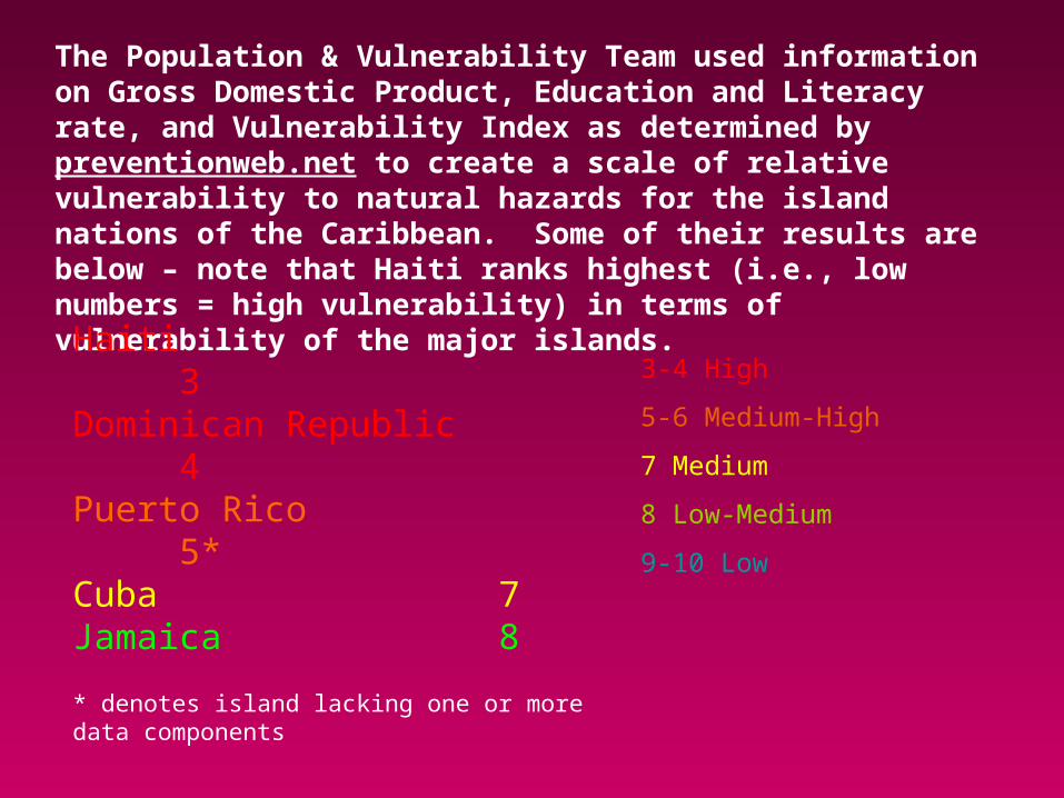
The Population & Vulnerability Team used information on Gross Domestic Product, Education and Literacy rate, and Vulnerability Index as determined by preventionweb.net to create a scale of relative vulnerability to natural hazards for the island nations of the Caribbean. Some of their results are below – note that Haiti ranks highest (i.e., low numbers = high vulnerability) in terms of vulnerability of the major islands.
Haiti 3Dominican Republic 4Puerto Rico 5*Cuba 7Jamaica 8
* denotes island lacking one or more data components
Enriquillo-Plantain Garden Fault Zone
•Runs along northern coast of Jamaica•Complex system of minor faults across island
The January 12, 2010 Mw = 7.0 earthquake (star) was located on the Enriquillo fault southwest of the Haitian capital of Port-au-Prince. This fault forms part of the complex boundary between the North American & Caribbean plates.
The city of Port-au-Prince lies on alluvium, which is prone to earthquake-induced liquefaction.
The class recognized that the coastal location of population centers in the Caribbean left them very vulnerable to liquefaction & tsunami damage.
Evidence of Liquefaction: below are the remains of a building that sunk into the ground due to liquefaction during the 1692 Port Royal, Jamaica earthquake. That earthquake killed ~2000 people and destroyed 2/3’s
of Port Royal, mainly by liquefaction.
Seismic Hazard Map of Central America and the Caribbean
One anomaly noted by the class was that seismic hazard maps of the region listed Haiti as having moderate (yellow & orange colors) seismic hazard. It was felt that this may have underestimated the degree of seismic hazard to the nation of Haiti.