United States Department of Agriculture Part 652 Irrigation National Engineering Handbook Natural Resources Conservation Service South Carolina Irrigation Guide Supplement (210-vi-NEH - SC Supplement, September 2016)
Transcript
United States Department of Agriculture
Part 652 Irrigation National Engineering Handbook
Natural Resources Conservation Service South Carolina Irrigation Guide
Supplement
(210-vi-NEH - SC Supplement, September 2016)
(Blank)
South Carolina Supplement Irrigation Guide Part 652
Issued September 2016
The United States Department of Agriculture (USDA) prohibits discrimination in its programs on the basis of race, color, national origin, sex, religion, age, disability, political beliefs, and marital or familial status. (Not all prohibited bases apply to all programs). Persons with disabilities who require alternative means for communication of program information (Braille, large print, audiotape, etc.) should contact USDA’s TARGET Center at (202) 720- 2600 (voice and TDD).
To file a complaint, write the Secretary of Agriculture, U.S. Department of Agriculture, Washington, DC 20250, or call 1-800-245-6340 (voice) or (202) 720-1127 (TDD). USDA is an equal employment opportunity employer.
(210-vi-NEH - SC Supplement, September 2016)
South Carolina Supplement Irrigation Guide Part 652
Preface (adapted from NEH, Part 652)
Supplemental irrigation is vital to produce acceptable quality and yield of crops in semi-arid and sub- humid climates during seasonal droughty periods. The complete management of irrigation water by the user is a necessary activity since competition for a limited water supply for other uses by the public require the irrigation water user to provide much closer control than ever before. The importance of irrigated crops is extremely vital to the public's subsistence.
Today's management of irrigation water requires using the best information and techniques that current technology can provide in the planning, design, evaluation, and management of irrigation systems. Support for many of the values included in this chapter come from field research, established design processes, and many system designs and evaluations over many years. Field evaluations must always be used to further refine the planning, design, evaluation, and management process. This design guide in the Natural Resources Conservation Service (NRCS), National Engineering Handbook (NEH) series provides that current technology.
NEH, Irrigation Guide, Part 652, is a guide, which describes the basics and process for planning, designing, evaluating, and managing irrigation systems.
Development of the South Carolina Irrigation Guide (SCIG) Supplement provides local soil, crop, and irrigation water requirement information needed to plan, design, evaluate, and manage irrigation systems.
It is written for NRCS employees who provide technical assistance to the water user with concerns for both water quantity and quality. Other technical personnel from Federal, State, private, and local agencies will also find the guide useful as a basic reference when providing technical assistance relating to planning, designing, evaluating, and managing irrigation systems. College and university instructors will also find the guide useful as a classroom reference.
At the time of publication, all website links were active.
The mention of specific brand names or products within this document does not constitute an endorsement by the U.S. Department of Agriculture.
(210-vi-NEH - SC Supplement, September 2016) i
South Carolina Supplement Irrigation Guide Part 652
Acknowledgments
Part 652, South Carolina Irrigation Guide Supplement, is an addition to the National Engineering Handbook series. The document was initially prepared by Dr. James Hook, Professor of Crop and Soil Sciences (retired), University of Georgia, National Environmentally Sound Production Agriculture Laboratory (NESPAL) with primary review, data input, and tool development by Yasmin Mazdab Bennett, state water management engineer, NRCS SC, Walterboro, South Carolina with editorial review by Dr. Hamid Farahani, water management engineer, East National Technical Service Center, (ENTSC) NRCS, Greensboro, North Carolina.
Principal NRCS staff and partners who contributed to the development and review of this publication were: Eric Fleming, former state conservation engineer, NRCS SC, Columbia, South Carolina, currently agricultural engineer, (ENTSC) NRCS, Greensboro, North Carolina Stephen Henry, assistant state conservation engineer, NRCS SC, Columbia, South Carolina Randy Fowler, resource soil scientist, NRCS SC, Charleston, South Carolina Emory Holsonback, resource soil scientist, NRCS SC, Laurens, South Carolina Clarence Prestwich, agricultural engineer, NRCS WNTSC, Portland, Oregon Dr. Jose Payero, irrigation faculty, Clemson University Edisto Research and Education Center, Blacksville, South Carolina Dr. Ryan Bowles, director, North Carolina State Climate Office, Raleigh, North Carolina Sharon Hrvol, administrative assistant, NRCS SC, Colleton Soil and Water Conservation District, Walterboro, South Carolina
Final review and approval was provided by Rob Sampson, national water management engineer, NRCS, Washington, DC. Ann English, state conservationist, NRCS SC, Columbia, South CarolinaScott Glenn, acting state conservation engineer, NRCS SC, Columbia, South Carolina
(210-vi-NEH - SC Supplement, September 2016) ii
(Blank)
South Carolina Supplement Irrigation Guide Part 652
South Carolina Irrigation Guide Supplement
Contents:
Chapter 1 Introduction
Chapter 2 Soils
Chapter 3 Crops
Chapter 4 Water Requirements
Chapter 5 Selecting an Irrigation Method
Chapter 6 Irrigation System Design
Chapter 7 Farm Distribution Components
Chapter 15 Resource Planning and Evaluation Tools and Worksheets
Chapter 16 Special Use Tables, Charts, and Conversions
Chapter 17 Glossary and References
To print pages in their correct orientation, choose "Auto" in the print window
"Link" symbol denotes an active hyperlink within this document.
Take note of your starting page prior to clicking "link" symbol. When you want to return, type the page number in the window & hit enter.
iii (210-vi-NEH - SC Supplement, September 2016)
yasmin.bennett
Oval
yasmin.bennett
Rectangle
yasmin.bennett
Rectangle
(Blank)
Chapter 1 Introduction
Contents
SC652.0106a General 1-7
SC652.0106b Meteorological Conditions in South Carolina 1-7 1-7 1-10 1-11 1-14 1-14
(1) (2) (3) (4) (5)
Precipitation Temperature Growing Season Wind Data Sources
SC652.0106c Surface Water Resources Available for Irrigation 1-16 1-16 1-18 1-19 1-19 1-19 1-19
(1) (2) (3) (4) (5) (6)
General Average Streamflow Seasonal Distribution of Streamflow Low Flows Surface Water Withdrawls Surface Water Quality
SC652.0106d Groundwater Resources Available for Irrigation 1-21 1-21 1-21 1-24 1-24 1-24 1-25 1-27 1-27 1-27 1-27 1-27 1-28
(1) (2) (3) (4) (5) (6) (7)
General Water Bearing Formations (Aquifers) Water Availability Well Depths Well Yields and Water Levels Groundwater Withdrawals Groundwater Quality General Temperature Dissolved Solids and Acidity Variation by Source Water Quality Effects on Irrigation Equipment
SC652.0106e Irrigation Development in South Carolina (1) General (2) Early Irrigation
General Surface Water Withdrawal Regulations Registration procedures Annual Reporting Previous, Regulating and Reporting Groundwater Withdrawal Regulation Well Drilling Permit/Registration procedures Annual Reporting Drought Regulations Irrigating with Animal Waste Regulations Irrigating with Municipal Waste Regulation Applying Chemicals using Irrigation Regulation
(3)
(4) (5)
(6)
(7)
Tables
SC1-1 Water Quality Constituents 1-28
Figures
South Carolina precipitation norms Statewide average of annual precipitation (inches) 1895 to 2013 Statewide mean monthly precipitation (inches) 1895 to 2013 Statewide coverage of mean monthly reference ETo and mean average monthly precipitation 2002 to 2009 South Carolina mean annual temperature 1970 to 2000 Average frost-free period (days) in South Carolina (1931 to 1960) Average dates of last freeze in Spring (Temp below 32F, 1931 to 1960) Average dates of first freeze in Fall (Temp below 32F, 1931 to 1960)
South Carolina Reference ET (ET0) and Precipitation climate recording stations Major stream basins and sub-basins of South Carolina Principle physiographic regions in South Carolina Distribution of average annual runoff and base flow in South Carolina South Carolina DHEC water quality management basins Distribution of primary withdrawal areas for South Carolina principle aquifers Generalized cross section of South Carolina showing the principle aquifers Hydrogeologic sections across the SC Coastal Plain Groundwater Withdrawal - Capacity Use Areas within South Carolina Portable pipe removed from field after final irrigation Peach orchard equipped with solid set sprinkler for Frost Protection Solid-set sprinkler on a turf farm Big gun (traveler) irrigation for a tobacco crop Hose-reel traveler parked at edge of field Spray pattern and typical movement of traveler Traveler system operating in an odd shaped field Pivot pipe span with truss rod structure and drop hose nozzles End gun on low pressure drop nozzle center pivot Center pivot patterns in square or rounded field areas Center pivots irrigate other field shapes (partial circle) Example of Sector and Zone prescriptions Drip tubing exposed under plastic mulch Drip tape, drip emitter, and microsprayer Buried tubing of subsurface drip irrigation (SDI) system Capacity Use, Notice of Intent (NOI), and Registration Counties
1-iii (210-vi-NEH - SC Supplement, September 2016)
(Blank)
Chapter 1 Introduction Part 652 Irrigation Guide
652.0106 State Supplement
(a) General These South Carolina supplement chapters to the NRCS National Engineering Handbook (NEH) Part 652, Irrigation Guide were written to include state specific data for designs and irrigation scheduling. They are meant to be used in conjunction with calculations and tabular data contained in NRCS NEH Part 623 (formerly Section 15), along with other state information contained in NRCS Field Office Technical Guides and state soil surveys. Section 15 is the old way of referencing the NEH and as parts are re-written they are converted to the new filing system, hence chapters in Section 15 became chapters in Part 623. To the extent possible, material that would duplicate discussion or data already in these chapters was eliminated.
Chapter headings, footers, pagination, tables, figures, and section numbers follow those of the corresponding NEH Part 652 chapters with state supplement sections being placed at the end of each appropraite NEH Part 652 chapter. The layout for the South Carolina Irrigation Guide (SCIG) Supplement follows the current policy with a single column format. For several NEH chapters, content in the existing chapter was adequate for use in South Carolina, and no supplement section was created for the State.
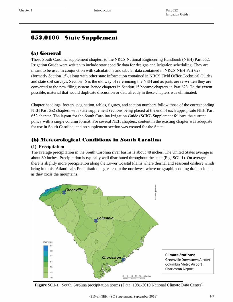
(b) Meteorological Conditions in South Carolina (1) Precipitation The average precipitation in the South Carolina river basins is about 48 inches. The United States average is about 30 inches. Precipitation is typically well distributed throughout the state (Fig. SC1-1). On average there is slightly more precipitation along the Lower Coastal Plains where diurnal and seasonal onshore winds bring in moist Atlantic air. Precipitation is greatest in the northwest where orographic cooling drains clouds as they cross the mountains.
Greenville
Columbia
Charleston
Figure SC1-1 South Carolina precipitation norms (Data: 1981-2010 National Climate Data Center)
(210-vi-NEH - SC Supplement, September 2016) 1-7
Climate Stations: Greenville Downtown Airport Columbia Metro Airport Charleston Airport
yasmin.bennett
Rectangle
Chapter 1 Introduction Part 652 Irrigation Guide
Based on more than 100 years of records, the statewide mean is about 48 inches, but year-to-year variability of total annual precipitation with extremes from 32 inches in 1954 to 70 inches in 1964, as Fig. SC1-2 illustrates. This creates one of the greatest incentives for irrigation because extremes of 50% above and below average can be seen locally.
The annual precipitation is rarely as low as the mean precipitation in the United States – 30 inches. Nonetheless, recent rainfall deficits, especially those since the late 1990’s, have occurred during a time when irrigation became an option in crop production. At that same time, growers and banks that fund them have grown more risk averse. The drive toward irrigation remains strong.
Another way to examine the precipitation deficits that irrigators may need to make up is to look at the mean monthly (average/max/min) precipitation from 1895 to 2013 (Fig. SC1-3). The period shows both high precipitation months as well as very dry months. The average precipitation declines slightly in the late spring and more so during the late fall and winter months. In general, South Carolina precipitation can maintain streamflow throughout the year and recharges the state’s aquifers, particularly in winter and early spring months but its distribution is not uniform throughout the growing season. This might suggest the need for supplemental water from an irrigation system.
(inch)
Figure SC1-2 Statewide average of annual precipitation (inches) 1895 to 2013. (Data: Southeast Regional Climate Center, State average data. (http://www.sercc.com/)
Figure SC1-3 Statewide mean monthly precipitation (inches) 1895 to 2013. (Data: Southeast Regional Climate Center. http://www.sercc.com/climateinfo/monthly_seasonal)
1-9 (210-vi-NEH - SC Supplement, September 2016)
While monthly precipitation is moderate throughout the year, it still falls below Reference ET (ET0) demand of the growing crops. Figure SC1-4 compares the average mean monthly precipitation to the mean monthly ET0 from the Columbia Metro Airport climate station.
The data indicates that between March through September there is a deficit of precipitation verse ET0 and supplement irrigation would be required to meet the crop ET water needs. In South Carolina, the typical high ET0 months are April through August with rainfall deficits of 2.6 to 0.7 inches. It is those expected growing season deficits that justify grower investments in irrigation infrastructure.
During severe dry months, growers may need to supply all of a crop’s water needs (Crop ET). One challenge in designing irrigation systems is balancing costs for larger capacity systems that could meet all crop needs in the worse years with less expensive designs that might fall short in some very dry months.
Figure SC1-4 Columbia Metro Airport climate station mean monthly reference evapotranspiration (ET0) and mean average monthly precipitation (inch) 2002 to 2009. (Data: Southeast Regional Climate Center. (http://www.sercc.com/) and North Carolina State Climate Center for ET0 data.
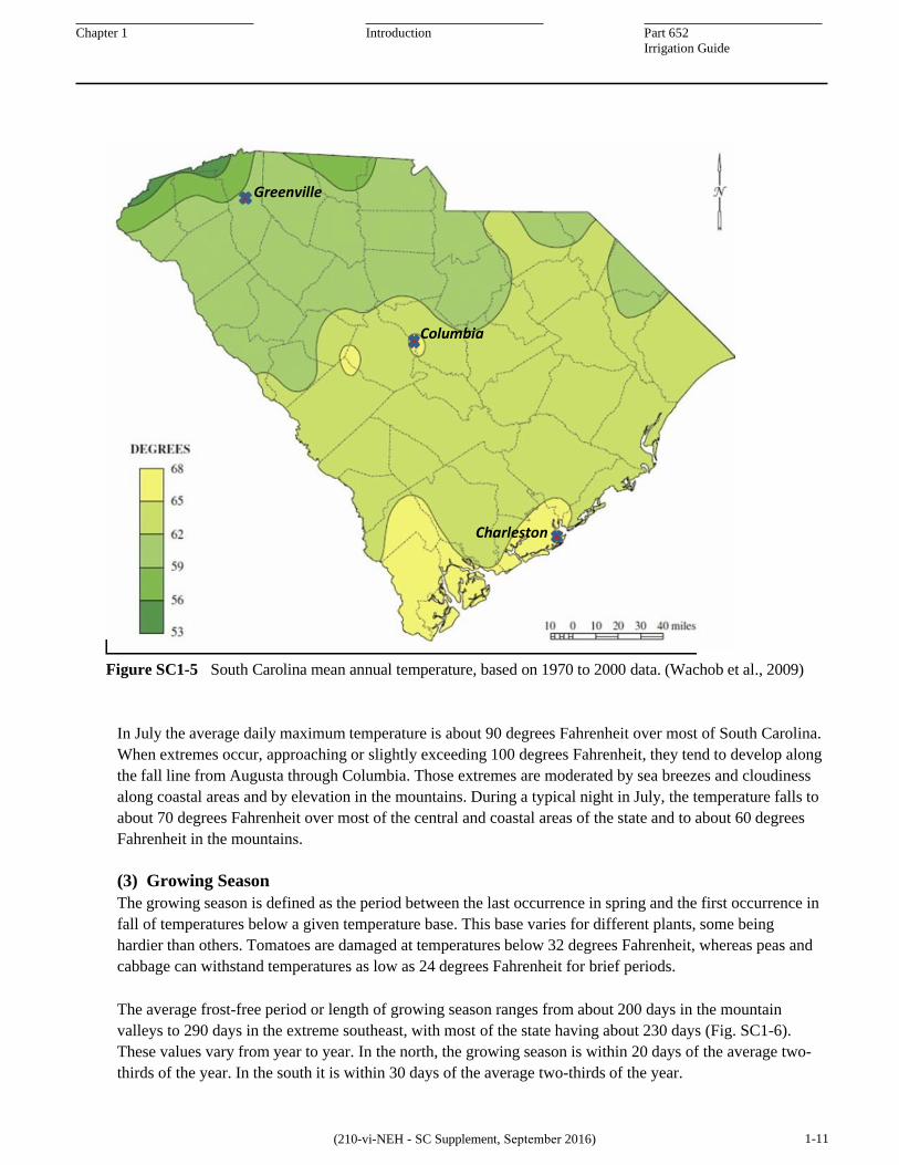
(2) Temperature Average daily temperatures for South Carolina remain well above freezing across the State (Fig. SC1-5). In general, the average temperature at the height of the summer is about 80 degrees Fahrenheit; slightly higher than the summer average of 75 degrees Fahrenheit seen through much of the continental US.
The average daily temperature range is about 20 degrees Fahrenheit, with the minimum usually at sunrise and the maximum usually in early afternoon. Variations in this pattern occur, of course, with frontal passage and a change of air mass, strong winds, and the formation of dense clouds. Through much of the summer growing season, afternoon cloudiness with or without thundershowers, moderates the afternoon rise in temperature.
With unusually long duration of cloudiness or with dense clouds, daily temperature range may be less than 10 degrees Fahrenheit but with clear skies, dry air, and light wind, the range frequently exceeds 30 degrees Fahrenheit. These last conditions are common during periods of drought. While they create ideal crop growing conditions, they also increase crop evapotranspiration and often the need for supplemental water.
On an average January day, the temperature rises to more than 50 degrees Fahrenheit in the mountains, the low 60’s in the central part of the state, and reaches 70 degrees Fahrenheit in the extreme southeast part. The minimum temperature during an average January day is 30 degrees Fahrenheit in the mountains, 40 degrees Fahrenheit in the central part, and nearly 50 degrees Fahrenheit in the extreme southern portion.
Figure SC1-5 South Carolina mean annual temperature, based on 1970 to 2000 data. (Wachob et al., 2009)
In July the average daily maximum temperature is about 90 degrees Fahrenheit over most of South Carolina. When extremes occur, approaching or slightly exceeding 100 degrees Fahrenheit, they tend to develop along the fall line from Augusta through Columbia. Those extremes are moderated by sea breezes and cloudiness along coastal areas and by elevation in the mountains. During a typical night in July, the temperature falls to about 70 degrees Fahrenheit over most of the central and coastal areas of the state and to about 60 degrees Fahrenheit in the mountains.
(3) Growing Season The growing season is defined as the period between the last occurrence in spring and the first occurrence in fall of temperatures below a given temperature base. This base varies for different plants, some being hardier than others. Tomatoes are damaged at temperatures below 32 degrees Fahrenheit, whereas peas and cabbage can withstand temperatures as low as 24 degrees Fahrenheit for brief periods.
The average frost-free period or length of growing season ranges from about 200 days in the mountain valleys to 290 days in the extreme southeast, with most of the state having about 230 days (Fig. SC1-6). These values vary from year to year. In the north, the growing season is within 20 days of the average two-thirds of the year. In the south it is within 30 days of the average two-thirds of the year.
(210-vi-NEH - SC Supplement, September 2016) 1-11
yasmin.bennett
Rectangle
Chapter 1 Introduction Part 652 Irrigation Guide
Figure SC1-6 Average frost-free period (days) in South Carolina (Date: 1931-1960.)
The average date of the last freeze in spring (Fig. SC1-7) and first freeze in the fall (Fig. SC1-8) are shown for temperature sensitive plants. For hardy plants, the average growing season would be about 25 days earlier in spring and about 20 days later in fall. The very long growing season in South Carolina opens agricultural fields to numerous crop options. Long season crops like peanut and cotton can be reliably grown without fear of frost.
Many multiple cropping options, including those with a variety of vegetables, winter grains, and traditional row crops are feasible. Due to agronomic reasons for crop rotations, especially weed, nematode and disease suppression, the design of an irrigation system needs flexibility in order to supply supplemental water to the diversity of crops possible in South Carolina.
(210-vi-NEH - SC Supplement, September 2016) 1-12
Charleston
Columbia
Greenville
yasmin.bennett
Rectangle
Chapter 1 Introduction Part 652 Irrigation Guide
Figure SC1-7 Average dates of last freeze in Spring (Data: Temp. below 32 F, 1931-1960)
Figure SC1-8 Average dates of first freeze in Fall (Data: Temp. below 32 F, 1931-1960) (Source: NOAA, Climatography of the United States, No. 85)
(210-vi-NEH - SC Supplement, September 2016) 1-13
Chapter 1 Introduction Part 652 Irrigation Guide
(4) Wind In South Carolina, winds move from southwest to northeast when offshore systems, mostly the Bermuda high, dominate during the summer. When overland, highs dominate wind movement mostly from northeast to southwest. For certain orchard applications, the direction might be a consideration in tree and irrigation system layout but normally predominant wind direction will not impact irrigation design. Average daily wind speeds are only 5 to 10 miles per hour for the state.
Physiographic influences are evident in the state. Wind speeds in open coastal areas are affected by diurnal on/off shore winds and average speeds are typically 7 to 10 miles per hour. On exposed ridges and open plateaus, average wind speeds of 8 to 10 miles per hour have been observed. In relatively sheltered valleys areas, such as around Columbia, winds average 5 to 7 miles per hour. Local variation is affected by the dominant tall pine and hardwood trees found in forests and hedgerows surrounding many fields.
For most of the growing regions where irrigation is installed and used, there are daily wind speed patterns consisting of negligible wind speeds from about two hours before to about two hours after sunrise. Warming of the ground and vegetation results in a steady increase in wind speed throughout the morning into early afternoon. Depending upon development of clouds and thunderstorms, wind speed may peak between 3 and 5 pm. When thunderstorms are not present, wind speed again drops in the evening, often precipitously in early evening and it remains so until the nighttime mixing with light winds from 3 to 4 am.
The wind pattern allows growers some control of wind sensitive operations including agricultural spraying and irrigation. For irrigation systems most affected by wind – high pressure impact sprinklers and big guns - application should be avoided whenever possible during the afternoon when moderate to gusty winds can disrupt intended application patterns.
The winds may also lead to offsite or off target overspray. Additionally the afternoon wind speed peaks when air temperatures are near daily maximums and air relative humidity are at their daily lowest - conditions favoring maximal evaporative irrigation water loss during application for any spray irrigation method. Conversely, nighttime and early morning application will make most effective use of water pumped to the field and will apply it within the uniformity designed for the system.
To allow irrigation to be used primarily at nighttime, the system and its water source must be sized to apply the average depth of moisture replacement (typically 0.25 inch) in 8 hours or less a day. Likewise, the system must be designed to require minimal attention during these nighttime application periods. Systems designed this way provide the flexibility to keep up with water demands of the crop and still take advantage of off peak utility rates, further increasing irrigation efficiency.
(5) Data Sources The National Climate Data Center (NCDC) website (http://www.ncdc.noaa.gov/cdo-web/datatools/normals) provides annual, monthly, daily, and hourly rainfall norms for the entire United States and multiple South Carolina stations grouped in 30 year datasets. The Southeast Regional Climate Center (SERCC), located at the University of North Carolina, Chapel Hill, NC provides long term mean precipitation for multiple stations across SC with datasets as far back as 1895. See Table SC4-7 for ET0 and SERCC station metadata information (http://www.sercc.com/climateinfo/historical/ historical). Fig. SC1-9 shows the climate stations used to calculate ETc for this Supplement.
Figure SC1-9 South Carolina map showing Reference ET (Station Name) and long term Rainfall stations used in this Supplement. (Data Source: North Carolina State Climate Office and Southeastern Regional Climate Center [SERCC], respectively)
1-15 (210-vi-NEH - SC Supplement, September 2016)
Fall Line
Fall Line
KCUB
yasmin.bennett
Rectangle
yasmin.bennett
Polygonal Line
yasmin.bennett
Rectangle
yasmin.bennett
Rectangle
yasmin.bennett
Polygonal Line
Chapter 1 Introduction Part 652 Irrigation Guide
(c) Surface Water Resources Available for Irrigation
(1) General In South Carolina, surface water flows predominantly from northwest to southeast as elevation decreases from the Appalachian mountains to the Flatwoods and coastal waters of the Atlantic (Fig. SC1-10). Of the four major river basins, only the Ashepoo-Combahee-Edisto (ACE) river basin lies entirely within the state. The Savannah River basin is about evenly split between Georgia and South Carolina and the river itself forms the boundary between the states. Withdrawals from surface waters of the Savannah River basin may be the subject of interstate compacts, especially withdrawals taken directly from the Savannah River and its instream reservoirs. Those operate under rules established by the U.S. Congress and implemented by the U.S. Army Corps of Engineers.
The Santee and Pee Dee major river basins have their headwaters in North Carolina. Unlike the Savannah basin, North Carolina users withdraw water upstream from South Carolina. The remaining river and stream- flows which enter South Carolina are affected by those NC withdrawals. As a result, the two states have been in negotiations over equitable use of the waters in these basins. Surface water users in South Carolina’s portions of these basins may be subject to actions of any interstate compact between the states.
Most South Carolina irrigators will not suffer direct affects from withdrawals or impoundments made by North Carolina users. Typically South Carolina withdrawals for irrigation are made directly from small streams or from farm ponds that collect runoff or impound flow in small streams. The catchment area for these streams and drainage ways lie within the state, often within the farm or those of neighbors.
Figure SC1-10 Major stream basins and sub-basins of South Carolina. (Wachob et al., 2009)
(210-vi-NEH - SC Supplement, September 2016) 1-16
Chapter 1 Introduction Part 652 Irrigation Guide
Irrigation withdrawals can be made directly from continuously flowing streams and rivers, subject to the laws of South Carolina (see section f, pg 1-38) and all applicable Federal laws. This eliminates the necessity for costly impoundments. Stream side pumps can be installed as portable pumps mounted on trailers or sleds. Typically these are powered by diesel or propane fueled engines or they can be permanent installations powered by an electric motor. A stream side or streambed dugout may be needed to assure sufficient flow at all stream levels into the siphon tube. In many cases there is sufficient base flow in these streams, but it is important to remember that irrigation needs are greatest when river flows are at their lowest levels.
Direct stream and river withdrawals have inherent risks. In addition to risks of insufficient flows during droughts, there may be restriction on irrigation pumping when the streamflow has reached a predetermined limit needed for permitted wastewater discharges and their associated waste assimilation, a limit set to protect flow for fish and other animal and plant habitats, or there may also be permitted withdrawers downstream with prior claims on the flow. There are risks during flood flows as well. Unless built onto sturdy platforms and mounted at an elevation above expected flood stages, stream side pumps may be submerged or dislodged and damaged. Even normal flood flows in winter can carry enough silt and sand to fill in dugouts made for siphon tubes, creating an annual maintenance chore.
Physiography can work against direct stream withdrawals. In the Coastal Plain regions of the State (Fig. SC1-11), in particular, streams and rivers meander in broad flood plains. Soils in these floodplains are subject to periodic flooding. Also, they are usually poorly or somewhat poorly drained.
Figure SC1-11 Principle physiographic regions in South Carolina. (Wachob et al., 2009.)
(210-vi-NEH - SC Supplement, September 2016) 1-17
yasmin.bennett
Rectangle
Chapter 1 Introduction Part 652 Irrigation Guide
Areas immediately adjacent to the stream, locations that would be most amenable for direct pumping, do not make productive row crop or vegetable fields. To use direct stream withdrawals, water would have to be pumped further, increasing capital and operating costs for pumping.
This is less often a problem in Piedmont or Blue Ridge regions. Streams may flow adjacent to adequately drained terraces or upland locations that have productive crop fields and orchards. However, even in these regions, the distance from major streams to fields needing irrigation is often too great to justify the expense of mile long and greater pressurized pipelines. Unless the irrigator owns the land all the way to the river there may also be costs associated with rights-of-way for the pipeline.
For all these reasons, farm operators most commonly rely upon small, on-farm streams and impoundments to secure their access to surface water. Interstate Compacts or South Carolina laws designed to protect downstream users in the State are another matter. Courts or state regulators could pass mandates that effect on-farm sources of water, as has happened in the West.
(2) Average Streamflow The range of annual streamflow (runoff and base flow) is from about 10 inches in the lower Coastal Plain and 15 inches in the lower Piedmont/upper Coastal Plain to about 35 inches in the Blue Ridge (Fig. SC1-12). As stated earlier, statewide mean precipitation is 48 inches with the average annual streamflow of 22 inches average depth over the State (U.S. Geological Survey, 1985), compared to the United States average of about 8 inches.
Figure SC1-12 Distribution of average annual runoff and base flow in South Carolina 1948-1990 (Wachob et al., 2009; Badr et al., 2004)
(210-vi-NEH - SC Supplement, September 2016) 1-18
Chapter 1 Introduction Part 652 Irrigation Guide
The remainder of the 48 inches of average annual precipitation (or 26 inches) enters and recharges the various aquifers in the state or is lost to evapotranspiration. With an average of 15 inches of runoff from farm fields and forests in the row crop areas of the state, it would seem, at first glance, that there would be little need for irrigation, let alone farm ponds. However, as was pointed out in the meteorology section, the precipitation (Fig. SC1-4) and subsequent runoff is not distributed uniformly through the growing season.
Average rainfall is at a deficit compared to average evapotranspiration demand in spring and summer months. Summer precipitation produces little net runoff, except locally under severe thunderstorms. Impoundments are needed near irrigated fields to retain spring runoff and to capture runoff during those periodic storm events.
(3) Seasonal Distribution of Streamflow Although related, the seasonal distribution of streamflow does not match the seasonal distribution of precipitation. Regardless of variations in the seasonal precipitation pattern, the average streamflow, except in certain coastal areas, is high in early spring and recedes to a low in late autumn. This average seasonal regime is typical even in most small streams in rural areas. The summer precipitation peak does not ordinarily produce a summer runoff peak because summer showers usually fall on relatively dry soil. Much of the rainfall is quickly transpired by vegetation. Some even evaporates directly from leaf surfaces and soil to the air; thus, summer rain contributes relatively little to runoff during this time of year.
(4) Low Flows Streams in the Lower Coastal Plain and Lower Piedmont normally have poorly sustained base flows, and some streams periodically go dry during late summer and fall. This is in contrast to the Blue Ridge and upper Coastal Plain regions (Fig. SC1-11) where base flows are well sustained. In the mountains, precipitation is greater, infiltration is enhanced by the highly porous floor of hardwood forests. Fractured shale and sandstone aquifers store, transmit, and discharge that water over an extended period. In the Upper Coastal Plain, precipitation infiltrates the sandy surface soils where much of the spring rains are transmitted through thick well drained soils into shallow aquifers of the Sand Hills and Upper Coastal Plain. Streams in the region are well connected with and drain surficial aquifers they flow through.
More information on low flows of streams in South Carolina may be obtained from the following publications of the South Carolina Water Resources Commission by Bloxham (1976, 1979, 1981.) Additionally, the South Carolina State Water Assessment provides a good overview of stream flow in many areas of the state (Wachob et al., 2009).
(5) Surface Water Withdrawals The average surface water discharge from South Carolina is about 33 billion gallons per day (U.S. Geological Survey, 1985). Between 1970 and 1980, total off stream water use in South Carolina nearly doubled to 5,780 million gallons per day. The South Carolina Water Resources Commission projected this amount to increase to about 8,550 million gallons per day by the year 2020 (Snyder et al., 1983). However, the 2010 Annual Use Report showed that off stream water use had already reached 9,770 million gallons per day a decade earlier (SCDHEC, 2010). Of that nearly 10 billion gallons per day in the report only 28 million gallons per day, as reported by 268 users, were surface withdrawals for irrigation.
(6) Surface Water Quality South Carolina manages its withdrawal permitting, discharge permitting and reporting for eight designated water quality management basins (Fig SC1-13). State code and regulations that affect agricultural
(210-vi-NEH - SC Supplement, September 2016) 1-19
Chapter 1 Introduction Part 652 Irrigation Guide
The natural temperature in large streams is near the average monthly air temperature. In smaller streams, day-to-day fluctuations in water temperature are greater than for the larger streams and in the smallest streams, hour-to-hour variations are evident with the daily range of temperature being nearly as great as for the nearby air.
Neither dissolved solids nor acidity presents problems in most South Carolina surface water supplies. The range of dissolved solids for surface water in South Carolina is from less than 15 to more than 100 mg/L with values generally ranging from 20 to 80 mg/L. The pH of surface water generally will be in the range from about 5.0 to 7.5 with alkalinity ranging from about 1 to 40 mg/L.
The quality of South Carolina's surface water is generally suitable for irrigation use. The water is soft and has a low buffering capacity. There are no known significant quality problems concerning the use of surface water for irrigation of row crops and orchards. South Carolina has listed streams with impaired water quality, and even unlisted streams and impoundments may contain bacteria or other contaminants from runoff or discharge. These create risks for food borne diseases. Generally, untreated surface waters should not be used for irrigation of fresh market fruits and vegetables.
Figure SC1-13 South Carolina DHEC water quality management basins. (Wachob et al. 2009)
(210-vi-NEH - SC Supplement, September 2016) 1-20
operations are described more fully in section f (pg 1-38), Regulatory Environment for Irrigation.
Chapter 1 Introduction Part 652 Irrigation Guide
(d) Groundwater Resources Available for Irrigation
(1) General Groundwater is often the preferred choice for irrigation in South Carolina. In most cases, wells will be drilled on the property of the farm where it will be used, adding value to the farm and providing some measure of water security during drought years. In many productive farming regions in South Carolina, well yields are sufficient to directly supply high capacity systems including large drip irrigation fields and center pivots. In others, wells may refill reservoirs or ponds from which the irrigation is operated.
Water from most water bearing formations (aquifers) in South Carolina appear free of the potential contaminates, especially bacterial that may clog microirrigation systems. Based on a water quality test, it may or may not be usable without treatment on vegetables, row crops, and fruits for fresh market consumption.
The major disadvantage of groundwater for irrigation has been the high capital costs for well drilling, pumping plant, and the added annual costs for energy to lift water from the water table to the surface. Also, wells and especially their pumps are subject to damage from lightening. In recent years, regulations on well drilling, permitting for water withdrawals from selected aquifers, and monitoring and reporting have added to those disadvantages. Even so, the advantages of a reliable and high quality water source have led many considering irrigation to make the additional investment in wells.
Farmers in the South often believe that water taken from below their own property belongs to them. It can be used by them in any quantity, for any use, and at any time for only the cost of drilling a well and pumping that water. This traditional view clashes with a more scientifically based understanding of geology and hydrology. In most cases, the water under a landowner’s property is part of larger and interconnected water bearing formations. Water withdrawn by one farmer may affect the availability of water under their neighbor’s property. Collectively, withdrawals can lower water tables, or hydraulic head in confined aquifers, in a large region. This can impact others with shallow wells, dewater surficial aquifers, reduce discharge from aquifers to streams, eliminate natural surface water storage features, or even enable salt water intrusion.
The State has attempted to use education, scientific monitoring and modeling, and regulation to protect long term sustainability of groundwater resources for all water users and ecosystems. Their rules and regulations (see section f, pg 1-42) are not always openly accepted. It is important to be sensitive to the traditional, scientific, and regulatory views of groundwater use when discussing plans that involve expansion of groundwater for irrigation.
(2) Water Bearing Formations (Aquifers) South Carolina groundwater resources differ substantially from one Physiographic Regions to the next (Fig. SC1-11). There are four major aquifers that are separated by layers of low permeability. Piedmont and Blue Ridge aquifers occur in alluvial deposits of sand and gravel, in weathered saprolite, and in joints, fractures and fault zones of crystalline bedrock. These are surficial aquifers, i.e. their water surface is open to atmospheric pressure. Water surfaces that are free from pumping tend to follow the contours of the land surface, and most discharge to drainage ways, streams, and rivers that dissect the landscape. That discharge forms the base flow in Blue Ridge and Piedmont streams, and pumping from these aquifers will affect associated stream flow.
1-21 (210-vi-NEH - SC Supplement, September 2016)
Chapter 1 Introduction Part 652 Irrigation Guide
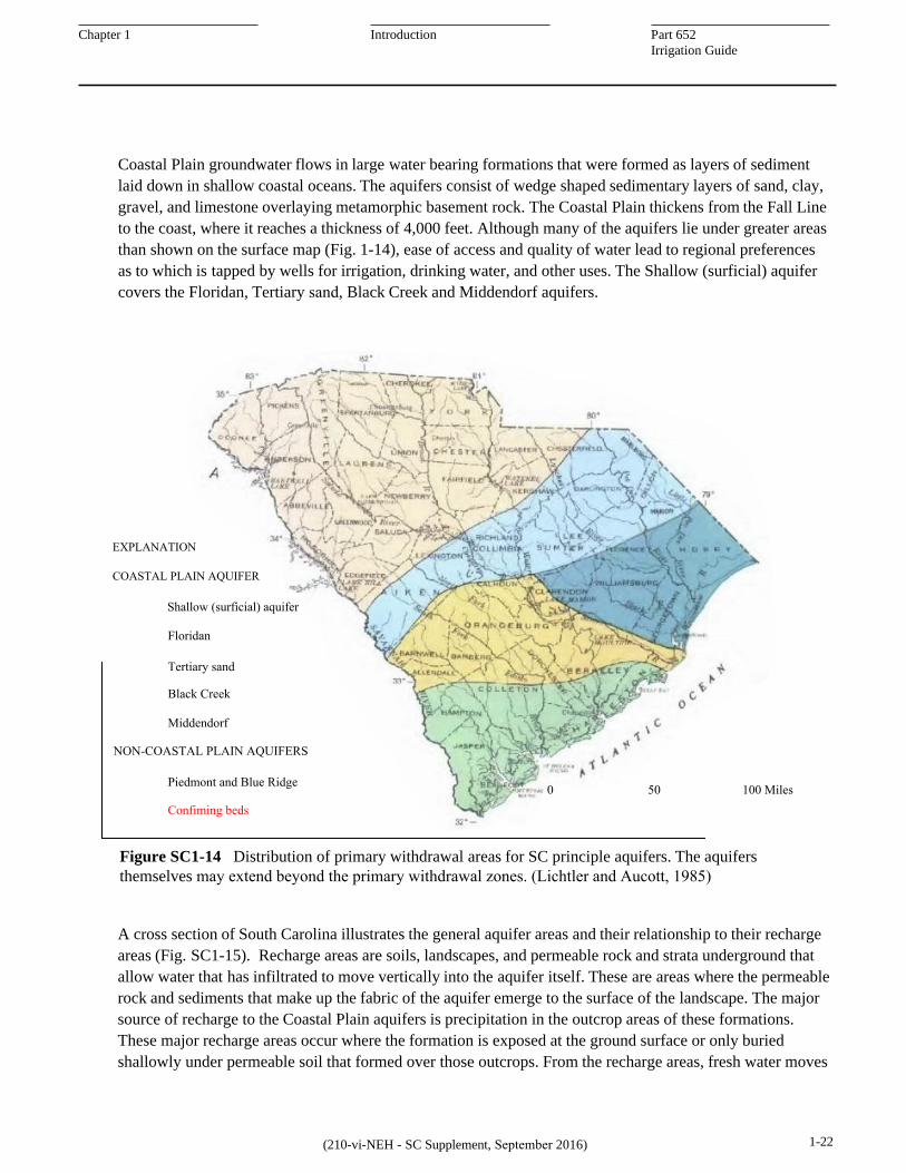
Coastal Plain groundwater flows in large water bearing formations that were formed as layers of sediment laid down in shallow coastal oceans. The aquifers consist of wedge shaped sedimentary layers of sand, clay, gravel, and limestone overlaying metamorphic basement rock. The Coastal Plain thickens from the Fall Line to the coast, where it reaches a thickness of 4,000 feet. Although many of the aquifers lie under greater areas than shown on the surface map (Fig. 1-14), ease of access and quality of water lead to regional preferences as to which is tapped by wells for irrigation, drinking water, and other uses. The Shallow (surficial) aquifer covers the Floridan, Tertiary sand, Black Creek and Middendorf aquifers.
Figure SC1-14 Distribution of primary withdrawal areas for SC principle aquifers. The aquifers themselves may extend beyond the primary withdrawal zones. (Lichtler and Aucott, 1985)
A cross section of South Carolina illustrates the general aquifer areas and their relationship to their recharge areas (Fig. SC1-15). Recharge areas are soils, landscapes, and permeable rock and strata underground that allow water that has infiltrated to move vertically into the aquifer itself. These are areas where the permeable rock and sediments that make up the fabric of the aquifer emerge to the surface of the landscape. The major source of recharge to the Coastal Plain aquifers is precipitation in the outcrop areas of these formations. These major recharge areas occur where the formation is exposed at the ground surface or only buried shallowly under permeable soil that formed over those outcrops. From the recharge areas, fresh water moves
1-22 (210-vi-NEH - SC Supplement, September 2016)
Shallow (surficial) aquifer
0 50 100 Miles
Floridan
Tertiary sand
Black Creek
Middendorf
EXPLANATION
COASTAL PLAIN AQUIFER
NON-COASTAL PLAIN AQUIFERS
Piedmont and Blue Ridge
Confiming beds
yasmin.bennett
Polygonal Line
yasmin.bennett
Rectangle
yasmin.bennett
Rectangle
yasmin.bennett
Rectangle
yasmin.bennett
Rectangle
yasmin.bennett
Rectangle
yasmin.bennett
Rectangle
yasmin.bennett
Rectangle
yasmin.bennett
Polygonal Line
yasmin.bennett
Line
yasmin.bennett
Rectangle
Chapter 1 Introduction Part 652 Irrigation Guide
Figure SC1-15 Generalized cross section of South Carolina showing the principle groundwater aquifers. (Reference: General Hydrology of South Carolina, SCDNR, 2001 and South Carolina Water Plan, second edition, SCDNR, 2004)
(210-vi-NEH - SC Supplement, September 2016) 1-23
downward and oceanward within the aquifer. The principle aquifers extend under the Atlantic for some distance. A wedge, thickening from the Fall Line toward the coastline, can be divided into aquifers and intervening confining units based on relative permeabilities, and other factors (Fig. SC1-16). Water generally moves laterally within each aquifer with confining units inhibiting but not preventing vertical movement of water between aquifers (Ancott and Speiran, 1984d).
As long as enough fresh water is entering through the recharge area and drawdown from pumped wells do not lower the hydraulic head (effective water table) below the mean sea level, the fresh water keeps saline ocean water from entering and rendering the aquifer unfit for most uses.
When recharge is blocked by impermeable surfaces or reduced by excessive capture and use of surface water, hydraulic head declines in the aquifer. When hydraulic head drops below sea level, especially near the coast, salt water migrates through the lower portions of the aquifer. The area around a pumped well – cone of depression – also creates an area of lower hydraulic head.
While there are local exceptions, groundwater in South Carolina’s Coastal Plain will have higher levels of dissolved solids, sodium, and chloride in the deepest and seaward areas of the aquifers. Well drillers attempt to balance depths that will provide sustained yield, by using casing and grout to prevent water from poorer quality layers from entering the well.
Chapter 1 Introduction Part 652 Irrigation Guide
(3) Water Availability In general, the Blue Ridge and Piedmont regions have limited groundwater supplies because of their geology. The underlying igneous and metamorphic rock (overlain by a weathered surface) is dense and crystalline and water is available only in the thin soil mantle and fracture zones of the rock itself. Within the Coastal Plains, thick sedimentary aquifers provide substantially greater supplies of generally good quality water. Groundwater can be obtained nearly everywhere by drilling a well and pumping.
(4) Well Depths Most water is stored in the top several hundred feet in the Piedmont and Blue Ridge Provinces, thus well depths usually stay within this range. Wells in the Coastal Plains often produce adequate yields at depths less than 500 feet, but it is not rare for depths to exceed 1000 feet or greater. The 2009 State Water Assessment (Wachob et al., 2009) provides maps showing depths to the top of each of the principle aquifers and typical hydraulic head (static water levels) to be found in wells drilled into those aquifers.
(5) Well Yield and Water Levels In the Piedmont and Blue Ridge, typical water levels generally range more than 200 feet below the ground surface. Almost half of the wells in the Piedmont yield less than 10 gallons per minute. Use of these wells for irrigation would be limited to very small areas – a few acres at most – unless pumped water can be stored in reservoirs or tanks. Water levels in most deep Coastal Plain wells (several hundred feet) prior to development are usually within 50 ft of the surface and sometimes above the land surface in the lower Coastal Plain due to artesian conditions.
Most large capacity wells in the Coastal Plain are screened in the Black Creek or the Middendorf (Tuscaloosa) Aquifer (Fig. SC1-14). Potential yields range from several hundred to greater than 2000 gpm.
(210-vi-NEH - SC Supplement, September 2016) 1-24
Figure SC1-16 Hydrogeologic sections across the SC Coastal Plain. At left, from Columbia to Charleston; at right along the coast. The combined aquifers are deepest (almost 4000 feet) near Hilton Head
0 10 20 30 40 50 milesCrystalline rock
Explanation
Confining unitAquifer
A A'Columbia Orangeburg St. George Charleston
B B'Parris Island Charleston Myrtle Beach
Sea LevelSea Level
Land surface
Land surface Surficial aquifer
Surficial aquifer
Vertical axis not to scale
Vertical axis not to scale
yasmin.bennett
Rectangle
yasmin.bennett
Rectangle
yasmin.bennett
Rectangle
yasmin.bennett
Line
yasmin.bennett
Line
yasmin.bennett
Line
yasmin.bennett
Line
yasmin.bennett
Polygon
yasmin.bennett
Line
yasmin.bennett
Polygonal Line
yasmin.bennett
Polygonal Line
yasmin.bennett
Polygonal Line
yasmin.bennett
Polygon
yasmin.bennett
Polygonal Line
yasmin.bennett
Polygonal Line
yasmin.bennett
Rectangle
yasmin.bennett
Polygonal Line
yasmin.bennett
Polygonal Line
yasmin.bennett
Polygonal Line
yasmin.bennett
Polygonal Line
yasmin.bennett
Polygonal Line
Chapter 1 Introduction Part 652 Irrigation Guide
The actual water level in any particular well during pumping is dependent on many factors including static water level prior to pumping, permeability of in-place materials and the gravel pack or filter at the screened sections, the well screen itself, transmissibility of the aquifer, and the discharge of the well. Screens or perforated casings are utilized in unconsolidated sand and gravel aquifers to allow water to enter the well and to stabilize the aquifer material. Consolidated rock aquifers often may be completed without perforated casing or screen. Due to the cost of screens, usually only the higher yielding zones are screened, resulting in some wells being multi-screened. Zones of poor quality water should not be screened if ample quantity of good quality water is available at different depths to dilute dissolved solids to levels that will not cause short or long term problems with crops, soils, and application equipment.
(6) Groundwater Withdrawals The 1980 withdrawal of groundwater in South Carolina was slightly less than 210 mgd (Lonon & Others, 1983). This was equivalent to about two-sevenths inch average depth per year over the southeastern half of the state. By 2010 that withdrawal had reportedly increased to only 215 mgd, as based upon reporting from 575 agricultural and 1300 other wells in the state (Butler, 2011). It is unlikely that these reported withdrawals provide the full report for the tens of thousands of known wells in the State.
A question to be considered is what rate of withdrawal could be sustained. There is little evidence of water level declines, except in heavily pumped areas of Florence, Myrtle Beach, and Savannah. Declines in the Florence area are reported to be greater than 100 ft. since 1930 for select wells. (Ancott & Speiran, 1984a, 1984b). In certain coastal areas, gradual increases in salinity and chloride in drinking water wells raised concerns.
Groundwater withdrawals for irrigation are seasonal, usually are spaced widely, and are located mostly in the upper part of the Coastal Plain where aquifer yields are large. Because of these conditions, declines in water levels due to irrigation are very localized and seasonal thus no deep permanent cones of depression have developed (Lichtler & Aucott, Water Supply Paper 2275).
Beginning in the 1980’s the US Geological Survey and Georgia, and South Carolina agencies began studying the saltwater intrusion problem in earnest. As a result of the documented salinization in some areas and excessive pumping and drawdown in other areas of the principle aquifers, South Carolina has enacted legislation to protect against further degradation of the aquifers.
The South Carolina Department of Health and Environmental Control (SCDHEC) identifies “Capacity Use Areas” (Fig. SC1-17) that require a plan to be drawn up and followed. Groundwater users must be permitted in these areas, and permits are subject to review every 5 years. As part of these plans governments in these areas are taking significant steps to reduce their dependence upon failing and limited groundwater supplies. In Horry County, most of the municipal water systems have shifted from groundwater to surface water supplies, using the increasingly saline wells as only backup systems.
Currently, there are four Capacity Use Areas including Waccamaw, Low Country, Trident, and Pee Dee. For each area there is an action and permitting plan to protect long range use and quality of the water supply. See Fig. SC1-33 (pg. 43) for additional groundwater withdrawal requirements for the rest of South Carolina.
(210-vi-NEH - SC Supplement, September 2016) 1-25
Chapter 1 Introduction Part 652 Irrigation Guide
Figure SC1-17 Groundwater Withdrawal - Capacity Use Areas within South Carolina (http://www.scdhec.gov/Environment/WaterQuality/GroundUseReporting/)
(7) Groundwater Quality General – Groundwater quality for irrigation is generally good to excellent in South Carolina. At points along the coast, saltwater intrusion is becoming a problem; and inland there are scattered places where salinity or sulfur limits the effectiveness of irrigation. Probably the most widespread problem concerns acidity (alkalinity) and dissolved solids and their effect upon metal parts of irrigation systems. In the Middendorf aquifer along the coast, concentrations of boron of as little as 8 mg/L may cause problems with certain irrigation uses.
Temperature – In general, temperature of groundwater is about the same as mean annual air temperature at the water table and increases to more than 100° F at depths greater than 2500 feet. Temperature of water from very shallow wells or from very small springs varies seasonably but temperature of water from deeper aquifers changes very little. Temperature of shallow groundwater ranges from about 64 to 69° F in the Coastal Plain and slightly cooler north of the Fall Line to below 60° F in the mountains (Personal Communication, G. Patterson, USGS, Columbia, SC).
Dissolved Solids and Acidity – The pH and alkalinity increases going from the west toward the coast within the range from about 4.0 to 9.0 (pH) with alkalinity less than 1 to greater than 1,000 mg/L. Values of pH are generally between 6.0 and 8.6. (personal communication-Glenn Patterson, USGS, Columbia, SC). At the lower end of the pH range (acid) damage may occur to well casings, screens, pumps, and the metal parts of the irrigation system.
Both acidity and low total dissolved solids, which are known causes of corrosion, are recognized problems in several center pivot systems in Lee and Sumter Counties. Some steel pipes have been severely corroded and have failed after only two to five years of use. Results of chemical testing, provided by the Water Resources Commission to the irrigators, indicate the probable cause of pipe deterioration in this area is a combination of two problems (acidity and low total dissolved solids). However, there may be some other contributing sources not yet investigated. At present, one recommended action for existing steel pipe systems is to inject lime containing adequate calcium carbonate to neutralize the acid and provide a substance that the water can dissolve instead of dissolving the pipes. The lime is normally injected on the discharge side of the pump. This slows down the corrosion and depending on the condition of the pipe, may add years of life to the system (personal communication, L. Lagmon, Chemist, SC Water Resources Commission, Columbia, SC). When possible, components should be of fiberglass, high quality stainless steel, or other material resistant to corrosion.
At the opposite end of the pH spectrum alkalinity can also create problems. In certain areas, boron dissolved in alkaline water may exceed recommendations for this micronutrient in certain crops.
Variation by Source – Water quality varies significantly between aquifers and even between layers within aquifers. Technical personnel are encouraged to discuss the acidity and dissolved solid problems with irrigators to make them aware of the known potential problem areas and the need to have their water analyzed. In most cases, alternate sources or aquifer levels are available.
The water source with known problem sites is primarily the Middendorf (Tuscaloosa) aquifer. The suspect area is a strip along the fall line including the upper Coastal Plains from Augusta, Georgia, through Chesterfield, South Carolina. Future groundwater investigations to be conducted by the Water Resources Commission will provide additional data to better define the area and refine treatment procedures.
(210-vi-NEH - SC Supplement, September 2016) 1-27
Chapter 1 Introduction Part 652 Irrigation Guide
Water Quality Effects on Irrigation Equipment – Whether pumping from ponds, streams, or wells with suspended sand, the pump and irrigation equipment orifices need to be checked regularly for wear. Sand content does not have to be high enough to make the water unclear for it to cause severe wear. A good indication of pump or orifice wear is a reduction in system pressure at the usual operating speed and water level – a reason to encourage irrigators to maintain accurate pressure gauges.
The hardness (mineral content) of the water can cause equipment problems due to mineral deposits closing orifices, freezing sprinklers and mineral encrustation in pipes. To some extent, nozzles can be selected that are less affected by encrustation, and the use of spray devices on drop tubes will keep buildup to a minimum on pivot equipment.
Microirrigation is particularly sensitive to water quality issues. Drip tape systems with their small emitter openings and more intricate labyrinth type internal structures are more easily clogged than other types of irrigation. Clogging seems to be less of a problem in those types of emitters were water moves at higher velocities.
Particulate matter and bacterial slimes are the usual causes of clogging problems for drip and microspray irrigation. Filtration will take care of the particulate matter problem, but with a high particulate matter content cleaning filters can become a problem. A combination of chlorine and filters will control the bacteria problem. It should be used as a preventive rather than a corrective treatment, because it is very difficult to clean out systems once they are clogged.
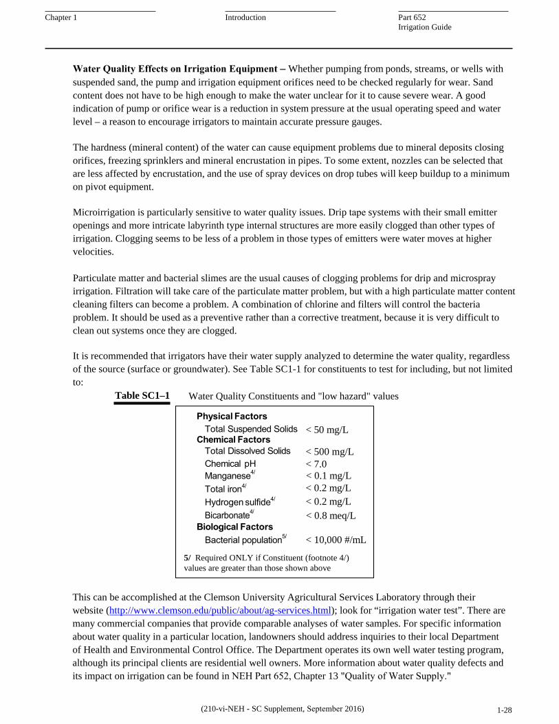
It is recommended that irrigators have their water supply analyzed to determine the water quality, regardless of the source (surface or groundwater). See Table SC1-1 for constituents to test for including, but not limited to:
Table SC1–1 Water Quality Constituents and "low hazard" values
This can be accomplished at the Clemson University Agricultural Services Laboratory through their website (http://www.clemson.edu/public/about/ag-services.html); look for “irrigation water test”. There are many commercial companies that provide comparable analyses of water samples. For specific information about water quality in a particular location, landowners should address inquiries to their local Department of Health and Environmental Control Office. The Department operates its own well water testing program, although its principal clients are residential well owners. More information about water quality defects and its impact on irrigation can be found in NEH Part 652, Chapter 13 "Quality of Water Supply."
(210-vi-NEH - SC Supplement, September 2016) 1-28
Physical Factors Total Suspended Solids < 50 mg/L
Chemical Factors Total Dissolved Solids < 500 mg/L Chemical pH < 7.0 Manganese4/ < 0.1 mg/L Total iron4/ < 0.2 mg/L Hydrogen sulfide4/ < 0.2 mg/L Bicarbonate4/ < 0.8 meq/L
(1) General Irrigation in South Carolina proceeded, as in other areas of the Southeast, through private investments of individual farm businesses and operators. Water could be withdrawn directly from the plentiful streams and rivers cutting through or bordering those farms. Farmers dug out ponds and trenches in areas with high water table or constructed impoundments to retain runoff and seepage for ponds that could be used for irrigation as well as for livestock and other uses.
Crops are irrigated by South Carolina farmers for several reasons: increasing overall profitability, stabilizing income over dry as well as wet years, and insuring they can meet contractual obligations including marketing agreements, operating loan and other farm indebtedness. Irrigation allows farmers to enter new enterprises such as vegetables or other produce for fresh and processing markets. Turfgrass sod can be grown for sale, and ornamental plants may be grown in-ground or in containers for wholesale markets. Irrigation increases the overall efficiency of crop land and investments that must be made annually for crop production. Expensive land preparation, seed and seed technology fees, fertilizers, fuel, and agrichemicals can be wasted when drought lowers crop yield or crop quality. Beginning in the late 1980s, South Carolina farmers began a conversion of their farming practices from dryland to irrigated.
(2) Early Irrigation When farmers convert fields from non-irrigated to irrigated production, they have several options for irrigation types and equipment, each having its advantages and disadvantages.
Surface Irrigation: In many areas of the world, in the western US, and even in the Mississippi Delta as well as Florida flatwoods, the first choice of irrigation was often surface irrigation. That held true for limited number of locations in South Carolina’s flatwoods. The agricultural rolling topography and sandy topsoils, as well as small land holdings, made extensive use of surface irrigation impractical. For surface irrigation, water is distributed by flooding the field or channeling water down long furrows. These distribution techniques typically require an infrastructure of canals or very large pumps to deliver enough water to spread across a practical sized field. Often, extensive land leveling work is needed to plane or terrace fields for this use. Heavy showers and tropical storms may add unwanted, excess water that must be removed from fields. A system of tailwater drainage also becomes a necessity. Water delivery and drainage require coordinated efforts among land holders.
Subsurface (water table control) Irrigation: Though not a widely applied as an irrigation practice in the U.S., subsurface irrigation does find uses in certain South Carolina fields where drainage is necessary to make a field productive. By decreasing the spacing of subsurface drains or seepage ditches in a field, the drainage system can be used in reverse to maintain a water table shallow enough to meet crop water needs. The practice developed and studied in nearby North Carolina flatwoods in the 1980’s was installed in about 3600 acres that had the specific conditions to make it feasible and economical.
By 2000, about 2200 acres of surface irrigation remained (Smith, 2000), only 1.5 percent of the states total irrigation. Of that 75 percent was supplied by flooding from ditches and the rest from use of layflat pipe.
(210-vi-NEH - SC Supplement, September 2016) 1-29
Chapter 1 Introduction Part 652 Irrigation Guide
Sprinkler Irrigation includes pivot, traveler, and both permanent and portable solid-set systems and can be used for crop or sod production as well as nutrient application. As Farahani et al. (2008) points out, irrigation system efficiency and uniformity can be improved to 85% for many sprinkler systems.
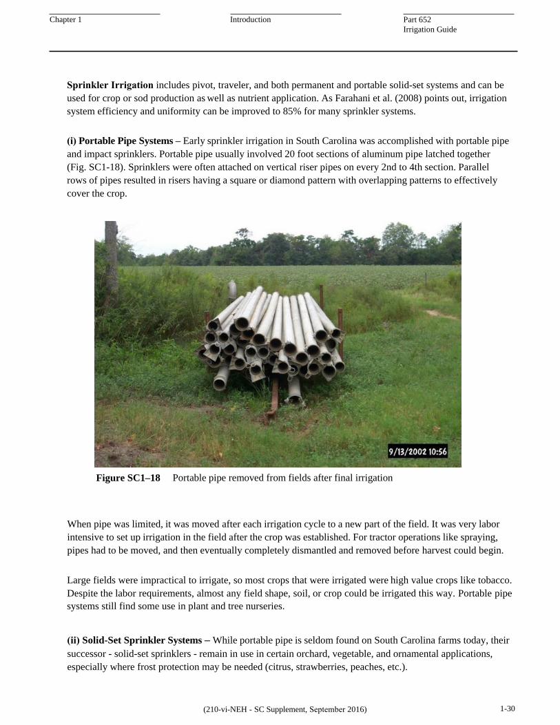
(i) Portable Pipe Systems – Early sprinkler irrigation in South Carolina was accomplished with portable pipe and impact sprinklers. Portable pipe usually involved 20 foot sections of aluminum pipe latched together (Fig. SC1-18). Sprinklers were often attached on vertical riser pipes on every 2nd to 4th section. Parallel rows of pipes resulted in risers having a square or diamond pattern with overlapping patterns to effectively cover the crop.
Figure SC1–18 Portable pipe removed from fields after final irrigation
When pipe was limited, it was moved after each irrigation cycle to a new part of the field. It was very labor intensive to set up irrigation in the field after the crop was established. For tractor operations like spraying, pipes had to be moved, and then eventually completely dismantled and removed before harvest could begin.
Large fields were impractical to irrigate, so most crops that were irrigated were high value crops like tobacco. Despite the labor requirements, almost any field shape, soil, or crop could be irrigated this way. Portable pipe systems still find some use in plant and tree nurseries.
1-30 (210-vi-NEH - SC Supplement, September 2016)
(ii) Solid-Set Sprinkler Systems – While portable pipe is seldom found on South Carolina farms today, their successor - solid-set sprinklers - remain in use in certain orchard, vegetable, and ornamental applications, especially where frost protection may be needed (citrus, strawberries, peaches, etc.).
yasmin.bennett
Rectangle
Chapter 1 Introduction Part 652 Irrigation Guide
In modern solid-set systems (Fig. SC1-19 and SC1-20), water is distributed by a buried plastic pipe system from a single or multiple pump stations to different zones within a field or orchard. Like their counterparts in home lawns, the system lends itself well to automation. Timers or other automation will assure that irrigation is regularly applied. Any size or shape field can be irrigated with these systems. These systems are expensive; materials cost $1500/ acre and installation is labor intensive.
Figure SC1–19 Peach orchard equipped with solid-set sprinkler on tall risers for frost protection
Figure SC1–20 Solid-set sprinklers on a turf farm
1-31 (210-vi-NEH - SC Supplement, September 2016)
yasmin.bennett
Rectangle
yasmin.bennett
Rectangle
Chapter 1 Introduction Part 652 Irrigation Guide
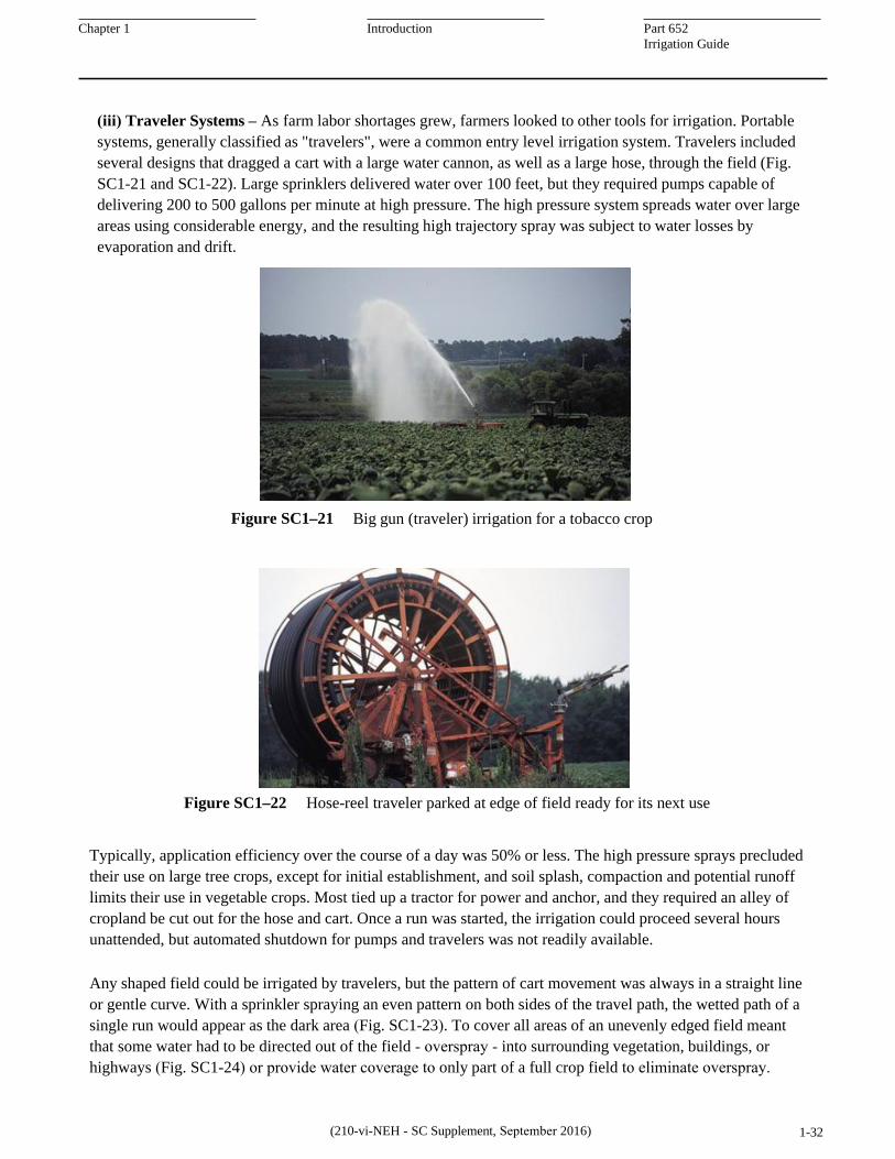
(iii) Traveler Systems – As farm labor shortages grew, farmers looked to other tools for irrigation. Portable systems, generally classified as "travelers", were a common entry level irrigation system. Travelers included several designs that dragged a cart with a large water cannon, as well as a large hose, through the field (Fig. SC1-21 and SC1-22). Large sprinklers delivered water over 100 feet, but they required pumps capable of delivering 200 to 500 gallons per minute at high pressure. The high pressure system spreads water over large areas using considerable energy, and the resulting high trajectory spray was subject to water losses by evaporation and drift.
Figure SC1–21 Big gun (traveler) irrigation for a tobacco crop
Figure SC1–22 Hose-reel traveler parked at edge of field ready for its next use
Typically, application efficiency over the course of a day was 50% or less. The high pressure sprays precluded their use on large tree crops, except for initial establishment, and soil splash, compaction and potential runoff limits their use in vegetable crops. Most tied up a tractor for power and anchor, and they required an alley of cropland be cut out for the hose and cart. Once a run was started, the irrigation could proceed several hours unattended, but automated shutdown for pumps and travelers was not readily available.
Any shaped field could be irrigated by travelers, but the pattern of cart movement was always in a straight line or gentle curve. With a sprinkler spraying an even pattern on both sides of the travel path, the wetted path of a single run would appear as the dark area (Fig. SC1-23). To cover all areas of an unevenly edged field meant that some water had to be directed out of the field - overspray - into surrounding vegetation, buildings, or highways (Fig. SC1-24) or provide water coverage to only part of a full crop field to eliminate overspray.
(210-vi-NEH - SC Supplement, September 2016) 1-32
yasmin.bennett
Rectangle
yasmin.bennett
Rectangle
Chapter 1 Introduction Part 652 Irrigation Guide
Figure SC1–24 Traveler system operating in an odd shaped field Spray pattern and typical Figure SC1–23
movement of traveler
Farmers who used travelers regularly and repeatedly during the growing season set up rows of risers connected by underground pipe to the pump. They preferred rectangular fields where a riser could be used for irrigation runs in two directions perpendicular to the row of risers.
Travelers are sometimes used for drought rescue irrigation, including pastures. With drought rescue, a farmer doesn't plan a full season control of the crop's water needs. Instead, irrigation will be set up to save a crop that is severely threatened by long rainless periods. With their portability, they can be dragged into fields that have a nearby water source like a pond. Portable pumps, often on wheeled trailers, and portable pipe can be brought in quickly to supply the traveler. This temporary setup requires considerable labor for each travel run.
In general, fields described and labeled as irrigated by travelers are not irrigated every year. In a five year field monitoring study, fields described as traveler irrigated typically received water only 50 to 75% of the time even in drought years. In a wetter than normal year, as many as 85% of monitored traveler sites were not irrigated at all. Traveler systems reached their peak use in 1982 when 4,900 systems were in use in Georgia. By 2008, their use had dropped to 2,100 as farmers found more permanent and reliable solutions for field crop irrigation (Source: Dr. James E. Hook, University of Georgia).
(iv) Center Pivot Systems – The real growth in irrigated land in South Carolina began in the early 1990's as center pivots began to move here. It was 10 to 20 years later that a similar boom occurred in Georgia. Early growth in Georgia occurred as poorer pine forests on sandy soils were cleared. It appears that most pivot construction in South Carolina took place on existing cropland, although those fields may have been expanded to allow the pivot to operate effectively. Additional information on center pivot and the related linear move systems are discussed thoroughly in Chapter 11 "Sprinkler Irrigation." in both NEH Part 623 and Section 15.
(210-vi-NEH - SC Supplement, September 2016) 1-33
yasmin.bennett
Oval
yasmin.bennett
Oval
yasmin.bennett
Oval
yasmin.bennett
Rectangle
yasmin.bennett
Rectangle
Chapter 1 Introduction Part 652 Irrigation Guide
Center pivots (Fig. SC1-25) are well engineered structures that effectively deliver water to large fields. A main water delivery pipe is suspended over the field out of the way of the crops. Sprinklers or spray nozzles can be spaced along that pipe to apply water wherever the pipe is traveling. Each tower pipe section is connected with a flexible joint. The joint allows the pipe to move through a limited range without twisting or breaking. This flexibility also allows vertical bending giving pivots the ability to climb moderate hillslopes.
Figure SC1–26 End gun on low pressure “drop nozzle" center pivot
Figure SC1–25 A pipe span is supported by a truss rod structure with low pressure drop nozzles
End guns are a common feature on most pivots in South Carolina. The guns themselves are large impact sprinklers. They may throw water as far as 130 feet beyond the pivot hardware, although the effective watering radius would only be about 100 feet of that. Adding 100 feet to the radius of the circle substantially increases the field area that can be watered by the pivot (Fig. SC1-26). For small pivot circle, say 25 acres, this would increase the area by 36%, providing another 9 acres of irrigated cropland. On a large pivot of 200 acres the increase is only 12%, but 24 acres of irrigated land are added using a single end gun.
Each pivot is designed specifically for the field in which it is constructed (Figs. SC1-27 and SC1-28). This is a process of matching design criteria to available natural resources. Farmers usually try to build out the pivot hardware as far as possible in a field. Fences, property lines, highways and barns, wooded areas, power poles, wetlands, and ponds are common obstructions that limit the length of the pivot system.
Figure SC1–27 Center pivots most efficiently cover squared or rounded field areas
(210-vi-NEH - SC Supplement, September 2016) 1-34
yasmin.bennett
Rectangle
yasmin.bennett
Rectangle
yasmin.bennett
Rectangle
Chapter 1 Introduction Part 652 Irrigation Guide
Center pivots owe their popularity to their convenience and durability. During the growing season, a single worker can go to the field, throw a few switches or set automated control panels to power and operate the unit and its attached pumps. A pivot is usually left in unattended mode while systems safety features keep the unit operating within design limits or shut it down if something fails. Center pivots are easily automated, tracked by remote monitors, or even controlled remotely. Changes in sprinkler packages can improve overall operating and especially water use efficiencies.
Figure SC1–28 Center pivots can be modified to irrigate other field shapes (partial circle)
Variable Rate Irrigation (VRI) is a management tool for Center or Lateral move pivots, which allows for precise sector or zone application of water based on numerous field variables, including EM/EC values, soil type, slope, drainage, crop, rain events, and drought through software programs or “prescriptions” developed for your specific scenario (Fig. SC1-29). The process involves the following steps (Courtesy of Reinke):
1. Field survey: First, an "on-ground" electrical conductivity (EM/EC) and RTK GPS elevation survey isconducted to determine topography and soil variables. These surveys are available through local independentsoil sampling services.
2. Irrigation prescription: The raw data is then compiled along with additional crop and field data and processedby data management specialists to create field specific irrigation prescriptions. The new prescription map isloaded from a USB drive into an appropriate Control Panel. The base water depth is set and you're ready to go.
Figure SC1–29 Example of sector and zone prescriptions maps (Courtesy of Reinke)
Microirrigation: These efficient water application systems were adapted in parallel with center pivots in South Carolina. Their special applications in vegetables, orchards, vineyards, and other crops important to the State led to adopting these precision irrigation systems as they expanded these high value operations.
(210-vi-NEH - SC Supplement, September 2016) 1-35
Zone VRI Sector VRI
yasmin.bennett
Rectangle
Part 652 Irrigation Guide
Chapter 1 Introduction
While center pivots now apply most of the irrigation to farm lands in South Carolina, drip and other microirrigation systems have many advantages in vegetable, fruit, and other specialty crops. Their use in small fields is increasing as more specialty crops are produced. Features common to these systems are partial root zone wetting and minimal evaporative loss during irrigation. Another consideration is the use of plasticulture (plastic mulch) for crop production (Fig. SC1-30).
Figure SC1–30 Exposed drip tape under plastic mulch on bed of staked tomatoes
(i) Surface (drip tape, emitters, microsprinklers) – Microirrigation is the broad classification of frequent, low volume, low pressure application of water on or beneath the soil surface by subsurface or surface drip tape, drip emitters, spaghetti tube, basin bubblers, and spray or mini-sprinkler systems. In the past it was also referred to as drip or trickle irrigation. Water is applied as discrete or continuous drops, tiny streams, or miniature spray through drip emitters or spray heads (Fig. SC1-31) placed along a water delivery line called a lateral or feeder line. Typically, water is dispensed through a pipe distribution network to zones where pressure is reduced to 8 to 30 psi (lb/in2) in a predetermined pattern.
(ii) Subsurface (SDI) Systems – Subsurface drip irrigation is one form of microirrigation that can be used in row crops. With SDI, a drip tape with in-line emitters is buried to depths of 8 to 16 inches. It has only recently come into use in the state (Fig. SC1-32). Difficulties with establishing a crop because the water may not reach up into the seed germination zone in many applications (Figure SC6-30, pg 6-30), and challenges with tillage operations (avoiding damage to long term buried tape) are reducing the adoption of a potentially efficient irrigation system for row crops.
(210-vi-NEH - SC Supplement, September 2016) 1-36
yasmin.bennett
Rectangle
yasmin.bennett
Rectangle
yasmin.bennett
Rectangle
yasmin.bennett
Rectangle
Chapter 1 Introduction Part 652 Irrigation Guide
Figure SC1–32 Buried white submain pipe with black flexible tubing connecting to buried heavy "mil" drip tape
Surface and subsurface microirrigation systems often require complex distribution and control systems. Although the slow drip of emitters and weak streams from microsprinklers give the appearance that little water is being applied, a quick calculation shows the combined application of emitters to a field or orchard is quite large.
For example to apply as much as 0.25 inch of water a day during peak use times would require 5.7 gallons per minute for each acre, with the pump operating 22 hours/day and a system efficiency of 90%. For a 50 acre orchard, this would mean a pumping rate of 286 gpm. Use the following equation to determine a "planning" gross system flow rate (Q).
453 x daily peak ETc (in/day) x acres Q (gpm) = Daily Operation (hrs/day) x Irrig. Efficiency (decimal)
Water pressure would have to be carefully managed as pressure is stepped down from pump operating pressures to the distribution pipes and finally to the Manufacturer’s recommended micro device requirements. Because water pressure decreases as it travels along the drip tape/distribution tubes, the length of these sections must be considered. The result of these hydraulic considerations is that each drip system must be carefully engineered and installed to operate effectively. Depending on the available yield from the water source, a field may need to be divided into smaller areas - zones/blocks - and irrigated separately. This allows for downtime of pumps and infiltration and drying cycles for soils. Electronic controls allow switching between zones and they control the length of time each zone is irrigated.
(3) Current Irrigation Practices Recent mapping using 2011 orthoimagery from the National Agricultural Imagery Program’s county mosaics provided an updated view of what irrigation practices were prominent and where they were located in South Carolina. Fields with visible irrigation features or typically irrigated crops were drawn for 24 of the State’s 46 counties.
(210-vi-NEH - SC Supplement, September 2016) 1-37
yasmin.bennett
Rectangle
yasmin.bennett
Rectangle
Chapter 1 Introduction Part 652 Irrigation Guide
These were the counties with the greatest irrigated area in the most recent South Carolina Irrigation Survey from 2000.To see the report, search the internet for South Carolina Irrigation Survey 2000.
Of the more than 1600 center pivots that were mapped, irrigated area averaged 66 acres and ranged from part- circle systems that covered only 3 acres to large pivots covering almost 400 acres. About 36% of the center pivots could only operate in a part circle pattern that ranged from 20% to 95% of a full circle. Some pivots operate in a back and forth irrigation pattern that somewhat lowers their flexibility and increases per acre costs of ownership and operation. Farmers have found that the advantages of using center pivots in corners and rectangular fields, or places where buildings, power lines, and other obstructions exist simplicity outweigh any additional inconvenience or unit cost.
Relatively few towable pivots remain in South Carolina. Only about 3.5% of center pivot irrigated fields relied upon these units. Towable pivots represent an entry level into pivot ownership, and they work in selected rotations, but most farmers find that once they have irrigation, they would prefer that it be available for every field as needed. The extra labor needed to move these systems has led most farmers to buy a second pivot as soon as they can afford it.
A few large Linear Move systems have found their way into South Carolina. These require either a towable hose for water supply or a water filled ditch parallel to the direction of linear movement. In a few Carolina Bay sites, level fields, existing drains, and experience with surface irrigation have enabled farmers to install large field systems that cover as much as 800 acres each. The limited number of suitable sites will prevent Linear Move systems from expanding in South Carolina.
(f) Regulatory Environment for Irrigation
(1) General Irrigation in South Carolina proceeded, as in other areas of the Southeast, through private investments of individual farm businesses and operators. Water could be withdrawn directly from the plentiful streams and rivers cutting through or bordering those farms. Farmers dug out ponds and trenches in areas with high water table or constructed impoundments to retain runoff and seepage for ponds that could be used for irrigation as well as for livestock and other uses.
Many areas of the state are underlain by high yielding aquifers that can sustain pumping for irrigation. Landowners tapped these water sources with wells located on their property, often in the immediate vicinity of the fields needing irrigation. With water directly available to most farms, there was no need for major reservoirs, canals, or pipelines to support irrigation. Likewise there was no need for water management districts or agencies to manage and regulate water distribution for agriculture irrigation.
Surface withdrawals impact water destined for reservoirs that were developed to provide hydropower, recreation, and other uses. Water withdrawals for agriculture were unregulated through the 1980’s and 1990’s while irrigated land area began to grow in South Carolina. Irrigation water supply did not require state or federal investments and the accompanying government oversight. Infrastructure was developed and withdrawals controlled by many individuals in an economic sector that traditionally shunned regulation.
(210-vi-NEH - SC Supplement, September 2016) 1-38
Chapter 1 Introduction Part 652 Irrigation Guide
Agricultural irrigation created a diffuse system of water withdrawals whose impact was difficult to ascertain. With no restrictions in place, farmers invested in equipment and operated them strictly based upon their business needs.
The first regulations on agricultural withdrawals did not come because of irrigation, but irrigation became part of state and regional efforts to protect shared water supplies. Water users along the lower coastal areas of Charleston and Hilton Head found evidence of increasing salinization in wells that supplied drinking water, irrigation for homes and golf courses, and water for commercial and industrial needs. Salinization occurs in coastal areas primarily when hydraulic head in those aquifers drops below mean sea levels. While the impact is felt most immediately in areas adjacent to the ocean, withdrawals throughout the aquifer contribute to those declining heads.
In 2001, the South Carolina legislature passed laws requiring the state’s Department of Health and Envi- ronmental Control (DHEC) to regulate withdrawals in a way that would provide long term protection of these aquifers. Competition for water withdrawals to support the State’s growing industrial base, expansion of residential areas and improved agricultural production have led to limited expansions of controls and reporting in other areas of the state.
Also in 2001, South Carolina, in the midst of a five year drought that taxed all water resources in the state, implemented a drought mitigation act. The act was to include significant user input in deciding what, where and how water restrictions would be put in place. In 2010, surface waters of the state came under similar scrutiny and control. The State and its cities became concerned with their ability to supply water for drinking and commercial interests during periods of extended drought experienced during the 1990’s and 2000’s.
Streamflows may drop below levels needed to meet waste assimilation requirements for discharges that the state has already permitted. Withdrawals for irrigation, in particular, lower summer flows when needs for waste assimilation and aquatic habitats protection are most critical.
South Carolina’s legislature creates laws in accordance with federal laws and regulation regarding land and water and provides state specific laws in accordance with the needs and wishes of its citizens. Those laws affecting soil and water use, management, and protection are encoded and made public through the States website: (http://www.scstatehouse.gov) and search for “Title 49” in the Code of Laws section. Most of the laws regarding water can be found under Title 49 of S.C. Code of Laws.
South Carolina’s Department of Health and Environmental Control (SCDHEC) and its oversight boards are responsibile for creating and implementing regulations in accordance to South Carolina code affecting water users, including agriculture. Information on their official website will contain the most current regulations regarding surface and groundwater withdrawals and should be consulted for up-to-date regulations, forms, and procedures: (http://www.scdhec.gov/).
As noted below, there are two exceptions to the SCDHEC agency authority. Rules regarding drought are, for the most part, handled by the Department of Natural Resources (http://www.dnr.sc.gov/) and search for "drought".
Regulations regarding chemigation and fertilizer use in irrigation are managed by The Division of Regulatory and Public Service Programs at Clemson University under authority given in the Pesticide Control Act (http://www.clemson.edu) and search for “pesticide control act”.
2) Surface Water WithdrawalsSCDHEC regulations regarding surface water use are based upon S.C. Code of Laws, Title 49, Chapter 4, currently entitled “Surface Water Withdrawal, Permitting Use, and Reporting Act.” The code is implemented through regulations R.61-119, “Surface Water Withdrawal, Permitting and Reporting,” effective June 22, 2012. Accordingly, “it establishes a system of rules for permitting and registering the withdrawal and use of surface water from the state of South Carolina and those surface waters shared with adjacent states.”
The Regulations – For withdrawal quantities exceeding 3,000,000 gallons during any one month, SCDHEC specifies permitting, registration, use, and reporting requirements. Agricultural irrigators are included in these requirements, but there are specific exemptions that affects them.
First, persons withdrawing water for agricultural purposes are required to register that use, as opposed to obtaining a permitting.
Second, withdrawals from farm ponds (defined as ponds completely situated on private property) that are used for providing water for agriculture purposes, including irrigation, are exempt from the requirements of R.61-119.
More generally, the act makes an exemption for a person withdrawing surface water from any pond completely situated on private property and which is supplied only by diffuse surface water (i.e. non- concentrated surface runoff), or supplied by springs completely situated on the private property, or supplied by groundwater. The groundwater use, however, would still be subject to provisions of the R.61-113, “Groundwater Use and Reporting,” effective June 23, 2006.
Despite the exemption for withdrawals from farm ponds, irrigators are encouraged to obtain a permit or to register for this use. For the farmer with varied sources of water, some of which do require permitting or registration and reporting, obtaining a permit for all wells may be preferred. It would allow a systematic management of permitting and pumping records. Perhaps, more importantly, courts historically protect the rights of established users who can document reasonable and beneficial use of the resource. Should laws change or interstate compacts dictate future use restrictions, a water user with a permitted or registered and documented use pattern may stand on stronger ground than a user without records. Irrigators may want to consult legal counsel before choosing the exemption rather than permitting or registering farm pond withdrawals.
Irrigators with non-exempted surface water withdrawals that existed prior to January 1, 2011 were required to register that use or obtain a permit prior to December 20, 2012 (180 days after the effective date of R.61-119). Irrigators needing to increase non-exempt withdrawals and irrigators who plan to create new withdrawals after 2010 must register that intention or apply for permits and follow other provisions of the Surface Water Withdrawal Permitting and Reporting Act (R.61-119).
Registration procedures – Registration of agricultural surface water withdrawals provides SCDHEC with the opportunity to determine if the proposed (or expanded) withdrawal quantity is within the safe yield for that water source at the time of the request. SCDHEC will notify the applicant by registered mail whether the registered surface water withdrawal is within safe yield or whether some adjustments are needed. The applicant is not authorized to install and use the new source without the determination of safe yield.
Application forms and required information are identified and available on the official web pages of SCDHEC (http://www.scdhec.gov) and search for “water withdrawal". Required information includes specific quantities of surface water requested for withdrawal, in million gallons per month, at each relevant withdrawal point. This would be based upon the design capacity of the existing or pending intake structure (pump capacity, presumably). The type of intake, permanent or mobile, is also needed.
While registration for each withdrawal point could create challenges for agriculture irrigation users, for some long term irrigation installations – fixed center pivots, SDI (buried drip tubing), solid-set irrigation – the water supply is often fixed. A well may be located at the pivot point, a pump delivers water from a fixed location on a pond, etc. Registering and reporting use for these installations is a simple matter. These systems are typically put to use each year.
Commonly throughout South Carolina, irrigators rotate their crops and with them they move their irrigation. As an example, vegetables under microirrigation may be planted for a few years in one location and from one water source. At some point, the field’s productivity declines or market demand for the crop changes. The farmer will remove "in field" components including plastic mulch, drip tape or tubing, and even parts of the water distribution system. The field will be idled or rotated into forage or row crop to rest the soil, extract accumulated fertilizer, and suppress pests and weeds. New or rested fields are then used for the vegetables, and a new water withdrawal point is possibly put into use.
Similarly, tobacco and other row crop farmers may use traveler irrigation systems in droughty fields. The application systems themselves and commonly the pumps and pipe that supply them are portable. They are moved from one field, even within a growing season. The withdrawal location may or may not change, depending on distance for the new field. Because of the additional labor these fields are not put into production every year.
Questions regarding the transferability of registered or permitted withdrawal points, idling and annual reporting for idled locations, and registration for temporary locations will need to be addressed by SCDHEC personnel.
Annual Reporting – Water withdrawals must be measured by one of the methods stipulated in the regulation. The user is responsible for installing and managing the water meter or other measuring device. Surface water withdrawals must be reported annually before February 1st on forms furnished by SCDHEC.
Previous Regulations and Reporting – Prior to 2011, reporting of agricultural water withdrawals was under the authority of the SC Department of Natural Resources (DNR) and implemented by their Regulations Chapter 121, Section 10. In this regulation, in place between 2001 and 2010, farmers reported to County Agents of the Clemson University Cooperative Extension Service, who in turn reported to DNR. With the passage of Act 247 in the 2010 legislative session, reporting functions were moved to SCDHEC. Act 247 substantially amended S.C. Code of Laws, Title 49, Chapter 4. The current (September 2012) on-line Regulations of DNR Chapter 121-10 do not yet reflect this change.
(3) Groundwater Withdrawals SCDHEC regulations regarding groundwater use are based upon S.C. Code of Laws, Title 49, Chapter 5 currently entitled “Groundwater Use and Reporting Act." The code is implemented through regulations R.61- 113, “Groundwater Use and Reporting,” effective June 23, 2006. Accordingly, “The Department finds the standards and procedures prescribed are necessary to maintain, conserve, and protect the groundwater resources of the state.”
The Regulations – Unlike the surface water withdrawals, the requirement for groundwater withdrawal permitting vary by location within the state. Based upon study of drawdown, saltwater intrusion, competition for water, and other aquifer and use information, SCDHEC has designated most of the lower Coastal Plain as a “Capacity Use Area.” Permits are required for all groundwater withdrawals exceeding 3 million gallons per month in any month.
While permits for surface water withdrawal (for those that are required) are issued for 30 years before re- newal, permits for groundwater withdrawal in Capacity Use Areas are issued for a 5 year period before requiring renewal. Outside of the Capacity Use Area, groundwater users will follow either Registration or Notice of Intent (NOI) procedures (Fig. SC1-33). All groundwater withdrawal user must register and report annual usage to South Carolina DHEC.
Well Drilling – Separate legislation and regulation, R.61-44, governs the permit required, notice of intent, and fees for drilling a new or replacement well or for abandoning an unused well. Drilling, which must be done by a South Carolina licensed well driller, is covered under provisions of R.61-71 “Well Standards.” These standards stipulate slurry materials used in drilling and sealing of well casings, define materials and procedures used for screens and well casing, and describe final surface preparation and wellhead protection. Also, creation and reporting of well logs during drilling are stipulated.
Normally NRCS personnel will not be involved with the design and installation of wells or participate in the record keeping and reporting of well logs. However, the desired pumping rate and working pressure for the irrigation system under design may be specified by the agency.
1-42 (210-vi-NEH - SC Supplement, September 2016)
Chapter 1 Introduction Part 652 Irrigation Guide
Figure SC1-33 Capacity Use, Notice of Intent (NOI), and Registration Counties within South Carolina delineate groundwater use areas with specific regulations regarding drilling, withdrawal permitting, and reporting. (Source: (Wachob et al. 2009)
Permit/Registration procedures – Required information includes specific quantities of groundwater requested for withdrawal, in million gallons per month, from each well. This would be based upon the design of the irrigation system.
Annual Reporting – Whether in a Capacity Use Area or not, groundwater withdrawal quantities must be reported to SCDHEC annually by January 30.
(4) Drought Regulations SCDHEC regulations regarding drought mitigation and water use restrictions are based upon S.C. Code of Laws, Title 49, Chapter 23 currently entitled “South Carolina Drought Response Act." Unlike the permitting and reporting of water withdrawals, drought mitigation and response planning is assigned to the South Carolina Department of Natural Resources (DNR). The code is implemented through DNR Chapter 121 section 11, “Drought Planning Response,” effective February 23, 2001.
1-43 (210-vi-NEH - SC Supplement, September 2016)
Fall Line
Fall LineEXPLANATION
Piedmont - Registration
Notice of Intent (NOI)
Pee Dee Capacity Use
Waccamaw Capacity Use
Trident Capacity Use
Low Country Capacity Use
yasmin.bennett
Rectangle
yasmin.bennett
Polygonal Line
yasmin.bennett
Rectangle
Chapter 1 Introduction Part 652 Irrigation Guide
Under the authorizing legislation, “The department shall formulate, coordinate, and execute a drought mitigation plan. The plan must be developed consistent with the South Carolina Water Resources Planning and Coordination Act, as provided in Chapter 3 of Title 49.”
In effect, DNR is required to monitor water flows and levels in lakes and groundwater to determine if drought conditions are developing in areas of the state. The act specifically asks DNR not to be overly broad in defining the areas of incipient drought conditions. Through State and appropriate Local Drought Response Committees, the department must work to develop a plan of action that identifies what levels of drought will require action. The committees, made up of all sectors of water users, must work with DNR to identify which non-essential water withdrawals may be curtailed for the different action levels.
DNR then has responsibility of providing information to users and informing them if and how their use may be curtailed. In the event of severe or widespread droughts, the Governor would be notified and he/she may initiate emergency actions to protect life, health, and property. For agricultural irrigators, it should be noted that Title 49, Chapter 23 was substantially altered in the 2005 legislative session by Act 99. The current (September, 2012) on-line Regulations of DNR Chapter 121-11 do not yet reflect this change.
In effect, Act 99 (2005) added “agricultural irrigation used for food production” to the list of “essential” water uses, and hence exempting that use from potential disruption by drought mitigation actions of DNR or any of its local drought response committees. Also under Act 99 (2005), before water use for agricultural irrigation of non-food products can be curtailed, farmers must be given the opportunity to request exemption on the basis of “critical economic loss” that might occur under mandatory curtailment of water use. Presumably, non-food crops include cotton, tobacco, sod farms, and ornamental plant nurseries. These crops constitute a substantial portion of the agriculture irrigation and economy in South Carolina.
(5) Irrigating with Animal Waste Irrigation using wastewater, slurries, or solids from agricultural animal operations is covered by provisions of SCDHEC R.61-43, “Standards for the Permitting of Agricultural Animal Facilities, dated June 28, 2002.” Similar but separate regulations cover swine, Part 100, and all other animal wastes, Part 200.
The Regulations – Rules for both swine (Part 100) and other animals (Part 200) allow spray application of liquid animal manure using irrigation equipment. This includes all methods of surface spray application, including but not limited to, fixed gun application, traveling or mobile gun application, or center pivot application. Section 110 of Parts 100 and 200 stipulate that on manure utilization area, slopes cannot exceed 10 percent unless approved by SCDHEC. Animal manure irrigation systems must be designed so that the distribution pattern optimizes uniform application and all current setback limits are maintained.
Hydraulic application rates will normally be based on the agronomic rate for the crop to be grown in the manure utilization area. However, the maximum rate may be reduced below the agronomic rate to ensure no surface ponding, runoff, or excessive nutrient migration to the groundwater occurs. Further, the hydraulic application rate may be limited based on nutrient or other constituent loading including any constituent required for monitoring under this regulation.
Because runoff and redistribution of applied wastes can be affected by water already in the soil profile, the waste cannot be applied when the vertical separation between the ground surface and the seasonal high
(210-vi-NEH - SC Supplement, September 2016) 1-44
Chapter 1 Introduction Part 652 Irrigation Guide
water table is less than 1.5 feet at the time of application (unless approved by the SCDHEC on a case-by-case basis, usually for something deemed an emergency). Conservation measures, such as terracing, strip cropping, etc., may be required in specific areas determined by the Department as necessary to prevent potential surface runoff from entering or leaving the manure utilization areas.
Also, a system for monitoring the quality of groundwater may also be required for the proposed manure utilization areas. The location of all monitoring wells would be approved by SCDHEC. The number of wells, constituents to be monitored, and the frequency of monitoring would be determined on a case-by-case basis based upon the site conditions such as type of soils, depth of water table, etc. Spray application systems should be designed and operated in such a manner to prevent drift of liquid manure onto adjacent property.
(6) Irrigating with Municipal Waste Irrigation with treated wastewater is covered by SCDHEC Regulations R.61-9 “Water Pollution Control Permits.” Specifically, R.61-9.505.42 sets the conditions applicable to special categories of Land Application Permits – irrigation with treated wastewater using solid-set, big gun, traveler, and center pivot systems.
The Regulations – Land Application Permits stipulate maximum rates of application, since most of these systems are more concerned with safely applying as much of the treated wastewater as possible rather than supplying minimum water needs of a forage or crop. The permits have stringent monitoring and reporting procedures for groundwater and surface water quality in and around the irrigation area, as well as setbacks distances from drinking water wells and water supply inlets. Setbacks also limit potential for spray drift onto nearby properties.
Generally speaking, NRCS Cooperators would not be involved with these treated wastewater land application systems for farm commodities, except for their production of greenchop and hay that may be included in animal feed.
However any such irrigation or use of commodities and produce from treated wastewater irrigation would be subject to conditions of the SCDHEC Pollution Control Permit. SCDHEC also has Pollution Control Permitting provisions (R.61-9.505) for similar irrigation using municipal sewage sludge.
Animal wastes generated at existing large CAFOs also fall into the provisions of SCDHEC regulations R.61-9 requiring Pollution Control permits. Irrigation involving treated wastewater (lagoon effluent) or slurries and solids from these large operations will be handled much the same as treated wastewater and sewage sludge. These provisions kick in when animal production equals 1,000,000 pounds or more normal production live weight for swine. Per provisions of R.61-43.100.110, regarding the Permitting of Agricultural Animal Facilities, new large swine facilities with 1,000,000 pounds or more normal production live weight are prohibited from utilizing spray application systems for manure application. Manure must be incorporated into the manure utilization fields utilizing subsurface injection at a depth of not less than six inches.
(7) Applying Chemicals using Irrigation Regulations regarding irrigation to apply fertilizers and chemicals are encoded under South Carolina Department of Agriculture Title 46, Section 46-1-140.
(210-vi-NEH - SC Supplement, September 2016) 1-45
Chapter 1 Introduction Part 652 Irrigation Guide
They include the requirement that irrigation systems designed or used for application of fertilizer, pesticide, or chemicals be equipped with an anti-siphon device. Clemson University’s Division of Regulatory and Public Service Program enacts the law using regulations R.27-1090 that defines the Chemigation Act and its general provisions; R.27-1091 that provides provisions for the Act’s enforcement; and R.27-1092 that gives the actual (plumbing) specifications for backflow prevention in agricultural irrigation systems.
The Regulations – Any irrigation system which is designed or used for the applications of fertilizer, pesticide, or chemicals must be equipped with an anti-siphon device adequate to protect against contamination of the water supply. The minimum acceptable anti-siphon device shall include a check valve, vacuum breaker, and low pressure drain on the irrigation supply line between the irrigation pump and the point of injection of fertilizer, pesticide, or chemicals. The vacuum breaker must be upstream from the check valve. The low pressure drain must be upstream from the vacuum breaker. The injection pump must be tied to the irrigation pump either mechanically or electrically so that the injection pump shall stop operating if the irrigation pump fails to function.
Any person who uses an irrigation system for the application of fertilizer, pesticide, or chemicals which is not equipped with an anti-siphon device as outlined in this section is subject to penalties described in the regulations. The Division of Regulatory and Public Service Programs at Clemson University shall formally announce regulations with the advice of the SCDHEC as it considers necessary to implement this section and is also charged with enforcing this section.
According to the regulations, all new and prior use chemigation activities were to be brought to code by June 1988. The regulations stipulate that individual applications of fertilizers and agrichemicals injected into the irrigation system must be recorded, and those records must be available for inspection for a period of 2 years. Farmers must immediately self report any spills or suspected backflow events to the Division at Clemson University.
The Division at Clemson University was chosen because they implement the South Carolina’s Pesticide Control Act. This includes training programs regarding pesticides, licensing and renewal of applicators, and record keeping. It should be noted that any agrichemical application using irrigation must be made in accordance with the pesticide label.
For those pesticides which are specifically permitted for irrigation application care should be taken to follow special formulation, mixing, and potential water quality concerns that may cause undesirable reactions with the chemical. Some pesticides, such as fungicides or insecticides that must adhere to the leaves will require oil or similar based formulations to get the material to “stick” to the leaves as the large volume of irrigation water is being applied. Other chemicals that become active in the soil should be in soluble or emulsified formulations that wash off and enter the soil with the water. Complete flushing of the irrigation application equipment is required at the end of any chemical injection application cycle.