N ational C ooperative S oil S urvey Newsletter February 2018 Issue 82 In This Issue— Upcoming Joint Northeast/South Regional NCSS Conference.......................................... 1 Soil Explorer – Soil Landscapes at Your Fingertips ....................................................... 3 Wisconsin Soil Interpretation to Help the Karner Blue Butterfly .................................... 5 Statistics Course Reveals New Ways to Analyze Data .................................................. 6 Hidden Gems: The NSSC Library......................... 8 MLRA Office Assists Federal Partners and Private Landowners after Wildfires ............. 9 MLRA Moves Forward in Collaborative ESD Development ................................................ 12 Using GPR to Assess the Effects of Sea Level Rise on Onsite Wastewater Treatment Systems........................................................ 14 Planning Workshop for Coastal Zone Soil Survey .......................................................... 15 Coastal Zone Soil Survey Featured at CERF 2017 .............................................................. 17 Underwater Soils – Coastal Zone Soil Survey .......................................................... 18 Nondiscrimination Statement ............................ 20 Editor’s Note I ssues of this newsletter are available at http://soils.usda. gov/. Under the Soil Survey tab, click on Partnerships, then on NCSS Newsletters, and then on the desired issue number. You are invited to submit articles for this newsletter to Jenny Sutherland, National Soil Survey Center, Lincoln, Nebraska. Phone—(402) 437–5326; FAX—(402) 437–5336; email—jenny. [email protected]. ■ 1 Upcoming Joint Northeast/ South Regional NCSS Conference T he joint Northeast/South Regional NCSS Conference will be held June 25 to 29, 2018, in Summersville, West Virginia. (The conference website is: https://www.nrcs.usda.gov/ wps/portal/nrcs/detail/soils/survey/ partnership/ncss/?cid=nrcseprd1350810.) Committees are now soliciting for member participation from any NCSS individual in the Northeast and South regions. They are also requesting submission of proposals and agenda items. Additional information on individual committees is provided below. Those wanting to participate on a committee are encouraged to subscribe to GovDelivery so that they can receive updates on committee meeting dates and activities as well as updated information on the conference itself. To subscribe, go to: https:// public.govdelivery.com/accounts/ USDANRCS/subscriber/new?topic_ id=USDANRCS_134. Soil and Ecosystem Dynamics Committee Since this is a joint conference between the northeastern and southern regions, the committee will prioritize the topics that both have listed. Soil health and dynamic soil properties are also technically covered by this committee, but an issue at past conferences has been finding time to cover all topics with equity. The committee welcomes your suggestions on agenda items. Given the time constraints at the conference, the committee plans to limit the number of agenda items to five or six. Agenda items from the National NCSS Conference in 2017 included:
Transcript
National
Cooperative
Soil
Survey Newsletter
February 2018Issue 82
In This Issue—Upcoming Joint Northeast/South Regional
are available at http://soils.usda.gov/. Under the Soil Survey tab, click on Partnerships, then on NCSS Newsletters, and then on the desired issue number.
You are invited to submit articles for this newsletter to Jenny Sutherland, National Soil Survey Center, Lincoln, Nebraska. Phone—(402) 437–5326; FAX—(402) 437–5336; email—[email protected]. ■
T he joint Northeast/South Regional NCSS Conference will be held
June 25 to 29, 2018, in Summersville, West Virginia. (The conference website is: https://www.nrcs.usda.gov/wps/portal/nrcs/detail/soils/survey/partnership/ncss/?cid=nrcseprd1350810.) Committees are now soliciting for member participation from any NCSS individual in the Northeast and South regions. They are also requesting submission of proposals and agenda items. Additional information on individual committees is provided below.
Those wanting to participate on a committee are encouraged to subscribe to GovDelivery so that they can receive updates on committee meeting dates and activities as well as updated information on the conference itself. To subscribe, go to: https://public.govdelivery.com/accounts/USDANRCS/subscriber/new?topic_id=USDANRCS_134.
Soil and Ecosystem Dynamics Committee
Since this is a joint conference between the northeastern and southern regions, the committee will prioritize the topics that both have listed. Soil health and dynamic soil properties are also technically covered by this committee, but an issue at past conferences has been finding time to cover all topics with equity. The committee welcomes your suggestions on agenda items. Given the time constraints at the conference, the committee plans to limit the number of agenda items to five or six.
Agenda items from the National NCSS Conference in 2017 included:
Agenda items from the 2017 NCSS National Meeting in Boise, Idaho, included:1. The wet soil order Aquasols2. Calcareous fens – organic soils with carbonates, “kalkic”3. Epi vs. endo and the densic contact4. Proposed densic great groups for Udepts and Aquepts5. Buried soil concepts6. Effects of disturbance on carbon pools in wetlands, North East
The committee will meet by teleconference several times prior to the conference to report the status of recent meeting charges and discuss current regional needs. Issues of high priority include: 1) updating national forestry interpretations, 2) crop yield data population, 3) forage suitability groups, and 4) urban interpretation needs.
The committee will meet by teleconference several times prior to the conference to report the status of recent meeting charges and discuss current regional needs. The committee will review and make recommendations on current proposals as well as newly solicited proposals and develop an agenda for items to present at the conference.
The committee will meet by teleconference several times prior to the conference to report the status of recent meeting charges and discuss current regional needs. The committee will review and make recommendations on current proposals as well as newly solicited proposals and develop an agenda for items to present at the conference.
Current and past agenda items include:1. Subaqueous soil survey projects2. New subaqueous proposals for Soil Taxonomy3. Proposed new landforms4. NASIS subaqueous data population guide5. Subaqueous and CZSS interpretations (thin layering, blue carbon, acid sulfate/
sulfides, storm-surge/catastrophic loss potential, coastal erosion, etc.)5. Blue carbon research7. Subaqueous soil sampling/laboratory analysis standards8. Action items for CZSS Work Planning Conference9. Flooding and Ponding NASIS population proposal (continuous and permanent)10. SSSA 2019 Subaqueous CZSS Conference (San Diego, CA)11. CZSS Focus Team update12. Safety standards/standard equipment13. Subaqueous ESD development14. Vote on committee name change
The committee is soliciting for members who are adept with field application of “Soil Taxonomy” and other soil survey technical standards. The committee will review and make recommendations on current proposals as well as newly solicited proposals and develop an agenda for items to present at the conference. Current proposals and other issues for discussion and development are available at NCSS Committee Proposals. The committee will meet by teleconference several times to discuss the proposals prior to the June regional meeting.
Soil Explorer – Soil Landscapes at Your FingertipsBy Darrell G. Schulze, Purdue University.
T he Soil Explorer website (SoilExplorer.net) and the Soil Explorer app for the iPad provide easy access to a growing number of soil property maps based on
the SSURGO dataset. Soil Explorer combines semi-transparent thematic maps of soil properties on a hillshade basemap to provide more information than either map would alone. Maps can be zoomed and panned to allow the user to see both the overview and the details on the same map, and a click or tap on a particular area results in a pop-up window that provides additional information. The hillshade basemap is derived from the best available elevation data from the U.S. Geological Survey’s 3D Elevation Program (3DEP) and other sources and is calculated to about 5-meter resolution
(about 1:18,000). It is exceptionally detailed over the approximately 25 percent of the conterminous United States for which LiDAR data is available.
Although maps for a few States have been available on Soil Explorer for some time, the Soil Orders map that went live in January 2018 is the first to cover the entire conterminous United States (fig. 1). A Natural Soil Drainage Classes map is available for the conterminous U.S. as well (fig. 2), and more maps will be added in the coming months.
Soil Explorer was developed as part of the Integrating Spatial Educational Experiences (Isee) Project. The Isee Project is funded by grants from the USDA Higher Education Challenge Grants Program and the Natural Resources Conservation Service. Its goal is to teach students how and why soils vary at different scales and why this information matters. Participants in the Isee Project use a teaching-with-maps approach in their pedology and other soil science courses. The Isee Project started in Indiana and, in its second phase, expanded to Wisconsin, Illinois, Kentucky, Ohio, West Virginia, and Texas. It is now expanding to 10 additional States: North Dakota, South Dakota, Nebraska, Kansas, Minnesota, Iowa, Missouri, Michigan, Maryland, and Arkansas. More than 55 individuals have contributed to the Isee Project in various capacities. They are listed on the Isee Network website (http://isee.network).
A particularly important map for explaining soil variability locally is the Dominant Soil Parent Material map. This map is created on a State-by-State basis by Isee Project participants, led by collaborators at land grant universities in each State. Although the Dominant Soil Parent Material maps are currently accessible in Soil Explorer on a State-by-State basis, the plan is to integrate them into one seamless map that will grow to include the entire United States and its territories.
Figure 1.—Distribution of soil orders across the Continental Divide in the Wind River Mountain Range in western Wyoming. Aridisols and Entisols at low elevations give way successively to Mollisols, Alfisols, Inceptisols, and finally rock outcrops and glaciers at the highest elevations. Pop-up text allows users to learn more about each map unit.
Soil Explorer continues to evolve. As more maps are added, they will automatically become available on both the website and app. Maps for Alaska, Hawaii, and U.S. territories will be added as well. The app, which is currently available only for the iPad, will be available for iPhone and Android platforms soon, probably by mid-April.
Soil Explorer is yet another way to access the fantastic legacy of our National Cooperative Soil Survey, one that is engaging, fast, and easy to use. It will hopefully inspire the general public, as well as students, to learn more about our soil resources. ■
Figure 2.—Circular depressions in deep loess around Utica, Nebraska, 40 miles west of Lincoln, result in an interesting, almost abstract pattern in the Natural Soil Drainage Classes map of the area.
Wisconsin Soil Interpretation to Help the Karner Blue Butterfly By Jason Nemecek, Wisconsin State Soil Scientist, Madison.
W isconsin NRCS staff are collaborating in the development of a soil interpretation to identify
habitat of the Karner blue butterfly. The Karner blue butterfly (KBB) is a federally listed endangered species present in small patches across the north-central and northeastern United States. The KBB typically inhabits open barrens, savannas, and prairies that contain wild lupine. This plant is widespread in Wisconsin’s Central and Northwest Sands. The pale green caterpillar of the KBB feeds exclusively on the leaves of wild lupine.
Wisconsin NRCS staff wanted to find an efficient and consistent way to identify likely lupine habitat so that these areas could be prioritized for protection under
NCSS Newsletter
6
NRCS easements and related programs. Because the presence of lupine is closely related to soil characteristics, staff approached Tim Miland (area resource soil scientist), Mike England (soil scientist), and Jason Nemecek about the possibility of developing a soil interpretation for KBB habitat suitability.
NRCS staff members involved included an area resource soil scientist, the state biologist, the assistant state conservationist for easements, and the state resource conservationist. Other partners in the project included the Wisconsin Department of Natural Resources, the U.S. Fish and Wildlife Service, the U.S. Forest Service, and the Farm Service Agency.
The team developed a draft Karner Blue Butterfly Habitat Suitability interpretation. The next steps, now underway, are to compare the habitat suitability ratings with field data on the presence of KBB larvae and to involve additional partners working in this area. Information gathered from the field and that provided by partners will be used to refine and revise the draft interpretation.
Jason Nemecek explains, “The biggest benefit is the ‘ah-ha’ moment when other resource management professionals realize soils can be used this way. By building the interpretation, they can see it in action and realize it can be done; they can now focus and prioritize where to spend conservation funds and back it up with the science of the interpretation.” This interpretation is an example of how soils data can and should be used to help facilitate conservation planning. ■
Draft interpretation for habitat suitability for Karner blue butterfly.
Statistics Course Reveals New Ways to Analyze Data By John Hammerly and Stephen Roecker, soil scientists, NRCS Soil Survey Region 11 Office.
S tatistics can be a sore subject to many within soil science. Merely mentioning statistics to someone is often met with a groan. Thankfully, turning those groans
into gladness has become the personal mission of a team of NRCS instructors, including Dylan Beaudette (CA), Tom D’Avello (NSSC Geospatial Research Unit), John Hammerly (IN), Zamir Libohova (NSSC), Philip Roberts (WA), Stephen Roecker (IN), Jay Skovlin (MT), and Skye Wills (NSSC). To remedy the situation, Tom D’Avello proposed Statistics for Soil Survey, an online course that helps soil scientists and ecologists gain a working knowledge of statistics and other quantitative techniques for soil survey.
Part one of the training was held recently, January 29 to February 1. It focused on data sources, sampling, exploratory (spatial) data analysis, and web apps. Twenty-
seven soil scientists and ecological site specialists representing 16 States began the course by learning R, the free, open-source software and programming language. R is a powerful tool that allows scientists to import and analyze numerous data sources and types. For example, the Algorithms for Quantitative Pedology (AQP) R package can generate and quickly draw soil profile plots with a few lines of code (fig. 1).
The course covered descriptive statistics, such as the mean, median, mode, standard deviation, and percentiles. Graphical methods were also covered and included histograms, kernel density estimates, quantile-quantile plots, box plots, scatter plots, and radial plots. Scatterplots, density curves, and correlations displayed as a matrix can provide a simple way to see how different soil variables relate to each other (fig. 2).
Figure 1.—R software generates soil profiles for analysis using AQP.
Figure 2. —A matrix of scatter plots and density curves comparing soil properties.
Viewing and analyzing spatial data, traditionally held within commercially available GIS (geographic information systems), is also possible within the R environment. Raster and vector data displayed together in R enables soil scientists and ecologists to reference and analyze geographic data quickly, without needing to switch to an alternative GIS. With the GIS data in R, the training participants were able to develop a sampling strategy. Sampling strategies covered included simple random, stratified random, and conditioned Latin hypercube sampling (cLHS). At the conclusion of the course, as a final project, participants had an opportunity to apply the techniques learned to soil data in their own survey areas.
Due to an increased interest in the course, a second session of part 1 of Statistics for Soil Survey is scheduled for April 10 to 13, 2018. Part 2, scheduled for online delivery in late August, will focus on numerical taxonomy, ordination, linear regression, generalized linear models, tree-based models, uncertainty, and validation.
The course materials for Statistics for Soil Survey can be found online at: http://ncss-tech.github.io/stats_for_soil_survey/chapters/. ■
Hidden Gems: The NSSC LibraryBy Jennifer Sutherland, NRCS-NSSC, Lincoln, Nebraska.
M ost people are not aware of the National Soil Survey Center’s (NSSC) Library, and those that are probably do not realize the great resource it is. I hope to
change that. I have developed two metadata worksheets for the library’s contents. More than 70 percent of what is currently shelved has its title, author, publication, date, and other information saved on a spreadsheet. Not counting published soil surveys and the many periodicals, almost 8,000 documents have been recorded to date. About 2,800 of these are international documents.
The library has an amazing collection of scientific books, some very rare, as well as maps, copies of theses, personal communications, and early drafts of important soil documents. The main collection is organized under 80 main subjects. The international
Examples of documents available in the NCSS Library.
section is organized by continent and country. There are currently documents covering 150 countries, 42 of which are in Africa.
The library is a work in process. Several documents have yet to be recorded, and retirees continually provide new contributions. If you have documents you would like to contribute or have any suggestions or comments, please feel free to contact me by email ([email protected]) or phone (402-437-5326).
The library is located at the NSSC, in the Federal Building, Lincoln, Nebraska. For employees at the Center, the spreadsheets and the files showing lists of subjects are available on the Center’s shared drive (S:\Library – NSSC). For all those wanting assistance, in viewing the latest spreadsheets and subjects, locating a specific document, or borrowing an item, please contact me. I am more than happy to work with others in ensuring that the library is useful, appreciated, dynamic, and enduring. ■
MLRA Office Assists Federal Partners and Private Landowners after WildfiresBy Chris Fabian and John Norman, NRCS soil scientists, Fort Collins, Colorado.
T he Fort Collins Soil Survey Office (4-FTC), in NRCS Region 4, covers the south-central Rockies and is primarily charged with completing soil surveys
and providing technical assistance to internal and external customers. The 4-FTC office (Fabian, Norman, and Soil Scientist Kari Sever) has been providing fire-related technical assistance to the Colorado NRCS conservation staff and the USDA Forest Service (USFS) since the catastrophic fires of 2012 and 2013. Growth in and along the Front Range mountains and foothills, along with increases in the size and intensity of wildfires, is causing increased cost and management issues for private and public owners of forestland. The fires also place increased stress on Colorado’s extensive irrigation and water resources, which results in high costs for infrastructure repair, watershed protection, local government services, and homeowner and business insurance. In addition to these costs, as noted by Secretary Perdue at the end of FY 2017, fire suppression efforts consumed a staggering 55 percent of last year’s entire USFS budget.
Aerial image showing the extent of fire with different burn intensities across the landscape.
NCSS Newsletter
10
Nine major fires have occurred in Colorado’s Front Range since 2002. The 4-FTC office initially became involved with fire issues with the High Park Fire in 2012, the third biggest fire in Colorado in recorded history. The 87,000-acre burn area contained critical water infrastructure, a heavily used wild and scenic river, and thousands of houses, roads, and other structures. NRCS and USFS worked collaboratively on the Burned Area Emergency Response (BAER) and Emergency Watershed Protection (EWP) teams to evaluate values at risk (water resources and infrastructure, roads, communities, houses and other structures, businesses, recreational facilities, etc.) and map fire severity. Tablet computers were used to map in real-time both on-the-ground and helicopter observations. The information was used to evaluate and fine-tune a remote-sensed data layer for burn intensity and develop maps with sediment and runoff management zones that could be used to reduce the post-fire sediment hazards. In 2013, the same methodology was implemented for the Black Forest and West Fork Complex burn areas.
The products developed by the BAER and EWP teams, along with NRCS soil data layers and GIS spatial models, were used by 4-FTC Soil Scientist John Norman to develop a spatial version of the Revised Universal Soil Loss Equation (RUSLE). The amount of sediment increase that a given value at risk would receive under treatment and no-treatment scenarios was assessed. A final layer determined the critical values at risk, the burned area that would be contributing runoff and sediment to that area, and the amount of post-fire sediment and runoff that could be reduced with applied treatments. As a result of this effort, management activities can be initiated sooner and
John Norman and Chris Fabian evaluate soil properties and burn severity on recently burned sites.
Immediately following the High Park Fire, thunderstorms resulted in severe sediment events before sediment-control practices could be installed.
NCSS Newsletter
11
land managers, for the first time, have the tools to quantitatively evaluate the cost and benefits of treating one area versus another.
In addition, John Norman and colleagues have given presentations at numerous public forums and conferences and through three USDA technical reports. Interestingly, this work has also demonstrated that soil survey products that originally cost 1 to 3 dollars per acre (in 2018 dollars) are valuable in making post-fire treatment decisions that can save more than 2,000 dollars per acre in a single year, by foregoing treatments on lands not likely to produce damaging runoff and sediment and focusing on areas with the greatest potential payback.
Since the fire seasons of 2012-2013 and the ensuing post-fire recovery efforts of 2012-2014, the 4-FTC office has transitioned to assisting efforts by the NRCS state forester, NRCS conservation staff, and USFS in applying proactive (rather than reactive) strategies when planning for fires. New models show high-priority areas where fire severity can be reduced through activities such as timber thinning and controlled burns. These areas, if exposed to severe fires, will cause the most economic and ecological damage and the most soil erosion and will impact significant values at risk.
Moving forward, the 4-FTC office has completed a project plan to update the soil survey and ecological site descriptions for the Front Range Mountains and Foothills area. Soil survey and ecological site mapping can be used to produce tools that will give landowners and managers a range of options for greatly reducing fire severity and the extraordinary cost of severe fires while improving their ability to economically manage lands for resources such as timber, grazing, wildlife, fishing, hunting, and tourism.
In November of 2017, Secretary Perdue introduced two goals that are especially important to the Fort Collins MLRA soil survey area: “Strengthen the Stewardship of Private Lands through Technology and Research” and “Foster the Productive and
Model developed by John Norman and Jonas Feinstein (Colorado state forester) showing topographic moisture patterns overlaid with common forest structures in communities subjected to low-density fires or management practices that reduce fuel hazard. The topographic moisture patterns are based on precipitation trends, insolation, and topographic influences on water flow and accumulation.
NCSS Newsletter
12
Sustainable Use of Our National Forest System Lands.” Continued work with new technologies and new ideas and close interaction with our partners will contribute to meeting these goals.)
Related reports:
Hydrologic Analyses of Post-Wildfire Conditions (https://directives.sc.egov.usda.gov/OpenNonWebContent.aspx?content=39877.wba)
West Fork Complex Fire: Potential Increase in Flooding and Erosion (https://www.researchgate.net/publication/267213160_West_Fork_Complex_Fire_Potential_Increase_in_Flooding_and_Erosion)
Wildfire-Induced Flooding and Erosion-Potential Modeling: Examples from Colorado, 2012 and 2013 (https://www.fs.fed.us/biology/nsaec/assets/yochum_sedhyd-2015_proceedings_wildfirehydrologyco2012-2013.pdf) ■
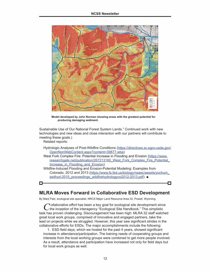
Model developed by John Norman showing areas with the greatest potential for producing damaging sediment.
MLRA Moves Forward in Collaborative ESD DevelopmentBy Marji Patz, ecological site specialist, NRCS Major Land Resource Area 32, Powell, Wyoming.
C ollaborative effort has been a key goal for ecological site development since the inception of the interagency “Ecological Site Handbook.” This simplistic
task has proven challenging. Discouragement has been high: MLRA 32 staff watched great local work groups, comprised of innovative and engaged partners, take the lead on projects while we struggled. However, this year saw significant strides in the collaborative efforts for ESDs. The major accomplishments include the following:
1. ESD field days, which we hosted for the past 4 years, showed significant increase in attendance/participation. The training needs of cooperating groups and interests from the local working groups were combined to get more people involved. As a result, attendance and participation have increased not only for field days but for local work groups as well.
2. We built a working relationship with BIA (Bureau of Indian Affairs) staff. This provided opportunities for us to visit multiple locations. Personnel from BIA, NRCS, and BLM (Bureau of Land Management) and volunteers (retired from other Federal agencies) collected tier 3 data documenting the ecological dynamics within the southern extent of the MLRA. Participants benefited from discussions, local knowledge of the data collected, and a hands-on connection with the state-and-transition models.
3. A networking opportunity led to an extended project with USFS (U.S. Forest Service). Utilization of historic as well as current monitoring methods on paired transects at multiple locations allowed historic data to be translated into current terms and, therefore, provide a larger functional data set. This project also afforded the opportunity to work with graduate students, summer interns, seasoned technicians, range leads, and retired personnel. Partipants came from various disciplines, including rangeland, wildlife habitat, and botany, and represented three agencies (USFS, BLM, and NRCS) and multiple districts.
4. Number of staff is a limitation for completing the necessary fieldwork, especially in areas with difficult access and potentially dangerous wildlife. Utilizing joint activities to collect allotment data, as well as site/soil correlations, helped to complete tasks efficiently for both BLM and NRCS. The added knowledge and experience within the team helped increase the data collection. This data will assist with allotment management planning as well as ESD development.
5. Collaborative partnerships on multi-functional projects helped fill data gaps for air temperature, precipitation, and soil temperature and moisture regimes. Installation of University of Wyoming climate stations with soil temperature sensors supplied by NRCS was completed with assistance across multiple MLRA leads, NRCS field staff, University of Wyoming Cooperative Extension, BLM, BIA, and conservation districts. Identifying the resources available, being tuned into partners’ projects, and being willing to do the leg work were key to the efficient and effective completion of ESDs.
This year is the first year that the collaborative effort has seemed effective within MLRA 32. The accomplishments may be small and insignificant to some, but they have had a strong ripple effect for ESD development locally. Important strategies are:
● Remember that no one approach will work the same from area to area. Know the priorities and topics of emphasis for your area.
● Include all resource entities (range specialists, wildlife biologists, recreationalists, fire personnel, realtors, etc.).
● Don’t expect success in a day. Set individual goals and re-evaluate often.
Through education, hands-on application, and one-on-one and group discussions, progress is being made. If we learn from our back steps and are effective with our side steps, every step is a step towards progress. We are listening and looking for new ways to reach our partners. Take the opportunity to share your attempts and successes! ■
NCSS Newsletter
14
Using GPR to Assess the Effects of Sea Level Rise on Onsite Wastewater Treatment SystemsBy Deborah A. Surabian, State Soil Scientist of Connecticut and Rhode Island.
R hode Island and Connecticut NRCS soil scientists have been working with University of Rhode Island doctoral candidate Alissa Cox. Alissa is completing
her dissertation entitled “Coastal Rhode Island Septic System Drainfields: Impacts of Sea Level Rise and Efficacy of Vegetation-Based Mitigation Strategies.” With guidance from Dr. George Loomis, research associate and director of the Onsite Wastewater Training Center, Alissa is investigating the impact of sea level rise on septic systems installed along the southern coast of Rhode Island. Two manuscripts prepared from Alissa’s dissertation describe historic changes in ground-water tables along the Rhode Island coast from the 1960s to present and explore how changes in depths of the ground-water tables may be affecting the functioning of onsite wastewater treatment systems (OWTS) and the systems’ compliance with separation distance regulations. To help visualize spatial variations in water table depths and their relationship to OWTS components in backyard drain fields, the use of ground-penetrating radar (GPR) was proposed.
The use of GPR in concert with continuous water table height loggers was explored in this study to help ascertain whether OWTS systems are currently meeting the 90-cm separation distance required by State regulations or are out of compliance. If the latter, the systems are potentially contributing nutrients and pathogens to Rhode Island’s fragile coastal ecosystems.
A common concern of GPR users is whether or not GPR will be able to achieve the desired depth of penetration in the soils of a project area. In many soils, high rates of signal attenuation severely restrict penetration depths and limit the suitability of GPR. For example, the national GPR soil interpretation in Web Soil Survey rates the Fortress soils as unsuited for GPR due to attenuation from salts (high electrical conductivity). Soils having high electrical conductivity rapidly attenuate radar energy, restrict penetration depths, and severely limit the effectiveness of GPR. Upon using GPR, the Fortress soil was found to be suitable for GPR as data was recorded to a
The GPR setup for the investigations.
NCSS Newsletter
15
depth of 3 meters. Updates to the national GPR soil interpretation are needed to adjust for salinity levels common to sandy soils that occur on or near sloping beach faces.
A 2D radar record from a random GPR traverse (figure above) shows high-amplitude reflections from a metallic manhole access cover to the septic tank where the solids are collected (white box). White arrows indicate what may be the original soil surface grading into the mounded septic system. The fill material at the 10-meter distance mark is about 90 centimeters thick. The leaching galley closest to the house (yellow box) is about 6 meters long. The actual distance could not be field verified with a push probe due to frozen ground. Another high-amplitude reflection is seen at about the 11.5-meter mark (white circle) and may be associated with the septic system.
At an abandoned well, a water table measurement of 2.1 meters was taken at the time of the GPR survey. This well coincides with the 1-meter distance mark on the radar record (black arrow). The blue dashed line identifies the interpreted water table, which varies in depth below the soil surface from approximately 2.1 to 2.9 meters. From left to right, the water table decreases in depth to about 2.9 meters as the elevation increases due to the construction of the mounded leach field. The distance from the bottom of the concrete leaching galley to the top of the water table is approximately 1.2 meters. ■
A soil map of the GPR site (orange marker) from the soil survey of the State of Rhode Island. The soil in this area is mapped as FtA—Fortress sand, 0 to 3 percent slopes.
Planning Workshop for Coastal Zone Soil Survey
T he 2018 Coastal Zone Soil Survey (CZSS) Planning Workshop was held January 8 to 12 in Savannah, Georgia. The workshop, organized by the
CZSS Focus Team, was attended by 37 participants who are currently involved with coastal issues. The participants were representatives of Federal and State agencies, universities, and other organizations, including:
● NRCS ● South Carolina Geological Survey and South Carolina Department of Natural
Resources (SCGS/DNR) ● Eastern Carolina University (ECU) ● Virginia Institute of Marine Science (VIMS) ● University of Maryland (UMD) ● Barnegat Bay Partnership (BBP) ● Albemarle-Pamlico National Estuary Partnership (APNEP) ● Georgia Department of Natural Resources/Coastal and Ocean Management
Program (GA DNR) ● Sapelo Island National Estuarine Research Reserve (Sapelo Island NERR)
NCSS Newsletter
16
● University of Rhode Island (URI) ● NOAA ● U.S. Army Corps of Engineers (USACE) ● University of Georgia Marine Extension and Sea Grant (UGA) ● St. Johns River Water Management District (SJRMD) ● National Park Service (NPS) ● University of Florida (UFL) ● Auburn University (AU) ● U.S. Fish and Wildlife Service (USFW) ● U.S. Geological Survey (USGS)
The purpose of the workshop was to introduce the coastal zone soil survey concept and provide examples of soil survey data, uses of the soil mapping and data, and research and case studies. There were also presentations from partners highlighting their needs for soil data in coastal environments. For one day, participants were grouped into regions and worked, as a start to future surveys, to identify priority areas to map and areas for which existing data is available. A total of 64 projects in States from Maine to Texas and in Puerto Rico were identified during the workshop. Details on these projects, along with support information, will be sent to the regional directors and state soil scientists so that they can begin to prioritize the projects into NASIS work plans and incorporate them into long-range plans. Maggie Payne captured these projects in a story map (click here to view). A final report of the workshop is being written and will be available shortly. For more information visit: www.mapcoast.org.
Workshop attendees (from right to left): Manuel Matos (State Soil Scientist of Puerto Rico), Dean Carpenter (APNEP), Reide Corbett (ECU), Sandy Page (NRCS), Greg Taylor (NRCS), Debbie Anderson (NRCS), Barret Wessel (UMD), Mike Lindsey (Louisiana State Soil Scientist), Jim Turenne (NRCS), Rob Tunstead (NRCS), Will Doar (SCGS/DNR), Joe Seney (NPS), Marty Rabenhorst (UMD), Dave Harper (Virginia State Soil Scientist), Mark Stolt (URI), Stan Hales (BBP), Phil King (Delaware/Maryland State Soil Scientist), Suzanne VanParreren (Sapelo Island NERR), Jan Mackinnon (GA DNR), Jim Lathem (Georgia State Soil Scientist), Julie Herman (VIMS), Debbie Surabian (Connecticut/Rhode Island State Soil Scientist), Darrell Leach (Acting Florida State Soil Scientist), Maggie Payne (NRCS), Forbes Boyle (USFW), Charles Lagoueyte (NRCS), Casey Sowell (NRCS), Chris Macon (USACE), Alan Stahnke (Texas State Soil Scientist), Collin McCormick (NRCS).
A total of 34 presentations were made during the 3-day workshop. Copies of the talks and additional information are available at: http://nesoil.com/sas/2018_WPC.html.
Also in attendance at the workshop were Dr. Martin Rabenhorst (University of Maryland) and Dr. Mark Stolt (University of Rhode Island), both of whom have over 30 years of experience in coastal and subaqueous soil research. Dr. Rabenhorst had an excellent presentation on the origins of subaqueous soil mapping that included the work of his former student, Dr. George Demas, who is considered the pioneer of subaqueous soil surveys in the United States. A video of his talk is available at: https://www.youtube.com/watch?v=h5QZ0rTJl5Q&feature=youtu.be. Dr. Stolt provided information on the research and mapping efforts at URI. ■
Coastal Zone Soil Survey Featured at CERF 2017
T he biennial conference of the Coastal and Estuarine Research
Federation (CERF) 2017 was held November 5 to 9 in Providence, Rhode Island (the Ocean State). Approximately 1,500 people from 36 States and 26 countries attended the conference (http://www.erf.org/cerf-2017-biennial-conference). The National Cooperative Soil Survey had an exhibition table set up to provide information about the work underway in conducting coastal zone soil surveys. Rhode Island NRCS Soil Scientist Jim Turenne ran the exhibit, where numerous people stopped by to learn about soils. The attraction to the exhibit was a series of four soil cores taken from the coastal lagoons in Rhode Island and Connecticut. Visitors to the exhibit table were shown how easy it was to obtain soils data for the coastal zone using the SoilWeb, Web Soil Survey, and SmartPhone. Those interested were also shown the new subaqueous interpretations, which were released with the 2017 refresh of NRCS’s NASIS (National Soil Information System) database. Many of the visitors did not know this type of information was available and so easy to obtain. Because Rhode Island completed the first coastal zone soil survey (in 2010), participants could view actual maps and data.
The conference featured numerous talks about coastal soils. Dr. Mark Stolt, professor of pedology at the University of Rhode Island (URI), gave a presentation titled “Characterizing the Shallow Subtidal Benthic Environments: It’s Not Just Mud Anymore.” He discussed the coastal mapping and research he is conducting at URI. Mark’s graduate student Chelsea Duball followed with a talk on the impacts of oyster aquaculture. There were also numerous posters about the coastal zone soil surveys.
For more information on coastal zone soil surveys, visit the Coastal Zone Soil Survey website at: www.mapcoast.org.
For an additional article on the use of coastal zone soil surveys (to find surf spots!), go to: http://41nmagazine.seagrant.gso.uri.edu/2018/02/06/geology-in-motion/. ■
Underwater Soils – Coastal Zone Soil SurveyBy Greg Taylor, CZSS Focus Team co-chair and NRCS soil scientist.
Why is Underwater Soil Important?
“Why is underwater soil important?” is an example of the comments and questions members of the Coastal Zone Soil Survey (CZSS) Focus Team hear as we travel around the country promoting the benefits of subaqueous soil surveys. We also have to remind people that we’re not just talking about the bays and areas underwater. The following is an example of a request for soil information the CZSS Focus Team received.
In November 2017, I delivered a 15-minute presentation to the Albemarle-Pamlico National Estuary Program (APNEP) – Science and Technology Advisory Committee (STAC) in North Carolina. During my presentation, I mentioned how CZSS can be used for soil interpretations for eel grass and oyster restoration. After the presentation, I was approached by a U.S. Fish and Wildlife (USFW) biologist as well as water quality experts from U.S. Geological Survey (USGS). The discussion centered on Lake Mattamuskeet, the largest natural, freshwater lake in North Carolina and its quickly declining eel grass population. These agencies, and other universities and State agencies, have tested many hypotheses for the decline but with no success. As of this writing, the eel grass population in the lake is estimated to be 0 percent. Because this lake is a major stopping point for waterfowl migration along the East Coast flyway, and because the eel grass is a food highly sought by the birds, it is one of the primary sources of income for the local population of Hyde County, North Carolina. Because eel grass is a major food source for the birds, its die-off has everyone concerned.
A meeting in December 2018, between NRCS, USFW, and East Carolina University (ECU), led to a comprehensive plan that includes mapping the soils in the lake, collecting soil and water samples for various analyses, and looking for any evidence of eel grass (fig. 1).
During the meeting, ECU made another request for soil information, for the nearby Swanquarter Bay. The university hopes to use our soil mapping of this saltwater bay
Figure 1.—Map of the proposed project areas for Lake Mattamuskeet.
NCSS Newsletter
19
for oyster habitat restoration. This project would follow the initial mapping of Lake Mattamuskeet.
The pump house at Lake Mattamuskeet was once the world’s largest pumping station (fig. 2). It was designed in the early 1900s to keep the lake drained and allow for farming. The lake bed was said to produce the largest yield of sweet potatoes ever recorded at that time—a whopping 900 bushels per acre! However, despite the productivity, keeping the lake drained for agriculture never proved cost effective and pumping stopped in the early 1930s.
The lake is roughly 7 miles wide and 18 miles long and covers approximately 40,000 acres, although its average depth is only 2 feet. This lake is the southernmost stop for swans, as a place to pair up for breeding. Currently, the eelgrass has completely died off.
How are Underwater Soil Surveys Used?
The CZSS Focus Team recently helped select a new oyster bed restoration site utilizing the subaqueous soil survey for Barnegat Bay, New Jersey (fig. 3). Stockton University, along with industry partner Dale Parsons of Parsons Mariculture, was
Figure 2.—Lake Mattamuskeet’s pump house.
Figure 3.—Spreading cultch (stones, broken shells, and grit) in Barnegat Bay to form an oyster bed.
NCSS Newsletter
20
awarded Barnegat Bay Partnership funds to establish a pilot-level restoration oyster bed in Little Egg Harbor Bay. Mariculture is a type of aquaculture specific to saltwater. It uses cultivation of marine organisms in their natural habitat, such as open ocean, an enclosed section of ocean, or tanks filled with seawater. Using general guidance from industry partner and bayman Parsons, Stockton University researchers (Steve Evert) approached Rob Tunstead of the Hammonton MLRA soil survey office to determine if a particular site was suitable for oyster bed implementation. Rob examined the site of interest remotely, utilizing the existing subaqueous soil survey mapping and data, and determined that the site had not only a great hard bottom but had excellent tidal flow due to its close proximity to the inlet. Additional sonar surveys and bottom grabs by Stockton confirmed Tunstead’s indication of suitable bottom type for restoration purposes. After conferring, the grower/shellfisherman, Stockton researchers, and the soil survey office all agreed on the suitable site for oyster bed implementation. The site was established in 2016 with 300 bushels of oysters. It is reported to be providing excellent habitat and has minimal silting and subsidence, which are issues associated with poor site selections. This is a success story of the subaqueous soil survey for Barnegat Bay. ■
Nondiscrimination Statement
I n accordance with Federal civil rights law and U.S. Department of Agriculture (USDA) civil rights regulations and policies, the USDA, its Agencies, offices,
and employees, and institutions participating in or administering USDA programs are prohibited from discriminating based on race, color, national origin, religion, sex, gender identity (including gender expression), sexual orientation, disability, age, marital status, family/parental status, income derived from a public assistance program, political beliefs, or reprisal or retaliation for prior civil rights activity, in any program or activity conducted or funded by USDA (not all bases apply to all programs). Remedies and complaint filing deadlines vary by program or incident.
Persons with disabilities who require alternative means of communication for program information (e.g., Braille, large print, audiotape, American Sign Language, etc.) should contact the responsible Agency or USDA’s TARGET Center at (202) 720-2600 (voice and TTY) or contact USDA through the Federal Relay Service at (800) 877-8339. Additionally, program information may be made available in languages other than English.
To file a program discrimination complaint, complete the USDA Program Discrimination Complaint Form, AD-3027, found online at http://www.ascr.usda.gov/complaint_filing_cust.html and at any USDA office or write a letter addressed to USDA and provide in the letter all of the information requested in the form. To request a copy of the complaint form, call (866) 632-9992. Submit your completed form or letter to USDA by:
mail: U.S. Department of Agriculture Office of the Assistant Secretary for Civil Rights 1400 Independence Avenue, SW Washington, D.C. 20250-9410;