132
NEAR EAST AREA PLAN City of Columbus, Department of Development, Planning Division
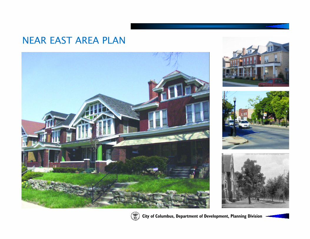
NEAR EAST AREA PLAN
City of Columbus, Department of Development, Planning Division


City of ColumbusMichael B. Coleman, Mayor
Department of DevelopmentMark Barbash, DirectorTrudy A. Bartley, Deputy Director
Planning DivisionVince A. Papsidero, AICP,
Planning Division AdministratorKevin Wheeler,
Long Range Planning Manager
Prepared by:Mark Dravillas, AICP, Senior PlannerDaniel Thomas, Urban Design ManagerElsie Stiger, Graphic DesignerAndrew Overbeck, Planning Intern
Columbus City CouncilMatthew D. Habash, PresidentMichael C. Mentel, President Pro-TemKevin L. BoyceMary Jo HudsonMaryellen O'ShaughnessyCharleta B. TavaresPatsy A. Thomas
Columbus DevelopmentCommissionMichael J. Fitzpatrick, ChairJohn A. Ingwersen, Vice ChairMarty AndersonJonathan BarnesJohn A. CooleyKay OnwukweDavid Brehm, Alternate
N E A R E A S T A R E A P L A N
Kathleen Bailey, ChairMargaret Cooley, Vice-ChairKim Powell, SecretaryDianne BrownDeedra BuxtonThomas CroweRobert FitrakisOuida JacksonIan JamesGeorgetta LakeTracy MahoneyMontreal Morand
The Near East Area Plan, adopted by City Council on September 19, 2005, is the city’s official guide for the Near East Side. Please direct inquiries about the plan to the Columbus Planning Division 109 North Front Street,Columbus, Ohio 43215 or contact our office at 645-8664
NEAR EAST AREA PLAN
Near East Area CommissionClyde PowellRick RedmonThelma RichardsonLarry RobertsThomas ShelbyWilliam ShafferEileen VinsonAl WaddellAnnette WhitesideAnnie WomackBaba Olugbala (Community Member)Steven Reid (Community Member)

ACKNOWLEDGEMENTS
The Planning Division would like to acknowledge Steve R. McClary, former Columbus Planning Administrator, who made substantialcontributions to this plan. The following organizations are also recognized for their valuable contributions and input into the plan andplanning process.
Bryden Road AssociationEastgate Gardens Civic AssociationFranklin Park Area AssociationKing-Lincoln Bronzeville Neighborhood AssociationLong Street Businessmen's AssociationMain Street Business AssociationMiami Resident's AssociationMount Vernon Avenue District Improvement AssociationOlde Towne East Neighborhood AssociationWoodland Park Neighborhood AssociationNeighborhood Design CenterColumbus Compact Corporation
ACKNOWLEDGEMENTS
N E A R E A S T A R E A P L A N
From the Director:
I am pleased to present the update of the Near East Area Plan. On behalf of the City's Department of Development, congratulations to the Near East Side on completion of the Near East Area Plan.
This plan is a complete update to the 1995 Near East Area Plan and was initiated at the request of the Near East AreaCommission. The plan includes design guidelines for commercial districts, East Broad Street, and infill housing. Theplan's development review checklist will assist stakeholders to review future development proposals for consistency withthese guidelines and other plan recommendations.
Representatives of the Near East Area Commission, civic associations, business associations, and other stakeholders put in many hours of hard work in the development of this plan and I would like to thank them for their leadership in the development of the plan. In addition, the staff of the Planning Division of the Columbus Department of Developmentwas instrumental in moving this important initiative forward.
The Development Department looks forward to continued cooperation with the Near East Side as we work together withthe community on the implementation of this plan.
Sincerely,
Mark Barbash, DirectorDepartment of Development
LETTER FROM THE DIRECTORN E A R E A S T A R E A P L A N
LETTER FROM THE DIRECTOR

LETTER FROM THE NEAR EAST AREA COMMISSION CHAIR
draft
From the Chair:
In the words of Helen Keller "I long to accomplish a great and noble task, but it is my chief duty to accomplish smalltasks as if they were great and noble."
We, the members of the Near East Area Commission (NEAC) have a great and noble task before us - the continuedrestoration of an area whose potential as a catalyst for the resurrection of the central city has just begun to be felt. The Near East Side, once the suburbs of the nineteenth and early twentieth centuries, represents a kaleidoscope ofhuman and architectural history. Its prime location and variety of housing stock provide a wellspring of developmentopportunities.
NEAC and other stakeholders have created the blueprint of our vision through hours of discussion, writing, and rewriting.We are in hopes that this plan will provide the reader with the means to participate in that vision.
Welcome to the Near East Side of the twenty-first century.
Sincerely,
Kathleen BaileyChair
LETTER FROM THE NEAR EAST AREA COMMISSION CHAIR
N E A R E A S T A R E A P L A N

Executive Summary 2
Introduction 4
History of the Near East Area 6
Land Use and Zoning 10
: Existing Conditions 11: Land Use Plan 16
: Development Strategy 26: Commercial District Design Guidelines 28
: Recommendations Specific to Each Commercial District 38
: East Broad Street Design Guidelines 50
Housing and Historic Preservation 62: Existing Conditions 63
: Housing and Historic Preservation Plan 70: Housing Design Guidelines 76
Transportation 82
: Existing Conditions 83: Transportation Plan 87
Community Facilities and Services 98
: Existing Conditions 99: Community Facilities and Service Plan 104
Implementation 110: Development Review Checklist 116
Maps
Figure 1 Near East Area Boundary 5
Figure 2 Existing Land Use 12Figure 3 Existing Zoning 13
Figure 4 Urban Commercial Overlay 14Figure 5 Development Strategy 27
East Broad Street Assessment 61Figure 6 Housing Conditions 64
Figure 7 Historic Districts and Sites 67Figure 8 Existing Transportation 86
Figure 9 Proposed Transportation 89Figure 10 Community Facilities 103
TABLE OF CONTENTSN E A R E A S T A R E A P L A N
TABLE OF CONTENT 1

EXECUTIVE SUMMARY
The Near East Area Plan is a roadmap to guide the continued revitalization and redevelopment of the Near East Side. Theplan encompasses the boundaries of the Near East Area Commission (NEAC): I-670 on the north, I-70 on the south, AlumCreek on the east, and I-71 on the west. This summary is designed as the first point of entry to the plan and will highlightthe key issues addressed within. However, all statements here do not stand alone, please reference each section of the plan.
The plan is made up of four main sections that cover: land use and zoning, housing and historic preservation, transportation, and community facilities and services. After assessing existing conditions, each section of the plan then outlines policies and strategies that address overall goals. The plan includes design guidelines for commercial districts,housing, and East Broad Street. These guidelines will shape new development and revitalization, as well as provide a basis for consistent, informed decision-making. To that end, the plan's implementation section includes a developmentreview checklist that will enable stakeholders to check a proposed development for consistency with the plan.
In addition to evaluating the current conditions on the Near East Side, the Land Use and Zoning portion of the plan incorporates several economic development recommendations. This section has the following goals: : Sustain/create a mix of land uses that contributes to a walkable and diverse neighborhood.
: Develop the commercial districts with a mix of higher density residential and retail/commercial uses as illustrated onthe Development Strategy Map.
: Create economically active commercial districts that reflect the urban nature of the Near East Side, yet accommodate the automobile.
: Establish residential areas that support the commercial districts.
: Increase the availability of good jobs within the neighborhood.
The Development Strategy (page 27) and Commercial District Guidelines are avenues for achieving these goals. TheDevelopment Strategy illustrates the key residential, office, commercial, and industrial corridors in the Near East Side andhighlights the development opportunities in the area. Recognizing that healthy commercial districts are the cornerstoneof livable communities, the Commercial District Guidelines specifically address the four primary commercial districts on the Near East Side: Parsons Avenue, Main Street, Long Street, and Mount Vernon Avenue. These guidelines identifythe commercial "node" of each district and provide specific land use and transportation recommendations to aid in the revitalization of each corridor. The East Broad Street Design Guidelines seek to maintain the "look and feel" of the thoroughfare, one of Columbus' most beautiful streets. This section of the plan strongly discourages the demolition ofcontributing buildings and provides guidelines for new construction.
2 EXECUTIVE SUMMARY
N E A R E A S T A R E A P L A N

The greatest strength of the Near East Side is its architecturally desirable in-town neighborhoods. The Housing and HistoricPreservation section builds on this strength by providing design guidelines to encourage appropriate new and renovatedhousing. The following goals aim to balance revitalization with diversity and the economic needs of current residents:: Maintain sound housing for all income levels in the area and avoid the displacement of existing residents, particularly
senior citizens.
: Develop new housing that is compatible with the existing architecture.
: Preserve existing housing stock and reduce the rate of housing demolition.
: Rehabilitate abandoned, boarded-up, and vacant housing units.
The Transportation section of the plan seeks to enhance residential and commercial areas of the Near East Side by improving connectivity, pedestrian-friendliness, and access to alternative forms of transportation by addressing the following goals: : Balance the needs of the automobile and pedestrian/bicyclist.
: Form a community mobility plan to implement the plan's goals, analyze impending changes to I-71 on traffic circulation,focus traffic movements to commercial nodes, and reduce traffic movement through primarily residential areas.
The Community Facilities and Services section of the plan is concerned with public access to parks, recreation centers,police and fire stations, schools, utilities, and other services. The section addresses the following goals: : Maintain/create safe, well-maintained parks, recreational centers and trails.
: Create a strong partnership between residents and neighborhood schools contributing to an environment of learning.
: Sustain/create a safe environment and strong sense of personal security for all.
Finally, the Implementation section suggests strategies for public outreach and other efforts to promote the plan and engage in projects. It also serves as a guide for checking a proposed development for consistency with the planthrough use of a development review checklist. The checklist is intended to allow developers, civic associations, NEACcommissioners, city staff, and other stakeholders to evaluate development proposals against the specific guidelines andrecommendations of the Near East Area Plan. Developers will be able to consult the checklist to get an idea of theexpected standards; civic associations and neighborhood organizations will be able to use the checklist to provide input on development proposals to NEAC; and NEAC will be able to make consistent, well-informed decisions and recommendations on development proposals to the city. This should streamline the decision-making process, enhanceneighborhood communication, and maximize the potential for the implementation of the Near East Area Plan.
N E A R E A S T A R E A P L A N
EXECUTIVE SUMMARY 3

INTRODUCTION
The Near East Area Plan is an update to and supersedes the 1995 Near East Area Plan. It references and builds upon previous plans, including 1995 Near East Area Plan, Holtzman-Main Neighborhood Plan (2000), ColumbusComprehensive Plan (1993), I-670 Corridor Plan (1989), the Alum Creek Action Plan (2004), the city of Columbus Recreation and Parks Master Plan (2002), King-Lincoln District Plan (2002), and the South of MainReinvestment Area Report and Action Plan (1994). It is to be used by the Near East Area Commission, city of Columbus, and other stakeholders in the Near East Side to guide the development of the Near East Side. The plan addresses the area within the Near East Area Commission boundary: I-670 on the north, I-70 on the south, Alum Creek on the east, and I-71 on the west (see Figure 1).
The plan addresses land use and zoning, housing and historic preservation, transportation, and community facilities andservices. Economic development-related recommendations are incorporated into the land use and zoning element. Eachsection of the plan includes a brief overview of existing conditions and then states overall goals. Specific issues are thenidentified along with accompanying policies and strategies to deal with the identified issues. An important part of theplan is design guidelines for commercial districts, East Broad Street, and housing. The primary goal of these designguidelines is to educate both community members and developers about appropriate development for these particularareas. While the guidelines, along with other plan recommendations, are not a mandate, it is hoped that they will form a basis for consistent, informed decision-making regarding proposed development.
The plan concludes with an implementation section, including a development review checklist. The checklist is a summary of the development standards and recommendations found throughout the Near East Area Plan and is to be used by stakeholders in the review of development proposals for consistency with plan provisions.
4 INTRODUCTION
N E A R E A S T A R E A P L A N

NEAR EAST AREA BOUNDARYN E A R E A S T A R E A P L A N
INTRODUCTION 5Figure 1
N

HISTORY OF THE NEAR EAST AREA
6 HISTORY OF THE NEAR EAST AREA
N E A R E A S T A R E A P L A N

Long before the City of Columbus came to be, people passed through the Near East area as they traveled between the Scioto and Muskingum rivers. By the 5th century, the Moundbuilder culture occupied the area, evident in the neighborhood until the early 20th century by a mound at the corner of Bryden Road and Champion Avenue. In later years, ancient burial sites were discovered at the natural springs near the previous site of the Center of Science andIndustry (COSI) at 280 East Broad St. The neighborhood has been occupied and settled for at least 10,000 years.
1800sThe original town of Columbus was laid out in 1812 by Joel Wright and occupied the area bounded by NationwideBoulevard (North Public Lane), Livingston Avenue (South Public Lane), Parsons Avenue (East Public Lane), andScioto River (West Public Lane). The Near East area is approximately 2.5 square miles in size and located directlyeast of the original city on a high ridge.
The relatively slow growth of Columbus changed by the end of the Civil War when large numbers of people came to the city. Columbus experienced unprecedented growth along developed arterials such as Broad, Long, and Mainstreets. During this period, the major transportation modes were foot, horse and buggy. These transportation formsare evident by the carriage houses and stables built among the early residential communities of the Near East area.
The single most important innovation of the late nineteenth century was the public transit street car system. Powered initially by horses and later by electricity, the streetcar permitted people to live considerably farther from their work places than possible in the “walking” city. As a result, the city expanded in all directions and large streetcar suburbssprang up along extended sections of Long, Main and Broad streets, and Mount Vernon Avenue. By the turn of the century, a streetcar line ran from Fair Avenue to the Ohio State Fairgrounds, then located at what is now Franklin Park. Alum Creek was the edge of town, and the Near East area was one of Columbus’ most prestigious and wealthy communities.
The residential area adjacent to Main Street was farmland. For example, the land between Kimball and LinwoodAvenues was part of a farm owned by Mr. Kimball who was highly active in the Underground Railroad. KimballAvenue was originally the lane that led to his house. Some semblance of these former farm tracts can be seen in the layout of the City of Columbus Health Department (formerly School for the Blind) building located at the corner of Main Street and Parsons Avenue.
HISTORY OF THE NEAR EAST AREAN E A R E A S T A R E A P L A N
HISTORY OF THE NEAR EAST AREA 7

The change from farmhouse to subdivision began in the 1870’s. Some existing houses on Main Street were built at that time, however, many have been gutted and masked by storefronts. A careful examination of some existingcommercial properties on Main Street between Parsons Avenue and Nelson Road reveals the vestiges of some once very large homes.
1920sBy the end of World War I, the community housed a firmly entrenched and diverse group of residents. Althoughthere were sharp differences in income and lifestyles, the relatively small size of the land mass encouragedinteraction among its residents. During the 1920s, the Near East area emerged with an identity of its own as a community of neighborhoods. Prior to that time, the main groups holding the community together had been churches and schools.
The 1920’s saw the rise of a commercial, social, and political base within the community. The area near HamiltonPark and Long Street developed into a wealthy African-American neighborhood complete with shops, theaters,professional offices, and restaurants along with numerous clubs or lounges that featured the newly developingmusical art form called jazz. Other sections of the Near East developed differently. Five movie houses were locatedwithin walking distance of each other. The Dunbar Theater was located at the corner of Mount Vernon andChampion avenues. The Cameo, which was located on Mount Vernon Avenue near 20th Street, prohibited AfricanAmericans from entering the theater. The Pythian Theater was located on Mount Vernon Avenue between Monroeand Garfield avenues. This theater was built by members of a black lodge called the Knights of Pythias and is nowthe site of the Martin Luther King Center. The Lincoln Theater and the Empress Theater were located on Long Streetnear Hamilton Park.
1940sThe portion of the Near East known as “The Blackberry Patch” was an area where many blackberries grew and poor African-Americans lived. The homes were constructed from pieces of scrap wood, heating usually came from large pot-bellied stoves, and many homes had out-houses. By 1941, one of the nation’s first public housing projects, Poindexter Village, was built on the former site of the “The Blackberry Patch.” The village was named after the Reverend James M. Poindexter, the first African-American City Council member of the City of Columbus.The community emerged from World War II intact. It was hoped that the good times of the 1920s would return.
8 HISTORY OF THE NEAR EAST AREA
N E A R E A S T A R E A P L A N

However, widespread interest in and the availability of the automobile changed the Near East as it changed the faceof America. Sprawling suburbs with acres of home sites, augmented by regional shopping centers and ultimately thesuburban relocation of businesses, sprang up surrounding the city. The suburbs lured inner city residents away from the older community.
1950sBy 1950, much of the housing stock that had served the wealthy of the previous generation was showing signs of deterioration. Many of the houses vacated in the older city during this time were subdivided into apartments or rooming houses. The Eastgate Subdivision, a suburban-type residential neighborhood located within the Near East area, was built in the fifties.
1960sDuring the 1960s, construction of interstate highways cleared vast sections of the Near East area, significantlyreducing the amount of housing stock available and forcing many families and residents to relocate. As a result, the community experienced a major period of readjustment. To this day, the freeways play a major role in the isolation of the Near East area from the surrounding city and its services.
The area experienced a period of extreme social strife. Portions of the Near East area community suffered the loss of additional housing stock to arson and vandalism. Quaint brick streets were paved over, and many residents andbusiness persons, who had remained through other hardships, fled the turmoil and violence of the late 1960s.
1970sBy 1970, portions of the Near East area had survived virtually intact while other areas appeared desolate andderelict. During this period, a variety of housing and rehabilitation programs were used as tools to revitalize the most needy of the areas. The Community Development Block Grant (CDBG) program encouraged rehabilitation of single-family housing by the end of the 70s. Neighborhood Commercial Revitalization (NCR) areas were formed on Main Street, Long Street, Parsons Avenue, and Mount Vernon Avenue.
* The History of the Near East area section was taken directly from the 1995 Near East Area Plan.
N E A R E A S T A R E A P L A N
HISTORY OF THE NEAR EAST AREA 9
Sources:Lentz, Edward, “Listen For The Jazz”, East By Northeast, p. 2-5;McDaniel, William T,, “Listen For The Jazz”, The Jazz Cradle of Columbus, p. 7-15;Bishop, Anna, The Blackberry Patch series;Allen, Kenneth: Afro American Pioneer Physicians: The Early Years;Lee, Alfred, The History of Columbus 1893;Near East Information Profile, City of Columbus,Department of Development, July 1976; andEldon Ward was interviewed by Kathleen Bailey andinformation from that interview was included in the history section of this plan.

LAND USE AND ZONING
10 LAND USE AND ZONING
N E A R E A S T A R E A P L A N

N E A R E A S T A R E A P L A N
Land use plans are used to determine the amount, intensity, and arrangement of residential, commercial, manufacturing,institutional, park and other uses that will provide a high quality of life for neighborhood residents. Zoning is a legal tool that regulates the type and form of development and is one way to implement a land use plan. This section will:
1) review the existing land use and zoning in the Near East area,
2) identify specific land use and zoning issues,
3) develop policies and strategies for dealing with identified issues, and
4) identify a development strategy.
EXISTING CONDITIONSThe diversity of land uses on the Near East Side is one of its inherent strengths. Lower and higher density housing, neighborhood stores and restaurants, schools, parks and other land uses are all mixed together within each of the Near East neighborhoods. A down-zoning in the early 1970's ensured that new inappropriately high density housing would not become the norm and replace the historic density pattern found in the neighborhood. The mix of land usesfound on the Near East Side, typical of historic urban areas, provides the following benefits:
: The ability for residents to walk to schools, parks, work, and other places.
: A neighborhood where people know each other and interact on a regular basis.
: A variety of housing stock for people of different family sizes and incomes.
LAND USE AND ZONING
LAND USE AND ZONING 11

N E A R E A S T A R E A P L A N
EXISTING LAND USE
The existing land use for the entire Near East Side is illustrated on Figure 2.The highest percentage of land in everypart of the Near East Side is residentialuse. Two-family and multifamily residential uses are mixed in with the single-family residential areas. The primary commercial corridors are MainStreet, Mt. Vernon Avenue, Long Street,and Parsons Avenue, with Broad Streetconsisting of office and residential uses.Institutional uses are a significant percentage of land use in every part of the Near East Side. Significant parklandexists in the area, with Franklin Park being the largest open space on the NearEast Side. Industrial uses are found near Alum Creek in the northeast andsoutheast portions of the neighborhood.Finally, significant amounts of vacant commercial and residential land existthroughout the area.
12 LAND USE AND ZONING
Single-Family Residential
Two-Family Residential
Multifamily Residential (3+ units)
Parks
Commercial
Institutional
Industrial
Vacant Figure 2
N

N E A R E A S T A R E A P L A N
EXISTING ZONING
LAND USE AND ZONING 13
The existing zoning for the Near East Side is illustrated on Figure 3. In general,there are not any major conflicts betweenexisting land use and zoning. The existing zoning for the majority of theNear East area is residential. The primarycommercial zoning exists along MainStreet and Mt. Vernon Avenue, with additional commercial zoning alongParsons Avenue, Nelson Road, and insmaller pockets in the neighborhood. The majority of the manufacturing zoningin the area is found in the vicinity of theintersection of Main Street and NelsonRoad, north of Maryland Avenue to theeast and west of Sunbury Road and to the south of Maryland Avenue near theNorfolk and Western railroad tracks. Themajority of Broad Street is zoned forapartment and offices (ARO).
Single-Family Residential
One-Two Family Residential
One-Four Family Residential
Apartment
Apartment-Office
Institutional
Commercial
Manufacturing
ParkingFigure 3
N

N E A R E A S T A R E A P L A N
URBAN COMMERCIAL OVERLAY
The Urban Commercial Overlay zoningdesignation (UCO) is in place along theentire extent of Main Street on the NearEast Side, the majority of ParsonsAvenue, and on significant portions ofLong Street and Mt. Vernon Avenue (see Figure 4). This overlay ensures that future development or significantredevelopment of existing buildings isconsistent with the urban nature of thearea and encourages pedestrian activity.Specifics of the UCO can be found atwww.development.columbus.gov
14 LAND USE AND ZONINGFigure 4
N

N E A R E A S T A R E A P L A N
The percent of existing land use and zoning by District is summarized in Table 1. A few highlights of existing land use and zoning in the four districts of the neighborhood include:
Table 1. Existing Land Use and Zoning by District (Percent of Developed Land)
Northwest (1) Northeast (2) Southwest (3) Southeast (4) District District District District
Existing Land Use
Single-Family 21% 35% 27% 30%
Two-Family 14% 6% 12% 11%
Multi-family (3+units) 20% 13% 12% 8%
Parks 5% 8% 2% 25%
Commercial 14% 10% 17% 13%
Institutional 16% 14% 16% 9%
Industrial N/A 9% .1% 2%
Vacant 12% 6% 14% 7%
Existing Zoning
Single-Family 7% 50% 50% 73%
One-Two Family 56% 6% 12% 0%
One-Four Family 1% 3% 0% 0%
Apartment 23% 14% 21% 5%
Apartment-Office 5% 5% 8% 2%
Institutional 0% 2% 0% 3%
Commercial 8% 4% 7% 7%
Manufacturing 0% 14% 0% 10%
DISTRICT HIGHLIGHTS
LAND USE AND ZONING 15
: Institutional uses make up approximately15 percent of the land use in theNorthwest (1), Northeast (2), andSouthwest (3) Districts, including significant amounts of church ownedproperty.
: Approximately 15 percent of the land inthe Northwest District (1) is owned by the Columbus Metropolitan HousingAuthority.
: The Northeast District (2) has the highestpercentage of land dedicated to industrialuses (located primarily along Nelson Road and I-670).
: The Northeast (2) and Southeast (4)Districts have significantly lower percentages of vacant land (six percent and seven percent, respectively) compared to the rest of the Near East Side.
: At 14 percent, the Southwest (3) Districthas the highest percentage of vacant landof any of the four Near East Districts.
: Twenty-five percent of the land in theSoutheast (4) District is parkland, themajority being Franklin Park.
: Only two percent of the land in theSouthwest District (3) is parkland.

The Land Use Plan builds on the strong urban fabric present on the Near East Side and identifies strategies for dealingwith key issues, including:
1) revitalization of commercial districts,
2) revitalization of residential areas,
3) parking for commercial districts and churches,
4) encroachment of non-residential uses into residential areas,
5) the need to create high quality jobs, and
6) future development on East Broad Street.
N E A R E A S T A R E A P L A N
LAND USE PLAN
16 LAND USE AND ZONING

N E A R E A S T A R E A P L A N
The Development Strategy map (page 27) illustrates recommended land uses and development priorities for the Near East Side, consistent with the recommended strategies. The Land Use Plan then provides commercial district design guidelines that include specific land use and transportation recommendations for each of the Near East Side commercial districts. Finally, the Land Use Plan provides design guidelines for new construction and rehabilitation on East Broad Street.
The overall goals of the Land Use Plan include:: A mix of land uses that contributes to a walkable and diverse neighborhood.
: Development of the commercial districts with a mix of higher density residential and retail/commercial uses as illustrated on the Development Strategy map.
: Economically active commercial districts that reflect the urban nature of the Near East Side, yet accommodate the automobile.
: Residential areas that support the commercial districts.
: Availability of good jobs within the neighborhood.
LAND USE AND ZONING 17
N E A R E A S T A R E A P L A N
LAND USE PLAN
The specific issues, policies and strategies identified to achieve the overall goals are:
ISSUE 1:Revitalization of the existing historic commercial districts
POLICY:Commercial development and revitalization should occur within the existing historic commercial districts (Main Street,Parsons Avenue, Long Street, and Mt. Vernon Avenue).
STRATEGIES:: Steer commercial development toward existing commercial districts, with the most intense retail/commercial activity
focused at the specific nodes identified on the Development Strategy map (page 27).
: These commercial districts should serve as the adjacent neighborhoods’ day-to-day retail hubs that provide local jobopportunities and where area residents purchase food, clothing, gifts, etc., and conduct their regular banking, postal, and personal service transactions.
: Require new commercial development to follow the commercial district design guidelines from this plan.
: Utilize the recommendations from the commercial district design guidelines to guide land use and transportation decisions, investment, revitalization, and redevelopment efforts.
: Commercial development is recommended for the portion of Nelson Road between Broad Street and Long Street.This site should be redeveloped as a signature development as it serves as a gateway to the city of Columbus. Anydevelopment should also follow the commercial development guidelines presented in this plan.
18 LAND USE AND ZONING

N E A R E A S T A R E A P L A N
: Encourage local businesses and residents to take advantage of the support of local business associations and community development corporations.
: Communicate regularly with local business associations and existing community development corporations and ensurethey are taking advantage of economic development programs offered by the city of Columbus, e.g., low-interest loans,facade improvement grants, incentives.
: As previously stated, commercial development should be directed to the existing historic commercial districts. But it is recognized that neither the city nor neighborhood can stop proposals for commercial uses outside of the existinghistoric commercial districts (identified on Development Strategy map on page 27). In these cases, the following criteria should be used to evaluate the proposal: 1) Has the applicant considered the existing commercial districts for their project?
2) Is the request in reference to an existing business that has been a good neighbor and is providing a desired service to the neighborhood?
3) Is the site adjacent to or near a commercial district?
4) If so, can a shared parking situation be created?
5) Does the proposed project result in the demolition of architecturally significant building(s) or is the project proposed to fill a vacant lot or replace a building that is historically noncontributing?
6) Is any proposed structure architecturally compatible with adjacent structures and consistent with the appropriate design guidelines from this plan?
7) What is the proposed project's anticipated impact on parking and traffic?
8) Is appropriate screening proposed to buffer the project, including its parking lot, from adjacent residential properties?
9) Does the proposed project/land use offer benefits desired by the neighborhood (needed jobs or business)?
LAND USE AND ZONING 19

Well maintained pocket park at Linwood and Mound.
"Infill developmentcannot begin
in the middle of the neighborhood;it must start at the visible edges
and work in." Source: Urban Land Institute
LAND USE PLAN
ISSUE 2:Revitalization of residential areas, including vacant land and structures
POLICY:Prioritize the revitalization and redevelopment of residential areas illustrated on the Development Strategy map (page 27).Vacant land within the neighborhood is a resource that should be redeveloped as housing, pocket parks, or as additionalyard space for adjacent homeowners.
STRATEGIES:: Support agencies and private sector developers working to assemble/develop land in a manner consistent with this plan.
: Tour existing developments by prospective developers, if possible, to learn more about their product.
: Work with the city's Land Bank and other non-profit agencies to secure vacant land for redevelopment.
: Investigate the removal of foundations from the sites associated with the failed "Youth Impressions" project to facilitatetheir development in a manner consistent with the housing design guidelines from this plan.
: Prioritize the development of new housing that is consistent with the housing design guidelines from this plan.
: Narrow or odd shaped, vacant parcels located adjacent to well maintained homes should be considered for a lot-splitwith each adjacent homeowner receiving one-half of the vacant lot as additional yard space or sold to one homeowneras a side yard.
: Larger vacant lots located in appropriate places may be considered for development as pocket parks when park space isneeded and desired by the neighborhood. Utilize local artists to enhance pocket parks with sculpture or other amenities.
: Work with local agencies to develop vacant lots as community gardens until redevelopment as housing or other use.
: Vacant, historic church buildings should be preserved and redeveloped as new churches or other community-related uses.Housing or other secular uses should be considered for vacant churches when a community-related use is not viable.
: Focus the development of higher density apartments, condominiums and townhomes, including affordable units, within and adjacent to the commercial districts, which are the visible edges of the adjacent neighborhood (seeDevelopment Strategy map).
: Ensure that Urban Infrastructure Recovery Fund (UIRF) projects and other public investments are targeted to areaswhere infill development is desired, i.e., commercial districts, etc.
20 LAND USE AND ZONING
N E A R E A S T A R E A P L A N

ISSUE 3:Parking for commercial areas and churches
POLICY:Churches and businesses are valued members of the Near East community. Parking needs for businesses, churches, andother organizations must be balanced with the need to preserve the urban fabric of the Near East Side.
STRATEGIES:: Encourage business and community organizations to use shared parking.
: Develop and adopt parking lot screening and landscape guidelines for churches, businesses and other organizations.
: In the case of a proposed house demolition, require the organization proposing the demolition to investigate movingthe house to another location in the neighborhood by advertising the availability of the structure for at least forty-fivedays.
: Focus new businesses, churches, and other organizations adjacent to the identified commercial nodes, making it easier to develop shared parking opportunities.
: Encourage the provision of signage that provides on-street parking on Sunday mornings for elderly and for people with disabilities immediately adjacent to churches with parking needs.
: Encourage churches to implement strategies such as carpooling and the use of church vans to reduce parking pressures.
N E A R E A S T A R E A P L A N
LAND USE AND ZONING 21
THE OPTIMAL INFILL SITE:
The Context:: Viable market
: Compatible, well-maintained surrounding properties
: Receptive neighborhood
: Helpful city government
: Workable building code
: Good public services
The Property:: Availability for sale at a realistic
price
: Sufficient size for intended use(s)
: Adequate utilities in place
: Street frontage
: Regularly shaped, developableparcels
: No major topographic, drainage, orsubsoil problems
: Appropriate zoning
: Potential development profitability,compared with alternative sites
(Source: Real Estate Research Corporation, InfillDevelopment Strategies. Washington, D.C., Urban LandInstitute and American Planning Association. 1982)
N E A R E A S T A R E A P L A N
LAND USE PLAN
ISSUE 4:Encroachment of non-residential uses into residential areas
POLICY:Recognizing that mixed land use is an inherent strength of the Near East Side, discourage the intrusion of new non-residential uses into residential areas.
STRATEGIES:: Maintain residential zoning districts.
: Discourage inappropriate rezonings and variances in residential areas.
: Steer new non-residential development to the commercial nodes identified on the Development Strategy map (page 27).
: As previously stated, the intrusion of new non-residential uses into residential areas is discouraged. But it is recognized that neither the city nor neighborhood can stop proposals for new non-residential uses in residentialareas. In these cases, the following criteria should be used to evaluate the proposal:1) Has the applicant considered the existing commercial districts for their project?
2) Is the site adjacent to or near a commercial district?
3) If so, can a shared parking situation be created?
4) Does the proposed project result in the demolition of architecturally significant building(s) or, on the contrary, is the project proposed to fill a vacant lot or replace a building which is historically noncontributing?
5) Is any proposed structure architecturally compatible with adjacent structures and consistent with the appropriate design guidelines from this plan?
6) What is the proposed project's anticipated impact on parking and traffic?
7) Is appropriate screening proposed to buffer the project, including its parking lot, on adjacent residential properties?
8) Does the proposed project/land use offer benefits desired by the neighborhood (needed jobs or business?)
22 LAND USE AND ZONING

N E A R E A S T A R E A P L A N
ISSUE 5:Need to create high quality jobs
POLICY:Direct office, retail, and clean manufacturing developments to areas identified on the Development Strategy map.
STRATEGIES:: Implement the recommendations of the Holtzman-Main Neighborhood Plan. Infrastructure improvements
(stormwater, sidewalks, curbs, etc.) are needed in the Holtzman-Main area.
: Consider the area near I-670 and Taylor Avenue as a potential job creation site (see Development Strategy, page 26.)
: Focus neighborhood retail/office uses at the commercial districts, as previously stated.
: Office uses should also be considered along East Broad Street.
LAND USE AND ZONING 23
N E A R E A S T A R E A P L A N
LAND USE PLAN
ISSUE 6:East Broad Street
POLICY:Future development on East Broad Street must be managed to maintain its current "look and feel", ensure its integrity,and enhance its place as one of Columbus' most distinguished thoroughfares.
STRATEGIES:: Future development should abide by the East Broad Street Design Guidelines.
: As stated in the Guidelines, the demolition of significant and contributing buildings is strongly discouraged.
: As stated in the Guidelines, the renovation of existing contributing buildings should utilize the city of Columbus'Historic Resources Commission's Architectural Guidelines as a resource.
: Detailed review of proposed projects for consistency with the East Broad Street Design Guidelines should be conducted by city staff, Near East Area Commissioners, and other stakeholders to ensure appropriate new development and renovations.
: Explore additional mechanisms for implementing the East Broad Street Design Guidelines, including the potential for forming a conservation district or planning overlay.
: The rehabilitation of historic buildings adjacent to historic districts should take their design cues from the buildings in the historic district.
: The maintenance of the current residential and office land use mix is recommended for East Broad Street.
24 LAND USE AND ZONING

N E A R E A S T A R E A P L A N
: Two sites present opportunities for some degree of commercial development on East Broad Street:1) Commercial development is recommended for the portion of Nelson Road between East Broad and Long Streets.
This site should be redeveloped as a signature development as it serves as a gateway to the city of Columbus. Any development should also follow the commercial development guidelines presented in this plan.
2) Some commercial use may be appropriate as part of the redevelopment of the southeast corner of East BroadStreet and Parsons Avenue. Recommendations include: a) use tax credits and facade easement to help finance a redevelopment of the Jones Mansion with the addition
of new construction on the site at the southeast corner of East Broad Street and Parsons Avenue (redevelop two sites together), or
b) redevelop the southeast corner of East Broad Street and Parsons Avenue as a mixed-use building with residential uses facing East Broad Street and a retail use that would face Parsons Avenue.
LAND USE AND ZONING 25
N E A R E A S T A R E A P L A N
DEVELOPMENT STRATEGY
The Development Strategy for the Near East Side is illustrated in Figure 5. It is intended to highlight development opportunities and priorities that would ultimately spur residential and commercial revitalization throughout the Near East Side and provide job opportunities within the neighborhood. The following correspond with the legend on theDevelopment Strategy map on the following page:: Lower and Medium Density Residential: Taylor Avenue serves as a visible edge of the adjacent neighborhoods
and will spur further revitalization. New and renovated single-family housing should be the predominant building type.Consideration may be given to rowhouses or other market-rate multifamily and some neighborhood based retail atsome locations. Future development should reflect the existing new and renovated Taylor Homes housing and/or the housing design guidelines presented in this plan.
: East Broad Street: East Broad is one of Columbus' most beautiful streets. Future development should consist ofnew and renovated buildings for medium to high-density housing and office uses. Development should follow theEast Broad Street Design Guidelines presented in this plan.
: Higher Density Residential/Mixed Use Development: These historic commercial corridors are the visible edges of the surrounding neighborhoods and present opportunities for mixed use developments and new higher densityhousing within walking distance of shops/offices and contribute to a lively atmosphere. Housing and commercialdevelopments should follow the guidelines presented in this plan.
: Commercial District Nodes: These sites should be the focus for retail/commercial development and revitalization.Each node will be a mixed-use center where residents purchase food, clothing, gifts, etc., and conduct regular banking, postal, and personal service transactions. Developments should follow the commercial district guidelinespresented in this plan. These should concurrently serve pedestrians living within a quarter to a half-mile radius andauto traffic traveling along the major east-west and north-south streets of the Near East Side.
: Office/Light Industrial/Mixed Uses: This area presents a strategic opportunity for job creation. Office and/or light industrial uses should be developed in the northern portions and transition to housing on the southern portion.Design standards should consider the potential for light rail and subsequent opportunities for transit-oriented development. Standards should also ensure an appropriate transition to existing residential areas and that office/light industrial uses relate to I-670.
26 LAND USE AND ZONING

N E A R E A S T A R E A P L A N
Lower and Medium Density Residential
East Broad Street:
Higher Density Residential/Mixed Use Development:
Commercial District Nodes
Office/Light Industrial/Mixed Uses
Light Industrial/Commercial
Potential Light Rail Station
DEVELOPMENT STRATEGY
LAND USE AND ZONING 27Figure 5
N
: Light Industrial/Commercial: Thisarea consists largely of light industrialdevelopment. Future developmentshould reinforce this land use.Development standards should be utilized to ensure high quality development.
: Potential Light Rail Station: A sitein this area should be reserved for apotential light rail station. COTA'sVision 2020 plan anticipates thedevelopment of light rail within thiscorridor and this area could provide a convenient rail station and spur/accommodate commercial and higherdensity residential development.

N E A R E A S T A R E A P L A N
COMMERCIAL DISTRICT DESIGN GUIDELINES
The Near East Side has four primary commercial districts: Parsons Avenue, Main Street, Long Street and Mount Vernon Avenue. The purpose of this section of the plan is to provide guidelines for the continued revitalization of these districts. The first part of this section includes general design recommendations relevant to all of the commercialdistricts. The second part includes specific land use, transportation, and other recommendations for each district.
Healthy commercial districts are the cornerstones of livable communities because they provide a place for daily interactions among the residents, workers, and visitors in a neighborhood. This is the place where a neighborhood comesalive, and it is important that it contains a mix of uses. A true mixed-use commercial district provides a community withbusinesses that meet their daily service and entertainment needs clustered within walking distance of their residences.
Using Jan Gehl's* premise that "life takes place on foot," it is essential to design places on a human scale. Attractive walkways, continuous storefronts, good lighting, street furniture, landscaping features, and varied facades and rooflines all contribute to a human scaled environment. Retail that is brought toward the street and parking lots moved to the side or back of buildings play a key role in making a commercial district pedestrian friendly. Narrower streets and buffers between cars and pedestrians, such as bike lanes, on-street parking, street trees, or bollards help to slow traffic(which helps retail) and provide a safe environment for pedestrians and bicyclists. Plazas, parks, and squares within the commercial district compliment retail activities by providing gathering places beyond the commercial components.These uses provide the pedestrian with a goal, making it more likely that someone will be willing to walk there. Finally, a gateway can be used to define a commercial district or wider area and let residents and visitors know that they havearrived. These design guidelines will help to create place instead of space.
*http://www.gehlarchitects.dk/
28 LAND USE AND ZONING

N E A R E A S T A R E A P L A N
Places need more than just good design to be successful. It is imperative to create critical mass. Focusing retail at particular intersections (see Development Strategy map, page 27) in the form of nodes will increase the potential for the development of a successful neighborhood commercial district. Vibrant street life attracts more people to the areabecause it is more alive and feels safer. If a place has a healthy street life, people will be more likely to incorporate it into their daily routine. Increased residential density is one strategy that is crucial in boosting the number of "feet on thestreet" and creating a ready market for new retail development. Multifamily and other types of residential developmentlocated within and next to commercial districts will provide a constant customer and worker base. Siting national retailersat strategic locations within the commercial district can also play a role in sparking momentum, in part by establishing thearea as a more credible financial risk from the banking perspective, and thereby helping to create critical mass.
Perhaps the greatest challenge in revitalizing historic commercial districts is finding the balance between utilizing designguidelines that enhance their urban, pedestrian friendly nature and yet lure retailers and accommodate contemporary commercial and retail building and parking requirements. Toward this end, it may be necessary to relax some aspects of the design standards presented in this section to assist in bringing national or other highly desired retailers to the area.The relaxation of standards should be strategic as a means to the overall goal of a pedestrian friendly commercial node and not become the rule in judging development proposals. Good design is key to the long-term health of the commercial district. Finding the balance between market demands and pedestrian friendly design can come only through the development review process itself. It is hoped that the guidelines listed on the following pages and thedetails provided for each commercial district will help to create a shared vision and minimize friction when developmentproposals come forth. Ultimately, each development proposal will be evaluated on its specific merits and compromisewill be necessary by all those interested in revitalizing the Near East Side's commercial districts.
LAND USE AND ZONING 29

N E A R E A S T A R E A P L A N
COMMERCIAL DISTRICT DESIGN GUIDELINES
The following recommendations include text from the city of Columbus Urban Commercial Overlay (UCO) and additional suggestions meant to enhance the UCO. The UCO (Columbus City Code Sections 3372.601 through 3372.699) is meant to protect, re-establish and retain the unique architectural and aesthetic characteristics of older, urban commercialcorridors. On the Near East Side, the UCO is in place on Mt. Vernon Avenue, Long Street, Parsons Avenue and MainStreet. Text given below has been paraphrased from the UCO for brevity but does not substitute for the UCO. The complete text for the UCO is available at http://www.development.columbus.gov
DESIGN STANDARDSWalking must be a stimulating activity. Therefore, the streetscape should be continuous and design allow for interactionbetween the pedestrian and the built environment.
30 LAND USE AND ZONING
This coffee house on North High Street blends turn-of-the-century proportions with contemporary detailing. Outdoor seating areasand large windows are pedestrian-friendly.
Brewers Yard was completed in the spring of 2002. This mixed-use project incorporates pedestrian-scale site elements and a large off-street parking area situated at the rear of the property.
This restaurant on North High Street features azero setback, large windows and a cornerentrance.

N E A R E A S T A R E A P L A N
UCO Guidelines: A primary building frontage shall incorporate at least one main entrance door. At a building corner where
two primary building frontages meet, one main entrance door may be located to meet the requirement for both building frontages.
: At least 60 percent of each primary building frontage, between the height of two (2) feet and ten (10) feet above the nearest sidewalk grade, must be clear/non-tinted window glass permitting a view of the building's interior to a minimum depth of four (4) feet. For secondary building frontage, the pattern of window glass shall continue from the primary frontage a minimum distance of ten (10) feet.
: Ornamental masonry or stone walls may be used for screening, sitting, or used as independent architectural elements.Walls may not exceed a height of four (4) feet.
: Fences, with or without masonry piers, shall be decorative and constructed of ornamental metal tubes or bars. Fencesmay not exceed a height of four (4) feet. Chain-link fences are not permitted.
: Billboard signs are prohibited.
: Backlit awnings are not permitted.
: Building frontages that face public streets and exceed a width of fifty (50) feet must include vertical piers or other vertical elements to break the plane of the building frontage. Piers/elements must be spaced at intervals of fifteen(15) feet to thirty-five (35) feet along the frontage.
: All roof-mounted mechanical equipment shall be screened from public view to the height of the equipment. Thedesign, colors, and materials used in screening shall be architecturally compatible with the rooftop and the aestheticcharacter of the building.
: Dumpsters and all ground-mounted mechanical equipment shall be located at the rear of the building and screenedfrom public view to the height of the dumpster/equipment.
: For any new installation or replacement of upper story windows, the new/replacement windows must be clear/non-tinted glass.
: Windows must not be blocked, boarded up, or reduced in size, unless required by Code for securing a vacant structure.
: At least 25 percent of the second and third floor building frontages (as measured from floor to ceiling) must be window glass. This requirement may be waived if historic documentation (e.g. historic photos) when the building wasfirst constructed can be provided that shows a different percentage of window glass was used on the second and thirdfloor building frontages. In such cases, the historic percentage must be maintained.
LAND USE AND ZONING 31

N E A R E A S T A R E A P L A N
COMMERCIAL DISTRICT DESIGN GUIDELINES
Additional Suggestions: Building heights should reflect historic building heights in the immediate area.
: Restore historic buildings to as much of their original condition as possible.
: New commercial facades and building details should be composed with proportions, window and door patterns, andfacade articulation that echo and/or complement nearby historic buildings.
: Express traditional lots widths in the facade.
: Recess entryways from the facade line.
SETBACKSTo maintain the urban fabric and enhance the sense ofplace, buildings are built close to the sidewalk.
UCO Guidelines: The minimum building setback is zero (0) feet. The
maximum setback is ten (10) feet.
: A fifteen (15)-foot building setback is permitted for up to 50 percent of a building frontage if aPublic-Private Setback Zone is provided.
: Buildings with multiple frontages (corner lots) must meet the above setback requirements for each frontage.
: The minimum setback for fences and masonry or stone walls is zero (0) feet.
32 LAND USE AND ZONING
Glossary for Typical Commercial Structuresdouble-hung window windowsill storefront cornice
pier bulkhead store entrance display window transom
parapet with coping
N E A R E A S T A R E A P L A N
PARKING AND ACCESSTo preserve the cohesive character of the neighborhood and create a pedestrian-friendly environment, parking should be designed to minimize negative impacts. The first goal of a parking plan is to provide the spaces necessary, but not so many that it encourages people to drive instead of walk. The advantage of a dense commercial district is that peoplecan park once and walk between destinations. Ample supply of on-street parking can reduce the need for surface parkinglots. Parking should be hidden and screened.
UCO Guidelines: Parking lots must be located at the rear of the principal building. Where access to the rear of the property is not
possible, up to 50 percent of the required parking may be located at the side of the principal building.
: The required number of off-street parking spaces may be reduced by up to 50 percent by the Director of theDepartment of Development in consultation with the Division of Transportation.
: Additional curb cuts along streets identified in the Columbus Thoroughfare Plan will not be permitted unless theDivision of Transportation staff determines that a new curb cut is the only means available to provide vehicular access to the site and that the new location of the curb cut meets the requirements of the Division of Transportation.
: Parking and vehicular circulation are not permitted between a principal building and a street right-of-way line.
: Parking lots must be screened from adjacent public streets with a four (4)-foot high decorative metal tube or solidmetal bar fence and landscaping or a masonry or stone wall.
LAND USE AND ZONING 33

N E A R E A S T A R E A P L A N
COMMERCIAL DISTRICT DESIGN GUIDELINES
Additional Suggestions: Parking areas on adjoining neighborhood commercial lots should be connected, whenever practical.
: On-street parking should be provided on at least one street adjacent to the main building entry, except where otherwise prohibited by city standards.
: On-street parking spaces should be credited toward the minimum parking required.
: Twenty-four hour on-street parking is encouraged.
: Ensure adequate buffering between parking lots and adjacent residential to minimize lighting and noise impacts.
: While the UCO restricts new curb cuts per the text provided on page 33, new curb cuts should be considered in specific situations where they could play a role in attracting a strategic retailer that could spur additional development.
: Alley access should be maintained. Consideration should be given to proposals that incorporate alleys into site development proposals to ensure buffering from adjacent residential yet maintain alley access.
: Shared parking agreements should be pursued within the commercial districts.
DRIVE THRU USES
UCO Guidelines: Drive-thru pickup windows and coverings are prohibited on primary building frontages and shall be attached to the
rear or side of the principal building.
34 LAND USE AND ZONING

N E A R E A S T A R E A P L A N
TRAFFIC CALMING, STREETSCAPE/INFRASTRUCTURE IMPROVEMENTS, AND BICYCLE ACCOMMODATIONS Retail streets should balance the needs of the automobile and the pedestrian. Traffic calming and pedestrian amenities will help to create a successful shopping street by improving pedestrian safety and making the commercial district more aesthetically attractive. : To make both sides of the street accessible to shoppers, shorten street crossings by installing curb bump-outs,
landscaped medians and/or pedestrian refuge islands, particularly at signalized intersections within the commercialnodes identified in the following section.
: Crosswalks should be made more visible to motorists by providing standard zebra stripes or by raising intersectionsslightly above grade and using different paving materials such as brick, stone, or colored pavement.
: Mid-block crosswalks should be provided to minimize jaywalking and slow down traffic.
: Street corners/crosswalks should have adequate lighting.
: Where possible one-way streets should be converted to two-way streets to calm traffic and give the areas aroundthe commercial nodes more of a neighborhood feel. Two-way streets are also a healthier environment for retail revitalization.
: Sidewalks should be a minimum of (5) five feet wide, and wider where café style seating is desired.
: Bike lanes should be considered on collector and residential streets.
: Bike parking and/or racks should be considered as a part of any commercial development proposal.
: Improve water, sewer, and other infrastructure to accommodate/spur future development.
: Investigate the potential of moving overhead wires to alleyways as development occurs.
: Limit speed limits in commercial districts to 25 mph.
LAND USE AND ZONING 35

N E A R E A S T A R E A P L A N
COMMERCIAL DISTRICT DESIGN GUIDELINES
GATEWAYS AND SIGNAGEGateways and other signage provides physical context and a connection to a place letting visitors and residents alike know that they have arrived in a defined commercial district. Other revitalized neighborhoods in Columbus, such as theShort North with its distinctive arches, have been very successful at "branding" their commercial districts. Likewise, the Near East Side needs to establish an image and visual cues to set the neighborhood apart from others. This can beaccomplished by using public art, signage, unique light posts, decorative sidewalks and other aesthetic improvements. Signs should be compatible with their building, neighboring buildings and the character of the commercial node.Billboards are not considered appropriate for the neighborhood. Suggested locations for gateways and public art areidentified in the following sections that address each particular commercial district. Additional suggestions for gatewaysand public art are identified in the King-Lincoln District Plan.
RESIDENTIAL DEVELOPMENT Residential growth is critical for the revitalization of commercial districts and neighborhood based retail.
: Higher density residential development should be encouraged within the commercial districts identified in the plan.Increased residential density within the commercial districts will create the consumers and workers necessary to support the commercial enterprises. Good design should ensure an appropriate transition from high-density housing(apartments and condos) in the commercial district to medium densities adjacent to the commercial districts (fourflats/doubles) to lower densities (doubles/single family) that match existing development within the surroundingneighborhood. See the Housing Design Guidelines (page 80) for appropriate examples.
: As indicated in the Land Use element, commercial districts are often the visible edge of a neighborhood. New and revitalized housing within and next to the commercial districts indicates that something is going on and helps to spurthe overall revitalization of the neighborhood.
: Housing within and near the commercial districts also provides developers an opportunity to construct higher densityhousing that can be more cost-effective.
: New and revitalized housing within and next to the commercial district should be market rate housing, at least in theshort term. As revitalization occurs throughout the Near East Side, housing within and near commercial districtsshould include some affordable housing to maintain a mix of housing for all income levels.
36 LAND USE AND ZONING

N E A R E A S T A R E A P L A N
MIXED-USE DEVELOPMENTMixed-use developments are strongly encouraged in the areas within and surrounding the commercial nodes.
: Mixed uses may be done vertically or horizontally by building apartments above ground-floor commercial space, or by building town-homes or apartments next to commercial space.
: Wherever possible, locate retail uses at street level.
: Whenever public financial participation is involved, encourage mixed-use development (also recommended in King-Lincoln District Plan).
SAFETY, CLEANLINESS AND MANAGEMENTA safe, clean, and friendly environment will draw more retailers and consumers to the commercial nodes.
: Increase police presence at commercial nodes and institute other neighborhood safety patrol programs to improve image and safety.
: Improved lighting should be installed to enable day-to-night use.
: Work with area businesses and public works to improve trash pick-up.
: A Business Improvement District could help manage and finance safety and cleanliness efforts, and joint marketing and business retention efforts.
LAND USE AND ZONING 37

N E A R E A S T A R E A P L A N
RECOMMENDATIONS SPECIFIC TO EACH COMMERCIAL DISTRICT
PARSONS AVENUE1) Improve the traffic/pedestrian connection from Parsons Avenue
to Hamilton Avenue.
2) Remove one of two left turn lanes; construct planted median with gateway in place of turn lane; allow left turn from East Broad Street onto Parsons Avenue.
3) Restaurant use; facade improvement with outdoor seating; eventual redevelopment of site (specific recommendation is given on page 25).
4) Pursue shared parking agreement.
5) Pursue shared parking agreement; eventual redevelopment as mixed use project
6) Renovate or rebuild apartment building with parking in back.
7) Remove right turn lane and install bump-outs on Oak Street; bump-out for crosswalk across Parsons Avenue; allow on-street parking on east side of Parsons Avenue north of Oak Street.
8) Gateway feature to match one at East Broad Street and Parsons Avenue. Place within currently marked area.
9) Mixed use building; three (3) or four (4) story building; national retail anchor along with live/work units.
10) Screen parking lot.
11) Public art - large enough so it can be seen from highway.
38 LAND USE AND ZONING
N
PARS
ONS
AVE-

N E A R E A S T A R E A P L A N
Other Recommendations:: Several new street trees need to be planted where previous ones have died and others
need to be replaced.
: Improve parking lot screening.
: Facade improvements needed on some commercial buildings on Parsons Avenue and the apartment building on Parsons and Franklin Avenues.
: More street lamps are required and should be placed at a lower level relative to existingstreet lamps, which are not well placed to illuminate for pedestrians.
: Bridges at Oak and Town Streets need to be enhanced (improved fencing, plantings, andwider sidewalks on both sides).
: Maintain Parsons Avenue as a two-way street connected to the existing grid system.
: Improve alley to the west of Parsons Avenue and provide signage to direct and encourageaccess to potentially shared parking areas.
: Encourage businesses to provide signage which addresses traffic flow on I-71.
LAND USE AND ZONING 39
Parsons Avenue storefront.

N E A R E A S T A R E A P L A N
RECOMMENDATIONS SPECIFIC TO EACH COMMERCIAL DISTRICT
MAIN STREET AT OHIO/CHAMPION AVENUES1) Redevelop southeast corner of Gilbert and Main
Streets.
2) Site to the east of Gilbert Street and Main Street redeveloped to allow for expansion of existing business.
3) Renovate the two existing doubles (located between22nd and Gilbert Streets on the southside of MainStreet) for market rate housing.
4) Revitalization of existing building at northwest corner of 22nd and Main Streets.
5) Renovate existing housing as market rate housing.Alternative: Consider redevelopment of block as a commercial development if the land can be assembledand an appropriate project is proposed.
6) Redevelop into mixed use project to complement building at northwest corner of Ohio Avenue and Main Street.
7) At intersection of Ohio Avenue and Main Street:: Northwest corner - Maintain.
: Northeast corner - Redevelop site and relocate existing business to a storefront within a new commercial development. Consider a plaza at the corner of the new development that would match the proposed plaza on the southwest corner.
: Southwest corner - Consider a plaza/pocket park.
: Southeast corner - Redevelop site with mixed use building.
: Establish textured pavement for crosswalks in all directions. Materials would be consistent with those used in the proposed plaza(s) indicated above. Consider gateway features to the west of Ohio Avenue on Main Street and other features to highlight area as commercial node (banners, etc).
: Install pedestrian refuge islands with trees that do not have a negative impact on left turn movements.
40 LAND USE AND ZONING
N

N E A R E A S T A R E A P L A N
8) Vacate alley on south side of Main Street between Ohio and Champion Avenues and allow curb cut at mid-point of block between Ohio and Champion Avenues on the south side.
9) At intersection of Champion Avenue and Main Street:: Northwest corner - Revitalize existing building.
: Northeast corner - Eventually redevelop site (meanwhile screen parking lot and develop shared parking
: Southwest corner - Revitalize existing building and incorporate structure into a commercial development on the parcels to the west of said structure.
: Southeast corner - Planned Central Ohio Transit Authority Transit Center.
: Establish textured pavement for crosswalks in all directions. Consider gateway features to the east of Champion Avenue on Main Street and other features to highlight area as commercial node (banners, etc).
: Install pedestrian refuge islands with trees that do not have a negative impact on left turn movements.
: Alley behind transit center site should connect to planned transit center parking lot.
10) Commercial development to support uses at planned transit center. Allow curb cut between Champion Avenue and Oakwood Street on the southside of Main Street to facilitate commercial development to the east of the plannedtransit center.
11) Redevelop site with new building(s) consistent with the Urban Commercial Overlay and the commercial district designguidelines presented in this plan. Pursue additional incentives from the city to assist with the implementation of theseguidelines. Consider the renovation of the rowhouses located to the south of Main Street that face Wilson Avenue as market rate housing. Develop new high-density market rate housing on the parcel at the southwest corner of MainStreet and Wilson Avenue. An alternative would be to raze the existing rowhouses and redevelop the whole site(existing Kroger building, existing rowhouses and southwest corner of Main Street and Wilson Avenue) as one commercial development built to the aforementioned standards with new market rate housing.
12) Develop existing building at Linwood and Main Street into mixed-use office/residential.
LAND USE AND ZONING 41
Main Street storefront.

RECOMMENDATIONS SPECIFIC TO EACH COMMERCIAL DISTRICT
Other Recommendations:: Consider curb cut and alley vacation requests within the commercial node in order to facilitate commercial
redevelopment consistent with the commercial district design guidelines. Any curb cut or alley vacations should be an exception to the general rule of maintaining alley access and not providing curb cuts; these requests should onlybe considered when they would play a strategic role in luring a desirable retailer. If alley vacations are considered,access to the rear of commercial properties should be provided in the form of a driveway.
: High density housing should be developed on available parcels on Main Street to support retail revitalization at the intersections (commercial nodes) at Main Street and Ohio/Champion Avenues and Main Street and Miller/KeltonAvenues.
: Create developable parcels along Main Street at Parsons Avenue as a result of any intersection work that occurs aspart of the planned reconstruction of I-70/I-71.
42 LAND USE AND ZONING
N E A R E A S T A R E A P L A N

N E A R E A S T A R E A P L A N
LAND USE AND ZONING 43
MAIN STREET AT MILLER/KELTON AVENUES1) Redevelop old McDonald's site along with
building to the east.
2) Restaurant use in existing building.
3) Renovate for market rate housing existing residential structure located to the immediatewest of the existing car lot.
4) Develop setback and screening for existing car lot and investigate potential for sharedparking arrangement. Optimal use would be new mixed use building with a setback and design cues consistent with adjacent residential structures.
5) Renovate existing structure (located to theimmediate west of commercial structure atMiller Avenue and Main Street) for market rate housing.
6) At intersection of Main Street and Miller Avenue:: Northwest corner - Redevelop with new building with the potential of parking on the west side of the building.
: Northeast corner - Consider a plaza with parking behind the plaza (provide landscaped screen between plaza and parking). Optimal use would be new commercial building.
: Southwest corner - Renovate/commercial use with housing above.
: Southeast corner - Renovate/commercial use with housing above.
: This intersection has a relatively strong urban fabric. Renovations and redevelopment should reflect this urban nature and serve the pedestrian.
: Establish textured pavement for crosswalks in all directions. Consider gateway features to the west of Miller Avenue on Main Street and other features to highlight area as commercial node (banners, etc).
: Install pedestrian refuge islands with trees that do not have a negative impact on left turn movements.
N
44 LAND USE AND ZONING
N E A R E A S T A R E A P L A N
7) Renovate for market rate housing existing house located to the immediate east of the commercial building at thesoutheast corner of Miller Avenue and Main Street.
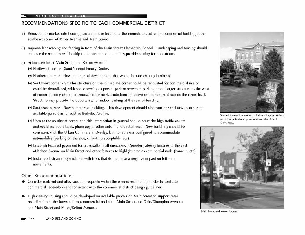
8) Improve landscaping and fencing in front of the Main Street Elementary School. Landscaping and fencing shouldenhance the school's relationship to the street and potentially provide seating for pedestrians.
9) At intersection of Main Street and Kelton Avenue:: Northwest corner - Saint Vincent Family Center.
: Northeast corner - New commercial development that would include existing business.
: Southwest corner - Smaller structure on the immediate corner could be renovated for commercial use or could be demolished, with space serving as pocket park or screened parking area. Larger structure to the west of corner building should be renovated for market rate housing above and commercial use on the street level. Structure may provide the opportunity for indoor parking at the rear of building.
: Southeast corner - New commercial building. This development should also consider and may incorporate available parcels as far east as Berkeley Avenue.
: Uses at the southeast corner and this intersection in general should court the high traffic counts and could include a bank, pharmacy or other auto-friendly retail uses. New buildings should be consistent with the Urban Commercial Overlay, but nonetheless configured to accommodate automobiles (parking on the side, drive-thru acceptable, etc).
: Establish textured pavement for crosswalks in all directions. Consider gateway features to the east of Kelton Avenue on Main Street and other features to highlight area as commercial node (banners, etc).
: Install pedestrian refuge islands with trees that do not have a negative impact on left turn movements.
Other Recommendations:: Consider curb cut and alley vacation requests within the commercial node in order to facilitate
commercial redevelopment consistent with the commercial district design guidelines.
: High density housing should be developed on available parcels on Main Street to support retail revitalization at the intersections (commercial nodes) at Main Street and Ohio/Champion Avenues and Main Street and Miller/Kelton Avenues.
Main Street and Kelton Avenue.
Second Avenue Elementary in Italian Village provides amodel for potential improvements at Main StreetElementary.
RECOMMENDATIONS SPECIFIC TO EACH COMMERCIAL DISTRICT
LAND USE AND ZONING 45
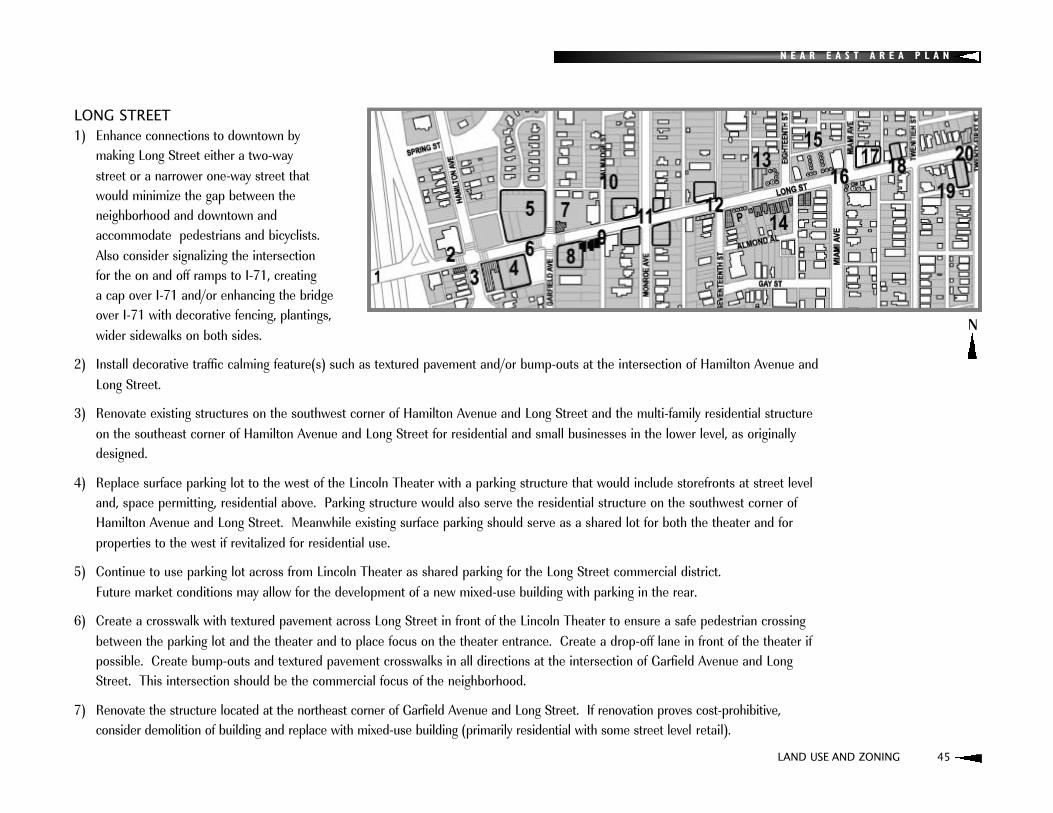
LONG STREET1) Enhance connections to downtown by
making Long Street either a two-way street or a narrower one-way street that would minimize the gap between the neighborhood and downtown and accommodate pedestrians and bicyclists. Also consider signalizing the intersection for the on and off ramps to I-71, creating a cap over I-71 and/or enhancing the bridgeover I-71 with decorative fencing, plantings,wider sidewalks on both sides.
2) Install decorative traffic calming feature(s) such as textured pavement and/or bump-outs at the intersection of Hamilton Avenue andLong Street.
3) Renovate existing structures on the southwest corner of Hamilton Avenue and Long Street and the multi-family residential structureon the southeast corner of Hamilton Avenue and Long Street for residential and small businesses in the lower level, as originallydesigned.
4) Replace surface parking lot to the west of the Lincoln Theater with a parking structure that would include storefronts at street leveland, space permitting, residential above. Parking structure would also serve the residential structure on the southwest corner ofHamilton Avenue and Long Street. Meanwhile existing surface parking should serve as a shared lot for both the theater and forproperties to the west if revitalized for residential use.
5) Continue to use parking lot across from Lincoln Theater as shared parking for the Long Street commercial district. Future market conditions may allow for the development of a new mixed-use building with parking in the rear.
6) Create a crosswalk with textured pavement across Long Street in front of the Lincoln Theater to ensure a safe pedestrian crossingbetween the parking lot and the theater and to place focus on the theater entrance. Create a drop-off lane in front of the theater ifpossible. Create bump-outs and textured pavement crosswalks in all directions at the intersection of Garfield Avenue and LongStreet. This intersection should be the commercial focus of the neighborhood.
7) Renovate the structure located at the northeast corner of Garfield Avenue and Long Street. If renovation proves cost-prohibitive, consider demolition of building and replace with mixed-use building (primarily residential with some street level retail).
N
N E A R E A S T A R E A P L A N

46 LAND USE AND ZONING
N E A R E A S T A R E A P L A N
8) Redevelop southeast corner of Long Street and Garfield Avenue with a new two (2)- to three (3)-story mixed-use building.
9) Preserve as single-family units with existing home occupation business. Renovate buildings, creating a consistentstreetscape element to unite buildings and allow home occupation business to hang shingle. Consider redevelopmentwith new higher density townhouses that would maintain the same orientation as the existing residential structures.
10) Talmadge Street should be revitalized as a residential street.
11) Redevelop all four-corners of Long Street and Monroe Avenue with two (2)- to three (3)-story residential or mixed use (storefronts with residential above) buildings.
12) Renovate storefronts at 17th and Long Streets. Redevelop northwest corner of 17th and Long Streets.
13) Renovate church on Long Street east of 17th Street for community use (new church, school, other community function). Other, secular uses such as housing or restaurant should be considered if community use is not economically feasible. In the case that renovation is cost-prohibitive, consider redevelopment of building that would at least preserve its facade. Green-space adjacent to church should be preserved and perhaps developed as a garden space with landscape feature to highlight the northwest corner of 17th Street and Long Street.
14) The south side of Long Street between 17th Street and Miami Avenue should remain residential. The vacant lot to the east of the building on the southeast corner of 17th Street and Long Street could potentially serve as parking forsaid corner building.
RECOMMENDATIONS SPECIFIC TO EACH COMMERCIAL DISTRICT

N E A R E A S T A R E A P L A N
LAND USE AND ZONING 47
15) Improve parking lot (pave and provide landscaping/screening) located on north side of Long Street, west of MiamiAvenue. Optimally, parking lot would be replaced with new building with parking in the rear.
16) Develop pocket park on the vacant lot on the southeast corner of Miami Avenue and Long Street.
17) Develop northeast corner of Miami Avenue and Long Street as a three(3)-story residential building.
18) Fill in gaps in between Miami Avenue and 20th Street with mixed-use buildings that reflect adjacent building types.
19) Develop new single family residential on vacant lots on the south side of Long Street in between 20th and 21st Streets.
20) Renovate building on northwest corner of 21st Street and Long Street.
Other recommendations:: Storefronts on Long Street should utilize the Lincoln Theater storefronts as an example for facade renovation.
: Consider moving the Elijah Pierce statue, located west of I-71 on Long Street, to a site of prominence along Long Street or in the adjacent neighborhood. Consider development of a pocket park/sculpture garden that highlights the statue. If statue is moved, mark current location with a plaque to note the location as the site of his barbershop.
: Consider extensions of proposed historic walking/biking trail (King-Lincoln District Plan) to the east and west along LongStreet.
: Utilize fiber optics along Long Street to spur economic development.
: As indicated in the Transportation section, conduct a community mobility plan/circulation study which would 1) analyze the impact of the impending changes to I-71 on traffic circulation throughout the neighborhood,
2) improve connections to neighborhoods to the south and north,
3) focus north/south traffic movements to areas where commercial revitalization is desired (Garfield and Long), and
4) reduce traffic movement through primarily residential areas.

48 LAND USE AND ZONING
N E A R E A S T A R E A P L A N
MOUNT VERNON AVENUE1) Redevelop the Whitney Young housing into housing
consistent with the housing design guidelines in this plan.
2) Facade improvements and renovation of buildings -commercial on street level with residential in upper stories.
3) Mixed use, two story development built to the sidewalk which would provide street level space for the OSU African American and AfricanStudies Community Extension Center and housingin upper stories.
4) The recommendation from the King-Lincoln District Plan (2002) is to "conduct a study to examine possible options for the future redesign and/or reconfiguration of the residential (and commercial) components of Mount Vernon Plaza so that they may become more integrated parts of the surrounding neighborhood". Additional considerations for the redesign should include:: Housing for existing residents would be maintained.
: Any redevelopment should be phased to minimize disturbance of existing and/or future residents.
: Any new development would be for a mixed-income community.
: Improvements that did not necessarily result in the demolition of any buildings, yet helped the commercial and/or housing at the site to better address Mt. Vernon Avenue would be desirable.
: Existing residents should be involved with any effort to develop a new design for the area.
: It is recognized that the use of the property is subject to U.S. Department of Housing and Urban Development regulations that ensure it provides housing for income-restricted residents. Any redesign would have to account for these restrictions and would likely be driven by market forces.
5) Facade and signage improvements. Screen any parking areas. Establish market rate housing in upper stories.
N
RECOMMENDATIONS SPECIFIC TO EACH COMMERCIAL DISTRICT
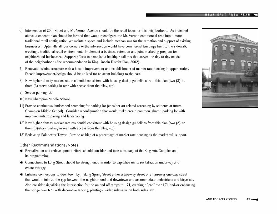
N E A R E A S T A R E A P L A N
LAND USE AND ZONING 49
6) Intersection of 20th Street and Mt. Vernon Avenue should be the retail focus for this neighborhood. As indicatedabove, a concept plan should be formed that would reconfigure the Mt. Vernon commercial area into a more traditional retail configuration yet maintain space and include mechanisms for the retention and support of existingbusinesses. Optimally all four corners of the intersection would have commercial buildings built to the sidewalk, creating a traditional retail environment. Implement a business retention and joint marketing program for neighborhood businesses. Support efforts to establish a healthy retail mix that serves the day-to-day needs of the neighborhood (See recommendation in King-Lincoln District Plan, 2002).
7) Renovate existing structure with a facade improvement and establishment of market rate housing in upper stories.Facade improvement/design should be utilized for adjacent buildings to the east.
8) New higher density market rate residential consistent with housing design guidelines from this plan (two (2)- to three (3)-story; parking in rear with access from the alley, etc).
9) Screen parking lot.
10) New Champion Middle School.
11) Provide continuous landscaped screening for parking lot (consider art-related screening by students at futureChampion Middle School). Consider reconfiguration that would make area a common, shared parking lot withimprovements to paving and landscaping.
12) New higher density market rate residential consistent with housing design guidelines from this plan (two (2)- to three (3)-story; parking in rear with access from the alley, etc).
13) Redevelop Poindexter Tower. Provide as high of a percentage of market rate housing as the market will support.
Other Recommendations/Notes:: Revitalization and redevelopment efforts should consider and take advantage of the King Arts Complex and
its programming.
: Connections to Long Street should be strengthened in order to capitalize on its revitalization underway and create synergy.
: Enhance connections to downtown by making Spring Street either a two-way street or a narrower one-way street that would minimize the gap between the neighborhood and downtown and accommodate pedestrians and bicyclists.Also consider signalizing the intersection for the on and off ramps to I-71, creating a "cap" over I-71 and/or enhancingthe bridge over I-71 with decorative fencing, plantings, wider sidewalks on both sides, etc.
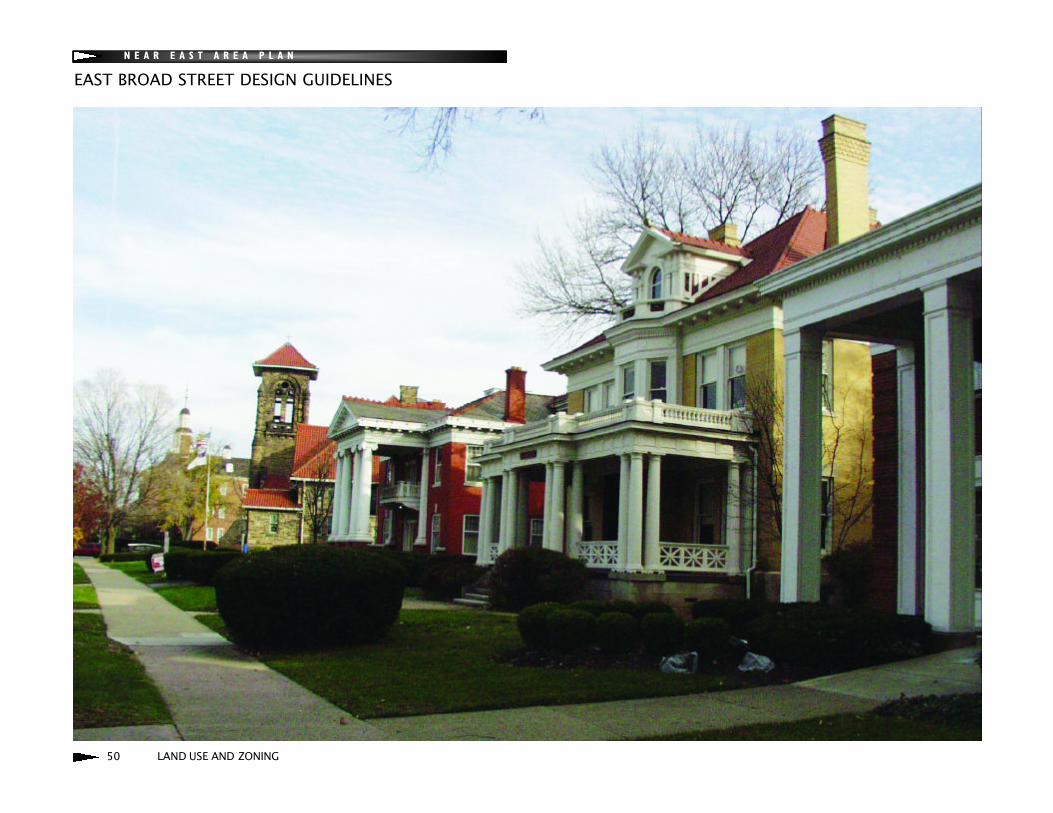
50 LAND USE AND ZONING
N E A R E A S T A R E A P L A N
EAST BROAD STREET DESIGN GUIDELINES

N E A R E A S T A R E A P L A N
STATEMENT OF INTENT
These are design guidelines primarily for the construction of new buildings on East Broad Street from I-71 to Alum Creek. Note that the preservation and restoration of existing historically significant and contributing buildings (defined on page 61) along East Broad Street remains a primary concern. To that end, refer to the Columbus Register of HistoricProperties Architectural Guidelines, Historic Resources Commission (HRC). The East Broad Street guidelines provide amore in-depth look at this great street than the more generic HRC guidelines (For land use recommendations see pages24-25 of the plan).
HOW TO USE: The East Broad Street guidelines express both community and city objectives and should be applied tothe development process. They are not meant to be constrictive or prescriptive, particularly in regards to contemporaryarchitecture.
ORGANIZATION: The section is organized in three parts: history, guidelines, and examples.
HISTORY: Snapshots taken from historical maps and other sources reveal that East Broad Street has undergone changewhile maintaining its rich architectural heritage.
GUIDELINES: The guidelines are intended as an articulation of elements that can be incorporated into new design.They are ordered so that the most important elements are up front. The initial elements such as setback, use of brick,and parking placement are most important; they should be incorporated whenever possible with other elements consid-ered. Contemporary expression is encouraged.
EXAMPLES: Examples show how on both East Broad Street and elsewhere in the city, the application of design elements in both contemporary and traditional expressions relate new buildings to historic setting.
LAND USE AND ZONING 51

N E A R E A S T A R E A P L A N
HISTORY
Since Columbus’ founding in 1812, Broad Street has been the city’s primary east-west thoroughfare. By the late 1800s and into the early decades of the 20th century, the high ground east of downtown Columbus became a preeminent site ofshowcase residences and other buildings such as churches and schools. These buildings reflected the architectural highstyles of their eras. Despite changes brought by forces of time, transportation, and uses, Broad Street retains a sense ofgrace and importance.
CHRONOLOGY The basis of this chronology are old maps that tell a story - snapshot of their eras. The following maps were used: 1899Baist’s (partial coverage); 1910 Baist’s; 1920 Baist’s; 1937 Franklin Atlas; 1922 Sanborn Insurance, updated to 1962; andGeographic Information System from the Franklin County Auditor’s Office (2004).
1899 - Near the end of the 19th century, the western end of East Broad Street was lined by brick mansions, larger residences and an occasional church. Residences were more sporadic toward the east end of Broad away from downtown. Across from the county fairgrounds (currently Franklin Park), the only remaining 19th century structure is the Home for the Aged. Eleven of the sixteen surviving 19th century buildings are west of 21st Street.
Italianate, Queen Anne, Romanesque, Chauteauesque and Greek Revival 19th century styles were seen along BroadStreet. The earliest existent structure is the Italianate at 1400 East Broad Street (1856). Refined Italianate houses were built from 1850 to 1880. They were succeeded by Queen Anne, Romanesque and Chauteauesque buildings thatreflected the exuberance of the 1890's. Slightly more restrained were Greek Revival and Neoclassical residences influenced by the Columbian Exposition in Chicago in 1893.
Architecture Columbus reports that, "East Broad Street was the premier residential street in Columbus in the late nineteenth century and the remaining homes from the era reflect that fact in a display of opulence and grandeur which is astounding." Successful men and their families inhabited these residences. William H. Jones who built a mansion at731 East Broad Street., was the founder of a dry goods and notions firm.
52 LAND USE AND ZONING
1400 E. Broad -- Italianate (c.1856)
965 E. Broad -- Queen Anne (c.1890)

N E A R E A S T A R E A P L A N
FRANKLIN PARK - In 1851, the Franklin County Agricultural Society purchased eight acres of land near Alum Creek for the purpose of the county fair grounds. This was later expanded to 93 acres. Now a city park, the grounds occupy significant frontage along Broad Street. The Beaux Arts conservatory was constructed in 1895.
1900-1920 - The first decades of the 20th century were a period of intense building on East Broad Street. By 1920, residences lined Broad Street almost continuously from Lexington Avenue to Alum Creek. The turrets, finials, and asymmetry of later decades of the 19th century gave way to symmetry, formalism and classicism reflected in ColonialRevival, Georgian Revival, Italian Renaissance Revival, Mediterranean Revival, Neoclassical and Beaux Arts.
The most prominent of these early 20th century residences is 1234 East Broad Street. Designed by Columbus' prolific architect, Frank Packard, the mansion was built in 1904 for Charles Lindenberg who made a great deal of his wealth as president of a company that was the world leader in supplying fraternal regalia. From 1919 to 1955, the mansion was used as the residence of the Governor of Ohio.
By the late 1910s, as some of the residences reached maturity, a new trend began. Property was assembled, houses demolished and higher density walk-up apartments were constructed. Other styles of note during this time were Prairie and Tudor. There are a few Prairie-style houses, possibly the first modern residential style, whose horizontal lines can betraced to Frank Lloyd Wright.
1921-1937 - The 1937 Franklin Atlas shows the designation of Broad Street as U.S. Route 40, which was the major national east-west highway prior to the interstate system. U.S. Route 40 largely followed the old National Road, althoughthis segment of the National Road followed Main Street to the south. U.S. 40 was routed up from Main Street in neighboring Bexley to Broad Street into downtown.
As the primary east-west highway, Broad Street began to serve the motoring public. By 1937, eight filling stations were built on Broad Street, with four in the vicinity of Broad and Nelson alone. While Broad Street retained mostly single-family residences, a few new offices were built on the western end and some of the older structures were converted to new uses such as offices and funeral homes.
LAND USE AND ZONING 53
731 E. Broad -- Chauteauesque (1889)
1234 E. Broad -- Georgian Revival withRenaissance Revival Influences (1904)
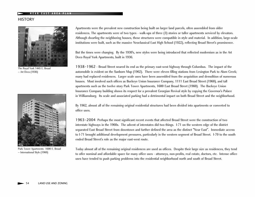
N E A R E A S T A R E A P L A N
HISTORY
Apartments were the prevalent new construction being built on larger land parcels, often assembled from older residences. The apartments were of two types - walk-ups of three (3) stories or taller apartments serviced by elevators.Although dwarfing the neighboring houses, these structures were compatible in style and material. In addition, large-scaleinstitutions were built, such as the massive Neoclassical East High School (1922), reflecting Broad Street's prominence.
But the times were changing. By the 1930's, new styles were being introduced that reflected modernism as in the ArtDeco Royal York Apartments, built in 1936.
1938-1962 - Broad Street neared its end as the primary east-west highway through Columbus. The impact of the automobile is evident on the Sanborn Map (1962). There were eleven filling stations from Lexington Park to Alum Creek;many had replaced residences. Larger scale uses have been assembled from the acquisition and demolition of numeroushouses. Most involved such offices as Buckeye Union Insurance Company, 1111 East Broad Street (1960), and tall apartments such as the twelve story Park Tower Apartments, 1600 East Broad Street (1960). The Buckeye UnionInsurance Company building shows its respect for a prevalent Georgian Revival style by copying the Governor's Palace in Williamsburg. Its scale and associated parking had a detrimental impact on both Broad Street and the neighborhood.
By 1962, almost all of the remaining original residential structures had been divided into apartments or converted tooffice uses.
1963-2004 Perhaps the most significant recent events that affected Broad Street were the construction of two interstate highways in the 1960s. The advent of interstates did two things. I-71 on the western edge of the district separated East Broad Street from downtown and further defined the area as the distinct "Near East”. Immediate accessto I-71 brought additional development pressures, particularly in the western segment of Broad Street. I-70 to the southended Broad Street's role as the major east-west route.
Today almost all of the remaining original residences are used as offices. Despite their large size as residences, they tendto offer nominal and affordable space for many office uses - attorneys, non-profits, real estate, doctors, etc. Intense officeuses have tended to push parking problems into the residential neighborhood north and south of Broad Street.
54 LAND USE AND ZONING
The Royal York 1445 E. Broad -- Art Deco (1936)
Park Tower Apartments 1600 E. Broad -- International Style (1960)

N E A R E A S T A R E A P L A N
WHEN TO USE THESE GUIDELINESThe following design elements should be used in new construction that will be appropriate to historic East Broad Street.These elements are based upon characteristics of the existing built environment.
APPLICABILITYThese guidelines are applicable on both sides of East Broad Street from I-71 to Alum Creek. Please keep in mind that measurements in the guidelines are based on field observations, photography, and the use of reasonably accurate historical maps and Geographical Information Systems maps. They are meant to provide a general idea of measure -allow for deviation (+/- 10 to 20%).
SETBACKThere is a variation of building setbacks along Broad Street, from zero feet at some properties in the western segment, to over one hundred sixty (160) feet at the Royal York apartments. Building setbacks are generally consistent in definedareas. The setbacks of adjacent buildings will be slightly different. Setbacks should be within the range of neighboringbuildings.
SITE/DEVELOPMENT CAPACITYIn order that buildings fit the area, they should neither be too large or small for the site. Building and parking setbacks,building height and parking requirements all contribute to development capacity constraints.
PARKINGWhenever possible, parking should be placed behind the building, without extending it into the neighborhood. At minimum, parking should be placed behind the setback line and screened using combinations of mounding, landscaping,fencing or low walls. A parking lot should not be placed in front of a building. Reduce curb cuts and drives along Broad Street.
MATERIALBrick is strongly suggested as the main exterior building material since about three-fourths of the buildings use brick with colors ranging from red to brown to salmon to buff. Limestone, granite and stucco are also used.
DESIGN GUIDELINES
LAND USE AND ZONING 55
Brick is the overwhelmingly predominant exterior material with the use of stucco andhalf-timbers with gable ends.
The Columbus Foundation skillfully tucks itsparking behind a rise in elevation as well asextensive landscaping.

N E A R E A S T A R E A P L A N
DESIGN GUIDELINES
HEIGHT & STORIESAlmost all of the original homes were two- and one-half (2 1/2) stories; the half story coming from habitable space underneath steeply pitched roofs with dormered windows. The typical height was forty (40) to fifty-five (55) feet.Exceptions to this were two (2)-story Italianate houses with high ceilings and low pitched hipped roofs. More variation came later with the advent of apartment buildings with flat roofs and more stories (three (3) to four (4) story walkups and eight (8)- to twelve (12)-story apartments serviced by elevators).
Roof type and shape: Most of the older houses are defined by steeply pitched, complicated roofs accented by dormers and intricate chimneys. The plans were not simple rectangles, but typically had multiple projections and bays.Hipped roofs are the predominant roof form. The general exception to this is flat roofs with parapets on apartment buildings three stories or taller.
Typical roof pitch: Roof slopes range from 8/12 to 15/12 with an average of 10/12. Slopes typically vary fromhouse to house.
Dormers: All of the two and one half (2 1/2) story former residences are defined by dormers of various types; hipped, gabled, parapet, etc. All of the dormers have windows in one form or another; paired, row of three, row of four, Palladian,arched, etc.
Elevation: Ground floors are elevated off of the ground by two (2) to three (3) feet. This gives porches and entrances agreater sense of prominence. Frequently, this base is articulated by a different material (stone) or coursing. Often theground is terraced down to the street.
Building width: General building widths of original houses range from thirty-five (35) to forty-five (45) feet.
Space between buildings: In general these houses are separated by a range of fifteen (15) to twenty (20) feet.
56 LAND USE AND ZONING
1706 E. Broad -- Note the ground floor in relationship to the ground.
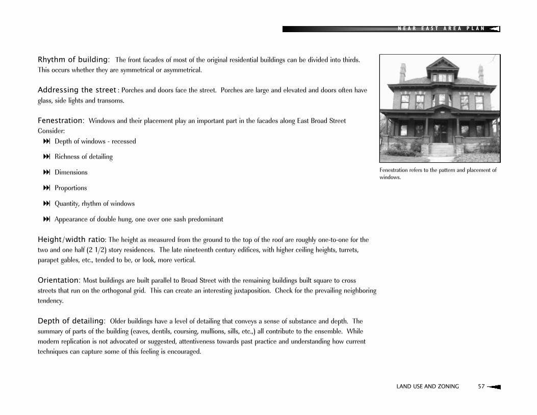
N E A R E A S T A R E A P L A N
Rhythm of building: The front facades of most of the original residential buildings can be divided into thirds. This occurs whether they are symmetrical or asymmetrical.
Addressing the street : Porches and doors face the street. Porches are large and elevated and doors often haveglass, side lights and transoms.
Fenestration: Windows and their placement play an important part in the facades along East Broad Street Consider:: Depth of windows - recessed
: Richness of detailing
: Dimensions
: Proportions
: Quantity, rhythm of windows
: Appearance of double hung, one over one sash predominant
Height/width ratio: The height as measured from the ground to the top of the roof are roughly one-to-one for thetwo and one half (2 1/2) story residences. The late nineteenth century edifices, with higher ceiling heights, turrets, parapet gables, etc., tended to be, or look, more vertical.
Orientation: Most buildings are built parallel to Broad Street with the remaining buildings built square to cross streets that run on the orthogonal grid. This can create an interesting juxtaposition. Check for the prevailing neighboringtendency.
Depth of detailing: Older buildings have a level of detailing that conveys a sense of substance and depth. The summary of parts of the building (eaves, dentils, coursing, mullions, sills, etc.,) all contribute to the ensemble. While modern replication is not advocated or suggested, attentiveness towards past practice and understanding how currenttechniques can capture some of this feeling is encouraged.
LAND USE AND ZONING 57
Fenestration refers to the pattern and placement ofwindows.

N E A R E A S T A R E A P L A N
DESIGN GUIDELINES
SIGNAGEGround signs are recommended when identifying buildings set back from the street which is usually the case with former residences. The two variations of ground signs advocated are the monument and two pole and are provisions of theColumbus Graphics Code. Consider:: Dimensions - height, width
: Appropriate distance from the street
: Quality - excluding certain materials
: Lighting - screen sources by landscaping
: Color and contrast
: Lettering size
LANDSCAPING AND OTHER SITE FEATURES: Trees
: Fences - wrought iron, steel to resemble wrought iron
: Dumpsters - screen from view from street by placement and brick walls
: Air conditioning units - Screen from view from the street. Rooftop units should use high parapet or other architectural devices
58 LAND USE AND ZONING
Low fence at 957 E. Broad St.
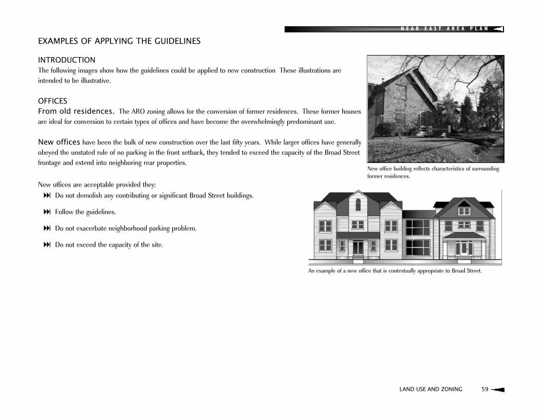
N E A R E A S T A R E A P L A N
INTRODUCTIONThe following images show how the guidelines could be applied to new construction These illustrations are intended to be illustrative.
OFFICES From old residences. The ARO zoning allows for the conversion of former residences. These former housesare ideal for conversion to certain types of offices and have become the overwhelmingly predominant use.
New offices have been the bulk of new construction over the last fifty years. While larger offices have generallyobeyed the unstated rule of no parking in the front setback, they tended to exceed the capacity of the Broad Streetfrontage and extend into neighboring rear properties.
New offices are acceptable provided they: : Do not demolish any contributing or significant Broad Street buildings.
: Follow the guidelines.
: Do not exacerbate neighborhood parking problem.
: Do not exceed the capacity of the site.
EXAMPLES OF APPLYING THE GUIDELINES
LAND USE AND ZONING 59
An example of a new office that is contextually appropriate to Broad Street.
New office building reflects characteristics of surroundingformer residences.
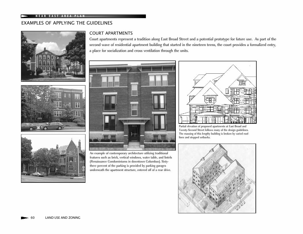
N E A R E A S T A R E A P L A N
EXAMPLES OF APPLYING THE GUIDELINES
60 LAND USE AND ZONING
COURT APARTMENTSCourt apartments represent a tradition along East Broad Street and a potential prototype for future use. As part of the second wave of residential apartment building that started in the nineteen teens, the court provides a formalized entry, a place for socialization and cross ventilation through the units.
An example of contemporary architecture utilizing traditional features such as brick, vertical windows, water table, and lintels(Renaissance Condominiums in downtown Columbus). Sixty-three percent of the parking is provided by parking garagesunderneath the apartment structure, entered off of a rear drive.
Partial elevation of proposed apartments at East Broad andTwenty-Second Street follows many of the design guidelines. The massing of this lengthy building is broken by varied roof- lines and stepped setbacks.

N E A R E A S T A R E A P L A N
LOWER DENSITY RESIDENCESNew single family houses: Single-family houses are a use-by-right inthe ARO district. If new single family houses are built on Broad Street, theyshould match the massing, detail and material of the older existing housing.
Apartments or condominiums massed to resemble original houses.In the elevation to the right, a single front door goes to an interior foyer andstairs lead to all units.
LAND USE AND ZONING 61
New house on Neil Avenue in Victorian Village.
EAST BROAD STREET ASSESSMENT
Significant - HistoricalContributingIntrusionEast Broad St. Historic Districts Historic District Evaluation for the Cityof Columbus, 1989
N

N E A R E A S T A R E A P L A N
62 HOUSING AND HISTORIC PRESERVATION
HOUSING AND HISTORIC PRESERVATION

N E A R E A S T A R E A P L A N
The Near East Side includes some of Columbus' most impressive housing, including the mansions of Columbus' past elite alongside workingman's Arts and Crafts bungalows, American Four Squares and a variety of other architectural gems. This housing stock simply cannot be recreated and is one of the strongest assets of the area.
It is the desirability of this architecture, along with the Near East Side's proximity to downtown and other factors thatposition it for significant neighborhood revitalization. This revitalization will bring benefits such as increased investmentin housing and commercial districts and other economic opportunities. The challenge is to ensure that both existing andfuture residents recognize these benefits. After a review of existing conditions, the Housing and Historic Preservation section presents issues, policies, and strategies designed to meet this challenge. Housing design guidelines are then presented to guide the form of new housing construction.
EXISTING CONDITIONSHousing Stock ConditionsData from the Franklin County Auditor were utilized to illustrate housing conditions throughout the Near East Side (see Table 2 and Figure 6). The distribution of housing in deteriorated, average/fair, good, and very good condition is relativelyconsistent throughout each of the Near East Side districts. The large majority (91 percent) of homes on the Near EastSide are in either average/fair or good condition. Approximately six percent are ranked as deteriorated and five percentas very good. The Northwest District (1) had the highest number of homes (eleven percent) ranked in the deterioratedcategory, with the Northeast District (2) having the lowest number (three percent) of deteriorated rankings. All four districts have about the same percentage of homes in the very good category (five or six percent).
Table 2. Housing Conditions on the Near East Side*
Housing Near East Northwest Northeast Southwest SoutheastCondition Side District (1) District (2) District (3) District (4)
Deteriorated 6% 11% 3% 7% 5%
Average/Fair 66% 67% 67% 59% 68%
Good 25% 17% 27% 27% 25%
Very Good 5% 6% 5% 6% 5%
*Percentages in this table represent the percentage of homes in each category (deteriorated, average/fair, good, or very good) relative to the actual numbers of homesranked by field inspectors with the Franklin County Auditor's Office. Percentages do not add up to 100 percent due to the rounding of numbers.
HOUSING AND HISTORIC PRESERVATION 63

64 HOUSING AND HISTORIC PRESERVATION
N E A R E A S T A R E A P L A N
HOUSING CONDITIONS
Very Good
Good
Average
Fair
*Housing conditions information based on Franklin County Auditor’s parcel data
Figure 6
N
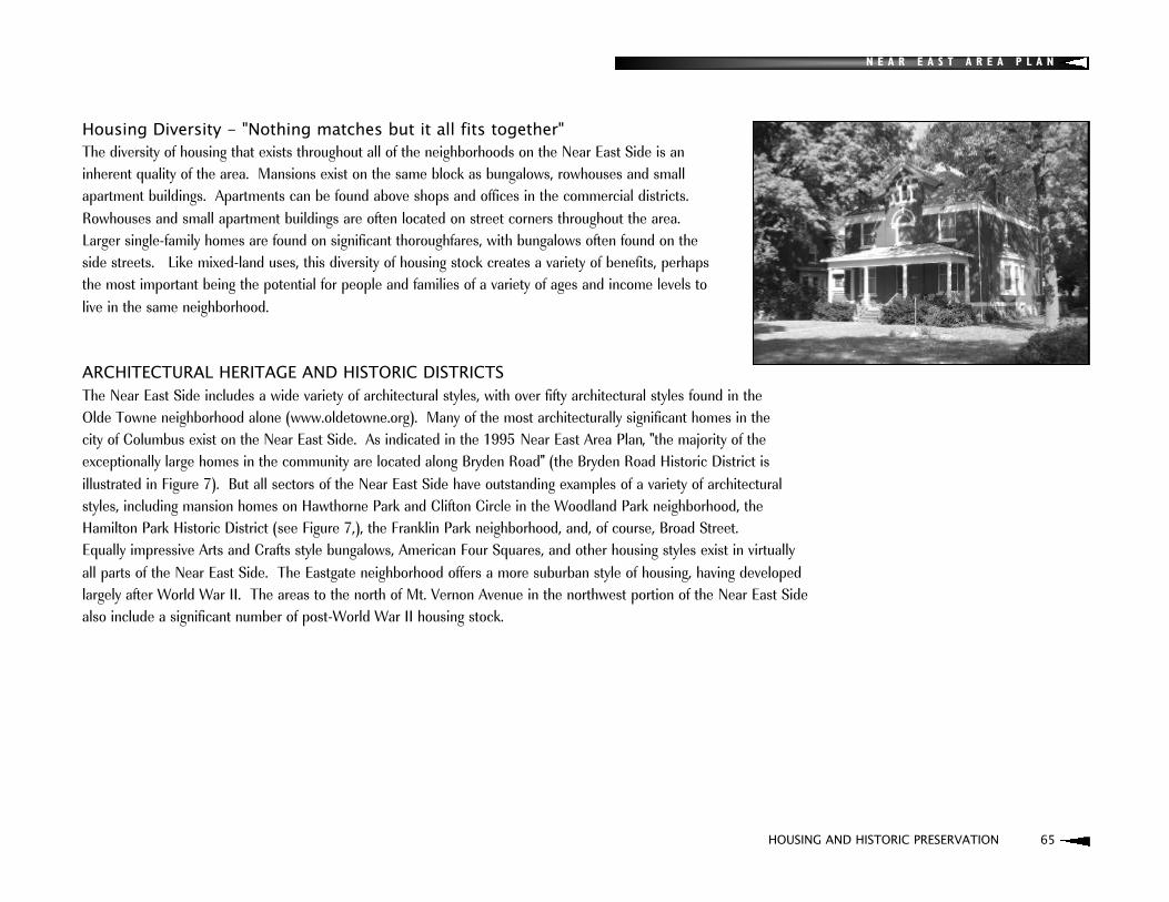
N E A R E A S T A R E A P L A N
HOUSING AND HISTORIC PRESERVATION 65
Housing Diversity - "Nothing matches but it all fits together"The diversity of housing that exists throughout all of the neighborhoods on the Near East Side is an inherent quality of the area. Mansions exist on the same block as bungalows, rowhouses and small apartment buildings. Apartments can be found above shops and offices in the commercial districts.Rowhouses and small apartment buildings are often located on street corners throughout the area. Larger single-family homes are found on significant thoroughfares, with bungalows often found on the side streets. Like mixed-land uses, this diversity of housing stock creates a variety of benefits, perhaps the most important being the potential for people and families of a variety of ages and income levels to live in the same neighborhood.
ARCHITECTURAL HERITAGE AND HISTORIC DISTRICTSThe Near East Side includes a wide variety of architectural styles, with over fifty architectural styles found in the Olde Towne neighborhood alone (www.oldetowne.org). Many of the most architecturally significant homes in the city of Columbus exist on the Near East Side. As indicated in the 1995 Near East Area Plan, "the majority of the exceptionally large homes in the community are located along Bryden Road" (the Bryden Road Historic District is illustrated in Figure 7). But all sectors of the Near East Side have outstanding examples of a variety of architectural styles, including mansion homes on Hawthorne Park and Clifton Circle in the Woodland Park neighborhood, the Hamilton Park Historic District (see Figure 7,), the Franklin Park neighborhood, and, of course, Broad Street. Equally impressive Arts and Crafts style bungalows, American Four Squares, and other housing styles exist in virtually all parts of the Near East Side. The Eastgate neighborhood offers a more suburban style of housing, having developedlargely after World War II. The areas to the north of Mt. Vernon Avenue in the northwest portion of the Near East Sidealso include a significant number of post-World War II housing stock.
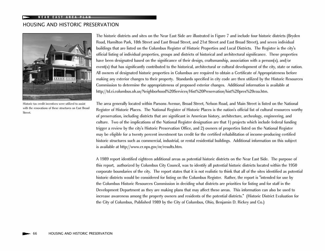
N E A R E A S T A R E A P L A N
66 HOUSING AND HISTORIC PRESERVATION
HOUSING AND HISTORIC PRESERVATION
The historic districts and sites on the Near East Side are illustrated in Figure 7 and include four historic districts (BrydenRoad, Hamilton Park, 18th Street and East Broad Street, and 21st Street and East Broad Street), and seven individualbuildings that are listed on the Columbus Register of Historic Properties and Local Districts. The Register is the city'sofficial listing of individual properties, groups and districts of historical and architectural significance. These propertieshave been designated based on the significance of their design, craftsmanship, association with a person(s), and/orevent(s) that has significantly contributed to the historical, architectural or cultural development of the city, state or nation.All owners of designated historic properties in Columbus are required to obtain a Certificate of Appropriateness beforemaking any exterior changes to their property. Standards specified in city code are then utilized by the Historic ResourcesCommission to determine the appropriateness of proposed exterior changes. Additional information is available athttp://td.ci.columbus.oh.us/Neighborhood%20Services/Hist%20Preservation/hist%20pres%20coa.htm.
The area generally located within Parsons Avenue, Broad Street, Nelson Road, and Main Street is listed on the NationalRegister of Historic Places. The National Register of Historic Places is the nation's official list of cultural resources worthyof preservation, including districts that are significant in American history, architecture, archeology, engineering, and culture. Two of the implications of the National Register designation are that 1) projects which include federal fundingtrigger a review by the city's Historic Preservation Office, and 2) owners of properties listed on the National Register may be eligible for a twenty percent investment tax credit for the certified rehabilitation of income-producing certified historic structures such as commercial, industrial, or rental residential buildings. Additional information on this subject is available at http://www.cr.nps.gov/nr/results.htm.
A 1989 report identified eighteen additional areas as potential historic districts on the Near East Side. The purpose ofthis report, authorized by Columbus City Council, was to identify all potential historic districts located within the 1950corporate boundaries of the city. The report states that it is not realistic to think that all of the sites identified as potential historic districts would be considered for listing on the Columbus Register. Rather, the report is "intended for use by the Columbus Historic Resources Commission in deciding what districts are priorities for listing and for staff in theDevelopment Department as they are making plans that may affect these areas. This information can also be used toincrease awareness among the property owners and residents of the potential districts." (Historic District Evaluation forthe City of Columbus, Published 1989 by the City of Columbus, Ohio, Benjamin D. Rickey and Co.)
Historic tax credit incentives were utilized to assistwith the renovations of these structures on East BroadStreet.

HOUSING AND HISTORIC PRESERVATION 67
HISTORIC DISTRICTS AND SITES
Historic Sites
Columbus Register of Historic Properties
National Register of HistoricPlaces
Figure 7
N
N E A R E A S T A R E A P L A N

N E A R E A S T A R E A P L A N
68 HOUSING AND HISTORIC PRESERVATION
HOUSING AND HISTORIC PRESERVATION
SUBSIDIZED HOUSINGAs indicated in the Land Use section, approximately fifteen percent of the land in the Northwest District (1) is owned bythe Columbus Metropolitan Housing Authority. Poindexter Village, one of the first subsidized housing projects in thecountry, is located in the Northeast District (2). According to a housing analysis funded by the Columbus Compact in2002, the Near East Side has 2,129 subsidized rental units, which is 61percent of the total in the Empowerment Zonecommunities. The subsidized housing of the neighborhood ensures housing for low- to moderate-income populations. A challenge posed by the concentration of subsidized housing is the high level of management required to ensure it does not hinder neighborhood revitalization, including the development of new market rate housing. As indicated below,the effort of Community Properties of Ohio Management Services (Community Properties) to renovate existing Section 8units, provide an attentive management service, and offer supportive services for tenants serves as a model of how tomeet the challenge of areas with concentrations of subsidized housing.
NEW DEVELOPMENTIn recent years, several new housing developments have been built or are being developed or planned. These developments provide an indication of the potential success for market rate housing and offer sound models forfuture development. The developments include:
Taylor Homes: A $60 million project that will bring more than 100 single-family homes and apartments to TaylorAvenue. The project is developing new homes on vacant lots, renovating existing homes in poor condition, or demolishing irreparable homes and building new homes in their place.
Twentieth and Long Condominiums: A historic structure at the corner of Twentieth and Long Streets was recently renovated into eight luxury condominiums.
Development at 18th and Main Street: Multi-story market rate apartments have been proposed at a vacant property at 18th and Main Street.
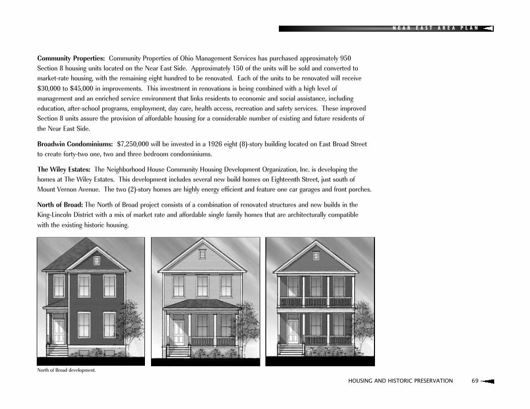
N E A R E A S T A R E A P L A N
HOUSING AND HISTORIC PRESERVATION 69
Community Properties: Community Properties of Ohio Management Services has purchased approximately 950 Section 8 housing units located on the Near East Side. Approximately 150 of the units will be sold and converted to market-rate housing, with the remaining eight hundred to be renovated. Each of the units to be renovated will receive$30,000 to $45,000 in improvements. This investment in renovations is being combined with a high level of management and an enriched service environment that links residents to economic and social assistance, including education, after-school programs, employment, day care, health access, recreation and safety services. These improvedSection 8 units assure the provision of affordable housing for a considerable number of existing and future residents ofthe Near East Side.
Broadwin Condominiums: $7,250,000 will be invested in a 1926 eight (8)-story building located on East Broad Streetto create forty-two one, two and three bedroom condominiums.
The Wiley Estates: The Neighborhood House Community Housing Development Organization, Inc. is developing thehomes at The Wiley Estates. This development includes several new build homes on Eighteenth Street, just south ofMount Vernon Avenue. The two (2)-story homes are highly energy efficient and feature one car garages and front porches.
North of Broad: The North of Broad project consists of a combination of renovated structures and new builds in theKing-Lincoln District with a mix of market rate and affordable single family homes that are architecturally compatible with the existing historic housing.
North of Broad development.

N E A R E A S T A R E A P L A N
70 HOUSING AND HISTORIC PRESERVATION
HOUSING AND HISTORIC PRESERVATION PLAN
The housing and historic preservation plan strives to strike a balance between the general goals of 1) fostering historicallyappropriate revitalization of existing housing stock and increased amounts of market rate infill housing with 2) the need tomaintain sound housing for all income levels in the area and avoid the displacement of existing residents. This is one ofthe greatest challenges faced by communities in the process of change such as the Near East Side. Housing designguidelines, presented after this section, will be one of the primary tools that help to ensure appropriate market rate andaffordable infill housing without presenting an extraordinary burden on potential developers. An immediate need on theNear East Side is to increase the number of market rate residential units. For the purpose of this plan, market rate shouldbe considered housing developed with price points aimed at individuals or families earning 80% to 120% of the AreaMedian Income. For 2005, 100% of the Area Median Income for a family of four is $ 63,800 and 80% of the AreaMedian Income is $35,850 for individuals and $51,200 for a family of four. Market rate could include proposed housingthat includes subsidies that would reduce the price for the purchaser, yet still increase the market for the neighborhood.
Specifically the plan identifies policies and accompanying strategies for dealing with the following key issues: 1) Low percentage of owner-occupied housing units.
2) Deteriorating housing conditions, vacant structures, and inappropriate alterations and renovations.
3) Vacant lots and the potential for incompatible infill development.
4) Potential displacement of area residents and potential shortage of affordable housing.
5) Areas with high concentrations of poverty and low income housing.
The overall goals of the Housing and Historic Preservation Plan:: Maintain sound housing for all income levels in the area and avoid the displacement of existing residents, particularly
senior citizens.
: Develop new housing that is compatible with the existing architecture.
: Preserve existing housing stock and achieve a reduced rate of housing demolition.
: Rehabilitate abandoned, boarded-up, and vacant housing units.

N E A R E A S T A R E A P L A N
HOUSING AND HISTORIC PRESERVATION 71
ISSUE 1:Low percentage of owner-occupied housing units
POLICYRecognizing that renters are valued members of the Near East Side, increased levels of homeownership are desired forincreased stability and other benefits.
STRATEGIES: Encourage private and public investments as a means to increase homeownership and rehabilitate vacant housing
units.
: Develop a mix of affordable and market rate single-family infill housing (single-family detached, townhomes, and condominiums), based on the housing design guidelines from this plan, to provide renters an opportunity to move into homeownership and bring new homeowners into the area. Initial focus should be on increased numbers of market rate units.
: Promote the city housing incentive programs available for renovations and new construction to local developers andhomeowners.
: Develop marketing strategies to lure new homeowners into the area, including brochures, house and neighborhoodtours, interpersonal efforts, church-related outreach, and other efforts.
: Support existing community development corporations and other developers with the development of new and rehabilitated infill owner-occupied housing consistent with the housing design guidelines presented in this plan.
: Support the reconversion of single-family homes that have been converted to multi-family housing back to single-family.

N E A R E A S T A R E A P L A N
72 HOUSING AND HISTORIC PRESERVATION
HOUSING AND HISTORIC PRESERVATION PLAN
ISSUE 2:Deteriorating housing conditions, vacant structures, and inappropriate alterations and renovations
POLICYThe preservation and renovation of the existing historic housing stock is a crucial aspect of the revitalization of the NearEast Side. Renovations should be consistent with the historic character of the area's housing.
STRATEGIES: Encourage area residents to rehabilitate their homes as a means of supporting revitalization efforts in the community.
Inform area residents of private and public loan and grant dollars available for housing rehabilitation.
: Encourage code changes that require property owners to comply with exterior housing code standards for both occupied and unoccupied structures.
: Promote the availability of funds and programs that provide assistance to residents and property owners wanting to rehabilitate their historic structures.
: Encourage preservation and renovation of historic structures rather than demolition.
: Promote relocation of sound historic structures to vacant parcels within the neighborhood as a last resort before demolition.
: Enhance communication with code enforcement officers through the participation of neighborhood organizations and block watches which would notify code enforcement officer of priority issues and property owners of potentialassistance programs.
: Cooperate with existing community development corporations to investigate the potential of establishing small scale community reinvestment areas which could be used to renovate existing structures (additionally, see strategy belowregarding infill housing development).
: Utilize the housing design guidelines in this plan for guidance with appropriate housing renovation.
: Support city efforts to establish new code and programs which would spur the redevelopment of vacant homes.

N E A R E A S T A R E A P L A N
HOUSING AND HISTORIC PRESERVATION 73
ISSUE 3:Vacant lots and the potential for incompatible infill development
POLICYNew housing should be compatible with the historical urban environment in order to enhance the revitalization of theNear East Side.
STRATEGIES: New housing should abide by the housing design guidelines presented in this plan.
: Work with developers and non-profit organizations to develop models of various types of housing, including single-family, townhouses and multi-family that demonstrate how good design could be used to create a mix of economicallyfeasible affordable and market rate housing.
: Cooperate with existing community development corporations to investigate the potential of establishing small scale community reinvestment areas which could be used to construct new infill housing consistent with the housing designguidelines in this plan along with the renovation of existing structures (as indicated above).
: Utilize field trips and other educational efforts with developers, existing community development corporations, andothers to view good examples of successful infill projects in Columbus and other locations.

N E A R E A S T A R E A P L A N
74 HOUSING AND HISTORIC PRESERVATION
HOUSING AND HISTORIC PRESERVATION PLAN
ISSUE 4:Potential displacement of area residents, particularly seniors, and potential shortage of affordable housing as a result of historic designation or other reasons
POLICY The revitalization of the Near East Side should provide housing opportunities for all income levels and contribute toenhanced economic opportunity for all residents
STRATEGIES: Maintain quality housing for all income levels, particularly existing residents and senior citizens.
: Work with local agencies to organize residents so they can play a role in appropriately channeling new growth andtake advantage of new economic development opportunities that come as a result of revitalization, i.e., the creation of new businesses, obtaining new jobs, etc.
: Work with local agencies and civic groups to assist with organizing local residents to raise awareness of home buyingand selling strategies, available affordable housing stock, home buying assistance programs, etc.
: Work with Community Properties and other organizations to assist with the implementation of new programs andefforts in support of Section 8 housing on the Near East Side to assure long-term, well maintained housing for thosein need of subsidized housing.
: Work with the city's Land Bank to assure that a percentage of infill housing developed on Land Bank property isaffordable for lower and moderate income individuals/families.
N E A R E A S T A R E A P L A N
HOUSING AND HISTORIC PRESERVATION 75
ISSUE 5: Areas with high concentrations of poverty and low income housing
POLICYSupport the development of new market rate single family and rental housing to help create a balanced amount of housing for all income levels.
STRATEGIES: Discourage high concentrations of very low-income housing.
: Implement previously described strategies to increase the production of market rate housing throughout the area.
: Support the deconcentration of subsidized housing, if such opportunity arises.

A new house under construction on the Near EastSide that provides an excellent example of compatibleinfill housing.
N E A R E A S T A R E A P L A N
76 HOUSING AND HISTORIC PRESERVATION
HOUSING DESIGN GUIDELINES
The primary goal of the housing design guidelines is to educate both community members and developers about appropriate housing for the Near East Side and prevent the construction of new housing that is incompatible with thescale, architecture, and general character of the neighborhood. The guidelines provide a general framework for evaluatingproposed infill housing and form a basis for consistent, informed decision-making.
The guidelines are meant to provide enough flexibility that they will not pose an extraordinary financial burden on potential developers. To the contrary, having a clear vision of acceptable housing design upfront should play a key role inavoiding potential conflict between developers and neighborhood leaders. This will help to streamline the developmentprocess and encourage neighborhood preservation and enhancement through redevelopment of blighted, distressed, andunderutilized properties.
COMPATIBILITYThe overall goal for incorporating new construction into the neighborhood is compatibility, not imitation or the creation of a false historic appearance. The ideal is quality design that conforms to the existing building patterns and "rhythm" of thearea, yet maintains its own identity as a new home. Compatibility means the existing homes will be used to determinethe appropriate height, massing/scale, materials, porches, roof pitch, setbacks, and window and door proportions for thenew construction. A brief description of the important considerations for each of these guidelines is given below. Theguidelines are presented in alphabetical order, not order of importance.
HEIGHTNew construction should be similar in height to surrounding structures. The new building's height should not exceed thetallest, nor be smaller than the shortest structure. Major elements should also align; a new porch should be as high as adjacent porches (porch decks on historic homes are often more than two point five (2.5) feet above the ground). Tallerbuildings shall step down to provide a height transition to existing adjacent (single-story) buildings. The orientation of thefacade of the new construction (horizontal or vertical) should also reflect the existing buildings.
Varied, yet compatible, building heights on the sameblock.
Height
Not appropriate

N E A R E A S T A R E A P L A N
HOUSING AND HISTORIC PRESERVATION 77
MASSING/SCALEThe size, proportions, and massing of a new building should be compatible with nearby structures. Carefully studying thesize, shape, and massing of neighboring buildings contributes to a successful, compatible new structure.
MATERIALSThe choice of materials should be guided by the predominant materials of adjacent structures. Continuity of material adds to the unity and harmonious character of a district. Simplicity is preferred. Where brick predominates in nearby structures,choose brick for the new construction. If frame predominates, choose frame. Vinyl siding and Hardiplank are acceptable, but appropriately scaled window and other trim should be used to ensure compatibility. The same materials should be used on all four sides of the structure (avoid brick on the front with vinyl on the sides and back). Although additions to residential structures may be either frame or brick, frame is preferred.
PORCHESDesign new homes with porches that repeat the proportions, depth (seven (7) - ten (10) feet), and materials of nearby homes. As previously indicated, a new porch should be as high as nearby porches. The decorativedetailing does not need to duplicate historic porches, but the new porchshould have support posts and balustrades that repeat the shape, thicknessand spacing of nearby porches. New decks and unfinished pressure-treatedlumber should not be visible from adjoining streets or public sidewalks.
ROOF PITCH - Roof pitch, height, and shape should be compatible withthose on surrounding structures. Generally, no roof pitch less than six over 12 is appropriate. Optimally, new construction should also repeat thepredominant dormer and chimney features found in the immediate area.
MassingBreak up uninteresting boxlike forms into smaller, varied masses similar to those found on nearby buildings
Roof Pitch
Porches
Not appropriate
Better
New construction on the Near East Side which provides an example of acceptable massing.

N E A R E A S T A R E A P L A N
HOUSING DESIGN GUIDELINES
SETBACKS The building's front and side setbacks (distance the building is from front and side lot lines) should be similar to those of adjacent buildings (no more shallow than the shallowest setback on the block and no further than the longest setbackon the block). This alignment gives a sense of unity to the buildings and strengthens the streetscape. Additionally, the orientation of new construction should be consistent with that of the existing homes, i.e., when the existing homes on a block are located at an angle to the street the new home(s) should match the existing angle.
WINDOWS AND DOORSThe size, height, width, and spacing of windows, doors and other entries in the new building should be compatible with those from nearby blocks. Double hung windows are the predominant form found on the Near East Side and are often the most appropriate for new construction and renovation. Examples from the wider neighborhood should be sought when the majority of windows on the given block have been replaced with inappropriate window types/sizes.Appropriately scaled window trim on frame houses, traditional window head and sill details on brick houses, and the use of porches and porticos helps to create interesting housing facades. In cases where side setbacks are particularlyshallow, windows on the side of the house should be positioned to ensure privacy between the new building and neighboring structures.
Varied, yet compatible setbacks.
Windows and Doors
Setbacks
78 HOUSING AND HISTORIC PRESERVATION
N E A R E A S T A R E A P L A N
HOUSING AND HISTORIC PRESERVATION 79
OTHER DETAILSIn addition to the design criteria listed above, attention to the following details is encouraged:: Vary the elevations and facades of adjacent houses.
: Flashing at chimneys, porches, etc. which is stepped.
: Gutter straps which are anchored underneath roof shingles/slates.
: Roof soffits which have an equal depth from both sides of the house from both the front and side elevations.
: Provision of a roof over back or side entries.
: Chain-link and barnyard-post and rail style fencing are not appropriate.
The guidelines discussed above primarily address an individual building's design. Three additional topics that should be considered include accessory dwellings, additions and garages, and density.
ACCESSORY DWELLINGSAn accessory dwelling is a small, secondary unit on a single-family lot, usually the size of a studio apartment. In general, accessory units are appropriate in existing carriage houses. But an accessory dwelling proposed as part of new construction may be considered, and would be expected to come in the form of a living unit located above a detached garage. No more than one accessory unit should be allowed per lot, the dwelling should not be larger than six hundred (600) to eight hundred (800) square feet in floor area, one parking space per accessory unit is recommended, and the primary residence should be owner-occupied. : The exterior of the accessory unit should be architecturally compatible with the primary residence.
: Separate entrances should be oriented toward the side or rear yards.
: Windows should ensure privacy for abutting properties by orienting windows away from sight lines.

N E A R E A S T A R E A P L A N
80 HOUSING AND HISTORIC PRESERVATION
HOUSING DESIGN GUIDELINES
GARAGES/ACCESSNew garages should be detached and located behind the house, with access from the existing alley, unless a drivewayalready exists. New curb cuts should be discouraged. Two- or three-single doors should be used instead of one large horizontally oriented door. Attached garages with doors facing the street are not acceptable in those neighborhoods built prior to 1940. Garages attached to the rear or side of a home may be acceptable in the case where several existing homes in the area have attached garages, such as in the Eastgate neighborhood. Any garage proposed as attached to the side of the house should not be wider than the actual house, should not project further than the building facade and would optimally be set back from the front facade. Breezeways may be used to connect a detached garage to a house, but 25 percent or more of the total lot space should be preserved as rear yard space.
ADDITIONSNew additions should be placed to the rear if possible, and should be distinguishable from the original structure.Recessing or offsetting the new addition will prevent it from looking like an extension of the original structure. An addition should not be taller than the original structure. Typically, single-story additions are preferable.
DENSITY In general, housing types and density should be consistent with the housing types and densities found in the surroundingarea. This general rule should consider the mixed densities that exist in the neighborhood and allow for the interspersion of doubles and rowhouses (typically found at intersections) within areas with predominantly single-family homes. Higherdensity multi-family should be encouraged within the commercial districts and transition to medium densities adjacent tothe commercial districts (rowhouses, four flats/doubles) and to lower densities (doubles/single family) that match existingdevelopment within the surrounding neighborhood.
Higher density housing with storefronts at the streetlevel is appropriate in the commercial districts.
Higher-density housing without storefronts may also beappropriate in the commercial districts.
Transition to neighborhood.Density that is appropriate adjacent to the commercial district.
Multi-family in the neighborhood.
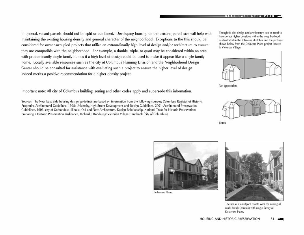
N E A R E A S T A R E A P L A N
HOUSING AND HISTORIC PRESERVATION 81
In general, vacant parcels should not be split or combined. Developing housing on the existing parcel size will help withmaintaining the existing housing density and general character of the neighborhood. Exceptions to the this should be considered for owner-occupied projects that utilize an extraordinarily high level of design and/or architecture to ensure they are compatible with the neighborhood. For example, a double, triple, or quad may be considered within an area with predominantly single family homes if a high level of design could be used to make it appear like a single familyhome. Locally available resources such as the city of Columbus Planning Division and the Neighborhood Design Center should be consulted for assistance with evaluating such a project to ensure the higher level of design indeed merits a positive recommendation for a higher density project.
Important note: All city of Columbus building, zoning and other codes apply and supersede this information.
Sources: The Near East Side housing design guidelines are based on information from the following sources: Columbus Register of HistoricProperties Architectural Guidelines, 1998; University/High Street Development and Design Guidelines, 2001; Architectural Preservation Guidelines, 1996, city of Carbondale, Illinois; Old and New Architecture, Design Relationship, National Trust for Historic Preservation; Preparing a Historic Preservation Ordinance, Richard J. Roddewig; Victorian Village Handbook (city of Columbus).
Delaware Place
Thoughtful site design and architecture can be used toincorporate higher densities within the neighborhood,as illustrated in the following sketches and the picturesshown below from the Delaware Place project locatedin Victorian Village.
Not appropriate
Better
The use of a courtyard assists with the mixing ofmulti-family (condos) with single-family atDelaware Place.
N E A R E A S T A R E A P L A N
82 TRANSPORTATION
TRANSPORTATION

N E A R E A S T A R E A P L A N
TRANSPORTATION 83
Transportation issues are a critical aspect of an area plan for several reasons, including 1) access to jobs and services,
2) traffic calming and pedestrian safety concerns,
3) commercial revitalization,
4) transportation/urban design enhancements, and
5) recreational considerations and other reasons.
This section will review the existing street classifications, average daily traffic volumes, and alternative modes of transportation including bus service and multi-use trails. The transportation plan will establish overall goals and identify policies and strategies for the following issues:
1) context sensitive design and traffic calming,
2) alternative modes of travel,
3) connectivity, and
4) transportation enhancements.
EXISTING CONDITIONSThe Near East Side's street system generally consists of a traditional grid system that is largely intact. This grid system contributes to the “fine grained" and diverse land uses and housing previously described. This street network provides relatively easy access throughout the neighborhood, to downtown to the west, Bexley to the east, and to the interstate system for regional trips.
The grid system was removed in the northwest portion of the Near East Side with the development of the Mt. VernonPlaza and public housing developments in that area. This area now consists of a relatively disconnected series of curvilinear streets and cul-de-sacs. The Eastgate neighborhood, primarily developed after World War II, is also separated from the rest of the Near East Side by the railroad right-of-way to the west of the neighborhood. While the streets within the neighborhood are not a traditional grid system, they are well connected and provide adequateaccess to adjacent areas.

N E A R E A S T A R E A P L A N
84 TRANSPORTATION
TRANSPORTATION
STREET CLASSIFICATIONSPrimary thoroughfares include Broad Street, Long Street (west of Taylor), Main Street, Leonard Avenue, Champion Avenue(north of Mt. Vernon Avenue), and Parsons Avenue. All of these streets except Broad Street are classified in the city ofColumbus Thoroughfare Plan as type "4-2" arterials: two-way streets that include four moving lanes. Broad Street is classified as a type "6-2" arterial: a two-way street with six moving lanes. The I-670, I-70, and I-71 interstates border the Near East Side and provide convenient access to the rest of Central Ohio.
Secondary thoroughfares include Cole Street, Champion Avenue (south of Mt. Vernon Avenue), Ohio Avenue, MillerAvenue (south of Main Street), Kelton Avenue (south of Main Street). These streets are classified as type "2-1" arterials:streets that include two moving lanes and two parking or additional lanes moving in one direction. Taylor Avenue, NelsonRoad, Long Street (east of Taylor), Mt. Vernon Avenue, Hamilton Avenue, and Bryden Road are classified as type "C" arterials: streets that include two moving lanes and two parking or additional moving lanes in two directions.
The classification assigned to a given street in the city's Thoroughfare Plan may be an important planning consideration as the classification determines recommended right-of-way, pavement widths, acceptable speed limits, and eligibility fortraffic calming devices.

N E A R E A S T A R E A P L A N
TRANSPORTATION 85
AVERAGE DAILY TRAFFICAverage Daily Traffic (ADT) for the Near East Side is given in Table 3 and illustrated in Figure 8. The table and map show a portion of data compiled by the Mid-Ohio Regional Planning Commission (MORPC). ADT is 24 hour, non-directional seasonal adjusted traffic count collected at the approximate location indicated on the map.
Table 3. Selected Average Daily Traffic (ADT) for the Near East Side
Location ADT
Broad Street at Nelson Road 28,200
Broad Street and Champion Avenue 33,300
Broad Street and Parsons Avenue 43,400
Leonard Avenue at Champion Avenue 21,000
Nelson Road at Maryland Avenue 16,000
Nelson Road at Broad Street 13,300
Long Street at Winner Avenue 4,400
Mt. Vernon Avenue at 17th Street 6,100
Main Street at Parsons Avenue 18,500
Main Street at Alum Creek Drive 30,300
Champion Avenue at Fulton Street 5,300
Ohio Avenue at Fulton Street 4,000
Miller Avenue at Cole Street 9,200
Kelton Avenue at Cole Street 10,200
Parsons Avenue at Broad 20,500
Parsons Avenue at Main Street 19,700
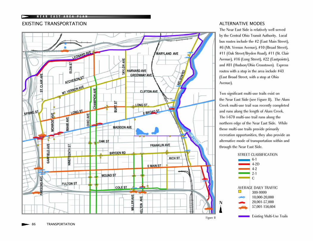
N E A R E A S T A R E A P L A N
86 TRANSPORTATION
EXISTING TRANSPORTATION ALTERNATIVE MODESThe Near East Side is relatively well served by the Central Ohio Transit Authority. Localbus routes include the #2 (East Main Street),#6 (Mt. Vernon Avenue), #10 (Broad Street),#11 (Oak Street/Bryden Road), #11 (St. ClairAvenue), #16 (Long Street), #22 (Eastpointe),and #81 (Hudson/Ohio Crosstown). Expressroutes with a stop in the area include #43(East Broad Street, with a stop at OhioAvenue).
Two significant multi-use trails exist on the Near East Side (see Figure 8). The AlumCreek multi-use trail was recently completedand runs along the length of Alum Creek.The I-670 multi-use trail runs along the northern edge of the Near East Side. Whilethese multi-use trails provide primarily recreation opportunities, they also provide analternative mode of transportation within andthrough the Near East Side.
STREET CLASSIFICATION6-14-2D4-22-1C
AVERAGE DAILY TRAFFIC309-999910,000-20,00020,001-57,00057,001-156,604
Existing Multi-Use TrailsFigure 8
N

N E A R E A S T A R E A P L A N
TRANSPORTATION 87
Transportation-related matters have a great potential impact on issues beyond moving cars throughout the neighborhood.Residents and local governments have come to recognize the need to balance the needs of automobiles and pedestrians in order to increase the quality of life in neighborhoods and provide a safe environment, particularly for children. Thistransportation plan seeks to enhance residential and commercial areas of the Near East Side by identifying strategies to address context-sensitive transportation improvements and traffic calming, alternative modes of transportation, connectivity, and transportation enhancements. These strategies are preceded with text that provides some backgroundand plan highlights regarding alternative modes of transportation and the importance of connectivity.
ALTERNATIVE MODESThere are several plans and proposals for projects that would enhance the availability of alternative modes of travel on theNear East Side.
TRANSIT CENTERA Near East Side Transit Center was recently built at the southeast corner of Main Street and Champion Avenue. The Transit Center will make it easier for area residents to use existing COTA bus routes and make waiting for and connecting between routes an easier and more convenient experience. Additionally, the center will provide transit andneighborhood supportive uses (e.g., health care and banking) and will spur additional development in the area. A newsmall-bus circulator route (Near East Columbus Link) is proposed along with the transit center. This route would provideservice to the area bounded by Parsons Avenue on the west, Kelton Avenue on the east, Clifton Avenue on the north, andFulton Street on the south. This route will link Near East residents to the Transit Center and other goods and services inthe area (Source: Environmental Assessment for the Near East Transit Center, COTA).
TRANSPORTATION PLAN

N E A R E A S T A R E A P L A N
88 TRANSPORTATION
TRANSPORTATION PLAN
MULTI-USE TRAILSConstruction on a connection between the Alum Creek and I-670 multi-use trails should occur in 2005. This willenhance the value of these trails and ultimately allow for a bicyclist to ride from Westerville to the Near East Side, downtown and beyond. Additional bikeway planning includes the MORPC bikeways plan for the region. Proposed bikeways from this plan that are within and adjacent to the Near East Side are illustrated on Figure 9. Finally, the King-Lincoln District Plan proposes a historic walking/biking trail that would extend from Broad Street to St. Clair Avenue. An extension of this trail is suggested on Figure 9.
LIGHT RAILThe Central Ohio Transit Authority's proposed light rail system includes a light rail line that would extend along the northedge of the Near East Side along I-670. A potential transit station location is identified on Figure 9. This station wouldensure service to the Near East Side in the case light rail were developed and would allow for connections to the streetand bicycle network in the area.

N E A R E A S T A R E A P L A N
TRANSPORTATION 89
PROPOSED TRANSPORTATION
Proposed Bike Routes/Trails(MORPC Bike Plan and King-Lincoln Plan)Planned Trail Connection
COTA Transit Center
Potential Light Rail StationExisting Multi-Use Trails
Pedestrian Priority Zones
Figure 9
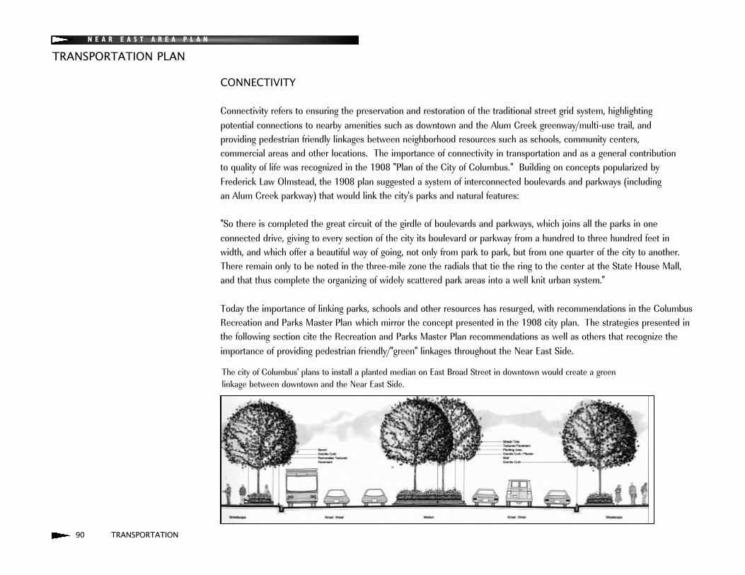
N E A R E A S T A R E A P L A N
90 TRANSPORTATION
TRANSPORTATION PLAN
CONNECTIVITY
Connectivity refers to ensuring the preservation and restoration of the traditional street grid system, highlighting potential connections to nearby amenities such as downtown and the Alum Creek greenway/multi-use trail, and providing pedestrian friendly linkages between neighborhood resources such as schools, community centers, commercial areas and other locations. The importance of connectivity in transportation and as a general contribution to quality of life was recognized in the 1908 "Plan of the City of Columbus." Building on concepts popularized byFrederick Law Olmstead, the 1908 plan suggested a system of interconnected boulevards and parkways (including an Alum Creek parkway) that would link the city's parks and natural features:
"So there is completed the great circuit of the girdle of boulevards and parkways, which joins all the parks in one connected drive, giving to every section of the city its boulevard or parkway from a hundred to three hundred feet inwidth, and which offer a beautiful way of going, not only from park to park, but from one quarter of the city to another.There remain only to be noted in the three-mile zone the radials that tie the ring to the center at the State House Mall,and that thus complete the organizing of widely scattered park areas into a well knit urban system."
Today the importance of linking parks, schools and other resources has resurged, with recommendations in the ColumbusRecreation and Parks Master Plan which mirror the concept presented in the 1908 city plan. The strategies presented inthe following section cite the Recreation and Parks Master Plan recommendations as well as others that recognize theimportance of providing pedestrian friendly/"green" linkages throughout the Near East Side.
The city of Columbus' plans to install a planted median on East Broad Street in downtown would create a green linkage between downtown and the Near East Side.

N E A R E A S T A R E A P L A N
TRANSPORTATION 91
COMMUNITY MOBILITY PLANThe city of Columbus recently completed a community mobility plan for the Linden area in cooperation with the Mid-Ohio Regional Planning Commission and private consultants. It is a comprehensive approach to traffic management for a neighborhood that is well-coordinated and creates an ongoing learning opportunity for both the community and city officials related to traffic calming and mobility throughout the Linden area.
The overall goals for the Transportation Plan include:: Balance the needs of the automobile and pedestrian/bicyclist when considering commercial developments, traffic
movement, roadway improvements, and other transportation issues.
: Form a community mobility plan in cooperation with the city of Columbus that will build upon and further examinethe recommendations in this plan and work toward the implementation of the identified strategies.
: The community mobility plan should also: 1) analyze the impact of the impending changes to I-71 on traffic circulation throughout the adjacent neighborhoods,
2) focus traffic movements to commercial nodes (see Development Strategy map page 27), and
3) reduce traffic movement through primarily residential areas.
: Additional transportation-related recommendations are given in the commercial district design guidelines section ofthe Land Use and Zoning element.
TRANSPORTATION PLAN

N E A R E A S T A R E A P L A N
92 TRANSPORTATION
TRANSPORTATION PLAN
ISSUE 1:Context-Sensitive Design and Traffic Calming
POLICY:Context-sensitive transportation improvements and a variety of traffic calming devices should be used to ensure pedestrian-friendly areas around schools and parks, and within neighborhoods and commercial districts.
STRATEGIES:: Implement context-sensitive transportation improvements and traffic calming, and pedestrian elements and
enhancements, such as pedestrian refuge islands, planted medians, pedestrian friendly turn radii, bump outs, enhanced crosswalks, plantings, etc. at commercial nodes (see commercial district design guidelines section for specific recommendations regarding recommended elements for each Near East Side commercial district.)
: Reclassify Bryden Road on the city's Thoroughfare Plan to allow for the implementation of traffic calming.
: Maintain on-street parking in commercial districts.
: Establish pedestrian priority zones within a one-half mile radius of schools, libraries, community centers, senior centers, cultural arts centers, and other shared facilities. These areas should be a high priority for upgrading theexisting pedestrian circulation system and constructing new sidewalks, crosswalks, and/or bike paths. Traffic-calmingmeasures should be implemented within these zones to ensure pedestrian safety (Columbus Recreation and ParksMaster Plan).
: Utilize historically sensitive materials for traffic calming devices.
: Strongly consider the restoration of Miller/Kelton Avenues and Champion/Ohio Avenues one-way pairs to two-waystreets in order to calm traffic and encourage retail activity at those commercial nodes. Consider the potential loss of on-street parking on these streets when studying this recommendation. Limiting the restoration of two-way trafficto the area between Main Street and Livingston Avenue may be a compromise between encouraging retail activity and not reducing on-street parking within the residential areas north of Main Street.
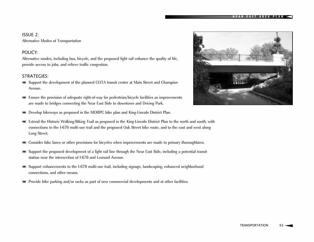
N E A R E A S T A R E A P L A N
TRANSPORTATION 93
ISSUE 2:Alternative Modes of Transportation
POLICY:Alternative modes, including bus, bicycle, and the proposed light rail enhance the quality of life, provide access to jobs, and relieve traffic congestion.
STRATEGIES:: Support the development of the planned COTA transit center at Main Street and Champion
Avenue.
: Ensure the provision of adequate right-of-way for pedestrian/bicycle facilities as improvements are made to bridges connecting the Near East Side to downtown and Driving Park.
: Develop bikeways as proposed in the MORPC bike plan and King-Lincoln District Plan.
: Extend the Historic Walking/Biking Trail as proposed in the King-Lincoln District Plan to the north and south, with connections to the I-670 multi-use trail and the proposed Oak Street bike route, and to the east and west along Long Street.
: Consider bike lanes or other provisions for bicycles when improvements are made to primary thoroughfares.
: Support the proposed development of a light rail line through the Near East Side, including a potential transit station near the intersection of I-670 and Leonard Avenue.
: Support enhancements to the I-670 multi-use trail, including signage, landscaping, enhanced neighborhood connections, and other means.
: Provide bike parking and/or racks as part of new commercial developments and at other facilities.

N E A R E A S T A R E A P L A N
94 TRANSPORTATION
TRANSPORTATION PLAN
ISSUE 3:Connectivity throughout the neighborhood and to adjacent neighborhoods
POLICY:Auto, pedestrian, bicycle and transit connections play a key role in 1) the safe and efficient movement of people throughout the Near East Side, 2) providing access to recreational resources, and 3) the support of commercial activity.
STRATEGIES:: Maintain the existing street and alley grid to ensure connectivity throughout the neighborhood and to the freeway
system and adjacent neighborhoods.
: Consider the sale of alley sections to adjacent property owners for yard space in the case when the alley section isnot required for access to other properties and no longer serves as a functioning alleyway.
: Ensure the provision of interconnected sidewalks throughout the Near East Side.
: Provide enhanced connections from the Alum Creek and I-670 multi-use trails, including but not limited to, signage,crosswalks with traffic calming and/or pedestrian facilities at key connection points to said trails along Nelson Roadand Leonard Avenue.
: Enhance pedestrian connections between schools, parks, recreational sites, and other facilities with traffic calmingmeasures, plantings, signage, and other mechanisms (Columbus Recreation and Parks Master Plan).
: Study the potential for providing new street connections in the Northwest District (District 1). This street restorationshould be completed in such a way to create parcels for the development of new housing.
: Ensure enhanced connectivity to downtown as I-70/I-71 is rebuilt via "caps" with park-space, bridges with enhancedpedestrian/bicycle facilities or other means.
Examples of pedestrian-friendly connections canbe found on the Near East Side.

N E A R E A S T A R E A P L A N
TRANSPORTATION 95
: Ensure that Spring and Long Streets are converted to two-way streets or narrower one-way streets that would minimize the gap between the neighborhood and downtown and accommodate pedestrians and bicyclists when I-71 is rebuilt.
: Ensure that Parsons Avenue continues to be interconnected to the existing grid network when I-71 is rebuilt.
: Establish a more efficient connection between Parsons Avenue south of Broad Street and the King-Lincoln District (King-Lincoln District Plan).
: Support implementation of the planned Broad Street planted median through downtown. Encourage the future extension of the planted median east through the Near East Side to provide a green linkage between Alum Creek,Franklin Park and the Statehouse grounds.
A 1937 plat of the Mt. Vernon Avenue area illustrates how the traditional grid system once provided connectivity throughout the neighborhood.

N E A R E A S T A R E A P L A N
96 TRANSPORTATION
TRANSPORTATION PLAN
ISSUE 4:Parking
POLICY:Parking needs for commercial and residential areas must be balanced with the need to maintain the historic fabric of thecommunity.
STRATEGIES:: Maintain on-street parking in commercial districts.
: Establish permit parking in residential areas, particularly adjacent to commercial districts, if on-street parkingdemands become excessive.
: Consider the replacement of surface parking with the construction of a parking garage structure on the south side ofLong Street just east of the bridge over I-71, or at a more suitable location (King-Lincoln District Plan).

N E A R E A S T A R E A P L A N
TRANSPORTATION 97
ISSUE 5:Transportation-Related Enhancements
POLICY:Enhancements that highlight key commercial, natural, and neighborhood features should be provided as roadway improvements are made.
STRATEGIES: Provide community gateways at locations identified in the commercial district design guidelines section and in the
King-Lincoln District Plan.
: Consider the restoration of brick streets in strategic locations, such as the King-Lincoln neighborhood (King-LincolnDistrict Plan).
: Maintain existing brick streets throughout the Near East Side.
: Provide bridge enhancements as improvements are made to bridges to downtown and Driving Park, e.g., improved fencing materials.
: Provide enhancements (signage, special markers, waysides at key view points) along Nelson Road that highlight Alum Creek.
: Encourage alley beautification through the establishment of "adopt-an-alley" programs.
: Provide enhancements such as decorative lighting, gazebos, public art or other features for the neighborhood parkways (Wilson Avenue, Hawthorne Avenue, others).
Ohio Avenue, north of East Broad Street.
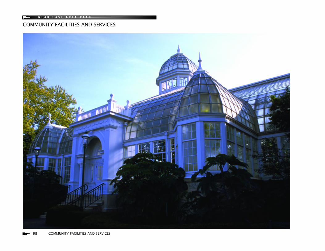
N E A R E A S T A R E A P L A N
98 COMMUNITY FACILITIES AND SERVICES
COMMUNITY FACILITIES AND SERVICES
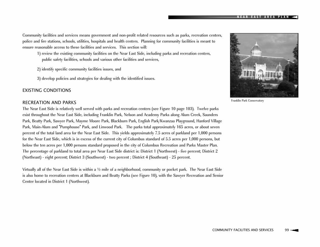
N E A R E A S T A R E A P L A N
COMMUNITY FACILITIES AND SERVICES 99
Community facilities and services means government and non-profit related resources such as parks, recreation centers,police and fire stations, schools, utilities, hospitals and health centers. Planning for community facilities is meant toensure reasonable access to these facilities and services. This section will:
1) review the existing community facilities on the Near East Side, including parks and recreation centers, public safety facilities, schools and various other facilities and services,
2) identify specific community facilities issues, and
3) develop policies and strategies for dealing with the identified issues.
EXISTING CONDITIONS
RECREATION AND PARKSThe Near East Side is relatively well served with parks and recreation centers (see Figure 10 page 103). Twelve parksexist throughout the Near East Side, including Franklin Park, Nelson and Academy Parks along Alum Creek, SaundersPark, Beatty Park, Sawyer Park, Mayme Moore Park, Blackburn Park, English Park/Kwanzaa Playground, Hanford VillagePark, Main-Alum and "Pumphouse" Park, and Linwood Park. The parks total approximately 165 acres, or about seven percent of the total land area for the Near East Side. This yields approximately 7.5 acres of parkland per 1,000 personsfor the Near East Side, which is in excess of the current city of Columbus standard of 5.5 acres per 1,000 persons, butbelow the ten acres per 1,000 persons standard proposed in the city of Columbus Recreation and Parks Master Plan. The percentage of parkland to total area per Near East Side district is: District 1 (Northwest) - five percent; District 2(Northeast) - eight percent; District 3 (Southwest) - two percent ; District 4 (Southeast) - 25 percent.
Virtually all of the Near East Side is within a ½ mile of a neighborhood, community or pocket park. The Near East Side is also home to recreation centers at Blackburn and Beatty Parks (see Figure 10), with the Sawyer Recreation and SeniorCenter located in District 1 (Northwest).
Franklin Park Conservatory

N E A R E A S T A R E A P L A N
100 COMMUNITY FACILITIES AND SERVICES
COMMUNITY FACILITIES AND SERVICES
The high percentage of parkland in District 4 (Southeast) is due to the presence of Franklin Park, which serves not only the Near East Side but also the whole city with both the park and Franklin Park Conservatory. The front lawn at the Columbus Health Department in District 3 (Southwest) is not included in the parkland calculations given above, yet provides additional high quality open space for that part of the Near East Side. Alum Creek and accompanying parklandis another park/open space resource of regional significance - a beautiful natural area within an urban neighborhood. As described in the Transportation element, the soon-to-be connected Alum Creek and I-670 multipurpose trails will provide Near East Side residents access to regional bikeways that will ultimately connect the neighborhood to parks and resources throughout Central Ohio.
PUBLIC SAFETYThe Near East Side is divided between two police precincts. The area north of Broad Street is within Precinct 6 and the area to the south of Broad Street is within Precinct 12. Community liaison police officers are assigned to each precinctand provide support to block watch groups within their respective precincts. Two police substations are located on theNear East Side. The Precinct 6 substation is located on Granville and is named for Harvey Alston, who rose to become second in command in the city of Columbus Police Department and at one point was the highest ranking African American police officer in the nation. The Precinct 12 substation is located on Main Street and is named for John F. Ward. Additionally, there is one fire station (named for Battalion Chief Herman Harrison) located on the Near East Side, at 1240 E. Long Street (see Figure 10).

N E A R E A S T A R E A P L A N
COMMUNITY FACILITIES AND SERVICES 101
SCHOOLSFifteen schools are located on the Near East Side (see Figure 10, page 103). Thirteen of these schools are Columbus Public schools and include eight elementary schools (Trevitt, Pilgrim, Main Street, Ohio Avenue, Douglas Alternative, Fair Alternative, Beatty Park, and Eastgate), four middle schools (Franklin Alternative, Clearbrook, Champion, and MonroeAlternative) and one high school (East). The Granville T. Woods Charter School operates out of the Martin Luther KingCultural Center on Mt. Vernon Avenue. The Mansion Day School, located at Long Street and Woodland Avenue, is a private school on the Near East Side and provides programs for preschoolers and elementary aged students.
In 2002 Columbus residents approved funding to modernize schools throughout the District. Improvements are plannedfor the following schools: Champion Middle School, Trevitt Elementary, Ohio Avenue Elementary, Eastgate Elementary,East High School, Clearbrook Middle School, Fair Alternative Elementary, Main Street Elementary, Monroe Alternative,and Douglas Alternative. Beatty Park Elementary is planned for demolition and will be replaced by the new ChampionMiddle School.

N E A R E A S T A R E A P L A N
102 COMMUNITY FACILITIES AND SERVICES
COMMUNITY FACILITIES AND SERVICES
OTHER FACILITIES AND SERVICES:Social Service Agencies: The 1995 Near East Area Plan listed twenty-nine social service agencies that were sited on the Near East Side. In many cases, these agencies have service areas that extend beyond the Near East Side. Servicesprovided include employment services, housing services, behavior rehabilitation services, counseling and other services.
Columbus Metropolitan Library: The Martin Luther King branch of the Columbus Metropolitan Library is located justwest of the intersection of Long Street and Woodland Avenue (see Figure 10). The facility was remodeled in 1996 and is about 9,000 square feet. The African Treasure Chest, a collection of artifacts is on loan to the branch by Friends of Art for Community Enrichment (F.A.C.E.). It has 30,000 volumes, including the Black Heritage Collection, a circulatingcollection of books pertaining to African Americans, the civil rights movement from 1950 to 1970 and diaspora Africans.
Neighborhood Pride Center: The Near East Side Neighborhood Pride Center, established in 2004, is a one-stop-shopfor city services. It is dedicated to protecting the health, safety and welfare of the families living in the area (see Figure10). Pride Centers house basic city services all in one place. The Pride Center staff includes the community liaison policeofficers, Department of Development code enforcement officers and solid waste inspectors, Public Service refuse collection division staff, Department of Development housing division staff, and the area's neighborhood liaison.
YMCA: The Eldon W. Ward YMCA, located at 130 Woodland Avenue, provides state-of-the-art facilities and program services for the Near East Side. In 2002 a $2.7 million renovation and expansion was completed. The facility has thirty-one thousand eighth hundred (31,800) square feet, including a seven thousand (7,000)-square-foot gymnasium, an indoor pool and a new child care/nursery area. A variety of programs are available for all ages, including aquatic programs, gymnastics, and yoga.
King Arts Complex: The King Arts Complex is located on the Near East Side and serves as an important cultural resource for all of Central Ohio. Its mission is to enrich and improve the quality of life in the community, creatingenhanced understanding and harmony by preserving, presenting and fostering the contributions of African Americansthrough creative expression and education. Facilities at the Complex include the Pythian Theater, a multipurpose room,dance studio, boardroom, and ballroom.
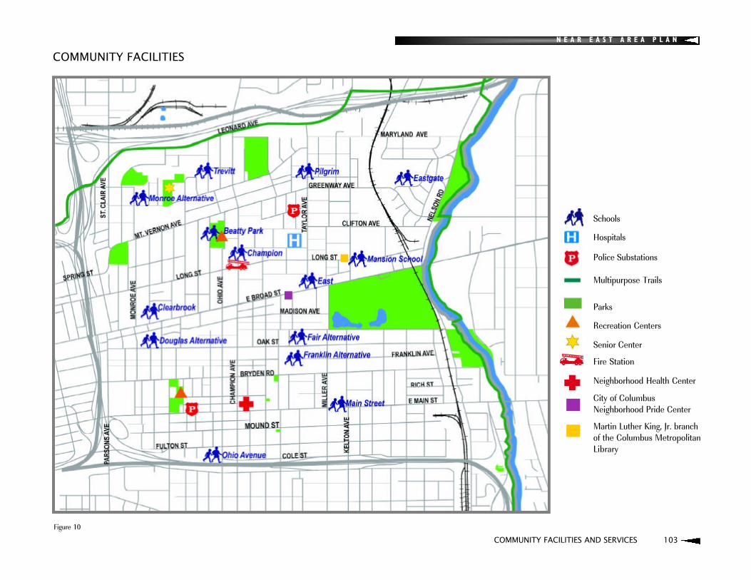
N E A R E A S T A R E A P L A N
COMMUNITY FACILITIES AND SERVICES 103
COMMUNITY FACILITIES
Figure 10
Schools
Hospitals
Police Substations
Multipurpose Trails
Parks
Recreation Centers
Senior Center
Fire Station
Neighborhood Health Center
City of ColumbusNeighborhood Pride Center
Martin Luther King, Jr. branchof the Columbus MetropolitanLibrary

N E A R E A S T A R E A P L A N
104 COMMUNITY FACILITIES AND SERVICES
COMMUNITY FACILITIES AND SERVICE PLAN
The overall goals of the Community Facilities and Services Plan are:: Safe, well maintained parks, recreational centers, and trails.
: A strong partnership between residents and neighborhood schools which will contribute to an environment of learningon the Near East Side.
: A safe environment and strong sense of personal security for all.
ISSUE 1:Need to enhance use of area parks and connectivity between parks and trails with neighborhoods, commercial districtsand other resources
POLICY:Improvements in connectivity and use of area parks and recreation centers will play an important role in neighborhoodrevitalization efforts.
STRATEGIES:: Improve connectivity between recreation centers, parks, and other facilities with landscaping efforts, benches,
sidewalks improvements, bikeways, signage, and gateways.
: Develop functional interrelationships between park spaces/activity centers (activities at each park/activity centerwhich complement each other and would enhance potential linkages, e.g., Heritage Concert Series at the MaymeMoore Park). One particular linkage to stress is between the pool at Saunders Park and activities at the BeattyRecreation Center.
: Consider new ways to generate revenue from recreational activities. Potential revenue generators include theAdventure Center in Franklin Park (teen and/or corporate training) and/or soccer or basketball camps for pay.
: Explore partnerships with other agencies that would enhance programming at city recreation centers.
: Consider acquiring for parkland the parcel where the old city water plant is located (northeast corner of the Near EastSide adjacent to Alum Creek). Consider additional acquisitions to the north of this parcel. Seek private sources ofmoney to support these purchases. Note: As the Alum Creek greenway is developed, there may be leftover portions ofthe parcels that comprise the greenway. Consider the development of said portions for community related purposes.
: Support the implementation of the Franklin Park Conservatory plans.

N E A R E A S T A R E A P L A N
COMMUNITY FACILITIES AND SERVICES 105
: Form a "Friends of the Parks" organization for the Near East Side. The group would be charged with forming a stewardship plan for each park, enhancing maintenance of parks, and enhancing communication with the city regarding programming, maintenance, and other issues (Columbus Recreation and Parks Master Plan).
: Increase access and interaction with Alum Creek for canoeing, public education for kids and other recreational uses(Alum Creek Action Plan).
: Support the removal of the two dams currently located in Alum Creek (Alum Creek Action Plan).
: Celebrate the history of the Underground Railroad along Alum Creek with signage and other means and connect thisto the State-wide effort (Alum Creek Action Plan).
: Per the Transportation Element of this Plan:: Establish pedestrian priority zones around schools, parks, community centers, senior centers, cultural arts
centers, and other shared facilities. These areas should be a high priority for upgrading the existing pedestrian circulation system and constructing new sidewalks and/or bike paths. Traffic-calming measures should be implemented within these zones to ensure pedestrian safety (Columbus Recreation and Parks Master Plan).
: Extend the Historic Walking/Biking Trail as proposed in the King-Lincoln District Plan to the north and south, with connections to the I-670 multi-use trail and the proposed Oak Street bike route, and to the east and westalong Long Street.
: Develop bike routes and trails as proposed in the MORPC bike plan and King-Lincoln District Plan.
: Support enhancements to the I-670 multi-use trail, including signage, landscaping, enhanced neighborhood connections, and other means.
: Provide enhanced connections to the Alum Creek and I-670 multi-use trails, including but not limited to, signage, crosswalks with traffic calming at key connection points to said trails along Nelson Road and Leonard Avenue.
N E A R E A S T A R E A P L A N
106 COMMUNITY FACILITIES AND SERVICES
COMMUNITY FACILITIES AND SERVICES PLAN
ISSUE 2: Crime and/or a perception of crime creates an insecure environment for residents and hinders revitalization efforts
POLICY:A strong partnership with the Columbus Police Department through block watches and other methods is an essential steptoward creating a strong sense of personal safety on the Near East Side.
STRATEGIES:: Form a steering committee consisting of block watch leadership and coordinated by the Near East Side community
liaison police officers that will serve as an umbrella group for all area block watches and hold quarterly or bi-annualmeetings and ensure the sharing of successful efforts, concerns and regular communication with the Columbus Police Department.
: Become actively involved with the city's Safety Academy.
: Ensure regular communication with community liaison police officers through invitations to NEAC meetings, mailing of minutes and agendas for meetings, invitations to block parties and other neighborhood events.
: Partner with Community Properties of Ohio to ensure adequate support for their efforts to revitalize their portfolio of Section 8 properties on the Near East Side. Reach out to and support other Section 8 property owners makingsimilar efforts.
: Promote the use of local email listservs to enhance communication between local residents, block watches, and otherorganizations on safety related issues.
: Partner with local civic associations and the Columbus Compact to enhance positive local news coverage of the Near East Side. Provide regular press releases on positive developments, particularly as they relate to communityorganization and safety.
: Ensure the formation of a block watch for every portion of the Near East Side.
: Assign foot and bicycle patrols in neighborhoods to increase the presence and visibility of police officers and enhanceneighborhood/police relations.
: Regularly nominate youth for the Columbus Youth Commission and seek additional ways to encourage positive youthinvolvement in the community.

N E A R E A S T A R E A P L A N
COMMUNITY FACILITIES AND SERVICES 107
ISSUE 3:Schools that are under-performing or underutilized hinder neighborhood revitalization
POLICY:Community support to local schools is a key component to enhancing the quality of life on the Near East Side.
STRATEGIES: Utilize the "Education at Large" Near East Area Commissioner to communicate and cooperate with the Columbus
Public Schools.
: Preserve historically significant school buildings by encouraging the school board to nominate schools for listing onthe Columbus Register of Historic Places.
: Encourage local agencies to develop proposals for the Columbus Public Schools whereby space be utilized withinschools for partnerships with agencies to provide social, medical, and recreational services to the children of theColumbus Public Schools (adapted from Columbus Public Schools policy).
N E A R E A S T A R E A P L A N
108 COMMUNITY FACILITIES AND SERVICES
COMMUNITY FACILITIES AND SERVICES PLAN
ISSUE 4:A disproportionate number of social service agencies are located on the Near East Side
POLICY:While the value of local social service agencies is recognized, the addition of new or expansion of existing social serviceagencies on the Near East Side is strongly discouraged.
STRATEGIES: Disapprove variance and/or zoning requests which would allow for the siting of any new social service agencies.
: Encourage existing social service agencies, including church outreach services, to cooperate with the delivery of services through the formation of an umbrella group of social service providers which would enhance communication.
: Investigate the potential of utilizing recreation centers and/or schools to focus the delivery of social services.
N E A R E A S T A R E A P L A N
COMMUNITY FACILITIES AND SERVICES 109
ISSUE 5:Need to continue maintenance of Near East Side lighting and address stormwater issues
POLICY:Utility issues should be monitored by residents and civic associations, reported to the Near East Area Commission and subsequently presented to the appropriate city department for review and consideration.
STRATEGIES: Utilize the Near East Area Commission Planning Committee to monitor capital improvement needs and advocate
for their funding and implementation.
: Work with the Department of Utilities, local schools and Friends of Alum Creek to implement environmental education programs, including the placement of "drains to creek" markers on storm sewers.
: Earmark capital improvement dollars for replacing lighting and lighting fixtures in and around parks, bus stops, alleys, and at major intersections.
: Encourage the addition of pedestrian scale lighting along residential streets and alleys with mature trees.
: Investigate the movement of electrical wires to alleys as improvements are made.
: Advocate for the improvement of electrical facilities to ensure consistent service to the Near East Side.
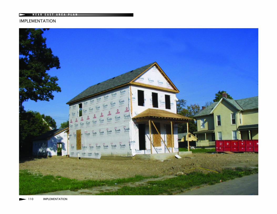
N E A R E A S T A R E A P L A N
110 IMPLEMENTATION
IMPLEMENTATION
N E A R E A S T A R E A P L A N
IMPLEMENTATION 111
The most effective way to implement the provisions of the Near East Area Plan is through the consistent and unified advocacy of the Near East Area Commission working in concert with the city of Columbus and other stakeholders, including community development corporations, business and civic associations, development related agencies, churches,social service agencies, and others. The most typical mechanism for plan implementation is the review of developmentproposals for consistency with the plan. Additionally, the plan can be used proactively to seek investment in the area,advocate for neighborhood issues, pursue grant funding and guide capital improvements.
Major implementation elements include:: Education and Outreach
: Plan Amendment and Revision
: Fostering Development and Public Improvements
: Development Review Checklist
EDUCATION AND OUTREACHA variety of strategies should be utilized to educate key stakeholders and the public regarding the use of the plan for theimprovement of the Near East Side and its specific goals, design guidelines and other features. Potential mechanisms foreducation and outreach include: : Hold annual meetings and tours to discuss progress and concerns regarding the plan's implementation (State of
the Plan). Include stakeholders such as elected officials and city staff, civic associations, developers, development corporations, local businesses and other interested parties.
: Develop large format versions of the plan maps for display at the Neighborhood Pride Center.
: Utilize the local media and newsletters to publicize the plan's adoption and implementation.
: Conduct annual field trip(s) to developments in the city of Columbus and beyond which illustrate the design principles from the Near East Area Plan (invite neighborhood residents, elected officials, community development corporations, developers and other stakeholders).
: Utilize an enhanced website and email to supplement existing information distribution system.
: Ensure the plan and/or its executive summary are distributed to key stakeholders and community agencies, includingcommunity development corporations, developers, civic associations, schools, libraries, and social service agencies.
: Develop a summary of the plan for presentation at Near East Side schools. Inform local principals of the potential of utilizing the plan as a classroom instructional aid.
IMPLEMENTATION

112 IMPLEMENTATION
N E A R E A S T A R E A P L A N
IMPLEMENTATION
PLAN AMENDMENT AND REVISIONThe plan should be regularly reviewed and updated to ensure its timeliness and relevancy. Minor amendments and briefupdates may be considered on an as-needed basis. The design guidelines and checklist are particular elements of the plan that should be evaluated after approximately one year to gauge their effectiveness at implementing the plan's goals and strategies. A more complete review and revision of the plan should be considered after approximately five years.
FOSTERING DEVELOPMENT AND PUBLIC IMPROVEMENTS:: The Near East Area Commission should consider altering its committee structure to reflect the primary elements of
the Near East Area Plan (Land Use and Zoning, Transportation, and Community Facilities and Services) and makeeach committee responsible for the implementation of the respective element.
: The Land Use and Zoning Committee would be responsible for the review of proposed development projects, zoningand variance applications.
: The Transportation Committee could foster the development of neighborhood working groups to identify specific traffic calming and speed limit requests and related projects, reviewing the transportation related portions of the city's capital improvement budget and advocating for capital improvements consistent with the plan, monitor I-71/70progress, review transportation related improvements, etc.
: The Community Facilities and Services Committee would be responsible for reviewing non-transportation publicimprovements, reviewing non-transportation portions of the city's capital improvements budget and advocating forcapital improvements consistent with the plan, reviewing school and park related proposals, etc. This Committeewould also be responsible for submitting Urban Infrastructure Recovery Fund (UIRF) projects consistent with thisplan.

: The city of Columbus Planning Division should allocate time from a planner to assist the Near East Area Commissionwith the implementation of the Near East Area Plan in cooperation with the area's Neighborhood Liaison.
: Said planner should form a list that identifies all recommendations of the plan and work with area commissioners and other stakeholders to prioritize recommendations and develop corresponding projects. This list could be periodically updated to track progress and published as part of the State of the Plan meeting. Planner could also provide limited assistance to the Near East Area Commission committees with plan implementation projects and tasks. A portion of these hours may also be supplemented with intern support. Examples of tasks may include technical assistance to other city departments/divisions and local agencies with development related activities for the Near East Side, the development of UIRF proposals consistent with plan recommendations, other requests for capital improvements, transportation related projects, etc.
: Non-profit agencies and the city should cooperate on strategic land purchases that are consistent with the Development Strategy from this plan to facilitate redevelopment. Model mixed-use projects should be developed to demonstrate the design guidelines advocated by the plan.
: Local agencies such as Urban Growth, Columbus Compact, and the Neighborhood Design Center should use thisplan as guide for redevelopment projects.
N E A R E A S T A R E A P L A N
IMPLEMENTATION 113

IMPLEMENTATION
114 IMPLEMENTATION
N E A R E A S T A R E A P L A N
DEVELOPMENT REVIEW CHECKLISTThe Development Review Checklist is a summary of the development standards and recommendations found throughout the Near East Area Plan. The checklist is designed for application by stakeholders in the review of development proposals for consistency with plan provisions. It is intended for use with zoning and variance requests, investments in community facilities and infrastructure, and other initiatives or requests impacting the built environment in the community. It is also intended as a means to provide a clear, concise record of stakeholder input in each stage of project consideration.
Users of the checklist are strongly encouraged to review additional background information for each item on the checklist by referencing the page number cited. The "Conditions to Approval" column is intended to note specific conditions thatthe proposal must incorporate in order to meet that standard. The "Mitigating Circumstances" column should be used tonote specific reasons why the proposal is not expected to meet that standard. Nothing in the checklist is intended tospeak to the development proposal's conformance with other city code requirements and policies.
N E A R E A S T A R E A P L A N
IMPLEMENTATION 115
It is the recommendation of the Near East Area Plan that:: Applicants be encouraged to review the checklist and incorporate its provisions in their proposals.
: Civic associations and other organizations become actively involved in NEAC committees, either by regularly slating candidates for NEAC elections, as "community members" or by simply attending meetings on a regular basis to become informed on development proposals and cooperate on seeking resources, advocating for necessaryimprovements to the neighborhood, and helping to implement the Near East Area Plan.
: Civic associations use the checklist to evaluate development proposals in their respective areas. One copy of the checklist as prepared and approved by the civic association should be provided to the Near East Area Commission toserve as the official input for the association regarding each proposal.
: Other stakeholder groups or agencies also use the checklist as an organizing element for their review and comment tothe Near East Area Commission on development proposals.
: The Near East Area Commission submit one approved checklist evaluation to the city as part of their recommendation in response to any development proposal.
: The city consider the checklist submitted by the Near East Area Commission in the development of a staff position or response to development proposals.
: City departments use the checklist as community facilities and infrastructure investments are made.
: Updated or modified project proposals receive updated checklist evaluation by appropriate parties.
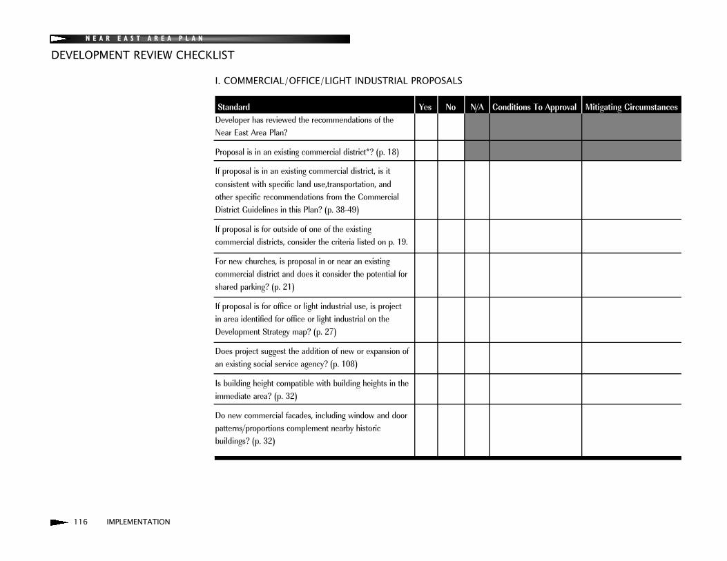
N E A R E A S T A R E A P L A N
116 IMPLEMENTATION
DEVELOPMENT REVIEW CHECKLIST
I. COMMERCIAL/OFFICE/LIGHT INDUSTRIAL PROPOSALS
Standard Yes No N/A Conditions To Approval Mitigating CircumstancesDeveloper has reviewed the recommendations of theNear East Area Plan?
Proposal is in an existing commercial district*? (p. 18)
If proposal is in an existing commercial district, is it consistent with specific land use,transportation, and other specific recommendations from the Commercial District Guidelines in this Plan? (p. 38-49)
If proposal is for outside of one of the existing commercial districts, consider the criteria listed on p. 19.
For new churches, is proposal in or near an existing commercial district and does it consider the potential for shared parking? (p. 21)
If proposal is for office or light industrial use, is projectin area identified for office or light industrial on the Development Strategy map? (p. 27)
Does project suggest the addition of new or expansion of an existing social service agency? (p. 108)
Is building height compatible with building heights in the immediate area? (p. 32)
Do new commercial facades, including window and door patterns/proportions complement nearby historic buildings? (p. 32)
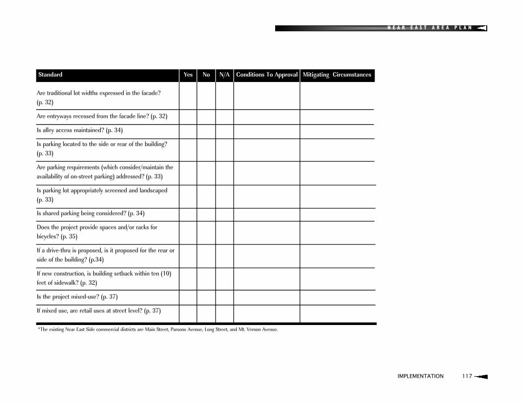
N E A R E A S T A R E A P L A N
IMPLEMENTATION 117
Standard Yes No N/A Conditions To Approval Mitigating Circumstances
Are traditional lot widths expressed in the facade? (p. 32)
Are entryways recessed from the facade line? (p. 32)
Is alley access maintained? (p. 34)
Is parking located to the side or rear of the building? (p. 33)
Are parking requirements (which consider/maintain the availability of on-street parking) addressed? (p. 33)
Is parking lot appropriately screened and landscaped(p. 33)
Is shared parking being considered? (p. 34)
Does the project provide spaces and/or racks forbicycles? (p. 35)
If a drive-thru is proposed, is it proposed for the rear or side of the building? (p.34)
If new construction, is building setback within ten (10)feet of sidewalk? (p. 32)
Is the project mixed-use? (p. 37)
If mixed use, are retail uses at street level? (p. 37)
*The existing Near East Side commercial districts are Main Street, Parsons Avenue, Long Street, and Mt. Vernon Avenue.

118 IMPLEMENTATION
N E A R E A S T A R E A P L A N
DEVELOPMENT REVIEW CHECKLIST
II. RESIDENTIAL PROPOSALS
Standard Yes No N/A Conditions To Approval Mitigating Circumstances
Developer has reviewed the recommendations of theNear East Area Plan?
Is housing market rate? (p. 70-71)
Is new housing located on the "visible edges" of a neighborhood, as identified on the Development Strategy Map? (p. 26-27)
Does project propose the renovation of an existing structure? (p. 72)
If demolition of an historic structure is proposed, hasits relocation been investigated? (p. 72)
Does project propose the reconversion a multi-family structure back to single-family structure? (p. 71)
Does project result in the deconcentration of existing subsidized housing? (p. 75)
Does project provide a percentage of affordable housing? (p. 71)
Is housing density consistent with housing types and densities in the immediate neighborhood? (p. 80)
If higher density housing is proposed, is it within or adjacent to existing commercial district? (p. 26-27, 80)
If higher density and not within or adjacent to existing commercial district, does project propose owner-occupied building(s) that utilize extraordinary high level of design? (p. 81)

N E A R E A S T A R E A P L A N
IMPLEMENTATION 119
Standard Yes No N/A Conditions To Approval Mitigating Circumstances
Is new housing similar in height and widths to adjacent structures? (p. 76-77)
Are housing materials guided by the predominant materials of adjacent structures? (p. 77)
Do porches repeat the proportions of other nearby homes? (p. 77)
Are the roof pitch, height, and shape compatible with surrounding structures? (p. 77)
Are setbacks similar to those of adjacent houses? (p. 78)
Are windows and doors of an appropriate size, width, and spacing? (p. 78)
Is the garage located behind the house? (p. 80)
Is alley access maintained? (p. 80)
Are additions placed to the rear of the structure? (p. 80)
Are additions distinguishable from the original structure? (p. 80)

120 IMPLEMENTATION
N E A R E A S T A R E A P L A N
DEVELOPMENT REVIEW CHECKLIST
III. TRANSPORTATION AND COMMUNITY SERVICE RELATED PROJECTS
Standard Yes No N/A Conditions To Approval Mitigating Circumstances
Developer has reviewed the recommendations ofthe Near East Area Plan?
For proposed street improvements and other investments in the right-of-way, is project consistent with specific recommendations from the Commercial District Guidelines from the Near East Area Plan? (p. 38-49)
For projects in District 1 (Northwest), does proposalconsider the potential for new street connections? (p. 48)
For projects in the I-70/71 corridors, does proposal enhance connections to downtown and adjacent neighborhoods and provide bridges with enhanced pedestrian/bicycle facilities? (p. 94-95)
Are landscaping, sidewalk improvements, bikeways, signage or gateways used to enhance connectivity? (p. 94)
Are mid-block crosswalks provided? (p. 35, 92)
Do traffic-calming devices utilize historically sensitive materials? (p. 92)
Is traffic calming for schools and other community facilities being established? (p. 92)

N E A R E A S T A R E A P L A N
IMPLEMENTATION 121
Standard Yes No N/A Conditions To Approval Mitigating Circumstances
Does project consider/improve connectivity between recreation centers, parks, schools and other facilities? (p. 94, 104)
Are pedestrian scale lighting fixtures being installed? (p. 39)
Is the existing street and alley grid maintained? (p. 94)
Are sidewalk connections being maintained and/or improved? (p. 94)
Are bike lanes or other provisions for bicycles provided?(p. 93)
Is project consistent with bike route and trails planfrom the Near East Area Plan? (p. 89)
For projects near existing/planned multi-purposetrails (Alum Creek and I-670 trails), does proposal consider signage and other enhancements to said trails? (p. 93, 105).
For projects within the I-670 corridor, does proposal consider the potential for light rail? (p. 93)
Are existing brick streets maintained? (p. 97)
For school proposals, does the project consider the preservation of historically significant buildings? (p. 107)

N E A R E A S T A R E A P L A N
122 IMPLEMENTATION
DEVELOPMENT REVIEW CHECKLIST
IV. EAST BROAD STREET PROPOSALS
Standard Yes No N/A Conditions To Approval Mitigating Circumstances
Developer has reviewed the recommendations of the Near East Area Plan?
Is the proposal for an office and/or residential land use? (p. 24)
Will the project result in the demolition of a contributing building? (p. 24, 61)
If the project is for the renovation of a contributingbuilding, is the proposal consistent with the city of Columbus Historic Resources Commission Architectural Guidelines? (p. 24, 51)
If the proposed building is adjacent to an existing historic district, does it take its design cues from the buildings in the historic district? (p. 24)
Is the proposed building material brick? (p. 55)
Is the parking proposed at the rear of the building with appropriate buffering and landscaping? (p. 55)
Is the proposed building setback the average of neighboring buildings? (p. 55)
Is the proposed building height compatible with neighboring buildings? (p. 56)
Are roof type and shape appropriate? (p. 56)
Is roof pitch within 8/12 and 15/12? (p. 56)

N E A R E A S T A R E A P L A N
IMPLEMENTATION 123
Standard Yes No N/A Conditions To Approval Mitigating CircumstancesStandard Yes No N/A Conditions To Approval Mitigating Circumstances Does the structure have appropriate dormers? (p. 56)
Are ground floors elevated at least two (2) to three (3)feet off the ground? (p. 56)
Is building width between thirty-five (35) and forty-five (45) feet? (p. 56)
Are buildings separated by fifteen (15) to twenty (20) feet? (p. 56)
Does the building proposal utilize a tri-partite facade design? (p. 57)
Is the height/width ratio appropriate? (p. 57)
Is the orientation of the building consistent with neighboring structures? (p. 57)
Is the size of the building appropriate for the parcel size? (p. 55)
Does the building proposal include an attentiveness to building details such as eaves, dentils, coursing, mullions, sills, etc.? (p. 57)
Does the building entryway and/or porch adequately address the street? (p. 57)
Are the number, depth, dimensions, and proportions of proposed windows appropriate? (p. 57)
Is any proposed signage appropriate? (p. 58)
Is landscaping/fencing appropriate and consistent with the planned downtown Broad Street median? (p. 58, 90)
Are dumpsters, air conditioning units and/or other mechanicals screened from view? (p. 58)

N E A R E A S T A R E A P L A N
NOTES


City of Columbus, Department of Development, Planning Division


