NOAAINMFS Developments In honor of the 25th anniversary of the National Marine Fisheries Service's Gloucester Laboratory of the Northeast Fisheries Center, a I-day "International Symposium on Fisheries Technology" has been scheduled in conjunction with the 30th Atlantic Fisheries Technological Conference 25-29 August 1985. The Conference will be held at the Copley Plaza Hotel in Boston, Mass., and is chaired by Ron Lundstrom. Keynote speaker for the Symposium will be Jack Connell, Director of the United Kingdom's Torry Research States had argued that it was entitled to a boundary line that retained all of Georges Bank. Canada had asked for a line dividing the Bank virtually in half, leaving all of the northeastern segment under its control. The World Court, in essence, split the difference, setting a line that cut Georges Bank about midway between the two claims. According to the National Oceanic and Atmospheric Ad- ministration, which has jurisdiction over fisheries out to 200 miles off the U.S. coast, including the Georges Bank area, the new boundary will make management of Atlantic fisheries, including cod and haddock, very complex, and will require close consultation with all interested par- ties. High seas rights pertaining to the area, such as freedom of navigation, are not affected. The Court, at the request of Canada and the United States, established a Special Chamber of five judges to hear the case, and had con- sidered extensive written and oral sub- missions presented by both sides dur- ing the previous 2 years. Members of the Chamber included: Judge Rober- to Ago of Italy, President of the Chamber; Judge Andre Gros of France; Judge Herman Mosler of the Federal Republic of Germany; Judge Stephen Schwebel of the United States; and Judge ad hoc Maxwell Cohen of Canada. Symposium Honors NEFC Gloucester Laboratory -', ; .. " ATLANTIC OCEAN D 4lJ'N vessels from both sides to return to their respective sides of the new boundary (see map). The heart of the issue, which has been a source of dispute since 1976 when both Canada and the United States extended their eastern bound- aries, was control of an area of be- tween l3,OOO and 18,000 square nautical miles that included the north- eastern half of Georges Bank, one of the world's richest fishing grounds. The area may also contain oil and natural gas reserves. The United Georges Bank B Gulf of Maine SOfalhO rns .' p Boundary turning points A 44°11' 12"N-67°16'46"W B 42°53'14"N-67°44'35"W C 42°31 '08"N-67°28'05"W D 40 0 27'05"N-65°41 '59"W Eastern U.S.-Canada Boundary Line Drawn by World Court UNITED STATES A compromise North Atlantic boundary line, dividing Georges Bank and its resources between the United States of America and Canada, has been drawn by the World Court in The Hague, Netherlands. The new boundary between New England and Nova Scotia gives part of the Bank to Canada for the first time. The issue was settled on 12 October 1984 and the decision was enforced as of mid- night, 26 October 1984. Both Canada and the United States had agreed to a 14-day grace period to allow fishing 46(4),1984 81
Transcript
NOAAINMFS Developments
In honor of the 25th anniversary ofthe National Marine FisheriesService's Gloucester Laboratory ofthe Northeast Fisheries Center, aI-day "International Symposium onFisheries Technology" has beenscheduled in conjunction with the30th Atlantic Fisheries TechnologicalConference 25-29 August 1985.
The Conference will be held at theCopley Plaza Hotel in Boston, Mass.,and is chaired by Ron Lundstrom.Keynote speaker for the Symposiumwill be Jack Connell, Director of theUnited Kingdom's Torry Research
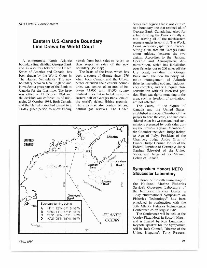
States had argued that it was entitledto a boundary line that retained all ofGeorges Bank. Canada had asked fora line dividing the Bank virtually inhalf, leaving all of the northeasternsegment under its control. The WorldCourt, in essence, split the difference,setting a line that cut Georges Bankabout midway between the twoclaims. According to the NationalOceanic and Atmospheric Administration, which has jurisdictionover fisheries out to 200 miles off theU.S. coast, including the GeorgesBank area, the new boundary willmake management of Atlanticfisheries, including cod and haddock,very complex, and will require closeconsultation with all interested parties. High seas rights pertaining to thearea, such as freedom of navigation,are not affected.
The Court, at the request ofCanada and the United States,established a Special Chamber of fivejudges to hear the case, and had considered extensive written and oral submissions presented by both sides during the previous 2 years. Members ofthe Chamber included: Judge Roberto Ago of Italy, President of theChamber; Judge Andre Gros ofFrance; Judge Herman Mosler of theFederal Republic of Germany; JudgeStephen Schwebel of the UnitedStates; and Judge ad hoc MaxwellCohen of Canada.
Symposium Honors NEFCGloucester Laboratory-', ;
:.~ .. "
ATLANTICOCEAN
D
4lJ'N
vessels from both sides to return totheir respective sides of the newboundary (see map).
The heart of the issue, which hasbeen a source of dispute since 1976when both Canada and the UnitedStates extended their eastern boundaries, was control of an area of between l3,OOO and 18,000 squarenautical miles that included the northeastern half of Georges Bank, one ofthe world's richest fishing grounds.The area may also contain oil andnatural gas reserves. The United
GeorgesBank
B
Gulf of Maine
SOfalhOrns
.'p '.~ Boundary turning points
A 44°11' 12"N-67°16'46"WB 42°53'14"N-67°44'35"WC 42°31 '08"N-67°28'05"WD 400 27'05"N-65°41 '59"W
Eastern U.S.-Canada BoundaryLine Drawn by World Court
UNITEDSTATES
A compromise North Atlanticboundary line, dividing Georges Bankand its resources between the UnitedStates of America and Canada, hasbeen drawn by the World Court inThe Hague, Netherlands. The newboundary between New England andNova Scotia gives part of the Bank toCanada for the first time. The issuewas settled on 12 October 1984 andthe decision was enforced as of midnight, 26 October 1984. Both Canadaand the United States had agreed to a14-day grace period to allow fishing
46(4),1984 81
Station. In addition, a program hasbeen assembled which features someof the world's foremost fisherytechnologists and the Symposium willbe an excellent opportunity to examine the state of the art in the fieldof fisheries technology.
The entire program of the 30thAFTC has been in preparation, aswell, with the first call for papers being sent out in early March. The second and final call for papers was to beissued in early June, with an abstractsubmission deadline of 1 July 1985. Afinal mailing, 1 month prior to theconference, will include the final program and registration and hotel information.
American Lobster Size,Gear Requirements Told
Effective 1 January 1985, federalregulations which implement theAmerican Lobster Fishery Management Plan (FMP) require that lobsterslanded in whole form must have aminimum carapace length of 33/ 16
inches, and gear must be appropriately marked and vented. Richard H.Schaefer, Acting Northeast RegionalDirector of the National MarineFisheries Service, stated that theseprovisions apply to all lobsterfishermen who are permitted to fish inthe fishery conservation zone (FCZ),either by his office or through an endorsement on a State lobster permit.
Lobster gear deployed in the FCZor possessed by a person whose vesselis permitted to fish in the FCZ mustbe marked with the vessel's Federalfishery permit number, or the markings required by the vessel's homeportState. This gear must also include anescape vent(s) in the parlor section ofthe trap. The vent may either be: 1) Arectangular portal with an unobstructed opening not less than 1 3/4inches (44.5 mm) by 6 inches (152.5mm); or 2) two circular portals withunobstructed openings not less than 21/4 inches (57.2 mm) in diameter.
According to Schaefer, these provisions for the minimum carapace size
82
and the gear marking and venting requirements will not affect mostlobstermen because they are alreadyrequired in many of the states. TheAmerican Lobster FMP was preparedby the New England Fishery Management Council, and is intended to implement the Federal share of thecoastwide lobster management program for this valuable fishery.
Misleading Reports Givenby Japanese Fish Groups
The National Marine FisheriesService announced at the NorthPacific Fishery Management Councilmeeting in Anchorage last fall thatdocuments seized from Japanesefishing vessels indicate that organizedmeasures had been used by Japanesefishing associations to frustrate U.S.observer programs and at-sea enforcement.
During fishing violations investigations conducted for improper catchlogging and reporting, Japanese language documents were seized andsubsequently translated. Thosedocuments indicate that the JapaneseLongline and Gillnet Association andthe National Federation of MediumTrawlers used highly organizedschemes to manipulate u.s. observercoverage on foreign vessels. The tactics included purposeful reductions incatch and restricting fishing areas.U.S. observers are used to monitorforeign catch levels and composition.The biased observer data may haveallowed the foreign vessels to avoidpayment of poundage fees andresulted in improper estimates of fishstocks by fishery managers.
Fishery managers use observercatch estimates when coverage of eachclass of foreign vessel is 20 percent ormore in a statistical area each week.The schemes employed oftenprevented achieving 20 percentobserver coverage so that foreignreported catch would be used. Thedocuments infer that vessels withoutobservers aboard could fishunrestricted but report only assignedquotas.
The schemes also involvedmonitoring of u.S. patrols to preventat-sea boardings of vessels that didnot have observers assigned. Patrolcraft location and movement information was sent by code to fishingvessels to allow movement away frompatrol vessels. When vessels withoutobservers were boarded, catchunderlogging violations were oftenfound.
Beginning in 1984, U.S. observercoverage was increased to nearly100%. That has eliminated the effectsof some of the tactics that had beenused. The level of foreign fishing offAlaska was significantly reduced in1984 and in part stems from increasedlevels of observer coverage.Observers, however, cannot monitorthe entire catch of a vessel that fishescontinuously and opportunities tobias observer catch estimates still exist.
The investigation results were provided to Department of State officialswho asked the Japanese Governmentto conduct an inquiry. While awaitingthat report, the North Pacific FisheryManagement Council and fisherymanagers were studying possible actions available to prevent recurrenceof such schemes.
Gulf Reef Fish FisheryRegulation Established
Regulations to conserve andmanage reef fish resources of the Gulfof Mexico became effective on 8November 1984, announced Jack T.Brawner, Southeast Regional Director, National Marine Fisheries Service(NMFS).
The regulations implement thefishery management plan (FMP) forreef fish resources prepared by theGulf of Mexico Fishery ManagementCouncil under the Magnuson FisheryConservation and Management Act.The regulations apply in the Gulf ofMexico portion of the fishery conservation zone (FCZ), which generallyincludes all waters extending from 3n.mi. off Alabama, Mississippi, andLouisiana, and 9 n.mi. off Florida
Marine Fisheries Review
NEFC Increases Salmon Research
(west coast) and Texas, to a distanceof 200 n.mi. offshore. Species regulated under the FMP are snappers,groupers, and sea basses.
The regulations establish a "stressedarea" in the nearshore waters of theFCZ off Florida and Alabama andportions of Mississippi and Texaswhere reef fish resources are subjectedto intensive fishing effort and wheresome species, especially red snapper,are overfished. In this area, the use offish traps and roller-rigged trawls isprohibited altogether, while powerheads (a projectile-firing device usedby divers) may not be used to harvestany regulated species. These restrictions are intended to reduce fishing effort and the potential for user conflicts.
Fish traps used outside the "stressedarea" are subject to certain construction specifications, number and sizelimitations, and permitting and tagging requirements. Individuals tending to use traps in the FCZ were required to apply for a permit from theRegional Director at least 45 days inadvance of the desired fishing date.Trap fishermen were given until 23November 1984 to comply with thepermit and tag requirements. There isno charge for permits and tags forfish traps. Permit applications may beobtained by writing or phoning theFishery Operations Branch, NationalMarine Fisheries Service, 9450 KogerBoulevard, St. Petersburg, FL 33702,(813) 893-3723. A copy of the reef fishregulations containing details of fishtrap construction features, a description of the "stressed area," and otherprohibitions also may be obtainedfrom the Fishery Operations Branch.
In addition, the regulations prohibit the use of poisons or explosivesfor taking any regulated species, andestablish a minimum size limit of 12inches fork length (13 inches totallength) on red snapper harvested inthe FCZ with three exceptions: I) Anincidental catch of five undersized redsnappers per person per trip is allowed; 2) domestic vessels lawfullyfishing trawls in the FCZ are exemptfrom the minimum size limit and incidental catch allowance for red snap-
46(4),1984
per; and 3) persons fishing in the FCZfrom headboats (generally vessels thatcarry seven or more persons who fishfor a fee) are exempt from theminimum size limit and incidentalcatch allowance for red snapper until
The United States, Canada, andmany European countries as far southas Spain produce Atlantic salmon,Salmo salar, which annually migrateto the waters off West Greenlandwhere they remain from one to severalyears before returning to their nativerivers to spawn. Greenland has noAtlantic salmon rivers but conducts asignificant fishery that has been thefocus of international concern sincethe mid-1960's. In 1971, for example,2,700 metric tons (t), or 750,000salmon, were caught in the high seasfishery off West Greenland. Scientistshave estimated that on average about42 percent of these fish come from theUnited States and Canada.
In 1972, the ICNAF (InternationalCommission for Northwest AtlanticFisheries) was able to set nationalquotas on fished species in the Northwest Atlantic for the first time andshortly thereafter the West Greenlandhigh seas fishery also came under control of ICNAF. The total catch wasgradually reduced to about 1,100 t annually, and the high seas fisheries ofNorway, the Faroe Islands, Sweden,and Denmark were completelyeliminated by 1976. The ICNAFmeasures continued in force until1977 when the U.S. extended itsfisheries jurisdiction to 200 miles.
In March 1983 the NMFS Northeast Fisheries Center (NEFC), wastasked to begin an Atlantic salmonresearch program which would address the high seas fisheries and the interception problem of U.S. salmon inthe Northwest Atlantic. On 25 March1983, NEFC representatives met withCanadian scientists in Halifax, NovaScotia, to review the Canadianresearch on Atlantic salmon. On 21April 1983, many of the U.S. scientists who are working directly with
8 May 1986. All red snapperharvested in the FCZ must be landedwith the head and fins intact. Federalcivil penalties up to $25,000 may beassessed for violation of these regulations.
Atlantic salmon from the States,Universities, and Federal Governmentmet at the NEFC in Woods Hole,Mass., to plan a detailed program ofresearch for the National MarineFisheries Service.
After review of the current U.S.research programs the group decidedthat the NEFC could contribute asignificant amount of informationprimarily in four areas: 1) Exploration and assessment of the methodsother than external tagging toseparate U.S. stocks of Atlanticsalmon from other stocks on the highseas, 2) provide assistance to the statesin analyzing their tagging data, 3) provide assistance to the states in expansion of their tagging programs, and 4)sponsorship of technical workshopswhich would bring together peoplewithin the New England area workingon Atlantic salmon to discuss common problems.
Thus, the NEFC has taken severalsteps. It is providing money to theAtlantic Sea Run Salmon Commission in Maine to evaluate the timing,magnitude, and distribution of commercial and home-water exploitationof 50,000 tagged hatchery-rearedAtlantic salmon smolts in 1984. TheCenter is also helping them to summarize and evaluate their tag returndata and establish a data processingsystem for tagging studies.
Also, the NEFC is providing fundsto the University of Rhode Island,Narragansett, for the assessment ofcertain characteristics associated withscales, otoliths, and body measurements which may be used in identifying U.S. Atlantic salmon stocks onthe high seas. In addition the Centerhas requested proposals, nationwide,for two studies on the review andevaluation of genetic and nongenetic
83
techniques to distinguish U.S. Atlantic salmon stocks from all otherstocks. Proposals are under review.The Center also held a workshop toevaluate the value of the stock identification techniques that will bestudied during the coming months.
Much effort has been spent overthe years to restore runs of Atlanticsalmon to the New England area bymany people. Their efforts are nowbeing rewarded with a significant increase in runs in several rivers. TheNational Marine Fisheries Service,which has responsibility for researchin the FCZ (3-200 miles from thecoast) and beyond, is now significantly developing an Atlantic salmonresearch program which will assist theStates and the Fish and Wildlife Service. By summer 1985, the Centerhopes to be in a position to knowwhich procedures are most useful foridentifying U.S. Atlantic salmon,regardless of where they are on thehigh seas. This will be useful inevaluating the degree of exploitationof U.S. Atlantic salmon off WestGreenland as well as in the Canadianfisheries as the salmon migrate fromWest Greenland back to the UnitedStates. If a proportion of U.S. Atlantic salmon are being killed by othercountries on the high seas, then it isvery important that the United Statesbe in a position to evaluate itssignificance.
Witch Flounder Eyed AsFishing Pressure Rises
The witch flounder, Glyp!ocephalus cynoglossus, also calledgray sole, is a slow-growing deepwater flatfish that is fairly common inthe Gulf of Maine-Georges Bankregion. Over the years, the species hasbeen taken primarily as a by-catchand landings have generally beenminor, averaging about 3,000 metrictons (t) during the 1960's and 1970's.Since 1980, however, landings haveincreased substantially; the 1982 totalwas 5,100 t and an increase to perhaps7,000 t was projected for 1983. Thisincrease has been accompanied by anincrease in effort and in landings of
84
smaller fish. In response to thesetrends, the NMFS Northeast FisheriesCenter has developed a preliminaryassessment to evaluate the currentstatus of the witch flounder resource.
In U.S. waters, witch flounder aremost abundant throughout the Gulfof Maine and in deeper areas alongthe fringes of Georges Bank. In 1982the primary fishing areas were locatedin the west-central Gulf of Maine, offCape Cod, and along the northwestern rim of Georges Bank. Specific spawning grounds have not beenfound, but the species appears tospawn widely throughout the westernGulf of Maine from March to October, with a peak in May and June.
Witch flounder are prized as a foodfish and command a high marketprice, but they are not abundantenough off New England to support acontinuous directed fishery.Therefore they have been caughtprimarily as part of a mixed fisheryand as a by-catch in other directedfisheries.
The bulk of U.S. landings in recentyears has been taken by small vesselsfishing year-round in the Gulf ofMaine and by larger vessels fishing onGeorges Bank during late spring andearly summer. In general, effort andtotal catch have increased for all tonnage classes. Another noteworthytrend in the witch flounder fishery hasbeen an apparent increase in landingsof small "peewee" flounder of 11-12inches in length. Future prospects forthis resource are uncertain. Researchvessel survey data suggest a decliningtrend since the late 1970's implyingthat the 1982-83 landings averageabout 6,000 t.
Northern Gadoid WorkshopScheduled at NWAFC
An international "Workshop onComparative Biology, Assessment,and Management of Gadoids fromthe North Pacific and AtlanticOceans" will be held 24-28 June 1985at the NMFS Northwest and AlaskaFisheries Center, Seattle, Wash. It iscosponsored by the Center, the Institute of Marine Research, Bergen,
Norway, and other Seattle and Bergeninstitutions.
At the Workshop, specialists fromseveral nations will review and discussthe life history, ecology, management, and utilization of these important gadoids and provide recommendations for future studies. Papers willbe submitted for the workshop, butnot formally presented. Instead, rapporteurs will provide a synthesis ofthe contributed papers by category.Workshop papers will be compiled inproceedings and selected papers willbe published in a special journal issue.Additional information can be obtained from the Gadoid WorkshopOrganizing Committee, c/o MilesAlton, F/NWCI, Northwest andAlaska Fisheries Center, NMFS,NOAA, 7600 Sand Point Way N.E.,Bin CI5700, Seattle, WA 98115.
NOAA/USGS WillMap 200-M i1e EEZ
NOAA and the Department of theInterior's u.s. Geological Survey(USGS) have launched a cooperativemulti-year program to provide basic"roadmaps" vital to systematicresource exploration, development,and conservation of the U.S. EEZ(exclusive economic zone). WhenPresident Ronald Reagan proclaimedthe EEZ 200 miles from the shores ofthe United States in 1983, the size ofthe United States nearly doubled.
NOAA's responsibilities for thelargely uncharted 6 million squaremile area in the EEZ include surveying, mapping, oceanic and resourceanalysis, and fisheries management.USGS responsibilities include definition of seafloor geology, geologicalprocesses, and resources, which include sand and gravel, placers,phosphorites, manganese nodules,cobalt crusts and sulfides, all with major stragetic and economic potential.The project began in the Pacific, withthe West Coast schedule for 1984-85;Alaska in 1986; the Hawaiian Islandsin 1987; and then the Trust Territories. East and Gulf Coastschedules have not yet been set.