45
NEIGHBORHOODS

NEIGHBORHOODS


: a section of a town or city
: the people who live near each other
‘na b e r hud
neighborhoods

Park City, the Best Town for the Planet142
THAY
NES
TH
AYN
ES

143
THAYN
ES
NEIGHBORHOOD 1: THAYNES

Park City, the Best Town for the Planet144
THAY
NES
THAYNES
NATURAL CONDITIONS
Existing TrailsExisting Roads
Ridgelines10’ ContoursSlopes > 30 %BuildingsWetlandsExisting VegetationStreams and WaterPriority Wildlife X-ingSecondary Wildlife X-ing
↔↔
Map 1

145
THAYN
ES
Total Area (sq. miles) 0.97 square milesTotal Area (acres) 620 acresTotal Units 250Unbuilt Units 99% of Total Park City Units 2.7%Average Density 3.16 units per acreRange of Density 0.1 - 7.7 units per acrePopulation 418Total Businesses 17% of Total Park City Businesses 2%Housing Type Single Family and AgricultureHistoric Sites McPolin BarnAffordable Housing NoneOccupancy 65% Primary residence
59% Owner-occupied6% Renter-occupied
Neighborhood Icons McPolin Farm, Rotary Park, Hiking Trails, Streams, Park City Golf Course
Parks Rotary ParkAmenities McPolin Farm, Frank Richards Farm, Aspen Springs
Open SpaceTrails McPolin Farm Trail and Thaynes Canyon Trail,
Connection to McCleod Creek TrailWalkability Internal streets and trails; few amenities within 1/4
mile that would decrease Vehicle Miles TraveledSub-Neighborhoods Aspen Springs, Iron Canyon, Thaynes Canyon,
Thaynes Creek Ranch
* HOAs may exist in this neighborhood; please refer to page 10.

Park City, the Best Town for the Planet146
THAY
NES
SR 224
Mea
dow
s Driv
e
Payday Drive
Thaynes Canyon Drive
TrailAffordable Housing
Trail HeadBus RouteBus StopPaved RoadOpen SpaceStreams and WaterInstitutional UseParks and Rec.
BUILT CONDITIONS
Map 2

147
THAYN
ES
A variety of housing densities exists within the Thaynes neighborhood. While all the units are single family homes, the size of the homes and the parcels differ. Estate homes in the Aspen Springs Ranch (see top left) have the lowest density in the neighborhood. These are large houses on large lots at the north end of the neighborhood. Homes in the Iron Canyon subdivision (see middle) are relatively more dense than Aspen Springs Ranch. The highest densities in the neighborhood are in the Thaynes Canyon subdivision located around the Park City Golf Course (see bottom). These homes are the oldest in the neighborhood and are much smaller than the more recently constructed homes in Iron Canyon and Aspen Springs Ranch. Many of these older homes have been remodelled with additions for added floor area.

Park City, the Best Town for the Planet148
THAY
NES
The yellow area represents the future location of the 30 approved units within the Ivers SPA in Summit County. The approved dwelling units may be transferred among the identified building locations/pods. Park City should work with the county to protect the pastoral setting of the entryway, and request that the four dwelling units proposed on the eastern edge be transferred behind the sight line of Saint Mary’s.
in Summit County. Park City should consider annexing the land up to the ridge to have governance over future development above this iconic entry way.
Park City’s Entry Corridor Protection Zone has created a soft landscaped edge along
1.1: McPolin Barn, the Gateway Icon to Park City.
The site of the McPolin Farm represents multiple core values of Park City: historic character, small town, and natural setting. The iconic Landmark Site, with its large dairy barn, outbuildings, silos, and corral (built c.1921 – 1954) welcomes residents and visitors alike, reminding them of the City’s rich history and strong values.
The City boundary currently exists at the edge of the McPolin Farm. Future development is planned behind Saint Mary’s Church within the Iver’s parcel, just beyond the City boundary (see aerial top right). The City should work closely with Summit County to guarantee that future development of the Iver’s parcel is sensitive to this historic and natural area so as not to interfere with the pastoral setting of the McPolin Farm.
the main entry into Park City providing a significant buffer between development and the main transportation entrance into the City. This design element is essential to preserving the small town feel and connection to the natural setting. The Entry Corridor Protection Overlay
1.2: The City Boundary, a Shared Greenbelt and Wildlife Corridor.
As the City boundary becomes a shared greenbelt with the County, safe wildlife and pedestrian crossings will become established. This area is utilized frequently by local wildlife, including elk, deer, and moose. Park City must work in cooperation with Summit County to establish a regional greenbelt shared between the communities.
1.3: The Edge, access to nature and soft edge of the Frontage Protection Zone.
The Thaynes Canyon neighborhood is nestled into the base of Iron Mountain. This beautiful natural backdrop is home to single track trails, wildlife, and skiing. The Park City boundary extends up a portion of the mountainside yet the ridge area is located
4 Dwelling Units
4 Dwelling Units10 Dwelling Units
12 Dwelling Units
4 Dwelling Units
4 Dwelling Units10 Dwelling Units
12 Dwelling Units
149
THAYN
ES
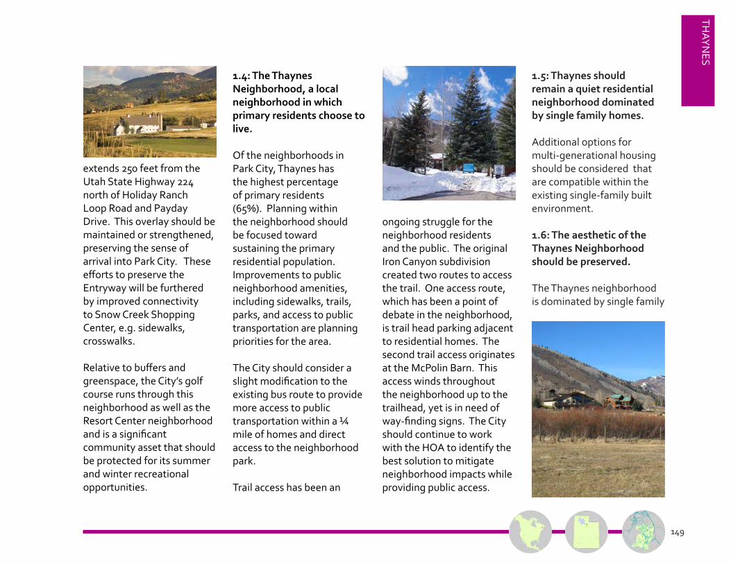
extends 250 feet from the Utah State Highway 224 north of Holiday Ranch Loop Road and Payday Drive. This overlay should be maintained or strengthened, preserving the sense of arrival into Park City. These efforts to preserve the Entryway will be furthered by improved connectivity to Snow Creek Shopping Center, e.g. sidewalks, crosswalks.
Relative to buffers and greenspace, the City’s golf course runs through this neighborhood as well as the Resort Center neighborhood and is a significant community asset that should be protected for its summer and winter recreational opportunities.
1.4: The Thaynes Neighborhood, a local neighborhood in which primary residents choose to live.
Of the neighborhoods in Park City, Thaynes has the highest percentage of primary residents (65%). Planning within the neighborhood should be focused toward sustaining the primary residential population. Improvements to public neighborhood amenities, including sidewalks, trails, parks, and access to public transportation are planning priorities for the area.
The City should consider a slight modification to the existing bus route to provide more access to public transportation within a ¼ mile of homes and direct access to the neighborhood park.
Trail access has been an
ongoing struggle for the neighborhood residents and the public. The original Iron Canyon subdivision created two routes to access the trail. One access route, which has been a point of debate in the neighborhood, is trail head parking adjacent to residential homes. The second trail access originates at the McPolin Barn. This access winds throughout the neighborhood up to the trailhead, yet is in need of way-finding signs. The City should continue to work with the HOA to identify the best solution to mitigate neighborhood impacts while providing public access.
1.5: Thaynes should remain a quiet residential neighborhood dominated by single family homes.
Additional options for multi-generational housing should be considered that are compatible within the existing single-family built environment.
1.6: The aesthetic of the Thaynes Neighborhood should be preserved.
The Thaynes neighborhoodis dominated by single family

Park City, the Best Town for the Planet150
THAY
NES
Past and future efforts, within the Thaynes neighborhood, will continue to focus on preserving the entry corridor into Park City. This entry corridor sets the small town aesthetic for Park City with the pastoral setting of the McPolin farm and the surrounding Open Space. It is also a shared wildlife corridor with the County - a corridor that should be protected and even enhanced.
ANTICIPATED CONDITIONS
Map 3
Future Development Ivers
Bus RoutePossible Bus RouteBus StopPossible Bus StopOpen SpaceAEA Boundary City Owned
Existing RoadPossible TrailExisting Trail

151
THAYN
ES
residential development and medium density lots ranging from a 1/4 to 1/2 acre. Existing lots in Thaynes Canyon do not have building pad limits or protection of natural vegetation. All lots in Iron Canyon and Aspen Springs have strict limits of disturbance areas
and platted restrictions on building pads.
To maintain the natural and built environment of the Thaynes neighborhood, regulations limiting building pads should be adopted. Building pads should be located to follow the pattern
of the street, typically maintaining Open Space toward the rear of the lot. Shared view corridors should be maintained. The Planning Commission should consider adopting increased rear yard setbacks or building pads to limit future development. Barns and
secondary structures should maintain view corridors and be located near the primary building on a lot.
Park City, the Best Town for the Planet152
PARK
MEA
DO
WS
Small Town
PRINCIPLES1A Infill development for transfer of development right credits. 1B Well-defined, natural neighborhood edge1C Liveability of Primary Neighborhoods1D Increase opportunity for local food production2D Materials and method of construction relate to region.3A Streets, pedestrian paths, and bike paths contribute to a fully connected system.
PLANNING STRATEGIES1.1 Amend LMC allow context sensitive infill development for TDR credits. 1.4 Revise minimum lot
size with context sensitive
regs..
1.5 Implement
conservation subdivision
design.
3.5 Connectivity of roads,
sidewalks, and trails.
3.9 Locate public
transportation infrastructure
to increase
capture rate.
PARK
MEA
DO
WS

153
PARK
MEA
DO
WS
NEIGHBORHOOD 2: PARK MEADOWS

Park City, the Best Town for the Planet154
PARK
MEA
DO
WS
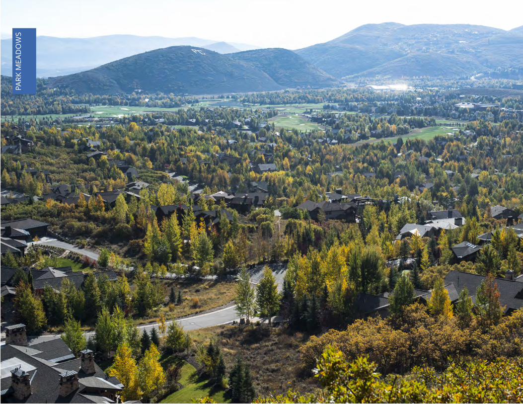
PARK MEADOWS
NATURAL CONDITIONS
Existing TrailsExisting Roads
Ridgelines100’ ContoursSlopes > 30 %BuildingsWetlandsExisting VegetationStreams and WaterSecondary Wildlife Corridor
↔
Map 1

155
PARK
MEA
DO
WS
Total Area (sq. miles) 2.49 square milesTotal Area (acres) 1593 acresTotal Units 1,610Unbuilt Units 117% of Total Park City Units 17%Average Density 2.56 units per acreRange of Density 0.14 - 39.41 units per acrePopulation 2604Number of Businesses 129% of Total Park City Businesses 16%Housing Type Single Family, condominiums, multifamily
apartmentsHistoric Sites Sprigg FarmAffordable Housing Holiday Village (80), Parkside (42)Occupancy 65% Primary residence
50% Owner-occupied30% Renter-occupied
Neighborhood Icons Park City School District Campus, Eccles Center, PC MARC, Park Meadows Golf Club
Parks Creekside ParkAmenities Round Valley, Boothill, Huntsman EntrywayTrails Many trails around edge of and connecting to
neighborhoodWalkability Internal streets and sidewalks. Few internal amenities
that would decrease vehicle miles traveled.
Sub-Neighborhoods Fairway Hills, Holiday Ranchettes, Park Meadows, Racquet Club Village, Risner Ridge
* HOAs may exist in this neighborhood; please refer to page 10.
Park City, the Best Town for the Planet156
PARK
MEA
DO
WS
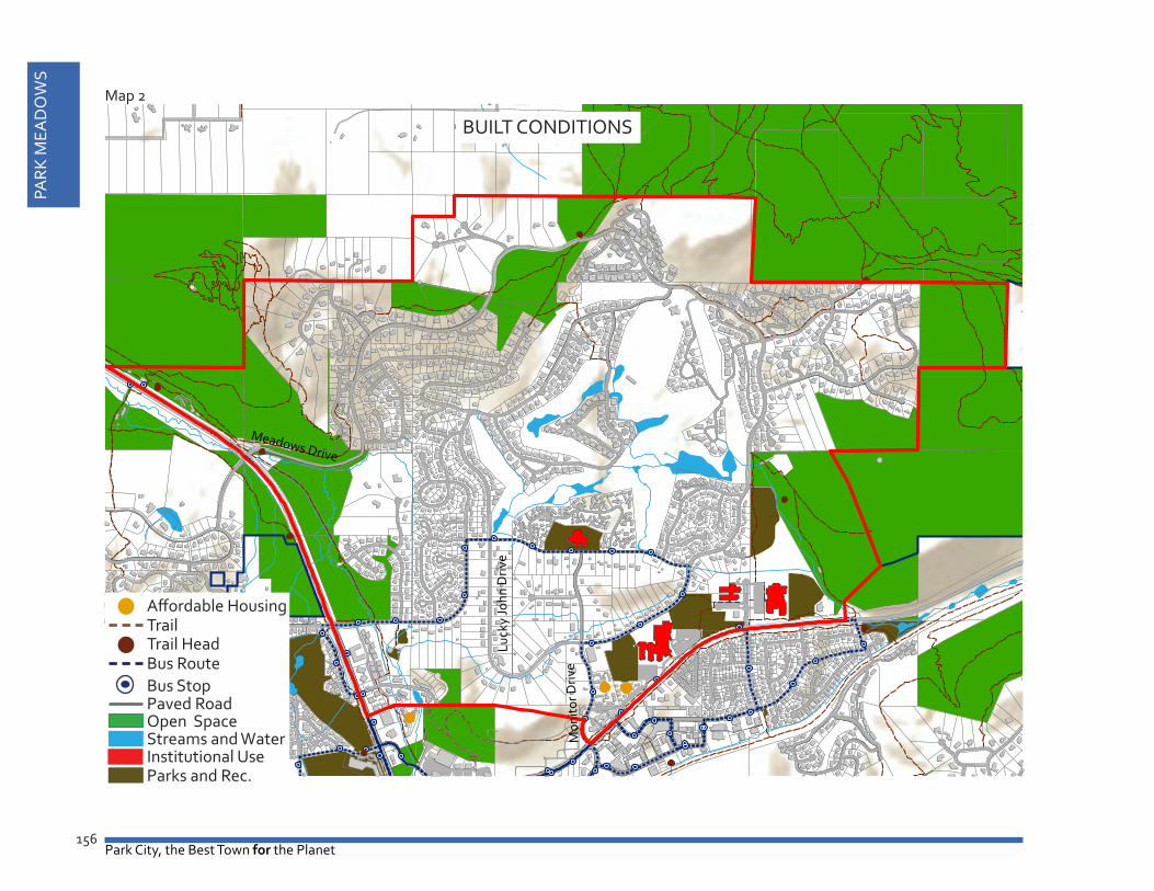
Meadows Drive
Mon
itor D
rive
Luck
y Jo
hn D
rive
BUILT CONDITIONS
TrailAffordable Housing
Trail HeadBus RouteBus StopPaved RoadOpen SpaceStreams and WaterInstitutional UseParks and Rec.
Map 2
157
PARK
MEA
DO
WS
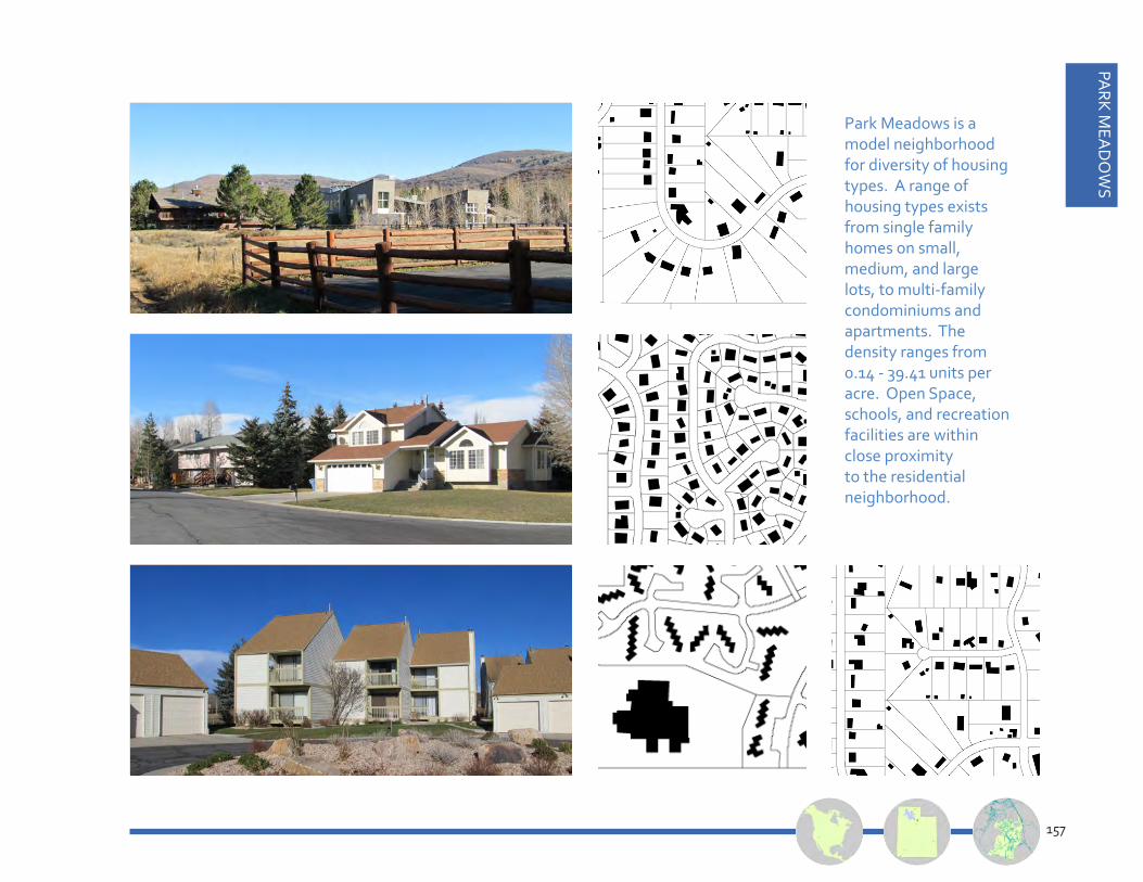
Park Meadows is a model neighborhood for diversity of housing types. A range of housing types exists from single family homes on small, medium, and large lots, to multi-family condominiums and apartments. The density ranges from 0.14 - 39.41 units per acre. Open Space, schools, and recreation facilities are within close proximity to the residential neighborhood.

Park City, the Best Town for the Planet158
PARK
MEA
DO
WS
2.1: The Park Meadows Neighborhood, tucked behind Boothill and the Entryway with a comfortable buffer for wildlife.
The northwestern edge of the Park Meadows neighborhood is defined by SR 224 within the pastoral Entryway into Park City. This must be protected. The combination of trails, wetlands, and a historic barn against the hillside backdrop creates a soft pastoral entry into the City, complimentary to the McPolin Farmstead across the street. McCleod Creek takes its last turn through the City before winding out to the Snyderville Basin. Mountain Top Hill provides
a natural screen to the most populated subdivision in Park City. As the boundary of the City becomes a greenbelt shared with the County, safe wildlife and pedestrian crossings should be established. The Entryway is frequently utilized by the wildlife, including elk, deer, and moose. The City should work with Summit County to ensure that the area between Mountain Top Hill and Round Valley does not become fragmented due to development, and resulting in loss of wildlife corridors.
Wildlife habitat is essential to a healthy ecosystem. As the Park Meadows area became subdivided,
limits of disturbance were introduced to protect the natural landscape within the area. This created a unique aesthetic within the subdivisions in which limits of disturbance are controlled. The City should consider incentives for residents to reintroduce native landscapes within the neighborhood and, especially, along the limits-of-disturbance-edge. This will support ecosystem health, biodiversity, and clean water.
2.2: The Park Meadows Neighborhood, home to diverse housing opportunities, many public amenities, and 34% of the City’s primary residents.
Park Meadows reported the highest population of full time residents, followed by the Prospector and Bonanza Park & Snow Creek Neighborhoods. The 2010 census reported a total of 2,604 primary residents within the Park Meadows neighborhood. There is a great mix of housing opportunities, including affordable housing apartments, a variety of condominiums, and a range of sizes and styles of single family homes. To maintain Park Meadows as a local

159
PARK
MEA
DO
WS
residential neighborhood, nightly rental should be prohibited and a diversity of housing opportunities should continue to be encouraged and protected. The local ambiance of this neighborhood is an essential part of its character.
In 2012, the Park Meadows
neighborhood had a total of 1,610 residential units (with 117 vacant developable lots) on a total of 1,593 acres. Taking the large golf course out of the equation, the Park Meadows neighborhood has an average density of 2.56 units per acre, relatively low compared to the Citywide average units per acre of
7.82.
2.3: As a primary resident neighborhood, community amenities should be planned to meet daily needs.
Future land use, transportation, and public amenity decisions should be geared toward the intent of sustaining Park Meadows as a primary resident neighborhood. Improvements to the public neighborhood amenities, such as sidewalks, trails, parks, and access to public transportation are planning priorities for the area. The City should consider a slight modification to the existing bus route to provide a greater portion of the Park Meadows neighborhood with access to bus stops within a ¼ mile. Providing safe routes to school is also a priority.
The Park Meadows neighborhood has many
community amenities including the private golf course, the dirt bike jump park, Creekside Park, the Racquet Club, the Park City School District Campus (home to four schools and a variety of athletic fields), the Eccles Center for the Performing Arts, and access to the Open Space of Round Valley. Creating community amenities close to residential neighborhoods is essential to maintaining community while decreasing Vehicle Miles Traveled. Additional pedestrian improvements should continue to be made within this neighborhood. Public amenities should be supported within the neighborhood with careful mitigation of negative impacts such as traffic, lighting, and compatibility.

Park City, the Best Town for the Planet160
PARK
MEA
DO
WS
ANTICIPATED CONDITIONS
Bus RoutePossible Bus RouteBus StopPossible Bus StopOpen SpacePossible Open SpaceCity Owned
Existing RoadPossible TrailExisting Trail
Map 3

161
PARK
MEA
DO
WS
2.4: The aesthetic of the Park Meadows Neighborhood should be preserved.
Park Meadows offers a variety of development patterns, including large ranch style horse properties with deep lots, dense
condominiums, compact track home development on smaller lots to the west, and larger single family homes scattered around the golf course and climbing up the hillside around Meadows Drive. To maintain the aesthetic of the individual pockets of development,
limitations on building pads should be adopted. The initial development of Park Meadows considered shared view corridors within the deep ranch style lots, yet there are few subdivision plats that limit the building pads to protect the view corridors during future
redevelopment. In the interest of protecting the built and natural aesthetic of the neighborhood, the Planning Commission should consider adopting appropriate tools such as building pads and/or floor area ratios to limit future development.

Park City, the Best Town for the Planet162
BON
AN
ZA P
ARK
3
BON
AN
ZA P
ARK

163
BON
AN
ZA PA
RK
NEIGHBORHOOD 3: BONANZA PARK & SNOW CREEK

Park City, the Best Town for the Planet164
BON
AN
ZA P
ARK
BONANZA PARK & SNOW CREEK
Existing TrailsExisting Roads
Ridgelines100’ ContoursSlopes > 30 %BuildingsWetlandsExisting VegetationStreams and Water
NATURAL CONDITIONSMap 1

165
BON
AN
ZA PA
RK
Total Area (sq. miles) .31 square milesTotal Area (acres) 197 acresTotal Units 337Unbuilt Units 10% of Total Park City Units 3.5%
Average Density 8.07 units per acreRange of Density 0.7 - 260.4 units per acrePopulation 662Total Businesses 137% of Total Park City Businesses 16%Housing Type Condos, multifamily apartmentsHistoric Sites NoneAffordable Housing Snowcreek Cottages (13), Upper Ironhorse - Fireside
(94)
Occupancy 65% Primary residence32% Owner-occupied40% Renter-occupied
Neighborhood Icons Rail Trail, Railroad Spur, CemeteryParks Olympic Park Welcome Plaza Amenities Rail TrailTrails Connected to Old Town, Quinn’s Junction, and Park
Meadows via paved trails. Walkability Extremely walkable due to diversity of amenities
including schools, stores, and restaurants
Sub-Neighborhoods Claimjumper/Homestake, Fireside/Ironhorse, Snow Creek
* HOAs may exist in this neighborhood; please refer to page 10.
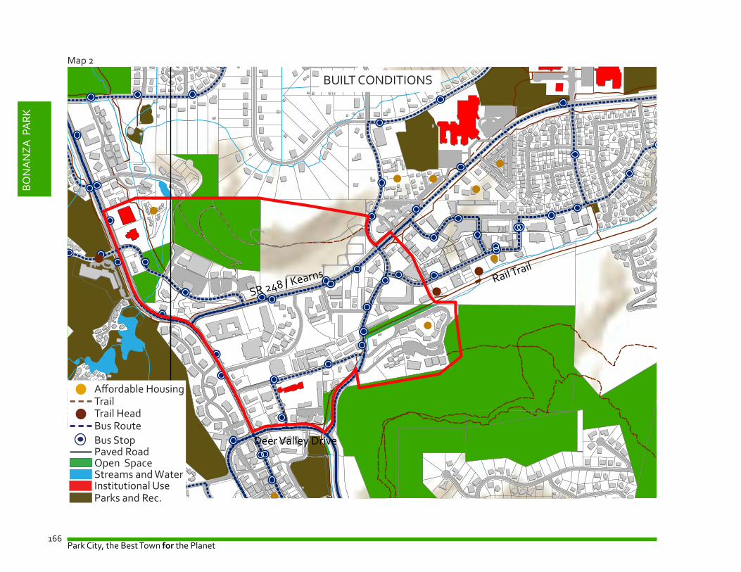
Park City, the Best Town for the Planet166
BON
AN
ZA P
ARK
SR 248 / Kearns
Deer Valley Drive
Rail Trail
TrailAffordable Housing
Trail HeadBus RouteBus StopPaved RoadOpen SpaceStreams and WaterInstitutional UseParks and Rec.
BUILT CONDITIONS
Map 2

167
BON
AN
ZA PA
RK
Housing types in the Bonanza Park & Snow Creek Neighborhood vary from cottage type housing on the western edge of the neighborhood to multifamily residential apartments and condominiums on the eastern edge. The neighborhood’s core is home to a mix of office spaces, commercial buildings, multifamily residential, and hotel/timeshare uses.

Park City, the Best Town for the Planet168
BON
AN
ZA P
ARK
3.1 Bonanza Park and Snow Creek: A mixed use neighborhood in which locals live and work.
The Bonanza Park & Snow Creek Neighborhood contains a variety of housing types as well as commercial development. Ranging from the single-family dwelling units that make up Snow Creek Cottages located adjacent to the Shopping Center, to the multifamily dwelling units that make up Homestake, Claimjumper, and Fireside Condominiums, the area is diverse in terms of housing units and is home to many of the City’s more affordable units - not all deed restricted, but de facto affordable units.
One of the greatest threats to the relatively affordable Bonanza Park neighborhood is gentrification. As the City adopts new policies to create a diverse neighborhood for locals, it is imperative that the locals be included in the
planning. The overriding goal for this neighborhood is to create new housing opportunities while maintaining the existing affordable housing units. In the case of redevelopment, any displacement of existing affordable units should be required to incorporate those units within the new development area. In an effort to support local start-up businesses and services, it is also essential to maintain affordable leases in the area.
This neighborhood is also home to the City’s only Light Industrial zoning district where automotive shops can coexist with a car wash, all within walking proximity of residential units. These types of uses should be preserved as the City moves forward with the concept of Form Based Code for this district. The City’s draft Bonanza Park Area Plan recommends similar strategies to preserve this neighborhood’s character.
As outdated buildings are replaced and existing buildings expand, the neighborhood will evolve into a local, mixed-use district. The Rail Trail State Park provides a main pedestrian spine for connectivity at the eastern end of the district (Prospector Square). As the area redevelops, it is envisioned that this spine will extend through the Bonanza Park Area.
As the neighborhood continues to evolve, multifamily residential uses should be concentrated within the Bonanza Park
redevelopment area. By directing higher density redevelopment to this area, the neighborhood has the potential to provide more Life-cycle Housing opportunities for Parkites, including starter and empty nester (step down) housing.
The Area Plan for this neighborhood should include a limit on nightly rentals if this district is to be protected as a locals neighborhood.
3.2 Bonanza Park: An authentic neighborhood.
Authenticity during redevelopment can be a

169
BON
AN
ZA PA
RK
challenge. Incentives to further subdivide properties to create multiple property owners within the district will help create a truly authentic place. Also, consideration to human scale, infusion of design elements representative of residents’ diverse roots, contemporary design, and consideration for the local history of the district, can add to placemaking and authenticity. The evolution of architectural design created over time will lead to an authentic, diverse district. Also, the introduction of Form Based Code will require incorporation of
design elements found in a traditional urban neighborhood, including sidewalks, landscaping, public art, and building interest at pedestrian eye level.
3.2 Bonanza Park and Prospector: The local employment hub.
To reach the goal of creating more diverse jobs for Parkites, a collaborative partnership approach to redevelopment must exist between the City, property owners, local residents, and business owners. Participation from
all parties is necessary to create a desirable mixed use neighborhood in which existing and new businesses choose to call home. The City has a goal to utilize economic development tools to attract new businesses in cooperation with investors. Private property owner participation is necessary for dedication of right-of-ways to transform the neighborhood into a connected neighborhood with public amenities. Infrastructure improvements that attract local residents and businesses must be explored and negotiated, including technology
infrastructure, public utilities, sidewalks, bike lanes, trails, public parks, roads, transit, and parking.
3.3 Bonanza Park: A model for sustainable redevelopment. The Bonanza Park & Snow Creek Neighborhood will be a model for green, sustainable redevelopment in balance with nature. The Bonanza Park Area Plan is a blueprint for environmentally sensitive development. Many of the principles identified in the Bonanza Park Area Plan reflect those emphasized by the U.S. Green Building
The Burnside Rocket, located in Portland, Oregon is a great example of sustainable design with art incorporated within the 24 office windows that have been painted by a local artist. The building has an “edible” roof from which produce is harvested by the restaurant tenants within the building. The building’s low carbon design saves 35o million BTU/yr. There is shared neighborhood parking rather than on-site, and its location next to bicycle routes, bus, and rail makes it extremely environmentally conscious and reflects the community’s core values.

Park City, the Best Town for the Planet170
BON
AN
ZA P
ARK
Council’s Leadership in Energy and Environmental Design for Neighborhood Development (LEED-ND) rating system. LEED-ND evaluates neighborhoods on a variety of principles within three categories: Smart Location and Linkage, Neighborhood Pattern and Design, and Green Infrastructure and Buildings. The Bonanza Park Area Plan incorporates all of the highest ranking LEED-ND principles, plus a few extras, from each of these categories. Consideration should be given by the City to expand the Bonanza Park Area Plan and Form Based Code to include the entire Bonanza Park and Prospector neighborhood. Due to limits on density within the Prospector neighborhood, this area could become a receiving zone for TDR credits and further alleviate growth pressures on Greenfield development.
3.4 Bonanza Park: Connected via new roadways, sidewalks, trails and a park system.
Connectivity is lacking throughout the district. The existing pattern of roads is disconnected, yet there is
a great opportunity to fix this disconnection as part of an overall redevelopment plan for the area. The BoPa Area Plan introduces new rights-of-way opportunities, sidewalks, an extension of the rail trail leading to a central park, and trails
connections within and around the district.
Beyond the importance of creating additional rights-of-way (ROWs) for vehicular access throughout the BoPa district is the need to utilize these ROWs for pedestrian
Connectivity and pedestrian safety are essential to neighborhood design within a mixed use area. Bonanza Park currently lacks both qualities. Proposed rights-of-way dedications and pedestrian improvements are imperative to actualize the vision of a live/work/play and walkable urban district. The exact locations of the proposed ROWs will be finalized as part of the BoPa Area Plan.

171
BON
AN
ZA PA
RK
and cyclist movement. This will allow for alternative modes of transportation thereby creating “complete streets.”
In addition to these connectivity recommendations for Bonanza Park, focus should be given to improving the connection between BoPa and Prospector Square. Bonanza Drive, running north/south within the eastern section of BoPa is heavily trafficked as a vehicular corridor. Improved pedestrian connections
across Bonanza Drive should be considered. The idea of a new under (or bridge over) Bonanza Drive to bring the rail trail further west into BoPa could create ease of access as well as a sense of entry to this district.
3.5 Bonanza Park: Explore as a central hub for public transportation.
With the neighborhood centrally located within the City, a future public transportation hub should be considered. Transportation routes that save commuters
time also result in saving the City money. To realize a change in the preferred transportation options from the car to walking, biking, and public transportation, a new look at the time efficiency of trips should be studied. Connectivity from the Bonanza Park central district to the resorts would alleviate traffic issues throughout the City. For example, a Bus Rapid Transit (BRT) or streetcar/trolley system connecting Bonanza Park to Kimball Junction and Main Street would begin to change local commuting patterns.
3.6 Bonanza Park: An important part of the Park City entry experience.
Due to its location along both of the entry corridors to Park City, the Bonanza Park & Snow Creek Neighborhood is geographically tied to the Park City entry experience. The scenic views that are
currently afforded to those entering the City are a defining characteristic of our town and should be preserved and enhanced.Currently, three sides of the Bonanza Park & Snow Creek Neighborhood are located within the Frontage Protection Zone (FPZ). The FPZ helps to preserve scenic view corridors by providing a significant landscaped buffer between development and highway uses and by restricting the location and height of structures in the zone. The FPZ also allows for future pedestrian and vehicular improvements along the highway corridors.In addition to investigating measures that would strengthen the FPZ, the City should also look at ways to enhance the entry experience. This might include installing public art, improving lighting or adding other elements that would improve the entry corridors.

Park City, the Best Town for the Planet172
BON
AN
ZA P
ARK
ANTICIPATED CONDITIONS
Existing Bus RoutePossible Bus RouteBus StopPossible Bus StopOpen SpacePossible RoadsCity Owned
Existing RoadPossible TrailExisting TrailPedestrian Paseo
Map 3

173
BON
AN
ZA PA
RK
3.7: The aesthetic of the Bonanza Park area should be true to the current character and the vision.
There are a four dominant architectural styles within the Bonanza Park district. The entryway along Park Avenue and Deer Valley
Drive emphasizes the ties to the resort with repeated use of shed roofs, gables, and timbers. As one wanders to the center of the district, known locally as Iron Horse, a more industrial design is apparent, with split block, horizontal siding, and metal decorative elements,
garage doors, and roofing. Residential areas have front porches with recessed garages. The commercial buildings are traditional with exterior materials of brick, stucco, or horizontal siding with symmetry of windows on the upper stories. The niches within the
neighborhoods shall become more defined as the area is redeveloped.

Park City, the Best Town for the Planet174
PRO
SPEC
TOR
SQ
UA
RE
PR
OSP
ECTO
R
SQU
ARE

175
PROSPECTO
R SQ
UA
RE
NEIGHBORHOOD 4: PROSPECTOR SQUARE

Park City, the Best Town for the Planet176
PRO
SPEC
TOR
SQ
UA
RE
PROSPECTOR SQUARE
Map 1
Existing TrailsExisting Roads
Ridgelines100’ ContoursSlopes > 30 %BuildingsWetlandsExisting VegetationStreams and WaterPriority Wildlife X-ing↔
NATURAL CONDITIONS

177
PROSPECTO
R SQ
UA
RE
Total Area (sq. miles) .4 square milesTotal Area (acres) 258 acresTotal Units 1149Unbuilt Units 50% of Total Park City Units 12%
Average Density 8.07 units per acreRange of Density 0.7 - 260.4 units per acrePopulation 1,862Total Businesses 281% of Total Park City Businesses 34%Housing Type Single Family, duplex,
condos, multifamily apartments
Historic Sites NoneAffordable Housing Silver Meadows Estates
(49), Prospector Sq. Condominiums (23), Aspen Villas (88)
Occupancy 45% Primary residence22% Owner-occupied26% Renter-occupied
Neighborhood Icons Rail TrailParks Prospector Park
New Prospector ParkAmenities Rail Trail, Silver CreekTrails Connected to Old Town,
Quinn’s Junction, and Park Meadows via paved trails. Connected to the Aerie via Lost Prospector Trail
Walkability Extremely walkable due to diversity of amenities including schools, stores, and restaurants.
Sub-Neighborhoods Prospector Park, Prospector Square, Prospector Village
* HOAs may exist in this neighborhood; please refer to page 10.

Park City, the Best Town for the Planet178
PRO
SPEC
TOR
SQ
UA
RE
SR 248 / Kearns
Deer Valley Drive
Rail Trail
Map 2
TrailAffordable Housing
Trail HeadBus RouteBus StopPaved RoadOpen SpaceStreams and WaterInstitutional UseParks and Rec.
BUILT CONDITIONS

179
PROSPECTO
R SQ
UA
RE
The Prospector Neighborhood contains a variety of housing types. Prospector’s eastern edge is dominated by single family homes, with multifamily residential apartments and condominiums scattered along the edge of SR 248. A mix of office spaces, commercial buildings, multifamily residential, and hotel/timeshare uses expand from the central Prospector area through Bonanza Park to the western border of Park Avenue.

Park City, the Best Town for the Planet180
PRO
SPEC
TOR
SQ
UA
RE
4.1 Prospector Square: The City’s first mixed-use and mixed-housing neighborhood.
The Prospector Neighborhood contains a variety of housing. Prospector’s eastern edge is dominated by single family homes and should remain a single family dominated neighborhood in the years to come. Multifamily residential apartments and condominiums are scattered along the edge of SR 248. A mix of office space, commercial buildings, multifamily residential, and hotel/timeshare uses expand from the central Prospector area through Bonanza Park to the western border of Park Avenue. The Rail Trail State Park provides a main pedestrian spine for connectivity.
At 1/5 the total size of the Park Meadows neighborhood and home
to 1862 full time residents, Prospector has an average of 8.07 units per acre, slightly above the average units per acre Citywide. As the neighborhood continues to evolve, multifamily residential uses should be concentrated within the Prospector Square commercial area (zoned General Commercial). By directing higher density redevelopment to these areas, the neighborhood has the potential to provide more life-cycle housing opportunities for Parkites, including starter and empty nester (step down) housing. Single family dwellings should be allowed only within the existing single family subdivisions on the eastern edge of the neighborhood.
Similar to Bonanza Park, one of the greatest threats to the relatively affordable Prospector neighborhood is gentrification. As the City
adopts new policies to create a diverse neighborhood for locals, it is imperative that the locals be included in the planning. The overriding goal for this neighborhood is to create new housing opportunities while maintaining the existing affordable housing units. In the case of redevelopment, any displacement of existing affordable units should be required to incorporate those units within the new development area. In an effort to support local start-up businesses and services, it is also essential to maintain affordable leases in the area.
The proposed Area Plan for
this neighborhood should include a limit on nightly rentals if this district is to be protected as a locals neighborhood.
4.2 Prospector Square: A Local Commercial District within a Residential Neighborhood
Prospector Square has long been the heart of Park City’s local economy. In conjunction with Bonanza Park, these two very connected neighborhoods contain 41% of the City’s businesses. Businesses in this neighborhood range from local restaurants and small offices to a local fitness

181
PROSPECTO
R SQ
UA
RE
center used by Parkites from all neighborhoods. The commercial area of Prospector Square is located on the western edge of the neighborhood and has easy access from Kearns Boulevard and Bonanza Drive. It is important to ensure convenient vehicular and pedestrian access to and from this district as this area continues to evolve. The eastern side of the neighborhood is primarily single family residential development. Residents in Prospector can easily walk to restaurants and shops in their neighborhood. This should be encouraged and protected as the area continues to grow. The commercial neighborhood has a pedestrian walkway that connects many businesses; while this is an asset to the district, the City should partner with the business association to ensure that its functionality is improved in the future.
The City’s Planning Department has committed to working with the Prospector Business Association and residents to create an Area Plan for this neighborhood that will provide opportunities for better connectivity, business growth, and neighborhood protection. The area has the basic framework for additional mixed-use development as well as opportunities for added mixed-income housing in the area zoned General Commercial (GC).With access to the Rail Trail along the neighborhood’s entire southern border, the area is well connected to the City’s trail system. The area has a unique opportunity to further the concept of shared parking; a reality that is already successful in this area. There may be opportunities to begin to examine redevelopment scenarios that utilize these parking lots (and existing sites) more efficiently.
4.3 Prospector Square: The eastern gateway to Park City. The eastern entry into Park City provides a beautiful, natural backdrop with Silver Creek and its adjacent wetlands to the south and PC Hill to the north. This preserved natural setting is due in large part to Park City’s Frontage Protection Zone (FPZ) and Entry Corridor Protection Overlay (ECPO) which run along SR-248 between the Quinn’s Junction and Bonanza Park Neighborhoods. These zones have ensured that visitors and residents are greeted by the feeling of a small town with a connection to nature. In order to preserve this sense of arrival, it is essential that these zones be maintained and enhanced.
One of the prominent features of the eastern entry to Park City is the Historic
Rail Trail. This reclaimed rail line begins in the Bonanza Park Neighborhood and runs through the entire Prospector Neighborhood before leaving Park City and continuing all the way to Coalville. The Rail Trail allows for Prospector Neighborhood visitors and residents to conveniently access the Open Space located along the entry corridor. It also serves as an important internal pedestrian and bicycle connection to the Bonanza Park Neighborhood and the network of trails connecting Old Town and Park Meadows. There is potential

Park City, the Best Town for the Planet182
PRO
SPEC
TOR
SQ
UA
RE
Map 3
Existing Bus RoutePossible Bus RouteBus StopPossible Bus StopOpen SpacePossible RoadsCity Owned
Existing RoadPossible TrailExisting TrailPedestrian Paseo
ANTICIPATED CONDITIONS

183
PROSPECTO
R SQ
UA
RE
for extending the Rail Trail to connect with future pedestrian improvements in the Bonanza Park Neighborhood.
Connectivity is generally lacking throughout the district. The existing pattern of roads is disconnected, yet there is a great opportunity to fix the disconnection without
widespread disturbance. The commercial area of Prospector Square was designed as a walking district that faces inward toward a wide pedestrian walkway. This great pedestrian design can accommodate outdoor dining and shopping yet is in need of activation. The area is not visible from the right of way or parking areas, therefore, unless a customer
has gone into one of the buildings and exited out the back door, they would not know this pedestrian area exists. If linkages were created to allow the car to drive across the pedestrian area in a few key locations, residents would become aware of the potential of the site and more businesses may choose to relocate there. Another alternative,
the use of pedestrian cross axes, may also provide better visibility and use. There is potential for this neighborhood to become one of the most pedestrian friendly areas of town. Three major design characteristics, two of which already exist, set the stage for the future. The previously mentioned pedestrian Prospector Square design, with minor tweaks, can establish the pedestrian focused shopping district. Second, the Rail Trail as noted, which connects this neighborhood to the rest of Park City with connections out to Quinn’s Junction (and beyond) and south to Old Town. The third is the future connectivity designed within the Bonanza Park Area Plan which will create safe connections between Prospector Square and Bonanza Park.


