Brief Description Outline of co-developed and co-selected mobility measures to be implemented in Malmo, Southend, Jerusalem, Thessaloniki, Bremen, Budapest
The sole responsibility for the content of this document lies with the authors. It does not necessarily reflect the opinion of the European Union. Neither the INEA nor the European Commission are responsible for any use that may be made of the information contained therein
Page 7 of 106
Malmo, Lindängen
1 Introduction
Over the last two years, a co-creative participation process has been set up in Lindängen, Malmö within the framework of the SUNRISE project. The objectives of this project are to co-identify and co-validate, co-develop and co-select, and co-implement mobility measures on the neighbourhood level (Lindängen) to foster sustainable mobility. As the aspect of co-creation is the main thread of SUNRISE, a participation process has been set up in Lindängen consisting of a variety of formats, such as on-tour-formats, interactive formats, and workshops to determine with stakeholders and residents the main mobility-related issues that the area of Lindängen is facing. Based on this problematisation, mobility measures have been developed in a co-creative format with participation of residents, stakeholder and the city administration of Malmö. More than 200 people have participated actively in these formats, and many more people have been informed about the ongoing process in Lindängen. In an online and offline public selection process, a number of measures have been identified that will be co-implemented in Lindängen in the framework of the SUNRISE project in the next two years.
On this basis, the Neighbourhood Mobility Action Plan contains all mobility measures that will be implemented. In this document, quick information about Lindängen will be provided for a contextualisation of the measures, and the objectives of the document and its measures. The core section is the list of measures with a detailed description of the location, the content and the start date of each of the developed and selected measures. At the end of the document, all measure ideas that have been developed, but will not be implemented as part of the SUNRISE project, are collected for possible future implementation in a different framework.
Page 8 of 106
2 Status Quo in Lindängen
Lindängen is located in the South of Malmö and home for 7.620 people. Compared to other parts of Malmö, the population in this neighbourhood is characterized by a high migration background. Most frequently spoken languages are Arabic, Polish, Danish and Serbian/Croatian. Lindängen is home to a very young population. 36 % of the residents are below the age of 24 compared to 29 % for Malmö’s average. Other socio-economic statistics describing Lindängen are an employment rate and per capita income below the city wide average, while school results rank above Malmö’s average.
The neighbourhood is representative for the Swedish building style of the 1960s-70s. During a time when housing was scarce, the national government encouraged the construction of one million new apartments with a clear separation of transport modes. Up until now, parking is reserved in underground garages and outside the neighbourhood. Inside, bike lanes and pedestrian paths connect residential areas with its central amenities, shops and services.
Malmö is standing at the outset of a building boom and Lindängen will be one of the main beneficiaries of this development. 200-300 new apartments will be built and two existing schools expanded to meet the needs of a growing population. Two bus express bus lines will be directed through the neighbourhood and accompanied with complementary changes e.g. redistribution of public and private space, bike-sharing system, bicycle paths.
More an organisational rather than a legal framework, Program Lindängen is a five-year pilot program with the objective to develop a model for geographical program governance. Investments and projects included into the program accumulate to a budget of ca. 500 million SEK (50 million EUR) and target both social and physical changes in the neighbourhood. The program is supposed to generate important lessons as well as various departments to act in a decisive and coordinated manner in order to meet challenges and use opportunities in Lindängen. Co-creation plays a central part for the program. SUNRISE contributes with a mobility perspective to the program.
Page 9 of 106
3 Goals
The Neighbourhood Mobility Action Plan serves as the basis for all implementation activities in Lindängen, Malmö, in SUNRISE. The Neighbourhood Mobility Action Plan represents the result of the co-creation process of SUNRISE with participation of residents, stakeholder and district administration. SUNRISE’s main goal is to foster sustainable mobility on the neighbourhood level with a co-creative approach.
All measures listed here are based on the co-identified and co-validated mobility problems and needs from the past SUNRISE process. The results will form the basis for new design solutions that might be implemented as permanent changes by the end of the project.
Malmö’s main objective with SUNRISE in Lindängen is to identify and test concrete mobility solutions that facilitate people living and working in Lindängen to travel in a more sustainable way. Special attention should be paid to foster use of bicycles, walking and public transport.
Overall, the co-creation process of SUNRISE in Lindängen should activate local residents and workers to actively take part in the development and shaping of their neighbourhood.
An underlying theme of SUNRISE activities in Malmö is to improve residents’ experience of public space. Lindängen has seen an increase in criminal activity in recent months which is discouraging use of public space. Therefore, activities that bring residents in public space are a key feature of participation in Lindängen.
These themes are represented by the measures outlined in the following section.
4 Planned Measures
In order to achieve the goals in Lindängen the SUNRISE team in cooperation with local stakeholder and residents developed the following list of measures. The aim is that the measures listed here will be implemented within the SUNRISE project. They have been co-developed and co-selected in various public participation activities as outlined in the Participation Action Plan.
Page 10 of 106
4.1 List of Planned Measures in Lindängen
The following measures will be implemented in Lindängen under the umbrella of the SUNRISE project. Please consult the following tables for more information on the measures.
Over a longer period of time illicit car driving - at designated bike and pedestrian paths in the park area - has been reported to the municipality customer service. This issue has also been validated in the initial dialogue during WP1 with residents of the neighbourhood. The traffic separated layout of the neighbourhood is not working as intended. Residents express that the illicit car driving cause unsafety and restrain the possibility of using the park for sustainable transportation and recreation.
The selected implementation area (see Figure 1) are owned by the city and is strategically important for ensuring safe and attractive bike and pedestrian paths between Lindängen and the city centre of Malmö.
Here, bike and pedestrian paths are to a great extent easily accessed by car due to the infrastructural layout of the neighbourhood. Several bike and pedestrian paths are seamlessly connected to adjacent car roads. There are regulatory signs, however, these are often neglected by car drivers.
In order to hinder motorists from driving on bike and pedestrian paths inside the park area, temporal traffic calming measures will be tested and placed at strategic locations in connection to the park.
These traffic calming test measures consist of: (a) physical barriers e.g. openable road barriers, bollards, bigger pots, and (b) clarification of traffic regulations by e.g. moving and adding signs, marking entrances of bike lanes with bike symbols.
Page 11 of 106
Objective
The objective of the temporal measures is to increase the perceptions of safety within the park by reducing illicit driving. The bike and pedestrian paths are to be reclaimed for their initial purpose: biking and walking and recreation. In addition, working as a basis for the success of further SUNRISE actions e.g. activating the park, promoting biking.
A desired side effect, of the traffic calming measures, could also be calming down the speeding motor scooter drivers along bike lanes.
Responsibility/Partner Organisations
The city of Malmö
Resources (personnel, finances)
The test measures and information material will be financed within the SUNRISE-project. Estimated budget 20 000 Euros. Permanent measures will be designed in 2020 financed by the city. A project group consisting of 1 traffic planner, 1 traffic regulator and 1 landscape architect are involved in this particular process in addition to the SUNRISE -team. Estimated work hours 335h.
Involvement of citizens/stakeholder during implementation
Neighbourhood residents will be informed about the test measures before implementation, and encourage commenting on them during the test period. A webmail with the name of the park will be promoted and used for direct communication between citizens and municipality. During the test period adjustments of test measures will be possible in consideration to comments from neighbourhood residents.
Page 12 of 106
Timeline
Mapping of location and design of suitable measures are done continuously with the citizen dialogue process, January to March 2019.
The test measures will be implemented during April to June 2019.
The test measures will be in operation April 2019 to approximately March 2020.
Test measures will be evaluated September/October 2019.
Risks & mitigation The budget for test measures might not be enough for ensuring a successful and satisfying result.
Figure 1: Map of Lindängen, Hermodsdal and Nydala. Area of implementation with in red rectangle.
Page 13 of 106
Safe Bike Parking – New/improved Facilities private space
Description
During the participatory process in WP1 residents in the neighbourhood conveyed an insecurity of parking their bike close to their own residence. Some even bring their bike into the apartment. Others reported that they don’t travel by bike anymore since their bike was stolen. Some residents don’t even see travelling by bike as an (attractive) alternative at all.
For this measure the focus will be on cooperating with one of the property owner in the area and a, by them, selected property to implement test solutions (see Figure 2).
Concretely SUNRISE-team plans to set up one or two new types of bike stands with weather shelter and stands allowing users to lock the bike frame.
We also want ease up the access to the bike infrastructure. Today there is a bike lane next to the apartment block but the cyclist must go around the whole block to reach the lane. Instead we want to create a new passage to facilitate access.
Objective Attractive and safe bike parking with good access to bike lane is expected to get residents to use the bike more often.
Responsibility/Partner Organisations
The SUNRISE-team at the City of Malmö together with property owner Stena Fastigheter AB will come up with a proposal plan for the measure. The SUNRISE technical support partner Koucky & Partners will be used for construction. Through procurement we get a provider/supplier to install the measures.
Resources (personnel, finances)
SUNRISE funds will be used to finance personnel (estimated 60 h) leading the process to come up with a bike parking suggestion. Technical support partner for SUNRISE, Koucky & Partners contributes with bike parking knowledge, inventory and construction. Estimation of the tests measures will be 18.000 Euros.
Page 14 of 106
Involvement of citizens/stakeholder during implementation
The property owner is involved in the implementation process. The tenants will be invited to be part of the preparation phase and to give feedback during the operation phase.
Timeline
Start of planning: March 2019
Start of construction: June/July 2019
Start of operation: August 2019
Risks & mitigation
There are some legal problems associated with the municipality financing test measures on private land. However, since the funds originate from SUNRISE, this creates a grey zone in which there is more flexibility.
Figure 2: Safe Bike Parking – New/improved Facilities private space - proposal
Page 15 of 106
Safe Bike Parking – Promotion campaign
Description
Connected to the physical test measures for safe and attractive bike parking at a designated apartment block, we want to carry out an promotion campaign for increased bicycle use. The mobility management measure is to inform about the physical improvements for safe and attractive bicycle parking, but also give the residents the opportunity to test-on-offer, bike pool solution, bicycle schools for adults, etc. The scope and content of the intervention are determined together with Stena Fastigheter.
Objective
With Mobility management measures we want to increase bicycle use by dwellers in the apartment block. We also want to boost the status of bikes as a viable and attractive means of transport.
Responsibility/Partner Organisations
The SUNRISE-team at the City of Malmö will be the main responsible for the measure. The bicycle school for adults is arranged together with Cykelfrämjandet (a non-profit organisation that promote cycling). The property owner Stena Fastigheter will assist distribution of information.
Resources (personnel, finances)
SUNRISE funds will be used to finance personnel leading the process (estimated 40 hours). Informative material, estimated budget 2.000 euros. The bicycle school for adults is an ongoing project partly funded by the City of Malmö.
Suggestions as bike pool solution and test-on-offers will either be sponsored by a supplier or sponsored by the property owner.
Involvement of citizens/stakeholder during implementation
Dwellers will get information about the test measures at the same time as we invite people to sign up for bicycle school or e-bike test etc. They will therefore be encouraged to be a part of the implementation.
Timeline Start of planning: April 2019
Start of operation: May 2019
Page 16 of 106
Risks & mitigation
The promotion campaign is contingent on physical measures being implemented in time.
The bike pool and test-on-offers depends on subsidising from third part. If this fails, the City of Malmö might fund the interventions.
Safe Bike Parking – New/improved Facilities urban space
Description
To increase bicycle use and boost the status of biking in a wider area around the selected apartment block, the SUNRISE-team wants to install a couple of bike facilities in the urban space. These measures will enhance the intervention we do together with property owner, Stena Fastigheter.
We want to put bike stands at a car parking lot to increase the number of bike parking spots but also to communicate a higher priority for bikes. We also want to install a self-service station close to a bike lane. This repair station with tools and air pump will provide cyclists with free equipment to make adjustments and repairs on the go (see Figure 3).
Objective Increasing the number of cyclists in the area by improve bike facilities in urban space. Boost the status of biking as a mode of transport.
Responsibility/Partner Organisations
The SUNRISE-team at the City of Malmö.
Resources (personnel, finances)
SUNRISE funds will be used to finance personnel leading the process (estimation 30 hours).
A bike service station including installation must be procured. The cost is estimated to 8.000 Euros.
The City of Malmö owns the temporary bike parking stand but there will be a cost for transport and installation. The cost is estimated to 2.000 Euros.
Page 17 of 106
Involvement of citizens/stakeholder during implementation
SUNRISE will hand out information about the measures to the dwellers in the area, encouraging to pass it on.
Together with property owners we will find the best spots for the installations.
Timeline Start of planning: September 2019
Start of operation: March 2020
Risks & mitigation
The aim is to get the measures financed by the City of Malmö. However, these funds are currently not guaranteed. Depending on the budget only one of the two measures (bike stands or service station) might be implemented.
Figure 3: Safe Bike Parking – New/improved Facilities urban space - proposal
Page 18 of 106
Facilitating Active Use of Urban Space by Physical Activity Boosting Measures
Description
Residents report that they do not feel comfortable using bicycle lanes and walking paths in the neighbourhood. Bicycle lanes and walking paths often go through park settings with vast and empty green areas. These are also separated from buildings and busier streets. Due to low perceived personal safety in the park residents avoid using it altogether, leaving it even emptier. Suggestions were put forward to stimulate more activity and make stuff happen to increase the use of the park, making it livelier and therefore creating a safer park to bike and walk in.
In the participation process citizens suggested that the park could be used for more work-out and sport related activities. The SUNRISE-team and local actors will, through different events, boost activity and usage and showcase the opportunities for exercise in the urban space and potential to work-out in the park. This will be done by bringing residents and stakeholders together to match offers and users, and to create new networks and opportunities.
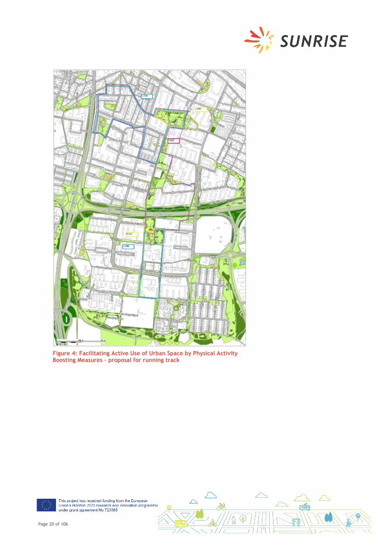
A. During the SUNRISE project the city of Malmö and the SUNRISE-team have been involved in identifying and designing a running-track (see Figure 4) through the neighbourhood with feedback and validation from residents. The running-track will be opened in spring 2019 and we will kick start the use of it through an opening event. This event will be co-created with local stakeholders in Lindängen. This event will take place in the park between Nydala, Hermodsdal and Lindängen (see map below) and the park will host different activities throughout the day.
B. The opening event will also be an opportunity to gather a network of fitness or sport focused local non-profit organisations around the potential of activating the park through physical activity on a more regular and continuous basis. The objective is to initiate a network with actors who are inspired to activating the park and the running track after the opening event. The SUNRISE-team will be a part of this network.
Page 19 of 106
Objective
Actual and perceived unsafety is an issue that directly influences people’s mobility choices throughout all transport modes. The neighbourhood has a well-developed bicycle infrastructure, however it is avoided after dark because of its isolated character. People report not to feel comfortable going outside or waiting for the bus. Particularly places where people do not feel secure and therefore avoid, could be activated and repopulated through different kinds of events, festivities and placemaking
Responsibility/ Partner Organisations
The SUNRISE- team at the City of Malmö will facilitate the networking process in this measure, together with local non-profit organisations and entrepreneurs focused on sports and public health.
Resources (personnel, finances)
The City of Malmö will finance the opening event of the running track together with the SUNRISE project. Estimation 1000 Euro. Personnel hours estimated to 20.
Involvement of citizens/ stakeholder during implementation
Local non-profit organisations may be involved in other activities on the day – such as information about ongoing activities, offering pop-up sport activities.
Ahead of the opening event SUNRISE will communicate through different information channels about the new track and the opening-event. Residents will be encouraged to spread material in their networks.
Timeline
A. Start of planning: February 2019
Information/invitations: April 2019
Event-date: April/May 2019
B. Start of planning: February 2019
Risks & mitigation B. There is a risk that we do not manage to create a network of local non-profit organizations during the timeline of the SUNRISE project, but this will be the start.
Page 20 of 106
Figure 4: Facilitating Active Use of Urban Space by Physical Activity Boosting Measures – proposal for running track
Page 21 of 106
Facilitating Active Use of Urban Space by Place Making Measures
Description
Residents report that they do not feel comfortable using bicycle lanes and walking paths in the neighbourhood. Bicycle lanes and walking paths often go through park settings with vast and empty green areas. These are also separated from buildings and busier streets. Due to the issue of low perceived personal safety in the park residents avoid using it altogether, making it even emptier. Suggestions were put forward to stimulate more activity and increase the use of the park, making it livelier and therefore creating a safer park to bike and walk in. The SUNRISE-team will test different ways to facilitate active use of the park by place making measures together with local actors:
A. During the participatory process many people mentioned bad lighting and growing vegetation that cause a feeling of unsafety. The SUNRISE-team will together with youths from the community center go for walks and map the park and the unsafe spots in it. Also participating in this walk are colleagues at a different department working with lighting and maintenance. By marking out vegetation, e.g. too tall bushes and trees and places where the light is not working well we will get a clearer picture of where people feel unsafe and have a list of measures to work on and questions can be answered directly by the responsible persons. This measure will both boost the feeling of participation and action. Making sure that the people we involved in WP2 can have a transparent look in to the processes of the municipality, since these processes often take time and it might be unclear why.
B. Today the park facilitates different functions and activities (see Figure 5) but citizens still report that the park is not well used. What activities and functions would create a greater use of the space? By working with different placemaking measures we want to test, explore and co-create a park with activities and functions that are relevant for citizens to create the conditions for a well-used park and a place perceived as safe to bike and walk in.
Page 22 of 106
Objective
Actual and perceived insecurity is an issue that directly influences people’s mobility choices throughout all transport modes. The neighbourhood has a well-developed bicycle infrastructure that is avoided after dark because of its isolated character. People report not to feel comfortable going outside or waiting for the bus. Particularly places where people do not feel secure and therefore avoided these, could be activated and repopulated through different kinds of events, festivities and placemaking.
Responsibility/ Partner Organisations
A. The SUNRISE-team at the City of Malmö will facilitate walks with youngsters from Allaktivitetshuset in collaboration with our colleagues at the city of Malmö.
B. The SUNRISE-team will work closely with colleagues working with the park, landscape architects and others at the City of Malmö and with local stakeholders in the area.
Resources (personnel, finances)
A. Personnel hours estimated 10 hours.
B. Personnel hours estimated 350 hours.
Budget for the tests and prototypes are 20.000 euros.
Involvement of citizens/ stake-holder during implementation
A. Citizens involved in WP2 will be invited through Allaktivitetshuset
B. Citizens and local stakeholders will be involved in the exploration and co-creation of new and improved uses of the space. In the extent that they can, citizens will also be invited to implement activities and functions in the park.
To make sure that the whole neighbourhood know about the measures SUNRISE will continually inform residents about the process.
Timeline
A. Start of planning – February 2019
Planned walk – May 2019
B. Start of planning: Spring 2019
Prototyping: Spring 2020
Start of tests: spring/summer 2020
Page 23 of 106
Risks & mitigation
B. Costs - the budget for tests are limited and might not be enough for ensuring a successful and satisfying result.
Legal – facilitating a prototyping test like this might not be possible through legal restrictions in the municipality.
Interest – people say that they are interested in participating but we can’t be sure that they will commit to a longer process of participating. We will try to minimize this risk by collaborating with established actors in the neighbourhood.
Political – if this measure is not prioritized by politicians we risk that it may not be possible to continue with prototypes and tests. By stressing the importance of this action in the neighbourhood, we hope that we will be able to at least to the try-outs in the area, even if a more permanent reformation of the park will not be submitted by the politicians.
Page 24 of 106
Figure 5: Facilitating Active Use of Urban Space by Place Making Measures – Proposed location of activities
Page 25 of 106
Facilitating Active Use of Urban Space by Cultural Measures
Description
Residents report that they do not feel comfortable using bicycle lanes and walking paths in the neighbourhood. Bicycle lanes and walking paths often go through park settings with vast and empty green areas. These are also separated from buildings and busier streets. Due to the issue of low perceived personal safety in the park residents avoid using it altogether, making it even emptier. Suggestions were put forward to stimulate more activity and make stuff happen to increase the use of the park, making it livelier and therefore creating a safer park to bike and walk in.
The City of Malmö are already involved in creating cultural activities all around the city and the SUNRISE-team wants to tap in to that. By supporting and creating cultural activities in the public space the SUNRISE-team will create more activity in Lindängen and Hermodsdal together with residents. To boost awareness and status we want to infuse sustainable mobility into these cultural settings. This will be done, both by being present at local events and festivals and by arranging SUNRISE events or campaigns. These events will also be used as a way of keeping the dialogue between citizens and the municipality alive. This will be done through:
A. Ongoing small local events – SUNRISE will be participating in already planned local events to infuse and boost awareness and status of sustainable mobility, for example during “Sommarfest” in June 2019 and/or other local events during 2019 and 2020. Collaborations with residents will be a big part of this.
B. Other events planned by the City of Malmö – SUNRISE-team will create internal awareness of the different venues in Lindängen and Hermodsdal which can be used when planning for bigger events in Malmö. And by participating in these events, SUNRISE will infuse and boost awareness and status of sustainable mobility. One example of this could be “Bike Day” in 2020 – this is an event with focus on sustainable mobility and biking. The day will include auction of bikes, station to get your bike fixed and other activities. We will try to place this event in Hermodsdal in 2020 to promote sustainable mobility in the area.
Page 26 of 106
Objective
Actual and perceived insecurity is an issue that directly influences people’s mobility choices throughout all transport modes. The neighbourhood has a well-developed bicycle infrastructure that is avoided after dark because of its isolated character. People report not to feel comfortable going outside or waiting for the bus. Particularly places where people do not feel secure and which are therefore avoided, could be activated and repopulated through different kinds of events, festivities and placemaking.
Responsibility/ Partner Organisations
The SUNRISE-team at the City of Malmö will coordinate different activities and events but also be involved in local ongoing happenings where we can boost sustainable mobility. SUNRISE will team up with colleagues at the City of Malmö and with local actors in the neighbourhood.
Resources (personnel, finances)
A. Personnel hours estimated 30. Budget 500 euros.
B. Personnel hours estimated 30. Budget 500 euros.
Estimation for the costs of this measure (planning, constructing etc.)
Involvement of citizens/stake-holder during implementation
Citizens will be involved through invitation and by active participation in the different events. Local stakeholders will also be involved in the planning and facilitation of activities on different events.
Information about different events will be communicated through information channels in the area and residents encouraged to spread the material in their networks.
Timeline
A. Start of planning: March 2019
Event: June 2019
B. Start of planning: February 2019
Risks & mitigation B. There is a risk that no larger events will be possible to place in the area. If this is the case we will try to boost smaller local events during the time of SUNRISE.
Page 27 of 106
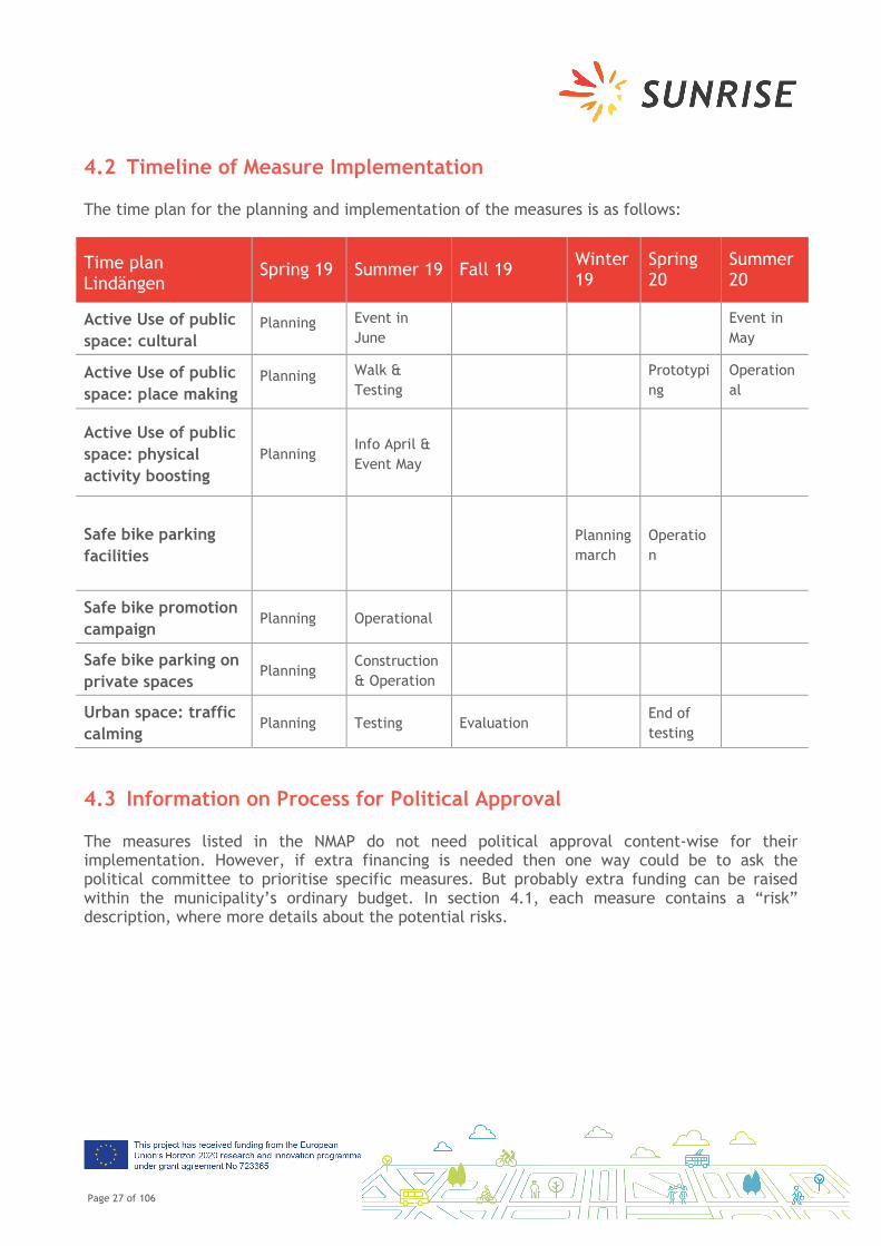
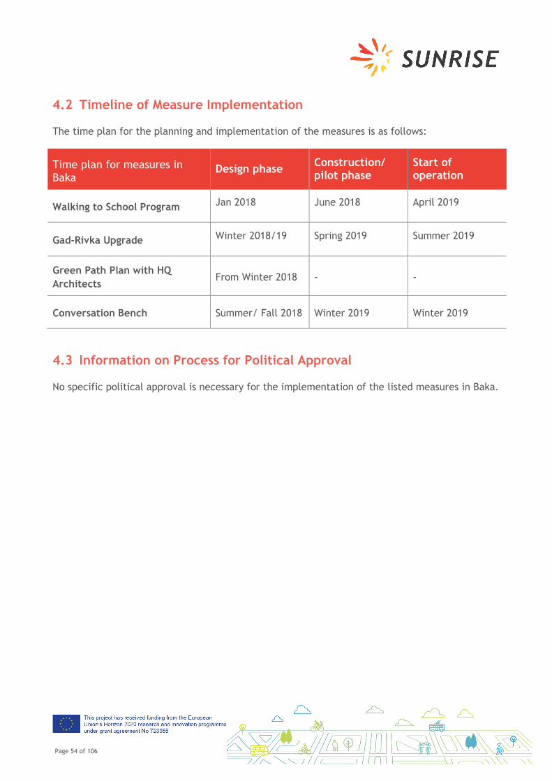
4.2 Timeline of Measure Implementation
The time plan for the planning and implementation of the measures is as follows:
Time plan Lindängen
Spring 19 Summer 19 Fall 19 Winter 19
Spring 20
Summer 20
Active Use of public space: cultural
Planning Event in June Event in
May
Active Use of public space: place making
Planning Walk & Testing
Prototyping
Operational
Active Use of public space: physical activity boosting
Planning Info April & Event May
Safe bike parking facilities
Planning march
Operation
Safe bike promotion campaign
Planning Operational
Safe bike parking on private spaces
Planning Construction & Operation
Urban space: traffic calming
Planning Testing Evaluation End of testing
4.3 Information on Process for Political Approval
The measures listed in the NMAP do not need political approval content-wise for their implementation. However, if extra financing is needed then one way could be to ask the political committee to prioritise specific measures. But probably extra funding can be raised within the municipality’s ordinary budget. In section 4.1, each measure contains a “risk” description, where more details about the potential risks.
Page 28 of 106
5 Ideas for Future Measures
In the co-creation process of SUNRISE, a number of measure ideas have been developed. Not all of them can be implemented under SUNRISE due to a variety of reasons such as resources, complexity, or scale. All these measure ideas are documented here and kept for a possible future implementation.
Over a longer period of time illicit car driving - at designated bike and pedestrian paths in the park area - has been reported to our customer service. This issue has also been validated in the initial dialogue with residents of the neighbourhood. The traffic separated layout of the neighbourhood is not working as intended. The illicit car driving is causing unsafety and restraining the possibility of using the park for sustainable transportation and recreation.
Bike and pedestrian paths are to a great extent easily accessed by car due to the infrastructural layout of the neighbourhood. Several bike and pedestrian paths are seamlessly connected to adjacent car roads. There are regulatory signs, however, these are often neglected by car drivers.
In order to hinder cars from driving on bike and pedestrian paths inside a park area, temporal traffic calming measures will be tested and placed at strategic locations in connection to the park. These temporal traffic calming measures consist of: (a) physical barriers e.g. openable road barriers, bollards, bigger pots, and (b) clarification of traffic regulations by e.g. moving and adding signs, marking entrances of bike lanes with bike symbols.
The temporal traffic calming measures will be implemented within and adjacent to the park area owned by the city. The implementation area is strategically important for ensuring safe and attractive bike and pedestrian paths between Lindängen and the city centre of Malmö.
Page 29 of 106
Objective
The objective of the temporal measures is to increase the perceptions of safety within the park by reducing illicit driving. A desired side effect of the traffic calming measures could also be calming down speeding of mopeds along bike paths.
Paths are to be reclaimed for their initial purpose: biking and walking. In addition, working as a basis for the success of further actions e.g. activating the park, promoting biking.
A desired side effect, of the traffic calming measures, could also be calming down speeding of mopeds along bike paths.
Responsibility/Partner Organisations
The city of Malmö
Resources (personnel, finances)
Estimated budget 20 000 Euros (see Risks &. A project group consisting of 1 traffic planner, 1 traffic regulator, 1 landscape architect and 1 dialogue expert is estimated to be required.
Involvement of citizens/stakeholder during implementation
Neighbourhood residents will be informed about the test measures before implementation, and encourage to comment on them during the test period. A webmail with the name of the park will be promoted and used for direct communication between citizens and municipality. During the test period adjustments of test measures will be done in consideration to comments from neighbourhood residents.
Timeline Start of planning: estimated January-March 2020
Start of implementation: estimated April 2020
Page 30 of 106
Risks & mitigation
If the result of the temporary test measures, implemented in the Hermodsdalsparken area, is satisfying, similar measures could be implemented in the area of Lindängsparken. However, this will only be possible if an internal budget is allocated.
At present, there is no budget allocated for the test measures in Lindängsparken.
Page 31 of 106
Southend
1 Introduction
Over the last two years, a co-creative participation process has been set up in Southend for the redesign of Victoria Circus and London Road within the framework of the SUNRISE project. The objectives of this project are to co-identify and co-validate, co-develop and co-select, and co-implement mobility measures on the neighbourhood level (the area of Victoria Circus and London Road) to foster sustainable mobility. As the aspect of co-creation is the main thread of SUNRISE, a participation process has been set up in Southend consisting of a variety of formats, such as drop-in sessions, on-tour-formats, online and offline interactive formats, and workshops to determine with stakeholders and residents the main mobility-related issues that the area of Victoria Circus and London Road is facing. Based on this problematisation, mobility measures have been developed in a co-creative format with participation of residents, stakeholder and the city administration of Southend. More than 200 people have participated actively in these formats, and many more people have been informed about the ongoing process in Southend. In an online and offline public selection process, several measures have been identified that will be co-implemented in Southend in the framework of the SUNRISE project in the next two years.
On this basis, the Neighbourhood Mobility Action Plan contains all mobility measures that will be implemented. In this document, quick information about Southend will be provided for a contextualisation of the measures, and the objectives of the document and its measures. The core section is the list of measures with a detailed description of the location, the content and the start date of each of the developed and selected measures. At the end of the document, all measure ideas that have been developed, but will not be implemented as part of the SUNRISE project, are collected for possible future implementation in a different framework.
2 Status Quo in Victoria Circus and London Road - Southend
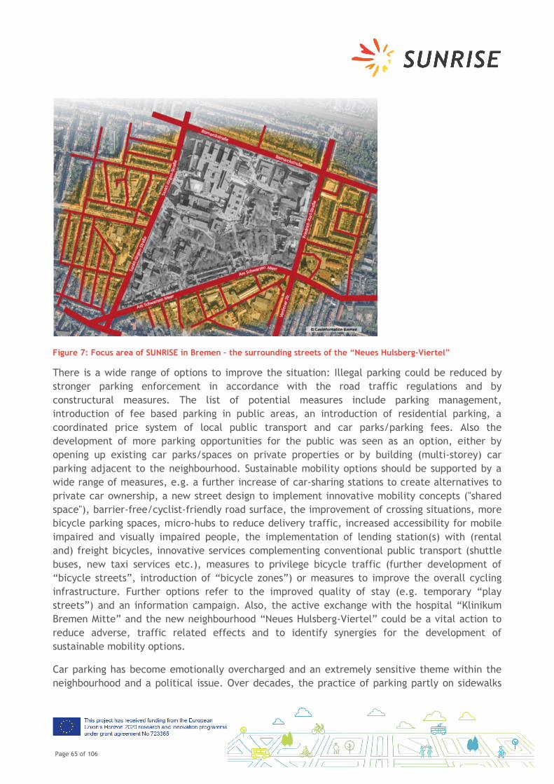
Victoria Circus and London Road in the Southend City Centre neighbourhood lie at the heart of Southend-on-Sea. It is a dynamic neighbourhood with a mixture of business, residential, demographics and environments and is in close proximity to both railway networks and public transport services. The area is also divided by two of the busy roads in the Borough which converge in the north of the neighbourhood (see map below).
Page 32 of 106
Figure 6: Project Area of SUNRISE in Southend
The neighbourhood covers an area of around 0.5 km2 and has a population of around 4,700. Around 27-30% of the inhabitants in the neighbourhood are economically inactive which includes people who are retired, looking after home/family, long term sick or disabled, and students. The neighbourhood is mixed with some affluent areas and some very low-income groups. There is a higher percentage of people unemployed in this neighbourhood compared to Southend as a whole. The neighbourhood falls under three Council wards which have overall about 15% of the inhabitants over the age of 60. However, the proportion of inhabitants over the age of 50 in certain parts of this neighbourhood is as high as 36-86%.
The neighbourhood falls within one of the most deprived wards in Southend-on-Sea and there are efforts being made to regenerate the area. These societal challenges are mirrored in the quality of some of the neighbourhood’s environment. The car is seen as a safer mode of transport and hence many opt not to walk or cycle.
Social networks in the neighbourhood are affected by the on-going regeneration of the neighbourhood, creating a divide between the older, less affluent, original residents, and the younger, more affluent new residents. Car often is perceived to represent affluence and is another reason that some choose the car over public transport, cycling and walking. Having said that, a recent survey revealed that walking is the main mode of travel to the City Centre. This includes people coming from different parts of Southend (not just the City Centre Neighbourhood).
Page 33 of 106
3 Goals
The Neighbourhood Mobility Action Plan serves as the basis for all implementation activities on Victoria Circus and London Road, Southend, in SUNRISE. The Neighbourhood Mobility Action Plan represents the result of the co-creation process of SUNRISE with participation of residents, stakeholder and district administration. SUNRISE’s main goal is to foster sustainable mobility on the neighbourhood level with a co-creative approach.
All measures listed here are based on the co-identified and co-validated mobility problems and needs from the past SUNRISE process. Southend-on-Sea aimed at finding creative solutions to mobility issues on Victoria Circus and London Road. It will use temporary trials to enable local stakeholders to test co-developed solutions for improving Victoria Circus and London Road (between College Way and Victoria Circus). The results will form the basis for new design solutions that will be implemented as permanent changes by the end of the project.
The main goals of SUNRISE in Southend are:
Redistribution of street space: Street space is not only transport space but space for social interactions with direct impacts on quality of life for citizens. The project will aim to reclaim all/part of carriageway to ensure the street space is used to its full potential and not just for car use.
Creation of a welcoming gateway to the City Centre: Innovative solutions to create an attractive entrance to the City Centre.
Promoting active travel: Facilitating active modes through comprehensive 'convenience' (infrastructure, information, campaigns etc.).
These themes are represented by the measures outlined in the following section.
Page 34 of 106
4 Planned Measures
In order to achieve the goals in Southend on Victoria Circus and London Road, the core group and the Co-creation Forum developed in cooperation with local stakeholder and residents the following list of measures. All measures listed here will be implemented within the SUNRISE project and have been co-developed and co-selected in various public participation activities as outlined in the Participation Action Plan.
4.1 List of Planned Measures in Southend on Victoria Circus and London
Road
The following measures will be implemented in Southend on Victoria Circus and London Road under the umbrella of the SUNRISE project. The selection of measures is the result of an online and offline public voting that took place in Spring 2019. Please consult the following tables for more information on the measures.
Page 35 of 106
Planting
Description
General greening, no specifics have been determined at this juncture to ensure flexibility of the type of greening i.e. trees, planters etc. as any specific measure will need to be checked to ensure they are not confined by constraints and also to avoid limiting the opportunities.
This can also incorporate water features as part of the greening, not necessarily a fountain in the image of the seafront as there are constraints below ground that will limit the scope, but something that can incorporate SUDs.
Objective
The conversations with people outlined a general desire to provide a softer feel to the existing streetscape, it was felt that the area is dominated too much by hard landscaping and needs to be broken up by trees and planting.
Responsibility/Partner Organisations Southend Borough Council
Resources (personnel, finances) £500,000
Involvement of citizens/stakeholder during implementation
Landscaping proposals will be produced and initially be brought to the Core Group to ensure they meet the requirements project. Once agreed these plans will be shared online, onsite and at specific meeting points and community groups to inform the neighbourhood of the intention.
Timeline
Detail Design: Spring/Summer 2019
Construction: Spring 2020
Completion: Winter 2021
Page 36 of 106
Risk Assessment & Mitigation
Risk - Expectations of planting possibilities exceed what can be achieved
Mitigation – Constraints to be clearly identified to ensure stakeholders are aware
Street furniture
Description
Seating to be sympathetic to the useable public space, but it was agreed more is required within the space.
Lighting to be used in a variety of ways, to reduce the unsociable spaces i.e. the alleyway or as way finding (beams of light) and to provide a visual enhancement to greening.
Entrance features to be considered at the gateways to the space i.e. the alleyway, London Road and Southchurch Road. This can be formed from lighting or from vertical features.
Public Art this does not need to be a permanent feature, but rather temporary and changeable and even digital.
Deeping at Southchurch Road to be covered/reduced in width to provide greater space.
Objective Meeting places were a key requirement that were raised during conversations, which prompted a need for more seating.
Page 37 of 106
The entrances to Victoria Circus can be an intimidating place as they are dark spaces and do not highlight the area which they lead to. Features to highlight these spaces and the inclusion of lighting was requested to create a more welcoming environment, free from shadows.
Responsibility/Partner Organisations Southend Borough Council
Resources (personnel, finances) £1,000,000
Involvement of citizens/stakeholder during implementation
Design proposals will be produced and initially be brought to the Core Group to ensure they meet the requirements project. Once agreed these plans will be shared online, onsite and at specific meeting points and community groups to inform the neighbourhood of the intention.
Timeline
Detail Design: Spring/Summer 2019
Construction: Spring 2020
Completion: Winter 2021
Risk Assessment & Mitigation
Risk – Too much street furniture will result in a cluttered space that undermines the area as an event space.
Mitigation – Constraints to be clearly identified to ensure stakeholders are aware
Usable public space activities/events/cafes
Description
Victoria Circus
The need to retain the space for events with seating arranged in a manner that allow a multi-purpose use, such as an Amphitheatre arrangement, this would allow tiered seating and an event space within the centre of Vic Circus. When empty the space would not feel vacant and will accommodate greening.
Restaurant seating area within the middle of Vic Circus, which would still accommodate an event
Page 38 of 106
space at specific dates.
London Road
Regular market that was more artisan in nature and provided something different to what was already available in the High Street.
Seating for restaurants outside to create a more continental feel.
Taxi rank to be made drop off and pick up only, extended waiting for taxis to be reduced. Taxis to be spread around the perimeter of the High Street to allow more pickups at other key locations.
Objective
Retain Victoria Circus as an event space and encourage more events to be held.
Change the nature of London Road to align more with the restaurants/cafes in the area.
Responsibility/Partner Organisations Southend Borough Council & BID
Resources (personnel, finances) £1,000,000
Involvement of citizens/stakeholder during implementation
Design proposals will be produced and initially be brought to the Core Group to ensure they meet the requirements project. Once agreed these plans will be shared online, onsite and at specific meeting points and community groups to inform the neighbourhood of the intention.
Timeline
Detail Design: Spring/Summer 2019
Construction: Spring 2020
Completion: Winter 2021
Page 39 of 106
Risk Assessment & Mitigation
Risk – Expectations of take up of markets or outside seating are not met.
Mitigation – Continuous conversations with restaurants to ensure the appetite for outside seating is maintained.
Wayfinding
Description
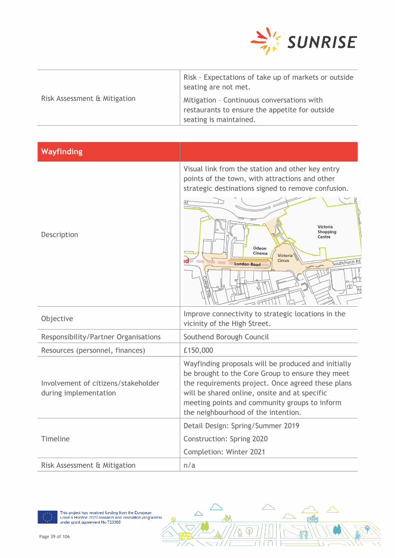
Visual link from the station and other key entry points of the town, with attractions and other strategic destinations signed to remove confusion.
Objective Improve connectivity to strategic locations in the vicinity of the High Street.
Responsibility/Partner Organisations Southend Borough Council
Resources (personnel, finances) £150,000
Involvement of citizens/stakeholder during implementation
Wayfinding proposals will be produced and initially be brought to the Core Group to ensure they meet the requirements project. Once agreed these plans will be shared online, onsite and at specific meeting points and community groups to inform the neighbourhood of the intention.
Timeline
Detail Design: Spring/Summer 2019
Construction: Spring 2020
Completion: Winter 2021
Risk Assessment & Mitigation n/a
Page 40 of 106
Walking/Cycling
Description
Bike parking to be included but in a manner that is consistent with the vision of the space rather than ad-hoc. Parking to be clustered rather than in one area.
Additional hour bikes to be incorporated.
20mph zone within the whole of London Road, from Queensway roundabout to High Street.
Objective
Provide more facilities for cycling and bring London Road into the existing 20mph zone.
Responsibility/Partner Organisations Southend Borough Council
Resources (personnel, finances) £250,000
Involvement of citizens/stakeholder during implementation
Design proposals will be produced and initially be brought to the Core Group to ensure they meet the requirements project. Once agreed these plans will be shared online, onsite and at specific meeting points and community groups to inform the neighbourhood of the intention.
Timeline
Detail Design: Spring/Summer 2019
Construction: Spring 2020
Completion: Winter 2021
Risk Assessment & Mitigation
Risk: Approval process for the 20mph zone runs beyond the duration of the contract
Mitigation: Ensure the 20mph zone is tied into the policy to remove constraints in timescales
Page 41 of 106
Improving Safety
Description Designing out Anti-Social-Behaviour through creating a more active space, both during the day and in the evening.
Objective Provide a safer environment for people at all times of the day/night
Involvement of citizens/stakeholder during implementation
Design proposals will be produced and initially be brought to the Core Group to ensure they meet the requirements project. Once agreed these plans will be shared online, onsite and at specific meeting points and community groups to inform the neighbourhood of the intention.
Timeline
Detail Design: Spring/Summer 2019
Construction: Spring 2020
Completion: Winter 2021
Risk Assessment & Mitigation
Risk: The scheme creates pockets of activity that allows ASB to remain
Mitigation: Education through design to be employed
Page 42 of 106
4.2 Timeline of Measure Implementation
The time plan for the planning and implementation of the measures is as follows:
Time plan for measures in Southend
Design phase Construction phase
Start of operation
Planting Spring/ Summer 2019
Spring 2020 Winter 2021
Street furniture Spring/ Summer 2019
Spring 2020 Winter 2021
Usable public space activities/events/café
Spring/ Summer 2019
Spring 2020 Winter 2021
Wayfinding Spring/ Summer 2019
Spring 2020 Winter 2021
Walking/Cycling Spring/ Summer 2019
Spring 2020 Winter 2021
Improving safety Spring/ Summer 2019
Spring 2020 Winter 2021
4.3 Information on Process for Political Approval
As the City Council of Southend and the city administration have been equally involved in the co-creation process, the support and the commitment of local politics is high. No specific political approval will be necessary for the measure implementation from today’s point of view.
Page 43 of 106
Jerusalem, Baka
1 Introduction
Over the last two years, a co-creative participation process has been set up in Baka, Jerusalem within the framework of the SUNRISE project. The objectives of this project are to co-identify and co-validate, co-develop and co-select, and co-implement mobility measures on the neighbourhood level (Baka) to foster sustainable mobility. As the aspect of co-creation is the main thread of SUNRISE, a participation process has been set up in Baka consisting of a variety of formats, such as drop-in sessions, on-tour-formats, interactive formats, and workshops to determine with stakeholders and residents the main mobility-related issues that Baka is facing. Based on this problematisation, mobility measures have been developed in a co-creative format with participation of residents, stakeholder and the city and district administration of Jerusalem and Baka. More than 1500 people have participated actively in these formats or have been informed about the ongoing process in Baka. In a public selection process, a number of measures have been identified that will be co-implemented in Baka in the framework of the SUNRISE project in the next two years.
On this basis, the Neighbourhood Mobility Action Plan contains all mobility measures that will be implemented. In this document, quick information about Baka will be provided for a contextualisation of the measures, and the objectives of the document and its measures. The core section is the list of measures with a detailed description of the location, the content and the start date of each of the developed and selected measures. At the end of the document, all measure ideas that have been developed, but will not be implemented as part of the SUNRISE project, are collected for possible future implementation in a different framework.
2 Status Quo in Baka
The Co-Creation Process in Baka was mainly a collection of CCF meetings, neighbourhood tours and brainstorming sessions, along with a pilot program for the Walking to School program.
The CCF met several times to brainstorm on ways to respond to the identified issues, from urban infrastructural problems to traffic and rush hour congestion challenges. As a result, the community agreed to categorize the solutions according to urban-physical interventions, and community-grassroots initiatives. Several projects such as upgrading seating areas along the Green Path with shared themes (thus creating visual connectivity along the Path) were chosen for development; the walking to school program was chosen as a behavioural, community--based project (i.e. without physical urban interventions).
Page 44 of 106
Tours and workshops were also conducted as alternate approaches to brainstorming responses to the challenges in Baka, where both the CCF and the wider community were invited to participate.
As a result, a group of projects were chosen for the implementation phase, led by CCF members and involving members of the community at large.
The Co-Creation process was a successful endeavour, in that the projects are underway and we have partners from within the community and the municipality to advance them substantially. However, because of the familiarity and eagerness of Baka residents to see results on the ground, it has been difficult to keep the larger group engaged. Many are ready for implementation, and we have had to work hard at keeping the process transparent and relevant.
Baka’s population is 13,000 inhabitants and compromises is a strongly diverse neighbourhood, with communities spanning: the religious and nonreligious; economically well to do and economically more marginal; native born and new immigrants; a European cultural orientation and a Middle Eastern cultural orientation; and the list goes on. Despite the different cultural orientations of the population, the community has a pluralistic ideology which fosters a shared sense of community identity, a heightened sense of environmental awareness, and a strong commitment to civic duty.
Page 45 of 106
3 Goals
The Neighbourhood Mobility Action Plan serves as the basis for all implementation activities in Baka, Jerusalem, in SUNRISE. The Neighbourhood Mobility Action Plan represents the result of the co-creation process of SUNRISE with participation of residents, stakeholder and district administration. SUNRISE’s main goal is to foster sustainable mobility on the neighbourhood level with a co-creative approach.
The stated objective of SUNRISE in the Baka neighbourhood are to:
• Increase the number of children walking to school rather than being driven by car • Reduce air pollution through increased use of public transport and less motorised travel • Change the split of travel mode in general: less motorised transport, more walking and
cycling • Redesign public spaces that enable safe and pleasant non-motorised travel • Implement a neighbourhood “Mobility Innovation Centre” • Advance community cohesiveness and programming that encourages the above
objectives. Through SUNRISE, neighbourhood stakeholders that were not previously involved in the formulation of these goals will be identified and their views taken on board towards a truly representative community vision. This vision will be translated into a clear work plan with shared responsibilities among stakeholders. The focus of action is anticipated to be around the redesign of public spaces and the creation of a low-motorised “Green Path” to link residential areas, community institutions and businesses (the Green Path was identified some decades ago by the neighbourhood council and residents as a principal axis to be developed by and for the community. During Sunrise's proposal preparations, the community steering committee decided to consider the detailed planning of the Green path as one of the project modules).
All measures listed here are based on the co-identified and co-validated mobility problems and needs from the past SUNRISE process. Jerusalem aimed to find creative solutions to mobility issues in Baka. It will use temporary trials to enable local stakeholders to test co-developed solutions for improving mobility on the neighbourhood level. The results will form the basis for new design solutions that will be implemented as permanent changes by the end of the project.
4 Planned Measures
In order to achieve the goals in Baka, the core group and the Co-creation Forum developed in cooperation with local stakeholder and residents the following list of measures. All measures
Page 46 of 106
listed here will be implemented within the SUNRISE project and have been co-developed and co-selected in various public participation activities as outlined in the Participation Action Plan.
4.1 List of Planned Measures in Baka
The following measures will be implemented in Baka under the umbrella of the SUNRISE project. The selection of measures is the result of an online and offline public voting that took place in several meetings in Winter and Spring 2019. Please consult the following tables for more information on the measures.
Walking to School Program
Description
Walking to School programme: 1. Encouraging students to walk to school in
order to shift mobility mode, decrease congestion and air pollution, and to create awareness about walkability. Walking routes and crosswalks have been designated as places to increase safety measures either by local police presence at rush hour or by traffic changes
2. Educational PR programme for grade 6 - students learn about walkability and create talks to give over to other classrooms and groups in the community
The following map is designed by the parents and local police together, designating safe walking routes and crosswalks where traffic police will stand during rush hour
Objective
● To shift mobility habits from driving to
walking to school, and to do so with the
community
Page 47 of 106
● To increase safety on the roads for
pedestrians and students walking to school
● to increase awareness of walkability as a
central mode of transport
● structure:
○ For the month of April, 2 weeks, in
which parents and students will be
encouraged to walk to school
(focused initiative to increase
awareness)
○ Will also be working with teachers to
form a group of students from grades
6 who will learn about walkability in
depth and deliver short
presentations to fellow students and
to the community at large (at the
community council).
Responsibility/Partner Organisations Environmental Department of the Jerusalem Muni., Efrata and Geulim schools, Jerusalem Master Plan Transportation office (PR department), local police
Resources (personnel, finances)
● Flyers
● Emails and Whatsapp messages
● Stickers, balloons, fruits and water for
walking days
● Coordination with community police
● Partnership with the schools
● Walking route brochure and map (produced
by Jerusalem Master Plan Transportation
office, PR department)
● Mini-curriculum for the group of students
(with teachers)
● Estimated cost: 600 Euro
Page 48 of 106
Involvement of citizens/stakeholder during implementation
● The SUNRISE sub-committee for the Walking to School programme is composed of active parent volunteers interested in advancing walkability initiatives in Baka. The parents are involved in designing the programme, mapping routes, participating in talks with local police, encouraging other parents to participate, walking their own kids to school, and encouraging teachers and principals to include the programme and its values in their educational framework.
● The educational programming is in partnership with the teachers and municipal/governmental programs in the Health and Environment sectors
Timeline
● Sub-committee began in Jan 2018, and ran a pilot in June 2018
● Sub-committee continued in 2019, with the start of the walking program in April 2019
● This will continue until the end of the school year, June 2019
Risk Assessment & Mitigation
With the help of the local police, parents will feel comfortable sending their kids to school walking However, increased traffic police at rush hour is limited to this year, and will require a new arrangement for next year’s students to continue walking. This will be done by:
1. Re-establishing a partnership with the local police
2. Engaging volunteer seniors to man crosswalks
3. Lobbying the local and national government to improve safety conditions at particular points and crosswalks
4. Establishing a core group of parents committed to retaining the walking to school programme
Page 49 of 106
Gad-Rivka Upgrade
Description
The courtyard at Gad-Rivka serves as the entryway from the commercial and industrial zone of Talpiot, as a seating area for seniors and a picnic area for families in the summer. Upgrading the courtyard will serve as a central node of interaction in the overall walkability scheme of Baka and the Green Path
Objective
To improve the aesthetic and functioning of the courtyard as a form of tactical urbanism in Baka To foster a co-design process between the residents and designers This will be done by meetings between residents and designers who will together decide on the best approach with the available budget
Responsibility/Partner Organisations
● SUNRISE Baka team
● Environmental Department of the Jerusalem
Muni.
● Local designers
● Public Works office for Baka
Resources (personnel, finances)
● sticky notes, pens
● printing for design schemes and flyers
● Industrial Designers
● Building materials (TBA)
● rooms for meetings at the community
council building
● 20,000 NIS/4890 euro allocated to designers
for design and public meetings
Involvement of citizens/stakeholder during implementation
Residents neighbouring the Gad-Rivka courtyard are involved at every stage of the process with the designers and the SUNRISE team. during the early stages, the wider public was invited to provide their assessment and feedback on the courtyard,
Page 50 of 106
and now in later stages of design and planning only the neighbours as a core Sub-committee for the project are involved and making decisions
Timeline
1. Public participation meetings took place
over the fall of 2018
2. Designers are working on plans and ideas
over the winter 2018-19
3. Residents will choose the design scheme in
Spring 2019, and implementation will take
place soon after
4. Any changes under municipal responsibility
will be requested during the
implementation period
Risk Assessment & Mitigation
The budget is limited to a small scale project, while the courtyard needs an overhaul in design and implementation. The SUNRISE team is attempting to raise additional funds
Page 51 of 106
Green Path Plan with HQ Architects
Description
The Green Path is a flagship project in SUNRISE. It is planned as the neighbourhood promenade aimed at improving walkability in Baka in terms of accessibility, environmental values, and community development. It crosses Baka north-south, includes many public buildings, parks, and important cross-sections to the city. It also includes many obstacles to walkability in terms of accessibility, traffic congestion, and using alternate modes of transportation like walking and cycling.
Objective
To continue the planning process with the full
participation of the Baka community and HQ
Architects.
Responsibility/Partner Organisations SUNRISE Baka team
HQ Architects
Page 52 of 106
Jeru Municipality - Environmental Dept., Roads and
Traffic Department, City Architect
Resources (personnel, finances)
● Flyers
● Emails and Whatsapp messages
● Printing for maps at public workshops, pens
and sticky notes
● Lobbying municipal actors to advance
implementation or synchronize adjoining
plans to the HQ plan
● The finances are included in the SUNRISE
budget
Involvement of citizens/stakeholder during implementation
Residents are involved at every phase of planning, offering feedback and making decisions for major issues like parking versus trees versus sidewalk width Each phase completed by HQ is accompanied by a public participation event where the plans are presented
Timeline SUNRISE time frame - 3 years
Risk Assessment & Mitigation
The Green Path is in the planning phase, which takes several years. Once it is completed, it will need to be processed by the Planning Dept. at the municipality, and then implemented by various departments, which will be a bureaucratic and budgetary challenge
Page 53 of 106
Conversation Bench
Description
It’s a small-scale urban intervention in an effort to increase social interactions and invite residents to walk through the neighbourhood The Conversation Bench is custom-designed for people of different ages to sit and talk with each other
Objective
In certain intersections there’s a lack of places to sit and meet people, or a lack of design which encourages this. As a way to improve walkability and increase social interactions, the bench was conceived and designed by residents and designers
Responsibility/Partner Organisations
SUNRISE Baka team
Jeru Municipality - Environmental Dept., Place-
making program with Eden urban corporation
Resources (personnel, finances) 4,400 euro for the bench - public meetings, design and construction
Involvement of citizens/stakeholder during implementation
1. Youth groups were involved in identifying
the issue and conceiving of the project
2. 3 public meetings at the bench location
were conducted for designing it
3. one public event for implementation,
including designers and residents took place
Timeline
The idea was created in Feb 2018 Public meetings and design took place from Aug-Dec 2018 Implementation took place from Feb-March 2019
Risk Assessment & Mitigation
To see if the bench really works and attracts people to sit and interact - so far it looks like it is the case. There are urban elements around the bench under municipal responsibility, and we are waiting to see if they take care of it. Otherwise we will need to lobby (i.e. road block to bikes, cleaning the area, replanting a tree)
Page 54 of 106
4.2 Timeline of Measure Implementation
The time plan for the planning and implementation of the measures is as follows:
Time plan for measures in Baka
Design phase Construction/ pilot phase
Start of operation
Walking to School Program Jan 2018 June 2018 April 2019
Gad-Rivka Upgrade Winter 2018/19 Spring 2019 Summer 2019
Green Path Plan with HQ Architects
From Winter 2018 - -
Conversation Bench Summer/ Fall 2018 Winter 2019 Winter 2019
4.3 Information on Process for Political Approval
No specific political approval is necessary for the implementation of the listed measures in Baka.
Page 55 of 106
Thessaloniki, Neo Rysio
1 Introduction
Over the last two years, a co-creative participation process has been set up in Neo Rysio, Thessaloniki, within the framework of the SUNRISE project. The objectives of this project are to co-identify and co-validate, co-develop and co-select, and co-implement mobility measures on the neighbourhood level (Neo Rysio) to foster sustainable mobility. As the aspect of co-creation is the main thread of SUNRISE, a participation process has been set up in Southend consisting of a variety of formats, such as drop-in sessions, on-tour-formats, online and offline interactive formats, and workshops to determine with stakeholders and residents the main mobility-related issues that Neo Rysio is facing. Based on this problematisation, mobility measures have been developed in a co-creative format with participation of residents and local stakeholder. More than approximately 3000 people have been reached by information or active in these formats Neo Rysio. In an online and offline public selection process, several measures have been identified that will be co-implemented in Neo Rysio in the framework of the SUNRISE project in the next two years.
On this basis, the Neighbourhood Mobility Action Plan contains all mobility measures that will be implemented. In this document, quick information about Neo Rysio will be provided for a contextualisation of the measures, and the objectives of the document and its measures. The core section is the list of measures with a detailed description of the location, the content and the start date of each of the developed and selected measures. At the end of the document, all measure ideas that have been developed, but will not be implemented as part of the SUNRISE project, are collected for possible future implementation in a different framework.
Page 56 of 106
2 Status Quo in Neo Rysio, Thessaloniki
The neighborhood of N. Rysio is located in Metropolitan Thessaloniki, covers an area of 20 ha and administratively belongs to the Municipality of Thermi. The population of N. Rysio accounts for 2,952 inhabitants (Census 2011), 20% of which are elderly (>=60 years), and 25% of which are young people (0-19 years old). During the decade 2001-2011 there was a population increase of 65%, which is indicative of the dynamics and the people-focused potential of this neighbourhood. Additionally, ~60% of the households consist of >=3 members. Education-wise, 42% of the municipality inhabitants hold higher education degrees, while unemployment rate in the municipality is 7%, with similar rates for males and females. Furthermore, the inhabitants of N. Rysio exhibit high degree of sense of belonging and cultural linkage that dates back to the historical roots of N. Rysio as a refuge of relocated Greek population during the 1920s.
The participation of Neo Rysio in SUNRISE arose after collaboration with the Municipality of Thermi, as an area presenting great interest in issues of urban mobility but also because of their recent involvement in the SUMP of Thermi. The aim, is to improve citizens' everyday life in terms of mobility through a process which involves active engagement and participation of citizens in an interactive and participatory manner.
Except from the supportive Municipality and the very cooperative Local Council, a strong and active Core Group has been set up for the needs of the project. This group with close collaboration to SUNRISE team is trying to mobilize the local community without however, always achieving the desired outcome. To this end, corrective actions are required to mobilize and involve more and more citizens in the co-creation phase.
In order to collect as much info as possible concerning the problems and the needs of the area, a website was set in order to facilitate the collection of data. Beyond the initial mobilization and the numbers of “hints” on the webpage, less and less participation on the site was observed so new publicity and communication actions were needed.
To this end, the SUNRISE team visited all schools of the area, the cultural center, the athletic center, the folklore association and the center for elderly in order to distribute the local leaflet, talk about the project and its aims and raise awareness about sustainable mobility.
Page 57 of 106
3 Goals
The main objective of the participatory process was to involve the local community and not just those people who act politics or are usually expressing opinion in such consultation processes. In addition, one of the key issues raised by SUNRISE in Thessaloniki is to ensure that all voices should be heard and especially vulnerable social groups such as the elderly, disabled, students, women with stroller, migrants etc.
4 Planned Measures
In order to achieve the goals in Neo Rysio, the core group and the Co-creation Forum developed in cooperation with local stakeholder and residents the following list of measures. All measures listed here will be implemented within the SUNRISE project and have been co-developed and co-selected in various public participation activities as outlined in the Participation Action Plan.
Page 58 of 106
4.1 List of Planned Measures in Neo Rysio
The following measures will be implemented in Neo Rysio under the umbrella of the SUNRISE project. The selection of measures is the result of an online and offline public voting that took place in Spring 2019. Please consult the following tables for more information on the measures.
Improvement of PT services and public transport information
Description - increase frequencies of inter-municipal public transport services
- introduce smart bus stops for public transport
Objective
Increase inter-municipal and public transport use in Neo Rysio
- There is no direct connection with the Municipality of Thermi despite the fact that it is in close distance form Neo Rysio
- There is no real time information for the bus routes
Responsibility/Partner Organisations
For the improvement of inter-municipal public transport services responsible is the Municipality of Thermi while responsible to install the smart bus stops is TheTA
Resources (personnel, finances)
For introducing two smart bus stops → 10.000 euros
Involvement of citizens/stakeholder during implementation
Co-decision on the exact location of the smart bus stops
Timeline
Risk Assessment & Mitigation
Introduce the smart bus stop with real time information at bus stops that are not used by the residents
Page 59 of 106
Improvement of accessibility to schools
Description
The measure refers to the development of a “pedestrian bus” that will reduce vehicles in areas around schools while at the same time increase road safety for both pedestrians and vehicles.
Objective
Most primary school pupils (with their parents in most cases), are moving around schools, mainly by private cars. As a result, traffic congestion is created outside the school buildings during students morning and leaving hours, as well as an increase in CO2 emissions and other pollutants due to the large number of vehicles. This action promotes the creation of a pedestrian bus.
Responsibility/Partner Organisations
TheTA will be responsible for the implementation of this measure in co-operation with the association of parents and guardians of the schools
Resources (personnel, finances)
Estimation for the costs of this measure is 2.000 euros
Involvement of citizens/stakeholder during implementation
Students are organized to walk all together and be accompanied by an adult. The team follows a defined route and gets / lets the children out of their homes. The students and the parents are actively involved in the realization of the measure. In addition, the students will be asked to decide upon the bus route and paint the signs that are going to be placed at the meeting points
Timeline
Risk Assessment & Mitigation
Demands organization and trust between parents, engaged parents/adults that spend time accompanying the children to school, training is recommended.
Page 60 of 106
Increase bicycle use
Description The measure refers to the development of bicycle facilities (parking facilities outside schools and athletic centres)
Objective
There is a bicycle path connecting main street of the settlement to the secondary School passing through the local municipal athletic center, the football court and other athletic sports facilities. There are gaps in some parts of the cycle corridor. The bicycle path is used by young people especially students to reach their school and the aforementioned leisure activities.
Responsibility/Partner Organisations
TheTA will be responsible for the implementation of this measure in co-operation with the Municipality of Thermi
Resources (personnel, finances)
Estimation for the costs of this measure is 6.000 euros
Involvement of citizens/stakeholder during implementation
A paint contest will be organised in the secondary schools, asking the students to draw the bike stands and shelters that are going to be placed out of the school and the athletic center. The first prize will win a bicycle.
Timeline
Risk Assessment & Mitigation
-
Page 61 of 106
Place informational maps in central point of the settlement
Description
The measure will create and place maps illustrating the available alternatives, the bus lines that pass through Neo Rysio and their timetable for both public and municipal transport. The map will be placed in a central part of the village where one of the two smart stops will be installed.
Objective
What really lacks from the area is the real-time information for both public and municipal transport as well as information in general about the options available to residents and visitors.
Responsibility/Partner Organisations
TheTA will be responsible for the implementation of this measure in co-operation with the Municipality of Thermi
Resources (personnel, finances) Estimation for the costs of this measure is 5.000 euros
Involvement of citizens/stakeholder during implementation
The details of the maps will be co-designed with the involvement of the public in order to ensure that they are usable and practical for the users.
Timeline
Risk Assessment & Mitigation
They may be vandalized very soon. The co-implementation procedure that is going to be followed will increase the feeling of ownership of the residents that can increase the life of the measure.
Page 62 of 106
4.2 Timeline of Measure Implementation
The time plan for the planning and implementation of the measures is as follows:
Time plan for measures in Neo Rysio
Improvement of public transport & information
Improvement of accessibility to schools
Increase bicycle use
Informational maps in center
4.3 Information on Process for Political Approval
No additional political approval has to be sought after; during the co-creation process, support from politicians and more importantly administrative bodies responsible for the implementation of the proposed measures has been gained.
Page 63 of 106
5 Ideas for Future Measures
In the co-creation process of SUNRISE, a number of measure ideas have been developed. Not all of them can be implemented under SUNRISE due to a variety of reasons such as resources, complexity, or scale. All these measure ideas are documented here and kept for a possible future implementation.
Implementation of traffic regulations
Description Install road lane separators across Konstantinoupoleos to prevent illegal parking
Objective
The two main streets Constantinoupoleos and Metamorphoseos are crossing Neo Rysio connecting the provincial road to Perea with Basilica village. These streets also offer a direct connection to the National Road of Thessaloniki (Nea Moudania), through the interchange of Neo Rysio. For these reasons the roads suffer from heavy traffic as these routes also form the shortest paths to the aforementioned area. Several uses (shopping, dining, and recreation) have evolved along the area attracting traffic and resulting in significant pedestrian movements. These streets face major problems due to parked vehicles across.
Responsibility/Partner Organisations
Municipality of Thermi
Resources (personnel, finances)
Estimation for the costs of this measure is 2.000 euros
Involvement of citizens/stakeholder during implementation
Some of the residents are not willing to implement the measure especially those that have commercial activities and are shop owners across Konstantinoupoleos.
Timeline
Page 64 of 106
Bremen, area around “Neues Hulsberg-Viertel”
1 Introduction
Over the last two years, a co-creative participation process has been set up in Bremen for the area around the “Neues Hulsberg-Viertel” within the framework of the SUNRISE project. The objectives of this project are to co-identify and co-validate, co-develop and co-select, and co-implement mobility measures on the neighbourhood level to foster sustainable mobility. As the aspect of co-creation is the main thread of SUNRISE, a participation process has been set up for the neighbourhoods around the “Neues Hulsberg-Viertel” consisting of a variety of formats, such as on-tour-formats, online and offline interactive formats, and workshops to determine with stakeholders and residents the main mobility-related issues that the area is facing, especially with the redevelopment activities in “Neues Hulsberg-Viertel”. Based on this problematisation, mobility measures have been developed in a co-creative format with participation of residents, stakeholder, the borough parliament and borough administration. More than 300 people and other stakeholder have participated actively in these formats, and many more people have been informed about the ongoing process in the area around “Neues Hulsberg-Viertel”.
On this basis, the Neighbourhood Mobility Action Plan contains all mobility measures that will be implemented. In this document, quick information about the neighbourhood in Bremen will be provided for a contextualisation of the measures, and the objectives of the document and its measures. The core section is the list of measures with a detailed description.
2 Status quo in area around “Neues Hulsberg-Viertel”, Bremen
The street space of the direct neighbourhood of the “Neues Hulsberg” area is heavily overused. Although the modal split of the neighbourhood shows a preference of non-motorised modes, a key problem remains being a high pressure of car parking and its related consumption of street space. This is clearly visible in the topics being mentioned by citizens in the SUNRISE process.
Many sidewalks are partly used for car parking. As a consequence, the space for pedestrians is significantly reduced. Bicycle parking on the sidewalks and garbage bins further add to the problem. The integration of the new neighbourhood “Neues Hulsberg” with new residents and the further enlargement of the hospital’s capacity - which is situated in the middle of the neighbourhood - might increase already existing problems.
Page 65 of 106
Figure 7: Focus area of SUNRISE in Bremen – the surrounding streets of the “Neues Hulsberg-Viertel”
There is a wide range of options to improve the situation: Illegal parking could be reduced by stronger parking enforcement in accordance with the road traffic regulations and by constructural measures. The list of potential measures include parking management, introduction of fee based parking in public areas, an introduction of residential parking, a coordinated price system of local public transport and car parks/parking fees. Also the development of more parking opportunities for the public was seen as an option, either by opening up existing car parks/spaces on private properties or by building (multi-storey) car parking adjacent to the neighbourhood. Sustainable mobility options should be supported by a wide range of measures, e.g. a further increase of car-sharing stations to create alternatives to private car ownership, a new street design to implement innovative mobility concepts ("shared space"), barrier-free/cyclist-friendly road surface, the improvement of crossing situations, more bicycle parking spaces, micro-hubs to reduce delivery traffic, increased accessibility for mobile impaired and visually impaired people, the implementation of lending station(s) with (rental and) freight bicycles, innovative services complementing conventional public transport (shuttle buses, new taxi services etc.), measures to privilege bicycle traffic (further development of “bicycle streets”, introduction of “bicycle zones”) or measures to improve the overall cycling infrastructure. Further options refer to the improved quality of stay (e.g. temporary “play streets”) and an information campaign. Also, the active exchange with the hospital “Klinikum Bremen Mitte” and the new neighbourhood “Neues Hulsberg-Viertel” could be a vital action to reduce adverse, traffic related effects and to identify synergies for the development of sustainable mobility options.
Car parking has become emotionally overcharged and an extremely sensitive theme within the neighbourhood and a political issue. Over decades, the practice of parking partly on sidewalks
Page 66 of 106
was accepted – although not being legal. With the situation that cars become bigger, the situation is getting more precarious. It needs the political will to change things.
A particular challenge of SUNRISE is the relatively short duration of the project. Four years is very short for urban and mobility planning including participation. Also, the project budget for the actual implementation is very small. The financing of the implementation of measures is in parts unclear and might be only possible in the middle or long term. As a consequence, it has been decided to identify different categories of measures:
• SUNRISE (pilot) measures, which will be implemented within the SUNRISE time frame - “Priority 1”
• Measures, which are considered to be important, but cannot be implemented within SUNIRSE in the short term (due to current financial restrictions or capacity reasons) - “Priority 2”
• Measures with a lower priority, which should be considered in the future – “Priority 3”
Page 67 of 106
3 Goals
The Neighbourhood Mobility Action Plan serves as the basis for all implementation activities in the area around “Neues Hulsberg-Viertel”, Bremen, in SUNRISE. The Neighbourhood Mobility Action Plan represents the result of the co-creation process of SUNRISE with participation of residents, stakeholder. SUNRISE’s main goal is to foster sustainable mobility on the neighbourhood level with a co-creative approach.
All measures listed here are based on the co-identified and co-validated mobility problems and needs from the past SUNRISE process. Bremen aimed at finding creative solutions to mobility issues for the area around “Neues Hulsberg-Viertel”. The results will form the basis for new design solutions that will be implemented as permanent changes by the end of the project.
The vision for the SUNRISE neighbourhood – the surrounding of the „Neues Hulsberg”-Quarter is
• keeping routes for fire engines clear at all times • a better and fair use of the limited street space available • improved mobility of all population groups and increased use of sustainable mobility
options • improved quality of stay and quality of life in the streets of the neighbourhood.
Within the four years project duration the following should be achieved
• a concept for innovative, sustainable mobility solutions and a coordinated action plan agreed with local residents and stakeholders
• individual measures to improve the use of street space and to foster sustainable mobility – implemented and tested in an exemplary manner
• a sound basis for further, medium to long-term implementation after the end of the project
• increased trust between residents and stakeholders in order to continue the dialogue and to work on further sustainable solutions for the street space in the neighbourhood
Concrete qualitative targets have been defined for SUNRISE in Bremen with regard to car sharing, which is a suitable measure for reclaiming street space for all street users: about 500 new car sharing users – and about 100 cars shall be taken off the roads.
Page 68 of 106
4 Planned measures
In order to achieve the goals in Bremen SUNRISE quarter (area around Neues Hulsberg Viertel), the core group and the Co-creation Forum (i.e. local stakeholder and residents) developed the following list of measures. All measures listed here will be implemented within the SUNRISE project and have been co-developed and co-selected in various public participation activities as outlined in the Participation Action Plan.
4.1 List of planned measures in area around “Neues Hulsberg-Viertel”
The SUNRISE action plan for Bremen (Table 1) encompasses nine measures, which are allocated to the following fields of action:
• Controlling and managing car parking • Supporting sustainable mobility options • Improvement of the quality of stay • Information and marketing campaign
The action plan has been co-developed and agreed by the SUNRISE core group. It has been based on the results of the citizens’ contributions and a comprehensive SWOT-Analysis.
Table 1 represents all measures and ideas for measures that originated in the co-creation process. Measures framed in green will be actively implemented within the SUNRISE project, in yellow and orange are measure ideas that might be implemented later and are outside the scope of SUNRISE. The selection of the measures happened in a discussion process with the core group. Table 1 is followed by a detailed description of the measures to be implemented in SUNRISE.
Page 69 of 106
Table 1: Overview on Action Plan
Measures Priority *
Fields of action A: Controlling and managing car parking
Measure 1. Reduction of illegal car parking Elements: 1.1 Stronger monitoring to enforce car-parking in accordance with the road traffic regulations 1.2 Constructional measures to hinder illegal car-parking or other measures to organize parking
1
Measure 2: Introduction of parking management Elements: 2.1 Pricing of parking space/introduction of fee based parking in public areas 2.2 Preparation and introduction of Residential Parking
1
Recommendations for implementation outside SUNRISE
• Installation of (multi-storey) car parks • Development/use of private/other suitable areas for public parking
2
Outlook – for future implementation:
• Digital tools for improved parking (e.g. app and sensor based smart parking)
3
Fields of action B: Supporting sustainable mobility options
Measure 3: Provision of more car-sharing stations 1
Measure 4: Creation of bicycle parking spaces in the neighbourhood 1
Measure 5: Implementation of lending station(s)/ bike-sharing with (rental and) freight bicycles etc.
1
Measure 6: Implementation of pilot micro-hub (decentralised distribution points for suppliers/ parcel services)
1
Page 70 of 106
Recommendations for implementation outside SUNRISE
• Measures to improve relevant crossings • Measures to improve cycling infrastructure
(further development of bike streets, introduction of bike zones, improvements of bike paths etc.)
• Measures to reduce barriers for mobility or visually impaired persons; barrier-free / cycling-friendly street surfaces
• Reduction of barriers at bus and tram stops • Review and further development of public transport offers • New design of street room to implement innovative mobility concepts
(„Shared Space“)
2
Outlook - for future implementation:
• Innovative services to supplement public transport (shuttle-buses, new taxi-offers, “Bike+Ride” etc.)
• Digital tools for pedestrians
3
Fields of action C: Improvement of the quality of stay
Measure 7: Creation of more space for play of children (e.g. temporary “play streets”) 1
Measure 8: Improvements of the quality of stay (greenery initiatives, waste bins, expansion of "nice toilet" initiative of gastronomy, benches etc).
1
Recommendations for implementation outside SUNRISE
• Speed control, especially at main streets 2
Fields of action D: Information and marketing campaign
Measure 9: Information and marketing campaign (about sustainable mobility offers, considerate behavior etc.)
1
Cross-sectional task:
Consideration of the mobility planning of the hospital “Klinikum Bremen Mitte” and the new Neighbourhood “Neues Hulsberg-Viertel” (using synergies, becoming involved)
* Priority „1“ (green) = high priority and implementation within SUNRISE; Priority „2“ (yellow)= high priority, but no active implementation within SUNRISE Priority „3“ (orange)= lower priority
Page 71 of 106
Measure 1 Reduction of illegal car parking
Description
Illegal parking has been a widespread practice in many Bremen neighbourhoods for years – also in the "SUNRISE Quarter". Parking enforcement hardly takes place, therefore illegal parking halfway on pathways is perceived by citizens as a "customary right". However, this practice is at the expense of third parties: the often narrow footpaths are further reduced and severely restrict pedestrian traffic. This affects in particular to people with specific mobility needs (wheelchairs, rollators, walking sticks and prams). Illegal parking also affects bike traffic as bike paths are blocked. Furthermore, illegal parking affects basic safety requirements. Many roads cannot be accessed from fire brigades and in the case of fire, this can have severe consequences. The problem increased as the size of cars grew over the last years.
Stronger monitoring shall be increased to enforce car parking in accordance with the road traffic regulations. This needs to be coordinated with the Ministry of internal affairs, which is responsible for this task. The selection of focus areas might be necessary due to very limited personnel for parking monitoring at present. Involvement of all relevant players, concrete planning of specific measures and decision-making are relevant implementation steps.
Where needed, illegal parking shall be prevented by structural measures (e.g. bollards) or other measures (e.g. markings). If possible, this can be combined with the implementation of facilities having an added value (e.g. bike racks, flower beds). The measures must be coordinated with the planning of car-sharing stations (measure 3), as the associated structural measures can also be used to organize parking and to keep crossings at intersections clear from any parking. The plans for additional bicycle parking spaces must also be taken into account here.
Activities:
1.1 Stronger monitoring to enforce car-parking in accordance with the road traffic regulations
1.2 Constructional measures to hinder illegal car-parking or other measures to organize parking
Implementation: Measure 1 involves the following activities:
• Exchange and cooperation with all relevant players on technical, legal, political issues
• Development of a “risk cadastre” (Identification of risks hot spots by test rides with fire brigade)
• Preparatory study on parking and street use to achieve quantitative data on the parking situation (subcontracted)
• Decision-making on measures and (pilot) actions, by relevant bodies
• Concretisation of measures, planning – on the basis of the preparatory study/ works
• Structural works ( 1.2: e.g. installation of bollards)
Execution and administration (1.1)
Page 72 of 106
Objective
• Reduced number of illegally parked cars
• Free sidewalks, bike paths
• Improved walkability, including less barriers for mobility impaired persons
• Open access for fire brigade etc.
• Changed (more sustainable) mobility habits
Responsibility/
Partner Organisations
• Involvement: Ministry of the Environment, Urban Development and Transportation, Road Authority, Ministry of Internal affairs, Office of Public Order, Police, Fire Brigade, Borough Administration, Borough Parliament, Representative for people with disabilities of the State of Bremen etc.
• Decision making: Ministry of the Environment, Urban Development and Transportation, Borough Administration, Road Authority, Ministry of Internal Affairs; maybe also: the Budget and Finance Committee of City of Bremen (HaFA) or Bremen’s Deputation for Environment, Construction, Traffic, Urban Development or Bremen’s Parliament (Bürgerschaft),
• Implementation: Office of Public Order, Police, Road Authority
• Further players: ADFC (German bicycle foundation), Initiative Bremen Alliance for Transport Change (“Bündnis für Verkehrswende”), Initiative “Platz da!”, ADAC (automobile club), etc.
Resources (personnel, finances)
1.1.
Personnel costs:
• one-off costs for planning and communication etc.: € ( Budgets of Road Authority and Ministry of Environment, Urban Development, Transportation)
• long term costs for monitoring/parking enforcement and administration (e.g. in cases of objection): €€€ ( Budget of Ministry of Internal Affairs)
1.2.
Personnel costs:
• one-off costs for planning etc.: € ( Budgets of Road Authority and Ministry of Environment, Urban Development, Transportation)
Investment cost:
• Bollards, construction works etc.: €-€€ (Budget of Ministry of Environment, Urban Development, Transportation)
Involvement of citizens/stakeholder during implementation
• Citizens are informed about the measures and its positives effects, to increase problem awareness and to safeguard support and acceptance
Page 73 of 106
Timeline
• Start of planning: t.b.d. (after political decision **)
• Start of construction/ implementation: t.b.d. (after political decision)
• Start of operation: t.b.d. (after political decision)
** Reduction of illegal parking is a highly sensitive topic, which has not been tackled for years. Re-organising the use of street space means that some parts of the citizens “loose” space formerly used for themselves – others “gain” from initiated changes. It needs the political will and the intense cooperation of at least three different administrative organisations to change the current practice. A positive political decision will need complex coordination of actors and interest in the next months. A wide range of discussion rounds/exchanges on technical, legal, political issues need to be initiated.
Page 74 of 106
Measure 2 Introduction of parking management
Description
In the SUNRISE quarter, residential parking is under debate due to the high parking pressure. The primary goal is to reduce the number of "external” parkers (e.g. visitors and employees of the hospital) and improve the situation for locals. This could be done by reducing the attractiveness of public space parking by the introduction of parking fees and residential parking (with parking permits within predefined residential zones). In order to decide upon and plan residential parking, the necessary framework conditions (legal parking space available, number of parking cars etc.) have to be investigated in a first step. For this purpose, a comprehensive study of the parking space has been commissioned and data from the Federal Motor Transport Authority has been requested and evaluated. These investigations form the basis for defining the conditions of residential parking conditions (regional extent, parking fees and conditions for visitors etc.).
The introduction of residential parking is highly sensitive and needs a political decision. The achievement of a positive political decision therefore is regarded as a vital milestone in the implementation process.
All parking management activities have to be accompanied by stronger monitoring to enforce car parking in accordance with the road traffic regulations (Measure 1.1.).
Activities:
2.1 Pricing of parking space/introduction of fee based parking in public areas
2.2 Preparation and introduction of Residential Parking
Implementation:
Measure 2 involves the following activities:
• Exchange and cooperation with all relevant players on technical, legal, political issues
• Preparatory study on parking and street use to achieve quantitative data on the parking situation (subcontracted)
• Decision-making on measures and actions, by relevant bodies
• Concretisation of measures on the basis of the preparatory study/ works
• Structural works (e.g. installation parking meters, signs)
• Ensuring sufficient enforcement (and related administration)
• Execution
Objective
• Reduced number of parked cars from visitors
• Reduced parking pressure for residents
• Reduced through traffic
• Free sidewalks, bike paths
• Changed (more sustainable) mobility habits
Page 75 of 106
Responsibility/ Partner Organisations
• Involvement: Ministry of the Environment, Urban Development and Transportation, Road Authority, Ministry of Internal affairs, Office of Public Order, Police, Fire Brigade, Borough Administration, Borough Parliament, Representative for people with disabilities of the state of Bremen etc.
• Decision making: Ministry of the Environment, Urban Development and Transportation, Borough Administration, Road Authority, Ministry of Internal Affairs; maybe also: the Budget and Finance Committee of City of Bremen (HaFA) or Bremen’s Deputation for Environment, Construction, Traffic, Urban Development or Bremen’s Parliament (Bürgerschaft),
• Implementation: Office of Public Order, Road Authority
• Further players: ADFC (German bicycle foundation), Initiative Bremen Alliance for Transport Change (“Bündnis für Verkehrswende”), Initiative “Platz da!”, ADAC (automobile club), etc.
Resources (personnel, finances)
Personnel costs:
• one-off costs for planning etc.: € ( Budgets of Road Authority, Ministry of Environment, Urban Development, Transportation, Ministry for Internal Affairs)
• long term costs for administrative processes: €€€ ( Budget of Ministry of Internal Affairs)
Investment cost:
• Purchase of parking meters €€ ( Budget of Ministry of Environment, Urban Development, Transportation )
• Construction works: €€ ( Budget of Ministry of Environment, Urban Development, Transportation)
• Long term costs for regular maintenance and repair of meters: €€ ( Budget of Ministry of Internal Affairs)
Involvement of citizens/ stakeholder during implementation
• Citizens are informed about the measures and its positives effects, to increase problem awareness and to safeguard support and acceptance
Timeline
• Start of planning: t.b.d. (after political decision **)
• Start of construction/ implementation: t.b.d. (after political decision)
• Start of operation: t.b.d. (after political decision)
** Reduction of illegal parking is a highly sensitive topic, which has not been tackled for years. Re-organising the use of street space means that some parts of the citizens “loose” space formerly used for themselves – others “gain” from initiated changes. It needs the political will and the intense cooperation of at least three different administrative organisations to change the current practice. A positive political decision will need complex coordination of actors and interest in the next months. A wide range of discussion rounds/exchanges on technical, legal, political issues need to be initiated.
Page 76 of 106
Measure 3 Provision of more of car-sharing stations
Description
Station-based car-sharing is an alternative to private car ownership. According to a study by TeamRed [2018] on average 16 private cars will be abolished (or not even purchased) in Bremen for every car-sharing vehicle. Station-based car-sharing is therefore an effective measure to reduce parking demand as strategy for reclaiming street space.
In addition to the already existing car-sharing stations in the borough, further stations are to be created in the SUNRISE neighbourhood. Thus the attractiveness of car-sharing shall be further improved (e.g. closer distance to the users, more vehicles, improved range of vehicle types). In the SUNRISE quarter, the smaller "mobil.pünktchen", accommodating 2-3 vehicles per station, are expected to be set up. The construction measures needed will be done to have further added values (re-organising parking, erection of bike racks etc.) A public invitation to tender for the operation of car-sharing stations will be carried out.
Implementation: Measure 3 involves the following activities:
• Exchange and cooperation with all relevant players
• Preparatory study on parking and street use to achieve quantitative data on the parking situation (subcontracted)
• Decision-making on measure and implementation actions, by relevant bodies
• Concretisation of measures on the basis of the preparatory study/ works
• Tendering the operation of car-sharing stations
• Structural works
• Operation
Objective • Increase attractiveness of car-sharing in the neighbourhood • Reduction of private car ownership • Changed (more sustainable) mobility habits
Responsibility/Partner Organisations
• Involvement: Ministry of the Environment, Urban Development and Transportation, car-sharing service providers, Bremen’s car park management company (Brepark), Road Authority, Borough Administration, Borough Parliament
• Decision-making: Ministry of the Environment, Urban Development and Transportation, car-sharing service providers
• Implementation: Road Authority, Bremen’s car park management company (Brepark)
• Further players:
Resources (personnel, finances)
Personnel costs:
• one-off costs for planning etc.: € (Budgets of Ministry of Environment, Urban Development, Transportation)
Investment cost:
• construction works: €€ (Budgets of Ministry of Environment, Urban Development, Transportation)
Business model of car-sharing service providers involves purchase of cars and operation of car-sharing stations.
Page 77 of 106
Involvement of citizens/ stakeholder during implementation
• Citizens are informed about the measures and its positives effects, to increase problem awareness and to safeguard support and acceptance
• Potential users are informed about the new services
• Citizens are involved in the configuration of car sharing stations (e.g. selection of vehicle types)
Timeline
Start of planning: April 2019
Start of construction/ implementation: Jan 2020
Start of operation: June 2020
Page 78 of 106
Measure 4: Creation of bicycle parking spaces in the neighbourhood
Description
Parking spaces for bicycles in the streets of the neighbourhood shall be created in order to provide safe bike-parking and to reduce the disorderly parking of bicycles in the streets (at front fences, traffic posts, etc.). This could include rain protected, large dimensioned and secured spaces for pedelecs, freight bicycles etc. Coordination with the planning of car-sharing stations is necessary, as bicycle parking spaces are generally integrated here as well.
Implementation:
Measure 4 involves the following activities:
• Exchange and cooperation with all relevant players
• Preparatory study on parking and street use (including bike parking) to achieve quantitative data on the parking situation (subcontracted)
• Decision-making on measure and pilot implementation actions, by relevant bodies
• Concretisation of measures on the basis of the preparatory study/ works
• Market search, selection and purchase of suitable bike racks
• Structural works (installation of bike racks)
Objective
• Strengthening of bike traffic • Free sidewalks, bike paths • Increased availability of space for parking bikes • Reduction of private car-ownership • Increase of accessibility (reduction of barriers) • Changed (more sustainable) mobility habits
Responsibility/Partner Organisations
• Involvement: Ministry of the Environment, Urban Development and Transportation, Road Authority, Borough Administration, Borough Parliament
• Decision-making: Borough Administration, Ministry of the Environment, Urban Development and Transportation, Road Authority
• Implementation: Road Authority
• Further players: ADFC (German Cyclists’ Federation)
Resources (personnel, finances)
Personnel costs:
• one-off costs for planning and installation: € ( Budgets of Ministry of Environment, Urban Development, Transportation and Road Authority)
Investment cost:
• bike racks: € ( SUNRISE budget, possibly others)
Page 79 of 106
Involvement of citizens/stakeholder during implementation
• Citizens are informed about the measures and its positives effects, to increase problem awareness and to safeguard support and acceptance
• Potential users are informed about the new services
• Citizens involvement in the configuration of bike racks (e.g. selection of products)
Timeline
Start of planning: June 2019
Start of construction/ implementation: March 2020
Start of operation: March 2020
Measure 5. Implementation of lending station(s) with (rental and) freight bicycles etc.
Description
Bike-sharing station(s) (including e-bikes/pedelecs and cargo bikes) shall be set up and operated at one or more suitable locations, to provide access to bikes and new bike models to new user groups.
Measure 5 involves the following activities:
• Exchange and cooperation with all relevant players
• Decision-making on measure and pilot implementation actions, by relevant bodies (e.g. operator of bike-sharing services)
• Concretisation of measures/ planning
• Operation
Objective
• Strengthening of bike traffic
• Reduction of private car ownership
• Changed (more sustainable) mobility habits
Responsibility/Partner Organisations
• Involvement: bike-sharing operator (e.g. ADFC, WK-Bike/nextbike), operation partners in the neighbourhood e.g. shop owners, Ministry of the Environment, Urban Development and Transportation, Borough administration, Borough Parliament
• Decision-making: bike-sharing operator (e.g. ADFC, WK-Bike/nextbike), operation partners in the neighbourhood e.g. shop owners,
• Implementation: bike-sharing operator (e.g. ADFC, WK-Bike/nextbike), operation partners in the neighbourhood e.g. shop owners)
• Further players:
Page 80 of 106
Resources (personnel, finances)
Personnel costs:
• one-off costs for planning: € (Budgets of bike-sharing operator, operation partners in the neighbourhood, Ministry of Environment, Urban Development and Transportation)
• Long term costs for regular maintenance and repair of meters: € (Budgets of bike sharing operator)
Investment costs:
• e-bikes, cargo bikes, other bikes: € ( SUNRISE budget, bike sharing operator, others)
• Long term costs for regular maintenance and repair of meters: € (Budgets of bike sharing operator)
Involvement of citizens/ stakeholder during implementation
• Citizens are informed about the measures and its positives effects, to increase problem awareness and to safeguard support and acceptance
• Potential users are informed about the new services
• Business in the neighbourhood act as local operation partners (e.g. lending station for cargo-bikes)
Timeline
Start of planning: June 2019
Start of implementation: March 2020
Start of operation: March 2020
Page 81 of 106
Measure 6. Implementation of pilot micro-hub
Description
The market for courier, express and parcel services (CEP) has been growing continuously for years due to the increasing online trade. This is associated with increasing burdens for the neighbourhoods: traffic jams, noise, exhaust fumes. The innovative delivery concept of "micro-hubs" is intended to relieve the pressure on residential areas: the service providers use inner-city interim storage facilities (e.g. containers, truck trailers, shops) for their parcels and transport them "on the last mile" with freight bicycles, etc. A micro-hub shall be pilot tested at a suitable location in the SUNRISE neighbourhood, in addition to the one planned for at the housing development “Neues Hulsberg-Viertel”. In case of the use of public street space, a special permit for a trail will be required, as the German Highway Code does not foresee such privileged use.
Measure 6 involves the following activities:
• Exchange and cooperation with all relevant players
• Decision-making on measure and pilot implementation actions, by relevant bodies (courier, express and parcel service provider)
• Concretisation of measures/ planning
• Legal process (permit for privileged use of public street space)
• Pilot operation
Objective
• Reduction of delivery traffic with conventional delivery vans
• Reduction of road blocking by delivery traffic
• Increased safety
• Reduction of emissions
Responsibility/Partner Organisations
• Involvement: Courier/ express/ parcel service provider, Borough Parliament, Borough Administration, Ministry of the Environment, Urban Development and Transportation, Road Authority
• Decision-making: Courier/ express/ parcel service provider, Borough Administration, Ministry of the Environment, Urban Development and Transportation, Road Authority
• Implementation: Courier/ express/ parcel service provider
• Further players:
Page 82 of 106
Resources (personnel, finances)
Personnel costs:
• one-off costs for planning: € (Budgets of Courier/ express/ parcel service provider, Ministry of the Environment, Urban Development and Transportation, Road Authority)
• costs for pilot operation (additional costs to normal processes): € (Budgets of Courier/ express/ parcel service provider)
Operational costs:
• Fees for “special use” (Sondernutzung) of public space: € (Budgets of Courier/ express/ parcel service provider)
Investment cost:
• Purchase of cargo bikes, use of container etc.: €-€€ (Budgets of Courier/ express/ parcel service provider)
Involvement of citizens/stakeholder during implementation
• Activities to inform citizens about the measure and its positives effects, to safeguard support and acceptance
Timeline
Start of planning: June 2019
Start of implementation: March 2020
Start of operation: March 2020
Page 83 of 106
Measure 7 Creation of more space for play of children
Description
In the streets of the SUNRISE quarter, there are only a few play areas for children and the distances to the nearest playgrounds are sometimes very large, especially for smaller children. One possibility is to set up "temporary play streets". A "temporary play street" is a residential street (or a section of a street) which is closed for any traffic for two to three hours one afternoon a week. Thus, space is provided for children to play and for other residents to meet each other. Within the framework of SUNRISE, the establishment of "temporary play streets" shall be initiated.
Measure 7 involves the following activities:
• Exchange and cooperation with all relevant players
• Decision-making on measure and pilot implementation actions, by relevant bodies
• Concretisation of measures/ planning
• (Pilot) operation
Objective
• Physical activity of children
• Increase quality of stay
• More room for children
• Changed (more sustainable) mobility habits
Responsibility/Partner Organisations
• Involvement: Residents, Borough Parliament, Borough Administration, Ministry of the Environment, Urban Development and Transportation, Road Authority, Initiative “SpielLandschaftStadt e.V.”
• one-off costs for planning: € ( Budgets of Ministry of the Environment, Urban Development and Transportation, Road Authority)
Investment cost:
• Purchase of play equipment: € (SUNRISE budget; Funding programme: „SpielRäume schaffen“)
Involvement of citizens/stakeholder during implementation
• Citizens are informed about the measure and its positives effects, to safeguard support and acceptance
• Residents need to be the driving force to implement a “temporary play street”, i.e. regularly organising the events in their streets
Page 84 of 106
Timeline
Start of planning: June 2019
Start of implementation: March 2020
Start of operation: March 2020
Page 85 of 106
Measure 8 Improvements of the quality of stay
Description
In the SUNRISE neighbourhood, the quality of stay shall be improved by greening initiatives, the installation of (additional) waste bins and benches, expansion of "nice toilet" initiative of gastronomy (i.e. offering restrooms for the public) etc.
Measure 8 involves the following activities:
• Exchange and cooperation with all relevant players
• Decision-making on measure and pilot implementation actions, by relevant bodies
• Concretisation of measures/ planning
• Installation/ Implementation
Objective
• Strengthening of pedestrian traffic
• Increase quality of stay
• Changed (more sustainable) mobility habits
Responsibility/Partner Organisations
• Involvement: Residents, Borough Parliament, Borough Administration, Ministry of the Environment, Urban Development and Transportation, Road Authority, Bremer Stadtreinigung (Waste disposal company), Umweltbetrieb Bremen, schools, businesses, etc.
• Implementation: Businesses, Bremer Stadtreinigung (Waste disposal company), residents etc.
• Further players:
Resources (personnel, finances)
Personnel costs:
• one-off costs for planning: € ( Budgets of Ministry of the Environment, Urban Development and Transportation, Road Authority, Bremer Stadtreinigung, Umweltbetrieb Bremen, schools, businesses, etc
Investment cost:
• Purchase of equipment (e.g. benches) etc. € ( SUNRISE budget, Borough budgets, others )
Involvement of citizens/ stakeholder during implementation
• Citizens are informed about the measure and its positives effects, to safeguard support and acceptance
• Citizens are involved to provide ideas and integrated in the concrete planning and implementation (e.g. business, schools)
Page 86 of 106
Timeline
Start of planning: June 2019
Start of implementation: March 2020
Start of operation: March 2020
Page 87 of 106
Measure 9 Information and marketing campaign
Description
An information and marketing campaign shall be conducted to increase the understanding and actual use of innovative sustainable mobility options (e.g. car-sharing, bike-sharing). Also the available multi-modal options for mobility, and specifically “eco-modes” (the environmental friendly options: public transport, bicycle and walking) shall be communicated. This might be done, for example, by specific marketing activities, like discounted monthly tickets for a promotion period. Finally, the need for the SUNRISE measures, a more fair use of street room, and the general consideration of the needs of other street users shall be communicated. This can be done, for example, by guided street walks (e.g. testing out wheelchairs, walking as blind persons). Thus, the information and marketing campaign is closely connected to all other measures of this action plan.
Measure 9 involves the following activities:
• Exchange and cooperation with all relevant players
• Decision-making on measure and pilot implementation actions, by relevant bodies
• Concretisation of measures/ planning
• If needed: tender for design/marketing agency
• Execution
Objective • Increase awareness on new mobility offers, multi mobility options • Increase acceptance/ consideration of needs of other street users • Changed (more sustainable) mobility habits
Responsibility/Partner Organisations
• Involvement: Ministry of the Environment, Urban Development and Transportation, BSAG, ADAC, ADFC, Initiative “Bündnis Verkehrswende”, car-sharing provider, bike-sharing provider, Initiative Perspektivwechsel, etc.
• Decision-making: institutions involved (see above)
• Implementation: institutions involved (see above)
• Further players:
Resources (personnel, finances)
Personnel costs:
• one-off costs for planning: € (budgets of involved institutions)
Investment cost:
• for marketing activities (e.g. subsidy for discounted tickets: € ( budgets: t.b.d.)
• Marketing/design agency, printing of brochures etc. ( SUNRISE budget)
Involvement of citizens/stakeholder during implementation
• Citizens as “testimonials” for new services etc.
• Initiatives, businesses for spreading information/brochures
Page 88 of 106
Timeline
Start of planning: April 2019
Start of implementation: June 2019
Start of operation: June 2019
Page 89 of 106
4.2 Timeline of Measure Implementation
The time plan for the planning and implementation of the measures is as follows:
Time plan for measures in Bremen
Planning/ Design phase
Construction /Implementation phase
Start of operation
Reduction of illegal car parking t.b.d** t.b.d** t.b.d**
Introduction of parking management
t.b.d** t.b.d** t.b.d**
Provision of more car-sharing stations
from April 2019 from March 2020 May 2020
Creation of bicycle parking spaces in the area
from April 2019 from March 2020 May 2020
Implementation of lending station(s) with (rental and) fright bicycles
from April 2019 from March 2020 May 2020
Implementation of pilot micro-hub
from April 2019 from March 2020 May 2020
Creation of more space for play of children
from April 2019 from March 2020 May 2020
Improvement of the quality of stay
from April 2019 from March 2020 May 2020
Information & marketing campaign
from April 2019 May2019 May 2019
** Reduction of illegal parking is a highly sensitive topic, which has not been tackled for years. Re-organising the use of street space means that some parts of the citizens “loose” space formerly used for themselves – others “gain” from initiated changes. It needs the political will and the intense cooperation of at least three different administrative organisations to change the current practice. A positive political decision will need complex coordination of actors and interest in the next months. A wide range of discussion rounds/exchanges on technical, legal, political issues need to be initiated.
Page 90 of 106
4.3 Information on Process for Political Approval
Up to now, the measures have been approved by the core group. Achieving political and administrative approval will be part of the implementation phase (WP3), which involves further planning steps (e.g. preparatory studies) and the further concretisation of measures.
The process of gaining approval is different with every measure. Depending on the type, scope and impact of the measures, decisions are taken on different levels, for example by:
• the Borough Parliament (“Stadtteilbeirat”); • the administration of the Free Hanseatic City of Bremen e.g. by the Road Authority (“Amt
für Straßen und Verkehr”); • the City of Bremen‘s Deputation for Environment, Construction, Traffic, Urban
Development, Energy and Agriculture; • Bremen’s Parliament (“Bürgerschaft”); • private actors, investors, others.
For each measure, the main actors involved in decision-making are listed in the detailed description of measures (see chapter 4.1).
For most measures, gaining political and administrative consent will not be a sensitive issue. For example, the implementation of car sharing stations is supported by all political parties in Bremen and is part of Bremen’s Mobility Strategy (e.g. Car Sharing Action Plan for Bremen (2009); SUMP Sustainable Urban Mobility Plan 2025 (2014)).
However, gaining political approval is particularly challenging for the measures 1 and 2 (“Reduction of illegal car parking” and “Introduction of parking management”). Parking is a highly sensitive topic currently in Bremen, which has not been tackled for years. Re-organising the use of street space means that some parts of the citizens “loose” space formerly used for themselves – others “gain” from initiated changes. It needs the political will and the intense cooperation of different administrative organisations to change the current practice. A positive political decision will need complex coordination of actors and interest in the next months. Discussion rounds with an exchange on a wide range of technical, legal, political and social issues are needed and have already been initiated. Also, a wide range of supporters have been found and activated. Therefore, it is expected that political and administrative approval for measures relating to the reduction of illegal car parking and the introduction of parking management will be granted.
Page 91 of 106
Budapest, Törökőr
1 Introduction
Over the last two years, a co-creative participation process has been set up in Törökőr, Zugló, Budapest within the framework of the SUNRISE project. The objectives of this project are to co-identify and co-validate, co-develop and co-select, and co-implement mobility measures on the neighbourhood level (in Törökőr) to foster sustainable mobility. As the aspect of co-creation is the main thread of SUNRISE, a participation process has been set up in Törökőr consisting of a variety of formats, such as thematic walks, on-tour-formats, online and offline interactive formats, and workshops to determine with stakeholder and residents the main mobility issues that Törökőr is facing. Based on this problematisation, mobility measures have been developed in a co-creative format with participation of residents, stakeholder and the district administration of Zugló, supported by Mobilissimus. More than 150 people have participated actively in these formats, and more than 2000 people have been informed about the ongoing process in Törökőr. In an online and offline public selection process, three measures have been identified that will be co-implemented in Törökőr in the framework of the SUNRISE project in the next two years.
On this basis, the Neighbourhood Mobility Action Plan contains all mobility measures that will be implemented. In this document, quick information about Törökőr will be provided for a contextualisation of the measures, and the objectives of the document and its measures. The core section is the list of measures with a detailed description of the location, the content and the start date of each of the developed and selected measures. At the end of the document, all measure ideas that have been developed, but will not be implemented as part of the SUNRISE project, are collected for possible future implementation in a different framework.
2 Status Quo in Törökőr
Törökőr is situated in Zugló, which is one of the 23 districts of Budapest, located in the transitional zone, between the core and the outskirts of the city. Budapest has 1,7 million residents, from which approximately 125.000 live in Zugló and 12.000 in Törökőr. The size of the neighbourhood is 1.75 km2. Budapest has a two-tier administrative system: The Municipality of the Capital City of Budapest being responsible for the issues of city level interest, and 23 district municipalities responsible for the issues of district-level interest. The Municipality of Zugló is the 14th district of Budapest, and has a representative body with elected representatives.
The issue of ageing population seriously affects the neighbourhood. The 12,045 people that were registered in 2015 fell into the following categories: 0-14 years: 1545, 15-24 years: 970, 25-62
Page 92 of 106
years: 6586, 62+ years: 2944. Ageing causes problems for the municipality to reorganise the institutions like kindergartens, or schools. It also has its effects on mobility. For instance, ageing has an effect on public transport as there are areas with more passengers that suffer from locomotor diseases.
The neighbourhood is divided into 5 smaller areas by the railway and three crossing collector roads; the Egressy road, the Mogyoródi road and the Fogarasi road. West from the railway older tenement houses and empty sites lay, with a high population density in the blocks of the old buildings. East from the railway in the northern area there are mainly family houses with lower density, while in the southern part a housing estate lays with high population density in the blockhouses. In the middle of the area mostly commercial units are located with a few residential buildings. Törökőr is home to middle-class people with higher qualification than the average of Budapest. 5 kindergartens, 2 elementary schools, 7 technical collages and one high school are located in the area.
Figure 8: Population density in Törökőr, 2017, source: Municipal Data
In the area of Törökőr 391 companies have operational permission, 70 companies have site permission and 7 gas stations are operating. The number of cars per 1000 habitants in Törökőr is really high (580)1, but it is partly due to the big share of the company-owned cars. Counting only the privately-owned vehicles, the number drops down to 240, which is less than the average in Budapest (284) and in Hungary (308).2 The area suffers from a huge number of parking cars. 6,550 cars were registered in Törökőr in 2013, most of them are parked on public spaces; more than half of the cars are owned by enterprises. The area also serves as an “informal P+R” solution for commuters due to parking fees in neighbouring areas. Having the national sport stadium and Hungary’s biggest sports court just across from the Hungária-ring also causes parking problems. The neighbourhood has a reasonably well-developed public transport system, however, coverage is not satisfying as there are white spots in the inner area. Getting to the main public transport lines causes problems for some groups of people (handicapped, aged or parents with babies).
1 source: Municipal Data 2 source: Hungarian National Statistical Office
Page 93 of 106
Cycling is growing rapidly, the need for developing cycling infrastructure – cycling routes, bicycle parking – is evident. The public bike sharing system MOL Bubi does not reach Törökőr.
Within the area of the neighbourhood pedestrians can move in safe conditions. Conditions of crossings or harmonisations of traffic lights could be developed, but the main problem is on the borders of Törökőr, where the main roads block the movement and separate Törökőr from the neighbouring areas. New pedestrian crossings could improve the situation. The area is flat, ideal for walking and cycling.
3 Goals
The Neighbourhood Mobility Action Plan serves as the basis for all implementation activities in Törökőr in SUNRISE. The Neighbourhood Mobility Action Plan represents the result of the co-creation process of SUNRISE with participation of residents, stakeholder and district administration. SUNRISE’s main goal is to foster sustainable mobility on the neighbourhood level with a co-creative approach.
All measures listed here are based on the co-identified and co-validated mobility problems and needs from the past SUNRISE process. The main needs for Törökőr have been identified relating to parking, pedestrian traffic, bicycle traffic, public transportation. A common theme among these categories were the dangerous crossings in the neighbourhood, especially for cyclists and pedestrians and an overall need to make the neighbourhood more walkable and less attractive for commuter car parking. These themes are represented by the measures outlined in the following section.
Page 94 of 106
4 Planned Measures
In order to achieve the above goals in Törökőr, the core group and the co-creation forum developed in cooperation with local stakeholder and residents the following list of measures. All measures listed here will be implemented within the SUNRISE project and have been co-developed and co-selected in various public participation activities as outlined in the Participation Action Plan.
4.1 List of Planned Measures in Törökőr
The following measures will be implemented in Törökőr under the umbrella of the SUNRISE project. The selection of measures is the result of an online and offline public voting that took place in January 2019. Please consult the following tables for more information on the measures.
Page 95 of 106
Tempo 30 zone, traffic-calming elements and the revision of the existing traffic regulations in the area bordered by Mogyoródi út, the railway, Kerepesi út and Hungária út
Description
Location:
Actual situation:
In the morning rush hour many who head toward the city enter regularly use the smaller residential streets as a short cut (e.g.: Zászlós utca). The drivers are often driving much faster than it is allowed and ignore give way signs. This situation increases the risk of accidents in the area, which might effect the local inhabitants as well as the visitors of the local social and educational institutions.
Suggested elements of the project:
• A solution could be revising the existing traffic regulations, introducing a tempo 30 zone, speed bumps and building one-way streets, if necessary
Further possible elements of the project:
• Pedestrian crossing in the intersection of Zászlós utca – Tábornok utca
• Speed bumps on Tábornok utca • Allowing bicycle traffic in both directions in one-way streets
Page 96 of 106
Objective
> Safe and calm residential area with the limitation of through traffic
> Safe environment around social and educational institutions
Responsibility/Partner Organisations
Main responsible:
- Municipality of the district
Partners:
- Budapest Közút (Hungarian Public Road Nonprofit Company)
Resources (personnel, finances)
5,5 million HUF
Involvement of citizens/stakeholder during implementation
- The plans will be presented and discussed with the SUNRISE Core Group.
Timeline
Start of planning: Spring 2019
Start of construction: Autumn 2019
Start of operation: Autumn 2019
Risk Assessment & Mitigation
-
Page 97 of 106
The developement of the underpass in Tábornok utca and the cyclist- and pedestrian-friendly developement of the intersections in Francia and Mexikói út
Description
Locations :
Actual situation:
Many cyclists use the underpass in Tábornok street even though it is not properly formed for this purpose. The two intersections at the two end of the underpass aren’t safe either neither for a cyclist not for a pedestrian user.
Suggested elements of the project:
• Improved possibilities for cyclists in the underpass, a traffic sign indicating a shared path (both for cyclists and pedestrians)
• Safe intersection at Francia út with a pedestrian crossing and/or the raised level of the intersection
• Safe intersection at Mexikói út with reduced car speed (e.g.: speed radar, push-button traffic light)
The cycling-friendly improvement of the underpass is stated in the Bicycle Network Plan of the district as a short term measure. The Plan suggests the introduction of a shared pedestrian and cycling lane, which fits into the width of the underpass and the number of passing pedestrians and cyclists. The plan suggests to remove the elements obstructing the entrance of the underpass.
Objective > Safe pedestrian and cycling opportunities
Page 98 of 106
Responsibility/Partner Organisations
Main responsible:
- Municipality of the district
Partners:
- Budapest Közút (Hungarian Public Road Nonprofit Company)
Resources (personnel, finances)
6,5 million HUF
Involvement of citizens/stakeholder during implementation
- The plans will be presented and discussed with the SUNRISE Core Group.
Timeline
Start of planning: Spring 2019
Start of construction: Autumn 2019
Start of operation: Autumn 2019
Risk Assessment & Mitigation
-
Page 99 of 106
Safe route to the educational and social institutions in the area of Újvidék tér
Description
Locations:
- Arany János School (Újvidék tér 3.) - Nursery in Bölcsőde street (Bölcsőde utca 1.) - Two buildings of the Napraforgó Kindergarten (Emma utca 18. and
Újvidék sétány 2.)
Page 100 of 106
(1st location)
Arany János School:
Actual situation:
At the start of the school day the area in front of the school got chaotic because of the parents parking or stopping their cars everywhere. To improve the situation, the regulation of parking, Kiss and Go parking pots, awareness raising campaigns and a shift towards more sustainable modes are needed.
Suggested elements of the project:
• Dedicated Kiss and Go parking-lots in the area of the school (Újvidék tér, Szugló utca, Újvidék utca) in a way that the children getting out of the car don’t have to pass the street. The goal is not that parents could stop right in front of the school.
• Regulation of the parking around the school and marking the parking lots in a way that the pedestrian connections will be safe
• Hand-raising surveys in the school (How do you go to school? How do you want to go to school?)
• Walking bus: An imaginary bus route to the school with stops, so the children can safely walk to school accompanied by teachers or parents
• Bicycle train: Similarly to the walking bus a route where children can bike to school in a safe mode.
• Other ideas form the STARS project.
Further ideas and campaigns can be developed based on the ideas of the teachers.
(2nd location)
Nursery in Bölcsőde street:
The biggest problem on the street is parking. Cars park on the sidewalk or on the green line between the pavement and the road and this way obstruct the pedestrians.
Suggested elements of the project:
parking regulation (the ban of parking on the sidewalk), renovation of the sidewalk
Page 101 of 106
(3rd location)
Kindergarten in Emma utca:
In the area of the kindergarten the biggest problem is the big number of parking cars and since many of them belong to the workers in a big office building across the street parents who bring their children to the kindergarten many times cannot stop near the building.
Suggested elements of the project:
parking regulations around the kindergarten, dedicated parking lots for the parents in front of or near the building (e.g.: parking only with a permit made by the kindergarten)
Objective
> Safe environment around social and educational institutions
> Enhancing the use of sustainable mobility modes
> Awareness-raising
> Safe mobility opportunities for the vulnerable groups of society
Responsibility/Partner Organisations
Main responsible:
- Municipality of the district
Partners:
- Schools, kindergartens and nurseries in the area
- Budapest Közút (Hungarian Public Road Nonprofit Company)
Resources (personnel, finances)
6 million HUF
Involvement of citizens/stakeholder during implementation
- The plans will be presented and discussed with the SUNRISE Core Group.
- Round Table with teachers and parents to discuss and find the best solutions to the mobility problems of the children
- Involvement of the teachers and parents to the realization of the soft solutions (e.g.: walking bus, bicycle train)
Timeline
Start of planning: Spring 2019
Start of construction: Autumn 2019
Start of operation: Autumn 2019
Page 102 of 106
Risk Assessment & Mitigation
In the project area there are five different sites of educational and social institutions for children where the elements of the project will take place. There are many ideas for what should be implemented to create a safer environment but all of them will be implemented pointwise in scattered locations. This way the elements of the project won’t strengthen each other in a significant scale and the risk is that if not the right elements will be chosen than the effect in itself won’t be strong enough.
To avoid this risk it is really important to find the right and most effective elements for which is necessary to understand the actual situation and problems (e.g.: modal split between the pupils) and to assess the effect of the possible element of the project.
4.2 Timeline of Measure Implementation
The time plan for the planning and implementation of the measures is as follows:
Time plan for measures in Törökőr
Spring 2019 Summer 2019 Fall 2019
Tempo 30 zone, traffic-calming elements
Start of Planning Start of Construction & Start of Operation
Development of underpass & redesign of crossings
Start of Planning Start of Construction & Start of Operation
Safe routes on Újvidék tér
Start of Planning Start of Construction & Start of Operation
Page 103 of 106
4.3 Information on Process for Political Approval
For the implementation of the projects the political approval of the NMAP or the technical plans is not necessary.
5 Ideas for Future Measures
In the co-creation process of SUNRISE, a number of measure ideas have been developed. Not all of them can be implemented under SUNRISE due to a variety of reasons such as resources, complexity, or scale. All these measure ideas are documented here and kept for a possible future implementation.
Traffic-calming elements, and the revision of the existing traffic regulations in the area bordered by Mexikói út, Thököly út, Róna utca and Egressy út and temporary, closures, picnics in Szugló utca/ Újvidék tér
Description
The roads in the area often used as a short-cut in the morning and afternoon rush-hours when the drivers are trying to avoid the traffic jams on bigger roads. Even though there is a 30 km/h speed limitation in the area, the lack of enough and efficiently working traffic-calming elements causes that drivers often do not keep the speed limitation and this way create dangerous situations. The aim of the project is to create a residential area with a 20 km/h speed limitation and to implement a new traffic system with the introduction of one-way streets, physical traffic-calming elements and possibly realize some temporary road closure as well.
Objective > Safe and calm residential area with the limitation of through traffic
> Safe environment around social and educational institutions
Resources (personnel, finances)
8,5 million HUF
Page 104 of 106
Installation of bicycle and scooter racks
Description
In the area of Törökőr there are many institutions, especially educational and social ones where many of the pupils go by bike or scooter. The aim of the project is to assess the existing bicycle racks in the area, get to know the needs around the institutions and install new ones at frequented locations. Besides the bicycle racks in the case of some institutions scooter racks are needed to.
Objective > Safe opportunities for cycling, developing the cycling infrastructure
Resources (personnel, finances)
3 million HUF
Residental area, traffic calming-elements and the revision of the existing traffic regulation in Pillangó Park
Description
Even though the area of Pillangó Park is in a tempo 30 zone and there is no through traffic, walking and cycling in the area is not safe, because of the speeding cars, the illegal parking and the frequent chaotic and dangerous situations. For the improvement of the area more traffic-calming elements are needed, included speed bumps, the introduction of one-way streets and a 20 km/h speed limitation.
Objective > Safe and calm residential area with the limitation of through traffic
Resources (personnel, finances)
2,5 million HUF
Page 105 of 106
Active participation in the “Cycle to work” campaign
Description
In Törökőr, similarly to the city of Budapest, the majority of the car-drivers are adult workers who use their car mostly to go to work. To change the modal split of the area it is important to reach this group with awareness-raising campaigns. One of the many ways of it is to popularize the “Cycle to work” program with proper advertisement, cyclists’ breakfast, the organization of a contest between the participating companies, the introduction of public pumps…etc.
Objective > Enhancing the use of sustainable mobility modes
> Awareness-raising
Resources (personnel, finances)
2 million HUF
Assessing the intersections with high edges and making some of them accessible
Description
In the area of Törökőr there are plenty of intersections without accessible curbs even though many parents with prams, disabled people and blind people use the area. The aim is to make an assessment of the not-accessible intersections using the already existing data in the Route for you program and improve some of them with the introduction of accessible curbs and tactic signs.
Objective > Barrier free mobility options for mobility-impaired people