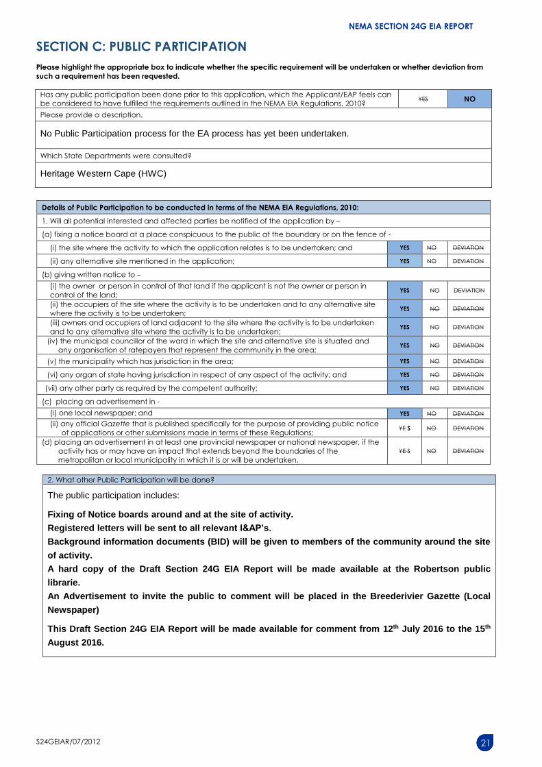
NEMA SECTION 24G EIA Report Section 24G Application Form for the rectification of unlawful commencement or continuation of listed activity/ies in terms of the: National Environmental Management Act, 1998 (Act No. 107 of 1998), (“NEMA”); Environment Conservation Act, 1989 (Act No. 73 of 1989) (“ECA”); Specific Environmental Management Acts (“SEMAs”) July 2012 Form Number: S24GEIAR/07/2012 Kindly note that: 1. This section 24G Environmental Impact Assessment (”EIA”) report must be completed for all section 24G applications in terms of the above Acts, by an independent Environmental Assessment Practitioner (“EAP”). 2. This EIA report is current as of July 2012. It is the responsibility of the Applicant/EAP to ascertain whether subsequent versions of the EIA report have been published or produced by the competent authority. Contents: Section A: Activity Information Section B: Description of Receiving Environment Section C: Public Participation Information Section D: Need and Desirability Section E: Alternatives Section F: Preliminary Impact Assessment, Management, Mitigation and Monitoring Section G: Assessment Methodologies and Criteria, Gaps in Knowledge, under laying Assumptions and Uncertainties Section H: Recommendations of the EAP Section I: Motivation for response to an emergency Section J: Appendices 3. An Independent EAP must be appointed to complete the section 24G EIA report on behalf of the applicant; the declaration of independence must be completed by the independent EAP and submitted with this EIA report. If a specialist report is required, the specialist will also be required to complete the declaration of independence. 4. Two hard copies and one electronic copy (CD/DVD) of this report must be submitted. 5. The required information must be typed within the spaces provided. The sizes of the spaces provided are not necessarily indicative of the amount of information to be provided. The space provided extend as each space is filled with typing. A legible font type and size must be used when completing the report. The font size should not be smaller than 10pt (e.g. Century Gothic 10). A digital copy of the Section EIA Report is available on the Department’s website (details below). 6. The use of “not applicable” in the EIA report must be done with circumspection. 7. No faxed or e-mailed EIA reports will be accepted. 8. Unless protected by law, all information contained in and attached to this EIA report will become public information on receipt by the competent authority. Upon request, any Interested and Affected Party (“I&AP”) should be provided with the information contained in and attached to this EIA report. During any stage of the application process, the information contained in and attached to it must be provided by the applicant / EAP. 9. This EIA report must be submitted to the Department at the postal address given below or by delivery thereof to the Registry Office of the Department. Unnecessary delays will be incurred should the application and attached information not be submitted to the correct address.
Transcript
NEMA SECTION 24G EIA Report
Section 24G Application Form for the rectification of unlawful commencement or continuation of listed
activity/ies in terms of the:
National Environmental Management Act, 1998 (Act No. 107 of 1998), (“NEMA”);
Environment Conservation Act, 1989 (Act No. 73 of 1989) (“ECA”);
Specific Environmental Management Acts (“SEMAs”)
July 2012 Form Number: S24GEIAR/07/2012
Kindly note that:
1. This section 24G Environmental Impact Assessment (”EIA”) report must be completed for all section 24G
applications in terms of the above Acts, by an independent Environmental Assessment Practitioner (“EAP”).
2. This EIA report is current as of July 2012. It is the responsibility of the Applicant/EAP to ascertain whether
subsequent versions of the EIA report have been published or produced by the competent authority.
Contents:
Section A: Activity Information
Section B: Description of Receiving Environment
Section C: Public Participation Information
Section D: Need and Desirability
Section E: Alternatives
Section F: Preliminary Impact Assessment, Management, Mitigation and Monitoring
Section G: Assessment Methodologies and Criteria, Gaps in Knowledge, under laying Assumptions and
Uncertainties
Section H: Recommendations of the EAP
Section I: Motivation for response to an emergency
Section J: Appendices
3. An Independent EAP must be appointed to complete the section 24G EIA report on behalf of the applicant;
the declaration of independence must be completed by the independent EAP and submitted with this EIA
report. If a specialist report is required, the specialist will also be required to complete the declaration of
independence.
4. Two hard copies and one electronic copy (CD/DVD) of this report must be submitted.
5. The required information must be typed within the spaces provided. The sizes of the spaces provided are not
necessarily indicative of the amount of information to be provided. The space provided extend as each
space is filled with typing. A legible font type and size must be used when completing the report. The font size
should not be smaller than 10pt (e.g. Century Gothic 10). A digital copy of the Section EIA Report is available
on the Department’s website (details below).
6. The use of “not applicable” in the EIA report must be done with circumspection.
7. No faxed or e-mailed EIA reports will be accepted.
8. Unless protected by law, all information contained in and attached to this EIA report will become public
information on receipt by the competent authority. Upon request, any Interested and Affected Party (“I&AP”)
should be provided with the information contained in and attached to this EIA report. During any stage of the
application process, the information contained in and attached to it must be provided by the applicant /
EAP.
9. This EIA report must be submitted to the Department at the postal address given below or by delivery thereof
to the Registry Office of the Department. Unnecessary delays will be incurred should the application and
attached information not be submitted to the correct address.
NEMA SECTION 24G EIA REPORT
S24GEIAR/07/2012 2
10. PROCESS TO BE FOLLOWED:
a) A section 24G Application Form constitutes the initiation of the Section 24G application process. If you
have failed to submit an application form, you may not proceed with the compilation and submission of
this EIA report until such time that a section 24G application form has been submitted to the Department
and subsequently acknowledged.
b) Once the information requirements in respect of the application have been met, a draft EIA report,
which must include an Environmental Management Programme (“EMP”), must first be made available to
the I&APs, including all the relevant State Departments that administer laws relating to a matter
affecting the environment, for comment for a period of 40 (forty) calendar days. Unless otherwise
indicated by the Department, a commenting period of at least 21 (twenty-one) days must be provided
to I&APs, including the relevant State Departments, to comment on any additional information,
documentation or reports (including the final EIR), other than the draft EIR.
c) The draft EIA report must be submitted to the Department in order to meet the requirements of section
24O of the NEMA. The Department will notify the State Departments of the 40 (forty) day commenting
after receipt of the draft EIA report.
d) Upon submission of the final EIA report, the competent authority will reconsider the application and may
undertake a site inspection or request such additional information as the competent authority may
require from the Applicant/EAP.
e) The Department will consider the final EIA report/additional information (if required) to determine the
administrative fine (not exceeding R1 million) and inform the applicant accordingly. The fine must be
paid within 60 days from the date of the fine notice. The applicant is required to provide proof of
payment of the fine to the Department.
f) In accordance with section 24G(2), the competent authority will then:
direct the applicant to cease the activity, either wholly or in part, and to rehabilitate the environment
within such time and subject to such conditions as the Department may deem necessary; or
issue an environmental authorisation to the applicant subject to such conditions as the Department
may deem necessary.
11. Note, failure to comply with a directive calling for information to be submitted within a specified period may
result in the institution of appropriate legal action as is deemed necessary by this Department and as provided
for in the legislation.
12. A person failing to comply with a directive or contravening or failing to comply with a condition of
environmental authorisation is guilty of an offence and is liable on conviction to a penalty of a fine not
exceeding R5 million or to imprisonment for a period not exceeding ten years, or to both such fine and such
imprisonment.
NEMA SECTION 24G EIA REPORT
S24GEIAR/07/2012 3
DEPARTMENTAL DETAILS DEPARTMENTAL REFERENCE NUMBER(S) (for official use)
Department of Environmental Affairs
and Development Planning,
Directorate: Environmental Compliance
& Enforcement,
Attention: Sub-directorate: Section 24G
Applications
Private Bag X9086
Cape Town, 8000
Registry Office
1st Floor Utilitas Building
1 Dorp Street, Cape Town
Queries should be directed to the Sub-
directorate: Section 24G Applications
at:
Tel: (021) 483-8019 Fax: (021) 483-4033
View the Department’s website on http://www.westerncape.gov.za/eadp for the latest version of the documents
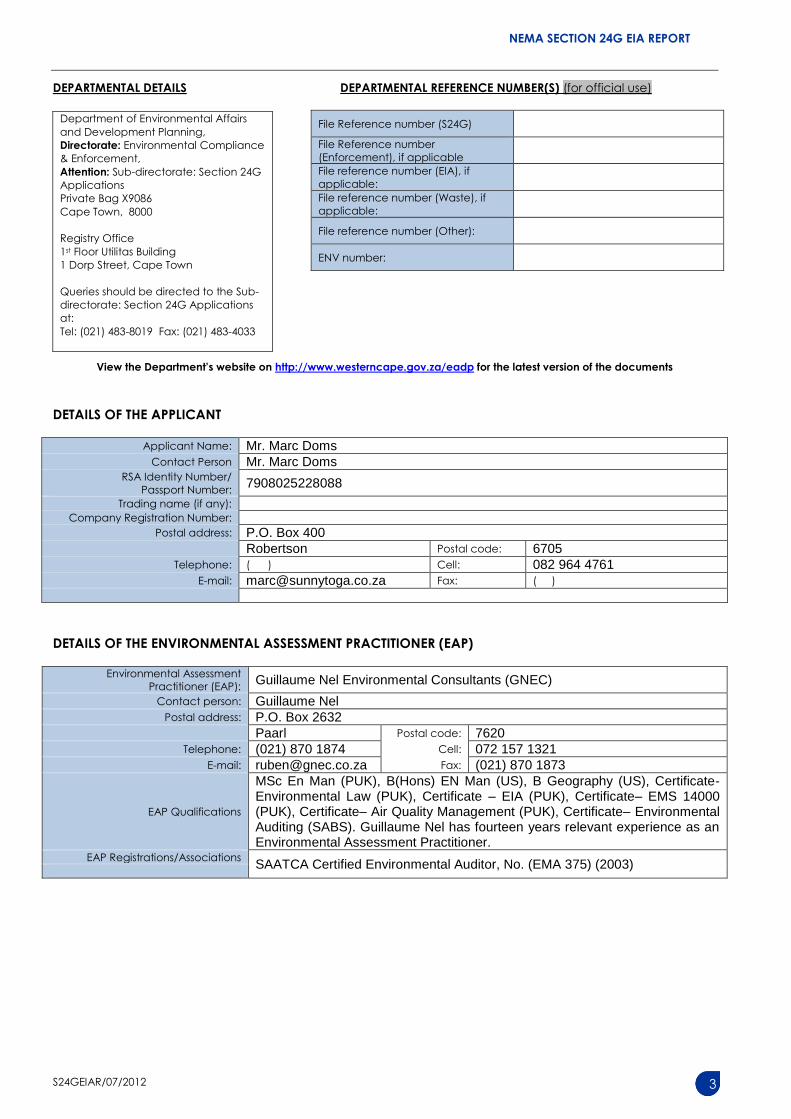
DETAILS OF THE APPLICANT
Applicant Name: Mr. Marc Doms Contact Person Mr. Marc Doms
RSA Identity Number/
Passport Number: 7908025228088
Trading name (if any):
Company Registration Number:
Postal address: P.O. Box 400 Robertson Postal code: 6705
MSc En Man (PUK), B(Hons) EN Man (US), B Geography (US), Certificate- Environmental Law (PUK), Certificate – EIA (PUK), Certificate– EMS 14000 (PUK), Certificate– Air Quality Management (PUK), Certificate– Environmental Auditing (SABS). Guillaume Nel has fourteen years relevant experience as an Environmental Assessment Practitioner.
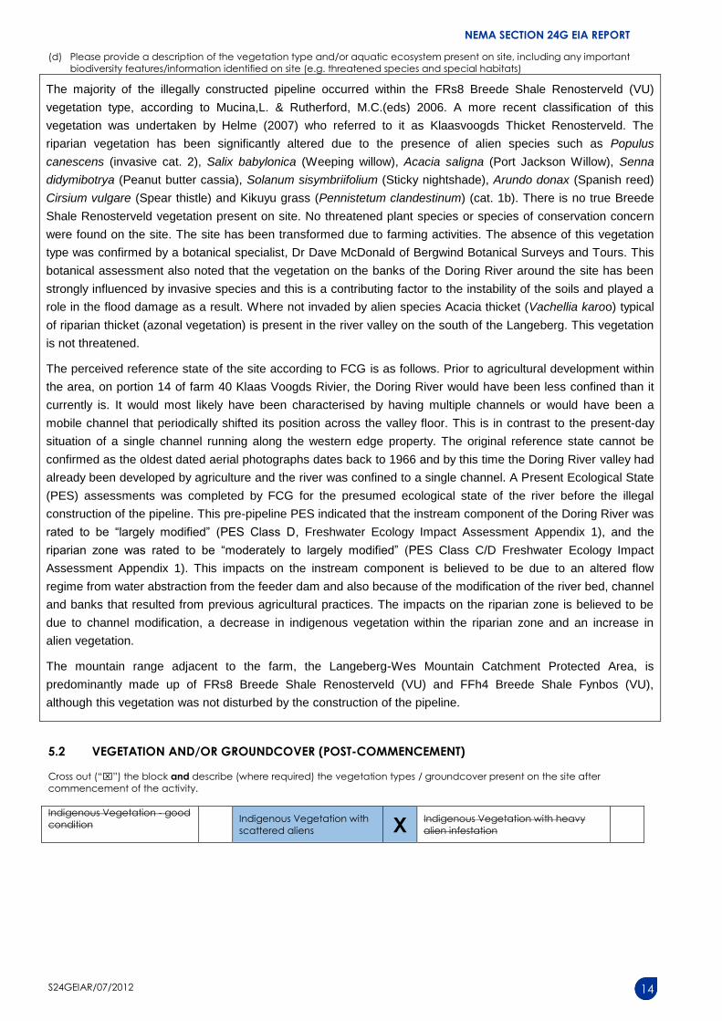
Cross out (“”) the block and describe (where applicable) the vegetation types / groundcover present on the site before
commencement of the activity.
Indigenous Vegetation - good
condition
Indigenous Vegetation with
scattered aliens X Indigenous Vegetation with heavy
alien infestation
Describe the vegetation type above:
Describe the vegetation type
above:
The vegetation type of the construction area is listed as FRs8 Breede Shale Renosterveld according to Mucina,L. & Rutherford, M.C.(eds) 2006. A more recent classification of this vegetation was undertaken by Helme (2007) who referred to it as Klaasvoogds Thicket Renosterveld. The riparian vegetation has been significantly altered due to the presence of alien species such as Populus (invasive cat. 2), Salix (Weeping willow), Kikuyu grass (Pennistetum) (cat. 1b) etc.
There is no true Breede Shale Renosterveld vegetation present on site. No threatened plant species or species of conservation concern were found on the site. The site has been transformed due to farming activities. The absence of this vegetation type was confirmed by a botanical specialist.
Describe the vegetation type above:
Provide ecosystem status for above:
Provide ecosystem status for above:
Provide ecosystem status for above:
Breede Shale Renosterveld vegetation type is listed to be Vulnerable
Indigenous Vegetation in an
ecological corridor or along a soil
boundary / interface
Veld dominated by alien species
Distinctive soil conditions (e.g. Sand over
shale, quartz patches, limestone, alluvial
deposits, termitaria etc.) – describe
Bare soil
Building or other structure
Sport field
Other (describe below) Cultivated land Paved surface
Cross out (“”) the block and describe (where required) the vegetation types / groundcover present on the site after
commencement of the activity.
Indigenous Vegetation - good
condition
Indigenous Vegetation with
scattered aliens X Indigenous Vegetation with heavy
alien infestation
NEMA SECTION 24G EIA REPORT
S24GEIAR/07/2012 15
Describe the vegetation type above:
Describe the vegetation type
above:
The vegetation type of the construction area is listed as FRs8 Breede Shale Renosterveld according to Mucina,L. & Rutherford, M.C.(eds) 2006. A more recent classification of this vegetation was undertaken by Helme (2007) who referred to it as Klaasvoogds Thicket Renosterveld. The riparian vegetation has been significantly altered due to the presence of alien species such as Populus (invasive cat. 2), Salix (Weeping willow) Kikuyu grass (Pennistetum) (cat. 1b) etc.
Describe the vegetation type above:
There is no true Breede Shale Renosterveld vegetation present on site. No threatened plant species or species of conservation concern were found on the site. The site has been transformed due to farming activities. The absence of this vegetation type was confirmed by a botanical specialist.
A small portion (± 50 m) of the proposed preferred and alternative replacement pipeline route is mapped as the Breede Alluvium Renosterveld threatened ecosystem. This vegetation type also no longer occurs here due to the current presence of a planted pasture field and a farm homestead.
Provide ecosystem status for above:
Provide ecosystem status for above:
Provide Ecosystem status for above:
FRs8 Breede Shale Renosterveld vegetation type is listed to be Vulnerable. Breede Alluvium Renosterveld threatened ecosystem is listed as Vulnerable.
Indigenous Vegetation in an
ecological corridor or along a soil
boundary / interface
Veld dominated by alien species
Distinctive soil conditions (e.g. Sand over
shale, quartz patches, limestone, alluvial
deposits, termitaria etc.) – describe
Bare soil
Building or other structure
Sport field
Other (describe below) Cultivated land Paved surface
NEMA SECTION 24G EIA REPORT
S24GEIAR/07/2012 16
(a) Highlight and describe the post-construction habitat condition on site.
Habitat Condition
Percentage of
habitat condition
class (adding up
to 100%)
Description and additional Comments and Observations
(including additional insight into condition, e.g. poor land management
practises, presence of quarries, grazing/harvesting regimes etc).
Natural
10% Acacia thicket (Vachellia karoo) typical of riparian thicket (azonal
vegetation) in the river valley on the south of the Langeberg. This
vegetation is not threatened.
Near Natural
(includes areas with low
to moderate level of alien
invasive plants)
0%
Degraded
(includes areas heavily
invaded by alien plants)
15% The riparian vegetation has been significantly altered due to the
presence of alien species such as Populus (invasive cat. 2), Salix
(Weeping willow), Kikuyu grass (Pennistetum) (cat. 1b) etc.
Transformed
(includes cultivation,
dams, urban, plantation,
roads, etc)
75% There is no true Breede Shale Renosterveld vegetation present on
site. The area has largely been utilized for agricultural purposes with
the surrounding area being dominated by pasture fields and
vineyards. The absence of this vegetation type was confirmed by a
botanical specialist.
The site was also altered by erosion from the flooding event that
took place not long after the construction of the pipeline. A proposed
preferred and alternative new route for a replacement pipeline will
result in minimal impacts on the environment as it will be
constructed in a pasture field and underneath an existing road, all of
which have been previously transformed.
(b) How have the vegetation and/or aquatic ecosystem(s) present on site (including any important biodiversity features
identified on site (e.g. threatened species and special habitats)) been affected by the commencement of the listed
activity(ies)?
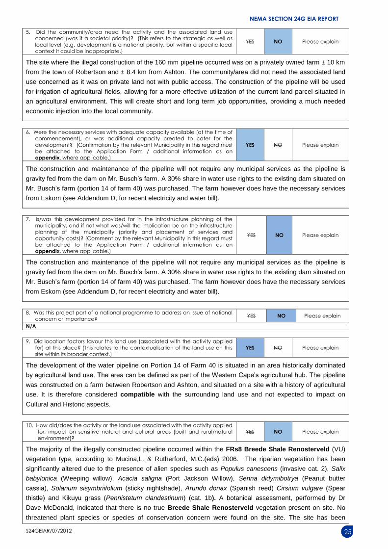
The majority of the illegally constructed pipeline occurred within the FRs8 Breede Shale Renosterveld (VU)
vegetation type, according to Mucina,L. & Rutherford, M.C.(eds) 2006. A more recent classification of this
vegetation was undertaken by Helme (2007) who referred to it as Klaasvoogds Thicket Renosterveld. The
riparian vegetation has been significantly altered due to the presence of alien species such as Populus
thistle) and Kikuyu grass (Pennistetum clandestinum) (cat. 1b). A botanical assessment, performed by Dr
Dave McDonald, indicated that there is no true Breede Shale Renosterveld vegetation present on site. No
threatened plant species or species of conservation concern were found on the site. The site has been
NEMA SECTION 24G EIA REPORT
S24GEIAR/07/2012 26
transformed due to farming activities. The vegetation on the banks of the Doring River around the site has
been strongly influenced by invasive species and this is a contributing factor to the instability of the soils and
played a role in the flood damage as a result.
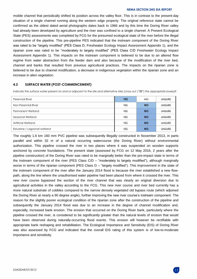
The roughly 1.6 km 160 mm PVC pipeline was subsequently illegally constructed in November 2013, in parts
parallel and within 32 m of a natural occurring watercourse (the Doring River) without environmental
authorization. This pipeline crossed the river in two places where it was suspended on wooden supports
anchored by concrete foundations. This watercourse serves as a habitat for various terrestrial and aquatic
flora and fauna that can be deemed a natural resource. A freshwater ecological assessment was also
conducted to determine the impact of the pipeline on the aquatic diversity of the Doring River by the Dean Ollis
of the Freshwater Consulting Group (FCG). The present state (assessed by FCG on 12 May 2016, 2 years
after the pipeline construction) of the Doring River was rated to be marginally better than the pre-impact state
in terms of the instream component of the river (PES Class C/D – “moderately to largely modified”), although
marginally worse in terms of the riparian component (PES Class D – “largely modified”). This improvement in
the state of the instream component of the river after the January 2014 flood is because the river established a
new flow-path, along the line where the unauthorised water pipeline had been placed from where it crossed
the river. This new river course bypassed the section of the river channel that was clearly an original diversion
due to agricultural activities in the valley according to the FCG. This new river course and river bed currently
has a more natural substrate of cobbles compared to the narrow densely vegetated old bypass route (which
adjoined the Doring River at nearly a 90 degree angle), further improving the new river course’s instream
component. The reason for the slightly poorer ecological condition of the riparian zone after the construction of
the pipeline and subsequently the January 2014 flood was due to an increase in the degree of channel
modification and, especially, increased bank erosion. The erosion that occurred on the Doring River bank,
particularly where the pipeline crossed the river, is considered to be significantly greater than the natural levels
of erosion that would have been observed during naturally-occurring flood events. This erosion will however be
rectifiable with appropriate bank reshaping and rehabilitation. The Ecological Importance and Sensitivity (EIS)
of Doring River was also assessed by FCG and indicated that the overall EIS rating of this system is of low-to-
moderate importance and sensitivity.
This freshwater study also indicated that the flood-related damage to the Doring River was not attributable to
the unauthorised water pipeline construction. This is evident from the magnitude of damage caused by the
flood, which extends well beyond the reach of the river that could have been affected by the pipeline and was
clearly a major flood event, which would have resulted in extensive erosion-related damage along the Doring
River whether the unauthorised pipeline had been present or not. However flood-related ecological impacts
were exacerbated by the presence of the unauthorised pipeline, in particular, more intensive bank erosion
occurred at the point where the pipeline crossed the river. The excavation of a trench for the pipeline alongside
the Doring River would also have facilitated the modification of the channel that resulted in a new river course.
The overall significance of these impacts was rated by FCG to be low-to-medium without rectification and
would become low with rectification. The negative impacts associated with the flood-related modifications to
the river must, however, be weighed up against the positive impact of the improvement of the instream habitat
within the new channel.
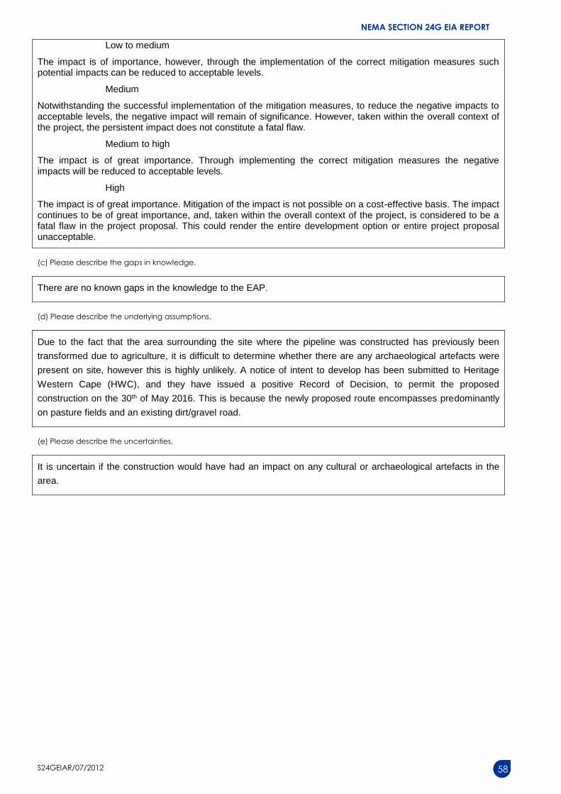
A notice of intent to develop has been submitted to HWC, and they have issued a positive Record of Decision,
to permit the proposed construction on the 30th of May 2016, whereby no cultural or heritage resources is
believed to be impacted upon.
11. How did/does the development impact on people’s health and wellbeing
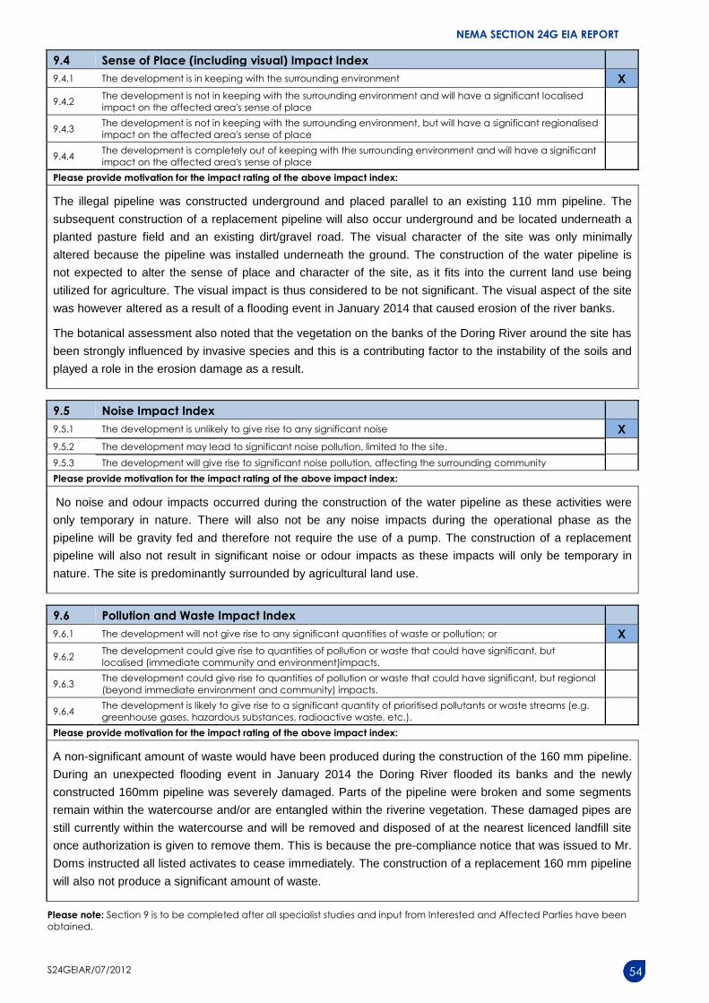
(e.g. in terms of noise, odours, visual character and sense of place, etc)? YES NO Please explain
No noise and odour impacts occurred during the construction of the water pipeline as these activities were
only temporary in nature. The visual character of the site was only minimally altered because the pipeline was
installed underneath the ground. The visual impact is thus considered to be not significant. The visual aspect
of the site was however altered as a result of a flooding event in January 2014 that caused erosion of the river
NEMA SECTION 24G EIA REPORT
S24GEIAR/07/2012 27
banks. Mr. Karl Reinecke (Southers Waters Ecological Research and Consulting cc), the freshwater
consultants that have prepared a River Maintenance and Management Plan for the entire Klaasvoogds river
area. He was consulted for a site visit on the 6th of October 2014 to assess the erosion damage and to discuss
potential causes thereof and rehabilitation measures. Mr. Reinecke indicated that it would however be
impossible to attribute the reasons or cause for the flood damage without having been present at the time of
the flood. The construction of the water pipeline is not expected to alter the sense of place and character of the
site, as it fits into the current land use being utilized for agriculture.
12. Did/does the proposed activity or the land use associated with the activity
applied for, result in unacceptable opportunity costs? YES NO Please explain
The construction of the water pipeline, in addition, allows for a more effective utilization of the current dormant
land parcel situated in an agricultural environment which will, with the short and long term job creation
opportunities, provide a much needed economic injection into the local community.
13. What were the cumulative impacts (positive and negative) of the land use
associated with the activity applied for? YES NO Please explain
The cumulative negative effect of the construction of the pipeline was the likely transformation of a portion of
riverine vegetation and Breede Shale Renosterveld vegetation type. The botanical assessment, performed
by Dr Dave McDonald, indicated that there is no true Breede Shale Renosterveld vegetation present on site
and that the pipeline would have only minimally impacted upon this vegetation. This assessment also indicated
that alien vegetation is present on the banks of the Doring River and would have contributed to the instability
of the soils which could likely have led to the flood damage as a result. No threatened plant species or species
of conservation concern were found on the site. The vegetation was therefore not in a pristine state and the
impact on the indigenous vegetation would have been minimal. The site was however transformed due to
agricultural purposes. Very little temporally visual and noise impacts associated with the construction of the
pipeline would have however also have added to the cumulative impact. The visual aspect of the site was
however altered as a result of a flooding event in January 2014 that caused erosion of the river banks. Mr. Karl
Reinecke (Southers Waters Ecological Research and Consulting cc), the freshwater consultants that have
prepared a River Maintenance and Management Plan for the entire Klaasvoogds river area. He was consulted
for a site visit on the 6th of October 2014 to assess the erosion damage and to discuss potential causes thereof
and rehabilitation measures. Mr. Reinecke indicated that it would however be impossible to attribute the
reasons or cause for the flood damage without having been present at the time of the flood.
The cumulative positive impacts were the short and long term job opportunities that were created by the
construction and the subsequent operation of the farming activities that would have been established as a
result of the construction of the pipeline. This pipeline will allow Mr. Doms to further expand on the agricultural
activities on his farm, potentially leading to additional job creation and financial injection in the local
community.
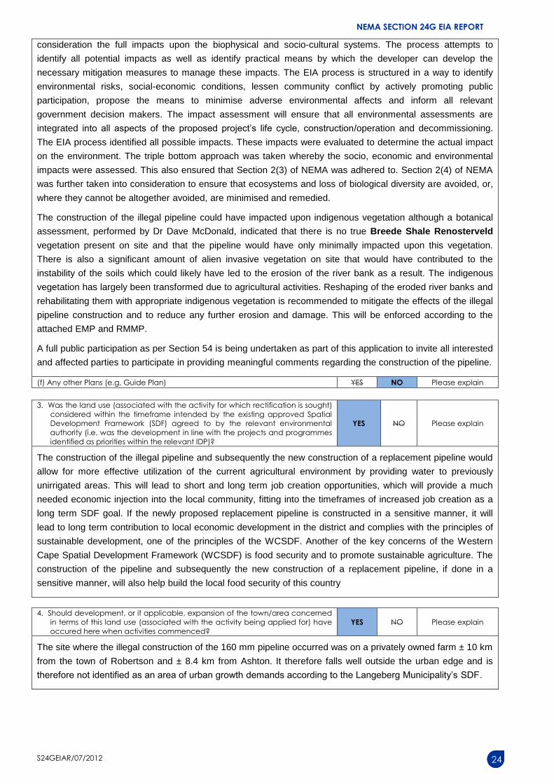
14. Is/was the development the best practicable environmental option for this
land/site? YES NO Please explain
The construction of the pipeline on portion 14 of farm 40 is situated in an area historically dominated by
agricultural land use. The area can be defined as part of the Western Cape’s agricultural hub and is located
between Robertson and Ashton. It is therefore considered compatible with the surrounding land use and not
expected to impact on Cultural and Historic aspects. However, during the site visit conducted on the 6th of
October 2014 the previous pipeline route (that was destroyed in the flood) was assessed in terms of its viability
in order to replace the 160 mm pipeline along the same route. It was the opinion of both GNEC and Mr. Karl
Reinecke that this route is not a viable option as any possible future flooding could result in the same
detrimental outcome. The costs for constructing such a pipeline is very high and it would be a significant risk to
replace the pipeline along the same route. It is the contention of GNEC that this route should never have been
deemed a viable option in terms of environmental impact.
NEMA SECTION 24G EIA REPORT
S24GEIAR/07/2012 28
17. Please describe how the general objectives of Integrated Environmental Management as set out in section 23 of NEMA
were taken into account:
The Impact Assessment process conforms to the principles of Integrated Environmental Management (IEM).
The process attempts to identify all potential impacts as well as identify practical means by which the
developer can develop the necessary mitigation measures to manage these impacts. The EIA process is
structured in a way to identify environmental risks, social-economic conditions, lessen community conflict by
actively promoting public participation, propose the means to minimise adverse environmental affects and
inform all relevant government decision makers.
The impact assessment will ensure that all environmental assessments are integrated into all aspects of the
proposed project’s life cycle, construction/operation and decommissioning. The EIA process identified all
possible impacts. These impacts were evaluated to determine the actual impact on the environment. The triple
bottom approach was taken whereby the socio, economic and environmental impacts were assessed. This
also ensured that Section 2(3) of NEMA was adhered to. Section 2(4) of NEMA was further taken into
consideration to ensure that ecosystems and loss of biological diversity are avoided, or, where they cannot be
altogether avoided, are minimised and remedied.
The construction of the illegal pipeline has impacted upon indigenous vegetation although the site has
previously been transformed due to agricultural activities. Reshaping of the eroded river banks and
rehabilitating them with appropriate indigenous vegetation is recommended to mitigate the effects of the illegal
pipeline construction and to reduce any further erosion and damage. This will be enforced according to the
attached EMP and RMMP.
It is not foreseen that any National or Cultural heritage resources were disturbed by the construction or will be
disturbed by the proposed replacement pipeline. Heritage Western Cape have issued a positive Record of
Decision, to permit the proposed construction on the 30th of May 2016, whereby no cultural or heritage
resources is believed to be impacted upon.
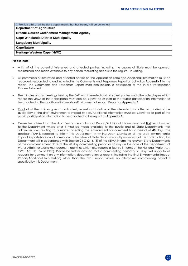
A full public participation as per Section 54 is being undertaken as part of this application to invite all interested
and affected parties to participate in providing meaningful comments regarding the construction of the pipeline.
The preferred replacement and alternative route for a new 160 mm pipeline is said to have minimal impacts on
the environment and is thus considered to be the best practicable environmental option. A positive Record of
Decision, to permit the proposed construction of the new pipeline was granted from HWC on the 30th of May
2016, whereby no cultural or heritage resources is believed to be impacted upon.
15. What are/were the benefits to society in general and to the local communities? Please explain
The cumulative positive impacts were the short and long term job opportunities that were created by the
construction and the subsequent operation of the farming activities that would have been established as a
result of the construction of the pipeline. This pipeline will allow Mr. Doms to further expand on the agricultural
activities on his farm, potentially leading to additional job creation and financial injection in the local
community. At current the farm provides employment to 40 permanent and 200 seasonal employees, all of
which are previously disadvantaged individuals.
16. Any other need and desirability considerations related to the activity? Please explain
N/A
NEMA SECTION 24G EIA REPORT
S24GEIAR/07/2012 29
18. Please describe how the principles of environmental management as set out in section 2 of NEMA were taken into
account:
The EIA process identified all possible impacts. These impacts were evaluated to determine the actual impact
on the environment. The triple bottom approach was taken whereby socio, economic and environmental
impacts were assessed. This ensured that Section 2(3) of NEMA was adhered to.
Section 2(4) of NEMA was further taken into consideration to ensure that ecosystems and loss of biological
diversity are avoided, or, where they cannot be avoided, are minimised and remedied. This is to ensure that
development is socially, environmentally and economically sustainable.
This 24G Environmental Impact Assessment Report will be conducted in such a way as to ensure that further
degradation of the environment is avoided by enforcing the attached EMP and RMMP. Rehabilitation as a
mitigation measure is recommended to restore the riverine vegetation into a once again ecologically stable
and suitable state.
It is not foreseen that any National or Cultural heritage resources were disturbed by the construction or will be
disturbed by the proposed replacement pipeline. Cultural and heritage resource impacts were assessed and
deemed to be insignificant by Heritage Western Cape, whereby they issued a positive Record of Decision, to
permit the proposed construction on the 30th of May 2016.
A full public participation as per Section 54 is being undertaken as part of this application to invite all interested
and affected parties to participate in providing meaningful comments regarding the construction of the pipeline.
1. SOCIO-ECONOMIC CONTEXT
1.1 SOCIO-ECONOMIC CONTEXT (PRE-COMMENCEMENT) Describe the pre-commencement social and economic characteristics of the community in order to provide baseline
information.
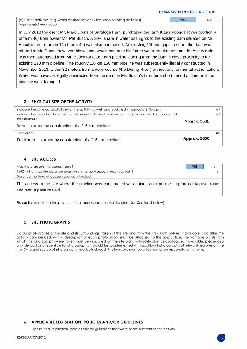
In July 2013 the client Mr. Marc Doms of Saratoga Farm purchased the farm Klaas Voogds Rivier (portion 4 of
farm 40) from owner Mr. Pat Busch. A 30% share in water use rights to the existing dam situated on Mr.
Busch’s farm (portion 14 of farm 40) was also purchased. An existing 110 mm pipeline from the dam was
offered to Mr. Doms, however this volume would not meet his future water requirement needs. A servitude was
then purchased from Mr. Busch for a 160 mm pipeline leading from the dam in close proximity to the existing
110 mm pipeline. The roughly 1.6 km 160 mm pipeline was subsequently illegally constructed in November
2013. This pipeline crossed the river in two places where it was suspended on wooden supports anchored by
concrete foundations. During an unexpected flooding event in January 2014 the Doring River flooded its banks
and the 160 mm pipeline was severely damaged and some sections of the original existing 110 mm pipeline
was also damaged. This flood also modified the river channel by establishing a new river course, along the
alignment of the unauthorised pipeline and eroded the bank into the first row of an adjacent vineyard. There
was however no damage to the pipeline between the dam and where it meets the river (the northern section).
The Department of Environmental Affairs and Development Planning was notified and a pre-compliance notice
was issued to Mr. Doms in February 2016.
Saratoga farm is a fully functioning farm specializing in growing blueberries and provides employment for 40
permanent and 200 seasonal staff, all of which are previously disadvantaged individuals. The pipeline was
initially installed to provide water to a portion of these Blueberry orchards on the farm. Due to the increased
demand for speciality fruit such as blueberries, a need has arisen for more growing facilities, where the
industry shows tremendous growth of about 30% per annum in South Africa. The climatic conditions within the
area are also optimally suited towards the growing of Blueberries, resulting in good yields. The farming of
berries has a very high labour requirement due to the fact that the berries can only be picked by hand and
cannot be picked by machine. This therefore provides large employment opportunities to previously
disadvantaged individuals. This pipeline will allow Mr. Doms to further expand on the agricultural activities on
his farm, potentially leading to additional job creation and financial injection in the local community.
NEMA SECTION 24G EIA REPORT
S24GEIAR/07/2012 30
1.2 SOCIO-ECONOMIC CONTEXT (POST-COMMENCEMENT) Describe the post commencement social and economic characteristics of the community in order to determine any change.
Where differences between pre- and post-commencement exist, state which are as a result of the activity(ies) for which
rectification is being applied for.
The 160mm water pipeline was constructed alongside an existing 110 mm pipeline in November 2013, it
was not in service for long before it was severely damaged in a flood event in January 2014. The benefits to
the agricultural fields that it fed would therefore not have been immediately apparent. This newly proposed
replacement pipeline will however facilitate the expansion the farm and result in an increased production
yield that would lead to local economic growth. This increase in production and economic growth will also
lead to an increase in job creation. Saratoga farm is a fully functioning farm specializing in growing
blueberries and provides employment for 40 permanent and 200 seasonal staff, all of which are previously
disadvantaged individuals. This pipeline could support further future expansion of the agricultural activities
on Saratoga farm, potentially leading to additional job creation and financial injection in the local community.
The construction costs of such a pipeline can be significant and would have led to a short term economic
boost in the local economy.
2. HISTORICAL AND CULTURAL ASPECTS
(a) Please be advised that if section 38 of the National Heritage Resources Act, 1999 (Act No. 25 of 1999), is applicable to your
development, then you are requested to furnish this Department with written comment from Heritage Western Cape as part
of your public participation process. Section 38 of the Act states as follows: “38. (1) Subject to the provisions of subsections
(7), (8) and (9), any person who intends to undertake a development categorised as-
(a) the construction of a road, wall, power line, pipeline, canal or other similar form of linear development or barrier
exceeding 300m in length;
(b) the construction of a bridge or similar structure exceeding 50m in length;
I any development or other activity which will change the character of a site-
(i) exceeding 5 000 m2 in extent; or
(ii) involving three or more existing erven or subdivisions thereof; or
(iii) involving three or more erven or divisions thereof which have been consolidated within the past five years; or
(iv) the costs of which will exceed a sum set in terms of regulations by SAHRA or a provincial heritage resources
authority;
(d) the re-zoning of a site exceeding 10 000 m2 in extent; or
(e) any other category of development provided for in regulations by SAHRA or a provincial heritage resources
authority,
must at the very earliest stages of initiating such a development, notify the responsible heritage resources authority and
furnish it with details regarding the location, nature and extent of the proposed development.”
(b) The impact on any national estate referred to in section 3(2), excluding the national estate contemplated in section
3(2)(i)(vi) and (vii), of the National Heritage Resources Act, 1999 (Act No. 25 of 1999), must also be investigated, assessed
and evaluated. Section 3(2) states as follows: “3(2) Without limiting the generality of subsection (1), the national estate may
include—
(a) places, buildings, structures and equipment of cultural significance;
(b) places to which oral traditions are attached or which are associated with living heritage;
(c) historical settlements and townscapes;
(d) landscapes and natural features of cultural significance;
(e) geological sites of scientific or cultural importance;
(f) archaeological and palaeontological sites;
(g) graves and burial grounds, including—
(i) ancestral graves;
(ii) royal graves and graves of traditional leaders;
(iii) graves of victims of conflict;
(iv) graves of individuals designated by the Minister by notice in the Gazette;
(v) historical graves and cemeteries; and
(vi) other human remains which are not covered in terms of the Human Tissue Act, 1983 (Act No. 65 of 1983);
(h) sites of significance relating to the history of slavery in South Africa;
(i) movable objects, including—
(i) objects recovered from the soil or waters of South Africa, including archaeological and palaeontological objects
and material, meteorites and rare geological specimens;
(ii) objects to which oral traditions are attached or which are associated with living heritage;
(iii) ethnographic art and objects;
(iv) military objects;
(v) objects of decorative or fine art;
(vi) objects of scientific or technological interest; and
NEMA SECTION 24G EIA REPORT
S24GEIAR/07/2012 31
(vii) books, records, documents, photographic positives and negatives, graphic, film or video material or sound
recordings, excluding those that are public records as defined in section 1(xiv) of the National Archives of South Africa
Act, 1996 (Act No. 43 of 1996).”
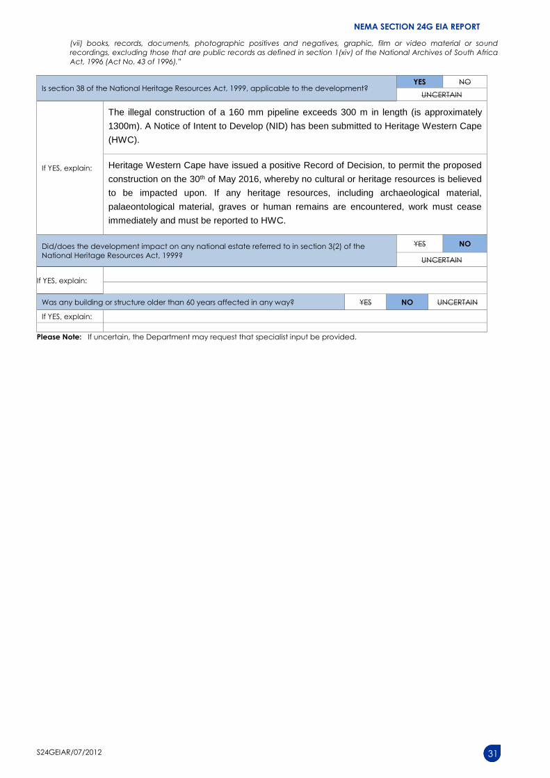
Is section 38 of the National Heritage Resources Act, 1999, applicable to the development? YES NO
UNCERTAIN
If YES, explain:
The illegal construction of a 160 mm pipeline exceeds 300 m in length (is approximately
1300m). A Notice of Intent to Develop (NID) has been submitted to Heritage Western Cape
(HWC).
Heritage Western Cape have issued a positive Record of Decision, to permit the proposed
construction on the 30th of May 2016, whereby no cultural or heritage resources is believed
to be impacted upon. If any heritage resources, including archaeological material,
palaeontological material, graves or human remains are encountered, work must cease
immediately and must be reported to HWC.
Did/does the development impact on any national estate referred to in section 3(2) of the
National Heritage Resources Act, 1999?
YES NO
UNCERTAIN
If YES, explain:
Was any building or structure older than 60 years affected in any way? YES NO UNCERTAIN
If YES, explain:
Please Note: If uncertain, the Department may request that specialist input be provided.
NEMA SECTION 24G EIA REPORT
S24GEIAR/07/2012 32
SECTION E: ALTERNATIVES
Please Note: Before completing this section, first consult this Department’s Guideline on Alternatives (October 2011) available on
the Department’s website (http://www.capegateway.gov.za/eadp).
“Alternatives”, in relation to a activity, means different means of meeting the general purposes and requirements of the activity,
which may include alternatives to –
(a) the property on which, or location where, it is to undertake the activity/the activity was undertaken;
(b) the type of activity to be undertaken;
(c) the design or layout of the activity;
(d) the technology to be used in the activity;
(e) the operational aspects of the activity; and
(f) the option of not implementing the activity.
The NEMA prescribes that the procedures for the investigation, assessment and communication of the (potential) consequences
or impacts of activities on the environment must, inter alia, with respect to every application for environmental authorisation –
ensure that the general objectives of integrated environmental management laid down in NEMA and the National
Environmental Management Principles set out in NEMA are taken into account; and
include an investigation of the potential consequences or impacts of the alternatives to the activity on the environment
and assessment of the significance of those potential consequences or impacts, including the option of not implementing
the activity.
The general objective of integrated environmental management is, inter alia, to “identify, predict and evaluate the actual and
potential impact on the environment, socio-economic conditions and cultural heritage, the risks and consequences and
alternatives and options for mitigation of activities, with a view to minimising negative impacts, maximising benefits, and
promoting compliance with the principles of environmental management” set out in NEMA.
1. In the sections below, please provide a description of any considered alternatives and alternatives that were found to be
feasible and reasonable.
Please note:
Detailed written proof of the investigation of alternatives must be provided and motivation if no reasonable or feasible
alternatives exist.
Alternatives considered for a Section 24G application are used to determine if the development was the best practicable
alternative (environmenally, socially, economically) for the property.
(a) Property and location/site alternatives to avoid negative impacts, mitigate unavoidable negative impacts and maximise
positive impacts, or detailed motivation if no reasonable or feasible alternatives exist:
Mr. Marc Doms of Saratoga Farm purchased the farm Klaas Voogds Rivier (portion 4 of farm 40) from owner
Mr. Pat Busch. A 30% share in water use rights to the existing dam situated on Mr. Busch’s farm (portion 14 of
farm 40) and a servitude for a 160 mm pipeline leading from the dam in close proximity to the existing PVC
110 mm pipeline was also purchased. A 160 mm PVC pipeline was subsequently illegally installed in
November 2013 (triggering EIA Regulations) and was severely damaged by a flood in January 2014.
Saratoga farm is a fully functioning farm specializing in the growing of blueberries and provides employment
for 40 permanent and 200 seasonal staff, all of which are previously disadvantaged individuals. The illegally
constructed pipeline was initially installed to provide water to a portion of these Blueberry orchards on the
farm. Due to the increased demand for speciality fruit such as blueberries, a need has arisen for more growing
facilities, where the industry shows tremendous growth of about 30% per annum in South Africa. The climatic
conditions within the area are also optimally suited towards the growing of Blueberries, resulting in good
yields. The farming of berries has a very high labour requirement due to the fact that the berries can only be
picked by hand and cannot be picked by machine. This therefore provides large employment opportunities to
previously disadvantaged individuals. It is the opinion of both GNEC and Mr. Karl Reinecke (Southers Waters
Ecological Research and Consulting cc) that the route where the pipeline was initially installed was not a
viable option as possible future flooding could result in the same detrimental outcome, and this route should
never have been deemed a viable option in terms of environmental impact. A replacement pipeline route is
therefore required to provide water to these agricultural fields, which will have a positive socio-economic
impact and not result in further negative impacts on the physical environment.
Succulent shrubs: Acrodon purpureostylus, Drosanthemum aureopurpureum, D. hallii, Lampranthus hurlingii.
Geophytic herb: Babiana villosa, Freesia fuctata, Ixia vanzijliae, I. vinacea, Moraea incurve, M. radians.
However please note that the site where the 160mm pipeline was constructed is located in an already
transformed agricultural area, and in a large part is laid parallel to an existing 110mm pipeline. Previous land
use has already transformed the property though agricultural practices. No threatened plant species or species
of conservation concern were found on the site. The absence of this vegetation type was confirmed by a
botanical specialist, Dr Dave McDonald. This botanical assessment also noted that the vegetation on the
banks of the Doring River around the site has been strongly influenced by invasive species and this is a
contributing factor to the instability of the soils and played a role in the flood damage as a result. Where not
invaded by alien species Acacia thicket (Vachellia karoo) typical of riparian thicket (azonal vegetation) is
present in the river valley on the south of the Langeberg. This vegetation is not threatened.
A small portion (± 50 m) of the proposed preferred and alternative replacement pipeline route is mapped as
the Breede Alluvium Renosterveld threatened ecosystem. However, the botanical assessment also
indicated this vegetation type no longer occurs here due to the current presence of a planted pasture field and
a farm homestead. Reshaping, rehabilitation with appropriate indigenous vegetation and the installation of
erosion protection structures on the river banks are also recommended once environmental authorization has
been granted. No rivers or wetlands were identified along these newly proposed routes. This will be enforced
according to the attached EMP and RMMP.
Please describe the manner in which any other biological aspects were impacted:
A vineyard and a planted pasture (perennial) field’s vegetation was also damaged by the river eroding and
changing its course.
(c) Socio-Economic aspects:
What was the capital value of the activity on completion? R
What is the (expected) yearly income or contribution to the economy that is/will be generated by or as a
result of the activity?
R
Has/will the activity contributed to service infrastructure? YES NO
How many new employment opportunities were/will be created in the construction phase of the activity?
NEMA SECTION 24G EIA REPORT
S24GEIAR/07/2012 39
What was the value of the employment opportunities during the construction phase? R
What percentage of this accrued to previously disadvantaged individuals? %
How was this ensured and monitored (please explain):
Not Known at this stage
How many permanent new employment opportunities were/will be created during the operational phase
of the activity?
What is the current/expected value of the employment opportunities during the first 10 years? R
What percentage of this accrued/will accrue to previously disadvantaged individuals? %
How was/will this be ensured and monitored (please explain):
Not Known at this stage
Any other information related to the manner in which the socio-economic aspects was/will be impacted:
This newly proposed replacement pipeline will however facilitate the expansion the farm and result in an
increased production yield that would lead to local economic growth. This increase in production and
economic growth will also lead to an increase in job creation. Saratoga farm is a fully functioning farm
specializing in growing blueberries and provides employment for 40 permanent and 200 seasonal staff, all of
which are previously disadvantaged individuals. This pipeline could support further future expansion of the
agricultural activities on Saratoga farm, potentially leading to additional job creation and financial injection in
the local community. The construction costs of such a pipeline can be significant and would have led to a short
term economic boost in the local economy.
(d) Cultural and historic aspects:
The illegal construction of a 160mm pipeline on Portion 14 of Farm 40 is situated in an area historically
dominated by agricultural land use. It is therefore highly unlikely that the construction of this illegal pipeline
would have unearthed any archaeological sites of importance being predominantly on agricultural land. The
potential impact to the surrounding environment and any heritage recourses is deemed to be minimal in nature
for the newly proposed preferred and alternative replacement pipeline route as this new pipeline will be buried
underground in a pasture field and underneath an existing gravel/dirt road. It will therefore not be visually
impairing to negatively affect the aesthetic aspect of the surrounding environment. A notice of intent to develop
has been submitted to Heritage Western Cape, and they have issued a positive Record of Decision, to permit
the proposed construction on the 30th of May 2016. If any heritage resources, including archaeological
material, palaeontological material, graves or human remains are encountered, work must cease immediately
and must be reported to HWC.
2. WASTE AND EMISSIONS
(a) Waste (including effluent) management
Did the activity produce waste (including rubble) during the construction phase? YES NO
If yes, indicate the types of waste (actual type of waste, e.g. oil, and whether hazardous or not) and
estimated quantity per type? M3
Does the activity produce waste during its operational phase? YES NO
If yes, indicate the types of waste (actual type of waste, e.g. oil, and whether hazardous or not) and
estimated quantity per type? M3
NEMA SECTION 24G EIA REPORT
S24GEIAR/07/2012 40
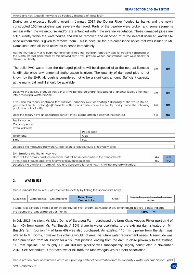
Where and how was/will the waste be treated / disposed of (describe)?
During an unexpected flooding event in January 2014 the Doring River flooded its banks and the newly
constructed 160mm pipeline was severely damaged. Parts of the pipeline were broken and some segments
remain within the watercourse and/or are entangled within the riverine vegetation. These damaged pipes are
still currently within the watercourse and will be removed and disposed of at the nearest licenced landfill site
once authorization is given to remove them. This is because the pre-compliance notice that was issued to Mr.
Doms instructed all listed activates to cease immediately.
Has the municipality or relevant authority confirmed that sufficient capacity exist for treating / disposing of
the waste (to be) generated by this activity(ies)? If yes, provide written confirmation from Municipality or
relevant authority.
The solid PVC waste from the damaged pipeline will be disposed of at the nearest licenced
landfill site once environmental authorization is given. The quantity of damaged pipe is not
known by the EAP, although is considered not to be a significant amount. Sufficient capacity
at the municipal landfill should be available.
YES NO
Does/will the activity produce waste that is/will be treated and/or disposed of at another facility other than
into a municipal waste stream? YES NO
If yes, has this facility confirmed that sufficient capacity exist for treating / disposing of the waste (to be)
generated by this activity(ies)? Provide written confirmation from the facility and provide the following
particulars of the facility:
YES NO
Does the facility have an operating license? (If yes, please attach a copy of the license.) YES NO
Facility name:
Contact person:
Postal address:
Postal code:
Telephone: Cell:
E-mail: Fax:
Describe the measures that were/will be taken to reduce, reuse or recycle waste:
(b) Emissions into the atmosphere
Does/will the activity produce emissions that will be disposed of into the atmosphere? YES NO
If yes, does it require approval in terms of relevant legislation? YES NO
Describe the emissions in terms of type and concentration and how it is/will be treated/mitigated:
3. WATER USE
Please indicate the source(s) of water for the activity by ticking the appropriate box(es)
Municipal Water board Groundwater River, Stream,
Dam or Lake Other
The activity did/does/will not use
water
If water was extracted from a groundwater source, river, stream, dam, lake or any other natural feature, please indicate
the volume that was extracted per month: 12500 m3
In July 2013 the client Mr. Marc Doms of Saratoga Farm purchased the farm Klaas Voogds Rivier (portion 4 of
farm 40) from owner Mr. Pat Busch. A 30% share in water use rights to the existing dam situated on Mr.
Busch’s farm (portion 14 of farm 40) was also purchased. An existing 110 mm pipeline from the dam was
offered to Mr. Doms, however this volume would not meet his future water requirement needs. A servitude was
then purchased from Mr. Busch for a 160 mm pipeline leading from the dam in close proximity to the existing
110 mm pipeline. The roughly 1.6 km 160 mm pipeline was subsequently illegally constructed in November
2013. See Addendum D for recent water bill from the Klaasvoogds Water Users Association.
Please provide proof of assurance of water supply (eg. Letter of confirmation from municipality / water user associations, yield
NEMA SECTION 24G EIA REPORT
S24GEIAR/07/2012 41
of borehole)
Did/does the activity require a water use permit / license from DWA? YES NO
If yes, please submit a certified copy of the water use permit/license or submit the necessary application to Department of
Water Affairs and attach proof thereof to this application, whichever is applicable.
See Addendum D for recent water bill from the Klaasvoogds Water Users Association. Guillaume Nel
Environmental Consultants will submit an application to confirm the applicability of General
Authorisation GN 1199 or a Water Use License Application to the Breede-Gouritz Catchment
Management Agency (BGCMA) (see Addendum D).
Describe the measures that were/ will be taken to reduce water demand, and measures to reuse or recycle water:
Guidelines and measures taken with respect to water efficiency is not yet known to the EAP.
4. POWER SUPPLY
Please indicate the source of power supply eg. Municipality / Eskom / Renewable energy source
The water pipeline is gravity fed and therefore does not require electricity. A portable generator will be used for
the construction of a new replacement pipeline, if authorization is granted. The electricity on the farm is
however supplied by Eskom. See Addendum D for recent electricity bill from the Langeberg Municipality.
If power supply is not available, where will power be sourced from?
A portable generator will be used for the construction of a new replacement pipeline, if authorization is
granted. The use thereof must be enforced according to the attached EMP.
5. ENERGY EFFICIENCY
Describe the design measures, if any, that have been taken to ensure that the activity is energy efficient:
Guidelines and measures taken with respect to energy efficiency is not known to the EAP.
Describe how alternative energy sources have been taken into account or been built into the design of the activity, if any:
Guidelines and measures taken with respect to alternative energy sources is not known to the EAP.
6. DESCRIPTION AND ASSESSMENT OF THE SIGNIFICANCE OF IMPACTS PRIOR TO AND AFTER
MITIGATION
Please note:
While sections are provided for impacts on certain aspects of the environment and certain impacts,
the sections should also be copied and completed for all other impacts.
Mitigation measures that were implemented and mitigation measures that are to be implemented should be clearly
distinguished.
(a) Impacts that resulted from the planning, design and construction phases (briefly describe and compare the impacts (as
appropriate), significance rating of impacts, proposed mitigation and significance rating of impacts after mitigation that
occurred as a result of the planning, design and construction phases.
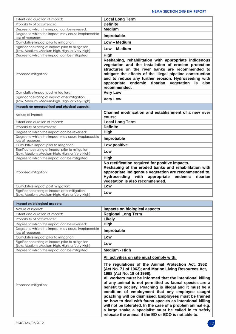
Impacts on geographical and physical aspects:
Nature of impact: Localized bank erosion where the pipeline crossed the Doring River
NEMA SECTION 24G EIA REPORT
S24GEIAR/07/2012 42
Extent and duration of impact: Local Long Term
Probability of occurrence: Definite
Degree to which the impact can be reversed: Medium Degree to which the impact may cause irreplaceable
loss of resources: Improbable
Cumulative impact prior to mitigation: Low – Medium Significance rating of impact prior to mitigation
(Low, Medium, Medium-High, High, or Very-High) Low – Medium
Degree to which the impact can be mitigated: High
Proposed mitigation:
Reshaping, rehabilitation with appropriate indigenous vegetation and the installation of erosion protection structures on the river banks are recommended to mitigate the effects of the illegal pipeline construction and to reduce any further erosion. Hydroseeding with appropriate endemic riparian vegetation is also recommended.
Cumulative impact post mitigation: Very Low Significance rating of impact after mitigation
(Low, Medium, Medium-High, High, or Very-High) Very Low
Impacts on geographical and physical aspects:
Nature of impact: Channel modification and establishment of a new river course
Extent and duration of impact: Local Long Term
Probability of occurrence: Definite
Degree to which the impact can be reversed: High Degree to which the impact may cause irreplaceable
loss of resources: Improbable
Cumulative impact prior to mitigation: Low positive Significance rating of impact prior to mitigation
(Low, Medium, Medium-High, High, or Very-High) Low
Degree to which the impact can be mitigated: High
Proposed mitigation:
No rectification required for positive impacts. Reshaping of the eroded banks and rehabilitation with appropriate indigenous vegetation are recommended to. Hydroseeding with appropriate endemic riparian vegetation is also recommended.
Cumulative impact post mitigation: Low Significance rating of impact after mitigation
(Low, Medium, Medium-High, High, or Very-High) Low
Impact on biological aspects:
Nature of impact: Impacts on biological aspects
Extent and duration of impact: Regional Long Term
Probability of occurrence: Likely
Degree to which the impact can be reversed: High Degree to which the impact may cause irreplaceable
loss of resources: Improbable
Cumulative impact prior to mitigation: Low Significance rating of impact prior to mitigation
(Low, Medium, Medium-High, High, or Very-High) Low
Degree to which the impact can be mitigated: Medium - High
Proposed mitigation:
All activities on site must comply with:
The regulations of the Animal Protection Act, 1962 (Act No. 71 of 1962); and Marine Living Resources Act, 1998 (Act No. 18 of 1998). All workers must be informed that the intentional killing of any animal is not permitted as faunal species are a benefit to society. Poaching is illegal and it must be a condition of employment that any employee caught poaching will be dismissed. Employees must be trained on how to deal with fauna species as intentional killing will not be tolerated. In the case of a problem animal e.g. a large snake a specialist must be called in to safely relocate the animal if the EO or ECO is not able to.
NEMA SECTION 24G EIA REPORT
S24GEIAR/07/2012 43
Reshaping, rehabilitation with appropriate indigenous vegetation and the installation of erosion protection structures on the river banks are recommended.
Cumulative impact post mitigation: Low Significance rating of impact after mitigation
(Low, Medium, Medium-High, High, or Very-High) Low
Impacts on socio-economic aspects:
Nature of impact: Provision of Temporary Jobs
Extent and duration of impact: Site Short Term - construction
Probability of occurrence: Definite
Degree to which the impact can be reversed: N/A Degree to which the impact may cause irreplaceable
loss of resources: N/A
Cumulative impact prior to mitigation: Low Positive Significance rating of impact prior to mitigation
(Low, Medium, Medium-High, High, or Very-High) Low Positive
Degree to which the impact can be mitigated: N/A, do not want to mitigate positive impacts.
Proposed mitigation: N/A, do not want to mitigate positive impacts.
Cumulative impact post mitigation: Low Positive Significance rating of impact after mitigation
(Low, Medium, Medium-High, High, or Very-High) Low Positive
Impacts on cultural-historical aspects:
Nature of impact: No impacts on the cultural/historical aspects are expected.
Extent and duration of impact: Site Long Term
Probability of occurrence: Improbable
Degree to which the impact can be reversed: Low Degree to which the impact may cause irreplaceable
loss of resources: Improbable
Cumulative impact prior to mitigation: Low Significance rating of impact prior to mitigation
(Low, Medium, Medium-High, High, or Very-High) Low
Degree to which the impact can be mitigated: Low
Proposed mitigation:
Should any heritage artefacts, including archaeological material, palaeontological material, graves or human remains be encountered during demolition or construction, work in this area must cease immediately and the ECO as well as the Local Council shall be notified within 24 hours.
Upon receipt of such notification, the ECO will arrange for the excavation to be examined by an Archaeologist. Only once authorisation from Heritage Western Cape has been granted can work again commence.
Under no circumstances shall archaeological artefacts be removed, destroyed or interfered with.
Cumulative impact post mitigation: Low Significance rating of impact after mitigation
(Low, Medium, Medium-High, High, or Very-High) Low
Noise impacts:
Nature of impact: Construction activities of the pipeline
Extent and duration of impact: Site Short term - will be for a short time and not be excessively noisy.
Probability of occurrence: Low
Degree to which the impact can be reversed: Low - Medium Degree to which the impact may cause irreplaceable
loss of resources: Improbable
Cumulative impact prior to mitigation: Low Significance rating of impact prior to mitigation
(Low, Medium, Medium-High, High, or Very-High) Low - Medium
NEMA SECTION 24G EIA REPORT
S24GEIAR/07/2012 44
Degree to which the impact can be mitigated: Low - Medium
Proposed mitigation:
Since the construction of the pipeline and subsequently the proposed replacement pipeline construction occur on an active agricultural farm it is not expected that the noise impacts during the construction phase would be significant. All construction vehicles must be in a good working order to reduce possible noise pollution. Work hours during the construction phase will be enforced unless permission was given (07H00 – 18H00). Permission should be granted without consultation with the local community. No work to be done on Sundays.
Cumulative impact post mitigation: Low Significance rating of impact after mitigation
(Low, Medium, Medium-High, High, or Very-High) Low
Visual impacts / Sense of Place:
Nature of impact: Construction activities of the pipeline
Extent and duration of impact: Construction - Short term
Probability of occurrence: Low
Degree to which the impact can be reversed: Low to Medium Degree to which the impact may cause irreplaceable
loss of resources: Improbable
Cumulative impact prior to mitigation: Low Significance rating of impact prior to mitigation
(Low, Medium, Medium-High, High, or Very-High) Low
Degree to which the impact can be mitigated: Low
Proposed mitigation:
Since the construction of the pipeline and subsequently the proposed replacement pipeline construction occur on an active agricultural farm it is not expected that the visual impacts during the construction phase would be significant. The damaged pipelines within the riverine vegetation should be removed and disposed of at the nearest registered municipal landfill.
Cumulative impact post mitigation: Low Significance rating of impact after mitigation
(Low, Medium, Medium-High, High, or Very-High) Low
(b) Impacts that result from the operational phase (briefly describe and compare impacts (as appropriate), significance rating of
impacts, proposed mitigation and significance rating of impacts after mitigation that are likely to occur as a result of the
operational phase.
Impacts on the geographical and physical aspects:
Nature of impact: Impacts on the geographical and physical aspect due to infrastructure constructed
Extent and duration of impact: Site Permanent
Probability of occurrence:
Improbable – the pipeline was placed underground and so will the proposed replacement pipeline. There are no expected impacts during operation.
Degree to which the impact can be reversed: High Degree to which the impact may cause irreplaceable
loss of resources: Unlikely
Cumulative impact prior to mitigation: Low Significance rating of impact prior to mitigation
(Low, Medium, Medium-High, High, or Very-High) Low
Degree to which the impact can be mitigated: High
Proposed mitigation:
The pipeline was installed underground and so will the proposed replacement pipeline. Reshaping, rehabilitation with appropriate indigenous vegetation and the installation of erosion protection structures on the river banks are recommended to mitigate the effects of the illegal pipeline construction and to reduce any further erosion. Hydroseeding with appropriate endemic
NEMA SECTION 24G EIA REPORT
S24GEIAR/07/2012 45
riparian vegetation is also recommended.
Cumulative impact post mitigation: Low Significance rating of impact after mitigation
(Low, Medium, Medium-High, High, or Very-High) Low
Impact on biological aspects:
Nature of impact: Transformation of natural vegetation
Extent and duration of impact: Site Permanent
Probability of occurrence: Low – the pipeline will not impact any biological aspects during operation.
Degree to which the impact can be reversed: Medium - High Degree to which the impact may cause irreplaceable
loss of resources: Improbable
Cumulative impact prior to mitigation: Medium Significance rating of impact prior to mitigation
(Low, Medium, Medium-High, High, or Very-High) Medium
Degree to which the impact can be mitigated: High
Proposed mitigation:
Reshaping, rehabilitation with appropriate indigenous vegetation and the installation of erosion protection structures on the river banks are recommended to reduce any further erosion. Hydroseeding with appropriate endemic riparian vegetation is also recommended.
Cumulative impact post mitigation: Low - Medium Significance rating of impact after mitigation
(Low, Medium, Medium-High, High, or Very-High) Low - Medium
Impacts on the socio-economic aspects:
Nature of impact: Positive impacts - Permanent and temporary jobs during the operational phase.
Extent and duration of impact: Long term – operational phase.
Probability of occurrence: Definite
Degree to which the impact can be reversed: N/A Degree to which the impact may cause irreplaceable
loss of resources: N/A
Cumulative impact prior to mitigation: Low Positive Significance rating of impact prior to mitigation
(Low, Medium, Medium-High, High, or Very-High) Low Positive
Degree to which the impact can be mitigated: N/A, do not want to mitigate positive impacts.
Proposed mitigation: N/A, do not want to mitigate positive impacts.
Cumulative impact post mitigation: Low Positive Significance rating of impact after mitigation
(Low, Medium, Medium-High, High, or Very-High) Low Positive
Impacts on the cultural-historical aspects:
Nature of impact: No impacts on the cultural/historical aspects are expected during the operational phase.
Extent and duration of impact: Site Permanent
Probability of occurrence: Improbable
Degree to which the impact can be reversed: Low Degree to which the impact may cause irreplaceable
loss of resources: Improbable
Cumulative impact prior to mitigation: Low Significance rating of impact prior to mitigation
(Low, Medium, Medium-High, High, or Very-High) Low
Degree to which the impact can be mitigated: Low
Proposed mitigation:
Should any heritage artefacts, including archaeological material, palaeontological material, graves or human remains be encountered during the operational phase, work in this area must cease immediately and the ECO as well as the Local Council shall be notified.
Cumulative impact post mitigation: Low Significance rating of impact after mitigation
(Low, Medium, Medium-High, High, or Very-High) Low
Noise impacts:
Nature of impact: No noise impacts are expected during the operational phase.
Extent and duration of impact: Site Permanent
NEMA SECTION 24G EIA REPORT
S24GEIAR/07/2012 46
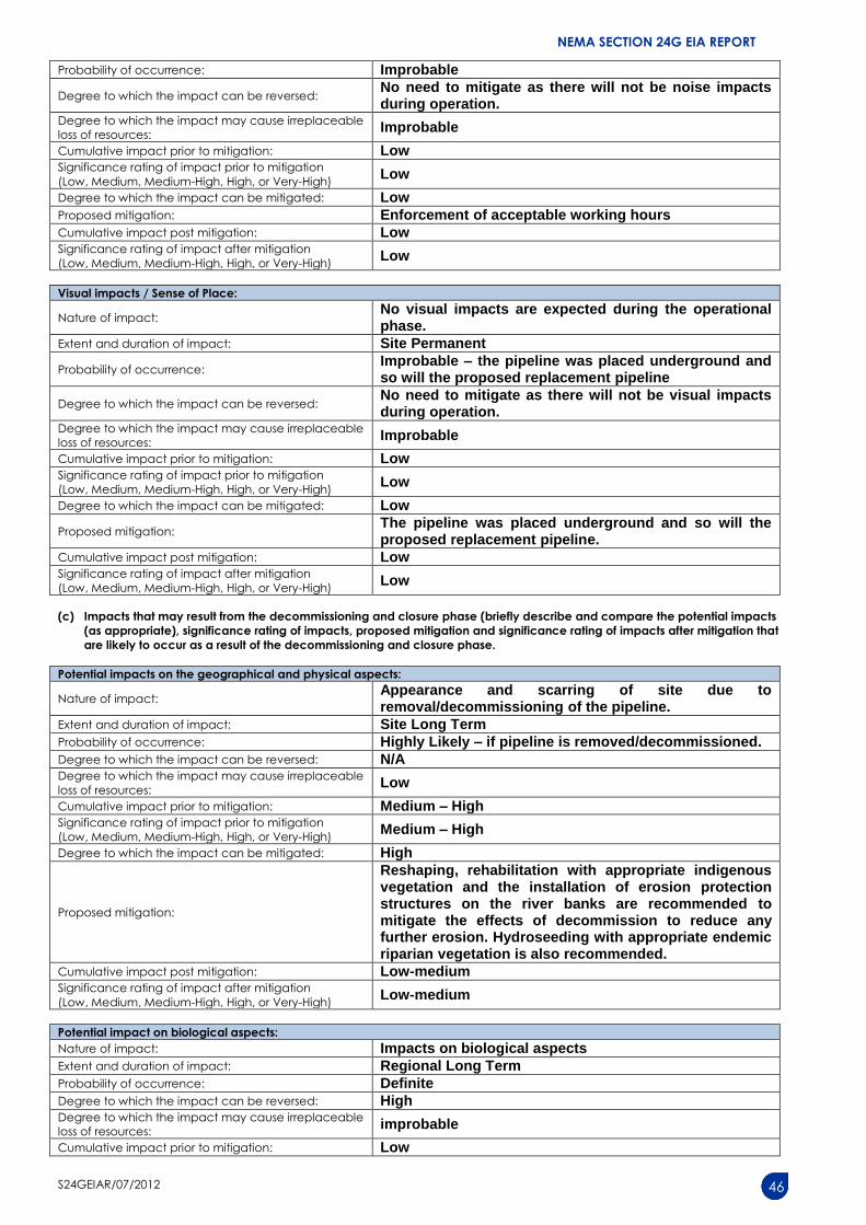
Probability of occurrence: Improbable
Degree to which the impact can be reversed: No need to mitigate as there will not be noise impacts during operation.
Degree to which the impact may cause irreplaceable
loss of resources: Improbable
Cumulative impact prior to mitigation: Low Significance rating of impact prior to mitigation
(Low, Medium, Medium-High, High, or Very-High) Low
Degree to which the impact can be mitigated: Low
Proposed mitigation: Enforcement of acceptable working hours
Cumulative impact post mitigation: Low Significance rating of impact after mitigation
(Low, Medium, Medium-High, High, or Very-High) Low
Visual impacts / Sense of Place:
Nature of impact: No visual impacts are expected during the operational phase.
Extent and duration of impact: Site Permanent
Probability of occurrence: Improbable – the pipeline was placed underground and so will the proposed replacement pipeline
Degree to which the impact can be reversed: No need to mitigate as there will not be visual impacts during operation.
Degree to which the impact may cause irreplaceable
loss of resources: Improbable
Cumulative impact prior to mitigation: Low Significance rating of impact prior to mitigation
(Low, Medium, Medium-High, High, or Very-High) Low
Degree to which the impact can be mitigated: Low
Proposed mitigation: The pipeline was placed underground and so will the proposed replacement pipeline.
Cumulative impact post mitigation: Low Significance rating of impact after mitigation
(Low, Medium, Medium-High, High, or Very-High) Low
(c) Impacts that may result from the decommissioning and closure phase (briefly describe and compare the potential impacts
(as appropriate), significance rating of impacts, proposed mitigation and significance rating of impacts after mitigation that
are likely to occur as a result of the decommissioning and closure phase.
Potential impacts on the geographical and physical aspects:
Nature of impact: Appearance and scarring of site due to removal/decommissioning of the pipeline.
Extent and duration of impact: Site Long Term
Probability of occurrence: Highly Likely – if pipeline is removed/decommissioned.
Degree to which the impact can be reversed: N/A Degree to which the impact may cause irreplaceable
loss of resources: Low
Cumulative impact prior to mitigation: Medium – High Significance rating of impact prior to mitigation
(Low, Medium, Medium-High, High, or Very-High) Medium – High
Degree to which the impact can be mitigated: High
Proposed mitigation:
Reshaping, rehabilitation with appropriate indigenous vegetation and the installation of erosion protection structures on the river banks are recommended to mitigate the effects of decommission to reduce any further erosion. Hydroseeding with appropriate endemic riparian vegetation is also recommended.
Cumulative impact post mitigation: Low-medium Significance rating of impact after mitigation
(Low, Medium, Medium-High, High, or Very-High) Low-medium
Potential impact on biological aspects:
Nature of impact: Impacts on biological aspects
Extent and duration of impact: Regional Long Term
Probability of occurrence: Definite
Degree to which the impact can be reversed: High Degree to which the impact may cause irreplaceable
loss of resources: improbable
Cumulative impact prior to mitigation: Low
NEMA SECTION 24G EIA REPORT
S24GEIAR/07/2012 47
Significance rating of impact prior to mitigation
(Low, Medium, Medium-High, High, or Very-High) Low
Degree to which the impact can be mitigated: Medium
Proposed mitigation:
Educate employees about environmental impacts and the potential impacts associated with the removal/decommission of the pipeline. Reshaping of the river banks and rehabilitating them with appropriate indigenous vegetation is recommended.
Cumulative impact post mitigation: Low Significance rating of impact after mitigation
(Low, Medium, Medium-High, High, or Very-High) Low
Potential impacts on the socio-economic aspects:
Nature of impact: Loss of Temporary and Permanent Jobs
Extent and duration of impact: Permanent
Probability of occurrence: Definite
Degree to which the impact can be reversed: N/A Degree to which the impact may cause irreplaceable
loss of resources: N/A
Cumulative impact prior to mitigation: High Negative Significance rating of impact prior to mitigation
(Low, Medium, Medium-High, High, or Very-High) N/A
Degree to which the impact can be mitigated: N/A
Proposed mitigation: N/A
Cumulative impact post mitigation: N/A Significance rating of impact after mitigation
(Low, Medium, Medium-High, High, or Very-High) N/A
Potential impacts on the cultural-historical aspects:
Nature of impact: No impacts on the cultural/historical aspects are expected.
Extent and duration of impact: Site Long Term
Probability of occurrence: Low
Degree to which the impact can be reversed: Low Degree to which the impact may cause irreplaceable
loss of resources: Improbable
Cumulative impact prior to mitigation: Low Significance rating of impact prior to mitigation
(Low, Medium, Medium-High, High, or Very-High) Low
Degree to which the impact can be mitigated: Low
Proposed mitigation:
Should any heritage artefacts, including archaeological material, palaeontological material, graves or human remains be encountered during the removal or decommissioning phase, work in this area must cease immediately and the ECO as well as the Local Council shall be notified.
Cumulative impact post mitigation: N/A Significance rating of impact after mitigation
(Low, Medium, Medium-High, High, or Very-High) N/A
Potential noise impacts:
Nature of impact: Demolition of structures
Extent and duration of impact: Short term
Probability of occurrence: High
Degree to which the impact can be reversed: Low - Medium Degree to which the impact may cause irreplaceable
loss of resources: Low
Cumulative impact prior to mitigation: Low Significance rating of impact prior to mitigation
(Low, Medium, Medium-High, High, or Very-High) Low-medium
Degree to which the impact can be mitigated: Low-medium
Proposed mitigation:
All construction vehicles must be in a good working order to reduce possible noise pollution. Work hours during the construction phase will be enforced unless permission was given (07H00 – 18H00). Permission
NEMA SECTION 24G EIA REPORT
S24GEIAR/07/2012 48
should be granted without consultation with the local community. No work to be done on Sundays.
Cumulative impact post mitigation: Low Significance rating of impact after mitigation
(Low, Medium, Medium-High, High, or Very-High) Low
Potential visual impacts:
Nature of impact: Demolition of structures
Extent and duration of impact: Short Term
Probability of occurrence: Definite
Degree to which the impact can be reversed: Low Degree to which the impact may cause irreplaceable
loss of resources: N/A
Cumulative impact prior to mitigation: Low Significance rating of impact prior to mitigation
(Low, Medium, Medium-High, High, or Very-High) Low
Degree to which the impact can be mitigated: Low-medium
Proposed mitigation:
Reshaping, rehabilitation with appropriate indigenous vegetation and the installation of erosion protection structures on the river banks are recommended to mitigate the effects of decommission to reduce any further erosion. Hydroseeding with appropriate endemic riparian vegetation is also recommended.
Cumulative impact post mitigation: Low-medium Significance rating of impact after mitigation
(Low, Medium, Medium-High, High, or Very-High) Low-medium
(d) Any other impacts:
Potential impact: N/A
Nature of impact: N/A
Extent and duration of impact: N/A
Probability of occurrence: N/A
Degree to which the impact can be reversed: N/A Degree to which the impact may cause irreplaceable loss of
resources: N/A
Cumulative impact prior to mitigation: N/A Significance rating of impact prior to mitigation
(Low, Medium, Medium-High, High, or Very-High) N/A
Degree to which the impact can be mitigated: N/A
Proposed mitigation: N/A
Cumulative impact post mitigation: N/A Significance rating of impact after mitigation
(Low, Medium, Medium-High, High, or Very-High) N/A
Please note: If any of the above information is not available, specialist input may be requested.
7. SPECIALIST INPUTS/STUDIES AND RECOMMENDATIONS
Please note: Specialist inputs/studies that will be undertaken as part of this application. These specialist inputs/studies must
take into account the Department’s relevant Guidelines on the Involvement of Specialists in EIA Processes available on
the Department’s website (http://www.capegateway.gov.za/eadp). A summary of all the specialist inputs/studies must be
provided with the additional information / Environmental Impact Report.
Please provide motivation for the impact rating of the above impact index:
A non-significant amount of waste would have been produced during the construction of the 160 mm pipeline.
During an unexpected flooding event in January 2014 the Doring River flooded its banks and the newly
constructed 160mm pipeline was severely damaged. Parts of the pipeline were broken and some segments
remain within the watercourse and/or are entangled within the riverine vegetation. These damaged pipes are
still currently within the watercourse and will be removed and disposed of at the nearest licenced landfill site
once authorization is given to remove them. This is because the pre-compliance notice that was issued to Mr.
Doms instructed all listed activates to cease immediately. The construction of a replacement 160 mm pipeline
will also not produce a significant amount of waste.
Please note: Section 9 is to be completed after all specialist studies and input from Interested and Affected Parties have been
obtained.
NEMA SECTION 24G EIA REPORT
S24GEIAR/07/2012 55
10. OTHER MANAGEMENT, MITIGATION AND MONITORING MEASURES
(a) Over and above the mitigation measures described above, please indicate any additional management, mitigation and
monitoring measures.
Full compliance with the Environmental Management Programme as compiled for this specific 24G EIA
Report.
(b) Describe the ability of the applicant to implement the management, mitigation and monitoring measures.
The applicant has the finances, resources and knowledge to implement the EMP.
Please note: A draft ENVIRONMENTAL MANAGEMENT PROGRAMME must be attached this report as appendix F.
NEMA SECTION 24G EIA REPORT
S24GEIAR/07/2012 56
SECTION G: ASSESSMENT METHODOLOGIES AND CRITERIA, GAPS IN
KNOWLEDGE, UNDERLAYING ASSUMPTIONS AND UNCERTAINTIES
(a) Please describe adequacy of the assessment methods used.
The assessment methods used for the proposed project were adequate as all possible impacts were assessed
in detail.
(b) Please describe the assessment criteria used.
The criteria for the description and assessment of environmental impacts were drawn from the National Environmental Management Act, 1998 (Act No.107 of 1998).
The level of detail was somewhat fine-tuned by assigning specific values to each impact. In order to establish a coherent framework within which all impacts could be objectively assessed it is necessary to establish a rating system, which is consistent throughout all criteria. For such purposes each aspect was assigned a value, ranging from 1-5, depending on its definition.
1 Potential Impact
This is an appraisal of the type of effect the proposed activity would have on the affected environmental component. Its description should include what is being affected and how it is being affected.
2 Extent
The physical and spatial scale of the impact is classified as:
Local
The impacted area extends only as far as the activity, e.g. a footprint.
Site
The impact could affect the whole, or a measurable portion of the site.
Regional
The impact could affect the area including the neighbouring erven and/or farms, the transport routes and the adjoining towns.
3 Duration
The lifetime of the impact, which is measured in relation to the lifetime of the proposed base.
Short term
The impact will either disappear with mitigation or will be mitigated through a natural process in a period shorter than any of the phases.
Medium term
The impact will last up to the end of the phases, where after it will be entirely negated.
Long term
The impact will continue or last for the entire operational lifetime of the Development, but will be mitigated by direct human action or by natural processes thereafter.
Permanent
This is the only class of impact, which will be non-transitory. Mitigation either by man or natural process will not occur in such a way or in such a time span that the impact can be considered transient.
4 Intensity
The intensity of the impact is considered here by examining whether the impact is destructive or benign, whether it destroys the impacted environment, alters its functioning, or slightly alters the environment itself. These are rated as:
Low
The impact alters the affected environment in such a way that the natural processes or functions are not affected.
NEMA SECTION 24G EIA REPORT
S24GEIAR/07/2012 57
Medium
The affected environment is altered, but functions and processes continue, albeit in a modified way.
High
Function or process of the affected environment is disturbed to the extent where it temporarily or permanently ceases.
This will be a relative evaluation within the context of all the activities and the other impacts within the framework of the project.
5 Probability
This describes the likelihood of the impacts actually occurring. The impact may occur for any length of time during the life cycle of the activity, and not at any given time. The classes are rated as follows:
Improbable
The possibility of the impact occurring is none, due either to the circumstances, design or experience.
Possible
The possibility of the impact occurring is very low, due either to the circumstances, design or experience.
Likely
There is a possibility that the impact will occur to the extent that provisions must therefore be made.
Highly Likely
It is most likely that the impacts will occur at some stage of the Development. Plans must be drawn up before carrying out the activity.
Definite
The impact will take place regardless of any prevention plans, and only mitigation actions or contingency plans to contain the effect can be relied on.
6 Determination of Significance – Without Mitigation
Significance is determined through a synthesis of impact characteristics, and is an indication of the importance of the impact in terms of both physical extent and time scale. The significance of the impact “without mitigation” is the prime determinant of the nature and degree of mitigation required. Where the impact is positive, significance is noted as “positive”. Significance is rated on the following scale:
No significance
The impact is not substantial and does not require any mitigation action.
Low
The impact is of little importance, but may require limited mitigation.
Medium
The impact is of importance and is therefore considered to have a negative impact. Mitigation is required to reduce the negative impacts to acceptable levels.
High
The impact is of great importance. Failure to mitigate, with the objective of reducing the impact to acceptable levels, could render the entire development option or entire project proposal unacceptable. Mitigation is therefore essential.
7 Determination of Significance – With Mitigation
Significance is determined through a synthesis of impact characteristics. It is an indication of the importance of the impact in terms of both physical extent and time scale, and therefore indicates the level of mitigation required. In this case the prediction refers to the foreseeable significance of the impact after the successful implementation of the suggested mitigation measures. Significance with mitigation is rated on the following scale:
No significance
The impact will be mitigated to the point where it is regarded to be insubstantial.
Low
The impact will be mitigated to the point where it is of limited importance.
NEMA SECTION 24G EIA REPORT
S24GEIAR/07/2012 58
Low to medium
The impact is of importance, however, through the implementation of the correct mitigation measures such potential impacts can be reduced to acceptable levels.
Medium
Notwithstanding the successful implementation of the mitigation measures, to reduce the negative impacts to acceptable levels, the negative impact will remain of significance. However, taken within the overall context of the project, the persistent impact does not constitute a fatal flaw.
Medium to high
The impact is of great importance. Through implementing the correct mitigation measures the negative impacts will be reduced to acceptable levels.
High
The impact is of great importance. Mitigation of the impact is not possible on a cost-effective basis. The impact continues to be of great importance, and, taken within the overall context of the project, is considered to be a fatal flaw in the project proposal. This could render the entire development option or entire project proposal unacceptable.
(c) Please describe the gaps in knowledge.
There are no known gaps in the knowledge to the EAP.
(d) Please describe the underlying assumptions.
Due to the fact that the area surrounding the site where the pipeline was constructed has previously been
transformed due to agriculture, it is difficult to determine whether there are any archaeological artefacts were
present on site, however this is highly unlikely. A notice of intent to develop has been submitted to Heritage
Western Cape (HWC), and they have issued a positive Record of Decision, to permit the proposed
construction on the 30th of May 2016. This is because the newly proposed route encompasses predominantly
on pasture fields and an existing dirt/gravel road.
(e) Please describe the uncertainties.
It is uncertain if the construction would have had an impact on any cultural or archaeological artefacts in the
area.
NEMA SECTION 24G EIA REPORT
S24GEIAR/07/2012 59
SECTION H: RECOMMENDATIONS OF THE EAP
In my view (EAP), the information contained in this Application Form and the documentation attached
hereto is sufficient to make a decision in respect of the activity applied for. YES NO
If “NO”, list the aspects that should be further assessed through additional specialist input/assessment:
N/A
If “YES”, please indicate below whether in your opinion the applicant should be directed to cease the activity or if it should be
authorised:
Applicant should be directed to cease the activity: YES NO
Please provide reasons for your opinion
NEMA SECTION 24G EIA REPORT
S24GEIAR/07/2012 60
1. The construction of the 160 mm pipeline occurred in close proximity to an existing 110 mm pipeline
and would not have significantly impacted upon the existing vegetation as the area had already be
transformed due to agriculture. No true Breede Shale Renosterveld vegetation was present on site and
no threatened plant species or species of conservation concern were found on the site by the
botanical assessment.
2. Historically the Doring Rivers would have been characterised by having multiple channels or a
periodically shifting channel across the valley floor. The ecological state of the Doring River before the
pipeline was constructed indicated that its instream component was already largely modified due to an
altered flow regime and agricultural practices. The present ecological state (after the pipeline
construction and flood) was rated to be marginally better than the pre-impact state in terms of the
instream component, bypassing a heavily vegetated previously diverted section of river and having a
more natural substrate of cobbles. The present ecological state is however marginally worse in terms
of the riparian component as a result of an increase in the degree of channel modification and bank
erosion.
3. The flood-related damage to the Doring River was not attributable to the pipeline construction and
was likely a result of a major flood event. The river erosion was however exacerbated by the presence
of the unauthorised pipeline. The overall significance would become low with rectification. The
negative impacts of the flood-related modifications to the river must be weighed up against the
positive impact of the improvement of the instream habitat within the new channel.
4. Negative impacts with regards to the disturbed indigenous vegetation and the erosion of the Doring
River can be mitigated to acceptable levels by the implementation of rehabilitation according to the
EMP and RMMP. The existing PVC segments of the damaged pipeline must be removed from within
riverbanks and be disposed of at a licenced landfill. The river banks must then be reshaped and
rehabilitated with appropriate indigenous riverine vegetation. This erosion will however be rectifiable
with appropriate bank reshaping and rehabilitation at the point where the pipeline crossed the river.
Guillaume Nel Environmental Consultants should be consulted to design and oversee the
implementation of the reshaping and rehabilitation.
5. A replacement pipeline is required whereby a preferred and an alternative replacement pipeline
route has been proposed to have positive socio-economic impacts and minimal environmental
damage. Both the preferred and the alternative replacement route will not trigger any National
Environmental Management Act: Environmental Impact Assessment Regulations GN R. 982 of 2014
listed activities, however it is foreseen that the preferred route will be more cost efficient and have less
environmental impacts.
6. No negative impact on any Cultural/Historical aspects occurred during the illegal construction of the
160 mm pipeline and are subsequently not expected to occur when constructing the replacement
pipeline. This is because it will be placed underneath a planted pasture field and an existing dirt/gravel
road.
NEMA SECTION 24G EIA REPORT
S24GEIAR/07/2012 61
7. The construction of the illegal pipeline and subsequently the replacement pipeline is in line with the
provincial and Municipal Spatial Development Frameworks as it promotes agricultural activities and
job creation.
8. The construction of a replacement pipeline will result in the expansion of agricultural activities and
increase the farm’s production, which will lead to the creation of short and long-term employment
opportunities and inject necessary capital into the local community.
9. The riparian vegetation has been significantly altered due to the presence of alien species and is a
contributing factor to the instability of the soils and could have played a role in the erosion damage as
a result. The Doring River banks will therefore require regular alien clearing within the watercourse
and the river catchment area.
NEMA SECTION 24G EIA REPORT
S24GEIAR/07/2012 62
SECTION I: MOTIVATION FOR RESPONSE TO AN EMERGENCY This section is only applicable to instances where Section 24F (3) of NEMA applies. Please list all steps that where taken in
response to the emergency.
N/A
Please note: Section 30 of NEMA deals with the procedures to be followed for the control of emergency incidents.
NEMA SECTION 24G EIA REPORT
S24GEIAR/07/2012 63
SECTION J: APPENDICES The following appendices must, where applicable, be attached to this report:
Appendix
Tick the box
if Appendix
is attached
Appendix A: Project plan
Appendix B: Locality map, Site map, Vegetation map, Biodiversity overlay
map, Preferred and Alternative site map and Topographical map.
Appendix C: Photographs
Appendix D: Permit(s) / license(s) from any other organ of state including
service letters from the municipality
Appendix E: Specialist Report(s)
Appendix F: Environnemental Management Programme
River Maintenance Management Plan
Appendix G: Certified copy of Identity Document of Transgressor/Applicant
Appendix H: Any Other (if applicable): Pre-compliance notice
Appendix I:
Public participation information: including a copy of the register
of interested and affected parties, the comments and responses
report, proof of notices, advertisements and any other public
participation information as required in Section C above.
NEMA SECTION 24G EIA REPORT
S24GEIAR/07/2012 64
DECLARATIONS
The applicant
I …………………………………., in my personal capacity or duly authorised as ………………………….
(state capacity) by …………….................................………………… thereto hereby declare that I:
regard the information contained in this report to be true and correct, and
am fully aware of my responsibilities in terms of the Environment Conservation Act, 1989 (Act No. 73
of 1989) and the National Environmental Management Act of 1998 (“NEMA”) (Act No. 107 of 1998),
the Environmental Impact Assessment Regulations (“EIA Regulations”) in terms of NEMA, and the
relevant specific environmental management Act(s), and that failure to comply with these
requirements may constitute an offence in terms of the environmental legislation;
appointed the environmental assessment practitioner as indicated above, which meet all the
requirements in terms of Regulation 17 of GN No. R. 543, to act as the independent Environmental
Assessment Practitioner for this application;
have provided the environmental assessment practitioner and the competent authority with
access to all information at my disposal that is relevant to the application;
am fully aware of the administrative fine to be paid before a decision with respect to the
continuation of the listed activity(ies) for which rectification is sought will be made;
will be responsible for the costs incurred in complying with the environmental legislation including
but not limited to –
o costs incurred in connection with the appointment of the environmental assessment
practitioner or any person contracted by the environmental assessment practitioner;
o costs incurred in respect of the undertaking of any process required in terms of this application;
o costs in respect of any fee prescribed by the Minister or MEC in respect of the regulations;
o costs in respect of specialist reviews, if the competent authority decides to recover costs;
o the provision of security to ensure compliance with the applicable management and
mitigation measures; and
o fine costs
am responsible for complying with the conditions that might be attached to any decision(s) issued
by the competent authority;
am aware that I may be issued with a directive and that I must comply with such a directive;
have the ability to implement the applicable management, mitigation and monitoring measures;
hereby indemnify, the government of the Republic, the competent authority and all its officers,
agents and employees, from any liability arising out of, inter alia, the content of any report, any
procedure or any action for which the applicant or environmental assessment practitioner is
responsible; and
Please Note: If acting in a representative capacity, a certified copy of the resolution or power of
attorney must be attached.
Signature of the applicant:
Name of company:
Date:
NEMA SECTION 24G EIA REPORT
S24GEIAR/07/2012 65
The independent environmental assessment practitioner (“EAP”)
I ……………………………………, as the appointed independent environmental practitioner (“EAP”)
hereby declare that I:
act/ed as the independent EAP in this application;
regard the information contained in this report to be true and correct, and
do not have and will not have any financial interest in the undertaking of the activity, other than
remuneration for work performed in terms of the ECA , the NEMA, the Environmental Impact
Assessment Regulations and any specific environmental management Act(s);
have and will not have any vested interest in the proposed activity proceeding;
have disclosed, to the applicant and competent authority, any material information that have or
may have the potential to influence the decision of the competent authority or the objectivity of
any report, plan or document required in terms of the NEMA, the Environmental Impact Assessment
Regulations, 2010 and any specific environmental management Act(s);
am fully aware of and meet the responsibilities in terms of NEMA, the Environmental Impact
Assessment Regulations (specifically in terms of Regulation 17 of GN No. R. 543) and any specific
environmental management Act, and that failure to comply with these requirements may
constitute and result in disqualification;
have ensured that information containing all relevant facts in respect of the application was
distributed or made available to interested and affected parties and the public and that
participation by interested and affected parties was facilitated in such a manner that all interested
and affected parties were provided with a reasonable opportunity to participate and to provide
comments;
have ensured that the comments of all interested and affected parties were considered, recorded
and submitted to the competent authority in respect of the application;
have kept a register of all interested and affected parties that participated in the public
participation process;
have provided the competent authority with access to all information at my disposal regarding the
application, whether such information is favourable to the applicant or not; and
Note: The terms of reference must be attached.
Signature of the environmental assessment practitioner:
Name of company:
Date:
NEMA SECTION 24G EIA REPORT
S24GEIAR/07/2012 66
The independent PERSON WHO COMPILED A SPECIALIST REPORT OR UNDERTOOK A
SPECIALIST PROCESS
I ……………………………………, as the appointed independent specialist hereby declare that I:
act/ed as the independent specialist in this application;
regard the information contained in this report as it relates to my specialist input/study to be true
and correct, and
do not have and will not have any financial interest in the undertaking of the activity, other than
remuneration for work performed in terms of the ECA, the NEMA, the Environmental Impact
Assessment Regulations and any specific environmental management Act(s);
have and will not have any vested interest in the proposed activity proceeding;
have disclosed, to the applicant, EAP and competent authority, any material information that
have or may have the potential to influence the decision of the competent authority or the
objectivity of any report, plan or document required in terms of the NEMA, the Environmental
Impact Assessment Regulations and any specific environmental management Act(s);
am fully aware of and meet the responsibilities in terms of NEMA, the Environmental Impact
Assessment Regulations (specifically in terms of Regulation 17 of GN No. R. 543) and any specific
environmental management Act, and that failure to comply with these requirements may
constitute and result in disqualification;
have ensured that information containing all relevant facts in respect of the specialist input/study
was distributed or made available to interested and affected parties and the public and that
participation by interested and affected parties was facilitated in such a manner that all interested
and affected parties were provided with a reasonable opportunity to participate and to provide
comments on the specialist input/study;
have ensured that the comments of all interested and affected parties on the specialist input/study
were considered, recorded and submitted to the competent authority in respect of the
application;
have ensured that the names of all interested and affected parties that participated in terms of the
specialist input/study were recorded in the register of interested and affected parties who
participated in the public participation process;
have provided the competent authority with access to all information at my disposal regarding the
application, whether such information is favourable to the applicant or not; and