NESDIS Global Automated Satellite Snow Product: Current Status and Planned Upgrades Peter Romanov NOAA-CREST, City University of New York (CUNY) Center for Satellite Applications and Research (STAR), NOAA/NESDIS
Transcript
NESDIS Global Automated Satellite Snow
Product: Current Status and Planned
Upgrades
Peter Romanov
NOAA-CREST, City University of New York (CUNY)
Center for Satellite Applications and Research (STAR), NOAA/NESDIS
Outline
• Overview of the system/product
• Performance in 2014-2015
• VIIRS snow
• Planned Improvements
Global Multisensor Automated Snow/Ice (GMASI-Autosnow) Mapping System: Overview
Objective: Generate daily spatially-continuous global snow/ice cover product
for use in NWP models and other operational applications
Approach:
Synergy of satellite observations in the visible/infrared and in the microwave
- Currently Metop-B AVHRR and SSMI/SSMIS on DMSP F-15 to F19
Recurrent gap-filling if no valid retrieval is made on the current day
On the Web: http://www.star.nesdis.noaa.gov/smcd/emb/snow/HTML/multisensor_global_snow_ice.html
Current day snow/ice map becomes available at ~10AM UTC the next day
Projection: Plate Carree, 0.040 x 0.040 (or about 4 km grid cell size)
Daily Snow/Ice Map
• No changes to the operational system since 2014
• Operational system maintained by NESDIS
• Routine validation and quality evaluation are ongoing
• Product application:
- IMS
- S-NPP IDPS (VIIRS and OMPS retrievals)
• Further development/improvement of the system is not funded
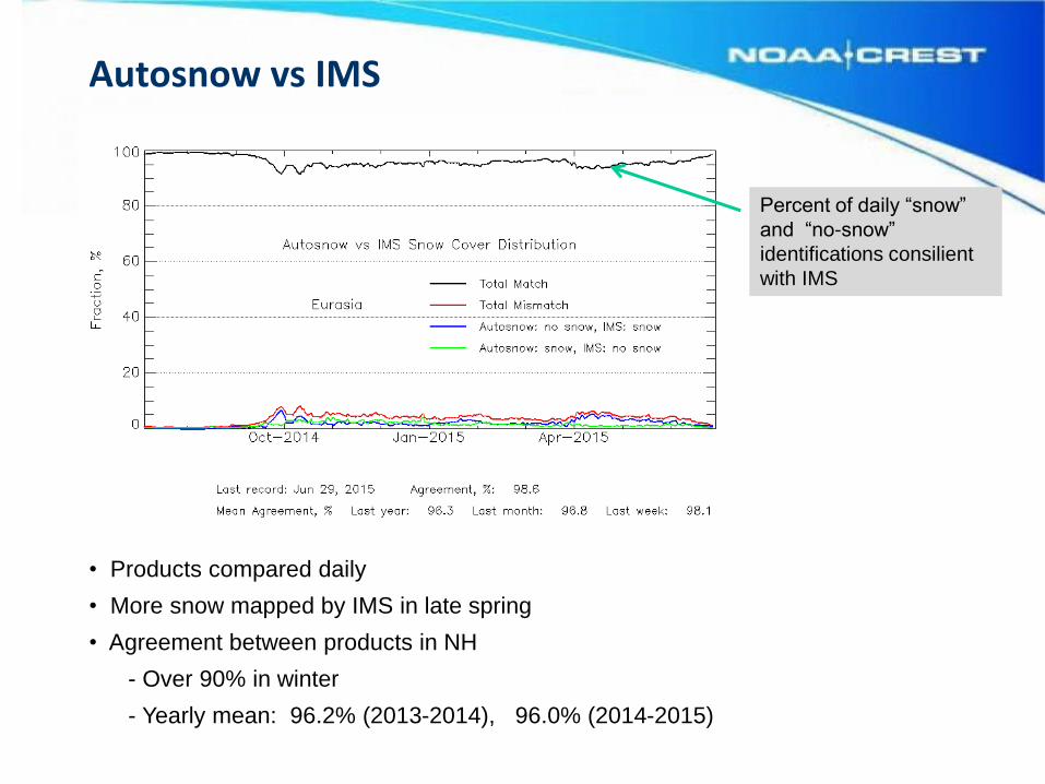
Autosnow: Current Status
2014-2015 Season
Snow and ice fraction is obtained by aggregating 4 km retrievals within 10x10 grid cell boxes
Snow Extent Monitor, NH
Snow area extent over N.
Hemisphere and all
continents is updated daily Northern Hemisphere
North America
Online at http://www.star.nesdis.noaa.gov/smcd/emb/snow/HTML/snow_extent_monitor.html
Eurasia
Snow Extent Monitor, SH
Online at http://www.star.nesdis.noaa.gov/smcd/emb/snow/HTML/snow_extent_monitor.html
South America
Estimated yearly min snow extent: 33,000-39,000 km2
Compare to 25,500 km2 glacier total area extent (USGS)
Correlation of daily snow extent anomalies, Autosnow vs IMS:
- 0.85 in North America
- 0.89 in Eurasia
- 0.86 in N. Hemisphere
Snow Extent Anomalies
Snow area extent daily anomalies, AutoSnow and IMS
VIIRS Snow Products
Snow Cloud Land No data
Feb 19, 2015
S-NPP VIIRS Binary Snow
- Binary and Fractional Snow Cover Maps - 375 m nominal spatial resolution - Universal cloud mask applied to all products - Snow Fraction: simplistic algorithm, will be replaced
VIIRS Snow vs MODIS and AVHRR
VIIRS: Marginally better accuracy but smaller effective clear-sky coverage 2014-2015: VIIRS cloud-clear fraction increased to 40.7% while the rate of agreement to IMS dropped to 97.8%
Mean agreement to IMS and cloud-clear fraction of daily automated snow products in 2013
Northern Hemisphere
*Cloud-clear fraction is estimated in 25-600N latitude band
VIIRS: Too conservative cloud mask
Cloud cover is frequently overestimated Snow/no-snow transition zones are typically mapped as “cloudy”
snow cloud land No data
• Potential improvements
- Improve resolution to 2 km globally (2 km SH map is operational)
- Add topographic correction (available in SH)
- Add AMSR2/GCOM-W1
- Add VIIRS
- This may introduce inhomogeneity/inconsistency to the time series
• Reprocess historical data, fill in existing data gaps
- Request from the GPM group for time series back to 1998
• All plans are dependent on the future funding of the project