Page 1
prepared for
THE NEW ENGLAND STRATEGIC ALLIANCE
by
Incorporating
Planning Workshop Australia
8-14 Telford Street Newcastle East PO Box 668 NSW 2300 Tel: +612 4907 5350 Fax: 02 4907 5333
April 2010
NEW ENGLAND
DEVELOPMENT STRATEGY
Page 3
Incorporating
Planning Workshop Australia
8-14 Telford Street Newcastle East PO Box 668 NSW 2300
Tel: +612 4907 5300 Fax: 02 4907 5333
in association with
Land & Environment Planning and Wakefield Planning Document No. Issue No. Description of Issue Prepared by / date Verified by Director Approved by Director
2049008/1 1 Draft MF/JK/AW/GF/100407 GF GF
2049008/2 2 Draft MF/JK/AW/GF/SB/JS/110608 GF GF
2049008/3 3 Final Draft MF/JK/AW/GF/SB/JS/PI/26608 GF GF
2049008/4 4 Amended Final Draft MF/JK/AW/GF/SB/JS/PI/210708 GF GF
2049004/5 5 Amended Final Draft MF/JK/AW/GF/SB/JS/PI/27/03/09 GF GF
prepared for
THE NEW ENGLAND STRATEGIC ALLIANCE
NEW ENGLAND
DEVELOPMENT STRATEGY
April 2010
Page 4
4 NEW ENGLAND DEVELOPMENT STRATEGY
ACKNOWLEDGEMENTS
The New England Development Strategy has been prepared for the New
England Strategic Alliance of Councils by Planning Workshop Australia in
association with Land and Environment Planning and Wakefield Planning.
PROJECT TEAM
Planning Workshop Australia
Garry Fielding, Jillian Kral, Matthew Borsato, Jenny Pickford, Cathy Blunt,
Steve Brown, Jennifer Smith, Prue Isenhood
Land and Environment Planning
Martin Fallding
Wakefield Planning
Angus Witherby, John Wolfenden
MAP PRODUCTION
Armidale Dumaresq Council, and
Daniel Steiner of Planning Workshop Australia
PHOTOGRAPHS
Reproduced courtesy of the New England Strategic Alliance Councils,
NRM Pty Ltd, and Cinch Solutions
NEW ENGLAND STRATEGIC ALLIANCE DEVELOPMENT STRATEGY
WORKING GROUP MEMBERS
Cr Ron Filmer, (Chair), Uralla Shire Council
Cr Peter Ducat, Armidale Dumaresq Council
Cr Robyn Jackson, Guyra Shire Council
Cr Janelle Archdale, Walcha Council
Craig Diss, Department of Planning
Stephen Gow, Armidale Dumaresq Council
Kathy Martin, Armidale Dumaresq Council
Bob Furze, Guyra Shire Council
Warren Sellings, Uralla Shire Council
Gerry Moran, Walcha Council
Garry Fielding, Planning Workshop Australia
Angus Witherby, Wakefield Planning
Thanks are extended to everyone who has been consulted for
information or advice during the compilation of the Development
Strategy.
The New England Development Strategy is published by WorleyParsons Incorporating Planning
Workshop Australia, February 2010.
Page 5
NEW ENGLAND DEVELOPMENT STRATEGY 5
TABLE OF CONTENTS
1 INTRODUCTION ......................................................................................... 7
2 VISION ........................................................................................................ 9
3 STRUCTURE OF STRATEGY ...................................................................... 10
4 SUB-REGIONAL PLANNING CONTEXT ................................................... 11
4.1 Growth Trends ................................................................................... 14 4.2 Planning Framework ......................................................................... 14 4.3 Infrastructure Provision ..................................................................... 16
5 GENERAL AIMS AND OBJECTIVES ........................................................ 26
6 ARMIDALE, BUNDARRA, GUYRA, TINGHA, URALLA, AND WALCHA 27
6.1 Urban expansion areas .................................................................... 27 6.2 Industrial land provision ................................................................... 38 6.3 Commercial land ............................................................................. 40 6.4 Urban infill development ................................................................. 43
7 VILLAGES, LARGE LOT RESIDENTIAL, AND RURAL SMALL HOLDINGS
DEVELOPMENT ............................................................................................... 45
7.1 Village Development and Servicing .............................................. 46 7.2 Large Lot Residential and Rural Small Holdings Development .. 55
8 RURAL AREAS .......................................................................................... 61 8.1 Subdivision in rural areas .................................................................. 66 8.2 SEPP (Rural Lands) 2008 ................................................................... 68 8.3 Other planning provisions for development in rural areas ......... 70 8.4 Climate change implications for land use.................................... 71
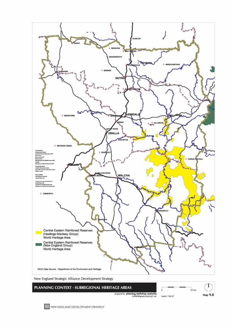
9 ENVIRONMENTAL VALUES AND CONSTRAINTS ................................... 73 9.1 Biodiversity and natural ecosystems .............................................. 73 9.2 Natural hazards and land capability ............................................. 78 9.3 Urban water supply catchments .................................................... 85 9.4 Heritage and landscape ................................................................. 87 9.5 Other constraints and hazards ....................................................... 91
10 PLANNING ADMINISTRATION AND STRATEGY IMPLEMENTATION .... 92
10.1 Standard Instrument (Local Environmental Plans) Order 2006 .. 93 10.2 Monitoring and Review .................................................................... 95
TABLES
TABLE 1: PLANNING AREAS AND KEY LAND USE ISSUES ....................................................... 13 TABLE 2: SUMMARY OF KEY INFRASTRUCTURE ISSUES ........................................................... 16 TABLE 2: CONTINUED ................................................................................................................. 17 TABLE 2: CONTINUED ................................................................................................................. 18 TABLE 3: CRITERIA FOR IDENTIFYING LAND SUITABLE FOR FUTURE RURAL SMALL
HOLDINGS ............................................................................................................. 57 TABLE 3: CONTINUED ................................................................................................................. 58 TABLE 4: STRATEGY RELATIONSHIP WITH OTHER PLANS AND PROGRAMS ........................ 92 TABLE 5: FUTURE STRATEGIC WORK PROGRAM PRIORITIES ................................................. 93
MAPS
MAP 1.1: LOCATION .................................................................................................................... 8 MAP 4.1: TOWNS, VILLAGES, LOCALITIES & PLANNING AREAS .......................................... 12 MAP 4.2: PLANNING CONTEXT –TRANSPORT INFRASTRUCTURE ......................................... 19 MAP 4.3: ARMIDALE PLANNING CONTEXT – INFRASTRUCTURE .......................................... 20
Page 6
6 NEW ENGLAND DEVELOPMENT STRATEGY
MAP 4.4: GUYRA PLANNING CONTEXT – INFRASTRUCTURE ................................................ 21 MAP 4.5: TINGHA PLANNING CONTEXT – INFRASTRUCTURE ............................................... 22 MAP 4.6: URALLA PLANNING CONTEXT – INFRASTRUCTURE ............................................... 23 MAP 4.7: BUNDARRA PLANNING CONTEXT - INFRASTRUCTURE ......................................... 24 MAP 4.8: WALCHA PLANNING CONTEXT – INFRASTRUCTURE ............................................ 25 MAP 6.1: ARMIDALE DUMARESQ – STRATEGY PROPOSALS ................................................ 33 MAP 6.2: GUYRA – STRATEGY PROPOSALS ............................................................................ 34 MAP 6.3: TINGHA-STRATEGY PROPOSALS .............................................................................. 35 MAP 6.4: URALLA – STRATEGY PROPOSALS ........................................................................... 36 MAP 6.5: WALCHA – STRATEGY PROPOSALS ........................................................................ 37 MAP 7.1: ARMIDALE DUMARESQ – LARGE LOT RESIDENTIAL & RURAL SMALL HOLDINGS
(INITIAL RELEASE AREAS) ..................................................................................... 48 MAP 7.2: URALLA RURAL SMALL HOLDINGS – STRATEGY PROPOSALS.............................. 49 MAP 7.3: LLANGOTHLIN – STRATEGY PROPOSALS ................................................................ 50 MAP 7.4: BEN LOMOND – STRATEGY PROPOSALS ................................................................ 51 MAP 7.5: BLACK MOUNTAIN – STRATEGY PROPOSALS ........................................................ 52 MAP 7.6: EBOR – STRATEGY PROPOSALS ............................................................................... 53 MAP 7.7: ARMIDALE DUMARESQ – FUTURE RURAL SMALL HOLDINGS .............................. 54 MAP 8.1: SITE DISTRIBUTION OF PROPERTY HOLDINGS IN ARMIDALE DUMARESQ .......... 62 MAP 8.2: SITE DISTRIBUTION OF PROPERTY HOLDINGS IN GUYRA SHIRE ........................... 63 MAP 8.3: SITE DISTRIBUTION OF PROPERTY HOLDINGS IN URALLA SHIRE .......................... 64 MAP 8.4: SITE DISTRIBUTION OF PROPERTY HOLDINGS IN WALCHA .................................. 65 MAP 9.1: PLANNING CONTEXT – BIODIVERSITY AND NATURAL ECOSYSTEMS ................. 77 MAP 9.2: PLANNING CONTEXT – LAND CAPABILITY ............................................................. 80 MAP 9.3: PLANNING CONTEXT – BUSHFIRE PRONE LAND ................................................... 81 MAP 9.4: PLANNING CONTEXT – UNCONSTRAINED LAND .................................................. 82 MAP 9.5: ARMIDALE PLANNING CONTEXT – FLOODING ..................................................... 83 MAP 9.6: BUNDARRA PLANNING CONTEXT – FLOODING ................................................... 84 MAP 9.7: PLANNING CONTEXT – CATCHMENTS.................................................................... 86 MAP 9.9: ARMIDALE CITY PLANNING CONTEXT – HERITAGE .............................................. 89 MAP 9.10: URALLA PLANNING CONTEXT – HERITAGE .......................................................... 90
GRAPHS
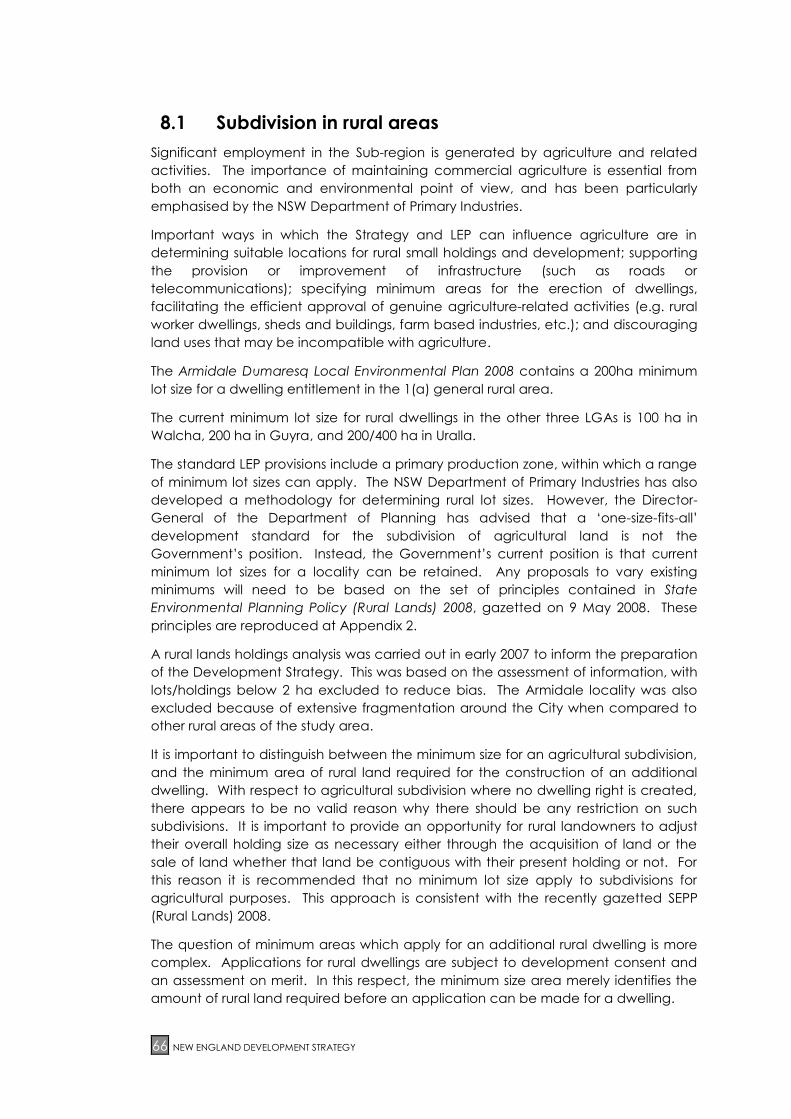
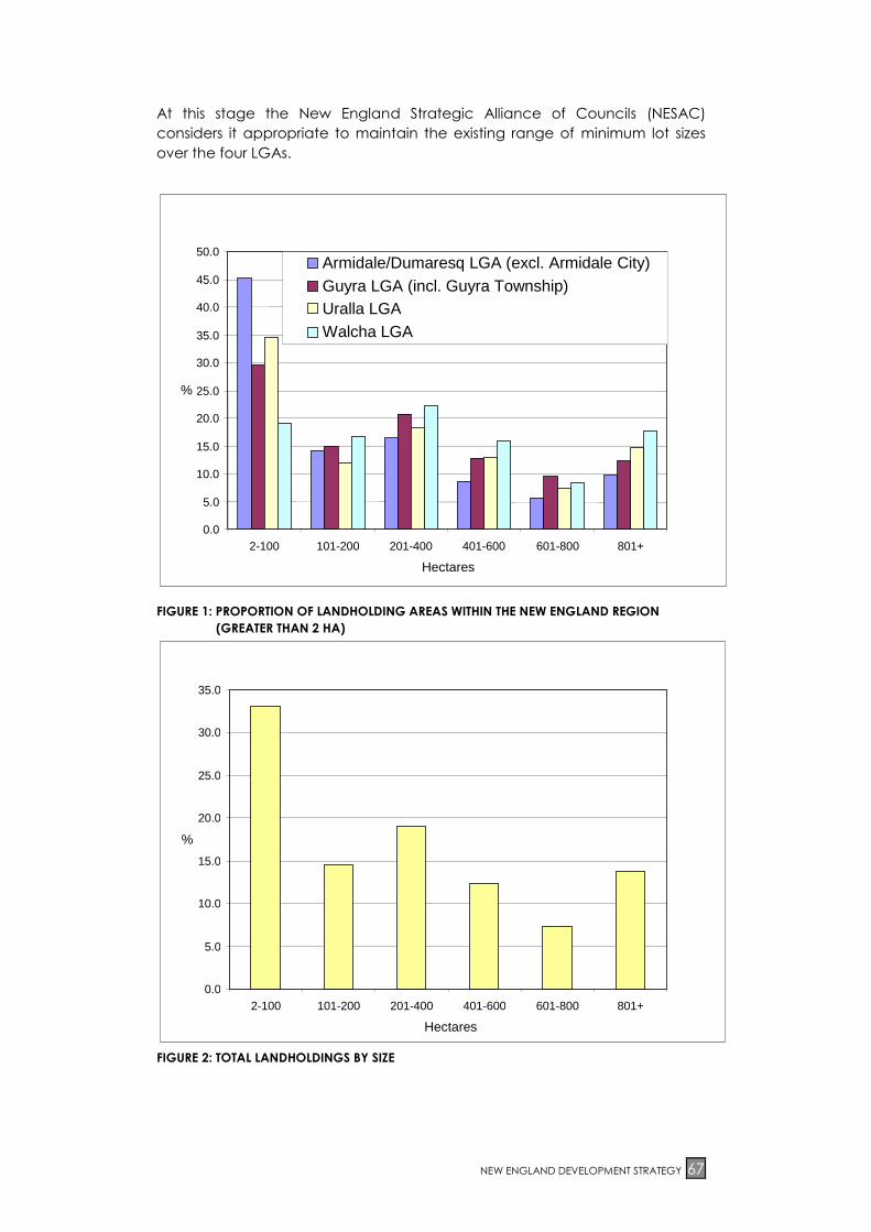
FIGURE 1: PROPORTION OF LANDHOLDING AREAS WITHIN THE NEW ENGLAND REGION
(GREATER THAN 2 HA) ........................................................................................ 67 FIGURE 2: TOTAL LANDHOLDINGS BY SIZE .............................................................................. 67 FIGURE 3: NUMBER OF LANDHOLDINGS WITHIN 4 NEW ENGLAND LAND CLASS AREAS
BY PROPORTION .................................................................................................. 68
APPENDICES
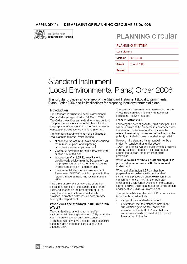
APPENDIX 1: DEPARTMENT OF PLANNING CIRCULAR PS 06-008 ................................... 94
APPENDIX 2: RURAL PLANNING PRINCIPLES, STATE ENVIRONMENTAL PLANNING
POLICY (RURAL LANDS) 2008 ...................................................................... 100
Page 7
NEW ENGLAND DEVELOPMENT STRATEGY 7
1 INTRODUCTION
The New England Development Strategy has been prepared for the New England
Strategic Alliance Councils. The Alliance comprises the four local government areas
(LGAs) of Armidale Dumaresq, Guyra, Uralla and Walcha, as shown in Map 1.1.
The Strategy outlines key land use policies and principles for the four LGAs, and
provides the planning context for the preparation of local environmental plan (LEP)
provisions. The Strategy has a time frame of approximately 25 years, to 2032.
The intent of the Strategy is to:
Recommend actions for achieving the vision prepared by each Council for
its LGA
Make recommendations for achieving sustainable land use in the Sub-region
Facilitate preparation of a single LEP or consistent LEPs for the New England
Sub-region to simplify the planning process and help ensure that the Councils
take coordinated planning decisions
The Development Strategy identifies where growth and change is expected to
occur, and land use planning objectives and strategies to guide this growth and
change. It also identifies infrastructure requirements to support development, and
informs local and state government budget processes.
The Strategy has been prepared with funding under the Department of Planning’s
(DoP) Planning Reform Funding Program. Preparation of the Strategy has been
overseen by a Development Strategy Working Group comprising representatives
from the four Councils and the Department of Planning, and involved the following
steps:
1. Review of key planning issues
2. Consultation with relevant State agencies
3. Preparation and public exhibition of a Situation Analysis report
4. Community consultation workshops
5. Preparation and public exhibition of the Strategy
The Situation Analysis report provides a profile of the New England Sub-region and
each LGA. It presents key background data and has established the key land use
planning issues and strategic priorities and actions to be considered in the
preparation of the Development Strategy and LEP. A summary of the information in
the Situation Analysis has been included in the Strategy.
Page 8
8 NEW ENGLAND DEVELOPMENT STRATEGY
MAP 1.1: LOCATION
Page 9
NEW ENGLAND DEVELOPMENT STRATEGY 9
2 VISION
The vision for the Development Strategy, based on the Councils’ vision statements
with a land use emphasis and the outcomes from public consultation on the
Situation Analysis, is to:
Facilitate the provision of quality development activity in an economically
efficient and environmentally sustainable manner, including urban water and
sewerage services, road links and telecommunications,
Support and facilitate economic development and a diverse economy
(including agriculture and rural development, industry, and tourism) while
maintaining and, where possible, enhancing environmental qualities,
Allow for an increase in the resident population of the Sub-region and
maintain a balanced Sub-regional demographic structure,
Identify a policy framework, land use and settlement structure that
recognises existing land uses, makes adequate provision for growth,
maintains Armidale’s role as a Sub-regional centre, and maintains and
enhances the towns and villages, and
Support social and cultural development and the protection of heritage
values, and foster the educational excellence of the Sub-region.
Page 10
10 NEW ENGLAND DEVELOPMENT STRATEGY
3 STRUCTURE OF STRATEGY
The Strategy is based on the Sub-regional profile and land use planning issues
identified in the Situation Analysis and during the consultation process. Its priority is
those issues that are within the scope of LEP provisions.
Key land use planning issues for the Strategy were identified in the Situation Analysis
as:
Rural small holdings subdivision and development
Economic development, and protecting employment opportunities and
the natural resource base
Identifying areas for urban expansion
Identifying environmental values, constraints and protection requirements
The themes used in structuring the Strategy take into account the key land use
planning issues, and are as follows:
Armidale, Bundarra, Guyra, Tingha, Uralla, and Walcha
Villages, large lot residential, and rural small holdings development
Rural areas
Environmental values and constraints
A summary of the present situation is presented for each theme, followed by
background information on each issue and objectives that can be considered for
the subsequent local environmental plan, development control plans, management
plans and the like. This is followed by a policy indicating how the Councils should
respond to each issue in a consistent manner, and strategic actions which would
direct future planning and identify implementation responsibilities. The Strategy also
provides broader direction to development control plans and other planning
documents.
Page 11
NEW ENGLAND DEVELOPMENT STRATEGY 11
4 SUB-REGIONAL PLANNING CONTEXT
The New England Sub-region has a population of 38,386 (ABS estimate at 30 June
2007) and an area of 18,140 km2. The area is widely recognised for its excellence in
agricultural production, particularly beef and wool. The Sub-region is an attractive
place to live in due to its country lifestyle, cultural, environmental and natural
resources. However, it experienced a declining population during the 15 year
period between 1991-2006 (-7.6%). In recent years this decline has slowed.
The City of Armidale is the Sub-regional centre, containing the largest urban centre,
and the principal focus for retail, commercial, education and research facilities. It
also houses 65% of the Sub-region’s population. The population of Armidale
Dumaresq rose steadily between 1981 and 1992, when it reached a high of nearly
26,200 people. Since then the population has decreased to 24,684 in 2007.
Uralla has experienced an increase in population, growing from 5,350 in 1981 to
5,987 in 2007. Guyra has declined from 5,000 in 1981 to 4,411 in 2007, and Walcha
has also declined from 3,850 in 1981 to 3,307 in 2007.
Despite this, there has been a marked increase in the value of agricultural
production (28% between 1994 and 2001) and an increase in agricultural
employment (10% between 1997 and 2001). Other key employment sectors are the
retail and education sectors.
Agriculture (and grazing in particular) is a key contributor to local and regional
economies and a very significant local employer. A total of 2,392 people (or 16% of
the total workforce) were directly employed in agricultural production in the Sub-
region in 2001. A further 447 persons were employed in agricultural processing and
support industries (excluding retail), and forestry, fisheries and minerals employed 615
persons. The total value of agricultural production in the Sub-region in 2001 was
estimated at nearly $200 million. A summary of existing agricultural holding
information is provided in Section 8 Rural Areas.
Planning areas used for demographic analysis in the Situation Analysis are shown in
Map 4.1. There are significant variations in the characteristics of each planning area
and in key land issues as summarised in Table 1. In particular, Armidale Dumaresq
has distinctly different demographic characteristics (such as age structure and
mobility) due to the presence of the student population associated with the
University of New England and boarding schools.
Page 12
12 NEW ENGLAND DEVELOPMENT STRATEGY
MAP 4.1: TOWNS, VILLAGES, LOCALITIES & PLANNING AREAS
Page 13
NEW ENGLAND DEVELOPMENT STRATEGY 13
Table 1: Planning areas and key land use issues
Planning area
name
Description Key land use issues (e.g. growth expectations,
land use constraints)
ARMIDALE DUMARESQ LGA
Armidale City Armidale urban area Urban infill development, consolidation of
CBD, retail/bulky goods/industrial hierarchy,
management of New England Highway
bypass, affordable housing, servicing and
infrastructure issues (especially urban
stormwater). Demand for large lot residential.
Dumaresq Inner Rural areas
surrounding Armidale
urban area. Primarily
rural residential in
character
Additional pressure for rural small holdings.
Biodiversity values and impacts require further
review for future development areas.
Dumaresq Outer Rural areas, primarily
used for grazing
Stable or slightly declining rural population.
Little land use change.
GUYRA LGA
Guyra urban Guyra urban area Stable or slightly declining urban population.
Provide additional land for general and large
lot residential, plus industrial development.
Tingha Tingha village and
surrounding areas
Increasing population requiring services.
Emerging demand for large lot residential
development.
Guyra rural Rural areas, primarily
used for grazing
Stable or slightly declining rural population.
Little land use change. Opportunity to assist
modest growth around Guyra via small holding
zonings.
URALLA LGA
Uralla township Uralla urban area Slightly increasing population due to gradual
infill development. Some limits due to urban
flooding. Provide land for additional large lot
residential development and facilitate
industrial development opportunities. Address
issue of natural hazards.
Bundarra Bundarra village area Minor urban infill development. Servicing
issues. Opportunity for small holdings close to
town.
Uralla rural Rural areas, primarily
used for grazing
Additional pressure for rural small holdings in
areas accessible to town. More distant rural
areas stable. Issue of consolidation at areas
such as Rocky River.
WALCHA LGA
Walcha urban Walcha urban area
(currently zoned
village)
Demand for urban infill. Some constraints on
further residential development due to flood
impacts. Differentiation of urban zones
needed in new LEP.
Walcha rural Rural areas, primarily
used for grazing
Stable rural population. Some demand for
rural small holdings around town.
Page 14
14 NEW ENGLAND DEVELOPMENT STRATEGY
4.1 Growth Trends
The Sub-regional growth scenario anticipated for the 25 years to 2032 is for a
population increase in the range of 0 to 1% per annum. The Development Strategy
adopts a population growth forecast of 0.5% (183 persons) per annum. Growth is
expected to substantially result from in-migration for lifestyle reasons, which is
currently around 190 persons per annum. Dwelling requirements are expected to
grow faster than population growth, based on lower dwelling occupancy rate
trends. A large proportion of the workforce is employed in primary industries
(agriculture and forestry), education and retail trade.
At 30 June 2007 the Australian Bureau of Statistics (ABS) released its estimates of
resident population. These estimates indicate that the population of the Sub-region
grew by 135 persons or 0.35% over the previous 12 months, reaching 38, 386 persons.
The population of Armidale Dumaresq is estimated to have grown by 151 persons to
24,684 (representing an increase of 0.6%).
While population in most areas of the Sub-region is expected to remain relatively
stable, continued population increase is expected in the Armidale Dumaresq LGA.
The increasingly ageing population structure reflects regional and national trends
and contributes to a reduction in dwelling occupancy rates which are expected to
contribute to additional demand for housing. An increasing proportion of the aged
population is expected to live in or close to urban areas. The population is likely to
require smaller dwellings which are accessible to transport and services. This is likely
to increase the demand for infill housing close to the centre of Armidale and to a
lesser extent in the smaller towns.
The segment of the market choosing to live in large lot residential areas and on rural
small holdings is still expected to require good accessibility to urban services and
employment.
4.2 Planning Framework
The existing planning framework within the Sub-region is outlined in the Situation
Analysis. A new LEP for the Armidale Dumaresq LGA was gazetted on 15 February
2008.
This Strategy supports the implementation of a consistent planning framework for the
Sub-region and has taken into account relevant State planning policies and
directions under Section 117 of the Environmental Planning and Assessment Act
1979.
The format and content of the LEP resulting from the Strategy will be substantially
determined by NSW Government’s standard provisions for such plans (refer
Appendix 1). A suite of reforms of the planning system approved by Parliament in
June 2008 will also affect both LEP preparation and implementation. Furthermore,
other specific agency requirements will affect the LEP provisions. The ‘standard
instrument’ (refer Appendix 1) provides a template which local Councils throughout
NSW must use as the basis for preparing a new LEP for each local area by 2011. The
standard components include:
Zones (including standard zone objectives and mandated permitted and
prohibited uses)
Definitions
Page 15
NEW ENGLAND DEVELOPMENT STRATEGY 15
Clauses
Format
Councils are able to:
Prepare additional local provisions that address local planning issues and
which reflect the outcomes of local and regional strategies
Add local objectives to core objectives
Add additional permitted or prohibited land uses for each zone in the land
use table
Decide whether or not to include optional provisions in their LEP
Insert local criteria or standards into certain mandatory clauses
Prepare maps that specify the lot sizes, building heights and floor space ratios
appropriate for their local area
Define terms within a local provision in certain circumstances
Suggest new definitions to the Department of Planning that could be suitable
for inclusion in the standard dictionary for all Councils to use.
Councils cannot:
Add new zones or create sub-zones
Prohibit uses that are mandated as permissible in a zone
Permit uses that are mandated as prohibited in a zone
Add local provisions that are inconsistent with the mandatory provisions
Change the standard dictionary by altering or adding to the standard
definitions
Change the standard clause numbering
Change the format
Change the wording of the provisions.
All local provisions prepared by Councils must be consistent with the relevant core
zone objectives and mandated land uses, other mandatory provisions (including
SEPPs, REPs, section 117 directions, metropolitan or regional strategies and other
relevant policy guidance).
A certificate to enable public exhibition cannot be issued to the draft LEP unless the
Director-General is satisfied that the Draft LEP has been prepared in accordance
with the standard instrument.
New principal LEPs will include a statement that the applicable mandatory provisions
of the standard instrument are adopted.
State, regional and local planning documents taken into account in the preparation
of this Strategy are outlined in the Situation Analysis.
Page 16
16 NEW ENGLAND DEVELOPMENT STRATEGY
Other plans and strategies affecting land use that will need to be taken into
account in conjunction with this Strategy are any LEPs prepared subsequent to the
Strategy, and catchment action plans prepared by Catchment Management
Authorities.
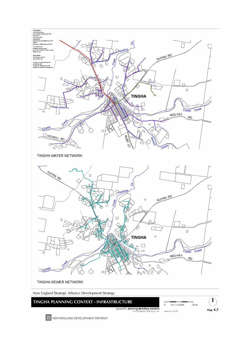
4.3 Infrastructure Provision
The Situation Analysis reviewed key infrastructure issues within the Sub-region. This is
summarised in Table 2 for each LGA and key elements are shown on Maps 4.2 to 4.8.
Overall, the current provision of services is generally appropriate. The main issue
relating to existing infrastructure is the financial cost of upgrading and maintaining
facilities. No specific major deficiencies have been identified. Provision of new
infrastructure as a result of projected development has been taken into account in
determining the suitability of development areas. Within urban areas, there do not
appear to be technical reasons preventing provision of services, the main limitation
is financial. Important policy issues arise, however, with the provision of infrastructure
services to rural residential areas, and the standard of services that should be
provided. Provision of water supply and onsite waste disposal for rural residential
areas is primarily provided by individual landowners, and is not referred to in Table 2.
Table 2: Summary of key infrastructure issues
ARMIDALE DUMARESQ
Water Armidale City currently has an adequate good quality water supply for
25,000 persons. Future augmentation has been built into the design and
there is capacity to meet the needs of projected development as
development requires it. The need to implement water restrictions is very
rare. All existing residences in the Armidale City area are supplied with
treated water, plus some outside but close to the boundary. Extension to
supply zones is proposed to improve supplies to outer areas which will
permit infill development. Rural and rural residential dwelling-houses are
often required to provide their own potable water supply via rainwater
tank collection. The Drought Management Plan specifies measures to
control demand during droughts. The Water and Sewerage Development
Servicing Plan provides for servicing projected population growth in
existing and new urban areas of Armidale. The villages of Hillgrove, Ebor
and Wollomombi do not have a reticulated water supply.
Sewerage Sewerage is connected to all dwellings within the Armidale City
boundaries if economically feasible, and only a small number of properties
are not connected. There is spare capacity to meet projected growth
with system augmentation. The majority of rural residential dwellings are
equipped with on-site waste disposal facilities such as aerated wastewater
treatment systems and septic systems. Further investigation on the
implementation of integrated water cycle management proposals is
being considered. The Council’s Water and Sewerage Servicing Plan for
servicing population growth in existing and new urban areas of Armidale.
The villages of Hillgrove, Ebor and Wollomombi are not sewered.
Roads The key issues in relation to roads relate to the sustainability of the assets,
and maintenance requirements.
Page 17
NEW ENGLAND DEVELOPMENT STRATEGY 17
Table 2: Continued
ARMIDALE DUMARESQ
Stormwater Stormwater drainage assets are mostly confined to Armidale City.
Arrangements are outlined in the Stormwater Drainage Strategic Business
Plan. The capability of the drainage system is reducing with increasing
connections. Deficiencies have been identified and the system is being
amplified as funding becomes available and/or where there are new
subdivisions and large developments. Stormwater quality and other
environmental issues are increasing in importance.
Waste
Management
There is one existing land fill site within the LGA. One major waste transfer
station at the waste management site in Armidale and 4 rural transfer
stations. Possible new land fill sites have been investigated and a
potential new site to replace the existing landfill has been identified and is
in the process of being assessed. There is increasing emphasis on, and
introduction of, waste recovery processes.
GUYRA
Water Guyra has capacity to cater for ongoing urban growth. There is an
adequate water supply, with the existing system capable of catering for a
doubling of the population to 5,000 persons.
Located north east of the township, at the headwaters of the Garra River.
The village of Tingha is serviced from the Copeton Dam through Inverell.
This supply is also adequate for the anticipated future use. The villages of
Black Mountain and Ebor have no reticulated water supply system and
the village of Ben Lomond has a private supply from the old railway dam
which is not treated and is therefore not considered potable.
Sewerage Sewerage is connected to virtually all dwellings in the town of Guyra and
the treatment works is capable of catering for additional capacity of up
to 5,000 persons with the recent augmentation of the sewage treatment
works.
All premises in the Village of Tingha have now been connected to the
new pressurised sewerage system with its capacity of 500 persons.
Roads Maintenance of the existing road network is a concern for the Council,
with alternative funding sources constantly being sought and new, better
or more cost effective methods being under constant investigation.
Stormwater Guyra’s stormwater network is adequate for the town, with very little
flooding experienced. Investigation is currently being undertaken into the
feasibility of a stormwater reuse scheme which, if funding can be
obtained, will reduce the impact on the environmental flow.
While the storm water system is adequate in the village of Tingha, there is
some flooding in extreme storm events in the village, where some of the
dwellings were built in close proximity to Copes Creek.
Page 18
18 NEW ENGLAND DEVELOPMENT STRATEGY
Table 2: Continued
GUYRA
Waste
Management
The bulk of Guyra’s waste is transported to and disposed of at Armidale’s
landfill, with some waste transported to the Tingha landfill. The Tingha
landfill is approaching the end of its useful life and the expansion of that
site and/or other alternatives for the disposal of the waste from that area
are currently being investigated. The Ben Lomond landfill has adequate
capacity for the foreseeable future, as it receives very little waste each
year.
Recycling or waste recovery is a high priority for the Council and it
operates recycling facilities in Guyra, Tingha, Ben Lomond and Black
Mountain.
URALLA
Water Existing schemes are in excess of current needs with a 6,000 person
capacity.
Sewerage Existing scheme is adequate to cater for expected demand. Scheme has
been upgraded to a capacity of 6,000 persons.
Roads Existing road network is adequate to cater for expected demand with
ongoing sealing program for gravel roads, and developer upgrading
associated with individual development proposals. The sustainability and
maintenance of existing assets is an issue
Stormwater Existing town infrastructure is adequate to cater for expected demand.
Waste
Management
Existing landfill site is adequate with expected lifespan of another 5 to 15
years. Unlicensed sites also exist at Kingstown and Bundarra.
WALCHA
Water The Council has an adequate water supply; however, consideration is to
be given to sourcing an additional supply. Current capacity is 2,000
persons.
Sewerage The sewerage infrastructure is old and consideration is being given to
upgrades. Alternative methods of disposals are to be considered.
Roads The road network is ageing with continual pressure to maintain and
improve the infrastructure.
Stormwater The local network of stormwater drainage is adequate to cater for the
‘average’ storm but is not adequate to cover events that have occurred
recently.
Waste
Management
The Council has 3 landfill sites in the Shire. The main one at Walcha is a
licensed landfill and consideration is being given to future waste disposal
options for Walcha.
Page 19
NEW ENGLAND DEVELOPMENT STRATEGY 19
MAP 4.2: PLANNING CONTEXT –TRANSPORT INFRASTRUCTURE
Page 20
20 NEW ENGLAND DEVELOPMENT STRATEGY
MAP 4.3: ARMIDALE PLANNING CONTEXT – INFRASTRUCTURE
Page 21
NEW ENGLAND DEVELOPMENT STRATEGY 21
MAP 4.4: GUYRA PLANNING CONTEXT – INFRASTRUCTURE
Page 22
22 NEW ENGLAND DEVELOPMENT STRATEGY
MAP 4.5: TINGHA PLANNING CONTEXT – INFRASTRUCTURE
Page 23
NEW ENGLAND DEVELOPMENT STRATEGY 23
MAP 4.6: URALLA PLANNING CONTEXT – INFRASTRUCTURE
Page 24
24 NEW ENGLAND DEVELOPMENT STRATEGY
MAP 4.7: BUNDARRA PLANNING CONTEXT - INFRASTRUCTURE
Page 25
NEW ENGLAND DEVELOPMENT STRATEGY 25
MAP 4.8: WALCHA PLANNING CONTEXT – INFRASTRUCTURE
Page 26
26 NEW ENGLAND DEVELOPMENT STRATEGY
5 GENERAL AIMS AND OBJECTIVES
General aims and objectives for land use within the New England Sub-region are
outlined in this section. These aims and objectives take into account the visions
expressed by the four Councils and their communities and the strategic objectives of
existing plans applying within the Sub-region.
Plan aims and objectives take into account the objects of the Environmental
Planning and Assessment Act 1979 which provides the legal framework for the
preparation of statutory plans.
The Development Strategy has the following aims and objectives, which have been
prepared in a form to enable them to be incorporated into subsequent LEP
provisions:
(a) to provide a coordinated approach to land use planning within the LGAs of
Armidale Dumaresq, Guyra, Uralla and Walcha (the Sub-region), which is
expected to include implementation of a single LEP, or alternatively a
number of consistent LEPs.
(b) to facilitate stimulation of demand for a range of residential, enterprise and
employment opportunities.
(c) to ensure that development is sensitive to both the economic and social
needs of the community and the environmental capacity of the area.
(d) to provide a choice of living opportunities and types of settlements.
(e) to encourage the proper management, development and conservation of
resources within the Sub-region by protecting, enhancing and conserving:
(i) land currently used for agricultural production
(ii) native vegetation, biodiversity, minerals, soils, water and other natural
resources
(iii) areas of high scenic or recreational value
(iv) places and buildings of heritage significance, including Aboriginal
places and relics.
(f) to ensure that development has regard to the principles of ecologically
sustainable development.
(g) to minimise the Sub-region’s contribution to the causes of global climate
change.
(h) to adapt to major social, economic and environmental changes affecting
the Sub-region such as climate change.
In addition to the general aims and objectives outlined in this section, LEPs are
required to have specific objectives for each land use zone identified within the
scope provided by the NSW Government’s standard plan provisions.
Page 27
NEW ENGLAND DEVELOPMENT STRATEGY 27
6 ARMIDALE, BUNDARRA, GUYRA, TINGHA, URALLA, AND
WALCHA
After Armidale City, there are 5 main towns in the New England Sub-region. They are
Bundarra, Guyra, Tingha, Uralla, and Walcha. These towns are expected to have a
relatively stable or slightly increasing population during the Strategy time frame.
Population increase is most likely to be focussed on Armidale, and to a lesser extent
on Uralla and Tingha. However, Walcha and Guyra are now also exhibiting signs of
growth. In particular, provision needs to be made for long term urban expansion in
Armidale, as this will have flow on effects throughout the Sub-region.
Adequate provision of urban land and service infrastructure exists in the short term,
although there are issues in relation to urban water supply security for Walcha.
The role of large lot residential development and rural small holdings in providing for
residential demand around Armidale, Bundarra, Guyra, Tingha, Uralla, and Walcha
requires consideration in future planning, as does maintaining a reasonable bank of
vacant but zoned land to assist with housing affordability.
Social infrastructure, community services and recreational facilities are reasonably
well catered for within the Sub-region, although the trend for increasing
centralisation of many specialist services means that these are located in Armidale
and Tamworth. Armidale’s excellent educational facilities, including a university, will
continue to attract people from within and outside the Sub-region.
Key land use planning issues for Armidale and the 5 towns in the Sub-region were
identified in the Situation Analysis as follows:
Identification of urban expansion areas
Industrial land provision (especially in Guyra, Uralla and Walcha)
Commercial land (including sites for bulky goods outlets)
Urban infill development
Residential large lot development
Potential urban expansion areas to cater for future industrial and residential growth
have been identified on Maps 6.1 to 6.5. These maps are not intended to provide
specific reference to cadastral boundaries.
6.1 Urban expansion areas
Housing in the New England Sub-region is principally in the form of individual
detached dwellings, representing 86% of the housing stock. This contrasts widely with
NSW as a whole, where 70% of dwellings are separate dwellings. The NSW proportion
of medium density housing is 27%, with the New England Sub-region having a much
lower proportion (12%) of dwellings in this category. The dwelling occupancy rate
Page 28
28 NEW ENGLAND DEVELOPMENT STRATEGY
for the Sub-region has shown long term decline and was estimated at 2.3 persons
per dwelling in 2006, slightly below the NSW average rate.
Demand for residential land differs within the Sub-region and is outlined below:
Armidale Dumaresq The main area required for future urban expansion is within
and around the Armidale urban area. An analysis has been
undertaken of projected residential land supply and demand
for Armidale Dumaresq up to 2021. An average growth in
population for the period 2001 to 2021 of 1.1% per annum is
projected, resulting in a total increase of 4,457 persons.
Based on past trends, the average household size is likely to
decline from 2.5 persons in 2001 to 2.3 persons during the
period to 2021, with the consequence that about 1,940 new
dwellings would be required in Armidale to cater for projected
population growth.
In Armidale, 78% of occupied private dwellings in 2001 were
single dwellings, while in the 5 years to 2003, 391 development
consents were granted for new dwellings. Of these 52% were
single dwellings and 48% were medium density (including dual
occupancy). Following a review of trends, the Strategic
Analysis for the Armidale Dumaresq LEP proposed that 30% of
new dwellings are likely to be medium density, with these
mainly occurring on infill sites within central parts of the City.
During the preparation of the Armidale Dumaresq LEP 2008, it
was estimated that land would be needed in Armidale to
accommodate an estimated 3,680 new dwellings up to 2021.
This estimate represents 1,940 new dwellings (as noted above)
for projected growth plus 1,740 lots as a land bank which
represents 25% of housing stock in 2001.
Up to 2021, the analysis indicates that about 580 new medium
density dwellings would be required and at least 770 dwellings
would need to be located on land currently zoned residential
but not yet subdivided. These figures do not include the
desirability of having supplementary zoned land available,
due to reluctance by some landowners to subdivide even if
the zoning permits it. A reasonable “land bank” provides a
more competitive market, as well as flexibility to respond to
higher growth and development rates. The recently gazetted
Armidale Dumaresq LEP now provides a sufficient supply of
residentially zoned land to meet projected dwelling demand
over the next 10 years. Beyond this period urban growth will
need to be accommodated in suitable areas identified for
urban investigation.
Bundarra Sufficient zoned land is already available within the village to
accommodate expected demand.
Page 29
NEW ENGLAND DEVELOPMENT STRATEGY 29
Guyra Demand for residential lots has increased since 2000. Analysis
of recent development approvals indicates that 20-25 new
dwellings are being constructed in the Guyra LGA each year,
of which at least 10 are within Guyra township. Based on a
10 year planning horizon, sufficient land for at least 125 new
dwellings needs to be provided to meet demand and ensure
a supplementary land stock of 25%. The Council has
indicated that the current supply of zoned residential land is
almost exhausted and needs supplementing as soon as
possible.
Tingha Generally, sufficient zoned land is available within the village
but there is scope for minor expansion. Provision is needed for
additional large lot residential land to increase housing
choice.
Uralla Sufficient zoned land is available for several years. There is a
current zoned land supply equivalent to approximately 220
lots. Provision is needed for additional large lot residential land
in the medium term. This is primarily due to the reluctance of
owners to bring existing zoned land onto the market. Analysis
of recent development approvals indicates that 30-40 new
dwellings are being constructed in Uralla LGA each year, of
which at least 16-20 are in or adjacent to the township. Based
on a 10 year planning horizon, sufficient land for at least 200
new dwellings needs to be provided to meet demand and
ensure a supplementary land stock of 25%.
Walcha Sufficient zoned land is available for the creation of at least
100 residential lots. However the servicing of some existing
residential lots is an issue. Analysis of recent development
approvals indicates that around 15 new dwellings are being
constructed in the Walcha LGA each year, of which
approximately 6-8 are within Walcha township. Based on a 10
year planning horizon, sufficient land for at least 75 new
dwellings needs to be available within the town to meet
demand and ensure a supplementary land stock of 25%.
During preparation of the draft LEP, consideration should be
given to permitting higher density housing close to the
Commercial Centre, while maintaining larger allotments more
distant from the Commercial Centre, thereby protecting the
ambience of the town. Consideration of a village zone for
Nowendoc will occur at the draft LEP stage.
Based on the reluctance of some existing owners to develop zoned land to stimulate
a more competitive land supply market, and provide greater choice of lots sizes, it is
proposed that additional land be investigated for urban purposes around Guyra,
Tingha and Uralla over the next 10 years. The new Armidale Dumaresq LEP now
provides sufficient zoned land to cater for anticipated growth in that city for the next
decade.
Page 30
30 NEW ENGLAND DEVELOPMENT STRATEGY
It will be necessary to provide extra land for anticipated urban expansion around
Guyra, Tingha and Uralla over the next 10 years. Within Walcha and Bundarra
sufficient residential zoned land appears to be already available, and infill of existing
zoned but vacant sites should be encouraged.
Objectives – Urban expansion areas
The New England Sub-region will have urban land that is zoned and serviced to
meet projected housing needs up to 2021. Housing will vary in size and form to
meet changing household formations and the needs of an ageing population.
Policies – Urban expansion areas
Areas to be investigated in more detail for future urban expansion are shown
on Maps 6.1 to 6.5.
Urban sustainability issues will be considered in the determination of
boundaries of urban expansion areas (e.g. protection of biodiversity values,
road and subdivision layout to provide optimum orientation for solar access).
Strategic Actions – Urban expansion areas
Ensure approximately 10 years of development potential through zoning
based on preliminary demand/supply analysis already undertaken.
Ensure that future demand and supply analysis also considers available infill
opportunities.
Implement comprehensive new zonings consistent with Standard LEP
recommended zones.
Establish a coordinated monitoring system to track the construction of new
dwellings and the creation of new allotments across the 4 LGAs within the
Sub-region. This system would extend from medium density and infill housing
to fringe urban development, rural small holdings and general rural areas. It
would assist in measuring the take up of existing zoned or serviced land,
identifying development and market trends, and in determining the staging
of future land releases and rezonings to maintain adequate land supply.
Provide land for residential development based on the following attributes:
- Flat-moderate grades to minimise construction costs and improve
‘walkability’
- Service and infrastructure capacity/staging
- Access to community services and facilities
- Access to convenience/other retail
- Road access
- Market considerations such as aspect and neighbourhood amenity
- Environmental sustainability
Page 31
NEW ENGLAND DEVELOPMENT STRATEGY 31
In general, direct urban growth to areas where effective use could be made
of existing urban infrastructure, particularly where spare capacity is available.
Urban growth should also be focussed on providing attractive lifestyle
choices, so as to capture potential “in migration” to New England towns and
to help retain existing residents seeking new homes.
Implement comprehensive Section 94 plans to assist the funding of those
facilities required to service new development and identify priorities for
expenditure.
Zoning Recommendations – Urban expansion areas
Armidale Dumaresq A wide range of residential development is provided for in the
new residential and business zones of the recently gazetted
Armidale Dumaresq LEP. Refer to Map 6.1 for guidance on
future growth areas.
The residentially zoned land is anticipated to satisfy projected
demand up to 2021. These lands can be subdivided now
subject to Council approval.
The Tilbuster Corridor (land bounded by New England
Highway, Rockvale Road, Tilbuster Creek and Puddleduck
Road) should be investigated as a future urban area for
Armidale in the longer term subject to future growth rates in
Armidale. Master planning for the area will need to
commence in the next 5 to 10 years.
Structure plans for future residential and future large lot
residential zones should include:
Approximate location of major roads including
connections to the existing road network as well as
residential collector roads
Infrastructure requirements such as water supply and
sewer
Indicative locations for neighbourhood shops and
open space areas
Environmental hazards and constraints
Bundarra Maintain current village boundaries, as adequate vacant land
remains within the existing village area.
Guyra Investigate Rural 1(c) land east of Hardings Street, south of
Clark Street and north of Albert Street for conversion to
residential zoning. This responds to the need for an expansion
of the residential area for Guyra. It provides a logical
Page 32
32 NEW ENGLAND DEVELOPMENT STRATEGY
eastwards extension of the existing residential areas in South
Guyra. In the short term, residential development is
appropriately consolidated on the east side of the New
England Highway and is contained by an existing recreation
zone. This maintains a compact urban form and makes
efficient use of existing services.
Tingha Maintain current village zonings, subject to a minor extension
of the village zone beyond or south of Garnet Street due to
increasing population and an emerging market for larger lots.
Uralla Maintain current town boundaries as adequate vacant land
remains available for subdivision and development within the
existing urban area. Investigate the area of land to the east of
Uralla Township for rezoning to large lot residential
development (consider 2,000m2 to 4,000m2 minimum lot size).
Larger residential lots in this location would be appropriate to
maintain the low density character of the town.
Walcha Maintain current town boundaries, as adequate vacant land
remains available for subdivision and development within the
existing urban area. Consideration be given to permitting
higher density housing close to the Commercial Centre, while
maintaining larger allotments more distant from the
Commercial Centre, thereby protecting the ambience of the
town.
Page 33
NEW ENGLAND DEVELOPMENT STRATEGY 33
MAP 6.1: ARMIDALE DUMARESQ – STRATEGY PROPOSALS
Page 34
34 NEW ENGLAND DEVELOPMENT STRATEGY
MAP 6.2: GUYRA – STRATEGY PROPOSALS
Page 35
NEW ENGLAND DEVELOPMENT STRATEGY 35
MAP 6.3: TINGHA-STRATEGY PROPOSALS
Page 36
36 NEW ENGLAND DEVELOPMENT STRATEGY
MAP 6.4: URALLA – STRATEGY PROPOSALS
Page 37
NEW ENGLAND DEVELOPMENT STRATEGY 37
MAP 6.5: WALCHA – STRATEGY PROPOSALS
Page 38
38 NEW ENGLAND DEVELOPMENT STRATEGY
6.2 Industrial land provision
The Armidale Dumaresq LEP 2008 identifies land for industrial purposes, comprising
147 hectares zoned Industrial 4(a); 70 hectares zoned Industrial 4(b); and 40 hectares
zoned Enterprise 10(a). The Enterprise Zone is adjacent to the University of New
England which also owns most of the land in this zone. The Industrially zoned land
adjacent to Armidale Regional Airport is owned by Armidale Dumaresq Council. The
Strategic Analysis concludes that industrially zoned land currently available for
development exceeds demand. It is estimated that there is sufficient land already
zoned to meet the needs of a population of over 30,000 in Armidale.
During the final stages of the preparation of Armidale Dumaresq LEP 2008 the
Department of Planning identified some unresolved policy and area specific issues
remaining in relation to the type and location of industrial development (e.g. DoP
policy regarding bulky goods retailing and development near the airport). These
issues are to be the subject of further investigation, with project funding having been
provided to Armidale Dumaresq Council via Round 5 of the Planning Reform Funding
for this supplementary work. Upon completion of this work its findings and
recommendations will be incorporated into the Draft Regional LEP.
Despite the current supply of industrial land, Armidale is perceived to have a relative
shortage of high visibility employment land.
It is also important to have enough land available within other parts of the Sub-
region for employment generating activities. Although there is adequate
undeveloped land currently zoned for industry, there is a perceived shortage of
developed industrial lots available on the market in the towns of Uralla and Guyra.
The main issue appears to be the limited choice of zoned industrial land, with the
current owners of zoned land not yet proceeding to service and develop the land.
As a result, alternative locations for industry and employment need to be identified
to provide a more competitive market in Uralla and Guyra.
Objectives – Industrial land provision
Provide adequate industrial land to meet demand for development and
enable employment opportunities.
Policies – Industrial land provision
The LEP within the New England Sub-region will provide adequate industrial
zoned land for each of the towns to meet demand for development and
enable employment opportunities.
Within Armidale Dumaresq LGA, further investigation of retail activity in the
west Armidale industrial zone is required, including an assessment of impacts
on general industrial activity.
Ensure planning provisions for industrial areas discourage inappropriate
commercial development.
Page 39
NEW ENGLAND DEVELOPMENT STRATEGY 39
Commission a specific study of bulky goods retailing and industrial lands in
Armidale, including the provision of adequate and appropriately located
land for this form of development.
Strategic Actions – Industrial land provision
Provide for heavy and light industrial zonings in conjunction with the main
towns
Permit industrial agriculture uses in industrial zones
Ensure a more competitive market for industrial land by enabling at least 2
development fronts in each main town
Ensure that, where possible, access to industrial areas avoids traversing
residential areas and the areas are accessible by public transport (if
available)
Ensure that the review of the village zoning in Walcha provides for adequate
and/or additional industrial land
Zoning Recommendations – Industrial land provision
Armidale Dumaresq Incorporate the findings and recommendations of the
recently commissioned bulky goods retail and industrial
lands study for Armidale Dumaresq LGA into the Draft
Regional LEP.
Bundarra Maintain current village zonings as this provides adequate
flexibility for employment generating activities.
Guyra Investigate an existing portion of land generally bounded by
the New England Highway and Black Mountain Road for
rezoning to industrial. Also investigate an additional portion
of land immediately east and north of the Guyra saleyards
for conversion to industrial. The two new industrial areas,
one to the south of the town and one to the north, have
been identified due to their site characteristics and the
nature of surrounding land uses. There is potential to
encourage a more competitive market for industrial land.
Tingha Maintain current village zonings as this provides adequate
flexibility for employment generating activities.
Uralla Industrial land in Duke Street is likely to be more suitable for a
light industrial zoning due to its proximity to existing
residential. Investigate the provision of a new industrial area
due to issues associated with the failure of the existing zoned
land being brought to the market. Additional industrial land
should provide opportunities for industrial uses in the vicinity
of existing industry and “buffered” from residential areas by
open space. The proposed new general industrial areas to
the south of the golf course and south-east of the railway
Page 40
40 NEW ENGLAND DEVELOPMENT STRATEGY
line/Thunderbolts Way crossing, shown in Map 6.4, are well
separated from residential areas.
Walcha Establish general industrial zones to rationalise the current
distribution of industrial uses in and around Walcha. These
will comprise land:
In the vicinity of Plumtree Street, Emu Creek Road
and Middle Street
North of North Street, generally between South Street
and Towers Street
Industrial Estate, Thunderbolts Way
6.3 Commercial land
The commercial centres hierarchy is discussed in the Situation Analysis for the New
England Sub-region.
Although outside the study area, Tamworth exerts a strong influence not only in terms
of retailing, but also in terms of the number of higher order services, including the
range of government agencies and medical services.
The City of Armidale fulfils an emerging regional centre role. The next level in the
hierarchy is occupied by the towns of Uralla, Guyra and Walcha. Uralla, and to a
lesser degree, Guyra, perform a satellite function to Armidale. The towns continue to
provide services for nearby rural communities. Tingha also has its own small main
street, and the other villages in the Sub-region have one or two retail outlets,
including a general store.
The existing retail hierarchy is seen as appropriate. In Armidale, the CBD should
remain as the major Sub-regional centre; the existing Girraween Shopping Centre
should function as a neighbourhood centre. Armidale is likely to experience an
excess of floor space with the now completed Centro Centre. There does not
appear to be justification for additional business zoning in Armidale at present.
The commercial and retail sectors are large employers in the Sub-region, with the
majority of the economic base being located in Armidale. Locational variations
among the LGAs are as follows:
Armidale Dumaresq There is a sufficient amount of land zoned for business
activities to meet the projected population up to 2021.
Limiting the expansion of business zoned land within the
centre of Armidale may encourage more efficient use of
areas within the CBD. (Source: Strategic Analysis for the Draft
Armidale Dumaresq LEP 2006). For this to occur, the land
should be of sufficient size and shape and have adequate
street frontage to meet the needs of new businesses. Provision
for bulky goods retailing requires further investigation,
recognising the standard LEP provisions for this use.
Key recommendations from the 2006 Strategic Analysis for
Armidale which are supported include:
Page 41
NEW ENGLAND DEVELOPMENT STRATEGY 41
The CBD continue to be the main focus of commercial
and retail development within Armidale and the Sub-
region in general
Land west of the existing CBD along Rusden Street to
Markham Street should be zoned for General Business
purposes
Mixed use retail/residential development should be
permitted within the General Business area
Land occupied by the Girraween Shopping Centre is
appropriately zoned for Business purposes
The scale of shops, commercial premises and bulky
goods retailing at Girraween shopping centre should
be limited by adopting a maximum gross floor area of
1500m2 for such developments
Professional consulting offices should be permissible on
residentially zoned land within the area bounded by
Jessie, Barney, Butler and Rusden Streets
Convenience stores should be permitted with consent
in residential and rural zones
Bundarra Adequate land is already zoned for existing and anticipated
future Commercial development. This is in a central and
compact location.
Guyra Adequate land is already zoned for existing and anticipated
future Commercial development. This is in a central and
compact location.
Tingha Adequate land is already zoned for existing and anticipated
future Commercial development. This is in a central and
compact location.
Uralla Adequate land is already zoned for existing and future
commercial use. Some is currently being used for residential
purposes, but provides scope for redevelopment.
Walcha The commercial centre is compact and concentrated on the
main streets of the town. A specific new commercial zone is
recommended to help maintain this area as the business hub
of the LGA.
Page 42
42 NEW ENGLAND DEVELOPMENT STRATEGY
Objectives – Commercial land
Provide adequate land for commercial development in town centres within
the Sub-region in suitable locations, while maintaining compact, walkable
centres in accordance with the commercial centres hierarchy within the Sub-
region.
Policies – Commercial land
Maintain existing commercial zoned land in towns, and strengthen the
integrity of the Armidale CBD by adopting planning controls that consolidate
commercial development.
Ensure planning provisions do not support commercial development in
inappropriate areas (such as industrial zones).
Within Armidale, permit small neighbourhood shops with consent in
residential zones.
Strategic Actions – Commercial land
Maintain the new Armidale CBD boundaries to ensure commercial areas are
appropriately zoned and to avoid oversupply of commercially zoned land.
Promote and facilitate ‘core’ and ‘peripheral/supporting' commercial zones
subject to the standard LEP template and town size.
Ensure the permissibility of community and cultural facilities in town centres.
Encourage compact town centres through infill and mixed use
developments.
Zoning Recommendations – Commercial land
Armidale Dumaresq Endorse the recently gazetted LEP which facilitates
intensification of commercial use within the existing
compact CBD. The establishment of a bulky goods retailing
area is to be the subject of the separate investigation to be
incorporated into the new LEP. This investigation will
consider the extent to which any form of retail activity
should be permissible in future within industrial areas. Permit
with consent small neighbourhood shops within residential
zones.
Bundarra No change to the current flexible village zoning is
recommended.
Guyra No change to the current provisions is recommended.
Adequate zoned land exists to meet foreseeable needs and
considerable intensification is possible within the existing
commercial area. The current commercial zoning defines
an appropriate ‘High Street’ area.
Page 43
NEW ENGLAND DEVELOPMENT STRATEGY 43
Tingha Minor change to the current flexible village zoning is
recommended, as shown in Map 6.3.
Uralla No change to the current provisions is recommended.
Adequate zoned land exists to meet foreseeable needs and
considerable intensification is possible within the existing
commercial area. The current commercial zoning defines
an appropriate ‘High Street’ area.
Walcha Designate a commercial core generally bounded by Walsh
Street, South Street, Apsley Street and the Apsley River.
Support this with mixed use zonings to reflect the current
patterns of use along Fitzroy Street. The eastern zoning
would generally extend to Lagoon Street, while the western
zoning would generally extend to Thee Street.
6.4 Urban infill development
Infill residential development is an important consideration in all existing urban areas,
most importantly in Armidale, where the pressures are likely to be greatest. Although
there is currently still a market preference for conventional housing on town fringes,
this has a range of implications such as poorer accessibility, environmental impacts
and higher service provision costs. Infill development within the existing urban
boundary may provide advantages to a growing proportion of the housing market,
in line with an ageing population, the ongoing needs generated by the University of
New England, and fewer persons living in each household. Key issues related to infill
are:
Targeted redevelopment sites in central locations
Good urban design and appropriate development scale
Infrastructure servicing
Minimum subdivision size and dimensions.
Objectives – Urban infill development
Ensure planning controls allow appropriate residential infill development, taking
into account important issues including adequacy of servicing, streetscape
and urban character, heritage, and water sensitive urban design.
Policies – Urban infill development
Residential infill development will be encouraged as an alternative to further
greenfield development outside the existing urban area.
Development should recognise existing infrastructure constraints (e.g. sewer
and drainage) and ensure that best use is made of current infrastructure
provision.
Page 44
44 NEW ENGLAND DEVELOPMENT STRATEGY
Strategic Actions – Urban infill development
As part of infill development, ensure that servicing capacities are assessed
and are adequate, particularly water supply, sewerage and stormwater
drainage.
Implement minimum lot sizes and DCP controls on infill development to
ensure the protection of urban character and appropriate amenity.
Identify constraints to infill development (e.g. urban flooding).
Identify any existing or projected surplus land holdings controlled by private
schools, other institutions or government agencies, investigate opportunities
for infill housing or other forms of development, and consider appropriate
future zonings.
Zoning Recommendations – Urban infill development
Armidale Dumaresq Pressures for urban consolidation and medium density
housing are likely to be highest in Armidale. Small-scale infill
subdivision is continuing to occur although additional
coordination, particularly regarding drainage, will assist
yields. An estimated 30% of new dwelling demand in
Armidale up to 2021 is likely to be in the form of medium
density dwellings. This equates to approximately 580
dwellings. Council’s 2006 Strategic Analysis contains a
breakdown of where medium density dwellings could be
provided under the former LEP. It is recommended that
Council maintain zonings which facilitate medium density
housing in central Armidale, as well as aiming to achieve a
mix of dwelling and allotment sizes in new development
areas on the periphery of the city.
Guyra No specific provisions for urban infill development are
considered necessary in Guyra. Large lots together with
considerable tracts of lightly developed land provide
considerable scope for infill and intensification, provided an
appropriate residential zoning is selected.
Uralla No specific provisions for urban infill development are
considered necessary in Uralla. Some flood prone areas
along Uralla Creek are unsuitable for intensification. Large
lots together with considerable tracts of lightly developed
land provide considerable scope for infill housing, provided
an appropriate residential zoning is selected.
Walcha Encourage low scale infill housing adjacent to the town
centre. Considerable opportunities for further development
exist throughout the town. This will make effective use of
existing infrastructure, noting that drainage issues may arise
with intensification.
Page 45
NEW ENGLAND DEVELOPMENT STRATEGY 45
7 VILLAGES, LARGE LOT RESIDENTIAL, AND RURAL SMALL
HOLDINGS DEVELOPMENT
Key land use planning issues were identified in the Situation Analysis as follows:
Village development and servicing, and
Large lot residential and rural small holdings development.
Large lot residential and rural small holdings subdivision and development is an
important land use planning issue in the Sub-region. It has the potential to affect
agricultural land uses and viability, and the provision of services and infrastructure. It
can also result in a range of environmental impacts including water availability,
traffic, and loss of biodiversity. Demand for large lot residential and rural small
holdings development is primarily related to proximity to Armidale and to the other
towns.
Existing rural villages have individual character and servicing issues. However, they
can provide alternative and more affordable residential opportunities compared to
Armidale and the major towns.
Individual LGAs are experiencing varying degrees of demand for large lot residential
and rural small holdings development, as highlighted below:
Armidale Dumaresq The demand for large lot residential and rural small holdings
development up to 2021 is expected to be fully met by the
land zoned for these purposes in LEP 2008 which is shown in
Map 7.1. Map 7.7 shows the longer term area proposed for
large lot residential development, west of Armidale.
Guyra Guyra experiences low to moderate demand for rural small
holdings development. Recent trends suggest that
approximately 8-10 rural small holdings are being built upon
per annum. A significant amount of land is already zoned
but not yet developed.
Uralla A rural lifestyle appears to be the impetus for rural small
holdings development, with most landowners relying on
employment in Armidale rather than an agricultural income.
Arding/Rocky River and Kentucky Plain experience
moderate demand for rural small holdings, with
approximately 12-15 lots being built upon per annum.
Walcha There is an emerging demand for rural small holdings in the
LGA. Around 5-6 rural dwellings are being approved on
existing holdings per annum. An application has recently
been approved for a 43 lot subdivision adjacent to the town
and fronting Oxley Drive.
The following strategy Maps 7.1 to 7.7 aim to provide general locational guidance.
The maps are not intended to provide specific reference to cadastral boundaries.
Page 46
46 NEW ENGLAND DEVELOPMENT STRATEGY
7.1 Village Development and Servicing
A review of development issues relating to each village within each LGA was
included in the Situation Analysis. With the exception of Black Mountain village in
Guyra LGA, all villages are expected to continue to experience relatively low
demand for development, and there is adequate zoned land available. Areas to
be investigated for potential village expansion are also shown on Maps 7.2 to 7.6.
The following objectives, policies and strategic actions are derived from the Situation
Analysis.
Objectives – Village development and servicing
Villages have a clear and distinct identity and facilitate community cohesion
and sense of belonging.
Provision of limited urban services (e.g. water, sewer and waste) where
demand for growth is identified and service provision is economic or required
for environmental reasons.
Policies – Village development and servicing
Minimum lot sizes for subdivision and the erection of dwelling houses to be
based on onsite wastewater capacity where reticulated sewer is not
available. The provision of a water supply sourced from rainwater tanks is
favoured over a reticulated supply. Mandatory first flush systems should be
required.
Maintain and enhance the distinctive character and landscape setting of
each village.
Strategic Actions – Village development and servicing
Identify through village zoning, ensuring that adequate land is designated to
accommodate villages which are experiencing growth. Maintain at least 2
development options in terms of land ownership for each village.
Ensure that distinctive character of each village is identified in DCP or LEP
supplementary objectives.
Put in place strong controls on incompatible land uses, including
supplementary objectives to the village zone and with DCP support.
Consider minimum lot sizes for each village, taking into account existing lots,
character requirements, onsite wastewater servicing requirements, and
separation distances from existing dwellings.
Page 47
NEW ENGLAND DEVELOPMENT STRATEGY 47
Zoning Recommendations – Village development and servicing
Armidale Dumaresq LEP 2008 caters for anticipated low development pressures
in Hillgrove, Wollomombi and Ebor (part). The villages of
Armidale Dumaresq have adequate land for expansion.
Hillgrove has considerable vacant land but, with the
adjacent mine, has more potential for expansion than the
other villages.
Guyra Ben Lomond is experiencing very low development pressure
at the present time. It is recommended that back zoning of
village land occur in the southwest corner of the village. The
value of land in this locality is insufficient to make re-
subdivision of the old ‘town lots’ viable. These could
appropriately return to a rural use.
Ebor (see also Armidale Dumaresq) - the current zoning
provision is satisfactory. An appropriate parcel of
developable land exists north of the current village. If
demand eventuates, a compact village form would result.
Llangothlin - the current zoning provision is satisfactory.
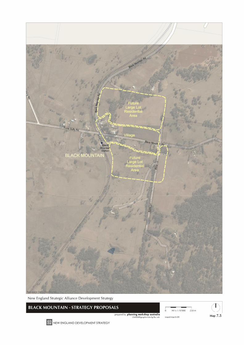
Black Mountain – the current zonings are satisfactory. This is
the closest village to Armidale, and has attracted a
combination of village and rural residential land uses.
Adequate zoned land exists to cater for anticipated future
demands.
Tingha – due to growth in population investigate additional
large lot residential zone in the area west of Kempton Road.
This area will accommodate anticipated demand for larger
lots adjacent to the existing village and help fill a gap in the
existing market.
Uralla Kentucky – investigate small village zones in areas of existing
settlement and services. The existing hubs should be
recognised by way of a village zoning, subject to identifying
a satisfactory lot size that protects the existing character of
the village and is environmentally appropriate. A rural small
holdings zone could be investigated as an appropriate
method of support for these village centres.
Walcha Identify Village Zones for Walcha Road, Woolbrook and
Nowendoc and consider a Village Zone for Yarrowitch in the
Draft Regional LEP, reflecting the existing landuse pattern.
Page 48
48 NEW ENGLAND DEVELOPMENT STRATEGY
MAP 7.1: ARMIDALE DUMARESQ – LARGE LOT RESIDENTIAL & RURAL SMALL HOLDINGS (INITIAL
RELEASE AREAS)
Page 49
NEW ENGLAND DEVELOPMENT STRATEGY 49
MAP 7.2: URALLA RURAL SMALL HOLDINGS – STRATEGY PROPOSALS
Page 50
50 NEW ENGLAND DEVELOPMENT STRATEGY
MAP 7.3: LLANGOTHLIN – STRATEGY PROPOSALS
Page 51
NEW ENGLAND DEVELOPMENT STRATEGY 51
MAP 7.4: BEN LOMOND – STRATEGY PROPOSALS
Page 52
52 NEW ENGLAND DEVELOPMENT STRATEGY
MAP 7.5: BLACK MOUNTAIN – STRATEGY PROPOSALS
Page 53
NEW ENGLAND DEVELOPMENT STRATEGY 53
MAP 7.6: EBOR – STRATEGY PROPOSALS
Page 54
54 NEW ENGLAND DEVELOPMENT STRATEGY
MAP 7.7: ARMIDALE DUMARESQ – FUTURE RURAL SMALL HOLDINGS
Page 55
NEW ENGLAND DEVELOPMENT STRATEGY 55
7.2 Large Lot Residential and Rural Small Holdings
Development
With the exception of Armidale Dumaresq, there has been no recent
comprehensive assessment of large lot residential and rural small holdings subdivision
and development within the Sub-region, although there has been continuing
demand for it over at least the last 15 years.
Within Armidale Dumaresq LGA new zones and a staged release program have
been introduced in the recently gazetted LEP 2008. The new zones and staged
release programs are based on the recommendations of the Armidale Dumaresq
Rural Residential Study (EDGE Land Planning, 2005). Land within the new zones,
which is shown in Map 7.1, is expected to satisfy demand for large lot residential and
rural small holding developments up to 2021.
Large lot residential development will occur in two corridors:
To the south of Armidale between Kellys Plains Road and the Main Northern
Railway Line
To the north of Armidale, west of the new England Highway.
In the longer term the Armidale Dumaresq Rural Residential Study identified land to
the west of Armidale along Bundarra Road as a future large lot residential area,
which is shown in Map 7.7. The take up rates of large lot residential land to the north
and south are being monitored, and land to the west of Armidale will be made
available through an amending LEP if required.
LEP 2008 provides that land within the new zones will be released for large lot
residential and rural small holdings development over the next 10 years or so. A
review of the program for releasing land has been carried out to determine its
effectiveness to date. Based on the review, it is proposed to retain the program of
staged land releases for the rural small holdings zone in LEP 2008. The initial land
release is shown in Map 7.1. However, it is intended to remove the requirement for
the staged release of land in the large lot residential zone for the following reasons:
Since gazettal of LEP 2008 on 15 February 2008, no new large lot residential
subdivisions have been approved. Only one development application for
subdivision has been submitted and this only had the potential to create one
additional lot within the first release area.
An alternative approach of varying the location of release areas within the
zone is not likely to achieve better outcomes than removing staged land
releases altogether. Varying the location of release areas raises issues to do
with identifying land owners who genuinely wish to subdivide their land within
the next 10 years so that their land may be included in the varied zone, and
determining whether land already in the first release areas in LEP 2008, but
not developed, should be retained or removed from a subsequent varied
release area.
Page 56
56 NEW ENGLAND DEVELOPMENT STRATEGY
Regional centres such as Armidale do not experience consistent growth
pressures. Development of land does not always occur in an ‘orderly’ and
predictable way and an LEP needs to be flexible enough to allow for these
less predictable development patterns.
The new zone for large lot residential development in LEP 2008 is significantly
smaller in area and concentrated in terms of location, compared to what
was previously permitted in the semi-rural areas surrounding Armidale up to
the late 1990’s.
If there is not a reasonable bank of vacant but zoned land available for large
lot residential development, then the market may be less competitive and
this type of development becomes generally less affordable.
Armidale Regional Airport is an important item of regional infrastructure. Future
options for ancillary developments that can make a positive economic contribution
to the region should be investigated, such as ‘hangar housing’ proposals. ‘Hangar
housing’ involves the provision of large residential lots with frontage to an airport.
Private aircraft are able to use airport facilities and owners can store their aircraft on
their private property. Any such development would need to ensure that the
operational integrity of the Airport is not compromised. Also, this type of subdivision
should not result in an ad hoc pattern of large lot residential development around
Armidale.
The Situation Analysis identified demand and supply issues and future planning
options. Flowing from this, the following objectives, policies, strategic actions and
zoning recommendations have been developed.
Objectives – Large lot residential and rural small holdings development
Provide opportunities for large lot residential and rural small holdings
development in suitable locations.
Ensure that adequate and appropriate services are available for large lot
residential and rural small holdings development.
Ensure that the supply of large lot residential and rural small holdings land does
not significantly exceed demand.
Identify the best locations for large lot residential and rural small holdings
development and balance development pressures with the need to preserve
areas of high agricultural, scenic or environmental value.
Identify appropriate planning controls for large lot residential and rural small
holdings development.
Policies – Large lot residential and rural small holdings development
Focus large lot residential and rural small holdings land adjacent to existing
development without prejudicing future urban growth.
Subdivision for the purposes of large lot residential and rural small holdings
should be undertaken in an environmentally sensitive manner.
Page 57
NEW ENGLAND DEVELOPMENT STRATEGY 57
The following criteria, where applicable, should be used to identify land suitable
for rural small holdings development.
Table 3: Criteria for identifying land suitable for future rural small holdings
Broad Location Criteria Comment
Distance from town Land should be within a reasonable travel distance/time from the
centre of an urban area (e.g. less than 5km).
Provision of services Ability to provide potable water electricity, telephone, bushfire
services should be considered.
Capacity for onsite
water storage
This relates to the ability to have supplementary dam supplies
(see NSW Farm Dams Policy).
Availability of
groundwater and
service water
Needs to be considered strategically for other purposes in terms
of quantity and quality, water source, and within Water
Management Act 2000 framework.
Minimal impact on
existing infrastructure
Sufficient reserve capacity should exist in power, school bus and
telecommunications services.
Good sealed road
access
Efficient use needs to be made of the existing road network. In
general, this is very lightly trafficked apart from the New England
Highway and some major roads leading to Armidale.
Exclude
environmentally
sensitive land
This land often has good visual outlooks, vegetation and privacy,
all of which are in demand.
Exclude areas of high
bushfire hazard
This land often has good visual outlooks, vegetation and privacy,
all of which are in demand.
Exclude known mineral
and extractive
resources
Includes appropriate buffers to extractive and other
non-compatible land uses.
Exclude areas near
non-compatible land
uses
Includes appropriate buffers to uses such as sewerage treatment
works, etc.
Exclude water supply
catchment land
This issue predominantly relates to avoiding contamination from
onsite treatment systems, but may also relate to water access
rights and usage.
Avoid areas with
threatened species,
Endangered Ecological
Communities and
remnant native
vegetation
This land often has good visual outlooks, vegetation and privacy,
all of which are in demand.
Avoid areas with high
soil erosion risk
Primarily relates to steeper lands, and land with soil characteristics
that make it more prone to erosion.
Page 58
58 NEW ENGLAND DEVELOPMENT STRATEGY
Table 3: Continued
Broad Location Criteria Comment
Avoid forestry land and
contaminated land
Relates generally to former orchard areas, stock dip areas, and
areas with identified forestry resources.
Avoid areas with soils
unsuitable for onsite
effluent disposal
Although not an absolute constraint, development of these lands
would require alternative treatment systems.
Avoid flood prone land Acceptable only if flood free access and building sites/waste
disposal areas are available.
Avoid Aboriginal and
European heritage
areas and sites and not
detrimentally affect
Aboriginal Cultural
Landscapes
Examples include the curtilage surrounding historic dwellings.
Avoid areas with high
groundwater tables
Problems with onsite waste disposal.
Avoid land with slopes
greater than 18 degrees
Increased erosion potential, including from vehicle access.
Strategic Actions – Large lot residential and rural small holdings development
‘Hub’ on the existing towns and villages while making sure that growth
corridors exist where needed for future standard residential development
(wedge approach). In village areas this can help to maintain the population
base and retain key services (e.g. general store, school).
Avoid water catchment areas for rural small holdings unless higher
development standards are applied.
Consider rationalising existing fragmented land holdings in accessible
locations with growth potential (e.g. Rocky River, Kentucky) while taking into
account development constraints (e.g. bushfire and water supply
catchment).
Consider back zoning, by way of sunset clause, long term zoned but
undeveloped rural small holding areas, particularly where they are in less
appropriate areas.
Consider both minimum and average lot size as a requirement, allowing for
more flexible design to reflect environmental and planning constraints.
Relate minimum subdivision size to servicing and to soil capacity for onsite
disposal. Ensure appropriate minimum areas for onsite disposal depending
upon soil type, slope, proximity to watercourse, and amount of effluent likely
to be generated.
Page 59
NEW ENGLAND DEVELOPMENT STRATEGY 59
Zoning Recommendations – Large lot residential and rural small holdings
development
Armidale Dumaresq Implement the provisions of Armidale Dumaresq Local
Environmental Plan 2008, except for the release areas in the
Large Lot Residential zone. The longer term large lot
residential corridor west of Armidale along Bundarra and
Old Inverell Roads (refer Map 7.7) should only be considered
for rezoning once the supply in the north and south of
Armidale has been taken up. In association with this,
consideration be given to air related and ancillary
development on land adjoining the Airport. Planning
proposals in areas designated as future expansion will need
to be carefully considered (prior to being developed for
rural small holdings) to ensure that the long term intended
use of these areas is not compromised.
Guyra At this stage no area in Guyra has been identified for rural
small holdings development. Investigate areas for large lot
residential development east of Guyra on Elm Street and
West of Mother of Ducks Lagoon.
Tingha – investigate additional areas for future large lot
residential development in the vicinity of New Valley Road
and west of Hospital Flat Road.
Uralla Invergowrie – A Local Environmental Study prepared for the
area in 1992 identified “substantial demand” for rural small
holdings lots. Study resulted in provision of 10 year supply of
land for rural small holdings (min. 2 ha lots). Now necessary
to investigate the availability of undeveloped land in the
area to ascertain whether additional supply required. Also
investigate possible provision of land for 5 ha rural small
holding lots in the area.
Rocky River - investigate potential rural small holdings zone.
This acknowledges the current settlement pattern. Parts of
this area are of relatively high bushfire risk and over
intensification of development would be inappropriate.
South Arding area - investigate potential rural small holdings
zone along Rocky River Road. This provides a logical rural
small holdings area immediately north of the Rocky River
area, and reflects existing fragmentation, etc. It also
reduces pressure on some of the traditional rural areas.
A rural small holdings zone could be investigated as an
appropriate method of support for these village centres.
Investigate an area of land to the east of Uralla township for
rezoning to large lot residential development and consider
2,000 m2 to 4,000 m2 minimum lot size (refer to Map 6.4).
Large lot residential lots in this location would be
appropriate to maintain the low density character of the
Page 60
60 NEW ENGLAND DEVELOPMENT STRATEGY
town. However, the area may be constrained by
endangered species of native vegetation. This potential
constraint will require resolution prior to any rezoning.
Saumarez – Rezone existing small holdings “clusters”
northeast of the township of Arding and Saumarez. This is
essentially to reinforce the current settlement pattern.
Kentucky - Investigate potential small village zones in areas
of existing settlement and services. The existing hubs should
be recognised by way of a village zoning subject to
identifying a satisfactory lot size that protects the existing
character of the village and is environmentally appropriate.
A rural small holdings zone could be investigated as an
appropriate method of support for these village centres.
Walcha Council has approved a development application for 43
rural residential blocks. The area nominated will be serviced
and appears to have few other constraints although there
are some bushfire issues to be resolved.
Rather than providing a specific rural small holdings zone, it
would be more appropriate to meet projected demand by
maintaining dwelling entitlements that are currently
available on vacant existing holdings and by maintaining
existing subdivision regime within 5 km of the Walcha
Township.
Page 61
NEW ENGLAND DEVELOPMENT STRATEGY 61
8 RURAL AREAS
There are over 1300 farms in the Sub-region. Agriculture is a significant industry and
employer, and is primarily focused on sheep and wool production. It is also the
major land use in terms of land area (12,879 km2) and represents about 2% of
agricultural land in NSW.
The 2001 ABS agricultural census indicates that average farm size for the Sub-region
is 978 hectares, and ranges between 897 hectares in Guyra and 1,062 hectares in
Walcha, not taking into account small holdings on which there is limited agricultural
production. ABS statistics in the decade leading up to 2001 show little change in the
number of farms, average farm size, and total farm area. However, there have
been significant increases in land values, value of production and, in Armidale
Dumaresq and Walcha, substantial increases in agricultural employment. Armidale
Dumaresq, the most populated LGA, has experienced a decline in total farm area.
The general trend is for population decline and ageing in rural areas, and
consolidation of land into larger holdings (not necessarily adjoining).
To assist in the preparation of the Strategy the Department of Primary Industries
prepared Property Holdings Maps during 2007 for each LGA. These maps show the
spatial distribution of the differing rural land holdings within each LGA. They are
reproduced in Maps 8.1 to 8.4.
In respect of rural areas in the Sub-region trends in the individual LGAs are as follows:
Armidale Dumaresq Reduction in agricultural area. Employment and production
has increased significantly, as has land value.
Guyra Substantial increase in agricultural production and land value.
Uralla Very significant increase in agricultural production (47%) and
significant increase in farm size.
Walcha Marked increase in agricultural employment and production.
Key land use planning issues for the rural areas of the Sub-region were identified in
the Situation Analysis as follows:
Subdivision in rural areas
Planning provisions for development in rural areas
Provision for forestry (primarily in Walcha)
Climate change implications for land use
Page 62
62 NEW ENGLAND DEVELOPMENT STRATEGY
MAP 8.1: SITE DISTRIBUTION OF PROPERTY HOLDINGS IN ARMIDALE DUMARESQ
Page 63
NEW ENGLAND DEVELOPMENT STRATEGY 63
MAP 8.2: SITE DISTRIBUTION OF PROPERTY HOLDINGS IN GUYRA SHIRE
Page 64
64 NEW ENGLAND DEVELOPMENT STRATEGY
MAP 8.3: SITE DISTRIBUTION OF PROPERTY HOLDINGS IN URALLA SHIRE
Page 65
NEW ENGLAND DEVELOPMENT STRATEGY 65
MAP 8.4: SITE DISTRIBUTION OF PROPERTY HOLDINGS IN WALCHA
Page 66
66 NEW ENGLAND DEVELOPMENT STRATEGY
8.1 Subdivision in rural areas
Significant employment in the Sub-region is generated by agriculture and related
activities. The importance of maintaining commercial agriculture is essential from
both an economic and environmental point of view, and has been particularly
emphasised by the NSW Department of Primary Industries.
Important ways in which the Strategy and LEP can influence agriculture are in
determining suitable locations for rural small holdings and development; supporting
the provision or improvement of infrastructure (such as roads or
telecommunications); specifying minimum areas for the erection of dwellings,
facilitating the efficient approval of genuine agriculture-related activities (e.g. rural
worker dwellings, sheds and buildings, farm based industries, etc.); and discouraging
land uses that may be incompatible with agriculture.
The Armidale Dumaresq Local Environmental Plan 2008 contains a 200ha minimum
lot size for a dwelling entitlement in the 1(a) general rural area.
The current minimum lot size for rural dwellings in the other three LGAs is 100 ha in
Walcha, 200 ha in Guyra, and 200/400 ha in Uralla.
The standard LEP provisions include a primary production zone, within which a range
of minimum lot sizes can apply. The NSW Department of Primary Industries has also
developed a methodology for determining rural lot sizes. However, the Director-
General of the Department of Planning has advised that a ‘one-size-fits-all’
development standard for the subdivision of agricultural land is not the
Government’s position. Instead, the Government’s current position is that current
minimum lot sizes for a locality can be retained. Any proposals to vary existing
minimums will need to be based on the set of principles contained in State
Environmental Planning Policy (Rural Lands) 2008, gazetted on 9 May 2008. These
principles are reproduced at Appendix 2.
A rural lands holdings analysis was carried out in early 2007 to inform the preparation
of the Development Strategy. This was based on the assessment of information, with
lots/holdings below 2 ha excluded to reduce bias. The Armidale locality was also
excluded because of extensive fragmentation around the City when compared to
other rural areas of the study area.
It is important to distinguish between the minimum size for an agricultural subdivision,
and the minimum area of rural land required for the construction of an additional
dwelling. With respect to agricultural subdivision where no dwelling right is created,
there appears to be no valid reason why there should be any restriction on such
subdivisions. It is important to provide an opportunity for rural landowners to adjust
their overall holding size as necessary either through the acquisition of land or the
sale of land whether that land be contiguous with their present holding or not. For
this reason it is recommended that no minimum lot size apply to subdivisions for
agricultural purposes. This approach is consistent with the recently gazetted SEPP
(Rural Lands) 2008.
The question of minimum areas which apply for an additional rural dwelling is more
complex. Applications for rural dwellings are subject to development consent and
an assessment on merit. In this respect, the minimum size area merely identifies the
amount of rural land required before an application can be made for a dwelling.
Page 67
NEW ENGLAND DEVELOPMENT STRATEGY 67
At this stage the New England Strategic Alliance of Councils (NESAC)
considers it appropriate to maintain the existing range of minimum lot sizes
over the four LGAs.
FIGURE 1: PROPORTION OF LANDHOLDING AREAS WITHIN THE NEW ENGLAND REGION
(GREATER THAN 2 HA)
FIGURE 2: TOTAL LANDHOLDINGS BY SIZE
0.0
5.0
10.0
15.0
20.0
25.0
30.0
35.0
2-100 101-200 201-400 401-600 601-800 801+
Hectares
%
0.0
5.0
10.0
15.0
20.0
25.0
30.0
35.0
40.0
45.0
50.0
2-100 101-200 201-400 401-600 601-800 801+
Hectares
%
Armidale/Dumaresq LGA (excl. Armidale City)
Guyra LGA (incl. Guyra Township)
Uralla LGA
Walcha LGA
Page 68
68 NEW ENGLAND DEVELOPMENT STRATEGY
Number of landholdings within four New England land class areas by proportion
0.0
5.0
10.0
15.0
20.0
25.0
30.0
35.0
40.0
45.0
2-100 101-200 201-400 401-600 601-800 800+
Size of each holding (hectares)
Pe
rce
nta
ge
(%
)
PRIME AGRICULTURAL LANDGRAZING LANDLOWER QUALITY LAND (WestF)LOWER QUALITY LAND (GorgeC)
FIGURE 3: NUMBER OF LANDHOLDINGS WITHIN 4 NEW ENGLAND LAND CLASS AREAS BY PROPORTION
8.2 SEPP (Rural Lands) 2008
On 9 May 2008, the Minister for Planning gazetted State Environmental Policy (Rural
Lands) 2008. It has been introduced with two objectives;
1. to protect the agricultural production value of rural land; and
2. to facilitate the orderly and economic development of rural lands for rural
and related purposes.
Under the SEPP Councils can maintain their minimum lot sizes in existing LEPs and
these can be transferred on the preparation of a new LEP. However, if a Council
does want to vary its existing minimum lot size it must do so in accordance with the
Rural Subdivision Principles, as follows:
a) the minimisation of rural land fragmentation
b) the minimisation of rural land use conflicts, particularly between residential
land uses and other rural land uses
c) the consideration of the nature of existing agricultural holdings and the
existing and planned future supply of rural residential land when considering
lot sizes for rural lands
d) the consideration of the natural and physical constraints and opportunities of
the land
e) ensuring that planning for dwelling opportunities takes account of those
constraints.
The SEPP (Rural Lands) 2008 applies when;
a) a Council prepares a draft LEP that affects land within an existing or
proposed rural or environmental protection zone (including the alteration of
any existing rural or environment protection zone boundary), or
b) a Council prepares a draft LEP that changes the existing minimum lot size on
land with a rural or environment protection zone.
Page 69
NEW ENGLAND DEVELOPMENT STRATEGY 69
The SEPP (Rural Lands) 2008 removes provisions relating to concessional lot style
subdivision from the Environmental Planning Instrument. However, if a lot has an
existing dwelling entitlement under the LEP this can be retained. However, the
preparation of a new LEP provides the opportunity for a Council to apply a sunset
clause to dwelling entitlement.
The SEPP encourages Councils to be mindful of emerging trends in agriculture, and
transitions from extensive agriculture to intensive agriculture such as horticulture and
intensive livestock.
There is also the opportunity under the SEPP for the Minister to establish a rural lands
panel at the local, regional or State level with the function of providing advice to the
Director General. However no such panels are currently developed.
While the objectives for the subdivision in rural areas (following) in this Strategy were
developed prior to gazettal of the SEPP (Rural Lands) 2008, there is alignment in
vision. Following are the objectives as developed for the Strategy.
Objectives – Subdivision in rural areas
The New England Sub-region will have agricultural landholdings that:
Are sufficient in size to maintain commercial agricultural production.
Accommodate a range of agricultural uses in accordance with land
capability and suitability.
Maintain employment for a significant share of the Sub-region’s labour force.
Provide for flexibility in overall land use management and primary production
on agricultural lands.
Respect and protect the environmental values and constraints of rural land.
Policies – New dwellings and subdivision in rural areas
LEP provisions for dwelling entitlement and subdivision of rural land should
reflect land use capability and the objective for maintaining commercial
agriculture.
Farm Plans or Property Management Plans should be mandatory planning
considerations in determining rural dwelling and subdivision requirements.
Further subdivision does not automatically result in the creation of a right or
expectation of additional water entitlements (e.g. avoid creation of
additional lots with river frontage, requiring onsite water provision, or by prior
purchase of water entitlement).
Page 70
70 NEW ENGLAND DEVELOPMENT STRATEGY
Strategic Actions – Subdivision in rural areas
Permit agricultural subdivision to occur without dwelling rights or without
minimum lot sizes, particularly for property consolidations and boundary
adjustments. Investigate additional use of exempt or complying
development provisions already in the Environmental Planning and
Assessment Act 1979.
Require the provision of a Property Management Plan as a key reference in
the consideration of the matters under Clause 10(3) of SEPP (Rural Lands)
2008 in respect of proposed variations of the minimum lot size.
Recognise that contemporary agricultural enterprises now often utilise
multiple properties, when setting minimum dwelling and lot sizes.
Maintain existing minimum lot sizes for dwellings in general rural areas at this
stage.
Consider a farm adjustment clause (as per standard LEP).
8.3 Other planning provisions for development in rural
areas
A range of land uses and activities need to be catered for in rural areas in the Sub-
region, including mining, extractive industries, forestry, tourism, recreation, renewable
energy projects and intensive agriculture. Some of these uses may potentially result
in high environmental impacts, and are also subject to separate regulatory regimes
(e.g. for clearing of native vegetation, private forestry, water licensing).
Objectives – Planning provisions for development in rural areas
Development should take into account the adequacy of infrastructure
provision and relevant development constraints identified in planning overlays.
Planning provisions for rural land should take into account other legislative
requirements regulating land use (e.g. protection of native vegetation and
water licensing).
Land uses should be compatible with agricultural production and protect
natural, cultural and scenic values in rural areas.
Urban uses that could lead to an increased potential for land use conflict are
not to be encouraged in rural zones.
Policies – Planning provisions for development in rural areas
Recognise the Catchment Management Action Plan’s targets, objectives
and priorities as a priority to assist in achieving the CAP targets and
contributing towards achieving the environmental targets of the State Plan.
Ensure water availability is considered in new development proposals and
that adequate supplies are available for the proposed use.
Page 71
NEW ENGLAND DEVELOPMENT STRATEGY 71
Development within rural areas should not adversely affect rural infrastructure
such as roads. Contributions plans or planning agreements provide
mechanisms for dealing with this issue in conjunction with development
approvals.
Strategic Actions – Planning provisions for development in rural areas
Ensure that water supply or provision of onsite tanks/water storage for rural
development is appropriately considered, including availability of water
licences and appropriateness of ground water usage.
Implement performance-based outcomes for the quality of water being
discharged.
Develop policies for dwellings erected in conjunction with intensive
agricultural production.
Develop policies for the control and management of environmental weeds
in rural areas.
8.4 Climate change implications for land use
Climate change has potentially significant implications for water supply, agriculture
and rural land use generally. It also has significant implications for urban land use.
While there is a long term likelihood of greater frequency of extreme events,
increasing temperatures, evaporation and potential changes in seasonal patterns,
the likely timeframes are beyond the period of the Strategy.
Climate change is likely to have implications for agricultural viability, and the size
and characteristics of rural holdings. The 3 major implications of climate change for
agriculture will be change to the growing season (and number of frosts), the impacts
on the availability of water (including total rainfall and higher evaporation), and
lower predictability of climate. A longer growing season may benefit the
introduction of new crops to the New England area, while lower effective water
availability may increase the frequency of drought conditions.
Additionally, NESAC has been awarded 2008-09 funding under the Federal
Government’s Local Adaptation Pathways Program to undertake detailed work on
the expected impacts of climate change in the Sub-region.
Objectives – Climate change implications for rural land use
Take into account the best available information on climate change scenarios
for the Sub-region in making strategic land use decisions, especially for uses
with sensitivity to climate change.
Minimise the Sub-region’s contribution to the causes of climate change.
Policies – Climate change implications for rural land use
Review responses to climate change periodically as further information
becomes available.
Page 72
72 NEW ENGLAND DEVELOPMENT STRATEGY
Strategic Actions – Climate change implications for rural land use
No specific planning response is identified. However, this may have
implications for the growth potential of towns utilising town water supplies in
the New England area, and may exacerbate some natural hazards with
potential to require higher building construction standards. Flooding may
also become more intense, suggesting a conservative approach in critical
areas.
Recommend periodic review through State of the Environment reporting.
Page 73
NEW ENGLAND DEVELOPMENT STRATEGY 73
9 ENVIRONMENTAL VALUES AND CONSTRAINTS
Many areas within the Sub-region have important environmental values and/or are
subject to constraints which may limit development opportunities. These areas
should be identified and, where necessary, addressed by provisions in the LEP, and
may require specific development control guidelines. In May 2008 the Departments
of Water and Energy, Environment and Climate Change, and Primary Industries
worked together to develop “Using Maps of Environmentally Sensitive Areas in Land
Use Strategies, Local Environmental Plans and Studies and Development
Assessment”. While the document had not been fully endorsed on the completion
of this Strategy it may be a useful resource when developing future LEPs.
Key land use planning issues for the Sub-region relating to environmental values and
constraints were identified in the Situation Analysis as follows:
Biodiversity and natural ecosystems
Natural hazards and land capability
Urban water supply catchments
Heritage and landscape
9.1 Biodiversity and natural ecosystems
The Sub-region supports diverse biodiversity as a result of its topography, geology
and climate. It includes parts of the North Coast, Nandewar and New England
Tablelands Bioregions. The New England Tablelands Bioregion is considered
botanically significant because of high levels of diversity in plant species and a high
level of endemism. Map 9.1 shows the biodiversity and natural ecosystems of the
Sub-region. Aquatic ecosystems are also important in the Sub-region.
A substantial proportion of the pre-European extent of native vegetation has been
cleared, especially on more fertile areas of low slope. Approximately 15% of the
total area of the Sub-region is included within dedicated conservation reserves
(national park or nature reserve). The reserve area primarily includes steep
escarpment areas on the eastern edge of the Sub-region which are unsuited to
agricultural land use, and reserved areas are not representative of the ecosystems
as a whole. The greatest extent of clearing within the Sub-region is within the Uralla
LGA, which also has the least area protected in conservation reserves.
Threatened species, endangered ecological communities, and other important
biodiversity characteristics occur within the Sub-region, including the following:
22 fauna species, 39 flora species and 9 migratory species listed under the
Commonwealth’s Environment Protection and Biodiversity Conservation Act
1999. Under NSW legislation, a total of 69 fauna species, 44 flora species, and
2 fish species occurring within the area are listed as threatened
One Ramsar listed wetland within the area (Little Llangothlin Nature Reserve),
and the listed Gwydir wetlands downstream of part of the Sub-region
Two Commonwealth listed threatened ecological communities, and two
NSW listed endangered ecological communities, with potential for others to
occur
Page 74
74 NEW ENGLAND DEVELOPMENT STRATEGY
Parts of the World Heritage listed Central Eastern Rainforest Reserves are
located within the Sub-region. Included are Oxley-Wild Rivers National Park,
New England National Park, and Werrikimbe National Park.
The number of listed threatened species and threatened/endangered ecological
communities has progressively increased over time, and this trend is expected to
continue. Land use responses require improved and regularly updated information,
especially in areas likely to be subject to land use change and development
pressure.
Important biodiversity areas potentially to be impacted upon by further
development and land use change are upland wetlands and Grassy White Box
woodland areas on the western slopes. Areas potentially suitable for residential
expansion and rural small holdings development are likely to have biodiversity values
which would be impacted upon by development. The Strategy needs to take
biodiversity values and the potential land use constraints into account.
Objectives – Biodiversity and natural ecosystems
Maintain the ecological values of conservation reserves, and recognise their
other economic benefits, including their role in supporting tourism.
Zone conservation reserves appropriately in the LEP.
Minimise adverse impacts of development on land adjoining or affecting
existing conservation reserves by establishing appropriate LEP provisions and
development guidelines.
Recognise the Catchment Management Action Plan’s targets, objectives and
priorities as a priority to assist in achieving the CAP targets and contributing
towards achieving the environmental targets of the State Plan.
Maintain or improve biodiversity values in the Sub-region. This includes
protection and recovery of threatened species, communities and populations
and their habitat, and endangered ecological communities.
Promote net gain of native vegetation within each LGA.
Consider opportunities to reverse the effect of Key Threatening Processes for
threatened species, as identified under the Threatened Species Conservation
Act 1995 and the Fisheries Management Act 1994, when determining planning
provisions and development proposals.
Undertake further investigations of biodiversity values and planning responses in
parts of the Sub-region expected to be subject to further pressure for urban
expansion and rural residential development (primarily around Armidale and
Uralla).
Policies – Biodiversity and natural ecosystems
The value of biodiversity in the Sub-region will be recognised where decisions
are made about land use.
Page 75
NEW ENGLAND DEVELOPMENT STRATEGY 75
The promotion and encouragement of water conservation, re-use and
recycling will be encouraged where possible to enable maximum release of
water from storages to help sustain environmental flows.
Strategic Actions – Biodiversity and natural ecosystems
Proposed LEP provisions:
Appropriate zoning of existing conservation reserves (E1 National Parks and
Nature Reserves using Standard LEP provisions).
Matters of national environmental significance under the Commonwealth’s
Environment Protection and Biodiversity Conservation Act 1999 are to be
recognised in LEP provisions, including Ramsar wetlands, world heritage
areas, migratory species, and Commonwealth-listed threatened species and
threatened ecological communities. These matters should be identified on
an LEP overlay map and be considered when determining zoning,
permissible land uses in environmental protection zones, and buffer zone
provisions.
Consult with DECC as to whether any land should be reserved in the LEP for
acquisition and incorporation within existing reserves.
Additional actions by Councils and/or relevant State agencies, as appropriate:
Undertake local area studies for areas identified for investigation, or where
development pressures may be anticipated
Investigate the appropriate size of a buffer zone to environmentally sensitive
areas.
Liaise further with DECC regarding the identification of important regional,
Sub-regional and local wildlife and habitat corridors and incorporate these
within an LEP overlay map, with appropriate provisions and/or environment
zonings with suitable permissible and prohibited uses.
Where significant natural values exist on private land, encourage the
voluntary adoption of conservation agreements, the establishment of Private
Protected Areas under the Natural Heritage Trust National Reserve System,
Nature Conservation Trust Agreements and/or management plans.
Consideration may be given to an appropriate environmental zone.
Protection of environmental assets through Property Vegetation Plans under
the Native Vegetation Act 2003 are another alternative to conservation
agreements.
In conjunction with State Government agencies, develop and manage a
Sub-regional database identifying the location of threatened species and
their habitat, as identified by cumulative flora and fauna surveys, to inform
future planning.
Work with State Government agencies to develop regional scale surveying
and mapping of high quality native vegetation areas and the distribution of
endangered ecological communities, for the purpose of including this
information as an overlay map forming part of the LEP.
Page 76
76 NEW ENGLAND DEVELOPMENT STRATEGY
Ensure consideration and implementation of appropriate threatened species
legislation during determination of development applications (Threatened
Species Conservation Act 1995, Fisheries Management Act 1994 and the
Environment Protection and Biodiversity Conservation Act 1999). Guidelines
for the application of these provisions could be included in DCP provisions.
Incorporate provisions within DCPs to address and consider impacts upon
threatened species, environmental conservation zone areas, wildlife corridors
and areas of high quality native vegetation when applying for development
consent. DCP provisions could include provisions for minimum ecological
survey standards, and could define local biodiversity values and policy to
determine local interpretation of maintaining or improving biodiversity values.
Page 77
NEW ENGLAND DEVELOPMENT STRATEGY 77
MAP 9.1: PLANNING CONTEXT – BIODIVERSITY AND NATURAL ECOSYSTEMS
Page 78
78 NEW ENGLAND DEVELOPMENT STRATEGY
9.2 Natural hazards and land capability
Natural hazards are accepted as constraints to land use in order to limit damage to
life and property. Within the Sub-region, these are primarily flooding and bushfires.
Natural hazard policy is primarily determined by NSW Government guidelines. A
summary of available information and references is included in the Situation Analysis.
Various parts of the Sub-region are subject to flooding, but little information exists for
areas other than Armidale. A summary of flooding information is provided below:
Armidale Dumaresq Extensive study and risk assessment: Armidale Flood Study
(2004)
Guyra Minimal flood information, records of flood heights at bridges
in Tingha over last 20 years
Uralla Minimal flood information is available for Uralla township, and
good information for Bundarra
Walcha A flood study for Walcha town is nearing completion
Existing residential areas are relatively isolated from bushfire prone land, although
significant areas of bushfire prone land in the Sub-region will impact upon the
location of rural residential areas. Bush Fire mapping for all NESCA is now drafted.
Regional scale rural land capability mapping exists for the whole Sub-region and
provides information on limits to land use potential and management issues. This
primarily focuses on soil erosion and slope stability.
Objectives – Natural hazards and land capability
Ensure that natural hazards are considered when making development
decisions, and that hazards are avoided wherever possible.
Maintain current and accurate flooding and development data that guides
land use planning decisions to limit damage to life and property.
Identify land with potential for bushfire hazard and implement systems to
minimise danger to life and property.
Ensure that future subdivision of land has regard to the capability of the land
for future use, and that boundaries are located appropriately having regard to
water catchments and capability considerations.
Policies – Natural hazards and land capability
Adopt a consistent flood standard for the Sub-region, in accordance with
floodplain management studies and the NSW Floodplain Development
Manual 2005.
Recognise the need to appropriately consider bushfire, flooding and salinity
as natural hazards in LEP provisions.
Adopt a system of water quality monitoring for the Sub-region in association
with the CMAs.
Page 79
NEW ENGLAND DEVELOPMENT STRATEGY 79
Consider the Border Rivers – Gwydir CMA’s reconnaissance scale soil
landscape mapping when available in preparing the LEP/s.
Strategic Actions – Natural hazards and land capability
Upgrade and maintain spatial information systems on natural hazards for planning
overlay maps to be included in proposed LEP provisions:
Include current bushfire mapping as an overlay
Include all available data relating to floodways and land subject to
inundation within urban zonings as overlays
Include land with known stability problems within urban zonings as an overlay
Map 9.2 through to Map 9.6 provide a broad overview of land constraints and Bush
Fire Prone Land, Unconstrained Land and some Flooding information in the
Sub-region.
Page 80
80 NEW ENGLAND DEVELOPMENT STRATEGY
MAP 9.2: PLANNING CONTEXT – LAND CAPABILITY
Page 81
NEW ENGLAND DEVELOPMENT STRATEGY 81
MAP 9.3: PLANNING CONTEXT – BUSHFIRE PRONE LAND
Page 82
82 NEW ENGLAND DEVELOPMENT STRATEGY
MAP 9.4: PLANNING CONTEXT – UNCONSTRAINED LAND
Page 83
NEW ENGLAND DEVELOPMENT STRATEGY 83
MAP 9.5: ARMIDALE PLANNING CONTEXT – FLOODING
Page 84
84 NEW ENGLAND DEVELOPMENT STRATEGY
MAP 9.6: BUNDARRA PLANNING CONTEXT – FLOODING
Page 85
NEW ENGLAND DEVELOPMENT STRATEGY 85
9.3 Urban water supply catchments
Water supply catchments in rural areas provide essential urban water supplies.
Map 9.7 highlights these catchment areas.
Objectives – Urban water supply catchments
To protect the quality and security of urban water supplies, by preventing
incompatible land uses within water catchment areas.
Policies – Urban water supply catchments
Development within urban water supply catchments is to maintain or
improve water flow and quality.
Strategic Actions – Urban water supply catchments
Consider LEP provisions to restrict incompatible land uses, limit subdivision or
impose development criteria to protect water quality and supply.
Map catchment boundaries for inclusion as overlays in LEP and establish
development criteria within catchments through LEP/DCP.
Implement performance-based controls on environmental evaluation of all
development within water supply catchments.
Ensure rural dwellings have a high standard of waste disposal (e.g. similar to
the Uralla Shire risk management approach).
Page 86
86 NEW ENGLAND DEVELOPMENT STRATEGY
MAP 9.7: PLANNING CONTEXT – CATCHMENTS
Page 87
NEW ENGLAND DEVELOPMENT STRATEGY 87
9.4 Heritage and landscape
The Sub-region contains many sites of heritage significance and a number of existing
heritage conservation areas. There are also landscapes with scenic and cultural
values, which provide important social and economic benefits. Map 9.8 through to
Map 9.10 highlight these heritage areas. It is noted that Walcha’s heritage study will
be completed soon.
The need to conserve the Sub-region’s heritage is important for tourism and
maintaining identity and cultural history. There are a significant number of heritage
items identified in the area as follows:
Armidale Dumaresq 332 items listed in a range of registers
Guyra 29 items listed in a range of registers
Uralla 90 items listed in a range of registers
Walcha 60 items listed in a range of registers
There are 508 identified sites of Aboriginal significance in the Sub-region with the
potential for many more to be identified. The Aboriginal Heritage Management
System is maintained by the NSW Department of Environment and Climate Change,
and is subject to confidentiality policies to protect sites.
Objectives – Heritage and landscape
The New England Sub-region will be a place where the rural landscape is
valued as an important vista to the open, treed character of its urban
neighbourhoods.
European heritage is identified, protected and valued.
Agencies will be encouraged to identify and protect Aboriginal heritage and
Aboriginal Cultural Landscapes.
Policies – Heritage and landscape
Heritage and landscape will be taken into account by implementing
standard LEP provisions and DCP guidelines.
Existing environment protection zones will be incorporated into the new LEP
and DCP provisions as appropriate.
Where there is lack of information on these issues, further investigation will be
required prior to zoning amendments or development consent.
Strategic Actions – Heritage and landscape
Implement Standard LEP clauses.
Identify conservation areas and heritage items with overlays. Overlay maps
will provide a trigger for further investigations.
Separately distinguish built heritage from sensitive environmental areas
through overlays.
Page 88
88 NEW ENGLAND DEVELOPMENT STRATEGY
map 9.8: planning context – subregional heritage areas
Page 89
NEW ENGLAND DEVELOPMENT STRATEGY 89
MAP 9.9: ARMIDALE CITY PLANNING CONTEXT – HERITAGE
Page 90
90 NEW ENGLAND DEVELOPMENT STRATEGY
MAP 9.10: URALLA PLANNING CONTEXT – HERITAGE
Page 91
NEW ENGLAND DEVELOPMENT STRATEGY 91
9.5 Other constraints and hazards
A range of other planning issues require consideration in LEP preparation. These
include airport height limitations, contaminated land, noise and odour impacts, and
other matters.
LEP provisions will be determined by the standard LEP requirements where these
relate to a specific issue.
Objectives – Other constraints and hazards
Relevant development constraints will be identified in planning provisions and
should be taken into account in development and land use.
Policies – Other constraints and hazards
Implement Standard LEP clauses and relevant NSW Government
requirements and guidelines.
Strategic Actions – Other constraints and hazards
Implement Standard LEP clauses.
Use an overlay map or LEP schedule to identify key development constraints
and hazards (e.g. airport height limitation surface and noise impacts, buffer
requirements around waste water treatment plants and contaminating land
uses) and DCPs where appropriate (e.g. contaminated land).
Page 92
92 NEW ENGLAND DEVELOPMENT STRATEGY
10 PLANNING ADMINISTRATION AND STRATEGY
IMPLEMENTATION
This Development Strategy provides a land use structure and policy framework for
the Sub-region. It closely relates to a range of other formal and informal plans and
documents, such as Council management plans, LEPs in adjoining LGAs, catchment
action plans, road and utility infrastructure planning, tourism development, state of
the environment reporting programs, etc. Key plans and documents are shown in
Table 4.
The Strategy will be implemented by the Councils of Armidale Dumaresq, Guyra,
Uralla and Walcha through their current and future land use planning and
management initiatives. The following strategic actions are recommended:
Prepare a single Local Environmental Plan (or a series of coordinated and
similar LEPs) be made in accordance with the Government’s Standard Local
Environmental Plan (refer Section 10.1 and Appendix 1) to implement the
Development Strategy in a consistent and uniform manner across the
Sub-region.
Ensure future service demands are integrated with Council financial and
infrastructure planning.
Develop a combined housing and land development monitor for the
Sub-region by the 4 Councils, particularly for residential, rural residential,
industrial and commercial land.
Clarify the role of the Catchment Management Authorities in determination
of development proposals (especially in relation to native vegetation
clearing and water entitlements), consistent with Standard LEP provisions.
Examine in detail identified investigation areas during preparation of future
LEPs to determine their suitability.
Table 4: Strategy relationship with other plans and programs
Plan or program Relationship to strategy Comment
Council management,
community and social
plans
Identify Council visions and
priorities, including
important demographic,
planning and social issues to
be addressed
Council management, community
and social plans should
complement, and be aligned with,
the Development Strategy
Local environmental
plans
Key instrument for regulating
land use and implementing
Development Strategy
Development control plans may be
made by Councils to identify land
use guidelines for matters not
included in LEP provisions
Catchment action
plans
CAPs identify investment
priorities for catchment
management authority
funding
CAPs inform the LEP, e.g. through
protection of environmental assets
and helping achieve Management
targets.
State of the
environment report
(SoE)
Enables monitoring of
achievement of strategy
objectives and
environmental indicators
Information from the Situation
Analysis may be included and
updated in SoE
Page 93
NEW ENGLAND DEVELOPMENT STRATEGY 93
Implementing the Strategy requires the preparation of draft LEP provisions under the
Environmental Planning and Assessment Act 1979. This provides the regulatory
framework for land use and, where possible, should not duplicate other approval
processes (e.g. native vegetation clearing, water use, etc).
Strategy implementation also requires further strategic land use analysis of some
issues and the preparation of land use guidelines through the preparation of DCPs.
DCPs are considered in the assessment of development proposals for which consent
is required by a LEP. Table 5 shows the scope of future strategic work. The program
can be built upon with subsequent studies and information, and should establish a
review framework.
Table 5: Future strategic work program priorities
Issue Proposed action
Preparation of development
control plans
DCP provisions should be prepared for the following
where required:
Staging, sustainability, design and infrastructure
issues in new and future residential release areas
Infill residential subdivision and development
guidelines
Industrial development guidelines
Rural small holdings subdivision and development
guidelines
Strategic biodiversity review of
proposed development areas
Undertake further review of biodiversity information for
the Sub-region and detailed assessment of issues relating
to proposed development areas. Investigate
opportunities for biodiversity certification of LEP.
Contributions plans Update contributions plans based on the Strategy and
LEP provisions, and prepare guidelines for planning
agreement use within the Sub-region
10.1 Standard Instrument (Local Environmental Plans)
Order 2006
This Development Strategy supports the implementation of a consistent planning
framework for the Sub-region and is compliant with relevant State planning policies
and directions under Section 117 of the Environmental Planning and Assessment Act
1979.
The format and content of the LEP resulting from the Strategy will be substantially
determined by the NSW Government’s standard provisions for plans. Other specific
agency requirements will also affect the LEP provisions. The standard instrument
provides a ‘template’ which local government will use as the basis for preparing a
new LEP for each local area within the next 5 years. The standard components
include:
Page 94
94 NEW ENGLAND DEVELOPMENT STRATEGY
Zones (including standard zone objectives and mandated permitted and
prohibited uses)
Definitions
Clauses
Format
Councils are able to:
Prepare additional local provisions that address local planning issues and
which reflect the outcomes of local and regional strategies
Add local objectives to core objectives
Add additional permitted or prohibited land uses for each zone in the land
use table
Decide whether or not to include optional provisions in their LEP
Specify what will be permitted as exempt and complying development
Insert local criteria or standards into certain mandatory clauses
Prepare maps that specify the lot sizes, building heights and floor space ratios
appropriate for their local area
Define terms within a local provision in certain circumstances
Suggest new definitions to the Department of Planning that could be suitable
for inclusion in the standard dictionary for all Councils to use
Councils cannot:
Add new zones or create sub-zones
Prohibit uses that are mandated as permissible in a zone
Permit uses that are mandated as prohibited in a zone
Add local provisions that are inconsistent with the mandatory provisions
Change the standard dictionary by altering or adding to the standard
definitions
Change the standard clause numbering
Change the format
Change the wording of the provisions
All local provisions prepared by Councils must be consistent with the relevant core
zone objectives and mandated land uses, other mandatory provisions (including
SEPPs, REPs, section 117 directions, metropolitan or regional strategies and other
relevant policy guidance).
A certificate to enable public exhibition cannot be issued to the Draft LEP unless the
Director-General is satisfied that the Draft LEP has been prepared in accordance
with the standard instrument.
Page 95
NEW ENGLAND DEVELOPMENT STRATEGY 95
New principal LEPs will include a statement that the applicable mandatory provisions
of the standard instrument are adopted. (Refer Department of Planning Circular PS
06-008; 03042006 http://www.planning.nsw.gov.au/planningsystem/practicenotes.asp.
A copy of circular PS 06-008 is contained at Appendix 1).
10.2 Monitoring and Review
The New England Development Strategy outlines the key land use policies and
principles for the 4 LGAs that form the New England Strategic Alliance. It provides
the planning context for the preparation of a single local environmental plan
covering the Sub-region. The Strategy has a time frame of approximately 10 years,
to 2018, but also provides a broad planning framework for the long term future of the
Sub-region to 25 years plus.
While the New England Alliance Councils will monitor the implementation of the
Strategy in their annual state of the environment reports, a formal review framework
will also be established, as follows:
A major review of the Strategy will be undertaken after 5 years to ascertain
whether the assumptions made in the Strategy are holding true, as well as
considering whether the visions, actions and policies are being achieved.
The Alliance Councils will monitor land supply and development to inform
land release and, subsequently, any necessary amendments of the LEP. This
monitoring will take place on an annual basis.
The above review will take place after the release of the 2011 ABS Census of
Population and Housing data. The 5 year review will also be undertaken to update
as necessary the Strategy’s Objectives, Policies and Strategic Actions. The LEP and
other documents, such as DCPs and Section 94 Plans, will then be appropriately
amended. In this way, the New England Development Strategy will become a
dynamic document, able to be refined and updated over time, but able to
maintain its fundamental strategic planning direction in guiding future growth and
change in the New England Sub-region.
Page 96
96 NEW ENGLAND DEVELOPMENT STRATEGY
APPENDIX 1: DEPARTMENT OF PLANNING CIRCULAR PS 06-008
Page 97
NEW ENGLAND DEVELOPMENT STRATEGY 97
Page 98
98 NEW ENGLAND DEVELOPMENT STRATEGY
Page 99
NEW ENGLAND DEVELOPMENT STRATEGY 99
Page 100
100 NEW ENGLAND DEVELOPMENT STRATEGY
Page 101
NEW ENGLAND DEVELOPMENT STRATEGY 101
APPENDIX 2: RURAL PLANNING PRINCIPLES, STATE ENVIRONMENTAL
PLANNING POLICY (RURAL LANDS) 2008
State Environmental Planning Policy (Rural Lands) 2008
7 Rural Planning Principles
The Rural Planning Principles are as follows:
(a) the promotion and protection of opportunities for current and potential productive and sustainable economic activities in rural areas,
(b) recognition of the importance of rural lands and agriculture and the changing nature of agriculture and of trends, demands and issues in agriculture in the area, region or State,
(c) recognition of the significance of rural land uses to the State and rural communities, including the social and economic benefits of rural land use and development,
(d) in planning for rural lands, to balance the social, economic and environmental interests of the community,
(e) the identification and protection of natural resources, having regard to maintaining biodiversity, the protection of native vegetation, the importance of water resources and avoiding constrained land,
(f) the provision of opportunities for rural li festyle, settlement and housing that contribute to the social and economic welfare of rural communities,
(g) the consideration of impacts on services and infrastructure and appropriate location when providing for rural housing,
(h) ensuring consistency with any applicable regional strategy of the Department of Planning or any applicable local strategy endorsed by the Director-General.
Note. Under section 117 of the Act, the Minister has directed that Councils exercise their functions relating to local environmental plans in accordance with the Rural Planning Principles. Under section 55 of the Act, the Minister may also direct a Council to prepare a local environmental plan.