33
New England Highway bypass of Muswellbrook Description of the proposal Transport for NSW | October 2021
New England Highway bypass of Muswellbrook Description of the proposal Transport for NSW | October 2021

3. Description of the proposal
This chapter describes the proposal and provides descriptions of existing conditions, the design parameters
including major design features, the construction method and associated infrastructure and activities.
3.1 The proposal
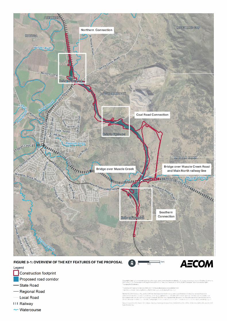
Transport proposes to build a New England Highway bypass of Muswellbrook. The proposal is located to
the east of Muswellbrook and connects the New England Highway to the north and south of Muswellbrook.
An overview of the construction footprint for the proposal is shown in Figure 3-1. The proposal has been
developed to concept design level and would be further refined subject to detailed design development and
innovation.
Key features of the proposal are shown in Figure 3-2, Figure 3-3 and Figure 3-4 and would include:
• About nine kilometres of new highway (the bypass) with a single lane in each direction and a wide
centreline treatment
• Connection with the New England Highway at the southern end of the proposal, which provides all
traffic movements (southern connection)
• A 38 metre bridge over the bypass at the southern connection
• A 76 metre long bridge over Muscle Creek Road and Main North railway line
• A 114 metre long bridge over Muscle Creek
• Connection with Coal Road, which provides all traffic movements (Coal Road connection)
• A 43 metre long bridge over Coal Road
• A 367 metre long bridge over Sandy Creek Road, Sandy Creek, Main North railway line and
southbound exit ramp
• Connection with the New England Highway at the northern end of the proposal, which provides all
traffic movements (northern connection).
Additional features and aspects of the proposal include:
• Demolition of buildings
• Vegetation clearing
• Tie-in with the New England Highway at the northern and southern ends of the proposal
• Utility adjustment or relocation, including electricity, water and telecommunications
• Operational spill containment basins
• Drainage infrastructure including permanent basins
• Property adjustments
• Provision of permanent access roads for maintenance activities
• Property access and local road adjustments including Burtons Lane, Koolbury Flats Row, Milpera
Drive, Muscle Creek Road and Coal Road
• Earthworks including construction of embankments
• Temporary ancillary facilities during construction including site offices, site compounds, stockpile
sites, laydown areas, concrete and asphalt batch plants, and temporary access tracks including
creek crossings
New England Highway bypass of Muswellbrook
Review of Environmental Factors
17
• Fauna infrastructure
• Finishing roadwork including pavement, road stabilisation, kerb and gutter, signage, lighting and line
marking works
• Demobilisation of ancillary facilities following the completion of the construction of the proposal
• Landscaping works
• Processing of materials
• Minor creek diversions
• Relocation of the overhead vehicle classifier at the northern connection.
Timing for construction of the proposal is subject to project approval. However, construction is expected to
start in late 2022 with enabling work. The main work is expected to commence in 2023 and would take
about three and a half years to complete. The NSW Government has committed full funding for the
proposal. Construction of the proposal may be staged.
New England Highway bypass of Muswellbrook
Review of Environmental Factors
18
3.2 Design
3.2.1 Design criteria
Standards
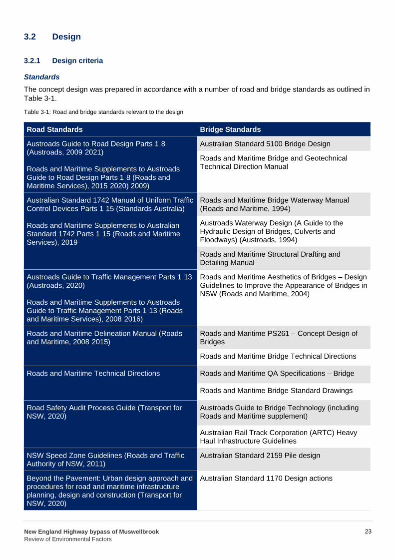
The concept design was prepared in accordance with a number of road and bridge standards as outlined in
Table 3-1.
Table 3-1: Road and bridge standards relevant to the design
Road Standards Bridge Standards
Austroads Guide to Road Design Parts 1 8 (Austroads, 2009 2021)
Roads and Maritime Supplements to Austroads Guide to Road Design Parts 1 8 (Roads and Maritime Services), 2015 2020) 2009)
Roads and Maritime Bridge and Geotechnical Technical Direction Manual
Australian Standard 1742 Manual of Uniform Traffic Control Devices Parts 1 15 (Standards Australia)
Roads and Maritime Supplements to Australian Standard 1742 Parts 1 15 (Roads and Maritime Services), 2019
Austroads Waterway Design (A Guide to the Hydraulic Design of Bridges, Culverts and Floodways) (Austroads, 1994)
Austroads Guide to Traffic Management Parts 1 13 (Austroads, 2020)
Roads and Maritime Supplements to Austroads Guide to Traffic Management Parts 1 13 (Roads and Maritime Services), 2008 2016)
Roads and Maritime Aesthetics of Bridges – Design Guidelines to Improve the Appearance of Bridges in NSW (Roads and Maritime, 2004)
Roads and Maritime Delineation Manual (Roads and Maritime, 2008 2015)
Roads and Maritime Bridge Technical Directions
Roads and Maritime Technical Directions
Roads and Maritime Bridge Standard Drawings
Road Safety Audit Process Guide (Transport for NSW, 2020)
Australian Rail Track Corporation (ARTC) Heavy Haul Infrastructure Guidelines
NSW Speed Zone Guidelines (Roads and Traffic Authority of NSW, 2011)
--
--
-
-
-
--
-
Australian Standard 2159 Pile design
Beyond the Pavement: Urban design approach and procedures for road and maritime infrastructure planning, design and construction (Transport for NSW, 2020)
Australian Standard 1170 Design actions
Australian Standard 5100 Bridge Design
Roads and Maritime Bridge Waterway Manual (Roads and Maritime, 1994)
Roads and Maritime Structural Drafting and Detailing Manual
Roads and Maritime PS261 – Concept Design of Bridges
Roads and Maritime QA Specifications – Bridge
Austroads Guide to Bridge Technology (including Roads and Maritime supplement)
New England Highway bypass of Muswellbrook
Review of Environmental Factors
23
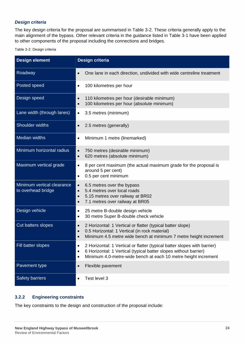
Design criteria
The key design criteria for the proposal are summarised in Table 3-2. These criteria generally apply to the
main alignment of the bypass. Other relevant criteria in the guidance listed in Table 3-1 have been applied
to other components of the proposal including the connections and bridges.
Table 3-2: Design criteria
Design element Design criteria
Roadway
• One lane in each direction, undivided with wide centreline treatment
Posted speed • 100 kilometres per hour
Design speed • 110 kilometres per hour (desirable minimum)
• 100 kilometres per hour (absolute minimum)
Lane width (through lanes) • 3.5 metres (minimum)
Shoulder widths • 2.5 metres (generally)
Median widths • Minimum 1 metre (linemarked)
Minimum horizontal radius • 750 metres (desirable minimum)
• 620 metres (absolute minimum)
Maximum vertical grade • 8 per cent maximum (the actual maximum grade for the proposal isaround 5 per cent)
• 0.5 per cent minimum
Minimum vertical clearance
to overhead bridge • 6.5 metres over the bypass
• 5.4 metres over local roads
• 5.15 metres over railway at BR02
• 7.1 metres over railway at BR05
Design vehicle
Cut batters slopes
• 25 metre B-double design vehicle
• 30 metre Super B-double check vehicle
• 2 Horizontal: 1 Vertical or flatter (typical batter slope)
• 0.5 Horizontal: 1 Vertical (in rock material)
• Minimum 4.5 metre wide bench at minimum 7 metre height increment
Fill batter slopes • 2 Horizontal: 1 Vertical or flatter (typical batter slopes with barrier)
• 6 Horizontal: 1 Vertical (typical batter slopes without barrier)
• Minimum 4.0-metre-wide bench at each 10 metre height increment
Pavement type • Flexible pavement
Safety barriers • Test level 3
3.2.2 Engineering constraints
The key constraints to the design and construction of the proposal include:
New England Highway bypass of Muswellbrook
Review of Environmental Factors
24
• Integrating into the undulating terrain to minimise grades for heavy vehicles on the bypass
• Balancing earthworks where feasible to reduce unnecessary import of fill or excess spoil material
• Minimising impacts from mine workings, including minimising cut and fill over former Muswellbrook
Coal Company (MCC) Open Cut No. 1
• Catering for movements of heavy / oversized vehicles on the bypass
• Minimising property acquisition, adjustment and access impacts
• Minimising impacts on existing utilities, including the Ausgrid substation
• Minimising flooding impacts associated with the construction and operation of the bypass
• Avoiding impacts on the Muswellbrook waste management facility and the Aboriginal land grant
• Constructing the bypass to cross over the Main North railway line, Muscle Creek, Sandy Creek,
Muscle Creek Road, Sandy Creek Road, and the New England Highway
• Maintaining traffic flow on the New England Highway during construction, including access for
heavy vehicles.
3.2.3 Major design features
The major design features of the proposal are described in the following sections. These features have
been developed to concept design level and would be further refined subject to detailed design
development and innovation.
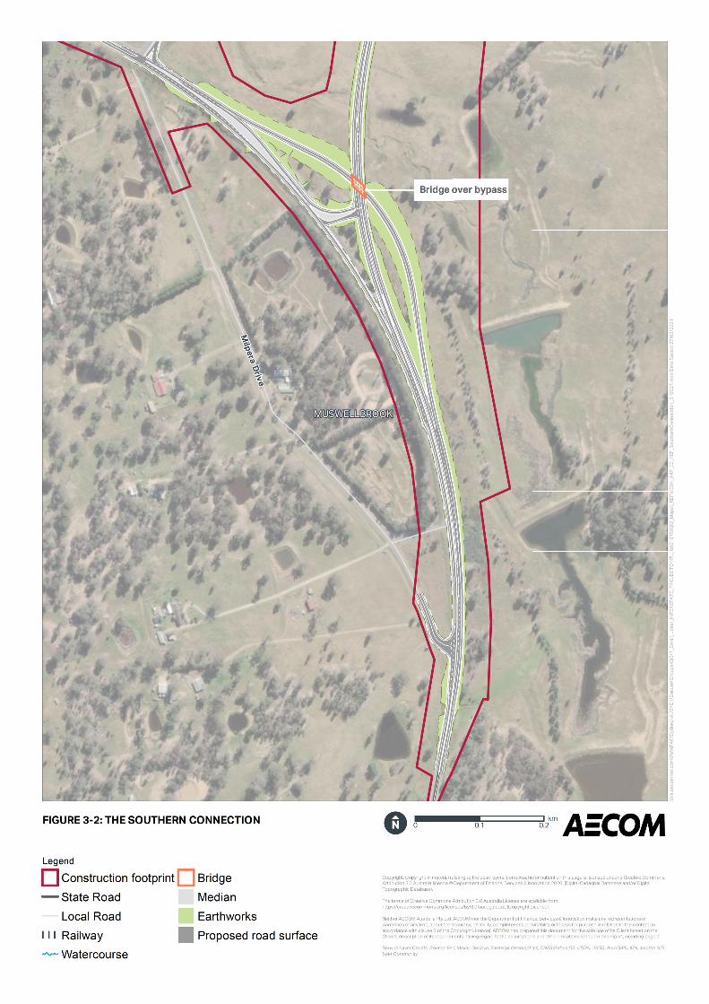
Southern connection
The bypass would depart the existing New England Highway at the southern connection in an easterly
direction. The southern connection would be a full connection providing for all traffic movements.
An exit ramp would be provided for vehicles travelling northbound into Muswellbrook. Vehicles would then
travel along the existing New England Highway to Muswellbrook.
Vehicles travelling southbound from Muswellbrook would use the southbound entry ramp to continue along
the New England Highway towards Singleton and would merge with vehicles travelling southbound on the
bypass. The southbound entry ramp passes over the bypass via a bridge structure. The bridge would be a
single span, industry standard super-T girder bridge and would be about 38 metres long and 6.7 metres
above the bypass. The bridge abutments would be located behind reinforced soil walls.
An at-grade intersection featuring a channelised right turn would enable southbound bypass traffic to
access Muswellbrook. A left turn would allow traffic travelling southbound from Muswellbrook to turn
northbound onto the bypass.
Muscle Creek Road intersection would be reconfigured to accommodate the connection to the bypass.
A new, relocated Milpera Drive intersection with the New England Highway would also be provided around
190 metres south of the existing intersection and would enable all traffic movements. The intersection
would include a channelised right-turn for southbound traffic into Milpera Drive and a dedicated northbound
left turn deceleration lane into Milpera Drive. The existing intersection providing access to Milpera Drive
would be closed.
The southern connection is shown in Figure 3-2.
Bridge over Muscle Creek Road and Main North railway line
North of the southern connection, the bypass would rise up on an embankment to provide for a bridge
across both Muscle Creek Road and the Main North railway line. The southern abutment of the bridge
would be located to the south of Muscle Creek Road behind a reinforced soil wall and the northern
abutment located to the north of the Main North railway line behind a reinforced concrete protection wall.
New England Highway bypass of Muswellbrook
Review of Environmental Factors
25
The central pier would lie between the railway line and Muscle Creek Road and is protected by deflection
walls either side of the pier.
The bridge would be a two span, industry standard super-T girder bridge and would be about 76 metres
long, eight metres above Muscle Creek Road and 5.6 metres above the Main North railway line.
Bridge over Muscle Creek
The embankment on the northern side of the bridge over Muscle Creek Road would continue and provide
for a bridge across Muscle Creek.
The bridge would be a four span, industry standard super-T girder bridge and would be about 114 metres
long and up to about 14 metres above creek level with spill through abutments.
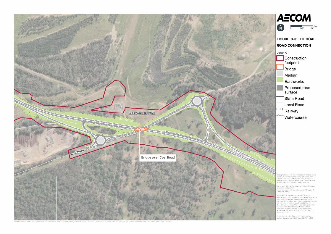
Coal Road connection
The Coal Road connection would comprise a full connection providing for all traffic movements.
A northbound exit ramp and entry ramp would be provided on the western side of the bypass and a
southbound exit and entry ramp on the eastern side. Two roundabouts, to the east and west of the bypass,
would connect the existing Coal Road to the connection ramps.
The northbound exit ramp on the western side of the bypass would provide access to the proposed
roundabout. From here, traffic can continue westbound along Coal Road to Muswellbrook.
The northbound entry ramp, also on the western side of the bypass, would be accessed from the existing
Coal Road via the proposed roundabout. Traffic would merge with vehicles travelling northbound on the
bypass.
Traffic from Muswellbrook travelling south on the bypass would access a southbound entry ramp from Coal
Road via the proposed roundabout.
The southbound exit ramp would diverge from the bypass to the roundabout for access to Muswellbrook.
The existing Coal Road, between the proposed roundabouts would be widened. The proposal does not
include further upgrades to Coal Road, as Coal Road is under the care control and management of
Muswellbrook Shire Council.
The Coal Road connection is shown in Figure 3-3.
Bridge over Coal Road
A bridge over Coal Road would be constructed east of the Muswellbrook Waste Management Facility.
The bridge would be a single span bulb-T girder bridge and would be about 43 metres long and 5.6 metres
above Coal Road. The bridge abutments would be located behind reinforced soil walls.
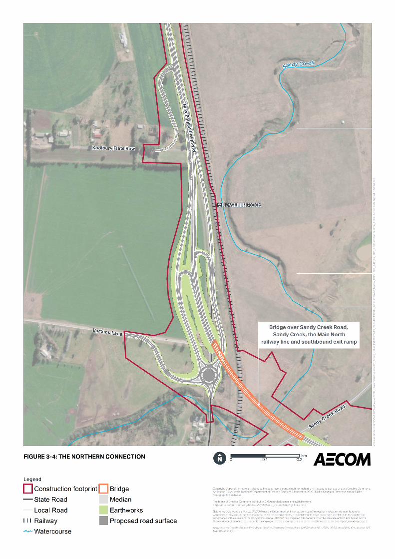
Bridge over Sandy Creek Road, Sandy Creek and the Main North railway line
A bridge over Sandy Creek Road, Sandy Creek, the Main North railway line and the southbound entry/exit
ramp would be constructed at the northern end of the bypass. The bridge would also cross the southbound
entry/exit ramp at the northern connection.
The bridge would be a 12 span girder bridge, consisting of nine spans with industry standard super-T
girders and three spans with bulb-T girders. The bridge would be about 376 metres long and measuring 5.9
metres above Sandy Creek Road, 7.4 metres above the Main North railway line, 7.1 metres above the
southbound entry / exit ramp and about 20 metres over Sandy Creek with spill through abutments. The
piers on both sides of the Main North railway line would include deflection walls.
New England Highway bypass of Muswellbrook
Review of Environmental Factors
26
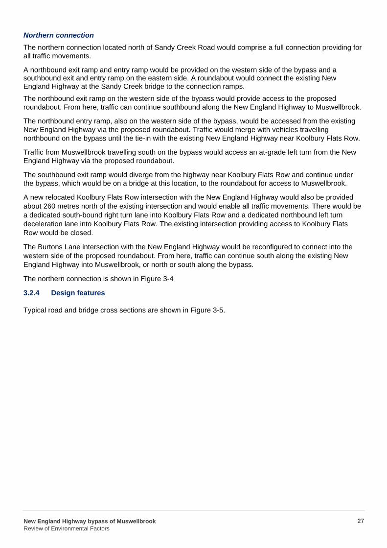
Northern connection
The northern connection located north of Sandy Creek Road would comprise a full connection providing for
all traffic movements.
A northbound exit ramp and entry ramp would be provided on the western side of the bypass and a southbound exit and entry ramp on the eastern side. A roundabout would connect the existing New England Highway at the Sandy Creek bridge to the connection ramps.
The northbound exit ramp on the western side of the bypass would provide access to the proposed
roundabout. From here, traffic can continue southbound along the New England Highway to Muswellbrook.
The northbound entry ramp, also on the western side of the bypass, would be accessed from the existing
New England Highway via the proposed roundabout. Traffic would merge with vehicles travelling
northbound on the bypass until the tie-in with the existing New England Highway near Koolbury Flats Row.
Traffic from Muswellbrook travelling south on the bypass would access an at-grade left turn from the New
England Highway via the proposed roundabout.
The southbound exit ramp would diverge from the highway near Koolbury Flats Row and continue under
the bypass, which would be on a bridge at this location, to the roundabout for access to Muswellbrook.
A new relocated Koolbury Flats Row intersection with the New England Highway would also be provided
about 260 metres north of the existing intersection and would enable all traffic movements. There would be
a dedicated south-bound right turn lane into Koolbury Flats Row and a dedicated northbound left turn
deceleration lane into Koolbury Flats Row. The existing intersection providing access to Koolbury Flats
Row would be closed.
The Burtons Lane intersection with the New England Highway would be reconfigured to connect into the
western side of the proposed roundabout. From here, traffic can continue south along the existing New
England Highway into Muswellbrook, or north or south along the bypass.
The northern connection is shown in Figure 3-4
3.2.4 Design features
Typical road and bridge cross sections are shown in Figure 3-5.
New England Highway bypass of Muswellbrook
Review of Environmental Factors
27
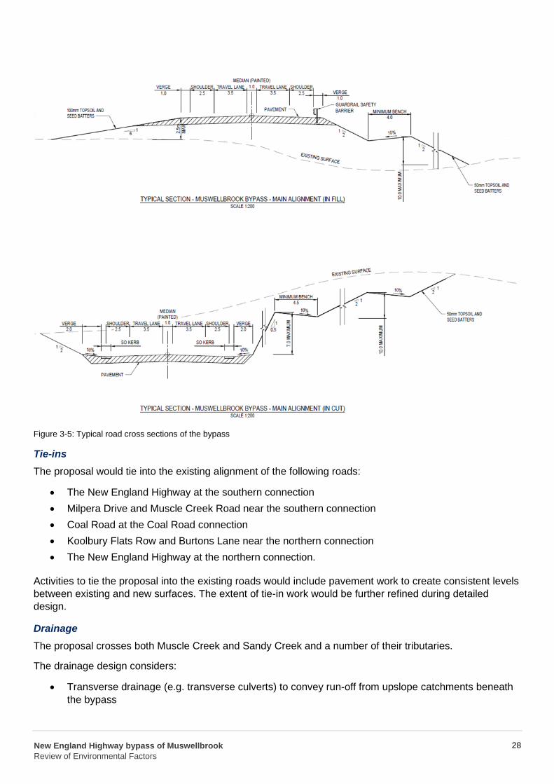
Figure 3-5: Typical road cross sections of the bypass
Tie-ins
The proposal would tie into the existing alignment of the following roads:
• The New England Highway at the southern connection
• Milpera Drive and Muscle Creek Road near the southern connection
• Coal Road at the Coal Road connection
• Koolbury Flats Row and Burtons Lane near the northern connection
• The New England Highway at the northern connection.
Activities to tie the proposal into the existing roads would include pavement work to create consistent levels
between existing and new surfaces. The extent of tie-in work would be further refined during detailed
design.
Drainage
The proposal crosses both Muscle Creek and Sandy Creek and a number of their tributaries.
The drainage design considers:
• Transverse drainage (e.g. transverse culverts) to convey run-off from upslope catchments beneath
the bypass
New England Highway bypass of Muswellbrook
Review of Environmental Factors
28
• Longitudinal drainage to convey flows either towards swales or transverse culverts
• Bridge drainage which would be piped and provide adequate drainage of surface water. Runoff
would be discharged via a spill containment basin or to existing drainage infrastructure depending
on the location and subject to detailed design
• Operational spill containment, including spill containment basins.
Property access
Any properties affected by changed access arrangements as a result of the proposal, would be provided
with restored or new permanent access arrangements. Refer to Section 3.3.7 for further details.
Parking facilities
No permanent parking facilities would be removed or provided by the proposal.
Pedestrian and bicycle facilities
The proposal would not provide any new pedestrian or dedicated bicycle facilities along the proposed road
corridor. Cyclists would be able to use the road shoulders on the bypass.
Bus facilities
No dedicated bus facilities would be removed or provided by the proposal.
Public utilities
There are a number of public utilities within the construction footprint that would require adjustment or
relocation as part of the proposal. Refer to Section 3.5 for further details.
Lighting
Lighting would be designed in accordance with relevant guidelines and standards to minimise light spillage
into residential properties and minimise glare that could impact on driver visibility. Although the bypass itself
would not be lit, the following sections would be lit to a Category V5:
• The intersections associated with the bypass at the southern and northern connections
• The exit / entry ramps where they join the bypass
• The roundabouts at the Coal Road connection
• The roundabout at the northern connection.
The lighting design would be further refined during the detailed design.
Urban and landscape design
A Landscape Character, Visual Impact Assessment and Urban Design Principles and Objectives Report
was prepared for the proposal as discussed in Section 6.11. In recognition of the potential impacts of the
proposal, six urban design objectives were developed as follows:
• Objective 1 – Respond to the landform: Embrace the undulating hills and gullies descending from
Skellatar Hill to the Hunter River pastural floodplains
• Objective 2 – Contribute to the urban structure: Acknowledge the connection the proposal has to
Muswellbrook township physically and visually
• Objective 3 – Maximise the travel experience: Utilise the unique characteristics of the region to
provide an enjoyable travel experience
New England Highway bypass of Muswellbrook
Review of Environmental Factors
29
• Objective 4 – Respond to landscape patterns: Reflect the historic mining land-use and respond to
the colours and shapes in the pastural floodplains, vegetated ridge lines and hills surrounding the
proposal
• Objective 5 – Design for minimal lifestyle costs: Design a low maintenance, long-living and
sustainable landscape
• Objective 6 – Coordinate a simple and consistent design language along the road corridor:
Coordinate the urban design treatments for bridges, walls, barriers, landscaping and standard
roadside furniture and infrastructure.
The urban design objectives were developed with reference to principles contained in the New England
Highway Urban Design Framework (Transport for NSW, 2016). The objectives have been integrated into
the concept design and would be considered further in the detailed design phase of the proposal.
Signage and line marking
Appropriate signage and line marking would be provided to suit the proposal, including a wide centreline
treatment and audio-tactile linemarking for the bypass.
Safety barriers
The proposal would include the modification of existing safety barriers as required. New safety barriers
would be provided in accordance with relevant standards and guidelines.
Throw screens
Throw screens would be required to bridges over:
• Southern connection (BR01) – full length
• Main Northern Railway line (BR02) – full length
• Main Northern Railway line (BR05) – a small length over the rail.
The throw screens would be visually and materially consistent with those existing along the Hunter
Expressway and previous upgrades of the New England Highway, and generally consist of the following
design principles:
• Screens should be fully integrated with other bridge and abutment elements
• There should be a neat, elegant transition of the bridge barrier safety screen (e.g. tapered end)
• The anti-throw screen should extend to the end of the bridge span.
The profile and materiality of the throw screens would consist of:
• Modular closed steel mesh screen panels integrated with the bridge parapet design and integral
with the bridge design
• Regular and consistently spaced steel posts with an angled profile.
Fauna Infrastructure
Fauna infrastructure would include an aerial crossing and underpass. The aerial fauna crossing would be
installed in the vicinity of where Squirrel Gliders have been recorded. Fauna exclusion fencing would also
be considered near the fauna crossing and known habitat for the Striped Legless Lizard. The final location,
design and types of structures would be determined during detailed design. The bridge over Muscle Creek
would provide an underpass crossing for terrestrial fauna species.
‘Koala Warning Signs’ or ‘Injured Native Wildlife Signs’ would also be installed. More detail on fauna infrastructure is provided in Chapter 6.1.
New England Highway bypass of Muswellbrook
Review of Environmental Factors
30
3.3 Construction activities
Construction activities would be guided by a construction environmental management plan (CEMP) to
ensure work is carried out to Transport specifications within the construction footprint (refer to Figure 3-1).
3.3.1 Work methodology
Detailed work methodologies would be determined during detailed design and construction planning. The
indicative work methodology is described below, however activities may vary to suit the construction
staging plans, which would be determined by the construction contractor. The proposal is anticipated to
involve the following general work methodologies and sequencing:
• Site establishment including set up of temporary ancillary facilities including site offices, site
compounds, stockpile sites, laydown areas, concrete and asphalt batch plants, and temporary
access tracks including creek crossings
• Utility adjustments
• Building demolition
• Vegetation clearing
• Earthworks and drainage
• Processing of materials
• Bridge construction including approaches
• Pavement construction
• Landscaping and finishing work
• Removal of ancillary facilities and site rehabilitation.
Site establishment work including set up of ancillary facilities
A number of ancillary facilities would be set up and would remain in operation for the duration of the
construction period. Ancillary facilities included as part of the proposal are further described in Section 3.4.
Establishment work would include:
• Identification and marking out of sensitive areas as defined by this REF and the CEMP
• Installation of traffic management measures including temporary traffic signs and barricades
• Installation of fencing
• Property adjustment work including relocation of fences, accesses and boundary features
• Minor earthworks to establish temporary construction roads (including temporary diversion roads for
Muscle Creek Road and Sandy Creek Road), temporary bridges (where required) and level areas
for construction compounds
• Utility connection work
• Establishment of construction compounds and ancillary facilities
• Sediment and erosion control work including installation of temporary sediment basins together with
localised treatments such as sediment fences and earth bunds/channels to separate on-site and off-
site water
• Minor road work to establish access points.
Utility adjustments
Services and utilities identified within the construction footprint that may require relocation or protection
include overhead and underground electricity (owned by Ausgrid), water and sewage services (owned by
Muswellbrook Shire Council), telecommunications (owned by Telstra and the National Broadband Network
New England Highway bypass of Muswellbrook
Review of Environmental Factors
31
(NBN) Corporation, optic fibre and signal cables (owned by ARTC) and various utilities owned by MCC
including waste water and raw water and overhead electrical utilities.
Utility relocation is further discussed in Section 3.5.
Activities that would be carried out to relocate utilities include:
• Identification and removal of redundant asbestos cement pipes
• Installation of new poles to carry overhead services
• Excavation of trenches along new utility routes
• Installation of bedding material and new utilities within the trenches or onto new poles
• Testing and cutover of utilities into new infrastructure
• Decommissioning and removal of redundant utilities where required.
Building demolition
Two buildings on properties which are already owned by Transport would be demolished(refer to Section
3.6).
Demolition activities would generally include:
• Identification and removal of asbestos
• Removal of fittings and other reusable elements using hand tools
• Progressive demolition of the building structures using modified excavators
• Sorting and temporary storage of demolition material into recyclable and waste components
• Loading and transporting recyclable and waste material to a licenced facility.
Vegetation clearing
Vegetation clearing would include:
• Identification and marking out of clearing limits and hollow bearing trees
• Identification of suitable habitat nearby for release of fauna that may be encountered
• Checking for the presence of fauna species onsite and relocate if there is the potential for the
animal to be disturbed or injured
• Clearing of non-hollow bearing trees including removal of stumps (trees in riparian zones would
have their stumps retained wherever possible)
• Checking tree hollows for fauna and then removal of the habitat trees
• Reuse of native vegetation or mulch for use in rehabilitation.
Earthworks and drainage
Earthworks are required to achieve the design levels along the entire length of the proposed road corridor,
including raised embankments and sections of cutting. Blasting is currently proposed to take place for
excavation of material for earthworks.
Some existing drainage systems such as culverts may need to be extended across the new road formation
at tie in points with the existing road system. Completely new drainage structures and systems would be
installed along the entire length of the proposed road corridor. One dam located along the proposed road
corridor would be filled.
Earthworks and drainage work would include:
• Stripping, stockpiling and management of grass, topsoil and unsuitable material
New England Highway bypass of Muswellbrook
Review of Environmental Factors
32
• Excavating and filling the road formation levels, including excavation for embankments and cuttings
and boxing out of new pavements
• Disposal of unsuitable and surplus material
• Installing new drainage lines, temporary and permanent sediment basins, sediment fences, earth
bunds and channels and protection of existing stormwater pits.
Processing of materials
Processing of materials would include crushing and grading of site materials for material reuse.
Bridge construction
As described in Section 3.2.3, a number of bridges would be constructed for the proposal. The construction
methodology for the bridges including approaches would include:
• Removal, relocation or protection of impacted existing utilities
• Stripping, stockpiling and management of grass, topsoil and unsuitable material
• Hauling and compaction of fill material for the embankment at each bridge abutment
• Foundation construction including:
o Piling (pile driving for steel tube piles and boring for cast in place piles)
o Pile cap construction including localised excavation
• Cast insitu bridge pier construction
• Reinforced soil wall construction
• Superstructure construction through the placement of pre-cast girders lifted into place using a crane
• Cast insitu concrete deck placement
• Installation of parapets, guardrails and throw screens where required.
The bridge construction would interface with some local roads and with the Main North railway line, and
may require temporary diversions, construction during rail shutdowns, night works and temporary barriers
to manage safety.
Pavement construction
Pavement would be laid along the entire length of the proposed road corridor (including bridges) and would
tie into existing roads at each connection.
Pavement construction work would include:
• Rolling and grading of road formation foundation
• Placement and compaction of bound gravel road pavement
• Installation of subsoil inter-pavement drainage with connections to existing and new drainage pits
where required
• Placement of a bitumen material over the road formation and/or bound gravel road pavement
• Placement of an asphalt wearing course and compaction with a roller.
Landscaping and finishing work
Landscape and finishing work would include:
• Installation of new streetlights
• Installation of road furniture including signage and roadside barriers as required
• Rehabilitation of disturbed areas and landscaping in accordance with the urban design and
landscape plan
New England Highway bypass of Muswellbrook
Review of Environmental Factors
33
• Line marking and installation of raised reflective pavement markers.
Removal of ancillary facilities and site rehabilitation
Upon completion of construction, construction advisory and warning signage would be removed, and the
road would be opened to traffic. The ancillary facilities would be removed, and areas disturbed during
construction would be rehabilitated. Once disturbed areas are established, erosion and sediment control
measures such as sediment fencing would be removed.
3.3.2 Construction workforce
The construction workforce would fluctuate depending on the stage of construction. Final workforce
numbers would be confirmed by the construction contractor.
3.3.3 Construction hours and duration
Construction would largely be carried out during standard construction working hours in accordance with
the Interim Construction Noise Guideline (DECC, 2009):
• Monday to Friday: 7am to 6pm
• Saturday: 8am to 1pm
• Sundays and public holidays: no work.
Construction activities that involve impulsive or tonal noise emissions would be limited to the following
hours in accordance with the Construction Noise and Vibration Guideline (Transport for NSW, 2016):
• Monday to Friday: 8am to 5pm
• Saturday: 9am to 1pm
• Sundays and public holidays: no work.
To minimise disruption to daily traffic and disturbance to surrounding landowners and businesses, it would
be necessary to carry out some work outside of these hours.
The following activities are likely to take place outside standard construction working hours:
• Construction activities within the rail corridor during rail possessions
• Delivery of construction materials such as precast bridge structures
• Intersection and tie-in activities, of the bypass to existing roads
• Installation and adjustment of barriers and signage for construction zones during each construction
stage
• Construction of the bridge over Sandy Creek Road and the bridge over Muscle Creek Road
• Operation of construction compounds to support the above work.
Construction is expected to start in late 2022 with enabling works. The main works are expected to start in
2023 and would take about three and a half years to complete.
3.3.4 Plant and equipment
A range of plant and equipment would be used during construction. The final equipment and plant
requirements would be determined by the construction contractor. An indicative list of plant and equipment
which would be used in each construction stage is provided below in Table 3-3.
New England Highway bypass of Muswellbrook
Review of Environmental Factors
34
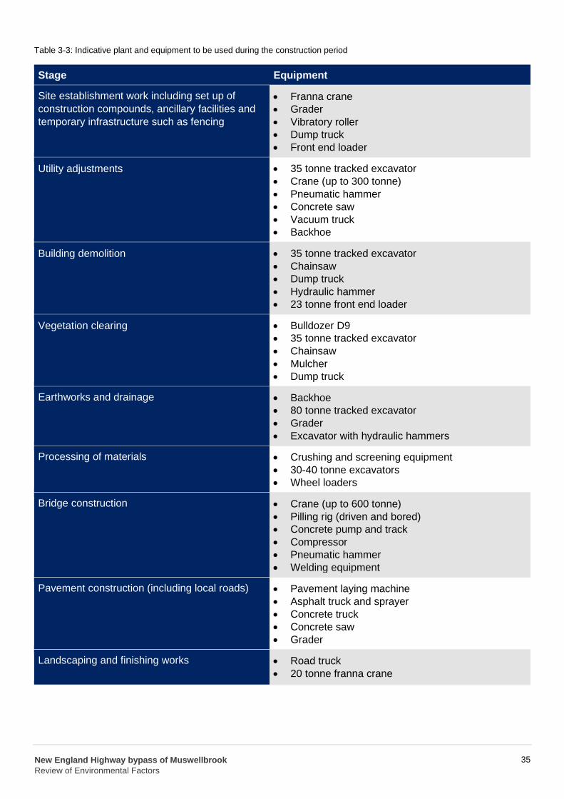
Table 3-3: Indicative plant and equipment to be used during the construction period
Stage Equipment
Site establishment work including set up of
construction compounds, ancillary facilities and
temporary infrastructure such as fencing
• • • • •
Franna crane
Grader
Vibratory roller
Dump truck
Front end loader
Utility adjustments • • • • • •
35 tonne tracked excavator
Crane (up to 300 tonne)
Pneumatic hammer
Concrete saw
Vacuum truck
Backhoe
Building demolition • • • • •
35 tonne tracked excavator
Chainsaw
Dump truck
Hydraulic hammer
23 tonne front end loader
Vegetation clearing • • • • •
Bulldozer D9
35 tonne tracked excavator
Chainsaw
Mulcher
Dump truck
Earthworks and drainage • • • •
Backhoe
80 tonne tracked excavator
Grader
Excavator with hydraulic hammers
Processing of materials • • •
Crushing and screening equipment
30-40 tonne excavators
Wheel loaders
Bridge construction • • • • • •
Crane (up to 600 tonne)
Pilling rig (driven and bored)
Concrete pump and track
Compressor
Pneumatic hammer
Welding equipment
Pavement construction (including local roads) • • • • •
Pavement laying machine
Asphalt truck and sprayer
Concrete truck
Concrete saw
Grader
Landscaping and finishing works • •
Road truck
20 tonne franna crane
New England Highway bypass of Muswellbrook
Review of Environmental Factors
35
Stage Equipment
Removal of ancillary facilities and site
rehabilitation
• Medium rigid truck
• Road truck
• Franna crane
• Front end loader
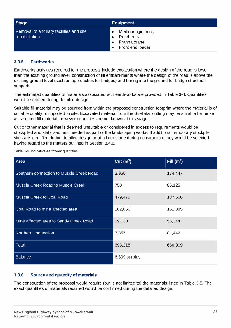
3.3.5 Earthworks
Earthworks activities required for the proposal include excavation where the design of the road is lower
than the existing ground level, construction of fill embankments where the design of the road is above the
existing ground level (such as approaches for bridges) and boring into the ground for bridge structural
supports.
The estimated quantities of materials associated with earthworks are provided in Table 3-4. Quantities
would be refined during detailed design.
Suitable fill material may be sourced from within the proposed construction footprint where the material is of
suitable quality or imported to site. Excavated material from the Skellatar cutting may be suitable for reuse
as selected fill material, however quantities are not known at this stage.
Cut or other material that is deemed unsuitable or considered in excess to requirements would be
stockpiled and stabilised until needed as part of the landscaping works. If additional temporary stockpile
sites are identified during detailed design or at a later stage during construction, they would be selected
having regard to the matters outlined in Section 3.4.6.
Table 3-4: Indicative earthwork quantities
Area Cut (m3) Fill (m3)
Southern connection to Muscle Creek Road
3,950 174,447
Muscle Creek Road to Muscle Creek 750 85,125
479,475 137,666
182,056 151,885
19,130 56,344
7,857 81,442
693,218 686,909
Muscle Creek to Coal Road
Coal Road to mine affected area
Mine affected area to Sandy Creek Road
Northern connection
Total
Balance 6,309 surplus
3.3.6 Source and quantity of materials
The construction of the proposal would require (but is not limited to) the materials listed in Table 3-5. The
exact quantities of materials required would be confirmed during the detailed design.
New England Highway bypass of Muswellbrook
Review of Environmental Factors
36
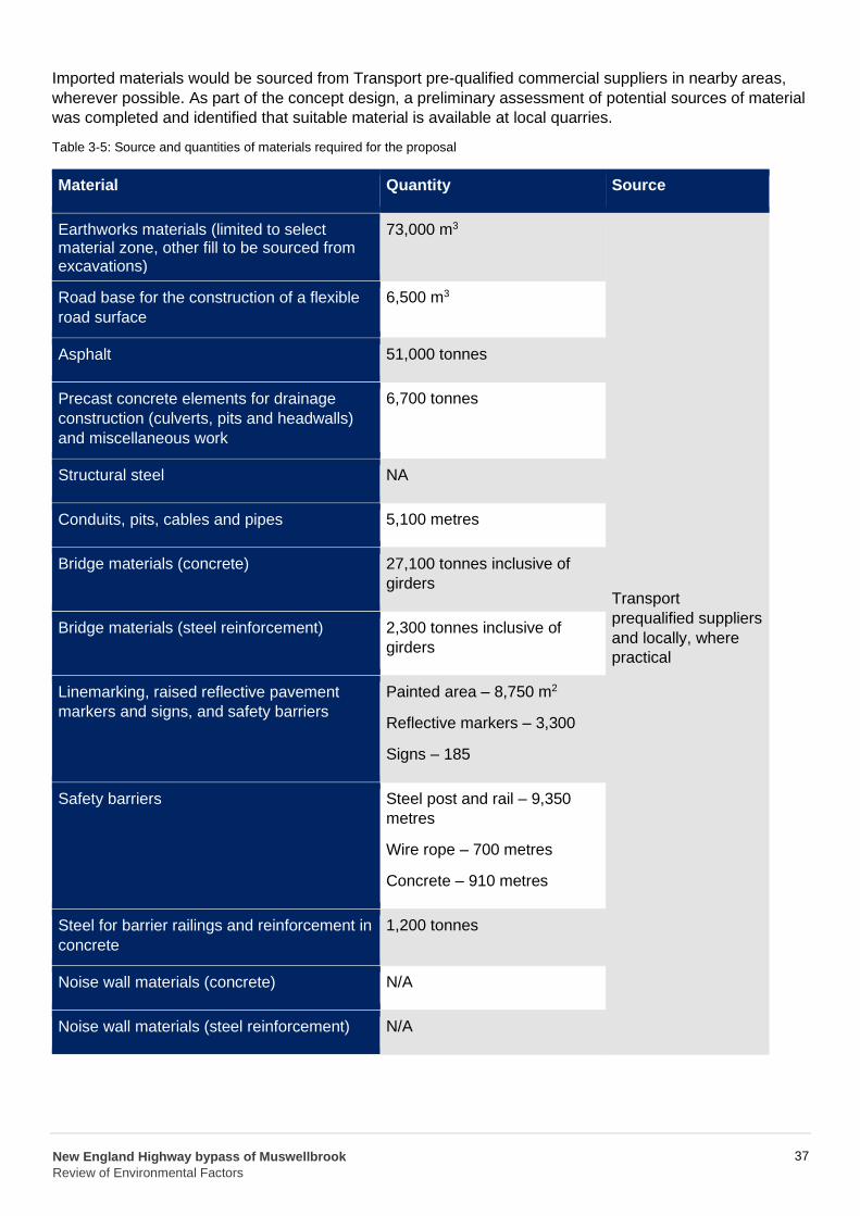
Imported materials would be sourced from Transport pre-qualified commercial suppliers in nearby areas,
wherever possible. As part of the concept design, a preliminary assessment of potential sources of material
was completed and identified that suitable material is available at local quarries.
Table 3-5: Source and quantities of materials required for the proposal
Material Quantity Source
3 Earthworks materials (limited to select 73,000 m material zone, other fill to be sourced from excavations)
3 Road base for the construction of a flexible 6,500 m
road surface
Asphalt 51,000 tonnes
Precast concrete elements for drainage 6,700 tonnes
construction (culverts, pits and headwalls)
and miscellaneous work
Structural steel NA
Conduits, pits, cables and pipes 5,100 metres
Bridge materials (concrete) 27,100 tonnes inclusive of
girders Transport
prequalified suppliers Bridge materials (steel reinforcement) 2,300 tonnes inclusive of
and locally, where girders
practical
2 Linemarking, raised reflective pavement Painted area – 8,750 m
markers and signs, and safety barriers Reflective markers – 3,300
Signs – 185
Safety barriers Steel post and rail – 9,350
metres
Wire rope – 700 metres
Concrete – 910 metres
Steel for barrier railings and reinforcement in 1,200 tonnes
concrete
Noise wall materials (concrete) N/A
Noise wall materials (steel reinforcement) N/A
New England Highway bypass of Muswellbrook
Review of Environmental Factors
37
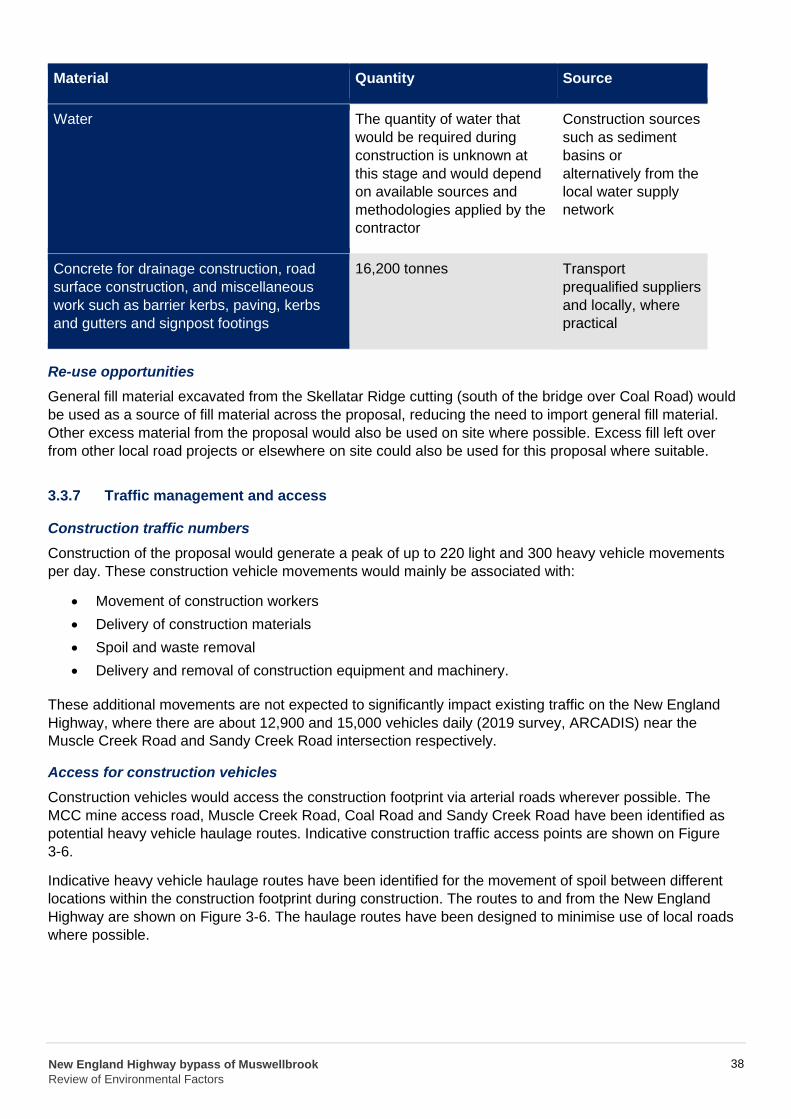
Water
Material Quantity Source
The quantity of water that Construction sources
would be required during such as sediment
construction is unknown at basins or
this stage and would depend alternatively from the
on available sources and local water supply
methodologies applied by the network
contractor
Concrete for drainage construction, road
surface construction, and miscellaneous
work such as barrier kerbs, paving, kerbs
and gutters and signpost footings
16,200 tonnes Transport
prequalified suppliers
and locally, where
practical
Re-use opportunities
General fill material excavated from the Skellatar Ridge cutting (south of the bridge over Coal Road) would
be used as a source of fill material across the proposal, reducing the need to import general fill material.
Other excess material from the proposal would also be used on site where possible. Excess fill left over
from other local road projects or elsewhere on site could also be used for this proposal where suitable.
3.3.7 Traffic management and access
Construction traffic numbers
Construction of the proposal would generate a peak of up to 220 light and 300 heavy vehicle movements
per day. These construction vehicle movements would mainly be associated with:
• Movement of construction workers
• Delivery of construction materials
• Spoil and waste removal
• Delivery and removal of construction equipment and machinery.
These additional movements are not expected to significantly impact existing traffic on the New England
Highway, where there are about 12,900 and 15,000 vehicles daily (2019 survey, ARCADIS) near the
Muscle Creek Road and Sandy Creek Road intersection respectively.
Access for construction vehicles
Construction vehicles would access the construction footprint via arterial roads wherever possible. The
MCC mine access road, Muscle Creek Road, Coal Road and Sandy Creek Road have been identified as
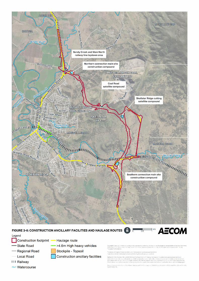
potential heavy vehicle haulage routes. Indicative construction traffic access points are shown on Figure
3-6.
Indicative heavy vehicle haulage routes have been identified for the movement of spoil between different
locations within the construction footprint during construction. The routes to and from the New England
Highway are shown on Figure 3-6. The haulage routes have been designed to minimise use of local roads
where possible.
New England Highway bypass of Muswellbrook
Review of Environmental Factors
38
Traffic management measures
It is expected that temporary signage, speed limits and lane closures would be required during
construction. Final construction methods would be refined to minimise traffic and transport impacts,
however traffic restrictions would be unavoidable during some construction activities, such as:
• Intersection and tie-in activities, of the bypass to existing roads
• Installation and adjustment of barriers and signage for construction zones during each construction
stage
• Construction of the bridge over Sandy Creek Road and the bridge over Muscle Creek Road.
Local property access management
Property access would be maintained as far as practicable throughout construction. However, there may be
temporary disruptions to private property access. The management of property access would be
considered by the construction contractor and detailed as part of the final staging plan for the proposal.
Commercial and private property access roads would be reinstated and/or relocated as required. Private
accesses include a residential access south of Muscle Creek Road and a farm access culvert under the
proposed bypass. Access to the MCC and Ausgrid substations off Coal Road, would be relocated. Ausgrid
access tracks would also be relocated to maintain access to assets and for fire safety.
Temporary construction access tracks
Temporary access tracks including creek crossings would be built to facilitate the movements of
construction vehicles and construction materials (e.g. girders for bridges) to key construction work areas for
bridges and bypass connection points.
Travelling stock routes (TSR) and stock routes
There are three TSRs and one stock route that are in the vicinity of the proposal namely the St Heliers TSR
which is on land that is leased, Muswellbrook Town TSR, Black Hill TSR (leased) and Black Hill Stock
Route.
It is proposed to extend the existing “farm access” culvert beneath the New England Highway at the start of the southbound entry ramp to ensure access to the Black Hill TSR is maintained once the bypass is
operational. The extension of the “farm access” culvert would be constructed in a manner to minimise or avoid where feasible impacts to stock travel during construction. Potential impacts to stock water in the
dam located on the Black Hill TSR would be avoided with construction work limited to within the
construction footprint.
Rail access and management
Bridge construction activities would occur within and adjacent to the Main North railway line corridor and
may be required to be carried out during rail possessions. Work zones would be set up to enable
construction of bridge piers outside rail possessions where possible.
3.4 Ancillary facilities
Construction ancillary facilities, including construction compounds and laydown areas are shown in Figure
3-6 and described further below. The proposed ancillary facility locations were selected using the following
criteria:
• Proximity to the proposal
• Where possible, away from residential and sensitive receivers
• Where possible, outside of the 1 in 10 year Average Recurrence Interval (ARI) floodplain
• At least 40 metres away from the nearest waterway
New England Highway bypass of Muswellbrook
Review of Environmental Factors
39
• On land of low heritage conservation significance
• Away from ecologically sensitive areas, including the Striped Legless Lizard habitat
• On land which does not require clearing of native vegetation
• Relatively flat ground that does not require substantial reshaping
• In plain view of the public to deter theft and illegal dumping.
Should additional or alternative ancillary facilities be required, the positioning of these would also be based
on the above criteria.
Site construction compounds would include portable buildings with amenities such as toilets, secure and
bunded storage areas for site materials including fuel and chemicals, office space for on-site personnel and
associated parking.
The main site construction compounds may also include asphalt and concrete batching plants and
associated facilities such as material storage areas and stockpiles.
The main site construction compounds would be securely fenced with temporary fencing. Signage would be
erected advising the general public of access restrictions. Upon completion of construction, the site
construction compounds, laydown areas, work areas and stockpiles would be removed, and the sites
cleared of all rubbish and materials. They would then be rehabilitated.
New England Highway bypass of Muswellbrook
Review of Environmental Factors
40
3.4.1 Southern connection main site construction compound
The southern connection main site construction compound would be located east of the New England
Highway just north of the southern connection. The compound would be located within a large grassed
paddock.
This would be a main construction compound and site establishment activities at this location would include
installation of environmental controls, fencing and signage, construction of hard stand and establishment of
site office, amenities, bunded fuel storage, and car parking. This construction compound may also include
concrete and/or asphalt batching plant(s). Construction activities at this location would include laydown of
construction materials and equipment required to support the southern connection, bridge over Muscle
Creek Road and bridge over Muscle Creek as well as stockpiling of topsoil material, processing of materials
and concrete batching.
This construction compound would be about 30,600 m2 in size. Access would be provided off Muscle Creek
Road.
3.4.2 Northern connection main site construction compound
The northern connection main site construction compound would be located south of Sandy Creek Road to
the east of the bridge over Sandy Creek. The compound would be located on land previously used for
agricultural purposes that has already been acquired by Transport.
This would be a main construction compound and site establishment activities at this location would include
installation of environmental controls, fencing and signage, construction of hard stand and establishment of
site office, amenities, bunded fuel storage, and car parking. This construction compound may also include
concrete and/or asphalt batching plant(s). Construction activities at this location would include laydown of
construction materials and equipment required to support the northern connection and bridge over Sandy
Creek as well as stockpiling of topsoil material, processing of materials and concrete batching.
This construction compound would be about 28,800 m2 in size and access would be provided off Sandy
Creek Road.
3.4.3 Skellatar Ridge cutting satellite compound
The Skellatar Ridge cutting satellite compound would be located about halfway along the construction
footprint. The compound would be located within a large grassed paddock.
This would be a satellite construction compound and site establishment activities at this location would
include installation of environmental controls, fencing and signage, construction of hard stand,
establishment of amenities and bunded fuel storage. Construction activities to be carried out at this location
would include the laydown of construction materials and equipment required to support the Skellatar Ridge
cutting, as well as stockpiling of materials.
This satellite compound would be about 15,200 m2 in size and access would be via a private property
access track off the MCC mine access road running between Muscle Creek Road and Coal Road.
3.4.4 Coal Road satellite compound
The Coal Road satellite compound would be located north of Coal Road to the east of the bridge over Coal
Road. The compound would be located on disturbed land near the MCC substation.
This would be a satellite construction compound and site establishment activities at this location would
include installation of environmental controls, fencing and signage, construction of hard stand,
establishment of amenities and bunded fuel storage. Construction activities to be carried out at this location
New England Highway bypass of Muswellbrook
Review of Environmental Factors
42
would include the laydown of construction materials and equipment required to support the bridge over
Coal Road and Coal Road connection, as well as stockpiling of materials.
The satellite compound would be about 3,800 m2 in size and access would be provided off Coal Road.
3.4.5 Sandy Creek and Main North rail line laydown area
The Sandy Creek and Main North rail line laydown area would be located between Sandy Creek and the
Main North rail line to the east of the bridge over Sandy Creek. The construction compound would be
located on land currently used for agricultural purposes.
Site establishment activities at this location would include installation of environmental controls, fencing and
signage, construction of hard stand, establishment of amenities and bunded fuel storage. Construction
activities to be carried out at this location would primarily include the laydown of construction materials and
equipment required to support the northern connection and bridge over Sandy Creek, as well as stockpiling
of materials.
The laydown area would be about 8350m2 in size. Access to the laydown area would be provided off Sandy
Creek Road.
An overview of the key construction activities to be carried out at the ancillary facilities above is provided in
Table 3-6.
New England Highway bypass of Muswellbrook
Review of Environmental Factors
43
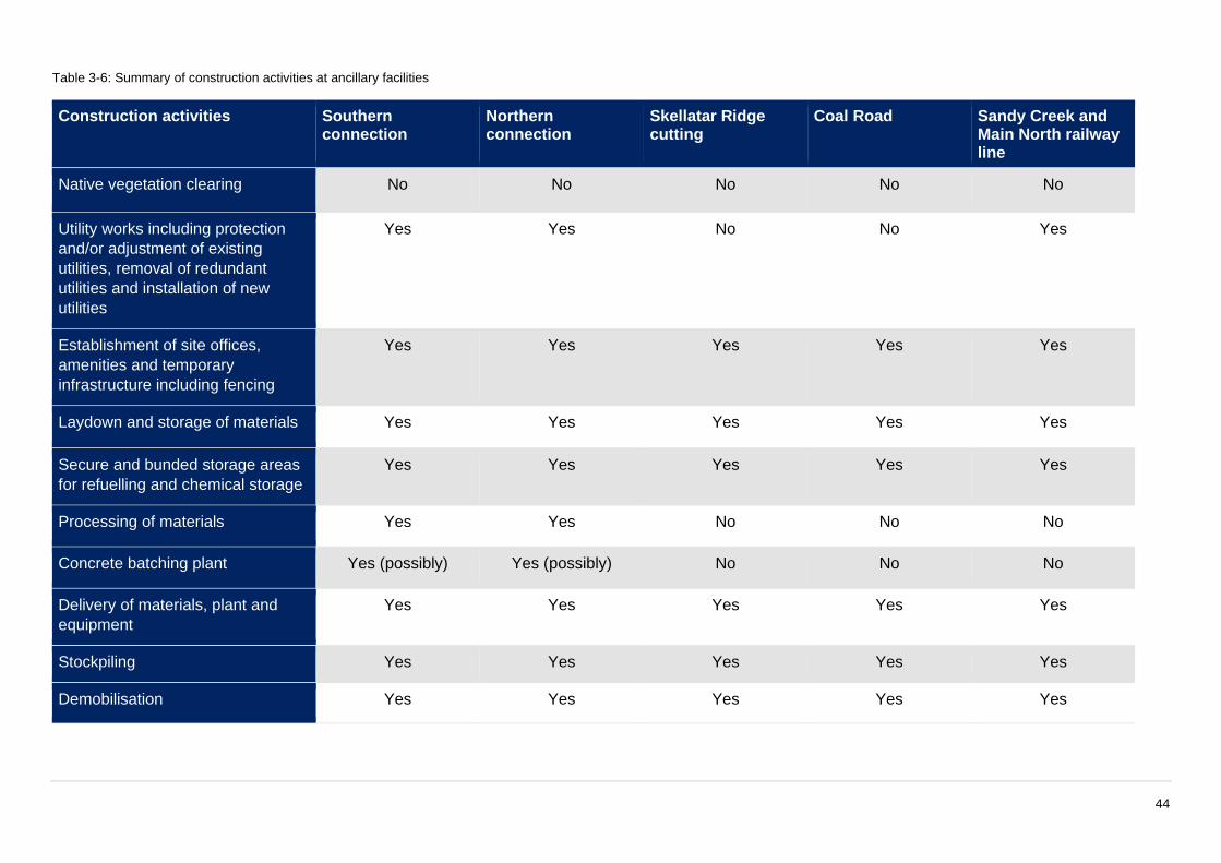
Table 3-6: Summary of construction activities at ancillary facilities
Construction activities Southern connection
Northern connection
Skellatar Ridge cutting
Coal Road Sandy Creek and Main North railway line
Native vegetation clearing No No No No No
Utility works including protection
and/or adjustment of existing
utilities, removal of redundant
utilities and installation of new
utilities
Yes Yes No No Yes
Establishment of site offices,
amenities and temporary
infrastructure including fencing
Yes Yes Yes Yes Yes
Laydown and storage of materials Yes Yes Yes Yes Yes
Secure and bunded storage areas
for refuelling and chemical storage
Yes Yes Yes Yes Yes
Processing of materials Yes Yes No No No
Concrete batching plant Yes (possibly) Yes (possibly) No No No
Delivery of materials, plant and
equipment
Yes Yes Yes Yes Yes
Stockpiling Yes Yes Yes Yes Yes
Demobilisation Yes Yes Yes Yes Yes
44
3.4.6 Stockpile sites
Stockpiling of materials would occur in site construction compounds and throughout the construction
footprint. All stockpiles would be managed in accordance with Roads and Maritime Stockpile Management
Guideline (RTA, 2011) and the QA Specification R44 Earthworks which include guidance around distance
from waterways, stabilisation and bunding. Contaminated soil that may be exposed during construction,
would be stockpiled with appropriate sediment and erosion control measures in place prior to off-site
disposal.
Additional temporary stockpile sites identified during construction would be located:
• Within the proposed road corridor or directly adjacent to the proposal where possible
• On land that is in Transport ownership or if unavailable on land that can be leased
• Outside the 1 in 10 year ARI floodplain
• On slopes with a gradient less than 2:1 horizontal to vertical
• On land of existing low conservation significance for flora and fauna and with no substantial
vegetation clearing
• On sites that have a low likelihood of having Aboriginal or non-Aboriginal heritage significance
• At least 40 metres from drainage lines.
3.5 Public utility adjustment
Consultation with public utility authorities has been carried out as part of the development of the concept
design to identify and locate existing utilities and incorporate utility authority requirements for relocations
and/or adjustments. Preliminary investigations have indicated that the following existing utilities were found
to be within the extents of the proposal and would need relocating or protection:
• Overhead and underground electricity – Ausgrid
• Water services – Muswellbrook Shire Council
• Telecommunications – Telstra and the NBN Corporation
• MCC utilities including electricity, telecommunications (Telstra) and water supply
• Rail infrastructure – ARTC telecommunications and signals.
The proposal may also impact on the ability of utility providers to access maintenance locations for their
utilities and services. Consultation would continue with the public utility authorities during the detailed
design phase. This consultation would allow the public utility authorities to provide input into the most
appropriate relocation options for the services and utilities. Modifications to the affected utilities would be in
accordance with the design and construction methods approved by the relevant utility stakeholder.
The construction footprint assessed as part of this REF includes areas likely to be required for utility
adjustments. If it is determined during detailed design that utility work is required outside of the construction
footprint, then a separate environmental assessment may be required.
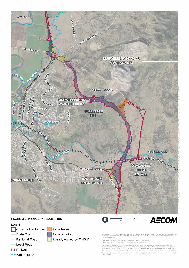
3.6 Property acquisition
Based on the concept design and subject to negotiations in accordance with the Land Acquisition (Just
Terms Compensation) Act 1991 (NSW) and the reforms announced in October 2016 (NSW Government
2016), the acquisition or temporary lease of the properties in Table 3-7 would be required. These properties
are shown on Figure 3-7.
New England Highway bypass of Muswellbrook
Review of Environmental Factors
45
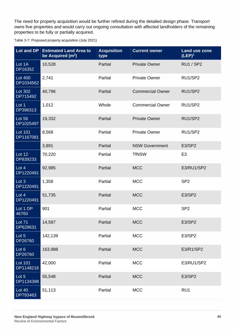
The need for property acquisition would be further refined during the detailed design phase. Transport
owns five properties and would carry out ongoing consultation with affected landholders of the remaining
properties to be fully or partially acquired.
Table 3-7: Proposed property acquisition (July 2021)
Lot and DP Estimated Land Area to be Acquired (m2)
Acquisition type
Current owner Land use zone (LEP)1
Lot 1A DP16352
10,528 Partial Private Owner RU1 / SP2
Lot 400 DP1034562
2,741 Partial Private Owner RU1/SP2
Lot 302 DP715492
40,796 Partial Commercial Owner RU1/SP2
Lot 1 DP396313
1,012 Whole Commercial Owner RU1/SP2
Lot 56 DP1025497
19,332 Partial Private Owner RU1/SP2
Lot 101 DP1167081
8,568 Partial Private Owner RU1/SP2
- 3,891 Partial NSW Government E3/SP2
Lot 12 DP839233
70,220 Partial TfNSW E3
Lot 4 DP1220491
92,985 Partial MCC E3/RU1/SP2
Lot 3 DP1220491
1,358 Partial MCC SP2
Lot 4 DP1220491
51,735 Partial MCC E3/SP2
Lot 1 DP 46760
901 Partial MCC SP2
Lot 71 DP629631
14,587 Partial MCC E3/SP2
Lot 5 DP26760
142,139 Partial MCC E3/SP2
Lot 6 DP26760
163,988 Partial MCC E3/R1/SP2
Lot 101 DP1148216
42,000 Partial MCC E3/RU1/SP2
Lot 5 DP1134398
55,548 Partial MCC E3/SP2
Lot 40 DP793463
51,113 Partial MCC RU1
New England Highway bypass of Muswellbrook
Review of Environmental Factors
46

Lot and DP Estimated Land Area to be Acquired (m2)
Acquisition type
Current owner Land use zone (LEP)1
Lot 1 DP249566
217,065 Partial MCC RU1/SP2
Lot 1 DP449384
Note 1:
532
Muswellbrook LEP 2009
Partial TfNSW (Sydney Trains)
SP2
New England Highway bypass of Muswellbrook
Review of Environmental Factors
47