New Orleans and Hurricane Katrina.II: The Central Region and the Lower Ninth WardR. B. Seed, M.ASCE;1; R. G. Bea, F.ASCE2; A. Athanasopoulos-Zekkos, S.M.ASCE3;G. P. Boutwell, F.ASCE4; J. D. Bray, F.ASCE5; C. Cheung, M.ASCE6; D. Cobos-Roa7;
L. Ehrensing, M.ASCE8; L. F. Harder Jr., M.ASCE9; J. M. Pestana, M.ASCE10; M. F. Riemer, M.ASCE11;J. D. Rogers, M.ASCE12; R. Storesund, M.ASCE13; X. Vera-Grunauer, M.ASCE14; and
J. Wartman, M.ASCE15
Abstract: The failure of the New Orleans regional flood protection systems, and the resultant catastrophic flooding of much of NewOrleans during Hurricane Katrina, represents the most costly failure of an engineered system in U.S. history. This paper presents anoverview of the principal events that unfolded in the central portion of the New Orleans metropolitan region during this hurricane, andaddresses the levee failures and breaches that occurred along the east–west trending section of the shared Gulf Intracoastal Waterway/Mississippi River Gulf Outlet channel, and along the Inner Harbor Navigation Channel, that affected the New Orleans East, the St.Bernard Parish, and the Lower Ninth Ward protected basins. The emphasis in this paper is on geotechnical lessons, and also broaderlessons with regard to the design, implementation, operation, and maintenance of major flood protection systems. Significant lessonslearned here in the central region include: �1� the need for regional-scale flood protection systems to perform as systems, with the variouscomponents meshing well together in a mutually complementary manner; �2� the importance of considering all potential failure modes inthe engineering design and evaluation of these complex systems; and �3� the problems inherent in the construction of major regionalsystems over extended periods of multiple decades. These are important lessons, as they are applicable to other regional flood protectionsystems in other areas of the United States, and throughout much of the world.
DOI: 10.1061/�ASCE�1090-0241�2008�134:5�718�
CE Database subject headings: Louisiana; Hurricanes; Floods; Failures.
Introduction
This paper is the second of a series of companion papers thattogether present a number of the principal results of an investiga-tion of the performance of the New Orleans regional flood pro-tection systems during and after Hurricane Katrina, which struckthe New Orleans region on August 29, 2005. A more completereport on these studies by the Independent Levee InvestigationTeam �ILIT� can be found in ILIT �2006� and Seed et al. �privatecommunication, 2008�. This paper addresses events that unfolded
1Professor of Civil and Environmental Engineering, Univ. of Califor-nia, Berkeley, CA.
2Professor of Civil and Environmental Engineering, Univ. of Califor-nia, Berkeley, CA.
3Doctoral Candidate, Dept. of Civil and Environmental Engineering,Univ. of California, Berkeley, CA.
5Professor of Civil and Environmental Engineering, Univ. of Califor-nia, Berkeley, CA.
6Engineer I, PB Americas Inc., San Francisco, CA.7Engineer, URS Corp., Oakland, CA.8Engineer, URS Corp., Oakland, CA.9Senior Water Resources Technical Advisor, HDR Inc., Folsom, CA.10Professor of Civil and Environmental Engineering, Univ. of Califor-
nia, Berkeley, CA.11
Professor of Civil and Environmental Engineering, Univ. of Califor-
718 / JOURNAL OF GEOTECHNICAL AND GEOENVIRONMENTAL ENGINE
in the central part of the devastated region, producing levee fail-ures and breaches along the east–west trending combined Missis-sippi River Gulf Outlet �MRGO�/Gulf Intracoastal Waterway�GIWW� channel and along the Inner Harbor Navigation Channel�IHNC�.
New Orleans is situated mainly between Lake Pontchartrain tothe north, the Mississippi River to the south, and Lake Borgne,immediately to the east. Fig. 1 shows the three main protected“polders” or levee-protected basins of the New Orleans metro-politan area: �1� the New Orleans East protected basin; �2� the St.
nia, Berkeley, CA.12Hasselmann Professor of Geological Engineering, Missouri Univ. of
Bernard and Lower Ninth Ward protected basin; and �3� the main�“downtown”� Orleans East Bank metropolitan basin. Fig. 1 alsoshows the locations of levee failures �breaches�, partial breaches,and incipient failures that occurred in this region. The closed starswithin circles in Fig. 1 show the locations of levee breachesand/or floodwall failures, and the open stars without circles showthe locations of partial breaches and/or significant levee distress.The �’s in Fig. 1 show the locations of deliberate “notches” inthe levees that were created after the storm had passed to facilitateoutward drainage of floodwaters from within the flooded basins.
Phase Three: Storm Surge and Failures in theCentral Region
The catastrophic flooding produced by Hurricane Katrina un-folded progressively in four main phases as the storm advanced.The first two phases were discussed in the preceding companionpaper in this series �Seed et al. 2008a�. These were: �1� the inun-dation of Plaquemines Parish �on the lower reaches of the Mis-sissippi River south of St. Bernard Parish, just to the south of themap of Fig. 1�; and then �2� the extensive erosional failures alongthe east flank of the regional flood protection system as the stormsurge first inflated the waters of Lake Borgne and then the stormsurge and wind-driven waves passed both over and through theLake Borgne frontage levees �as indicated by dashed arrows inFig. 1�.
This paper discusses the third phase of the storm as the swol-len waters of Lake Borgne were pushed westward along the east–west trending GIWW/MRGO channel. This combined channel
Fig. 1. Map schematically illustrating the lateral flow from Lake Borgin the IHNC region and vicinity
forms a “T” intersection at its western end where it meets the
JOURNAL OF GEOTECHNICAL AN
north–south trending Inner Harbor Navigation Channel �IHNC�.The south end of the IHNC is closed off by a navigational lockjust to the south of Location “D” in Fig. 1 �providing controlledaccess to the main Mississippi River�, so the storm surge flowfrom Lake Borgne into the IHNC raised the water levels withinthe IHNC and then flowed north into Lake Pontchartrain. Thisprecipitated the third phase of the disaster, as numerous failuresand breaches occurred along the banks of the GIWW/MRGO andIHNC channels.
Fig. 2 shows a hydrograph of water elevations produced at fivelocations within the IHNC waterway as the storm surge waspushed westward from Lake Borgne through both the GIWW/MRGO and IHNC channels �IPET 2007�. The storm surge rose ata moderate pace until it reached an elevation of approximately+5 ft �MSL� at approximately 10:00 p.m. on August 28, then itrose more rapidly over the next 11 h to a maximum elevation ofapproximately +14 to +14.5 ft �MSL� at approximately 8:45 to9:00 a.m., after which it subsided relatively quickly. The dip inthe rising hydrograph at one of the stations �where Highway I-10Bridge crosses the IHNC� and the partial dip in a second gauge�also adjacent to the I-10 Bridge� were caused by a localizedtemporary drawdown due to the occurrence of a breach in thatvicinity at approximately 5:00 a.m. The Highway I-10 Bridge islocated immediately north of the two breaches labeled as Points Aand B in Fig. 1. These two breaches are the most likely candidatesfor the source of this localized drawdown, and they are associatedwith penetrations of a rail line through the levee perimeter onboth sides of the IHNC. The localized and temporary drawdowndid not appear to extend far from the I-10 bridge, and it is the
he IHNC, and showing the locations of breaches and partial breaches
ne to t
gauge levels without dips, representing conditions farther to the
south within the IHNC, that will be the principal basis for discus-sions in the sections that follow.
Failures along the GIWW/MRGO and IHNC Channels
The surge through the GIWW/MRGO and IHNC channels pro-duced numerous breaches and partial breaches along both of thesewaterways. The following sections discuss key features commonto some of the most important types of failures, and then presenta more detailed examination of two catastrophic failures that oc-curred at the west end of the Lower Ninth Ward.
Failures at Transitions
A majority of the failures along these two waterways occurred attransitions between two separate sections of the flood protectionsystem, usually built at separate times as independent projects. Atleast 21 failures �breaches� and 10 additional partial failures oc-curred at such transitions �ILIT 2006; IPET 2006, Vol. V; ERP2007; Van Heerden et al. 2006�.
Fig. 3 shows a straightforward example of a transition betweena full height earthen levee embankment section adjoining a half-height earthen embankment section topped by a sheetpile-supported concrete I-wall �floodwall�. The elevation of the top ofthe I-wall shown on the left of Fig. 3 is approximately 1 ft higherthan the top of the adjoining full-height earthen levee section. Itwas observed that the sections with significant “structural compo-nents” �e.g., concrete floodwalls, concrete gate structures withsteel floodgates� consistently had slightly higher top elevationsthan adjoining earthen embankment sections �Baumy, privatecommunication, 2005; ILIT 2006�. The two adjoining and well-performing sections �levee reaches� in Fig. 3 are connected by atransition section that consists of a simple sheetpile wall section.The height of the top of this sheetpile wall is lower than either ofthe two adjoining levee or levee/floodwall sections, and overtop-ping thus occurred preferentially at this low spot. This overtop-
Fig. 2. Hydrographs showing measured �and photographed� w
ping flow eroded �scoured� a trench behind the back side of the
720 / JOURNAL OF GEOTECHNICAL AND GEOENVIRONMENTAL ENGINE
sheetpile wall, and the lateral force of the floodwaters then pushedback against the now inadequately laterally supported sheetpilewall and produced the failure shown.
Failures at such transitions were common in this area and inother areas as well �e.g., Plaquemines Parish�. Sixteen of the ap-proximately nineteen full breaches and partially developedbreaches along the GIWW/MRGO and IHNC waterways oc-curred at transitions between two flood defense sections; usuallywhere structural sections joined with earthen embankments �ILIT2006�. There is clearly a need to recognize that these are floodprotection systems, and that individual segments and componentsshould combine seamlessly into an overall defense that does nothave localized points of weakness �ILIT 2006; ERP 2007�. Simi-larly, there is a need to place additional emphasis on the engineer-
evels at gange stations along the IHNC �IPET 2007, Vol. V�
Fig. 3. An example of one of the numerous failures �breaches� thatoccurred at “transitions” between disparate, adjoining flood systemelements. �From left to right: concrete floodwall, sheet pile wall, andearthen levee.�
ing design and construction of such transitions, as more than halfof the approximately 53 breaches that occurred throughout thefull region during this overall event occurred at transitions �ILIT2006�.
Failures at Penetrations
One of the reasons for many of the transitions between differingtypes of adjoining flood protection system elements is penetra-tions, i.e., locations where a utility, pipe, roadway, rail line, orsecondary navigable channel pass through the protective perim-eter. This is often accomplished by means of gated concrete struc-tures; or floodwalls with openings for rolling or hinged steelfloodgates that can be closed during storm surges. These penetra-tions often pose an additional set of difficulties as they oftenrepresent locations where a collection of differing interests anddiffering authorities converge with overlapping responsibilities.
Seven of the failures and breaches, and six more of the partialfailures, in this central region occurred at such penetrations/transitions, and there were at least nine additional failures at suchpenetrations/transitions at other locations throughout the overallregion during this event �ILIT 2006; IPET 2007, Vol. V�. Two ofthe most disappointing failures during Hurricane Katrina were theeast bank and west bank crossings of the IHNC waterway by theCSX rail line �the two breaches indicated as Points A and B inFig. 1�. These same two sites had also failed previously duringHurricane Betsy in 1965, and so represented a failure to learnfrom that previous disaster.
The west bank crossing of the rail line �Point A in Fig. 1�represents an excellent example of the difficulties associated withcomplex penetrations. Fig. 4�a� shows the main breach at the siteof the penetration of the rail line across the crest of the levee onthe west bank of the IHNC, immediately to the south of the High-way I-10 Bridge. This photograph is taken looking east towardthe IHNC, and the elevated Highway I-10 Bridge can be seen inthe top left of the photograph. The rail line is adjacent to thehighway bridge at ground level at the left of the photograph, andthe steel drawbridge for the rails is in the raised position in theupper center of the photograph. At the time of this photograph,the breach had been partially repaired, and the newly compactedfill in the immediate foreground is infilling part of the originalbreach.
This is a complex multiple penetration, with the Highway I-10Bridge crossing over the federal levee system immediately to thenorth of the rail crossing �at the left of the photograph�, the railline crossing over the top of the earthen levee and then crossingover a steel drawbridge �which is in a raised position at the centerof the photo�, and a road passing over the crest of the leveeimmediately adjacent to the rail line �the partially destroyed as-phalt pavement at the right of the photograph� to provide accessto Port of New Orleans facilities on the outboard �water� side ofthe federal levees. At least five agencies and bodies have mutuallyoverlapping interests and jurisdictions at this site; the U.S. ArmyCorps of Engineers �USACE�, the local levee board, the StateHighway Department, the rail line, and the Port of New Orleans.In the course of our investigation, we were unable to determinewho, if anyone, was in overall charge at this location prior toHurricane Katrina’s arrival.
The main failure and breach at this site occurred as a result ofadverse interaction between the rail line and the adjacent portaccess roadway. The low spot at this site with regard to passage ofwater was the base of the pervious gravel ballast beneath the
railroad tracks. Flow through this ballast appears to have eroded
JOURNAL OF GEOTECHNICAL AN
the soils beneath the adjacent port roadway. These soils consistedof poorly compacted, and highly erodeable, lightweight shellsands as evidenced by the eroded detritus strewn back behind thebreach and by the material still in place beneath the partiallydestroyed asphalt cement pavement section shown in the photo-graph of Fig. 4�a� �ILIT 2006�. As discussed in a companionpaper �Seed et al. 2008a�, these lightweight shell sand mixes,comprised of small mollusk shells and fine sands, are highlyerodeable and represent an intrinsic hazard, especially when theyare not provided with slope face protection to prevent risk oferosion due to frontal wave attack and overtopping and internalcut-offs to prevent through-flow. Conversely, the main �federal�levee embankment section was built with superior materials�compacted clay�, but the USACE did not appear to have controlof the selection of fill immediately beneath the roadway section.
A second problem occurred just to the left of the photograph ofFig. 4�a�, immediately to the left of the person in Fig. 4�a�, wherethe rail line passes through a concrete gatewall with a rolling steelfloodgate. This location is shown in Fig. 4�b�, this time lookingwest �away from the IHNC�. The rail line passes through a con-crete gatewall structure, and the people in this image are standingin the center of the gateway. A rolling steel floodgate is supposedto close this opening, but the steel floodgate had been damaged bya minor rail accident several months prior to Hurricane Katrina’s
Fig. 4. �a� Breach at a complex “penetration” through the federallevee system at the west bank crossing of the IHNC waterway by theCSX rail line; �b� concrete floodgate structure at the west bank IHNCcrossing of the CSX Rail line
arrival and had been taken away for repairs. An emergency levee
crest section was erected across the opening in the concrete gate-wall using sandbags prior to Katrina’s arrival, but it washed outduring the storm, leaving another void in the perimeter defenses.
The lessons here are obvious, but they are also important.Penetrations are challenging both because they require transitionsbetween different adjoining system elements and also because ofoverlapping interests and jurisdictions. If regional flood protec-tion systems are to function safely and reliably, one organizationshould be in overall charge at such sites, and they must havesufficient authority to impose successful overall engineering so-lutions on behalf of public safety and the greater common good.Special attention should be paid to penetrations to ensure a reli-able overall system of flood protection.
Partially Developed Breaches
A large number of partially developed breaches occurred alongthe IHNC waterway, especially on the east bank of the IHNC atthe west end of the New Orleans East protected basin. Most ofthese were erosional features where concrete floodwalls �oftengatewalls for rolling steel floodgates� joined with earthen em-bankment sections. Erosion at the wall/embankment contacts,often at both ends of the gatewalls, was common. It should benoted that these partially developed breaches each began to erodeand scour, but then the scouring stopped before a major breachcould be fully eroded through the defenses. In our opinion, eachof these partially developed breaches appeared to be capable ofprogressing to become a full breach, but they did not do so; inpart because the New Orleans East protected basin was alreadyinfilling rapidly with floodwaters from numerous additionalbreaches at other locations, so that the inboard and outboard waterlevels had partially equilibrated before further scour occurred.Thus, most of these partially developed breaches were of littleactual consequence in this disastrous event, but each might poten-tially have become features of greater significance if other, worsefailures and breaches had not already occurred at other locations.
Lower Ninth Ward
The two most significant breaches that occurred in the centralregion were located on the east bank of the IHNC, at the west endof the Lower Ninth Ward.
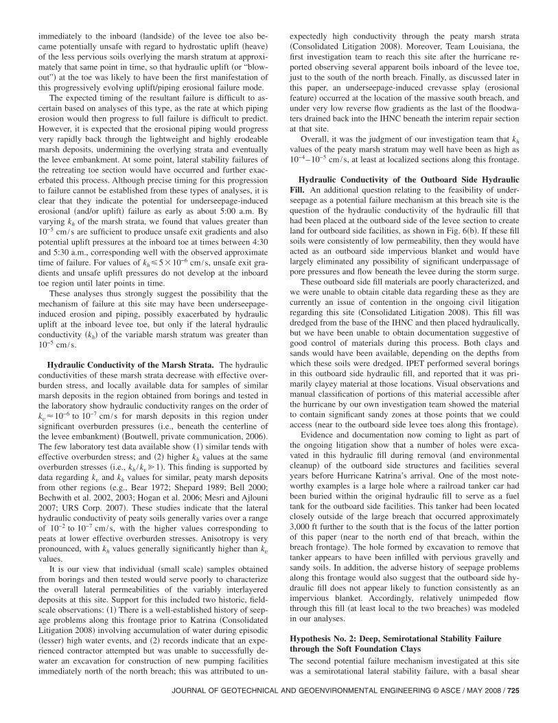
North Breach on the IHNC at the Lower Ninth Ward
The first of these two breaches to occur was the north breach �atLocation C in Fig. 1�. Based on timing established by “stoppedclocks” in the adjacent neighborhood and by an eyewitness, thisbreach occurred at approximately 5:30 a.m. �Van Heerden et al.2006; IPET 2007, Vol. V; Consolidated Litigation 2008�. Theeyewitness saw the breach from a vantage point to the northwestand was looking across the waters of the IHNC, and hence hecould not see what was occurring at the inboard �land� side of thelevee and floodwall immediately prior to the breach.
Fig. 5 shows an aerial view of this feature. The levee runsfrom left to right across this photograph and the inboard side�landside� is at the bottom. This photograph was taken on October5, 2006, and the interim outboard side repair embankment is near-ing completion. The narrow, trench-like erosional channelthrough the breach has also been largely infilled at the time of thisphotograph. The toppled sheetpiles that had supported the con-
crete I-wall at this location can be seen just behind the nearly
722 / JOURNAL OF GEOTECHNICAL AND GEOENVIRONMENTAL ENGINE
completed interim repair section. This was a relatively narrowfeature, less than 90 ft in width, and unlike the more massivesecond failure that occurred approximately 3,000 ft to the south�as discussed in the section that follows� there was no evidence ofsustained overtopping adjacent or near to this feature �ILIT 2006�.The full depth of the breach feature was not determined prior tothe commencement of emergency repairs.
Fig. 6�a� shows a cross section through this breach site, asmodeled in the finite-element and limit equilibrium analyses. Thecross section is based on two pre-Katrina borings located in closeproximity to the breach performed for the original design studies,five borings and one CPTU probe performed by the IPET �2006�investigation, and two borings and one cone penetration test�CPTU� probe performed as part of our ILIT �2006� studies. Ad-ditional borings and CPT probes are available farther south alongthis frontage to further define stratigraphic units and their engi-neering properties.
As shown in this figure, the top of the concrete floodwall oc-curs at approximately Elev. +12.7 ft �MSL�, and the steel sheet-pile curtain supporting the concrete I-wall is tipped with its baseextending to approximately Elev. −8 ft �MSL�. The embankmentcrest occurs at an elevation of approximately +7.5 ft �MSL�, andthe levee embankment itself consists primarily of moderatelycompacted reddish brown clay fill. The embankment is underlainby marsh/swamp clays of relatively high plasticity �CH�. Theseclayey swamp materials are underlain by a stratum of variablemarsh deposits ranging from approximately 9 to 12 ft in thick-ness. These highly variable materials include peat deposits andvariably interlayered clays and silts. The upper portion of thesemarsh deposits is more fibrous and peaty, and these are called outseparately in Fig. 6�a� as the “upper marsh” stratum. The peatswithin the lower portion of the marsh stratum are generally moredecomposed, but consist of similarly intermixed layers and lensesof peats, silts, and clays. The marsh stratum is, in turn, underlainby a relatively deep 30 ft thick layer of soft, light gray lacustrineor interdistributary clays of relatively high plasticity �CH�. Theseare underlain by older beach sands and clays �Rogers et al. 2008�,which represent stronger and more competent soils relative to theweaker overlying soil strata, and these older soil units were notinvolved in the failure �ILIT 2006�. Figs. 6�a and b� also show therelatively extensive dredged hydraulic fill placed at the outboardside of the levee to create additional land for facilities on theoutboard �water� side; these facilities had been abandoned andremoved in the years prior to the hurricane.
Hypothesis No. 1: Underseepage-Induced Piping or BlowoutOne of the potential types of failure modes examined at this sitewas underseepage-induced failure due to either �1� piping anderosion, or �2� hydraulic uplift/heaving �or “blowout”� at the in-board toe. Transient flow analyses were performed using thefinite-element program SEEP/W �Krahn 2004�. Fig. 6�b� showsthe finite-element mesh used for transient flow seepage analysesand Table 1 summarizes the parameters used to characterize theseepage characteristics of the critical strata. These parameters arebased primarily on local experience and data from these soils,consideration of local practice, experience with similar soils inother regions, and engineering judgment. It was assumed in theseanalyses that the soils beneath the upper, compacted levee fillwere saturated before the final relatively sharp rise in IHNC waterlevels began at about 10 p.m. on August 28, so that changes inpore pressure were essentially a pore pressure pulse, rather than
requiring the passage of a large volume of water. The through-
passage of water pressures was further enhanced by the fact thatthe peaty marsh strata were partially capped by the less perviousoverlying clayey swamp/marsh soils.
As shown in Fig. 6, the relatively short sheetpiles supportingthe concrete floodwall along this frontage had been designed ascantilever support for the floodwall, and not as an underseepagecut-off, as it was assumed that the permeabilities of the founda-tion soils were sufficiently low that there would not be significanttransmission of pore pressures beneath the floodwall during therelatively short duration of a hurricane-induced storm surge in theIHNC channel �USACE 1966�. As a result, the sheetpiles did notextend deeply enough to cut off potential flow through the vari-ably peaty upper marsh stratum.
The lateral �horizontal� hydraulic conductivity �kh� of thesepeaty marsh deposits is thus a potentially critical issue here. Thehydraulic conductivity of these layered marsh deposits is knownto be highly anisotropic, and varies considerably as a function ofcomposition, layering, and effective overburden stress. Unfortu-nately, it is the opinion of our investigation team that the “macro”scale seepage characteristics of these variably interbedded unitscannot currently be satisfactorily characterized �at full field scale�with existing laboratory data. A parametric study was conducted,in which the kh values were varied from 10−3 to 10−6 cm /s �Table
Fig. 5. �Color� Aerial view of the north breach on the ea
1� to investigate: �1� the sensitivity of the calculated �time-
JOURNAL OF GEOTECHNICAL AN
dependent� propagation of underseepage-induced pore pressuresto these variations; and �2� the ranges of kh that might provecritical for this site. Ranges of anisotropy of horizontal versusvertical hydraulic conductivities �i.e., kh /kv� of 10:1 to 50:1 wereconsidered, but it was found that the horizontal conductivity wasthe dominant factor, and that variations in the anisotropy over thisrange had only a small effect on the results. The analyses reportedin this paper use kh /kv=10:1 for these marsh units �ILIT 2006�.
These transient flow analyses modeled the progressive rise instorm surge levels over the 24 h preceding the failure. Fig. 6�c�shows a close-up view of calculated seepage exit gradients asthey would have existed at approximately 5:30 a.m. �with a canalwater level of Elev. +10.5 ft, MSL� if the representative lateralhydraulic conductivity of the peaty marsh stratum had been kh
=10−4 cm /s. This figure also shows the seepage gradient vectors;indicating that the principal passage of flow/pressure is throughthe marsh stratum, with high gradient vectors occurring aroundthe base of the sheetpile curtain. For this particular scenario, exitgradients had become unsafe with regard to initiation of erosionand piping at an earlier stage of this analysis, with exiting gradi-ents at and near to the inboard side levee toe reaching valuesgreater than 0.6 �sufficient to begin piping for some of the light-weight soils in the toe region� as early as 4:30 to 5:00 a.m. In
of the IHNC, at the west end of the Lower Ninth Ward
st bank
addition, the pore pressures beneath the thin surficial clay stratum
Silt and mixed organics N/A 85 10−5 10−6 �Su /�v��NC,DSS�0.22, and ��0.8 — — 2
Soft gray clay �bay sound� N/A 105 10−6 10−7 �Su /�v��NC,DSS�0.24, and ��0.78 — — VariesaOCR varies laterally across the domain as a function of overburden stress, and also varies over depth within these deposits.bThe horizontal permeabilities of the marsh deposits were varied over a range of Kh=10−3–10−6 cm /s in these studies, and vertical permeabilities weremodeled as being between 10 and 20 times higher than horizontal permeabilities. For these finite-element analyses, the marsh permeabilities and canalwater elevations were adjusted to provide pore pressures beneath the inboard levee toe approximately equal to those calculated in the transient seepage
Fig. 6. �a� Cross section for analysis of the north breach, IHNC at the west end of the Lower Ninth Ward; �b� finite-element mesh for analysisof the north breach, IHNC at the west end of the Lower Ninth Ward; and �c� transient flow seepage analysis results showing equipotential lines�1 ft contours�, seepage flow vectors, and exit gradients at 5:30 a.m., based on a lateral coefficient of permeability of the upper marsh strata ofkh=10−4 cm /s
analyses performed separately by the finite-difference method.
immediately to the inboard �landside� of the levee toe also be-came potentially unsafe with regard to hydrostatic uplift �heave�of the less pervious soils overlying the marsh stratum at approxi-mately that same point in time, so that hydraulic uplift �or “blow-out”� at the toe was likely to have been the first manifestation ofthis progressively evolving uplift/piping erosional failure mode.
The expected timing of the resultant failure is difficult to as-certain based on analyses of this type, as the rate at which pipingerosion would then progress to full failure is difficult to predict.However, it is expected that the erosional piping would progressvery rapidly back through the lightweight and highly erodeablemarsh deposits, undermining the overlying strata and eventuallythe levee embankment. At some point, lateral stability failures ofthe retreating toe section would have occurred and further exac-erbated this process. Although precise timing for this progressionto failure cannot be established from these types of analyses, it isclear that they indicate the potential for underseepage-inducederosional �and/or uplift� failure as early as about 5:00 a.m. Byvarying kh of the marsh strata, we found that values greater than10−5 cm /s are sufficient to produce unsafe exit gradients and alsopotential uplift pressures at the inboard toe at times between 4:30and 5:30 a.m., corresponding well with the observed approximatetime of failure. For values of kh�5�10−6 cm /s, unsafe exit gra-dients and unsafe uplift pressures do not develop at the inboardtoe region until later points in time.
These analyses thus strongly suggest the possibility that themechanism of failure at this site may have been underseepage-induced erosion and piping, possibly exacerbated by hydraulicuplift at the inboard levee toe, but only if the lateral hydraulicconductivity �kh� of the variable marsh stratum was greater than10−5 cm /s.
Hydraulic Conductivity of the Marsh Strata. The hydraulicconductivities of these marsh strata decrease with effective over-burden stress, and locally available data for samples of similarmarsh deposits in the region obtained from borings and tested inthe laboratory show hydraulic conductivity ranges on the order ofkv�10−6 to 10−7 cm /s for marsh deposits in this region undersignificant overburden pressures �i.e., beneath the centerline ofthe levee embankment� �Boutwell, private communication, 2006�.The few laboratory test data available show �1� similar tends witheffective overburden stress; and �2� higher kh values at the sameoverburden stresses �i.e., kh /kv�1�. This finding is supported bydata regarding kv and kh values for similar, peaty marsh depositsfrom other regions �e.g., Bear 1972; Shepard 1989; Bell 2000;Bechwith et al. 2002, 2003; Hogan et al. 2006; Mesri and Ajlouni2007; URS Corp. 2007�. These studies indicate that the lateralhydraulic conductivity of peaty soils generally varies over a rangeof 10−2 to 10−7 cm /s, with the higher values corresponding topeats at lower effective overburden stresses. Anisotropy is verypronounced, with kh values generally significantly higher than kvvalues.
It is our view that individual �small scale� samples obtainedfrom borings and then tested would serve poorly to characterizethe overall lateral permeabilities of the variably interlayereddeposits at this site. Support for this included two historic, field-scale observations: �1� There is a well-established history of seep-age problems along this frontage prior to Katrina �ConsolidatedLitigation 2008� involving accumulation of water during episodic�lesser� high water events, and �2� records indicate that an expe-rienced contractor attempted but was unable to successfully de-water an excavation for construction of new pumping facilities
immediately north of the north breach; this was attributed to un-
JOURNAL OF GEOTECHNICAL AN
expectedly high conductivity through the peaty marsh strata�Consolidated Litigation 2008�. Moreover, Team Louisiana, thefirst investigation team to reach this site after the hurricane re-ported observing several apparent boils inboard of the levee toe,just to the south of the north breach. Finally, as discussed later inthis paper, an underseepage-induced crevasse splay �erosionalfeature� occurred at the location of the massive south breach, andunder very low reverse flow gradients as the last of the floodwa-ters drained back into the IHNC beneath the interim repair sectionat that site.
Overall, it was the judgment of our investigation team that kh
values of the peaty marsh stratum may well have been as high as10−4–10−5 cm /s, at least at localized sections along this frontage.
Hydraulic Conductivity of the Outboard Side HydraulicFill. An additional question relating to the feasibility of under-seepage as a potential failure mechanism at this breach site is thequestion of the hydraulic conductivity of the hydraulic fill thathad been placed at the outboard side of the levee section to createland for outboard side facilities, as shown in Fig. 6�b�. If these fillsoils were consistently of low permeability, then they would haveacted as an outboard side impervious blanket and would havelargely eliminated any possibility of significant underpassage ofpore pressures and flow beneath the levee during the storm surge.
These outboard side fill materials are poorly characterized, andwe were unable to obtain citable data regarding these as they arecurrently an issue of contention in the ongoing civil litigationregarding this site �Consolidated Litigation 2008�. This fill wasdredged from the base of the IHNC and then placed hydraulically,but we have been unable to obtain documentation suggestive ofgood control of materials during this process. Both clays andsands would have been available, depending on the depths fromwhich these soils were dredged. IPET performed several boringsin this outboard side hydraulic fill, and reported that it was pri-marily clayey material at those locations. Visual observations andmanual classification of portions of this material accessible afterthe hurricane by our own investigation team showed the materialto contain significant sandy zones at those points that we couldaccess �near to the outboard side levee toes along this frontage�.
Evidence and documentation now coming to light as part ofthe ongoing litigation show that a number of holes were exca-vated in this hydraulic fill during removal �and environmentalcleanup� of the outboard side structures and facilities severalyears before Hurricane Katrina’s arrival. One of the most note-worthy examples is a large hole where a railroad tanker car hadbeen buried within the original hydraulic fill to serve as a fueltank for the outboard side facilities. This tanker had been locatedclosely outside of the large breach that occurred approximately3,000 ft further to the south that is the focus of the latter portionof this paper �near to the north end of that breach, within thebreach frontage�. The hole formed by excavation to remove thattanker appears to have been infilled with pervious gravelly andsandy soils. In addition, the adverse history of seepage problemsalong this frontage would also suggest that the outboard side hy-draulic fill does not appear likely to function consistently as animpervious blanket. Accordingly, relatively unimpeded flowthrough this fill �at least local to the two breaches� was modeledin our analyses.
Hypothesis No. 2: Deep, Semirotational Stability Failurethrough the Soft Foundation ClaysThe second potential failure mechanism investigated at this site
was a semirotational lateral stability failure, with a basal shear
surface passing primarily through the soft gray clays underlyingthe upper marsh deposits. This failure mechanism was also inves-tigated by the IPET investigation; however, the approaches takento characterize the shear strength characteristics of the deep layerof soft gray clays by the investigation teams differed in severalways including: �1� weighting of available laboratory �UU-TX�versus field test �CPTU� data; �2� procedures for addressing theeffects of variations in effective overburden stresses at variouslocations at and near to the inboard side levee toe; and �3� ourinvestigation found the clay stratum to be significantly overcon-solidated at its top �apparently due to desiccation� and moderatelyoverconsolidated near its base, while the IPET interpretation con-sidered the unit to be normally consolidated throughout.
Seed et al. �2008c� presents a detailed explanation of the pro-cesses used for derivation of shear strengths for these types ofclay and marsh strata at a site with very similar stratigraphy. Insummary, our approach recognized the problems and uncertain-ties associated with use of UU-TX data for these types of soils,and so concentrated initially on the use primarily of CPTU data.Site-specific and material-specific CPT tip factors �Nkt� were de-veloped for evaluation of undrained shear strengths for this clayunit, and the available CPT data �from the four profiles withinclosest proximity to the failure location� were then used to per-form an inverse �SHANSEP-type� regression as suggested byPestana to simultaneously develop estimates of the vertical pro-files of overconsolidation ratio �OCR� and undrained shearstrength �su� versus depth at various locations �ILIT 2006�. Goodagreement was found between these and apparent profiles of su
versus depth at various locations based on the conjugate UU-TXdata available from both the pre-Katrina investigations and thevarious post-Katrina investigations as well as with data fromother sites with similar materials �ILIT 2006�.
Beneath the levee crest, where the effective overburdenstresses were greatest due to the thick levee fill, the clay stratumwas found by our approach to be nearly normally consolidatedover most of its depth. However, the soil shear strengths beneaththe inboard side levee toe, and further inboard �beneath the free-field�, are most critical for this potential failure mode. In thiscritical region we found the clay stratum to have a significantoverconsolidation profile near the top �representative of a desic-cation profile due to periodic exposure during the progressivegeologic accretion of sediments at this site�, and the clay stratumwas also found to be moderately overconsolidated near its base;probably due to aging and secondary compression of the oldersoils near the bottom of the relatively thick stratum �ILIT 2006�.This profile was similar to the profile of the similar soft gray claydeposit at the 17th Street Canal breach site �Seed et al. 2008c�.
Our modeled ratio of su /�v� reflects the application of a num-ber of empirical adjustments to account for anisotropy and thedirect simple shear �DSS� conditions that would dominate thismode, and also for the sensitivity of these clays �ILIT 2006�.Specifically, we derived a ratio of �su /�v��NC,TX�0.31 for nor-mally consolidated material under triaxial conditions, after whichwe applied a set of empirical modifications for �1� stress path andanisotropy; and �2� sensitivity to develop an estimated ratio of�su /�v��NC,DSS�0.24 for the direct simple shear conditions domi-nant for this potential failure mode at this site. These empiricaladjustments were similar to those applied by the IPET investiga-tion. A SHANSEP coefficient of m�0.78 was used to define thevariation of �su /�v��DSS as a function of overconsolidation ratio�OCR�. These values of �su /�v��NC,DSS and m were found to be in
excellent agreement with data for similar materials compiled by
726 / JOURNAL OF GEOTECHNICAL AND GEOENVIRONMENTAL ENGINE
Ladd and DeGroot �2003�, and also with the results from similardeposits at other key sites in the New Orleans region.
The heavy black line in Fig. 7 shows a profile of �su /�v��DSS
used at a lateral location directly beneath the contact of the in-board side levee toe and the nearly horizontal adjacent groundsurface within this critical clay stratum in our own studies �theseprofiles continued to vary somewhat further beneath the levee,and further toward the inboard �free field� side, as a function ofvarying overburden stresses�. The heavy dashed line in Fig. 7shows the profile of su versus depth determined by our studies�prior to adjustments for DSS shear conditions�; this increaseslinearly versus depth in the middepth region where the clays arenormally consolidated, but this profile shows higher strengths atthe top and bottom of this clay stratum representing the variableOCR profiles in these zones. This strength profile is in goodagreement with the available UU-TX data. The heavy solid linethen shows the final profile of su versus depth, after empiricaladjustments �reductions�, that was actually used for the limit equi-librium stability analyses performed �and also for finite-elementanalyses as well�. The adjacent linear trend, showing strengthincreasing linearly versus depth, was the alternate interpretedstrength profile used in the corresponding IPET �2006� analyses.
Our characterizations of shear strengths in the marsh strata andin the overlying marsh/swamp strata also depended heavily on the
Fig. 7. ILIT model for shear strengths beneath the inboard side leveetoe; north breach, IHNC at the west end of the Lower Ninth Ward�adapted from IPET 2007, Vol. V�
use of CPTU data, and cross correlations with available empirical
relationships for similar soils at other locations. Once again, weperformed an inverse SHANSEP-based regression of the avail-able data, and concluded that these two upper units �the marshand the overlying marsh/swamp clays� both exhibited classicoverconsolidation profiles typical of “stands” during the progres-sive accretion of these deposits. Fig. 7 shows our strength model�at a location directly below the termination of the inboard sidelevee toe� for these units. These clearly show our interpretationregarding a classic pair of desiccation profiles in both units, andalso the somewhat lower strengths �the vertical lines in these twostrata in Fig. 7� used in the IPET analyses.
Table 2 summarizes the shear strength parameters used in limitequilibrium analyses of this potential semirotational failure modeby our studies. It is noted that both the IPET and ILIT usedsimilar properties to characterize the strengths of the engineeredlevee embankment fill, based on the limited UU-TX data avail-able, and that these do not significantly affect the results of thestability analyses as the embankment would have largely dis-placed monolithically atop a shear failure surface dominated bythe underlying soft clays in this hypothetical potential failuremode.
Both investigation teams performed limit equilibrium analysesto assess the factor of safety �FS� for a potential semirotationalfailure through these soft gray clays, and both assumed the for-mation of a water-filled gap on the outboard side of the sheetpiles/I-wall, between the sheetpiles and the soils, and applied full porepressures laterally against the sheetpiles/I-wall to push the in-board side of the levee embankment section toward the inboard�land� side. Our analyses were performed using Spencer’s method�1967�, with the computer program SLOPE/W �Krahn 2004�, andthe results for the critical surface were cross-checked both byhand and using the program UTEXAS4 �Wright 1999�.
Fig. 8 shows the most critical potential failure surface foundby our analyses for this potential deep, semirotational failuremode, and for an IHNC water level of Elev. +10.5 ft �MSL�; theconditions present at approximately 5:30 a.m. when the actualfailure occurred. The critical failure surface shown in Fig. 8 issimilar to the most critical failure surface found by the IPETstudies �IPET 2007�. Although both studies found similar geom-etries for the most critical potential failure surface, the calculatedlevels of stability differed somewhat between the two investiga-tions. Our characterization of strengths within the soft gray claysand overlying marsh and swamp strata, including the additionalstrength due to the overconsolidation profiles found within thesestrata, resulted in a somewhat higher calculated FS values whencompared to the IPET findings. We computed the factor of safetyfor the most critical failure surface of Fig. 8 to be approximatelyFS=1.18, for a canal water level of +10.5 ft, whereas IPET foundthe FS to be 1.03 for that same canal water level.
In addition, we note that these are two-dimensional planestrain analyses, and that they likely significantly underestimatethe actual three-dimensional �3D� factor of safety due to the un-usually narrow and deep shape of the actual field failure �lowaspect ratio� and the cohesive strength that would have been mo-bilized along the sides of this narrow feature. Our best estimate ofthe actual factor of safety is therefore approximately 5–10%higher, in order to account for these 3D effects, resulting in abest-estimated overall FS�1.24–1.30. This represents an appar-ently stable condition, but we acknowledge that uncertaintiesmight still have permitted the occurrence of such a deep rotationalfailure at this IHNC water level. Nevertheless, even if we con-
able
2.Su
mm
ary
ofSo
ilM
odel
Para
met
ers
Use
din
PLA
XIS
Ana
lyse
sfo
rth
eIH
NC
Sout
hB
reac
h�E
ast
Ban
k�
trat
umna
me
PLA
XIS
soil
mod
elSh
eari
ngty
pea
�un
sat
�pcf
��
sat
�pcf
�k h
�ft/d
ay�
k y�f
t/day
��
Ere
f�p
sf�
c ref
�psf
��
��d
eg�
ompa
cted
fill
�ML
�M
ohr
Cou
lom
bU
ndra
ined
N/A
115
0.00
280.
0002
80.
3523
4,00
090
00.
001
trat
umna
me
PLA
XIS
soil
mod
elSh
eari
ngty
pe�
unsa
t
�pcf
��
sat
�pcf
�k h
�ft/d
ay�
k y�f
t/day
��
*
*�
urK
o nc
Mc r
ef
�psf
��
��d
eg�
atp r
efd
OC
Rb
atcl
ay�C
H�
Soft
soil
Und
rain
edN
/A95
0.00
280.
0002
80.
170.
030.
150.
631.
240.
001
22va
ries
arsh
Soft
soil
Und
rain
edN
/A80
Var
iesc
Var
iesc
0.21
0.03
30.
150.
61.
90.
001
36va
ries
iltSo
ftso
ilU
ndra
ined
N/A
850.
030.
003
0.1
0.02
0.15
0.61
1.27
0.00
123
2
trat
umna
me
PLA
XIS
soil
mod
elSh
eari
ngty
pe�
unsa
t
�pcf
��
sat
�pcf
�k x
�ft/d
ay�
k y�f
t/day
��
Ere
f�p
sf�
c ref
�psf
��
��d
eg�
oft
gray
clay
�bay
soun
d�M
ohr
Cou
lom
bU
ndra
ined
N/A
105
0.00
280.
0002
80.
31,
000,
000
800
0.00
1
The
seso
ilsw
ere
mod
eled
as“d
rain
ed”
duri
ngco
nsol
idat
ion
unde
rth
eem
bank
men
tfil
llo
ads,
but
wer
eth
enm
odel
edas
“und
rain
ed”
duri
ngth
esh
ort-
dura
tion
load
ing
repr
esen
ted
byth
era
pid
stor
msu
rge
ise
with
inth
eca
nal.
OC
Rva
ries
late
rally
acro
ssth
edo
mai
nas
afu
nctio
nof
over
burd
enst
ress
,an
dal
sova
ries
over
dept
hw
ithin
thes
ede
posi
ts.
The
hori
zont
alpe
rmea
bilit
ies
ofth
em
arsh
depo
sits
wer
eva
ried
over
ara
nge
ofK
h=
10−
3–
10−
6cm
/sin
thes
est
udie
s,an
dve
rtic
alpe
rmea
bilit
ies
wer
em
odel
edas
bein
gbe
twee
n10
and
20tim
eshi
gher
han
hori
zont
alpe
rmea
bilit
ies.
For
thes
efin
ite-e
lem
ent
anal
yses
,th
em
arsh
perm
eabi
litie
san
dca
nal
wat
erel
evat
ions
wer
ead
just
edto
prov
ide
pore
pres
sure
sbe
neat
hth
ein
boar
dle
vee
toe
appr
oxim
atel
yqu
alto
thos
eca
lcul
ated
inth
etr
ansi
ent
seep
age
anal
yses
perf
orm
edse
para
tely
byth
efin
itedi
ffer
ence
met
hod.
Fric
tion
angl
efo
rso
ftso
ilm
odel
defin
edat
p ref
1
atm
.
sider only the two-dimensional FS of 1.18 for the critical failure
surface for this mechanism, we judge this to be less likely thanthe underseepage and piping mode of Hypothesis No. 1.
More important, it should be noted that the deep rotationalmode of failure would have become more critical if the levee andI-wall section had remained in place until the IHNC water levelreached its eventual peak within the IHNC at an elevation ofapproximately +14 ft, MSL. Our analyses indicate marginal sta-bility �FS�1� for this failure mode at that higher water stage.
Hypothesis No. 3: Translational Stability Failure due toUnderseepage-Induced Strength ReductionsThe third potential failure mechanism studied was a potential lat-eral translational instability, with shearing largely within the“marsh” due to the combined effects of: �1� lateral water pres-sures acting against the face of the sheetpiles/I-wall; and �2� re-duction in shear strengths at the top of the marsh stratum due tounderseepage-induced increases in pore pressures �and resultingdecreases in effective stress� at this location.
A detailed study and analysis of exactly this mode of potentialfailure is presented in the next section of this paper for the mas-sive second breach that occurred approximately 3,000 ft to thesouth �the South Breach�, and to save space readers are referred tothat section �which had very similar soils and stratigraphy� fordetails of this type of analysis. The important findings here were:�1� At each IHNC water level, and for each assumed value of kh,the potential failure mode of Hypothesis No. 1 �underseepage-induced piping and/or uplift and blowout� as discussed previouslyprovided a more critical situation �lower FS�, and �2� the analysesof this mode �underseepage-induced lateral translational instabil-ity� produced FS=1.11, 1.20, and 1.34 for canal water elevationsof +10.5 ft, MSL �the conditions at 5:30 a.m. when the breachoccurred� when coupled with values of kh=10−3, 10−4, and10−5 cm /s, respectively.
Based on these analyses, it was concluded that this potentialfailure mode could not be fully excluded, but that �like the modeof Hypothesis No. 2� it was a less likely mode than theunderseepage-induced erosional failure of Hypothesis No. 1.Similarly, once again this potential failure mode would have rep-resented a more critical condition if the section had remained inplace for another 3 h �until the peak rise in the IHNC to Elev.+14 ft, MSL at approximately 8:45 a.m.�, by which time factorsof safety of less than 1.0 would have occurred for this mode for
−5
Fig. 8. Calculated minimum factor of safety for deep, semirotationalwith surge height at Elev. +10.5 ft �MSL�
all values of kh�10 cm /s.
728 / JOURNAL OF GEOTECHNICAL AND GEOENVIRONMENTAL ENGINE
Summary of the Prevailing Failure Mechanism. As de-scribed in the preceding sections, it was our investigation’s con-clusion that three potentially feasible failure mechanisms werepresent and operating at this site, rendering the determination asto which mechanism occurred first and actually caused the failureto be somewhat challenging. The analyses presented wouldslightly favor the mechanism of Hypothesis No. 1 �underseepage-induced failure due to piping, likely exacerbated by initial upliftand blowout at the toe�, but these are not fully conclusive, due inlarge part to uncertainties associated with kh of the variable marshstrata. In the end, it is the confluence of these analyses, and theactual field observations, that should jointly form the basis forassessment of the most likely failure mechanism.
The mechanism of underseepage-induced uplift and erosionalpiping failure best fits the narrow geometry of the observed fail-ure �and closely matches the similarly narrow geometry of thefailure near the south end of the London Avenue Drainage Canal,which was also judged most likely to be an underseepage-inducedpiping failure; Seed et al. 2008b; IPET 2007�. The available fieldinformation and local observations regarding apparent permeabil-ity characteristics and the local history of underseepage problemsprior to Katrina also lend support for this mechanism. In addition,the other two potential mechanisms considered show higher �andapparently stable� FS values at the time �and water elevation� atwhich this failure occurred.
An underseepage-induced failure would require the flow �or atleast the pore water pressure� to defeat the apparent watersideblanket represented by the hydraulically placed fill at that loca-tion. Given the variable apparent nature of that fill, its relativelypoor documentation, voids apparently introduced during removalof structures and facilities prior to Katrina, and the history ofseepage problems along this frontage, it appears likely that theoutboard side hydraulic fill was not fully effective in preventingunderseepage along this full frontage.
Some debate and differences of opinion continue to persistwithin our investigation team, but the majority consensus is thatunderseepage-induced failure and piping �likely exacerbated byhydraulic uplift�, likely also exacerbated by localized evolution oflateral instability as the toe geometry progressively degraded, rep-resents the most promising overall candidate mode, and that the
at the north breach, IHNC at the west end of the Lower Ninth Ward
failure
other two modes �lateral semirotational instability failure through
the top of the soft gray clays, and lateral translational/semirotational instability due to underseepage-induced strengthloss� cannot be fully discounted.
South Breach on the IHNC at the Lower Ninth Ward
As shown in Fig. 1 �Location D�, a second massive failure andbreach occurred approximately 3,000 ft to the south of the breachdiscussed in the previous section. This was one of the largest andbest-known failures to occur during Hurricane Katrina. Thisbreach occurred at approximately 8:30 a.m., with the water levelin the adjacent IHNC at approximately +14 to +14.5 ft �MSL�.
Fig. 9 shows an oblique aerial view of this south breach, whichwas approximately 950 ft in length. A large barge was washed inthrough this very long feature, and is visible in this photographnear to the top of the image �just inboard of the south end of thebreach�. The toppled and displaced sheetpile wall is also clearlyvisible; the sheetpiles remained interlocked throughout the severeinflow and scour caused by the breach, and the sheetpile curtain�although stretched and extended to a length of approximately1,300 ft as the flanges were stretched and straightened out� is still
Fig. 9. �Color� Oblique view of the �south� levee breach a
contiguous over its full length. The concrete floodwall atop the
JOURNAL OF GEOTECHNICAL AN
sheetpiles could not match this level of extensile ductility so mostof the concrete I-wall panels spalled off of the top of the sheetpilecurtain during this failure.
As shown in the left half of the photograph of Fig. 9, theinboard side community was devastated by the heavy rush ofwater through this breach; the homes of the first several blockshave been stripped from their foundations and scattered across thecommunity. At the time of this photograph �September 30, 2006�,the initial interim closure embankment on the outboard side of thelarge breach had been largely completed �the lighter colored newembankment section in the right-center of the photograph�.
The first question to answer was whether the barge caused thebreach or was it drawn in through a breach that was already open.Fig. 10 shows a close-up view of the top of the concrete floodwallat the south end of the breach. The concrete floodwall along thetop of the sheetpile curtain across the full rest of the width of thislarge breach was largely spalled off of the tops of the sheetpiles inextension as the sheetpiles were pulled by extensile/tensile forces.The south end of the breach �Fig. 10� was the only location wherethe concrete floodwall was crushed by compressive impact. Inaddition, a large dent on the left side of the barge, near the bow,
nner Harbor Navigation Canal into the lower Ninth Ward
t the I
and a scrape on its base at that location, appeared to correlate well
with the south end impact site shown in Fig. 10. Finally, as de-scribed later, geo-forensic studies performed as part of our inves-tigation show that this section would have been expected to failwithout barge impact. It was concluded by this investigation thatthe barge was most likely drawn in through a breach that wasalready open, and that it impacted at the extreme south end of thebreach as it passed inland through the �already open� breach.
Fig. 11 shows a trench behind the concrete floodwall at thesouth end of the breach. This photograph is taken looking north,and the large barge can be seen in the background of this image.As canal waters overtopped and passed over the top of the flood-wall, they eroded this trench, reducing the lateral support for thefloodwall and its supporting piles. The IPET investigation �IPET2007, Vol. V� concluded that this directly caused the failure, asthe raised waters in the canal pushed the then insufficiently later-ally braced wall sideways toward the inboard �protected� side.
Fig. 12 shows a cross section through the breach section. Thetop of the concrete floodwall at this location is at approximatelyElev. +12.7 ft �MSL�. The foundation stratigraphy at this section
Fig. 10. Close-up view of crushed �impacted� concrete floodwall atthe south end of the south breach at the east bank of the IHNC at thewest end of the Lower Ninth Ward
Fig. 11. Eroded trench at the rear �inboard� side of the floodwall atthe south end of the south breach at the east bank of the IHNC at thewest end of the Lower Ninth Ward
730 / JOURNAL OF GEOTECHNICAL AND GEOENVIRONMENTAL ENGINE
is similar to that of the north breach discussed previously in thispaper. The clayey levee embankment sits atop primarily grayswamp/marsh clays �CH� with occasional plastic silt strata, butthere are two significant marsh deposits in the upper foundationas well. As shown in Fig. 12, the sheetpile curtain supporting theconcrete floodwall is again very short, with its base at Elev. −8 ft�MSL�, and fails to cut off flow through the second �main� marshlayer. As with the nearly adjacent north breach, the marsh layer isa variably interbedded layer of organic silts, clays, and peats. Thekh of this ensemble is variable, and there is a well-establishedhistory of underseepage problems along this overall levee front-age �ILIT 2006; Van Heerden et al. 2006; Consolidated Litigation2008�.
Transient flow analyses showed that the rising storm surge inthe canal was likely able to be at least partially transmitted tofoundation soils beneath the inboard side levee toe. The stormsurge rose slowly at first, cycling with tides over the several dayspreceding the storm’s arrival, and then the rate of water level riseincreased as the eye of the storm approached more closely, raisingwater levels from Elev. +4.5 ft to their full peak at approximatelyElev. +14 to +14.5 ft �MSL� over a 15 h period, and overtoppingthe concrete floodwall by a bit more than a foot. Finite-elementanalyses were performed, again using the program SEEP-W, tomodel the progressive rise in IHNC water levels shown in Fig. 2.Properties for the key strata were modeled in the same manner aswas discussed previously for the nearby north breach and aresummarized in Table 1.
Fig. 13�a� shows equipotential contours �contoured in 1 ft in-crements of head� and seepage vectors for transient flow analysesof conditions just as the canal water levels reached Elev. +14 ft�MSL� at approximately 8:30 a.m. Once again the marsh stratumwas assumed to be initially saturated prior to the final rise instorm surge level. The equipotential contours shown in Fig. 13�a�are those calculated based on an assumed value of kh
=10−4 cm /s for the marsh stratum. Fig. 13�b� shows pore pres-sures calculated at the top of the marsh stratum, directly beneaththe inboard side levee toe �directly beneath Point D in Fig. 13�a��based on transient flow analyses modeling the time series ofstorm surge rise �see Fig. 2�, and using a range for the marshstratum of kh=10−3–10−6 cm /s. The fully developed steady stateseepage pore pressure at this location �at the top of the marshstratum, directly beneath Location D� would have been1,080 lb / ft2 if the maximum canal water level of Elev. +14 ft�MSL� had remained in place long enough as to permit the estab-lishment of steady state flow conditions.
Fig. 13�b� shows porewater pressures calculated over the last4 h before the surge peaked at about 8:45 a.m. As shown in thisfigure, the fraction of the steady state pore pressure that actuallyaccrues at this location is affected by the kh of the marsh stratum.For values of kh=10−3, 10−4, 10−5, and 10−6 cm /s, the fraction ofthe full steady state pore pressure achieved by transient flow atthis location would have been on the order of 92, 84, 78, and 73%of the steady state pore pressures, respectively. This overstates thedegree of pore pressure transmission due to the transient rise incanal water level, however, as the pore pressures shown in Fig.13�b� also include the initial pore pressure present at this locationprior to the final storm surge rise. Subtracting out the initial porepressure as it existed approximately 24 h before the final stormsurge rise, the fraction of the steady state pore pressure change�due to storm surge rise� transferred to the top of the marsh be-neath Point D was calculated to be on the order of 83, 61, 49,and 38% for values of kh=10−3, 10−4, 10−5, and 10−6 cm /s,
It should also be noted that the pore pressures shown in Fig.13�b� correspond to the gapped case, wherein it is assumed that agap opens between the sheetpiles and the levee embankment soilson the waterside as the canal water reaches an elevation ofapproximately +10 to +11 ft �MSL�, as such gapping was sug-gested by finite-element analyses performed to model the behav-ior of this section �ILIT 2006�. The effect of this opening of a gap,in part, was to permit direct entry of high water pressures at thebase of the sheetpile curtain during the later stages of the stormsurge rise, and this also adds a bit to the calculated overall porepressure rise beneath the inboard side of the levee embankment.
Exit gradients at the toe were calculated to be marginally un-stable with respect to initiation of erosion and piping at this stageby approximately 8:30 a.m. for conditions corresponding to kh
�10−4 cm /s or greater, and hydrostatic forces on the upper clayveneer �overlying the main marsh layer� at the toe region werealso marginally unstable with regard to potential hydrostatic upliftfor those same conditions. Accordingly, it is possible that initialpiping was initiated, but if so it is not likely that it had time toprogress much. An important difference between the section at thenorth breach described earlier, and this south breach, occurs at theinboard side toes of the two sections. The ground surface eleva-tion declines slightly, as one moves progressively north along thelandside toes of this overall levee frontage, and there is also a thinfillet of fill at the inboard side of the south breach section. As a
Fig. 12. Cross section through the large south breach on the
result, the relatively impervious cover over the pervious marsh
JOURNAL OF GEOTECHNICAL AN
stratum provided by the upper marsh clays was very thin at thenorth breach �as thin as approximately 3 ft in thickness�, whereasthe cover provided by the swamp/marsh clays and the fillet of fillover the more pervious marsh stratum at the inboard toe of thesouth breach section was on the order of 6–8 ft in thickness.Accordingly, potential uplift instability would have developedlater in time at this south breach section.
As with the north breach, it was necessary to investigate sev-eral competing failure modes at this south breach site.
Hypothesis No. 1: Potential Underseepage-Induced LateralTranslational InstabilityBoth limit equilibrium analyses and finite-element analyses wereperformed to study this, and the results were in excellent agree-ment; generally within 10% or less of each other at the samewater stages and with the same modeling of underseepage-induced pore pressure development at the later stages of the stormsurge rise �ILIT 2006�.
The conventional limit equilibrium stability analyses were per-formed using the program SLOPE-W in conjunction withSEEP-W, which was used to perform the necessary transient flowseepage analyses. The coupling of these programs permits thepore pressures �and seepage gradients� from any stage of thetime-dependent transient seepage analyses to be imported intoSLOPE-W for use in the limit equilibrium stability analyses. In
ank of the IHNC, at the west end of the Lower Ninth Ward
east b
these coupled seepage/limit equilibrium analyses, it was assumed
that a water-filled gap formed at the outboard side of thesheetpiles/I-wall during the later stages of the storm surge rise, tothe full depth of the sheetpile curtain, and lateral water forceswere applied against the sheetpile curtain and I-wall over this fulldepth for the stability analyses.
Similar analyses were performed using the finite-element pro-gram PLAXIS �Brinkgreve 2007� to simultaneously model seep-age forces, pore pressures, and resulting deformations anddisplacements. In these finite-element analyses, the shear strengthreduction �SSR� method �e.g., Dawson et al. 1999; Griffith andLane 1999� was used to evaluate the overall factor of safety withrespect to lateral translational stability failure at various stages,and for various underseepage/permeability assumptions in themarsh strata.
Fig. 14�a� shows the results of one of the finite-element analy-ses performed; in this case conforming to conditions at approxi-mately 8:30 a.m., with an IHNC water elevation of +13.5 ft�MSL�, and based on underseepage associated with kh
=10−5 cm /s within the main marsh stratum. The shear strain con-tours in this figure are relative shear strain, which is shear straindeveloped divided by the shear strain required to result in fullshear failure �for a Mohr–Coulomb model�. Shear strengths in thefoundation soils were again modeled as described in Table 1,except that effective stress parameters were used to model shearstrength behavior within the marsh strata so that the effects ofunderseepage-induced pore pressure increases �which resulted in
Fig. 13. �a� Equipotential contours at the time when canal water lepressure versus time at the top of the marsh stratum directly beneathmarsh stratum.
decreases in shear strengths� could be modeled. These effective
732 / JOURNAL OF GEOTECHNICAL AND GEOENVIRONMENTAL ENGINE
stress properties are summarized in Table 1. It was the interactionbetween underseepage-induced pore pressures and the marshstrata �which were locally capped by less pervious clays� thatappears to have led to the strength reduction that may have even-tually promoted overall lateral instability of this section.
The progressive formation of a water-filled gap was directlymodeled in these incremental finite-element analyses, and Fig.14�a� has been retouched �for clarity� to show that a partial gaphas begun to form �extending to a depth approximately halfwaydown the combined sheetpile/I-wall, so far� at this stage. Themost critical failure surfaces were found by both the finite-element and by the combined seepage/limit equilibrium analysesto be a nearly co-equal pair of mechanisms, as shown in Fig.14�a�. The upper critical potential failure surface was a semirota-tional mechanism that acted along the top of the thin upper marshstratum, and the lower potentially critical failure surface was asemirotational failure occurring mainly within the lower �main�marsh stratum, as shown by the lower failure surface in Fig.14�a�.
The lower mode was found to be slightly more critical in thefinite-element analyses, and the upper mode was found to beslightly more critical in the coupled seepage/limit equilibriumanalyses. The calculated FS for the lower semirotational modewas calculated in the specific analysis shown in Fig. 14�a� to beFS=1.08 �by the SSR method�, for conditions when the IHNCwater level was at +13.5 ft �just short of its eventual peak at
eached Elev. +14 ft �MSL�. Contours are at 1 ft intervals; �b� poretion D of Fig. 13�a�, as a function of the lateral permeability of the
vels rLoca
approximately +14.5 ft, MSL�, and FS=1.13 was calculated for
the lower mode. It should be noted that the analyses of Fig. 14�a�represent just one canal water elevation, and are based on kh
=10−5 cm /s.Both the limit equilibrium analyses and the finite-element
analyses included the presence of a gap that opened on the out-board side of the sheetpile curtain between the sheetpiles and theoutboard section of the levee embankment. This effectively cutthe levee embankment in half, and it also admitted water into thisgap; significantly increasing the lateral water pressures against thelower portions of the sheetpiles/floodwall and the resisting in-board side of the embankment. As shown in Fig. 15, finite-element analyses showed that this gap likely began to open at
Fig. 14. �Color� �a� Finite-element analysis results showing the twowater level at Elev.� +13.5 ft �MSL�, and for pore pressure andfinite-element analysis results showing stable “cradling” of a partiallyend of the Lower Ninth Ward
canal water levels of approximately +10 to +12 ft �MSL�, and
JOURNAL OF GEOTECHNICAL AN
opened progressively �to increased depth� thereafter. The analyti-cal details used to model this gap propagation are explained in bySeed et al. �2008c�. A third, and also significant, effect of theopening of the gap during the later stages of the storm surge risewas that it allowed pore pressures to be introduced directly at thebase of the sheetpile curtain once it opened to full depth.
Fig. 15 shows the calculated evolution of the overall FS forthis potential failure mode as a function of progressively risingwater levels �over time� in the IHNC, and for two sets of modeledkh levels within the peaty marsh strata. The results shown are forfinite-element analyses, but the results of more conventionalseepage/limit equilibrium analyses were similar for the later
ritical potential failure surfaces for the south breach with the IHNCeepage conditions at 8:45 a.m., based on kh,marsh�10−5 cm /s; �b�d I-wall and sheetpile curtain, south breach section, IHNC at the west
most cunderstopple
stages of water rise �generally within 10% or less for most com-
binations of water level and modeled marsh kh�. In Fig. 15, thedashed lines and diamond symbols are calculated FS values with-out the opening of a water-filled gap on the outboard side of thesheetpiles �from analyses where the development of the gap wasprevented�, and the solid lines �and infilled circles� are the calcu-lated FS values when such gapping is allowed to occur naturally.As shown in this Fig. 15, these finite-element analyses showedthat such a gap would begin to open at a canal water level ofbetween +11 and +12.5 ft �MSL�. For other ranges of stiffnessparameters also considered reasonable, this gap began to open atwater elevations of between about +10 to +13 ft �MSL�.
Fig. 15 shows results for two assumed sets of lateral hydraulicconductivity conditions within the peaty marsh strata: kh
=10−4 cm /s and kh=10−5 cm /s. As shown in Fig. 15, these analy-ses show a reduction to FS�1 at water levels of +12.5 and+14.5 ft �MSL�, respectively; so that analyses based on lateralmarsh permeabilities in this range would largely bracket the ob-served performance �failure at a canal water elevation of approxi-mately +14 to +14.5 ft, MSL�. For lateral marsh permeabilitiesprogressively lower than about 10−5 cm /s, the calculated valuesof FS for the full height of water level rise in the IHNC to+14 to +14.5 ft �MSL� progressively begin to rise above 1.0.
Hypothesis No. 2: Overtopping, Trench Erosion, and LateralToppling of the I-WallIt is also necessary to consider the alternate possibility that over-topping, and resulting erosion of a trench adjacent to the inboardside of the concrete I-wall �as shown previously in Fig. 11�, di-rectly served as the primary cause of the failure and breach at thissite. Analyses showed that it would be necessary to erode such atrench to a depth of approximately 6.5–8 ft in order to fullytopple the I-wall �and its supporting sheetpile wall� laterally underthe lateral water pressure loads imposed by a canal water eleva-tion of +14 ft, MSL �ILIT 2006�. The erosive trenching observedimmediately to the south of the breach site �Fig. 11� was to adepth of typically between 2.5 and 4 ft along most of this front-age, but deepened toward to edge of the breach itself with amaximum observed eroded trench depth of 4.5 ft at the edge ofthe last portion of intact levee adjacent to the breach itself. Thatleaves open the question of the likely depth of erosive trenchingat the location of the breach itself, as the breached sectionwas catastrophically eroded during the failure and so cannot be
Fig. 15. Evolution of factor of safety as IHNC water levels rose; plotof overall factor of safety for lateral translation versus water elevation�south breach on the IHNC, at the west end of the Lower Ninth Ward�
examined.
734 / JOURNAL OF GEOTECHNICAL AND GEOENVIRONMENTAL ENGINE
There are no rigorous and well-accepted methods for quanti-fying the precise rate �and depth� to which such overtopping ero-sion would occur �Hughes 2006�. Accordingly, the approachtaken was to examine observed scour produced by overtopping ofI-walls at other locations throughout the regional flood protectionsystem during this event. Such erosion of trenches at the inboardsides of overtopped I-walls occurred at numerous locations duringhurricane Katrina.
Studying the depths of resulting trench erosion, as a functionof water fall height �wall heights above the earthen levee crests�,it was observed that the only section that eroded a trench to adepth greater than the water drop height was at the Citrus BackLevee �at Location E, in Fig. 1�. Trenching scour occurred tovarying depths along this frontage over a distance of more than1,500 ft, and long sections of the I-wall �and supporting sheetpilecurtain� were pushed laterally along this frontage. The deepesttrenching measured by our investigation was to a depth of 6.5 ftalong this section, slightly more than the approximate 5.5–6 ftwater fall height �from the top of the I-wall to the earthen leveecrown� at that location. It is suggested that it is unlikely that theapproximately 5.5 ft fall height over the I-wall at the south breachat the west end of the Lower Ninth Ward produced a significantlygreater eroded trench depth. Finite-element analyses �again withPLAXIS� showed that erosion of a trench to a depth of approxi-mately 6.5–8 ft would be required to topple the I-wall at themaximum water elevation of +14 ft �MSL�. That suggests thatlateral toppling of the I-wall at the massive south breach wassomewhat unlikely, but does not fully rule it out as a possibility.
Analyses of the potential effects of erosion to sufficient depthto laterally topple the unbraced concrete floodwall are thus also ofinterest. Fig. 14�b� shows finite-element analyses performed for asituation in which overtopping has been assumed to result in ero-sion of a trench to a depth of 8 ft at the inboard side of thefloodwall �sufficient to allow the wall to be pushed sideways bythe IHNC water level of +14 ft, MSL�, but wherein theunderseepage-induced pore pressures �and resulting reduction infoundation soil strengths� are not allowed to cause overall lateralstability failure �as in Hypothesis No. 1, discussed previously�.The floodwall in Fig. 14�b� has been laterally displaced �pushedover� by water pressures associated with a canal water level ofElev. +14 ft �MSL�, and is now resting against the inboard side ofthe eroded trench. The configuration, as shown, is stable with aFS �based on the SSR method� of approximately FS=1.18 withregard to cantilever failure. If lateral embankment failure is pre-cluded, then the most critical failure mode �the one with this FS�is illustrated by the arrow superimposed on the figure; a cantileverfailure requiring reverse slippage �with movement to the left inthe figure� of the soils laterally supporting the base of the sheet-pile curtain. Secondary modes of failure, with higher margins ofsafety, would include: �1� failure to the right of the upper portionof the levee embankment under the lateral “push” exerted by theupper portion of the I-wall and sheetpile curtain; and �2� a deeperseated, semirotational failure of the overall embankment andfloodwall. This analysis thus suggests that simply toppling theI-wall laterally by eroding a trench at its back side, while simul-taneously applying water pressures equal to the full surge rise inthe IHNC, would not immediately produce a catastrophic failurealong the full width of the observed failure.
This is supported by observations of the performance ofI-walls at other locations in the region. Fig. 16 shows two ex-amples, at two sections of the Citrus Back Levee �and floodwall�described previously. Fig. 16�a� shows a deeply eroded �scoured�
trench on the inboard side of the floodwall, at one of the deepest
scoured sections observed behind these types of walls. The wallleans inboard slightly, and a close look at the sheetpiles at thebase of this wall �in the left center of this photograph� shows thatthis lateral wall deflection resulted in heaving up �or plowing� ofsoil against the sheetpile curtain at the base of the floodwall,which in turn stabilized the wall in the partially displaced positionshown. The lower Fig. 16�b� shows a second long reach of thisCitrus Back Levee, this time viewed from the outboard side,where the floodwall �and sheetpile curtain� were pushed laterallyto a position cradled by the far side of the eroded trench behindthe floodwall �as in Fig. 14�b��. Again, the wall remained stable inthat position until the storm surge had subsided.
This does not mean that the conditions shown in Fig. 14�b��without significant underseepage� do not represent a potentiallyfeasible failure mechanism. The large lateral displacement of thesheetpiles and I-wall would have resulted in differential move-ments, and resultant elongation of the sheetpile curtain and I-wall.As noted previously, the sheetpile curtain showed itself to besurprisingly capable of surviving such extensile stresses and de-formations while retaining its interlocks, but the concrete I-wallcould have broken and spalled off the top �or separation couldhave occurred between two adjacent concrete panels�, and this inturn could have led to uncontrolled erosion �and further propaga-tion of the failure� as floodwaters began to enter through the
Fig. 16. �a� Significant lateral deflection of the Citrus Back Leveefloodwall, seen from the inboard �protected� side. Note the soil heaveadjacent to the displaced sheetpiles; �b� deflection and tilting of an-other section of the Citrus Back Levee floodwall, this time viewedfrom the outboard side. Note the gap between the outboard side leveeembankment and the sheetpile curtain.
resulting localized breach in the I-wall and to produce additional
JOURNAL OF GEOTECHNICAL AN
scour. The initially localized breach could then have propagatedrapidly. Thus, lateral I-wall instability produced by overtoppingerosion represents at least a second theoretically feasible candi-date mechanism for the failure at this site.
Hypothesis No. 3: Semirotational Stability Failure throughthe Top of the Soft Gray ClaysAnother potential failure mechanism that requires consideration isa semirotational stability failure through the top of the soft grayclays underlying the marsh strata, as was Hypothesis No. 2 for thenorth breach. This mechanism proved to have larger associatedfactors of safety, due largely to the slightly higher ground surfaceelevation inboard of the levee toe, and so was found not to be apotentially feasible mechanism �FS�1.3 at the maximum IHNCwater elevation of +14.5 ft, MSL�.
Hypothesis No. 4: Underseepage-Induced Piping and/orBlowoutAs discussed previously, analyses performed with different valuesof Kh consistently showed a higher likelihood of underseepage-induced lateral �semirotational� embankment stability failure thanunderseepage induced uplift and piping erosion failure. This wasdue primarily to the slightly greater depth of cover of the peatymarsh stratum at this south breach. In addition, the piping/upliftfailure would have been expected to initially produce a narrowfailure/breach feature, not the unusually broad �950 ft wide� mas-sive feature that was observed.
Summary of the Prevailing Failure Mechanism. In the end,it is our investigation’s conclusion that a fully definitive determi-nation cannot be made between the multiple available competingpotential failure mechanisms at this site based solely on theseconventional geotechnical analyses. The two leading potentialcandidate mechanisms are: �1� overtopping, producing erosion ofa trench on the rear face of the concrete I-wall, and resultantlateral instability of the I-wall; and �2� underseepage-induced re-duction of strength in the foundation soils, and resultant lateralstability failure of the inboard half of the levee embankmentpushed by lateral water forces exerted against the sheetpile cur-tain and I-wall. Opinions within our investigation team are some-what divided, as both mechanisms appear to provide at leastpotentially feasible explanations
Arguments for the overtopping-induced failure include theclear observation of such erosive scouring of trenches behindovertopped I-walls along this frontage, and the demonstrated fea-sibility �at least marginal feasibility� of sufficient erosion as toproduce lateral wall movement and resultant potential damage tothe concrete I-wall. The underseepage-induced failure hypothesiswould require either localized lateral hydraulic conductivity ofsome of the marsh strata along this frontage of kh
�10−4–10−5 cm /s, or some additional through-passage ofseepage-induced pore pressures through the joints in the sheetpilecurtain into the upper marsh stratum.
Some of the most important evidence comes not from geotech-nical analyses, which can support the potential feasibility of bothmechanisms, but from the field evidence associated with thebreach itself. This was a very long breach �nearly 1,000 ft inlength�, and the evidence suggests that it occurred substantiallyall at once, as a single cataclysmic event rather than as a progres-sively widening feature that had initiated at a smaller point ofinception. Witnesses described a roar, and then a massive rush ofwater �Consolidated Litigation 2008�, and the homes within the
first several hundred feet of the breach, along its full width, were
clearly subjected to massive lateral water forces over essentiallythe full width of the approximately 950 ft wide feature �see Fig.9� and were stripped from their foundations and broken up by theinflow. This is not consistent with a localized point of initiationthat then propagated �spread� more broadly, as waters would havebegun to pond if the initial breach had been a localized featureand the full brunt of the initial inflow would not have been ap-plied along the full breach width.
The overtopping failure hypothesis can be further checkedagainst other overtopping-induced failures �and nonfailures� thatoccurred during Hurricane Katrina. In addition to the Citrus BackLevee I-wall that was discussed previously �the breach at Loca-tion E in Fig. 1�, an additional I-wall failure due to overtoppingoccurred on the west bank of the IHNC, almost directly across thechannel �slightly to the north� from the two large breaches at thewest end of the Lower Ninth Ward, and this is presented anddiscussed briefly in a companion paper �Seed et al. 2008b�. Hereagain, the I-wall failure due to overtopping produced a muchmore localized and noncatastrophic failure; lateral displacementof the I-wall as it became partially unbraced by erosion of ascoured trench at its inboard side resulted in separation of twoadjacent concrete I-wall panels, but the damage was very local-ized and the feature did not then subsequently scour very muchand so did not grow into a very large feature.
So it appears that overtopping-induced lateral I-wall instabilityproduced failures of a different character than that observed at theLower Ninth Ward’s south breach. The occurrence of lateraltranslational embankment stability failure, on the other hand,would well explain the sudden and dramatic failure along a con-siderable frontage length, and also the resulting apparent suddenlateral force of the unleashed floodwaters along essentially thefull length of this large feature.
Finally, it is noted that the kh of the marsh strata at this site arehighly variable. Historic geologic mapping clearly shows the oc-currence of northeast trending drainage features passing diago-nally across this levee frontage from southwest to northeast,which eventually converge and form the headwaters of BayouSauvage just to the east of this failure site �Rogers et al. 2008�.There was also a well-established history of underseepage issuesalong this frontage.
An additional indication of the potential for a zone of pro-nounced underseepage at the south breach location was providedafter the hurricane had passed. Fig. 17 shows a well-developedcrevasse splay �the fan-shaped feature in the bottom left corner ofthe photograph�; a classic erosional feature produced by reverseunderseepage through the foundation marsh strata at this breachsite as the last of the floodwaters drained back into the IHNCfrom the flooded Lower Ninth Ward beneath the newly completedemergency repair embankment section at the south breach. Thegradients that produced this feature would have been very low, asthe Lower Ninth Ward had already been largely unwatered bypumping when the repair section was closed, so this classic re-verse crevasse splay is an indication of locally problematic soils�with regard to both lateral permeability and erosive potential�underlying the repair embankment at precisely the location of theoriginal failure.
One final piece of evidence is the relatively minor, but notice-able, lateral displacement of a considerable portion of the leveeand floodwall along the frontage section between the north andsouth breaches along this IHNC frontage; as shown in Fig. 18.This photograph shows the I-wall along the frontage between thetwo major breaches, and is taken from the north breach looking
toward the south. The two concrete I-wall panels in the immediate
736 / JOURNAL OF GEOTECHNICAL AND GEOENVIRONMENTAL ENGINE
foreground mark the south end of the north breach, and the largebarge that passed in through the large south breach can be seen�dimly� in the background; just behind and above truck on the leftof the I-wall. As shown in Fig. 18, the I-wall is significantlymisaligned between these two major breach features in the wakeof Hurricane Katrina. This misalignment did not appear to beassociated with significant overtopping-induced trench scour be-hind the floodwalls; in fact many of the displacements occurred at
Fig. 17. Reverse crevasse splay produced by reverse drainage outthrough the foundation soils beneath the interim repair embankmentsection; south breach IHNC at the Lower Ninth Ward �IPET 2006�
Fig. 18. View of lateral misalignment along the I-wall between thenorth and south breach features; IHNC at the west end of the LowerNinth Ward �IPET 2007�
locations that exhibited little or no scour of that sort. Instead, themisalignment appears to have been due to deeper-seated move-ments; movements that could apparently only be explained aspartial or incipient lateral translational displacement of the leveeembankment itself.
In the end, it is the conclusion of our �ILIT� studies that thepreponderance of the evidence appears to favor underseepage-induced lateral translational failure as the most likely cause of thefailure and breach at this site, but that the alternate hypothesis ofovertopping-induced failure is also plausible and cannot be fullydiscounted.
Conclusion
The devastating damages produced by the flooding of New Or-leans during Hurricane Katrina resulted in substantial human andfinancial losses. Numerous breaches along the GIWW/MRGOand IHNC channels resulted from several sets of causes. Onecommon cause was the occurrence of failures at “transitions” be-tween two separate sections of the flood protection system. Thiswas a repeated theme throughout the overall region, and it servesto point out:1. The importance and difficulty of designing and constructing
compatible transitions �or connections�, and the need to givethem extra attention.
2. The difficulties intrinsic in construction of large regionalflood protection systems over periods of multiple decades asa result of current governmental approval and appropriationsprocesses. These systems must function well as systems, withall of the individual elements meshing together seamlessly ina mutually supportive manner. Construction of these systems“in bits and pieces,” and over long periods of time, duringwhich personnel changes can result in loss of continuity andinstitutional memory, is not ideal.
3. A significant number of failures occurred at penetrationswhere utilities and/or other infrastructure pass through thelevee frontages. These represent locations where multipleoverlapping agencies and interests, and overlapping jurisdic-tions, can render it difficult to ensure a safe transition be-tween project elements. In the future, public safety shouldcome first ahead of other competing interests. In addition, asingle agency should be in overall charge at such penetra-tions, and they must have adequate authority as to be able toimpose a safe overall solution if conflicts arise.
A third set of failures, and partial failures, in this central regionwere due to overtopping and erosion, often at transitional contactsbetween structural elements and earthen embankment sections.The overtopping was exacerbated by the fact that the USACE hadprogressively lost track of its elevation control over the severaldecades of construction of the levees and floodwalls due to ongo-ing settlement of regional benchmarks, which resulted in many ofthe levees and floodwalls having crest elevations between 1 and2 ft below their original Congressionally authorized design grade�IPET 2007; Wooley and Shabman 2007�. Additional erosionalfeatures can also be attributed to the use of highly erodeable soils,including both cohesionless sands and also lightweight shellsands, as levee embankment fills at some locations; three suchlocations occurred on the west bank of the IHNC near the southend, and these will be discussed further in a companion paper�Seed et al. 2008b�. Two additional locations with highly erode-
able shell sand fills were noted on the east bank of the IHNC, at
JOURNAL OF GEOTECHNICAL AN
the west end of the New Orleans East protected basin. At theselocations, highly erodeable shell sand mixes �which pose anintrinsic hazard with regard to their unusually high erosion poten-tial� were present without internal cut-offs to prevent through-flow seepage and erosion, and without crest and face protection toprevent erosion due to wave attack or overtopping. It is unlikelythat all such locations containing highly erodeable shell sand fillalong the IHNC were daylighted during Hurricane Katrina, andone of our recommendations is that further studies be undertakento look for additional sites where such materials may be present�especially near to transitions and penetrations� along the banks ofthe IHNC. If such sites are found, they need to be addressed.
Finally, significant effort was devoted to determination of thecauses of the two large failures on the east bank of the IHNC, atthe west end of the Lower Ninth Ward. At each of these twoimportant breach locations, multiple modes represented at leastpotentially feasible explanations for the failures observed, makingfinal determination of the precise cause�s� of these two majorfailures challenging.
The most likely cause of the north breach was underseepage-induced erosion and piping, initially exacerbated byunderseepage-induced hydraulic uplift near the inboard toe. Acritical issue here is the likely lateral hydraulic conductivity of thepeaty marsh stratum in the upper foundation soils. Our conclu-sions are based in part on our interpretation of the ability of thislayered and variable stratum to transmit pore pressures from thestorm surge laterally beneath the levee and floodwall �and shortsheetpile curtain�, and are supported by our seepage and stabilityanalyses, and also by the observed timing and geometry of thisfailure. While the alternate mechanism of lateral, semirotationalstability failure cannot be fully discounted, it appears to be lesslikely based on the observed postfailure field geometry and avail-able geotechnical data.
Similarly, underseepage-induced reduction in foundation soilstrengths, and consequent lateral translational stability failure ofthe levee embankment and floodwall, was the most likely cause ofthe massive south breach. A second possibility would be thatovertopping erosion and resultant scouring of an eroded trenchbehind the floodwall resulted in laterally unbracing of the flood-wall, and that elevated IHNC canal water levels then pushed thefloodwall sideways producing the failure. Although it appears theless likely of the two potential failure modes, this second hypoth-esis that cannot be fully discounted. Important arguments for theunderseepage-induced lateral stability failure include: �1� the un-usual length �950 ft� of the failure; �2� the massive lateral waterforces exerted against the inboard side community along the fullwidth of the breach �suggesting sudden onset, rather than propa-gating from a localized initiation point�; �3� a history of under-seepage along this levee frontage; and �4� lateral displacements ofadjacent I-wall sections that also appear to be deep-seated fea-tures that are not associated with overtopping and trench scourbehind the floodwalls.
There were multiple competing potential failure mechanismsoperating simultaneously at both of these major breach sites. Thesuites of potential mechanisms associated with underseepagewere not considered in the original design analyses as it wasassumed that the foundation soils were insufficiently pervious asto transmit large underseepage-induced pore pressures beneaththe �shallowly embedded� floodwalls during the relatively shortduration of a hurricane-induced storm surge �USACE 1966�. Thishighlights the importance of considering all potential failuremodes during design, and also during postfailure forensic
It appears that the two major, and catastrophic breaches at thewest end of the Lower Ninth Ward might both have been pre-vented if the shallow sheetpile curtains �which were less than20 ft in depth at both sites� had been extended 8–12 ft deeper;fully “cutting off” underseepage flow through the marsh strata atthose depths and achieving secure hydraulic tie-in �embedment�within underlying, relatively impervious clays. Extending these togreater depth would also have likely eliminated the potential can-tilever failure due to scouring of a trench behind the wall at thesouth breach, and would also have served to increase the lateralstability of both embankment sections by driving any potentialtranslational or rotational failure surfaces deeper.
This was a costly lesson, and one to be seriously considered inother parts of the nation where optimistic assessments regardinglikely hydraulic conductivity and seepage behaviors of bothlevees and their foundation soils are not sufficiently uncommon.A more defensive, conservative approach with regard to soilswhose hydraulic conductivity is difficult to assess would appearto be warranted.
Acknowledgments
The studies reported herein would not have been possible withoutthe generous help of many individuals and organizations. A moredetailed and extensive acknowledgment is presented in the first ofthe companion papers and for the sake of brevity is not repeatedhere. This project was supported, in large part, by the NationalScience Foundation �NSF� under Grant Nos. CMS-0413327 andCMS-0611632. Any opinions, findings, and conclusions or rec-ommendations expressed in this material are those of the writersand do not necessarily reflect the views of the NSF. Additionalsupport was provided by the Center for Information TechnologyResearch in the Service of Society �CITRIS� at the University ofCalifornia at Berkeley. In addition, several senior members of theinvestigation team contributed from their own discretionary re-sources. All of this support is gratefully acknowledged.
References
Bear, J. �1972�. Dynamics of fluids in porous media, Dover, London.Beckwith, C. W., Baird, A. J., and Heathwaite, A. L. �2002�. “Anistropy
and depth-related heterogeneity of hydraulic conductivity in a bogpeat. I: Laboratory measurements.” Hydrological processes, Vol. 17,Wiley, London, 89–101.
Beckwith, C. W., Baird, A. J., and Heathwaite, A. L. �2003�. “Anisotropyand depth-related heterogeneity of hydraulic conductivity in a bogpeat. II: Modeling the effects on groundwater flow.” Hydrologicalprocesses, Vol. 17, Wiley, London, 103–113.
Bell, F. G. �2000�. “Chapter 7: Organic soils: Peat.” Engineering proper-ties of soils and rocks, Blackwell Science Ltd., Oxford, U.K., 202–476.
Brinkgreve, R. �2007�. “PLAXIS 2D. Version 8.5 finite-element code forsoil and rock analyses.” Complete set of manuals, R. Brinkgreve ed.,Balkema, Rotterdam, Brookfield.
Consolidated Litigation. �2008�. Katrina Canal Breaches, United StatesDistrict Court, Eastern District of Louisiana.
Dawson, E. M., Roth, W. H., and Drescher, A. �1999�. “Slope stabilityanalysis by strength reduction.” Geotechnique, 49�6�, 835–840.
External Review Panel �ERP�. �2007�. “The New Orleans hurricane pro-
738 / JOURNAL OF GEOTECHNICAL AND GEOENVIRONMENTAL ENGINE
tection system: What went wrong and why.” ASCE Rep., �http://www.asce.org/files/pdf/ERPreport.pdf� �June 4�.
Griffiths, D. V., and Lane, P. A. �1999�. “Slope stability analysis by finite-elements.” Geotechnique, 49�3�, 387–403.
Hogan, J. M., van der, Kamp G., Barbour, S. L., and Schmidt, R. �2006�.“Field methods for measuring hydraulic properties of peat deposits.”Hydrological processes, Vol. 20, Wiley InterScience, London, 3635–3649.
Hughes, S. A. �2006�. “Protection for backside levee slopes.” Draft Rep.to the New Orleans District, U.S. Army Corps of Engineers, Washing-ton, D.C.
Independent Level Investigation Team �LILIT�. �2006�. “Investigation ofthe performance of the New Orleans regional flood protection systemsduring Hurricane Katrina.” Final Rep., �http://www.ce.berkeley.edu/~new_orleans/� �July 31, 2006; Rev. Sept. 10, 2006�.
Interagency Performance Evaluation Task Force �IPET�. �2006�. “Perfor-mance evaluation of the New Orleans and Southwest Louisiana hur-ricane protection system.” Draft Final Rep. of the Interagency Perfor-mance Evaluation Task Force, �https://ipet.wes.army.mil/� �June 1,2006�.
Interagency Performance Evaluation Task Force �IPET�. �2007�. “Perfor-mance evaluation of the New Orleans and Southwest Louisiana hur-ricane protection system.” Final Rep. of the Interagency PerformanceEvaluation Task Force, �https://ipet.wes.army.mil/� �November 2007�.
Krahn, J. �2004�. “GeoStudio 2004.” Complete set of manuals, J. Krahn,ed., Calgary, Alba., Canada.
Ladd, C. C., and DeGroot, D. �2003�. “Recommended practice for softground site characterization.” Arthur Casagrande Lecture, 12th Pan-american Conf. on Soil Mechanics and Geotechnical Engineering,Boston.
Ladd, C. C., and Foott, R. �1974�. “A new design procedure for stabilityof soft clays.” J. Geotech. Engrg. Div., 100�GT7�, 763–786.
Mesri, G., and Ajlouni, M. �2007�. “Engineering properties of fibrouspeats.” Commun. Anal. Geom., 133�7�, 850–866.
Rogers, J. D., Boutwell, G. P., Schmitz, D. W., Karadeniz, D., Watkins, C.M., Athanasopoulos-Zekkos, A., and Cobos-Roa, D. �2008�. “Geo-logic conditions underlying the 2005 17th Street canal levee failure inNew Orleans.” J. Geotech. Geoenviron. Eng., 134�5�, 583–601.
Seed, R. B., Bea, R. G., Abdelmalak, R. I., Athanasopoulos-Zekkos, A.,Boutwell, G. P., Briaud, J-L., Cheung, C., Cobos-Roa, D., Ehrensing,L., Govindasamy, A. V., Harder, L. F., Inkabi, K. S., Nicks, J.,Pestana, J. M., Porter, J., Rhee, K., Riemer, M. F., Rogers, J. D.,Storesund, R., Vera-Grunauer, X., and Wartman, J. E. �2008a�. “NewOrleans and Hurricane Katrina. I: Introduction, overview, and the EastFlank.” J. Geotech. Geoenviron. Eng., 134�5�, 701–739.
Seed, R. B., Bea, R. G., Athanasopoulos-Zekkos, A., Boutwell, G. P.,Bray, J. D., Cheung, C., Cobos-Roa, D., Cohen-Waeber, J., Collins, B.D., Harder, L. F., Kayen, R. E., Moss, R. E. S., Pestana, J. M., Porter,J., Riemer, M. F., Rogers, J. D., Storesund, R., Vera-Grunauer, X., andWartman, J. E. �2008b� “New Orleans and Hurricane Katrina. IV: TheOrleans East Bank �metro� protected basin.” J. Geotech. Geoenviron.Eng., 134�5�, 762–779.
Seed, R. B., Bea, R. G., Athanasopoulos-Zekkos, A., Boutwell, G. P.,Bray, J. D., Cheung, C., Cobos-Roa, D., Harder, L. F., Moss, R. E. S.,Pestana, J. M., Porter, J., Riemer, M. F., Rogers, J. D., Storesund, R.,Vera-Grunauer, X., and Wartman, J. E. �2008c�. “New Orleans andHurricane Katrina. III: The 17th Street canal.” J. Geotech. Geoenvi-ron. Eng., 134�5�, 740–761.
Shepard, R. G. �1989�. “Correlations of permeability and grain-size.”Ground Water, 27�5�, 633–638.
Spencer, E. �1967�. “A method of analysis of the stability of embank-ments assuming parallel interslice forces.” Geotechnique, 17�1�, 11–26.
URS Corporation/Jack R. Benjamin & Associates, Inc. �2007�. “Topicalarea, levee vulnerability, draft 2.” Technical Memorandum, Delta RiskManagement Strategy �DRMS� Phase 1, Prepared for Dept. of WaterResources, Sacramento, Calif.
U.S. Army Corps of Engineers �USACE�. �1966�. “General design, Lake
Pontchartrain, LA and vicinity, Chalmette area plan.” Design Memo-randum No. 3, U.S. Army Engineer District, New Orleans.
Van Heerden, I. L., Kemp, G. P., Mashriqui, H., Sharma, R., Prochaska,B., Capozzoli, L., Theis, A., Binselam, A., Streva, K., and Boyd, E.�2006�, “The failure of the New Orleans levee system during Hurri-cane Katrina.” State Project No. 704-92-0022, 20, �http://www.publichealth.hurricane.lsu.edu/TeamLA.htm�.
JOURNAL OF GEOTECHNICAL AN
Wooley, D., and Shabman, L. �2007�. “Decision making chronology for
the Lake Pontchartrain & vicinity hurricane protection project.” Draft
Final Rep. for the Headquarters, USACE, �http://www.iwr.usace.army.mil/inside/products/pub/hpdc/DraftFinalHPDC3.pdf�.
Wright, S. G. �1999�. “UTEXAS4—A computer program for slope sta-bility calculations.” Shinoak Software, Austin, Tex.