+ All Categories
Home > Documents > New Trends in Shallow Geophysical/Seismic Surveying and...

New Trends in Shallow Geophysical/Seismic Surveying and...

Date post: 01-Jul-2018
Category:
Upload: vandieu
View: 224 times
Download: 0 times
Share this document with a friend
20
New Trends in Shallow Geophysical/Seismic Surveying and Borehole Logging Dr. Michael Haschke Principal Geologist UIT GmbH Zum Windkanal 21 01109 Dresden-Germany email: [email protected] www.uit-gmbh.de
Transcript

New Trends in ShallowGeophysical/Seismic Surveying

and Borehole Logging

Dr. Michael HaschkePrincipal Geologist

UIT GmbHZum Windkanal 2101109 Dresden-Germanyemail: [email protected]

www.uit-gmbh.de

2

General AtomicsElectronic

SystemsInc

GeneralAtomics

General AtomicsAeronautical

SystemsInc

General AtomicsUranium

Resources

UIT is GA and Affiliates

UIT

General AtomicsEnergy Multiplier

Module EM2

GENERAL ATOMICSTechnologies Corporation

SpezialtechnikGroup

Germany

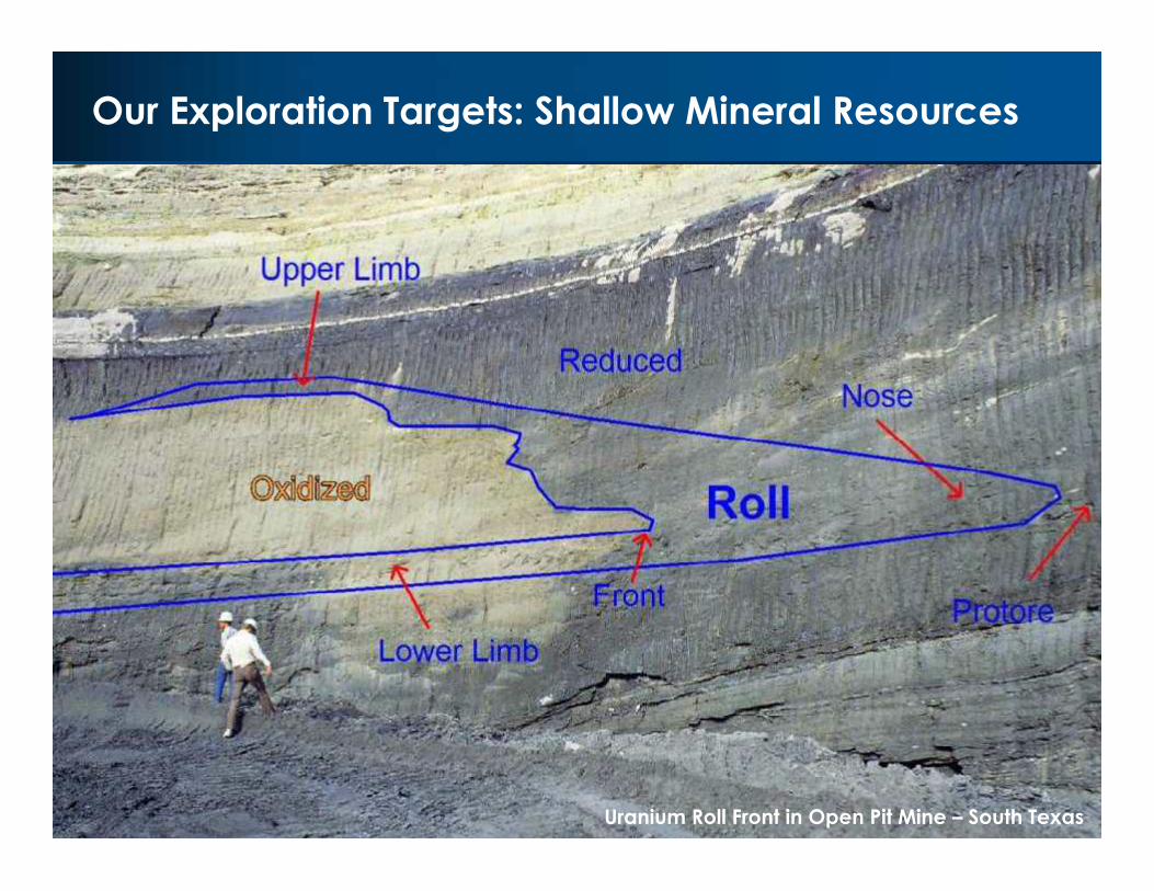
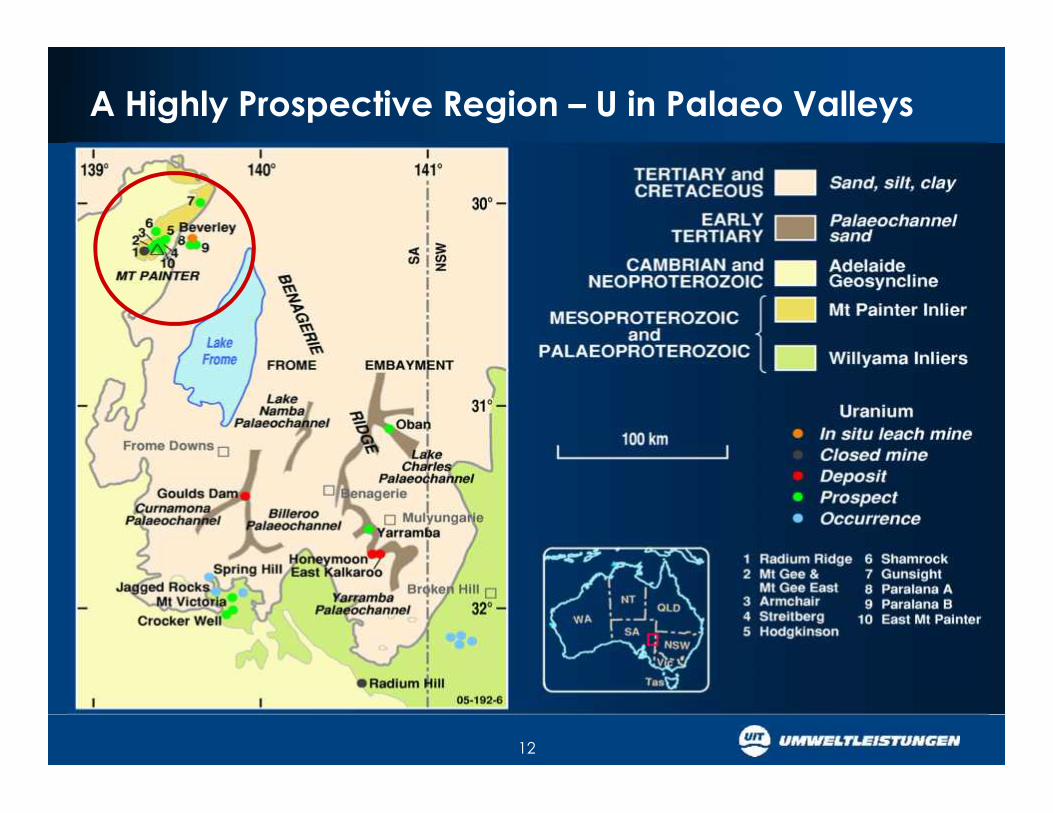
Our Exploration Targets: Shallow Mineral Resources

Uranium Roll Front in Open Pit Mine – South Texas

4

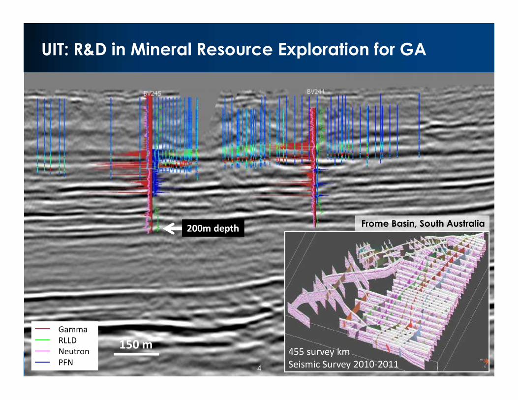
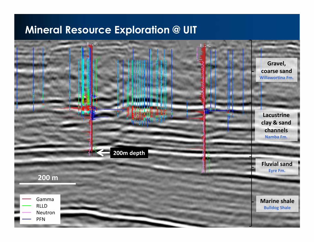
UIT: R&D in Mineral Resource Exploration for GA

150 mGammaRLLDNeutronPFN

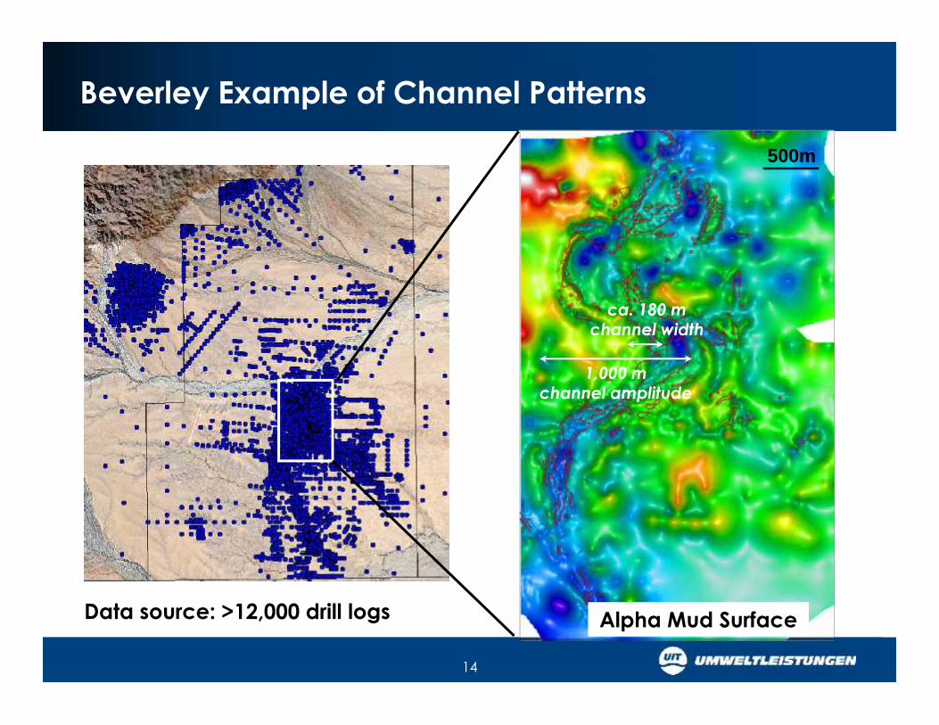
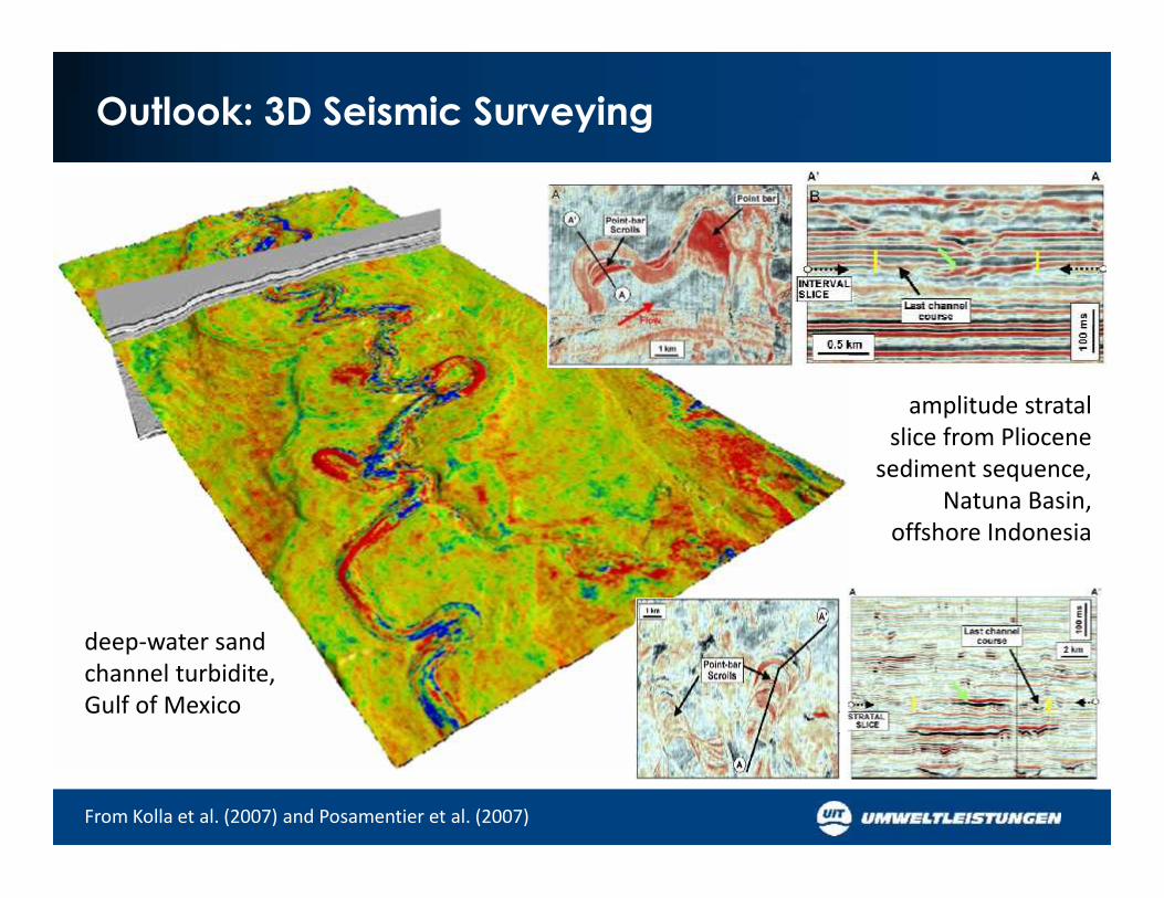
455 survey kmSeismic Survey 2010-2011

Frome Basin, South Australia200m depth

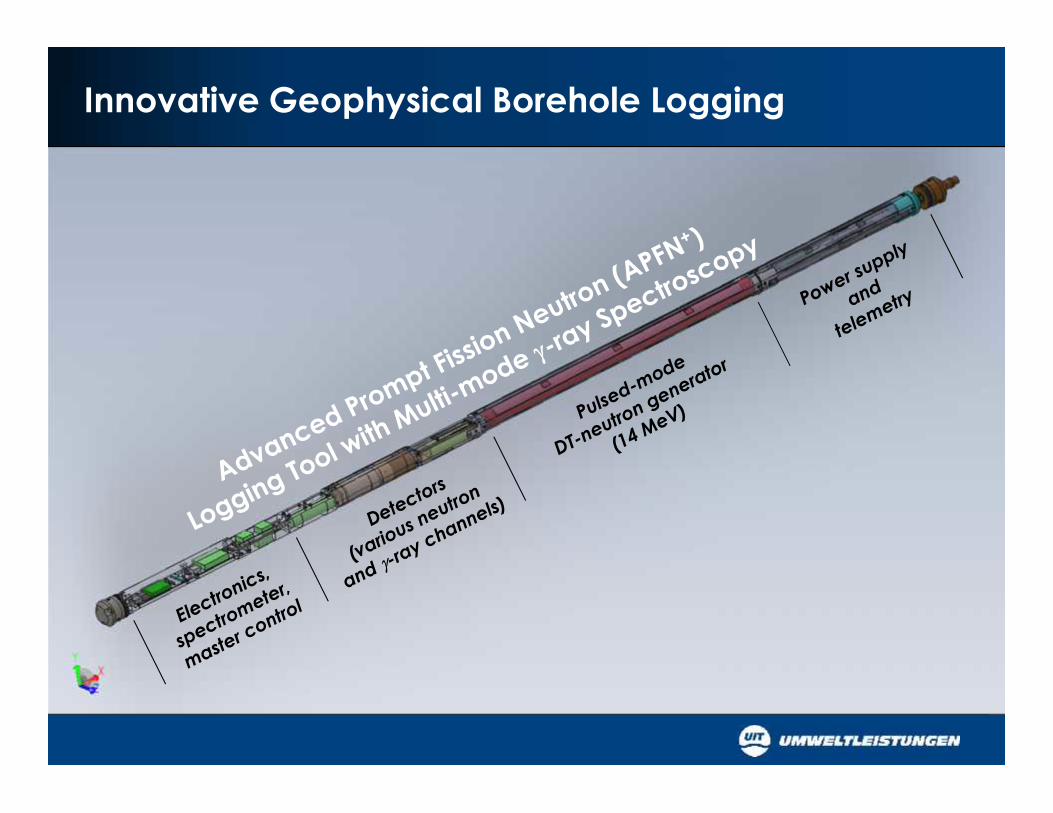
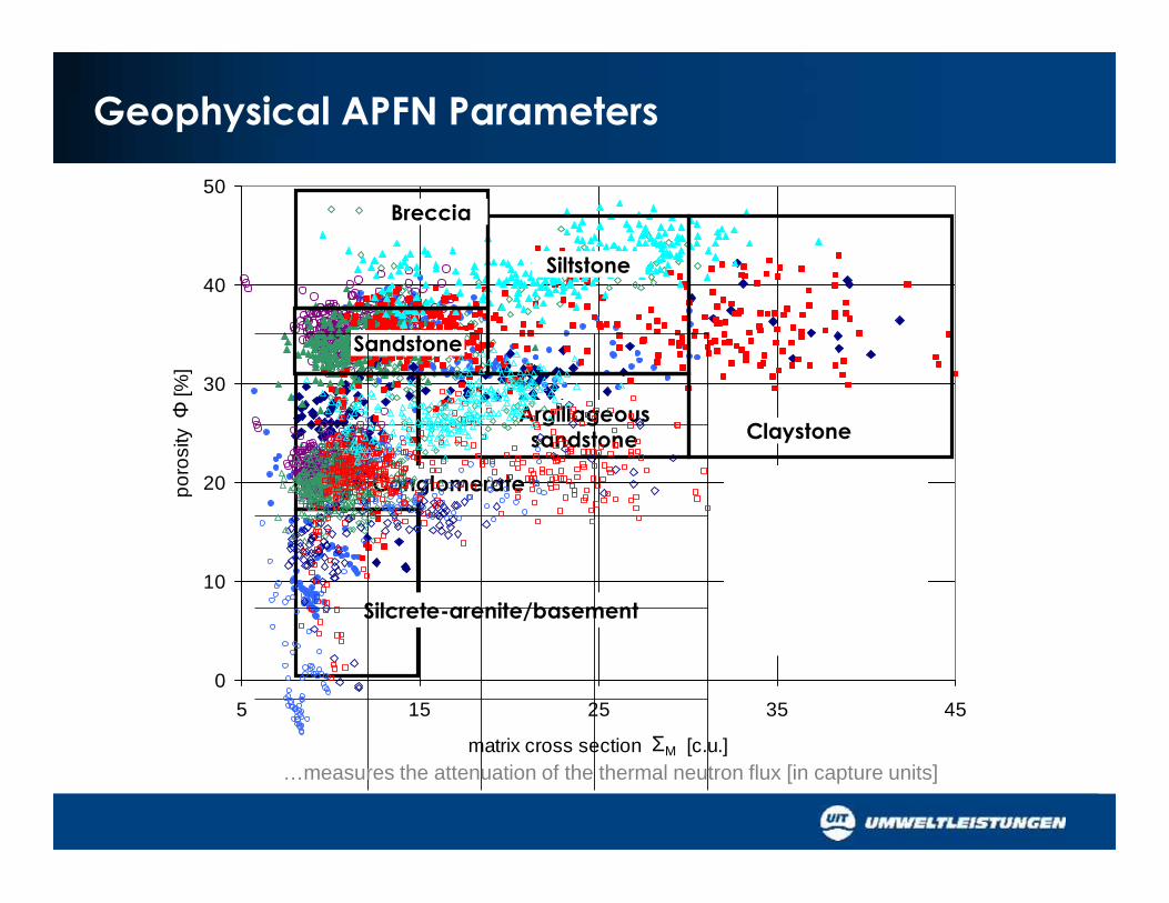
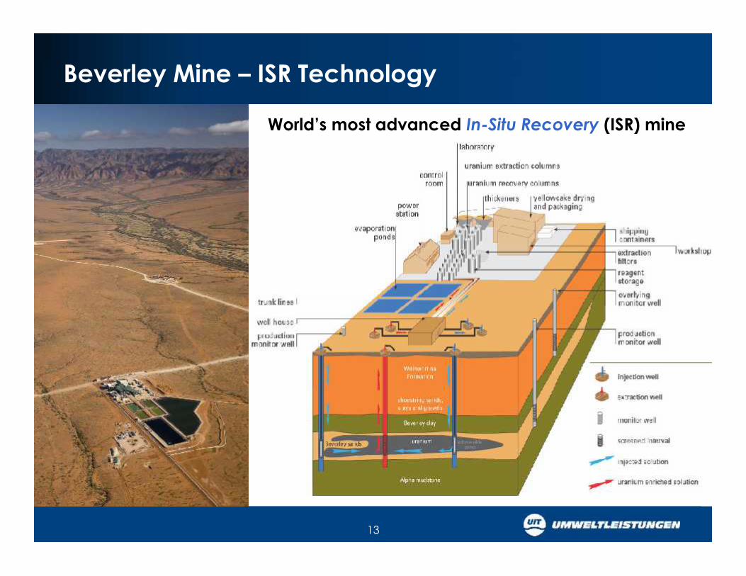
Innovative Geophysical Borehole Logging

Logging Operation

APFN+ operationin the field

On-site calibration pits(QA compliant)

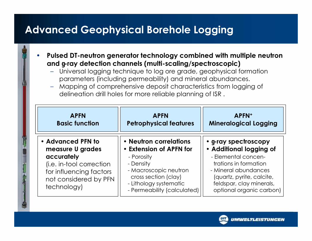
Advanced Geophysical Borehole Logging

APFNBasic function

APFNPetrophysical features

APFN+

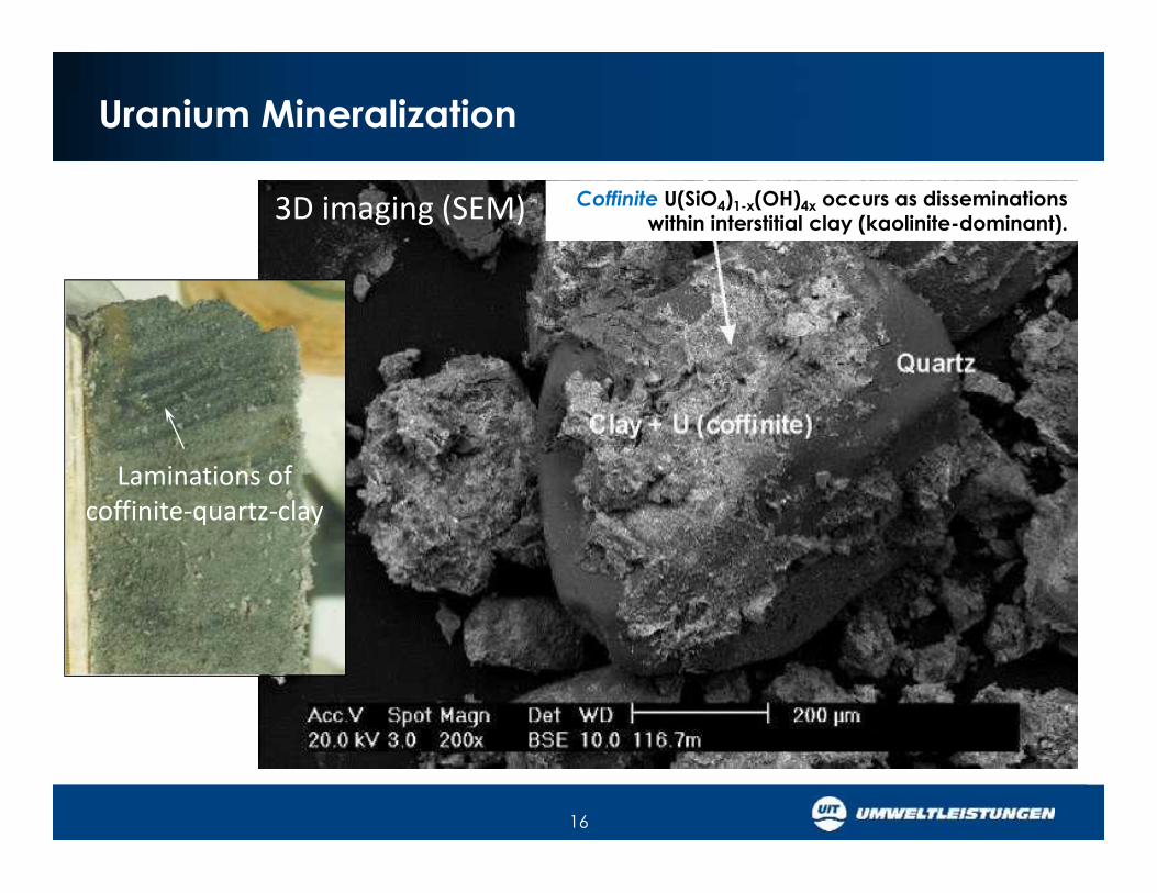
Mineralogical Logging

• Advanced PFN tomeasure U gradesaccurately(i.e. in-tool correctionfor influencing factorsnot considered by PFNtechnology)

• Neutron correlations• Extension of APFN for

- Porosity- Density- Macroscopic neutroncross section (clay)

- Lithology systematic- Permeability (calculated)

• -ray spectroscopy• Additional logging of

- Elemental concen-trations in formation

- Mineral abundances(quartz, pyrite, calcite,feldspar, clay minerals,optional organic carbon)

• Pulsed DT-neutron generator technology combined with multiple neutronand -ray detection channels (multi-scaling/spectroscopic)

– Universal logging technique to log ore grade, geophysical formationparameters (including permeability) and mineral abundances.

– Mapping of comprehensive deposit characteristics from logging ofdelineation drill holes for more reliable planning of ISR .

Geophysical APFN Parameters

0

10

20

30

40

50

5 15 25 35 45

matrix cross section ΣM [c.u.]

poro

sity

Φ [%

]

Breccia

Argillageoussandstone

Sandstone

Conglomerate

Silcrete-arenite/basement

Siltstone

Claystone

0

10

20

30

40

50

5 15 25 35 45

matrix cross section ΣM [c.u.]

poro

sity

Φ [%

]

PR1299 [258-279m]PR1301 [196-217m]PR1301 [230-162m]PR1302 [193-206m]PR1302 [239-275m]PR1304 [199-242m]PR1437 [187-213m]

…measures the attenuation of the thermal neutron flux [in capture units]

Mineral Resource Exploration @ UIT

200m depth

Gravel,coarse sand

Willawortina Fm.

Lacustrineclay & sand

channelsNamba Fm.

Fluvial sandEyre Fm.

Marine shaleBulldog Shale

GammaRLLDNeutronPFN

200 m

Seismic Imaging in the Frome Basin 2012

channel

Willawortina Willawortina

Beverley Clay

Seismic Exploration ApproachIdentify repeatable patterns in seismic reflection data:

- sand channels- concave dents in reflectors- porosity contrast

channel

Beverley Clay

Where to drill …?

200m

lower limb

upper limb

roll

reduced

protorenose

ROLL FRONT

300m depth

12

A Highly Prospective Region – U in Palaeo Valleys

13

Beverley Mine – ISR Technology

World’s most advanced In-Situ Recovery (ISR) mine

14

Beverley Example of Channel Patterns

Data source: >12,000 drill logs Ore outline

500m

Alpha Mud Surface

1,000 mchannel amplitude

ca. 180 mchannel width

Radiometrics – DEM - Gravimetry

15

2km(from Skirrow, 2009)

Digital Elevation Model

U ore

Uranium Band Radiometrics

U ore

Gravimetry with3D Fault Surfaces

16

Uranium Mineralization

Laminations ofcoffinite-quartz-clay

Coffinite U(SiO4)1-x(OH)4x occurs as disseminationswithin interstitial clay (kaolinite-dominant).3D imaging (SEM)

Seismic Imaging in the Frome Basin 1984 - 2012

1984-SPG Petratherm 2006 Curtin U 2012 UIT/Petrologic

Central Line

2010/2011 Velseis

2500 2500Enhancedresolution

TIME

DEPT

H

TIME

DEPT

H

Central Line

Key to High-Resolution Shallow Seismic Imaging

2012 UIT/DMT Petrologic

2500Enhancedresolution

DEPT

H

Maximum resolution in shallow seismic exploration(<500m depth) requires a combination ofcustomized methods:

• Energy source: e.g. high-frequency 8.4t IVIEnvirovibe vibroseis buggies @ 60 kN peakforce

• Tight 2-5m shot intervals• 2-5m geophone recording intervals• Customized data processing

- Derive new deconvolution parameters• Redetermine new static

- Refraction static (instead of elevation static)

Impact of Petrophysics on Seismic Resolution

Outlook: 3D Seismic Surveying

From Kolla et al. (2007) and Posamentier et al. (2007)

deep-water sandchannel turbidite,Gulf of Mexico

amplitude stratalslice from Pliocene

sediment sequence,Natuna Basin,

offshore Indonesia


Recommended