Page 1
New York Historical Markers--by Chapter
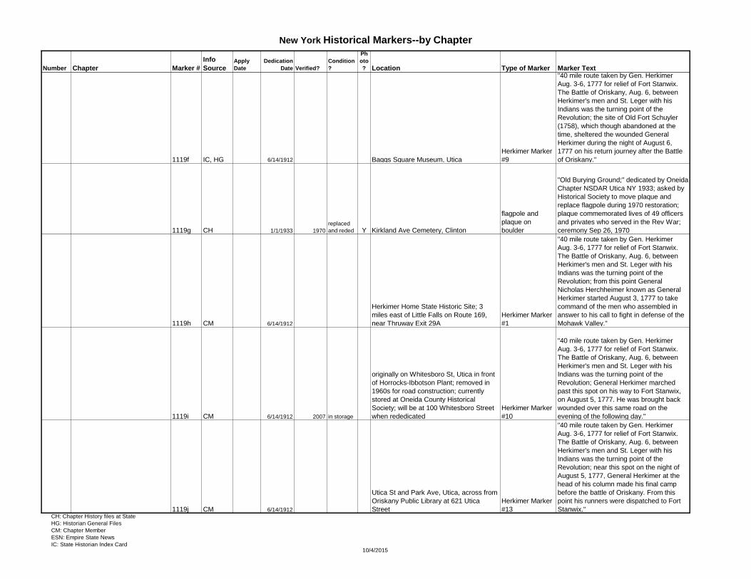
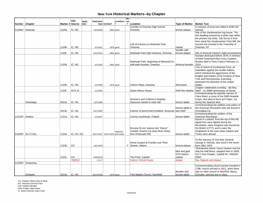
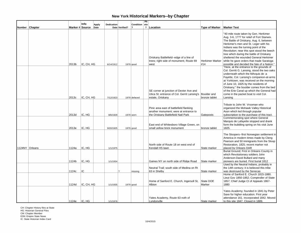
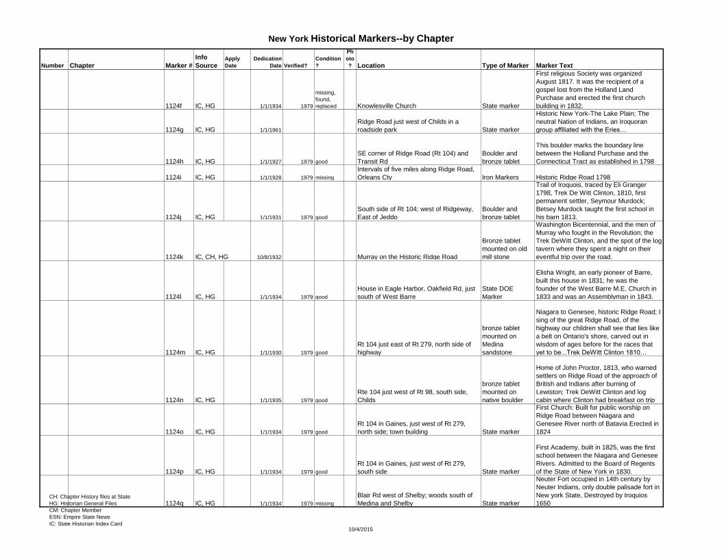
Number Chapter Marker #
Info
SourceApply
Date
Dedication
Date Verified?
Condition
?
Ph
oto
? Location Type of Marker Marker Text
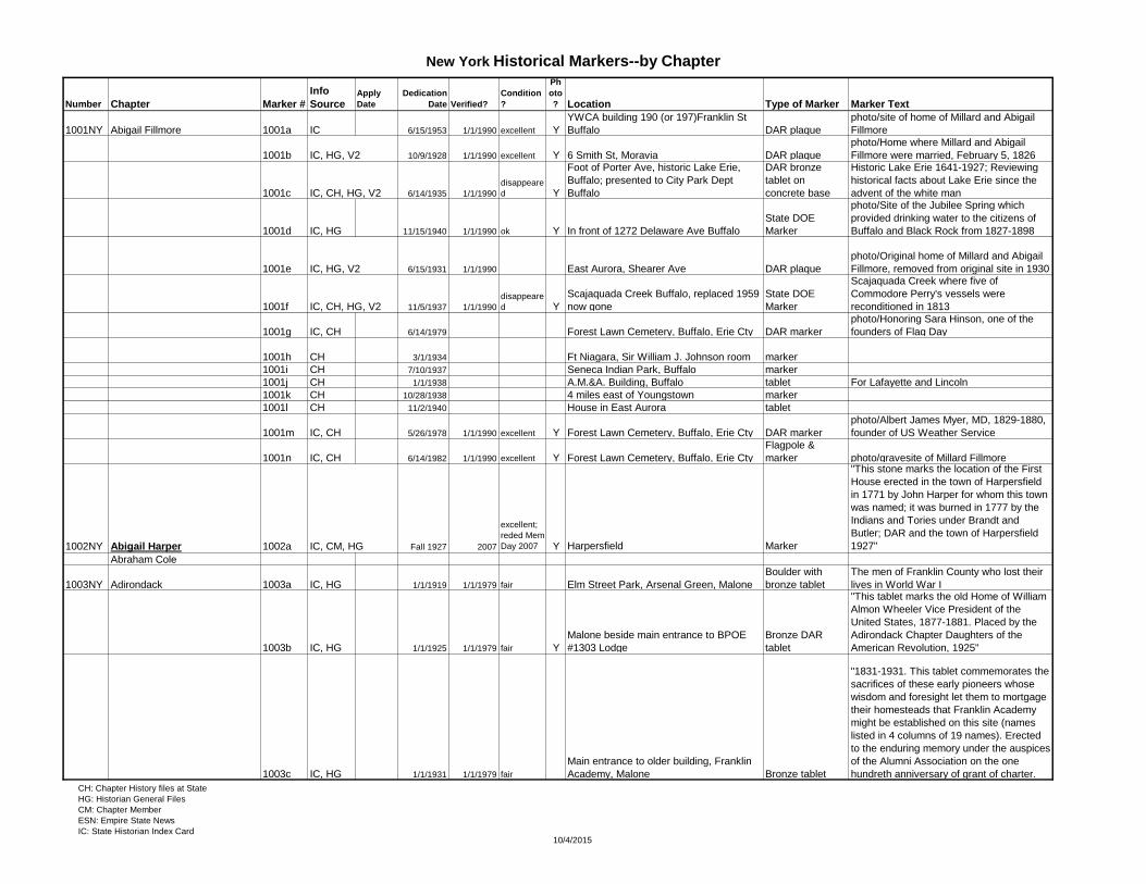
1001NY Abigail Fillmore 1001a IC 6/15/1953 1/1/1990 excellent Y
YWCA building 190 (or 197)Franklin St
Buffalo DAR plaque
photo/site of home of Millard and Abigail
Fillmore
1001b IC, HG, V2 10/9/1928 1/1/1990 excellent Y 6 Smith St, Moravia DAR plaque
photo/Home where Millard and Abigail
Fillmore were married, February 5, 1826
1001c IC, CH, HG, V2 6/14/1935 1/1/1990
disappeare
d Y
Foot of Porter Ave, historic Lake Erie,
Buffalo; presented to City Park Dept
Buffalo
DAR bronze
tablet on
concrete base
Historic Lake Erie 1641-1927; Reviewing
historical facts about Lake Erie since the
advent of the white man
1001d IC, HG 11/15/1940 1/1/1990 ok Y In front of 1272 Delaware Ave Buffalo
State DOE
Marker
photo/Site of the Jubilee Spring which
provided drinking water to the citizens of
Buffalo and Black Rock from 1827-1898
1001e IC, HG, V2 6/15/1931 1/1/1990 East Aurora, Shearer Ave DAR plaque
photo/Original home of Millard and Abigail
Fillmore, removed from original site in 1930
1001f IC, CH, HG, V2 11/5/1937 1/1/1990
disappeare
d Y
Scajaquada Creek Buffalo, replaced 1959
now gone
State DOE
Marker
Scajaquada Creek where five of
Commodore Perry's vessels were
reconditioned in 1813
1001g IC, CH 6/14/1979 Forest Lawn Cemetery, Buffalo, Erie Cty DAR marker
photo/Honoring Sara Hinson, one of the
founders of Flag Day
1001h CH 3/1/1934 Ft Niagara, Sir William J. Johnson room marker
1001i CH 7/10/1937 Seneca Indian Park, Buffalo marker
1001j CH 1/1/1938 A.M.&A. Building, Buffalo tablet For Lafayette and Lincoln
1001k CH 10/28/1938 4 miles east of Youngstown marker
1001l CH 11/2/1940 House in East Aurora tablet
1001m IC, CH 5/26/1978 1/1/1990 excellent Y Forest Lawn Cemetery, Buffalo, Erie Cty DAR marker
photo/Albert James Myer, MD, 1829-1880,
founder of US Weather Service
1001n IC, CH 6/14/1982 1/1/1990 excellent Y Forest Lawn Cemetery, Buffalo, Erie Cty
Flagpole &
marker photo/gravesite of Millard Fillmore
1002NY Abigail Harper 1002a IC, CM, HG Fall 1927 2007
excellent;
reded Mem
Day 2007 Y Harpersfield Marker
"This stone marks the location of the First
House erected in the town of Harpersfield
in 1771 by John Harper for whom this town
was named; it was burned in 1777 by the
Indians and Tories under Brandt and
Butler; DAR and the town of Harpersfield
1927"
Abraham Cole
1003NY Adirondack 1003a IC, HG 1/1/1919 1/1/1979 fair Elm Street Park, Arsenal Green, Malone
Boulder with
bronze tablet
The men of Franklin County who lost their
lives in World War I
1003b IC, HG 1/1/1925 1/1/1979 fair Y
Malone beside main entrance to BPOE
#1303 Lodge
Bronze DAR
tablet
"This tablet marks the old Home of William
Almon Wheeler Vice President of the
United States, 1877-1881. Placed by the
Adirondack Chapter Daughters of the
American Revolution, 1925"
1003c IC, HG 1/1/1931 1/1/1979 fair
Main entrance to older building, Franklin
Academy, Malone Bronze tablet
"1831-1931. This tablet commemorates the
sacrifices of these early pioneers whose
wisdom and foresight let them to mortgage
their homesteads that Franklin Academy
might be established on this site (names
listed in 4 columns of 19 names). Erected
to the enduring memory under the auspices
of the Alumni Association on the one
hundreth anniversary of grant of charter.
CH: Chapter History files at State
HG: Historian General Files
CM: Chapter Member
ESN: Empire State News
IC: State Historian Index Card10/4/2015
Page 2
New York Historical Markers--by Chapter
Number Chapter Marker #
Info
SourceApply
Date
Dedication
Date Verified?
Condition
?
Ph
oto
? Location Type of Marker Marker Text
1003d IC 1/1/1940 1/1/1979
Main entrance to Franklin Academy,
Malone Plaque
"Richard Harrison/Born 1747 England/Died
1829 New York/Founder of Malone/Donor
of site of Franklin Academy on which a
school building has stood since the first
one was erected in 1805-6 from timber cut
and hewn on the spot then primeval forest.
Graduate First Class Kings College/Law
Partner of Alexander Hamilton/State
Assemblyman elected 1787/Member
Federal Constitutional Convention
1788/United States Attorney appointed by
President Washington 1789/Secretary
State Board of Regents 1787-1790/To
honor our founder and in recognition of his
benefactions to the town of which he was
the first citizen and proprietor. This tablet is
here placed by Adirondack Chapter DAR
1940."
1003e HG 1/1/1933 Campus of Franklin Academy, Malone DAR plaque
Commemorating the gift of the campus to
the township by Ricahrd Harrison, founder
of Malone, scotch pine trees originally
marking plaque were gone by 1980
1003f
many markers listed in State Chapter
history file, but no other info known
1003g Y97, NYS VI 6/19/1905
First Settlers Cemetery, First
Congregational Church, Malone
Voted in 1997 to donate up to $15000 for
chain link fence around cemetery to protect
it from vandals
Ag-Wron-Doug-Was see Ag-Wron-Doug-Was-Cunahunta
1004NY Ag-Wron-Doug-Was-Cunahunta1004a IC, CM, HG 9/12/1929 1/1/2007 good Y Route 7 between Bainbridge and Sidney
Sullivan bronze
tablet #__
"[map and portraits] Routes of the armies
of General John Sullivan and General
James Clinton 1779; an expedition against
hostile Indian nations which checked the
aggressions of the English and Indians on
the frontiers of New York and
Pennsylvania, extending westward the
dominion of the United States; erected by
the State of New York 1929"
1004b IC, HG 6/14/1934 West Bainbridge 3 trees
Commemorating three solders who died in
the World War
CH: Chapter History files at State
HG: Historian General Files
CM: Chapter Member
ESN: Empire State News
IC: State Historian Index Card10/4/2015
Page 3
New York Historical Markers--by Chapter
Number Chapter Marker #
Info
SourceApply
Date
Dedication
Date Verified?
Condition
?
Ph
oto
? Location Type of Marker Marker Text
1004c IC, HG 5/24/1935 Village of Bainbridge
2 bronze DAR
markers
Commemorating two village churches,
Presbyterian and Episcopal, each over one
hundred years old; "The first Presbyterian
Church Society founded March 31, 1793
through the efforts of Rev. Wm. A. Stone of
the Vermont Domestic Missionary Society.
The first church was erected in 1798, and
was destroyed by fire in 1814. The present
building was erected in 1831." St. Peter's
Episcopal Chruch, second oldest church in
village, erected in 1826.
1004d IC, CM, HG 10/31/1929 1/7/2007 good Y Village Green, Main St, Afton
DAR bronze
plaque
"In memory of the men in the twon of Afton
who fought in the Revolutionary War [29
names, see photo]; Presented b
Cunahunta Chapter NSDAR and State of
New York 1929"
1004e CM 1/1/1920 1/7/2007 good Y
Intersection of State Rt 7 and Rt 41,
VillageGreen, Afton
Bronze NYS
marker
"About two miles down the Susquehanna
River on an island and adjacent shores
was the campsite of the army of General
James Clinton on the night of August 18,
1779. The siteof Afton was occupied by the
Indian village of Conihunto; destroyed by a
force under Captain William Gray in
October 1778; erected by the State of New
York 1920"
1005NY Amsterdam 1005a IC, CH, HG 1/1/1925 1/1/1979 good
Amsterdam, East end of Florida Ave,
across the Chuctanunda Creek in 5th
Ward by the Florida Ave bridge
Granite boulder
with bronze DAR
tablet
Halt of the Army of Gen. VanRensselaer on
its way to defend the upper Mohawk Valley
from the Tories and Indians from Canada
1197NY Anna Ingalsbe Lovell
1176NY Anna Smith Strong
Anne Cary see Anne Cary-Lord Stirling
Anne Cary-Lord Stirling 1092a IC Vicinity of village of East Rockaway
State DOE
Marker Site of first post office, East Rockaway
1092b IC Vicinity of village of East Rockaway
State DOE
Marker Site of first public oven
1092c IC Vicinity of village of East Rockaway
State DOE
Marker Site of first grist mill
1092d IC Vicinity of village of East Rockaway
State DOE
Marker Site of home of Alexander Davison
1092e IC Vicinity of village of East Rockaway
State DOE
Marker Site of home of John Hewlett
1092f IC Vicinity of village of East Rockaway
State DOE
Marker Site of home of Col. Richard Hewlett
1092g V2 1930s Polish Catholic Church, Hempstead LI tablet in church Honoring Count Pulaski
1007NY Anne Hutchinson 1007a IC, CH 1/1/1967 Y Bronxville, (oldest house)
DAR Tablet on
boulder
"Abijah Morgan House where Jonathan
Verian's regiment mustered on the morning
of September 13, 1812, under the
command of Captain Lawrence Davenport
of New Rochelle, Lieutenant John Butler of
Fordham, Ensign Abijah Morgan"CH: Chapter History files at State
HG: Historian General Files
CM: Chapter Member
ESN: Empire State News
IC: State Historian Index Card10/4/2015
Page 4
New York Historical Markers--by Chapter
Number Chapter Marker #
Info
SourceApply
Date
Dedication
Date Verified?
Condition
?
Ph
oto
? Location Type of Marker Marker Text
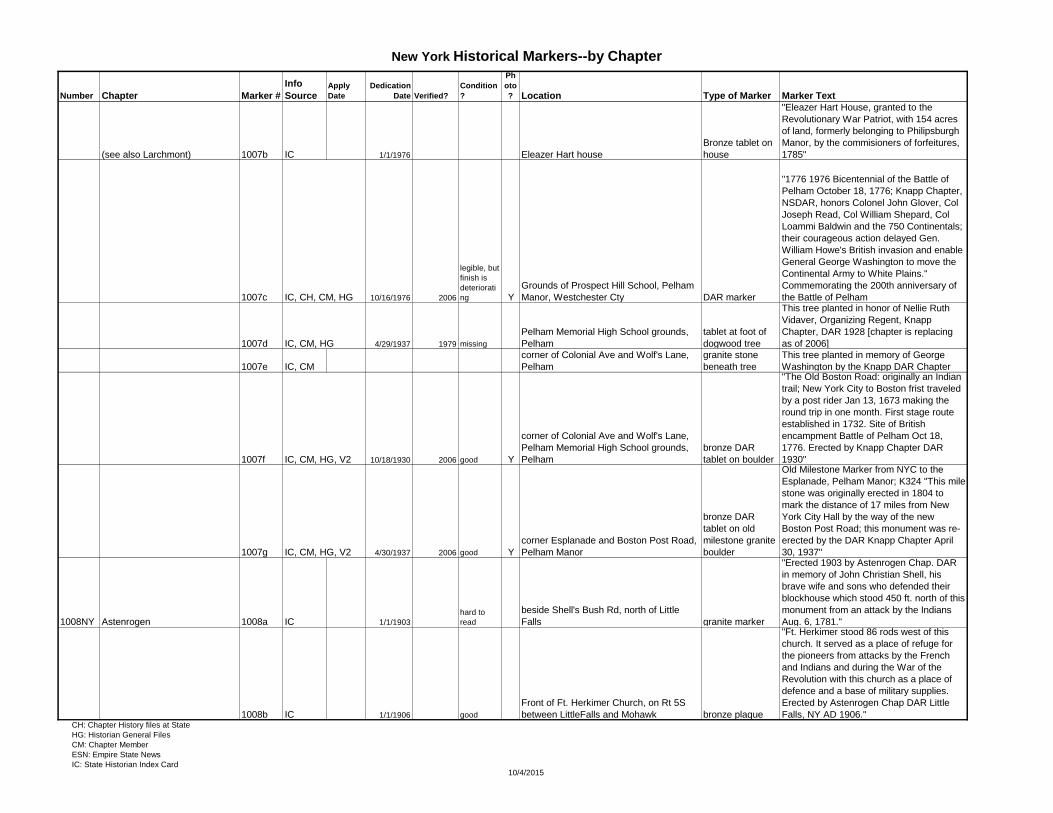
(see also Larchmont) 1007b IC 1/1/1976 Eleazer Hart house
Bronze tablet on
house
"Eleazer Hart House, granted to the
Revolutionary War Patriot, with 154 acres
of land, formerly belonging to Philipsburgh
Manor, by the commisioners of forfeitures,
1785"
1007c IC, CH, CM, HG 10/16/1976 2006
legible, but
finish is
deteriorati
ng Y
Grounds of Prospect Hill School, Pelham
Manor, Westchester Cty DAR marker
"1776 1976 Bicentennial of the Battle of
Pelham October 18, 1776; Knapp Chapter,
NSDAR, honors Colonel John Glover, Col
Joseph Read, Col William Shepard, Col
Loammi Baldwin and the 750 Continentals;
their courageous action delayed Gen.
William Howe's British invasion and enable
General George Washington to move the
Continental Army to White Plains."
Commemorating the 200th anniversary of
the Battle of Pelham
1007d IC, CM, HG 4/29/1937 1979 missing
Pelham Memorial High School grounds,
Pelham
tablet at foot of
dogwood tree
This tree planted in honor of Nellie Ruth
Vidaver, Organizing Regent, Knapp
Chapter, DAR 1928 [chapter is replacing
as of 2006]
1007e IC, CM
corner of Colonial Ave and Wolf's Lane,
Pelham
granite stone
beneath tree
This tree planted in memory of George
Washington by the Knapp DAR Chapter
1007f IC, CM, HG, V2 10/18/1930 2006 good Y
corner of Colonial Ave and Wolf's Lane,
Pelham Memorial High School grounds,
Pelham
bronze DAR
tablet on boulder
"The Old Boston Road: originally an Indian
trail; New York City to Boston frist traveled
by a post rider Jan 13, 1673 making the
round trip in one month. First stage route
established in 1732. Site of British
encampment Battle of Pelham Oct 18,
1776. Erected by Knapp Chapter DAR
1930"
1007g IC, CM, HG, V2 4/30/1937 2006 good Y
corner Esplanade and Boston Post Road,
Pelham Manor
bronze DAR
tablet on old
milestone granite
boulder
Old Milestone Marker from NYC to the
Esplanade, Pelham Manor; K324 "This mile
stone was originally erected in 1804 to
mark the distance of 17 miles from New
York City Hall by the way of the new
Boston Post Road; this monument was re-
erected by the DAR Knapp Chapter April
30, 1937"
1008NY Astenrogen 1008a IC 1/1/1903
hard to
read
beside Shell's Bush Rd, north of Little
Falls granite marker
"Erected 1903 by Astenrogen Chap. DAR
in memory of John Christian Shell, his
brave wife and sons who defended their
blockhouse which stood 450 ft. north of this
monument from an attack by the Indians
Aug. 6, 1781."
1008b IC 1/1/1906 good
Front of Ft. Herkimer Church, on Rt 5S
between LittleFalls and Mohawk bronze plaque
"Ft. Herkimer stood 86 rods west of this
church. It served as a place of refuge for
the pioneers from attacks by the French
and Indians and during the War of the
Revolution with this church as a place of
defence and a base of military supplies.
Erected by Astenrogen Chap DAR Little
Falls, NY AD 1906."CH: Chapter History files at State
HG: Historian General Files
CM: Chapter Member
ESN: Empire State News
IC: State Historian Index Card10/4/2015
Page 5
New York Historical Markers--by Chapter
Number Chapter Marker #
Info
SourceApply
Date
Dedication
Date Verified?
Condition
?
Ph
oto
? Location Type of Marker Marker Text
1008c IC 9/5/1911
reded
2011
Located corner Church and School Sts.
Little Falls
large boulder on
flat granite stone
"This memorial erected by Astenrogen
Chapter of Daughters of the American
Revolution of Little Falls, N.Y., aided by
patriotic citizens of this city was dedicated
Sept. 5, 1911 and marks the site of the old
Octagon Church. The first church in Little
Falls in which all denominations
worshiopped. Built in 1796, Demolished in
1842."
1008d IC 6/14/1912 good
From Herkimer Home travel west on
Route 5S to the Fort Herkimer Church,
about 7.5 miles
Herkimer Marker
#3
"40 mile route taken by Gen. Herkimer
Aug. 3-6, 1777 for relief of Fort Stanwix.
The Battle of Oriskany, Aug. 6, between
Herkimer's men and St. Leger with his
Indians was the turning point of the
Revolution; near this spot was the site of
Fort Herkimer, built in 1756, around the
second stone house of Johan Jost
Herchheimer, father of Gen. Nicholas
Herkimer. HereNicholas pased his
boyhood, and here he rested when
returning wounded from the Battle of
Oriskany."
1033f IC, HG 10/18/1959 1979
good, used
for target
practice
Between Little Falls and Herkimer on
Smith rd in Central Herkimer Cty
monument with
bronze plaque
"This monument marks the site where Lt.
Solomon Woodworth and his men fell in
battle on 7 Sept. 1781 during the
Revolutionary War. It was erected in 1959
during New York State's Year of History by
the Herkimer County Board of Supervisors
and dedicated by the Mohawk Valley
Chapters DAR." Lt. Solomon Woodworth
who with many of his brave followers met
death by being ambushed by Indians. Their
men were buried in a common grave on the
land where the fighting took place. Mohawk
Valley Indian ambush near Shells Bush.
Au-Ly-Ou-Let 2001a IC, HG 6/27/1927 Franklin
DAR bronze
tablet on boulder
"This boulder marks the site of the home of
Sluman Wattles, the first settler in the
Town of Franklin, who built this house in
1785. One hundred and fifty feet south
stood the Treaty Elm under whose
branches he made a treaty with the
Indians."
Barnard
Baron Steuben 1009a IC, HG 5/4/1929 1/1/1979 good Pultney Park, Bath bronze marker
"To mark the first clearing in Steuben
County made in 1793 by Col. Charles
Williamson founder of Bath and first agent
of the Pulteney Estate. Placed by Baron
Steuben Chapter N.S. Daughters of the
American Revolution and the State of New
York 1929."
CH: Chapter History files at State
HG: Historian General Files
CM: Chapter Member
ESN: Empire State News
IC: State Historian Index Card10/4/2015
Page 6
New York Historical Markers--by Chapter
Number Chapter Marker #
Info
SourceApply
Date
Dedication
Date Verified?
Condition
?
Ph
oto
? Location Type of Marker Marker Text
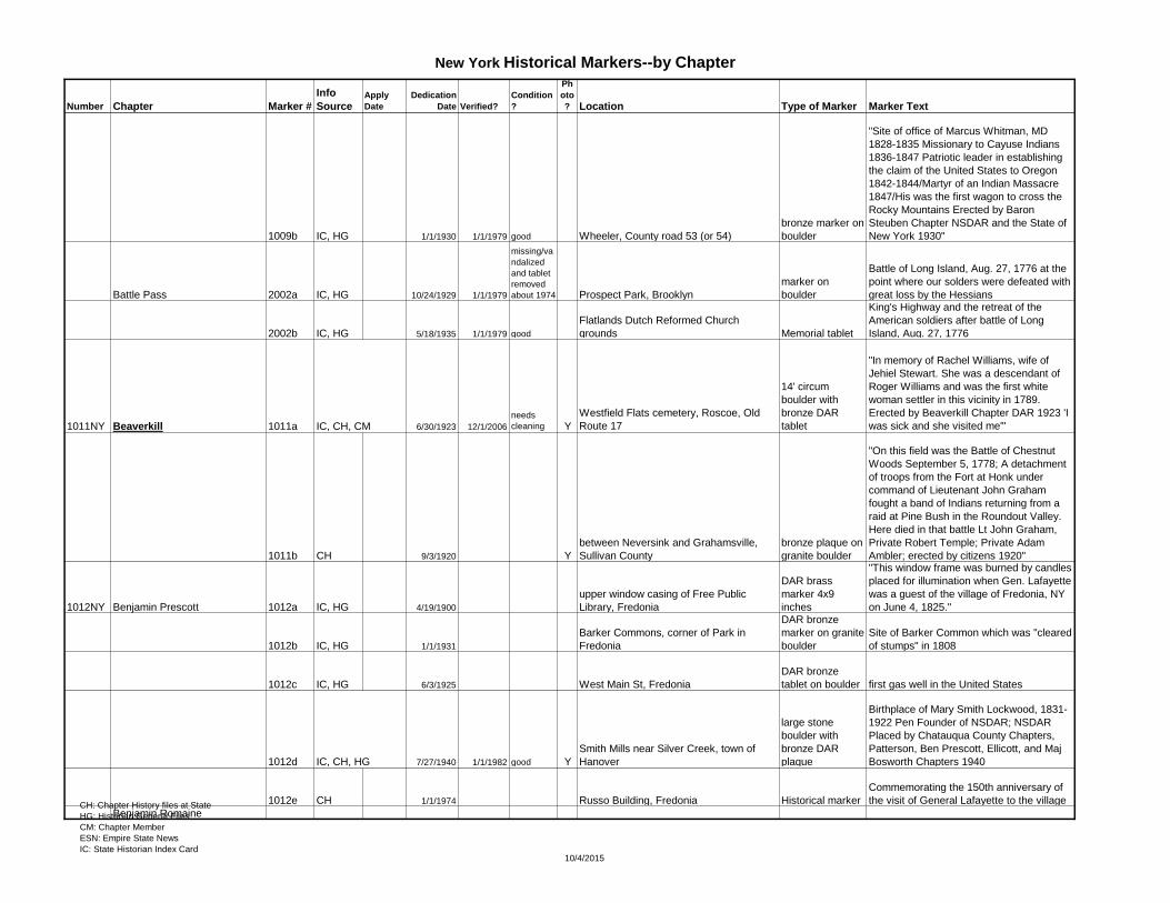
1009b IC, HG 1/1/1930 1/1/1979 good Wheeler, County road 53 (or 54)
bronze marker on
boulder
"Site of office of Marcus Whitman, MD
1828-1835 Missionary to Cayuse Indians
1836-1847 Patriotic leader in establishing
the claim of the United States to Oregon
1842-1844/Martyr of an Indian Massacre
1847/His was the first wagon to cross the
Rocky Mountains Erected by Baron
Steuben Chapter NSDAR and the State of
New York 1930"
Battle Pass 2002a IC, HG 10/24/1929 1/1/1979
missing/va
ndalized
and tablet
removed
about 1974 Prospect Park, Brooklyn
marker on
boulder
Battle of Long Island, Aug. 27, 1776 at the
point where our solders were defeated with
great loss by the Hessians
2002b IC, HG 5/18/1935 1/1/1979 good
Flatlands Dutch Reformed Church
grounds Memorial tablet
King's Highway and the retreat of the
American soldiers after battle of Long
Island, Aug. 27, 1776
1011NY Beaverkill 1011a IC, CH, CM 6/30/1923 12/1/2006
needs
cleaning Y
Westfield Flats cemetery, Roscoe, Old
Route 17
14' circum
boulder with
bronze DAR
tablet
"In memory of Rachel Williams, wife of
Jehiel Stewart. She was a descendant of
Roger Williams and was the first white
woman settler in this vicinity in 1789.
Erected by Beaverkill Chapter DAR 1923 'I
was sick and she visited me'"
1011b CH 9/3/1920 Y
between Neversink and Grahamsville,
Sullivan County
bronze plaque on
granite boulder
"On this field was the Battle of Chestnut
Woods September 5, 1778; A detachment
of troops from the Fort at Honk under
command of Lieutenant John Graham
fought a band of Indians returning from a
raid at Pine Bush in the Roundout Valley.
Here died in that battle Lt John Graham,
Private Robert Temple; Private Adam
Ambler; erected by citizens 1920"
1012NY Benjamin Prescott 1012a IC, HG 4/19/1900
upper window casing of Free Public
Library, Fredonia
DAR brass
marker 4x9
inches
"This window frame was burned by candles
placed for illumination when Gen. Lafayette
was a guest of the village of Fredonia, NY
on June 4, 1825."
1012b IC, HG 1/1/1931
Barker Commons, corner of Park in
Fredonia
DAR bronze
marker on granite
boulder
Site of Barker Common which was "cleared
of stumps" in 1808
1012c IC, HG 6/3/1925 West Main St, Fredonia
DAR bronze
tablet on boulder first gas well in the United States
1012d IC, CH, HG 7/27/1940 1/1/1982 good Y
Smith Mills near Silver Creek, town of
Hanover
large stone
boulder with
bronze DAR
plaque
Birthplace of Mary Smith Lockwood, 1831-
1922 Pen Founder of NSDAR; NSDAR
Placed by Chatauqua County Chapters,
Patterson, Ben Prescott, Ellicott, and Maj
Bosworth Chapters 1940
1012e CH 1/1/1974 Russo Building, Fredonia Historical marker
Commemorating the 150th anniversary of
the visit of General Lafayette to the village
Benjamin RomaineCH: Chapter History files at State
HG: Historian General Files
CM: Chapter Member
ESN: Empire State News
IC: State Historian Index Card10/4/2015
Page 7
New York Historical Markers--by Chapter
Number Chapter Marker #
Info
SourceApply
Date
Dedication
Date Verified?
Condition
?
Ph
oto
? Location Type of Marker Marker Text
1179NY Betsy Baldwin
Beukendaal 2003a IC, HG 1/1/1929 1/1/1979 good
Schenectady two miles up the Sarandoga
Road from Scotia
monument and
bronze DAR
tablet
"Beukendaal -1748 Dutch word meaning
Beechdale DeGraff House where 40
Schenectady Militia fought off French-
Indian raiding party" July 18, 1748
1014NY Beulah Patterson Brown 1014a CH, CM 9/13/1924 6/9/2007 excellent Y
Brown Settlement Cemetery, Brown Lane
off Route 38, Berkshire
DAR bronze
plaque on
boulder
"Beulah Patterson Brown Jan 20, 1741-
July 6, 1820 widow of Capt. Abraham
Brown; placed by Beulah Patterson Brown
Chapter DAR 1924;" unveiled by seventh
generation descendants
Blooming Grove see Quassaick
Bronx see Jonas Bronck
1200NY Brooklyn 1200a CM 8/1/2006 12/11/2006 New Y
Louise J. Valentino Park Pier in Red
Hook, Brooklyn
Park & Rec
marker
To commemorate Fort Defiance and its
role in the defense of New York Cityin
1776, especially covering retreat of
Washington across the East River on Aug
29, 1776. [see marker document 1200a_2
for full citation]
1195NY Caleb Hopkins 1195a ESN 201108 6/11/2011
Northfield Enriched Housing Butterfly
Garden, 4560 Nine Mile Road, Fairport Stone Marker
"We dedicate this marker to commemorate
the works of the Caleb Hopkins Chapter
DAR in our endeavo to bring new life and
beauty of this garden to the rsidents of
Northfield. May the Lord bless our efforts
and preserve the life of this garden and the
memory of this marker which signifies our
ongoing commitment to the Daughters of
the American Revolution, 'God, Home and
Country.' for many years to come. Amen."
1015NY Camden 1015a IC, HG 7/4/1899 Cemetary on Mexico St, Camden
7' plain granite
stone
34 Revolutionary soldiers came from Conn.
And settled in Camden and buried in this
cemetery
1015b IC, CH, HG 10/31/1913
six miles from Camden; 18 miles from
Rome; route from Rome to Sacketts
Harbor
bronze marker on
a boulder
"Here stood for more than a century the
last remaining cedar mile post marking the
route from Rome to Sacketts Harbor, over
which troops marched in the war of 1812"
1191NY Canandaigua
1016NY Captain Christian Brown 1016a IC, HG 7/4/1918 Sego-Sego Park, Cobleskill
a cannon and a
DAR tablet
Present to the village, and history of the
cannon
1016b IC, CH, HG 8/24/1914 Y
Intersection of 2 roads, 1.5 miles north of
state highway, wast of Cobleskill
boulder with
bronze plaque
Captain Christian Brown, a true patriot and
soldier who served in the struggle for our
independence and received honorable
discharge
1016c IC, CH, HG 10/1/1927 good
reded
2005 Y near Janesville
Barre Rock with
DAR bronze
plate
Catherine Merckley, shot and killed by
Indians while fleeing on horseback; Oct 18,
1780CH: Chapter History files at State
HG: Historian General Files
CM: Chapter Member
ESN: Empire State News
IC: State Historian Index Card10/4/2015
Page 8
New York Historical Markers--by Chapter
Number Chapter Marker #
Info
SourceApply
Date
Dedication
Date Verified?
Condition
?
Ph
oto
? Location Type of Marker Marker Text
1016d IC, CH, HG 10/26/1924 East Main St, Cobleskill
boulder with
bronze plaque
Fort DuBois, which was named in honor of
Col. Lewis DuBois
Captain Israel Harris see Captain Israel Harris-General John Williams
1017NY Captain Israel Harris-General John Williams1017a IC, HG 1/1/1922 1979 poor Mettowee Cemetary, Granville Marked pine tree
a weathered board 6x16" nailed to base of
tree listing 13 men who died in WWI; small
bronze plaque attached to base
1017b IC, HG about 1914 1979 good
Quaker, North, Mettowee Cemetary
intersections Granville Mounds
commemorating cannon located at North
Street Mound
1017c IC, HG about 1914 1979
good/cano
n scrapped
in WWII Main and Quaker St, Granville
boulder with
bronze plaque
names of Revolutionary soldiers from
Granville
1017d IC, HG 1/1/1932 good
North Street Mound (Pine and North St),
Granville Marked tree
George Washington Bicentennial year,
Flag pole, at base are 2 plaques, original
plus a new one dedicated in 1976
1017e IC, CH, HG 7/4/1959 1979 good Abrams Bldg, Main St, Salem bronze marker
"Turner's Cabin was built on this site in
1762 by James Turner, Joshua Conkey
and Hamilton McCollister. In 1764 they
brought their families from Pelham, Mass.
To form the first settlement in this place.
Placed by Gen. John Wms. Ch., DAR
1959"
1017f CH 3/1/1974 Evergreen Cemetery gate, Salem
cemetery
entrance marker
Revolutionary soldiers buried within,
dedicated March 1974
1018NY Captain John Harris 1018a IC, HG 6/12/1936 Norwich
State DOE
marker
"First log cabin in Norwich was built on this
site about 1790 by Col. Wm. Munroe,
drummer boy fo the Revolutionary War."
1018b IC, HG 6/12/1936 Norwich, Sherburne 4 corners
State DOE
marker
The first newspaper in Chenango Co. was
the "Western Oracle," published in this site
in 1803 by Abraham and Nicholas Romeyn.
1018c IC, HG 6/12/1936 North Norwich
State DOE
marker
Site of the home of Militia General at North
Norwich. On this site 1794 stood the home
of Obadiah German, Militia General, land
agent, State Assemblyman, United States
Sentaor 1809-1815.
1018d IC, HG 6/12/1936 Smyrna Village, Norwich
State DOE
marker
A stake driven here marked 101 miles west
from Albany on the Albany-Ithaca Turnpike;
built 1805
1018e IC, HG 6/12/1936 Norwich
State DOE
marker
First site of Oxford Academy, charter
granted 1794; Uri Tracey, first principal;
one of first four charters granted west of
the Hudson
1018f IC, HG 6/12/1936 Norwich
State DOE
marker
Brigham Young, when a boy, lived about 2
miles up this road. The Young family went
from here to western New York.
CH: Chapter History files at State
HG: Historian General Files
CM: Chapter Member
ESN: Empire State News
IC: State Historian Index Card10/4/2015
Page 9
New York Historical Markers--by Chapter
Number Chapter Marker #
Info
SourceApply
Date
Dedication
Date Verified?
Condition
?
Ph
oto
? Location Type of Marker Marker Text
1018g IC, HG 6/12/1936 Norwich
State DOE
marker
Site of early homestead of Capt. John
Harris, 1789. Capt. Harris, seaman and
pioneer, bought land from Broad St. to
river. First Norwich town meeting held in
his house.
1018h IC, HG 6/12/1936 Norwich
State DOE
marker
Site of ancient Indian fort. In 1791 early
settlers found evidence of this fort having
been in use nearly four hundred years.
1018i IC, HG 6/12/1936 Norwich
State DOE
marker
Site of home of Avery Power, first settler in
Norwich Township 1788, owned adjoining
river flat. Lucy Power, first white native of
Chenango Valley.
1018j IC, HG 6/12/1936 Noriwch
State DOE
marker
Site of land used by the Oneida Indians for
Councils. "The Castle," Oneida Indian fort.
Councils held here up to 1790. About 1/4
mile west from road.
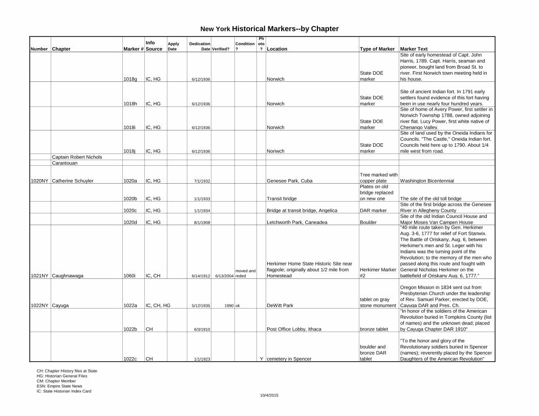
Captain Robert Nichols
Carantouan
1020NY Catherine Schuyler 1020a IC, HG 7/1/1932 Genesee Park, Cuba
Tree marked with
copper plate Washington Bicentennial
1020b IC, HG 1/1/1933 Transit bridge
Plates on old
bridge replaced
on new one The site of the old toll bridge
1020c IC, HG 1/1/1934 Bridge at transit bridge, Angelica DAR marker
Site of the first bridge across the Genesee
River in Allegheny County
1020d IC, HG 8/1/1908 Letchworth Park, Caneadea Boulder
Site of the old Indian Council House and
Major Moses Van Campen House
1021NY Caughnawaga 1060i IC, CH 6/14/1912 6/13/2004
moved and
reded
Herkimer Home State Historic Site near
flagpole; originally about 1/2 mile from
Homestead
Herkimer Marker
#2
"40 mile route taken by Gen. Herkimer
Aug. 3-6, 1777 for relief of Fort Stanwix.
The Battle of Oriskany, Aug. 6, between
Herkimer's men and St. Leger with his
Indians was the turning point of the
Revolution; to the memory of the men who
passed along this route and fought with
General Nicholas Herkimer on the
battlefield of Oriskany Aug. 6, 1777."
1022NY Cayuga 1022a IC, CH, HG 5/12/1935 1990 ok DeWitt Park
tablet on gray
stone monument
Oregon Mission in 1834 sent out from
Presbyterian Church under the leadership
of Rev. Samuel Parker; erected by DOE,
Cayuga DAR and Pres. Ch.
1022b CH 6/3/1910 Post Office Lobby, Ithaca bronze tablet
"In honor of the soldiers of the American
Revolution buried in Tompkins County (list
of names) and the unknown dead; placed
by Cayuga Chapter DAR 1910"
1022c CH 1/1/1923 Y cemetery in Spencer
boulder and
bronze DAR
tablet
"To the honor and glory of the
Revolutionary soldiers buried in Spencer
(names); reverently placed by the Spencer
Daughters of the American Revolution"
CH: Chapter History files at State
HG: Historian General Files
CM: Chapter Member
ESN: Empire State News
IC: State Historian Index Card10/4/2015
Page 10
New York Historical Markers--by Chapter
Number Chapter Marker #
Info
SourceApply
Date
Dedication
Date Verified?
Condition
?
Ph
oto
? Location Type of Marker Marker Text
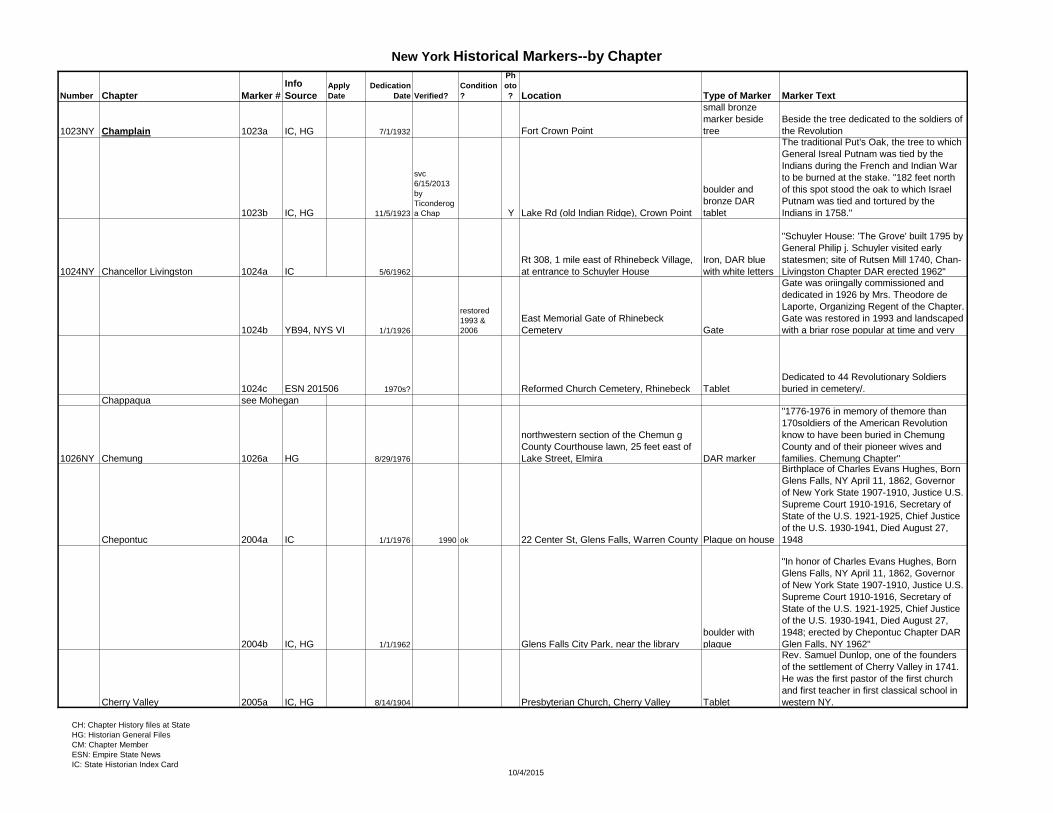
1023NY Champlain 1023a IC, HG 7/1/1932 Fort Crown Point
small bronze
marker beside
tree
Beside the tree dedicated to the soldiers of
the Revolution
1023b IC, HG 11/5/1923
svc
6/15/2013
by
Ticonderog
a Chap Y Lake Rd (old Indian Ridge), Crown Point
boulder and
bronze DAR
tablet
The traditional Put's Oak, the tree to which
General Isreal Putnam was tied by the
Indians during the French and Indian War
to be burned at the stake. "182 feet north
of this spot stood the oak to which Israel
Putnam was tied and tortured by the
Indians in 1758."
1024NY Chancellor Livingston 1024a IC 5/6/1962
Rt 308, 1 mile east of Rhinebeck Village,
at entrance to Schuyler House
Iron, DAR blue
with white letters
"Schuyler House: 'The Grove' built 1795 by
General Philip j. Schuyler visited early
statesmen; site of Rutsen Mill 1740, Chan-
Livingston Chapter DAR erected 1962"
1024b YB94, NYS VI 1/1/1926
restored
1993 &
2006
East Memorial Gate of Rhinebeck
Cemetery Gate
Gate was oriingally commissioned and
dedicated in 1926 by Mrs. Theodore de
Laporte, Organizing Regent of the Chapter.
Gate was restored in 1993 and landscaped
with a briar rose popular at time and very
1024c ESN 201506 1970s? Reformed Church Cemetery, Rhinebeck Tablet
Dedicated to 44 Revolutionary Soldiers
buried in cemetery/.
Chappaqua see Mohegan
1026NY Chemung 1026a HG 8/29/1976
northwestern section of the Chemun g
County Courthouse lawn, 25 feet east of
Lake Street, Elmira DAR marker
"1776-1976 in memory of themore than
170soldiers of the American Revolution
know to have been buried in Chemung
County and of their pioneer wives and
families. Chemung Chapter"
Chepontuc 2004a IC 1/1/1976 1990 ok 22 Center St, Glens Falls, Warren County Plaque on house
Birthplace of Charles Evans Hughes, Born
Glens Falls, NY April 11, 1862, Governor
of New York State 1907-1910, Justice U.S.
Supreme Court 1910-1916, Secretary of
State of the U.S. 1921-1925, Chief Justice
of the U.S. 1930-1941, Died August 27,
1948
2004b IC, HG 1/1/1962 Glens Falls City Park, near the library
boulder with
plaque
"In honor of Charles Evans Hughes, Born
Glens Falls, NY April 11, 1862, Governor
of New York State 1907-1910, Justice U.S.
Supreme Court 1910-1916, Secretary of
State of the U.S. 1921-1925, Chief Justice
of the U.S. 1930-1941, Died August 27,
1948; erected by Chepontuc Chapter DAR
Glen Falls, NY 1962"
Cherry Valley 2005a IC, HG 8/14/1904 Presbyterian Church, Cherry Valley Tablet
Rev. Samuel Dunlop, one of the founders
of the settlement of Cherry Valley in 1741.
He was the first pastor of the first church
and first teacher in first classical school in
western NY.
CH: Chapter History files at State
HG: Historian General Files
CM: Chapter Member
ESN: Empire State News
IC: State Historian Index Card10/4/2015
Page 11
New York Historical Markers--by Chapter
Number Chapter Marker #
Info
SourceApply
Date
Dedication
Date Verified?
Condition
?
Ph
oto
? Location Type of Marker Marker Text
2005b 8/15/1906 Monument
Marker commemorating Col Alden
Massacre of 1778; The card is postally
used, dated 1906. Written on the back are
the names of the people in the photo: last
names that we can read are - Little, Smith,
White, Cox, O'Connor, Leaning, Gibbons,
Watkins, and possibly "Rev. Mr. Keaton" or
"Keaston"
Chi-Nose-Heh-Geh see Mary Jemison
Chief Catoonah see Pierre van Cortlandt
1028NY Chief Taughannock 1028a IC, HG Trumansburg Hermann Camp house
1028b IC, HG pre-1976 reded 1976 ok-1990
Halseyville--crossroads 1/2 mile south of
Trumansburg on Rt 96 Plot Marker Commemorating Sullivan's plot
1028c IC, HG Halseyville Marker
Marker commemorating Nicoll Halsey
House
1184NY Christopher Stone
1029NY Colonel Aaron Ogden
1196NY Colonel Bigelow Lawrence 1196a Y95 1995 Skaneateles Historical Society Flagpole Presented to SHS by Chapter in 1994-95
1196b photo 1/1/1932 Sherwood Inn, Skaneateles
NYS DOE
Marker "…Sherwood Inn Built about 1800"
1030NY Colonel Gilbert Potter 1030a IC, HG 4/9/1989
Chicester Cemetery Oak St, Amityville,
Town of Babylon Suffolk Cty.
DAR Bronze
plaque at base of
flowering cherry
tree set in
concrete
By Col. Gilbert Potter Chapter presenting
tree and plaque commemorating the 200th
anniversary of the inaugeration of our 1st
United States President, Gen. George
Washington
1031NY Colonel Israel Angell 1031a IC 6/19/1914 1979 good
On Carr farm 2 mile south of West
Edmiston; moved to a plot farther south
on the new road to So. Edmeston 3x4' marker
"In memory of the three scouts killed on the
estate of Percifer Carr by 'Brandt's Indians,'
Sept. 16th 1778. Erected by the Col. Israel
Angell Chapter NSDAR."
1032NY Colonel Josiah Smith 1032a IC, CH, CM, HG 5/5/1963 2006 good Y
Manor of St. George, Mastic, Long Island,
Suffolk Co [William Floyd Parkway and
Neighborhood Rd, near front of manor
house]
Bronze DAR
marker
Battle of Ft. St. George; "Under orders
from Gen. George Washington, two
companies of the Continental Light
Dragoons commanded by Major
BenjaminTallmadge, attacked and captured
Fort St. George and captured the British
garrison at this place on November 23rd,
180_"
1032b IC, CM, HG 6/1/1933 3/12/2007 good Y
Route 112 and Route 25, Coram NY
[triangular piece of land west side of
Route 112]
bronze DAR
marker on native
boulder
"Near this spot while Long Island was
under English military control Col. Benjamin
Tallmadge with twelve Patriot soldiers
captured and burned a British magazine
and supply of forage on November 23,
1780; Erected by Col. Josiah Smith DAR
and the State of N 1933"
1032c IC, CM, CH, HG 10/13/1925 3/12/2007 good Y
Main Street and River Avvenue, north
side of Main Street, Patchogue
engraved granite
stone
Site of Hart's Tavern, in West Patchogue.
George Washington reports in diary that
when he made his tour of Long Island in
April 22, 1790, he remained overnight at
Hart's Tavern and ate Oysters there. CH: Chapter History files at State
HG: Historian General Files
CM: Chapter Member
ESN: Empire State News
IC: State Historian Index Card10/4/2015
Page 12
New York Historical Markers--by Chapter
Number Chapter Marker #
Info
SourceApply
Date
Dedication
Date Verified?
Condition
?
Ph
oto
? Location Type of Marker Marker Text
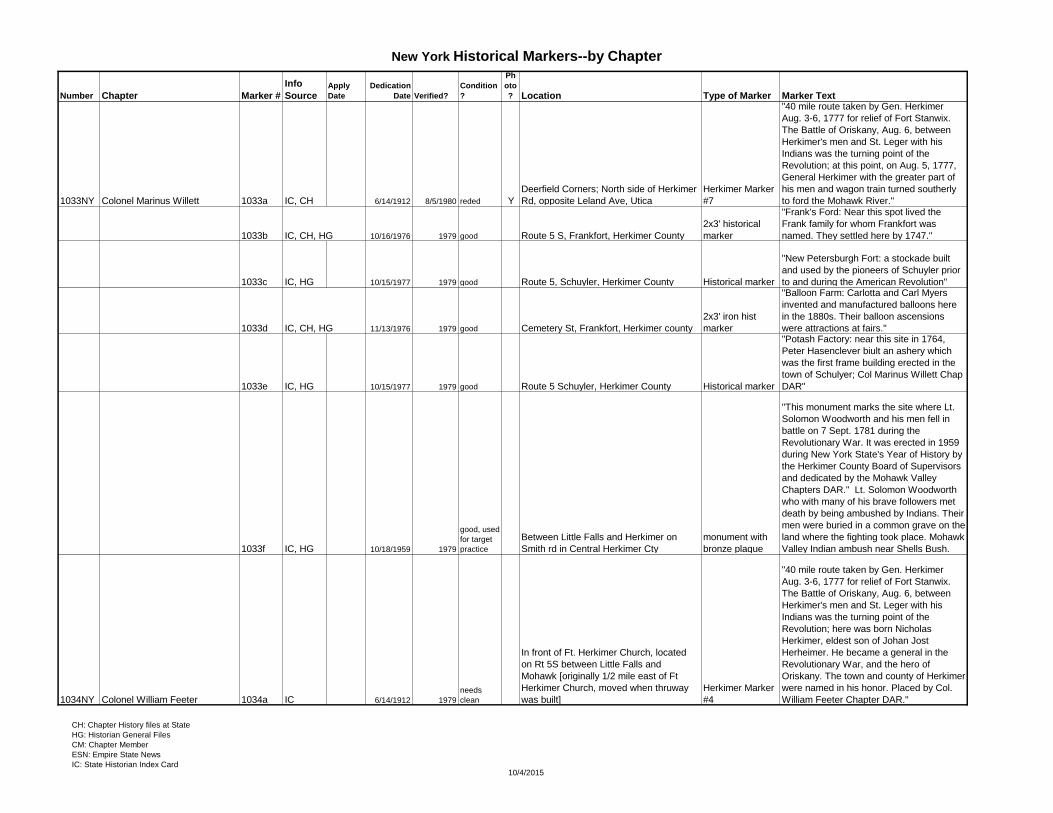
1033NY Colonel Marinus Willett 1033a IC, CH 6/14/1912 8/5/1980 reded Y
Deerfield Corners; North side of Herkimer
Rd, opposite Leland Ave, Utica
Herkimer Marker
#7
"40 mile route taken by Gen. Herkimer
Aug. 3-6, 1777 for relief of Fort Stanwix.
The Battle of Oriskany, Aug. 6, between
Herkimer's men and St. Leger with his
Indians was the turning point of the
Revolution; at this point, on Aug. 5, 1777,
General Herkimer with the greater part of
his men and wagon train turned southerly
to ford the Mohawk River."
1033b IC, CH, HG 10/16/1976 1979 good Route 5 S, Frankfort, Herkimer County
2x3' historical
marker
"Frank's Ford: Near this spot lived the
Frank family for whom Frankfort was
named. They settled here by 1747."
1033c IC, HG 10/15/1977 1979 good Route 5, Schuyler, Herkimer County Historical marker
"New Petersburgh Fort: a stockade built
and used by the pioneers of Schuyler prior
to and during the American Revolution"
1033d IC, CH, HG 11/13/1976 1979 good Cemetery St, Frankfort, Herkimer county
2x3' iron hist
marker
"Balloon Farm: Carlotta and Carl Myers
invented and manufactured balloons here
in the 1880s. Their balloon ascensions
were attractions at fairs."
1033e IC, HG 10/15/1977 1979 good Route 5 Schuyler, Herkimer County Historical marker
"Potash Factory: near this site in 1764,
Peter Hasenclever biult an ashery which
was the first frame building erected in the
town of Schulyer; Col Marinus Willett Chap
DAR"
1033f IC, HG 10/18/1959 1979
good, used
for target
practice
Between Little Falls and Herkimer on
Smith rd in Central Herkimer Cty
monument with
bronze plaque
"This monument marks the site where Lt.
Solomon Woodworth and his men fell in
battle on 7 Sept. 1781 during the
Revolutionary War. It was erected in 1959
during New York State's Year of History by
the Herkimer County Board of Supervisors
and dedicated by the Mohawk Valley
Chapters DAR." Lt. Solomon Woodworth
who with many of his brave followers met
death by being ambushed by Indians. Their
men were buried in a common grave on the
land where the fighting took place. Mohawk
Valley Indian ambush near Shells Bush.
1034NY Colonel William Feeter 1034a IC 6/14/1912 1979
needs
clean
In front of Ft. Herkimer Church, located
on Rt 5S between Little Falls and
Mohawk [originally 1/2 mile east of Ft
Herkimer Church, moved when thruway
was built]
Herkimer Marker
#4
"40 mile route taken by Gen. Herkimer
Aug. 3-6, 1777 for relief of Fort Stanwix.
The Battle of Oriskany, Aug. 6, between
Herkimer's men and St. Leger with his
Indians was the turning point of the
Revolution; here was born Nicholas
Herkimer, eldest son of Johan Jost
Herheimer. He became a general in the
Revolutionary War, and the hero of
Oriskany. The town and county of Herkimer
were named in his honor. Placed by Col.
William Feeter Chapter DAR."
CH: Chapter History files at State
HG: Historian General Files
CM: Chapter Member
ESN: Empire State News
IC: State Historian Index Card10/4/2015
Page 13
New York Historical Markers--by Chapter
Number Chapter Marker #
Info
SourceApply
Date
Dedication
Date Verified?
Condition
?
Ph
oto
? Location Type of Marker Marker Text
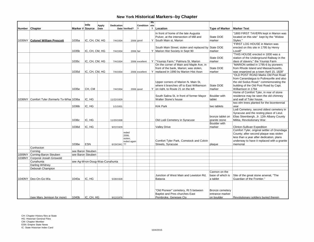
1035NY Colonel William Prescott 1035a IC, CH, CM, HG 7/4/1934 2006 good Y
In front of home of the late Augusta
Pulver, at the intersection of Mill and
South Main st, Marion
State DOE
marker
"1800 FIRST TAVERN kept in Marion was
located on this site" kept by the "Widow
Styles."
1035b IC, CH, CM, HG 7/4/1934 2006 fair Y
South Main Street; stolen and replaced by
Marion Hist Society in Sept 90
State DOE
marker
"FIRST LOG HOUSE in Marion was
erected on this site in 1795 by Henry
Lovell"
1035c IC, CH, CM, HG 7/4/1934 2006 excellent Y "Youngs Farm," Palmyra St, Marion
State DOE
marker
"THIS HOUSE erected in 1830 was a
station of the Underground Railway in the
days of slavery;" the Youngs Farm
1035d IC, CH, CM, HG 7/4/1934 2006 excellent Y
On the corner of Main and Maple Ave, in
front of the bank, Marion; was stolen,
replaced in 1990 by Marion Hist Assn
State DOE
marker
"MARION settled in 1795-6 by pioneers
from Rhode Island and Massachusetts,
was organized as a town April 15, 1828"
1035e CH, CM 7/4/1934 2006 good Y
Upper corners of Marion N. Main St,
where it branches off to East Williamson
on right, to Route 21 on the left
State DOE
marker
"OLD POST ROAD Marks Old Post Road
from Canandaigua to Pultneyville and also
the old Sodus Road;" commemorating the
building of the Old Post Road by Capt.
Williamson in 1794
1036NY Comfort Tyler (formerly To-Whan-Ta-Qua)1036a IC, HG 11/22/1929
South Salina St, in front of former Mayor
Walter Stone's house
Boulder with
tablet
Home of Comfort Tyler, in rear of stone
residence may be seen the old chimney
and wall of Tyler house.
1036b IC, HG 1/1/1931 Kirk Park two tablets
two elm trees planted for the bicentennial
year
1036c IC, HG 11/20/1938 Old Lodi Cemetery in Syracuse
bronze tablet on
granite stone
Lodi Cemetery, second oldest cemetery in
Syracuse and the resting place of Lieut.
Elias Steenbergh, Jr. 12th Albany County
Militia, Revolutionary War.
1036d IC, HG 9/22/1929 Valley Drive
Boulder with
marker Clinton-Sullivan Expedition
1036e ESN 6/19/1941
reded
2006;
stolen,
reded again
??
Comfort Tyler Park, Comstock and Colvin
Streets, Syracuse plaque
Comfort Tyler, original settler of Onondaga
County; after second plaque was stolen
less than a year after dedication, plans
underway to have it replaced with a granite
memorial
Conhocton
Corning see Baron Steuben
1009NY Corning-Baron Steuben see Baron Steuben
1038NY Corporal Josiah Griswold
Cunahunta see Ag-Wron-Doug-Was-Cunahunta
Darling Whitney
Deborah Champion
1040NY Deo-On-Go-Wa 1040a IC, HG 5/28/1928
Junction of West Main and Lewiston Rd,
Batavia
Cannon on the
base of which is
a tablet
Site of the great stone arsenal, "The
Guardian of the Frontier."
(see Mary Jemison for more) 1040b IC, CH, HG 9/12/1976
"Old Pioneer" cemetery, Rt 5 between
Baptist and Pres churches East
Pembroke, Genesee Cty
Bronze cemetery
entrance marker
on boulder Revolutionary soldiers buried therein
CH: Chapter History files at State
HG: Historian General Files
CM: Chapter Member
ESN: Empire State News
IC: State Historian Index Card10/4/2015
Page 14
New York Historical Markers--by Chapter
Number Chapter Marker #
Info
SourceApply
Date
Dedication
Date Verified?
Condition
?
Ph
oto
? Location Type of Marker Marker Text
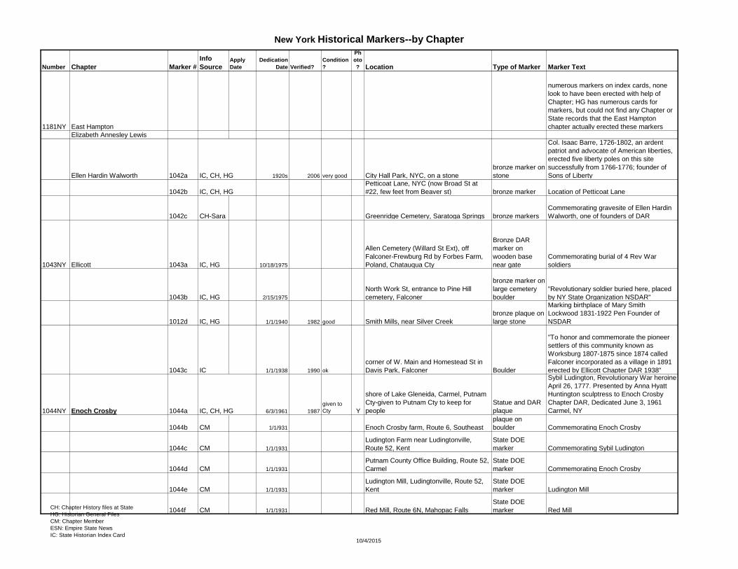
1181NY East Hampton
numerous markers on index cards, none
look to have been erected with help of
Chapter; HG has numerous cards for
markers, but could not find any Chapter or
State records that the East Hampton
chapter actually erected these markers
Elizabeth Annesley Lewis
Ellen Hardin Walworth 1042a IC, CH, HG 1920s 2006 very good City Hall Park, NYC, on a stone
bronze marker on
stone
Col. Isaac Barre, 1726-1802, an ardent
patriot and advocate of American liberties,
erected five liberty poles on this site
successfully from 1766-1776; founder of
Sons of Liberty
1042b IC, CH, HG
Petticoat Lane, NYC (now Broad St at
#22, few feet from Beaver st) bronze marker Location of Petticoat Lane
1042c CH-Sara Greenridge Cemetery, Saratoga Springs bronze markers
Commemorating gravesite of Ellen Hardin
Walworth, one of founders of DAR
1043NY Ellicott 1043a IC, HG 10/18/1975
Allen Cemetery (Willard St Ext), off
Falconer-Frewburg Rd by Forbes Farm,
Poland, Chatauqua Cty
Bronze DAR
marker on
wooden base
near gate
Commemorating burial of 4 Rev War
soldiers
1043b IC, HG 2/15/1975
North Work St, entrance to Pine Hill
cemetery, Falconer
bronze marker on
large cemetery
boulder
"Revolutionary soldier buried here, placed
by NY State Organization NSDAR"
1012d IC, HG 1/1/1940 1982 good Smith Mills, near Silver Creek
bronze plaque on
large stone
Marking birthplace of Mary Smith
Lockwood 1831-1922 Pen Founder of
NSDAR
1043c IC 1/1/1938 1990 ok
corner of W. Main and Homestead St in
Davis Park, Falconer Boulder
"To honor and commemorate the pioneer
settlers of this community known as
Worksburg 1807-1875 since 1874 called
Falconer incorporated as a village in 1891
erected by Ellicott Chapter DAR 1938"
1044NY Enoch Crosby 1044a IC, CH, HG 6/3/1961 1987
given to
Cty Y
shore of Lake Gleneida, Carmel, Putnam
Cty-given to Putnam Cty to keep for
people
Statue and DAR
plaque
Sybil Ludington, Revolutionary War heroine
April 26, 1777. Presented by Anna Hyatt
Huntington sculptress to Enoch Crosby
Chapter DAR, Dedicated June 3, 1961
Carmel, NY
1044b CM 1/1/931 Enoch Crosby farm, Route 6, Southeast
plaque on
boulder Commemorating Enoch Crosby
1044c CM 1/1/1931
Ludington Farm near Ludingtonville,
Route 52, Kent
State DOE
marker Commemorating Sybil Ludington
1044d CM 1/1/1931
Putnam County Office Building, Route 52,
Carmel
State DOE
marker Commemorating Enoch Crosby
1044e CM 1/1/1931
Ludington Mill, Ludingtonville, Route 52,
Kent
State DOE
marker Ludington Mill
1044f CM 1/1/1931 Red Mill, Route 6N, Mahopac Falls
State DOE
marker Red MillCH: Chapter History files at State
HG: Historian General Files
CM: Chapter Member
ESN: Empire State News
IC: State Historian Index Card10/4/2015
Page 15
New York Historical Markers--by Chapter
Number Chapter Marker #
Info
SourceApply
Date
Dedication
Date Verified?
Condition
?
Ph
oto
? Location Type of Marker Marker Text
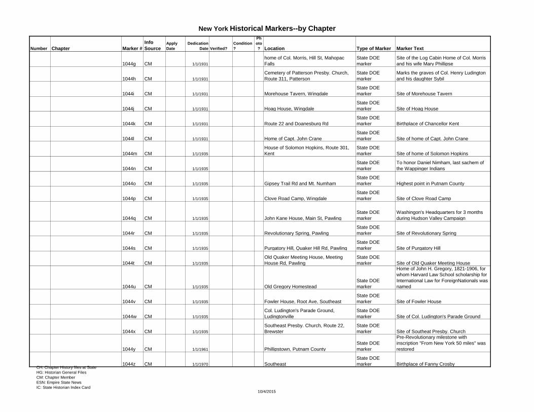
1044g CM 1/1/1931
home of Col. Morris, Hill St, Mahopac
Falls
State DOE
marker
Site of the Log Cabin Home of Col. Morris
and his wife Mary Phillipse
1044h CM 1/1/1931
Cemetery of Patterson Presby. Church,
Route 311, Patterson
State DOE
marker
Marks the graves of Col. Henry Ludington
and his daughter Sybil
1044i CM 1/1/1931 Morehouse Tavern, Wingdale
State DOE
marker Site of Morehouse Tavern
1044j CM 1/1/1931 Hoag House, Wingdale
State DOE
marker Site of Hoag House
1044k CM 1/1/1931 Route 22 and Doanesburg Rd
State DOE
marker Birthplace of Chancellor Kent
1044l CM 1/1/1931 Home of Capt. John Crane
State DOE
marker Site of home of Capt. John Crane
1044m CM 1/1/1935
House of Solomon Hopkins, Route 301,
Kent
State DOE
marker Site of home of Solomon Hopkins
1044n CM 1/1/1935
State DOE
marker
To honor Daniel Nimham, last sachem of
the Wappinger Indians
1044o CM 1/1/1935 Gipsey Trail Rd and Mt. Numham
State DOE
marker Highest point in Putnam County
1044p CM 1/1/1935 Clove Road Camp, Wingdale
State DOE
marker Site of Clove Road Camp
1044q CM 1/1/1935 John Kane House, Main St, Pawling
State DOE
marker
Washingon's Headquarters for 3 months
during Hudson Valley Campaign
1044r CM 1/1/1935 Revolutionary Spring, Pawling
State DOE
marker Site of Revolutionary Spring
1044s CM 1/1/1935 Purgatory Hill, Quaker Hill Rd, Pawling
State DOE
marker Site of Purgatory Hill
1044t CM 1/1/1935
Old Quaker Meeting House, Meeting
House Rd, Pawling
State DOE
marker Site of Old Quaker Meeting House
1044u CM 1/1/1935 Old Gregory Homestead
State DOE
marker
Home of John H. Gregory, 1821-1906, for
whom Harvard Law School scholarship for
International Law for ForeignNationals was
named
1044v CM 1/1/1935 Fowler House, Root Ave, Southeast
State DOE
marker Site of Fowler House
1044w CM 1/1/1935
Col. Ludington's Parade Ground,
Ludingtonville
State DOE
marker Site of Col. Ludington's Parade Ground
1044x CM 1/1/1935
Southeast Presby. Church, Route 22,
Brewster
State DOE
marker Site of Southeat Presby. Church
1044y CM 1/1/1961 Phillipstown, Putnam County
State DOE
marker
Pre-Revolutionary milestone with
inscription "From New York 50 miles" was
restored
1044z CM 1/1/1970 Southeast
State DOE
marker Birthplace of Fanny CrosbyCH: Chapter History files at State
HG: Historian General Files
CM: Chapter Member
ESN: Empire State News
IC: State Historian Index Card10/4/2015
Page 16
New York Historical Markers--by Chapter
Number Chapter Marker #
Info
SourceApply
Date
Dedication
Date Verified?
Condition
?
Ph
oto
? Location Type of Marker Marker Text
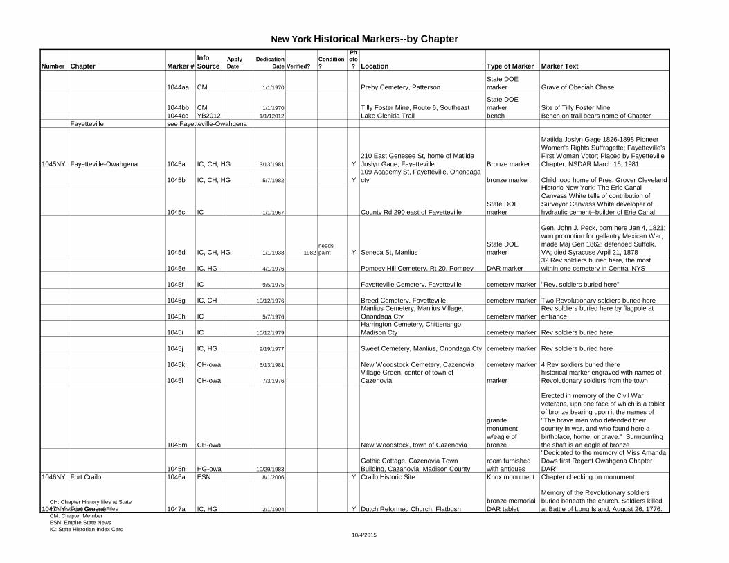
1044aa CM 1/1/1970 Preby Cemetery, Patterson
State DOE
marker Grave of Obediah Chase
1044bb CM 1/1/1970 Tilly Foster Mine, Route 6, Southeast
State DOE
marker Site of Tilly Foster Mine
1044cc YB2012 1/1/12012 Lake Glenida Trail bench Bench on trail bears name of Chapter
Fayetteville see Fayetteville-Owahgena
1045NY Fayetteville-Owahgena 1045a IC, CH, HG 3/13/1981 Y
210 East Genesee St, home of Matilda
Joslyn Gage, Fayetteville Bronze marker
Matilda Joslyn Gage 1826-1898 Pioneer
Women's Rights Suffragette; Fayetteville's
First Woman Votor; Placed by Fayetteville
Chapter, NSDAR March 16, 1981
1045b IC, CH, HG 5/7/1982 Y
109 Academy St, Fayetteville, Onondaga
cty bronze marker Childhood home of Pres. Grover Cleveland
1045c IC 1/1/1967 County Rd 290 east of Fayetteville
State DOE
marker
Historic New York: The Erie Canal-
Canvass White tells of contribution of
Surveyor Canvass White developer of
hydraulic cement--builder of Erie Canal
1045d IC, CH, HG 1/1/1938 1982
needs
paint Y Seneca St, Manlius
State DOE
marker
Gen. John J. Peck, born here Jan 4, 1821;
won promotion for gallantry Mexican War;
made Maj Gen 1862; defended Suffolk,
VA; died Syracuse Arpil 21, 1878
1045e IC, HG 4/1/1976 Pompey Hill Cemetery, Rt 20, Pompey DAR marker
32 Rev soldiers buried here, the most
within one cemetery in Central NYS
1045f IC 9/5/1975 Fayetteville Cemetery, Fayetteville cemetery marker "Rev. soldiers buried here"
1045g IC, CH 10/12/1976 Breed Cemetery, Fayetteville cemetery marker Two Revolutionary soldiers buried here
1045h IC 5/7/1976
Manlius Cemetery, Manlius Village,
Onondaga Cty cemetery marker
Rev soldiers buried here by flagpole at
entrance
1045i IC 10/12/1979
Harrington Cemetery, Chittenango,
Madison Cty cemetery marker Rev soldiers buried here
1045j IC, HG 9/19/1977 Sweet Cemetery, Manlius, Onondaga Cty cemetery marker Rev soldiers buried here
1045k CH-owa 6/13/1981 New Woodstock Cemetery, Cazenovia cemetery marker 4 Rev soldiers buried there
1045l CH-owa 7/3/1976
Village Green, center of town of
Cazenovia marker
historical marker engraved with names of
Revolutionary soldiers from the town
1045m CH-owa New Woodstock, town of Cazenovia
granite
monument
w/eagle of
bronze
Erected in memory of the Civil War
veterans, upn one face of which is a tablet
of bronze bearing upon it the names of
"The brave men who defended their
country in war, and who found here a
birthplace, home, or grave." Surmounting
the shaft is an eagle of bronze
1045n HG-owa 10/29/1983
Gothic Cottage, Cazenovia Town
Building, Cazanovia, Madison County
room furnished
with antiques
"Dedicated to the memory of Miss Amanda
Dows first Regent Owahgena Chapter
DAR"
1046NY Fort Crailo 1046a ESN 8/1/2006 Y Crailo Historic Site Knox monument Chapter checking on monument
1047NY Fort Greene 1047a IC, HG 2/1/1904 Y Dutch Reformed Church, Flatbush
bronze memorial
DAR tablet
Memory of the Revolutionary soldiers
buried beneath the church. Soldiers killed
at Battle of Long Island, August 26, 1776.CH: Chapter History files at State
HG: Historian General Files
CM: Chapter Member
ESN: Empire State News
IC: State Historian Index Card10/4/2015
Page 17
New York Historical Markers--by Chapter
Number Chapter Marker #
Info
SourceApply
Date
Dedication
Date Verified?
Condition
?
Ph
oto
? Location Type of Marker Marker Text
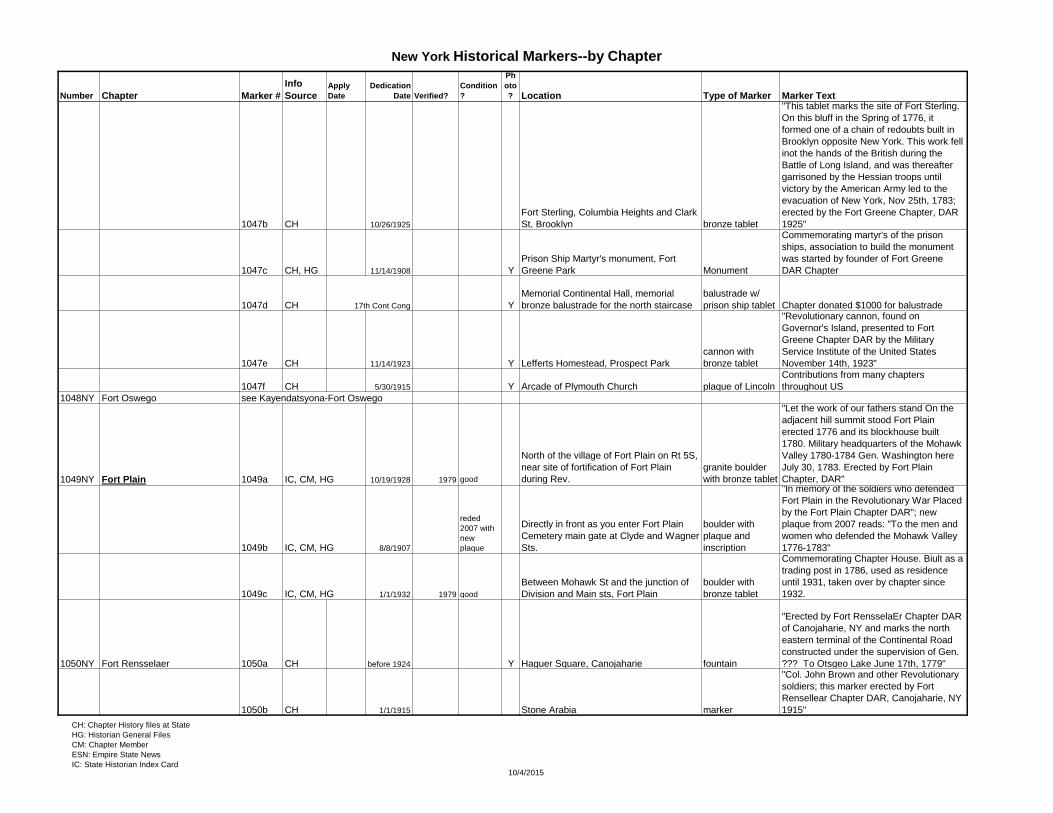
1047b CH 10/26/1925
Fort Sterling, Columbia Heights and Clark
St, Brooklyn bronze tablet
"This tablet marks the site of Fort Sterling.
On this bluff in the Spring of 1776, it
formed one of a chain of redoubts built in
Brooklyn opposite New York. This work fell
inot the hands of the British during the
Battle of Long Island, and was thereafter
garrisoned by the Hessian troops until
victory by the American Army led to the
evacuation of New York, Nov 25th, 1783;
erected by the Fort Greene Chapter, DAR
1925"
1047c CH, HG 11/14/1908 Y
Prison Ship Martyr's monument, Fort
Greene Park Monument
Commemorating martyr's of the prison
ships, association to build the monument
was started by founder of Fort Greene
DAR Chapter
1047d CH 17th Cont Cong Y
Memorial Continental Hall, memorial
bronze balustrade for the north staircase
balustrade w/
prison ship tablet Chapter donated $1000 for balustrade
1047e CH 11/14/1923 Y Lefferts Homestead, Prospect Park
cannon with
bronze tablet
"Revolutionary cannon, found on
Governor's Island, presented to Fort
Greene Chapter DAR by the Military
Service Institute of the United States
November 14th, 1923"
1047f CH 5/30/1915 Y Arcade of Plymouth Church plaque of Lincoln
Contributions from many chapters
throughout US
1048NY Fort Oswego see Kayendatsyona-Fort Oswego
1049NY Fort Plain 1049a IC, CM, HG 10/19/1928 1979 good
North of the village of Fort Plain on Rt 5S,
near site of fortification of Fort Plain
during Rev.
granite boulder
with bronze tablet
"Let the work of our fathers stand On the
adjacent hill summit stood Fort Plain
erected 1776 and its blockhouse built
1780. Military headquarters of the Mohawk
Valley 1780-1784 Gen. Washington here
July 30, 1783. Erected by Fort Plain
Chapter, DAR"
1049b IC, CM, HG 8/8/1907
reded
2007 with
new
plaque
Directly in front as you enter Fort Plain
Cemetery main gate at Clyde and Wagner
Sts.
boulder with
plaque and
inscription
"In memory of the soldiers who defended
Fort Plain in the Revolutionary War Placed
by the Fort Plain Chapter DAR"; new
plaque from 2007 reads: "To the men and
women who defended the Mohawk Valley
1776-1783"
1049c IC, CM, HG 1/1/1932 1979 good
Between Mohawk St and the junction of
Division and Main sts, Fort Plain
boulder with
bronze tablet
Commemorating Chapter House. Biult as a
trading post in 1786, used as residence
until 1931, taken over by chapter since
1932.
1050NY Fort Rensselaer 1050a CH before 1924 Y Haguer Square, Canojaharie fountain
"Erected by Fort RensselaEr Chapter DAR
of Canojaharie, NY and marks the north
eastern terminal of the Continental Road
constructed under the supervision of Gen.
??? To Otsgeo Lake June 17th, 1779"
1050b CH 1/1/1915 Stone Arabia marker
"Col. John Brown and other Revolutionary
soldiers; this marker erected by Fort
Rensellear Chapter DAR, Canojaharie, NY
1915"
CH: Chapter History files at State
HG: Historian General Files
CM: Chapter Member
ESN: Empire State News
IC: State Historian Index Card10/4/2015
Page 18
New York Historical Markers--by Chapter
Number Chapter Marker #
Info
SourceApply
Date
Dedication
Date Verified?
Condition
?
Ph
oto
? Location Type of Marker Marker Text
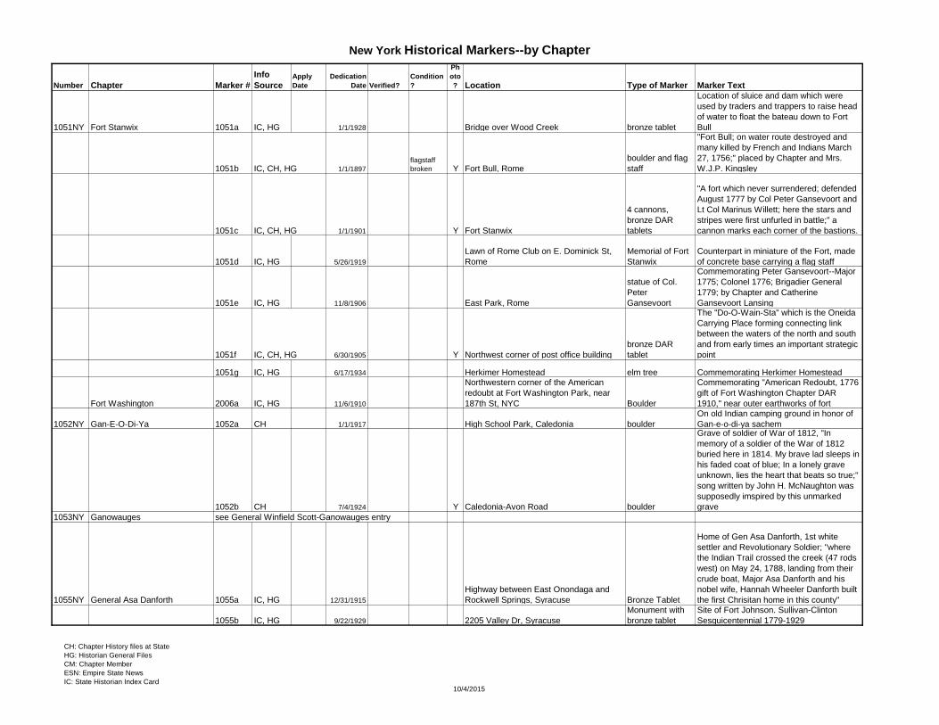
1051NY Fort Stanwix 1051a IC, HG 1/1/1928 Bridge over Wood Creek bronze tablet
Location of sluice and dam which were
used by traders and trappers to raise head
of water to float the bateau down to Fort
Bull
1051b IC, CH, HG 1/1/1897
flagstaff
broken Y Fort Bull, Rome
boulder and flag
staff
"Fort Bull; on water route destroyed and
many killed by French and Indians March
27, 1756;" placed by Chapter and Mrs.
W.J.P. Kingsley
1051c IC, CH, HG 1/1/1901 Y Fort Stanwix
4 cannons,
bronze DAR
tablets
"A fort which never surrendered; defended
August 1777 by Col Peter Gansevoort and
Lt Col Marinus Willett; here the stars and
stripes were first unfurled in battle;" a
cannon marks each corner of the bastions.
1051d IC, HG 5/26/1919
Lawn of Rome Club on E. Dominick St,
Rome
Memorial of Fort
Stanwix
Counterpart in miniature of the Fort, made
of concrete base carrying a flag staff
1051e IC, HG 11/8/1906 East Park, Rome
statue of Col.
Peter
Gansevoort
Commemorating Peter Gansevoort--Major
1775; Colonel 1776; Brigadier General
1779; by Chapter and Catherine
Gansevoort Lansing
1051f IC, CH, HG 6/30/1905 Y Northwest corner of post office building
bronze DAR
tablet
The "Do-O-Wain-Sta" which is the Oneida
Carrying Place forming connecting link
between the waters of the north and south
and from early times an important strategic
point
1051g IC, HG 6/17/1934 Herkimer Homestead elm tree Commemorating Herkimer Homestead
Fort Washington 2006a IC, HG 11/6/1910
Northwestern corner of the American
redoubt at Fort Washington Park, near
187th St, NYC Boulder
Commemorating "American Redoubt, 1776
gift of Fort Washington Chapter DAR
1910," near outer earthworks of fort
1052NY Gan-E-O-Di-Ya 1052a CH 1/1/1917 High School Park, Caledonia boulder
On old Indian camping ground in honor of
Gan-e-o-di-ya sachem
1052b CH 7/4/1924 Y Caledonia-Avon Road boulder
Grave of soldier of War of 1812, "In
memory of a soldier of the War of 1812
buried here in 1814. My brave lad sleeps in
his faded coat of blue; In a lonely grave
unknown, lies the heart that beats so true;"
song written by John H. McNaughton was
supposedly imspired by this unmarked
grave
1053NY Ganowauges see General Winfield Scott-Ganowauges entry
1055NY General Asa Danforth 1055a IC, HG 12/31/1915
Highway between East Onondaga and
Rockwell Springs, Syracuse Bronze Tablet
Home of Gen Asa Danforth, 1st white
settler and Revolutionary Soldier; "where
the Indian Trail crossed the creek (47 rods
west) on May 24, 1788, landing from their
crude boat, Major Asa Danforth and his
nobel wife, Hannah Wheeler Danforth built
the first Chrisitan home in this county"
1055b IC, HG 9/22/1929 2205 Valley Dr, Syracuse
Monument with
bronze tablet
Site of Fort Johnson. Sullivan-Clinton
Sesquicentennial 1779-1929
CH: Chapter History files at State
HG: Historian General Files
CM: Chapter Member
ESN: Empire State News
IC: State Historian Index Card10/4/2015
Page 19
New York Historical Markers--by Chapter
Number Chapter Marker #
Info
SourceApply
Date
Dedication
Date Verified?
Condition
?
Ph
oto
? Location Type of Marker Marker Text
1055c IC, HG 12/31/1915 Dorwin Springs Rd, Syracuse Bronze Tablet
Ephraim Webster's home, "Soldier,
pioneer, Indian interpreter, 1st supervisor
of town settled here in 1786. Died 1824."
1055d IC, HG 1/1/1932
On the Pompey Road from Jamesville just
beyond dam of Jamesville Reservoir
State DOE
Marker
Moses DeWitt, burial place and house,
"near here was the home of Moses DeWitt,
pioneer settler, surveyor, major of militia
and judge of county court"
1056NH General Jacob Odell see Hudson River Patriots
General James Clinton 2007a IC, HG 6/30/1906 ? good Y
Junction of Cherry Valley Turnpike and
Continental Rd, East Springfield (Rt 20
and Cont Rd) Marker
"Clinton march from Canajoharie to Otsego
Lake, to join Gen. Sullivan in his
campaign." Known as Continental Rd.
2007b CH 1/1/1976
Old Springfield Cemetery entrance,
Springfield marker
29 Revolutionary soldiers buried in
cemetery
2007c CH 1/1/1929 Presbyterian churchyard, Springfield marker
Erected by Gen. James Clinton Chapter
with names of 95 Revolutionary soldiers
"who have lived at some time in the town of
Springfield and helped make its history"
2007d CH before 1936 1970
restored
and
rededicate
d
Col. Ichabod Alden monument, south of
Cherry Valley monument
Monument to where Col Alden was buried
after the Cherry Valley massacre; restored
and rededicated by family members of
former Cherry Valley Chapter DARs in
1970
1193NY General John Paterson 1193a CH, HG 5/28/1984
Junction of highway routes 11, 26, and
79, at the traffic light intersection, Whitney
Point
memorial tablet
on native rock
"General John Paterson, 1744-1808;
Revolutionary Patriot; New York State
Assemblyman [1798]; United States
Congressman [1803]; Colonial Pioneer;"
erected near site of original home of Gen.
Paterson
General John Williams see Captain Israel Harris entry
General Nathaniel Woodhull 2008a IC, HG Chapel on Governor's Island Tablet
Commemorating General Nathaniel
Woodhull and the soldiers in the Battle of
Long Island
2008b IC, HG Y
New Utrecht Cem (New Utrecht Reformed
Church, 1828 83rd St), Brooklyn
DAR Tablet on
Boulder
Opposite DeSalle house where General
Woodhull died
1060NY General Nicholas Herkimer 1060a IC, CH, HG 8/6/1907
Myers Park facing Park Ave, center of
village of Herkimer
boulder with
statue of Gen.
Herkimer
"Statue of General Nicholas Herchheimer,
gift of Hon. Warner Miller, placed on the
boulder and presented to the village of
Herkimer by General Nicholas Herkimer
Chapter D.A.R. in memory of those who
have died for our country." Sculptor Burr
Miller, son of Warner Miller
see more entries under
"Henderson-General Herkimer" 1060b IC, HG 7/13/1963
Swezey Hill Cem, off Rose Valley Rd, Rt
8, Cold Brook, Newport, Herkimer Cty
12x18" bronze
plaque
"Town of Newport, Swezey Hill Cemetery,
eastablished in 1798 by Deacon Daniel
Swezey, a God-fearing pioneer deidicated
to the memory of our pioneer families and
our soldiers in the Revolution. 1963"
CH: Chapter History files at State
HG: Historian General Files
CM: Chapter Member
ESN: Empire State News
IC: State Historian Index Card10/4/2015
Page 20
New York Historical Markers--by Chapter
Number Chapter Marker #
Info
SourceApply
Date
Dedication
Date Verified?
Condition
?
Ph
oto
? Location Type of Marker Marker Text
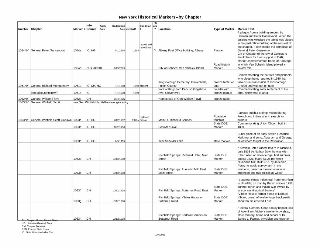
1054NY General Peter Gansevoort 1054a IC, HG 5/1/1935 1938
moved and
rededicate
d Y Albany Post Office building, Albany Plaque
A plaque from a building erected by
Herman and Peter Gansevoort. When the
building was wrecked the tablet was placed
in the post office building at the request of
the chapter. It now marks the birthplace of
General Peter Gansevoort.
1054b Dtrs 201001 9/19/2009 City of Cohoes; Van Schaick Island
Road historic
marker
Gift of Chapter to the city of Cohoes to
thank them for their support of DAR;
marker commemorates Battle of Saratoga,
in which Van Schaick Island played a
pivotal role.
1061NY General Richard Montgomery 1061a IC, CH, HG 1/1/1908 1990 present
Kingsborough Cemetery, Gloversville,
Fulton County
bronze tablet on
gate
Commemorating the patriots and pioneers
who sleep there; reported in 1980 that
tablet is in possession of Kinsborough
Church and was not on gate
(see also Johnstown) 1061b IC 1/1/1928 1990
front of Kingsboro Park on Kingsboro
Ave, Gloversville
boulder with
bronze plaque
Commemorating early settlement of the
area, show map of area
1062NY General William Floyd 1062a CH 7/24/1925 Homestead of Gen William Floyd bronze tablet
1063NY General Winfield Scott see Gen Winfield Scott-Ganowauges entry
1063NY General Winfield Scott-Ganowauges1063a IC, HG 7/12/1932 1970s
replaced
marker Main St, Richfield Springs
Roadside
fountain
Famous sulphur springs visited during
French and Indian War in search for
sulphur
1063b IC, HG 10/2/1936 Schuyler Lake
State DOE
marker
Commemorating Union Church built in
1839
1063c IC, HG 8/3/1935 near Schuyler Lake state marker
Burial place of an early settler, Hendrick
Herkimer and sons, Abraham and George,
all of whom fought in the Revolution
1063d CH 10/12/1938
Richfield Springs: Richfield Hotel, Main
Street
State DOE
Marker
"Richfield Hotel: Oldest tavern in Richfield,
built 1816 by Nathan Dow; he was with
Ethan Allen at Ticonderoga; first summer
guests 1821; board $1.25 per week"
1063e CH 10/12/1938
Richfield Springs: Tunnicliff Mill, East
Main Street
State DOE
Marker
"Tunnicliff Mill: Built 1791 by Jedediah
Peck; he would survey farm in the
forenoon, preach a funeral sermon in
afternoon and talk politics all week"
1063f CH 10/12/1938 Richfield Springs: Butternut Road East
State DOE
Marker
"Butternut Road: Indian trail from Fort Plain
to Unadilla; on map by British officers 1757
during French and Indian War owned by
Wisconsin Historical Society"
1063g CH 10/12/1938
Richfield Springs: Vibber House on
Butternut Road
State DOE
Marker
"Vibber House: former home of Lemuel
Vibber; owner of twelve forge blacksmith
shop; house erected 1798"
1063h CH 10/12/1938
Richfield Springs: Federal Corners on
Butternut Road
State DOE
Marker
"Federal Corners: Once a busy hamlet, site
of Averill Inn, Vibber's twelve forge shop,
store tannery, home and school of Dr.
James L. Palmer, physician and teacher"CH: Chapter History files at State
HG: Historian General Files
CM: Chapter Member
ESN: Empire State News
IC: State Historian Index Card10/4/2015
Page 21
New York Historical Markers--by Chapter
Number Chapter Marker #
Info
SourceApply
Date
Dedication
Date Verified?
Condition
?
Ph
oto
? Location Type of Marker Marker Text
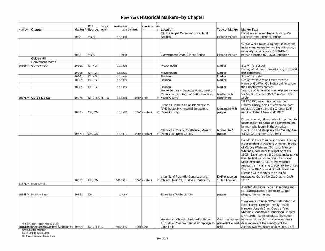
1063i YB90 1/1/1990
Old Episcopal Cemetery in Richland
Springs Historic Marker
Burial site of seven Revolutionary War
Soldiers from Richfield Springs
1063j YB90 1/1/990 Ganwauges Great Sulphur Spring Historic Marker
"Great White Sulphur Spring" used by the
Indians and others for healing purposes, a
nationally famous resort 1810-1940;
perhaps located by 1063a, fountain?
Golden Hill
Gouverneur Morris
1066NY Go-Won-Go 1066a IC, HG 1/1/1935 McDonough Marker Site of first school
1066b IC, HG 1/1/1935 McDonough Marker
Setting off of town from adjoining town and
first settlement
1066c IC, HG 1/1/1935 Brisben Marker Site of first cabin
1066d IC, HG 1/1/1935 Brisben Marker Site of first tavern and town meeting
1066e IC, HG 1/1/1935 Brisben Marker
Home of Go-Won-Go Indian girl for whom
the Chapter was named.
1067NY Gu-Ya-No-Ga 1067a IC, CH, CM, HG 1/1/1928 2007 good Y
Route 364, near DeLooza Road, west of
Penn Yan, near town of Potter townline,
Yates County
boulder with
eengraving
"Marcus Whitman Highway; erected by Gu-
Ya-No-Ga Chapter DAR Penn Yan, NY
1928"
1067b CH, CM 1/1/1927 2007 excellent Y
Kinney's Corners on an island next to
NYS Route 54A, town of Jerusalem,
Yates County
Monument with
plaque
"1827-1904; near this spot was born
Coates Kinney; soldier, statesman, poet;
erected by Gu-Ya-No-Ga Chapter DAR
and the State of New York 1927"
1067c CH, CM 1/1/1931 2007 excellent Y
Old Yates County Courthouse, Main St,
Penn Yan, Tates County
bronze DAR
plaque
Plaque is on righthand side of front door to
courthouse; "To honor and commemorate
he men who fought in the American
Revolution and sleep in Yates County; Gu-
Ya-No-Ga Chapter, DAR 1931"
1067d CH, CM 10/23/1931 2007 excellent Y
grounds of Rushville Congregational
Church, Main St, Rushville, Yates Cty
DAR plaque on
15 ton boulder
Boulder is from farm owned at one time by
a descendant of Augusta Whitman, brother
of Marcus Whitman; "To honor Marcus
Whitman, born near this spot Sept 4th,
1802 missionary to the Cayuse Indians. His
was the first wagon to cross the Rocky
Mountains 1842-1844. Gave valuable
assistance in claiming Oregon to the United
States. In 1847 he and his wife Narcissa
Prentice were martyrs in an Indian
massacre. Gu-Ya-No-Ga Chapter DAR
1931"
1187NY Hannakrois
1068NY Harvey Birch 1068a CH 1970s? Scarsdale Public Library plaque
Assisted American Legion in moving and
redeicating James Fenimoore Cooper
plaque, had ceremony
1060NY Henderson-General Nicholas Herkimer1060c IC, CH, HG 7/14/1985 1990 good
Henderson Church, Jordanville, Route
167; Main Road from Richfield Springs to
Little Falls
Cast iron marker
painted blue and
gold
"Henderson Church 1829-1878 Peter Bell,
Peter Harter, Geroge Fetterly, Jacob
Hangen, Joseph Crim, George Yule,
Micholas Shoemaker Henderson Chapter
DAR 1985;" commemorates the seven
founders of the church who were direct
descendants of the survivors of the
Andrustown Massacre of July 18th, 1778CH: Chapter History files at State
HG: Historian General Files
CM: Chapter Member
ESN: Empire State News
IC: State Historian Index Card10/4/2015
Page 22
New York Historical Markers--by Chapter
Number Chapter Marker #
Info
SourceApply
Date
Dedication
Date Verified?
Condition
?
Ph
oto
? Location Type of Marker Marker Text
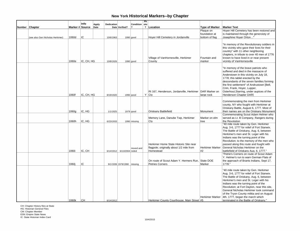
(see also Gen Nicholas Herkimer) 1060d IC 10/6/1963 1990 good Hoyer Hill Cemetery in Jordanville
Plaque on
foundation at
bottom of flag
Hoyer Hill Cemetery has been restored and
is maintained through the generoisty of
Josephine Hoyer Orton…"
1060e IC, CH, HG 10/8/1926 1990 good
Village of VanHornesville, Herkimer
County
Fountain and
marker
"In memory of the Revolutionary soldiers in
this vicinity who gave their lives for their
country" with 11 other neighboring
chapters, in tribute to over 40 men of 1776
known to have lived in or near present
vicinity of VanHornesville
1060f IC, CH, HG 8/19/1920 1990 good Y
Rt 167, Henderson, Jordanville, Herkimer
Cty
DAR Marker on
large rock
"In memory of the brave patriots who
suffered and died in the massacre of
Anderstown in this vicinity on July 18,
1778; this tablet erected by the
descendants of the seven families forming
the first settlement" of Andrustown [Bell,
Crim, Frank, Hoyer, Lupper,
Osterhout,Starring, under aupices of the
Henderson Chapter DAR]
1060g IC, HG 1/1/1925 1979 good Oriskany Battlefield Monument
Commemorating the men from Herkimer
county, NY who fought with Herkimer at
Oriskany Battle, August 6, 1777. Most of
their names are on the Oriskany Monument
1060h IC, HG 6/23/1933 1990 missing
Memory Lane, Danube Twp, Herkimer
Cty
Marker on elm
tree
Commemorating Scout Adam Helmer who
served as Lt. B Company, Rangers during
the Revolution
1060i IC, CH 6/14/1912 6/13/2004
moved and
reded
Herkimer Home State Historic Site near
flagpole; originally about 1/2 mile from
Homestead
Herkimer Marker
#2
"40 mile route taken by Gen. Herkimer
Aug. 3-6, 1777 for relief of Fort Stanwix.
The Battle of Oriskany, Aug. 6, between
Herkimer's men and St. Leger with his
Indians was the turning point of the
Revolution; to the memory of the men who
passed along this route and fought with
General Nicholas Herkimer on the
battlefield of Oriskany Aug. 6, 1777."
1060j IC 9/1/1939 1979/1990 missing
On route of Scout Adam Y. Hermers Run,
Petries Corners
State DOE
Marker
"Petrie's Corners on route of Scout Adam
Y. Helmer's run to warn German Flats of
the approach of Brants Indians, Sept 17,
1778."
1060k CH 6/14/1912 Herkimer County Courthouse, Main Street
Herkimer Marker
#5
"40 mile route taken by Gen. Herkimer
Aug. 3-6, 1777 for relief of Fort Stanwix.
The Battle of Oriskany, Aug. 6, between
Herkimer's men and St. Leger with his
Indians was the turning point of the
Revolution; at Fort Dayton, near this site,
General Nicholas Herkimer took command
of the Tryon County militia and on August
4th, 1777, began the march which
terminated in the Battle of Oriskany."
CH: Chapter History files at State
HG: Historian General Files
CM: Chapter Member
ESN: Empire State News
IC: State Historian Index Card10/4/2015
Page 23
New York Historical Markers--by Chapter
Number Chapter Marker #
Info
SourceApply
Date
Dedication
Date Verified?
Condition
?
Ph
oto
? Location Type of Marker Marker Text
1060l CH 6/29/1909
Myers Park facing old Spinner Homestea,
village of Herkimer
statue with
pedastal
Pedestal furnished by Gen Nicholas
Herkimer chapter DAR, "The fact that I was
instrumental in introducng women to
employment in the ffices of the government
gives me more real satisfaction than all the
other deeds of my life." 1802-1890 General
Francis Elias Spinner, Sec Treasury 1861-
1875
1060m CH 9/1/1939 On route of Scout Adam Y. Helmers Run marker
"Site of home of Peter Hoyer and wife
Maria Helmer on route of Scout Adam
Helmer's run to warn German Flatts of the
approach of Brandt's Indians, Sept 17,
1778"
1060n CH 9/1/1939 On route of Scout Adam Y. Helmers Run marker
"Trail of Scout Adam Helmer entering
Mohawk Valley to warn settlers of German
Flatts of the approach of Brandt's Indians,
Sept 17, 1778"
1033f IC, HG 10/18/1959 1979
good, used
for target
practice
Between Little Falls and Herkimer on
Smith rd in Central Herkimer Cty
monument with
bronze plaque
"This monument marks the site where Lt.
Solomon Woodworth and his men fell in
battle on 7 Sept. 1781 during the
Revolutionary War. It was erected in 1959
during New York State's Year of History by
the Herkimer County Board of Supervisors
and dedicated by the Mohawk Valley
Chapters DAR." Lt. Solomon Woodworth
who with many of his brave followers met
death by being ambushed by Indians. Their
men were buried in a common grave on the
land where the fighting took place. Mohawk
Valley Indian ambush near Shells Bush.
1070NY Hendrick Hudson 1070a IC, CM, HG 1/1/1938 2006 excellent Y Teviotdale
flag and marker;
State DOE
marker
"Teviotdale, built about 1773 Livingston-
Fulton house; home of Hon. Walter
Livingston and of son-in-law Robert
Fulton;" cannot see flagpole in photo
1070b CH 7/6/1975
gate of St. Peter's Presbyterian Church
Cemetery, Spencertown DAR Hist Marker
Commemorating where 38 Revolutionary
War verterans rest
1070c CH 1/1/1976
entrance to "Free Ground" cemetery at
Ancram DAR marker
Commemorating Revolutionary soldiers
buried there
1070d CH 1/1/1976
entrance to North Hillsdale Methodist
Church Cemetery, Hillsdale DAR marker
Commemorating Revolutionary soldiers
buried there
1071NY Holland Patent 1071a IC, HG 5/1/1915 Holland Patent Park, Holland Patent tablet on boulder
Commemorating the memory of soldiers
who served in the Revolutionary War.
1071b IC, HG 5/1/1974 1979 good
gate of Holland Patent Cemetery, Holland
Patent, Oneida Cty entrance marker
Revolutionary War soldiers buried there [17
names]
1072NY Hoosac-Walloomsac 1072a IC, HG, V2 1930s 1980 good Hoosick Falls Marker
Site of first Meeting House erected 1800.
First Baptist Church organized 1847.
(see also Ondawa-Cambridge) 1072b IC, HG, V2 9/9/1933 1980 missing
Near St. Croix Bridge on the North
Hoosick Cambridge Road, Hoosick,
Renselear Cty
State DOE
Marker
"St. Croix Church marker. Here is the site
of Dutch Reformed Chruch. The first
Protestant Church in Hoosick Valley. On
Lot of A. Wendell in Hoosick Patent."
1072c IC, HG, V2 1930s 1980 missing Hoosick Falls, buried during blasting Marker
Site of first bridge over Hoosick River at
the Falls, built 1791 as "federal Bridge."CH: Chapter History files at State
HG: Historian General Files
CM: Chapter Member
ESN: Empire State News
IC: State Historian Index Card10/4/2015
Page 24
New York Historical Markers--by Chapter
Number Chapter Marker #
Info
SourceApply
Date
Dedication
Date Verified?
Condition
?
Ph
oto
? Location Type of Marker Marker Text
1072d IC, HG, V2 1930s 1980 good Hoosick Falls Marker
Site of Walloomsac Methodist Episcopal
Church, opposite of Bennington Battlefield
1072e IC, HG, V2 1930s 1980 good Hoosick Falls Marker
Early Tavern, kept by David Wilcox before
1814. Later home of Dr. John Warren,
1806-1882.
see Ondawa-Cambridge for more 1072f IC, HG, V2 1930s 1980 good Buskirk Marker
Dutch Reformed Church organized 1792.
First Pastor, Rev. Samuel Smith
1056NY Hudson River Patriots 1056a IC, HG, V2 1/3/1934
Junction of Broadway, Edgar Lane, and
Warburton Ave, NYC
bronze tablet on
boulder Site of the "skirmish of Edgar Lane."
1056b CH,CM 6/1/2001 6/19/2004 1/1/2007 good Y
Odell Tavern, corner of Dows Lane and
Broadway, Irvington
Bronze DAR
marker
"The Odell Tavern: according to tradition
this building was used as a tavern and also
served as the Odell home. The patriot,
Jonathan Odell and his wife Margaret
Dyckman live here. Their sons, John,
Isaac, and Abraham were Westchester
guides, and their son Jacob was a post
rider for the Committee of Safety during the
war for American Independence (1775-
1783). The odell's home was a site of a
meeting of the Committee of Safety, Aug
31, 1776; marker placed June 19, 2004 by
Hudson River Patriots Chapter, DAR in
appreciation of the restoration of this
building"
1056c IC 11/1/1965 Hardscrabble Rd, Pleasantville
bronze marker on
boulder
Marking a spring where Major Andre
stopped to water his horse on his way to
his capture in Tarrytown
1056d IC, HG
Valentine Hill, St. Joseph's Ave, Yonkers,
NY marker
Commemorating Washington's
Headquarters on Valentine Hill; put in fence
of St Joseph's Seminary; wreath placed
there every June 14th.
1056e IC, CH, HG 6/1/1970
St John's Church South Wall, Yonkers,
Westchester Cty tablet
"To honor all American Revolutionary
Soldiers buried in Saint John's Church
cemetery, Yonkers NY Presented by
Keskeskick Chapter DAR, 75th
Anniversary June 1970." Bones re-buried
when church enlarged. Used as a hospital
therefore both English and American.
1056f CH, HG 5/1/1983 Sherwood House, Yonkers
flagpole and
marker
1740s Sherwood House: "A Landmark, the
Sherwood house will soon be on the
National Register of Historic places. It was
constructed in 1740 by Thomas Sherwood,
one of Frederick Philipse's tenant farmers.
Presented by NSDAR Keskeskick Chapter,
June 26, 1983"
1056g IC, HG 1/1/1932 1990 excellent
High school grounds, Tarrytown,
Westchester Co tree and marker Bicentennial memorial oak tree
1056h IC, CH, HG 11/1/1976 1990
Old Dutch 1st Reformed Church
Cemetery, Mt Pleasant, Westchester marker
Cemetery entrance marker commemorating
the Revolutionary soldiers buried withinCH: Chapter History files at State
HG: Historian General Files
CM: Chapter Member
ESN: Empire State News
IC: State Historian Index Card10/4/2015
Page 25
New York Historical Markers--by Chapter
Number Chapter Marker #
Info
SourceApply
Date
Dedication
Date Verified?
Condition
?
Ph
oto
? Location Type of Marker Marker Text
1056i IC, CH, HG 5/28/1977 1990
Elmsford Community Reformed Church
Cemetery, Greenburgh, Westchester
bronze cemetery
entrance marker
Commemorating Revolutionary soldiers
buried there
1056j IC, CH, HG 5/1/1976 1990
Sleepy Hollow Cemetery, Mt Pleasant,
Westchester
bronze cemetery
entrance marker
Commemorating Revolutionary soldiers
buried there
Increase Carpenter
1073NY Irondequoit 1073a IC, HG 1/1/1932
East end of Veteran's Memorial Bridge,
Carthage
bronze memorial
tablet
Commemorating pioneers Caleb Lyon,
Elisha B. Strong and others
1073b IC, HG 7/4/1924
grounds of the Village Hall, Warsaw
Highway, Wyoming
bronze marker on
stone: Holland
Land Co marker
Commemorating pioneers and children of
Wyoming vicinty, placed by Meda Cox
1073c IC, HG, CM, ESN 3/1/1906 10/14/2006 reded Y
Mount Hope Cemetery lot owned jointly
by DAR and SAR, Rochester
boulder with oval
plaque
Commemorating spot where the remains of
Captain Thomas Boyd, 4 fellow officers, his
Oneida Indian guide, and 9 volunteer
riflemen were reinterred; these men fell at
Grovland, Livingston County on Sep 13,
1779.
1073d IC, HG 1/11897 or 1898 Rochester Marker
Commemorating purchased lot to which the
remains of Rev. Ebenezer Vining, a
Revolutionary soldier, were placed after
removal from the Potter's field.
1074NY Iroquois 1074a IC 6/6/1928 1990 Y Worcester DAR Tablet
"In honor of the Revolutionary soldiers who
established the township of Worcester" 66
names of Revolutionary soldiers are on the
bronze plaque, dedicated to the community
of Worcester
1074b CH 1/1/1928
80th anniv
celeb 2008 Y
Corner of NYS Route 20 and Continental
Rd, 1/2 mile west of East Springfield marker on marble
"This monument is erected to the memory
of Gen'l James Clinton Born 1736 Died
1812 & marks a point on the line of march
of his troops from Mohawk River to Otsego
Lake in June 1779 General James Clinton
Chapter DAR aedificant" cared for by the
owners of the house across Continental Rd
on the corner
1074c CH 1/1/1928 Y
Corner of NYS Route 20 and Continental
Rd, 1/2 mile west of East Springfield
NYS DOE
Marker
"Camp and Fort; at Hyde Bay, Otsego
Lake, 2 1/2 miles south,occupied by 4th
Massachusetts Regiment 1799; NYS Hist
Marker 1928" **not sure if DAR affiliated
Jacobus Roosevelt
1075NY James Madison 1075a IC, CH 10/17/1924 1991 ok Y
flagpole in center of park in center
Hamilton
DAR plaque on
boulder
"To the memory of those who defended the
honor of our country in the War for
American Independence 1776-1783
erected by James Madison Chapter DAR
1924""
CH: Chapter History files at State
HG: Historian General Files
CM: Chapter Member
ESN: Empire State News
IC: State Historian Index Card10/4/2015
Page 26
New York Historical Markers--by Chapter
Number Chapter Marker #
Info
SourceApply
Date
Dedication
Date Verified?
Condition
?
Ph
oto
? Location Type of Marker Marker Text
1075b IC, HG 6/20/1929 1991 ok memorial
"1/4 mile west stood the home of Col. Wm.
S. Smith. Occupied 1807-8 by him and his
daughter, Abigail Adams, daughter of
President John Adams. Col. Smith served
as Adjutant to Generals Sullivan, Lafayette
and Washington 1776-1781. He purchased
in 1781, six townships in Madison and
Chenango counties, which became known
as Smith's Valley. He died in 1816 and was
buried in Sherburne West Hill. Base
supporting this tablet was the doorstep of
Smith House which was built in 1807."
1075c IC 7/28/1976
corner of Gilchrist Memorial Church
building, Kortright Center, Mr.
Harpersfield, Delaware Cty.
DAR Cem
Marker
Revolutionary war soldiers buried in
Gilchrist Memorial Cemetery
1075d CH 1/1/1976
Lebanon Cemetery, Lebanon, Madison
Cty
DAR Cem
Marker Revolutionary soldiers buried here
1075e CH 1/1/1976
West Eaton Cemetery, Eaton, Madison
Cty
DAR Cem
Marker Revolutionary soldiers buried here
1075f CH 7/1/1976
Episcopal Cemetery, Sherburne,
Chenango
DAR Cem
Marker Revolutionary soldiers buried here
1075g CH 5/1/1976
Quarter Cemetery, Sherburne, Chenango
Cty
DAR Cem
Marker Revolutionary soldiers buried here
1075h CH 6/1/1974
West Hill Cemetery, Sherburne,
Chenango Cty
DAR Cem
Marker Revolutionary soldiers buried here
1075i CH 6/1/1974
East Hill Cemetery, Sherburne,
ChenangoCty
DAR Cem
Marker Revolutionary soldiers buried here
1075j Y97 6/18/1905 Hamilton Monument
Chapter raised $319 for monument
honoring Rev Soldiers over 8 years
1076NY Jamestown Regent Carolyn Volk verified no markers
1077NY Jane McCrea 1077a IC 6/11/1925 1979 good
Hudson Fall village mall across form
Presb. Church
bronze plaque
inset into Tall
Soldiers
Monument
Commemorating Lafayettes visit, his fourth,
along with his son. "Lafayette, in
recognition of whose service to our country
this tablet is placed in the park where he
was welcomed in June 1825."
1077b IC 7/18/1976 1979 good lawn of Old Fort House Museum
bronze plaque on
3' stone from Fort
Edward
"The Bicentennial Barge here July 17, 18
1976"
1077c IC, HG 4/25/1981 1990 12 Center St, Glens Falls, Warren Cty plaque
Birthplace of Robert Porter Patterson, US
Secretary of War under President Truman
1945-1947. He died Jan 22, 1952
1077d IC, CH 9/16/1914 1979 good
Near canal, site of old Fort Edward, Glens
Falls; end of Old Fort St. about a block
from Broadway at curve in street on south
side of Ft Edward
bronze plaque
20x16" in boulder
removed from
canal bed
"This boulder marks the site of Old Fort
Edward 1755-1780 erected by Jane
McCrea Chapter DAR 1914"
1077e IC, CH, HG 7/27/1901 1978 repaired Broadway in Ft Edward, near high school
Pyramid of stone
with bronze plate
"Memorial to Jane McCrea, massacred
near this point by Indians July 27, 1777,
Erected by Jane McCrea DAR July 27,
1901"CH: Chapter History files at State
HG: Historian General Files
CM: Chapter Member
ESN: Empire State News
IC: State Historian Index Card10/4/2015
Page 27
New York Historical Markers--by Chapter
Number Chapter Marker #
Info
SourceApply
Date
Dedication
Date Verified?
Condition
?
Ph
oto
? Location Type of Marker Marker Text
1077f YB06 1/1/2006 Burial plot of Jane McCrea Monument
Dedicated to Sarah McNeil, a friend of
Jane McCrea's previously buried with her
1173NY Jerusalem 1173a Y2000 2000 Plaque
George Washington's 1790 route was
marked with a plaque
1185NY Johannes Hardenbergh 1185a CH, HG 2/14/1985 Y Greenville Presbyterian Church, Catskill
National Register
plaque
Built in 1790, first church west of the
Hudson north of New Jersey
John Jay
1061NY Johnstown 1061c IC, CH, HG 8/31/1901 2001 reded Y Johnstown Battlefield
large boulder
with bronze tablet
Site of the battle fought in the war of the
American Revolution, Oct 25, 1781
(see also Gen Richard Montgomery) 1061d IC, HG 7/15/1908 1979 excellent Colonial Cemetery, Johnstown, Fulton Co
Memeorial arch
with bronze tablet
"To the memory of our historic dead who
bore arms in the War of Independence and
who were ever the brave defneders of the
Mohawk Valley and to the early inhabitants
of our city who load her foundations so
enduring this arch is erected and dedicated
by the Johnstown Chapter DAR 1908.
1061e IC, HG 1/1/1937 1979 good
Wallager Bros Building, corner Mainand
William Sts, Johnstown bronze tablet
"Site of Free School built by Sir William
Johnson opened with about 45 pupils
spring 1769. Edward Wall schoolmaster
NYS Ed Dept and Johnstown Chapter DAR
1937."
1061f IC, HG 1/1/1926
Former James Burke Inn , once known as
"Black Horse Tavern" (NOT Black Horse
Inn) bronze tablet
Bronze tablet inside house for former
Regent, the late Josie Potter without whose
generosity the Chapter would not be able
to maintain the house.
1061g IC, HG 1/1/1937
corner Main and N. Market St, State Bank
of Albany Building, Johnstown bronze tablet
Commemorating birthplace of Elizabeth
Cady Stanton
Jonas Bronck (formerly Bronx) 2009a IC, HG 10/18/1901 1975 excellent Glover's Rock, Pelham Bay Park NYC
DAR tablet on
the rock
"Glover's Rock: in memory of the 550
patriots who led by Col. John Glover, held
Gen. Howe's Army in check at the Battle of
Pell's Point Oct 18, 1776 thus aiding
Washington in his retreat to White Plains;
'fame is the perfume of heroic deeds'
erected by the Bronx Chapter of Mount
Vernon, NY DAR Oct 18, 1901"
2009b IC 5/30/1924 St Paul's, Eastchester, Mt. Vernon
marker on side of
church building
Plaque reads in memory of Patriots of the
American Revolution who lie buried in the
churchyard (list of names)
2009c IC, HG 6/14/1906 Indian Field, Van Cortlandt Park, NYC
bronze tablet with
cairn of rough
boulders
Commemorating memory of Chief Ninham
and 17 Stockbridge Indians, as allies of the
patriots who gave their lives for liberty;
article in Daily Argus Newspaper June
1906
CH: Chapter History files at State
HG: Historian General Files
CM: Chapter Member
ESN: Empire State News
IC: State Historian Index Card10/4/2015
Page 28
New York Historical Markers--by Chapter
Number Chapter Marker #
Info
SourceApply
Date
Dedication
Date Verified?
Condition
?
Ph
oto
? Location Type of Marker Marker Text
2009d IC, HG 11/22/1913 1979 good Tuckahoe
tablet on granite
boulder
"This tablet marks the spot where Captain
Samuel Crawford was killed ina skirmish
with British troops November 18, 1777. He
was a soldier and a statesman. Deputy
form Westchester County to Provincial
Congress. Committeeman from Scarsdale
Seconded Resolution to make New York a
state."
2009e HG 1/1/1910 St Paul's, Eastchester, Mt. Vernon
gravestone
marker
"this marks the site of the sand pit in which
are buried those Hessian soldiers who died
in the chruch when used as a hospital,
1776; erected by Bronx Chapter DAR
1910"
2009f HG 1/1/1910 St Paul's, Eastchester, Mt. Vernon marker
On grave of Revolutionary soldiers whose
bones were accidentally found when
excavations were made in Tuckahoe in
1909. The Chapter had these bones
interred in the churchyard at St. Paul's in
1910.
1080NY Kanaghsaws
1081NY Kanestio Valley 1081a CH, CM 5/29/1903 2007 excellent Y Armory Lawn, Hornell
boulder with DAR
plaque
"To the patriots of the American Revolution
buried in the Upper Canisteo Valley; this
memorial erected by the Kanisteo Chapter
NSDAR [date]"; plaque underneath lists
names of Rev War soldiers; in 1997 added
plaque underneath listing all 62 area Rev
War soldiers
1082NY Katharine Pratt Horton-Buffalo 1082a IC, HG 10/19/1975 Y
Evergreen Hill Cemetery entrance,
outside Cemetery Chapel, Corfu, near
Batavia
Metal DAR
plaque Burial ground of five Rev. War soldiers
1082b IC, HG 9/1/1907
Drummond Hill Cemetery, Niagara Falls,
Ontario Cty Stone monument
In memory of Capt. Abraham F. Hull and
nine unknown soldiers of the United States
Army killed at the Battle of Lundy's Lane
July 25, 1814
1082c IC, HG 11/1/1939 1981
put in
storage
Historical Society Warehouse Storage,
Erie Co, Buffalo bronze plaque
To the memory of Mary Norton Thompson
who founded the Buffalo Chapter of the
National Society DAR in the year 1892 and
was its Regent and honorary Regent until
her death Nov. 24, 1902. This tablet is
erected in grateful and loving appreciation
by members of her Chapter.
1082d IC, CH 9/27/1981 Forest Lawn Cemetery, Buffalo, Erie Cty bronze marker
"In memory of Katherine Pratt Horton
Regent 1901-1930 This marker placed and
dedicated by Katherine Pratt Horton
Chapter" on 50th anniversary of her death
1082e IC, HG 194? Just south of Court St, Buffalo Marker
Site of Eagle Tavern, where Lafayette was
entertained and spoke in 1825
1082f IC, HG American Hotel, Buffalo Marker
Site where Lincoln was entertained and
spoke when he stopped in Buffalo enroute
to his inauguration, 1861CH: Chapter History files at State
HG: Historian General Files
CM: Chapter Member
ESN: Empire State News
IC: State Historian Index Card10/4/2015
Page 29
New York Historical Markers--by Chapter
Number Chapter Marker #
Info
SourceApply
Date
Dedication
Date Verified?
Condition
?
Ph
oto
? Location Type of Marker Marker Text
1082g IC, HG 1/1/1905
Main entrance wall Buffalo and Erie
County Public Library, Buffalo, Erie Cty bronze plaque
"The site of the first courthouse of Niagara
and Erie Counties. First court house built
and destroyed at the burning of Buffalo by
British Dec. 30, 1813. Second courthouse
built 1816-17, abandoned March 11,
1876…"
1082h CH 5/24/1902 Near village of LaSalle
bronze tablet on
field boulder
Spot where the "Griffon" was built and
launched in May 1679 near the village of
LaSalle.
1082i CH 190?
West side of Main St between Court and
Mohawk Streets, was "Neisner" store in
1940s, Buffalo marker
The St John House, only dwelling to be
spared by the British and Indians at the
time of the burning of Buffalo Dec 30/31,
1813.
1082j CH 8/2/1902
Niagara St Bridge spanning Scajaquada
Creek, Buffalo tablet
Site of the Battle of Black Rock, Aug 3,
1814
1082k CH 9/13/1902 Niagara Gorge below falls talblet
Site of Devil's Hole Massacre, Sept 14,
1763; unveiled by Mrs. John Miller Horton
1082l CH 190?
West side of Pearl St, just below Swan,
Buffalo marker
Site of the first school house built in 1807-
08, th eschool burned Dec 30, 1813.
1082m Cen 1950 Library, Veterans Hospital Buffalo Marker
"These libraries have been furnished in
commemoration of the Golden Anniversary
of the New York State Organization
NSDAR …"
1083NY Kayendatsyona-Fort Oswego 1083a CH 1/1/1976 Cemetery Gate Marker "Revolutionary soldiers buried here"
1083b IC, HG 1/1/1927 Montcalm Park, Oswego
boulder with
bronze marker Commemorating Montcalm
1083c IC, HG 1/1/1927 grounds of Hotel Pontiac, Oswego
boulder with
bronze tablet
The meeting of Sir William Johnson and
Pontiac
1083d IC, HG 10/14/1909 Ft George, Oswego
boulder with
bronze tablet Site of Fort George
1083e IC, HG 1/1/1906 Old Cemetery, Fort Ontario Monument
Commemorating the graves of 12 unknown
Revolutionary soldiers.
1083f IC, HG 7/4/1906 Entrance to Fort Ontario
Boulder with
bronze tablet
The dates of the building and rebuilding of
Fort Ontario
1083g CH 8/21/1976 Fort Ontario Cemetery, Oswego
bronze on pink
marble
1084NY Keskeskick see Hudson River Patriots
1085NY Ketewamoke 1085a IC, HG 1/1/1948 Nassau Road, Huntington
DAR Bronze
marker
Ketewamoke Chapter House:
"Ketewamoke Chapter NSDAR this house
was built 1837 by the Universalist Society
as a place of worship for all denominations
later used as their parsonage--purchased
by Ketewamoke Chapter 1914--restored for
Chapter House 1926-1948 - marker placed
in memory of Phoebe Underhill Dickson
190222 1853-1943 by Mariana Rish
Dickson"
1085b CH 1/11973 Cemetery marker "Revolutionary soldiers buried here"
CH: Chapter History files at State
HG: Historian General Files
CM: Chapter Member
ESN: Empire State News
IC: State Historian Index Card10/4/2015
Page 30
New York Historical Markers--by Chapter
Number Chapter Marker #
Info
SourceApply
Date
Dedication
Date Verified?
Condition
?
Ph
oto
? Location Type of Marker Marker Text
1085c Y97 3/30/1905 reded 1997 Local Hospital Women's Ward plaque
Yearbook 1997: "We had a rededication of
a missing plaque stating that Ketewamoke
had furnished the women's ward in 1916
when our local hospital first opened its
doors."
1086NY Kiandaga 1086a IC 1/1/1940
Rt 21 by village park, coming into Naples
from the north
State DOE
marker
Naples founded 1789 on the old Seneca
Village of Nundawao; first known as
Watkinstown; on April 6, 1908 named
Naples
1086b IC 1980 missing Main and Vine, Naples marker 2nd Grimes Glen marker
1086c IC 1980 missing Rt 21 north, Naples marker site of the Balm of Gilead tree
1086d IC 6/14/1932 1979
tree gone,
plaque
good
Village park, north end of Naples, corner
Rt 21 and 245
boulder with
plaque
"Under the parent of this tree Washington
first took command of the American Army
July 3, 1775"
1086e IC 1/1/1931 1979 good Rt 53 to Prattsburg, south end of Naples
State DOE
marker Narcissa Prentiss Highway
1086f IC 1/1/1939 1979 fair
Grimes Glen at extreme end of Vine St,
Naples
State DOE
marker
1939, Grimes Glen. Home of oldest fossil
tree found and mounted by D Dana Luther,
now in State Education Building, Albany
1086g IC, HG 3/1/1944 1979 good
Naples Presbyterian Church, Naples;
Village Park, north end of Naples on Rt
21 at back of park near Fairview
Cemetery
bronze plate on a
tablet
First Church. On this site was organized
the 'First Religious Compact of middletown
1800." The church was built in 1824.
1086h IC 1/1/1940 1979 good Rt 21, coming into Naples from the south
State DOE
marker
Naples; Known as Watkinstown 1789;
named Middletown 1796, midway between
Canandaigua and Bath; Naples April 6,
1808"
1086i IC 1/1/1925 good
Village park, north end of Naples, corner
Rt 21 and 245
boulder with
plaque
"Memorial Canesque, Chief of the Senecas
at Nundawao Village, who came from the
Genesee Reservation in 1794 to die and
be buried in his beloved Kiandaga Valley"
1086j IC 1/1/1932 1980 good
Corner Clara Barton St and Rt 36, St
Paul's Lutheran Church, Dansville
State DOE
marker
In this church was organized the first local
Red Cross society in the United States by
ClaraBarton Aug 22, 1881
Knapp see Anne Hutchinson
CH: Chapter History files at State
HG: Historian General Files
CM: Chapter Member
ESN: Empire State News
IC: State Historian Index Card10/4/2015
Page 31
New York Historical Markers--by Chapter
Number Chapter Marker #
Info
SourceApply
Date
Dedication
Date Verified?
Condition
?
Ph
oto
? Location Type of Marker Marker Text
1199NY Knickerbocker 1199a IC, CH, HG 11/25/1903 Y
Site of Murray Mansion, Park Ave and
37th St, NYC; now on the median strip
that runs down Park Ave at 37th St, lower
edge is covered with dirt and behind
fence
DAR tablet on
large boulder
Commemorating Mary Lindley Murray, wife
of Robert Murray, for services rendered her
country during the Revolution. The Murray
home was on this site on Sept 15?, 1776
when the American forces were being
withdrawn from the lower part of New york
to join forces at Harlem and King's Bridge.
The British were in close pursuit of the
column under General Putnam, which was
not more than ten minutes ahead. General
Howe and his staff stopped at the Murray
home to inquire how long since General
Putnam had passed. Ms. Murray assured
them he was beyond successful pursuit
and as the day was "insufferably hot" urged
them to dismount and partake of
refreshments. They yielded to her
persuasion and this charming Quaker lady
and her lovely daughter succeeded in
delaying them formore than two hours, thus
enabling the Americans to reach Harlem
Heights in safety.
1199b CH before 1903 Y
Kemble Bldg, Whitehall St, NYC arcoss
from Customs House tablet
Site of the home of Anneke Jans, wife of
Dominic E_crardus Bogardus of
Knickerbocker fame
1199c CH 10/19/1910 Y
Southern entrance to the Riverside Drive
Viaduct tablet
Marks important point connected with the
battle of Harlem Heights
1088NY Koo Koose 1088a IC, CM, HG 9/22/1925 May-03 restored Y 129 Second St, Deposit
bronze tablet on
boulder
"This marker marks the Fort Stanwix
Treaty Line; the deed from the Indians to
the whites was signed November 5, 1768;
the line was run in 1769 from the Delaware
River almost due north to the mouth of the
Unadilla River; it afterward became the
dividing line between Delaware and
Broome counties; placed by Koo Koose
Chapter DAR September 22 1925"
1088b IC, CM 5/1/1982 2007 good Revolutionary Cemetery, Deposit (?) Gate of cemetery restoration of gate
Kuy-A-Hoo-Ra 1060k CH 6/14/1912 Herkimer County Courthouse, Main Street
Herkimer Marker
#5
"40 mile route taken by Gen. Herkimer
Aug. 3-6, 1777 for relief of Fort Stanwix.
The Battle of Oriskany, Aug. 6, between
Herkimer's men and St. Leger with his
Indians was the turning point of the
Revolution; at Fort Dayton, near this site,
General Nicholas Herkimer took command
of the Tryon County militia and on August
4th, 1777, began the march which
terminated in the Battle of Oriskany."
CH: Chapter History files at State
HG: Historian General Files
CM: Chapter Member
ESN: Empire State News
IC: State Historian Index Card10/4/2015
Page 32
New York Historical Markers--by Chapter
Number Chapter Marker #
Info
SourceApply
Date
Dedication
Date Verified?
Condition
?
Ph
oto
? Location Type of Marker Marker Text
1007NY Larchmont 1007h IC, CH, HG 3/1/1972 1979 fair
Thomas Paine Memorial Schoolhouse,
New Rochelle
4x10" bronze
marker
"In memory of Elizabeth Shepard Lough for
Rehabilitation of the Sophia Brewster
Schoolhouse, New Rochelle Chapter
NSDAR March 1972; (also listed as 1976
accomplishment)
(see also Anne Hutchison) 1007i IC 2/25/1941 1979 tarnished
Thomas Paine Memorial Complex on
large boulder near road, North Ave, New
Rochelle
2x3' bronze
marker
"To commemorate the services of the
soldiers, sailors, and patriotic men and
women of New Rochelle who helped the
cause of liberty in the War of the American
Revolution this tablet is gratefully
dedicated. Placed by the New Rochelle
Daughters of the American Revolution to
celebrate the golden jubilee of the National
Society..."
1007j IC, CH, HG 3/27/1977 1979 excelllent
Griffen Homestead, 1152 Old White
Plains Rd, Mamaroneck
10x15" bronze
marker
Griffen Homestead, circa 1711, one of the
oldest deeded homes in Westchester
County, 1661 land purchased from
Siwanoy Indians by John Richbell…
1007k IC, CH, HG 6/5/1976 1979 good
Larchmont Public Library, Larchmont Ave,
Larchmont
10x15" bronze
marker
1661 land purchased from Siwanoy
Indians, a chieftancy of the Mahicans, by
John Richbell, who put himself under Dutch
laws of Nieu Netherlands…
1007l IC, CH, HG 6/5/1976 1979 good 4 Pryor Manor Road, Larchmont
10x15" bronze
marker
Sann's House; 1776 house built by James
Mott, 1730 adjacent to site of Premium
Grist Mill, land bought from Palmer and
Underhill families after purchased in 1661
by John Richbell
1007m IC, HG 1/1/1970 1979 destroyed Flint Park, Larchmont marker destroyed by vandals
1007n IC, HG 1/1/1968 1979 destroyed
flagpole at a black church children's
playground, Mamaroneck marker destroyed by vandals
1007o CH 1/1/1976 plaque
site of first house in 1701, could be same
as 1007k
1007p IC, HG 2/21/1955
Paine Memorial hall, mantel by fireplace,
North Ave, New Rochelle
sterling silver
plaque
Recognition of the renovation of the
Thomas Paine Memorial, a silver plaque
placed by chapter during Mrs. Erwin
Stugard's regime.
1007q V2 9/17/1937 Flint Park, Larchmont Tree marker Linden Tree planted for Constitution Day
1007r YB06 11/11/2005 Mamaoneck
Flagpole and
marker WWI memorial flagpole and plaque
1091NY Le Ray de Chaumont 1091a IC, HG 9/16/1903 1979
reded
2003 or so Madison Barracks, Sacketts Harbor 3x5' bronze tablet
Commemorating officers and 286 enlisted
men of the ninth US Infantry who lost their
lives in Cuba, China and the Phillippines,
1898-1902
1091b CH, HG 8/15/1984
Le Ray Mansion, Fort Drum (near
Watertown)
"Honoring James Le Ray de Chaumont
1760-1840; pioneer of the settlement of
LeRaysville and extensive land owner of
northern N.Y. this tablet dedicated 1983 by
the Le Ray de Chaumont Chapter DAR"
CH: Chapter History files at State
HG: Historian General Files
CM: Chapter Member
ESN: Empire State News
IC: State Historian Index Card10/4/2015
Page 33
New York Historical Markers--by Chapter
Number Chapter Marker #
Info
SourceApply
Date
Dedication
Date Verified?
Condition
?
Ph
oto
? Location Type of Marker Marker Text
1091c HG 5/26/1980
Green Settlement Cemetery, Adams
Center, Jefferson County
DAR plaque on
cemetery gate Revolutionary soldiers buried here
1091d Arsenal Cemetery DAR Memorial restored in 2000
Lenni Lenape
Lieutenant Stephen Taft
1092NY Lord Stirling see Anne Cary
Lowville
1094NY Mahwenawasigh 1094a IC, HG 6/6/1975 1979 good Poughkeepsie Rural Cemetery entrance
bronze cemetery
entrance marker
"Revolutionary Soldiers buried here. Placed
by New York State Organization, NSDAR."
1094b IC, HG 4/30/1904 1979 good new Court House in Poughkeepsie tablet
"The people of the state of New York, by
their convention assembled on a former
courthouse which stood on this ground,
ratified the Constitution, July 26, 1788."
Rededicated 1976
1095NY Major Benjamin Bosworth 1095a IC, HG 6/23/1928 1979 excellent
West Main at Ward Ave, Village of Silver
Creek marker
Site of Old Mill Stone, 1804; and site of
historic walnut tree; largest walnut east of
Mississippi R; stone from first mill used;
stone made from round head extracted
from Oak Hill.
1012d IC, CH, HG 7/27/1940 1/1/1982 good
Smith Mills near Silver Creek, town of
Hanover
large stone
boulder with
bronze plaque
birthplace of Mary Smith Lockwood, 1831-
1922 Pen Founder of NSDAR
1096NY Major Jonathan Lawrence
1097NY Major Thomas Wickes
1098NY Manhattan 1098a CH 10/1/1925
Washington's Headquarters' Dining Room
doorway, 160th Street near Amsterdam
Ave, NYC
illuminated
marker above
doorway DAR insignia and "Manhattan Chapter"
1098b IC, CH, HG 5/29/1925 1979 unknown
George Washington High School, Laurel
Hill, old Fort George, 192nd and Audobon
Ave., NYC
plaque on glacial
boulder
"In memory of the patriotic PA volunteers
led by Col. William Baxter who with many
of his men fell while defending this height,
Laurel Hill, Nov. 16, 1776, and was buried
near this spot."
1098c IC, HG 6/3/1925 1979 unknown City Mission at Ellis Island marker Commemorating the City Mission
1098d IC, HG 6/29/1925 1979 unknown
National Old Trails Road--exact location
unknown marker Commemorating National Old Trails
1098e IC, HG 4/3/1929 1979 excellent
St. Stephen's M.E. Chruch, west 228th
St, (east of 228th St entrance), Manhattan tablet
Commemorating site of the following
historic spots: waterway of ebb and flow;
ferry of Johannes Verveelen, Kings Bridge
1693; second King's bridge, Ft Prince
Charles 1776
1098f IC, HG 10/15/1931 1979 unknown
George Washington Dr, Kissena Park,
Flushing, LI bronze marker
Commemorating George Washington
bicentennial
1098g IC, HG 2/21/1932 1979 unknown
George Washington Dr, Kissena Park,
Flushing, LI tree and marker
Commemorating George Washington
bicentennial and opening of GW drive in
park
CH: Chapter History files at State
HG: Historian General Files
CM: Chapter Member
ESN: Empire State News
IC: State Historian Index Card10/4/2015
Page 34
New York Historical Markers--by Chapter
Number Chapter Marker #
Info
SourceApply
Date
Dedication
Date Verified?
Condition
?
Ph
oto
? Location Type of Marker Marker Text
1098h IC, HG 10/24/1933 1979 unknown S.S. Washington tablet
Rededication of the George Wahington
tablet taken from the S.S. George
Washington and placed on the SS
Washington , a new ship built to succeeed
the former after its withdrawal from service
1931.
1098i IC, HG 5/12/1934 1959 missing
Mutual Life Insurance Bldg, NYC; main
office now 1740 Broadway, no plaque on
this building tablet
"Site of Livingston Sugar house erected in
1754, demolished in 1846. The building
was used as a British military prison during
the American Revolution."
1098j IC, HG 1/1/1934 1979 missing
PS 135, 51st and 1st Ave, NYC, 1979 Intl
Comty Center bronze tablet
"Site of the Beekman House which was
occupied by Generals Howe, Clinton and
Carleton during the Revolution. In this
same mansion Nathan Hale was tried ans
sentenced to death as a spy. He was
hanged in front of the building 1776."
1194NY Margaret Corbin
Mary Desha Memorial
1182NY Mary Fellows Penfield 1182a CH 1/1/1976 Gate of Oakwood Cemetery, gate marker
DAR marker, Revolutionary soldiers buried
here
1040NY Mary Jemison (originally Chi-Nos-Heh-Geh)1040c IC, CH, HG 6/9/1928 1979 good Warsaw Cemetery, Warsaw
Monument
w/bronze plaque
"Mary Hosford (Fisher), graduating from
Oberlin College in 1841, was the first
woman ever to receive an A.B. Degree"
see also Deo-on-go-wa 1040d HG spring 1980
Darien Cemetery, east of Darien Center,
Genesee County entrance marker
"Revolutionary soldiers buried here placed
by NYSO NSDAR"
1040e HG spring 1980
Humphrey or Old Town Cemetery, Darien
Center, Genesee County entrance marker
"Revolutionary soldiers buried here placed
by NYSO NSDAR"
1040f HG spring 1980
Cotton School House Cemetery, Darien
Center, Genesee County entrance marker
"Revolutionary soldiers buried here placed
by NYSO NSDAR"
1040g HG spring 1980
County Line Road Cemetery, Darien
Center, Genesee County entrance marker
"Revolutionary soldiers buried here placed
by NYSO NSDAR"
1040h HG spring 1980
Maple Hill Cemetery, Darien, Genesee
County entrance marker
"Revolutionary soldiers buried here placed
by NYSO NSDAR"
Mary Murray 2010a IC, HG 5/8/1926 2001
replaced
by Murray
Hill Assn,
metal now
instead of
bronze
F.F.French Apartment House, 16 Park
Ave, NYC tablet
"Site of the geographic center of the Robert
Murray Farm where his wife, Mary Lindley
Murray, entertained British officers in order
that Gen. Putnam and his American
patriots could escape a trap which the
British had set for them."
1101NY Mary Washington Colonial 1101a IC, CH, HG 9/22/1948 Y
Yale Club, nw corner Vanderbilt and East
44th; Sulzberger Bldg, 1st Ave and 45th
St, NYC
bronze DAR
plaque
Commemorating Nathan Hale, executed
there on Sep 22, 1776; 1st tablet of Nov
16, 1915 disposed of after bldg was
demolished to clear site for UN complex.
1101b IC, CH, HG 4/15/1901
1979;
donated
$1K in
2000 to
refurbish good Y City Hall Park, NYC
DAR tablet set in
granite pillar
Old Hall of Records which was used by the
British as Provost Prison for American
Patriots during the Revolution, including
Ethan Allen; Provost was demolished in
1903 to make way for subway
1101c IC, CH, HG 11/16/1909 1979 good Y Knowlton Court at 159th St, NYC tablet
Bravery of Col. Robert Magaw and his
3000 men at the Battle of Fort Washington,
"third line of defense"CH: Chapter History files at State
HG: Historian General Files
CM: Chapter Member
ESN: Empire State News
IC: State Historian Index Card10/4/2015
Page 35
New York Historical Markers--by Chapter
Number Chapter Marker #
Info
SourceApply
Date
Dedication
Date Verified?
Condition
?
Ph
oto
? Location Type of Marker Marker Text
1101d IC, CH, HG 1/1/1897
reded
1942; 1972 good Y SE of Mall in front of City Hall, NYC bronze tablet
Originally in interior wall of General Post
Office, bldg demolished in 1939, tablet
reset; "on the common of the city of New
York where this building now stands there
stood from 1766 to 1776 a liberty pole
erected to commemorate the repeal of the
Stamp Act. It was repeatedly destroyed by
the violence of the Tories and as
repeatedly replaced by the Sons Of Liberty
who roganized a constant watch and
guard. In its defence the first martyr blood
of the American Revolution was shed on
Jan 18, 1770."
1101e IC, CH, HG 4/30/1898 1979 good Y
Twelve feet above sidewalk on the face of
southeast pier under the Brooklyn Bridge,
at the intersection of Frankfort, Dover,
and Pearl Sts.
bronze DAR
tablet
"The first Presidential Mansion, No. 1
Cherry St. occupied by George
Washington from April 23, 1789 to
February 23, 1790;" built by Walter
Franklin in 1770 and demolished in 1856.
1101f IC, CH, HG 4/30/1902 1979 good Y
inside Holyrood Church, NE corner of Ft
Washington andWest 179th St, NYC
bronze DAR
tablet
"To the glory of God and in patriotic
remembrance of Margaret Corbin; at the
Battle of Fort Washingtn November 16th,
1776 she stood by the side of her husband,
John Corbin Artilleryman, during the
Hessian assault and after he was killed she
served his gun until she was wounded;
erected by the Mary Washington Colonial
Chapter April 30th 1902"
1101g IC, CH 6/13/1982
entrance to Ft Tryon Park, 190th St and
Ft Wash Ave, NYC bronze tablet
Dedicated to Margaret Cochran Corbin (not
DAR)
1101h IC, CH, HG 1/20/1901 1979
church
office Y
St Stephens Church, 120 West 69th Str,
NYC
memorial DAR
tablet
to Rev. Charles Russell Treat, MA, rector
of St Stephens Episcopal Church and 1st
chaplain of chapter
1101i IC, CH, HG 1/1/1944 1982 missing Marine Hospital, Ellis Island memorial tablet
Chapter minutes record erecting a tablet to
Mrs. Mary Sutphen Starkes (Chapter
member) for providing a special room for
therapists in the hospital
1101j IC, CH, HG 4/17/1937 1982 missing Ellis Island bronze tablet
Chapter minutes record erecting tablet
honoring a Mrs. Cooke in Chapter's 75th
Anniv booklet
1101k IC, CH, HG 12/4/1904 1983 stolen Y
Building on corner of Whitehall and State
St, NYC DAR tablet
Site of Whitehall Ferry from which Gen.
Washington embarked after bidding
farewell to his officers at Fraunces Tavern
on Dec 4, 1783; orig bldg demolished,
rededicated 12/2/1971, good cond 1979
1101l IC, CH, HG 10/30/1975 4/25/1976 stolen
Richmond Hill Mansion, 2 Charlton St bet
6th Ave and Varick St, NYC Historical marker
240th Ann of birth of John Adams and
marking the site of the 1st Vice Presidential
residence "Richmond Hill."
CH: Chapter History files at State
HG: Historian General Files
CM: Chapter Member
ESN: Empire State News
IC: State Historian Index Card10/4/2015
Page 36
New York Historical Markers--by Chapter
Number Chapter Marker #
Info
SourceApply
Date
Dedication
Date Verified?
Condition
?
Ph
oto
? Location Type of Marker Marker Text
Mary Weed Marvin 2016a CH Walton highway markers
MWM Chapter cooperated with
superintendent of highways of the town of
Walton to place 6 markers: Dr. Platt
Townsend, Joshua Pine, and Gabriel North
homesteads; First church in Walton,
birthplace of William B. Ogden, Esophus
Turnpike; also placed marker at homestead
of David Harrower in town of Hamden.
Matinecock see Rufus King
1103NY Matinecock-Rufus King see Rufus King
1104NY Meeting House Hill
1105NY Melzingah 1105a IC, HG 1/1/1932 1979 missing
Theodorus VanWyck Farm, Wicopee,
"Jay House" marker
Jay family took refuge there when British
forced them to flee from Westchester
home.
1105b IC, CH, HG 10/29/1902 1979 missing
3.5 miles S of Fishkill, old NY-Albany post
road
huge boulder
with 16x24"
bronze tablet
"On the hills back of this stone stood three
batteries [redoubts] guarding this pass,
1776-1783…"
1105c IC, HG 6/4/1938 1990 good
Intersection "Y" at division of Rt 52 ans 82
at Fishhkill (Brinckerhoff)
stone monument
with bronze tablet
"Daniel Ninham, chief Sachem of the
Wappinger Indians. Born in Dutchess
County was killed in engagement at
Cortland's Ridge, NY August 31, 1778
defending the American cause."
1105d IC, HG 1/1/1935 1990
church
being
refurbishe
d Trinity Church, Fishkill roadside marker
"Trinity Church organized by Rev. Samuel
Seabury 1756, built 1760, provincial
Congress met here Sept. 1776. Used as a
hospital during Revolution."
1105e IC, HG 1/1/1935 1990 good
Verplanck House (Mt. Gulian), 145
Sterling St, off Rt 9D outside of Beacon roadside marker
Built in 1740; headquarters for Baron
Steuben in 1782; Society of the Cincinnati
organized there in 1783.
1105f IC, HG 1/1/1935 1990 good
Dutch Reformed Church Rt 52, Main St
Fishkill (just off Rt 9) roadside marker
"Dutch Church. Reformed Church of
Fishkill, organized 1716, Built 1725,
occupied 1776 byNew York Provincial
Congress, also prison during Revolution."
1105g IC, HG 1/1/1935 1990 good
Dutch Reformed Church Rt 52, Main St
Fishkill (just off Rt 9) roadside marker
"Enoch Crosby. American spy, taken with
recruits for British Army, confined here
after mock trial by Committee of Safety
was allowed to escape."
1105h IC, HG 1/1/1935 1990 good
Abraham Brinckerhoff Store; Rt 52 Fishkill
in front of Blue Seal Feed Store roadside marker
"Site of Fishkill Tea Party, August 26,
1776, 100 women forced Abraham
Brinckerhoff, storekeeper to sell them tea
at lawful price of six shillings per pound."
1105i IC, HG 1/1/1932 1990 good
Col. Kip home, Old Glenham Rd near Rt
52, Fishkill
State DOE
marker
"Home of Hendrick Kip. Built 1753, Fishkill
Headquarters of Baron von Steuben about
1777. Gen. Washingotn and Count Pulaski
visitied here."
1105j IC, HG 1/1/1932 1990 good
Col. John Brinckerhoff Home, Rt 82 north
right side of road, between Fishkill and All
Angels Rd Hopewell Junction
State DOE
marker
"Built 1738 by Colonel John Brinckerhoff.
Washingtons headquarters while Army in
Fishkill."
CH: Chapter History files at State
HG: Historian General Files
CM: Chapter Member
ESN: Empire State News
IC: State Historian Index Card10/4/2015
Page 37
New York Historical Markers--by Chapter
Number Chapter Marker #
Info
SourceApply
Date
Dedication
Date Verified?
Condition
?
Ph
oto
? Location Type of Marker Marker Text
1105k IC, HG 1/1/1932 1979 missing
Corner Rt 9 and 84 East, "Wharton
House" near Fishkill
State DOE
marker
Cornelius VanWyck home, headquarters of
officers in command of troops stationed at
the head of the Highlands
1105l IC, HG 1/1/1932 1990 good
Rt 52 at Rt 84 West, Bailey's Forge,
Fishkill Marker
Washington's sword now in Smithsonian in
DC was made near here by John Bailey, a
cutler from New York and Fishkill
1105m IC, HG 6/29/1930 1979 missing
Vadevort home (now gone), just off Rt 9
near RR tracks, Fishkill marker
Site of Louden printing shop. Samuel
Louden printed the State's First
Constitution and from 1776 to 1783 issued
New York and Fishkill Packet, official paper
of new government.
1105n IC, HG 6/29/1930 1990 good
Upper Hopewell, Beekman Rd one block
from Taconic Pkwy North
Indian grindstone
and marker,
tablet on house
"Home of Capt. George Brinckerhoff on
March to Conn. In 1776 Gen. Washington
spent the night here. The Indian grindstone
was found on this farm."
1105o IC, HG 6/6/1928 1990 good
Griffen Tavern, Rt 82, 1/5 mile north of All
Angels Hill Rd, between Brinckerhoff and
Hopewell Junction
bronze tablet on
concrete base
"This house owned by Col. Jacob Griffen
during the Revolution known as 'Griffen's
Tavern' or the 'Rendez-vous.' The Comm.
Of Observation for Rombout Precinct held
famous meeting here August 15, 1775.
Frequented by Washington, Lafayette,
Putnam, Steuben, Continental and French
soldiers."
1105p IC, CH, HG 7/10/1905 1979 missing
Mill ruins behind Blue Seal Feed Store, Rt
52 before "Y" at 52 and 82 heading north Tablet
"Star Mill built by Adam Brinckerhoff, burnt
about 1777. Rebuilt by order of George
Washington while soldiers were encamped
at Fishkill."
1105q IC, CH, HG 7/4/1900 1990; reded 2000
good, hard
to get to Top of North Beacon Mountain, Beacon
tall shaft of stone
with inscription
Site of signal fires on North and South
Beacons, used during the Revolution.
1105r IC, HG 5/19/1900 1990 good
Rt 52 cemetery near "Y" in road at 52 and
82 split, Brinckerhoff
tablet on
5/30/1898 marker
"On this knoll stood the Middle Church
(Presbyterian) built 1747, rebuilt 1830,
burned 1866. Used as a military hospital
during the Revolution."
1105s IC, CH, HG 5/30/1898
1990;
reded 1999 good Brinckerhoff Cemetery, Rt 52 Fishkill granite marker
"In honor of Major General, the Marquis de
LaFayette who was ill many weeks in the
Brinckerhoff House adjoining during
American Revolution. This stone given by
Lafayette Post No 140, Dept of NY GAR to
Melz…"
1105t IC, HG 1/1/1935 1979 good
Hopewell Hamlet, former Adriance Post
Office
State DOE
marker
Formerly Adriance Post Office. Isaac
Adriance a settler about 1740, after whom
Post Office was originally named
CH: Chapter History files at State
HG: Historian General Files
CM: Chapter Member
ESN: Empire State News
IC: State Historian Index Card10/4/2015
Page 38
New York Historical Markers--by Chapter
Number Chapter Marker #
Info
SourceApply
Date
Dedication
Date Verified?
Condition
?
Ph
oto
? Location Type of Marker Marker Text
1105u IC, CH, HG 10/14/1897 1990 good Y
Rt 9 and 84 East, VanWyck Homestead,
Continental Soldiers Monument Fishkill
rare Quincy
granite marker
"In grateful remembrance of the brave men
who gave their lives for their country during
the American Revolution and whose
remains repose in the adjoining field, this
stone is erected by Melzingah Chapter…"
Rededicated Oct 14, 1979, moved from
Route 9 Fishkill due to heavy traffic
1105v 6/21/1905 City of Beacon bust bust of George Washington
Mersereau (or Paul Mersereau)
1106NY Minisink 1106a IC, HG 6/13/1927 1979 good
Chimney of Yelverton Inn (1979-home of
Mrs. Sanford Durland) Main St, Chester Bronze plaque
Yelverton Inn, built in 1765, used as a
tavern for 67 years and occupied by six
generations of the Yelverotn family. Among
distinguished guests entertained were
George Washington, Alexander hamilton,
and Aaron Burr. This tablet erected by
Minisink Chapter. DAR.
1106b IC, CH, HG 10/10/1910 1979 good
Land of Wm. S. Johnson, Fort Hill Rd,
Goshen
4x9' boulder with
bronze plaque
Site of signal fires War of the Revolution
Erected Oct. 10, 1910 by Minisink Chapter
DAR
1106c IC, CH, HG 7/22/1913 1979 good Y First Presbyterian Church, Goshen
Bronze DAR
plaque
To the memory of Reverend Nathan Ker
Patriot and Christian gentlemen, pastor of
this church during the Revolution known to
be a zealous friend to American liberty and
on all occasions exerted himself
accordingly
1107NY Mohawk
1108NY Mohawk Valley 1108a CH, HG 6/14/1912 Y
Route 5 west, John Ladd Farm at Staring
Creek
Herkimer Marker
#6
"40 mile route taken by Gen. Herkimer
Aug. 3-6, 1777 for relief of Fort Stanwix.
The Battle of Oriskany, Aug. 6, between
Herkimer's men and St. Leger with his
Indians was the turning point of the
Revolution; General Herkimer camped near
this spot on the night of August 4, 1777.
With him were his 800 men, and 400 ox-
carts filled with supplies for the relief of Fort
Stanwix."
1033f IC, HG 10/18/1959 1979
good, used
for target
practice
Between Little Falls and Herkimer on
Smith rd in Central Herkimer Cty
monument with
bronze plaque
"This monument marks the site where Lt.
Solomon Woodworth and his men fell in
battle on 7 Sept. 1781 during the
Revolutionary War. It was erected in 1959
during New York State's Year of History by
the Herkimer County Board of Supervisors
and dedicated by the Mohawk Valley
Chapters DAR." Lt. Solomon Woodworth
who with many of his brave followers met
death by being ambushed by Indians. Their
men were buried in a common grave on the
land where the fighting took place. Mohawk
Valley Indian ambush near Shells Bush.
1025NY Mohegan 1025a IC, HG 5/27/1905 1979 good
Ladew Monument, Sparta Cemetery,
Ossining marker
Marks hole made in Monument by cannon
ball fired from British sloop of war "Vulture";
1979 bullet hole destroyed by vandalsCH: Chapter History files at State
HG: Historian General Files
CM: Chapter Member
ESN: Empire State News
IC: State Historian Index Card10/4/2015
Page 39
New York Historical Markers--by Chapter
Number Chapter Marker #
Info
SourceApply
Date
Dedication
Date Verified?
Condition
?
Ph
oto
? Location Type of Marker Marker Text
1025b IC, HG 5/30/1919 1979 good Nelson Park, Ossining
boulder with
bronze plaque
Commemorating those from Ossining,
Briarcliff and Scarboro who served and
died in the 1st World War.
1025c IC, HG 1/1/1932 1979 excellent Nelson Park, Ossining
tree-Washington
Oak Commemorating Washington Bicentennial
1025d HG 6/18/1964 Saint Mark's Cemetery, Mount Kisco
bronze grave
marker on stake
Area of unmarked graves of Revolutionary
soldiers: Revolutionary soldiers buried
here"
1109NY Monroe 1109a IC, HG 10/1/1934 Historic Ridge Rd, Clarkson and Garland marker Old Houstan Tavern, built in 1824
1109b IC, HG 10/1/1934 Historic Ridge Rd, Clarkson and Garland marker
Henry R. Seldon House, built in 1819 (Lt
Gov and noted jurist; his son, the inventor
of the Seldon patent of earliest
automobiles)
1109c IC, HG 10/1/1934 Historic Ridge Rd, Clarkson and Garland marker
Old Phillips Boss House, built in 1817
(pioneer of Clarkson, cabinet maker and
noted portrait painter)
1109d IC/ESN 6/20/1914 8/1/2006
restored
and reded
by Iron
Chapt Y
Corner of Main and Erie, Steeple, M.E.
Church Brockport; restored by town of
Brockport, Irondequoit Chapter
represented DAR at rededication
town clock and
bronze tablet
Commemorating patriotic ancestors, the
known ands unknown, who gave their
services and lives for their country in the
Revolution, buried in Brockport and nearby
towns
1109e IC, HG 9/1/1938 Center of Churchville, Monroe Cty
State DOE
marker
Churchville graded school, founded 1843,
occupied this building until 1895--example
of cobblestone building
1109f IC, HG 10/25/1924 Clarkson Corners bronze tablet
Commemorating sacrifice and services of
our Revolutionary ancestors and other
pioneers, who made a settlement in
Clarkson in 1803
1110NY Mount Pleasant 1110a IC, CH, HG 1/1/1946 Bedford Rd School, Pleasantville
oak tree and
bronze marker
In memory of Stella B. Bierce; principal of
Bedford Rd School 1930-1946
1110b IC, CH, HG 1/1/1938 1979 good Old Pleasantville Library, Mount Pleasant
bronze and stone
marker
Commemorating the Succabonk Trail
(Bedford Rd) which was traveled and used
by thr Litchfield Indians from Connecticut.
They carried their furs to trade with the
Dutch at the mouth of the Neperhan (Saw
Mill) River
1110c IC, CH, HG 1979 good Pleasantville marker
Homesite of Dr. Isaac Gilbert Graham,
1760-1849; Surgeon's mate in Revolution
1110d IC, HG 1/1/1932 1979 good
Grasslands Rd and Bradhurst, Rt 100A
Valhalla, Pleasantville
State DOE
marker
Commemorating site of Young's house,
American outpost, headquarters burned by
1110e IC, HG 12/1/1932 1979 good Pleasantville school grounds
State DOE
marker
Isaac VanWart, one of the captors of Major
Andre; Westchester militia. Buried
Elmsford, NY Old Greenburgh Churchyard,
died May 23, 1828
Nathaniel Gardiner
Navy's Birthplace
New Netherland see Ellen Hardin Walworth
1042NY New Netherland-Walworth see Ellen Hardin Walworth
New Rochelle see Anne Hutchison/Larchmont
1113NY New York City 1113a IC 1990 good
Princeton Cemetery, Princeton NJ, Mrs
Sara Rice Atkinson Pryor
Commemorating appointment of Mrs Pryor
as the Regent of NYC Chapter on Oct 11,
1890CH: Chapter History files at State
HG: Historian General Files
CM: Chapter Member
ESN: Empire State News
IC: State Historian Index Card10/4/2015
Page 40
New York Historical Markers--by Chapter
Number Chapter Marker #
Info
SourceApply
Date
Dedication
Date Verified?
Condition
?
Ph
oto
? Location Type of Marker Marker Text
1113b IC, CH, HG 1/1/1899 Y
New York Museum Room, Memorial
Continental Hall, Wash DC
bronze DAR
tablet Commemorating Mrs. Donald McLean
1113c IC, HG 6/9/1900
above Dutch oven door in Avery
Homestead, Mount Pleasant, Tarrytown silver tablet
The loyalty and courage of Capt Thaddeus
Avery and his wife who refused to tell the
hiding place of money for the Revolutionary
Army, after Capt Avery had been branded
by the Hessians. Mrs. Avery baked bread
in the oven for soldiers.
1113d IC, HG 11/1/1928 St Stephen's Protestant Church, NYC bronze tablet
Commemorating Col. Marinus Willett,
Patriot and Rev soldier, sheriff of NY
county, Mayor of NYC
1113e CH-Mary Wash 1/1/1939
39 Broadway, between Morris St and
Exchange Place, Alexander McComb
Mansion, NYC Tablet
Erected by Colonial (New York) Chapter to
honor Second Presidential Mansion, whih
George Washington occupied from
February 23-August 30, 1790
1113f CH, HG 10/15/2003 Y
15 East 65th St, Kosciuscko Foundation
House, NYC
DAR bronze
marker
"New York City Chapter NSDAR honors
the memory of Polish-born Brigadier
General Thaddeus Kosciuszko (1746-
1817) a patriot of the American Revolution;
planner of the fortifications at Bemis
Heights, that contributed to the American
victory on October 17, 1777, after the
Battles of Saratoga; engineer appointed by
the Continental Congress to oversee the
fortifications of West Point, 1778-1780; "He
is as pure a son of liberty as I have ever
known, and of that liberty which is to go to
all, and not to the few and rich alone"
Thomas Jefferson on T.K.; plaque
dedicated October 2003
1113h CH, HG 11/25/2000 Y
East River at 30th Street, Water Club
Restaurant, NYC
DAR bronze
marker
Invasion of Manhattan plaque with map
(see photo)
1113i NYS VVI 1/1/2000 Broadway and 147th St plaque Battle of Harlem Heights?
1114NY Niagara Falls 1114a IC, CH 6/14/1937 1979
needs
refurbish Schoellkopf Park, Pine Ave, Niagara Falls
Nearby ran the old French highway for fur
trade, worn by thousands of feet in
moccasins before the Pilgrims landed on
Plymouth Rock
1114b IC, CH, HG 4/19/1975 Oakwood Cemetery, Niagara Falls
DAR bronze
marker Revolutionary War soldiers buried here
1114c IC, CH, HG 6/14/1937 1979
needs
refurbish
Buffalo Ave and Portage Rd, Niagara
Falls
state DOE
marker
On Portage Rd, an indian trail used before
white men settled in America. Highway for
French fur trade, later improved by British
as a military road.
1114d IC, CH, HG 5/31/1976 Tower Cemetery, Porter, Niagara County
DAR bronze
marker Revolutionary War soldiers buried here
1114e IC, CH, HG 1/1/1932 1979
good, tree
dead Hyde Park, Niagara Falls
marker on
boulder near elm
tree
George Washington Elm, donated by
Niagara Falls Chapter.
1114f IC, HG 6/14/1939 1979 fair
On road following the Niagara River,
between Lewsiton and Fort Niagara, near
Stella Niagara
state DOE
marker
"In 1813 the British forces landed on the
river bank below and marched to burn
Manchester, a village on the site of Niagara
Falls."CH: Chapter History files at State
HG: Historian General Files
CM: Chapter Member
ESN: Empire State News
IC: State Historian Index Card10/4/2015
Page 41
New York Historical Markers--by Chapter
Number Chapter Marker #
Info
SourceApply
Date
Dedication
Date Verified?
Condition
?
Ph
oto
? Location Type of Marker Marker Text
1114g IC, CH, HG 9/11/1976
Bear Ridge Cemetery, Pendleton Niagara
County
DAR bronze
marker Revolutionary War soldiers buried here
1114h IC, CH, HG 9/19/1976
Somerset Cemetery, Somerset, Niagara
County
DAR bronze
marker Revolutionary War soldiers buried here
1114i IC, CH, HG 6/14/1937 1979 missing
Buffalo Ave at Elizabeth St; Site of Fort
DePortage, Niagara County
state DOE
marker
Site of "Fort Du Portage" 1751 to protect
French trade. Burned 1757 during French
and Indian War except for chimeny, which
1114j IC, CH, HG 6/14/1937 1979 missing
state DOE
marker
First use of Niagara River for power;
according to tradition, Joncaire's Saw Mill
stood on this site about 1757 and made
first use of "The Power of Niagara River"
1114k IC, CH, HG 6/14/1937 1979 missing Buffalo Ave near First Street, on the bank
state DOE
marker
Site of first house built by Judge Augustus
Porter, 1808; many notable visitors and
friendly Indians were received within its
walls
1114l IC, CH, HG 6/14/1939 1979
needs
refurbish
On Portage Road between Ferry and Fort
Ave, Niagara Falls
state DOE
marker
"Here stood one of a line of blockhouses
built in 1764 by Montressor to protect the
army of Bradstreet form Indian massacres
on March"
1114m CH 6/14/1939
Opposite Navy Island, Buffalo Ave near
Niagara Falls Filtration plant
state DOE
marker
"Across the river lies Navy Island. On it
was a French shipyard. After capture by
British, vessels for use on Lake Erie were
1114n CH 6/14/1939
Buffalo Ave, near 10th Street, on edge of
Porter Park
state DOE
marker
"200 years ago in this park was the
terminus of the old French portage, where
goods were transshipped when only
1114o CH 6/14/1939 Corner of Erie Ave and Tenth Street
state DOE
marker
"From Lewiston the first or French Portage
ran along the river to the site of the lower
Arch Bridge, then through the woods to this
point."
1115NY Nihanawate
1116NY North Riding 1116a IC, HG 11/11/1936 1979 good
Entrance of Stepping Stone Park, next to
Merchant Marine Academy, Kings Point DAR tablet
Commemorating the site of town of
Hempstead which was settled by the
English in 1644
1116b IC, HG 6/14/1932 1979 good
Old Onderdonck Residence, Old Northern
Blvd, opposite clock tower in Roslyn,
Long Island Tablet
now in Mexican night club, George
Washington, house where he ate his
breakfast on the morning of April 24, 1790
1116c CH, HG 11/20/1936 1979 missing
Middle Neck Road and Northern Blvd
entrance ot Great Neck
DAR marker with
historical dam Early history of Great Neck
1116d CH Great Neck high school grounds
tree with boulder
and tablet in honor of Washington Bicentennial
1192NY Old Hellebergh
1180NY Old Mine Road CH
2 markers placed late 1980s, no other
data
1180c ESN 201506 11/1/2014 Orange Square Veteran Park, Port Jervis Monument
Honoring those who served during the
American Revolution
1117NY Olean 1117a IC, CH, HG 10/7/1904
reded
2004 Lincoln Park, Olean
15 ton boulder
with bronze tablet
Commemorating Major Adam Hoops, a
soldier of the Revolution and founder of
Olean, 1804, and the patriots who are
buried in Cattaraugus County; article in
Dec 1904 DAR MagazineCH: Chapter History files at State
HG: Historian General Files
CM: Chapter Member
ESN: Empire State News
IC: State Historian Index Card10/4/2015
Page 42
New York Historical Markers--by Chapter
Number Chapter Marker #
Info
SourceApply
Date
Dedication
Date Verified?
Condition
?
Ph
oto
? Location Type of Marker Marker Text
1072NY Ondawa-Cambridge 1072g IC, HG 1/1/1959
Route 22, left side going north, United
Presbyterian Church, Cambridge NY granite piece
This marks the site of the military traning
grounds on the old Cambridge District
(see Hoosac-Wallomsac for more) 1072h IC, CH, HG 7/4/1976 1979 good
Old White Church, Cambridge,
Washington Cty marker
"Old White Church cemetery; Twenty
Revolutionary Soldiers rest here; erected
by Ondawa-Cambridge Chapter NSDAR
1976" [names]
1072i IC, HG 1/1/1921
Old Turnpike Rd, Buskirk, 2 miles south
of Cambridge marker
Site of the checkered house built by James
Cowden 1765; Baum's headquarters
August 13, 1777; Continental Hospital Aug
18, 1777
1072j HG Hoosick Falls marker Site of First Baptist Church
1119NY Oneida 1119a CH, HG 6/18/1897
Hotel Utica, corner Seneca and Lafayette
St
bronze tablet
designed and
made by Tiffany
Commemorating the route which Gen.
Lafayette entered the town, June 10,
1824/5; originally on Savings Bank Bldg;
when Bank Building was demolished in
1912 and table reset in location on Hotel
Utica
1119b IC, HG 1/1/1918-20 1979
moved &
reded Nicholas Herkimer Homestead tablet
Commemorating Nicholas Herkimer
Homestead, hall furnished
1119c IC, HG 6/14/1912 8/5/1980
Side of Memorial Bldg at Baggs Square,
Utica
Herkimer Marker
#8
"40 mile route taken by Gen. Herkimer
Aug. 3-6, 1777 for relief of Fort Stanwix.
The Battle of Oriskany, Aug. 6, between
Herkimer's men and St. Leger with his
Indians was the turning point of the
Revolution; 1500 feet east of this spot was
the great ford of the Mohawk, protected in
1758 bythe erection of old Fort Schuyler.
General Herkimer used this ford August 5,
1777, on his march to the relief of Fort
Stanwix."
1119d IC, HG 6/14/1912 1979 good
Spriggs Park, junction of Erie and
Whitesboro St, Utica
Herkimer Marker
#11
"40 mile route taken by Gen. Herkimer
Aug. 3-6, 1777 for relief of Fort Stanwix.
The Battle of Oriskany, Aug. 6, between
Herkimer's men and St. Leger with his
Indians was the turning point of the
Revolution; on August 5th, 1777 leading
his army of men and ox-carts, General
Herkimer tolied past this spot. The present
Whitesboro Street was then the only road
south of the Mohawk River leading to Fort
Stanwix."
1119e IC, HG 6/14/1912
Dunham Public Library, 78 Main St.,
Whitesboro
Herkimer Marker
#12
"40 mile route taken by Gen. Herkimer
Aug. 3-6, 1777 for relief of Fort Stanwix.
The Battle of Oriskany, Aug. 6, between
Herkimer's men and St. Leger with his
Indians was the turning point of the
Revolution; the rear guard of General
Herkimer's army encamped along the
highway near this spot on August 5, 1777,
the night before the battle of Oriskany."CH: Chapter History files at State
HG: Historian General Files
CM: Chapter Member
ESN: Empire State News
IC: State Historian Index Card10/4/2015
Page 43
New York Historical Markers--by Chapter
Number Chapter Marker #
Info
SourceApply
Date
Dedication
Date Verified?
Condition
?
Ph
oto
? Location Type of Marker Marker Text
1119f IC, HG 6/14/1912 Baggs Square Museum, Utica
Herkimer Marker
#9
"40 mile route taken by Gen. Herkimer
Aug. 3-6, 1777 for relief of Fort Stanwix.
The Battle of Oriskany, Aug. 6, between
Herkimer's men and St. Leger with his
Indians was the turning point of the
Revolution; the site of Old Fort Schuyler
(1758), which though abandoned at the
time, sheltered the wounded General
Herkimer during the night of August 6,
1777 on his return journey after the Battle
of Oriskany."
1119g CH 1/1/1933 1970
replaced
and reded Y Kirkland Ave Cemetery, Clinton
flagpole and
plaque on
boulder
"Old Burying Ground;" dedicated by Oneida
Chapter NSDAR Utica NY 1933; asked by
Historical Society to move plaque and
replace flagpole during 1970 restoration;
plaque commemorated lives of 49 officers
and privates who served in the Rev War;
ceremony Sep 26, 1970
1119h CM 6/14/1912
Herkimer Home State Historic Site; 3
miles east of Little Falls on Route 169,
near Thruway Exit 29A
Herkimer Marker
#1
"40 mile route taken by Gen. Herkimer
Aug. 3-6, 1777 for relief of Fort Stanwix.
The Battle of Oriskany, Aug. 6, between
Herkimer's men and St. Leger with his
Indians was the turning point of the
Revolution; from this point General
Nicholas Herchheimer known as General
Herkimer started August 3, 1777 to take
command of the men who assembled in
answer to his call to fight in defense of the
Mohawk Valley."
1119i CM 6/14/1912 2007 in storage
originally on Whitesboro St, Utica in front
of Horrocks-Ibbotson Plant; removed in
1960s for road construction; currently
stored at Oneida County Historical
Society; will be at 100 Whitesboro Street
when rededicated
Herkimer Marker
#10
"40 mile route taken by Gen. Herkimer
Aug. 3-6, 1777 for relief of Fort Stanwix.
The Battle of Oriskany, Aug. 6, between
Herkimer's men and St. Leger with his
Indians was the turning point of the
Revolution; General Herkimer marched
past this spot on his way to Fort Stanwix,
on August 5, 1777. He was brought back
wounded over this same road on the
evening of the following day."
1119j CM 6/14/1912
Utica St and Park Ave, Utica, across from
Oriskany Public Library at 621 Utica
Street
Herkimer Marker
#13
"40 mile route taken by Gen. Herkimer
Aug. 3-6, 1777 for relief of Fort Stanwix.
The Battle of Oriskany, Aug. 6, between
Herkimer's men and St. Leger with his
Indians was the turning point of the
Revolution; near this spot on the night of
August 5, 1777, General Herkimer at the
head of his column made his final camp
before the battle of Oriskany. From this
point his runners were dispatched to Fort
Stanwix."CH: Chapter History files at State
HG: Historian General Files
CM: Chapter Member
ESN: Empire State News
IC: State Historian Index Card10/4/2015
Page 44
New York Historical Markers--by Chapter
Number Chapter Marker #
Info
SourceApply
Date
Dedication
Date Verified?
Condition
?
Ph
oto
? Location Type of Marker Marker Text
1120NY Oneonta 1120a IC, HG 1/14/1926 1991 good
Corridor of Oneonta High School,
Oneonta bronze plaque
In memory of local men killed in WWI [23
names]
1120b IC, HG 1/1/1912 1979 good
Left of entrance to Neahwah Park,
Oneonta marker
Site of the Vanderwerker log house. The
first dwelling erected by a white man within
the present city limits. 136 Sw by S from
here stood the Vanderwerker Grist Mill, the
second one erected in the Township of
Oneonta, NY
1120c IC, HG 9/12/1912 1991 good Neahwah Park right entrance, Oneonta
boulder with
bronze plaque Site of General Clinton's night encampment
1120d IC, HG 1/1/1922 1991 good
Neahwah Park, beginning of Memorial Dr,
wall woth fountain, Oneonta drinking fountain
fountain destroyed before 1979; in memory
of Ethel Scatchard Red Cross Canteen
Worker died in Paris France February 11,
1919
1120e IC, HG 1/1/1929 1979 good Clinton Plaza, Oneonta Monument
Line of march of Continental Army; an
expedition against the hostile indians,
which checked the aggressions of the
English and Indians of the frontiers of New
York and Pennsylvania, extending
westward the dominion of the United
States
1120f NYS VI 1/1/2004 Swart Wilcox House DAR Rev Marker
Chapter celelbrated unveiling - did they
help? - on 200th anniversary of House
Onondaga 2012a IC, HG 11/1/1900
Women's and Children's Hospital,
Syracuse-mantel in main hall bronze tablet
Commemorating the patriotic service of
Clara Ward, a nurse of the DAR Hospital
Corps, who died of fever at Ft Myer, Va,
during the Spanish War.
2012b IC, HG 6/17/1902 Exterior of government building, Syracuse
bronze tablet in
bas-relief
Commemorating the soldiers and sailors of
the American Revolution who are buried in
Onondaga Cty
1121NY Ontario 1121a IC, HG 1/1/1927 County courthouse, Pulaski bronze tablet
Commemorating the soldiers of the
American Revolution
1122NY On-Ti-Ora 1122a IC, CH, HG 10/17/1927 10/17/1976
replaced
and reded
Broome St ext; lookout site "Kykuit;"
Catskill, Greene Cty (was River Road,
then Embought Rd) bronze tablet
Kykuit or Lookout; from the top of this hill
signal fires were lighted during the
Revolution, when Kingston was burned by
the British (1777); and to warn the
inhabitants of the town when Indians and
Tories were abroad
1122b CH 10/1/1970 Y
Home located at Franklin and Third
Streets, Athens bronze plaque
To the memory of Civil War General
George S. Nichols, who lived in the home
from 1861-1916
1122c CH 5/30/2010 The Point, Catskill
blue and gold
NYS historic
marker
"Wanatonka Island: Henry Hudson and his
ship the Half Moon, stopped here in 1609;
On-Ti-Ora Chapter, Catskill NY, NSDAR
2009"
YB2012 2012? Historic School house plaque flag, flappole and plaque
1123NY Onwentsia
Oriskany 2013a IC, HG 10/14/1933 1979 good First Baptist Church, Deerfield
Boulder and
bronze tablet
Commemorating church society founded in
1798, church erected in 1811, when there
was no other church in Deerfirld, Marcy,
Schuyler, and but one in Utica.
CH: Chapter History files at State
HG: Historian General Files
CM: Chapter Member
ESN: Empire State News
IC: State Historian Index Card10/4/2015
Page 45
New York Historical Markers--by Chapter
Number Chapter Marker #
Info
SourceApply
Date
Dedication
Date Verified?
Condition
?
Ph
oto
? Location Type of Marker Marker Text
2013b IC, CH, HG 6/14/1912 1979 good
Oriskany Battlefield--edge of a line of
trees; right side of monument, Route 69
west
Herkimer Marker
#14
"40 mile route taken by Gen. Herkimer
Aug. 3-6, 1777 for relief of Fort Stanwix.
The Battle of Oriskany, Aug. 6, between
Herkimer's men and St. Leger with his
Indians was the turning point of the
Revolution; near this spot stood the beech
tree which during the battle of Oriskany
sheltered the wounded General Herkimer
while he gave orders that made Saratoga
possible and decided the fate of a Nation."
2013c IC, CH, HG 7/12/1923 1979 defaced
SE corner at junction of Dexter Ave and
Utica St; entrance of Col. Gerrit Lansing's
estate, Oriskany
Boulder and
bronze tablet
"Here, at the entrance to the grounds of
Col. Gerritt G. Lansing, stood the two oaks
underneath which the MArquis de :a
Fayette, Col. Lansing's companion-at-arms
at Yorktown, was received on the morning
of June 10, 1825 by the residents of
Oriskany;" the boulder comes from the bed
of the Erie Canal up which the General had
come in the packet boat to visit Col.
Lansing
2013d IC, HG 8/6/1929 1979 worn
Pinic area east of battlefield flanking
another monument; were at entrance to
the Oriskany Battlefield Natl Park Gateposts
Tribute to John W. Vrooman who
organized the Mohawk Valley Historical
Assn which led through popular
subscription to the purchase of this tract.
2013e IC, HG 9/20/1925 1979 good
East end of Whitesboro Village Green, on
small yellow brick monument bronze tablet
Commemorating spot where General
Marquis de Lafayette stopped and drank
form the bubbling spring on his visit June
1825.
1124NY Orleans 1124a IC, HG 1/1/1975
North side of Route 18 on west end of
Kendall HS lawn State marker
The Sloopers--first Norwegian settlement in
America in modern times made by Cleng
Peerson and 50 immigrants from the Sloop
Restoration, 1825; recent marker not
placed by Orleans DAR
1124b IC, HG 1/1/1934 Gaines NY on north side of Ridge Road State marker
Burial Ground; First in Orleans County in
which Revolutionary soldiers John
Anderson-David Bullard and many
pioneers are buried. First burial 1812
1124c IC ? missing
Neutral Trail; south side of Medina on Rt
63 in Shelby State marker
Used by the Neutral Indians, probably in
the 14th century; it is believed this tribe
was destroyed by the Senecas
1124d IC, CH, HG 1/1/1935 1979 good
Home of Sanford E. Church, Ingersoll St,
Albion
State DOE
Marker
Home of Sanford E. Church 1815-1880.
Lieut Gov 1850-1852; Comptroller of State
1857; Chief Judge Ct of Appeals 1867-
1880
1124e IC, HG 1/1/1976
Yates Academy, Route 63 noth of
Lyndonville State marker
Yates Academy; founded in 1841 by Peter
Saxe for higher education. First year
attendance 161. incorporated 1842. Moved
to this site 1847. Closed in 1889.
CH: Chapter History files at State
HG: Historian General Files
CM: Chapter Member
ESN: Empire State News
IC: State Historian Index Card10/4/2015
Page 46
New York Historical Markers--by Chapter
Number Chapter Marker #
Info
SourceApply
Date
Dedication
Date Verified?
Condition
?
Ph
oto
? Location Type of Marker Marker Text
1124f IC, HG 1/1/1934 1979
missing,
found,
replaced Knowlesville Church State marker
First religious Society was organized
August 1817. It was the recipient of a
gospel lost from the Holland Land
Purchase and erected the first church
building in 1832.
1124g IC, HG 1/1/1961
Ridge Road just west of Childs in a
roadside park State marker
Historic New York-The Lake Plain; The
neutral Nation of Indians, an Iroquoran
group affiliated with the Eries…
1124h IC, HG 1/1/1927 1979 good
SE corner of Ridge Road (Rt 104) and
Transit Rd
Boulder and
bronze tablet
This boulder marks the boundary line
between the Holland Purchase and the
Connecticut Tract as established in 1798
1124i IC, HG 1/1/1928 1979 missing
Intervals of five miles along Ridge Road,
Orleans Cty Iron Markers Historic Ridge Road 1798
1124j IC, HG 1/1/1931 1979 good
South side of Rt 104; west of Ridgeway,
East of Jeddo
Boulder and
bronze tablet
Trail of Iroquois, traced by Eli Granger
1798, Trek De Witt Clinton, 1810, first
permanent settler, Seymour Murdock;
Betsey Murdock taught the first school in
his barn 1813.
1124k IC, CH, HG 10/8/1932 Murray on the Historic Ridge Road
Bronze tablet
mounted on old
mill stone
Washington Bicentennial, and the men of
Murray who fought in the Revolution; the
Trek DeWitt Clinton, and the spot of the log
tavern where they spent a night on their
eventful trip over the road.
1124l IC, HG 1/1/1934 1979 good
House in Eagle Harbor, Oakfield Rd, just
south of West Barre
State DOE
Marker
Elisha Wright, an early pioneer of Barre,
built this house in 1831; he was the
founder of the West Barre M.E. Church in
1833 and was an Assemblyman in 1843.
1124m IC, HG 1/1/1930 1979 good
Rt 104 just east of Rt 279, north side of
highway
bronze tablet
mounted on
Medina
sandstone
Niagara to Genesee, historic Ridge Road; I
sing of the great Ridge Road, of the
highway our children shall see that lies like
a belt on Ontario's shore, carved out in
wisdom of ages before for the races that
yet to be...Trek DeWitt Clinton 1810…
1124n IC, HG 1/1/1935 1979 good
Rte 104 just west of Rt 98, south side,
Childs
bronze tablet
mounted on
native boulder
Home of John Proctor, 1813, who warned
settlers on Ridge Road of the approach of
British and Indians after burning of
Lewiston; Trek DeWitt Clinton and log
cabin where Clinton had breakfast on trip
1124o IC, HG 1/1/1934 1979 good
Rt 104 in Gaines, just west of Rt 279,
north side; town building State marker
First Church: Built for public worship on
Ridge Road between Niagara and
Genesee River north of Batavia Erected in
1824
1124p IC, HG 1/1/1934 1979 good
Rt 104 in Gaines, just west of Rt 279,
south side State marker
First Academy, built in 1825, was the first
school between the Niagara and Genesee
Rivers. Admitted to the Board of Regents
of the State of New York in 1830.
1124q IC, HG 1/1/1934 1979 missing
Blair Rd west of Shelby; woods south of
Medina and Shelby State marker
Neuter Fort occupied in 14th century by
Neuter Indians, only double palisade fort in
New york State, Destroyed by Iroquios
1650CH: Chapter History files at State
HG: Historian General Files
CM: Chapter Member
ESN: Empire State News
IC: State Historian Index Card10/4/2015
Page 47
New York Historical Markers--by Chapter
Number Chapter Marker #
Info
SourceApply
Date
Dedication
Date Verified?
Condition
?
Ph
oto
? Location Type of Marker Marker Text
1124r IC, HG 1/1/1934 1979 good
Rt 237 south of Clarendon Village, edge
of small village park State marker
Farwell's Mills; ruins of a sawmill 1811 and
gristmill 1813 built by Edward Farwell, first
white settler here
1124s IC, HG 1/1/1934 1979
good,
replaced
Rt 104 1/4 mile west of Transit Rd, north
side State marker
Five Mile House, built in 1816 by John Huff
was the overnight stopping place for mail
carriers between Canandaigua and
Lewiston, Later known as Ball's Tavern
and Swartz's Tavern
1124t IC, HG 1/1/1934 1979 good
Kendall, Se corner of Norway and
Lakeshore Rd, Orsland Farm State marker
Norway Road passed through the first
Norwegian settlement in NY state. This
colony was founded in 1838 by Ole
Orsland, and about 20 other persons
whose passage to this country had been
paid by him.
1124u IC, HG 1/1/1934 1979 good
Rt 387, about 1/2 mile north of Erie Canal
bridge, Francher Rd State marker
Balcom's Mills; Site of flour and grist mill
erected 1834 by Hiel Brockway and Abner
Balcom. Saw mill on north end of dam
erected 1837
1124v IC, HG 1/1/1934 1979 good
Oak Orchard River Rd 1.5 miles form the
Bridges loacted at the end of a long
private drive State marker
Ancient mound built by the Algonquin
Indians in the Polished Stone Age,
excavated in 1932-33 by Charles W.
Palmer
1124w IC, HG 1/1/1934 1979 good
Oak Orchard River Road about 2 miles
west of the Bridges State marker
Fording place, location first used by
Indians, later by pioneers, to cross the
creek on the Oak Orchard Trail from
Batavia to Lake Ontario
1124x IC, HG 1/1/1934 1979 good
Grave in Hulburton Churchyard,
Hulberton Rd, Hulberton State marker
Joseph Budd, founded Hulburton in 1826.
In 1830 he bought 130 acres of land which
he laid out in lots in 1833 and gave to the
M.E. church
1124y IC, HG 1/1/1934 1979 missing Barre Center, Rt 98, north edge of village State marker
Indian trail sometimes called Oak Orchard
Trail, was a branch of the Grand Central
Trail and led from Batavia to Lake Ontario
1124z IC, HG 1/1/1934 1979 good
SW corner of Sand and East County Line
Rd, front lawn of descendant's home State marker
First Settlement; Clark's settlement made
by the following families Clark, Bates,
Priest, Randall, Balcom, Ross, Manley in
this vicinity in 1812-1817
1124aa IC, HG 1/1/1934 1979 good
Barre Center, north side of West Barre
Road at Braggs Corners State marker
Braggs Corners; Solomon Bragg with son
Nathan were first settlers west of Barre
Center. Blazed forest trail to this place
where they built a cabin in 1818
1124bb CH 6/10/1984
Route 104 and 279 instersection in
Gaines
2' x' cast iron
marker on
pedastal with
DAR logo
"Crossroads--Oak Orchard Road Batavia
to Oak Orchard Creek surveyed 1803 and
Ontario Trail known as the Ridge.
Rochester to the Lewiston improved in
1914"
1125NY Otsego 1125a IC, HG 1/1/1901
Susquehanna River at Cooperstown,
outlet of Lake Otsego
Boulder in water
with tablet and
small cannon on
it
Site of a dam built here by the soldiers
under General Clinton during the summer
of 1779, to enable them to join forces with
General Sullivan at Tioga.
Owahgena see Fayetteville-Owahgena
1127NY Owasco 1127a IC, CM, HG 1/1/1914 2006 good Y
Cayuga County Courthouse, Genesee St,
Auburn Bronze tablet
Commemorating Harriet Tubman a negro
woman who railroaded slaves to safetyCH: Chapter History files at State
HG: Historian General Files
CM: Chapter Member
ESN: Empire State News
IC: State Historian Index Card10/4/2015
Page 48
New York Historical Markers--by Chapter
Number Chapter Marker #
Info
SourceApply
Date
Dedication
Date Verified?
Condition
?
Ph
oto
? Location Type of Marker Marker Text
1127b IC, CM, HG 6/1/1925 2006 fair Y
Western Tavern , formerly Smith and
Pearson Bldg/W.T. Grant Building,
Genesee St, Auburn
DAR Bronze
tablet
Commemorating the visit of General
Lafayette to Auburn 1825
1127c IC, CM, HG 1/1/1932 2006 poor Y
Hoopes Park, South Herman Ave,
Auburn, west central walkway near
clubhouse
Washington
Elm/oak, DAR
plaque
In commemoration of the Bicentennial of
Geo. Washington 1732-1932. Planted by
Owasco Chapter DAR
1127d IC, CM, HG 10/19/1906 6/14/2011 Reded Y
Post Office Building, 157 Genesee St,
SW side of front entrance, Auburn
DAR Bronze
tablet
In memory of the soldiers and sailors in the
War for Independence; 1776; buried
Cayuga cty
1127e CH 1/1/1932 Y Auburn
State DOE
marker
"500 feet Fort Hill: Prehistoric Indian Fort
traditional birthplace of Chief Logan now a
cemetery"
1127f CH 11/10/1969 Y
Helmer Farm, Cottle Road, east of
Weedsport
State DOE
Marker
"Burial place of Lt. Adam Helmer and wife,
Anna Bellinger Helmer, famous Mohawk
Valley Scout in the Revolutionary War. He
purchased this farm in 1803;" see news
article for exploits
1127g CH 1/1/1932 Y Auburn
State DOE
Marker
"During the War of 1812 barracks were
eastablished in this locality troopspassing
to and from Niagara camped here"
1127h CH 1/1/1932 Y Auburn
State DOE
Marker
"Fort Hill of moundbuilder origin later
Cayuga Council seat and village Fort
Wasco traditional birthplace of Chief
Logan"
1/1/2012 marker rededication of which marker?
1128NY Oyster Bay
one on Raynham Hall? Was refurbished
by DAR in 1940s
1129NY Patterson 1129a IC, HG 6/14/1929 Barcelona on Lake Erie bronze tablet
100th anniversary of old light house on
Lake Erie, made of native stone; oldest
lighthouse on chain of Great Lakes
1012d IC, CH, HG 1/1/1940 1982 good Smith Mills near Silver Creek
bronze plaque on
large stone
Mary Smith Lockwood 1831-1922 Penn
Founder of NSDAR, placed by Chatauqua
County Chapters
1129b IC, CH, HG 7/16/1924
Old Portage Rd and Sherman Rd
crossing highway (west side of
Chatauqua creek), Westfield
boulder with
bronze DAR
marker
"At this point the French portage built by
Celoron in 1749 and rebuilt in 1753
Descended the bank and crossed
Chatuaqua Creek. Placed by Petterson
Chapter DAR 1924"
1129c IC, CH, HG 7/16/1924
Sherman Rd, 1.5 miles south of village of
Westfield--descend the bank and cross
Chatauqua Creek (east side of creek)
boulder with
bronze DAR
marker
Old French and Indian trails--one part of
old trail: "The Old Portage Rd built by
Celoron in 1746 when he explored and
claimed this region for France, followed an
Indian trail and crossed the highway at this
point. In 1753 it was rebuilt by French for
military purposes. Placed by Patterson
Chapter DAR 1924"
1129d IC, HG 1/1/1929 Barcelona lighthouse on Lake Erie bronze tablet
"First light house in the world to be lit form
gas supply"
1129e IC, HG 7/5/1912 Vestibule of Patterson Library, Westfield tablet
Commemorating the founder of chapter,
Frances D. Patterson
CH: Chapter History files at State
HG: Historian General Files
CM: Chapter Member
ESN: Empire State News
IC: State Historian Index Card10/4/2015
Page 49
New York Historical Markers--by Chapter
Number Chapter Marker #
Info
SourceApply
Date
Dedication
Date Verified?
Condition
?
Ph
oto
? Location Type of Marker Marker Text
1129f HG 10/27/1978
Quincy Cemetery, Ripley, Chatauqua
County
DAR cemetery
entrance marker
Soldiers of the Revolution: Levi Adams and
Orange Spencer [newly found: John
Tennant]
1174NY Peter Minuit 1174 YB90 Apr-90 DAR HQ Admin Building lunchroom wall
large gold eagle on behalf of Peter Minuet
Chapter donated by chapter member
Frances Messmore
1130NY Philip Schuyler 1130a IC, CH, HG 6/6/1976
Village Cemetery, Troy, Lansingburgh,
Rennselear County bronze plaque
"Revolutionary soldiers buried here…"
Rededication of "The Village Cemetery."
Cemetery opened in 1771 and contains the
graves of more than 25 soldiers of the
American Revolution
1130b IC, CH, HG 9/1/1928 Mt Ida Cemetery, Troy stone
Commemorating Col. Albert Pawling, first
mayor of Troy
1130c CH 10/17/1925 Y Prospect Park, Troy
Barre granite
monument with
DAR bronze
tablet
"In grateful remembrance of the patriots of
Rensselear County who participated in the
Revolutionary War. Placed by Philip
Schulyer Chapter, DAR, Troy, NY October
17, 1925"
1130d CH before 1948
Vander Hyden Mansion, Division and
River Sts, Troy marker
Served as Schuyler's headquarters during
the war and was later visitied by Lafayette
1131NY Pierre Van Cortlandt 1131a IC, HG 5/18/1931
Oregon Rd, Peekskill, lounge of Cortlandt
Nursing Home; VanCortlandtville
bronze tablet on
tree
Commemorating a tree used as military
whipping post during the Revolution. Tree
fell in 1955, stump removed to begin
excavation for building. Tablet is now
embedded in the brick wall of the lounge of
the Cortlandt Nursing Home, still the
original property of the whipping tree
1131b IC, HG 9/6/1927 St Peter's Church, VanCortlandtville bronze tablet
Commemorating the 160th anniversary of
the consecration of the church
Priscilla
1132NY Quassaick 1132a IC, HG 1/1/1973 Presbyterian Cemetery, Marlboro
historic site
marker
"Presbyterian Church and Cemetery
founded 1764 built at this site on land given
by Lewis Dubois, present church built
1869"; Revolutionary soldiers buried here
1132b IC, CH, HG 4/19/1974 Y
Old Town Cemetery burying ground,
corner of South and Liberty Sts,
Newburgh
DAR cemetery
entrance marker
"Revolutionary soldiers buried here/placed
by NYS Org, NSDAR"
1132c IC, CH, HG 10/18/1901 1979 good Y
Brewster Forge at Moodna near
Newburgh; Old Temple Hill Rd, Vail's
Gate
bronze tablet on
boulder
"On this site stood the forge, where were
made parts of the chains thrown across the
Hudson River during the American
Revolution 1776-1778; Erected by
Quassaick Chapter DAR 1901"
1132d IC, CH, HG 5/30/1899 1979 good Y
Old Town burying ground, corner of South
and Liberty Sts, Newburgh
bronze DAR
tablet on boulder
"On this glebe site about 1730 the Lutheran
Church of the Palatine Parish of
Quassaick, Rev. Michael Christian Knoll,
Pastor. From July 19, 1747-The Rev.
Hezekiah Watkins, of the Church of
England, held services for about twenty-
five years. Erected by Quassaick Chapter
DAR 1899"; used as a schoolhouse
thereafterCH: Chapter History files at State
HG: Historian General Files
CM: Chapter Member
ESN: Empire State News
IC: State Historian Index Card10/4/2015
Page 50
New York Historical Markers--by Chapter
Number Chapter Marker #
Info
SourceApply
Date
Dedication
Date Verified?
Condition
?
Ph
oto
? Location Type of Marker Marker Text
1132e IC, CH, HG 9/7/1985
Peace Bell, Parklands across from New
Windsor Cantonment, Temple Hill Rd
14"x 10" bronze
marker
"The Peace Bell designed by Eric Sloane
Erected by the National New Windsor
Historic Association to mark the 200th
Anniversary of the reading of the Cessation
of Hostilities to the Continental Army April
19, 1783 on this site. Placed by the
Quassaick Chapter DAR Newburgh NY
1985"
1132f ESN 5/30/1928
reded
1992 Isaac Belknap House
bronze tablet on
house
Chapter helped save Isaac Belknap House
from destruction in 1926. He was ancestor
of one of organizing Chapter members,
Evalino Deyo Belknap.
1132g CH 1/1/1928
"CLINTON: Site of the homestead of
CHARLES CLINTON; settled in Little
Britain in 1753 GEN JAMES CLINTON
Frontenac, of the Highlands and Yorktown;
GEORGE CLINTON member of the
Continental Congress, first Governor of the
State Of New York, Vice President of the
United States; DeWITT CLINTON
Governor of the State of New York;
Erected under the auspices of Blooming
Grove Chapter of DAR and the State of
New York, 1928"
1132h CH 1/1/1932
in Chapter
files
old County Courthouse, Newburgh [until
tree cut down 2002 or earlier, now in
Chapter possession]
Bronze Tree
Marker
"In memory of George Washington 1732-
1799 This tree is planted by the Quassaick
Chapter DAR in the Bicentennial year of his
birth 1932"
1133NY Rhadamant
Richmond County see Richmond County-Staten Island
1134NY Richmond County-Staten Island 1134a IC, CH, HG 11/7/1925 Tompkinsville Park, Staten Island
bronze tablet on
boulder
Marking the Watering Place used before
1623 by ships anchoring inside the
Narrows. Oldest historic spot on Staten
Island
(see also Staten Island) 1134b IC, CH, HG 5/24/1929
Green Ridge (Fresh Kills) Arthur Hill Rd,
Staten Island tablet Site of Old French Church (about 1695)
1134c IC, CH, HG 5/8/1931
1978
restored
after
vandalism
1997
reded New Dorp, Staten Island tablet
Site of the Rose and Crown Tavern,
erected by Huguenots in 1665. This inn
was occupied during the Revolution by
Gen. Wm. Howe as his headquarters and
here the Declaration of Independence was
read to the British officers, July 9, 1776
1134d IC,CH, HG 5/4/1928 Perine House, Dongan Hills, Staten Island tablet
King's Highway connecting the Watering
Place (Tompkinsville) with Cuckold's
Tavern (Now Richmond), 1705.
CH: Chapter History files at State
HG: Historian General Files
CM: Chapter Member
ESN: Empire State News
IC: State Historian Index Card10/4/2015
Page 51
New York Historical Markers--by Chapter
Number Chapter Marker #
Info
SourceApply
Date
Dedication
Date Verified?
Condition
?
Ph
oto
? Location Type of Marker Marker Text
1134e IC, HG 5/17/1913 St. Andrew's Church, Richmond tablet
"1776 In memory of the patriots who under
General Hugh Mercer crossing from Perth
Amboy surprised and overcame the enemy
on this spot on October 16th, 2776 taking
twenty prisoners besides arms and
ammunition two of the Americans were
killed and Colonel Griffin and Lieutenant
Colonel SMith were wounded in this action;
this tablet is placed by the Richmond
County Chapter DAR 1913"
1134f IC, HG 1/1/1918
Old King's Highway between
Tompkinsville and Richmond
10 markers on
tele poles Old King's Highway
1134g IC, HG 5/26/1929
Huguenot Memorial Church, Huguenot,
Staten Island memorial arch
Memory of Rev. David de Bourepos,
Pastor of the French Church on Staten
Island, 1690-1734, and his congregation of
French Huguenots who worshipped in the
church at Fresh Kills, 1661
1134h CH 5/25/1929
Conference House, Tottenville, Staten
Island marker marked Conference House
1134i CH 4/25/1941 Home of Abraham Burbank, Staten Island marker
Abraham Burbank 1745-1823, outstanding
citizen. The land, previously owned by his
grandfather, was once part of the tract f the
English Colonial Governor of New York,
Thomas Dongan
1135NY Rufus King 1135a IC, HG 1/1/1934 1979 good
Jamaica Ave between 150th and 153rd
Streets, Jamaica, stonepost entrance to
King Park marker on stone
"Rufus King Mansion the home of Rufus
King early American statesman marked by
the Rufus King Chapter DAR 1934"
1135b IC, HG 5/21/1977 1977 good
159th st and Geaver Rd, on the Chapel at
the entrance of the Sisters Prospect
Cemetery, Jamaica bronze tablet
"Revolutionary soldiers buried here; placed
here by NYSO NSDAR Rufus King
Chapter"
1135c IC, HG 1/1/1937 1979 good
Chase Manhattan Bldg, Union Hall St and
Jamaica Ave, Jamaica bronze tablet
Site of Old Stone Church, built 1699 and
used as a prison by the British in 1776; "At
the head of this street known in colonial
days as meeting house lane stood the Old
Stone Church, used as a place of worship
from 1688 to 1813 and as a prison in 1776
by the British marked by the Rufus King
Chapter DAR"
CH: Chapter History files at State
HG: Historian General Files
CM: Chapter Member
ESN: Empire State News
IC: State Historian Index Card10/4/2015
Page 52
New York Historical Markers--by Chapter
Number Chapter Marker #
Info
SourceApply
Date
Dedication
Date Verified?
Condition
?
Ph
oto
? Location Type of Marker Marker Text
1135d CH Whitestone Bridge, Lewis Blvd bronze marker
Honorable Francis Lewis, signer
Declaration of Independence, bought a
farm of 200 acres at Whitestone in the
township of Flushing, in 1775 he was
chosen, with others, to represent N.Y. in
the Continental Congress. He served in
the vestry of St. George's Episcopal
Church from 1770 to 1790. A highway to
connect with the Whitestone Bridge has
been named in his honor. Matinecock
Chapter, DAR, placed a bronze marker on
the boulevard on the opening of the bridge
and also a tablet in his memory in St.
George's Church
1135e CH St. George's Church, Flushing tablet
Honorable Francis Lewis, signer
Declaration of Independence, bought a
farm of 200 acres at Whitestone in the
township of Flushing, in 1775 he was
chosen, with others, to represent N.Y. in
the Continental Congress. He served in
the vestry of St. George's Episcopal
Church from 1770 to 1790. A highay to
connect with the Whitestone Bridge has
been named in his honor. Matinecock
Chapter, DAR, placed a tablet in his
memory in St. George's Church
1135f CH 1/1/1934 reded 1969 Horace Harding Parkway
boulder and
tablet
Alley Pond Park Road, chapter placed a
boulder and tablet on route traveled by
George Washington in 1790 across Long
Island; after construction at Alley Pond, the
tablet and boulder were replaced on
Horace Harding Parkway, just off L.I.
Expressway and rededicated in1969 by the
chapter
1135g CH, HG 10/12/1922 Y
164th St and Jamaica Ave, First
Presbyterian Church, Jamaica bronze tablet
To commemorate the fact that this church
has maintained its religious activities
continuously for two hundred and sixty
years within a few rods of its original
location and to memorialize the men, all
members of this church, who constituted
the local "Committee of Observation and
Correspondence" appointed in 1774 to
cooperate with the Provincial Congress of
New York.
1135h IC, HG, V2 5/25/1934 Alley Pond Park, Douglaston, Long Island
bronze marker on
boulder
Commemorating route traveled by George
Washington April 24, 1790 from Flushing to
Roslyn
1136NY Ruth Floyd Woodhull 1136a IC, CH, HG 10/12/1935 1990 fair
Babylon Turnpike near Seaman Ave,
Freeport
State DOE
marker
Sand Hole Church, site of converted store,
first Methodist Church in Freeport 1835-58,
near the old Crooked Ave
1136b IC, CH, HG 10/12/1935 1990 fair Y Mill Rd near Main St, Freeport
State DOE
marker
Site of grist and saw mill of Daniel Raynor;
Raynortown settled by Edward Raynor or
his children, 1659
CH: Chapter History files at State
HG: Historian General Files
CM: Chapter Member
ESN: Empire State News
IC: State Historian Index Card10/4/2015
Page 53
New York Historical Markers--by Chapter
Number Chapter Marker #
Info
SourceApply
Date
Dedication
Date Verified?
Condition
?
Ph
oto
? Location Type of Marker Marker Text
1136c IC, CH, HG 10/12/1935 1990 missing
Wantagh State Park, Wantagh Ave and N
Jerusalem Ave, Wantagh
State DOE
marker
North Jerusalmem Ave, very old route from
Hempstead to Jerusalem, settled 1644
1136d IC, CH, HG 10/12/1935 1990 fair
East side of Wantagh Ave, across from
present Sizzles rest, north of Sunrise
Highway, Wantagh
State DOE
marker
"Site of the home of Robert Jackson,
pioneer settler of Jerusalem 1644, patentee
to tract southward after Hempstead
puchase."
1136e IC, CH, HG 9/1/1932 1990 missing
Merrick Rd at Jones Cemetary,
Massapequa marker
George Washington's travels through Long
Island. "Ye South Post Road, Washington's
Route 1790"
1136f IC, CH, HG 10/12/1935 1990 missing Merrick Rd, West Amityville
State DOE
marker
Home burned and marker destroyed;
Carman homestead; west wing built before
1776; owned continuously by family of John
Carman 1643 purchaser of town of
Hempstead; site of original loghouse
1136g IC, CH, HG 1/1/1932 1990 missing
Babylon Turnpike at Freeport near
Meadowbrook State Pkwy roadside marker
"Ye South Post Road, Washington Route
1790"
1136h IC, CH, HG 10/12/1935 1990 missing
Sunrise Highway at Meadowbrook Pkwy,
Merrick
State DOE
marker
Site of Indian Village; Merrick settled 1643;
lodges of Merike Tribe were few hundred
feet south
1136i IC, CH, HG 10/12/1935 1990 missing Merrick Rd, Freeport
State DOE
marker
Site of homestead for six generations of
the Jonathan Smith, Jr branch of the Rock
Smith family, 1687-1884; Long Island
settlers 1644
1136j IC, CH, HG 10/12/1935 1990 present
Grounds of Wantagh Preservation
Society, Wantagh Ave, Wantagh roadside marker
Wantagh named in memory of the Grand
Sachem of the Montauks, 1651-58, an
unwavering friend of the white man; marker
moved to new site on Feb 29, 1984
1136k IC, CH, HG 10/12/1935 1980
West side of Wantagh Ave, north of
island rd, south of Jarusalem Ave,
Wantagh
State DOE
marker
Site where Captain Richard Jackson,
Jerusalem Co, Queens Cty militia, lived
1776; now in possession of Nassau Co
Dept of Parks
1136l IC, CH, HG 10/12/1935 1990 present
Small Park on Seaman's Neck Rd,
northwest of intersection with Merrick Rd,
Seaford
State DOE
marker
Indian Trail and Seaman's Neck path;
through tract purchased from Massapequa
Indians 1664 by Captain John Seaman;
became public highway 1762
1136m IC, CH, HG 10/12/1935 1990 missing
Babylon Turnpike near Meadowbrook Rd,
Merrick
State DOE
marker
Site of stagecoach stop route from
Brooklyn to Babylon; Merrick post office
and general store 1840-1873; Liberty Flag
Pole 1862-1892
1136n IC, CH, HG 10/12/1935 1990 missing
Merrick Rd at Wantagh State Pkwy,
Wantagh
State DOE
marker
Gristmill site; Col. John Jackson granted
whole liberty and privilege Jerusalem River
1704; also Cornbury patent 1708 from
Queen Anne (now Jones Beach)
1136o IC, CH, HG 10/12/1935 1990 present
On building behind Baptist Ch; Wantagh
Ave north of Jerusalem Ave, Wantagh
State DOE
marker
Meeting house built in 1827 by the religious
Society of Friends. First meeting in
Jerusalem held at home of Benjamin
Seaman, 1699; Nassau Cty placed marker
on the building (was roadside marker) 1990
CH: Chapter History files at State
HG: Historian General Files
CM: Chapter Member
ESN: Empire State News
IC: State Historian Index Card10/4/2015
Page 54
New York Historical Markers--by Chapter
Number Chapter Marker #
Info
SourceApply
Date
Dedication
Date Verified?
Condition
?
Ph
oto
? Location Type of Marker Marker Text
1136p IC, CH, HG 10/12/1935 1990 missing Wantagh and Jerusalem Ave,Wantagh
State DOE
marker
"Cherrywood" home of Capt. John
Seaman, built near this site 1644; pioneer
settler of Jerusalem, patentee to 300-acre
tract of the Hempstead purchase
1136q CH 10/12/1935 Home of Col John Jackson, Wantagh
State DOE
marker
1666 - Jackson - Jones 1935, Home of Col
John Jackson, Brig Gen Jacob S. Jackson,
Samel Jackson Jones (1923) and their
descendants for ten generations
1137NY Ruth Lyon Bush
1138NY Saghtekoos
1139NY Sa-Go-Ye-Wat-Ha 1139a IC, CH, HG 6/15/1925
North side of Seneca Falls-Waterloo
Highway, near Kingdom Bridge, just
outside Seneca Falls
CT granite with
bronze plaque
"To the memory of the Revolutionary
soldiers, Pioneer settlers of Seneca
County, to commemorate Seneca County
as part of the military tract assigned
Revolutionary soldiers. Erected by Sa-Go-
Ya-Wat-Ha Chapter DAR of Seneca Falls
June 15, 1925"
1139b IC, HG 1/1/1911 Park in Seneca Falls
bronze talbet on
park fountain
"Erected by Sa-Go-Ye-Wat-Ha Chapter
DAR to mark the encampment of General
Sullivan's Army 1779 1911"
1139c IC, HG 1/1/1913 Village Park, Seneca Falls
Fountain and
marker on
fountain Trail used by Gen. Sullivan's expedition
1139d IC, HG 1/1/1917 End of Main St, Seneca Falls tablet on boulder
"Iroquois Trail and Seneca Turnpike placed
by Sa-Go-Ye-Wat-Ha Chapter DAR"
1139e IC, HG 1/1/1928
2 miles north of Seneca Falls on US
Highway 5
granite
monument with
tablet
Tablet on which is a brief legend and a
raised map of Seneca Co showing Gen.
Sullivan's line of march
1139f IC, HG 2/22/1921 Mynderse Library, Seneca Falls bronze tablet
To the Kirk-Casey Post, American Legion
containing the names of 360 soldiers,
sailors, and nurses from Seneca Falls who
served in the Great War
1140NY Saint Johnsville 1140a IC, CH, HG 5/26/1980
Rt 5, 1/2 mile east of village line of Town
of St. Johnsville, Mont Cty roadside marker
"Historic Klock's Church; 300 feet north on
hill; 1750 First St John's Reformed Church
and School; Klock's Churchyard Cemetery
where several Rev. War soldiers and
Mohawk Valley pioneers are buried Oct 19,
1780 Rev. Battle of Klock's Field took place
in and around this site"
1140b CH 1/1/1976 St Johnsville Cemetery marker
"Revolutionary soldiers buried here; placed
by NYSO NSDAR"
1140c CH 1/1/1976 West St Johnsville Cemetery marker
"Revolutionary soldiers buried here; placed
by NYSO NSDAR"
1140d CH 10/19/1906
Site of Battle of Klock's Field, St
Johnsville flagpole
Erected flagpole in honor of 124th
anniversary of battle
1140e CH 8/14/1910
Palatine Church, 3 miles east of St
Johnsville tablet
Commemorating the 140th anniversary of
the historic old edifice.
CH: Chapter History files at State
HG: Historian General Files
CM: Chapter Member
ESN: Empire State News
IC: State Historian Index Card10/4/2015
Page 55
New York Historical Markers--by Chapter
Number Chapter Marker #
Info
SourceApply
Date
Dedication
Date Verified?
Condition
?
Ph
oto
? Location Type of Marker Marker Text
1140f CH 10/27/1921 Y
Entrance to Memorial Park at east end of
St Johnsville
Cobblestone
entrance
At a cost of $1000, entrance gift was made
in memory of all soldiers and sailors of all
wars who have fought for America
1060i IC, CH 6/14/1912 6/13/2004
moved and
reded
Herkimer Home State Historic Site near
flagpole; originally about 1/2 mile from
Homestead
Herkimer Marker
#2
"40 mile route taken by Gen. Herkimer
Aug. 3-6, 1777 for relief of Fort Stanwix.
The Battle of Oriskany, Aug. 6, between
Herkimer's men and St. Leger with his
Indians was the turning point of the
Revolution; to the memory of the men who
passed along this route and fought with
General Nicholas Herkimer on the
battlefield of Oriskany Aug. 6, 1777."
1141NY Salamanca 1141a IC 1/1/1971 1991 present
East Otto Cemetery; East Otto,
Cattaraugus Co. 8x4" plaque
Commemorating most Revolutionary
graves in our area
1142NY Saranac 1142a IC, HG 1/1/1903 East side of Plattsburgh Post Office bronze tablet
MacDonough's victory over the British fleet
under Downie on Cumberland Bay; the
soldiers and sailors who gave their lives in
the engagement around Plattsburgh, Sept
1814
1142b IC, HG 2/22/1923 Corridor of High School, Plattsburgh bronze tablet
"Sacrifice and service of the sons and
daughters of the high school who
participated in the World War"
1142c IC, HG 5/1/1925 Y
Old Miltary Cemetery, Fort Chambly,
Quebec, Canada Monument
Grave of General John Thomas, physician,
died of smallpox 1776, buried with 400
others; plaque stolen 6/1/2015; rock still
in place
1142d IC, HG 10/11/1928
Main shore opposite the south end of
Valcour Island marker
152nd anniversary of Battle of Valcour
between British under Gen. Charleton and
Americans under Benedict Arnold
1142e IC, HG 10/11/1930 Y
Point au Fer, Lake Champlain, near
Rouses Point
marker with
tablet
Military post with a strong garrison in 1774,
many stirring events took place there and
important men resorted there; known as
"White House; tablet reads "To the
unknown soldiers British and American
1776-1798"
1142f IC, HG 7/4/1895 1981 Y 112 Bridge St, Plattsburgh on building bronze tablet
"In this house lived Benjamin Mooers; a
lieutenant in the War of the American
Revolution and Major General of
Volunteers in the War of 1812-1814;
erected by the Saranac Chapter DAR July
4, 1895"
1143NY Saratoga 1143a IC 10/18/1899
reded
4/30/2011
Walworth Oval; Greenridge Cemetery,
Saratoga Springs
30 foot
monument
Grave of Rubena Hyde Walworth;
"Fortress Monroe Montauk Spanish-
American War 1898; she served her flag --
not as a man but better still as only a
woman can" [daughter of one of four
founders, Ellen Hardin Walworth]; first
nurse to lose her life in the service of her
country Spanish American War
1143b IC, HG 5/7/1938 123 Maple Ave, Saratoga Springs Bronze tablet
Commemorating first inn in Saratoga
Springs where visitors came to drink water
at High Rock Springs
1143c IC 10/17/1921 Saratoga Battlefield, Saratoga Memorial Commemorating battlefieldCH: Chapter History files at State
HG: Historian General Files
CM: Chapter Member
ESN: Empire State News
IC: State Historian Index Card10/4/2015
Page 56
New York Historical Markers--by Chapter
Number Chapter Marker #
Info
SourceApply
Date
Dedication
Date Verified?
Condition
?
Ph
oto
? Location Type of Marker Marker Text
1143d IC, HG, ESN 10/17/1921 7/18/2006
replaced
and reded Y Putnam Cemetery, Saratoga
DAR bronze
tablet on gate of
fence
"To the memory of the Early Pioneers of
Saratoga who lie Buried in this Putnam
Cemetery; erected October 17, 1921 by
Saratoga Chapter DAR"
1143e CH, HG 1/1/1909
Road to Saratoga Battlefield from
Saratoga Springs: Moons, on the
Saratoga Lake Road
granite marker 3
feet in height
Commemorating the road to the Saratoga
Battlefield; "To the Battlefield 1777 Erected
by the Saratoga Chapter DAR"
1143f CH, HG 1/1/1909
Road to Saratoga Battlefield from
Saratoga Springs:Howland's Corner
granite marker 3
feet in height
Commemorating the road to the Saratoga
Battlefield; "To the Battlefield 1777 Erected
by the Saratoga Chapter DAR"
1143g CH, HG 1/1/1909
Road to Saratoga Battlefield from
Saratoga Springs: McOmber Corner
granite marker 3
feet in height
Commemorating the road to the Saratoga
Battlefield; "To the Battlefield 1777 Erected
by the Saratoga Chapter DAR"
1143h CH, HG 1/1/1909
Road to Saratoga Battlefield from
Saratoga Springs: Albert Bakers
granite marker 3
feet in height
Commemorating the road to the Saratoga
Battlefield; "To the Battlefield 1777 Erected
by the Saratoga Chapter DAR"
1143i CH, HG 1/1/1909
Road to Saratoga Battlefield from
Saratoga Springs: near Quaker Meeting
House
granite marker 3
feet in height
Commemorating the road to the Saratoga
Battlefield; "To the Battlefield 1777 Erected
by the Saratoga Chapter DAR"
1143j CH, HG 1/1/1909
Road to Saratoga Battlefield from
Saratoga Springs: Quaker Meeting House
granite marker 3
feet in height
Commemorating the road to the Saratoga
Battlefield; "To the Battlefield 1777 Erected
by the Saratoga Chapter DAR"
1143k CH, HG 1/1/1909
Road to Saratoga Battlefield from
Saratoga Springs: south of Quaker
Meeting House
granite marker 3
feet in height
Commemorating the road to the Saratoga
Battlefield; "To the Battlefield 1777 Erected
by the Saratoga Chapter DAR"
1143l CH, HG 1/1/1909
Road to Saratoga Battlefield from
Saratoga Springs: Leggett's Place
granite marker 3
feet in height
Commemorating the road to the Saratoga
Battlefield; "To the Battlefield 1777 Erected
by the Saratoga Chapter DAR"
1143m CH, HG 1/1/1909
Road to Saratoga Battlefield from
Saratoga Springs: Freeman's Corners
granite marker 3
feet in height
Commemorating the road to the Saratoga
Battlefield; "To the Battlefield 1777 Erected
by the Saratoga Chapter DAR"
1143n HG, Y96 2/16/1995 7/8/1995
West fence of Wast Line Cemetery,
Malta, Saratoga County
bronze cemetery
entrance marker
"In memory of the men buried in this
cemetery who served with valor in the
Revolutionary War; placed by Saratoga
Chapter DAR May 1995"
1143o 1937 Walworth House Marker Centennial History p62
1144NY Saugerties/Wiltwyck 1144a IC, HG 5/30/1920 High School grounds, Saugerties
bronze tablet on
boulder
Commemorating the boys from Saugerties
who served in the World War
1144b IC, CH, HG 5/6/1938 Main Street, Saugerties roadside marker
"Kiersted House. Of pre-Revolutionary
days. Home of Christopher Kiersted, first
physician in town. Rendered service during
Revolutionary War."
1144c IC, CH, HG 5/6/1938 Route 31, Katsbaan roadside marker
"Persen Store Site; 25 yards east stood
store of Cornelius Persen; also fur trade
headquarters of John Jacob Astor; in 1867
used as a place of worship"CH: Chapter History files at State
HG: Historian General Files
CM: Chapter Member
ESN: Empire State News
IC: State Historian Index Card10/4/2015
Page 57
New York Historical Markers--by Chapter
Number Chapter Marker #
Info
SourceApply
Date
Dedication
Date Verified?
Condition
?
Ph
oto
? Location Type of Marker Marker Text
1144d IC, CH, HG 5/6/1938 Route 31, Katsbaan roadside marker
"King's Road; oldest highway in town;
1703, first known as footpath to Albany,
then as Queen's Highway; later as the Old
King's Road"
1144e IC, CH, HG 5/6/1938 Route 31, Katsbaan roadside marker
"Katsbaan Church. Erected 1732 known as
De Steeneberk Op De Katsbaan; rebuilt
1867; in north wall are stones with names
of builders"
1144f IC, CH, HG 5/6/1938 Route 9W, West Camp roadside marker
"West Camp Village; settled 1710 by
Palatines from the Rhineland for production
of naval stores. Built church and school
during first winter."
1144g IC, CH, HG 5/6/1938 1979 missing Main Street, Saugerties roadside marker
"Post tavern site; used as patriotic meeting
place during Revolution. Articles of
Association signed there; religious services
held 1815-1829"
1144h IC, CH, HG 5/6/1938 1979 missing Livingston Street, Saugerties roadside marker
"Brick Church; this Brick Church was built
1827 used for worship until 1852; sold for
use as Academy; later known and used as
Burhan's Blacksmith Shop"
1144i IC, CH, HG 5/6/1938 Route 31, Katsbaan roadside marker
"Tavern site; tavern site kept by Christian
Fiero, public meeting place during the
Revoltion; first town meeting held here
April 16, 1811"
1144j IC, CH, HG 5/6/1938 Route 32, Katsbaan roadside marker
"Indian Cave; home of 'Nachte Jan' last
Indian of region; friend of Cornelius Persen;
often warned him of attacks by Indians and
Tories"
1144k IC, CH, HG 5/6/1938 Route 9W, Saugerties roadside marker
"Sawyer's Mill stood on this site 1663;
Saugerties derived its name from the Dutch
word 'De Zaagertjes'"
1144l IC, CH 5/6/1938 1979 missing Route 9W, West Camp roadside marker Lutheran Church inscription unknown
1144m IC, HG 10/15/1913
Gate of Mountain View Cemetery, Main
St, Saugerties Bluestone tablet
Commemorating Revolutionary soldiers
buried there
1144n IC, CH, HG 5/6/1938 Route 33,Mount Marion roadside marker
"Brink Homestead; owned continuously by
family of Cornelius Lambertsen Brink,
purchaser 1688 of second land grant in
town; part of original house remains"
1144o IC, CH, HG 5/6/1938 Route 33, Churchland roadside marker
"Myer Homestead; land deeded 1724 to
Christian Myer prominent Palatine settler;
eighteen descendants served in
Revolutionary War"
1144p IC, CH, HG 5/6/1938 Route 33, Churchland roadside marker
"Tavern site; near here stood noted inn
kept by 'Oom Hans' Myer, frequented by
Aaron Burr; Myer drove ambulance wagon
from Saratoga to Albany."
1144q IC, CH, HG 5/6/1938 Mynders Street, Saugerties roadside marker
"Mynderse House. John Persen, Patentee
1712; built grist mill and est'dferry across
Esopus Creek; deeded to daughter of
Myndert Mynderse; addition built 1743"CH: Chapter History files at State
HG: Historian General Files
CM: Chapter Member
ESN: Empire State News
IC: State Historian Index Card10/4/2015
Page 58
New York Historical Markers--by Chapter
Number Chapter Marker #
Info
SourceApply
Date
Dedication
Date Verified?
Condition
?
Ph
oto
? Location Type of Marker Marker Text
1144r IC, HG 1/1/1951 Leamon Park, Saugerties
Tree, bronze on
stone
"This tree was planted in memory of our
Charter Members, 1931-1951"
1144s IC, CH, HG 5/6/1938 Main Street, Saugerties roadside marker
"Schoonmaker Homestead; elder Katsbaan
Church, member of General Committee
ofArticles of Association; occupied
continuously by descendants; pre-
Revolutionary House"
1144t IC, HG 11/6/1940 Route 9W, Saugerties, Barclay Heights roadside marker
Barclay Heights; named for Henry Barclay,
1778-1851; early settlers who founded
Trinity Church, utilized local water power
and promoted industry.
1144u IC, HG 5/1/1935 Reformed Church, Main St, Saugerties
bronzetablet on
bluestone Bicentennial elm tree
1144v CH, HG 10/21/1939 Front of Trinity Church, Saugerties tablet
"Henry Barclay, 1778-1851. A beloved
Christian gentlemen for whom Barclay
Heights was named. He founded this
church and Sunday School, cut the
raceway, built the dam and established
extensive mills upon the Esopus Creek.
The site of his former home "Ury" is directly
east upon the bank of the Hudson River.
Placed by the Saugerties Chapter DAR
1939."
1145NY Schenectada 1145a IC, HG 1/1/1926 1979; 2013 good
Mabee Farm Historic Site Cemetery,
northgate of stockade, Schenectady bronze marker
House erected about 1680; "Beukendaal
skirmish, July 18, 1748; this occurred in
Glen village about three miles northrly from
city; sixty citizens were drawn into ambush
by Indians, thirty nine were killed. Dead
were brought through this gate to barn on
lot north of present Dutch Church."
1145b IC, HG 6/16/1926 1979 good
Western Gateway Bridge entrance over
Mohawk River, foot of Washington Ave,
Schenectady marker
"To commemorate the opening of the Old
Mohawk turnpike; the historic gateway to
the west; placed by Schenectada Chapter
DAR 1925;" Early bridge; wooden
suspension bridge; erected here 1808;
designed by Theodore Burr; used by
Saratoga Ref. 1832-39; replaced 1874
1145c IC, HG 10/1/1924 1979 good
Vale Cemetery, Schenectady, side of
ravine marker
"Sacred to the memory of 57 American
soldiers who were buried at Schenectady
during the Revolution. Their remains were
disinterred Nov. 1854 and reinterred with
military honors Aug. 1859. They were again
removed and placed beneath this
monument erected by the citizens of
Schenectady; they were again moved and
placed beneath this stone."
1146NY Schoharie 1146a CH, HG 10/11/2003 2003 excellent Y Front Lawn of Old Stone Fort, Schoharie
granite DAR
marker
"In Memoriam - This marker honoring the
known and unknown Revolutionary War
soldiers of Schoharie County 1775-1783
was placed by Schoharie Chapter DAR
2003CH: Chapter History files at State
HG: Historian General Files
CM: Chapter Member
ESN: Empire State News
IC: State Historian Index Card10/4/2015
Page 59
New York Historical Markers--by Chapter
Number Chapter Marker #
Info
SourceApply
Date
Dedication
Date Verified?
Condition
?
Ph
oto
? Location Type of Marker Marker Text
1147NY Seawanhaka 1147a IC, HG 1/1/1932 1979
no elms on
school
property
School grounds at Glen Head, Long
Island
bronze marker on
Washington elm
tree Commemorating Washington's birthday
1147b IC, HG 1/1/1932 1979
no marker,
great elm
School grounds at Glenwood Landing,
Long Island
Washington Elm
Tree Commemorating Washington's birthday
1147c IC, HG 1/1/1932 1979
no elms on
school
property
Triangle, Park Place, Sea Cliff, Long
Island
bronze marker on
Washington
Hawthorne tree Commemorating Washington's birthday
1147d IC, HG 1/1/1932 1979
tree nearly
dead
Grounds of Fire Hall, Locust Valley, Long
Island
bronze marker on
Washington
Hawthorne tree
Commemorating Washington's birthday;
tree nearly dead in 1979, north Riding
Chapter willrelocate and rededicate marker
and tree if necessary
1147e IC, HG 1/1/1932 1979 missing
Roslyn Park, Roslyn, Long Island--site of
old Onderdonck paper mill wooden marker
Visit of George Washington in 1790; while
making his tour of LongIsland, Washington
made a sheet of paper at the mill, which
was the first to be erected in the Province
of NewYork; part of mill is still standing
1147f IC, HG 1/1/1936
Memorial Drive, Tamassee, North
Carolina tree with marker
Commemorating the memory of departed
members
1147g IC, HG 1/1/1930 1979 missing
Triangle, Park Place, Sea Cliff, Long
Island
bronze marker on
boulder
Founding of Sea Cliff as a village,
incorporated in 1883
1148NY Seneca 1148a HG, YB89 10/8/1988
Geneva Free Library, on wall above inner
door, Geneva, Ontario County
DAR 8 x 10
bronze plate
The establishment of the Geneva Free
Library in 1905 by Seneca Chapter, DAR. It
opened for issuance of books on May 14,
1906
1148b CH 6/14/1928
Lake Road and Waterloo highway at the
foot of Seneca Lake
Sullivan bronze
plaque on granite
boulder
"Route between Lakes, sullivan Expedition.
This campaign severed the English-Indian
alliance and checked English aggression
on the Western Frontier. Erected by
Seneca Chapter DAR Geneva NY June 4,
1928."
1149NY Shatemuc 1149a IC, HG 5/14/1932 1979 missing American Legion Hall, Spring Valley
bronze marker
and tree
Bicentennial tree; no longer standing 1979,
marker missing
1149b IC, HG 7/1/1932 6/13/1981 reded
Springsteel Farm on Cricket-town Road
(swinging marker at Route 210 and C-t
Rd; visible from Frank Rd)
20x25 boulder
with inscription
"Mad Anthony Wayne: about one mile
north lies Springsteel Farm where General
Wayne spent the evening of July 16, 1779,
before the Battle of Stony Point;"
Commemorating Anthony Wayne's resting
place on the eve of the capture of Stony
Point, July 15, 1779; Scouts cleaned in
1979
1149c IC, HG 1/1/1942 1980 missing Camp Shanks' Nurse's Quarters marker Chapter furnished room in 1942
1149d IC, HG 9/1/1935 1979 good
West New Hempstead Reformed Church,
brick wall near entrance bronze tablet
Commemorating Reformed Dutch Church,
Sept 28, 1774
1149e IC, HG 11/11/1967 1979 good
Camp Shanks Triangle, Orangeburg-
Tappan, Rockland County bronze plaque Camp Shanks Memorial and Park
1149f IC Stony Point
State DOE
marker Commemorating Stony Point Battle
1149g CH, HG 1/1/1932 6/13/1981 reded Stony Point marker
Chapter had marker repaired and
rededicated
1172NY Shelter Island
CH: Chapter History files at State
HG: Historian General Files
CM: Chapter Member
ESN: Empire State News
IC: State Historian Index Card10/4/2015
Page 60
New York Historical Markers--by Chapter
Number Chapter Marker #
Info
SourceApply
Date
Dedication
Date Verified?
Condition
?
Ph
oto
? Location Type of Marker Marker Text
1150NY She-Qua-Gah 1150a IC 11/11/1929
Court House Yard, Franklin St, Watkins
Glen, Schuyler Cty marker
"In memory of the Schuyler County boys
who made the supreme sacrifice in the
World War. William…Erected by She-Qua-
Gah Chapter of Schuyler County, DAR
1929"
1150b IC 6/14/1928
State Highway 14, south of Montour Falls,
Schuyler Cty
Sullivan bronze
plaque #__on
granite boulder
Commemorating Sullivan Trail (one of
seven markers); "Route between the
Lakes, Sullivan Expedition, 1779. This
campaign severedthe English-Indian
alliance and checked English aggression
on our Western Frontier. Erected by the
She-Qua-Gah Chapter DAR…"
1151NY Sidney 1151a IC, CH, HG 5/26/1976
restored
2008
Iron gate, Masonville Pioneer Cemetery,
Masonville, Delaware Cty
bronze cemetery
entrance marker
"Revolutionary soldiers buried here. Placed
by NYSO DAR." 11 soldiers in cemetery
1151b IC, HG 9/12/1929
Camping place of General Clinton's on his
way to join Sullivan; ground deeded to
Chapter
marker, 2 elm
trees
Ground deeded to chapter, marker placed
June 1933 for 2 elm trees planted on the
plot in 1929; commemorating camping
place of Clinton
1152NY Silas Towne
1153NY Ska-Hase-Ga-O 1153a NYS VI 1/1/2000 Lima Park Tree with plaque
Planted tree sometime between 1992-
2008; marked with a plaque
1154NY Skenandoah 1154a IC, HG 6/30/1925 1979 good Allen Park, Oneida
Drinking fountain
with tablet
Commemorating the soldiers, sailors and
patriots of the Revolution buried n Madison
County
1154b IC, HG 9/21/1912 1979 good Y
Near Old Seneca Turnpike west of
Oneida Castle large boulder
Site of the last home of old Chief
Skenandoah, from whom the Oneida
Chapter takes its name, 7000 lb boulder
1154c IC, HG 6/1/1912 1979 good Corner of Hamilton Ave, Oneida Castle
Skenandoah
boulder
Commemorating spot where Chief
Skenanadoah of the Oneidas had a home
or old tavern
1154d IC, HG 12/12/1963 1979 good
Neva Bligh Woodbury Memorial House,
Vernon, Oneida Cty
sign painted
designating
Chapter House
Commemorating house given to Chapter
by Walter Woodbury in memory of his
mother, Neva Bligh Woodbury
Sleepy Hollow
1155NY Southampton Colony 1155a IC, HG 6/12/1924 1979 excellent
East and west entrance to Village of
Southampton signs
Commemorating oldest English settlement
in New York State founded by Puritans
1640
1155b IC, HG 3/9/1925 1979 good Main St, town building, Southampton tablet
Commemorating the patriots of the town
who gave service in the war of the
American Revolution
1155c HG 6/12/1932 Southampton
elm tree and
marker Washington Bicentennial
1155d HG 9/3/1934 Water Mill, NY marker
Old Cornwith Grist Mill, marking the
passing of an important colonial industry
1183NY Southold
1156NY Staten Island 1156a IC, CH, HG 6/7/1930 Port Richmond Park, Staten Island
bronze tablet on
a standard
Commemorating "this tree planted 1927 in
memory of Dr. Mary Wolcott Green, in
organizing Regent, Staten Island Chapter,
DAR"
CH: Chapter History files at State
HG: Historian General Files
CM: Chapter Member
ESN: Empire State News
IC: State Historian Index Card10/4/2015
Page 61
New York Historical Markers--by Chapter
Number Chapter Marker #
Info
SourceApply
Date
Dedication
Date Verified?
Condition
?
Ph
oto
? Location Type of Marker Marker Text
(see also Richmond County-
Staten Island) 1156b IC, HG 3/25/1937
Pero House, Watchogue and Willowbrook
Rd, Port Richmond, Staten Island
bronze tablet on
right of stone wall
Pero House, built before the Revolution,
owned by Garrett Cruser in 1739, by John
Cruser in 1784, Daniel Winant 1839, and
by Pero in 1878
1156c IC, CH, HG 6/25/1921
Willowbrook Rd and Victory Blvd, Staten
Island
granite marker
and bronze tablet
Commemorating crossing of Indian trails,
Willowbrook Road and Blazing Star Trail,
1793
1156d IC, CH, HG 2/22/1932 9/14/1976 reded
15 Richmond Ave, Port Richmond, Staten
Island--Port Richmond Hotel at Bayonne
Ferry bronze marker
"On this site stood St. James Hotel built
shortly after the American Revolution
Aaron Burr died here September 14, 1836;
originally dedicated Feb, 22 1932;
rededicated Sep, 1976
1156e IC, CH, HG 9/17/1932
Pelton House, corner of Pelton Ave and
Richmond Terrace, West New Brighton,
Staten Island bronze tablet
"The Pelton House, this pre-Revolutionary
homestead is built in three distinct
sections, each representing a different
period. The earliest was erected in 1730,
the central portion in 1776, the third in
1832. Originally built by Johannes de
Groot, the house passed to the Pelton
family in 1811. In this house (then owned
by the Cruser family) Gen. Courtlandt
Skinner in command of the British forces
occupying Staten Island, was quartered;
and here for a time Major Andre was
billetted. HRH Prince William Henry, later
King WIlliam IV, was entertained here. A
British man-of-war the "Asis" fired into this
house from the Kill Von Kull, dislodging the
Americans. Marked Sept 17, 1932, during
Washington Bicentennial.'
1156f IC, HG 1/1/1932 Mariner's Harbor, Staten Island tree and marker Commemorating the bicentennial year
CH: Chapter History files at State
HG: Historian General Files
CM: Chapter Member
ESN: Empire State News
IC: State Historian Index Card10/4/2015
Page 62
New York Historical Markers--by Chapter
Number Chapter Marker #
Info
SourceApply
Date
Dedication
Date Verified?
Condition
?
Ph
oto
? Location Type of Marker Marker Text
1156g IC, HG 1/1/1932
Dutch Reformed Church, Richmond Ave,
Port Richmond, brick wall left of entrance bronze tablet
"This building, erected in 1786 and rebuilt
in 1844, is used for the worship of Almighty
God, by the congregation of the Reformed
Church of Staten Island. The congregation
was organized in 1663 by the Reverend
Samuel Brisius, who began preaching on
Staten Island in 1660. The congregation
was the first religious organization on
Staten Island. At least two, possibly three
buildings preceded the erection of the
present edifice. A hexagonal building of
logs erected in 1751 was destroyed by the
British troops during the Revolution. A
more substantial building followed in 1785.
In 1844 the structure was rebuilt and
enlarged, upon the site occupied by the
present Church building. Following a
destructive fire in 1929 the interior of the
present building was completely
remodeled. More than 270 years have
gone by during which only 16 ministers
have served the congregation as pastors."
1156h IC, HG 5/19/1940 Reformed Church at Port Richmond tablet
275th Anniversary of the Reformed Church
on Staten Island and in celebration of the
50th Golden Jubilee of the NSDAR
1156i IC, CH, HG 11/5/1932
Faber Park, Kill Von Kull, Richmond
Terrace, Port Richmond
bronze tablet on
boulder
"In honor of George Washington, who
sailed through the Kill Von Kull past this
spot on his way from Elizabethtown NJ to
New York City for his inaugeration as
President of the United States, April 23,
1789."
1156j IC, CH, HG 10/12/1912
Staten Island Reformed Church façade,
Richmond Ave, Port Richmond
bronze tablet on
brick wall
Major William Gifford (1750-1814) who is
buried under the side walk in front of the
church. He served during the war in the 3rd
Regiment of NJ, and Aide-de-Camp to
Gen. Washington
1156k IC, HG 1/1/1932 Port Richmond Park, Port Richmond tree and marker Commemorating the bicentennial year
1156l IC, CH, HG 5/21/1932
Conference (Billop) House, Hylan Blvd,
Tottenville, Staten Island tree and marker
"In memory of George Washington, 1732-
1799, marked by Staten Island Chapter
May 21, 1932"
1156m IC, CH, HG 6/7/1930
Port Richmond Park, Park Ave, Port
Richmond
granite marker
and bronze tablet
Spot where the Americans under Gen.
Sullivan routed the British at Deckers Ferry
1156n IC, CH, HG 6/19/1925
Staten Island Reformed Church, Port
Richmond on Richmond Ave bronze tablet
Commemorating the five Mersereau
brothers who took part in the Revolution
from Long Island
CH: Chapter History files at State
HG: Historian General Files
CM: Chapter Member
ESN: Empire State News
IC: State Historian Index Card10/4/2015
Page 63
New York Historical Markers--by Chapter
Number Chapter Marker #
Info
SourceApply
Date
Dedication
Date Verified?
Condition
?
Ph
oto
? Location Type of Marker Marker Text
1156o IC, CH, HG 11/20/1932
Huguenot Church, Amboy Road and
Huguenot Ave, Huguenot, Staten Island tree and marker
"New York State tree planted in honor of
Nicolas Martiau, Huguenot ancestor of
George Washington, and in recognition of
the Bicentennial of the birth of George
Washington. Nicolas Martiau wasborn in
France in 1591, and was an original
Patentee of Yorktown, Virginia. He died at
Yorktown in 1657. He married a widow,
Mrs. Jane Barkley, who died in 1640 in
Va."
1156p IC, CH, HG, ESN 5/25/1929 reded 2002
Conference House at foot of Hylan
Boulevard, Tottenville, Staten Island
bronze tablet on
stone
"Conference House, long known as Billop
House, built before 1680. In this house on
Sept. 11, 1776, after the battle of Long
Island, a peace conference was held
between Lord Howe, Benjamin Franklin,
John Adams, and Edward Rutledge."
1156q IC, HG 1/1/1932 Port Richmond High School tree and marker Bicentennial year for the Public School 23
1156r CH, HG 11/10/1928
Victory Boulevard at Travis near Carteret
Ferry, Staten Island
Boulder and
tablet
"Site of the new Blazing Star Ferry, and a
skirmish with British forces Aug 22, 1777
when Gen. Sullivan of the American forces
made a sudden raid from New Jersey,
erected by the Staten Island Chapter Nov
10, 1928"
1156s CH, HG 6/21/1932
Tomkinsville Park, Arietta St at Victory
Blvd, Tompkinsville
boulder with
bronze tablet
"Daniel S. Tompkins 1774-1825 Gov.
State of New York 1807-1817, Vice
President of the United States 1817-1825,
and resident of Staten Island, NY. Among
many meritorious acts he aided the
passage of the law abolishing slavery
within the state; added to the fortification of
the Narrows during the War of 1812;
founded the village of Tompkinsville, laid
out the Richmond Turnpike (now Victory
Boulevard); gave the land on which the
New Brighton Reformed Church was built
and eastablished the first steamboat ferry.
In 1824 he and the Rev. Van Felt
entertained General Lafayette on Staten
Island. Erected during the Washington
Bicentennial June 21, 1932."
CH: Chapter History files at State
HG: Historian General Files
CM: Chapter Member
ESN: Empire State News
IC: State Historian Index Card10/4/2015
Page 64
New York Historical Markers--by Chapter
Number Chapter Marker #
Info
SourceApply
Date
Dedication
Date Verified?
Condition
?
Ph
oto
? Location Type of Marker Marker Text
1156t CH, HG 9/17/1932
Christopher House, Willowbrook Rd,
south of Victory Blvd, Staten Island
bronze tablet to
right of doorway
"Christopher House: in this house the
Committee of Safety met during the
Revolution, to advise Gen. Washington of
theplans of the British in and around New
York, especially Staten Island. This house
was situated on the great swamp which
has now been converted into Willowbrook
Park. Hans Christopfel recieved a land
grant on Staten Island in 1695. His
grandson built the housein 1750. Another
grandson, Joseph Christpoher, who lived
here during the American Revolution was a
member of the Committee of Safety;
erected Sept 17, 1932 during the
Washington Bicentennial."
1156u CH, HG 9/17/1932
Stone gateway entrance to St. Andrews
Churchyard, Richmond, Staten Island bronze tablet
"Church of St Andrews was founded in
1708, and the first Church building was
completed in 1712 on land given in 1711 by
William Tillier. In 1713 Queen Anne
granted the Church a charter and
presented valuavble gifts, including a
chalice and paten. The first Rector was the
Rev. Acucas Mac Kensie. During the
American Revolution, skirmishes initiated
by the American forces occurred in the
vicinity of the church on Oct 28, 1777 and
Aug 8, 1777; the church was damaged
during the latter engagement. This Church
was twice razed by fire, once on March 9,
1867 and again on Oct 6, 1872; but the
original walls remain. This church has been
served by a distinguished line of
clergymen, among them the Right
Reverend Samuel Seabury, consecrated
firt American bishop at Aberdeen in 1784.
The Right Reverend Richard Channing
Moore, consecrated Bishop of Virginiain
1815; and the Right Reverend Charles
Sumner Burch, consecrated Bishop of New
York in 1911."
1156v CH 11/1/1934 Patriot's Hall, Valley Forge, PA bronze tablet
Placed in honor of Mrs. Newton D.
Chapman, the state chairman of the
National Shrine, commemorating her
devotion to that service.
1189NY Stockbridge
1157NY Suffolk
1158NY Swe-Kat-Si 1158a IC, HG 10/6/1899 Fort la Presentation, Ogdensburg
stone monument
shaped like
Wash Mon
Father Francois Piquet, on the site of his
original garrison and settlement at
Ogdensburg. Exact site of the Fort La
Presentation built by Abe PiquetCH: Chapter History files at State
HG: Historian General Files
CM: Chapter Member
ESN: Empire State News
IC: State Historian Index Card10/4/2015
Page 65
New York Historical Markers--by Chapter
Number Chapter Marker #
Info
SourceApply
Date
Dedication
Date Verified?
Condition
?
Ph
oto
? Location Type of Marker Marker Text
1158b IC, HG 10/2/1935 Webster Mansion, Ogdensburg marker
Birthplace of Senator Preston Foster,
prominent statesman of the 19th century
and friend of President Lincoln
1158c IC, HG 5/30/1936 City Hall, Ogdensburg
marker near gray
cornerstone
The cornerstone of the original Fort La
Presentation which is incoporated in the
corridor of City Hall
1158d CH 1/1/1939 Hotel Seymour, Ogdensburg bronze marker
Marks site where Captain Joseph York
commanded a cannon with signal bravery
during a surprise attack by the British on
Feb 22, 1813.
Sylvia DeGrasse see LeRay du Chaumont
Taconic Valley
Tarrytown see Hudson River Patriots
1161NY Tawasentha 1161a IC, HG 6/5/1927 Berne, 14 miles from Albany
granite stone with
bronze tablet
"Johannes Dietz and eight members of his
family were massacred by Tories and
Indians, Sept. 1781. Capt. Dietz was one of
twenty-two out of a company of eighty-five
militia men who fought on the American
side; the remainder joined the British."
1161b IC, HG 10/23/1927 Guilderland, 6 miles from Albany
granite stone with
bronze tablet
"Hamilton Glass House, one of the earliest
glass factories in America, named for
Alexander Hamilton."
1161c IC, CH, HG 11/5/1933 John Boyd Thatcher Park
bronze marker on
cliffs
Pioneer geologists who worked there in
period 1819-1850
1161d IC, HG 10/11/1925
Presbyterian Church grounds, New
Scotland
granite stone with
bronze tablet
Second oldest Presbyterian Church in
Albany Co., organized 1787, Revolutionary
soldiers buried in yard; program on 35th
anniversary of NSDAR.
1161e Y95 1995 Tory Caves, Heldeberg marker Stolen marker was replaced in 1995
1161f NYSVI 1/1/2007 Local School
Tulip tree and
bronze plaque
Commemorating "Centennial Tree" of
Chapter's 100th anniversary
Te-Car-Na-Wun-Na
1162NY Tianderah 1162a IC, HG 9/1/1976
Prentiss Cemetery, Butternuts, Otsego
Co
cemetery
entrance marker
"Revolutionary soldiers buried here. Placed
by NYSO DAR."
1163NY Ticonderoga 1163a CH 10/11/1925
South Main Street near Battery St,
Ticonderoga granite marker
"From this point south this street follows
the route of the IndianCarry between the
lakes and of Montcalm's Military Road
traversed by Washington and Franklin
during the Revolution; erected by
Ticonderoga Chapter DAR 1925"
1163b CH 11/1/1922 Y Black Watch Library lawn, Ticonderoga
boulder with DAR
tablet
"To the honor and glory of the Ticonderoga
boys who gave their services and
especially in memory of [list] who gave their
lives in the World War; this tablet is
erected by Ticonderoga Chapter DAR
1922"
1163c YB06 10/1/2005 Old Military Road Marker
Old military Road used in 1759 by General
Jeffrey Amherst prior to his siege of Fort
Ticonderoga
1163d NYS VI 1/1/2000 Historic Marker
Honoring Prince Taylor, a freed slave and
veteran of the Am Rev from New England
who settled in Ticonderoga
CH: Chapter History files at State
HG: Historian General Files
CM: Chapter Member
ESN: Empire State News
IC: State Historian Index Card10/4/2015
Page 66
New York Historical Markers--by Chapter
Number Chapter Marker #
Info
SourceApply
Date
Dedication
Date Verified?
Condition
?
Ph
oto
? Location Type of Marker Marker Text
1163e NYS VI 1/1/2000 Cliffseat Historic Marker
Home of Joseph Cook, world famous
author and lecturer and Tinconderoga town
historian
1164NY Tioughnioga 1164a IC, HG 6/11/1929 Y
Parker Farm, NYS route 222 W.
Cortlandville
granite stone with
marker
Birthplace of Alton B. Parker; Chief Justice
of Court of Appeals, 1852-1926
1164b NYS VI 1/1/1906
restored
1990s Courthouse Park, Cortland DAR Boulder
Plaque honors 107 men and women who
fought in the Rev War and later lived in
Cortland County
To-Whan-Ta-Qua see Comfort Tyler
1165NY Tuscarora 1165a IC, HG 5/12/1902 1979 good
County Courthouse, Binghamton, wall of
corridor bronze tablet
Memory of soldiers and sailors in the War
for Independence, 1776, buried in Broome
County, NY
1165b IC, HG 5/28/1976 1979 good
Patch & River Road, Kattleville, Broome
County, owned by Chenango Forks
Central School
State Hist
marker, family
marker, SAR
marker
"Joseph Handy, Revolutionary soldier,
1752-1838", private burial grounds on farm
formerly owned by Azariah Heath, now
owned by Chenenago Forks Central
School
1165c IC, HG 10/12/1929 1979 good Chenango Point Park, Binghamton boulder
Point where Aug. 18, 1779, camped the
army of Gen. James Clinton enroute to join
the forces of Gen. Sullivan in the
expedition against the Iroquois Indians and
their British allies
1165d IC, HG 6/17/1909 1982 replaced
Site of Old Fort, 2 miles north of village of
Windsor, Broome County natural boulder
"Memory of Mrs. Rebecca Kellogg Ashley
(Wausaunia), an interpreter to the Indians
and the first white woman buried in the
town of Windsor (born 12/22/1695 in
Suffield, Mass; died Aug 1757 in Windsor,
NY)
1165e IC, HG 6/17/1913 1979 good Union, Broome CO
memorial boulder
with tablet
Meeting of General Clinton's army with a
detachment of that of General Sullivan,
August 1779
1165f HG 9/3/1983 Broome County Courthouse grounds
bronze marker on
boulder
"The Colonial Grove is planted in
commemoration of the bicentennial of our
Nation [200th Anniv Treaty of Paris] and in
loving memory of Mrs. Radcliffe B.
Lockwood, past Regent of Tuscarora
Chapter, NSDAR
1165g FB 8/18/2015 Confluence Park, Binghampton marker
Replaced previous marker at park; marks
where General James Clinton's troops
reached the Conlfuence of the
Susquehanna and Chenango Rivers to join
the Sullivan Expedition.
1198NY Van Rensselaer
Vassar College
Washington Heights 1113g IC, CH (NYC), HG (NYC)9/29/1909 2001
rededicate
d by NYC
Chapter Y
Along Hudson River back from George
Washington Bridge
boulder and DAR
marker
Battle of Harlem Heights; Marks the
position of "The First Line of Defense
Constructed Across these Heights and
Bravely Defended by the American Army,
1776;" rededicated Sept 25, 2001 on 225th
Anniversary of Battle of Harlem Heights, by
NYC Chapter
CH: Chapter History files at State
HG: Historian General Files
CM: Chapter Member
ESN: Empire State News
IC: State Historian Index Card10/4/2015
Page 67
New York Historical Markers--by Chapter
Number Chapter Marker #
Info
SourceApply
Date
Dedication
Date Verified?
Condition
?
Ph
oto
? Location Type of Marker Marker Text
1113i HG, FB 5/5/1929 2015 excellent
Trinity Church Cemetery, 155th St and
Broadway, Washington Heights, NYC--6
miles from Trinity church
plaque on a
boulder rock
"This marks the middle redoubt built by the
American Army 1776; at this point on Nov
16, 1776 under General Washington
occurred some of the fiercest fighting of the
Battle of Washington Heights Erected by
Wash Heights Chapter NSDAR May 5,
1929"
1113j HG Morris House, NYC bronze plaque
"Washington's Headquarters: this tablet is
dedicated by the Washington Heights
Chapter DAR to the memory of General
George Washington who occupied this
mansion as his headquarters from Sep 16
to Oct 21st 1776. Battle of Harlem Heights
Sep 16 Councils of War. President
Washington visited this mansion
accompanied by the cabinet Jury 1790. "
West Point
1190NY West Point
1167NY White Plains 1167a IC, CH, HG, CM 10/28/1911 Y Chatterton (or Battle) Hill, White Plains flagstaff
Commemorating the 135th anniversary of
the Battle of White Plains; Chatterton Hill,
from whose heights Alexander Hamilton in
the memorable conflict of the Revolution,
poured forth musket balls by the hatful from
the mouths of two cannon of his battery,
which carried destruction into the
advancing ranks of the Hessians, forcing
them to fall back.
1167b IC, CH, HG, CM 10/28/1915 Y Chatterton (or Battle) Hill, White Plains
bronze marker on
mounted gun
carriage
Commemorating the 139th anniversary of
the Battle of White Plains; marker, suitably
inscribed, mounted on a granite gun
carriage, supporting a gun from the
Battleship Maine
1167c IC, HG, CM 10/28/1923 Y
Entrance to Grasslands Hospital, Valhalla
(now Westchester Med Center)
stone monument
with DAR tablet
Commemorating the 147th anniversary of
the Battle of White Plains. "Here rest the
remains of the soldiers of the Continental
Army who fell February 3rd, 1780 in the
gallant defense of Young's Corners. Buried
in this vicinity with several of their
opponents they are re-interred on the field
of conflict beneath this memorial by the
White Plains Chapter of the DAR." Found
on the Taylor farm and reinterred.
1167d IC, HG, CM 5/11/1918
Old Miller House (Washington's HQs),
North White Plains bronze tablet
141st anniversary of the Battle of White
Plains. Placed in memory of Geor.
Washington on the house which sheltered
him 3 times during the Revolution
CH: Chapter History files at State
HG: Historian General Files
CM: Chapter Member
ESN: Empire State News
IC: State Historian Index Card10/4/2015
Page 68
New York Historical Markers--by Chapter
Number Chapter Marker #
Info
SourceApply
Date
Dedication
Date Verified?
Condition
?
Ph
oto
? Location Type of Marker Marker Text
1167e IC, HG 6/14/1910
South Broadway, in front of Armory,
White Plains stone shaft
Commemorating the birthplace of the state
of NY, large stone shaft surmounted by a
bronze eagle, bronze shield of the State of
NY, insignia of NSDAR and lettering in
bronze on face of monument
1167f IC, CH, HG, CM 6/14/1910 Y County Courthouse
large DAR
marker
Site of the County Courthouse where on
July 10, 1776 the Provincial Congress
proclaimed the passing of the dependent
colony and the birth of the independent
State of New York
1167g IC, HG, CM 3/20/1928
N. Broadway and Virginia Ave, White
Plains
iron and bronze
marker
Commemorating the Historic Oak; wrought
iron and bronze marker bearing an oak
tree, hung from a design of a gun with
bayonet pointing to Washington's
headquarters
1167h IC,CH, HG 10/28/1921 Y
N. Broadway and Virginia Ave, North
White Plains
stone near white
oak tree
"Site of historic oak. Stump made of
ancient tree. Stone from Washington's
Headquarters. Placed by White Plains
Chapter DAR Oct 28, 1921." Near the spot
where the old historic white oak stood
which was a "line" tree to the Indians and
which sheltered Washington and his
troops.
1167i CH, CM 1/1/1908
New York Post Road, Route 22,
Scarsdale bronze marker
"White Plains Chapter Daughters of the
American Revolution 1773-1908"
1167j CH 11/11/1922 Y VFW, White Plains
brass naval
cannon
Brass naval cannon from the battleship
Santiago, which took part in the Spanish
War, was loaned by the government to the
White Plains Chapter. They loaned it to the
Veteran's of Foreign Wars, and with money
raised by popular subscription, a granite
base was erected and the gun mounted
thereon. It was unveiled with appropriate
ceremonies on Armistice Day.
1167k CH 10/30/1906 Y North Broadway, White Plains
tablet with Rev
War mortar
A tablet was erected to mark the
earthworks on North Broadway, from which
an old mortar had protruded since
Revolutionary times. This mortar was
placed on a granite base and the tablet
unveiled on the 130th Ann of the Battle of
White Plains.
1167l HG, CM 10/28/1932 Route 22 at Armonk
two Rev War
millstones in a
stone monument
with plaque
Reuben Wright's Mill, used by Gen.
Washington as his headquarters, July
1778. 156th Anniversary of the Battle of
White Plains.
1167m CM 4/11/1993
Washington's Headquarters Museum,
White Plains plaque
"In tribute to the White Plains DAR in
recognition of unstinting service to
Washington's Headquarters Museum
spanning the years from 1917 to 1993."CH: Chapter History files at State
HG: Historian General Files
CM: Chapter Member
ESN: Empire State News
IC: State Historian Index Card10/4/2015
Page 69
New York Historical Markers--by Chapter
Number Chapter Marker #
Info
SourceApply
Date
Dedication
Date Verified?
Condition
?
Ph
oto
? Location Type of Marker Marker Text
1168NY Willards Mountain 1168a IC, HG 1/1/1931 1991 good
Cemetery connected to Bottskill Baptiist
Church at Greenwich, Washington Cty
granite marker
and bronze tablet
Commemorating "This burying ground was
given by John P. Becker in 1794 and for
more than 50 years it was used by the
community. After many years of neglect it
was reclaimed by Willards Mountain
Chapter NSDAR through the generous gift
of Anna Clarke Giles of a fund for
restoration and endowment as a memorial
to her mother Frances Corey Clark a
descendant of Job Whipple (a founder of
Greenwich)."
1168b IC, CH, HG 5/23/1923 Y
Road between Greenwich and
Cambridge; Easton Washington County marker
Baum'sTrail, route that Baum's troops took
after leaving the main body of British troops
to raid the colonial storehouse at
Bennington; "Old Continental Road over
which a detachment of Burgoyne's Army
under Col. Baum passed on its way to
Bennington, Vt. Aug 13, 1777, erected by
Willard's Mountain Chapter DAr,
Greenwich NY 1922""
1168c IC, CH, HG 9/1/1919 Dix Bridge, Tomson, Washington County marker
Commemorating the spot where
Burgoyne's Army crossed the Hudson
River at the time of the Battle of Saratoga:
"300 feet north of this spot is the road cut
in the bank by Gen. Fraser for the crossing
of the Hudson by Burgoyne's Army, Sept
13-14, 1777, erected by Willard's Mountain
Chapter DAR Greenwich NY Sept 1919"
1168d IC 2 miles north of Schuylerville wooden marker
Commemorating the Hudson River
crossing where British army crossed from
the east to the west side of the river about
2 miles north of Old Saratoga, now
Schuylerville
1168e IC, HG 11/1/1932 1990
elm gone,
replaced Memorial Park, Greenwich
elm tree (now
maple) with
bronze marker
"Memorial tree George Washington
Bicentennial (1732-1932) Williard's
Mountain Chapter DAR"
1168f IC, HG 7/1/1927 1990 fair South Argyle, Washington County cairn
Site of loghouse in which nine persons of
the family of John Allen were massacred by
the Indians under Chief LeLoup, at noon,
July 26,1777
1169NY William Dawes 1169a ESN 2013 5/22/2013
Hill overlooking Museum and Long Island
Sound, US Merchant Marine Academy
Kings Point
elm tree and
marker
Replaced elm lost dugin Hurricane Sandy
fall 2012.
1175NY Williams Mills
1144NY Wiltwyck see Saugerties
Women of 76 2015a IC, HG Prospect Park, Brooklyn, crest of hill tree
Commemorating: here General Sullivan
was captured in the Battle of Long Island
2015b IC, HG 11/16/1929 Fort Hamilton, Brooklyn bronze tablet
Commemorating site of "Long House of
Nayack Indians"
CH: Chapter History files at State
HG: Historian General Files
CM: Chapter Member
ESN: Empire State News
IC: State Historian Index Card10/4/2015
Page 70
New York Historical Markers--by Chapter
Number Chapter Marker #
Info
SourceApply
Date
Dedication
Date Verified?
Condition
?
Ph
oto
? Location Type of Marker Marker Text
2015c IC, HG 5/22/1926 Prospect Park, Brooklyn
bronze tablet on
oak tree
Tree dedicated to the memory of the
women who rendered service to their
country by giving moral support and
material aid to the brave men who took part
in the Battle of Long Island, August 27,
1776
2015d IC, HG 5/9/1936 Van Sicklen Ave and Neck Rd, Brooklyn
bronze marker on
boulder
Commemorating the early settlers of
Gravesend
New York State Organization 1400a IC, HG 10/10/1931 Y American Cemetery, Saratoga Battlefield
18 foot granite
monument,
octagon shape,
bronze DAR
tablet
"The unknown American soldiers who
perished in the Battle of Saratoga--Sept 19
and Oct 7, 1777…and were here buried in
unmarked gravs. Helped to assure the
triumph of the War of Independence; To
create the Republic of the United States of
America; and to establish liberty throughout
the world. In honor of these patriots and in
recognition of the birthday of George
Washington this memorial is erected by the
DAR of New York State 1931"
1400b IC 1/1/1936
Memorial Drive, Tamassee, NC
(Seawanhaka) tree with marker
Commmorating the memory of departed
members
1400c IC, HG 10/24/1982 Capitol Park, Albany
Flowering crab
tree w/DAR
plaque
"In celebration of the 250th Anniversary of
the birth of George Washington this tree
was dedicated October 24, 1982, NYSO
NSDAR, Mrs. Ralph E. Theobold, State
Regent"
1400d IC, HG 8/2/1926 Feb-81
rededicate
d
Capitol Building, Albany; moved to Flag
Room in 1981
DAR bronze
tablet with reliefs
of the four men
Commemorating the four signers of the
Declaration of Independence from New
York State
1400e IC, HG 10/31/1925 Valley Forge Chapel, Pennsylvania
Bell in the Peace
Chimes Chapel
The New York State soldiers at Velley
Forge. It is one of the two largest bells in
the Star Spangled Chime of the Peace
Chimes.
1400f IC, HG 4/14/1926 Y
West Point Cemetery, US Military
Academy, to left of Old Cadet Chapel
DAR granite
monument with
brass plaque
Monument has bronze tablet with figure in
relief of a woman firing a cannon;
"Margaret Corbin, a heroine of the
Revolution, known as "Captain Molly" 1751-
1800, who filled her husband's place at the
Battle of Fort Washington…"
1400g IC, HG 4/14/1926
Church of the Holy Innocents, Highland
Falls, Orange Cty DAR brass tablet
Patriot's Corner of church, "Margaret
Corbin, known throughout the Highlands of
the Hudson as "Captain Molly" in the
vicinity where she had slept the last sleep
of 126 years"
1400h IC, HG 2/24/1929
Cathedral of St. John the Divine, New
York City
DAR bronze
tablet
Tablet with Declaration of Independence
and a bas-relief of the signing of the
Declaration of Trumbull' as a reminder to
succeeding generations for all time of the
Country and their God
1400i CH-131 before 1948 West Point Chapel
Silver receiving
basin?CH: Chapter History files at State
HG: Historian General Files
CM: Chapter Member
ESN: Empire State News
IC: State Historian Index Card10/4/2015
Page 71
New York Historical Markers--by Chapter
Number Chapter Marker #
Info
SourceApply
Date
Dedication
Date Verified?
Condition
?
Ph
oto
? Location Type of Marker Marker Text
1400j SH 7/30/2003
Memory Walk, Saratoga National
Cemetery
incised stone
marker
voted that NYSO place marker to Patriots
of 1777 at the Battle of Saratoga
(complete?)
1400k
Carved eagle over front entrance to
Constitution Hall
1400l 1973 Old Cadet Chapel, West Point plaque Honoring George Washington
1400m Crown Point State Historic Site
Bronze Historic
Marker
Marking start point of the Knox Trail, also
known as the artillery trail from 1775
American capture of Crown Point;
NYSDAR donated $2000 in 2013 for
marker
1400n ESN 201306 5/23/2013
New York State Military Museum,
Saratoga Springs
Large DAR
Bronze Marker
Commemorating gift of $28000 by
NYSSDAR for $28000 to restore battle
flags.
1400o 10/21/2012
Trinity Churchyard, Broadway at Wall
Street, Manhattan
DAR Bronze
Marker
In memory of Major General Horatio Gates,
buried in unmarked grave in the cemetery
1400p 1/1/2012 Troy birthplace of Uncle Sam
1400q 9/25/1972
Two 50 foot flagpoles outside Constitution
Hall, DC Flagpoles Bicentennial gift of NYS to NSDAR
1400r 1/1/2012 Albany Rural Cemetery marker
"Mary Margaretta Fryer Manning, Fourth
President General of the National Society
Daughters of the American Revolution,
1898-1900; Instrumental in the creation of
Memorial Continental Hall; Appointed by
President McKinley to represent the United
States at the 1900 Ceremony to Dedicate
the Equestrian Statue of Washington in
Paris; Mohawk Chapter Regent; Devoted
Daughter; Erected by the NYSO, NSDAR&
PG Merry Ann T Wright , 2012"
CH: Chapter History files at State
HG: Historian General Files
CM: Chapter Member
ESN: Empire State News
IC: State Historian Index Card10/4/2015