25
NEWTOWNFORBES LOCAL AREA PLAN 2006- 2012

NEWTOWNFORBES
LOCAL AREA PLAN 2006-2012

2
TABLE OF CONTENTS
INTRODUCTION………………………………………………………………..…..4
PART I
BACKGROUND…………………….…………………………………………….….5
LOCATION AND CONTEXT…………………………………………..……………......5 HISTORY…………………………………………..……………….…………………..5 MORPHOLOGY AND DEVELOPMENT………………………………………………....5 LANDSCAPE SETTING………………….……………………………..……………….6 DEMOGRAPHIC PROFILE..…………………………………………………...…….…7
LOCAL CHARACTER……………………………………………………….……..7
TYPICAL FEATURES…………………………………………………………...……………...…7 BUILT HERITAGE……………………………………………………………………………8 STREETSCAPE…………………………………………………………………...…..11 SHOPFRONTS………………………………………………………………………...11 COMMUNITY GROUPS/ORGANISATIONS……………………………..…………..…11
PUBLIC REALM………………………………………………………………...…13
PATHS…………………………………..………………………………………...….13 OPEN SPACES………………………………………………..………………………...…...13 LANDSCAPING……………………………………………………….........................13 DEVELOPMENT PRESSURE………………………………………………………....13 DEVELOPMENT POTENTIAL……………………………………………………......13
INFRASTRUCTURE…………………………………………………………….…14
RESIDENTIAL PROVISION…………………………………………………………...14 COMMERCIAL PROVISION…………………………………………………………..14 ROADS………………………………………………………………………………..14 PUBLIC TRANSPORT……………………………………………………………...….14 SEWERAGE & WATER……………………………………………..…………….…..14
3
PART II
SWOT ANALYSIS………………………………………………………………….15
DEVELOPMENT POLICIES…………………………………………………….17
DEVELOPMENT STRATEGY………………………………………………..………..17 SUSTAINABLE DEVELOPMENT…………………………………………………...…17 HOUSING……………………………………………………………………………..17 EMPLOYMENT…………………………………………………………………….…18 RETAIL/COMMERCIAL………………………………………………………………19 INFRASTRUCTURE………………..…………………………………………………19 ROADS AND TRANSPORTATION………………………………………..…………...20 AMENITY ENVIRONMENT AND HERITAGE………………………………………....21 COMMUNITY HEALTH AND EDUCATION……………………………………….…..22 ENERGY………………………………………………………………………………23
DESIGN PRINCIPLES…………………………………………………………….24
ZONINGS……………………………………………………………………….…..24
COMMERCIAL………………………………….…………………………………....24 SOCIAL/COMMUNITY………………………………………………………………..24 RESIDENTIAL…………………………………………….………….........................24 RECREATIONAL…………………………………………..………………………....24
4
INTRODUCTION
This Local Area Plan (LAP) for Newtownforbes is intended to inform the general public, statutory authorities, developers and other interested bodies as to the issues affecting Newtownforbes during the lifespan of the plan (2006-2012). The aim of the LAP is to set out a framework for future development, which will allow for structured expansion and improvements with minimal detrimental consequence to environmental, heritage and conservation issues as well as the overall sense of place of the village. The necessity for the LAP has arisen as a result of the vast and rapid demographic expansion of the area, accompanied by the simultaneous demand for additional housing. This expansion must be to be taken into account and planned accordingly, in conjunction with any necessary infrastructural improvements, in a co-ordinated and sustainable manner. Newtownforbes has been identified as a “local growth centre” in the County Development Plan. A Screening report for a Strategic Environmental Assessment has been sent to the Environmental Protection Agency, although it is not envisaged that an SEA will be necessary for Newtownforbes The LAP has been prepared in accordance with the statutory requirements of the Planning and Development Act, 2000 and subsequent amendments, as well as the National Development Plan (2000-2006), Regional Planning Guidelines and the National Spatial Strategy (2002-2020). The LAP takes the form of a written document with accompanying Zoning Plan and Streetscape Map. If any conflict or ambiguity arises between the written document and the accompanying maps, the written statement will take precedence.

5
PART I
BACKGROUND
LOCATION & CONTEXT Newtownforbes is located in the west of County Longford, 8 km north west of Longford town. It is a rapidly expanding settlement, partly due to its strategic location, being in close proximity to Longford town making Newtownforbes a satellite town, as well as on the main N4 route, along with its picturesque surroundings and traditional layout.
Map of Longford, showing location of Newtownforbes
HISTORY Newtownforbes takes its name from the Forbes family, also known as the Earls of Granard, who originated in Aberdeen and were granted lands in the area around 1621, and have been resident in Castle Forbes since 1691. The family was in service to the Crown and successive generations were promoted to Viscount, Baronet and eventually Earldom. The family changed the name of the village from Lisbrack to Newtownforbes around 1750. Many of the houses in the original part of the village date from the late nineteenth and early twentieth centuries. MORPHOLOGY AND DEVELOPMENT Although Newtownforbes is not strictly classed as an estate village, it is situated beside Castle Forbes. A few houses in the centre of the village, opposite the main entrance to the estate, which were built by the estate owners for the workers on the estate, and both churches were built by the Forbes family. There is no clear estate village design, although the road is unusually wide for such a small village. Until

6
recent years, the village built up on either side of the straight section of the main road, although it is now expanding rapidly, particularly southwards and eastwards.
Postcard of Newtownforbes dated 1908, showing a combination of different building heights and styles. Many of the vernacular cottages visible in the postcard have since been replaced with two
storey buildings. The white building in the foreground on the left was the RIC barracks.
LANDSCAPE SETTING Newtownforbes is located beside Lough Forbes complex, which has been designated a Natural Heritage Area and a Special Area of Conservation in the County Development Plan (section 5.2.2.5). It is close to the commanding Corn Hill, which dominates the skyline to the north east of the locality. The entrance to the village from Longford is currently identifiable by crossing a small bridge over the railway. The northern approach, from Rooskey, is currently identifiable by the landscaped area on the left. The approach from the east is characterised, again, by crossing another small bridge over the railway line. The village is defined, on the east and west, by Castle Forbes Demesne and the railway line. DEMOGRAPHIC PROFILE
1991 1996 2002 Change 1991-96 (Actual)
Change 1996-2002 (Actual)
Change 1991-96 (%)
Change 1996-2002 (%)
Newtownforbes 723 768 848 45 80 6.2 10.4 Co. Longford 30296 30166 31127 -103 902 -0.3 3
The statistics show that Newtownforbes has grown dramatically in recent years per head of population, compared with the county as a whole, and the village experienced more growth than any other centre in the county between 1996 and 2002. Since 2002, there have been a substantial number of planning applications and, based on CSO statistics for the average number of persons per household (2.9)1 it is estimated that the population of Newtownforbes in 2005 may have increased to approximately 1200, an increase of over 300. Realistically, it is safe to assume that the population is in excess of 1000. Longford is located wholly within the Northern Development Area, as 1 http://www.cso.ie on 26/09/05

7
identified in the Midland Regional Planning Guidelines, 2004. Future population growth, taking account of both recent trends and the strategic goals, to this development area would need to grow by between 8,000 and 11,000 in the period to 2020. Taking the maximum level of growth of 11,000, the projected population growth for Newtownforbes for this period is 235. Although this is already more than the quota allowed for Newtownforbes, it is anticipated that, since Newtownforbes is effectively a satellite town of Longford, some of the population designated for Longford will end up in Newtownforbes. There are an additional 35 hectares available for residential development within Newtownforbes; therefore, to be in compliance with these guidelines, it is recommended that no additional land is zoned residential.
LOCAL CHARACTER
TYPICAL FEATURES While many different types of buildings combine to create the visual complexity and quality of the main street in Newtownforbes, there are some clear links. The roof pitches of the two-storey houses are generally the same, particularly those dating from the late nineteenth and early twentieth centuries. The sliding sash window (one-over-one) is another typical feature. The two-storey and single-storey terraces are also typical features in the village. The narrow, vertical-emphasis windows and doors, of which there are many examples,
Window styles: although these are all modern windows, it looks as though they are indicative of
the original style of window.
Note the standard pitch of the roof s
8
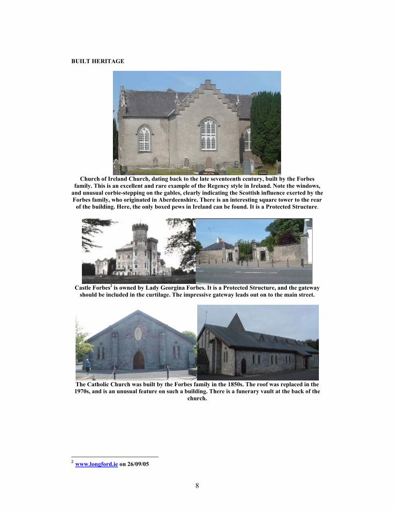
BUILT HERITAGE
Church of Ireland Church, dating back to the late seventeenth century, built by the Forbes
family. This is an excellent and rare example of the Regency style in Ireland. Note the windows, and unusual corbie-stepping on the gables, clearly indicating the Scottish influence exerted by the Forbes family, who originated in Aberdeenshire. There is an interesting square tower to the rear
of the building. Here, the only boxed pews in Ireland can be found. It is a Protected Structure.
Castle Forbes2 is owned by Lady Georgina Forbes. It is a Protected Structure, and the gateway
should be included in the curtilage. The impressive gateway leads out on to the main street.
The Catholic Church was built by the Forbes family in the 1850s. The roof was replaced in the 1970s, and is an unusual feature on such a building. There is a funerary vault at the back of the
church.
2 www.longford.ie on 26/09/05
9
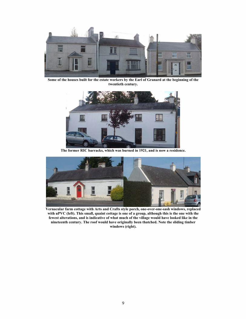
Some of the houses built for the estate workers by the Earl of Granard at the beginning of the
twentieth century.
The former RIC barracks, which was burned in 1921, and is now a residence.
Vernacular farm cottage with Arts and Crafts style porch, one-over-one-sash windows, replaced
with uPVC (left). This small, quaint cottage is one of a group, although this is the one with the fewest alterations, and is indicative of what much of the village would have looked like in the
nineteenth century. The roof would have originally been thatched. Note the sliding timber windows (right).

10
The convent was founded in 1869, at the request of the contemporary Lord Granard, who was
keen for the nuns to establish an orphanage and industries to benefit the poor on his estate. The chapel was designed by William Hague, the famous nineteenth century Gothic church architect. Note the interesting round bay window above the doorway of the convent building. The building
has recently been converted into flats.
Nursing home, dating from the late nineteenth century, once Lisbrack House and home to Bishop Conroy. Note the Dutch influence in the triangular Arts and Crafts gables, the bay windows and
the timber bargeboards.
The Station, which was built at the time of extensive railway construction during the 1860s, was
closed in 1963 and is now a residence. This is an attractive ashlar limestone building, with a hipped slate roof. The station building once housed the station ticket office, waiting rooms etc on the ground floor and living accommodation for the stationmaster and his family on the first floor.

11
STREETSCAPE The main street in Newtownforbes is comprised of a combination of buildings from different periods, and different building heights and styles. Buildings marked in red on the townscape map denote historic buildings, which contribute to the character of the streetscape. Buildings marked in orange are particularly outstanding landmarks in the village, which are the most important features and should be retained as such as well as enhanced. The area marked in pink is the only part of the main street that is in need of attention. SHOPFRONTS Many of the shopfronts in Newtownforbes are finished traditionally and tastefully (see photos on next page). Collum’s, Bell’s Casey’s and McGowan’s all have traditional shopfronts. Note the “castellated” fascia in The Castle Inn. COMMUNITY/AMENITY Newtownforbes has an active Tidy Towns committee, as well as a Development Co-op. There is one mixed primary school, and a GAA pitch wit a sports/community centre, and there are plans to add another two GAA pitches as well as a handball alley. There is a recycling centre beside the GAA pitch, where glass and aluminium cans can be recycled.

12
Newtownforbes Traditional Shopfronts

13
PUBLIC REALM
PATHS Pavements along the main street in Newtownforbes are unusually wide, although the road itself is also unusually wide. Pavement surfaces in the main street are, in places, tasteful, and in others are in need of attention. This is particularly important around the main landmarks on the main street, although because parts of the pavement are used for car parking, surfaces in other areas are appropriate. Additionally, current litterbins, streetlights and flowerpots in the main street are old and shabby and detract from the character of the area. However, trees planted along the main street are an attractive means of enhancement. OPEN SPACE Some of the housing developments have been built around a green area, equipped with goalposts for use as a football pitch. However, there is a need for an accessible general public park, with a children’s play area and picnic area. LANDSCAPING There are several pleasant landscaped areas in Newtownforbes, although some of those would benefit from an enhancing feature, such as flowerbeds, particularly at the entrance to the village from Longford. Some of the benches in these areas are in need of repair. DEVELOPMENT PRESSURE The expansion Newtownforbes has resulted in increased pressure on both infrastructure and land. The original village has so far been extended southwards, eastwards and westwards, although development to the east and west is limited by the railway line (east) and Castle Forbes Demesne (west). DEVELOPMENT POTENTIAL Despite recent development pressures, there are several opportunities for further development within the current development envelope. Additionally, there are some gap sites along the main street, which should be occupied with high quality infill design, and particular priority should be given to small commercial developments.

14
INFRASTRUCTURE
RESIDENTIAL PROVISION Much of Newtownforbes is residential, and has been significantly extended in recent years. In the past three years, over 200 additional houses were built or are currently under construction within the village. COMMERCIAL PROVISION There is little commercial provision for Newtownforbes in relation to its rapid residential expansion. At present, there is a Post Office-cum-shop, Chinese takeaway, mini-mart, clothes shop and Italian restaurant/takeaway, as well as three pubs and a beauty salon. ROADS Newtownforbes is served by the N4, which runs through the village to Longford (south) and to Rooskey (north). This road experiences a considerable amount of heavy traffic, particularly at peak times. A by-pass is planned to deal with the problem, as part of the N4 improvements from Leitrim to Longford, expected to be carried out within the life of this plan. PUBLIC TRANSPORT Newtownforbes features in the main Dublin-Sligo, Sligo-Longford and Longford-Omagh CIE bus services. SEWERAGE & WATER Sewerage in Newtownforbes is provided by the local authority, and there are plans to improve this service in the future. The Longford Regional Water Supply supplies water to Newtownforbes, and there are also plans to upgrade this in the future.

15
PART II
SWOT ANALYSIS
Element Strengths Weaknesses Opportunities Threats Morphology
Strong centre of the village Weaker at the edges as a
result of extensive and rapid expansion
A better, stronger structure could be achieved with careful consideration to
designs at the entrances from all sides
The central core (main street) could be dwarfed by
expansion
Streetscape
Historic village, based around main street and Castle
Forbes
Some gap sites and some old houses empty/in need of
repair/renovation etc
Poor quality street furniture
Could be enhanced with high quality new developments
and renovated and revitalised old buildings;
Could be enhanced with more appropriate street furniture
Unstructured and unco-ordinated development, could be detrimental to the village
instead of achieving a planned urban area
Landscaping
Some fine and well-kept landscaped areas
Some bare areas Potential for enhancement of existing landscaped areas, adding flowerbeds and tree
planting
The current building boom could overlook the
importance of landscaped areas
Open Spaces Small open spaces within housing developments
Lack of a public park A pubic park should be created
The need for a public park may be overlooked in favour
of development Housing
Significant increase in number of houses in recent years, many good quality new designs
Too many houses for the infrastructural capacity
The opportunity exists to use Lisbrack House as well as
other empty buildings on the main street as housing.
Risk of becoming suburb of Longford town if appropriate facilities are not put in place
to correspond with the current housing expansion

16
Infrastructure Strategic location on main N4 route
Insufficient water and sewage provision; heavy
traffic through main street
Opportunity to improve existing water and sewerage supplies; a by-pass is also in
planning stages
Delay in investing in infrastructure
Commercial Emphasis on small local shops
Lack of commercial provision corresponding to
population needs
Further small-scale commercial expansion should be encouraged,
particularly among existing businesses, along the main
street
Lack of car parking and accessibility to commercial
services
Tourism Raw assets: C17 Church, Castle Forbes, historic
village, Lisbrack House, Covent; B&B, restaurants
Lack of tourists; absence of satisfactory commercial
provision (coffee shop, etc)
Potential for greater emphasis on the village as a
tourist attraction
Authenticity could be compromised in a desire to
make money.
Environment Lough Forbes Complex (SAC & NHA)
Absence of accessible public park
Landscaped areas and parks should plant native trees and
plants
Risk of overdevelopment at the expense of the
environment Built Heritage Interesting buildings,
particularly the two churches, Lisbrack House, estate houses; Castle Forbes
Not used and exhibited to full potential
Could be enhanced using traditional materials and
features on old buildings, and making new buildings
sympathetic
Risk of demolition and radical alteration due to
neglect
Archaeology Five archaeological sites in Newtownforbes and in Castle
Forbes demesne, including three earthworks and two old
graveyards
Access to graveyard limited Protect and enhance graveyards, removing
harmful weeds and looking after stones, and ensuring
public access
Risk of damaging archaeological fabric by extensive development

17
DEVELOPMENT POLICIES
DEVELOPMENT STRATEGY The future development of Newtownforbes is based on the neighbourhood concept. The basic principles of the neighbourhood concept are underpinned by the aim of securing more sustainable patterns of development. Access to employment, shopping, education, health, leisure and social facilities are all important criteria in determining where future housing growth should be directed. Accessibility to such facilities is also a key element, and housing should be directed to locations where walking and cycling to shops, the local primary school and areas of open space are easily achieved. SUSTAINABLE DEVELOPMENT This Local Area Plan is important in terms of achieving sustainable development in Newtownforbes by focusing development on the town centre, where people can live and work in close proximity, thus reducing the dependency on the car. AIMS
♦ The Council shall aim to strengthen the fabric of the existing settlement, creating and maintaining a vibrant and thriving urban community with a sufficient level of physical, social and economic infrastructure and services.
♦ To provide a high quality physical development pattern and pleasant,
sustainable environment in which the population of Newtownforbes can live, work, interact and recreate safely, and provide a catalyst for social and economic development and regeneration.
♦ It is an objective of the Council that all new development in urban and rural
situations shall be guided by sustainable development principles. HOUSING The population of Newtownforbes has increased by 10.4% in the period 1996 – 2002. This trend appears to be continuing, taking into account committed development in the town since 2002, with considerable new development sine then. The Planning Authority sees Newtownforbes as being suitable for further residential development owing to its location, and the range of social and community facilities and services available within the town. It has been designated as a local growth centre with a regional element in the County Development Plan 2003 – 2009 and as such it is felt important to focus development in the town. The amount of land identified to accommodate growth in the period to 2011 is guided by a number of factors such as infrastructure, proposals to upgrade the services available, and the capacity of the sewerage treatment plant. The guidelines set out in
18
the Regional Planning Guidelines for growth in the overall region must also be taken into account. AIMS
♦ To secure the provision of high quality, affordable and sustainable residential accommodation in sufficient supply to meet the demand for new houses in Newtownforbes.
♦ To secure a high standard of landscaping in residential developments, with the
provision of adequate public and private open space, amenity areas and pedestrian links to public footways.
♦ To secure adequate childcare facilities within new residential developments.
POLICY AND OBJECTIVES
♦ In general, in accordance with the Guidelines on Residential Density, issued by the Department of the Environment, Heritage and Local Government, densities in excess of 10 units per acre will be acceptable subject to the highest urban and architectural design standards.
♦ Any new residential development on residentially zoned land will be required
to comply with Part V of the Planning and Development Act, 2000, in terms of the provision of social and affordable housing, at a rate of 20% of the overall development, as specified in the Housing Strategy.
♦ High quality designs and finishes will be required in connection with new
development and shall include the provision of decorative street furniture, pavement treatment and lighting.
♦ The developer will normally be required to reserve 15% public open space in
association with new developments and/or may be required to contribute (either financially or with land) towards the assembly of a larger public park for the benefit of the settlement as a whole. All open space shall be heavily landscaped as part of the development and provided with woodland areas and walks linked to other areas of public open space. Private open space to the rear of dwellings shall be provided at a minimum of 11 metres in length.
EMPLOYMENT Newtownforbes is primarily a commuter town with most people employed in Longford town. This situation is expected to continue. RETAIL/COMMERCIAL The Planning Authority considers it important to protect the existing retail/commercial function of the town to meet the needs of the existing population and to expand the range of services to sustain the proposed population.

19
AIMS
♦ To maintain and consolidate the role of the main street in Newtownforbes as a local retail and commercial centre.
♦ To ensure that as the population of the area expands there are sufficient
convenience and comparison retail outlets to meet the needs of residents of the area.
POLICY AND OBJECTIVES
♦ Small-scale local commercial development in the main street should be promoted and encouraged
♦ Any application for retail development in Newtownforbes will need to be
consistent with the policies in this plan and those of the County Development Plan and the Retail Strategy for Co. Longford.
♦ To permit the provision of new retail development and commercial outlets of a
range and type consistent with the growth of the town.
♦ The design of new retail premises or refurbishment of existing will be required to be sympathetic to existing development in the vicinity. Modern designs are acceptable, provided that they respect the character of the streetscape and neighbouring development.
♦ The provision of adequate car parking, to development plan standards shall be
provided and only in exceptional circumstances will any alternative be considered by the Planning Authority.
INFRASTRUCTURE Lough Forbes provides water to Newtownforbes and capacity is adequate to cater for future development. OBJECTIVES
♦ To upgrade the current water and sewerage schemes.
♦ To identify any areas within the development envelope that may be liable to flooding and investigate the possibility of preventing and alleviating flooding in the area.
♦ The Council will co-operate with and facilitate the ESB in providing
additional sub-stations and power lines in the area as the need for increased electrical power arises.

20
♦ Overhead cabling should be put underground ♦ Alternative car parking facilities should be made available, in order to ease
congestion on the main street. ♦ Priority should be given to improvements to sewerage and water systems in
Newtownforbes to counteract the negative effects of rapid expansion ROADS AND TRANSPORTATION Newtownforbes is strategically located on the N4 Longford-Rooskey road, which runs through the centre of the village. As a result of its position on the N4, the town experiences large volumes of heavy goods vehicles travelling through the town. Parking is mainly along the Main Street, which gives rise to problems of congestion. AIMS
♦ Through the road network, there is a need to strengthen the links within as well as outwith the region.
♦ The Council recognises the importance of good pedestrian and cycle linkages
within and out of new residential development sites into the town centre and community facilities, including open space to reduce the need to travel by car and to encourage the safe and efficient movement of the local population to other facilities and services.
♦ To provide adequate off-street parking, in order to reduce congestion in the
town and to provide for and encourage side on car parking along Main Street. POLICY AND OBJECTIVES
♦ A line for the bypass shall be identified and the Council shall reserve lands along this route to facilitate the future development of this bypass.
♦ To encourage side-on car parking and prevent parking on the footpaths.
♦ To require all new residential developments to provide adequate pedestrian
and cycle linkages to the town centre.
♦ The Council shall normally require minimum parking provision to the standards of the County Development Plan in conjunction with new development and alterations to existing premises. Parking provided over and above these standards is acceptable subject to the application of normal planning criteria.
♦ Pavement surfaces should be replaced with a more appropriate material, such
as stone slabs, or cobbles similar to those in front of the gateway to Castle Forbes, outside the buildings marked in orange on the map (i.e. both churches

21
and the convent). These buildings are the most impressive features in the streetscape, and they should be enhanced for this reason.
♦ New, more appropriate litterbins and streetlights should replace current ones
in the main street
♦ Measures shall be taken to prevent parking on pavements AMENITY, ENVIRONMENT AND HERITAGE The preservation and enhancement of amenities and heritage is an integral part of the development of the County, both in terms of providing an attractive and accessible resource for the County’s population and in terms of attracting inward investment from tourism and increasing the marketability of Longford as a location for industry, business and commercial activity. Longford County Council has assisted Newtownforbes in achieving a reasonable provision of recreational and amenity facilities, with GAA grounds, and a proposed public park with children’s play area. AIMS
♦ The Council recognises the importance of amenities and recreational amenities in terms of the social, economic and cultural well being of the County and aims to protect, preserve and enhance these amenities.
♦ To conserve and protect monuments, artefacts, structures of architectural
heritage merit, and areas special character through relevant statutory protection and through the process of development management.
POLICY AND OBJECTIVES
♦ Developers of residential schemes may be required, as a condition on any grant of planning permission, to locate open spaces in such a way as to provide links to or consolidation of areas of public open space within a settlement. Public open spaces shall be substantially landscaped and planted with native woodland trees.
♦ Environmental improvements of visually poor areas, as identified above, shall
be promoted.
♦ The Planning Authority shall promote the protection and conservation of heritage sites, monuments, artefacts and monuments and the integrity of their setting, as listed and illustrated in the Record of Monuments and Places.

22
♦ To secure statutory protection of the following structures, subject to the listing process under the Planning and Development Act, 2000:
Lisbrack House The Former Convent The Catholic Church The Railway Station Both Railway Bridges
♦ A detailed map of Protected Structures, showing the extent of curtilage and
attendant grounds, will be made available at the Planning Office. It is the policy of the Council to ensure the protection of structures included in the Record of Protected Structures generally and in particular by:
♦ Controlling development which would alter the character of protected
structures and proposed protected structures.
♦ Monitoring the condition of protected structures and proposed protected structures to identify those endangered by neglect, vandalism or unauthorised development and taking appropriate action.
♦ Street layout in the original part of the village should remain intact as far as
possible.
♦ Repairs to older buildings should be sensitive: traditional styles and materials (e.g. slate roofs, timber windows etc) should be used wherever possible. At the very least, the replacement should resemble in colour and style what was there previously.
♦ A public park should be created behind the main street (see map) with a small
area designated for car parking. There should also be a children’s play area, picnic area and duck pond.
♦ Landscaping, particularly native tree and shrub planting, should be encouraged
in designated buffer zones, landscaped areas and beside the GAA pitch. Detailed landscaping measures shall be provided, where appropriate, as part of any proposed residential development.
COMMUNITY, HEALTH AND EDUCATION Community facilities play an important role in the life of people in the town. There is one primary school, Cnoc Mhuire, in the village. There is a health centre in the town and a number of community organisations, community hall, etc. However, although the town already has quite well established community facilities, there is a need to encourage further development and consolidation of these facilities. AIMS
♦ To ensure that there are sufficient and appropriate educational and community facilities available to meet the needs of residents of the area.

23
♦ To promote childcare facilities in appropriate locations, such as residential areas, places of employment, or educational establishments and where possible convenient to public transport and safe pedestrian routes.
POLICY AND OBJECTIVES
♦ It is the policy of the Council to facilitate and promote the expansion and improvement of educational facilities, where possible and to ensure that adequate lands are available in appropriate locations for the provision, expansion and/or improvement of educational facilities.
♦ To identify appropriate locations within settlements for childcare facilities.
♦ It is the policy of the Council to facilitate and encourage the provision of
improved health care facilities and to ensure that adequate lands are available for the provision, expansion and improvement of Health Care facilities.
ENERGY Energy provision within the settlement would appear to be meeting requirements. It is assumed that sufficient capacity exists for the scale of development likely to take place in the Newtownforbes area over the period of this Local Area Plan. Longford County Council recognises the need to adopt more a sustainable approach to energy production and promotes the use of renewable energy, passive and low energy houses. AIMS
♦ To facilitate and promote investigation into and provision of the potential of alternative, renewable energy sources.
♦ Encourage low energy and passive houses.
DESIGN PRINCIPLES
LOCAL CHARACTER ♦ New buildings, particularly on the main street, should sensitively incorporate
some of the local paradigms that are already prevalent in the village, such as timber window styles, pitch of the roofs etc. This ensures that the character and overall look of the original village are not compromised by modern rapid expansion.
♦ The effect on the landscape should also be considered in new developments ♦ Traditional buildings remaining on the main street should be adapted and
renovated rather than demolished, in order to maintain and enhance a sense of continuity and sense of place in Newtownforbes.
♦ Densities should be in the region of 12-20 per hectare, subject to location and design criteria.

24
COMMERCIAL DEVELOPMENT ♦ Commercial development should be limited to the main street. ♦ Any new shops should use traditional and tasteful shopfronts, where possible. ♦ Traditional buildings should be retained and converted into shops where
possible, in preference to demolishing and building anew
ZONINGS
The zonings are intended to be flexible, provided that the basic concepts of proper planning, residential amenity and good design practice are adhered to. Any proposed development should be compatible with the primary zonings should not detract from the amenity of the area. These zonings should be read in conjunction with the Development Plan Design Statement (Section 7), particularly in relation to design, materials, public open space and parking requirements. COMMERCIAL/RESIDENTIAL
To primarily provide for residential development, with a possible element of commercial/retail development
The main street in Newtownforbes (i.e. what was originally the village) should remain the commercial core of the expanding town, whilst also enhancing the area, making it more attractive. This is the historic core of Newtownforbes, and should remain so as an important and multi-functional part of the village. As such, mixed commercial-office-residential use is appropriate. (See map) SOCIAL/COMMUNITY/EDUCATION
To primarily provide for social, community and educational facilities There are two churches (one Roman Catholic and one Church of Ireland) in Newtownforbes, as well as a primary school and a community hall beside the GAA pitches. (See map) RESIDENTIAL
To primarily provide for residential development; to preserve and improve residential amenity, dwellings and compatible uses including social and community facilities, open spaces and local shopping facilities.
The areas outside the central main street should continue to be zoned for residential use. (See map) Because it is estimated that the population projection quota for Newtownforbes for the next 20 years has already been reached, and 35 hectares of zoned residential land is still available for development. The areas beside the low density residential development are landscaped buffer zones, which are intended to provide a break between existing and new development.

25
RECREATIONAL To primarily provide for recreational open space and ancillary structures
The at the entrance to Newtownforbes is already in use as a sports ground, and further sporting facilities, including a handball alley and extra GAA pitches are planned for the area. For this reason, the area should continue to be zoned for recreational purposes. Additionally, the proposed public park, including a children’s play area and picnic area, should be located behind St. Paul’s Church (see map). This location has been chosen because this road is already used as a walkway, and its proximity to the main street should allow for access on foot as opposed to by car. The demesne wall surrounding Castle Forbes, and the mature trees within the demesne, provide a pleasant backdrop for such a park. RESIDENTIAL WITH CAR PARKING REQUIREMENT
To be zoned primarily for residential use, with provision made for car parking facilities.
As part of any proposed development, 10% of the land shall be required for car parking as part of the proposed scheme at the nearest point to the main street. Open space requirements in the same development will be reduced from 15% to 10%. These will be provided as part of any development on said lands.


